the croydon gypsy and traveller accommodation needs assessment
TRANSCRIPT
1
Assessment and selection of
sites for Gypsy and Travellers
Evidence for the Croydon Local Plan:
Detailed Policies and Proposals (Preferred
and Alternative Options)
August 2015
2
1. Why provide more pitches?
1.1. Croydon’s population is growing including the local population of gypsy and travellers. The main drivers of need include families living on unauthorised encampments wanting to permanently reside in Croydon, overcrowding and new family formations. The need to demonstrate a supply of pitches is essential to avoid ‘planning by appeal’ and to ensure a ‘sound’ Croydon Local Plan: Detailed Policies and Proposals DPD
2. History of development of identification of need
2.1. Currently there are 19 pitches provided in Latham’s Way, Valley Park, Broad Green. The site originally opened in 1988 with 15 permanent residential pitches. The site was refurbished to enable an additional 4 pitches in 2007/8.
2.2. The need for 10-19 extra pitches between 2007 and 17 was identified in the London Boroughs’ Gypsy and Traveller Accommodation Needs Assessment Report of March 2008. The Croydon Local Plan: Strategic Policies incorporated the lower figure, identifying in Policy SP 2.7 that the Council will seek to deliver ten additional pitches in the borough by 2021.
2.3. However by adoption of the Strategic Policies in 2013, it was recognised that a further Needs Assessment was required. This was commissioned to consider the need up to 2033 and the Croydon Gypsy and Traveller Accommodation Needs Assessment 2013 (GTANA) was produced in November 2013. This GTANA stated that the accommodation need should be reviewed every 3-5 years as the population and demographic needs can change rapidly.
2.4. The GTANA identified that 49 additional pitches are required by 2033 as follows:
27 pitches in 2013-2018
7 more in 2018-2023
7 more in 2023-28
8 more in 2028-2033
It stated that the Council need to consider providing a permanent site for Irish Traveller families who make up a large proportion of the unauthorised encampments in the borough. Eight pitches are identified as being needed in the first five year period, within the total of twenty seven required.
One emergency stopping place is identified as being needed by 2018 to provide a place for stays of up to 28 days for gypsy and travellers passing
3
through the borough which should help reduce the number of unauthorised encampments.
2.5. The number of pitches to provide for has been adjusted to 39 as a proportion of the total need of 49 pitches to reflect the proportion of homes that can be accommodated in the London Borough of Croydon in the context of overall housing need.
2.6. The Communities and Local Government (CLG) Good Practice Guide `Designing Gypsy and Traveller Sites` (2008) recommends a maximum of 15 pitches per site for ease of management. Ideally three sites should therefore be provided but as sites may be difficult to find and deliver a minimum of two should be sought. These should provide 19 and 20 pitches respectively with a stopping place on one of these two sites or in an alternative location if it can be found. This quantum of pitches per site reflects Croydon’s experience with the management of the existing 19 pitch site which functions adequately.
2.7. One permanent site and a stopping place are required for the period 2013-2018 and a further site in the period 2023-2033.
3. Methodology to assess sites
3.1. Further to extensive political and officer consultation and dialogue during 2013/ 2014 it was established that the following were ‘absolutes’ for the initial screening:
Pitch size average of 500sq.m. for permanent sites. This includes a quantum towards the site access road and shared facilities required and as advised by the CLG guidelines for gypsy and traveller pitches.
Minimum size of 1500 sq m per site to accommodate 3 pitches, but for management purposes ideally find sites of approximately 1.5 hectares to take 15-20 pitches.
One stopping place, size 170 - 500sq.m. (to allow a stopping place for 2 to 3 caravans with parking spaces for 2 to 3 cars and hard standing for a portaloo, stand pipe and cess pit, and a firebreak/planting buffer if near or next to the roadside).
Potential sites in all urban areas, Green Belt (GB) and Metropolitan Open Land (MOL) were reviewed to ensure all locations for a site considered.
4
Exclusion of sites in Croydon Metropolitan Centre and within District Centres and Strategic Industrial Locations and Conservation Areas due to viability, deliverability and impact on heritage considerations1.
Exclusion of sites with planning consent or the subject of a planning
application.
3.2. Potential locations for stopping places initially considered only sites near A roads. The search was widened in 2015 following a council officer workshop when it was established that the traveller community were likely to identify an official stopping place by word of mouth and did not require a prominent strategic A road location.
3.3. Further to the initial screening of the ‘Call for Sites’ database a more detailed screening of over 300 sites included search criteria from Croydon Local Plan: Strategic Policies, SP2.7, with that established from both the consultation with council officers working with gypsy and travellers in Croydon and the CLG Good Practice Guide and ‘Planning Policy for traveller sites’ 2012 and the revision of 2015. This established the policy designation considerations, services/social infrastructure criteria and site specific criteria.
3.4. The site criteria has been given a scoring in order to establish which sites could be possible for consideration as a permanent site or stopping place, with the score adjusted for the latter to remove the criteria for proximity to services reflecting the short period of stay allowed at a stopping place of up to 28 days.
3.5. The scoring acknowledges that a site in Council ownership is more deliverable, and that sites in Green Belt and Metropolitan Open Land are unlikely to be acceptable in policy terms unless there is already built form on the site, and in compliance with the National Policy Planning Framework (NPPF) the impact on openness must be considered.
3.6. Sites were considered from those suggested by council officers, and from sites submitted through two Call for Sites consultations as part of the preparation of the Croydon Local Plan: Detailed Policies and Proposals DPD). A desk based search of sites that were considered for housing was included but eliminating sites that did not meet the initial screening criteria of ‘absolutes’.
3.7. Site visits were undertaken to establish if sites met the site specific criteria and the site specific information added to the Sites Assessment.
3.8. Sites were assessed for their Public Transport Accessibility Level (PTAL) and closeness to services and community and the recommended guidance of the CLG, however it was established from discussion with council officers working with the gypsy and traveller population in Croydon that the
1 The exception to this is the Council owned site of Wandle car park in the Croydon Opportunity Area
which was included as is currently a vacant Council owned site although partly safeguarded for a public transport facility.
5
community prefer to use their own transport and also prefer to be located where they can have as much privacy as possible and away from the existing residential community. This contradicts the CLG guidance but it is considered relevant because the information has come direct from those involved with management of the existing Gypsy and Traveller site at Latham’s Way. The privacy criterion has been included in the site search criteria and the PTAL excluded.
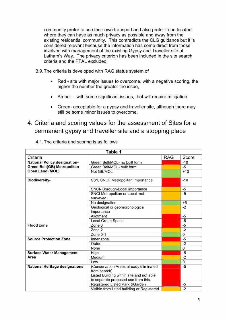
3.9. The criteria is developed with RAG status system of
Red - site with major issues to overcome, with a negative scoring, the higher the number the greater the issue,
Amber - with some significant issues, that will require mitigation,
Green- acceptable for a gypsy and traveller site, although there may still be some minor issues to overcome.
4. Criteria and scoring values for the assessment of Sites for a
permanent gypsy and traveller site and a stopping place
4.1. The criteria and scoring is as follows
Table 1
Criteria RAG Score
National Policy designation- Green Belt(GB) Metropolitan Open Land (MOL)
Green Belt/MOL- no built form -10
Green Belt/MOL- built form -5
Not GB/MOL +10
Biodiversity-
SS1, SNCI, Metropolitan Importance
-10
SNCI- Borough-Local importance -5
SNCI Metropolitan or Local not surveyed
-5
No designation +5
Geological or geomorphological importance
-2
Allotment -5
Local Green Space -5
Flood zone Zone 3 -5
Zone 2 -2
Zone 0-1 0
Source Protection Zone Inner zone -5
Outer -2
None 0
Surface Water Management Area
High -5
Medium -2
Low 0
National Heritage designations (Conservation Areas already eliminated from search) Listed Building within site and not able to separate proposed use from this
-5
Registered Listed Park &Garden -5
Visible from listed building or Registered -2
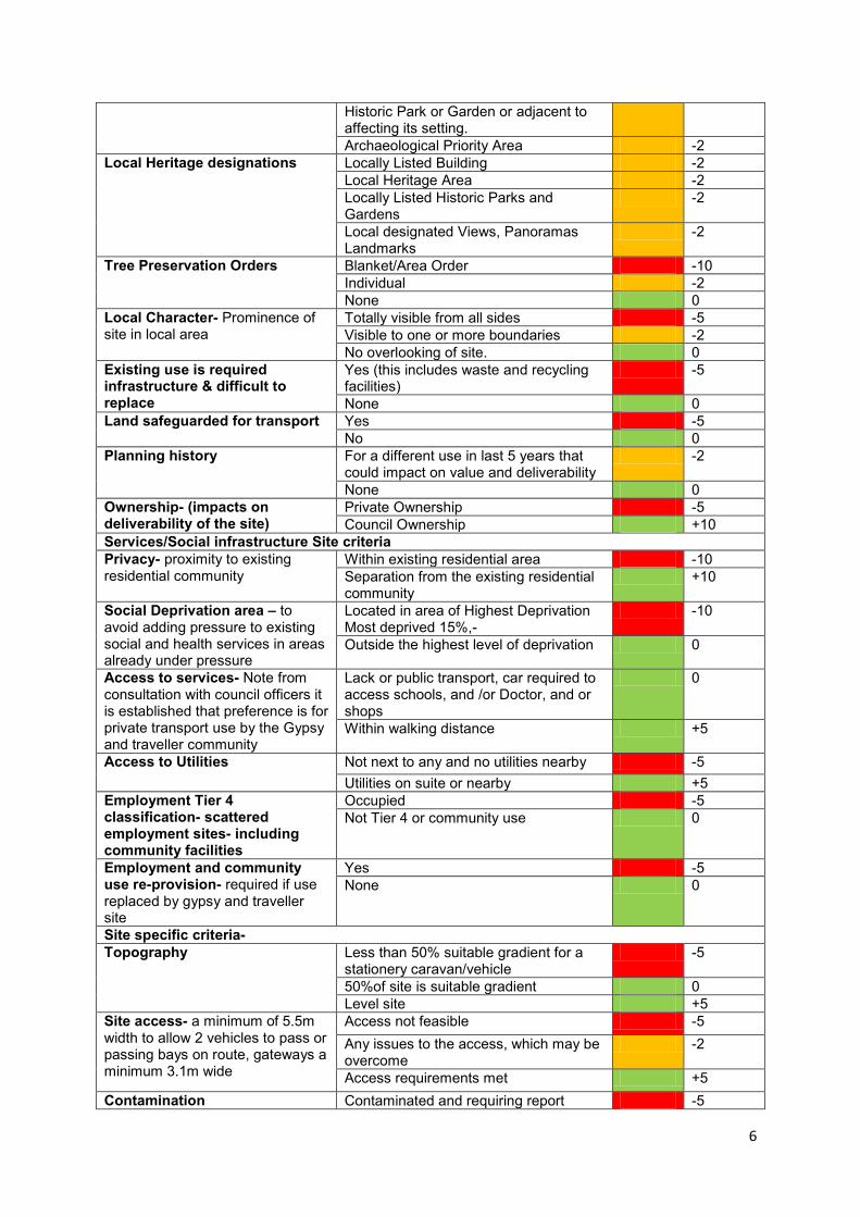
6
Historic Park or Garden or adjacent to affecting its setting.
Archaeological Priority Area -2
Local Heritage designations Locally Listed Building -2
Local Heritage Area -2
Locally Listed Historic Parks and Gardens
-2
Local designated Views, Panoramas Landmarks
-2
Tree Preservation Orders Blanket/Area Order -10
Individual -2
None 0
Local Character- Prominence of site in local area
Totally visible from all sides -5
Visible to one or more boundaries -2
No overlooking of site. 0
Existing use is required infrastructure & difficult to replace
Yes (this includes waste and recycling facilities)
-5
None 0
Land safeguarded for transport Yes -5
No 0
Planning history For a different use in last 5 years that could impact on value and deliverability
-2
None 0
Ownership- (impacts on deliverability of the site)
Private Ownership -5
Council Ownership +10
Services/Social infrastructure Site criteria
Privacy- proximity to existing residential community
Within existing residential area -10
Separation from the existing residential community
+10
Social Deprivation area – to avoid adding pressure to existing social and health services in areas already under pressure
Located in area of Highest Deprivation Most deprived 15%,-
-10
Outside the highest level of deprivation 0
Access to services- Note from consultation with council officers it is established that preference is for private transport use by the Gypsy and traveller community
Lack or public transport, car required to access schools, and /or Doctor, and or shops
0
Within walking distance +5
Access to Utilities Not next to any and no utilities nearby -5
Utilities on suite or nearby +5
Employment Tier 4 classification- scattered employment sites- including community facilities
Occupied -5
Not Tier 4 or community use 0
Employment and community use re-provision- required if use replaced by gypsy and traveller site
Yes -5
None 0
Site specific criteria-
Topography Less than 50% suitable gradient for a stationery caravan/vehicle
-5
50%of site is suitable gradient 0
Level site +5
Site access- a minimum of 5.5m width to allow 2 vehicles to pass or passing bays on route, gateways a minimum 3.1m wide
Access not feasible -5
Any issues to the access, which may be overcome
-2
Access requirements met +5
Contamination Contaminated and requiring report -5
7
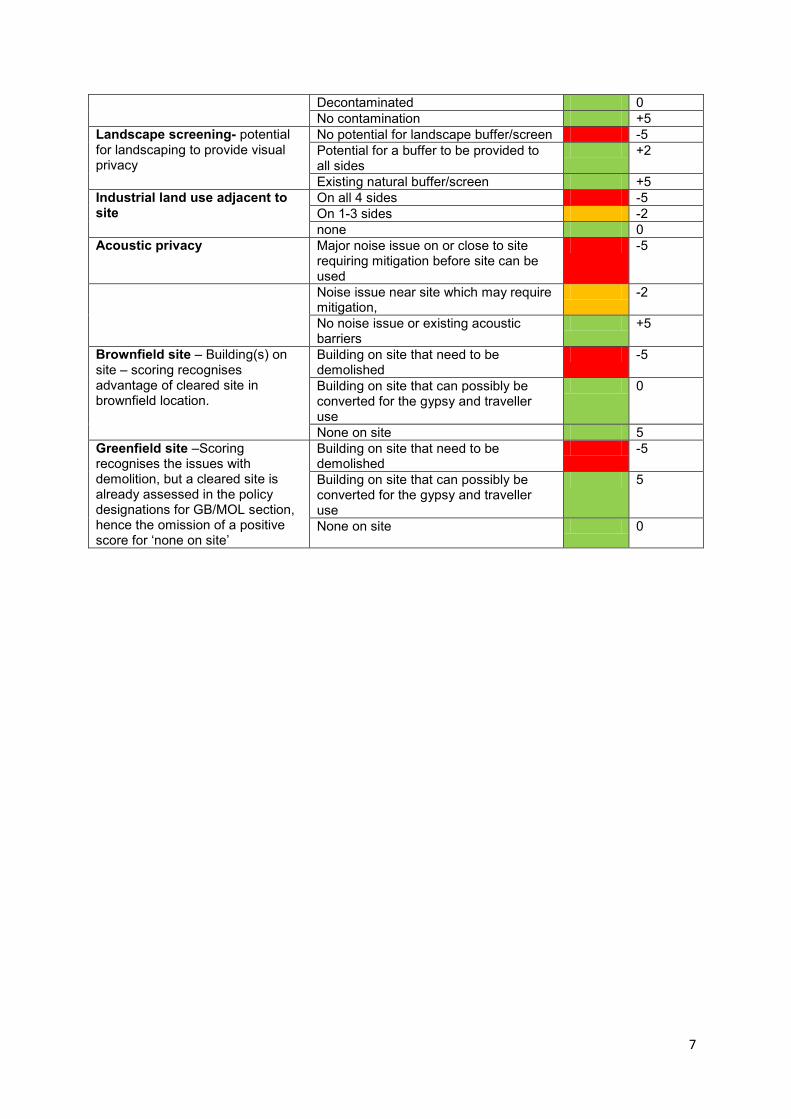
Decontaminated 0
No contamination +5
Landscape screening- potential for landscaping to provide visual privacy
No potential for landscape buffer/screen -5
Potential for a buffer to be provided to all sides
+2
Existing natural buffer/screen +5
Industrial land use adjacent to site
On all 4 sides -5
On 1-3 sides -2
none 0
Acoustic privacy Major noise issue on or close to site requiring mitigation before site can be used
-5
Noise issue near site which may require mitigation,
-2
No noise issue or existing acoustic barriers
+5
Brownfield site – Building(s) on site – scoring recognises advantage of cleared site in brownfield location.
Building on site that need to be demolished
-5
Building on site that can possibly be converted for the gypsy and traveller use
0
None on site 5
Greenfield site –Scoring recognises the issues with demolition, but a cleared site is already assessed in the policy designations for GB/MOL section, hence the omission of a positive score for ‘none on site’
Building on site that need to be demolished
-5
Building on site that can possibly be converted for the gypsy and traveller use
5
None on site 0
8
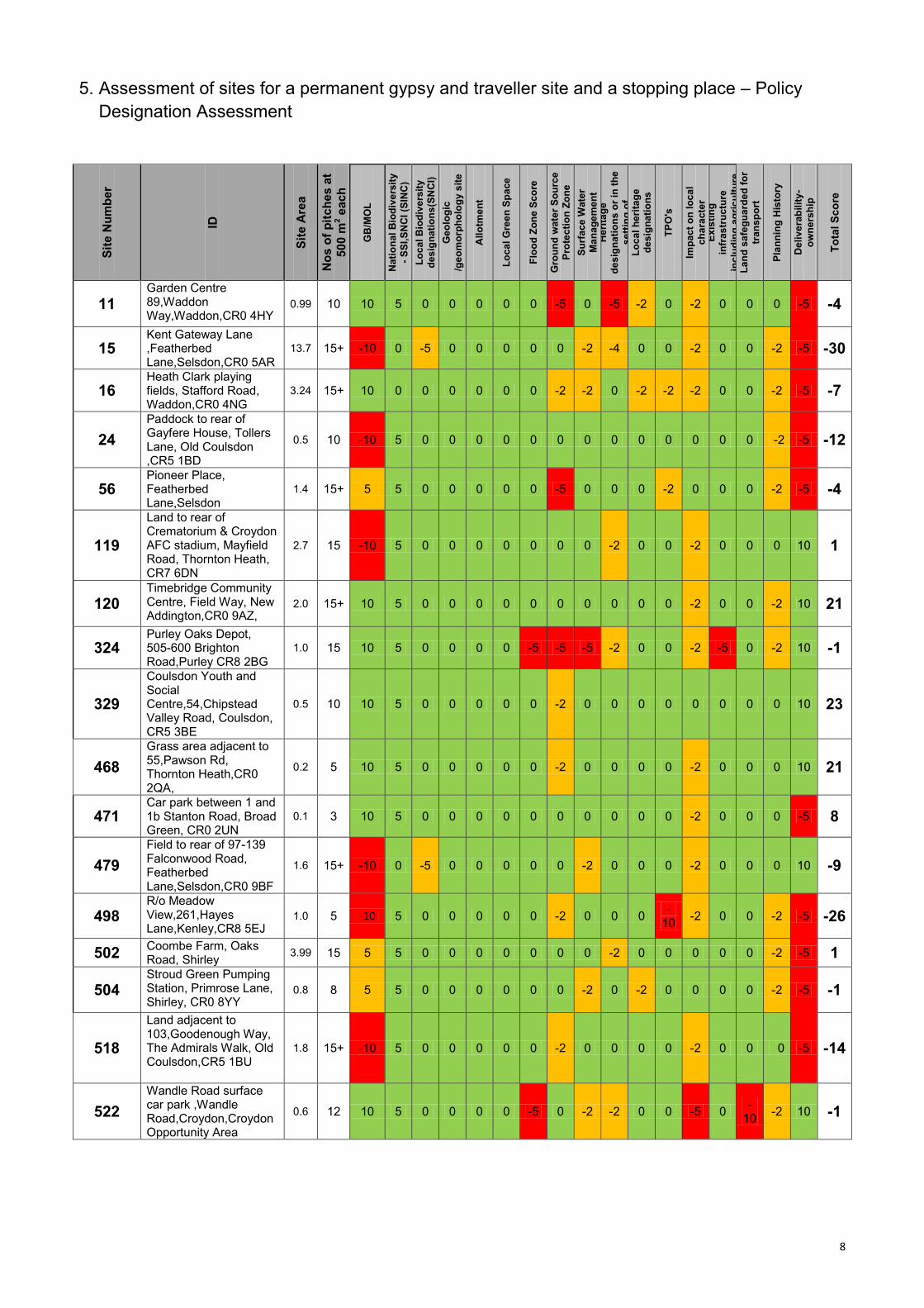
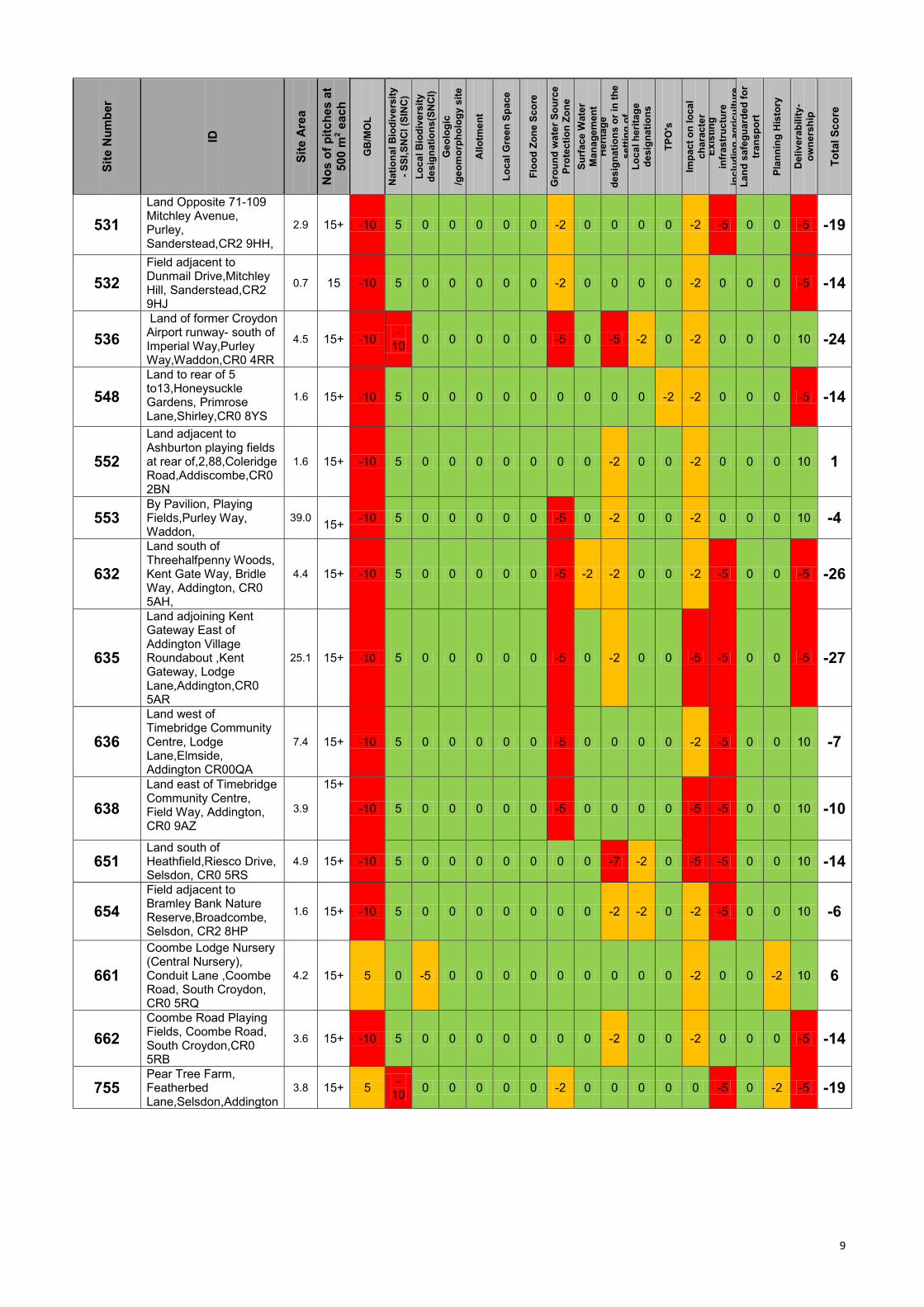
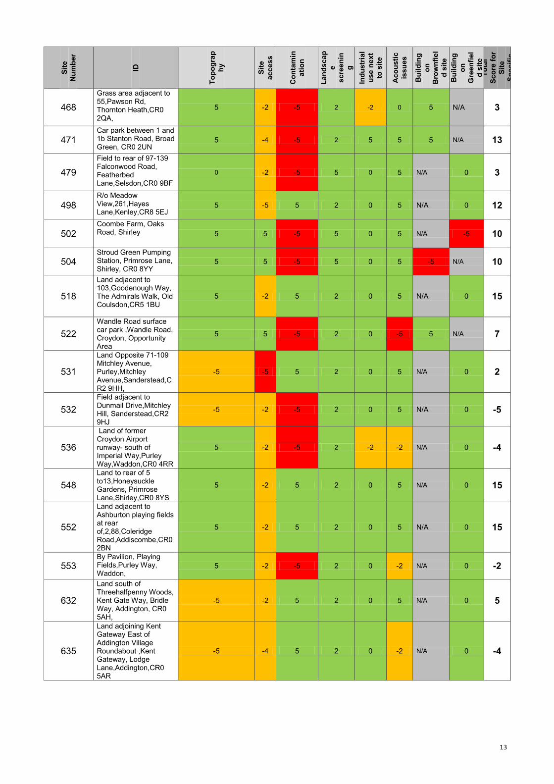
5. Assessment of sites for a permanent gypsy and traveller site and a stopping place – Policy
Designation Assessment
Sit
e N
um
be
r
ID
Sit
e A
rea
No
s o
f p
itc
he
s a
t
500
m2 e
ach
GB
/MO
L
Na
tio
na
l B
iod
ive
rsit
y
- S
SI,
SN
CI
(SIN
C)
Lo
ca
l B
iod
ive
rsit
y
de
sig
na
tio
ns
(SN
CI)
Ge
olo
gic
/ge
om
orp
ho
log
y s
ite
All
otm
en
t
Lo
ca
l G
ree
n S
pa
ce
Flo
od
Zo
ne
Sc
ore
Gro
un
d w
ate
r S
ou
rce
Pro
tec
tio
n Z
on
e
Su
rfa
ce
Wate
r
Ma
na
ge
men
t H
eri
tag
e
de
sig
na
tio
ns o
r in
th
e
se
ttin
g o
f L
oc
al
he
rita
ge
de
sig
na
tio
ns
TP
O's
Imp
ac
t o
n l
oc
al
ch
ara
cte
r
Ex
isti
ng
infr
as
tru
ctu
re
inc
lud
ing
ag
ric
ult
ure
L
an
d s
afe
gu
ard
ed
fo
r
tra
ns
po
rt
Pla
nn
ing
His
tory
De
liv
era
bilit
y-
ow
ne
rsh
ip
To
tal S
co
re
11 Garden Centre 89,Waddon Way,Waddon,CR0 4HY
0.99 10 10 5 0 0 0 0 0 -5 0 -5 -2 0 -2 0 0 0 -5 -4
15 Kent Gateway Lane ,Featherbed Lane,Selsdon,CR0 5AR
13.7 15+ -10 0 -5 0 0 0 0 0 -2 -4 0 0 -2 0 0 -2 -5 -30
16 Heath Clark playing fields, Stafford Road, Waddon,CR0 4NG
3.24 15+ 10 0 0 0 0 0 0 -2 -2 0 -2 -2 -2 0 0 -2 -5 -7
24
Paddock to rear of Gayfere House, Tollers Lane, Old Coulsdon ,CR5 1BD
0.5 10 -10 5 0 0 0 0 0 0 0 0 0 0 0 0 0 -2 -5 -12
56 Pioneer Place, Featherbed Lane,Selsdon
1.4 15+ 5 5 0 0 0 0 0 -5 0 0 0 -2 0 0 0 -2 -5 -4
119
Land to rear of Crematorium & Croydon AFC stadium, Mayfield Road, Thornton Heath, CR7 6DN
2.7 15 -10 5 0 0 0 0 0 0 0 -2 0 0 -2 0 0 0 10 1
120 Timebridge Community Centre, Field Way, New Addington,CR0 9AZ,
2.0 15+ 10 5 0 0 0 0 0 0 0 0 0 0 -2 0 0 -2 10 21
324 Purley Oaks Depot, 505-600 Brighton Road,Purley CR8 2BG
1.0 15 10 5 0 0 0 0 -5 -5 -5 -2 0 0 -2 -5 0 -2 10 -1
329
Coulsdon Youth and Social Centre,54,Chipstead Valley Road, Coulsdon, CR5 3BE
0.5 10 10 5 0 0 0 0 0 -2 0 0 0 0 0 0 0 0 10 23
468
Grass area adjacent to 55,Pawson Rd, Thornton Heath,CR0 2QA,
0.2 5 10 5 0 0 0 0 0 -2 0 0 0 0 -2 0 0 0 10 21
471 Car park between 1 and 1b Stanton Road, Broad Green, CR0 2UN
0.1 3 10 5 0 0 0 0 0 0 0 0 0 0 -2 0 0 0 -5 8
479
Field to rear of 97-139 Falconwood Road, Featherbed Lane,Selsdon,CR0 9BF
1.6 15+ -10 0 -5 0 0 0 0 0 -2 0 0 0 -2 0 0 0 10 -9
498 R/o Meadow View,261,Hayes Lane,Kenley,CR8 5EJ
1.0 5 -10 5 0 0 0 0 0 -2 0 0 0 -
10 -2 0 0 -2 -5 -26
502 Coombe Farm, Oaks Road, Shirley
3.99 15 5 5 0 0 0 0 0 0 0 -2 0 0 0 0 0 -2 -5 1
504 Stroud Green Pumping Station, Primrose Lane, Shirley, CR0 8YY
0.8 8 5 5 0 0 0 0 0 0 -2 0 -2 0 0 0 0 -2 -5 -1
518
Land adjacent to 103,Goodenough Way, The Admirals Walk, Old Coulsdon,CR5 1BU
1.8 15+ -10 5 0 0 0 0 0 -2 0 0 0 0 -2 0 0 0 -5 -14
522
Wandle Road surface car park ,Wandle Road,Croydon,Croydon Opportunity Area
0.6 12 10 5 0 0 0 0 -5 0 -2 -2 0 0 -5 0 -
10 -2 10 -1
9
Sit
e N
um
be
r
ID
Sit
e A
rea
No
s o
f p
itc
he
s a
t
500
m2 e
ach
GB
/MO
L
Na
tio
na
l B
iod
ive
rsit
y
- S
SI,
SN
CI
(SIN
C)
Lo
ca
l B
iod
ive
rsit
y
de
sig
na
tio
ns
(SN
CI)
Ge
olo
gic
/ge
om
orp
ho
log
y s
ite
Allo
tme
nt
Lo
ca
l G
ree
n S
pa
ce
Flo
od
Zo
ne
Sc
ore
Gro
un
d w
ate
r S
ou
rce
Pro
tec
tio
n Z
on
e
Su
rfa
ce
Wate
r
Ma
na
ge
men
t H
eri
tag
e
de
sig
na
tio
ns o
r in
th
e
se
ttin
g o
f L
oc
al
he
rita
ge
de
sig
na
tio
ns
TP
O's
Imp
ac
t o
n l
oc
al
ch
ara
cte
r
Ex
isti
ng
infr
as
tru
ctu
re
inc
lud
ing
ag
ric
ult
ure
L
an
d s
afe
gu
ard
ed
fo
r
tra
ns
po
rt
Pla
nn
ing
His
tory
De
liv
era
bilit
y-
ow
ne
rsh
ip
To
tal S
co
re
531
Land Opposite 71-109 Mitchley Avenue, Purley, Sanderstead,CR2 9HH,
2.9 15+ -10 5 0 0 0 0 0 -2 0 0 0 0 -2 -5 0 0 -5 -19
532
Field adjacent to Dunmail Drive,Mitchley Hill, Sanderstead,CR2 9HJ
0.7 15 -10 5 0 0 0 0 0 -2 0 0 0 0 -2 0 0 0 -5 -14
536
Land of former Croydon Airport runway- south of Imperial Way,Purley Way,Waddon,CR0 4RR
4.5 15+ -10 -
10 0 0 0 0 0 -5 0 -5 -2 0 -2 0 0 0 10 -24
548
Land to rear of 5 to13,Honeysuckle Gardens, Primrose Lane,Shirley,CR0 8YS
1.6 15+ -10 5 0 0 0 0 0 0 0 0 0 -2 -2 0 0 0 -5 -14
552
Land adjacent to Ashburton playing fields at rear of,2,88,Coleridge Road,Addiscombe,CR0 2BN
1.6 15+ -10 5 0 0 0 0 0 0 0 -2 0 0 -2 0 0 0 10 1
553 By Pavilion, Playing Fields,Purley Way, Waddon,
39.0
15+ -10 5 0 0 0 0 0 -5 0 -2 0 0 -2 0 0 0 10 -4
632
Land south of Threehalfpenny Woods, Kent Gate Way, Bridle Way, Addington, CR0 5AH,
4.4 15+ -10 5 0 0 0 0 0 -5 -2 -2 0 0 -2 -5 0 0 -5 -26
635
Land adjoining Kent Gateway East of Addington Village Roundabout ,Kent Gateway, Lodge Lane,Addington,CR0 5AR
25.1 15+ -10 5 0 0 0 0 0 -5 0 -2 0 0 -5 -5 0 0 -5 -27
636
Land west of Timebridge Community Centre, Lodge Lane,Elmside, Addington CR00QA
7.4 15+ -10 5 0 0 0 0 0 -5 0 0 0 0 -2 -5 0 0 10 -7
638
Land east of Timebridge Community Centre, Field Way, Addington, CR0 9AZ
3.9
15+
-10 5 0 0 0 0 0 -5 0 0 0 0 -5 -5 0 0 10 -10
651 Land south of Heathfield,Riesco Drive, Selsdon, CR0 5RS
4.9 15+ -10 5 0 0 0 0 0 0 0 -7 -2 0 -5 -5 0 0 10 -14
654
Field adjacent to Bramley Bank Nature Reserve,Broadcombe, Selsdon, CR2 8HP
1.6 15+ -10 5 0 0 0 0 0 0 0 -2 -2 0 -2 -5 0 0 10 -6
661
Coombe Lodge Nursery (Central Nursery), Conduit Lane ,Coombe Road, South Croydon, CR0 5RQ
4.2 15+ 5 0 -5 0 0 0 0 0 0 0 0 0 -2 0 0 -2 10 6
662
Coombe Road Playing Fields, Coombe Road, South Croydon,CR0 5RB
3.6 15+ -10 5 0 0 0 0 0 0 0 -2 0 0 -2 0 0 0 -5 -14
755 Pear Tree Farm, Featherbed Lane,Selsdon,Addington
3.8 15+ 5 -
10 0 0 0 0 0 -2 0 0 0 0 0 -5 0 -2 -5 -19
10
Sit
e N
um
be
r
ID
Sit
e A
rea
No
s o
f p
itc
he
s a
t
500
m2 e
ach
GB
/MO
L
Na
tio
na
l B
iod
ive
rsit
y
- S
SI,
SN
CI
(SIN
C)
Lo
ca
l B
iod
ive
rsit
y
de
sig
na
tio
ns
(SN
CI)
Ge
olo
gic
/ge
om
orp
ho
log
y s
ite
Allo
tme
nt
Lo
ca
l G
ree
n S
pa
ce
Flo
od
Zo
ne
Sc
ore
Gro
un
d w
ate
r S
ou
rce
Pro
tec
tio
n Z
on
e
Su
rfa
ce
Wate
r
Ma
na
ge
men
t H
eri
tag
e
de
sig
na
tio
ns o
r in
th
e
se
ttin
g o
f L
oc
al
he
rita
ge
de
sig
na
tio
ns
TP
O's
Imp
ac
t o
n l
oc
al
ch
ara
cte
r
Ex
isti
ng
infr
as
tru
ctu
re
inc
lud
ing
ag
ric
ult
ure
L
an
d s
afe
gu
ard
ed
fo
r
tra
ns
po
rt
Pla
nn
ing
His
tory
De
liv
era
bilit
y-
ow
ne
rsh
ip
To
tal S
co
re
767
Cane Hill-south part,Hollymeoak Road,Portnalls Road,Coulsdon,CR5 3YL
3.8 15+ -10 0 -5 0 0 0 0 -5 0 -2 -2 -
10 0 -5 0 -2 -5 -46
271,107 Fishers Farm Recycling Centre, North Downs Road, New Addington
0.6 10 10 5 0 0 0 0 0 0 0 0 0 0 0 -5 0 -2 10 18
676, 677, 905
Field adjacent to Woodcote Park Golf Club and school, Grove Wood Hill,Coulsdon
9.1 15+ -10 5 0 0 0 0 0 -2 0 0 0 0 0 -5 0 0 -5 -17
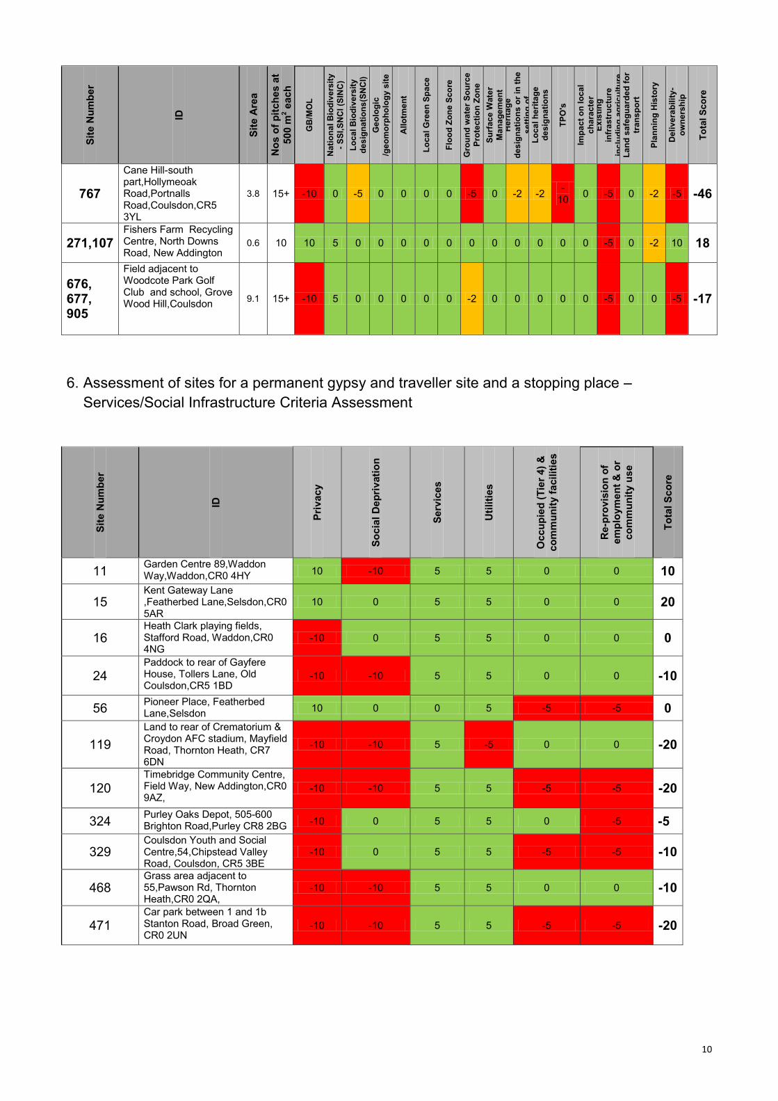
6. Assessment of sites for a permanent gypsy and traveller site and a stopping place –
Services/Social Infrastructure Criteria Assessment
Sit
e N
um
be
r
ID
Pri
vac
y
So
cia
l D
ep
riv
ati
on
Se
rvic
es
Uti
liti
es
Oc
cu
pie
d (
Tie
r 4
) &
co
mm
un
ity f
acilit
ies
Re-p
rovis
ion
of
em
plo
ym
en
t &
or
co
mm
un
ity u
se
To
tal S
co
re
11 Garden Centre 89,Waddon Way,Waddon,CR0 4HY
10 -10 5 5 0 0 10
15 Kent Gateway Lane ,Featherbed Lane,Selsdon,CR0 5AR
10 0 5 5 0 0 20
16 Heath Clark playing fields, Stafford Road, Waddon,CR0 4NG
-10 0 5 5 0 0 0
24 Paddock to rear of Gayfere House, Tollers Lane, Old Coulsdon,CR5 1BD
-10 -10 5 5 0 0 -10
56 Pioneer Place, Featherbed Lane,Selsdon
10 0 0 5 -5 -5 0
119
Land to rear of Crematorium & Croydon AFC stadium, Mayfield Road, Thornton Heath, CR7 6DN
-10 -10 5 -5 0 0 -20
120 Timebridge Community Centre, Field Way, New Addington,CR0 9AZ,
-10 -10 5 5 -5 -5 -20
324 Purley Oaks Depot, 505-600 Brighton Road,Purley CR8 2BG
-10 0 5 5 0 -5 -5
329 Coulsdon Youth and Social Centre,54,Chipstead Valley Road, Coulsdon, CR5 3BE
-10 0 5 5 -5 -5 -10
468 Grass area adjacent to 55,Pawson Rd, Thornton Heath,CR0 2QA,
-10 -10 5 5 0 0 -10
471 Car park between 1 and 1b Stanton Road, Broad Green, CR0 2UN
-10 -10 5 5 -5 -5 -20
11
Sit
e N
um
be
r
ID
Pri
vac
y
So
cia
l D
ep
riv
ati
on
Se
rvic
es
Uti
liti
es
Oc
cu
pie
d (
Tie
r 4
) &
co
mm
un
ity f
acilit
ies
Re-p
rovis
ion
of
em
plo
ym
en
t &
or
co
mm
un
ity u
se
To
tal S
co
re
479 Field to rear of 97-139 Falconwood Road, Featherbed Lane,Selsdon,CR0 9BF
10 0 0 5 0 0 15
498 R/o Meadow View,261,Hayes Lane,Kenley,CR8 5EJ
10 0 0 5 0 0 15
502 Coombe Farm, Oaks Lane, Shirley
10 0 0 5 0 0 15
504 Stroud Green Pumping Station, Primrose Lane, Shirley, CR0 8YY
-10 0 5 5 0 -5 -5
518
Land adjacent to 103,Goodenough Way, The Admirals Walk, Old Coulsdon,CR5 1BU
-10 -10 5 5 0 0 -10
522
Wandle Road surface car park ,Wandle Road,Croydon,Croydon Opportunity Area
-10 0 5 5 0 0 0
531
Land Opposite 71-109 Mitchley Avenue, Purley,Mitchely Avenue,Sanderstead,CR2 9HH,
10 0 5 -5 0 0 10
532 Field adjacent to Dunmail Drive,Mitchley Hill, Sanderstead,CR2 9HJ
10 0 0 5 0 0 15
536
Land of former Croydon Airport runway- south of Imperial Way,Purley Way,Waddon,CR0 4RR
10 0 5 5 0 0 20
548
Land to rear of 5 to13,Honeysuckle Gardens, Primrose Lane,Shirley,CR0 8YS
-10 0 0 5 0 0 -5
552
Land adjacent to Ashburton playing fields at rear of,2,88,Coleridge Road,Addiscombe,CR0 2BN
-10 -10 5 5 0 -5 -15
553 By Pavilion, Playing Fields,Purley Way, Waddon,
10 0 5 -5 0 0 10
632 Land south of Threehalfpenny Woods, Kent Gate Way, Bridle Way, Addington, CR0 5AH,
10 0 5 5 0 0 20
635
Land adjoining Kent Gateway East of Addington Village Roundabout ,Kent Gateway, Lodge Lane,Addington,CR0 5AR
10 -10 5 -5 0 0 0
636
Land west of Timebridge Community Centre, Lodge Lane,Elmside, Addington CR00QA
10 -10 5 5 -5 -5 0
638 Land east of Timebridge Community Centre, Field Way, Addington, CR0 9AZ
-10 -10 5 5 0 -5 -15
651 Land south of Heathfield,Riesco Drive, Selsdon, CR0 5RS
10 -10 0 -5 0 0 -5
654 Field adjacent to Bramley Bank Nature Reserve,Broadcombe, Selsdon, CR2 8HP
-10 -10 5 -5 0 0 -20
661
Coombe Lodge Nursery (Central Nursery),Conduit Lane, Coombe Road, South Croydon, CR0 5RQ
10 0 0 5 0 0 15
12
Sit
e N
um
be
r
ID
Pri
vac
y
So
cia
l D
ep
riv
ati
on
Se
rvic
es
Uti
liti
es
Oc
cu
pie
d (
Tie
r 4
) &
co
mm
un
ity f
acilit
ies
Re-p
rovis
ion
of
em
plo
ym
en
t &
or
co
mm
un
ity u
se
To
tal S
co
re
662 Coombe Road Playing Fields, Coombe Road, South Croydon,CR0 5RB
10 0 0 5 -5 -5 5
755 Pear Tree Farm, Featherbed Lane,Selsdon,Addington 10 0 0 5 0 -5 10
767 Cane Hill-south part,Hollymeoak Road,Portnalls Road,Coulsdon,CR5 3YL
10 0 0 -5 0 0 5
271,107 Fishers Farm Recycling Centre, North Downs Road, New Addington
-10 -10 5 5 0 -5 -15
676, 677, 905
Field adjacent to Woodcote Park Golf Club and school, Grove Wood Hill, Coulsdon -10 0 5 -5 0 0 -10
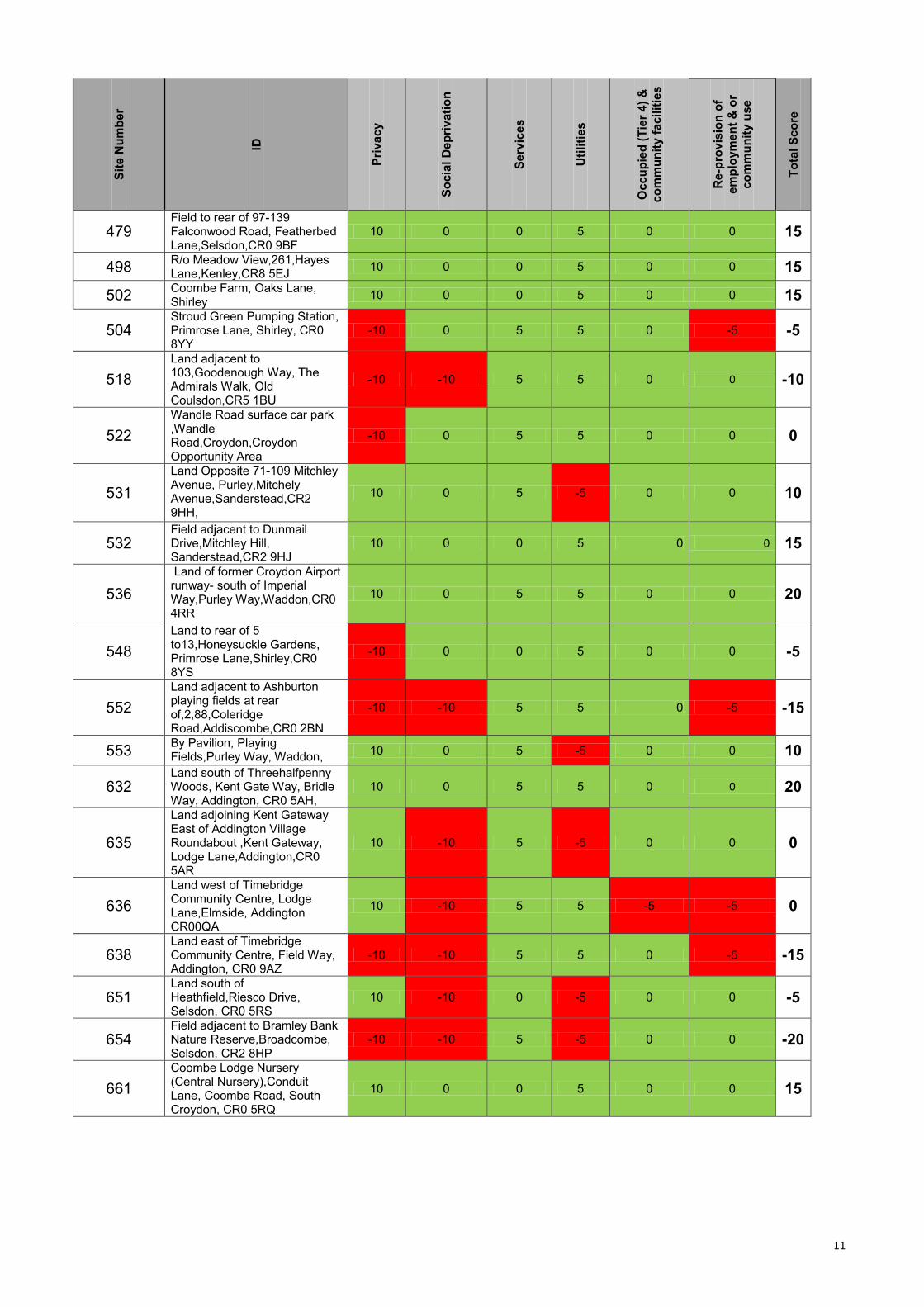
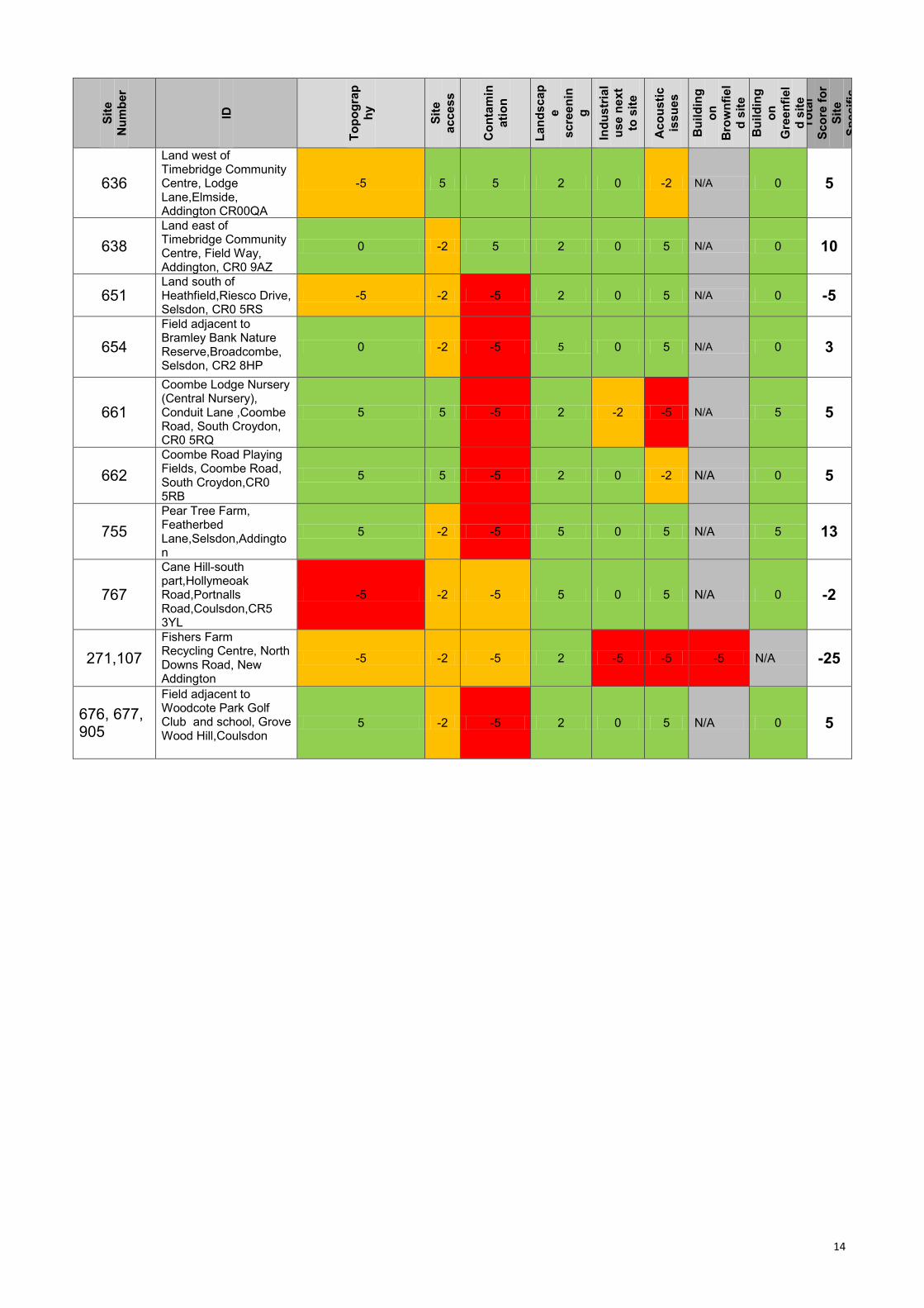
7. Assessment of Sites for a permanent gypsy and traveller site and a stopping place – Site
Specific Criteria Assessment
Sit
e
Nu
mb
er
ID
To
po
gra
p
hy
Sit
e
access
Co
nta
min
ati
on
Lan
dscap
e
scre
en
in
g
Ind
ustr
ial
use
ne
xt
to s
ite
Ac
ou
sti
c
issu
es
Bu
ild
ing
on
Bro
wn
fie
l
d s
ite
Bu
ild
ing
on
Gre
en
fiel
d s
ite
To
tal
Sc
ore
fo
r
Sit
e
Sp
ec
ific
11 Garden Centre 89,Waddon Way,Waddon,CR0 4HY
5 5 -5 2 -2 -2 -5 N/A -2
15 Kent Gateway Lane ,Featherbed Lane,Selsdon,CR0 5AR
0 -4 -5 2 0 -2 N/A 0 -9
16 Heath Clark playing fields, Stafford Road, Waddon,CR0 4NG
5 -4 -5 2 -2 -2 5 N/A -1
24
Paddock to rear of Gayfere House, Tollers Lane, Old Coulsdon ,CR5 1BD
5 -4 5 5 0 5 N/A 0 16
56 Pioneer Place, Featherbed Lane,Selsdon
0 5 5 2 0 5 N/A -5 12
119
Land to rear of Crematorium & Croydon AFC stadium, Mayfield Road, Thornton Heath, CR7 6DN
5 -5 -5 2 0 5 N/A 0 2
120 Timebridge Community Centre, Field Way, New Addington,CR0 9AZ,
0 5 5 5 0 5 -5 N/A 15
324 Purley Oaks Depot, 505-600 Brighton Road,Purley CR8 2BG
5 5 -5 2 0 5 -5 N/A 7
329
Coulsdon Youth and Social Centre,54,Chipstead Valley Road, Coulsdon, CR5 3BE
5 -2 -5 2 -2 -2 -5 N/A -9
13
Sit
e
Nu
mb
er
ID
To
po
gra
p
hy
Sit
e
access
Co
nta
min
ati
on
Lan
dscap
e
scre
en
in
g
Ind
ustr
ial
use
ne
xt
to s
ite
Ac
ou
sti
c
issu
es
Bu
ild
ing
on
Bro
wn
fie
l
d s
ite
Bu
ild
ing
on
Gre
en
fiel
d s
ite
To
tal
Sc
ore
fo
r
Sit
e
Sp
ec
ific
468
Grass area adjacent to 55,Pawson Rd, Thornton Heath,CR0 2QA,
5 -2 -5 2 -2 0 5 N/A 3
471 Car park between 1 and 1b Stanton Road, Broad Green, CR0 2UN
5 -4 -5 2 5 5 5 N/A 13
479
Field to rear of 97-139 Falconwood Road, Featherbed Lane,Selsdon,CR0 9BF
0 -2 -5 5 0 5 N/A 0 3
498 R/o Meadow View,261,Hayes Lane,Kenley,CR8 5EJ
5 -5 5 2 0 5 N/A 0 12
502 Coombe Farm, Oaks Road, Shirley 5 5 -5 5 0 5 N/A -5 10
504 Stroud Green Pumping Station, Primrose Lane, Shirley, CR0 8YY
5 5 -5 5 0 5 -5 N/A 10
518
Land adjacent to 103,Goodenough Way, The Admirals Walk, Old Coulsdon,CR5 1BU
5 -2 5 2 0 5 N/A 0 15
522
Wandle Road surface car park ,Wandle Road, Croydon, Opportunity Area
5 5 -5 2 0 -5 5 N/A 7
531
Land Opposite 71-109 Mitchley Avenue, Purley,Mitchley Avenue,Sanderstead,CR2 9HH,
-5 -5 5 2 0 5 N/A 0 2
532
Field adjacent to Dunmail Drive,Mitchley Hill, Sanderstead,CR2 9HJ
-5 -2 -5 2 0 5 N/A 0 -5
536
Land of former Croydon Airport runway- south of Imperial Way,Purley Way,Waddon,CR0 4RR
5 -2 -5 2 -2 -2 N/A 0 -4
548
Land to rear of 5 to13,Honeysuckle Gardens, Primrose Lane,Shirley,CR0 8YS
5 -2 5 2 0 5 N/A 0 15
552
Land adjacent to Ashburton playing fields at rear of,2,88,Coleridge Road,Addiscombe,CR0 2BN
5 -2 5 2 0 5 N/A 0 15
553 By Pavilion, Playing Fields,Purley Way, Waddon,
5 -2 -5 2 0 -2 N/A 0 -2
632
Land south of Threehalfpenny Woods, Kent Gate Way, Bridle Way, Addington, CR0 5AH,
-5 -2 5 2 0 5 N/A 0 5
635
Land adjoining Kent Gateway East of Addington Village Roundabout ,Kent Gateway, Lodge Lane,Addington,CR0 5AR
-5 -4 5 2 0 -2 N/A 0 -4
14
Sit
e
Nu
mb
er
ID
To
po
gra
p
hy
Sit
e
access
Co
nta
min
ati
on
Lan
dscap
e
scre
en
in
g
Ind
ustr
ial
use
ne
xt
to s
ite
Ac
ou
sti
c
issu
es
Bu
ild
ing
on
Bro
wn
fie
l
d s
ite
Bu
ild
ing
on
Gre
en
fiel
d s
ite
To
tal
Sc
ore
fo
r
Sit
e
Sp
ec
ific
636
Land west of Timebridge Community Centre, Lodge Lane,Elmside, Addington CR00QA
-5 5 5 2 0 -2 N/A 0 5
638
Land east of Timebridge Community Centre, Field Way, Addington, CR0 9AZ
0 -2 5 2 0 5 N/A 0 10
651 Land south of Heathfield,Riesco Drive, Selsdon, CR0 5RS
-5 -2 -5 2 0 5 N/A 0 -5
654
Field adjacent to Bramley Bank Nature Reserve,Broadcombe, Selsdon, CR2 8HP
0 -2 -5 5 0 5 N/A 0 3
661
Coombe Lodge Nursery (Central Nursery), Conduit Lane ,Coombe Road, South Croydon, CR0 5RQ
5 5 -5 2 -2 -5 N/A 5 5
662
Coombe Road Playing Fields, Coombe Road, South Croydon,CR0 5RB
5 5 -5 2 0 -2 N/A 0 5
755
Pear Tree Farm, Featherbed Lane,Selsdon,Addington
5 -2 -5 5 0 5 N/A 5 13
767
Cane Hill-south part,Hollymeoak Road,Portnalls Road,Coulsdon,CR5 3YL
-5 -2 -5 5 0 5 N/A 0 -2
271,107
Fishers Farm Recycling Centre, North Downs Road, New Addington
-5 -2 -5 2 -5 -5 -5 N/A -25
676, 677, 905
Field adjacent to Woodcote Park Golf Club and school, Grove Wood Hill,Coulsdon
5 -2 -5 2 0 5 N/A 0 5
15
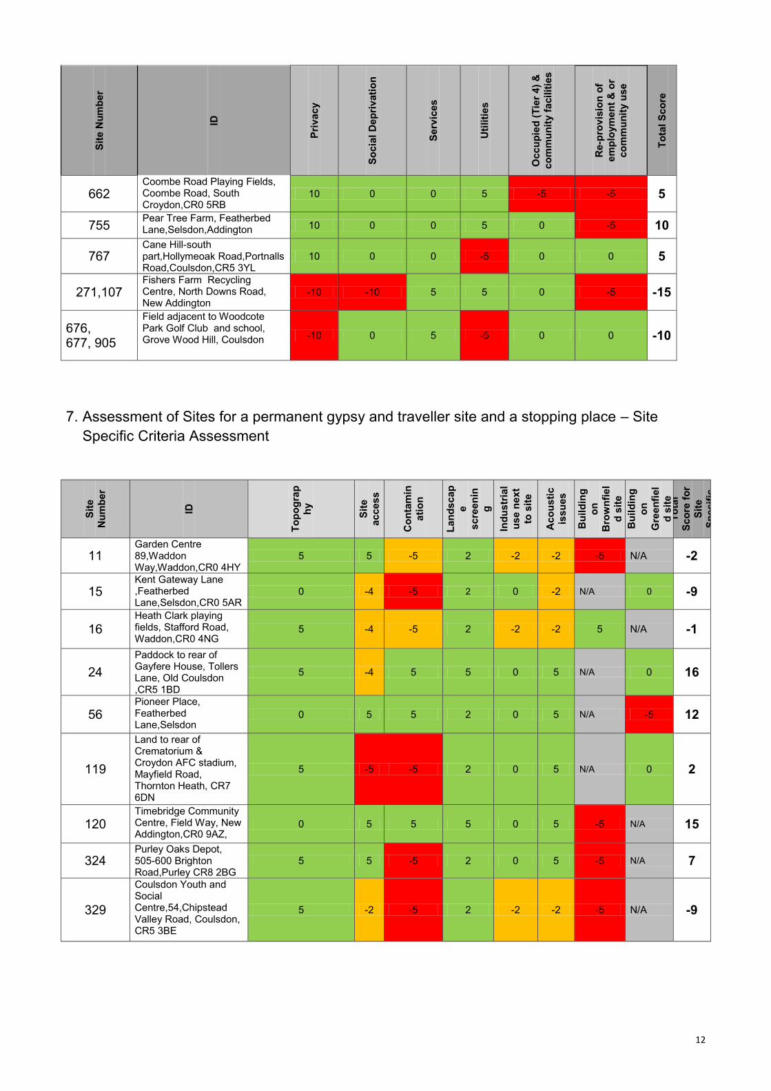
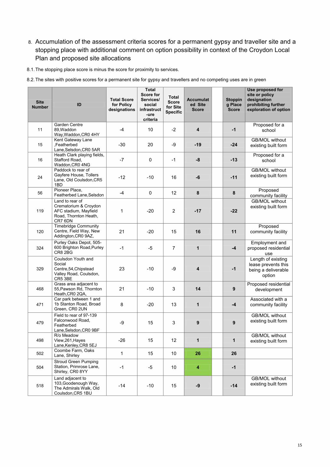
8. Accumulation of the assessment criteria scores for a permanent gypsy and traveller site and a
stopping place with additional comment on option possibility in context of the Croydon Local
Plan and proposed site allocations
8.1. The stopping place score is minus the score for proximity to services.
8.2. The sites with positive scores for a permanent site for gypsy and travellers and no competing uses are in green
Site Number
ID Total Score for Policy
designations
Total Score for Services/
social infrastruct
-ure criteria
Total Score
for Site Specific
Accumulated Site Score
Stopping Place Score
Use proposed for site or policy designation prohibiting further exploration of option
11 Garden Centre 89,Waddon Way,Waddon,CR0 4HY
-4 10 -2 4 -1 Proposed for a
school
15 Kent Gateway Lane ,Featherbed Lane,Selsdon,CR0 5AR
-30 20 -9 -19 -24 GB/MOL without existing built form
16 Heath Clark playing fields, Stafford Road, Waddon,CR0 4NG
-7 0 -1 -8 -13 Proposed for a
school
24
Paddock to rear of Gayfere House, Tollers Lane, Old Coulsdon,CR5 1BD
-12 -10 16 -6 -11
GB/MOL without existing built form
56 Pioneer Place, Featherbed Lane,Selsdon -4 0 12 8 8
Proposed community facility
119
Land to rear of Crematorium & Croydon AFC stadium, Mayfield Road, Thornton Heath, CR7 6DN
1 -20 2 -17 -22
GB/MOL without existing built form
120
Timebridge Community Centre, Field Way, New Addington,CR0 9AZ,
21 -20 15 16 11 Proposed
community facility
324
Purley Oaks Depot, 505-600 Brighton Road,Purley CR8 2BG
-1 -5 7 1 -4 Employment and
proposed residential use
329
Coulsdon Youth and Social Centre,54,Chipstead Valley Road, Coulsdon, CR5 3BE
23 -10 -9 4 -1
Length of existing lease prevents this being a deliverable
option
468 Grass area adjacent to 55,Pawson Rd, Thornton Heath,CR0 2QA,
21 -10 3 14 9 Proposed residential
development
471
Car park between 1 and 1b Stanton Road, Broad Green, CR0 2UN
8 -20 13 1 -4 Associated with a community facility
479
Field to rear of 97-139 Falconwood Road, Featherbed Lane,Selsdon,CR0 9BF
-9 15 3 9 9
GB/MOL without existing built form
498 R/o Meadow View,261,Hayes Lane,Kenley,CR8 5EJ
-26 15 12 1 1 GB/MOL without existing built form
502 Coombe Farm, Oaks Lane, Shirley 1 15 10 26 26
504
Stroud Green Pumping Station, Primrose Lane, Shirley, CR0 8YY
-1 -5 10 4 -1
518
Land adjacent to 103,Goodenough Way, The Admirals Walk, Old Coulsdon,CR5 1BU
-14 -10 15 -9 -14
GB/MOL without existing built form
16
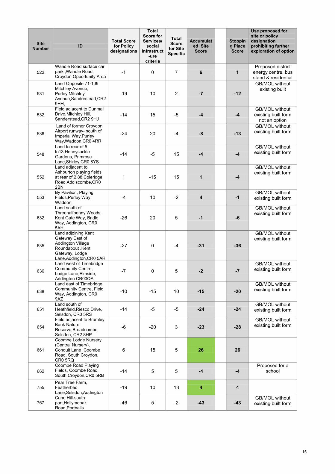
Site Number
ID Total Score for Policy
designations
Total Score for Services/
social infrastruct
-ure criteria
Total Score
for Site Specific
Accumulated Site Score
Stopping Place Score
Use proposed for site or policy designation prohibiting further exploration of option
522
Wandle Road surface car park ,Wandle Road, Croydon Opportunity Area
-1 0 7 6 1
Proposed district energy centre, bus stand & residential
531
Land Opposite 71-109 Mitchley Avenue, Purley,Mitchley Avenue,Sanderstead,CR2 9HH,
-19 10 2 -7 -12
GB/MOL without existing built
532
Field adjacent to Dunmail Drive,Mitchley Hill, Sanderstead,CR2 9HJ
-14 15 -5 -4 -4
GB/MOL without existing built form
not an option
536
Land of former Croydon Airport runway- south of Imperial Way,Purley Way,Waddon,CR0 4RR
-24 20 -4 -8 -13
GB/MOL without existing built form
548
Land to rear of 5 to13,Honeysuckle Gardens, Primrose Lane,Shirley,CR0 8YS
-14 -5 15 -4 -4
GB/MOL without existing built form
552
Land adjacent to Ashburton playing fields at rear of,2,88,Coleridge Road,Addiscombe,CR0 2BN
1 -15 15 1 -4
GB/MOL without existing built form
553 By Pavilion, Playing Fields,Purley Way, Waddon,
-4 10 -2 4 -1 GB/MOL without existing built form
632
Land south of Threehalfpenny Woods, Kent Gate Way, Bridle Way, Addington, CR0 5AH,
-26 20 5 -1 -6
GB/MOL without existing built form
635
Land adjoining Kent Gateway East of Addington Village Roundabout ,Kent Gateway, Lodge Lane,Addington,CR0 5AR
-27 0 -4 -31 -36
GB/MOL without existing built form
636
Land west of Timebridge Community Centre, Lodge Lane,Elmside, Addington CR00QA
-7 0 5 -2 -7
GB/MOL without existing built form
638
Land east of Timebridge Community Centre, Field Way, Addington, CR0 9AZ
-10 -15 10 -15 -20
GB/MOL without existing built form
651 Land south of Heathfield,Riesco Drive, Selsdon, CR0 5RS
-14 -5 -5 -24 -24 GB/MOL without existing built form
654
Field adjacent to Bramley Bank Nature Reserve,Broadcombe, Selsdon, CR2 8HP
-6 -20 3 -23 -28
GB/MOL without existing built form
661
Coombe Lodge Nursery (Central Nursery), Conduit Lane ,Coombe Road, South Croydon, CR0 5RQ
6 15 5 26 26
662
Coombe Road Playing Fields, Coombe Road, South Croydon,CR0 5RB
-14 5 5 -4 -4
Proposed for a school
755 Pear Tree Farm, Featherbed Lane,Selsdon,Addington
-19 10 13 4 4
767 Cane Hill-south part,Hollymeoak Road,Portnalls
-46 5 -2 -43 -43 GB/MOL without existing built form

17
Site Number
ID Total Score for Policy
designations
Total Score for Services/
social infrastruct
-ure criteria
Total Score
for Site Specific
Accumulated Site Score
Stopping Place Score
Use proposed for site or policy designation prohibiting further exploration of option
Road,Coulsdon,CR5 3YL
271,107
Fishers Farm Recycling Centre, North Downs Road, New Addington
18 -15 -25 -22 -27
676, 677, 905
Field adjacent to Woodcote Park Golf Club and school, Grove Wood Hill, Coulsdon
-17 -10 5 -22 -27
GB/MOL without existing built form
18
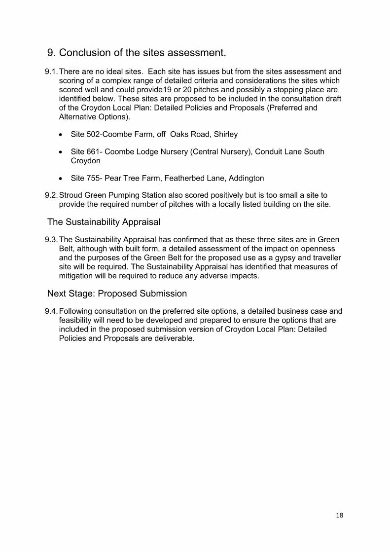
9. Conclusion of the sites assessment.
9.1. There are no ideal sites. Each site has issues but from the sites assessment and scoring of a complex range of detailed criteria and considerations the sites which scored well and could provide19 or 20 pitches and possibly a stopping place are identified below. These sites are proposed to be included in the consultation draft of the Croydon Local Plan: Detailed Policies and Proposals (Preferred and Alternative Options).
Site 502-Coombe Farm, off Oaks Road, Shirley
Site 661- Coombe Lodge Nursery (Central Nursery), Conduit Lane South Croydon
Site 755- Pear Tree Farm, Featherbed Lane, Addington
9.2. Stroud Green Pumping Station also scored positively but is too small a site to provide the required number of pitches with a locally listed building on the site.
The Sustainability Appraisal
9.3. The Sustainability Appraisal has confirmed that as these three sites are in Green Belt, although with built form, a detailed assessment of the impact on openness and the purposes of the Green Belt for the proposed use as a gypsy and traveller site will be required. The Sustainability Appraisal has identified that measures of mitigation will be required to reduce any adverse impacts.
Next Stage: Proposed Submission
9.4. Following consultation on the preferred site options, a detailed business case and feasibility will need to be developed and prepared to ensure the options that are included in the proposed submission version of Croydon Local Plan: Detailed Policies and Proposals are deliverable.
19
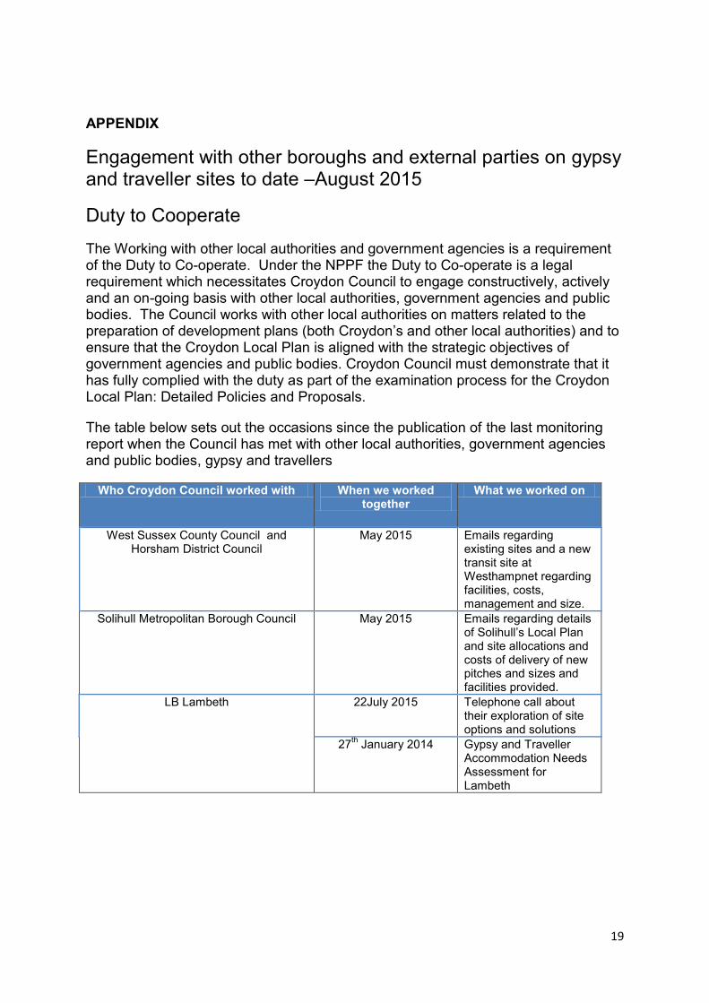
APPENDIX
Engagement with other boroughs and external parties on gypsy and traveller sites to date –August 2015
Duty to Cooperate
The Working with other local authorities and government agencies is a requirement of the Duty to Co-operate. Under the NPPF the Duty to Co-operate is a legal requirement which necessitates Croydon Council to engage constructively, actively and an on-going basis with other local authorities, government agencies and public bodies. The Council works with other local authorities on matters related to the preparation of development plans (both Croydon’s and other local authorities) and to ensure that the Croydon Local Plan is aligned with the strategic objectives of government agencies and public bodies. Croydon Council must demonstrate that it has fully complied with the duty as part of the examination process for the Croydon Local Plan: Detailed Policies and Proposals.
The table below sets out the occasions since the publication of the last monitoring report when the Council has met with other local authorities, government agencies and public bodies, gypsy and travellers
Who Croydon Council worked with When we worked together
What we worked on
West Sussex County Council and Horsham District Council
May 2015 Emails regarding existing sites and a new transit site at Westhampnet regarding facilities, costs, management and size.
Solihull Metropolitan Borough Council May 2015 Emails regarding details of Solihull’s Local Plan and site allocations and costs of delivery of new pitches and sizes and facilities provided.
LB Lambeth 22July 2015 Telephone call about their exploration of site options and solutions
27th January 2014 Gypsy and Traveller
Accommodation Needs Assessment for Lambeth
20
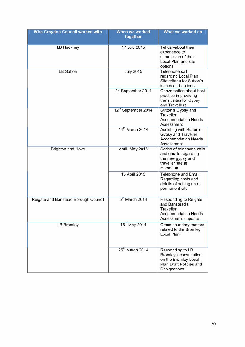
Who Croydon Council worked with When we worked together
What we worked on
LB Hackney 17 July 2015 Tel call-about their experience to submission of their Local Plan and site options
LB Sutton
July 2015 Telephone call regarding Local Plan Site criteria for Sutton’s issues and options.
24 September 2014 Conversation about best practice in providing transit sites for Gypsy and Travellers
12th September 2014 Sutton’s Gypsy and
Traveller Accommodation Needs Assessment
14th March 2014
Assisting with Sutton’s Gypsy and Traveller Accommodation Needs Assessment
Brighton and Hove April- May 2015 Series of telephone calls and emails regarding the new gypsy and traveller site at Horsdean
16 April 2015 Telephone and Email Regarding costs and details of setting up a permanent site
Reigate and Banstead Borough Council 5th March 2014 Responding to Reigate
and Banstead’s Traveller Accommodation Needs Assessment - update
LB Bromley
16th May 2014 Cross boundary matters
related to the Bromley Local Plan
25th March 2014 Responding to LB
Bromley’s consultation on the Bromley Local Plan Draft Policies and Designations
21
Who Croydon Council worked with When we worked together
What we worked on
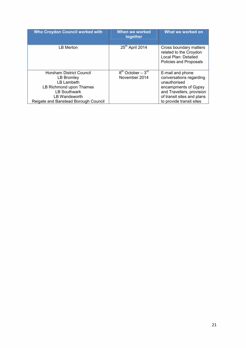
LB Merton 25th April 2014 Cross boundary matters
related to the Croydon Local Plan: Detailed Policies and Proposals
Horsham District Council LB Bromley LB Lambeth
LB Richmond upon Thames LB Southwark
LB Wandsworth Reigate and Banstead Borough Council
8th October – 3
rd
November 2014 E-mail and phone conversations regarding unauthorised encampments of Gypsy and Travellers, provision of transit sites and plans to provide transit sites