the cueva de las manos, rio pinturas
TRANSCRIPT

WHC Nomination Documentation File Name: 936.pdf UNESCO Region: LATIN AMERICA AND THE CARIBBEANS __________________________________________________________________________________________________ SITE NAME: The Cueva de las Manos, Rio Pinturas DATE OF INSCRIPTION: 4th December 1999 STATE PARTY: ARGENTINA CRITERIA: C (iii) DECISION OF THE WORLD HERITAGE COMMITTEE: Excerpt from the Report of the 23rd Session of the World Heritage Committee The Committee inscribed the site on the World Heritage List on the basis of criterion (iii): Criterion (iii): Cueva de las Manos contains an outstanding collection of prehistoric rock art which bears witness to the culture of the earliest human societies in South America. BRIEF DESCRIPTIONS The Cueva de las Manos, Río Pinturas, contains an exceptional assemblage of cave art, executed between 10,000 and 1,000 years ago. It takes its name (Cave of the Hands) from the stencilled outlines of human hands in the cave, but there are also many depictions of animals, such as guanacos (Lama guanicoe), which are still common in the region. The hunter-gatherer communities that were responsible for the paintings inhabited this remote area of Patagonia until the arrival of European settlers in the 17th century. 1.b State, Province or Region: Patagonia Region, Santa Cruz Province 1.d Exact location: 47° 9' S, 70° 40' W
1
UNESCO - Organization des Nations Unies pour l’Education, la Science et la CultureConvention concerning the Protection of the World Cultural and Natural Heritage
PROPOSAL FOR THE INSCRIPTION OF CULTURAL AND NATURALPROPERTIES IN THE
UNESCO WORLD HERITAGE LIST
1. IDENTIFICATION OF THE PROPERTY
a. Country:
Argentina
b. State, province or region
Area: Alto Río PinturasRegion: PatagoniaProvince: Santa Cruz
c. Name of the property
Area Arqueológica y Natural, Alto Río Pinturas - Santa Cruz -
d. Exact situation on the map indicating the geographic coordinates
Carta topográfica de la República Argentina: Hoja 4772 - 24. RIO PINTURASInstituto Geográfico Militar (IGM) del Ejército Argentino. Zona Militar de Comodoro Rivadavia -Santa Cruz - 1947. Escala 1/100.000 (10 cm = 10 Km/ 1 cm= 1 Km)
Area of the property - Site Cueva de las Manos: 47º 09' 30'' Latitude South 70º 40' 00'' Longitude West
Tampon area: Between 70º 37' 00'' / 70º 12' 00'' Longitude West and 47º 08' 00'' / 47º 10' 00'' Latitude South(Appendix 1)
2
e. Maps and/or plans indicating the borders of the area proposed for the inscription and those ofthe tampon area
See Appendix 1: (map of Argentine with the location of Cueva de las Manos of Alto Río Pinturas,Santa Cruz Province, satelital image 1:250.000 (Instituto Geográfico Militar, República Argentina),topographic map “Rio Pinturas” chart 1:100.000.
f. Surface of the property proposed for inscription (in hectares) and of the tampon area (inhectares), in case there is one.
Surface of the property proposed for inscription: 600 HectaresSurface of the Tampon area: 2.331 Hectares
3
2. REASONS FOR THE PROPOSAL OF INSCRIPTION
a. Declaration of the value of the property
The Area Arqueológica y Natural Alto Río Pinturas -Santa Cruz- (Archaeological andNatural Area Upper Pinturas River) has an unquestionable outstanding universal value, which highlyjustifies its inclusion in the World Heritage List. This point of view is shared by specialists in thediscipline, both public and private national entities and also by foraigners, as we will explain later on.
The reasons for supporting this statement rise from the following inherent values of the culturalproperty:
Historic/cultural value: the Area Arqueológica y Natural Alto Río Pinturas, which includes thearchaeological site Cueva de las Manos with its cave, rock shelters and rock walls decorated withmagnificent paintings, is an outstanding area because it keeps within itself the oldest artisticrepresentations belonging to the first hunter-gatherer groups who inhabited what is now theArgentine territory. One can certainly consider Cueva de las Manos as one of the most importantrock art sites in Patagonia (Gradin et al, 1976:201). The artistic sequence, which includes three mainStylistic Groups, started as far back in time as the 10th millenium before the present (BP). It meansthat Cueva de las Manos is one of the few rock art sites from the Early Holocene Period in Patagoniathat is still quite well preserved (see point 3.d. for more details). We must also emphazise thepermanence of this sequence throughout a long time span; the last moment belonging to the peoplewho inhabited the site about the year 700 AD (aproximately 1,300 before the present), being thepossible ancestors of the first Tehuelche groups of Patagonia. From a chronological point of view,the sequence is based on the results of the archaeological investigations. The excavations carried onat the entrance of the cave have revealed that social units (bands) lived in the area for a very longtime.
Besides, Cueva de las Manos is considered by the international scientific community to be oneof the most relevant sites belonging to the first hunter-gatherer groups of South America (see thelatest publications: Les Dossiers D’Archeologie (Nº 178), 1993:2; Bahn 1998:113-115, 149-156 aswell as its cover; Bednarik 1998:4; J. Schobinger 1998:40-47). This has moved some renownedforeign researchers to visit the site: Ian Wainwright from Canada (1995) and Paul G. Bahn fromEngland (1997). Jean Clottes from France is coming next year invited by the Instituto Nacional deAntropología y Pensamiento Latinoamericano (1999).
Natural Value:The Area Arqueológica y Natural Alto Río Pinturas is an outstanding example of a prehistoric humanhabitat. The archaeological sites found on both sides of the Río Pinturas Canyon are the evidence ofthe occupation of the prehispanic hunters that used the different resourses available in the canyon andits environment.
The report of the Argentine Wild Life Foundation states: “From a biological point of view(this region) shows a wide sampling of communities characteristic of the Patagonian steppe...”, and itis a “singular very environment, unique within the province of Santa Cruz, as well as in a regionallevel, it is of great value for the conservation of the natural systems of our country and it is worth tobe included within the World Heritage List” (appendix 2).
4
For Archaeological research see section 3: Description of the property (3.a.)
Scientific value: The artistic evidences, its natural environment and the archaeological sites found inthis region, are some of the very important reasons that made of this area a focus of archaeologicalresearch (Gradin et al 1976).
The scientific interest for Cueva de las Manos has been aroused in 1941 by the catholic priestA. de Agostini with the first mention of the site, and by M. Vignati in 1950. The latter makesreference to some anthropological studies carried on during a field work in charge of both theInstituto Superior de Estudios Patagónicos from the city of Comodoro Rivadavia, Province ofChubut and the Facultad de Ciencias Naturales y Museo de La Plata, Province of Buenos Aires. BothDoctors F.A. Escalada and A.R. González took part in this work. Later on, in 1952, Dr. O.F.A.Menghin, an european prehistorian settled in Argentina, described what he called the “Style ofScenes” (making reference to the hunting scenes found in the site), including it in his rock artsequence of the Argentine Patagonia. His studies were later on used as a framework for future localresearch.
The investigations coordinated by C.J. Gradin started in 1964, when the first documentationof Cueva de las Manos was carried on, but it was not until 1972 that these took a grater importancethanks to the finnancial support of the Consejo de Investigaciones Científicas y Técnicas -CONICET-(Council for Scientific and Technologic Research), the first public organism related to scientificresearch in Argentina. The first international news about the area came to light in 1968 (Gradin1968a, 1968b). During these last 25 years, archaeological research has been carried on withoutinterruption, enriched by the contributions of other scientific disciplines such as: BiologicalAnthropology, Paleopathology, Pollinic and Sedimentologic Analysis, Mineralogy, SocialAnthropology and Conservation. These have produced a countless number of scientific publicationsas well as diffusion papers (Gradin and Aguerre 1994)
As described in item 3.c, the Instituto Nacional de Antropología y PensamientoLatinoamericano (INAPL), under the Secretaría de Cultura de la Nación has started, since 1995, aPROGRAM OF DOCUMENTATION AND PRESERVATION OF ROCK ART IN ARGENTINA(Programa de Documentación y Preservación del Arte Rupestre Argentino), where Cueva de lasManos is considered the mayor priority, thus beginning the first actions of the Program in this site(appendix 3).
It is important to emphazise that this is the first case of international scientific cooperation for arock art site, carried on in our country. The Canadian Conservation Institute (CCI) of Ottawa,provides counseling regarding the preservation conditions of the paintings as well as the rocksurfaces.
Aesthetic value: the paintings located in the “Alto Río Pinturas” rockshelters and cave, provide astunning experience to the viewer, because of their dramatic location, their composition and beautifuldesings. The sites are not only placed in an outstanding landscape with the river running along a deepcanyon, but its numerous paintings, very often superimposed which appear on the rock walls, sheltersor inside the cave itself, provide an uncomparable aesthetic experience to the visitor.
As we mentioned before they left extraordinary hunting scenes depicted on the rock surfaces,where animals and human figures interact in a very dynamic and naturalistic way. These silhouettesare outlined in such a delicate, elegant and refined way that one cannot help feeling astonished beforeits presence. Different hunting strategies stand before our eyes: the animals appear either surrounded,or trapped in an ambush, or persecuted by the hunters who are using their throwing weapons, stone

5
spheres called bolas. Some persecution scenes have a single hunter while others represent circles of10 or 12 men surrounding a group of 20 guanacoes. These represent a unique testimony of huntersbehaviour.
Representative value: It is assigned by numerous hunting scenes and a great variety and profusion ofstenciled hands (see item 3.a: Description of the site)which allows to know about antiques techniquesof hunting.
Symbolic value: There is no doubt that the “Area Arqueológica y Natural Alto Río Pinturas” has anoutstanding symbolism. The inhabitants of our country are hardly aware of their prehispanic past, astheir bonds with that period have been deeply disarrayed during the Spanish conquest and later onwith the colonization of the territory. Cueva de las Manos is one of the major evidences of this past.It is the best archaeological site known by the Argentinians. Tourism is growing a great deal in thesite. As an example, we can put the example of one of the most important leader Agencies inCommunications of our country, TELECOM. It used some of the pictographs of Cueva de las Manosfor a publicity campaign (TELECOM, Annual Report and Finnancial Statements).
b. Comparative analysis (conservation conditions of similar properties)
To make a reasonable comparative analysis of the property, we must include other sites foundnot only within the borders of our country (national level), but also some sites found abroad(international level). Such analysis reconfirms Cueva de las Manos del Alto Río Pinturas, as acultural/natural property, unique in its type, not only for its magnificent landscape, its high artisticvalue, but also because it is the testimony of the oldest settlements of the Patagonian steppes duringthe Late Holocene, lasting for nearly 10,000 years long without interruption.
National level:There are some aspects of other archaeological sites in the Argentine Patagonia that can be
compared to Cueva de las Manos del Area Alto Río Pinturas. These are for instance: chronologicalaspects of their rock art sites or the aesthetic and representative value of their paintings. But theseaspects do not fulfill the entire nature of the property we are describing here and its value neither dothey present the whole artistic sequence of Cueva de las Manos.
1. Sites found along the tributaries of the Pinturas River: (appendix 4)
Cueva Grande del Arroyo Feo: (46º 56’ Latitude south and 70º 30’ Longitude west. It has many rockart paintings related with Stylistic Groups B and B1 of Cueva de las Manos.
Alero Charcamata: (47º 03’ Latitude south and 70º 24’ Longitude west) This rock shelteroutstanding for its paintings, related as well with Stylistic Groups B and B1, was once the home basisof a Tehuelche family until 1940. There are numerous stenciled hands, guanacoes silhouettes showingdifferent attitudes (grazing, giving birth, female guanacoes with their breedings, etc) as well ashunters and other human figures. The main colours used are red and white (Gradin 1994).
Alero Cárdenas: (47º 18’ Latitude south and 70º 26’ Longitude west). This site shows an artistic
6
sequence that starts with stenciled hands in different colours, changing in more recent times(between the VIIth and Xth centuries AD) to different artistic expressions: there are some geometriccomposite polychrome forms (Gradin et al 1979).
2. Basin of the Posadas Lake
Cerro de los Indios: (47º 33’ Latitude south and 71º 42’ Longitude west) shows a complete sequenceof the regional rock art belonging to the last 3,500 years, and shares with Cueva de las ManosStylistic Group B. The excavations carried on near the great rock mass were the paintings are found,showed the evidence of a succession of settlements of hunter-gatherers spread along a very widesurface (Aschero y Guraieb 1995).
3. Sites of the Central Plateau of Patagonia
Cueva 3 de Los Toldos: there are archaeological evidences in this place showing that rock art is atleast 11,000 years old. Fallen rocks with remains of paintings and the existence of mineral pigmentsfound within the dated stratigraphic contexts, relate the artistic expressions (stenciled hands) found inthe cave with the findings (Cardich 1979).
El Ceibo: (48º 31’ Latitutude south and 68º 45’Longitude west) there are many caves and shelterswith rock art: stenciled hands and guanaco figures.
International level:
The site of Cueva de las Manos del Alto Río Pinturas is one of the oldest rock art sites inSouth America, and therefore one of the few an well preserved examples of the artistic expressions ofthe first hunter-gatherers who inhabited the American Continent.
A controversial fact such as the comming of man to America during the Late Pleistocene andhis consequent distribution from north to south along the continent, implies a great difficulty whentreating the subject of the first art expressions of the early hunter-gatherers.
On the last few years a great advance has been made on this subject; even so, very littleinformation is available. In North America, specially in the U.S.A., since the ‘80s, a great deal ofinformation regarding the early hunter-gatherers is comming to light (Whitley and Loendorf 1994).
In South America, the evidences are scarce and incomplete and in certain cases not verytrustful. There are only certain isolated places in this huge portion of the continent. The studies of theearliest sites of rock art in South America is a very complex subject. On the first place, because thesample to be considered is very small, and on the second handsecondly, because it is veryheterogeneous. From a number of 95 sites chosen in a recent paper concerning hunting-gatherers inSouth America, less than 5% show rock art up to date. Evidences are scattered over a huge territory,such as the South American continent, along very different geographic areas.
In most South American countries the study of rock art has been left aside in comparison toother aspects of Archaeology. This not only happens in the southern hemisphere, but it is also aworldwide phenomenon. Nevertheless this situation has started to change since 1980.
Another important issue one must have in mind when studying rock art in South America, isthe problem concerning the preservation of these sites. They undergo a permanent natural andcultural deterioration. Most of these early sites, known so far, are rock walls, shelters and not very
7
deep caves, highly exposed to atmospheric conditions, and sometimes subjected to a process ofconstant weathering. South American countries count with very low budgets for archaeologicalresearch and there is a considerable delay in the application of conservation policies forarchaeological sites. This brings little expectations of changing the situation in a near future. Thecontrast one finds comparing with the North American countries, where preservation plans are one ofthe main objectives in archaeological research, is significant (Wainwright 1995a).
The scarce information about rock art in South America include sites ranging over a time spanthat goes from 12,000 to 8,000 years BP, that is, towards the end of the Pleistocene an the beginningof the Holocene, about 10,000 years BP. These sites are distributed along very different regions, suchas North and Central Brazil, South of Perú, Northwestern and Southwestern Argentina. Recentinformations suggest that the beginning of pictorial activity occurred somewhere at a very earlymoment. Evidences from Northeastern Brazil could possibly bring this moment further back in timethan what it was expected (Guidon 1995, Guidon y Delebrias 1986), although specialists have notcome to an agreement as to the authenticity of these early dates.
1. Amazonas Region (Brazil):
Recent investigations coordinated by Roosevelt show the evidence of different caves andshelters from Monte Alegre with rock art, presumably made by paleoindian groups who inhabited theregion during the last stage of the Pleistocene. The paintings have geometric signs, human and animalfigures, hand stencils belonging to adults and children, depicted in red and yellow. Thesuperimpositions suggest that there is a long sequence of rock art (Roosevelt et al 1996)
2. Northeast Region (Brazil):
Early radiocarbon dates comming from the archaeological area of Sao Raimundo Nonato,south east of Piauí, published by Niede Guidon and colleagues, have arroused a great controversyamongst specialists on the subject of early peopling in the Americas. About 50 radiocarbon datesranging between 48,000 and 6,000 years BP, from Toca do Boqueirao da Pedra Furada, made knownonce the excavations started in 1978, have renewed the differences between those who think thatSouth American colonization took place sometime before 12,000 BP, and those who speak of apaleoindian colonization for South America, which means about 12,000 BP. On the other hand, thishas awakened the interest in rock art reserach on a worldwide scale, in spite that the evidence of areliable pictorial activity, prior to 12,000 BP, or even more so, before 17,000 years BP is still weak.
Sao Raimundo Nonato with 40,000 Km², has about 244 rock faces and shelters withpaintings. One of the most important sites due to its archaeological sequence is Pedra Furada. Guidon(1991) recognized a first phase: Pedra Furada I, beginning 48,000 years BP. She suggests an earlypictorial activity based on the evidences of fallen rocks from the wall, containing pigments residueswithin the archaeological layers, though these do not include representations. This phase is followedby three more: Pedra Furada II, III and IV, reaching the year 17,000 BP. The evidences related withrock art are not very clear. A piece of rock fallen from the wall with two parallel lines is considered areliable example of pictorial activity on the site, and the oldest example known so far in America(Guidon and Delibrias 1986:771). It was dated in 17,000 ± 400 years BP, though this date is doubtfuland has been put under question.
Pedra Furada Phases are followed by the Northeastern Tradition, which begins about 12,000

8
years BP and gets up to 6,000 years BP. This one is a clear Rock Art Tradition with a widedispersion within the region, appearing in most of the regional sites and even further away from there,reaching as far as Mina Gerais, down south. A radiocarbon date from Rio Grande do Norte, sets thistradition around the year 9,000 (Guidon 1991). It has human and animal figures in a very dynamicattitude and some objects as well as plants. According to the author, there are composite formsrepresenting scenes of the everyday life. There seem to be ritual scenes too.
3. Minas Gerais Region (Central Brazil):
Prous mentions rock art sites where mineral pigments are found as well as other materialsrelated with the handling and preparation of the paint, in contexts dated between 3,500 and 11,960years BP. Two sites: Lapa Vermelha and Santana do Riacho showed evidences of paintings withinthe archaeological sediments, which allows us to make an estimation of 5,000 for the first of the sitesand more than 4,000 years BP for the second. The oldest, from the site of Santana do Riacho,belongs to the Planalto Tradition and emphazises the presence of hunting scenes, such as deerscrossed by arrows and surrounded by schematic human figures (Prous 1986, 1989, 1992). The firstevidence of paintings comes from about the year 12,000 BP, though this evidence is uncertain evenfor its author.
4. Southern Perú Region:
From all the sites known for the South of Perú, Cueva de Toquepala, in the TacuaDepartment, has been the first to show early evidences of rock art. The archaeological research tookplace in 1963 by Muelle and González García (Muelle 1969). Schematic human figures andnaturalistic silhouettes of guanacoes were included in a middle stage of the Archaic Period, ca. 8650years BP (Aldenderfer 1987:387). Inside the Abrigo de Caru, Ravines has dated tentatively the sametype of schematic human figures in 8,190 years (Ravines 1982:186).
Aldenderfer has studied four shelters in the basin of the Osmore River (1987). These haverock art in association with archaeological contexts dated between 7,500 and 7,100 years BP, relatedto the Archaic Period. The sites are: Coscori, Huacanane, Tala and Quelcatani and they have figuresof “camélidos” ( llamas) with very dynamic figures, as well as armed human figures executed withinear traces. Sometimes these human and animal figures are represented during hunting scenes.
Comment: the cases that have been mentioned in comparison with Cueva de las Manos, are the mostrelevant examples of the oldest rock art sites in South America. These are some few testimoniesthreatened by natural weathering, and in recent times by human vandalic actions. With the exceptionof the rock art sites in Brazil, none of them have such a long artistic sequence as the one Cueva de lasManos presents. Neither do these count with such a solid basis for the relationship between thepaintings and the archaeological contexts.
c. Authenticity/integrity
The Archaeological and Natural Area of Alto Río Pinturas and its main archaeological siteCueva de las Manos, responds thoroughly to the criteria of authenticity proposed by the UNESCOOrientations, the Venecian Chart (1964) and by the Nara Document.
Detailed scientific excavations, co-ordinated by C.J. Gradin together with many professional
9
archaeologists, such as C.A. Aschero, A.M. Aguerre, E. Crivelli, A. Alvarez, M. Silveira, M. Onetto,C. Bellelli and others, made possible to relate the paintings of the site with the groups who inhabitedthe region since the tenth millennium before the present.
The excavations carried on at the entrance of the cave, covered an area of 31 m². As results ofthe evidences that came to light, it was possible to set up some contextual associations between thecultural levels and the paintings. These associations were based on the findings within thearchaeological layers, and the most outstanding evidences were: blocks with rock art remains,remnants of mineral pigments with the same chemical components as those used for the preparationof the paint mixture and artifacts with evidences of pigments. One of the most significant examples isa block whith ochre and white hand stencils in its lower part, similar to the ones that appear at thefront hand corner of the rock shelter, very close to where the excavations took place.
The authenticity of the pictorial sequence has also been verified by careful research studieswhich considered the stylistic characteristics of the paintings, the superimpositions observed and thechemical composition of the pigments. Microscopic and chemical analysis carried on, on the firstplace by the Laboratorio de Ensayos de Materiales e Investigaciones Tecnológicas de la Argentinaand, secondly, by the Analytical Research Laboratory of the Canadian Conservation Institute ofOttawa, allowed to confirm the authenticity of the paintings of Cueva de las Manos (Iniguez y Gradin1977; Wainwright y Helwig 1997).
Neither Gradin’s works -started more than three decades ago- nor the ones carried on by theINAPL of the Secretaría de Cultura de la Nación since 1995, have done any restoration works to thepaintings or the rock surfaces of the site. Their work consisted in recording the morphology of thepaintings and in analyzing the preservation conditions, as well as the implementation of amanagement plan to control the flow of visitors so as to make sure that it will be properly preservedfrom now onwards and for the future generations. The basic principle of the Management Planproposed for Cueva de las Manos is based on the articles 9, 10, 11, 12, and 13 of the Venecian Chart,which considers that every restoration work must be exceptional and it is to be done only whenneeded for very specific cases.
The archaeological excavations, which took a minimum surface (32 m²) in spite of theimportance that the archaeological sediments of the site showed, considered the criteria adopted bythe UNESCO in Nueva Delhi in 1956 and in later considerations (see Stanley Price 1984). Thearchaeological products have been deeply studied, and these collections are found in the Instituto deCiencias Antropologicas of the Universidad de Buenos Aires. There are numerous publicationsconcerning this site (see bibliographyenclosed).The Municipalidad of Perito Moreno, Provincia de Santa Cruz (the Provincial Town Hall) hasassigned a property for the installation of a local Museum (Museo Cueva de las Manos), where thearchaeological collections worked by Gradin and colleagues, as well as a photographic exhibition ofCueva de las Manos will be exposed to visitors and preserved. this museum will also include otherobjects related with the history of the region and the town of Perito Moreno. The INAPL willprovide counselling with archaeologists and museum specialists.
As a conclusion, we can say that Cueva de Las Manos, in spite of the inevitable naturalweathering undergone during ten millennia and of some deterioration produced by human actions, isquite well preserved in its original form, located within an exceptional environment with very fewmodifications.
d. Basis for the proposal of inscription of the property (and reasons for the proposal according to

10
these paradigms)
See 2 a
11
3. DESCRIPTION
a. Description of the property
Area Arqueológica y Natural, Alto Río Pinturas - Santa Cruz -(Archaeological and Natural Area, Upper Pinturas River - Santa Cruz-)
This Archaeological and Natural Area is located in the Region of Patagonia, in thenorthwestern part of the Province of Santa Cruz, down south in the Argentine Republic. It isimportant not only for being a natural resort, but also for its archaeological relevance: this is wherethe famous site “Cueva de las Manos” stands. Its name means “Cave of the Hands” because themost outstanding feature of its art is the presence of more than 800 hands depicted on the rocksurface, distributed in seven sections along 680 meters long. This site was designated in 1993 aNational Historic Monument by decision of the National Congress (Law 24.225/93) due to theimportance of its artistic and archaeological contexts.
According to Gradin et al. (1976) the Area of the Pinturas River includes four topographicalfeatures:1. The Plateau of the Buenos Aires Lake;2. The “pampas” or plains and the intermediate canyons;3. The Central High Plateau (northwestern border);4. The lake basins of the Cordillera of the Andes.
The first one corresponds to a basaltic plateau with elevations of more than 1,200 meters overthe sea level. It runs between the southern cost of Lake Buenos Aires reaching the Ghío andPueyrredón Lakes. Very low temperatures allow human settlements only during the summer season.The second feature is represented by low plateaux or flatlands of 800 and 1,000 meters high. Itincludes different shapes: pampas or plains and deep canyons (400 meters over the sea level),bordered by steep slopes or cliffs of porphiric rocks. The main one is the Canyon of the PinturasRiver. The climate in these places is temperate, which makes them very appropriate for wintersettlements or seasonal stations of the local “estancias”. The Central High Plateau includes numerousponds with inward drainage. There are plains and low hills as well as short canyons and foothillswhere the country settlements stand nowadays. The last section is represented by the following lakes:Buenos Aires (southern cost), Ghío, Posadas and Pueyrredón. It is characteristic because of its mildclimate (Onelli, 1904).
The Pinturas River, together with the Fénix Grande, form the basin of the Deseado River,which runs across the northern part of the Province of Santa Cruz with a west-eastern direction untilit flows into the Atlantic Ocean. Both tributaries have their origin in the Cordillera of the Andes,south and north of Lake Buenos Aires. Towards the south, runs the Plateau that bears the name ofthat lake. The River Ecker springs out from the snows of this plateau; it can be considered the originof the Pinturas river. It is in this place where the Area del Alto Río Pinturas starts (Area of the HighPinturas River). Leading northwards, this river receives two streams on the left margin: the Feo andthe Telken Streams, while on the opposite side the tributaries are very poor or practically dry:Cañadón Caracoles and the Charcamata Stream. All of these deep canyons end up in the Pinturasriver; where one can find plenty of rock shelters along their very high cliffs.
12
VegetationThe vegetation found in this area is under the so called Subdistrito Santacrucense (Soriano
1956:330), corresponding to the Central District of the Province of Santa Cruz, with a rocky andrough soil, very poor in organic matter and nitrogen. The most characteristic plant is the “matanegra” (Verbena tridens) which together with hard grasses of the steppes (coirones: Stipa), grow onthe pampas and hillsides. Besides, one can find different kinds of plants in the canyons: “calafate”,“mata amarilla” and “molle” (local names). The vegetation is evergreen, characteristic of thePatagonian Steppe, with shrubs or low trees. In the valleys we find bushes such as “coirón”, “mataamarilla or mata guanaco”, “calafate”, “molle” and in the high plateaux that surround the canyon,there is a semidesertic steppe covered with harsh grasses.
Animals
The animals that live in this region are characteristic of the Subregión Andino-patagónica:guanaco (lama guanicoe), pumas (felis concolor), gato montés (felis guigna: wild cat), ñandú (rheaamericana: american ostrich), zorro colorado (ducysion culpaeus: red fox) and zorro gris (ducysiongriseus: grey fox), mara (dolichotis patagonum: liebre patagónica/patagonian hare), liebre europea(lepus europaeus: european hare), conejo silvestre (orictolagus cuniculus: wild rabbit), cuis(microcavia australis), peludo (chaeotophractus pilosus), piche (Zaedyus pichii) zorrino (conepatuschincha: skunks), hurón (galictis cuja: ferrets), cisne de cuello negro (cygnus melanchoriphus: blackneck swans), cóndor (vultur griphus), águila mora (geranoetus melanoleucus: eagle), many sorts ofducks, owls, etc.(appendix 5).
ClimateAccording to Polanski (1965:457) climatic conditions correspond to a semidesertic dry
region, with an average rainfall of less than 200 mm per year. Nevertheless, the canyon (about 200meters deep) acts as a means of protection for the river level, so those hard climatic conditions arereduced a great deal. West winds blowing very often across the pampas and high lands, reduce theireroding effects, thus keeping the natural humidity of the valley and, what is more important still,making winter conditions less severe with an annual average temperature of 8º C, althoughsometimes it gets up to -10º C.
Sediment studies of Cueva de las Manos related with paleoclimate show us that the localclimate -cold and dry- has not undergone important changes during the last millenia. Polanski (1965)think that the territory of Patagonia, west of the Cordillera de los Andes, has not undergone theutmost effects of the last glaciations that took place during the final period of the Pleistocene. Mercer(1970) argues that the continental ice sheets were in regression since the year 12,500 BP and aboutthe year 11,000 BP the present conditions were already established. Weather has evolutioned frommilder to colder conditions than the present ones, but with a much more humid climate, reaching anoptimus moment between the years 7,000 and 5,000 BP. From that moment onwards a progressivedryness took place in this part of Patagonia, and this process acted over the vegetation, producing aneast-west oriented advance of the steppe and a consequent regression of the woods (Auer 1951).Climate depends on the position the site has in relation to its latitude, altitude and distance to the sea.It is a continental and a very hard climate, characteristic of the Central Region of the Province ofSanta Cruz.
13
Area Arqueológica y Natural, Alto Río Pinturas -Santa Cruz-(Archaeological and Natural Area, Upper Pinturas River - Santa Cruz-)
Cueva de las Manos stands in the spectacular canyon of the Río Pinturas, a few hours’drivefrom the town of Perito Moreno (appendix 6). Visitors to the site are particularly struck by the rockwalls just outside the entrance to a cave shelter that are covered with a concentration of stencils ofhands (negative). These, together with hunting scenes, herds of guanacos (lama guanicoe: a relativeof the llama), anthropomorphic and zoomorphic figures, as well as geometric designs, are theexpression of a hunter- gatherer culture that inhabited the region from at least 9,000 years ago untillthe end of the prehispanic period (9,300 BP: radiocarbon date). The paintings are executed in variouscolours of natural mineral pigments: red, purple, yellow, black, white and green. The archaeologicalsite itself consists of a series of rock faces and a cave in the cliff high above the canyon floor(appendix 7).
Access to the site:There are two possible ways of getting to Cueva de las Manos. One is across route Nº 40, a
main route that joins the town of Perito Moreno with the small village of Bajo Caracoles. From thereonwards, a secondary road leads eastwards to the Estancia Los Toldos, distant 15 km to the site.Cueva de las Manos stands inside this private property, whose owner is Dr. Alicia Sosa de Molina.Visitors who get to the place by Los Toldos have to descend a very steep slope down to the valley,cross the river through a small bridge and climb up the opposite slope to the site.The other way of access is from Perito Moreno to Bajo Caracoles and from this village across a roadleading to the Canyon of the Pinturas River. In this way, visitors reach the site from the same side ofthe river where the archaeological site stands. There is a car parking, a building that includes thehouse for the guardian, a place for visitors and rest rooms (appendix 6).
The Pinturas RiverThe most relevant element of this river is thar it has a permanent flow. It starts in the Plateau of theBuenos Aires Lake and its main tributary is the Ecker River. It is fed with the waters comming fromthe melted winter snows and runs through a very wide canyon, flowing out in the Deseado Riverwhich reaches the Atlantic Ocean.All the subsidiary canyons have temporary streams, being the two most important ones, theCharcamac and the Olvidado Canyons.
PopulationThe nearest village is Bajo Caracoles, distant about 50 Km from the site (appendix 6) Local
inhabitants are very scarce in the surroundings of the site and they live in “estancias” an in small“puestos” (places were very small and precariuos settlements are located. They are ussualy inhabitedby one or two persons and they look after the animals and keep the place safe from foreign visitors).
The Archaeological siteAs we already pointed out, these groups of hunters apparently first occupied this rock shelter
about 9.300 years before the present (BP).They left extraordinary hunting scenes depicted on the rock surfaces, where animals and
human figures interact in a very dynamic and naturalistic way. These silhouettes are outlined in such a
14
delicate, elegant and refined way that one cannot help feeling astonished before its presence. Differenthunting strategies stand before our eyes: the animals appear either surrounded, or trapped in anambush, or persecuted by the hunters who are using their throwing weapons, stone spheres calledbolas. Some persecution scenes have a single hunter while others represent circles of 10 or 12 mensurrounding a group of 20 guanacoes. Stencils of hands are always present in Cueva de las Manos,from the very first moment; it is a permanent artistic expression.
According to Gradin’s classification (appendix 8), this first moment belongs to Styilistic GroupA, associated with a lithic cultural technology (locally known as Río Pinturas I) that reveals theywere long distance hunters. Their main resourse -the guanaco- provided them with its flesh, skin,bones and tendons.
Some time before the year 7000 BP a second cultural level (Río Pinturas II) is found in thearea, and it lasts up to the year 3.300 BP. It is related with Stylistic Group B where hunting scenesare replaced by single figures of guanacoes; they are in a motionless attitude and have protrudingbellies. That intimate linkage between man and animal is lost. Large concentrations of superimposedhand stencils are characteristic of this moment; all the sizes are represented here and several colourswere used: red, purple, orange, ocher, yellow, white, black and very few in green. Gradin has made avery important study about these hands, which reveals some interesting conclusions concerning thisartistic tradition that lasts over nine millenia. There are more than 800 hands, most of them are lefthands belonging to children, youngsters and adults, either feminin or masculin, and in some occasionsthey include the forearm. The stencil technique has also been applied to the foot of the ñandú(american ostrich).
After this moment, art becomes more and more schematic -Stylistic Group B1/ Río PinturasIII- and it is supposed to have lasted for a long time. It includes zoomorphic and anthropomorphicfigures with a much more stylized design, hand stencils, ñandú footsteps, dotted lines, etc.
At the very end of the sequence we find the last Group (Stylistic Group C/ Río Pinturas IV),superimposed in many opportunities to the others. Bright red colour was used to paint abstractgeometric figures such as zigzags, straight and angular lines, dots or circles, as well as schematicsilhouettes of men and animals. Human figure is represented with simple traces. This momentincludes some simple designs of hands as well as hand stencils.Group C represents the end of the long sequence of the site, about 1.300 years before the present.Gradin suggests that these people could have been the ancestors of the historic Tehuelche groups ofhunter gatherers, dwellers of the vast territory of Patagonia when the first travelers and settlersarrived during the XIXth and XXth centuries (see ZIP and videos and photographs in this report).
The paintings were executed with natural mineral pigments, which were grinded and mixed upwith some kind of dissolvent solution so as to obtain some sort of crayon. It is very difficult to knowwhat kind of binding they used because there are no remains left of these emulsions (possibly wateror grease). Sometimes they added gypsum to the mixture. The most common minerals used were ironoxide for the red and purple colours (hematite and maghemite); kaolin for white; natrojarosite foryellow and manganese oxide for black. This has been determined chemically by X Ray DifractionMethod.
Finally, as time went by, those hunters were taken by surprise when the first explorers,travelers or settlers belonging to very different cultures, irrupted in their territory breaking apparttheir way of life. Later on, with the establishment of the first “estancias” (ranchs), or the settlement ofthe first village “Nacimiento” in 1980 (which means “Birth” and is nowadays known as Perito

15
Moreno), this people started to desappear little by little. Some of them slowly integrated themselveswith the new dwellers. Unluckily, their traditions and culture were lost together with the nativeTehuelche people of the Basin of the Pinturas River. This is what some of the descendants of thosefamilies that are still alive remember about their recent past. Some of these families are: Vera,Sacamata, Quichamal and Chapalala, and one of the last old women to leave her homeplace in theRío Pinturas was “Beltenshum”; she left in 1949.
b. History and development
Research HistoryThe first news about the basin of the Pinturas River come from a report made by Musters, an
English traveler, who visited the region together with some natives of the Southern Tehuelche groupin the middle of the XIXth century. He made a long trip from Punta Arenas (southern Chile) toCarmen de Patagones (northeastern Patagonia). He talks about “el país del diablo”, which means“the land of the devil”, because of the great difficulties they had to undergo while travelling alongthese territories. He also mentions “la colina de Dios” (“God’s hill”), which some years later wasidentified by Escalada (1949) as the place where all the people and animals of the Tehuelchecosmology had had their origin.
Early in the XXth century, Clemente Onelli (1904), an Italian scientist who worked for theArgentine government in the Comisión de Límites Internationales (Commission for theDelimitation of the International Frontier Line),) mentions “El Valle de las Pinturas” (“The Valleyof the Paintings”), because the native women used to climb up the slopes of the canyon searching forcoloured earth which they mixed up with ostrich grease in order to paint their capes made out ofguanaco skins.
Cueva de las Manos was first made known by Alberto M. De Agostini in the early 40’s (DeAgostini 1941), who published four pictures of the Estancia Río Pinturas with representations ofguanacoes and hand stencils.
In 1950, Professor Milcíades Vignati included several paragraphs in his publication of the LaPlata Museum, where he talks about hunting scenes depicted on the rock walls of the site. Thisinformation was the result of an expedition organized by Doctor Federico Escalada, who personallyrecognized the main archeological sites of the area.
In 1952 and 1957 Dr. Menghin, who was an expert researcher on patagonian rock art,emphasized the importance of documentation available at the time. He defined two styles inPatagonia, corresponding to the oldest occupations of the site: “negativos de manos” (hand stencils)and “escenas” (scenes).
For more than thirty years, Carlos J. Gradin has been working in the archaeological researchof the site and of the entire Río Pinturas Region together with Ana M. Aguerre and Carlos A.Aschero. These investigatins include not only a detailed study of the rock paintings, but alsoexcavations at the entrance of the cave. Consequently, an important archaeological sequence hascome to light, showing us that rock art was a current activity developped by hunter-gatherers, whoused the canyon in search of protection and sustenance, during thousands of years. They were mainlyguanaco hunters, as we can clearly appreciate today in the dynamic and realistic scenes depicted onthe walls.
Rock art was classified by Gradin in four sequential Stylistic Groups (A, B, B1 and C), basedon the analysis of the numerous superimpositions found on the rock surfaces, different uses and

16
distribution of colours, and on various archaeological evidences related with the artistic activitydevelopped in the site. Radiocarbon date of organic matter found within the stratified layers of theexcavations held out at the site, in association with mineral pigments or with remains of decoratedpieces fallen from the wall, allowed them to date the cultural levels of Cueva de las Manos as well asthe art of the site.
Gradin and his team helped to spread out its outstanding scientific significance not only in ourcountry but also abroad. Results of these investigations have been published from the very firstmoment (Gradin 1968a, 1968b, 1977, 1988, 1990 and 1994, among others; Gradin y Aguerre 1994;Gradin, Aschero y Aguerre 1976, 1979) (see also item 3.a: Descrition of the property)
Human influence on the area
Human influence on the area have produced some changes over the natural environment andthe animal species that occupied this area. Some of these activities are: agriculture, cattle raising,rural settlements, roads and routes, wire fences, forest exploitation, etc. Some of them have hadpositive effects over the landscape or habitat, while others have been tremendously negative. Thesehave been synthesized as follows:
Negative actions ( - ) Environmental impact Impact over animalsExcesive pasturing Desertification Number of animals disminishForests set on fire Erosion increases Restrictions in its distributionTrees cut down without Alteration of watercontrol cycles
Excesive hunting Better quality pastures Some species desappear desappear together with some species of plants
Tourism: trekking, Various problems related Extinction of speciessaffary without a with this item Other problemsproper impact analysis------------------------------------------------------------------------------------------------------------Positive actions (+) Environmental impact Impact over animals
Increase of irrigation Increase of food resourses Increase of animal spe- cies
Recovering eroded Increase of shelters and nes- Increase of wild speciesareas tling sitesCultivation of fruits, Various positive effects Various positive effectstrees and other species--------------------------------------------------------------------------------------------------------c. Form and date of the most recent documents related with the site (see appendix 9)
1. NATIONAL CONGRESS OF THE ARGENTINE REPUBLIC
17
Members of the Senate. Ordinary Sessions - Bill proposed for consideration by Senator Ludueña (S-925/92) Date: May 11th, 1993
The Commission on Government and Justice held up the proposal of Senator Ludueña todeclare the Area “Cañadón de las Cuevas, Provincia de Santa Cruz, Argentina” a National HistoricMonument (see document enclosed).
2. NATIONAL CONGRESS OF THE ARGENTINE REPUBLIC Members of the Senate and Chamber of Deputies -
Law 24.225/93Sanctioned: June 23, 1993Promulgated: July 20, 1993
Senator’s Ludueña proposal became a law. Cueva de las Manos was declared a National HistoricMonument (see documents enclosed-appendix 9).
3. GOVERNMENT OF THE PROVINCE OF SANTA CRUZ Provincial Law: Decree Nº 133 Date: May, 13th, 1981
The Government of the Province of Santa Cruz declares the city of Perito Moreno as the“ARCHAEOLOGICAL CAPITAL OF SANTA CRUZ”, because of the importance of thearchaeological site of Cueva de las Manos.
4. PROGRAMA DE DOCUMENTACIÓN Y PRESERVACIÓN DEL ARTE RUPESTREARGENTINO (DOPRARA) (Documentation and Preservation of Argentinian Rock ArtProgram). Instituto Nacional de Antropología y Pensamiento Latinoamericano. Secretaría deCultura de la Presidencia de la Nación. Argentina. (appendix 3, 10 and 19).
Dr. Diana Rolandi de Perrot, Director of the Instituto Nacional de Antropología yPensamiento Latinoamericano, under the Secretary of Culture, iniciated this project in 1995,within the frame of a wider program concerning the Documentation and Preservation of ArgentinianArchaeological Heritage. The coordinators of the program are Professor Carlos J. Gradin of theNational Council of Scientific and Technological Research (CONICET) and Carlos A. Aschero of theUniversidad Nacional de Tucumán/CONICET. The research team includes archaeologists MaríaMercedes Podestá, María Onetto, Ana M. Aguerre and Mario Sánchez Proaño; Ian Wainwright ofthe Canadian Conservation Institute (CCI), and other experts in photography, topography, chemicalanalysis, museum, etc.
Its main goal is to set forth a number of actions tending to preserve rock art sites within ourterritory. These actions include documentation, photographic recording and topographic plans;analysis of natural weathering as well as a complete inventory of cultural deterioration by vandalism;computer digitalization of images in order to handle graphic information, to process a vast quantity ofdata so as to create a data bank, and to obtain a proper manipulation of colour; information andeducation for different levels of the population; exhibitions, conferences, cientific meetings etc;
18
permanent diffusion of the present state of research by regular reports and publications.Researchers undergo a professional training in conservation and management of rock art sites,
including training courses and seminars. A collection of photographs of the rock art sites, includingdigitalized images (“Los Antiguos Cazadores en el Arte Rupestre”: “Ancient Hunters in Rock Art”)has been exhibited in various places in our country as well as in the Rock Art International Congressheld out in Cochabamba, Bolivia, in April 1997.
Education of the public at large is considered very important. National and local governmentsshould work together making an effort in spreading information so that people become conscious ofthe importance of preserving our archaeological heritage.
The most outstanding rock art site included in this Program is Cueva de las Manos, where asecond step has already been taken since february 1998, working in a field camp research whichincluded monitoring the current state of the site and the impact of tourism. A site management planhas also been accomplished (see document enclosed-appendix 3, 19).
d. Present conservation conditions
As we have stated before in item 3.C, the National Congress of the Argentine Republic hassanctioned and promulgated Law Nº 24.225/93, declaring Cueva de las Manos del Alto RìoPintura, Department of Lago Buenos Aires, Province of Santa Cruz, a National HistoricMonument.
This regulation includes both the paintings on the rock surfaces of the walls, rock shelters andinside the cave, and the whole archaeological sites found within the environment. The ComisiónNacional de Museos, Monumentos y Lugares Históricos, Secretaría de Cultura de la Presidencia de laNación, has the compromise to take all the necessary measures (both administrative and financial)regarding the property, so as to accomplish what Law 12.665 has settled. This Law regulates theactions of this Commission (appendix 9).
The status of the Area Arqueológica y Natural, Alto Río Pinturas, Santa Cruz, as a protectedarea depends on both national and provincial obligations. At the national level it involves thejurisdiction of the Comisión Nacional de Museos, Monumentos y Lugares Históricos as a NationalHistoric Monument. It falls under its protective jurisdiction. Besides, this site is a private property, soits owner has to answer for its care as well.
On the other hand there is a provincial Law of Protection and Conservation of the Cultural andNatural Heritage of the Province, that considers natural and cultural properties as belonging to theprovince (appendix 16).
In addition to these national entities, the Instituto Nacional de Antropología y PensamientoLatinoamericano de la Secretaría de Cultura de la Nación (INAPL) set forth the program“Preservación y Conservación del Arte Rupestre Argentino” in order to protect the site .
So Cueva de las Manos and other archaeological and natural sites within this area havecontinually been protected by federal and provincial laws, and administered by the INAPL, Secretaríade Cultura de la Nación since 1995, and by the Government of the Province of Santa Cruz, throughthe Municipalidad de Perito Moreno (Town Hall).
19
Natural weathering:
Cueva de las Manos has not undergone important deterioration processes, as has been statedby Ian N.M. Wainwright of the C.C.I. (Canadian Conservation Institute) from Ottawa. The C.C.I.’srole in the Program is to offer advise based on experience in Canada and to provide analytical supportto investigate the pigments, binding media and deterioration mechanisms of the rock paintings.
Wainwright’s work during a field work in February/March 1995, consisted in recording theexisting graffiti at the site and removal of a number of microscopical samples for analysis by x-raymicroanalysis. The C.C.I. investigated the formation of mineral accretion on the site and thepossibility that a preparation layer may have been used for some of the rock paintings.
As a result of this work Wainwritght noticed that the place is very well preserved from anatural point of view. The rock of the walls, inside the cave and shelters is very stable, so as a resultof its solidness and tenacity, has kept its integrity. Natural weathering is due to exposure to the sun,and some eolic erosion. This can be clearly observed in those surfaces that are most exposed toclimatic conditions. The place is very dry, there are no water filtrations so dampness is not a problemin this case (appendix 11).
Cultural deterioration:
Visitors to Cueva de las Manos have increased a great deal in the course of these last few years.The region of Patagonia as a whole has become an attraction for all sorts of tourists, either native orforeign; it is growing in importance day by day and this is causing a great damage to this site, becauseCueva de las Manos is included in almost every tour that visits the southern part of that territory.
The surveys carried out at the site showed us that the worst damage has been produced byhuman actions. Therefore, our main objective is to stop these actions and to preserve the site for thefuture generations.
The main “vandalic” actions observed by the program team are: all sorts of graffiti,“souveniring” (people break pieces of the rock surfaces with some tool so as to take part of thepaintings), dust accumulation, touching-up of art surfaces, etc. (sensu Gale and Jacobs 1987;Rosenfeld 1988) (appendix 21).
Present situation:
One can approach the site through a paved road where there is a parking; a building whichincludes the house for the guardian (who remains in the place during four months in summer), a placefor visitors and rest rooms. Visitors have to pay an admission ticket before they get to the site, butthey are not always escorted by the keeper. There are some guided tours during the summer,organized by the Tourist Office of Perito Moreno, and private tourism is increasing a great deal.These tours are organized by the owners of the “estancias” (ranchs) and they include trecking, hiking,horse riding and a visit to Cueva de las Manos. The paintings are enclosed with chain link fencing,but this fencing does not seem to be quite successful. One of the main objectives of the program is toevaluate some other alternatives to this enclosure, so as to protect the pictographs, control the flow
20
of visitors and allow for enhance interpretation of the site (see photo in appendix 8, video and imagesin ZIP).
The second phase of the Program has considered the implementation of a new sitemanagement plan which includes the installation of wooden pathways with interpretative signs alongthe way, together with a regular monitoring and review of these facilities (appendix 12).
e. Policies and programs related with the management of the property and with its promotion
The Importance of Rock Art Conservation: Recommendations proposed by UNESCO,ICOMOS, ICOM, ICCROM and IUAES. XIth International Congress of Anthropological andEthnological Sciences. Pre-Congress Symposium C-100: Conservation, Recording and Interpretationof Rock Art, Vancouver, B.C. 1983
“I.1- Having considered that rock art provides a unique insight into the human intellectual elementarycharacters and qualities over at least 30,000 years before the invention of writing; having furtherevaluated that it is found widely disseminated all over the world (...), it has emerged that thosefigures and symbols painted and engraved on rock surfaces constitute a documentation of the utmostrelevance for the study and comprehension of the cultural roots of mankind. It should be the concernof every man and woman to assure that this really universal patrimony is preserved, documented,studied and understood, and that it becomes a concious part of our general culture.
I.2. Rock art is very vulnerable and is fast deteriorating. Inventory and documentation should begiven high priority in all countries where it is present. The international organizations should act asauthorative channels in stimulating national and regional actions, as leaders in coordinating andfavoring efforts aimed at assuring the inventory and documentation; in assuring also that theinformation is published, disseminated, made accesible to all, and be preserved for future generations(...).
II.1. Preservation and conservation of rock art is a very delicate matter which should be carried on athighly professional levels. Due to factors of environment, of human intentional or unvoluntaryvandalism, as well as of the variety of agents causing deterioration, each case requires specific studies(...)”.
Work done by the Instituto Nacional de Antropologia y Pensamiento Latinoamericano(INAPL). First phase (1995/1997) (appendix 3, 10 and 19).
⇒ Field work and laboratory resarch In order to accomplish the main goals of this first phase of the Program, a field work wascarried on in Cueva de las Manos in February/March, 1995. The research team included: C.J. Gradin,D. Rolandi de Perrot, M. Onetto, M.M. Podestá, M. Sánchez Proaño, Ian Wainwright of theCanadian Conservation Institute, Ottawa, and a group of topographers from the UniversidadNacional de Tucumán (appendix 1- see topographic record of Cueva de las Manos).
• Recording and documentation: Photographs, videos (enclosed)• Survey of the entire site and topographical plans (enclosed)

21
• Documentation and recording of the rock paintings;• Complete inventory of cultural deterioration ( partially enclosed in appendix 21).• Analysis of the causes of natural deterioration of the paintings and removal of microscopical
samples for analysis by x-ray diffraction, infrared spectroscopy and x-ray microscopy (in charge ofI.N.M. Wainwright from the Canadian Conservation Institute) (appendix 11 and 19).)
• Database documentation with computer-digitalization of images (in charge of M. Sánchez Proaño)(appendix 13).
⇒ Diffusion and education
• Publication of a book and brochures explaining the objectives of the Program (appendix 10).• Photographic exposition: “Los Antiguos Cazadores en el Arte Rupestre”, exposed in the
following places of our country and abroad: (see some brochures in appendix 23) - In the INAPL, November 10-24, 1995, Secretaría de Cultura de la Nación and theFundación Antorchas. -In the town of Perito Moreno, Province of Santa Cruz. January 15-22, 1996. A conferencefor the public at large was given as well as guided tours during a whole week. -In the III JORNADAS DE ARQUEOLOGIA DE LA PATAGONIA, held on in the town ofSan Carlos de Bariloche, Province of Río Negro. May 27-31, 1996. - In the CENTRO CULTURAL BORGES (Borges Cultural Centre), under the leadership ofthe Unión Latina and the Secretaría de Cultura de la Nación. July 4th to August 4th, 1996.Capacitation course for the guided tours. -In the Colegio Ciudad Jardín (Ciudad Jardin primary and secondary School). MartínCoronado, Province of Buenos Aires. November 7th to 30th, 1996. Conference for primary,secondary levels and for the school staff as well. -In the CONGRESO INTERNACIONAL DE ARTE RUPESTRE (INTERNATIONALCONGRESS OF ROCK ART), held out in Cochabamba, Bolivia. Centro Pedagógico y CulturalSimón I. Patiño, March 25th to April 7th, 1997. Consulate of the Argentine Republic. -In the Museo Nacional de Arte. Secretaría Nacional de Cultura. La Paz, Bolivia. April 9th to22nd. Embssy of the Argentine Republic. -In the Provincies of Tucumán, Salta and Jujuy. August 1997/February 1998. In Expo Lisboa since June 1998.Portugal (see brochures enclosed).
• Interviews held with different media: touristic publications, newspapers, television, provincialentities, etc.
⇒ Researchers capacitation: Training courses for specialists. Instituto Nacional de Antropología y Pensamiento Latinoamericano.(see programs in appendix 24)
• “Theory and Practice of Rock Art Conservation and Recording”, 12 hours, by Ian N.M.Wainwight of the Canadian Conservation Institute; March 13-15, 1995.
• “Management of Rock Art Sites”, de 12 horas, by Dr. Nicholas Stanley Price of the Getty

22
Conservation Institute; May 27-30, 1997.
⇒ Actions taken before public and private organisms
• Actions before national and provincial organisms in order to obtain financial support to accomplishthe site management tasks: The Comisión Nacional de Museos y de Monumentos y LugaresHistóricos, the Dirección de Turismo de la Casa de Santa Cruz y la Dirección de Turismo de laProvincia de Santa Cruz.
• Actions before different media• Actions before private organisms in order to obtain financial support: Presentation of the Program
for the Rolex Price.
⇒ Presentation of the advances and results of the Program in the following National andInternational Scientific Meetings:
• III JORNADAS DE ARQUEOLOGIA DE LA PATAGONIA, May 1996. Participation in theSympossium: “Arqueología, Turismo, Impacto y Manejo de Recursos Culturales”(Archaeology,Tourism, Impact and Natural Resources), with the following paper; “Conservación,Turismo y Manejo de Sitios con Arte Rupestre en la Patagonia Centro-Meridional: Cueva delas Manos y Cerro de los Indios”.
• CONGRESO INTERNACIONAL DE ARTE RUPESTRE, Cochabamba, Bolivia. Simpossium:Nuevos estudios del Arte Rupestre en Sudamérica. April 1997. Paper presented: “Avances en elestudio de la Preservación y Administración de sitios con arte rupestre en la Patagonia Centro-Meridional Argentina”.
• FOURTH INTERNATIONAL CONGRESS ON ART AND CULTURAL MANAGEMENT,Golden Gate University, San Francisco. USA. June/July 1997.Rolandi de Perrot, D., C. Bellelli, M.M. Podestá, M. Onetto and C. Sierra. 1997Rock Art Sites Management in Areas of High Touristic Impact: Analysis of Two Cases Studiedin the Republic of Argentina (see in appendix 22)
⇒ Publications: Podestá, M.M. 1995 Documentación y Presevación del Arte Rupestre Argentino. Boletín de laSIARB 9( 41 - 44) (see in appendix 22) Wainwright, I. 1995 Conservation et recensement de l’ art rupestre en Argentine. Bulletin de I CC16(1- 4), septembre. (appendix 11). Rolandi de Perrot D., C.J. Gradin, C.A. Aschero, M.M. Podestá, M. Onetto, M. Sánchez Proaño,I.N.M. Wainwright and K. Helwig. 1997 “Documentación y Preservación del Arte Rupestre Argentino. Primeros resultados obtenidos enla Patagonia Centro-Meridional”. CHUNGARA, Nº 28, 1-2. Arica, Chile. (appendix 19). Rolandi de Perrot, D., C. Bellelli, M.M. Podestá, M. Onetto and C. Sierra. 1997 Rock Art Sites Management in Areas of High Touristic Impact: Analysis of Two Cases Studied inthe Republic of Argentina (Administración de sitios con Arte Rupestre en zonas de alto impacto
23
turístico: Análisis de dos casos de estudio en la República Argentina). Fourth International Congress On Art And Cultural Management, Golden Gate University, San
Francisco. USA. June/July 1997 (see in appendix 22). Arte Rupestre Argentino. Su Documentacion y Preservacion. INAPL 1997 (appendix 10). Reports:
⇒ Sánchez Proaño, M. Relevamiento fotográfico de sitios de arte rupestre de la Provincia de Santa Cruz. 1995 INAPL
(appendix 13).
⇒ Onetto, M. Proyecto Preservacion y Administracion del Sitio Cueva de las Manos. Provincia de Santa Cruz.Argentina. 1998. INAPL . Second Phase of the Program Site Management Plan Signposting
Interpretative bilingual signs (spanish and english) have been already written and sent to theSecretary of Tourism of Perito Moreno. They are to be placed along the path that runs next to thepaintings and at the local Information Center. This work was carried on by Carlos J. Gradin, Ana M.Aguerre, María Onetto and Verónica Ramos (advanced student of Tourism, as well as tourists guidein Cueva de las Manos). English translation : María Onetto. Second semester 1997. Field work : Monitoring the state of the paintings With the object of accomplishing these works, a field work was carried out on February 1997. MaríaOnetto was in charge of these works with the collaboration of A.M. Aguerre, Verónica Ramos andAlejandra Podlejski (a french student, with a Diplome d’Etudes Universitaires Général (DEUG) inBiology, University of Marseilles). The work consisted of :
• Inventory of human vandalism at the site from March 1995 to February 1997. The team was ableto compare with the documentation obtained during the former field work: photographic andvideographic material and a complete inventory. In this way it was possible to record the damagessuffered in the site during this period (inventory enclosed).
• Complete photographic and videgraphic recording.• Interview with Mr. Carlos Inostrosa, local keeper, to find out the amount and type of tourists
visiting Cueva de las Manos and their behaviour; needs at the site and its present situation, etc. Heshowed us a book where visitors write down their suggestions and claims with regards to theassistance, information, infrastructure, etc. We consider this of an outstanding importance for theplanning of this site management project.
24
• Control of the efficiency of the texts for the signposting (which have not yet been placed). Thiswas done in the following way : three different groups of people walked along the site, reading thetexts but without our company. From this experience we obtained invaluable suggestions that willbe kept in mind to make some corrections.
• Interviews with authorities at Perito Moreno to discuss the problem regarding the the preservationof the site. Together with Dra. Aguerre, we talked with the Director of Tourism, Mr. OscarRamos, and the Secretary of Culture, Professor Graciela Umile. We also had a meeting with theSecretary of Government, Mr. Gregorio Victor Abadie, the Architect Carlos Barletta from ObrasPúblicas of the Municipalidad de Perito Moreno ; Professor Graciela Umile and Verónica Ramos,to specify details related with the signs for the site.
Results:
The results of the 1998 campaign were very positive. In the first place the interviews with theauthorities and with some people of the town allowed us to clarify many aspects which are not easyto understand from our working place in Buenos Aires. I consider it very important to keep a fluentcommunication with the local representatives.
In the second place, detailed field work carried out with scientific discipline, with plenty ofphotographic and videographic documentation -always comparing with those of 1995- allowed us toknow the present conditions of the paintings as well as the changes suffered over the last two years.This shows us that the permanent monitoring of the site is of great importance.
In the appendix 21 we give the detail list of damages found, but summarizing the results, wemust say that. The principal “vandalic” actions are all type of graffiti, with deep incisions, with cuttinginstruments, with chalk and specially with the fruit of the calafate plant, (plenty of it can be foundnear the site). All these damages have been found principally in sectors with no protection of ironbars. Plan for the preservation and administration of the site Present situation
As we have already stated, the principal sectors with paintings have been protected sinceseveral years ago with fences to avoid the entrance of people, but these do not seem to be effective. Site management proposal
Among the necessary measures for the site management and preservation, the majority of themare urgent and should be accomplished as soon as possible. Many of them have been proposed inseveral opportunities by Mr. Carlos Gradin. These are the following :
• Precise delimitation by the Comisión Nacional de Museos, Monumentos y de Lugares Históricosof the area belonging to it as a Historic National Monument (Monumento Histórico Nacional).This area should include the archaeological site and part of its natural environment.
• Enclose this area to prevent the entry of visitors without adequate control.• Permanent protection of the site by two persons alternating in this job.
25
• Control all the different ways of access to the site : by Estancia Los Toldos, by Bajo Caracoles andby the opposite side of the keepers house (near to Sector V with paintings). Close these entrieswhen the site is not open to the public and specially in winter.
• A strict control of tourists’ movements, writing down the number of the persons’ identificationcard (only one person responsible in case of numerous tours) and license number of each vehicle.
• Provide local tourist guides previously trained.• Provision of lodging facilities for the guides, who must stay two or three days at the site due to the
distance to Perito Moreno.• Establish an opening time within a determinate time table (between 11am and 6 p.m.) as well as a
timetable for guided tours (for example 12 a.m., 2 p.m. and 4 p.m.). The groups should notoverpass 15 people. Forbid the entrance without a guide.
• Charge with an admission ticket to the site and use this momey for the maintainance of thepersonnel assigned.
• Place the corresponding signs.• Installation of an Information Center in the room next to the keeper’s house within the actual
building, so as to provide the visitor with a complete information (explanatory and informationcharts, photographic material, brochures, etc.).
• Provide these facilities with a radio equipment.• Construction of boardwalks with double rails next to the paintings, according to the plan
suggested in this report. If this is fulfilled, we suggest to take off the fences. This step is onlypossible if the previous ones are fulfilled. If not it is not advisable to take them off (appendix 12).
26
4. MANAGEMENT
a. Property rights (see appendix14, 15, 16). Area proposed for the inscription: Area Arqueológica y Natural Alto Río Pinturas-Santa Cruz.Located in the Estancia “Los Toldos”, Provincia de Santa Cruz, Argentina, consists of a privateproperty whose owners are: Doctor Alicia Noemí Sosa de Molina, Argentine citizen, widow of PedroEustacio Molina, and her two sons, (present owners since May 1995). Both the title of dominion anda notification signed before a public notary, presented by the owner of the property (Dr. Alicia Sosade Molina), are enclosed within this report. Dr. Molina gives her consent and declares her interestconcerning the inclusion of the Area in the List of the UNESCO World Heritage (appendix 14). The former owners were: 1. The Sumich Family: Estancia “Los Toldos”. 2. The Joaquin Family: The name of the Estancia was then changed to “La Elisa” (about the 60decade FALTA GUION) 3. The Brugna Family: Estancia “La Elisa” (80 decade) OJO GUION Tampon Area: Located within the same property of the Estancia “Los Toldos”, Provincia de SantaCruz, Argentina. It consists as well, as we said before, of a private property owned by Doctor AliciaNoemí Sosa de Molina and sons (present owners since May 1995) (see appendix 15 ). Alicia Noemí Sosa de Molina. Adress: Luis S. Peña 105-6º A. Buenos Aires, Argentina. Tel.: 54-1-901.0436 b-Legal status
The area proposed for the inscription and the tampon area consist of a private property (seeabove).
In 1993 the area proposed has been declared “Monumento Histórico Nacional” (NationalHistoric Monument) by the Comisión Nacional de Museos y de Monumentos y Lugares Históricos ofthe Secretaría de Cultura, Presidencia de la Nación (Ley nº 24.225, June 1993) under the name of“Cueva de las Manos, located in the Alto Río Pinturas Area, within the Estancia Los Toldos,Department of Lago Buenos Aires, Province of Santa Cruz (appendix 9). Article 3, Law Nº 12,665 of the Comisión Nacional de Museos y de Monumentos y LugaresHistóricos declared in 1940 that “the Executive Power, under the proposal of that National Comisionwill declare of public utility all the places, monuments, real properties and documents belonging toprivate owners, considered of both historic and historic-artistic interest, for its expropiation, or elsethis Commision will come to an agreement with the owners of the property, so as to assure thepatriotic aims of this law. If conservation of the Place or Momument sets some restrictions upon itsdominion, in that case the National Government will indemnify the owner” (underlining is ours). (“... declarará de utilidad pública los lugares, monumentos, inmuebles y documentos de propiedad departiculares que se consideren de interés histórico o histórico-artístico a los efectos de laexpropiación o se acordará con el respectivo propietario el modo de asegurar los fines patrioticos deesta ley. Si la conservación del lugar o monumento inplicase una limitación al dominio, el Poder
27
Ejecutivo indemnizará al propietario en su caso”) (see appendix... Ley nº 12.665) Article 12th declares that the “National Commision is in charge exclusively of the care, conservation,repair and restauration of all the properties belonging to the National State inscribed under itsregister...” (“la Comisión Nacional tiene a su exclusivo cargo la custodia, conservación, refacción yrestauración de los bienes del dominio de la Nación inscriptos en el registro ...” ) and the article 13points out that the “historic properties or historic/artistic properties (...), cannot be submitted to anykind of repair or restauration, nor can they be destroyed in all or in part, without the intervention andapproval of the National Commision” (“los bienes históricos o históricos artísticos(...), no pueden sersometidos a refacción ni restauración, ni destruidos en todo o en parte, sin intervención y aprobaciónde la Comisión Nacional”). c. Protection measures and management plans National measures:
National Law 9080 of 1913 and the Law Regulation of 1921: the very first concern regardingthe means for regulating the protection of both Archaeological and Paleontological Heritage inArgentina, was through the National Law Nº 9080, sanctioned in 1913. This law regulated theinvestigations and protected the sites and objects found within the Argentine territory. It waspromulgated by the Executive Power in 1921. This law, in spite of its validity, has never been useddue to different reasons (Berberián 1992) (appendix 15).
The Comisión Nacional de Museos y de Monumentos y Lugares Históricos declared theproperty of Cueva de las Manos, which belongs to the Estancia Los Toldos and is found in the AreaAlto Río Pinturas, as a National Historic Monument. This Commision, dependant of the Secretary ofCulture (Secretaría de Cultura de la Presidencia de la Nación), declared of public utility the wholeArea and takes under its exclusive responsibility the care, conservation, repair and restauration of theproperty (see above item b and appendix 9).
Provincial measures
The provinces, seing that this National Law was unable to be applicated, reactioned with theirown Laws and Regulations. For example, the Province of Santa Cruz promulgated Law Nº 1024 in1975, regarding the Conservation of the Historic, Archaeological and Paleontological Heritage of theProvince. This law declares all the ruins, material remains, objects and cultural and natural places thathave any scientific, historic, archaeological or paleontological interest, within the provincial territory,and which are not a private dominion, as a provincial property (article 3).
It also declares of public utility or general interest (susceptible for expropiation): all thoseplaces and sites, objects, documents, libraries and private collections, with an historic, archaeological,and paleontological interest This measure has one main goal: to create historic, aechaeological orpaleontological parks and places; site museums; or even to complete thier own museums and publiclibraries (article 5). The Province has created the Comisión de Conservación del PatrimonioHistórico, Arqueológico y Paleontológico (Commision for the Conservation of the Hitoric,Archaeological and Paleontological Heritage), to see this law is being applicated (article 23) .
In September 1997, the Province of Santa Cruz prepared a new bill: Law Project nº 2472 “DeProtección del Patrimonio Cultural” (Cultural Heritage Protection), where the archaeological sitesare included. It ennumerates a number of protection measures, assigning the Subsecretaría deCultura (Subsecretary of Culture), the Municipios (Town Halls) and the Comisiones de Fomento(Promotion Commisions), as the authorities in charge of the effective application of the Law (see
28
appendix 16) d- Organisms in charge of the managment: Governmental Organisms: Civic Level:
• Municipalidad de Perito Moreno, Provincia de Santa Cruz, República Argentina (Civil Government of Perito Moreno, Province of Santa Cruz, Argentine Republic)
• Coordinador Regional de Turismo -Perito Moreno- (Regional Tourism Coordinator -Perito Moreno- National Level:
• Comisión Nacional de Museos y de Monumentos y Lugares Históricos. Secretaría de Culturade la Presidencia de la Nación. República Argentina. (National Commision of Museums, Monuments and Historic Places. Secretary of Culture ofthe National Presidence. Argentine Republic)
• Instituto Nacional de Antropología y Pensamiento Latinoamericano. Secretaría de Cultura dela Presidencia de la Nación. República Argentina. 3 de Febrero 1378. (1426) Buenos Aires.
National Non Governmental Organisms
• Asociación de Amigos del Instituto Nacional de Antropología y PensamientoLatinoamericano. 3 de Febrero 1378. 1426 Buenos Aires. tel.: 54-1-7843371
• Fundación Antorchas. Chile 300 (1098) Buenos Aires. tel.: 54-1-3319905
Foreign Non Governmental Organisms:
• Canadian Conservation Institute. Government of Canada. 1030 Innes Road. Ottawa, Canada K1AOM5. Tel.: 1-613-9983721 Fax: 1-613-9984721. Contacto: Ian.N.W. Wainwright.Manager.Analytical Research Laboratory. CCI.
e. Level in which the control management is to be carried out, and name and adress of the personresponsible for the, plan to be contacted Civil Level: 1-Municipalidad de Perito Moreno. Provincia de Santa Cruz. República Argentina:
Intendente: Sr. Guillermo Bilardo. Coordinador Regional de Turismo: Lic. Damián Alberto Pessolano.
29
Jefe de la Dirección de Turismo: Sr.Oscar Ramos. Sarmiento 1517. Perito Moreno. Pcia de Santa Cruz. Tel.: 54-0963-32121 Jefa de la Dirección de Cultura: Prof. Graciela UMILE. Sarmiento 1517. Perito Moreno. Pcia. de Santa Cruz Tel.: 54-0963- 32121 2- Permanent guardian of the archaeological site (in charge the whole year round): Site Cueva de las Manos, Alto Río Pinturas, Provincia de Santa Cruz: Señor Carlos INOSTROSA.
National Level: 1- Comisión Nacional de Museos y de Monumentos y Lugares Históricos. Secretaría deCultura de la Presidencia de la NaciónPresidente: Lic. Magdalena Faillace-Tel.: 54-1-3433960
2-Instituto Nacional de Antropología y Pensamiento Latinoamericano. Director: Dr. Diana ROLANDI DE PERROT (she is also the co-ordinator of the Programa deDocumentación y Preservación del Arte Rupestre Argentino) 3 de Febrero 1378. Tel.: 54-1-7843371. e mail: inalp @bibapl.edu.ar f. Plans adopted regarding the property Civil Level: (Municipalidad de Perito Moreno, Provincia de Santa Cruz) Touristic development plan:
The Province of Santa Cruz, throughout the Municipalidad de Perito Moreno, has undertakendifferent tasks in order to protect the site, as well as to allow visitors to have a better access to it. Aprovincial road (nº 97), starting in the small village of Bajo Caracoles and parting from national roadnº 40, is constantly beeing maintained along its 46 km because it ends in Cueva de las Manos.
The pathways of the site have been improved and parking facilities are available for a betteraccess of vehicles. Chain link fences have been installed in front of some sectors with paintings toprevent the access of visitors.
A building including the house for the guardian, who remains at the site the whole year roundto control the flow of visitors, a place for visitors, bar service and rest rooms are available at the site.
The archaeological site has become one of the province’s main touristic attraction. It isregularly published through the different media. “Cueva de las Manos Festival takes place in PeritoMoreno every summer and it celebrates the “Provincial Day of Rock Art”. This town is consideredthe Archaeological Capital of the Province of Santa Cruz due to its proximity to the cave. The Regional Coordinator of Tourism has requested the Government of the Province of Santa Cruzin Dicember 1997 a “Petitorio de Puesta en Valor y Reconversión Económica para Cueva de lasManos” (a three years plan) in order to maximize services, equipment and the promotion of the site(see appendix 17).

30
National Level:
-“Programa de Documentación y Preservación del Arte Rupestre Argentino”. Undertakenin 1995 by the Instituto Nacional de Antropología y Pensamiento Latinoamericano, Secretaría deCultura de la Presidencia de la Nación. The general co-ordinator is the Director of the INAPL, Dra.Diana Rolandi de Perrot and the scientific co-ordinators are Mr. Carlos J. Gradin and Lic. Carlos A.Aschero. The research team is integrated by: Dra. Ana M. Aguerre, Lic. María Onetto, Lic. M.Mercedes Podestá, and it has a technical staff as well: Lic. Mario Sánchez Proaño and Ana B.Sánchez (photography and visual design); Lic. M. Cristina Zubillaga (museology); specialist inConservation: Ian N.M. Wainwright (CCI, Ottawa, Canada).
The Program’s aim is to preserve most of the sites with rock art in the Argentine territory. Its
main goal is to set forth a number of actions tending to preserve rock art sites within our country todelay deterioration or prevent further damage of these sites. It involves environmental control andreglamentations regarding the use of a particular site with the purpose of maintaining it as similar aspossible to its original state. These actions include documentation, photographic recording and topographic plans; analysis ofnatural weathering as well as a complete inventory of cultural deterioration by vandalism; computerdigitalization of images in order to handle graphic information, to process a vast quantity of data soas to create a data bank, and to obtain a proper manipulation of colour; information and education fordifferent levels of the population; exhibitions, conferences, cientific meetings etc; permanent diffusionof the present state of research by regular reports and publications. Researchers undergo a professional training in conservation and management of rock art sites,including training courses and seminars. A collection of photographs of the rock art sites, includingdigitalized images (“Los Antiguos Cazadores en el Arte Rupestre”: “Ancient Hunters in Rock Art”)has been exhibited in various places in our country as well as in the Rock Art International Congressheld out in Cochabamba, Bolivia, in April 1997 and this year in Lisbon. Education of the public at large is considered very important. National and local governments shouldwork together making an effort in spreading information so that people become conscious of theimportance of preserving our archaeological heritage (see item 3.b for more information)
The first step included the actions we have cited above (stage 1-Cueva de las Manos Project:
completed), and the planification and implementation of a correct management plan for the site (stage2- Cueva de las Manos Project: at work now). A diffusion policy, education and capacitation ofspecialists has been going on from the very first start of the Program. Two courses: “Theory andPractice of Rock Art Conservation and Recording”(12 hs.) and “Administration of Rock Art Sites”(20 hs.) in charge of I.N.M. Wainwright (1995) and Nicholas Stanley Price (1997), respectively, andthe organization of permanent and itinerant photographic expositions of national and internationallevel (some completed and in others in process). (For further information see Programa de Documentación y Preservación del Arte RupestreArgentino; Arte Rupestre Argentino, su documentación y preservación- INAPL 1997; Rolandi dePerrot et al. 1997, Wainwright 1995 y Podestá 1995). (appendix 3, 10 and 19). g. Means and levels of finantial support
31
(see appendix 18) i- Improvements for tourists and statistics: Management strategies implemented until 1998:
• Improvement of the road that runs between Bajo Caracoles and Cueva de las Manos (road nº 97-46 km).
• Car parking to control vehicle access and ensure that only pedestrians reach Cueva de las Manos.• Camping facilities with barbecue installations and two toilets.• Information and Visitor’s Control Center, rest rooms, bar, guardian’s residence. Visitors have to
pay and admission ticket (3 U$S)• Brochures (given to all visitors at the entrance)• Signs at the site entrance and information panels inside the visitor’s Center (not along the visitor’s
pathway)• Fences have been installed along some sections of the pathway to protect rock art
shelters and to prevent the entrance to the cave (see topographic site plans, photographs as well asvideos).
• The Management Plan has had in mind the future replacement of the wire fences and theinstallation of wooden boardwalks along the entire or part of the pathways. This task can be donein different stages and the decision depends on financial support (for better information see item3.e and appendix 12)
j. Site management plan and exposition of its main objectives (see items 3.d, 3.e and appendix 3, 10,19) k-number of employees (professional, technical sectors, etc.) Civic Level: Municipalidad de Perito Moreno:
• Tourism Director:----------------------------------------------------1• Regional Coordinator in the Northern Area of the country-----1• Promotion in the Northern Area of the country------------------1• Guardian of the site--------------------------------------------------1• Promotion in Perito Moreno:- -------------------------------------5 --------------------------------------------------------------------------------------------------------- Total: ------------------------------------------------------------------9
5. FACTORS WHICH AFFECT THE PROPERTY
The constant flow and increase of tourism is the most important factor that affects the “Area
32
Arqueológica y Natural Alto Río Pinturas”. This issue is explained with more details in item d.Mitigation measures are being implemented to prevent problem from reaching higher levels. The Areain itself together with its tampon area, are not greatly affected by any other factor. a. Pressures due to development factors As has been stated before, (see 4a and b) this area is part of a private property. The owner isaware of the outstanding value of the site and has acted positively and appropriately in every matterconcerning the property. Thanks to this positive attitude the site has been rationally exploited and noserious and unchangeable damages have been caused. Furthermore, Law 24.225 (already named) which declared Cueva de las Manos del Area AltoRío Pinturas (Estancia Los Toldos, Department of Lago Buenos Aires, Provincia de Santa Cruz) as aNational Historic Monument, means that it has given the site a status as part of the State’s NationalPatrimony since 1993, and therefore that it is protected by law. Sheep grazing is the main economic activity developed in the area. This is one of the fewsuitable activities in this arid-semidesertic region, with a rainfall average of less than 200 annual mmand very rough winters. Down in the valleys animals graze during winter time because the climate ismilder. Here the animals are protected from the strong winds that blow from the west and chastisethe pampas and high plains which surround the valley. Here the average temperature in winter isbetween -8 and -10 centigrade. The topographic location of the rock surfaces with rock art preventsthe deterioration of the paintings, as the few animals gather down in the valley and not on the higherslopes where the paintings are. The soil is not appropriate for any other way of exploitation (makingreference to the kind of traditional exploitation which is developed in the area). Within the proposed area, as well as in the tampon zone, there are no plans or projects relatedwith mineral, hydraulic energy, agriculture or any other kind of exploitation which could affect theplace, nor its cultural or natural values. b-Constraints related to the environment: Generally speaking they do not occur. The climatic conditions, according to a sedimentanalysis (Etchichury 1976), do not seem to have changed greatly. According to the scant alterationsuffered by the mineral components of the sediment, specially feldspars, an arid and cold weatherwould have dominated during the last 10 millenniums. The dryness of the environment would explainthe scant content of carbonates in all the layers (Gradin et al. 1976:246). c. Natural catastrophes and previous planing: (earthquakes/ earth trembling, fires, floods, etc.)
No important natural hazards have occured on the area. The presence of pieces of fallen blocksfrom the rock surface is a natural process which has been taking place for a long time. During thearchaeological excavations they have verified the presence of lithocalsts an some blocks which werehidden or partly hidden within the sediment, which is something which allowed the specialists toanalyze and describe the rock walls of the caves and shelters, characterizing them as being slightlyunstable.
About the year 500 BC, a generalized phenomenon has been observed: some huge blockscoming from the roof of the rock shelters fell down. This phenomenon has been somehow relativelysynchronic to similar events that occurred down south of the province of Chubut. This allowes us to

33
suppose that they were caused by regional orogenic movements (Gradin et al 1976) Another outstanding event are some volcanic phenomena that have somehow affected in certaindegree the area. Its effect can be described as the deposit of volcanic matter. Cueva de las Manos hashad an increase of vulcanism between the years 5330 and 1430 BC, and later on, after the year 1000BC. This can be detected on the upper layers of the excavation. In recent times (August 1991), therehas been an eruption of the Hudson Volcano, located within Chilean territory. This event hasproduced the fall of some ashes over the area, but it did not affect in a negative way the paintings, inopposition to what has happened in some sites in Chile (Mena Larrain 1995) (appendix 2). d. Effects due to the flow of visitors/and of tourism
The effects of man upon the area is the most important of them all. The Site Management Planscarried out by the Municipalidad de Perito Moreno and by the INAPL are focused in trying tominimize the negative effects of the human presence upon the area.
Rock paintings in Cueva de las Manos have remained almost unaltered during the last 10thousand years, except for its natural weathering due to atmospheric agents, until the arrival oftourism.
From that moment on, they started to suffer a gradual deterioration, that is increasingnowadays and specially since the ‘90s, owing to the great flow of tourism within the region. (forfurther information see appendix 20 given by the Tourist Office of Perito Moreno and 21). Number of tourists registered in the municipal camping (appendix 20). October/April 91/92: 419 October/April 92/93: 2632 October/April 93/94: 4400 October/April 94/95: 4632 October/April 95/96: 10833 October/April 96/97: 5903 Number of tourists who visited Cueva de las Manos (registered by the guardian, Mr. Inostrosa) October/April 91/92: 123 October/April 92/93: 722 October/April 93/94: 2021 October/April 94/95: 2074 October/April 95/96: 4473 October/April 96/97: 2841 October/April 97/98: 3027
The statistiques concerning number, composition of visitors, different seasons, etc, have beenprepared by the Dirección de Turismo de la Municipalidad de Perito Moreno, and they are availablein appendix 20). Notice that during the summer season 1996/97 tourism decreased about an averageof 36% due to some cases of hanta virus registered in North Patagonia. On the other hand,1997/1998 shows an increase of 10% (appendix 20).
From the 90’s onwards “adventure and ecologic” tourism increased, and Cueva de las Manos,

34
together with the Argentine Patagonia are part of the most common tours. As we stated before, anew touristic policy operates in the Province of Santa Cruz: the “Estancias Turísticas”: “Casa dePiedra”, “Telken”, “Los Toldos”, “La Serena”, “Lagos del Furioso”, and many others, offer all kindsof services and “adventures”to the visitors, and they are assisted by their owners.
In the town of Perito Moreno, there are 2 hotels (150 persons), campings, and all sorts ofservices, including tours to the Cave.
The increase of tourism brought has left negative effects over the rock art of the site. TheMunicipalidad de Perito Moreno was not able to make an efficient control of this situation and thesite managemnt strategies have not yet been modified
The last complete monitoring of the site was carried on by Lic. María Onetto, during thesummer of 1997, together with Dra. Ana Aguerre and tourist guide Verónica Ramos. This inventoryis part of the site management works, in charge of the INAPL‘s Program (since 1995) (see Inventoryof cultural deterioration enclosed - appendix 21)
As it has been stated before, the National Congress and the Comisión de Museos y deMonumentos y Lugares Históricos have declared this site as a National Historic Monument. In 1995,the Instituto Nacional de Antropología y Pensamiento Latinoameircano of the Secretaría de Culturade la Nación, has started and set forth the Program: Documentación y Preservación del Arte RupestreArgentino, focusing its absolute priority in Cueva de las Manos. The Municipalidad of Perito Morenohas implemented new management strategies: signposting for the site, extension of the keeper’spermanence in the site -Mr. Carlos Inostrosa- during the whole year round (he used to stay for aperiod of 7 months, from October to April). e. Number of inhabitants inside the property and of the tampon area
• Inhabitants inside the property: The guardian of the site, Carlos Inostrosa and family. Three (3)persons.
• Inhabitants in the tampon area: 3 persons in the Estancia Los Toldos, plus 4 persons during thesummer season (november-march). These people work in the inn. Not more than 2 or 3 peopleliving in some “puestos” (small country places).
During the summer seasons, this number is greatly increased with the flow of visitors andtourists. These come from all over the country, as well as from abroad. Some are local visitors whocome by themselves, either in small groups or in guided tours. There are plenty of people comingfrom the “Estancias Turísticas”, private country settlements (appendix 20 and brochures in appendix23).
We have to adjoint the touristic flow during the summer season (an average of 15 visitors perday coming from the Estancia Los Toldos.
d. Organism in charge of the site management
• Comision Nacional de Museos y de Monumentos y Lugares Históricos.• Subsecretaría de Turismo. Provincia de Santa Crux. Argentina• Municipalidad de Perito Moreno, Pcia. de Santa Cruz.Instituto Nacional de Antropología y Pensamiento Latinoamericano, under the Secretaría de Culturade la Presidencia de la Nación (Secretary of Culture). Director: Dr. Diana Rolandi de Perrot.

35
Secretary of Culture: Dr. Beatriz Gutiérrez Walker

36
6. MONITORING
Items 6. a, 6.b and 6. c have been explained in items 3.c, 3.d, 3.e (see especially “Field work:monitoring the state of the paintings”, ”Plan for the preservation and administration of the site”, and“Site management proposal”) and item 4.j.

37
7. DOCUMENTATION
All the documentation required is enclosed
38
Bibliografía:
Aguerre, A.M. 1977A propósito de un nuevo fechado radiocarbónico para la Cueva de las manos. Alto Río Pinturas-Prov. de Santa Cruz. Relaciones XI: 129-142.
Aldenderfer,M.S. l987Hunter-gatherer settlement dynamics and rupestral art: inferring mobility and aggregation in theSouth-Central Andes of Southern Peru. Actas del Simposium Internacional de Arte RupestreAmericano. Santo Domingo, Rep. Dominicana.(373-403).
Aschero, C.A y G. Guraieb 1995Informe sobre el sitio Cerro de los Indios-1 (Lago Posadas-Santa Cruz). Proyecto “Documentación yPreservación del Arte Rupestre Argentino.INAPL”. MS.
Auer, V. 1951Consideraciones científicas sobre la conservación de los recursos naturales de la Patagonia. IDIA.Revista de mineria de Agricultura y Ganadería de la Nación 40 y 41.
Bahn, P. G. 1998Cambridge Illustrated History of Prehistoric Art. Cambridge University Press.
Bednarik, R.G. 1998The first stirrings of creation. The UNESCO Courier. April.
Berberian, E. E. 1992La protección jurídica del patrimonio arqueológico en la República Argentina.Argentina:Comechingonia.
Cardich, A. 1979Un motivo sobresaliente de las pinturas rupestres de El Ceibo (Santa Cruz). Relaciones XIII:163-182.
Clerre, H. 1996The concept of “outstanding universal value” in the World Heritage Convention. Conservation andManagement of Archaeological Sites I: 227-233
De Agostini, A.M. 1941 Andes patagónicos. Viajes de exploración a la Cordillera PatagónicaAustral. Imp. Gotelli. Buenos Aires.
Escalada, F. A. 1949El complejo Tehuelche. Estudios de Etnografía Patagónica. Bs.As.
Etchichury, M.C. 1976Sedimentología de la Cueva de Las manos. Estancia Alto Río Pinturas (Provincia de Santa Cruz).Relaciones X: 251260.
39
Gale, F. , J.M .Jacobs 1987Tourists and the National Estate: procedures to protect Australian’ s heritage. Australian HeritagePublication Series (6).
Gradin, C. J. 1968aPictografías de la Estancia Alto Río Pinturas, provincia de Santa Cruz (República Argentina).Simposio Internacional de Arte Rupestre. Instituto de Prehistoria y Arqueología (pp.297-308).Barcelona, España.
-------------- 1968b Panorama del arte rupestre de la Patagonia Meridional. Las pictografias de laEstancia de Santa Cruz. Actas y Memorias del XXXVII Congreso Internacional de Americanistas(Mar del Plata 1966), vol. II: 487-494. Buenos Aires.
-------------- 1977Pinturas rupestres del Alero Cárdenas- Prov. de Santa Cruz. Relaciones XI: 143-158.
-------------- 1988Caracterización de las tendencias estilísticas del arte rupestre de la Patagonia (provincias de RioNegro, Chubut y Santa Cruz). SIARB. Bolivia.
--------------1990Arqueología y arte rupestre de los cazadores prehistóricos de la Patagonia. (J.R.Bárcena ed.)Culturas Indígenas de la Patagonia. España :Turner Libros S.A. (pp.37-61).
-------------- 1994L’art rupestre dans la Patagonie Argentine. L’ Anthropologie 98 (1):149-172.
--------------1994El Alero Charcamata y su arte rupestre. (Gradin, C.J. & A M. Aguerre, directores de la publicación)Contribución a la Arqueología del Río Pinturas. Provincia de Santa Cruz. Concepción del Uruguay,Arg.: Búsqueda de Ayllu (pp. 153-177).
Gradin, C.J. y A.M. Aguerre 1994Contribución a la Arqueología del Río Pinturas. Provincia de Santa Cruz. Concepción del Uruguay,Arg.: Búsqueda de Ayllu.
Gradin, C.J., C.A. Aschero, A. M. Aguerre 1976Investigaciones arqueológicas en la Cueva de las Manos, Estancia Alto Río Pinturas (Provincia deSanta Cruz). Relaciones de la Sociedad Argentina de Antropología X (NS):201-250.
--------------------------------------------------- 1979Arqueología del Area Río Pinturas (Provincia de Santa Cruz). Relaciones de la Sociedad Argentinade Antropología XIII (NS):183-227.
40
Gutiérrez, M. de la L., E. Hambleton, J. Hyland, N. Stanley Price 1996The management of World Heritage sites in remote areas. The Sierra de San Francisco, BajaCalifornia, Mexico. Conservation and Management of Archaeological Sites I: 209-225
Guidon, N. 1991Peintures prehistoriques du Bresil. Paris:Editions Recherche sur les Civilisations.
------------- 1995Traditions rupestres de l’ aire archeologique de Sao Raimundo Nonato, Piaui, Bresil. (J.Steinbringed.) Rock Art Studies in the Americas. Oxbow Monograph 45.
------------- y G. Delibrias l986Carbon-14 dates point to man from the Americas 32,000 years ago. Nature 231.
Iñiguez, A.M. y C.J.Gradin 1977Análisis minieralógico por difracciones de rayos X de muestras de pinturas de la Cueva de las Manos,Estancia lto Rio Pinturas (Prov. de Santa Cruz). Relaciones XI:121-128.
Mena Larrain, F. 1995Días de Oscuridad. Erupciones volcánicas y cazadores perhistóricos en Aisén continental. MundoPrecolombino. Revista del Museo Chileno de Arte Precolomino 2: 14-27.
Menghin, O. 1952Las Pinturas rupestres de la Patagonia. Runa 5: 23-43
-------------- 1957Estilos del arte rupestre de la Patagonia. Acta Praeshistórica I:57-87.
Mercer, J.H. 1970Variations of some patagonian glaciers since late-Glacial. II American Journal of Science 269
Muelle, J. l969 Las cuevas y pinturas de Toquepala. Mesa redonda sobre Prehistoria 2:186-195.Universidad Católica de Perú.
Onelli, C. 1904Trepando los Andes. Buenos Aires: Cía Sudamericana de Billetes de Banco.
Podestá, M.M. 1995Documentación y Preservación de Arte Rupestre Argentino. Boletín de la SIARB 9:41-44.
Polanski, J. 1965Estratigrafía, neotectónica y geomorfología del Pleistoceno pedemontano entre los ríos Diamante yAtuel. Mendoza. Revista de la Asociación Geológica Argentina XVII (3-4).
Prous, A 1986L’ Archéologie au Brésil. 300 siecles d’occupation humaine. L’Anthropologie 90 (2).
41
------------ l989Arte rupestre brasileira: uma tentativa de classificacao. Revista Pré-História 7
------------. l992Arqueologia Brasileira .Brasilia: Editora Universidade de Brasilia .
Ravines R. 1982 Panorama de la Arqueología Andina. Perú: Instituto de Estudios Peruanos.
Rolandi de Perrot, D.S., C. J. Gradin, C. A. Aschero, M. M. Podestá, M. Onetto, M. SánchezProaño, I. N.M.Wainwright, K. Helwig 1997Documentación y preservación del arte rupestre argentino. Primeros resultados obtenidos en laPatagonia Centro-Meridional. Chungara 28 (1-2). Universidad de Tarapaca, Chile.
Roosevelt, A.C., M.Lima da Costa, C.Lopes Machado, M. Michab, N. Mercier, H.Valladas, J.Feathers, W. Barnett, M.Imazio da Silveira, A. Henderson, J. Sliva, B. Chernoff, D.S. Reese, J.A.Holman, N. Toth, K. Schick 1996Paleoindian cave dwellers in the Amazon: the peopling of the Americas. Science 272: 373-384.
Roselfeld, A. 1988Rock art conservation in Australia. Australian Heritage Publication Series (2).
Schobinger, J. 1998Arte Prehistorico de America. Corpus Precolombino. Seccion General. Proyecto R.Piña Chan.Coordinador Matos Moctezuma. Jaka Book: México
Stanley Price, N. 1984Excavación y conservación.En: (ed. dirigida por N.Stanley Price) La conservación en excavacionesarqueológicas. ICCROM. (13-21 pp.).
Titchen, S.M. 1996On the construction of “outstanding universal value”. Some comments on the implementation of the1972 UNESCO Eorld Heritage Convention. Conservation and Management of Archaeological SitesI: 235-242
UNESCO. Recomendación que define los principios internacionales que deberán aplicarse a lasexcavaciones arqueológicas. Nueva Delhi, 5 de diciembre de 1956.
Vignati, M.A. 1950Estudios antropológicos en la zona militar de Comodoro Rivadavia . I Relación. Anales del Museo deLa Plata (Nueva Serie). Sección Antropología 1:7-18.
Wainwright, I.N.M. 1995aConservación y Registro de Pinturas Rupestres y Petroglifos en Canadá. (M. Strecker & F.TaboadaTellez eds.) Administración y Conservación de Sitios de Arte Rupestre.
42
--------------------- 1995bConservation et recensement de l’ art rupestre en Argentine. Bulletin de l’ICC 16.
-------------------- y K.Helwig 1997Analysis of pigments from rock paintings at Cueva de las Manos and Cerro de los Indios, Argentina.Comunicación presentada al Congreso Internacional de Arte Rupestre, Cochabamba, Bolivia, 1-6abril de 1997 (ep).
Whitley, D.S. y L.L.Loendorf 1994Introduction. Off the cover and into the book. (D.S. Whitley & L.L. Loendorf) New light on Old Art.Recent advances in hunter-gatherer rock art research.


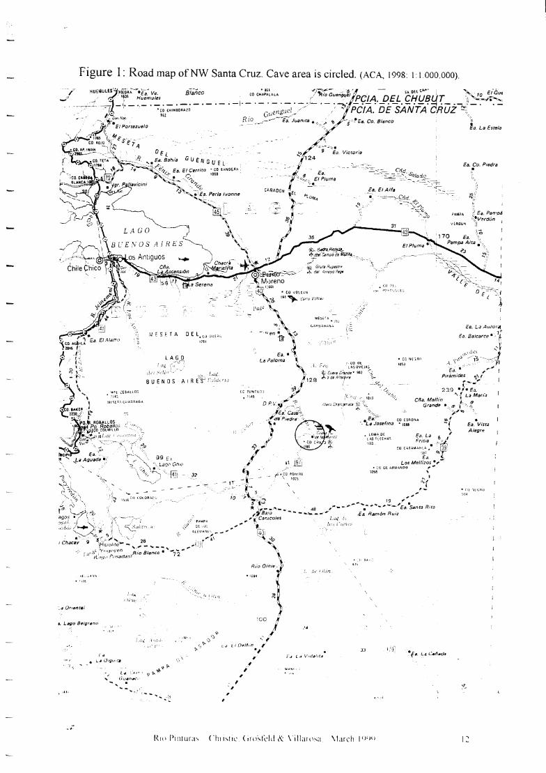
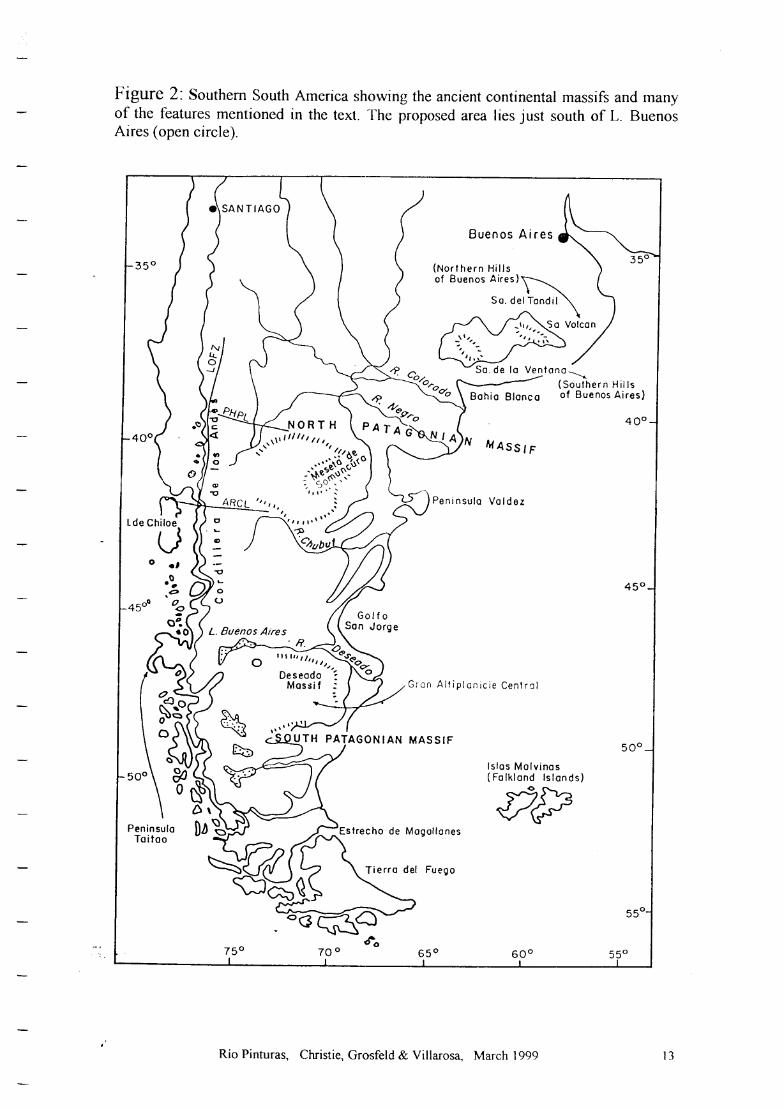

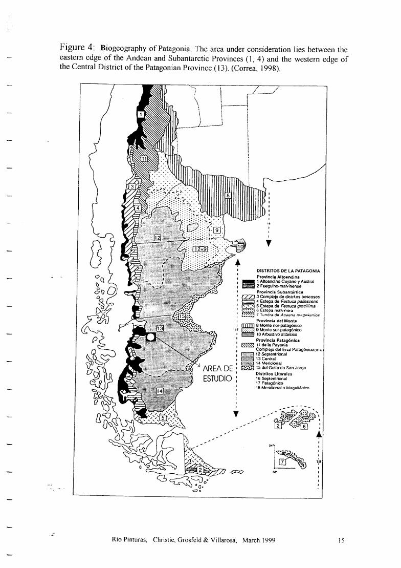

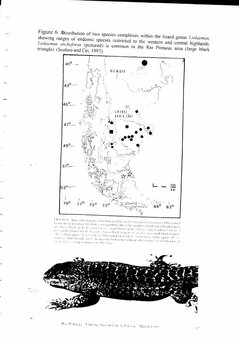

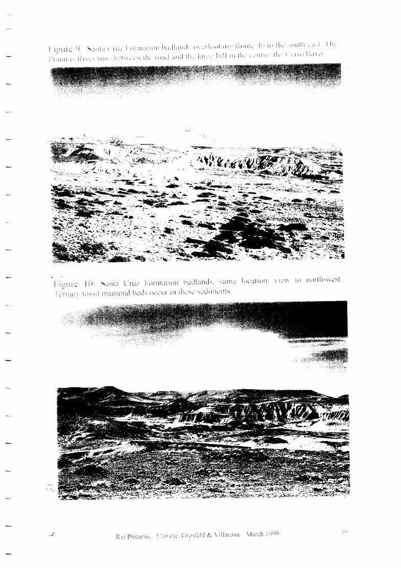
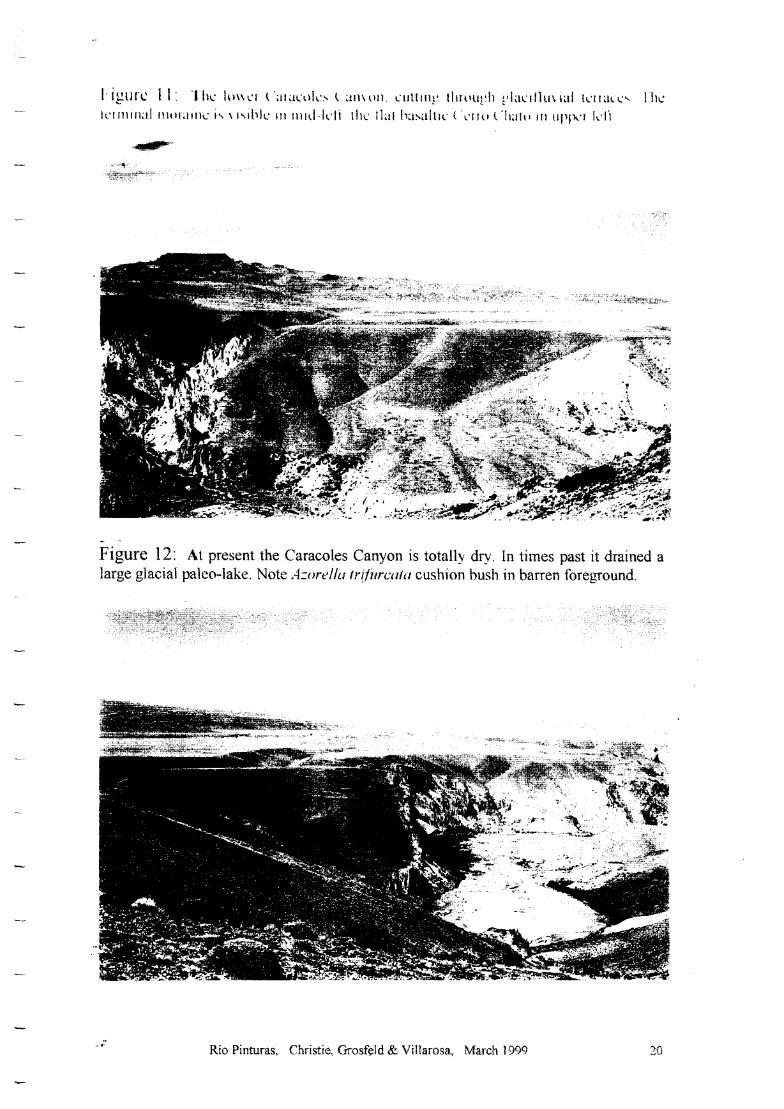
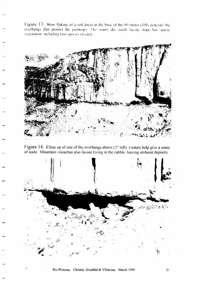
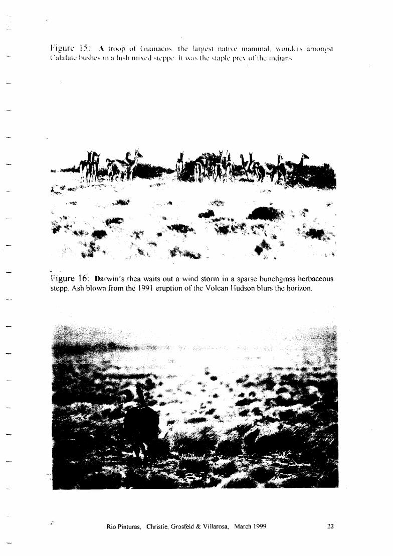

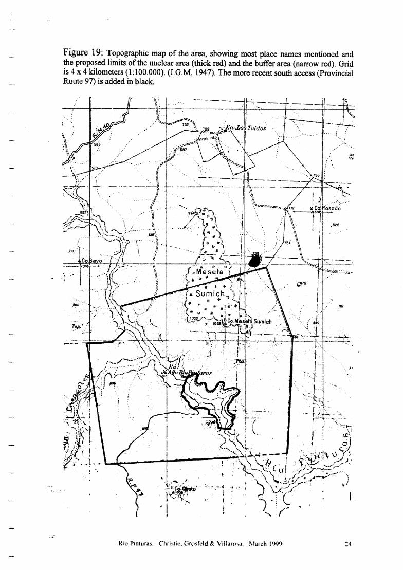
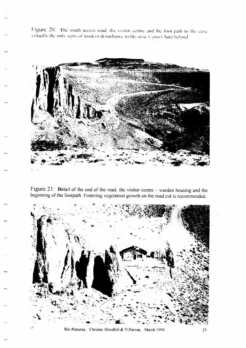
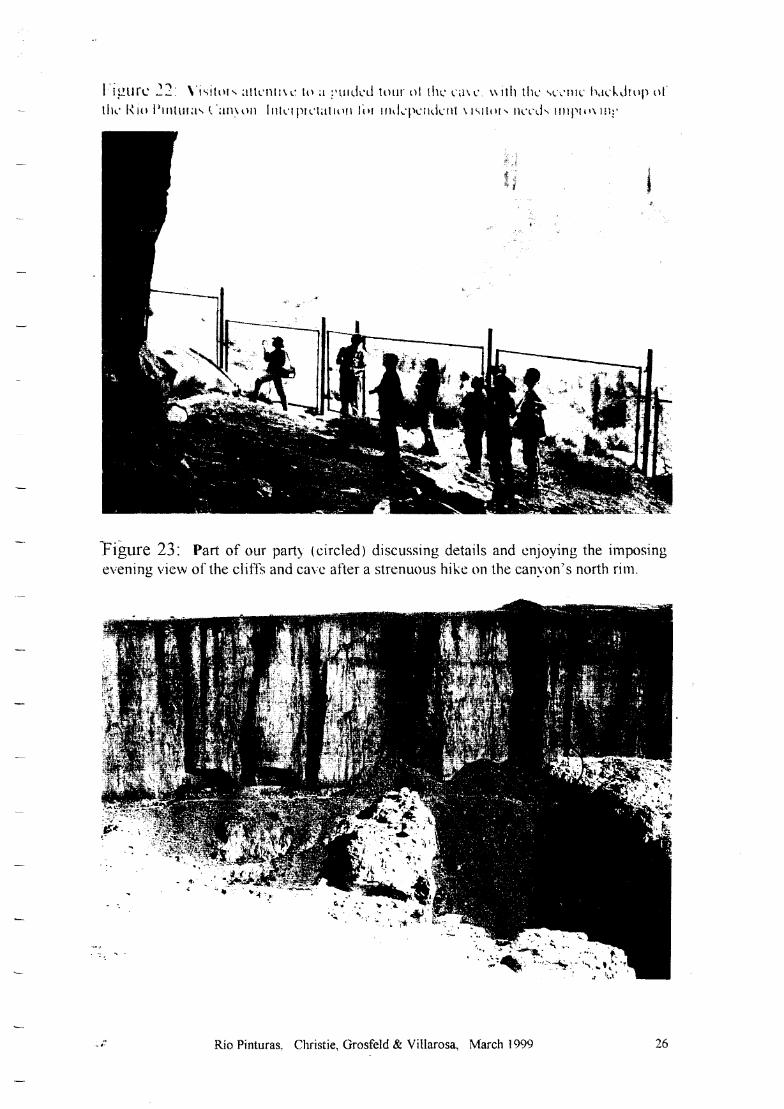
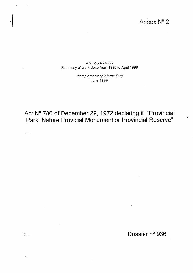
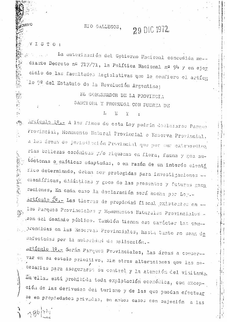


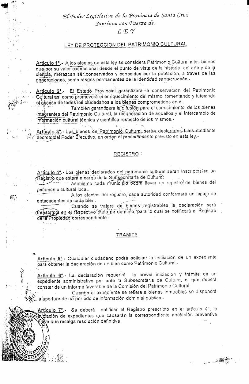
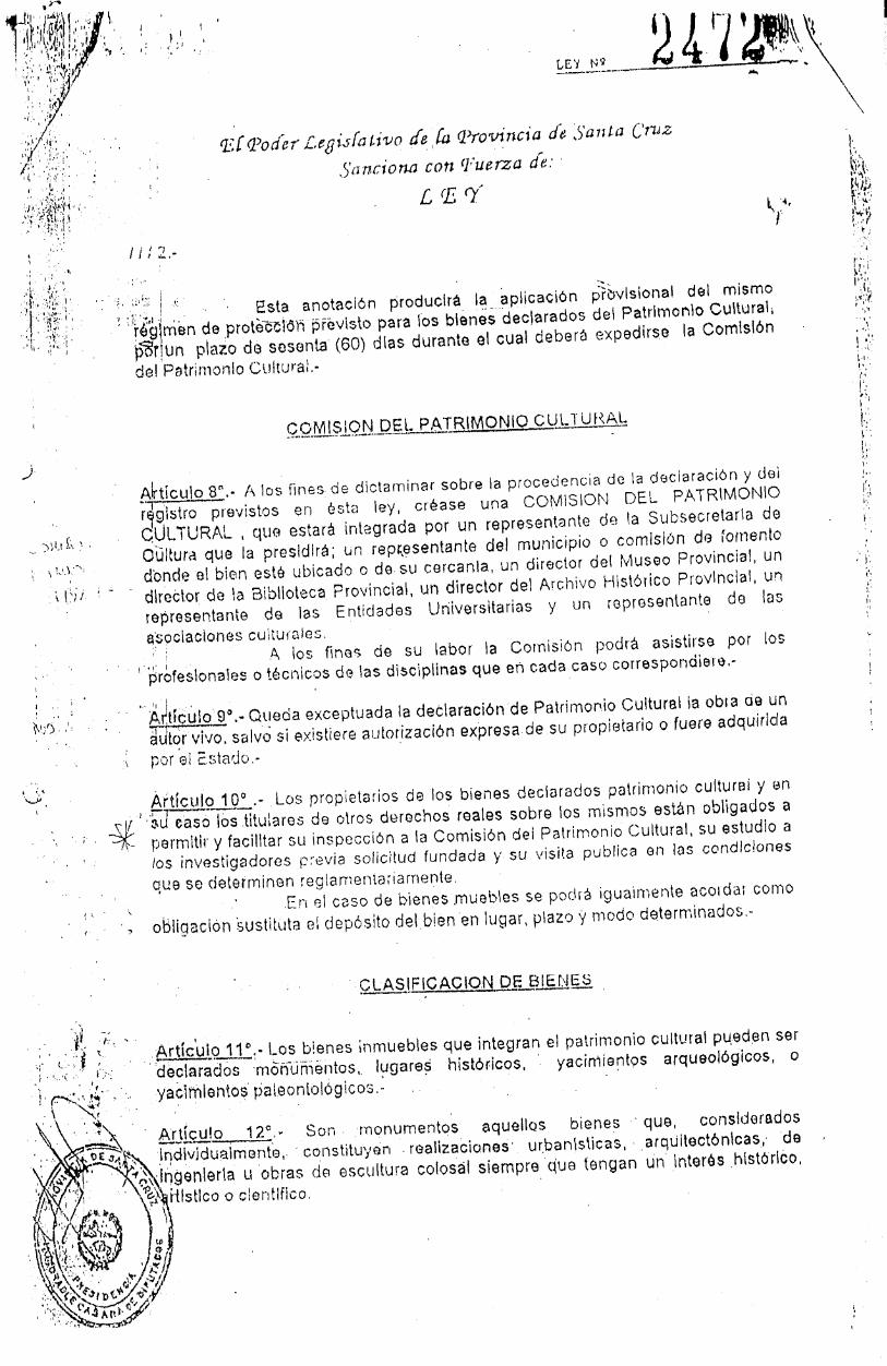
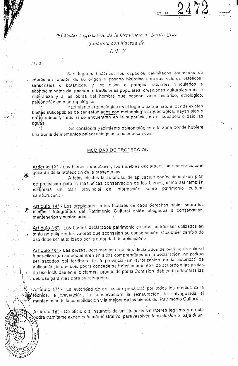
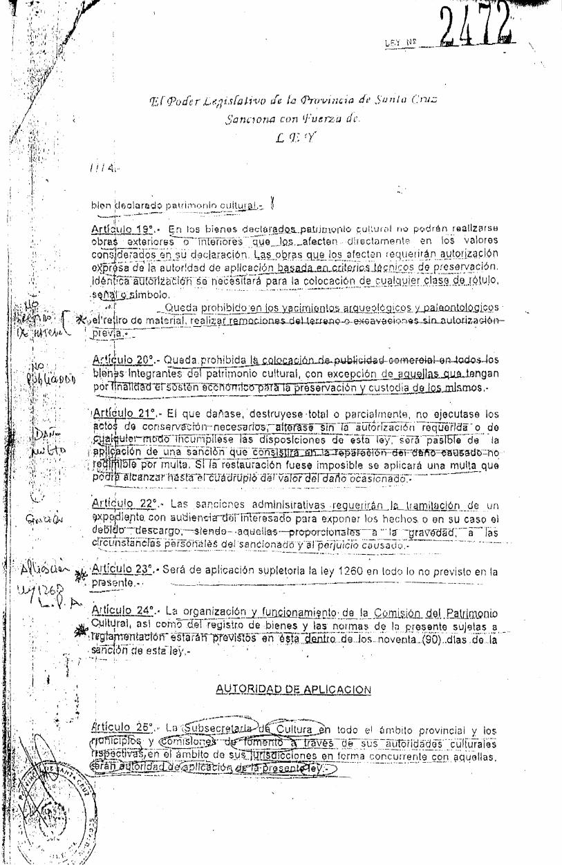


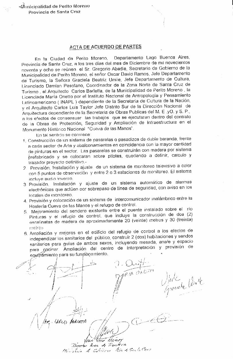
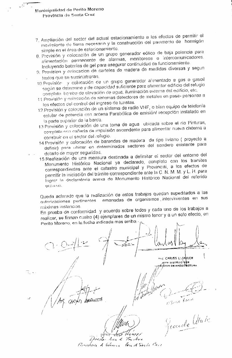

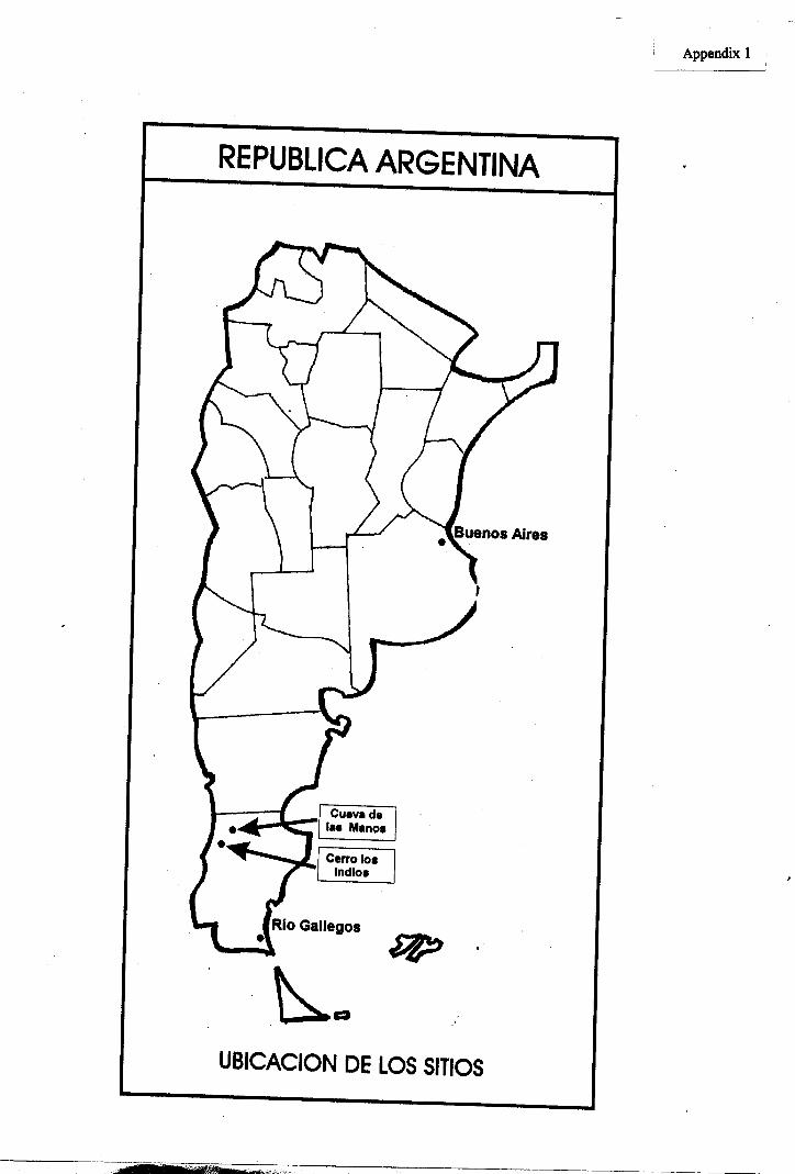
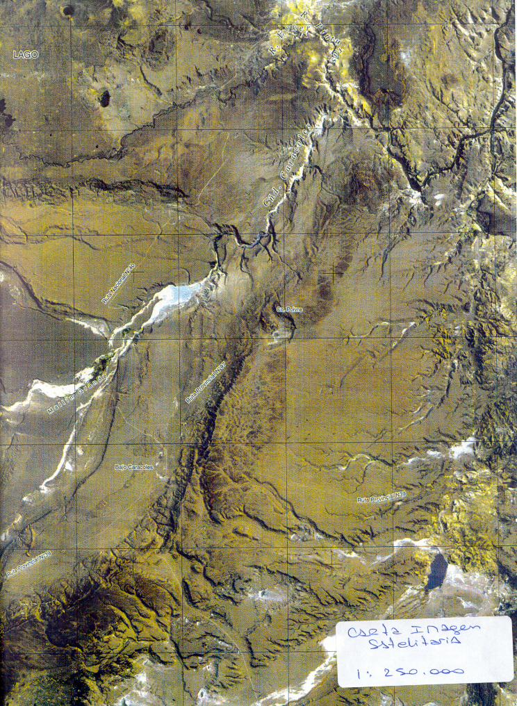

14
Río Pinturas (Argentina)
No 936
Identification
Nomination La Cueva de los Manos, Rio Pinturas
Location Patagonia Region, Santa Cruz Province
State Party Argentina
Date 30 June 1998
Justification by State Party
The Area Arqueológica y Natural Río Pinturas-Santa Cruz,which includes the archaeological site of the Cueva de losManos (Cave of the Hands) with its cave, rock shelters, androck walls decorated with magnificent paintings, is anoutstanding area because it contains the oldest artisticrepresentations belonging to the first hunter-gatherer groupswho inhabited what is now the territory of Argentina.
The artistic sequence, which includes three main stylisticgroups, began as early as the 10th millennium BP [BeforePresent]. It is one of the few rock-art sites from the EarlyHolocene Period in Patagonia that is still well preserved. Thesequence is a long one: archaeological investigations haveshown that the site was last inhabited around AD 700 by thepossible ancestors of the first Tehuelche people of Patagonia.The Cueva de los Manos is considered by the internationalscientific community to be one of the most important sites ofthe earliest hunter-gatherer groups in South America.
The Area Arqueológica y Natural Río Pinturas-Santa Cruz isan outstanding example of a prehistoric human habitat.Archaeological sites found on both sides of the Río PinturasCanyon are evidence of occupation by pre-Hispanic hunterswho made use of the resources of the canyon and itsenvironment.
The paintings on the rock shelters and cave are located in anoutstanding landscape, with the river running through a deepcanyon, and provide an incomparable aesthetic experiencefor the visitor. The hunting scenes depict animals and humanfigures interacting in a dynamic and naturalistic manner.Different hunting strategies are shown, with animals beingsurrounded, trapped in ambushes, or attacked by huntersusing their throwing weapons, round stones known as bolas.Some scenes shown individual hunters and others groups often or more men.
There is no doubt that the Area Arqueológica y Natural RíoPinturas-Santa Cruz has high symbolic value. Theinhabitants of Argentina are hardly aware of their pre-Hispanic past, since the links with that period were brokenby the Spanish conquest and in the subsequent colonization
of the territory. The Cueva de los Manos is one of the mostimportant testimonies to that past, and it is the archaeologicalsite best known to the Argentinian people.
[Note The State Party does not make any proposals in thenomination dossier concerning the criteria under which itconsiders this property should be inscribed on the WorldHeritage List.]
Category of property
In terms of the categories of cultural property set out inArticle 1 of the 1972 World Heritage Convention, this is asite.
History and Description
The progress of human penetration into South America is thesubject of intensive scientific debate at the present time.Some early radiocarbon dates from the north-eastern regionof Brazil have challenged the hitherto generally acceptedview that this began around 12,000 BP.
However, this does not affect the dating of the occupation ofthe Río Pinturas rock shelter, which has been established byexcavation and radiocarbon analysis to c 9300 BP. The firsthuman group (whose art is classified as Stylistic Group A)were long-distance hunters whose main prey was theguanaco.
Around 7000 BP a second cultural level can be identified,distinguished by Stylistic Group B. Hunting scenes are nolonger found, and the rock art is dominated by hand stencils.There are also some examples of stencils of the feet of theAmerican ostrich (ñandú). This culture lasted until c 3300BP, when the art became more schematic and includedhighly stylized zoomorphic and anthropomorphic figures.
The final cultural phase at Río Pinturas began around 1300BP. Its art (Stylistic Group C), executed in bright redpigments, concentrated on abstract geometric figures andhighly schematic representations of animals and humans. It isbelieved to have been the work of the historic Tehuelchehunter-gatherers who were inhabiting the vast area ofPatagonia when the first Spanish traders and settlers arrived.It was the creation of vast cattle ranches (estancias) thatbrought their way of life to an end.
The Area Arqueológica y Natural Río Pinturas-Santa Cruz islocated in the pampas section of the Pinturas River region.Low plateaux at an altitude of 800-1000m are cut by deepcanyons bordered by steep cliffs, the main one being that ofthe Pinturas itself. There are many natural rock shelters inthese cliffs. The soil is rocky and poor, but the regionsupports a diverse natural fauna, in which the guanaco(Lama guanicoe) figures prominently.
The climate of the canyons is temperate, since they areprotected from the winds that sweep the pampas. The mildwinter temperatures and the high humidity as compared withthe pampas make this region appropriate for seasonalgrazing of the cattle from the estancias. Palaeoclimaticstudies based on the sediments of the Cueva de los Manossuggest that the present conditions had been established by11,000 BP.
15
The entrance to the Cueva de los Manos is screened by arock wall that is covered by many hand stencils. Within therock shelter itself there are five concentrations of rock art.Later figures and motifs are frequently superimposed uponthose from earlier periods.
The paintings were executed with natural mineral pigmentsthat were ground and mixed with some form of binder, thenature of which is unknown. Traces of the pigments werefound in the archaeological excavations carried out in theentrance to the cave, thus establishing a contextual linkbetween the paintings and the stratified cultural material. X-ray diffraction analysis has shown that the most commonminerals used were iron oxides (hematite and maghemite) forred and purple, kaolin for white, natrojarosite for yellow, andmanganese oxide for black; gypsum was sometimes added tothe mixture.
Management and Protection
Legal status
The National Congress of the Argentine Republic declaredthe Cueva de los Manos an Historic National Monument byLaw No 24.225 of 20 July 1993. This was in accordancewith powers accorded by Law No 12.665 of 1940 to theNational Commission of Museums, Monuments, andHistoric Places.
At provincial level, the Government of the Province of SantaCruz declared the City of Perito Moreno as theArchaeological Capital of Santa Cruz, because of theimportance of the archaeological site of the Cueva de losManos, by Decree No 133 of 13 May 1981. Thepromulgation of a provincial bill on the Protection of theCultural Heritage is currently in progress.
Management
The 1993 National Law assigns responsibility for all actionsrelating to the Cueva de los Manos to the NationalCommission for Museums, Monuments, and Historic Placesand the Culture Secretariat of the Presidency of the Nation.
An Agreement for the Protection, Security, and Expansion ofInfrastructure in the National Historic Monument “Cueva delos Manos” was signed in December 1998 between theMunicipality of Perito Moreno, the local Departments ofCulture and Tourism, the Southern Directorate ofArchitecture (an agency of the national Secretariat of PublicWorks), and the National Institute of Anthropology andLatin-American Thought (Instituto Nacional deAntropología y Pensamiento Latinoamericano – INAPL),which reports to the Culture Secretariat of the Presidency.This agreement assigned responsibilities to each of thesebodies for specific activities within the framework of theAgreement.
INAPL began work on a management plan for the site in1995. The first phase, which was completed in 1997,involved comprehensive recording, survey, anddocumentation of the entire site, inventarization of the stateof conservation of the paintings, analysis of the reasons fordeterioration and sampling for analysis, and the creation of adatabase. This was accompanied by programmes ofeducation and public information, training of specialists, anddissemination of scientific results.
The second stage is under way. Activities in 1998 coveredthe preparation of bilingual interpretive material and signageand monitoring of the state of conservation of the paintings(including vandalism). A comprehensive site managementproposal that is being presented to the responsible authoritiescovers precise delimitation of the site and the erection of asecure barrier round it, the installation of two alternatingguardians permanently on the site, tighter control of touristvisits, the training of local guides and the provision offacilities for them, setting up regular opening and closinghours for visits, imposition of a charge for visits, provision ofadequate on-site signage, creation of an interpretation centre,and replacing the barrier with a boardwalk.
The area proposed for inscription covers 600ha: this isshown on the map accompanying the nomination dossier as arectangle surrounding the Cueva de los Manos. The bufferzone, however, which is not shown on the map, is only2.331ha. Both the site and the buffer zone are within theproperty of a private individual, who has signed anagreement consenting to the declaration of her land as aWorld Heritage site.
There is a guardian living on the site, which is remote fromany settlement, during the four summer months; he isassisted by his son and daughter. They are responsible forsupervision, security, and visitor management. Visitorsregister at a cabin on the site and must be accompanied by aguide. Organized tours from Perito Moreno are accompaniedby a national tourist guide who is a specialist in the Cueva delos Manos. Private visits are also organized by local estanciaowners as part of horse-riding or backpacking tours.
Conservation and Authenticity
Conservation history
Travellers have been visiting the Cueva de los Manos sincethe mid 19th century and recording their impressions of thepaintings. They were first mentioned in the scientificliterature during the present century, but it was not until the1960s that they became the subject of serious study byCarlos J Gradin and his co-workers. Their work on recordingand excavation established the importance of the Cueva delos Manos as a prehistoric rock-art site of internationalscientific importance.
The favourable conditions (very low humidity, no waterinfiltration, stable rock strata) at the rock shelter haveensured that the state of conservation of all but the mostexposed paintings is excellent.
However, the increase of tourism to Patagonia in recent yearshas resulted in damage from human vandalism. This hasincluded graffiti, removal of fragments of painted rock,touching of painted surfaces, accumulation of dust andrefuse, etc. Visitor numbers to the Cueva de los Manos haverisen from 123 in 1991/92 to 3027 in 1997/98. The presenceof a guardian on the site during the summer months, whenalmost all visits take place, and the installation of aprotective barrier in front of the paintings, which stretchalong some 680m, have helped to reduce damage of thiskind, but the need for better protection remains.
Authenticity
The authenticity of the rock art of the Cueva de los Manos isunquestionable. It has survived several millennia untouched
16
and no restoration has been carried out since it becamewidely known to the scientific community in the second halfof the 20th century. The archaeological excavations havebeen very restricted, so as to obtain the maximum culturalinformation for dating the art with the minimum disturbanceto archaeological layers or to the appearance of the rockshelter.
Evaluation
Action by ICOMOS
An ICOMOS expert mission visited the Area Arqueológica yNatural Río Pinturas-Santa Cruz in January/February 1999.ICOMOS also consulted its International ScientificCommittee on Rock Art.
Qualities
The rock art of the Cueva de los Manos in the AreaArqueológica y Natural Río Pinturas-Santa Cruz isexceptional, both for the range of its subject matter andexecution and its remarkable state of conservation afterseveral millennia.
Comparative analysis
The nomination dossier refers to several comparable rock-artsites in Patagonia, but concludes that they do not approachthe significance of the Cueva de los Manos.
In a comparative study carried out in 1998, the ICOMOSInternational Scientific Committee on Rock Art identified sixcriteria for evaluating rock-art sites: aesthetic qualities;ethnological qualities; archaeological and chronologicalqualities; environmental qualities; number of images in aprescribed area (sacred sites); and degree of protection. Inapplying these criteria, the study identified the Cueva de losManos as conforming in an exceptional manner with thesecriteria.
ICOMOS recommendations
There was considerable ambiguity about what was originallyproposed for inscription on the World Heritage List. Thearea shown on the map supplied seems to be a somewhatarbitrarily drawn rectangular area of 600ha. However, thenomination dossier concentrated entirely on the Cueva de losManos and its rock art. ICOMOS recommended that only therock-shelter site itself, with a small security and facilities areaaround it, should be delineated and proposed for inscription.The 600ha area shown in the nomination dossier could beretained as an appropriate buffer zone, since its role hasalready been acknowledged by the owner of the land. Thisproposal was accepted by the State Party.
ICOMOS was concerned about the management of the site,in the light of the remarkable growth of visitor numbers overthe present decade and the continued increase likely to resultfrom eventual World Heritage inscription. However, theState Party has informed ICOMOS that the proposals madefor the second phase of the INAPL programme were now inforce and constituted an official management plan, fullysupported by the responsible institutions.
Recommendation
That the title of the nominated property be changed to “TheCueva de los Manos, Río Pinturas” and that it be inscribedon the World Heritage List on the basis of criterion iii:
Criterion iii The Cueva de los Manos contains anoutstanding collection of prehistoric rock art which bearswitness to the culture of the earliest human societies inSouth America.
ICOMOS, September 1999
31
Río Pinturas (Argentine)
No 936
Identification
Bien proposé La Cueva de los Manos, Río Pinturas
Lieu Patagonie, province de Santa Cruz
État partie Argentine
Date 30 juin 1998
Justification émanant de l’État partie
L’Area Arqueológica y Natural Río Pinturas - SantaCruz, qui comprend le site archéologique de la Cuevade los Manos (la grotte des mains), avec ses grottes, sesabris-sous-roche et ses murs rocheux ornés demagnifiques peintures, est une zone remarquable, carelle abrite les plus anciennes représentations artistiquesdes premiers groupes d’habitants de ce qui estaujourd’hui l’Argentine, dont la civilisation reposait surla chasse et la cueillette.
La séquence artistique, qui inclut trois grands groupesstylistiques, commence dès le Xe millénaire. C’est l’undes rares sites d’art rupestre de l’Holocène ancien enPatagonie qui reste bien préservé. La séquence estlongue : les recherches archéologiques ont démontréque le site a été habité pour la dernière fois auxalentours de 700 après J.-C., par les probables ancêtresdu premier peuple Tehuelche de Patagonie. Lacommunauté scientifique internationale considère laCueva de los Manos comme l’un des plus importantssites des premiers groupes de chasseurs-cueilleurs enAmérique du Sud.
L’Area Arqueológica y Natural Río Pinturas - SantaCruz est un exemple remarquable d’habitat humainpréhistorique. En effet, les sites archéologiquesdécouverts des deux côtés du canyon Río Pinturasprouvent l’occupation des lieux par des chasseurspréhispaniques qui vivaient des ressources du canyon etde ses alentours.
Les peintures des abris et des grottes s’inscrivent dansun paysage remarquable, avec la rivière coulant dans unprofond canyon, et offrent au visiteur une expérienceesthétique incomparable. Les scènes de chassedépeignent des animaux et des figures humaines enpleine interaction, sur un mode dynamique etnaturaliste. Différentes techniques de chasse sontillustrées : les animaux sont encerclés, pris dans despièges ou attaqués par des chasseurs à l’aide de leursarmes de jet, des pierres rondes connues sous le nom de
bolas. Certaines scènes représentent des chasseurs seuls,d’autres des groupes de dix hommes ou plus.Il ne fait aucun doute que l’Area Arqueológica y NaturalRío Pinturas - Santa Cruz possède une grande valeursymbolique. Les Argentins n’ont que peu conscience deleur passé préhispanique, car la conquête espagnole et lacolonisation importante du territoire qui s’ensuivit ontbrisé les liens avec cette période. La Cueva de losManos est l’un des témoignages le plus important de cepassé ; c’est aussi le site archéologique que lesArgentins connaissent le mieux.
[Remarque L’État partie n’avance aucune hypothèsedans la proposition d’inscription quant aux critères envertu desquels il considère que ce bien devrait êtreinscrit sur la Liste du patrimoine mondial.]
Catégorie de bien
En termes de catégories de biens culturels, tellesqu’elles sont définies à l’article premier de laConvention du Patrimoine mondial de 1972, il s’agitd’un site.
Histoire et description
L’avancée des incursions humaines en Amérique duSud fait actuellement l’objet de débats passionnés ausein de la communauté scientifique. Certaines datationsau carbone 14 effectuées au Brésil, dans le Nordeste,remettent en effet en question l’opinion généralementrépandue jusqu’à présent, selon laquelle ces incursionsauraient commencé aux alentours de 12000 ans.
Toutefois, cela n’affecte pas la datation de l’occupationde l’abri-sous-roche Río Pinturas, qui, d’après lesfouilles et l’analyse au carbone 14, remonte à 9300 ans,environ. Le premier groupe humain (dont les peinturesconstituent le groupe stylistique A) chassait sur delongues distances et principalement le guanaco.
On peut identifier aux environs de 7000 ans un secondniveau culturel, baptisé groupe stylistique B. Les scènesde chasse disparaissent, l’art rupestre est dominé par desreprésentations en négatif de mains, parfois mêmed’empreintes d’autruche américaine (le nandou, ñandú).Cette culture a duré jusqu’en 3300 ans, environ, époqueà laquelle l’art devient plus schématique, intégrant desfigures zoomorphiques et anthropomorphiques trèsstylisées.
C’est aux alentours de 1300 ans que fut entamée ladernière phase culturelle de Río Pinturas. Les peinturesde cette période (groupe stylistique C), réalisées avecdes pigments rouges vifs, se concentraient sur desfigures géométriques abstraites et des représentationstrès schématiques d’animaux et d’humains. On pensequ’il s’agit là de l’œuvre des anciens chasseurs-cueilleurs Tehuelche, qui habitaient cette vaste régionqu’est la Patagonie avant l’arrivée des premiersmarchands et colons espagnols. La création de grandsélevages de bétail (estancias) a mis fin à leur mode devie.
32
L’Area Arqueológica y Natural Río Pinturas - SantaCruz est située dans la pampa de la région du fleuvePinturas. Ses plateaux peu élevés, culminant à 800-1000m, sont entrecoupés de profonds canyons bordés defalaises abruptes, dont le principal est celui du Pinturaslui-même. Ces falaises comptent nombre d’abris-sous-roche naturels. Le sol est rocheux et pauvre, mais larégion abrite une faune naturelle variée, au sein delaquelle le guanaco (Lama guanicoe) tient une placeprépondérante.
Le climat des canyons, abrités des vents qui balaient lapampa, est tempéré. Ainsi, grâce aux températureshivernales relativement douces et à l’humidité élevéepar rapport à la pampa, le bétail des estancias peut ypaître de façon saisonnière. Des étudespaléoclimatologiques basées sur les sédiments de laCueva de los Manos suggèrent que les conditionsactuelles étaient déjà présentes dès 11000 ans.
L’entrée de la Cueva de los Manos est masquée par unmur de roche couvert de nombreuses mains négatives.Dans l’abri lui-même, on compte cinq concentrationsd’art rupestre, les figures et les motifs les plus récents sesuperposant fréquemment aux plus anciens.
Ces peintures ont été exécutées à l’aide de pigmentsminéraux naturels, moulus et mélangés à un quelconqueliant, dont la nature est inconnue. Des traces depigments ont été découvertes lors de fouillesarchéologiques conduites à l’entrée de la grotte,établissant ainsi un lien contextuel entre les peintures etles matériaux culturels stratifiés. L’analyse pardiffraction des rayons X montre que les minéraux lesplus communément utilisés étaient les oxydes de fer(hématite et maghémite) pour le rouge et le violet, lekaolin pour le blanc, le natrojarosite pour le jaune, etl’oxyde de manganèse pour le noir ; du gypse étaitparfois ajouté au mélange.
Gestion et protection
Statut juridique
Le Congrès national de la République argentine a classéla Cueva de los Manos monument historique national envertu de la loi n° 24.225 du 20 juillet 1993 etconformément aux pouvoirs accordés par la loi n°12.665 de 1940 à la Commission nationale des musées,monuments et lieux historiques.
Au niveau provincial, le gouvernement de la provincede Santa Cruz a déclaré la ville de Perito Morenocapitale archéologique de Santa Cruz, du fait del’importance du site archéologique de la Cueva de losManos, par décret n° 133 du 13 mai 1981. En outre, unprojet de loi provinciale sur la protection du patrimoineculturel est actuellement en cours d’adoption.
Gestion
La loi nationale de 1993, pour sa part, assigne laresponsabilité de toutes les actions relatives à la Cuevade los Manos à la Commission nationale des musées,
monuments et lieux historiques, ainsi qu’au secrétariatde la Culture de la Présidence de la nation.
En outre, un accord pour la protection, la sécurité etl’expansion de l’infrastructure du monument historiquenational « Cueva de los Manos » a été signé endécembre 1998 entre la municipalité de Perito Moreno,les directions locales de la Culture et du Tourisme, ladirection méridionale de l’Architecture (agence dusecrétariat national des Travaux publics), et l’Institutnational de l’anthropologie et de la pensée latino-américaine (Instituto Nacional de Antropología yPensamiento Latinoamericano – INAPL), ce dernierétant chapeauté par le secrétariat de la Culture de laPrésidence. Cet accord assigne à chacun de cesorganismes la responsabilité d’activités données dans lecadre de l’accord même.
L’INAPL a commencé à travailler sur un plan degestion du site en 1995. La première phase, achevée en1997, impliquait un inventaire détaillé, une étude et unedocumentation exhaustive du site entier, l’inventaire del’état de conservation des peintures, l’analyse desraisons de la détérioration, le prélèvementd’échantillons en vue d’une analyse, et la création d’unebase de données. Elle s’accompagnait de programmesd’éducation et d’information publique, de formation despécialistes et de diffusion des résultats scientifiques.
La seconde phase est actuellement en cours. En 1998,les activités couvraient la préparation de matérielsd’information bilingues et le suivi de l’état deconservation des peintures (y compris du vandalisme).En outre, une proposition exhaustive de gestion du siteactuellement présentée aux autorités compétentes traitede la délimitation précise du site et de l’érection d’uneclôture sûre autour de celui-ci, de l’installation de deuxgardiens, en alternance, assurant une présencepermanente sur le site, d’un contrôle plus strict desvisites touristiques, de la formation de guides locaux etde l’aménagement d’infrastructures à leur intention, del’organisation d’heures régulières d’ouverture et defermeture pour les visites, d’un droit d’entrée, del’installation de panneaux signalétiques appropriés surle site, de la création d’un centre d’information, et duremplacement de la clôture par une passerelle en bois.
La zone proposée pour inscription couvre 600 hectares :sur la carte accompagnant le dossier de propositiond’inscription, elle apparaît comme un rectangleentourant la Cueva de los Manos. Cependant, la zonetampon, qui n’apparaît pas sur la carte, ne couvre que2331 hectares. Le site et la zone tampon sont tous deuxsitués dans la propriété d’une particulière, qui a signé unaccord par lequel elle consent à ce que sa terre soitinscrite sur la Liste du patrimoine mondial.
Un gardien vit sur le site, isolé de tout lieu depeuplement, pendant les quatre mois d’été ; il est assistépar son fils et sa fille. Tous trois sont responsables ducontrôle, de la sécurité et de la gestion des visiteurs. Cesderniers s’inscrivent à un guichet situé sur le site etdoivent être accompagnés d’un guide. Des visitesorganisées à partir de Perito Moreno sont accompagnéespar un guide touristique national, spécialiste de la Cuevade los Manos, tandis que des visites privées sont
33
également organisées par les propriétaires des estanciaslocales, dans le cadre de randonnées équestres oupédestres.
Conservation et authenticité
Historique de la conservation
Depuis le milieu du XIXe siècle, les voyageurs visitent laCueva de los Manos et enregistrent leurs impressionsdes peintures. Ces dernières apparaissent pour lapremière fois dans la littérature scientifique au cours denotre siècle, mais ce n’est que dans les années soixantequ’elles font l’objet d’une étude sérieuse, réalisée parCarlos J. Gradin et ses collaborateurs. Leur travail surl’enregistrement et les fouilles a établi l’importance dela Cueva de los Manos comme site d’art rupestrepréhistorique d’envergure scientifique internationale.Les conditions favorables (humidité très faible, absenced’infiltrations d’eau, strates rocheuses stables) dansl’abri-sous-roche ont assuré un état de conservationexcellent pour la quasi-totalité des peintures, exceptionfaite des plus exposées.
Toutefois, l’augmentation du tourisme en Patagonie cesdernières années a entraîné des dégâts dus auvandalisme : graffiti, vols de fragments de roche peinte,contact avec les surfaces peintes, accumulation depoussière et d’ordures, etc. De 123 en 1991-1992, lenombre des visiteurs de la Cueva de los Manos est passéà 3027 en 1997-1998. La présence d’un gardien sur lesite pendant les mois d’été, où ont lieu presque toutesles visites, et l’installation d’une barrière de protectiondevant les peintures sur une longueur de 680 m ontfavorisé la réduction des dégâts de ce type, mais lerenforcement de la protection continue de s’imposer.
Authenticité
L’authenticité de l’art rupestre de la Cueva de losManos ne fait absolument aucun doute. Il est en effetresté intact pendant plusieurs millénaires, et aucunerestauration n’a été effectuée, puisqu’il n’estlargement connu de la communauté scientifique quedepuis la seconde moitié du XXe siècle. Les fouillesarchéologiques ont en outre été limitées, de façon àobtenir le maximum d’informations culturelles et àpermettre la datation des peintures en troublant lemoins possible les différentes couches archéologiqueset l’aspect de l’abri-sous-roche.
Évaluation
Action de l’ICOMOS
Une mission d’expertise de l’ICOMOS a visité l’AreaArqueológica y Natural Río Pinturas - Santa Cruz enjanvier/février 1999. L’ICOMOS a également consultéson Comité scientifique international sur l’artrupestre.
Caractéristiques
L’art rupestre de la Cueva de los Manos, dans l’AreaArqueológica y Natural Río Pinturas - Santa Cruz, estexceptionnel, tant par l’étendue de sa thématique et
par son exécution que par son état remarquable deconservation après plusieurs millénaires d’existence.
Analyse comparative
La proposition d’inscription fait référence à plusieurssites d’art rupestre comparables en Patagonie, pourfinalement parvenir à la conclusion qu’ils sont loind’égaler, en termes de signification, la Cueva de losManos.
Dans une étude comparative réalisée en 1998, le Comitéscientifique international de l’ICOMOS sur l’artrupestre identifiait six critères d’évaluation des sitesd’art rupestre : qualités esthétiques ; qualitésethnologiques ; qualités archéologiques etchronologiques ; qualités environnementales ; nombredes représentations sur une superficie bien délimitée(lieux sacrés) ; degré de protection. L’étude, enappliquant ces critères, a estimé que la Cueva de losManos les satisfaisait de manière exceptionnelle.
Recommandations de l’ICOMOS
Une certaine ambiguïté sous-tendait la propositiond’inscription sur la Liste du patrimoine mondial. Eneffet, la zone montrée sur la carte fournie semble être unrectangle quelque peu arbitraire de 600 hectares.Pourtant, la proposition d’inscription se concentraitexclusivement sur la Cueva de los Manos et son artrupestre. L’ICOMOS a recommandé que seul le site del’abri-sous-roche lui-même, avec une petite zone desécurité et d’infrastructures autour de lui, soit délimité etproposé pour inscription. La zone de 600 hectares quiapparaît dans la proposition pourrait être retenue commezone tampon adéquate, son rôle ayant déjà été reconnupar la propriétaire du terrain. Cette proposition avait étéacceptée par l’Etat partie.
L’ICOMOS était préoccupé par la gestion du site, à lalumière de l’incroyable augmentation du nombre devisiteurs ces dix dernières années, tendance que devraitconfirmer une éventuelle inscription sur la Liste dupatrimoine mondial. Toutefois, l’Etat partie a informél’ICOMOS que les propositions faites pour la secondephase du programme de l’INAPL sont maintenant misesen oeuvre et constituent un plan de gestion officiel toutà fait soutenu par les institutions responsables.
Recommandation
Que l’intitulé du bien proposé pour inscription soitchangé en « La Cueva de los Manos, Río Pinturas » etque ce bien soit inscrit sur la Liste du Patrimoinemondial sur la base du critère iii :
La Cueva de los Manos renferme un ensembleexceptionnel d’art rupestre préhistorique quitémoigne de la culture des premières sociétéshumaines en Amérique du Sud.
ICOMOS, septembre 1999