the da ming hunyi tu: repurposing a ming map for sino ... · the da ming hunyi tu: repurposing a...
TRANSCRIPT

Cross-Currents: East Asian History and Culture Review
E-Journal No. 21 (December 2016) • (http://cross-currents.berkeley.edu/e-journal/issue-21)
The Da Ming Hunyi Tu: Repurposing a Ming Map for Sino-African Diplomacy Alexander Akin, Bolerium Books Abstract In 2002, an exhibition at South Africa’s parliament included a reproduction of the Da Ming Hunyi Tu (Amalgamated map of the Great Ming), citing it as the earliest world map to depict the entire African continent. As part of its broader efforts to shape a narrative of long-standing and peaceful international relations with Africa, the People’s Republic of China formally presented a replica of this map as a gift to the South African government in conjunction with the exhibition. In official statements and popular media coverage alike, the map was described as evidence of a distinctly Chinese approach to global relations, based on benevolence and mutual respect. In particular, the map was ahistorically intertwined with the legacy of Zheng He’s diplomatic expeditions, which reached the East African coast in the early 1400s. To the cartographic historian, however, the depiction of Africa in the Da Ming Hunyi Tu is clearly derived from non-Chinese sources that predate Zheng He’s expeditions. This article examines the ways in which the map has been divorced from its original context to suit modern needs, exemplifying the deployment of cartography to deflect anxieties about the nature of Chinese economic influence in South Africa. Keywords: Da Ming Hunyi Tu, China, South Africa, cartography, diplomacy, Zheng He, Ming
In 2002, South Africa hosted the Parliamentary Millennium Project (PMP) in Cape Town.
Featuring a series of exhibitions and addresses by dignitaries, the project proclaimed a new era in
world history: one in which Eurocentrism in Africa had given way to a new age not only of
political independence but also of ideological independence. Part of this vision for the future
included allowing Africa to map its own destiny, and to deconstruct and challenge the mapping
of the past. Exhibits connected with the project used historical maps to re-envision global
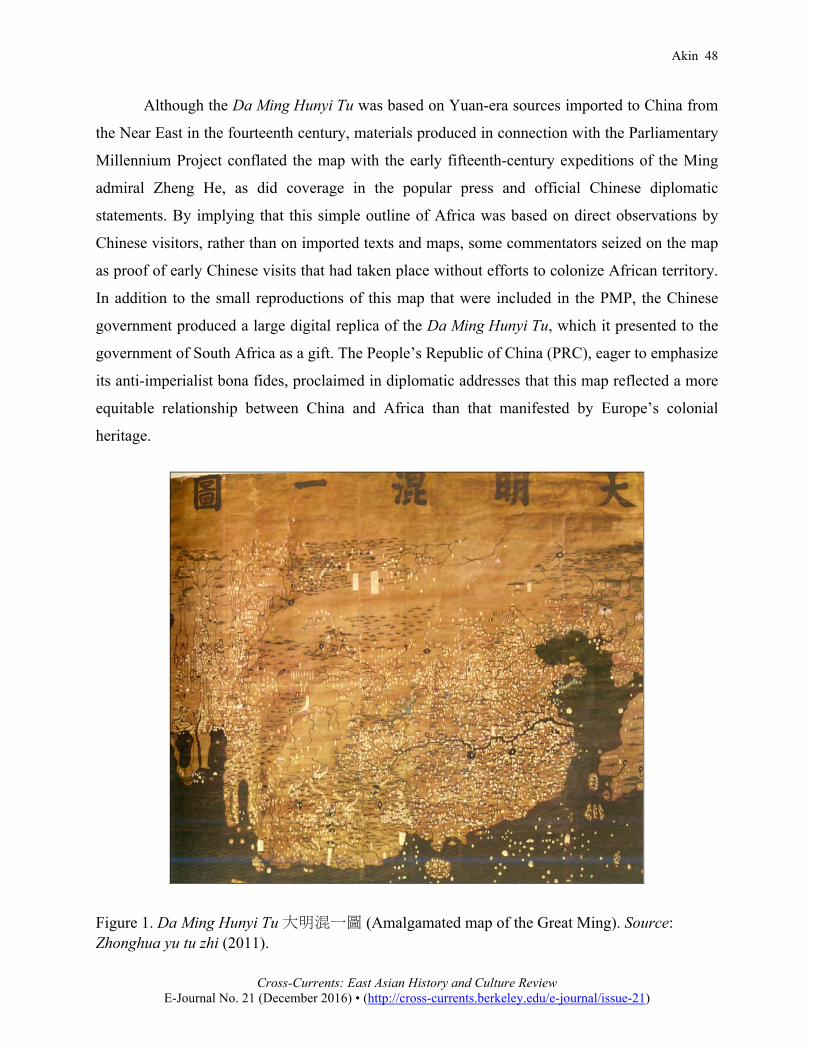
relationships of the past and future. One of these maps was the Da Ming Hunyi Tu
(Amalgamated map of the Great Ming), a 600-year-old depiction of China’s known world (figure
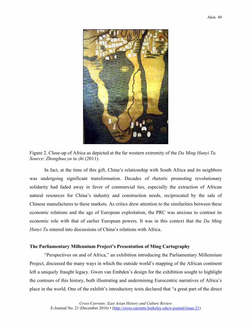
1). This map included a small rendering of Africa at its far western edge (figure 2).
Akin 48
Cross-Currents: East Asian History and Culture Review
E-Journal No. 21 (December 2016) • (http://cross-currents.berkeley.edu/e-journal/issue-21)
Although the Da Ming Hunyi Tu was based on Yuan-era sources imported to China from
the Near East in the fourteenth century, materials produced in connection with the Parliamentary
Millennium Project conflated the map with the early fifteenth-century expeditions of the Ming
admiral Zheng He, as did coverage in the popular press and official Chinese diplomatic
statements. By implying that this simple outline of Africa was based on direct observations by
Chinese visitors, rather than on imported texts and maps, some commentators seized on the map
as proof of early Chinese visits that had taken place without efforts to colonize African territory.
In addition to the small reproductions of this map that were included in the PMP, the Chinese
government produced a large digital replica of the Da Ming Hunyi Tu, which it presented to the
government of South Africa as a gift. The People’s Republic of China (PRC), eager to emphasize
its anti-imperialist bona fides, proclaimed in diplomatic addresses that this map reflected a more
equitable relationship between China and Africa than that manifested by Europe’s colonial
heritage.
Figure 1. Da Ming Hunyi Tu 大明混一圖 (Amalgamated map of the Great Ming). Source: Zhonghua yu tu zhi (2011).
Akin 49
Cross-Currents: East Asian History and Culture Review
E-Journal No. 21 (December 2016) • (http://cross-currents.berkeley.edu/e-journal/issue-21)
Figure 2. Close-up of Africa as depicted at the far western extremity of the Da Ming Hunyi Tu. Source: Zhonghua yu tu zhi (2011).
In fact, at the time of this gift, China’s relationship with South Africa and its neighbors
was undergoing significant transformation. Decades of rhetoric promoting revolutionary
solidarity had faded away in favor of commercial ties, especially the extraction of African
natural resources for China’s industry and construction needs, reciprocated by the sale of
Chinese manufactures to these markets. As critics drew attention to the similarities between these
economic relations and the age of European exploitation, the PRC was anxious to contrast its
economic role with that of earlier European powers. It was in this context that the Da Ming
Hunyi Tu entered into discussions of China’s relations with Africa.
The Parliamentary Millennium Project’s Presentation of Ming Cartography
“Perspectives on and of Africa,” an exhibition introducing the Parliamentary Millennium
Project, discussed the many ways in which the outside world’s mapping of the African continent
left a uniquely fraught legacy. Gwen van Embden’s design for the exhibition sought to highlight
the contours of this history, both illustrating and undermining Eurocentric narratives of Africa’s
place in the world. One of the exhibit’s introductory texts declared that “a great part of the direct
Akin 50
Cross-Currents: East Asian History and Culture Review
E-Journal No. 21 (December 2016) • (http://cross-currents.berkeley.edu/e-journal/issue-21)
lived experience of the people of Africa has been shaped by maps and mapping. For many
people of the world maps are mere tools for guiding travel or identifying place. For Africa and
Africans maps have had a far more fundamental impact on their progress” (van Embden
2002). The exhibition noted in particular the early role of China at a time when Europe was in
disarray and not yet capable of its later forays around and into the continent:
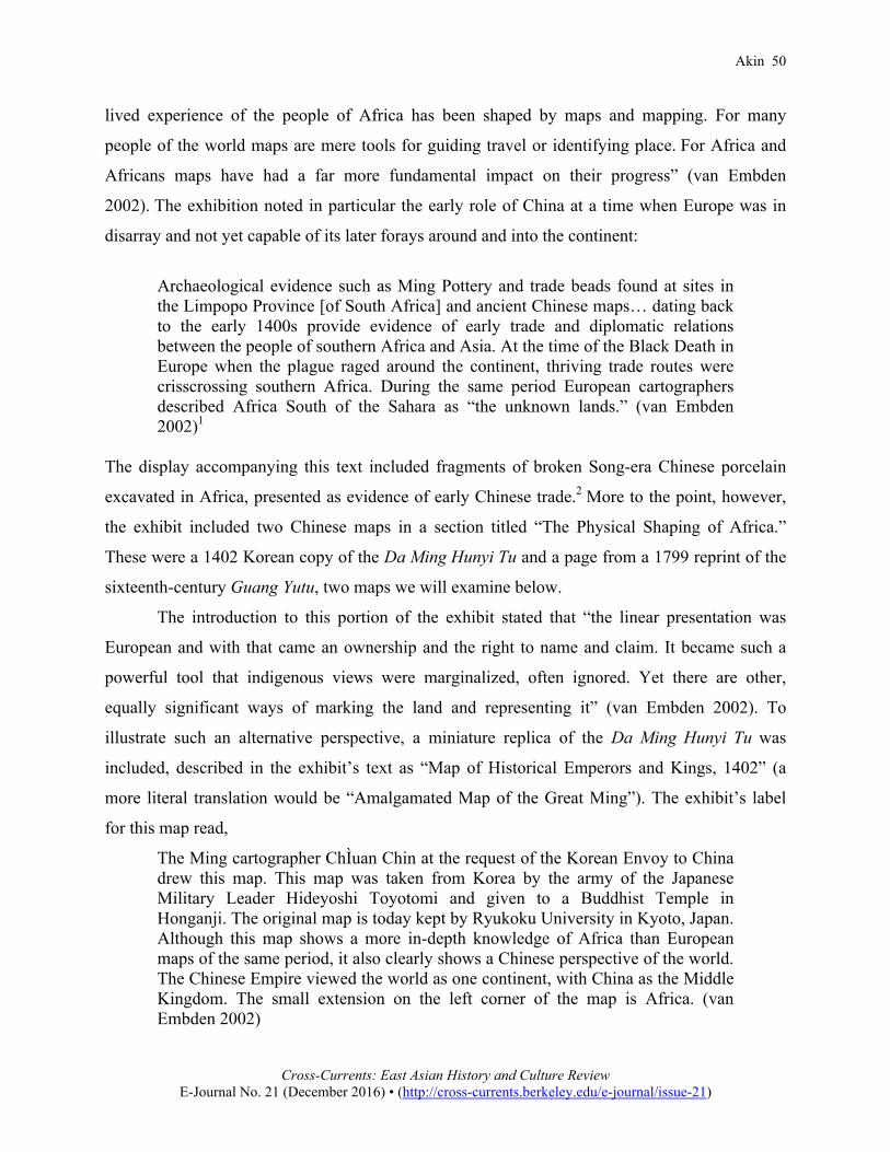
Archaeological evidence such as Ming Pottery and trade beads found at sites in the Limpopo Province [of South Africa] and ancient Chinese maps… dating back to the early 1400s provide evidence of early trade and diplomatic relations between the people of southern Africa and Asia. At the time of the Black Death in Europe when the plague raged around the continent, thriving trade routes were crisscrossing southern Africa. During the same period European cartographers described Africa South of the Sahara as “the unknown lands.” (van Embden 2002)1
The display accompanying this text included fragments of broken Song-era Chinese porcelain
excavated in Africa, presented as evidence of early Chinese trade.2 More to the point, however,
the exhibit included two Chinese maps in a section titled “The Physical Shaping of Africa.”
These were a 1402 Korean copy of the Da Ming Hunyi Tu and a page from a 1799 reprint of the
sixteenth-century Guang Yutu, two maps we will examine below.
The introduction to this portion of the exhibit stated that “the linear presentation was
European and with that came an ownership and the right to name and claim. It became such a
powerful tool that indigenous views were marginalized, often ignored. Yet there are other,
equally significant ways of marking the land and representing it” (van Embden 2002). To
illustrate such an alternative perspective, a miniature replica of the Da Ming Hunyi Tu was
included, described in the exhibit’s text as “Map of Historical Emperors and Kings, 1402” (a
more literal translation would be “Amalgamated Map of the Great Ming”). The exhibit’s label
for this map read,
The Ming cartographer ChÌuan Chin at the request of the Korean Envoy to China drew this map. This map was taken from Korea by the army of the Japanese Military Leader Hideyoshi Toyotomi and given to a Buddhist Temple in Honganji. The original map is today kept by Ryukoku University in Kyoto, Japan. Although this map shows a more in-depth knowledge of Africa than European maps of the same period, it also clearly shows a Chinese perspective of the world. The Chinese Empire viewed the world as one continent, with China as the Middle Kingdom. The small extension on the left corner of the map is Africa. (van Embden 2002)

Akin 51
Cross-Currents: East Asian History and Culture Review
E-Journal No. 21 (December 2016) • (http://cross-currents.berkeley.edu/e-journal/issue-21)
The caption reflects some confusion about the map and its authorship. ChÌuan Chin, credited
with creating the Da Ming Hunyi Tu, is a typographical error for Chʻüan Chin (pinyin Quan Jin).
This is actually the Chinese pronunciation of the name Gwon Geun 權近, who was a Korean
rather than a Chinese official. The map on display is a 1402 Korean copy of the original Da
Ming Hunyi Tu, which is thought to date to approximately 1389.3
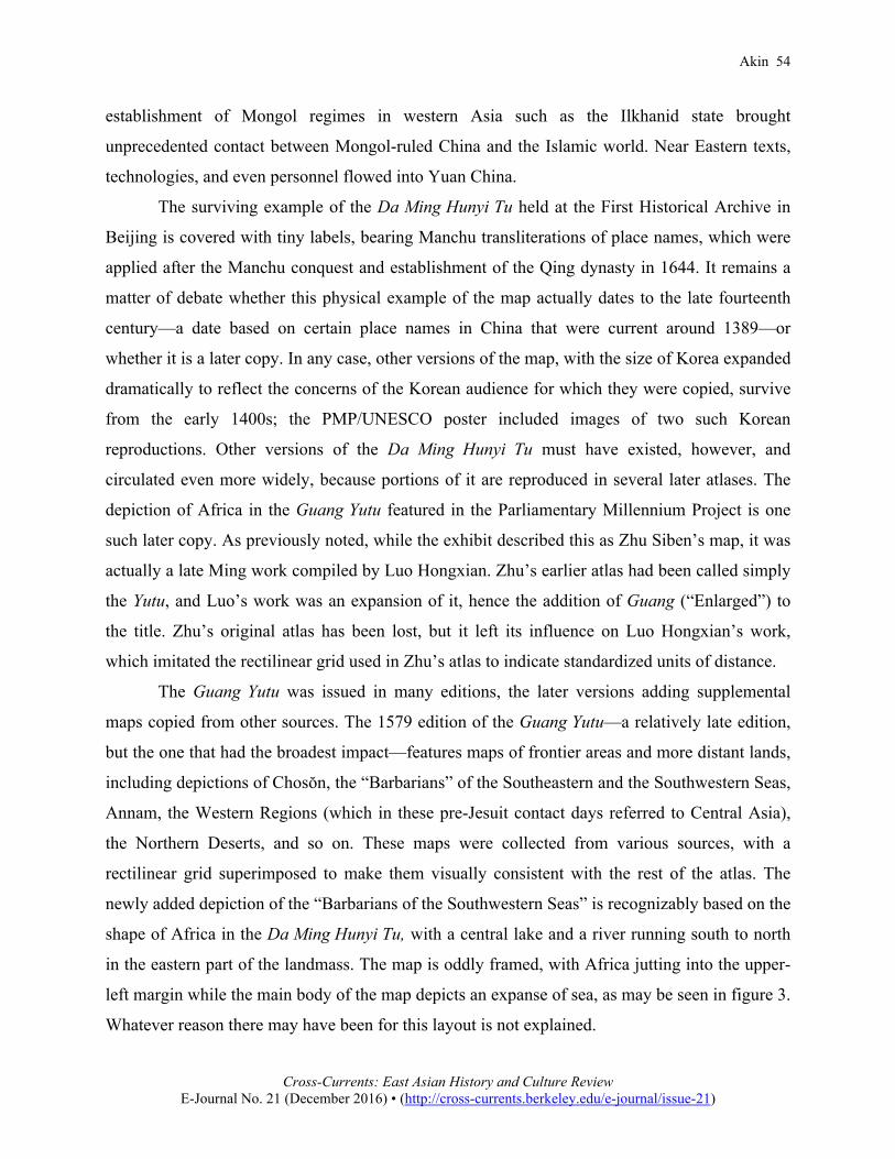
Figure 3. Map showing the “Barbarians of the Southwestern Seas.” The lower portion of Africa, derived from the Da Ming Hunyi Tu, can be seen at upper left. Source: Luo (1969).
Together with this map was displayed a copy of the printed map of Africa from the
Guang Yutu (Enlarged terrestrial atlas) of Luo Hongxian (figure 3), with the following label:
The presentation of the southern part of Africa in the world atlas Kuang Ju Thu by Chu Ssn-Pen c 1315, first printed c 1555 (ed. of 1799). Already in Chu’s time the Chinese knew that the continent pointed due south and not eastwards. It is interesting to find that the centre of the land-mass is shown as a vast lake, probably because... the existence of one or more of the great east-centred African lakes (Nyasa, Tanganyika, Victoria, etc.) was known. (van Embden 2002)
Akin 52
Cross-Currents: East Asian History and Culture Review
E-Journal No. 21 (December 2016) • (http://cross-currents.berkeley.edu/e-journal/issue-21)
In this caption for the second map, the authorship of the Guang Yutu is attributed to Zhu Siben
(using an obsolete transliteration). Actually, Zhu Siben’s atlas, the Yutu (Terrestrial atlas), is long
lost, but Luo Hongxian used it as his inspiration in creating the Guang Yutu (Enlarged terrestrial
atlas), in the mid-sixteenth century. The caption conflates the two men, who lived in different
centuries. The Guang Yutu was reprinted many times; the 1799 date given here represents the
most common later reprint. We will return to these maps in a moment.
The Parliamentary Millennium Project, in conjunction with UNESCO, produced a poster
based on this exhibit (figure 4). Titled “Eastern Perspectives and the Mapping of Africa,” it
features two Korean copies of the Da Ming Hunyi Tu, which are described as deriving from Zhu
Siben’s Terrestrial Map of 1320 (Parliamentary Millennium Project 2008).4 Zhu’s map (which,
as we recall, is actually lost, its influence known only from later derivative maps) is said to be
“the first map that accurately shows the south-pointing shape of the African continent as being
peninsular.” The text notes that the Da Ming Hunyi Tu is derived from that earlier map by Zhu.
In fact, we should note that it is only the portion of the map showing the region of China and its
immediate neighbors that is based on Zhu’s map. The portion of the map showing the western
regions, including the depiction of Africa at the center of our inquiry here, are believed to have
been copied from a different precursor, the Shengjiao Guangbei Tu 聲教廣被圖 (Map of the vast
reach of the sacred teaching) created by Li Zemin during the Yuan dynasty.
The PMP/UNESCO poster depicts a hale and hearty Zheng He, dressed in a dragon robe
and cap. Zheng’s ship is portrayed next to one of Columbus’s vessels, the difference in size
greatly exaggerated to highlight a sense of Chinese technical superiority.5 The poster says of
Zheng He:
As the “Admiral of the Western Sea” Zheng He led China’s most ambitious voyages of discovery. He was ordered by the Ming Emperor to sail to “the countries beyond the horizon… all the way to the end of the earth… to display the might of Chinese power and collect tribute… from beyond the seas.” Between 1405 and 1433 Zheng He made seven voyages that took him as far as the eastern coast of Africa—or perhaps even beyond. For his first voyage Zheng He amassed more than 300 vessels with some 30,000 men! Many of these vessels were more than 130 meters long and 60 meters wide. The extraordinary size of these ships is illustrated by the superimposition of Columbus’s ships against Zheng He’s treasure ship. Throughout his seven voyages Zheng He visited more than 30 countries before collecting marvelous treasures and tribute for the Ming. (Parliamentary Millennium Project 2008)

Akin 53
Cross-Currents: East Asian History and Culture Review
E-Journal No. 21 (December 2016) • (http://cross-currents.berkeley.edu/e-journal/issue-21)
In the poster’s statement that Zheng He went “as far as the eastern coast of Africa—or perhaps
even beyond,” we see the influence of British author Gavin Menzies’s farfetched and universally
discredited book 1421: The Year China Discovered America, in which he claims that Zheng He’s
fleet not only circumnavigated Africa but continued all around the world. This poster does not
explain, however, what Zheng He’s voyages in the early fifteenth century could have had to do
with showing the contours of Africa on an earlier map. As we have seen, repeated confusion
about authors, dates, and sources obscures the history of this depiction of Africa, and makes it
possible for non-expert commentators—and diplomats, as we shall see—to anachronistically link
it to Zheng He’s voyages to Africa.
Figure 4. Poster produced by the Parliamentary Millennium Project in conjunction with UNESCO. Source: Parliamentary Millennium Project (2008). The Da Ming Hunyi Tu and Its Descendants
Having seen how the Parliamentary Millennium Project presented the Da Ming Hunyi Tu
and related maps, we now turn briefly to what is actually known about them. The Da Ming
Hunyi Tu is a very large map, 386 by 456 centimeters, painted on silk, depicting the entire world
as it was known at the time of the map’s composition in about 1389, soon after the founding of
the Ming. The depictions of China and its neighbors were based on domestic sources, while the
regions farther abroad, such as Europe and Africa, were grafted onto this central landmass by
amalgamating information from other maps based on Yuan-era sources. During the Yuan, the
Akin 54
Cross-Currents: East Asian History and Culture Review
E-Journal No. 21 (December 2016) • (http://cross-currents.berkeley.edu/e-journal/issue-21)
establishment of Mongol regimes in western Asia such as the Ilkhanid state brought
unprecedented contact between Mongol-ruled China and the Islamic world. Near Eastern texts,
technologies, and even personnel flowed into Yuan China.
The surviving example of the Da Ming Hunyi Tu held at the First Historical Archive in
Beijing is covered with tiny labels, bearing Manchu transliterations of place names, which were
applied after the Manchu conquest and establishment of the Qing dynasty in 1644. It remains a
matter of debate whether this physical example of the map actually dates to the late fourteenth
century—a date based on certain place names in China that were current around 1389—or
whether it is a later copy. In any case, other versions of the map, with the size of Korea expanded
dramatically to reflect the concerns of the Korean audience for which they were copied, survive
from the early 1400s; the PMP/UNESCO poster included images of two such Korean
reproductions. Other versions of the Da Ming Hunyi Tu must have existed, however, and
circulated even more widely, because portions of it are reproduced in several later atlases. The
depiction of Africa in the Guang Yutu featured in the Parliamentary Millennium Project is one
such later copy. As previously noted, while the exhibit described this as Zhu Siben’s map, it was
actually a late Ming work compiled by Luo Hongxian. Zhu’s earlier atlas had been called simply
the Yutu, and Luo’s work was an expansion of it, hence the addition of Guang (“Enlarged”) to
the title. Zhu’s original atlas has been lost, but it left its influence on Luo Hongxian’s work,
which imitated the rectilinear grid used in Zhu’s atlas to indicate standardized units of distance.
The Guang Yutu was issued in many editions, the later versions adding supplemental
maps copied from other sources. The 1579 edition of the Guang Yutu—a relatively late edition,
but the one that had the broadest impact—features maps of frontier areas and more distant lands,
including depictions of Chosŏn, the “Barbarians” of the Southeastern and the Southwestern Seas,
Annam, the Western Regions (which in these pre-Jesuit contact days referred to Central Asia),
the Northern Deserts, and so on. These maps were collected from various sources, with a
rectilinear grid superimposed to make them visually consistent with the rest of the atlas. The
newly added depiction of the “Barbarians of the Southwestern Seas” is recognizably based on the
shape of Africa in the Da Ming Hunyi Tu, with a central lake and a river running south to north
in the eastern part of the landmass. The map is oddly framed, with Africa jutting into the upper-
left margin while the main body of the map depicts an expanse of sea, as may be seen in figure 3.
Whatever reason there may have been for this layout is not explained.
Akin 55
Cross-Currents: East Asian History and Culture Review
E-Journal No. 21 (December 2016) • (http://cross-currents.berkeley.edu/e-journal/issue-21)
Benjamin Elman writes of this depiction of Africa from the Guang Yutu that “Luo’s
map… included a clear depiction of the Cape of Good Hope and southern Africa, leading some
to speculate that Zheng He was the ‘Vasco da Gama of China’ and had traversed from the Indian
to the Atlantic Ocean and back some seventy years before da Gama did it in reverse” (Elman
2007, 32). It appears to have escaped the notice of these “speculators” that the Guang Yutu map
is clearly based on some version of the ca. 1389 Da Ming Hunyi Tu, which predates Zheng He’s
voyages. Late Ming-era books including the Huangyu kao (Examination of the Imperial
Territory), the Tushu bian (Compendium of illustrations and texts), and the Sancai tuhui
(Illustrated compendium of the three fields of knowledge) would in turn reprint this map from
Luo Hongxian’s version. Yet because none of these works presents any textual annotation to this
map, it is unclear that any reader—or, for that matter, anyone copying the maps—would have
even realized that this was the same continent visited by Zheng He’s fleets.
Given that the distinctive outline of Africa on these later Ming maps cannot derive from
Zheng He’s voyages, having been based on a late fourteenth-century predecessor, what was the
source of this depiction? We must turn from groundless theories about long-forgotten Chinese
missions circumnavigating Africa and instead consider the Persian and Arab geographical
sources imported during the Yuan dynasty.
The Yuan shi (Yuan dynastic history) includes a description in chapter 48, under the
heading Xiyu (Western regions), of a globe that the Yuan astronomer Jamal ad-Din presented to
Kubilai Khan as a gift from the Ilkhanid ruler Hulagu in 1267. Cartographic historian Takahashi
Tadashi notes that the color scheme for fresh and salt water used on the Da Ming Hunyi Tu is the
same as that described for Jamal al-Din’s globe, raising the possibility that the globe was a
model for the map (Takahashi 1963, 85). Another possible source of cartographic information on
Western regions was the collection of maps from foreign visitors. In 1287, Muslim sailors in
Fujian Province were ordered to submit their sailing guides to the central government (Park
2012, 107). Hundreds of pages of Persian texts were found in 1374, when the Ming took control
of the Yuan archives. However, their content is today unknown, because among the translators of
Persian working for the Ming, none was capable of understanding their technical aspects
(Bernard 1935, 14). The charts collected from overseas sailors during the Yuan appear to be long
lost and most likely destroyed, their influence remaining only in Chinese textual records, and in
maps that gave Sinicized transliterations of Persian and Arabic place names.

Akin 56
Cross-Currents: East Asian History and Culture Review
E-Journal No. 21 (December 2016) • (http://cross-currents.berkeley.edu/e-journal/issue-21)
Takahashi’s textual analysis shows that the place names from the far western part of the
Da Ming Hunyi Tu derive from Arabic names, such as the island of Sanguba, or Zanzibar 桑骨八
off the African coast.6 If we look more closely at Africa in the Sancai tuhui, we see that Zanzibar
appears twice, once on the west coast with an erroneous final character, and again on an island
approximating its actual position in the east. The island has an extra character noting that this
was a slave market, although the copyist appears to have believed the extra character was part of
the name (figure 5). The corruption of toponyms and confusion about their placement reflect
common issues that creep in when maps are copied from other maps without any external source
to cross-check. This is yet further evidence that this depiction of Africa derives from Islamic
sources rather than from direct Chinese observation.
Figure 5. Detail of Africa from the Sancai tuhui 三才圖會 (Illustrated compendium of the three fields of knowledge), 1609. To the west is Sangguru 桑骨入, an erroneous transcription of Sangguba 桑骨八(Zanzibar). Zanzibar is also correctly shown as an island to the east of the continent with the added character 奴 for “Slaves.” Zhebuluma 這不魯麻 may be Jabal al-[Qa]mar (Mountains of the moon). Source: Wang and Wang (1988).
The central lake is impossible to reconcile with any known body of water. It would be
interesting to discover whether the misinterpretation of some text or the transmission of distorted
maps somehow gave rise to this feature, but one must suspect that the links in that chain are long
lost, and the path of its evolution would be impossible to reconstruct. If we stretch to interpret
what it was “supposed to represent” (Lake Tanganyika, for example) and then claim based on
our interpretation that the cartographer possessed far greater direct familiarity with East Africa
Akin 57
Cross-Currents: East Asian History and Culture Review
E-Journal No. 21 (December 2016) • (http://cross-currents.berkeley.edu/e-journal/issue-21)
than was actually the case, we are chasing our own tails.
In short, it is clear that these maps have nothing to do with Zheng He’s missions that
reached East Africa in the early fifteenth century, given that they are based on foreign sources
that predated his voyages. In van Emden’s exhibition descriptions, the main point was to argue
for a multipolar view of world trade and cultural exchange, rather than to make particular claims
about the nature of Sino-African diplomacy. In the words of a leaflet produced for the exhibition,
the real goal was “to contrast European perspectives with indigenous ones, and through this to
encourage an understanding of differing past experiences, to challenge perceived history, and to
promote the recognition of shared South African identities.”7 There are few explicit claims made
about the precise nature of Chinese contact with Africa. However, in the PRC’s diplomatic
efforts surrounding this exhibition, such claims rose to the fore.
The Da Ming Hunyi Tu in PRC Diplomacy
As part of its broader efforts to shape a narrative of long-standing and peaceful
international relations with Africa, the PRC formally presented a detailed digital reproduction of
the Da Ming Hunyi Tu as a gift to the South African government in conjunction with the
Parliamentary Millennium Project.8 In official statements and popular media coverage alike, the
map was described as evidence of a distinctly Chinese approach to global relations based on
benevolence and mutual respect, in contrast with European imperialism. PRC ambassador Liu
Guijin referred to the map repeatedly to argue that the “time-honored China-Africa relationship
is truly one of equality, friendship and mutual benefit” (Liu 2006). In particular, the map was
ahistorically intertwined with the legacy of Zheng He’s diplomatic expeditions, which, as we
have seen, reached the East African coast only after the Da Ming Hunyi Tu had been compiled.
In the publicity around the gift of this replicated map, it was presumed that the map’s depiction
of Africa derived from the observations of Ming-era visitors to the continent, rather than having
been copied from Near Eastern sources.
In 2004, Ambassador Liu Guijin told the Seminar on Sino-African Relations, organized
by the Institute for Security Studies of South Africa, that
In 2002, the copy of a Chinese map entitled Da Ming Hun Yi Tu, which dates back to the year of 1389 and is identified as the earliest map indicating the outline of the whole African continent in the world, made a stir in South Africa, when it

Akin 58
Cross-Currents: East Asian History and Culture Review
E-Journal No. 21 (December 2016) • (http://cross-currents.berkeley.edu/e-journal/issue-21)
was displayed as part of the Parliamentary Millennium Project exhibition in [the] Parliament of South Africa. It proves that the contact between Chinese and Africans predates the European discovery of the African continent by over 100 years and China was the first country that established contacts with Africa. (Liu 2004)
In a 2006 interview, Liu repeated the same statement word for word (like many
ambassadors, he had boilerplate text to refer to), but added that
In this context, China was the first country to have official contacts and exchanges with Africa…. [The] China-Africa friendship is time-honored and China’s relationship with Africa [has] always [been] a cornerstone of China’s foreign policy. So much has changed in the world but China and Africa remain good friends, good brothers and good partners, sharing both weal and woe and profound friendship. (Liu 2006)
We have seen that the map proves no such thing, but it is worth asking: what do Ming
geographical sources tell us about that government’s actual attitude toward these places?
Chapters 89 and 90 of the Da Ming Yitong Zhi, the most widely published national gazetteer of
that dynasty, discuss various neighboring states, as well as Western regions that had been visited
by Zheng He’s fleets as far away as Malindi, in East Africa. The descriptions of these places
follow the same format used for prefectures within the Ming dominion, listing each locale’s
mountains and rivers, local customs, products, and so on, as if to deny the existence of any land
truly exterior to the Ming’s unification. Under the yan’ge 沿革 headings, which explain
administrative changes over time, the complex history of foreign states that did not appear in
earlier dynastic histories is glossed over with simple statements such as “No contact with the
Middle Kingdom in the past” (前代不通中國) and “Earlier periods have not been investigated”
(前代無考). Far from showing an attitude of diplomatic parity, such sources depict the East
African sites visited by Zheng He as either actual or potential tributaries, ostensibly subject to the
Son of Heaven just like all other regions. Historian Geoff Wade has gone so far as to characterize
Zheng He’s missions as attempts at proto-colonialist expansion, “attempts to achieve a pax Ming
in the Asian maritime realm” (Wade 2005, 37). In Ming sources we do not see discussion of sites
in Africa beyond the well-documented routes of Zheng He’s fleet along the coast to what is now
Tanzania. There is no description of southern Africa, or evidence of circumnavigation of the
continent.

Akin 59
Cross-Currents: East Asian History and Culture Review
E-Journal No. 21 (December 2016) • (http://cross-currents.berkeley.edu/e-journal/issue-21)
This brings us to the common theme of this special issue of Cross-Currents: cartographic
anxiety. Why would China today be anxious to prove not only the current character of its
connections to and solidarity with Africa, but also to cite an allegedly egalitarian and mutually
beneficial relationship dating back centuries? Sun Yun, a researcher on contemporary Sino-
African relations, frames China’s motivations within a broader transformation of policy. The
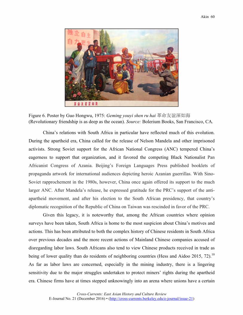
PRC’s priorities in Africa before 1979 had primarily been political, including supporting
revolutionary movements and supplying unilateral aid to seek diplomatic favor in the aftermath
of the Sino-Soviet split (see figure 6). In Sun’s words,
This strategy led to temporary political gains and fostered a sense of affinity that endures. However, in economic terms, these policies were less rational…. 30 years into reform and opening up, China’s Africa policy is believed to have swung to the other end of the spectrum…. For African countries, the key implication is that first and foremost, China’s relationship with them must serve China’s domestic economic development agenda through the “mutual complementarity of their economies.” (Sun 2014, 26)
Sun notes that as Chinese commercial interests seek to maximize their economic benefits in
Africa,
Their pragmatic, mercantilist approach has undermined the foundation for political relations. Most Chinese analysts point out that the Chinese business community’s narrow-minded pursuit of maximum economic gains has left little or no room or regard for social, economic and environmental impact, or for the sustainable development of local Africa in China’s Foreign Policy. This is believed to underlie the perception that China is the new “colonial power.” Chinese companies’ behavior has, in many cases, alienated local governments and populations, and seriously undermined the soundness of bilateral political relations. (Sun 2014, 26–27) The PRC’s gift of the Da Ming Hunyi Tu replica and its prominent role in the
Parliamentary Millennium Project came at a time of maximum flux in this changing relationship,
as bilateral trade between China and the African continent was beginning to skyrocket, from its
$10 billion in 2000 to about five times that amount six years later, driven by China’s rapid
development and its consequent demand for raw materials.9 This raised the stakes for Chinese
diplomats to emphasize the long history of allegedly non-coercive and mutually beneficial
relations with Africa, contrasting this narrative with that of European colonialism on the
continent.
Akin 60
Cross-Currents: East Asian History and Culture Review
E-Journal No. 21 (December 2016) • (http://cross-currents.berkeley.edu/e-journal/issue-21)
Figure 6. Poster by Guo Hongwu, 1975: Geming youyi shen ru hai 革命友谊深如海(Revolutionary friendship is as deep as the ocean). Source: Bolerium Books, San Francisco, CA.
China’s relations with South Africa in particular have reflected much of this evolution.
During the apartheid era, China called for the release of Nelson Mandela and other imprisoned
activists. Strong Soviet support for the African National Congress (ANC) tempered China’s
eagerness to support that organization, and it favored the competing Black Nationalist Pan
Africanist Congress of Azania. Beijing’s Foreign Languages Press published booklets of
propaganda artwork for international audiences depicting heroic Azanian guerrillas. With Sino-
Soviet rapprochement in the 1980s, however, China once again offered its support to the much
larger ANC. After Mandela’s release, he expressed gratitude for the PRC’s support of the anti-
apartheid movement, and after his election to the South African presidency, that country’s
diplomatic recognition of the Republic of China on Taiwan was rescinded in favor of the PRC.
Given this legacy, it is noteworthy that, among the African countries where opinion
surveys have been taken, South Africa is home to the most suspicion about China’s motives and
actions. This has been attributed to both the complex history of Chinese residents in South Africa
over previous decades and the more recent actions of Mainland Chinese companies accused of
disregarding labor laws. South Africans also tend to view Chinese products received in trade as
being of lower quality than do residents of neighboring countries (Hess and Aidoo 2015, 72).10
As far as labor laws are concerned, especially in the mining industry, there is a lingering
sensitivity due to the major struggles undertaken to protect miners’ rights during the apartheid
era. Chinese firms have at times stepped unknowingly into an arena where unions have a certain
Akin 61
Cross-Currents: East Asian History and Culture Review
E-Journal No. 21 (December 2016) • (http://cross-currents.berkeley.edu/e-journal/issue-21)
degree of leverage, a situation unknown at home. Furthermore, the ANC’s post-Mandela
performance after Thabo Mbeki took office in 1999 has come under increasing criticism for
corruption and mismanagement, making China’s support for it less of a net positive.
In 2006, just before the China-Africa Cooperation Forum in Beijing, the Chinese
government issued “Nine Principles” to “Encourage and Standardize Enterprises’ Overseas
Investment,” which included adherence to labor laws, protection of the local environment, and
other ways to defend the image of Chinese enterprises as responsible partners and investors. The
circular was widely seen as an answer to allegations of “neo-colonialist” conduct. As Shanghai-
based analyst Scott Zhou suggested at the time, “China’s moral case is spoiled by support for
authoritarian regimes caring nothing about human rights, bribing its way into big contracts,
leaving one big empty hole after another on the continent after extracting minerals, and making
Africa both a supplier of raw materials and a market serving China’s ‘world workshop’
economy” (Zhou 2006). In short, there was much for China to be anxious about, raising the
stakes of using tools such as the Da Ming Hunyi Tu to present an alternative image of eternal
friendship and mutual benefit.
In more recent years, changes in China’s economy have reduced its demand for some raw
materials, and the relationship with Africa seems to be entering a new stage whose contours
remain unclear. The use of maps in diplomacy continues in other realms, however, perhaps most
obviously in the South China Sea, where the PRC has territorial disputes with several Southeast
Asian countries. North American antiquarian book dealers report recent incidents of buyers from
the mainland looking through old atlases for maps of the region, purchasing those that show the
disputed reefs and island clusters as Qing territory so that they can be presented as trophies to the
relevant authorities back home. Maps that fail to indicate the desired sovereignty are, naturally,
not purchased.11 In sum, the Da Ming Hunyi Tu is but one of many maps that have been divorced
from their original contexts to suit modern needs, in this case using cartography to deflect
anxieties about the nature of Chinese economic activity in South Africa. This instance is
therefore quite different from the simple boundary disputes with India and Russia in which the
PRC has also cited historical maps to make its case.
The deployment of the Da Ming Hunyi Tu in South Africa in 2002 also came at a
moment when many were caught up in fascination at the astonishing claims of Gavin Menzies,
who fed Chinese nationalist sentiments with his assertions that China had once ruled the seas,
Akin 62
Cross-Currents: East Asian History and Culture Review
E-Journal No. 21 (December 2016) • (http://cross-currents.berkeley.edu/e-journal/issue-21)
and that Zheng He had actually settled lands as far afield as North America. Part of what gave
Menzies’s theories such appeal to those unfamiliar with Chinese history or maritime exploration
was the gloss of anti-imperialist rhetoric with which he dressed them, implying that
Eurocentrism was the ultimate reason for the alleged suppression of these achievements of
Zheng He. It was in this context that an early Ming map based on Yuan-era sources, the Da Ming
Hunyi Tu, was conflated with the later oceanic expeditions of Zheng He, and the legacy of that
diplomat portrayed as a counterweight to the European invasion and exploitation of the African
continent. The congruence of several factors at the turn of the twenty-first century allowed this
map to play a small but remarkable role within the broader context of efforts by the PRC to
distinguish its development projects from the legacy of European colonialism.
Alexander Akin holds a PhD in East Asian Languages and Civilizations from Harvard University and is co-owner of Bolerium Books in San Francisco. Notes 1 Gwen van Embden, an accomplished artist and curator, made no pretensions about being
a scholar of Chinese history. In this article I do not wish to judge her unfairly in this regard, but rather to discuss the ways that the description of Chinese maps in this exhibit both reflected and further shaped the narrative of China as a non-colonial power in contact with Africa.
2 The presence of Chinese porcelain in Africa does not necessarily indicate that Chinese ships brought it to African shores. While popular reportage often seizes on such finds of pottery and beads as evidence of very early direct Chinese contact, trade goods such as porcelain were widely distributed by merchants of other lands, especially Muslim traders. Suzanne Valenstein cites examples of pottery from as early as the Tang found in Iraqi trading centers and as far away as coastal East Africa (1988, 76). Without additional context, such discoveries do not tell us who brought these trade goods. Despite the outsize reputation of Zheng He’s diplomatic missions, the vast majority of trade wares such as utilitarian pottery must have come from more pedestrian sources over a longer period of time. Persian records refer to “Chinese ships” on such trade runs, but George Hourani argues that the terms sufun min al-Sin and sufun Siniyah, in Arabic and Persian respectively, refer to ships on the “China run,” rather than ships owned or piloted by the Chinese (Hourani 1995, 47–50). The movement of the Abbasid capital to Baghdad in 762 was remembered for bringing directness to sea trade with the Far East. Al-Tabari quotes caliph al-Mansur as proclaiming, “This is the Tigris; there is no obstacle between us and China; everything on the sea can come to us on it” (Hourani 1995, 64). Furthermore, raising additional complications to analysis of shards found at port sites, broken crockery was used as ballast on ships, and it was not unusual for a ship to carry pieces of crockery older than the ship itself.

Akin 63
Cross-Currents: East Asian History and Culture Review
E-Journal No. 21 (December 2016) • (http://cross-currents.berkeley.edu/e-journal/issue-21)
3 The Da Ming Hunyi Tu and its Korean copies are superficially quite similar in
appearance and are often conflated in popular sources. The Korean copies are identifiable by the dramatic enlargement of Korea at the right side of the map. For an introduction to the Da Ming Hunyi Tu, see Cao (1994, plates 1–6 and pages 1 and 21).
4 The maps this poster illustrates are 1402 and 1420 copies of the Da Ming Hunyi Tu. It is unclear why the poster displays these copies rather than the original. While the 1420 map shows changes in the orientation and location of Japan and other improvements for East Asia, its depiction of Africa and Europe is quite similar to the 1402 copy and to the original map.
5 This is a perfect example of the so-called “ship inflation” evident in the last couple of decades, as portrayals of Zheng He’s ships compared with those of Columbus have shown increasing divergence correlating with China’s modern economic significance. An early example of such a portrayal is Jan Adkins’s illustration to Levathes (1994, 21). In reality, a wooden-hulled ship so much larger than the European ships of its time would pose numerous operational difficulties. For a detailed study of this question, see Church, Gebhardt, and Little (2010).
6 For a brief discussion of Idrisi’s maps and their Asian impact, and a diagram comparing the Osaka version of the 1402 Korean map with the Guang Yutu, see Takahashi (2005, 53–55). See also Takahashi (1963, 85–89), in which he traces the depiction of the Nile from Ptolemy via Idrisi to the Hunyi Tu and thence to the Guang Yutu.
7 Quoted in Stiebel (2004, 56). It should be noted that Stiebel, who is not a historian of China, accepts Gavin Menzies’s discredited work at face value in this article.
8 Prints made from this digital copy, which was originally prepared by the College of Computer Science and Technology of Zhejiang University, have also been exhibited at later events, including the World Design Capital 2014 exhibition at the Iziko Museums of South Africa.
9 This was by no means a one-way relationship, as Africa’s imports from China also increased almost six-fold from $6.5 billion in 2000 to $37.1 billion in 2007 (Ademola, Bankole, and Adewuyi 2009, 491).
10 The perception of Chinese product quality may in large part be due to the higher standard of living in South Africa, and the higher expectations of its consumers.
11 Personal communication with Don Stewart, proprietor of Macleod’s Books (Vancouver, BC, December 20, 2015).
References
Ademola, Oyejide Titiloye, Abiodun S. Bankole, and Adeolu O. Adewuyi. 2009. “China–Africa Trade Relations: Insights from AERC Scoping Studies.” The European Journal of Development Research 21 (4): 485–505.
Bernard, Henri. 1935. Matteo Ricci’s Scientific Contribution to China. Translated by Edward Chalmers Werner. Peiping: H. Vetch.
Cao Wanru 曹婉如. 1994. Zhongguo gudai ditu ji中國古代地圖集 [Atlas of ancient maps in China: The Ming Dynasty, 1368–1644]. Beijing: Wenwu chubanshe.
Church, Sally K., John C. Gebhardt, and Terry H. Little. 2010. “A Naval Architectural Analysis of the Plausibility of 450-ft Treasure Ships.” Report prepared for the International Conference on Zheng He and the Afro-Asian World, Melaka, July.

Akin 64
Cross-Currents: East Asian History and Culture Review
E-Journal No. 21 (December 2016) • (http://cross-currents.berkeley.edu/e-journal/issue-21)
Elman, Benjamin. 2007. “Ming-Qing Border Defence, the Inward Turn of Chinese Cartography, and Qing Expansion in Central Asia in the Eighteenth Century.” In The Chinese State at the Borders, edited by Diana Lary, 29–56. Vancouver: University of British Columbia Press.
Hess, Steve, and Richard Aidoo. 2015. Charting the Roots of Anti-Chinese Populism in Africa. Cham: Springer.
Hourani, George F. 1995. Arab Seafaring: In the Indian Ocean in Ancient and Early Medieval Times. Princeton, NJ: Princeton University Press.
Levathes, Louise. 1994. When China Ruled the Seas: The Treasure Fleet of the Dragon Throne, 1405–1433. New York: Oxford University Press.
Li Xian 李賢, ed. 1461. Da Ming yitongzhi 大明一統志 [Gazetteer of the Great Ming’s unification]. Beijing: Nei fu.
Liu Guijin 刘贵今. 2004. “Speech by Ambassador Liu Guijin at the Seminar on China-Africa Relations Held by ISS.” Address given November 9. Available at http://www.chinese-embassy.org.za/eng/dsxx/dshd/t174414.htm, accessed March 8, 2016.
———. 2006. “Ambassador Liu: Time-Honored China-Africa Relationship Is Truly One of Equality, Friendship and Mutual Benefit.” Interview given October 12. Available at http://www.chinese-embassy.org.za/eng/dsxx/dshd/t275907.htm, accessed January 10, 2016.
Luo Hongxian 羅洪先. 1969. Guang yutu 廣輿圖 [Enlarged terrestrial atlas]. Facsimile reprint of 1799 edition. Taipei: Xuehai chubanshe.
Menzies, Gavin. 2002. 1421: The Year China Discovered America. New York: Bantam. Park, Hyunhee. 2012. Mapping the Chinese and Islamic Worlds: Cross-Cultural Exchange in
Pre-Modern Asia. Cambridge: Cambridge University Press. Parliamentary Millennium Project. 2008. “Eastern Perspectives and the Mapping of Africa.”
Available at http://www.pmpsa.gov.za/newpages/publications.html, accessed January 10, 2016. Cape Town: Parliamentary Millenium Project (PMP).
Stiebel, Lindy. 2004. “Putting Africa [Back] on the Map: The South African Parliamentary Millennium Project.” Transformation: Critical Perspectives on Southern Africa 56 (1): 53–67.
Sun, Yun. 2014. “Africa in China’s Foreign Policy.” Brookings, April 14, 26–27. Available at http://www.brookings.edu/research/papers/2014/04/10-africa-china-foreign-policy-sun, accessed December 13, 2016.
Takahashi Tadashi 高橋正. 1963. “Tōzen seru chūsei Isurāmu sekaizu” [Eastward diffusion of Islamic world maps in the medieval era]. Ryūkoku Daigaku ronshū 374: 77–95.
———. 2005. “Chūsei Isurāmu sekaizu” 中世イスラーム世界図 [Islamic world maps in the medieval era]. In Chizu no shisō 地図の思想 [Cartographic thought], edited by Hasegawa Kōji 長谷川孝治, 53–55. Tokyo: Asakura Shoten.
Valenstein, Suzanne G. 1988. A Handbook of Chinese Ceramics. New York: Metropolitan Museum of Art.
van Embden, Gwen. 2002. Perspectives on and of Africa: An Introductory Exhibition to the Parliamentary Millennium Project. Available at http://www.gwenvanembden.com /parliamentary-millenium-project-2.php, accessed January 10, 2016.
Wade, Geoff. 2005. “The Zheng He Voyages: A Reassessment.” Journal of the Malaysian Branch of the Royal Asiatic Society 78 (1): 37–58.

Akin 65
Cross-Currents: East Asian History and Culture Review
E-Journal No. 21 (December 2016) • (http://cross-currents.berkeley.edu/e-journal/issue-21)
Wang Qi 王圻 and Wang Siyi 王思義. 1988. Sancai tuhui 三才圖繪 [Illustrated compendium of the three fields of knowledge]. Facsimile of ca. 1609 edition. Shanghai: Shanghai guji chubanshe.
Zhonghua yu tu zhi bian zhi ji shu zi zhan shi xiang mu zu bian zhu 中华舆图志编制及数字展
示项目组编著 [A collection of Chinese antique maps]. 2011. Beijing: Zhongguo di tu chubanshe.
Zhou, Scott. 2006. “China as Africa’s ‘Angel in White.’” Asia Times Online, November 3. Available at http://www.atimes.com/atimes/China_Business/HK03Cb04.html, accessed March 26, 2016.