the demarcation of arbitrary boundaries for coastal zone ... · the demarcation of arbitrary...
TRANSCRIPT
lable at ScienceDirect
Journal of Environmental Management 91 (2010) 2358e2369
Contents lists avai
Journal of Environmental Management
journal homepage: www.elsevier .com/locate/ jenvman
The demarcation of arbitrary boundaries for coastal zone management:The Israeli case
Eliraz Sas a,1, Itay Fischhendler b,*, Michelle E. Portman b,2
aUrban and Regional Planning, POB 67, Har Adar 90836, IsraelbDepartment of Geography, The Hebrew University of Jerusalem, Mount Scopus, Jerusalem 91905, Israel
a r t i c l e i n f o
Article history:Received 17 September 2009Received in revised form1 June 2010Accepted 29 June 2010Available online 24 July 2010
Keywords:Coastal policyResource management boundariesICZMBoundary delineation
* Corresponding author. Fax: þ972 2 5883347.E-mail addresses: [email protected] (E.
(I. Fischhendler), [email protected] (M.E. Portm1 Fax: þ972 2 5345992.2 Fax: þ972 2 5883347.3 Integrated management is by and large a wester
cultures have for years practiced collective action andintegrated management but without coining it “inOstrom, 1990). In addition, some of the integrationapproach) can be traced back to the 19th and early 2vation movement in the US (see Keiter, 1994).
0301-4797/$ e see front matter � 2010 Elsevier Ltd.doi:10.1016/j.jenvman.2010.06.027
a b s t r a c t
Integrated coastal zone management (ICZM) addresses the interconnections, complexities, and conflictsbetween many users of the coastal area with different goals. It requires setting managerial boundariesthat capture many elements of human and natural systems. Experience teaches us that withouta directed effort managerial rules and laws are not likely to coincide with the physical sensitivity of unitsthat reflect different environmental characteristics of the coastal zone. Hence the aim of this study is toexplore why coastal managerial boundaries are set arbitrarily and whether and how it is possible toaddress the problems this poses. We examine what influences the decisions of a new coastal manage-ment authority in Israel to determine how this body overcomes the limits of arbitrary boundarydemarcation. The study found that real life management succeeded to both address areas outside thearbitrary boundaries and also to respect some of the different socio-economic needs and physicalconstraints of the coastal sub-units. Israel’s Coastal Environment Protection Law allows and, in fact,encourages the regulator to use discretion and to employ various criteria to balance development andconservation. This implies that policy makers are cognizant of a need to balance ecologically-sensitiveboundaries that consider the homogeneity of the coast with politically feasible boundaries that are setarbitrarily.
� 2010 Elsevier Ltd. All rights reserved.
1. Introduction
In recent decades, resource managers and planners have widelyaccepted the main tenets of integrated coastal zone management(ICZM)(Sorensen, 1993, 2002; Cicin-Sain and Knecht, 1998; Bridgeand Salman, 2000). This mostly western concept3 is now appliedthroughout the world in an institutionalized manner in developingcountries as well as industrialized countries (Christie et al., 2005). Itis designed to overcome the splits in jurisdiction along the coastamong different levels of government and in the landesea interfacewhile acknowledging the mosaic of community based initiatives
Sas), [email protected]).
n concept. Many indigenousto some degree elements oftegrated management” (seespatial elements (the basin0th century and the conser-
All rights reserved.
along the coast.4 ICZM implemented through coordination amongsectors and at various levels of administration is expected to opti-mize socio-economic demands and ecological needs in the coastalarea (Olsen, 2003; Lau, 2005). In a spatial sense this approachintegrates the terrestrial and marine components of the coastalenvironment; but on a finer-grained systems level it integratesphysical, chemical and biological processes with human activitiesand needs in the coastal zone.
In adopting ICZM,managers have built on experience from othersectors and disciplines where integration has taken place. Anexample is integrated water resource management that firstemerged in the early 1930s with the establishment of the Tennes-see Valley Authority and then re-emerged in the 1990s (Molle,2009). More recently, ecosystem-based management, defined asan integrated approach to resource management, considers theentire ecosystem, including human needs and constructs. The goalof ecosystem-based management is to maintain an ecosystem ina healthy, productive and resilient condition, objectives that canfrequently only be achieved by crossing jurisdictional and sectoral
4 For more on the multi-cultural aspirations of fostering integration whilecontribution to building community based management see Hildebrand, 1994.

E. Sas et al. / Journal of Environmental Management 91 (2010) 2358e2369 2359
administrative boundaries (Schlaepfer, 1997; CommunicationPartnership for Science and the Sea, 2005) such as those found inthe coastal zone. Olsen et al. (2004) point out that ICZM should bea “stepping-stone” toward making ecosystem-based managementfor the marine environment an operative reality.
Due to its wide acceptance and contrast to sectoral resourcemanagement there has been a plethora of attempts to implementICZM (e.g., Bridge and Salman, 2000; Enemark, 2005) and to study,evaluate and improve it (e.g., Cicin-Sain, 1993; Hershman et al.,1999; Allmendinger et al., 2002). While many previous empiricalstudies have addressed the programmatic effectiveness of ICZM(e.g., Christie et al., 2005), there is a lack of work focusing on theissue of boundary demarcation (Balaguer et al., 2008). This isimportant because implementation often begins with delineatingthe managerial boundaries of coastal zones to correspond witheither the physical and ecological units of the coast (Clark, 1996;Kana, 1991) or to address a specific problem of a certain sectorsuch as flooding or water pollution (May et al., 1996; Brenner et al.,2006). Yet, there are still many cases where instead of settingjurisdictions that will encompass physical or even administrativeunits, boundaries are set arbitrarily. The term “arbitrary” refers toa spatial demarcation of management that does not consider thephysical, especially natural elements of the coastal environment. Assuch it may impede meaningful conservation and integrationefforts (Cicin-Sain and Knecht, 1998; Clark, 1996). The aim of thisstudy is to explore the reasons for arbitrary coastal managerialboundaries and whether and how it is possible to address theproblems they pose.
As a case study we examine a national governance framework inIsrael designed to protect the country’s Mediterranean beaches andshores. The regulatory framework gives a relatively new coastalbody jurisdictional authority within arbitrary boundaries. Ourstudy aims to statistically define the extent to which the newcoastal body makes conservation and development decisions basedon the proactively set arbitrary boundaries or in contrast, based onother criteria that correspond to the characteristics of the envi-ronment and of the proposed development. Our findings offerinsights relevant to coastal and ecosystem protection programs thatare dependent on similar constructs.
The next section of this paper reviews literature, theory andexamples of demarcation of coastal zones and coastal sub-units.Section 3 describes the Israeli case study and how the regulatoryprogram examined in this study developed. Section 4 covers thecore of this research project: statistical analyses of the regulatorydecisions made by the planning body created to protect the coastalzone. Finally, Section 5 describes the findings and broad implica-tions of this case study followed by overall conclusions in Section 6.
2. Boundary demarcation and coastal zone management
The definition of boundaries is the first stage in the developmentof successful management systems for common property resources(Crean, 2000). Generally marine and coastal areas, if not commonproperty resources in and of themselves, at least contain resourcesheld in public trust. Prominent among Ostrom’s seven design prin-ciples for enduring common pool resource management systems isthe presence of clearly defined boundaries (Ostrom, 2001). Buildingon these principles, other researchers have outlined the importanceof spatial dimensions in boundary determination (e.g., Bolin et al.,2008), particularly for activities in the coastal zone (e.g., Crean,2000; Cowell, 2003; Clark, 1996).
The focus on spatial dimensions stems from the interdepen-dence and the disparity of natural systems andhuman activities thatimpact coastal areas (OJEC, 2002). For example, problems resultingfrom the sectoral management of activities wholly or partially
within the coastal zone (Olsen et al., 2004) are aggravated whenactivities that need to be managed lie outside declared boundaries.In the following section we describe spatial dimension concernssuch as scale, referring to levels of administration (i.e., local,regional, national, international), and extent,whichwedefine as theability to encompass or exclude certain activities. Regulatory pro-grams that operationalize issues of scale and extent spatially oftendo so using jurisdictional lines stipulated by marked boundaries.Descriptions of some examples of such regulatory programs followthe more theoretical discussion of scale and extent.
2.1. Spatial scale and extent
Spatial dimensions, consisting of the scale and extent of a tar-geted geographic area, will influence the type of managementstrategies employed to manage it and vice versa. As an example ofthe latter, the goals and objectives of a regulatory program willinfluence scale and extent of management boundaries in thecoastal zone.When sustainability is a goal, questions of scale can befundamental. As a case in point, from a comparative analysis ofnational, regional and local scale boundaries for fisheriesmanagement, Crean (2000) found that local scale boundaries incrab fisheries of the western English Channel came closest toachieving the theoretical ideal of establishing congruence betweenecosystem needs for sustainability and governance.
When coupling ICZM with the ecosystem-based managementapproaches, boundaries are likely to extend across differentbiophysical units and jurisdictions to encompass areas of varyingscales (ConventiononBiologicalDiversity, 2000;Wang, 2004). Largescale boundary demarcation is of concern in proposals for environ-mental regionalization, such as the marine ecosystems of the world(Sherman and Alexander, 1986), environmental land units of Euro-pean ecological region proposals (European Environmental Agency,2003), and proposals for reform of U.S. coastal and ocean policy(Turnipseed et al., 2009). Smaller scale boundary demarcation isimportant for sub-national or territorial seamarine spatial planningefforts. For example, the Massachusetts Oceans Act (2008) usesa nearshore “fixed” boundary for its Ocean Management PlanningArea. This is the merger of a line projected 0.3 nautical miles (nm)from an approximatemean highwater and closing lines that ensurethemost developed coastal embaymentseports, harbors, and otherprotruding landforms and infrastructure e are located landward ofthe nearshore boundary.
Questions of extent, which also determine jurisdictional reach,are most salient in sectoral management, but also in other types ofmanagement regimes. For ecosystem-based fisheries management,extent must be determined at a large enough scale to encompassdifferent stages in a fish’s life-cycle, and therefore it usuallyencompasses regional resources. These types of spatial concernsreceive ample attention in overarching programs such as the EUICZM program and also in practical plans such as the Wadden SeaProtection scheme (Enemark, 2005) and the Great Lakes coastalmanagement plans (Lawrence, 1997). A more localized example isthat of regulatory restrictions employed by the US state of Massa-chusetts for “fishing, fowling and navigating” within flowed tide-land areas between high and low water (Portman, 2006).
In determining spatial dimensions for coastal managementoften “special area” programs are designed to capture coastalsystems, such as areas of particular sensitivity such as a watershedthat surrounds an estuary system (Sorensen, 1993) or areasparticularly prone to coastal hazards (May et al., 1996). The largephysical and administrative heterogeneity of these managerialboundaries requires dividing them into discrete homogeneousareas (UNESCO, 1997; Balaguer et al., 2008) or units with similarphysical and socio-economic characteristics (Brenner et al., 2006;
E. Sas et al. / Journal of Environmental Management 91 (2010) 2358e23692360
Zonnenveld, 1994; Amir, 1987). Ideally, because each discretehomogeneous area will have a different level of sensitivity and willinclude different ecological values, policy makers and regulatorswill apply different managerial rules to each unit (Baja et al., 2002).The result of this “zoom in” process is often the delineation of areasdesigned to solve a specific problem for a specific sector such aspollution which has major influences on many uses in a large area.Balaguer et al. (2008) contends that the type of problem addressedusually determines the spatial scale and scope of a managementinitiative. For ICZM, this demarcation should at least include boththe cause and effect of problems in a zone or management unit.
While it is common for landward lines of the coastal zone todepend on characteristics of the environment for determiningboundary extent (Clark, 1996) of note is that in offshore portions ofthe coastal zone, policy makers have usually determined spatialscale and extent based on jurisdictional lines (Tanaka, 2004). Thisperhaps reflects a sense of greater understanding and familiaritywith the terrestrial environment when compared with the marineenvironment. For terrestrial bounds, there are several commonparadigms such as the use of physical landscape, ecologicalprocesses and species, and land uses and infrastructure. Allowingthe boundary to correspond with the physical landscape may resultin setting an extremely wide managerial unit that may link thecoastal zone to river basinmanagement and thus to the entire river-coast ecosystem continuum including discharging rivers and theircatchment areas (European Environmental Agency, 2006). UNESCO(1997) describes the use of natural territorial units as the optimalgeographical working framework for coherent coastal zonemanagement and illustrates this approach in several cases.Ecological processes may confine the range of certain naturalprocesses. For example, NATURA 2000 established a network ofImportant Bird Areas that consider sites along wildlife migrationroutes. An example of a boundary demarcated by land use is theMassachusetts Waterway Regulation Program that uses landwardroadways (infrastructure) to determine spatial extent of jurisdic-tion for coastal development licensing (Portman, 2006).
In contrast to boundaries that follow physical landscape units orecological processes, administrative lines may unduly confine theterrestrial or marine boundary. Further they likely neglect theimportant cross-cultural and multi-community, both biocentricand anthropocentric, aspirations of ICZM. Whether these boundarylines constrain management or not, they are frequently in place forconvenience of governance and may be historic policy relics thathave continued mostly because it is politically difficult to changethem. These are human constructs that must be better understood,especially in terms of how they impede or support integratedmanagement of the coastal zone.
5 For the meaning of arbitrary see our definition in the Introduction section.
2.2. Jurisdiction, regulation and planning in the coastal zone
The need to address the interconnections and conflicts betweenmany users of the coastal area requires an appropriate regulatoryframework (Allmendinger et al., 2002). Furthermore, as our tech-nological capabilities to exploit the ocean expand over time, so doesthe need to revisit the jurisdictional scope and extent withinwhichwe apply regulation. For example, offshore wind farms are nowbeing planned in deeper water than they were a decade ago drivingsome nations, such as Germany and the UK, to extend coastalplanning efforts beyond the territorial sea and well into their 200nautical-mile exclusive economic zone (Portman et al., 2009). Herewe identify some coastal units and give examples of boundaries setby different laws, regulations and managerial programs at variousspatial dimensions of the landside and nearshore environment thattogether make up the coastal zone.
The UN Convention on the Law of the Sea (UNCLOS) uses a zonalmanagement approach that divides between marine spaces adja-cent to the coast and those beyond state sovereignty (Vallega,2002). UNCLOS determined that coastal state territorial waters,and therefore coastal planning efforts, extend to a distance of 12nautical miles from the shoreline. These territorial boundaries havebeen adopted by most countries, including Israel. By determiningjurisdictional limits based on a “distance from shore” criteria, theecological interaction between marine species, their life-cycleneeds as well as ecological conditions of their physical surround-ings, are largely ignored (Tanaka, 2004).
In some cases, coastalmanagement is restricted to a narrow stripas is the case for the majority of the US states whose marine zonalboundary is limited to threenauticalmiles fromshore (NOAA, 2004).Offshore jurisdiction can also be set by bathymetric depth such asthe case of China that has set 15 m depth as the reference fora boundary (Clark, 1996) or Israel that uses 30m seabed depth as itsseaward limit of the Coastal Strip, as described below in Section 3.3.
At the sub-national level there may be significant variationamong coastal states in how boundaries are determined in thecoastal zone. Physical landscape elements often determine land-ward boundaries of the coastal zone such as in the U.S. states ofIndiana and Michigan along the Great Lakes coastline that respec-tively use watershed and geomorphological units. For the latter,boundaries tend to follow estuaries, dunes and flood plains,resulting in an irregular terrestrial management area with variedspatial dimensions. Ecological processes determine boundaries inthe state of Alaska where the coastal zone is defined according tothe strength of interaction between physical and biologicalprocesses (NOAA, 2004). Administrative lines of coastal munici-palities confine the management jurisdiction in the states ofWashington, Virginia and Ohio, just as state or national boundarieslimit integrated management for many countries on a larger scale.In New York, it is the land uses defined as existing infrastructurethat determine the boundary of the coastal zone, that is, roads orrailways within 500 feet from the coastline (NOAA, 2004).
While in some cases the delineation of boundaries followphysical or administrative elements or lines, in other places theboundaries are set completely or partially arbitrarily.5 In Denmark,for example, a 3 km lateral coastal strip restricts development andsecures public access within 300 m landward from the shoreline.Finland adopted a similar seemingly arbitrary approach: develop-ment is restricted to 100 m landward from the shoreline althoughphysical and administrative units stretch far beyond this setbackline (Bridge and Salman, 2000).
These differences in boundary demarcation lead to the followingquestions: Can arbitrary boundary be viable demarcation for inte-grated coastal zone management? Specifically, does it serve thegoals of integrated coastal zone management and/or allow forecosystem-based management? Such questions highlight the needto examine whether boundary demarcations used in real-worldregulatory programs succeed in: a) transcending arbitrary bound-aries to regulate the coastal system elements outside the officialextent of jurisdiction, and b) creating managerial differentiationwithin jurisdictions that respect the different needs and constraintsof sub-units ignored by the demarcation process. It is based onthese questions and concerns that natural resource managementexperts (e.g., Molle, 2009), and among them coastal zone managers(e.g., Olsen, 2003), call for studies of governance mechanisms forintegration. Of particular interest are those environmental policymechanisms, including ICZM, that balance development withconservation at varying spatial scales (Gibbs and Jonas, 2000).

Fig. 1. Location map.
E. Sas et al. / Journal of Environmental Management 91 (2010) 2358e2369 2361
3. Coastal zone demarcation and management in Israel
3.1. The Israeli coast and development
The 190-kilometer Mediterranean shoreline of Israel is quitestraight. It extends from the chalky limestone cliffs of Rosh Hanikrain the north at the borderwith Lebanon, to thewhite sandy beachesof Erez in the south at the border with Gaza. The stretch has onlyone big bay in the city of Haifa (Adler and Inbar, 2007). To the northof Haifa the coast is mostly rocky and lacking the continuous sandybeach characteristic of the area to the south. Outstandinggeomorphological features along Israel’s coast include threelongitudinal sandstone ridges of ancient fossilized dunes whichfacilitate division to five morphologic units (Emery and Neev, 1960;Goldsmith and Golik, 1980) distinguished by their topography, sandcomposition, and origin (See Fig. 1).
Following the establishment of the state of Israel in 1948,decision makers in the newly formed planning institutions gavescant attention to the coastal zone. Planners considered areasadjacent to freshwater sources such as the Sea of Galilee to be ofvalue for their natural amenities while they relegated the Medi-terranean coast for construction of polluting industrial facilitiessuch as oil refineries, or for resource extraction such as sandmining. The coastal zone became the locale of projects typicallyassociated with NIMBY (Not in My Back Yard) attitudes anddevelopment occurred at the expense of nature (Amir, 1984).
Further aggravating matters, rivers that were once importantcoastal features were used over the years for sewage conduits andmuch of their natural value has been destroyed (Brachya, 2002).Although there are several national plans that pertain to the coast,including a Master Plan for National Parks and a Master Plan forTourism approved in 1981 and 1983 respectively, none of themprovides direct protection to the coastal area. By the 1990s, Israel’sMediterranean shores contained a slew of poorly sited infrastruc-ture projects including power plants, harbors and pollutingindustry (Fletcher, 2000).
As the industrialization and development of Israel as a wholecontinued on a wide scale, the public recognized the value ofcoastal areas for recreation and accommodation beginning in themid-1980s. Then, local authorities and municipalities starteddesignating the coast for commercial and residential development(Ariel, 2009). As a result of the multiple uses of the landside area ofthe coast and a lack of comprehensive coastal protection ormanagement efforts, many conflicts emerged between the differentstakeholders (Brachya, 2002), among them conflicts betweenrecreation, energy generation, nature protection, and accommo-dation uses (State of Israel, 1999).
Today around 70% of the Israeli population is clustered along15 km of the Mediterranean coastline (State of Israel, 2003). Out ofthe 190 km of coastline, 50 km are exclusively used for militarypurposes, power plants and ports. Out of the remaining area, about60 km are already developed. Another 40 km are designated forfuture urban or rural development (Papay, 2003) and from amongthese areas along 70 km bathing is not allowed. Only 13 km aredesignated public beaches (Papay, 2007). Further conflicts will nodoubt emerge over the seaward, submerged area of the coastalzone as proposals for such uses as desalinization plants, energypipelines, communication cables and artificial islands come tofruition (State of Israel, 1999).
3.2. The emergence of a managerial and legal framework
The Planning and Building Law of Israel of 1965 establisheda hierarchy of plans and planning authorities at the national,regional, and local level. Based on the previous British Mandate
Planning Ordinance, the law is similar in concept to the BritishTown and Country Planning System (Fletcher, 2000). It requiresdevelopers and landowners to obtain approval from the relevantplanning authority to realize a project. At the top of the hierarchy isthe National Planning and Building Board (NPBB), responsible for
6 The shoreline was also arbitrarily set at 0.75 m above the current sea level toaccommodate future sea level rise due to climate change.
E. Sas et al. / Journal of Environmental Management 91 (2010) 2358e23692362
setting strategic polices through the development of NationalOutline Schemes (NOSs) for specific planning issues. Six districtplanning and building commissions (PBCs) implement the nationaloutline schemes and their own district master plans; over 100 localplanning bodies serve individual municipalities. The regional andlocal level PBCs make planning decisions and execute national anddistrict planning policy through the approval of detailed plans andthe issuance of building permits.
Law makers established the Territorial Water Committeeauthority to regulate the development of marine structures inIsrael’s territorial water in the early 1970s (Amir, 1984). Althoughthe NPBB issued guidelines for the use and management of theterrestrial part of Israel’s Mediterranean coastal zone in 1970, thesewere largely ineffective at regulating development (Fletcher, 2000).It was not until 1983 that the NPBB approved the National OutlineScheme for the Coastline (NOS 13). NOS 13 has designated someareas for various levels of protection (i.e., bathing beaches, coastalreserves, and landscape reserves), outlined the uses allowed in thenearshore land area (i.e., tourism, agriculture etc.), and determineda 100 m landward setback line for development. Besides its failureto address submerged areas along the coast, NOS 13 excluded somecoastal areas because they are within existing urban and ruralcommunities and therefore have their own plans (State of Israel,1983).
Israel’s obligations to comply with two international treatieshelped create new laws and institutions related to the marineenvironment. The Israeli government ratified the 1976 BarcelonaConvention and its Protocol for the Protection of theMediterraneanSea Against Pollution from Land-Based Sources, and the 1973International Convention for the Prevention of Pollution from Shipsand its 1978 Protocol. It subsequently translated these conventionsinto two crucial pieces of domestic legislation aimed at protectingmarine elements of the coastal zone: the 1980 Prevention of SeaWater Pollution from Oil Ordinance (New Version), and the 1988Prevention of Pollution from Land-based Sources Law (Talitmanet al., 2003; Weinthal and Parag, 2003).
Following the adoption of these laws the government began toregulate, monitor, and grant permits for marine dumping anddischarge into coastal waters. A marine pollution prevention fundwas established that authorized collection of fees subsequentlyusedfor pollution prevention and treatment. This contributed to theestablishmentof numerousnewwastewater treatment facilities andupgrades of older ones. By the early 1990s there was someimprovement in coastal water quality. However, the two systems ethe physical planning systemand the pollutionprevention systeme
worked separately (Amir, 1987). Some agencies are responsible forplanning while others for management and enforcement; someregulate the shoreline environmentwhile others the upland areaseall evidence of the need for further integration (Brachya, 1991).
Despite public calls for a more comprehensive integratedapproach to coastal zone management including an unsuccessfulattempt to make changes to NOS 13 that would have fused socio-economic and environmental concerns with management of thecoastal zone (Brachya, 1993), environmental regulations, programsand plans remained ineffective at balancing development andconservation along the coast and protecting public resources. Forexample, in the 1990s several mega-projects were authorized incoastal areas by the planning system that transformed the costalresource into real estate designed for high income residential devel-opment while severely reducing access for the public (Tzafrir, 2005).
With burgeoning population, increased standards of living andintense expansion of the tourist industry, it became clear to policymakers that NOS 13 and regulations rooted in the Planning andBuilding Law of 1965 were not adequate to protect the coast fromdestructive development (State Comptroller, 1998). In addition,
they recognized the need to overcome disjointed managementresulting from the Territorial Waters Committee’s responsibility forregulating development in submerged areas and the PBC’sresponsibility for development on land.
In a report from 1998 the State Comptroller stressed the need toease tensions between coastal development and the public interest(State Comptroller,1998). The Israeli courts frequently echoed theseconcerns. Some needs were addressed by a new policy reportpublished by the Territorial Waters Committee (State of Israel,1999); others were addressed by a coastal conservation bill in1998 developed by the Ministry of the Environment (the Ministry)and influenced by environmental NGOs working to protect thecoast. The former report offered guidelines for a new ICZM policyfor Israel (Ministry of Environmental Protection, 2003). It recom-mended dividing both marine and terrestrial parts of the coast intophysical sub-units each with a varied spatial structure and corre-sponding development restrictions based on the estimatedcarrying capacity of the subunit. The Ministry’s coastal conserva-tion bill set up the marine boundary to include all submerged areasto a depth 30 m while the landward boundary would extend to500 m (Governmental Interior and Environmental Committee,2000). Within the landward boundary two secondary arbitrarysetback lines would prohibit development entirely within 100 mlandward from the shoreline and restrict development consider-ably between 100 and 200 m from the shore (Ben Ari, 2000).
3.3. Reconfiguring the managerial system
Local coastal municipalities objected vigorously to the proposalthey considered to include over-zealous development restrictions(Governmental Interior and Environmental Committee, 2000; BenAri, 2000). They argued that the landward boundary shouldcorrespond with the existing ecological values or lack thereof. Forexample, in intensely developed urban areas the jurisdictionshould be narrower (Kizer, 2000; Alemalich, 2000). The 30 mmarine depth demarcation constitutes a 7 km marine jurisdictionin some places which they argued extends beyond the ecologicalsystem boundaries (Wisman, 2000). They wanted to exclude manyactivities from regulation and to narrow the law’s spatial extent orto make it flexible (Bibi, 2002). In return, proponents of the billargued against a flexible boundary based on ecological and socialvalues because of disagreement about what these are (Adler andShtern, 2000). They advocated a uniform boundary that sets themost precautious standard (Ben Ari, 2002).
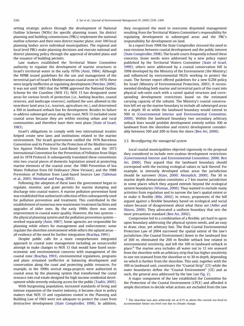
Compromise led to a combination of a flexible, yet hard to agreeupon boundary addressing the physical system needs, and an easyto draw, clear, yet arbitrary line. The final Coastal EnvironmentalProtection Law of 2004 narrowed the spatial extent of the law’sjurisdiction (the Coastal Environment) down to the landward lineof 300 m, eliminated the 200 m flexible setback line related toenvironmental sensitivity, and left the 100 m landward setback inplace.6 The marine area includes all water out to 12 nm seawardfrom the shorelinewith an arbitrary strip that has higher sensitivityto one nm seaward from the shoreline or to 30 m depth, dependingon which is further from the shoreline. This unit, together with the100 m landward unit, constitutes the “Coastal Strip” (CS) while theouter boundaries define the “Coastal Environment” (CE) and assuch, the general area addressed by the law (see Fig. 2).
A major component of the law established the Committee forthe Protection of the Coastal Environment (CPCE) and afforded itample discretion to decide what actions are excluded from the law
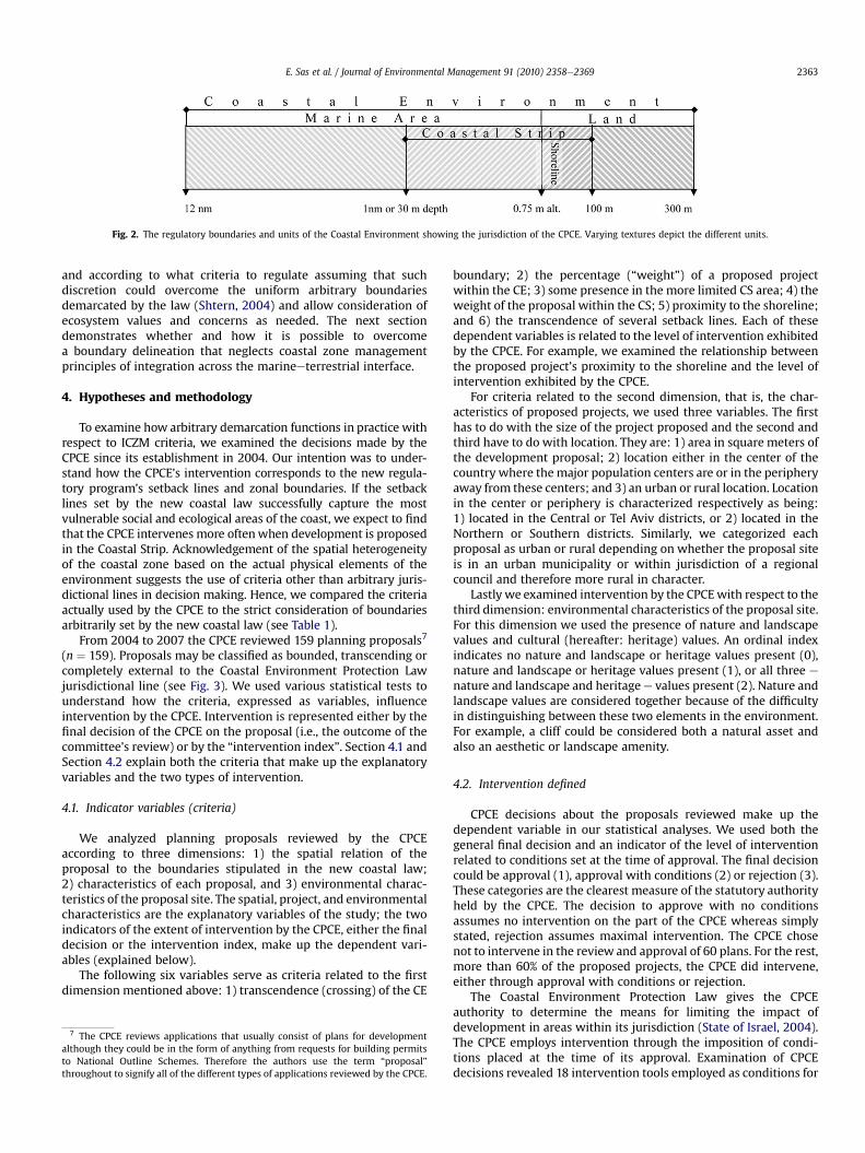
Fig. 2. The regulatory boundaries and units of the Coastal Environment showing the jurisdiction of the CPCE. Varying textures depict the different units.
E. Sas et al. / Journal of Environmental Management 91 (2010) 2358e2369 2363
and according to what criteria to regulate assuming that suchdiscretion could overcome the uniform arbitrary boundariesdemarcated by the law (Shtern, 2004) and allow consideration ofecosystem values and concerns as needed. The next sectiondemonstrates whether and how it is possible to overcomea boundary delineation that neglects coastal zone managementprinciples of integration across the marineeterrestrial interface.
4. Hypotheses and methodology
To examine how arbitrary demarcation functions in practice withrespect to ICZM criteria, we examined the decisions made by theCPCE since its establishment in 2004. Our intention was to under-stand how the CPCE’s intervention corresponds to the new regula-tory program’s setback lines and zonal boundaries. If the setbacklines set by the new coastal law successfully capture the mostvulnerable social and ecological areas of the coast, we expect to findthat the CPCE intervenes more oftenwhen development is proposedin the Coastal Strip. Acknowledgement of the spatial heterogeneityof the coastal zone based on the actual physical elements of theenvironment suggests the use of criteria other than arbitrary juris-dictional lines in decision making. Hence, we compared the criteriaactually used by the CPCE to the strict consideration of boundariesarbitrarily set by the new coastal law (see Table 1).
From 2004 to 2007 the CPCE reviewed 159 planning proposals7
(n ¼ 159). Proposals may be classified as bounded, transcending orcompletely external to the Coastal Environment Protection Lawjurisdictional line (see Fig. 3). We used various statistical tests tounderstand how the criteria, expressed as variables, influenceintervention by the CPCE. Intervention is represented either by thefinal decision of the CPCE on the proposal (i.e., the outcome of thecommittee’s review) or by the “intervention index”. Section 4.1 andSection 4.2 explain both the criteria that make up the explanatoryvariables and the two types of intervention.
4.1. Indicator variables (criteria)
We analyzed planning proposals reviewed by the CPCEaccording to three dimensions: 1) the spatial relation of theproposal to the boundaries stipulated in the new coastal law;2) characteristics of each proposal, and 3) environmental charac-teristics of the proposal site. The spatial, project, and environmentalcharacteristics are the explanatory variables of the study; the twoindicators of the extent of intervention by the CPCE, either the finaldecision or the intervention index, make up the dependent vari-ables (explained below).
The following six variables serve as criteria related to the firstdimension mentioned above: 1) transcendence (crossing) of the CE
7 The CPCE reviews applications that usually consist of plans for developmentalthough they could be in the form of anything from requests for building permitsto National Outline Schemes. Therefore the authors use the term “proposal”throughout to signify all of the different types of applications reviewed by the CPCE.
boundary; 2) the percentage (“weight”) of a proposed projectwithin the CE; 3) some presence in the more limited CS area; 4) theweight of the proposal within the CS; 5) proximity to the shoreline;and 6) the transcendence of several setback lines. Each of thesedependent variables is related to the level of intervention exhibitedby the CPCE. For example, we examined the relationship betweenthe proposed project’s proximity to the shoreline and the level ofintervention exhibited by the CPCE.
For criteria related to the second dimension, that is, the char-acteristics of proposed projects, we used three variables. The firsthas to do with the size of the project proposed and the second andthird have to do with location. They are: 1) area in square meters ofthe development proposal; 2) location either in the center of thecountry where themajor population centers are or in the peripheryaway from these centers; and 3) an urban or rural location. Locationin the center or periphery is characterized respectively as being:1) located in the Central or Tel Aviv districts, or 2) located in theNorthern or Southern districts. Similarly, we categorized eachproposal as urban or rural depending on whether the proposal siteis in an urban municipality or within jurisdiction of a regionalcouncil and therefore more rural in character.
Lastly we examined intervention by the CPCEwith respect to thethird dimension: environmental characteristics of the proposal site.For this dimension we used the presence of nature and landscapevalues and cultural (hereafter: heritage) values. An ordinal indexindicates no nature and landscape or heritage values present (0),nature and landscape or heritage values present (1), or all three e
nature and landscape and heritagee values present (2). Nature andlandscape values are considered together because of the difficultyin distinguishing between these two elements in the environment.For example, a cliff could be considered both a natural asset andalso an aesthetic or landscape amenity.
4.2. Intervention defined
CPCE decisions about the proposals reviewed make up thedependent variable in our statistical analyses. We used both thegeneral final decision and an indicator of the level of interventionrelated to conditions set at the time of approval. The final decisioncould be approval (1), approval with conditions (2) or rejection (3).These categories are the clearest measure of the statutory authorityheld by the CPCE. The decision to approve with no conditionsassumes no intervention on the part of the CPCE whereas simplystated, rejection assumes maximal intervention. The CPCE chosenot to intervene in the review and approval of 60 plans. For the rest,more than 60% of the proposed projects, the CPCE did intervene,either through approval with conditions or rejection.
The Coastal Environment Protection Law gives the CPCEauthority to determine the means for limiting the impact ofdevelopment in areas within its jurisdiction (State of Israel, 2004).The CPCE employs intervention through the imposition of condi-tions placed at the time of its approval. Examination of CPCEdecisions revealed 18 intervention tools employed as conditions for
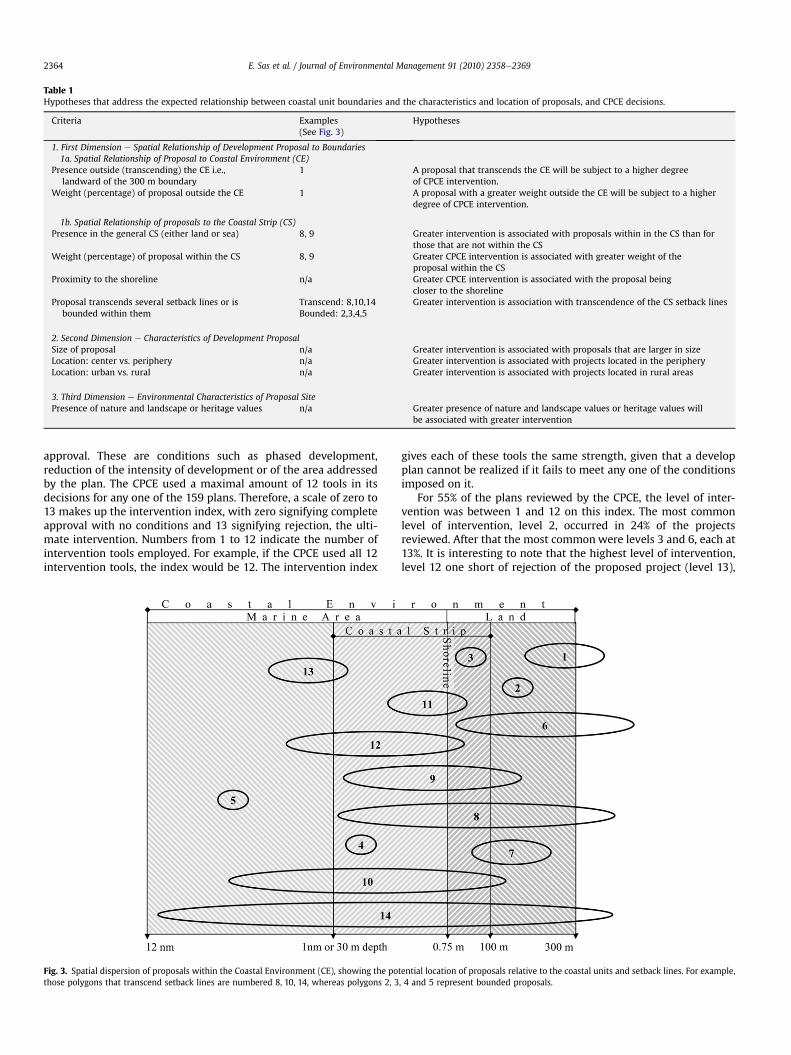
Table 1Hypotheses that address the expected relationship between coastal unit boundaries and the characteristics and location of proposals, and CPCE decisions.
Criteria Examples(See Fig. 3)
Hypotheses
1. First Dimension e Spatial Relationship of Development Proposal to Boundaries1a. Spatial Relationship of Proposal to Coastal Environment (CE)
Presence outside (transcending) the CE i.e.,landward of the 300 m boundary
1 A proposal that transcends the CE will be subject to a higher degreeof CPCE intervention.
Weight (percentage) of proposal outside the CE 1 A proposal with a greater weight outside the CE will be subject to a higherdegree of CPCE intervention.
1b. Spatial Relationship of proposals to the Coastal Strip (CS)Presence in the general CS (either land or sea) 8, 9 Greater intervention is associated with proposals within in the CS than for
those that are not within the CSWeight (percentage) of proposal within the CS 8, 9 Greater CPCE intervention is associated with greater weight of the
proposal within the CSProximity to the shoreline n/a Greater CPCE intervention is associated with the proposal being
closer to the shorelineProposal transcends several setback lines or is
bounded within themTranscend: 8,10,14Bounded: 2,3,4,5
Greater intervention is association with transcendence of the CS setback lines
2. Second Dimension e Characteristics of Development ProposalSize of proposal n/a Greater intervention is associated with proposals that are larger in sizeLocation: center vs. periphery n/a Greater intervention is associated with projects located in the peripheryLocation: urban vs. rural n/a Greater intervention is associated with projects located in rural areas
3. Third Dimension e Environmental Characteristics of Proposal SitePresence of nature and landscape or heritage values n/a Greater presence of nature and landscape values or heritage values will
be associated with greater intervention
E. Sas et al. / Journal of Environmental Management 91 (2010) 2358e23692364
approval. These are conditions such as phased development,reduction of the intensity of development or of the area addressedby the plan. The CPCE used a maximal amount of 12 tools in itsdecisions for any one of the 159 plans. Therefore, a scale of zero to13 makes up the intervention index, with zero signifying completeapproval with no conditions and 13 signifying rejection, the ulti-mate intervention. Numbers from 1 to 12 indicate the number ofintervention tools employed. For example, if the CPCE used all 12intervention tools, the index would be 12. The intervention index
Fig. 3. Spatial dispersion of proposals within the Coastal Environment (CE), showing the pothose polygons that transcend setback lines are numbered 8, 10, 14, whereas polygons 2, 3
gives each of these tools the same strength, given that a developplan cannot be realized if it fails to meet any one of the conditionsimposed on it.
For 55% of the plans reviewed by the CPCE, the level of inter-vention was between 1 and 12 on this index. The most commonlevel of intervention, level 2, occurred in 24% of the projectsreviewed. After that the most common were levels 3 and 6, each at13%. It is interesting to note that the highest level of intervention,level 12 one short of rejection of the proposed project (level 13),
tential location of proposals relative to the coastal units and setback lines. For example,, 4 and 5 represent bounded proposals.
8 In the Israeli case, for example, ideal ICZM would capture the entire coastalsediment cell which by necessity includes Egypt and Lebanon. Under the currentpolitical conditions the discrepancy between the political and national boundarieswill hamper any ideal ICZM management.
E. Sas et al. / Journal of Environmental Management 91 (2010) 2358e2369 2365
occurred only in 2% of the decisions. The next least common werelevels 10 and 11, at 3% each.
To analyze the relationship between the final decision of theCPCE which is an ordinal variable, and the explanatory variables(the criteria used by the CPCE) we used contingency analysis. This isa statistical significance test appropriate when sample sizes aresmall and data are categorical; it is used to examine the significanceof the association, or contingency, between classifications. Foranalyzing the relationship between the intervention index and thespatial characteristics of the proposal (i.e., location in relation to thecoastal units and setbacks), we used either a bivariate fit or one-way analysis of variance (ANOVA). The intervention index isa continuous variable. The bivariate fit and ANOVA are appropriatetests when the explanatory variable is continuous or ordinal,respectively. The p-value threshold for rejecting the null-hypoth-eses which supports the conclusion that the characteristic beingexamined does not influence decisions of the CPCE, was at the<0.05 levels. To conduct the analyses we used JMP7 statisticalsoftware (JMP , 1989e2007).
5. Results
In this section we first summarize the universe of proposals anddecisions that make up the data set. Then we describe findings ofthe statistical analyses and their possible implications.
5.1. Spatial characteristics of the proposed plans
Overall most of the proposals were for projects in the center ofthe country, in urban environments, were local scale plans, andwere submitted by private entities. The CPCE made decisions aboutmore than 100 local detailed proposals e 80% of these were withinurban municipalities. Proposals were submitted by private entities,municipalities or the national government, with the breakdown ofthese being 56%, 23% and 21% respectively.
About 70% of the proposals were located in urban areas,particularly in the cities of Tel Aviv-Yafo and Netanya that togethermade up 45% of all the project proposals submitted and 65% ofurban proposals. Geographically, about 57% proposed developmentin the central district of the country; otherwise 27% proposeddevelopment in the northern district and 16% in the southerndistrict.
Altogether, 14 spatial types of proposals (Fig. 3) are possible, inrelation to coastal boundaries. More than 50% of the proposalsreviewed by the CPCE were completely within the CE. Others hadvarying amounts (weights) of area within the CE. About 14% of theproposals covered areas that were less than 5% within the CE. Inregards to the more restrictive CS, 46% of the proposals were not atall within either the marine or terrestrial CS (as such, each of theirweights was 0%). About 10% of the proposals were completelywithin the CS and these made up about 20% of the proposals thatwere completely within the CE.
About a third of all proposals fell completely within one of theCE’s four units (e.g., polygon 2 in Fig. 3), and another third we foundcrossed two units (e.g., polygons 1 and 11 in Fig. 3). The last third ofthe proposals crossed three or four units (e.g., polygons 9 and 10 inFig. 3). Close to 90% of the proposals fall within one of the outerzones, meaning in the CE yet not in the CS. Less than a quarter of theproposals covered areas of the marine CS and more than halfcovered areas of the terrestrial CS. About 23% covered areas in both.Only 3 proposals of the 159 fell in areas within the marine outerunit of the CE; two of those were completely within this unit. About87% of the proposals covered areas within the outer unit of theterrestrial CE, and about 30% of these covered areas that werecompletely within this unit.
5.2. Statistical analysis and testing of CPCE’s decisions
The results of our statistical analyses (Table 2) suggest that theCPCE: 1) largely ignores jurisdictional boundaries stipulated in theCoastal Protection Law; and 2) makes decisions and mandateschanges in proposals based on other locational or environmentalfactors. This is reflected particularly in analyses involving theintervention index. Results of the study suggest that the CPCEmakes decisions based on characteristics of the project proposalsuch as proximity to the shoreline or the proposal’s geographicscope. Also, aspects of the environment such as landscape valuesand intensity of surrounding development are important influ-encing factors.
Specifically, the areas outside of the CE boundary are importantand the weight of the proposal in the general CE does not influencethe CPCE decision or the propensity to intervene. The CPCE is proneto intervene in decisions about plans that have some part withinthe CS, with the level of intervention increasing as the weight ofthis part rises. There seems to be more intervention when a plan ismostly on land than mostly in the marine area. This may reflect theplanning body’s greater familiarity with asserting its authority overterrestrial resources.
Although intervention in decisions regarding proposals that arecompletely in the marine area may be minimal, the proximity ofthese proposals to the shoreline is important. The shoreline is anelement of the meeting of land and sea and therefore a sensitivelandscape element. This is reinforced by the fact that intervention ishigh for proposals that have a small portion of their area in the sea.Results suggest that the location of the plan within the CE and theenvironmental values of the site greatly influence the propensity tointervene.
We found that the following factors significantly affect thedevelopment of the coast: the distance of proposed developmentfrom the shoreline; transcendence of several setback lines; thepercentage of the proposed development within the CS; andwhether or not a proposal also transcends the general CE. As to thelatter criteria we found that the size of the development programandwhether the program falls into an urban or a rural area tends toinfluence the decisions of the CPCE. The 100 m arbitrary setbackline set by the law was found to be insignificant in light of the CPCEdecisions. In summary, the CPCE does not limit its intervention tothe CE, sensitive elements of the environment take precedent overCE boundaries, and the CPCE generally does not use the legislatedboundaries categorically.
6. Discussion
Experience throughout the world teaches us about the imped-iments to integration in the governance of natural resources (e.g.,Biswas, 2004; Blomquist and Schlager, 2005), and of coastalresources in particular (Shipman and Stojanovic, 2007). Forexample, barriers could be either insufficient political stability ofnational administration (Sorensen, 1993) or insufficient economicresources to cover transaction costs related to coordinationbetween multiple agencies. In the Israeli case the spatial discrep-ancy between physical units and jurisdictional boundaries begins atthe national level where due to political realities true integratedcoastal management is already curtailed.8

Table 2The relationship between boundaries, characteristics and location of proposals and CPCE decisions.
Criteria Final decision contingency analysisa (p-value) Intervention index bivariate fit or one-wayanalysisb (p-value)
1. First Dimension e Spatial Relationship of Development Proposal to Boundaries1a. Spatial Relationship of Proposal to Coastal Environment (CE)
Transcending the CE Approval is more likely for proposals that arecompletely within the CE than for those thattranscend the CE boundary (0.0256)
Greater intervention is observed for proposals thattranscend the CE boundary than for those completelywithin it (0.0346)
Weight (percentage) of proposalwithin the CE
No connection between weight of proposalwithin the CE and the final decision
Intervention increases as the weight of a proposalwithin the CE increases for weights <55%; if >55%,the level of intervention decreases as the weightof the proposal within the CE increases (0.0029).
1b. Spatial Relationship of proposals to the Coastal Strip (CS)Presence in the general CS (either land or sea) Approval is more likely for a proposal not within
the CS than one that is partially or completelyin the CS (0.0001)
Greater level of invention for those proposals thatare partially or completely within the CS compared tothose not in the CS (0.0001)
Weight (percentage) of proposal withinthe general CS
Approval is less likely as the weight of theproposal within the CS increases (0.0018)
Intervention increases as weight of a proposal within theCS increases for weights <60%; for weights >60%,the level of intervention decreases as the weight ofthe proposal within the CS increases (0.0001).
Proximity to the shoreline Approval is more likely the greater the distancefrom the water line (0.0001)
The closer the proposal is to the shoreline, the greaterthe intervention level (0.0001). However, level ointervention steadily decreases up to 150 m landwardfrom the shoreline, and increases beyond.
Proposal transcends several setback lines or isbounded within them
Approval is less likely the greater the spatialdispersion across setback lines (0.0004)
Level of intervention increases as wide spread acrossthe CE the proposals are (0.0001)
2. Second Dimension e Characteristics of Development ProposalSize of proposal Approval is less likely the larger the proposal (0.0009) Level of intervention goes up as does the size of the
proposal, peaking at size 100e1000 dunam sizecategory (0.0013)
Location of proposal: center vs. periphery Approval is more likely in the center of the countrythan in the periphery (0.0438)
The level of intervention is greater for proposals inthe center of the country than for those in theperiphery (0.0095)
Location of proposal: urban vs. rural Approval is more likely in an urban municipality thanif proposal is within a regional council (0.0022)
Level of intervention is lower for proposals in anurban municipality than in a regional council(rural) (0.0001)
3. Third Dimension e Environmental Characteristics of Proposal SitePresence of nature and landscape or
heritage valuesApproval is more likely if there are no natural andlandscape or legacy values, or values from eitherof these groups (0.0001)
Level of intervention is greater if natural andlandscape and/or legacy values are present (0.0001)
a Decisions to approve, approve with conditions, or reject.b Levels of CPCE intervention (levels 0e13) in relation to three categorical dimensions of project proposals.
E. Sas et al. / Journal of Environmental Management 91 (2010) 2358e23692366
These costs and the complexity of integration often reduce thescale and scope of integration and address only a specific problem,a situation that clearly deviates from the holistic definition ofecosystem-based management (Tanaka, 2004; Balaguer et al.,2008). Even in places where the planning and managementauthorities can adopt ICZM principles, coastal boundaries are oftenset arbitrarily and therefore counter integration that would other-wise consider ecosystem characteristics.
When coastal boundaries are set arbitrarily, managerial rulesand laws are not likely to coincide with the physical sensitivity ofthe coastal units or with the area of influence of the problem andtherefore negatively impact the effectiveness of managementprograms. Thus, this study examines arbitrary coastal managerialboundaries e particularly, whether and how managerial bodiessupersede these when they have the opportunity.
Some policy analysts have asserted that arbitrary jurisdictionallines do not favor integrated coastal zone management andecosystem-based management principles (e.g., Tanaka, 2008), butthe Israeli case shows that when a certain amount of flexibility isallowed, some integration occurs. This integration considersphysical aspects of the environment, recognizes the sensitivity ofthe landesea interface and also acknowledges to some degree thesocial dimension as rural areas are considered more valuable thanareas already intensely developed.
In Israel, coastal boundary demarcation that corresponds withecological units or administrative ones was not politically feasible.The Israeli coastal area is heterogeneous in terms of geomor-phology, vegetation and biotic types even though the new CoastalEnvironment Protection Law treats the coast as homogeneous. Indesigning the law, policy makers have clearly relied on arbitraryboundary and setback lines. Yet we found that in practice CPCEmembers take the liberty to consider other factors when decidingon whether to restrict or intervene with development and they doso in ways that to some extent correspond to the ecological andsocial heterogeneity of the coast. Some of their criteria for inter-vention address the spatial relations between the developmentprograms and the different sub-units of the Coastal Environment;others relate to the characteristics of the particular developmentproposal and some high value elements of the environment such asocean views and geomorphological amenities (e.g., cliffs).
Many of the criteria used by the CPCE are not within thecommittee’s narrow mandate and are free interpretations of the lawwhich lacks detailed guidelines for protecting the coast. Extendingthe CPCE’s influence beyond the coast by intervening in proposalsthat fall mostly outside the formal jurisdiction of the committee isone example. This phenomenon is evidenced by greater levels ofintervention being observed for proposals that transcend the CEboundary than for those completely within the boundary. Extending
E. Sas et al. / Journal of Environmental Management 91 (2010) 2358e2369 2367
the meaning of the law is possible due to its ambiguities which leadto various interpretations of the CPCE’s mandate (Tzafrir, 2005).
The flexibility used by the CPCE highlights the tension describedin the literature between certainty and discretion (Booth, 1955,1996). The former stems from the regulatory planning system thatrequires the approval of detailed land use plans. These plans allocaterights in advance and therefore provide certainty. This approachcharacterized Israeli coastal management prior to the new coastallaw (Alfasi, 2008). The new coastal law adds more opportunities fordiscretion. It opens avenues for interpretation and greater judgmentby the CPCE while also allowing it to overcome arbitrary boundarydemarcation. Yet, too much discretion provides opportunities forregulatory capture9 and may favor those who have financial andlegal resources (Stigler, 1971) and hence will not necessarily providebetter outcomes. How to solve the certainty-discretion dilemmawhile at the same time maintaining the viability and usefulness ofarbitrary boundary demarcation, is a topic for further research.
A limitation of this research is clearly its failure to control for thecapacity of certain stakeholders, most likely developers, but alsoNGOs well versed in planning advocacy, to have the upper hand ininfluencing decisions of the CPCE. Since we have addressed theCPCE as a homogeneous body it is impossible to identify themarginal affect of these forces within the CPCE.10 With the limita-tion of the type of quasi-experimental study design we employed,our research looks at what influences decisions of the CPCE bylooking at the relationship of the decision, or intervention, to thespatial location of the proposed development. The spatial locationis expressed in reference to the arbitrary boundaries of the regu-latory program. The main assumption wemake that has influencedthe study design and therefore our conclusions, is that spatiallocationwithin the confines of the CE is a major factor affecting thedecisions of the CPCE and one that can be observed and measured.
Study findings not directly resulting from statistical analysis ofchosen criteria and levels of intervention have to do with how theCPCE takes initiative and exploits its ability to interpret the newCoastal Environment Protection Law. The CPCE tends to involveother authorities by delegating the responsibility for implementingconditions to other agencies. This can be understood as an attemptto make up for CPCE limitations as a reactive authority with limitedoperational power to affect protection of the coastal environment.The CPCE is a planning body and as such lacks the force andinfluence that a stand-alone jurisdictional management authorityresponsible for the coastal zone might have. Further the CPCE takesaction at the late stages of the planning process. Further study isneeded on how these aspects of the law and the operation of theCPCE fits with the ideals of ICZM.
7. Conclusion
Boundary demarcation in the coastal zone is an important partof the managerial process for ICZM, yet it continues to challengecoastal managers and scientists (Balaguer et al., 2008). Many arguethat zonal boundaries should be set according to physical land-scape, ecological processes, administrative lines and land uses. Yet,the real life spatial and scalar configuration of governance revealsthe struggle between stakeholders and decision makers on how to
9 Regulatory capture is a process whereby those entities being regulated capturepower using their economic and political resources. As a result a policy ora program will be biased toward the interests of the capturing group (Stigler, 1971).10 However, since the CPCE is a national board and various interests are repre-sented by members of the committee, including environmentalists, developers andthe national planning establishment, there is at least a balance among the decisionmakers. Also, all proposals are subject to the same interests before the CPCEthroughout the country so there is a level playing field, so to say.
balance development with environmental concerns (Bulkeley,2005). This struggle is illustrated by the great variation in howand according to what criteria boundaries are established for themanagement of natural resources (Feitelson and Fischhendler,2009), especially those designed for management of the coastalzone. One option is arbitrary boundary delineation that ignoresboth the physical and administrative heterogeneity of the coastalarea and therefore is likely to hinder the implementation of ICZMand ecosystem-based management approaches.
Therearemanybarriers for the implementationof ICZMacross theworld and in different contexts. Some impediments are associatedwith the complexity of the relationship between physical, economicand social sectors as expressed in current administrative and insti-tutional constructs. This explains for example, why the dominatemodel of ICZM in Europe is one of inconsistency and fragmentation(Shipman and Stojanovic, 2007). Hence it is unrealistic to assume thatICZM initiatives will easily contain the entire ecological or adminis-trative systems or even those that influence a specific problem forwhich a solution is sought (Balaguer et al., 2008).
This case study found that despite the physical irrationality ofarbitrary demarcation, the CPCE succeeded to both address areasoutside the arbitrary boundary demarcation and also to respect someof the different needs and constraints of the coastal sub-units. Israel’sCoastal Environment Protection Law allows and, in fact, encouragesthe regulator to use discretion and to employ various criteria tobalance development and conservation in the coastal zone.
Policy makers and resource managers must consider the balancebetweenboundaries thatoptimize environmentalneedsbycapturingentire ecosystems versus boundaries that are politically feasible. Thisbalance is now tilted towards arbitrary lines e as evidenced, forexample, by the use of setback lines for coastal management inEurope (Bridge and Salman, 2000). We conclude that despite thefrequentuseof arbitraryboundarydemarcation, the interconnectionsamong physical coastal and human systems can still be addressed.The approach implemented by the CPCE has some clear advantages.Whileflexible boundary demarcation based onenvironmental valuesopens the window to disagreements on the meaning of values, arbi-trary lines in programs that encourage flexibility are useful andpractical. Such boundaries are consistent and easily understood bydevelopers, regulators and the public at large. In any case, criticismsassociatedwith arbitrary boundarydemarcation should also considerthe benefits such a system can provide.
References
Adler, E., Inbar, M., 2007. Shoreline sensitivity to oil spills, the Mediterranean coast ofIsrael: assessment and analysis. Ocean & Coastal Management 50 (1e2), 24e34.
Adler, A., Shtern, U. 2000. Testimonyof Alik Adler from theMinistry of EnvironmentalProtection in front of the Interior and Environment Committee, 27 June 2000.
Alemalich, R., 2000. Testimony of Rafi Alemalich in front of the Interior and Envi-ronment Committee, 27 June 2000.
Alfasi, N., 2008. From Rude Illegalism to the Rule of Policy: the Shift from Regulatoryto Discretionary Planning in Israeli Coastal Planning. Law and EnvironmentWorking Papers 2/5769. The Department of Geography and EnvironmentalDevelopment, Ben Gurion University of the Negev.
Allmendinger, P., Barker, A., Stead, S., 2002. Delivering integrated coastal-zonemanagement through land-use planning. Planning Practice & Research 17 (2),175e196.
Amir, S., 1984. Israel’s coastal program: resource protection through management ofland use. Coastal Zone Management Journal 12 (2e3), 189e223.
Amir, S., 1987. Classification of coastal resources: a Mediterranean case study.Landscape and Urban Planning 14, 399e414.
Ariel, A., 2009. The Determinants and Implications of Scale and Scope of CoastalManagement in the Mediterranean. PhD dissertation, the Hebrew UniversityJerusalem.
Baja, S., Chapman, D.M., Dragovich, D., 2002. A conceptual model for defining andassessing land management units using a fuzzy modelling approach in GISenvironment. Environmental Management 29 (5), 647e661.
Balaguer, P., Sardá, R., Ruiz, M., Diedrich, A., Vizoso, G., Tintoré, J., 2008. A proposalfor boundary delimitation for integrated coastal zone management initiatives.Ocean and Coastal Management 51, 806e814.
E. Sas et al. / Journal of Environmental Management 91 (2010) 2358e23692368
Ben Ari, E., 2000. Testimony of Eli Ben Ari from Israel Union for EnvironmentalDefense in front of the Interior and Environment Committee, 27 June 2000.
Ben Ari, E., 2002. Testimony of Eli Ben Ari, from Israel Union for EnvironmentalDefense in front of the Interior and Environment Committee, 14 April 2002.
Bibi, Y., 2002. Testimony of Cabinet Member Yegal Bibi in front of the Interior andEnvironment Committee, 14 April 2002.
Biswas, A.K., 2004. Integrated water resources management: a reassessment:a water forum contribution. Water International 29 (2), 248e256.
Blomquist, W., Schlager, E., 2005. Political pitfalls of integrated watershedmanagement. Society and Natural Resources 18 (2), 101e117.
Bolin,B., Collins, T.,Darby,K., 2008. Fateof theverde:water, environmental conflict, andthe politics of scale in Arizona’s central highlands. Geoforum 39 (3), 1494e1511.
Booth, P., 1995. Zoning or discretionary action: certainty and responsiveness inimplementing planning policy. Journal of Planning Education and Research 14(2), 103e112.
Booth, P., 1996. Controlling development: certainty and discretion in Europe, theUSA and Hong Kong. In: The Natural and Built Environment Series 9. UCL Press,London.
Brachya, V., 1991. Integrated Planning and Management of Coastal Zones. IsraelNational Report to Regional Activity Centre, Priority Actions Program, Nairobi,Kenya.
Brachya, V., 1993. Environmental assessment in land use planning in Israel. Land-scape and Urban Planning 23, 167e181.
Brachya, V., 2002. Integrated coastal zone management in Israel. In: Cicin-Sain, B.,Pavlin, I., Belfiore, S. (Eds.), Sustainable Coastal Manangement: a Transatlanticand Euro-Mediterranean Perspective. Kluwer Academic Publishers, theNetherlands, pp. 113e121.
Brenner, J., Jimenez, J.A., Sardá, R., 2006. Definition of homogeneous environmentalmanagement units for the Catalan coast. Environmental Management 38,993e1005.
Bridge, L., Salman, A., 2000. Policy Instruments for ICZM in Nine Selected EuropeanCountries: Final Study Report Prepared for the Dutch National Institute forCoastal and Marine Management. RIKZ, Leiden, The Netherlands.
Bulkeley, H., 2005. Reconfiguring environmental governance: towards a politics ofscales and networks. Political Geography 24, 875e902.
Christie, P., Lowry, K.,White, A., Oracion, E.G., Sievanen, L., Pomeroy, R.S., Pollnac, R.B.,Patlis, J., Eisma, L., 2005. Key findings from a multidisciplinary examination ofintegrated coastal management process sustainability. Ocean and CoastalManagement 48, 468e483.
Cicin-Sain, B., 1993. Special issue on integrated coastal management. Ocean &Coastal Management 21 (1e3), 1e377.
Cicin-Sain, B., Knecht, R., 1998. Integrated Coastal and Ocean Management:Concepts and Practices. Island Press, Washington D.C.
Clark, J.R.,1996. Coastal ZoneManagement Handbook. Lewis Publishers, NewYork, NY.Communication Partnership for Science and the Sea, 2005. Scientific consensus
statement on marine ecosystem-based management. http://compassonline.org/pdf_files/EBM_Consensus_Statement_v12.pdf (accessed September 2009).Convention on Biological Diversity, 1999. Liaison Group on the EcosystemApproach. Convention onBiologicalDiversity&UNESCO,WorkshopReport, Paris.
Convention on Biological Diversity, 2000. The Ecosystem Approach DecisionsAdopted by the Conference of the Parties to the Convention on BiologicalDiversity at its Fifth Meeting Nairobi, Kenya.
Cowell, R., 2003. Substitution and scalar politics: negotiating environmentalcompensation in CardiffBay. Geoforum 34 (3), 343e358.
Crean, K., 2000. The influence of boundaries on themanagement of fisheries resourcesin the European Union: case studies from the UK. Geoforum 31 (3), 315e328.
Emery, K.O., Neev, D., 1960. The Mediterranean beaches of Israel. Israel GeologicalSurvey Bulletin 26, 1e24.
Enemark, J., 2005. The WaddenSea protection and management scheme e towardsan integrated coastal management approach? Ocean & Coastal Management 48(11e12), 996e1015.
European Environmental Agency, 2003. DMEER: digital map of European eco-logical regions. http://dataservice.eea.europa.eu/atlas/viewdata/viewpub.asp?id¼7 (accessed September 2009).
European Environmental Agency, 2006. The Changing Faces of Europe’s CoastalAreas. Office for Official Publications of the European Communities, Luxembourg.
Feitelson, E., Fischhendler, I., 2009. Spaces of water governance: the case of Israeland her neighbors. The Association of American Geographers 99 (4), 728e745.
Fletcher, S., 2000. The evolution of coastal management policy in the state of Israel.Marine Policy 24, 395e405.
Gibbs, D., Jonas, A.E.G., 2000. Governance and regulation in local environmentalpolicy: the utility of a regime approach. Geoforum 31 (3), 299e313.
Goldsmith, V., Golik, A., 1980. Sediment transport model of the southeasternMediterraneanCoast. Marine Geology 37, 137e145.
Governmental Interior and Environmental Committee, 2000. Meeting from 29 May2000.
Hershman, M., Good, J., Bernd-Cohen, T., Goodwin, R., Lee, V., Pogue, P., 1999. Theeffectiveness of coastal zone management in the United States. CoastalManagement 27, 113e138.
Hildebrand, L., 1994. Cooperation in the coastal zone. Ocean and Coastal Manage-ment 25, 233e235.
JMP, 1989e2007. Version 7. SAS Institute Inc., Cary, NC.Kana, T.W., 1991. Treating the coast as a dynamic system. CAMPANET. In: Clark, J.R.
(Ed.), The Status of Integrated Coastal Zone Management: a Global Assessment.University of Miami/RSMAS, Miami, pp. 60e61.
Keiter, R.B., 1994. Beyond the boundary line: constructing a law of ecosystemmanagement. University of Colorado Law Review 65 (2), 293e333.
Kizer, D., 2000. Testimony of Danny Kizer from the Municipality of Tel Aviv infront of the Governmental Interior and Environmental Committee, 29 May2000.
Lau, M., 2005. Integrated coastal zone management in the People’s Republic ofChina: an assessment of structural impacts on decision-making processes.Ocean & Coastal Management 48, 115e159.
Lawrence, P.L., 1997. Integrated coastal zone management and the Great Lakes. LandUse Policy 14 (2), 119e136.
Massachusetts Oceans Act, 2008. (codified at Chapter 21A M.G.L. Section 4c(b) x x).May, P.J., Burby, R.J., Ericksen, N.J., Handmer, J.W., Dixon, J.E., Michaels, S., Smith, D.I.,
1996. Environmental Management and Governance. Ministry of EnvironmentalProtection, 2003. Coastal area report. Routledge, London. http://www.sviva.gov.il (Accessed September 2009).
Molle, F., 2009. River-basin planning and management: the social life of a concept.Geoforum 40, 484e494.
NOAA, 2004. State coastal zone boundaries e ocean and coastal resource manage-ment. http://coastalmanagement.noaa.gov/mystate/docs/stateczboundaries.pdf(Accessed September 2009).
OJEC, June 2002. L148/24: recommendation of the European Parliament and thecouncil of 30 May 2002 concerning the implementation of integrated coastalzone management in Europe (2002/413/EC). Official Journal of the EuropeanCommunities 45 (6).
Olsen, S.B., 2003. Assessing progress towards the goals of coastal management.Journal of Coastal Management 30 (4), 325e345.
Olsen, S.B., Kenchington, R., Davies, N., Dutra, G.F., Hale, L.Z., Robles, A., Wells, S.,2004. A global network for sustained governance of coastal ecosystems. In:Glover, L., Earle, S. (Eds.), Defying Oceans End. Island Press, Washington D.C.,pp. 43e70.
Ostrom, E., 1990. Governing the Commons: The Evolution of Institutions forCollective Action. CambridgeUniversity Press, Cambridge, U.K.
Ostrom, E., 2001. Reformulating the commons. In: Burger, J., Ostrom, E., Norgaard, R.B., Policansky, D., Goldstein, B.D. (Eds.), Protecting the Commons: a Frameworkfor Resource Management in the Americas. Island Press, Washington, D.C,pp. 17e41.
Papay, N. (Ed.), 2003. The coast of Israel: the gap between the existing coast and thedesired one. Report # 4, Society for the Protection of Nature in Israel (in Hebrew).
Papay, N. (Ed.), 2007. Follow up Report on the Situation of the Israeli Coast. Societyfor the Protection of Nature, Israel (in Hebrew).
Portman, M., 2006. Tidelands management: implementation of the Massachusettspublic waterfront act. Journal of Environmental Policy and Planning 8 (4),293e308.
Portman, M.E., Duff, J.A., Köppel, J.J.R., Higgins, M.E., 2009. Offshore wind energydevelopment in the exclusive economic zone: legal and policy supports andimpediments in Germany and the U.S. Energy Policy 37 (9), 3596e3607.
Schlaepfer, R., 1997. Ecosystem-based Management of Natural Resources: a Steptowards Sustainable Development. International Union of Forestry ResearchOrganization, Slovakia.
Sherman, K., Alexander, L.M., 1986. Variability and Management of Large MarineEcosystems AAAS Selected Symposium 99. Westview Press, Boulder, Colorado.
Shipman, B., Stojanovic, T., 2007. Facts, fictions and failures of integrated coastalzone management in Europe. Coastal Management 35, 375e398.
Shtern, U., 2004. Testimony of cabinet member Yuli Shtern in front of the Interiorand Environment Committee, 8 June 2004.
Sorensen, J., 1993. The international proliferation of integrated coastal zonemanagement efforts. Ocean & Coastal Management 21, 45e80.
Sorenson, J., August 2002. Baseline 2000. Background report. The Status of Inte-grated Coastal Management as an International Practice. Urban HarboursInstitute, Boston, Second Iteration. pp. 26.
Stigler, G.J., 1971. The theory of economic regulation. The Bell Journal of Economicsand Management Science 2 (1), 3e21.
State Comptroller, 1998. State Comptroller report No. 49 on Land Use Planningalong the Mediterranean Coast.
State of Israel, 1983. Planning and Building Law, National Master Plan for theMediterranean Coast of Israel # 13 Israel (in Hebrew).
State of Israel, 1999. Coastal Policy for Israel: Policy Report. Territorial WaterCommittee Authority, Israel (in Hebrew).
State of Israel, 2003. Facts on the Mediterranean Sea. Ministry of EnvironmentalProtection. http://www.sviva.gov.il (Accessed September 2009).
State of Israel, 2004. Coastal Environmental Protection Law Israel (in Hebrew).Talitman, D., Tal, A., Brenner, S., 2003. The devil is in the details: increasing inter-
national law’s influence on domestic environmental performance e the case ofIsrael and the Mediterranean sea. New York University Environmental LawJournal 11, 414e478.
Tanaka, Y., 2004. Zonal and integrated management approaches to ocean gover-nance: reflections on a dual approach in international law of the sea. TheInternational Journal of Marine and Coastal Law 19 (4), 483e514.
Tanaka, Y., 2008. A Dual Approach to Ocean Governance: The Cases of Zonal andIntegrated Management in International Law of the Sea. Ashgate Publishing,Aldershot, U.K.
Turnipseed, M., Crowder, L.B., Sagarin, R.D., Roady, S.E., 2009. Legal bedrock forrebuilding America’s ocean ecosystems. Science 324 (5924), 183e184.
Tzafrir, D., 2005. The coastal zone act: the social purpose and environmental justice.Mekarkeyin 4 (1), 38e54 (in Hebrew).

E. Sas et al. / Journal of Environmental Management 91 (2010) 2358e2369 2369
UNESCO, 1997. Methodological Guide to Integrated Coastal Zone Management.Intergovernmental Oceanographic Commission, Manuals and guides. pp. 36.
Vallega, A., 2002. The regional approach to the ocean, the ocean regions, and oceanregionalization e a post-modern dilemma. Ocean & Coastal Management 45(11e12), 721e760.
Wang, H., 2004. Ecosystems management and its application to large marineecosystems: science, law, and politics. Ocean Development & International Law35, 41e74.
Weinthal, E., Parag, Y., 2003. Two steps forward, one step backward: societalcapacity and Israel’s implementation of the Barcelona convention and theMediterranean action plan. Global Environmental Politics 3 (1), 51e71.
Wisman, A. 2000. Testimony of Wisman Aaron, The Shipping and Ports Adminis-tration in front of the Interior and environment committee, 27 June 2000.
Zonnenveld, I.S., 1994. Basic principles of classification. In: Klijn, F. (Ed.), EcosystemClassification for Environmental Management. Kluwer Academic Publishers,The Netherlands, pp. 23e47.