the dtc winter forecast experiment (dwfe) dtc winter forecast experiment (dwfe): dave dempsey (san...
TRANSCRIPT

The DTCWinter Forecast Experiment (DWFE):
Dave Dempsey(San FranciscoState University;
DTC visitor)
William Skamarock(NCAR/MMM)
Analysis of Kinetic Energy Spectra
Acknowledgements:
• Ligia Bernardet (NOAA/FSL/DTC)
• Zavisa Janjic (NCEP)
• Bob Gall (Director, DTC/NCAR)

2006 DTC Reunion NCAR/DTC
• Kinetic energy spectra– background– backstory– accidental DWFE discoveries– ARW and NMM results– sensitivity study: NMM spectra and
model configurations
Outline:
• DTC Winter Field Experiment (DWFE)• Motivating observations
– mountain waves
• Conclusions and Further Work

2006 DTC Reunion NCAR/DTC
• Two versions of WRF:– Two different dynamical cores
(NMM & ARW)– Two different physics packages
(NCEP & NCAR)
• 5 km resolution; 37 levels
• Initial and boundary conditions from Eta212 (40 km)
• 00Z initialization, daily 48-hour forecasts
• Explicit convection (no convective parameterization)
DTC Winter Forecast ExperimentJan 15 - March 31, 2005
ConUS Domain

2006 DTC Reunion NCAR/DTC
My Context (a parable of howscience sometimes happens)
• Sabbatical leave (half pay), Jan-July ‘05• Invite self to visit DTC. Flexible agenda—will work for chance to be useful, learn something• Gall says “OK”, provides:
• office, computer, office supplies• no promises of anything else
• Office shared (1 day/wk) w/Steve Koch (NOAA)• Gall says, “Dempsey: DWFE forecasts.
See what you can see.”

2006 DTC Reunion NCAR/DTC
Mountain WavesPotential Temperature Cross Sections
(12 hr forecasts valid 12Z Jan 13, 2005)ARW NMM

2006 DTC Reunion NCAR/DTC
The Parable (cont’d)• I print copies of mountain wave plots.• NCAR is big place—lots of printers. Can’t find
the printer. Plots sit by printer 3 days.• It’s NCAR/MMM’s printer, near Bill Skamarock’s
office.• Skamarock notices plots. He sees possible
support for his (contentious) work on ARW andNMM KE spectra (work he’d given up).
• I finally find plots. Bill happens to be there. Bill revives interest in ARW/NMM spectra.
• He computes some.

2006 DTC Reunion NCAR/DTC
• Kinetic energy spectra– background– backstory– accidental DWFE discoveries– ARW and NMM results– sensitivity study: NMM spectra and
model configurations
• DTC Winter Field Experiment (DWFE)
Coming Up Next:
• Motivating observations– mountain waves
• Conclusions and Further Work

2006 DTC Reunion NCAR/DTC
• Nastrom and Gage (1985):Spectrum computed from GASP observations(commercial aircraft)
• Lindborg (1999):Functional fit to MOZAIC observations (aircraft)
Kinetic Energy Spectra
mesoscale

2006 DTC Reunion NCAR/DTC
Backstory• Skamarock and Baldwin
(white paper, Nov. 2003)– NMM’s KE spectra show that NMM has too much
dissipation– ARW’s KE spectra are fine
• Janjic and Black (NCEP) respond:– Not true, on both counts– Don’t know what mesoscale model spectra should
look like, anyway
• Skamarock (MWR, 2004) refines white paper arguments; veils references to NMM.

2006 DTC Reunion NCAR/DTC
The Parable (cont’d)
• Skamarock’s NMM and ARW KE spectra of DWFE forecasts (Jan. 2005) resemble previous spectra. Dispute over KE spectra threatens to revive.
• DTC idea: have Dempsey act as neutralinvestigator, recalculate spectra, try to get to bottom of Skamarock/Janjic differences.
• Hmmm ….

2006 DTC Reunion NCAR/DTC
Questions• Do DWFE NMM & ARW model spectra resemble
the Nastrom & Gage (1985) observed spectrum?• Should they?• If they should, and if they do, do they for the right
(physical) reasons? And how can we tell?
• If not, why not?

2006 DTC Reunion NCAR/DTC
Computing model KE spectra• Interpolate u, v to pressure levels• Detrend u, v along each 1-D transect• Compute discrete Fourier transform of kinetic
energy along each E/W (or N/S or diagonal) transect
• Average spectra over:– multiple transects, and– pressure layer (100 mb deep)

2006 DTC Reunion NCAR/DTC
• NMM “E” grid: compute KE spectraon transects:– diagonally;– east/west; or– north/south
• ARW “C” grid: compute spectra:– east/west, or– north/south
2006 DTC Reunion NCAR/DTC
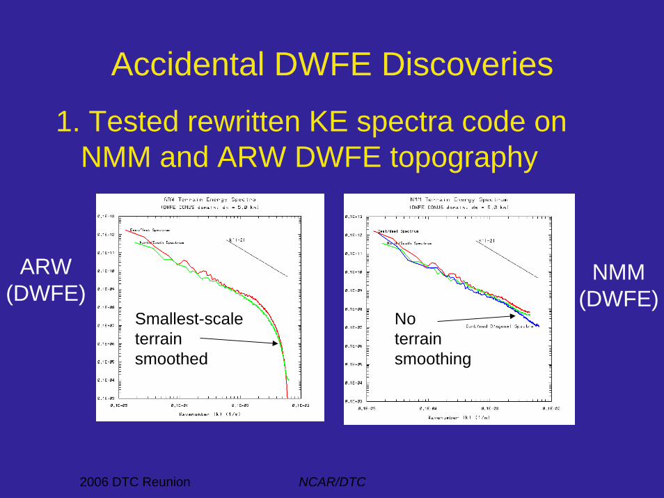
Accidental DWFE Discoveries
1. Tested rewritten KE spectra code on NMM and ARW DWFE topography
ARW(DWFE)
NMM(DWFE)
Smallest-scaleterrainsmoothed
Noterrainsmoothing

2006 DTC Reunion NCAR/DTC
Accidental DWFE Discoveries
2. Bug in WRF-NMM-SI initialization
• Spike in initial energyat L = 2Δx at all levels(diagonal spectra only)
• Gone by 3 hr forecast
Contour plot: Initial u-component(2Δx pattern due to array index error)
2006 DTC Reunion NCAR/DTC
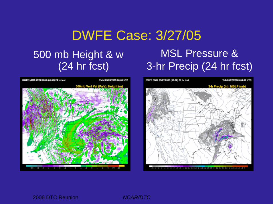
DWFE Case: 3/27/05500 mb Height & w
(24 hr fcst)MSL Pressure &
3-hr Precip (24 hr fcst)

2006 DTC Reunion NCAR/DTC
Spin-up of Kinetic Energy Spectra
ARW NMM
• Spectra in 300-200 mb layer• 6 hour intervals, 00 to 48 hrs
mesoscale mesoscale
• Note: get mature spectrum by ~< 24 hours
initial initial

2006 DTC Reunion NCAR/DTC
“Mature” Kinetic Energy Spectra• Average over 24-48 hours. Three tropospheric layers shown• Note:
– NMM: less mesoscale energy aloft– NMM: more energy on smallest scales, esp. at lower levels
NMMARW
Uppertroposphere
Uppertroposphere

2006 DTC Reunion NCAR/DTC
Questions:1. Why did NMM spectrum have less energy at
mesoscales aloft than observations and ARW, hence lacking transition to k-5/3 slope?
2. Why did NMM spectrum have more energy than ARW at smallest scales at low altitudes?
Initial Testing Strategy:1. Rerun NMM with various bug fixes2. Rerun with smoothed topography3. Rerun without horizontal-divergence damping4. Rerun with more horizontal diffusion (2nd order, 4th order)
Hypotheses:• NMM has unsmoothed topography, very low horizontal
diffusion, and horizontal-divergence damping

2006 DTC Reunion NCAR/DTC
Some results of NMM reruns:1. Fixing bugs: little effect on spectra
• Original DWFE run• 3 levels shown; 24-48 hr fcst avg
• Rerun #1: Bug fixes• 3 levels shown; 24-48 hr fcst avg

2006 DTC Reunion NCAR/DTC
modest (x 0.5) decrease in energy at small scales
• Rerun #1: Unsmoothed terrain• 3 levels shown; 24-48 hr fcst avg
• Rerun #2: Smoothed terrain• 3 levels shown; 24-48 hr fcst avg
2. Smoothed terrain:
Some results of NMM reruns:
NMM,smoothed
terrainARW,
smoothedterrain
NMM, unsmoothed terrain

2006 DTC Reunion NCAR/DTC
Some results of NMM reruns:3. No divergence damping:
• Rerun #3: No divergence damping• Forecasts: 00, 03, 06, 09, 12 hrs; • 300-200 mb layer
Oops!

2006 DTC Reunion NCAR/DTC
External modes!Surface pressure change after 03 hrs(contour interval = 2 mb)
ConUSdomain

2006 DTC Reunion NCAR/DTC
External modes:Vertical Velocity Cross Section
• 03 hr forecast

2006 DTC Reunion NCAR/DTC
Revised Testing Strategy:
4. Rerun with no horizontal-divergence damping but add a vertically-integrated horizontal-divergence damper (to damp external modes)
5. Rerun with more horizontal diffusion (2nd order, then 4th order)

2006 DTC Reunion NCAR/DTC
Results:
• 18 hr forecast• 3 tropospheric levels
• Rerun #3: No divergence damping
External mode removed
• Rerun #4: No divergence damping; external-mode damping added
• 18 hr forecast• 3 tropospheric levels

2006 DTC Reunion NCAR/DTC
Conclusions• ARW in DWFE:
– Kinetic energy spectra similar to Nastrom & Gage (1985) observations at mid-mesoscales (~7Dx) and larger
– Implicit damping and weak explicit diffusion, plus smoothed topography, reduce small scale energy
– Arguably desirable (Skamarock and others); or maybe not (Janjic)• NMM in DWFE:
– NMM spectra showed less energy at mesoscales than Nastrom& Gage (1985) observations, especially aloft
• Can apparently change this by replacing horizontal-divergence damping with sufficient external-mode damping
– Spectra show more energy at smallest scales than ARW (but less than observed)
• smoothing topography reduces small-scale energy somewhat• can debate whether need more small-scale damping

2006 DTC Reunion NCAR/DTC
Further Work (NMM)• Fine-tune external-mode damping
• Try 4th-order diffusion to reduce energy selectively on smallest scales– NCEP: Adapt 4th-order diffusion to parallel
computing (doesn’t work yet)
• Evaluate effect of these alternative filters on meteorological fields and traditional verification statistics– NOAA: Test against T-REX data (mountain
waves) and Rapid Refresh runs

2006 DTC Reunion NCAR/DTC
24-Hour Precipitation BiasesDWFE: Jan 15-Mar 31 2005
WRF-NMM
WRF-ARW
Eta1.0
6.0
2006 DTC Reunion NCAR/DTC
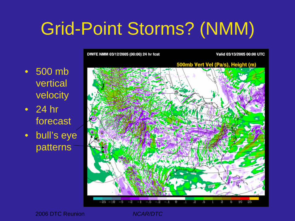
Grid-Point Storms? (NMM)
• 500 mbverticalvelocity
• 24 hr forecast
• bull’s eyepatterns

2006 DTC Reunion NCAR/DTC
A Bull’s Eye Close-up:500 mb Vertical Velocity• Data on native “E”-grid
(no interpolation orsmoothing beforecontouring)
• Depth of verticalmotion: sfc to 300 mb(max near 300 mb)
Grid pts.
2006 DTC Reunion NCAR/DTC
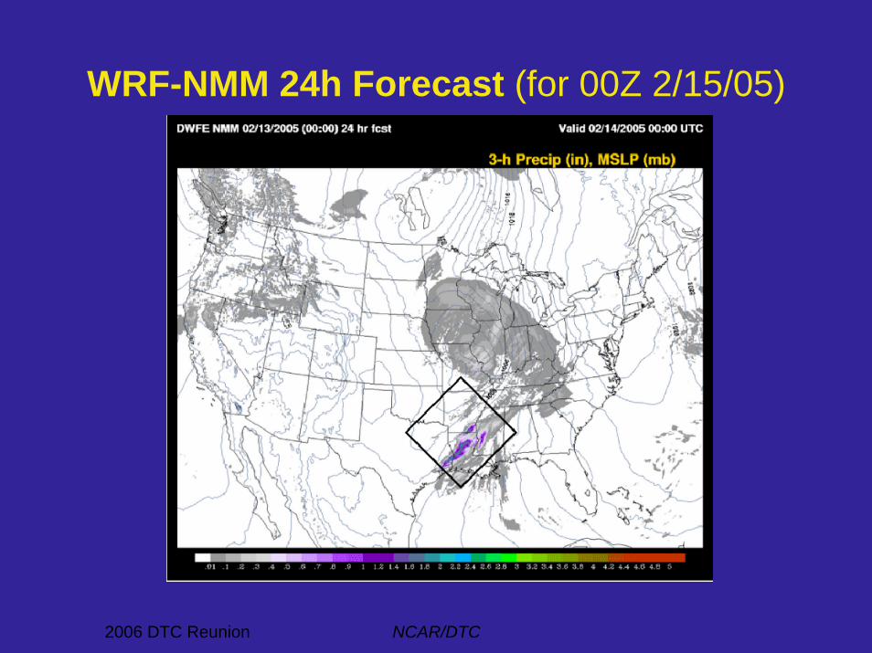
WRF-NMM 24h Forecast (for 00Z 2/15/05)

2006 DTC Reunion NCAR/DTC
WRF-NMM, 13 Feb 2005• 00Z init, 24h forecast• vertical velocity (cint = 0.2 m/s)• model level 10 (~ 900 mb)