the first maya civilization - yasser musa · the first maya civilization illustrates the latest...
TRANSCRIPT
The First Maya Civilization illustrates the latest archaeological finds that forcea revision of old theories on the beginnings of Maya civilization. As we knowtoday, the Lowland Maya developed and sustained state societies centuriesprior to the Classic period. The period archaeologists refer to as the Preclassic(2000 BC–AD 200) represents the first of a series of complete cycles of Mayacivilization. Thanks to new data, the massive Preclassic temple pyramids of El Mirador are no longer seen as an unprecedented phenomenon but as theoutcome of a gradual process begun several centuries earlier by Lowlandfarmers.
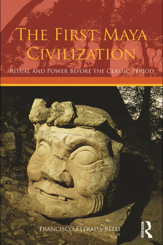
Francisco Estrada-Belli focuses largely on two newly discovered early citiesin the eastern part of the Petén, Cival and Holmul, the location of spectacularand early finds by the author, as well as recent discoveries by other Mayanistsat San Bartolo, Nakbe, El Mirador and Tikal. Spectacular finds that have forceda revision of old theories include writing, monumental art and architecture, aswell as dense settlements, some of which are among the earliest in the NewWorld. The ceremonial center of Cival, among the oldest recorded to date, wasfounded circa 900 BC. By 500 BC the Lowland Maya had developed a sophis-ticated civilization. It reached its peak around AD 100, after which time itunderwent a political reorganization, and some centers were abandoned.
In the periods that followed, the Classic and Postclassic periods, LowlandMaya kings steadily maintained the tradition of ritual, art and architecture aswell as trade and warfare established by their Preclassic ancestors. The art,ritual and power institutions created by the Preclassic Maya comprise one ofthe richest and most long-lived legacies of the Americas’ ancient civilizations.
Francisco Estrada-Belli is Visiting Assistant Professor at Boston University.He specializes in Mesoamerican archaeology, the emergence of Maya civiliza-tion, and GIS and remote sensing. His publications include The Archaeology ofSoutheastern Pacific Coastal Guatemala: A regional GIS approach (1999).
THE FIRST MAYA CIVILIZATION


THE FIRST MAYACIVILIZATION
Ritual and Power before the Classic Period
Francisco Estrada-Belli

First published 2011by Routledge
2 Park Square, Milton Park, Abingdon, Oxon OX14 4RN
Simultaneously published in the USA and Canadaby Routledge
270 Madison Ave, New York, NY 10016
Routledge is an imprint of the Taylor & Francis Group, an informa business
© 2011 Francisco Estrada-Belli
The right of Francisco Estrada-Belli to be identified as author of this work has been asserted by him in accordance with sections
77 and 78 of the Copyright, Designs and Patents Act 1988.
All rights reserved. No part of this book may be reprinted or reproduced or utilised in any form or by any electronic, mechanical, or other means,
now known or hereafter invented, including photocopying and recording, or in any information storage or retrieval system, without permission in
writing from the publishers.
British Library Cataloguing in Publication DataA catalogue record for this book is available from the British Library
Library of Congress Cataloguing in Publication DataEstrada-Belli, Francisco.
The first Maya civilization : ritual and power before the classic period / Francisco Estrada-Belli.
p. cm.Includes bibliographical references.
1. Mayas–Guatemala–Petén (Dept.)–Antiquities. 2. Excavations (Archaeology)–Guatemala–Petén (Dept.) 3. Maya architecture–Guatemala–Petén (Dept.)
4. Petén (Guatemala : Dept.)–Antiquities. I. Title. F1435.1.P47E77 2010
972.81'2–dc222010019911
ISBN 13: 978–0–415–42993–1 (hbk)ISBN 13: 978–0–415–42994–8 (pbk)ISBN 13: 978–0–203–83913–3 (ebk)
This edition published in the Taylor & Francis e-Library, 2011.
To purchase your own copy of this or any of Taylor & Francis or Routledge’scollection of thousands of eBooks please go to www.eBookstore.tandf.co.uk.
ISBN 0-203-83913-7 Master e-book ISBN

FOR NIÑA

CONTENTS
List of figures ixPreface xiiAcknowledgements xv
1 Maya civilization in perspective 1
An overview of Classic Maya research 4Classic Maya people, places and history 9The beginnings of Maya civilization 28
2 Trajectories of evolution: Maya archaeology and the Preclassic Maya 31
Theories of the origins of Maya civilization: the first part of the 20th century 31
Theories of the origins of Maya civilization: the second part of the 20th century 33
Peasant pioneers 36The earliest Lowland farmers 38Early villages and social ranking 39Suddenly civilization? Highland–Lowland migrations, again 44The Preclassic Maya behemoth 49
3 Maya states before the Classic period 54
The rise of the first Lowland states 54In the line of the founder: Preclassic royal burials 55Preclassic kingdoms and the AD 100 “conjuncture” across the Lowlands 61The dawning of a new era: Tikal 64
4 Planting the seed of civilization: the making of sacred ground 67
Preclassic Maya site planning 67The earliest monumental works and the making of a civilization 74The earliest plaza rituals: activating the Maya cosmos 78
vii

5 Earth–mountain–caves and sky–serpent–birds: meta-narratives of Preclassic Maya art 84
The role of hieroglyphic writing in Maya (royal) narratives 110
6 The Preclassic–Classic Maya transition: a new beginning? 117
A “Protoclassic” or “Terminal Preclassic” to Classic transition 117The eclipse of El Mirador and the rise of Classic kingdoms 119The rise of new Maya kings and the Teotihuacan “entrada” 122The puzzling end of El Mirador 128Environment, politics and friends in high places 129
7 Conclusion 140
A new beginning for Maya studies 141Long-term and life histories 142Where do we go from here? 146
Notes 148References 151Index 169
C O N T E N T S
viii

FIGURES
1.1 Time divisions used by Maya archaeologists and important, period-ending Maya calendar dates commemorated in Classic period inscription 3
1.2 Map of the Maya region and sites mentioned in the text 51.3 Map of the central and eastern region of the Maya Lowlands and
major sites mentioned in the text 61.4 Sylvanus Morley and Eric Thompson with their consorts at
Chichén Itzá during the CIW excavations 71.5 Map of Tikal’s central area 101.6 Rooftops of Tikal Temples I, II and III 121.7 Tikal king Jasaw Chan K’awiil celebrating his victory over
arch-rival Chak Tok Ichaak of the Snake Kingdom (Calakmul) on September 14, 695 13
1.8 Façade of the Kaana’ pyramid at Caracol 141.9 Caracol Altar 21 and passage relating the Tikal war 151.10 Structure 2 pyramid at Calakmul with Late Classic stelae erected
on the plaza floor and pyramid’s terraces 161.11 Temple of the Inscriptions, Palenque, resting place of King
Pakal 181.12 The Palenque palace after many additions 191.13 Carving from the stone sarcophagous lid of King Pakal, who
died August 28, 683 201.14 The CIW map of Kaminaljuyú 211.15 Copan’s Altar Q 231.16 Copan’s King Uaxaclajuun Ubah K’awiil’s architectural legacy:
the Great Plaza at Copan with the ball court and the hieroglyphicstairway 24
1.17 Kiche’ Maya procession in the main plaza of Chichicastenango,Guatemala 26
2.1 Lowland sites with Pre-Mamom ceramics (1100–850 BC) 362.2 Artist’s reconstruction of the Pre-Mamom K’awiil ceramic
complex from the Holmul region 41
ix

2.3 Ixcanrio polychrome tetrapod (Terminal Preclassic), Holmul,Building B, Burial 10 46
2.4 Artist’s reconstruction of the central area of El Mirador, as it may have appeared circa AD 100 50
2.5 Map of El Mirador 513.1 Burial 85 in plan and profile view under Structure 5D-Sub 2-2nd 573.2 Tikal North Acropolis circa AD 70 with shrines facing temple
buildings 583.3 Profile of the University of Pennsylvania Museum trench across
the North Acropolis 603.4 Late Preclassic tomb in Building B’s Room 8 at Holmul 644.1 Map of Cival showing E-Group sightlines 684.2 Virtual view of Cival’s central area from the west based on GIS
data 704.3 Virtual view of Cival’s ceremonial complex from the southwest
based on GIS map data 704.4 Map of Holmul 724.5 View of sites with E-Group complexes in the Holmul region 734.6 Three-dimensional views of Cival’s volumetric input during the
Middle Preclassic and Late Preclassic periods 764.7 View of Cache 4 at Cival with jars deposited in k’an-cross-shaped
pit on the east–west axis of the E-Group 804.8 Rendering of Cache 4 at Cival (circa 800 BC) 814.9 Rendering of Cival’s E-Group Plaza, Structure 7, Stela 2 and
wooden posts (300–200 BC) 815.1 Cival Stela 2 855.2 La Mojarra Stela 1 855.3 Avian dance on Kaminaljuyú vessel 865.4 PBD mask on Nakbe Structure 1 875.5 Kaminaljuyú Altars 9 and 10 895.6 Kaminaljuyú Stela 11 905.7 Izapa Stela 12 905.8 Eastern masks on the terraces of Structure 5C-2nd at Cerros
(circa 50 BC) 915.9 Masks on the terraces of Structure Sub 3 in Group H at
Uaxactun (Late Preclassic) 925.10 Profile elevation of Building B-1st, Holmul (circa 400 BC) 935.11 Façade of Holmul Building B-1st 945.12 Masks and temple room, Building B-1st, Holmul (circa 350 BC) 945.13 View of zoomorphic head in profile and human skull, Building
B-1st, Holmul (circa 400 BC) 955.14 Structure 5D-33-2nd, profile with masks, Tikal 975.15 San Bartolo North Wall mural: mountain/cave scene 985.16 Sepolturas sky bench, pawatun support, Copan (Late Classic) 99
L I S T O F F I G U R E S
x

5.17 La Venta Altar 4 1015.18 Chalcatzingo Monument 22 1025.19 Oxtotitlan cave painting 1025.20 Northern mask on Cival Structure 1–4th 1045.21 Southern mask on Cival Structure 1–4th 1055.22 Figure 1 of Mural 1 on Cival Structure 1–4th (circa 200 BC) 1075.23 Figure 13 of Mural 1 on Cival Structure 1–4th (circa 200 BC) 1085.24 Figure 2 of Mural 1 on Cival Structure 1–4th (circa 200 BC) 1085.25 The earliest carved Long Count date in the Lowlands, Tikal
Stela 29 (July 8, AD 292) 1105.26 Stela 2, El Mirador (Late Preclassic) 1115.27 Kaminaljuyú Stela 10 (Late Preclassic) 1125.28 El Baul Stela 1 1135.29 Chalchuapa Monument 1 1135.30 Hieroglyphs from a painted stone block found in the rubble of
the Pinturas structure at San Bartolo 1146.1 Preclassic sites, including those walled and abandoned at the
onset of the Classic period 1206.2 Lowland sites with carved monuments bearing Baktun 8
(Cycle 8) Long Count dates (i.e. earlier than AD 435) 1216.3 Early Classic sites related to Tikal or Teotihuacan “entrada” and
least-effort routes computed by GIS algorithm 1236.4 Tikal Stela 39 showing ruler Chak Tok Ichaak standing above a
captive (Early Classic period) 1246.5 Uaxactun Stela 5—a possible portrait of Siyaj K’ahk’ 1256.6 Tikal Stela 31 depicting Siyaj Chan K’awiil and his father Yax
Nuun Ayiin (dedicated in AD 445, or 9.0.10.0.0) 1266.7 View of the topography of Cival 1296.8 Tenoned blocks on Group 1 main stairway, Cival (circa AD 100) 1316.9 Map of Cival’s main structures and topography (circa AD 100) 1326.10 Holmul Building B-4th Room 1, burials from circa AD 350–400 1336.11 Mural 1, La Sufricaya palace, Holmul (circa AD 379) 1346.12 Warrior from Mural 1, La Sufricaya palace (circa AD 379) 1356.13 Mural 6N, La Sufricaya palace (circa AD 379) 1366.14 Mural 5, La Sufricaya palace, depicting a scaffold sacrifice
ceremony (circa AD 400) 1376.15 Cormoranes Pyramid, Dzibanché, containing the tomb of King
Sky Witness (circa AD 500–600) 1397.1 Preclassic Lowland Maya sites with E-Groups 1437.2 View of Danta pyramid at El Mirador 1457.3 Map of southern Lowlands showing known sites and unexplored
areas in northern Guatemala, southern Campeche and Quintana Roo 146
L I S T O F F I G U R E S
xi

PREFACE
My fascination with the Maya began at age seven. It was during my secondtrip to visit family in Guatemala that, luckily for me, my parents decided takeme on a one-day excursion to Tikal. This was in 1970. The PennsylvaniaMuseum project had just ended. There was no road to Tikal and the daily flightinto Tikal was on what must have been a Second World War surplus airplane.The landing on the site’s dirt airstrip was a memorable experience in and of itself. Looking out from the small airplane window as the plane almosttouched the treetops, I had no idea where we were going to land. At the lastminute, the white landing strip appeared below us. The experience only grewmore astonishing for me from that moment on. The view of temples of theGreat Plaza left the biggest impression on me. The sounds and sights of Tikal’swildlife were also something I never forgot. Because the restorations had justbeen finished, the pyramids were blindingly white and stood in contrast to thedark green of the tropical trees around them. During the tour, I rememberasking many questions. The answers were rather disappointing. There weretoo many “we don’t know”s. I distinctly remember that the most pressingquestion I and everyone else was asking was “How did the Maya build such animpressive civilization in this fearsome jungle with stone tools?”
I probably did not spend the next thirty-something years of my life con-stantly thinking about this question, but it was certainly in the back of mymind as I set out to become an archaeologist. I was fortunate enough to beadmitted into a graduate program that was most closely focused on the earlyperiods of Maya civilization (Boston University). By then, much progress hadbeen made in Maya archaeology since my first visit to Tikal. But most of thenew information had come from the decipherment of hieroglyphic inscriptionsand therefore it dealt primarily with the lives of Classic Maya kings. It saidlittle about the time before kings. So there was still plenty for me to contributeon the subject of how the Maya had built their civilization. The answers were obviously to be found in the obscure eras prior to the Classic period.When it came to choosing a dissertation project, I wanted to take up a site inthe unexplored Peten district of Guatemala. Norman Hammond, my advisor,suggested Holmul because ever since 1911 it had been known to have some
xii
of the earliest polychrome ceramics, which in turn everyone believed wereindicators of the beginning of Classic Maya culture. But after a brief anddifficult one-day trip to this remote site in March 1992, I convinced myselfthat as a poor graduate student I could not find the resources to work there.Holmul was not a huge “lost” city, but it had some very beautiful standingarchitecture that surely needed consolidation. Any archaeologist working therewould have to foot the bill for centuries of neglect. So I turned to the PacificCoast of Guatemala for my dissertation, where I documented many sites, somevery early but easy to work at, as the jungle had long since been removed byfarming. I returned to Holmul in 2000 with a Ph.D. degree, sufficient moneyand friends who were experts in various specialties and willing to join theadventure in this new area.
What ensued in the next ten years of explorations at and around Holmulwas a series of discoveries that would affect my thinking regarding how theMaya built their civilization and how archaeologists before me have beenapproaching this subject perhaps erroneously. Many of these thoughts and factsare summarized in this book. The first major discovery came in 2001, whenwe located Cival. This site was astonishingly beautiful in terms of its pristineand serene wetland jungle environment. It was even more beautiful thanHolmul because it was, incredibly, a completely Preclassic city. Until thattime, Maya cities that had not been inhabited in the Classic period wereknown only in the Mirador Basin. Our various findings at Cival may have sent a few ripples if not shockwaves into the archaeological community. I wondered: if Cival was as early, if not earlier, than El Mirador and Nakbe,could this area be regarded as a cradle of Maya civilization, alongside theMirador Basin? I hoped so.
During that same year (2001) came the discovery (or relocation) of a muchsmaller site, La Sufricaya, a stone’s throw from Holmul. From this site welearned much about the onset of the Classic period and the so-called Maya–Teotihuacan entrada. While significantly later than Cival, La Sufricaya had alot of information about an important old theory about the “origins” of Mayacivilization, the one that focused on the role played by the influential centralMexican state of Teotihuacan. Because of the fine-grained nature of our data(including readable texts) we were able to put the Maya–Teotihuacan connec-tion within a historical context. Much of this history was simply not knownin the 1960s when that theory was formulated (see Chapters 2 and 6).
A third significant finding of my collaborative research at Holmul camefrom the center of Holmul itself, within the very building that had attractedme to the site, Building B of Group II. This was a small pyramid that hadproduced some of the most spectacular funerary offerings ever excavated byMaya archaeologists. This material had been stored at Harvard’s PeabodyMuseum since Raymond E. Merwin’s work at the site in 1909. Deep withinthe core of the pyramid, in layers untouched by Harvard’s excavators, werecovered a large sample of ceramics that did not fit into any of the common
P R E F A C E
xiii
Preclassic or Classic typologies we expected. They are part of a ware that wasused at the beginning of the first millennium BC at only a handful of places.Until then the Lowlands were thought to have been completely deserted byhumans prior to 800 BC. Instead, we were uncovering fine ceramics, in manyrespects finer than those of much later epochs of Maya history, from 1000 BC.Obviously, I thought, our assumptions must be wrong. Now we have come toregard these ceramics as much more than just traces of an incoming popu-lation. They reveal the very seed of Maya civilization in the Lowlands.
Finally, as I was exploring the need for and the difficulties of writing a bookabout the beginnings of Maya civilization, or whether I should focus on otherimportant subjects for which I had more copious data, I visited El Mirador.This two-day visit was a turning point in my thinking about the Maya. It wasin many ways an experience like my first visit to Tikal. There, I realized thetrue grandiosity of what the Preclassic Maya had accomplished. Everything Ihad seen before, even Tikal, paled in comparison. I found myself in agreementwith many of Richard Hansen’s claims about the site. But what was even moreshocking to me was that El Mirador, although earlier than any Classic Mayacity, had begun significantly later than Cival. Therefore, Cival and possiblymany other sites like it had an important story to tell and I was its primarywitness. I realized that not all the answers can be found at one site, no matterhow great and important it may be. Moreover, even though we are far fromhaving excavated a representative portion of El Mirador and Cival, or evenfound most of the Preclassic cities that are out there, the research on the EarlyMaya seems to have reached a critical mass that requires and sustains a rede-finition of our paradigms.
With these thoughts in mind, I solidified my determination to take up thechallenging subject of this book. Indeed, the field will progress tremendouslyin the next few years as a new wave of archaeologists and funding pour intothe region. In my opinion research on the Preclassic Maya is the new frontierand cutting edge of Mesoamerican archaeology today. Ten years from now wewill surely know much more about the early Maya, but it is my hope that thecore ideas and data contained in this book will still be relevant and thoughtprovoking by then.
P R E F A C E
xiv

ACKNOWLEDGEMENTS
The field research of the Holmul Archaeological Project that I summarize in this book has been possible thanks to grants and generous contributionsfrom various institutions and private individuals to whom I am deeplygrateful. The seed-grants for the first campaign were given by Peter Harrison,Boston University, FAMSI and the National Geographic Society in 2000. The2001–2009 campaigns were funded by Vanderbilt University, the NationalGeographic Society, the National Science Foundation, the Ahau Foundation,FAMSI, the Reinhart Foundation, the New World Archaeological Foundationand the Alphawood Foundation. Generous donations were received from ARB-USA, Toyota Motors, Yamaha Motors, PIAA lights, Interco Tires Co., OptimaBatteries, Garmin, American Racing, Traimaster, Bushwacker, Borla, RhinoLinings, Leer, Procomp Tires, Warn Industries, Holley, Flowmaster, K&N,ITP, Eureka and several private individuals, beginning with the Neivens,Estrada and Belli families. Over the years, it has been especially helpful to havethe continued support of my friends Marco Gross and Inma Salcines, ownersof the Rio Mopan Lodge in Peten. It was Marco who first led me to Holmulin his vintage Land Rover in 1992. Inma has kept the food coming to ourcamp.
I am also indebted to many dedicated officials with the Ministry of Cultureand Sports and with the Directorate of Patrimonio Cultural in Guatemala who facilitated the necessary permits. Various scholars contributed theirexpertise in research and conservation. Magaly Koch (Boston University)helped acquire and analyzed multi-spectral and terrain data to understand thegeology of the region and helped me detect sites. Gene Ware (Brigham YoungUniversity) brought his multi-spectral imaging for three consecutive seasonsto document invisible pigments on mural paintings at La Sufricaya and Cival. Nikolai Grube (University of Bonn) documented the epigraphy andiconography of stelae at La Sufricaya and Cival. Alex Tokovinine (HarvardUniversity) compiled the epigraphic texts on all portable objects from Holmuland La Sufricaya. David Wahl (US Geological Survey) contributed a paleo-environmental study of the region using data collected from lake sediments.Alberto Semeraro (Accademia di Carrara) curated the murals and carvings to
xv

ensure their survival after the trauma they had received from looters and years of exposure. Laura Kosakowsky (University of Arizona) analyzed the first season’s ceramics. Michael Callaghan (University of Texas-Arlington)compiled a new complete ceramic typology of Holmul incorporating materialfrom all existing collections. Bernard Hermes (University of San Carlos) helped us keep our ceramic analysis up to date with nearby typologies. Many young scholars made contributions by developing Ph.D. theses at andaround Holmul: Michael Callaghan (Preclassic ceramic technology andexchange, Ph.D., Vanderbilt University, 2008), Alexandre Tokovinine (ritualspace and performance, Ph.D., Harvard University, 2008), John Tomasic(Preclassic political economy, Ph.D., Vanderbilt University, 2009), JasonPaling (Preclassic lithic production at Hamontun, Ph.D., SUNY Albany),Heather Hurst (mural painting style and technique, Ph.D., Yale University,2009) and Niña Neivens Estrada (Pre-Mamom ceramic production andexchange Ph.D., Tulane University). In addition, many graduate and under-graduate students from Guatemala, the US and other countries contributedtheir hard work every year. I owe all of them a huge debt of gratitude. Finally,hundreds of men and women from the town of Melchor have worked with mein the jungle to study and protect archaeological sites. I thank them for alltheir careful efforts and I hope one day these cultural resources will help themsecure a more prosperous living for their children.
Among those who have shared their thoughts and helped me in creatingthis book over the last few years, I would like to thank Norman Hammond,Clemency Coggins, Niña Neivens Estrada, Karl Taube, Vera Kutzinsky, Pierre Colas, Nikolai Grube, E. Wyllys Andrews, George Stuart, Kathy Reese-Taylor, Stuart Miller, John Janusek and David Stuart. Finally, I would like tothank the many scholars who generously shared their data and images whichI reproduce with their permission in this book: Robert Sharer, WilliamSaturno, David Freidel, Donald Thompson, Nikolai Grube, Simon Martin,Stephen Houston, Richard Hansen, David Grove, Michael Coe, ChristopherJones, Merle Greene-Robertson, Marion Popenoe Hatch and Pat Culbert.
A C K N O W L E D G E M E N T S
xvi
1
MAYA CIVILIZATION IN PERSPECTIVE
The ancient Maya inspire awe and fascination in each of us today as they didto the first explorers more than two centuries ago, because of their cities buriedin the tropical jungle and because so much about them is unknown. Two basic questions about them are: Where did they come from? And why did they disappear? The answers remain shrouded in an aura of mystery. This book explores their earliest beginnings with the hope that knowledge of howthey built their civilization will also give us clues to what caused them todecline.
Contrary to common perception, we know quite a bit about the greatClassic Maya civilization, thanks to over 100 years of archaeological excava-tions and more recent hieroglyphic decipherments. We refer to the “ClassicMaya” as the people who built Tikal and many other great cities deep in the jungles of Mexico, Guatemala, Belize and Honduras during the firstmillennium AD. We use the term “Classic” to distinguish them from theirpredecessors, the Formative or Preclassic Maya of the first millennium BC, andfrom their successors, the Postclassic Maya who thrived until the arrival ofEuropeans in the 15th century.
But these ancestors are, of course, one and the same people as the present-day Maya who still inhabit the Yucatan Peninsula, and walk the streets ofGuatemala City, Chichicastenango, San Cristobal de Las Casas, Merida andcountless villages. The Maya are at a fundamental level a people united by one culture that underwent various transformations through time. Thoughnow fragmented by more than 31 Maya languages1 (Sergio Romero, personalcommunication, 2010), all share the worldview and agrarian way of life of theirancestors while becoming increasingly integrated in western culture.
Today, researchers no longer consider the terms Preclassic, Classic andPostclassic as stages of cultural evolution or devolution, but simply as arbitrarytime divisions that are too engrained in our scholarly literature to be changed.As this book will demonstrate, far from being a primitive ancestor of the moreevolved Classic period, the Preclassic period produced the first amalgamationof complex social norms, interactions, and production of material represen-tations of the sort we normally associate with the greatest civilizations in world
1

history. The Preclassic period also witnessed the demise of this first incarnationof Maya civilization.
In the same way that ancient and modern Maya conceived of their own lives as existing in one of several cycles of creation, so many archaeologiststoday are replacing a linear evolutionary perspective of ancient culture—onethat privileged progress, complex institutions and hierarchy—with anotherthat focuses on cycles of aggregation and fragmentation of communities. From this new point of view, the making of culture is no longer seen as a process of emerging governmental institutions which can be reconstructed throughtheir material correlates, but as a process of place-making, as the emergence of traditions of specific people tied to specific places (Pauketat 2007). In this perspective, communities were created in the process of place-making,including the construction of monumental buildings. Forms of governmentdeveloped from this process, not vice versa.
To explore the period before the Classic most meaningfully, however, weshould briefly review the Classic Maya themselves, and recent scholarshipwhich has revised our knowledge. Thanks mainly to the decipherment of epi-graphic inscriptions, we know much more today than even 20 years ago aboutClassic Maya civilization. We have gone from discussing abstract processes ofcultural interaction (trade, migration, warfare) to delving into the history ofkingdoms and the deeds of their rulers. But the general public still associatesthe Maya mainly with the towering pyramids of a mysterious culture. Oneruined city, Tikal, figures prominently in western pop culture as the RebelAlliance’s spaceship base in the Star Wars IV film. With Chichén Itzá, the greatcity of the north, Tulum, the stunning coastal center and the beautifullysculpted Copan in Honduras, Tikal is one of the archaeological sites that todayreceive the greatest number of visitors from every corner of the globe. Theimages and narratives promoted everywhere by tour guides, brochures andscholarly books are typically the same:
• The Maya as great astronomers.• The Maya as mathematicians and architects.• The mysterious calendar and its prophecies—2012 and the end of the
world recently the most popular.• The mysterious Maya collapse.• Their formidably complex hieroglyphic writing, which was baffling until
deciphered by some of the most ingenious scholars of our time.• Most of all, the Classic Maya fascinate us for having tamed the inhos-
pitable jungle and built a thriving civilization with what today weconsider very limited resources.
M A Y A C I V I L I Z A T I O N I N P E R S P E C T I V E
2

M A Y A C I V I L I Z A T I O N I N P E R S P E C T I V E
3
Figure 1.1 Time divisions used by Maya archaeologists and important, period-endingMaya calendar dates commemorated in Classic period inscription
Source: © F. Estrada-Belli
Note: Some of the Maya calendar dates correspond to archaeological division by coincidence orare deliberate attempts by archaeologists to fit their chronology to Maya cycles of time

An overview of Classic Maya research
An overview of what we know about the Classic Maya includes the two mainsources of evidence: archaeology and epigraphy. The year 2009 marked animportant milestone in Maya archaeology—the hundredth anniversary of thefirst archaeological excavation of a Maya site. This was the Peabody Museumof Harvard University’s expedition to Holmul, Peten, Guatemala, led by ayoung graduate student, Raymond E. Merwin (Merwin and Vaillant 1932). Inthe following expedition, Merwin and his mentor, Alfred Tozzer, completedthe work begun at Tikal by two earlier European explorers, Alfred Maudslay(Maudslay 1889–1902) and Teobert Maler (Maler 1911; Tozzer 1911).Following these pioneering efforts, each generation of Maya archaeologistsexcavated new sites in the harsh jungles of Guatemala, Mexico, Belize andHonduras. With each generation, the database increased by orders of mag-nitude allowing more complex research questions to be posed.
When seen in historical perspective, the older archaeological sample appearsto be biased towards certain kinds of site. Typically, the largest sites in theLowlands were targeted, neglecting medium-sized and small settlements.Also, many more centers with inscriptions were excavated than those without,leaving a whole section of ancient Maya society and its geography unexplored.Much of the research conducted since the 1960s has attempted to correct thisimbalance, but more sites with inscriptions than not continue to be targetedby archaeologists. At the same time, the deciphering of hieroglyphs spurred awave of new excavations at royal capitals rich in inscriptions. Filling gaps inMaya history became a major priority.
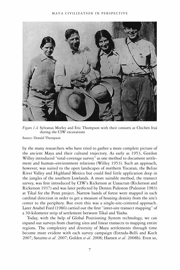
The history of Maya archaeology deserves a more detailed look, beginningwith the sponsoring by the Carnegie Institution of Washington (CIW) oflarge-scale digs at Maya sites between 1915 and 1958.2 The first large-scaleLowland excavation project at Chichén Itzá was led by Sylvanus G. Morleyfrom 1923 to 1940. Chichén Itzá was chosen because of its accessibility, won-derful art and architecture, and also because of the wealth of artifacts dredgedfrom its cenote3 in 1904 by an amateur American archaeologist, Edward H.Thompson. The second great Lowland Maya dig was led by A. Ledyard Smithat Uaxactun from 1926 to 1937. Compared to Chichén Itzá, this was aninfinitely more difficult site to work. In the heart of the remote Peten forest,it could be reached only by several days’ mule-train travel. It was selectedbecause the earliest carved inscription was found there in 1916 (Stela 9). The goal was to explore the beginnings of Maya civilization “in its pureststate” (Morley 1943: 205). A Guatemalan archaeologist, Juan Antonio Valdés,resumed excavations at Uaxactun in 1983–1985. The Highlands of Guatemalaand Honduras were the focus of CIW excavations in the 1930s and 1940s atKaminaljuyú and Copan (Kidder et al. 1946; Morley 1943; Stromsvik 1946).The CIW’s final project investigated the last phase of Maya civilization, justprior to the Spanish conquest, at Mayapan in the Mexican state of Yucatan(Pollock et al. 1962).
M A Y A C I V I L I Z A T I O N I N P E R S P E C T I V E
4

M A Y A C I V I L I Z A T I O N I N P E R S P E C T I V E
5
Figure 1.2 Map of the Maya region and sites mentioned in the text
Source: © F. Estrada-Belli, Topographic data courtesy of NASA SRTM mission

Following the CIW model, the University of Pennsylvania carried out exca-vations and restorations at Tikal from 1955 to 1970, first under Ed Shook, thenunder William R. Coe (Hammond 1982). In the 1980s Guatemala sponsoredits own excavations, led by Juan Pedro Laporte. Presently, Guatemalan-ledexcavations at Tikal are uncovering its greatest pyramid, Temple IV. Oninvitation by the Honduran government, Harvard planned a long-term projectat Copan (Willey et al. 1975) that lasted until 1996. In Mexico, large-scaleprojects were carried out at Dzibilchaltun (Andrews and Andrews 1980),Palenque (Ruz Lhuillier 1955), Cobá (Folan et al. 1983) and more recently atCalakmul (Willey et al. 1975; Folan et al. 2001; Carrasco 1996), Oxkintok(Rivera Dorado 1987) and Ek Balam (Bey et al. 1998), to name just a few.
As is evident from this summary, Maya archaeology in the southernLowlands, at least, was until recently site-based. That is, ceremonial centers,along with their temples, palaces, plazas and tombs, have been the focus ofinvestigation more than other aspects of Maya landscape and society. Thishistorically understandable bias of Maya archaeology has not gone unremarked
M A Y A C I V I L I Z A T I O N I N P E R S P E C T I V E
6
Figure 1.3 Map of the central and eastern region of the Maya Lowlands and major sitesmentioned in the text
Source: © F. Estrada-Belli, Topographic data courtesy of NASA SRTM mission
by the many researchers who have tried to gather a more complete picture ofthe ancient Maya and their cultural trajectory. As early as 1953, GordonWilley introduced “total-coverage survey” as one method to document settle-ment and human–environment relations (Willey 1953). Such an approach,however, was suited to the open landscapes of northern Yucatan, the BelizeRiver Valley and Highland Mexico but could find little application deep inthe jungles of the southern Lowlands. A more suitable method, the transectsurvey, was first introduced by CIW’s Ricketson at Uaxactun (Ricketson andRicketson 1937) and was later perfected by Dennis Puleston (Puleston 1983)at Tikal for the Penn project. Narrow bands of forest were mapped in eachcardinal direction in order to get a measure of housing density from the site’scenter to the periphery. But even this was a single-site-centered approach.Later Anabel Ford (1986) carried out the first “inter-site transect mapping” ofa 30-kilometer strip of settlement between Tikal and Yaxha.
Today, with the help of Global Positioning System technology, we canexpand our surveys from charting sites and linear transects to mapping entireregions. The complexity and diversity of Maya settlements through timebecome more evident with each survey campaign (Estrada-Belli and Koch2007; Saturno et al. 2007; Golden et al. 2008; Hansen et al. 2008b). Even so,
M A Y A C I V I L I Z A T I O N I N P E R S P E C T I V E
7
Figure 1.4 Sylvanus Morley and Eric Thompson with their consorts at Chichén Itzáduring the CIW excavations
Source: Donald Thompson

large tracts of the southern Lowlands remain unexplored and Maya cities andvillages of all periods still await discovery. Principally, Preclassic sites havebeen added to our sample of Maya archaeology. Having been unoccupied inthe Classic period, these lack carved monuments and standing architecture, at least on the surface. Ironically, these sites have been shunned by mostresearchers and looters, and consequently have seldom been reported. Evenwhen reported, not much attention has been paid to them. Such was the caseof the largest Maya site ever found, El Mirador, which was noted by airplanepilots in the 1930s but believed to be a natural hill until it was visited andmapped in the 1960s by explorer Ian Graham. Because of its remoteness,among other reasons, it was not further investigated for another 25 years. Onlyin the last decade, following many site-based excavations at El Mirador andnearby Nakbe, mostly thanks to the efforts of the Mirador Project (Hansen etal. 2008b), has the mapping of sites in northernmost Guatemala begun inearnest. These sites, with their extensive Preclassic populations, are giving usa new understanding of the Classic Maya and the locales which played impor-tant roles in shaping ancient Maya culture.
Parallel to these developments in the archaeological database have been new trends in archaeological theory. We have shifted our focus away fromdiscussing cultural evolution patterns, which are typically seen in linear per-spective and through the lens of fixed social types. Those discussions often led to dead-end arguments about whether the Maya were a tribe, chiefdom orstate at one or another period. We should no longer emphasize abstract socio-political institutions with a goal of understanding general behavioral “laws”behind cultural development (Pauketat 2007; Yoffee 2005). Following newerdirections in archaeological theory, in this book I focus instead on the historyof people and places. With a long-term historical perspective, so akin to anarchaeologist’s dataset, we can learn about how the history and culture of apeople are linked to places as well as interactions. Cities as built places are lociof religious, political and social gathering—providing a sense of communitybeyond the confines of their architectural layout. The making and remakingof places then become the making of a people’s collective memory, identity andworldview. While we cannot tell the history of all places, some centers aremore significant to us archaeologists because of their size, long or short life-spans, or simply, because of their state of preservation, there is more to befound there. Each site has an important story to tell and can give us clues tounderstand how that great aggregate of cultural achievements we associatewith “Maya civilization” was created and changed through time.
M A Y A C I V I L I Z A T I O N I N P E R S P E C T I V E
8

Classic Maya people, places and history
Tikal
To some, Tikal is in many ways the most important among Classic Maya cities.Indeed, for a long time the ancient Tikaleños rightly thought of themselves asthe greatest of all Maya. Inscriptions indicate that other cities and their kingswere subordinate to Tikal’s. Today, as it did 1200 years ago, the city boasts thelargest number of towering pyramid temples and palaces. Its great plaza islittered with beautifully carved stelae—depicting its kings and recording theiraccomplishments, religious rites, and celebrations of calendar cycles. Thoughthe modern restorations of its architecture are impressive, the sample they givehardly does justice to the dramatic viewscapes and vivid sounds that we knowcharacterized the city’s urban core. Much of it is now blanketed by tropicalforest and, except for the occasional cries of wild animals, is silent. Buriedbeneath the temples, however, researchers have found rich tombs of kings andqueens whose reigns spanned some 1000 years.4 In the site’s museum is areconstruction of the tomb [Tomb 116] of perhaps the greatest Tikal king,Jasaw Chan K’awiil, who in the 7th century AD defeated his long-time rivalYich’aak K’ahk’, king of Calakmul, bringing his city to its maximum expan-sion. One of the richest ever found by Maya archaeologists, the tomb wasdiscovered in a small room cut into the soft limestone bedrock layer under thestairway of Temple 1 in the Great Plaza (Coe 1990). There, the king lay on ajaguar skin on a stone platform dressed in royal garments and covered withthousands of jade jewels. Around him were obsidian and stingray perforators,together with dozens of precious red Spondylus oyster shells, sacred receptaclesfor his bloodletting rituals, intended to connect with ancestors and gods.Among the most striking artifacts are several inscribed and carved bones. One in particular is from a human limb and depicts a captive. A finely carvedcolumn of hieroglyphs next to him identifies him as a lord from the Snakekingdom (Calakmul, see below). Another beautifully carved human bonedepicts a canoe occupied by a young maize god ferried into the underworld bythe paddler gods. Dozens of the finest painted ceramics sat beside him, alongwith food and beverages for his afterlife journey (Trik 1963). His chocolate-drink vases are painted with scenes from such well-known myths as the OldGod conversing with his faithful messenger. Others depict the ruler in hispalace, sitting behind curtains on a bench-throne while being visited by dig-nitaries. In addition, musicians, dwarfs and other courtiers provide the kingwith amusement. Some of these scenes may recall day-to-day interactions withlords of the kingdom or important diplomatic visits by powerful lords fromelsewhere. In one of the most elaborately painted vases the king, sitting highon his throne, receives gifts—a bowl of delicacies and a feathered fan. The twodonors—one kneeling, the other walking up a hieroglyphic stairway—wearelaborate loincloths and headdresses appropriate to their rank. On the right,
M A Y A C I V I L I Z A T I O N I N P E R S P E C T I V E
9

M A Y A C I V I L I Z A T I O N I N P E R S P E C T I V E
10

M A Y A C I V I L I Z A T I O N I N P E R S P E C T I V E
11
Figure 1.5 Map ofTikal’s central area
Source: After Carrand Hazard 1961,courtesy of theUniversity ofPennsylvaniaMuseum ofArchaeology andAnthropology

four other lords stand witness to this ritual, each having a different headdressbut all wearing similar capes and shell necklaces. They appear to be lords ofthe highest rank and their names are spelled in short columns of glyphs beforetheir faces. Finally, on the left, three kneeling lords observe the scene whilegazing at the king (Culbert 1993: Figure 68A). A great sense of vibrant pomppermeates these palace images, underscoring the marked hierarchical natureof this society.
As mentioned, other inscriptions from Tikal and elsewhere tell us that JasawChan K’awiil was the architect of a major comeback of the Tikal kingdom aftersome 130 years of military defeats and failed political alliances. Since its firstdefeat in the year 562 AD at the hands of a king from the Snake kingdom (laterassociated with the city of Calakmul, see below), Tikal kings had struggled tosurvive. Few monuments were erected during those years. At the same time,scores of Tikal-allied kings were first defeated, then shamefully paraded andsacrificed. Others broke ranks and offered allegiance to the Snake kings, laterwaging war on their former Tikal ally. In one extraordinarily cruel case, asibling of the Tikal king went to establish a new kingdom for himself at DosPilas, in the southern Petexbatun lakes region (Houston 1993). Within a shorttime he was a Calakmul ally and sworn enemy of his own brother. Siblingrivalry for succession is suspected here (Martin and Grube 2008).
Caracol
The kingdom of Caracol in Belize (known as Uxwitzá ’—“three mountain-water”; Stuart 2007b), may also have started as a close Tikal ally only to finishamong its most persistent enemies in concert with Calakmul. Caracol centerwas located on a high plateau next to the Maya Mountains (see Figure 1.2,
M A Y A C I V I L I Z A T I O N I N P E R S P E C T I V E
12
Figure 1.6 Rooftops of Tikal Temples I, II and III (foreground), seen from the top ofTemple IV
Source: © F. Estrada-Belli

M A Y A C I V I L I Z A T I O N I N P E R S P E C T I V E
13
Figure 1.7 Tikal king Jasaw Chan K’awiil celebrating his victory over arch-rivalChak Tok Ichaak of the Snake kingdom (Calakmul) on September 14,695 carved on doorway Lintel 3 of Jasaw’s funerary shrine, Temple I
Source: After Jones and Satterthwaite 1982, courtesy of the University of PennsylvaniaMuseum of Archaeology and Anthropology
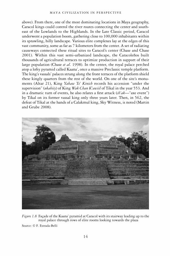
above). From there, one of the most dominating locations in Maya geography,Caracol kings could control the river routes connecting the center and south-east of the Lowlands to the Highlands. In the Late Classic period, Caracolunderwent a population boom, gathering close to 100,000 inhabitants withinits sprawling, hilly landscape. Various elite complexes lay at the edges of thisvast community, some as far as 7 kilometers from the center. A set of radiatingcauseways connected these ritual sites to Caracol’s center (Chase and Chase2001). Within this vast semi-urbanized landscape, the Caracoleños builtthousands of agricultural terraces to optimize production in support of theirlarge population (Chase et al. 1998). In the center, the royal palace perchedatop a lofty pyramid called Kaana’, once a massive Preclassic temple platform.The king’s vassals’ palaces strung along the front terraces of the platform shieldthese kingly quarters from the rest of the world. On one of the site’s monu-ments (Altar 21), King Yahaw Te’ Kinich records his accession “under thesupervision” (ukabiiy) of King Wak Chan K’awiil of Tikal in the year 553. Andin a dramatic turn of events, he also relates a first attack (ch’ak—“axe event”)by Tikal on its former vassal king only three years later. Then, in 562, thedefeat of Tikal at the hands of a Calakmul king, Sky Witness, is noted (Martinand Grube 2008).
M A Y A C I V I L I Z A T I O N I N P E R S P E C T I V E
14
Figure 1.8 Façade of the Kaana’ pyramid at Caracol with its stairway leading up to theroyal palace through rows of elite rooms looking towards the plaza
Source: © F. Estrada-Belli

Calakmul
Calakmul was located far to the north of all this, in the present state ofCampeche, some 100 kilometers from Tikal (see Figure 1.3, above). Even so, its environment was in many ways similar to the tropical marshy and hillyforest of the southern Lowland cities and its history was similar, too. Its kingsboasted the Snake kingdom emblem as royal symbol whenever and whereverthey intervened in the affairs of other kingdoms. According to recent epi-graphic evidence (Hansen and Guenter 2005), the Snake kingdom may betraced back to a great Preclassic city somewhere in the vicinity, perhaps evenEl Mirador, which was the seat of the greatest potentates of the PreclassicMaya. Another possibility is the recently discovered Preclassic site of Xcabal,located near Dzibanché and the Bay of Bacalar, on the east of the Yucatan
M A Y A C I V I L I Z A T I O N I N P E R S P E C T I V E
15
Figure 1.9 Caracol Altar 21 (drawn by Stephen Houston) and passage relating theTikal war (text block insert drawn by Simon Martin)
Source: Courtesy of Stephen D. Houston and Simon Martin
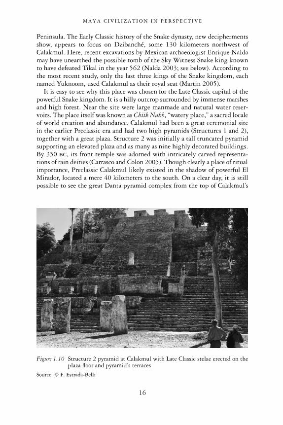
Peninsula. The Early Classic history of the Snake dynasty, new deciphermentsshow, appears to focus on Dzibanché, some 130 kilometers northwest ofCalakmul. Here, recent excavations by Mexican archaeologist Enrique Naldamay have unearthed the possible tomb of the Sky Witness Snake king knownto have defeated Tikal in the year 562 (Nalda 2003; see below). According tothe most recent study, only the last three kings of the Snake kingdom, eachnamed Yuknoom, used Calakmul as their royal seat (Martin 2005).
It is easy to see why this place was chosen for the Late Classic capital of thepowerful Snake kingdom. It is a hilly outcrop surrounded by immense marshesand high forest. Near the site were large manmade and natural water reser-voirs. The place itself was known as Chiik Nahb, “watery place,” a sacred localeof world creation and abundance. Calakmul had been a great ceremonial sitein the earlier Preclassic era and had two high pyramids (Structures 1 and 2),together with a great plaza. Structure 2 was initially a tall truncated pyramidsupporting an elevated plaza and as many as nine highly decorated buildings.By 350 BC, its front temple was adorned with intricately carved representa-tions of rain deities (Carrasco and Colon 2005). Though clearly a place of ritualimportance, Preclassic Calakmul likely existed in the shadow of powerful ElMirador, located a mere 40 kilometers to the south. On a clear day, it is stillpossible to see the great Danta pyramid complex from the top of Calakmul’s
M A Y A C I V I L I Z A T I O N I N P E R S P E C T I V E
16
Figure 1.10 Structure 2 pyramid at Calakmul with Late Classic stelae erected on theplaza floor and pyramid’s terraces
Source: © F. Estrada-Belli

Structure 2. The Late Classic period Snake kings took the city to new heights,constructing huge ritual plazas and erecting the largest number of inscribedmonuments (117) at any Maya site (compare to Tikal’s 40). Unfortunately, thequality of the local stone has not permitted us to recover many of thoseinscriptions, or we would have an astonishingly complete record of its history.
Calakmul’s population rivaled those of Tikal and Caracol in numbers. Itskings were buried with some of the finest objects. Among the most remarkableartifacts are large jade masks and beautifully inscribed and painted codex-stylevases. The vases themselves were created by elites residing nearby, probably at Calakmul itself and at Nakbe, one of the ruined capitals of Preclassic kingsnear El Mirador where codex-style ceramics have been recovered in largenumbers (Hansen et al. 1991). The master painters of Calakmul were some ofthe finest in all of the Maya Lowlands. They decorated the outer platform of anorth complex with watery symbols and glyphs spelling “Chiik Nahb,” tellingus this complex is the place mentioned in the inscriptions. Its central buildingwas painted with images of elites drinking, eating, and receiving goods—probably as gifts or tributes, during a ritual of unknown nature. However, asthe inscriptions from many other sites also tell us, the Chiik Nahb location was the plaza where kings were hailed in office—not just Calakmul’s but those of its client kingdoms. The painted scenes of celebration may refer to onesuch ceremony (Carrasco and Colon 2005). At the site of La Corona (formerlyknown as Site Q), a panel by King Chak Ak’aach Yuk, a vassal of Calamul’sYichaak K’ahk’, records the rituals associated with the Long Count date 9.12.15.0.0 (AD 687) as being performed at Uxtetun Chiik Nahb, or Calakmul itself.It was probably common for the vassal kings of the great Snake kingdom to travel to Calakmul on important occasions, thus strengthening their rela-tions with the patron king (Martin and Grube 2008). On this and othermonuments, the La Corona lords displayed the Snake emblem glyph, acknowl-edging Calakmul kings’ power over them. The apparent lack of a La Coronaemblem glyph suggests that it was not a separate client kingdom of the Snakekings, but instead formed an integral part of the Snake kingdom’s greaterterritorial domain. The territory directly controlled by the Late Classic Snakekings will then have extended for a remarkable distance of nearly 80 kilo-meters to the southwest of their capital, Calakmul. To the east, the reach ofthe Snake kings may have extended for about 80 kilometers to Los Alacranes,another site that did not posses its own emblem glyph but displayed the Snakekingdom’s. Far beyond these outposts, the Snake kings oversaw the activitiesof scores of allies as far south as Cancuen and Quirigua, on the very southernlimits of the Lowlands.
Palenque
Palenque is another well-known city of the Classic period. Its ancient namewas Lakamha, while its emblem glyph called it the Baak (Bone) kingdom.
M A Y A C I V I L I Z A T I O N I N P E R S P E C T I V E
17

Located in the west, where the Maya Lowland limestone hills merge into thelower plains of the Gulf of Mexico, its dynasty was established by a rulernamed K’uk Balam, probably originating from another place. Later, in the 7thcentury, the Palenque kings made numerous references to Tikal, so it wouldseem that the Palenque kingdom was also established as a friend of the Tikalkings. In the 7th century, Palenque was ruled by Kinich Janaab Pakal, or Pakalthe Great. During his seven-decade reign, he led the city into its golden age.Today the Palace and the Temple of the Inscriptions, containing his tomb, arehis most evident legacies. Many today consider this the most beautiful amongthe surviving Maya temples. He built the central throne-room of the palace,House E (appropriately named the Sak nuuk naah, “White Skin House”). Itssimple initial floor-plan was greatly expanded by his successors and turned intoa labyrinth of well-lit rooms around secluded courtyards, all set atop under-ground hallways. The temple was decorated with an inscription constitutingPalenque’s longest text, recounting Pakal’s accomplishments and linking theorigins of his dynasty to the birth of gods some 1.2 million years ago (Scheleand Mathews 1998).
Pakal’s tomb, the most elaborate so far discovered in the Maya world, wasbuilt during his lifetime and finished by his son, Kan Bahlam. Situated belowthe base of the pyramid, it connects to the temple above by means of aninternal zig-zag stairway. Inside a stone sarcophagus, Pakal’s body lay wrapped
M A Y A C I V I L I Z A T I O N I N P E R S P E C T I V E
18
Figure 1.11 Temple of the Inscriptions, Palenque, resting place of King Pakal
Source: © F. Estrada-Belli

in a cloth, with jade jewels in his hands and by his feet and groin, in cosmicarrangement. The sarcophagus was covered by a stone lid in which Pakal isdepicted as a young lord in apotheosis, rising as a god after death. He hadassumed the personae of the young maize god and that of a death god, thelightning god. He is shown reborn, emerging from the maw of an earth mon-ster, as all things did at creation. A world-tree emerges from his body, asthough it were the seed for sustenance itself. On the side of the stone slab areportraits of six generations of royal ancestors as fruit trees (Schele and Mathews1998). To sanctify his interment, his son and successor had six people sacrificedoutside the tomb chamber.
While Pakal’s reign (AD 615–683) was the period of greatest prosperity for his kingdom, it was not free from trouble. On one occasion a vassal lordfell captive to the kings of Piedras Negras, a large city on the lower course of the Usumacinta River. According to the inscriptions, in 654 Lakamha wassubjected to an “axe event,” one of the more violent forms of defeat, at thehands of a Calakmul king (Sharer and Traxler 2006). By the time of Pakal’sdeath, though, his kingdom had long recovered from this downturn and wasa regional power in the western Lowlands.
M A Y A C I V I L I Z A T I O N I N P E R S P E C T I V E
19
Figure 1.12 The Palenque palace after many additions
Source: © F. Estrada-Belli
Note: Pakal’s building, House E, can be seen on the left of the tower

M A Y A C I V I L I Z A T I O N I N P E R S P E C T I V E
20
Figure 1.13 Carving from the stone sarcophagous lid of King Pakal, whodied August 28, 683
Source: Courtsey of Merle Green-Robertson

Kaminaljuyú
As they are today, in ancient times the Highland regions of today’s Chiapas,Mexico, Guatemala, Honduras and eastern El Salvador were populated byMaya speakers. Kaminaljuyú was probably the greatest highland Maya centerin all of Maya history. At its zenith, the ceremonial core stretched over some
M A Y A C I V I L I Z A T I O N I N P E R S P E C T I V E
21
Figure 1.14 The CIW map of Kaminaljuyú
Source: After Popenoe Hatch 1997; courtesy M. Popenoe Hatch
14 square kilometers of the plateau now occupied by Guatemala City. Thisapogee was reached in the first and second centuries AD, prior to the Classicperiod. Dozens of plaza–pyramid complexes were built in different parts of asprawling urbanized landscape. Score of basalt stone monuments stood inthose plazas. Some depicted deities and mythological scenes; others were his-torical in nature, such as Monument 65. In it pairs of bound captives kneel tothree lords seated on thrones. Each figure is identified by his headdress (Sharerand Traxler 2006: Figure 5.8). The water from a lake in its center was chan-neled to agricultural fields to support its population with sustainable farming(Popenoe Hatch 1997). The 5-kilometer-long effigy mound that weaved itsway from the center towards the mountain ridges to the east was one of thelargest structures ever built by the Late Preclassic Maya. Sections of it stillstand 6–8 meters high today among Guatemala City’s urban lots and through-ways. The Preclassic rulers of Kaminaljuyú no doubt also received tribute fromlarge sections of the Guatemala Highlands and Pacific slope. Judging fromceramic imports and from the similarities in ceramic and architectural stylesin this region, Kaminaljuyú exerted hegemonic influence on coastal sites as farwest as the Guatemala–Mexico boarder and as far east as the Guatemala–El Salvador border. Further in each direction were other great centers withtheir own regions of influence—Chiapa De Corzo in Chiapas, Mexico, andChalchuapa in El Salvador. According to the data we have today, the rulers of all these centers shared most cultural traits and were responsible for thegreat innovations in monument carving and Long Count dating, prior to their Lowland neighbors. During the Classic period each of these importantHighland centers experienced a contraction in population and eventually waseclipsed by new centers. In the fifth century AD Kaminaljuyú maintained a relatively modest population and was occupied by elite groups fromTeotihuacan as well as from the Maya Lowlands (Sanders and Michels 1977).The foreigners built temples in their own style and were buried with lavishofferings. But this was a short-lived phase and the site slowly fell into oblivionduring the Late Classic period.
Copan
The brightest star among Highland centers in the Classic period wasundoubtedly Copan, in the Honduran Highlands. Its center was founded by a lord named Yax K’uk’ Mo’ who appeared in Teotihuacan garb in later Copan art, but was actually born and raised somewhere in the east-centralMaya Lowlands, according to his bone chemistry (Sharer 2004; Stuart 2007b).One of his titles was Wite’ Naah Ajaw—an epithet apparently reserved forMaya rulers of this epoch who claimed to have received their power from aplace or temple called Wite’ Naah, which may have been at Teotihuacan.Comparing references in the Maya Lowlands with the iconography of thePyramid of the Sun at Teotihuacan, Fash et al. (2009) have suggested that Yax
M A Y A C I V I L I Z A T I O N I N P E R S P E C T I V E
22
K’uk’ Mo’ and a small number of Early Classic rulers, including Tikal’s YaxNuun Ayiin, may have traveled to Teotihuacan to receive the insignia of powerat the Pyramid of the Sun, which included in its front a sanctuary of the new fire ceremony (also known as the Adosada structure). At Copan, Yax K’uk’Mo’ built a ritual space for his newly founded dynasty in a style that wasforeign to the Copan Valley and incorporated Maya Lowland and Teotihuacanelements (Hunal structure). After his death, his son and later successorscontinued to acknowledge the founder’s foreign/Teotihuacan heritage while atthe same time asserting a strong sense of Maya-ness in art and architecture.
The Copan kings not only maintained strong links with Tikal and theLowlands but controlled the all-important Highland–Lowland route of the Motagua River, where jade and obsidian sources are found. Late ClassicCopan kings continued to expand the ceremonial center by building over the founder’s temple and tombs and turning its broad plaza into a massiveacropolis complex. Their temples were beautifully decorated with intricatehigh-relief sculptures and hieroglyphs.
One of the greatest Copan kings, Uaxaclajuun Ubah K’awiil, erected someof the most spectacular carved monuments in the plaza. Perhaps the mostimpressive of Copan’s buildings is Temple 26, with its hieroglyphic stairway,
M A Y A C I V I L I Z A T I O N I N P E R S P E C T I V E
23
Figure 1.15 Copan’s Altar Q, dedicated by Yax Pasac to commemorate his 15predecessors and the dynasty’s founder, Yax K’uk’ Mo’
Source: © F. Estrada-Belli
Note: Yax K’uk Mo’ is depicted here (center left) passing Yax Pasac a lit torch, symbol of royaloffice
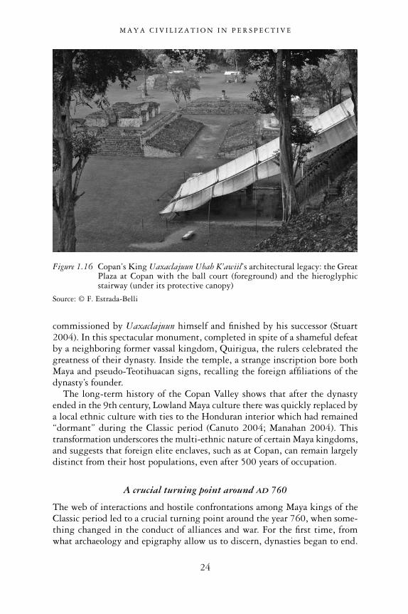
commissioned by Uaxaclajuun himself and finished by his successor (Stuart2004). In this spectacular monument, completed in spite of a shameful defeatby a neighboring former vassal kingdom, Quirigua, the rulers celebrated thegreatness of their dynasty. Inside the temple, a strange inscription bore bothMaya and pseudo-Teotihuacan signs, recalling the foreign affiliations of thedynasty’s founder.
The long-term history of the Copan Valley shows that after the dynastyended in the 9th century, Lowland Maya culture there was quickly replaced bya local ethnic culture with ties to the Honduran interior which had remained“dormant” during the Classic period (Canuto 2004; Manahan 2004). Thistransformation underscores the multi-ethnic nature of certain Maya kingdoms,and suggests that foreign elite enclaves, such as at Copan, can remain largelydistinct from their host populations, even after 500 years of occupation.
A crucial turning point around AD 760
The web of interactions and hostile confrontations among Maya kings of theClassic period led to a crucial turning point around the year 760, when some-thing changed in the conduct of alliances and war. For the first time, fromwhat archaeology and epigraphy allow us to discern, dynasties began to end.
M A Y A C I V I L I Z A T I O N I N P E R S P E C T I V E
24
Figure 1.16 Copan’s King Uaxaclajuun Ubah K’awiil’s architectural legacy: the GreatPlaza at Copan with the ball court (foreground) and the hieroglyphicstairway (under its protective canopy)
Source: © F. Estrada-Belli
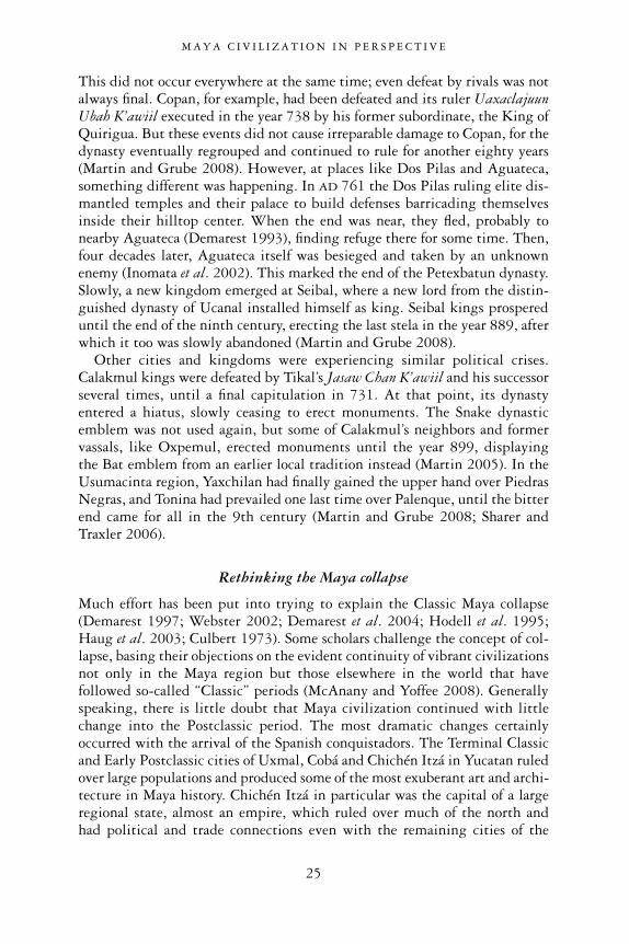
This did not occur everywhere at the same time; even defeat by rivals was notalways final. Copan, for example, had been defeated and its ruler UaxaclajuunUbah K’awiil executed in the year 738 by his former subordinate, the King ofQuirigua. But these events did not cause irreparable damage to Copan, for thedynasty eventually regrouped and continued to rule for another eighty years(Martin and Grube 2008). However, at places like Dos Pilas and Aguateca,something different was happening. In AD 761 the Dos Pilas ruling elite dis-mantled temples and their palace to build defenses barricading themselvesinside their hilltop center. When the end was near, they fled, probably tonearby Aguateca (Demarest 1993), finding refuge there for some time. Then,four decades later, Aguateca itself was besieged and taken by an unknownenemy (Inomata et al. 2002). This marked the end of the Petexbatun dynasty.Slowly, a new kingdom emerged at Seibal, where a new lord from the distin-guished dynasty of Ucanal installed himself as king. Seibal kings prospereduntil the end of the ninth century, erecting the last stela in the year 889, afterwhich it too was slowly abandoned (Martin and Grube 2008).
Other cities and kingdoms were experiencing similar political crises.Calakmul kings were defeated by Tikal’s Jasaw Chan K’awiil and his successorseveral times, until a final capitulation in 731. At that point, its dynastyentered a hiatus, slowly ceasing to erect monuments. The Snake dynasticemblem was not used again, but some of Calakmul’s neighbors and formervassals, like Oxpemul, erected monuments until the year 899, displaying the Bat emblem from an earlier local tradition instead (Martin 2005). In theUsumacinta region, Yaxchilan had finally gained the upper hand over PiedrasNegras, and Tonina had prevailed one last time over Palenque, until the bitterend came for all in the 9th century (Martin and Grube 2008; Sharer andTraxler 2006).
Rethinking the Maya collapse
Much effort has been put into trying to explain the Classic Maya collapse(Demarest 1997; Webster 2002; Demarest et al. 2004; Hodell et al. 1995;Haug et al. 2003; Culbert 1973). Some scholars challenge the concept of col-lapse, basing their objections on the evident continuity of vibrant civilizationsnot only in the Maya region but those elsewhere in the world that havefollowed so-called “Classic” periods (McAnany and Yoffee 2008). Generallyspeaking, there is little doubt that Maya civilization continued with littlechange into the Postclassic period. The most dramatic changes certainlyoccurred with the arrival of the Spanish conquistadors. The Terminal Classicand Early Postclassic cities of Uxmal, Cobá and Chichén Itzá in Yucatan ruledover large populations and produced some of the most exuberant art and archi-tecture in Maya history. Chichén Itzá in particular was the capital of a largeregional state, almost an empire, which ruled over much of the north and had political and trade connections even with the remaining cities of the
M A Y A C I V I L I Z A T I O N I N P E R S P E C T I V E
25

south, such as Seibal and Lamanai (Robles Castellanos and Andrews 1986;Cobos 2003, 2004; Schele and Freidel 1990). This was perhaps the largesthegemonic state the Maya Lowlands had ever seen. Albeit with reduced powerand resources, the Maya continued to erect temples and were ruled by kingsup to the arrival of the Europeans. Since then, despite population losses caused by new diseases and the oppression they suffered at the hands of theirconquerors, the Maya continue to exist. Today, an estimated ten million Maya-speaking people live in semi-autonomous communities in the Highlands ofGuatemala, Chiapas and Yucatan. They have incorporated Catholicism intotheir pre-Columbian belief system, exchanging their traditional gods for saintsand human sacrifices for more mundane offerings. Superficial western culturalinfluences aside, in many regards their ancestral culture and ways of livingcontinue to be as original and vibrant as they were a thousand years ago.
If what we perceive as collapse was not a wholesale cultural downfall (as itseldom is), what was it? For some, it was the end of a system of dynastic rulecentered on the person of a divine king and an exclusionary political strategy,typical of the southern Lowland states (Blanton et al. 1996). But others pointout that dynastic rule persisted with some adjustments and greater inclusive-ness until the Spanish conquest. What may have disappeared was the erectionof portrait stelae, but not royal rule, hieroglyphic writing or calendrical
M A Y A C I V I L I Z A T I O N I N P E R S P E C T I V E
26
Figure 1.17 Kiche’ Maya procession in the main plaza of Chichicastenango, Guatemala,amid market stands. Led by priests, four young men carry the image ofSanto Tomas on a litter decorated with colorful feathers and flowers
Source: © F. Estrada-Belli
knowledge, for the Postclassic Maya continued to reckon time and tell theirhistory using the count of katuns,5 based on the Long Count system. Thearmies of Kiche’ Highland Maya kings and the Lowland Maya of Yucatan andTayasal, Peten, fought fiercely against the Spanish invaders and resisted con-quest longer than any other Mesoamerican people (Fuentes y Guzmán et al.1932; Jones 1998; Roys 1952). If we had not lost countless Maya books to theiconoclastic destruction of overzealous bishops in the 16th century, we wouldknow much more about the religion, history and political systems of the Mayabefore the conquest (Thompson 1954).
What remains to be explained, then, is the death of the southern cities, andthe final flight of their kings and populations, presumably towards betterpastures. There is great variability in the timing and circumstances of theabandonment. Probably each case should be treated separately. When we lookat the whole southern Lowlands, the process of abandonment is spread over the9th and 10th centuries AD. And if we broaden the perspective even further toinclude the cities of northern Yucatan, the rise and fall of Maya kingdomscontinued until the last great kings of Mayapan lost their hegemony over anumber of smaller kingdoms in the 15th century.
There is no doubt that warfare, escalating to new levels in the Late Classicperiod, accounts for some of the specific site collapses, though scholars rarelyagree on the causes of such confrontations and their deadly consequences fortheir kings and people. Some have looked at the burden placed by more, largerand more densely populated Maya cities on the environment, as well asepisodes of drought during the 9th century (Beach et al. 2008; Gill 2000;Haug et al. 2003; Hodell et al. 1995). These factors alone may have broughtMaya dynasties as a “system” to the brink of collapse. In this scenario, warfarewould be a symptom of overall economic and political crises within each king-dom, further compounding these underlying problems. Environment-basedexplanations have many fans, but in such areas as Petexbatun, which had ashort-lived and thin occupation in the Classic Period, soil and water studieshave shown no great pressure on the environment and no evidence of drought(Demarest 1997). Other areas may have been affected by drought, but not thePetexbatun and not in the 8th century. According to Arthur Demarest (1997),the failing kingdoms of Petexbatun—Dos Pilas and Aguateca would havegenerated migrating refugee populations that could have put severe pressureon other parts of the Lowlands. And if other areas were at the limit of theirland sustainability, the results could have been disastrous.
Some scholars (Freidel 1985; Webb 1973) have held that the rise of tradingcenters and a shift in trading networks outside of the southern Lowlandsbypassed the old kingdoms of the south and took away their resources. But it is unclear how much support the economies of Maya kingdoms drew from long-distance trade. Indeed, as the cities of the southern Lowlandsdeclined, cities in the north, such as Uxmal and Chichén Itzá, were quicklybecoming great urban centers. Seen from the vantage point of Chichén Itzá,
M A Y A C I V I L I Z A T I O N I N P E R S P E C T I V E
27

the Postclassic was a new era of greatness and political cohesion in the MayaLowlands. The center of gravity had just shifted to the north.
In the end, the environmental/drought theories’ greatest weakness lies intheir failure to explain how the generally drier and more thin-soiled northcould prosper during the droughts of the 10th century. As many others havepointed out, the final explanation for the Maya collapse may be out of reach at the moment, but hopefully not for ever. If we think in terms of severalcontributing factors and in terms of variability of sites’ histories rather thansingle-cause, catch-all explanations, we will likely soon have a better under-standing.
The beginnings of Maya civilization
This book focuses on the beginnings of Maya civilization, itself the subject of many heated debates. Because of new data and new ideas, we may now be inour best ever position to understand it. While scholarly interest in the PreclassicMaya began in the 1920s with the Uaxactun excavation, it was soon supersededby the race to document sites with inscriptions. After a long pause, a new waveof focused studies began in the 1970s with surveys and excavations in northernBelize (Hammond 1973, 1974), and in the Highland regions of Verapaz (Sedatand Sharer 1972), Chalchuapa (Sharer and Gifford 1970), Kaminaljuyú(Sanders and Michels 1969) and in northern Yucatan (Andrews and Ringle1992; Andrews 1981b). In the central part of the Maya Lowlands (northernPeten and southern Campeche) only in the last 20 years has this problem beenaddressed by targeted long-term excavation and survey projects in the heart of the southern Maya Lowlands (i.e. the north and eastern Peten region).Previously, Preclassic remains were found only as fortuitous by-products at thebottom of excavations designed to address questions regarding Late ClassicMaya culture. With the expansion of excavations at sites such as El Mirador andNakbe, as well as spectacular discoveries at centers such as San Bartolo and Cival, a new understanding of the Preclassic Maya is emerging. The firstbuilding blocks of this civilization were its ceremonial centers, symbols of newregional identities in the making. The substantial database we have accu-mulated is forcing us to reconsider old theories and to change our perspective;otherwise, great cities like El Mirador will continue to remain a mystery.
In essence, we have discovered that the Maya people created their firstcivilization in the Preclassic period. When seen in the perspective of 3000years of constant refinement, the cultural peak we call the “Classic” civilizationwas a second, and even less dazzling, manifestation of cultural elaboration.Chapter 2 outlines older theories now at odds with available evidence aboutthe earliest Maya. These theories envisioned a huge, empty landscape intowhich waves of migrants came as colonizers, building a new civilization withtools developed elsewhere, either in the Highlands of Guatemala or in theOlmec region. Old theories also stressed the simplicity of the Maya farming
M A Y A C I V I L I Z A T I O N I N P E R S P E C T I V E
28
way of life during much of the Preclassic period. According to them, the explo-sive growth of El Mirador after 300 BC seemed unlikely without substantialinput from outside the Maya world.
Chapter 3 looks at the issue of kingship, often regarded as a key ingredientof early civilizations. Here the epigraphic sources and archaeological evidencetell different narratives. In the material record, “royal” tombs and associatedsymbols of power clearly predate the earliest kings recorded by Maya scribesas well as the accepted beginning date of the Classic Maya period. The searchfor the founder of the Tikal dynasty, one of the longest-lived in the Lowlands,is a case in point. The “founding” of a dynasty may not mark the origin ofkingship at Tikal, or anywhere else. Instead, the epigraphic evidence mayindicate only the start of a line of rulers and a new era of prosperity. In short,Maya civilization needs to be understood in a broader context, beyond thewritten data purporting to show the beginning of dynastic lines.
Chapter 4 explores the nature of this broader context through an analysis ofPreclassic centers as places of gathering, their planned nature, cosmologicalsignificance and ritual functions. The process of place-making is the key tounderstanding the making of a civilization, when the ideas, interests and aspi-rations of a people converge to form a new identity and community. Ceremonialplazas represent the catalysts for the integration and growth of large con-stituencies around a common heritage, a memory of place, of ancestors andsupernatural forces (Ashmore and Knapp 1999).
The meaning of sacred landscapes carved in the façades of pyramids andtemples is the subject of Chapter 5. The many different images in PreclassicMaya monumental art are symbols of a supernatural order which this worldmimics. As in other cultures, the Preclassic Maya elite claimed a special placefor themselves within this worldview, one of intermediaries and managers in the human–human and human–supernatural interactions. This is evidentnot only in the imagery but in the materiality of plazas, temples and eliteresidences on great platforms.
Having presented an overview of early manifestations of civilization,Chapter 6 reviews several important issues regarding the end of the Preclassicand the beginning of the Classic periods. Long thought to be an obscure butcreative period in Maya history, this is a transition from a world of greathomogeneity and possibly hegemonic power across the Lowlands to one offragmentation and new competitors. It was clearly a period of restructuring of relations and expressions of new ideals. The key to understanding this tran-sition might lie in the historical circumstances of such sites as El Mirador and Cival, on one hand, and Tikal and the Snake kingdom, on the other. Thelatter are the leading protagonists of Classic Maya history. The Classic periodmay be seen as a 500-year attempt to establish a political hegemony in theLowlands by these two kingdoms.
Finally, Chapter 7 reviews the progress made in understanding the processesand historical circumstances by which the Maya created an original civilization.
M A Y A C I V I L I Z A T I O N I N P E R S P E C T I V E
29

Even though we might not have all the answers, we have come a long way sincethe publication of The Origins of Maya Civilization (Adams 1977), the last majorbook on this subject. Even though the past may forever remain an elusive targetfor archaeologists, social scientists and historians, through the accumulation ofknowledge and the shifting of our perspectives we can ask ever more mean-ingful questions about this great civilization.
M A Y A C I V I L I Z A T I O N I N P E R S P E C T I V E
30

2
TRAJECTORIES OF EVOLUTION
Maya archaeology and the Preclassic Maya
Theories of the origins of Maya civilization: the first part of the 20th century
The archaeologists of the early part of the 20th century had to contend with a frustrating dearth of solid archaeological data regarding the emergence of Classic Maya civilization in the Maya Lowlands. Until the CarnegieInstitution’s excavations at Uaxactun in the 1930s there was little or no actualarchaeological evidence for anything that preceded the Classic period—or theOld Empire, as it was then called. One of the most authoritative views on the antecedents to the Old Empire was by Herbert Spinden (1928). This waslargely based on the scanty Paleoindian evidence pointing to the Highlandregions of Mexico and Guatemala as having the longest history and accordinglybeing the places where complexity might be expected to have emerged first.The few Paleoindian remains in Highland Guatemala dating to 11,000 yearsago were believed to be of a culture of hunters ancestral to the first farmers. Thelatter were identified with a style of “Archaic” figurines found throughout theHighlands. Only much later in this long Archaic period would the Highlandfarmers colonize the Lowlands. The similarities in style of the Archaic figurinesin both regions were taken to indicate the ethnic identity of Highland andLowland Maya populations, thus lending support to a migration theory.
After being adopted by such authoritative figures in Maya archaeology as Alfred Tozzer (1957), the Highland–Lowland migratory theory gainedmomentum in the post–Second World War period. It seemed especiallyconvincing because archaeological progress at such Preclassic centers asKaminaljuyú and Chalchuapa had shown the greater antiquity of Highlandpyramids, tombs and inscriptions. According to another major figure of the time, Alfred Kidder (1950), the Highlanders had the advantage of moreproductive lands and a more manageable landscape, contrasting with theLowlanders, who had to contend with taming the rainforest. This, he wrote,“would have been an almost prohibitively difficult environment for pullingoneself up, so to speak, by the bootstraps” (1950: 6). Thus, the Highland
31

Maya, with their longer history of sedentary living, were thought to have hadthe opportunity to acquaint themselves with agriculture, tame the hostileLowland environment, and make a living in it.
By contrast, Sylvanus G. Morley (1946) argued that the earliest datedinscriptions and monuments at Tikal and Uaxactun could not be explained byHighland migrations but rather must have resulted from a long accumulationof knowledge in the same area. Kidder (1950) added that this could have been accomplished only by a class of individuals long removed from labors of subsistence and free to specialize without interruptions. According to this view, the invention of the Maya hieroglyphic script and, by extension, itscivilization was a purely Lowland phenomenon. Morley (1946) also wiselypredicted that as archaeological investigations made progress in the Peten, thedevelopmental stages of Lowland Maya culture would become apparent, as hadbeen increasingly obvious from the extraordinary pre-Classic temple (E-VII-sub structure) that was being unearthed at Uaxactun.
The Carnegie Institution’s excavations at Uaxactun (Smith 1950a) broughtto light not only an impressive temple but an extensive series of stratigraphiclevels predating it. Due to its elaborate iconography that closely presagedClassic period art, the temple itself was assigned to the later part of the LatePreclassic Chicanel ceramic phase (400 BC–AD 200). Under the temples wereceramics of the Mamom phase (800–400 BC) that were interpreted as remainsof the first Archaic Lowlanders. Because of their similarity with ceramic stylesin Oaxaca, Veracruz and Highland Guatemala they were thought to beimports from the Highlands (Kidder 1950: 7).
In his 1954 book The Rise and Fall of Maya Civilization, J. Eric Thompsonrejected his own earlier conviction that the Lowland Maya owed theirinnovations to their Highland neighbors. His first-hand observation of theimpressive complexity of stucco masks on Uaxactun’s Temple E-VII-subpersuaded him that the Maya people of the Highland and Lowland regions haddeveloped closely related but distinct cultural traditions. In addition, he notedthat the then-recently discovered Olmec sculptures and architecture at LaVenta, Tabasco, also had much in common with Maya art, and were probablyanother case of parallel development.
In fact, after the excavations of the Olmec center of La Venta by MatthewStirling in the early 1950s, the site was thought to have been built by a Maya-speaking people. The work at La Venta followed earlier finds, also made byStirling (1940), at Tres Zapotes that included carved inscriptions, insertingnew energy into a theory that had been propounded long before: the originsof Mesoamerican civilization had to be researched in the tropical Lowlands ofthe Gulf Coast of Mexico. The early proponents of this theory, George Vaillant(1947) and Miguel Covarrubias (1946), had been influenced by the finding ofearly sculpture, ceramics and calendar inscriptions in the region at that time(Stirling 1940). Later, the monumentality of La Venta and its complex iconog-raphy became better known, and its antiquity with respect to any known
M A Y A A R C H A E O L O G Y A N D T H E P R E C L A S S I C M A Y A
32

monumentality in the Maya region became more widely accepted as a result.Alfonso Caso (1947) and Michael Coe (1966) became the staunchest pro-ponents of the theory that much, if not all, that was civilized in Mesoamericancultures could somehow be traced back to the Olmec. Others soon imaginedwaves of Olmec farmers migrating east from Gulf Coast, towards the MayaLowlands, during the Preclassic period (e.g. Borhegyi 1965; Jiménez Moreno1966). This idea was later known as “Olmec as the Mother Culture ofMesoamerica” (Coe 1966), and it is still supported by some scholars today(Clark and Pye 2000; Coe 2005; Diehl 2004).
Advances in the archaeology of the Highland and the Pacific Coast ofChiapas and Guatemala in the mid-20th century increasingly showed thatthese were areas of great artistic and cultural innovation during the centuriesprior to the Classic Maya florescence. Kidder’s work at Kaminaljuyú haddemonstrated the great wealth and monumentality of Highland chieflylineages expressed in their lavish tomb furnishings, which overshadowedanything then known from the Lowlands, including the rich Early Classictombs from Uaxactun (Kidder et al. 1946). Also, excavations at the site ofIzapa produced the largest corpus of carved stelae south of the Maya Lowlandsand in a style that was clearly similar to those of Kaminaljuyú’s Maya sculptureand Lowland Classic Maya. Because the Izapa cultural style was placed in theLate Preclassic period, it represented the chronological as well as the geograph-ical middle ground between the Gulf Coast Olmec and the Lowland Mayaflorescence (Coe 1966). Based on these perceived relationships, the Highland–Lowland theory of earlier decades was strengthened. Coe and others proposedthat the Izapan and Kaminaljuyú Maya were largely responsible for trans-mitting the sculptural style, hieroglyphic writing and iconographic motifsfrom the Olmec, who came before them, to the Maya of the Lowlands, therebystimulating the emergence of Classic Maya civilization (Coe 1966; Parsons1986). Finally, as archaeological reconnaissance progressed at the Highlandsites of Chiapas (Chiapa de Corzo; Lowe 1977, 1981), it pointed to that regionas a natural intermediary between the Olmec and the Lowland Maya and alsoto a chronologically intermediate florescence there and a possible source ofmigrations into the Lowlands. The “colonization of the Lowlands by Highlandfarmers” theory gained increased momentum through the second half of thecentury when agricultural and urban expansion in the Highlands and PacificCoast opened new areas for archaeological investigation and many new sitesbecame known. Comparatively speaking, however, little was known aboutmuch of the Maya Lowlands during the Preclassic period.
Theories of the origins of Maya civilization: the second part of the 20th century
The discussion on the “origins” of Maya civilization in the second part of the20th century centered on the two main subjects debated by an earlier generation
M A Y A A R C H A E O L O G Y A N D T H E P R E C L A S S I C M A Y A
33

of archaeologists: the arrival of the first farmers in the Lowlands, and the suddenappearance of the trappings of civilization at the end of the Preclassic period.However, the archaeological discoveries in the Lowlands over the last 20 yearsdo not fit prior assumptions and have brought earlier theories under closerscrutiny. This has produced heated debate among proponents of differenttheories of the rise of Maya civilization that have continued into the present.
Until recently, the prevailing view has been that the Lowlands wereunoccupied until farming migrants arrived there from the west, east and southfollowing the main rivers towards the interior (Puleston and Puleston 1971). This was all based on scanty ceramic remains, dating no earlier than1000 BC. The earliest Lowland ceramics are significantly later than the earliestknown ceramic-producing villages along the Gulf Coast, and in the southernHighlands of Chiapas, Guatemala, Honduras and El Salvador. Because of thesimilarity among the ceramics to styles of neighboring regions, it was believedthat the earliest Lowland ceramics had been brought into the region bymigrant farmers from one or more neighboring regions.
By the 1970s, the theory that developed farming societies migrated into theMaya Lowlands from the south or the west had long been accepted, beingtreated as a corollary to other theories. In many respects, though, these theorieswould turn out to have feet of clay. They dealt with later developments in theLowlands and stressed ecological conditions, as well as processes of adaptationand competition. One of the most influential models was that of Olga andDennis Puleston (Puleston and Puleston 1971), who suggested that migrantfarmers spread into the Lowlands’ interior along rivers because of a village-splitting and multiplying process, thanks, at least initially, not to maizeagriculture but to bread-nut tree nuts (ramon) being their main staple. Thismodel much resembled the well-known model of the colonization of centralEurope through the Danube river system during the late Neolithic by theculture known as the Linearbandkeramik (Childe 1929; Bellwood 2005). Itpresupposed an egalitarian society, exponential population growth, and vastempty spaces to be filled by communities moving increasingly away from therivers as time went by. Other models pointed our attention to processes suchas population pressure and competition over increasingly scarce land and waterresources leading to consolidation into areas of greater productivity andtherefore greater population density (the Central Zone) and areas of lesserproductivity and lower population density which were also geographicallymarginal (the Belize, Pasion and Northern zones). This led to the CentralZone, the area of Tikal, Uaxactun and some of the largest sites known at thetime in the Lowlands being identified as the more dynamic core within acore–periphery interaction region (Rathje 1971; Sanders 1977). Warfare andtrade were thought to be the most important mechanisms of a process leadingto increasing Lowland social complexity. Both mechanisms were understoodto have been stimulated by population pressure amid scarce resources (Rathje1971; Webster 1977).
M A Y A A R C H A E O L O G Y A N D T H E P R E C L A S S I C M A Y A
34
The second issue about “origins” was related to the first. Because they werethought to have arrived relatively late in the Lowlands, the Maya were believedto have had a late start in the process of civilization when compared with theirneighbors along the Gulf Coast and in the southern Highlands. The apparentlack of archaeological evidence for any sort of complexity prior to 300 BC
seemed to support this view. It was believed that most, if not all, of the trap-pings of civilization had originated elsewhere and were transferred into theMaya Lowlands when conditions were ripe for their adoption. Those con-ditions, it was believed, were not in place prior to the Protoclassic period (circaAD 50–250). Excavations in the Olmec region, however, had documentedmuch earlier art and architecture at such sites as San Lorenzo and, again, LaVenta. The Olmecs of San Lorenzo, a great site in a water-rich area of southernVeracruz, flourished between 1100 and 900 BC, while La Venta, perhaps thelargest Olmec site, flourished between 900 and 400 BC.
Impressive new data from the Gulf Coast led an increasing number ofscholars to embrace the Mother Culture theory. The Olmec of San Lorenzo andLa Venta, with their monumental sculptures, pyramids, earthworks, cachesand complex imagery (partly related to kings), appeared to predate any othercivilization in Mesoamerica. How the trappings of civilization were exportedfrom the Olmec heartland of the Gulf Coast into the Maya Lowlands was lessclear. Indeed, if the Classic Maya had adopted the attributes of civilizationfrom the Olmecs, this transformation would necessarily have happenedcenturies after La Venta was abandoned and the Olmecs as a culture haddisappeared. The latter proposition was discussed as a possibility in the 1970s.Some hypothesized that after the break-up of the advanced Olmec politicalsystems, agriculturalists fleeing from the Gulf Coast moved into the MayaLowlands bringing remnant “institutions of authority” along with them(Webster 1977: 358). This hypothesis was made more plausible by the beliefthat the Olmec of the Gulf Coast were Maya speakers (Coe 1966).
As noted earlier, the problem of the non-contemporaneity of Olmec andMaya was resolved by identifying a culture and a geographic zone in whichcivilization flourished in an intermediate time, during the Late Preclassicperiod. This intermediate culture corresponded with the Izapan culture of thePacific Coast and the nearby Highland Maya culture. These cultures had aflorescence of monumental architecture, sculpture and writing prior to theClassic Maya, and bore much resemblance to Late Preclassic and Classic Mayaart, as well as to earlier Olmec “prototypes.” Until the end of the 20th century,both cultures were viewed as direct sources of much of the iconography andthe political institutions of the Lowland Classic Maya, notwithstanding thefact that those features had originally been formulated by the Gulf CoastOlmec (Parsons 1986). The Late Preclassic period was viewed as a time of rapidgrowth in the Lowlands and the most likely period of cross-fertilization withthe Izapan and Highland Maya cultures.
M A Y A A R C H A E O L O G Y A N D T H E P R E C L A S S I C M A Y A
35

Peasant pioneers
As noted, the timing of the first colonization of the Maya Lowlands was largelytied to the earliest known ceramics. These ceramics are best referred to as Pre-Mamom, because they predate the first homogeneous style of pan-LowlandMaya ceramics. The Mamom ceramic complex had first been identified by theCarnegie Institution’s excavations at Uaxactun and were later recognized inlittle-modified form at most Lowland sites dating to the later part of theMiddle Preclassic period, from 800 to 400 BC (Smith 1950b). Pre-Mamom
M A Y A A R C H A E O L O G Y A N D T H E P R E C L A S S I C M A Y A
36
Figure 2.1 Lowland sites with Pre-Mamom ceramics (1100–850 BC)
Source: © F. Estrada-Belli, Topographic data courtesy of NASA SRTM mission
ceramics, on the other hand, were known only from a few sparse locations.They were first identified in the Pasion River region, at Altar de Sacrificios andSeibal, in the Belize River Valley and at Tikal. Subsequently, Pre-Mamomceramics were also found in northern Belize, the Mirador Basin and at Holmul.
What is most striking about all the different sets of Pre-Mamom ceramicsis that there is a high degree of stylistic divergence among them from regionto region (Cheetham 2005). Similarities are strongest among neighboringsites. The Pre-Mamom ceramics of Altar de Sacrificios and Seibal appear toshare enough similarities to suggest a homogeneous style. The ceramics of Holmul also share many similarities with the Belize River Valley (Cunilcomplex) and the Tikal/Uaxactun area (early Eb complex). The similaritiesacross areas can be seen in the forms and decorations of serving vessels, whileutilitarian vessels suggest greater local diversity. Clark and Cheetham (2002)have interpreted similarities among these early ceramic complexes to representfour major stylistic and interaction groups. These include a western Pasiongroup represented by the Xe ceramic complex of Seibal and Altar de Sacrificios(Adams 1971; Sabloff 1975). The central Peten group is represented by the Ebceramic complex of Tikal, Uaxactun (Culbert 1977; Laporte and Valdés 1993),the Yaxha-Sacnab lake area’s Ah Pam complex (Rice 1979) and the early Oxcomplex of Nakbe (Hansen 2005). In the third group is the Cunil ceramiccomplex of the Belize River Valley, with the possible inclusion of Holmul’sPre-Mamom types in it or in the Eb group (Awe 1992; Healy et al. 2004a;Strelow and LeCount 2001; Estrada-Belli 2006; Cheetham 2005; Callaghan2006). Finally, the fourth group is represented by the Swasey/Bladen complexof northern Belize (Hammond 1973; Pring 1979; Kosakowsky 1987;Kosakowsky and Pring 1991, 1998). This ceramic complex is stylisticallymore dissimilar than similar to any other Pre-Mamom group. It lacks some ofthe incised decorations and has strong resemblances to the forms of the sub-sequent monochrome Mamom ceramic complex. Hypothetical migrationsfrom various sources aside, it may be considered a regional variant moredirectly ancestral to the Mamom ceramic style than the other early complexes(Andrews and Hammond 1990; Cheetham 2005).
According to a recent reassessment (Clark and Cheetham 2002), the fewscanty radiocarbon dates available for the Xe, Eb and Cunil ceramic complexesseem to cluster around the 1100–850 BC period. The same survey of earlycomplexes proposes to place the beginning of Swasey/Bladen ceramics near900 BC, therefore close to the end of the Pre-Mamom ceramic and culturalphenomenon, even though earlier published dates pushed its beginnings to asearly as 2400 BC and subsequently to 1200 BC (Andrews and Hammond 1990;Andrews 1990).
At present there are no ceramics that predate 1100 BC in the MayaLowlands. The set of known early ceramics is, to a large extent, the same asthat examined by earlier generations of archaeologists. The same data or lackof any earlier data led them to hypothesize that Pre-Mamom ceramics reflected
M A Y A A R C H A E O L O G Y A N D T H E P R E C L A S S I C M A Y A
37
the colonization of the Maya Lowlands by groups of farming pioneers. Thedates for the earliest ceramics gave the consistent indication that no farmingvillages were present in the Lowlands prior to 1100 BC and that the influx ofpioneers and the spread of villagers into the interior were rapid processes. Sostrong was the belief in the validity of this model that many scholars failed toacknowledge another set of data that suggested a drastically different scenario.
The earliest Lowland farmers
In the late 1960s pollen data from the Peten lakes began to show signs ofwidespread deforestation and maize agriculture early in the Preclassic period,beginning at least as early as 2000 BC (Cowgill et al. 1966; Rice 1976).Interestingly, the lowest archaeological levels at the Belizean village site ofCuello have been dated by radiocarbon technique to 2600 BC (Hammond et al. 1976; but see below for corrected dates). These early dates remainedcontroversial for some time. Later, more sediment data from Belize and thePeten lakes began to show consistently that deforestation and maize agri-culture predated the advent of ceramics in the Lowlands. Most sediment coresprovide dates for the beginning of deforestation and maize agriculture in theLowlands clustering near 2500 BC, almost 1500 years prior to the earliestknown ceramics (Neff et al. 2006; Pohl et al. 1996; Wahl et al. 2006b).
Although scarce, the sediment data come from geographically widespreadLowland locations and outline a consistent pattern of early or incipient agri-cultural societies throughout the interior, long before the postulated farmers’migrations.
Who were these early farmers? Some suggest that they were the directdescendants of late Archaic hunters and gatherers who left scanty remains oftheir stone tools, some of which have been recovered in the Belize coastalLowlands (Clark and Cheetham 2002; Lohse et al. 2006). Here, two types ofstone tool—the stemmed bifacial point or Lowe point and a heavier axe knownas the constricted uniface—appear in Pre-Ceramic and Early Ceramic periodlevels, between 3000 and 850 BC. These stone tools are believed to be the onlyremaining evidence, besides pollen data, for the early inhabitants of the Pre-Ceramic period. They are known exclusively from northern Belize and theirdistribution largely overlaps with the distribution of Swasey and Cunilceramics styles. The spatial correlation and continuity between the earlierstone tools and later ceramics suggest a cultural and ethnic continuity betweenthe Pre-Ceramic and Ceramic inhabitants of the coastal Lowlands. Elsewherein the interior of the Lowlands Pre-Ceramic stone tools are remarkably absent,perhaps due to accidents of discovery or because Pre-Ceramic farmers chose tolive in very different locations than Early Ceramic villages and later settle-ments we archaeologists typically target for excavation.
Therefore, the northern Belizean stone tool data support the increasinglyaccepted proposition that there were widespread communities of Pre-Ceramic
M A Y A A R C H A E O L O G Y A N D T H E P R E C L A S S I C M A Y A
38
agriculturalists in the Lowlands as early as 2400 BC. The wide distribution ofpollen core data and the ephemeral nature of these farmers’ archaeologicalremains suggest that these early inhabitants were living in small, semi-permanent communities. In the rich wetlands, where early maize pollen hasbeen found, extending into the adjacent upland areas, their subsistence was based on maize agriculture supplemented by hunting and gathering.Their residences have not been found, however, perhaps because they wereephemeral, semi-permanent settlements and the population relied on low-investment, slash-and-burn farming practices. On the other hand, theirresidences may not have been entirely ephemeral and their farming practicesmay not have required any shifts in settlement location. Instead, they may havebeen tied to wetland field cultivation, as in later periods, requiring limitedinvestment. Given that few such areas have been the focus of intensive exca-vation, their fields and residences may simply not yet have turned up inarchaeological samples.
Early villages and social ranking
At the moment, Pre-Mamom ceramics constitute the best archaeologicalevidence we have for the inhabitants of the Maya Lowlands circa 1000 BC.These ceramics are typically found in deeply buried contexts at the base ofplazas, or directly on the modified natural rock surface below the most sacredand central part of a site. These spots invariably represent the highest and mostprominent ground of an archaeological site and may have been selected byearly farmers because they gave the advantage of visually controlling nearbyresources. They also represent, in later periods, the most sacred space of a largeceremonial center and may therefore have been related to ritual since thebeginning. Very few structures have been found in association with Pre-Mamom ceramics outside of northern Belize. At Cahal Pech, a few simplehouse platforms have been excavated in connection with Pre-Mamom (Cunil)ceramics at the bottom of Plaza B. One was more elaborate than the others andhas been interpreted as a higher-status or ritual structure. This structure (B-IV 10c-sub) was a lime-plastered pole and thatch building resting on a 20-centimeter-high stone-and-plaster platform. Inside, against the back wall, wasa lime-plastered bench. Its exterior plastered walls were painted red (Awe1992; Cheetham 1998). A similar high-quality structure (B-1 10th–13th) wasfound below a Late Preclassic temple building at Blackman Eddy, a few milesdownstream along the Belize River from Cahal Pech. This was an apsidal-planpole-and-thatch structure whose exterior walls were also decorated with dullred painted plaster (Garber et al. 2004), as were ritual buildings of laterPreclassic phases. At other sites, while no clear architectural remains have beenfound for this period, Pre-Mamom ceramics are found in bedrock pits orconstruction fill deposits below temple buildings and plazas, such as the NorthAcropolis and Mundo Perdido complexes at Tikal (Culbert 1977; Laporte and
M A Y A A R C H A E O L O G Y A N D T H E P R E C L A S S I C M A Y A
39
Fialko 1993; Hermes 1993), the E-Group plaza at Cival and the Group IItemple platform at Holmul (Estrada-Belli 2006). The latter location has pro-duced the largest sample of Pre-Mamom ceramics in the Lowlands availabletoday. In a few other cases, Pre-Mamom ceramics have been found in actualritual contexts, such as the k’an-cross-pattern cache of Seibal, with four jadeaxes and a “bloodletter” effigy in the central location forming, like the Civalcache, the k’an symbol of Maya cosmic portals (Willey 1970) and a jade cacheat Uolantun (Puleston 1973). In addition, a shell cache at Pacbitun, Belize,was dated to this period by C-14, although it included no ceramics (Healy et al. 2004b). All these finds present a consistent pattern of association of Pre-Mamom ceramics with ritual spaces, ritual activity and high-status structures,suggesting that early ceramics were possibly used primarily in elite or ritualcontexts. This pattern is especially significant at large sites such as Tikal (andnow also at Cival), where excavations have been extensive and yet failed toencounter Pre-Mamom ceramics away from the center.
All known samples of Pre-Mamom ceramics include a majority of servingvessels and jars. The most typical forms include spherical jars (tecomates) forliquids and round-sided or outcurving-side bowls, and flat-bottomed disheswith outsloping sides and everted rims, as well as vertical-side and outcurving-side dishes and plates to hold food. In addition to these, the Pre-Mamomceramic inventory also includes censers, effigy bowls and mushroom stands.Differences among Pre-Mamom regional groups include certain unique vesselforms and jar handles. Surface finish is largely shared across groups. This isgenerally an orange-brown or buff dull finish, and red, black and more rarelywhite slips. Vessel forms are also largely shared among stylistic groups. Amongthese are peculiar wide-everted-rim dishes. The most notably recurring formis the globular tecomate jar, with or without short vertical neck. This form isalso frequent in the southern Maya Highlands and Pacific Coast, as well asalong the Gulf Coast of Highland Mexico in Early to Middle Preclassiccontexts, indicating wide-ranging interactions among neighboring regions.White-slipped ceramic types are only known in limited percentages in thewestern Peten Pre-Mamom samples and may also indicate interaction with the west, primarily the Chiapas Highlands, where this surface color is morefrequent.
The similarities among the earliest Maya ceramics and those of neighboringregions led many to assume that the farmers migrating into the Lowlandsbrought such ceramic technology and styles from their places of origin.According to Lowe (1977, 1981), these “donor areas” could be identified withHighland Chiapas; while Sharer and Gifford (1970) traced them to theGuatemalan and Salvadoran Highlands. The fact that a new, interrelatedceramic style was found in the area between the Highlands and the Lowlands,at Sakajut in the Alta Verapaz, strengthened the migration theory (Sedat andSharer 1972). According to this same model, later innovations in Maya culturewere also believed to have originated in the Highlands and transmitted to
M A Y A A R C H A E O L O G Y A N D T H E P R E C L A S S I C M A Y A
40

the Lowlands through migration. The existence of large Late Preclassic cen-ters in the Highlands and the clear antiquity of hieroglyphic writing in thatregion supported the view that the Guatemala and Salvadoran Highlands and the Pacific Coast were the areas of greatest cultural dynamism during thePreclassic Maya. Because of their greater dynamism and the fact that theyoccupied the middle ground in time and space between the Olmec and theLowland Maya, these areas were also more apt to have received influxes of com-plexity from the Gulf Coast (Coe 1966) and thus mediate contacts between theOlmec and the Maya.
However, similarities are greater among the Peten Pre-Mamom stylisticgroups than between any of them and other styles outside of the MayaLowlands. For example, the greatest similarities between two groups existbetween the Holmul and Cunil. Similarities between Holmul and Seibal andTikal or Cunil and Seibal are fewer. Seibal and Altar de Sacrificios, however,share the majority of ties. Each of these groups has a small set of similaritiesin color, forms and decorations with certain types in the Highlands and PacificCoast. When compared to more distant styles, such as those of Oaxaca, forexample, similarities are limited to incised decorative motifs. This patternsuggests the unlikelihood of these styles having been introduced to theLowlands by a more developed group of migrants. Rather, these stylistic formswere a combination of locally developed forms (from the Pre-Ceramic) andsymbolic expressions developed at similar times through inter-regional peerinteractions.
The greatest similarity among the four Pre-Mamom stylistic groups of the Maya Lowlands is found in motifs incised on the vessels’ surfaces. Thesetypically include the flamed-eyebrow, the k’an-cross, the cleft-head, the
M A Y A A R C H A E O L O G Y A N D T H E P R E C L A S S I C M A Y A
41
Figure 2.2 Artist’s reconstruction of the Pre-Mamom K’awiil ceramic complex fromthe Holmul region
Source: Drawing by Fernando Alvarez; © Holmul Archaeological Project

double-line break, the music brackets, the shark-tooth or bloodletter and the avian-serpent motifs. The k’an-cross and shark-tooth/bloodletter occurprimarily on everted-rim dishes or on round-sided or vertical-sided bowls. Thelatest discovered Pre-Mamom ceramics from Holmul and Cival display thewoven-mat, crossed-bands and U-shaped motifs in addition those noted above.
Outside of the Maya region, these motifs are found on ceramics of the lateEarly Preclassic and early Middle Preclassic periods in Highland Mexico,Oaxaca, the Gulf Coast, Highland and coastal Chiapas, and the Highlands andPacific Coast of Guatemala and El Salvador. The vessels on which these signsoccur are also generally similar to some of the forms of flat-based bowls anddishes from the Maya region.
The other common form across Mesoamerica, between 1200 and 900 BC, isthe tecomate, the neckless globular jar. Flannery and Marcus (1994) suggest thatthe distribution of motifs on specific ceramic types (Gray and Yellow-white)within the Formative site of San Jose Mogote reflect clan divisions. Suchdivisions were clearly marked by the distribution of two sets of signs whichthese authors group under the headings “sky-monster,” which includes theflamed-eyebrow, music-brackets and crossed-bands motifs as variants, and“were-jaguar” (a jaguar-faced human creature), which includes the double-linebreak and cleft-head motifs as variants (Flannery and Marcus 1994). Duringthe San Jose phase the first set of signs was common on Leandro Gray warewhile the second set occurred almost exclusively on Atoyac Yellow-white ware.It is interesting, however, that the distribution of such symbols on ceramicsalso marked a separation between low-status and high-status households. Thehigh-status household had access not only to greater quantities of clan-symbol-decorated fine pottery but to several fine types imported from other regions,such as Tehuacan, Morelos/Valley of Mexico and the Gulf Coast. Similarvarieties of incised motifs occur on pottery in those areas as well (Flannery andMarcus 1994: 339). These associations would indicate not only a preferencefor certain symbols among some clans/lineages within the Oaxacan commu-nity of San Jose but their ties through ritual and gift exchange with otheremerging elites in far-distant regions of Mesoamerica.
Aside from the relatively higher-status structures of Cahal Pech, BlackmanEddy and some of the ritual caches from this period (Uolantun [Puleston1973] and Seibal [Willey 1970]) noted earlier, the evidence for status dif-ferentiation during the Pre-Mamom phases is slim in the Maya Lowlands. The high quality of the ceramics and the meaning of the symbols they bearmight be indications of the social context in which they were used. The finequality of the ceramics can be seen in the lack of coarse paste among them andalso in an abundance of fine paste and thin-walled forms with slipped surfacefinish and mostly post-fire incised decoration. The latter appears to have beenapplied after the ceramic was produced and possibly by someone other thanthe potter—a person of higher status who understood the meaning of abstractsymbols.
M A Y A A R C H A E O L O G Y A N D T H E P R E C L A S S I C M A Y A
42

The meaning of the symbols on Pre-Mamom ceramics can often be recon-structed using examples derived from the Late Preclassic and Classic periodsas guides. The flamed eyebrow and crossed bands often occur together on thesame vessel. Crossed bands often appear as representing the eyes of the sky-monster or the interior of its mouth. Music brackets are a variant of this aviansymbol and apparently relate to the sky-monster, avian-serpent or principalbird deity of later Mesoamerican iconography. In Preclassic contexts, the celes-tial deity is depicted as a primordial god of creation. It is associated with a setof rain-evoking symbols, such as lightning, and the shark-tooth/bloodletter.The k’an-cross, cleft-head and double-line break motifs, and related variantsof the were-jaguar, may be associated with the idea of the place of creation(cleft in the earth/mountain), the maize sprouting from a cleft in the earth, andultimately the maize god. Finally, the mat motif is associated with the idea ofrulership as well as with the maize and sun gods. With minor stylistic modi-fication, both sets of motifs (sky and earth/maize) appear prominently in LatePreclassic and Classic period iconography (Estrada-Belli 2006). The media inwhich they appear in early Maya contexts are cache offerings such as the k’an-cross-shaped pits of Seibal and Cival, which are rich in jades as maize symbols,water symbols, and posts like the maize stalk and world-tree symbol (seeChapter 3). Other examples of avian maize god images are found on carvedmonuments such as the Cival Stela 2, where the figure wears a principal birddeity (PBD) mask pectoral identifying him as the personification of the maizegod bearing the headdress of the avian god, as also depicted on KaminaljuyúStela 11. Recently, Lowland examples close in time to these have been dis-covered in Cival Mural 1 and in the West Wall of the San Bartolo mural (Hurst2005; Saturno et al. 2005a). The avian-serpent imagery is also prevalent ontemple pyramid sculptures at Nakbe, Cerros, Uaxactun and other sites wheregiant masks frame temple rooms in which the birth of the maize god is re-enacted (Freidel and Schele 1988; Hansen 1992). This theme is repeated onthe friezes of Classic period temple buildings in the form of monstrous masksas well as on carved stelae as the rulers’ headdress (Andrews 1995).
In light of the above observations, I think the motifs depicted on Pre-Mamom ceramics at various sites in the Maya Lowlands are consistent withrituals of evocation of sky deities, rain gods and the birth of the maize god, allof which are related aspects of the Maya (and Mesoamerican) story of creation.These symbols overlap in meaning with the accoutrements of Maya rulers ofsubsequent Preclassic periods, such as the avian aspects of the sun god, themaize god and various attributes of their costume. Rather than through migra-tions or colonization, these symbols are widely distributed across Mesoamericabecause of intense inter-regional interaction and emulation across cultural and ethnic boundaries. Because the similarities in form and decoration aregreater among groups within the Maya Lowlands than with groups in otherregions, these similarities cannot be due to a flow of foreign populations intothe area. Their meaning and context suggest that these symbols were used for
M A Y A A R C H A E O L O G Y A N D T H E P R E C L A S S I C M A Y A
43

semi-public displays during feasting rituals and other semi-public functionsrelated to social ranking within farming communities in the Lowlands as inother parts of Mesoamerica. The wide distribution of these symbols and con-sistent association with high-status structures are further reinforced by theknown disposition of emerging elites to engage in long-distance exchange toincrease their status. This evidence supports a scenario in which the earliestceramics known from the Maya Lowlands were adopted as elite objects withinsedentary communities as status distinctions began to develop. Thus, theadoption of ceramics in the Maya Lowlands can be seen not as the first sign offarmer migrants entering the region but as the first sign of social ranking andthe first step on the path towards state organization around 1000 BC. As acorollary to this, the evidence for egalitarian farming communities lies in thestill-unrehearsed pre-1000 BC archaeological record of the Maya Lowlands asit is in neighboring parts of Mesoamerica.
Suddenly civilization? Highland–Lowland migrations, again
After the work of the Carnegie Institution at Uaxactun, the large-scale exca-vations of the University of Pennsylvania at Tikal from 1957 to 1970 (Shook1957; Coe 1990) represented the next major advance within the Peten ingathering data about the Preclassic. In particular the excavations in the NorthAcropolis at Tikal exposed a long and continuous sequence of temples andtombs that in some cases preceded the accepted date for the start of monu-mental architecture and tomb construction in the Classic period. Theseexcavations also pointed to the Late Preclassic period as the phase of most rapiddevelopment of the institutions and artistic manifestations of Classic Mayacivilization. This work was complemented by other large-scale excavations at Altar de Sacrificios (Willey 1973) and Seibal (Willey et al. 1982), and large-scale surveys in the Belize River Valley (Willey et al. 1965), which not onlyprovided further indications of the antiquity of Maya occupation in theLowlands (as we saw earlier) but added new fuel to diffusionist theories con-cerning the origins of Maya civilization.
The defining characteristics of the Classic Maya were polychrome ceramics,masonry architecture and hieroglyphic writing. Vaulted masonry buildingshad now been found with increased frequency in Preclassic contexts. This wasespecially clear in the building sequence of the North Acropolis at Tikal,where several temple structures dated to the mid-Late Preclassic period (circaAD 100). These were lavishly decorated with mural paintings and stuccomasks depicting supernatural beings apparently related to Classic Mayadeities, along with ancestral figures related to rulers’ iconography. In addition,richly furnished tombs were found inside the foundations of these earlytemples, suggesting the association of early architecture and ancestral rulers’veneration, a few centuries prior to the first-known dynastic rulers.
M A Y A A R C H A E O L O G Y A N D T H E P R E C L A S S I C M A Y A
44

It was increasingly obvious to many that the institutions of Classic Mayacivilization and their material manifestations had made their first appearanceat places like Tikal in the Late Preclassic. The period of 300 BC onward wasbelieved to be one of rapid growth until the “crystallization” of the institutionof divine kingship and state organization near the 1st century AD (Adams andCulbert 1977; Willey 1977). As a corollary of this assumption, many saw thepassage from village farming communities to Classic Maya city-states as asudden phenomenon. Once again, there were indications that the sources ofthis rapid change could be found outside of the Lowlands.
Polychrome ceramics were a stylistic choice and technological innovationthat appeared more or less suddenly at the end of the Late Preclassic periodand were believed to be an important indicator of, if not a factor in, significantchanges in the structure of Lowland Maya society. The earliest set of Lowlandpolychrome ceramics was first identified at Holmul during the 1911 Harvardexcavations (Merwin and Vaillant 1932). The polychrome decoration consistedof abstract symbols and stylized supernatural forms in red, black and yellow,on an orange slip background. The new painted decoration appeared on newforms such as bowls, dishes and vases having mammiform supports, as well as on Z-angle profile vessels. Both painted styles and vessel forms appearedunrelated to previous types of Preclassic decoration, which favored red mono-chrome slips and simpler vessel forms. Prior to the Holmul excavations, noPreclassic ceramics were known. The early polychromes were found in twosealed tombs in a temple building (Rooms 8 and 9, Building B in Group II)and were identified as the starting point of the Maya cultural sequence—theHolmul I phase. Later, the Holmul combination of forms and polychromepaint began to be called the Q complex (Merwin and Vaillant 1932). Asbecame clear later, these tombs also contained red monochrome vessels of com-mon Late Preclassic types next to the polychromes. The subsequent Uaxactunexcavation encountered ceramics of much earlier date. The Mamom andChicanel Preclassic phases demonstrated a long, albeit slow, sequence of localdevelopment prior to the appearance of polychrome painted ceramics. TheHolmul I types, however, were curiously absent from the Uaxactun corre-sponding early Classic phase, the Tzakol phase, or even the previous Chicanelphase. The Uaxactun polychromes instead included vessel forms such as basalflange bowls and painted decorations similar to the Holmul II ceramic periodat Holmul. The first systematic regional survey in the Maya Lowlands, theBelize River Valley survey directed by Gordon R. Willey in 1954, recovereda much larger sample of Holmul I polychrome vessels amid abundant LatePreclassic complexes (Willey et al. 1965). This was denominated the FloralPark complex.
The naming of Holmul I ceramics as a ceramic complex had importantimplications. A ceramic complex is a complete set of vessels used at any onetime in a site or region, and the introduction of a complex implies a majorchange in vessel manufacture and style. This led Gifford to hypothesize that a
M A Y A A R C H A E O L O G Y A N D T H E P R E C L A S S I C M A Y A
45
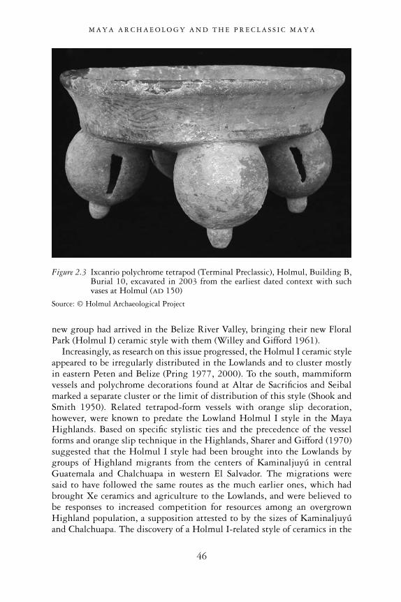
new group had arrived in the Belize River Valley, bringing their new FloralPark (Holmul I) ceramic style with them (Willey and Gifford 1961).
Increasingly, as research on this issue progressed, the Holmul I ceramic styleappeared to be irregularly distributed in the Lowlands and to cluster mostlyin eastern Peten and Belize (Pring 1977, 2000). To the south, mammiformvessels and polychrome decorations found at Altar de Sacrificios and Seibalmarked a separate cluster or the limit of distribution of this style (Shook andSmith 1950). Related tetrapod-form vessels with orange slip decoration,however, were known to predate the Lowland Holmul I style in the MayaHighlands. Based on specific stylistic ties and the precedence of the vesselforms and orange slip technique in the Highlands, Sharer and Gifford (1970)suggested that the Holmul I style had been brought into the Lowlands bygroups of Highland migrants from the centers of Kaminaljuyú in centralGuatemala and Chalchuapa in western El Salvador. The migrations were said to have followed the same routes as the much earlier ones, which hadbrought Xe ceramics and agriculture to the Lowlands, and were believed to be responses to increased competition for resources among an overgrownHighland population, a supposition attested to by the sizes of Kaminaljuyúand Chalchuapa. The discovery of a Holmul I-related style of ceramics in the
M A Y A A R C H A E O L O G Y A N D T H E P R E C L A S S I C M A Y A
46
Figure 2.3 Ixcanrio polychrome tetrapod (Terminal Preclassic), Holmul, Building B,Burial 10, excavated in 2003 from the earliest dated context with suchvases at Holmul (AD 150)
Source: © Holmul Archaeological Project

intermediate northern Highland region of Salama, Alta Verapaz (in connectionwith early inscriptions and sculpture), suggested that they may have movednorth with a wave of migrants with hieroglyphic writing and complex poli-tical institutions via the shortest route (Adams 1971; Sharer and Gifford 1970;Sharer and Sedat 1973).
Another possible motive for this migration could have been the eruption ofthe Ilopango volcano in El Salvador, which perhaps sent waves of refugeesnorth and west (Sharer and Gifford 1970; Sheets 1971). This eruption was alsocorrelated with the termination of temple construction and stela carving atKaminaljuyú and Chalchuapa. Elites from these centers would have fled intothe Lowland centers with which long-standing relations already existed. Thenew influx of foreigners would have overlaid a new high-status class of indi-viduals upon a society with less developed ranking. This process was evidentin the appearance of “rich” polychrome vessel types—in addition to theexisting “poor” Preclassic forms—concurrent with other elite features, such asthe stela cult, Long Count calendar systems, and more elaborate tombs at someLowland centers. Study of the Ilopango eruption and the ensuing widespreaddestruction of settlement in western El Salvador added weight to this theory(Sheets and Grayson 1979). It was widely adopted when the Ilopango eruptionwas dated to AD 260. The eruption was later re-dated to AD 400–550 (Dull et al. 2001). However, in either case, the Ilopango catastrophe was a couple of centuries too late to have caused the influx of Holmul I ceramic style in the Maya Lowlands, which was believed to have occurred in the first centuryAD (Pring 1977, 2000). Nevertheless, most scholars continued to accept themigration theory as fact.
The period from AD 50 to 250 was believed to represent a major transitionfrom the Preclassic to the Classic period and the “crystallization” of ClassicMaya civilization. It was termed the “Protoclassic” (Gifford 1965; Willey andGifford 1961). Exactly what significant cultural and social changes this tran-sition entailed was to be a matter of discussion for some time.
Even in the face of widespread ceramic influences from the Highlands, somedoubted that such similarities should be attributed to significant populationmovements into the Lowlands. In an overview of this issue Gordon Willey(1977) pointed out that the Late Preclassic period was a time of growth inpopulation as well as in cultural complexity in the Lowlands. The Holmul I-style ceramics appeared at the end of this period but no corresponding popu-lation increase was discernible in the archaeological record. However, Willeyalso noted that some areas, such as the northern plains (Dzibilchaltun), expe-rienced a decline, while other areas continued their progress towards the earlyClassic with a total lack of Holmul I-style ceramics (Willey 1977; see also Ball1977).
Protoclassic or Holmul I-style ceramics were clearly present at Tikal(Culbert 1977). The Highland-inspired polychrome techniques and theUsulutan-like (Highland-inspired) negative/resist or double-slip painting
M A Y A A R C H A E O L O G Y A N D T H E P R E C L A S S I C M A Y A
47
technique at Tikal marked a gradual increase in sophistication and overallstatus differentiation locally extending back to the Late Preclassic period.Willey (1977) believed, as Morley (1946) did before him, that the existence ofearly carved dates (Baktun 8: i.e. pre- 9.0.0.0.0/AD 435) primarily in the Tikalzone was of paramount importance for understanding the development processof Classic Maya civilization. While the “ideas” of the stela cult and polychromedecoration may have been introduced through contact with the Highlands,Morley (1946) believed these were innovations of a local emerging elite cen-tered at Tikal. Once formed, the Tikal kingdom assumed an expansive mode,attempting to build an “empire” in the Peten. This would have explained theintroduction of elite innovations at Tikal first, such as the carving of LongCount inscriptions on stela monuments there, and the radiating distributionof early-dated monuments at sites in the central Tikal region, as well as insurrounding areas to the east (Holmul and Belize), west (Usumacinta region)and south (Pasion region). This zone also largely overlapped with the spottydistribution of Holmul I ceramic styles, and, as Hammond (1977) noted,included northern Belize, probably because of its strategic resources and riverroutes to the sea. Long-distance trade connections were also believed to beradiating from Tikal during the Protoclassic and Early Classic period, due tothe increased complexity of the local system.
Willey (1977) noted that it was probably not coincidental that the earliest signs of Teotihuacan interest in the Maya Lowlands were found atplaces along the Lowland routes, such as Altun Ha on the Belizean coast (seealso Pendergast 1971). The distant center of Teotihuacan might have had aninfluential role in the formation of the Classic Maya state. Sanders and Price(1968) proposed that Classic Maya society was the product of a process ofsecondary state formation emanating from the area of primary state forma-tion, the central Highlands of Mexico. This process was viewed from anevolutionary perspective, envisioning Late Preclassic Highland centers such asKaminaljuyú being transformed into state-organized societies after the arrivalof elite emissaries from Teotihuacan. Subsequent penetration of Teotihuacantraders and accompanying military groups, similar to the Aztec pochteca, intothe Peten region would also have transformed the Preclassic Tikal chiefdominto an Early Classic Maya state. Evidence of Teotihuacan-style templearchitecture and richly furnished tombs in Early Classic Kaminaljuyú (Kidderet al. 1946) was interpreted as a sign of a foreign enclave of elite merchants atthat site. Similarly, the mounting evidence of Teotihuacan-style architectureand ceramics at Tikal brought to light by the Pennsylvania excavationsinspired many scholars to envision a strong Teotihuacan influence on the localsat the opening of the Classic period (Coe 1965; Coggins 1975; Proskouriakoff1993).
M A Y A A R C H A E O L O G Y A N D T H E P R E C L A S S I C M A Y A
48
The Preclassic Maya behemoth
The discovery of the Preclassic Maya center of El Mirador and a score of otherlarge Preclassic centers in northern Guatemala in the last 20 years of the 20thcentury turned many theories of foreign influence about the origins of theMaya Lowlands on their heads.
The site of El Mirador was known to airplane pilots in the 1930s as a clearpeak emerging from the rather flat forested landscape of northern Peten. Thefact that this was a man-made feature—massive pyramids later called theDanta complex—was subsequently established by oil prospectors, chicle gumcollectors, and finally by solitary Maya explorer Ian Graham in 1962. Grahamfirst mapped the site and reported that El Mirador was a predominantly Late Preclassic construction, and the largest Maya site thus far known. In fact,the Danta complex is the largest Mesoamerican pyramid. The idea that a siteof these proportions dated to before the Classic period was largely dismissedby the academic community but later confirmed by excavations. The firstarchaeological explorations were conducted in the 1980s by Brigham YoungUniversity (Matheny et al. 1980) and briefly by Harvard University (Demarest1984). Research at El Mirador and nearby sites continues with an inter-disciplinary project led by Idaho State University’s Richard Hansen (Hansen1990, 1998, 2005).
The site’s map shows a vast ceremonial core stretching along an upland areafor over 2 kilometers from east to west and more than 1 kilometer from northto south. This area was likely completely paved with plaster flooring andpunctuated by massive temple complexes. The largest of these was the Dantacomplex at the east end of the site. It featured a Triadic Group of temples, acommon feature at El Mirador, whose eastern temple rose 73 meters above thegroup. The group rested on a gigantic platform over 600 meters wide, risingin three broad terraces. The lowest terrace is occupied by a large pyramid onthe west and an elongated platform on the east. This type of arrangement wasfirst identified at Preclassic Uaxactun Group E, and is known at other Mayasites as the E-Group plaza type (see Chapter 3). The Danta complex stands inrelative isolation with respect to the central and western parts of the site,which constitute a more compact area of connected plazas, platforms andtemples. A large moat and embankment encircling the central and westernpart of the site gives the impression that the Danta complex was thought bythe Maya themselves to be separate from the rest of the site. Within this mainarea are a number of very impressive temple complexes, such as El Tigre, thesecond-largest Triadic complex (53 meters maximum height), located at thewestern extreme of the ideal axial line bisecting the site from east to west andpassing through the Danta pyramid. Of the major Triadic Groups, the MonosGroup, located at the south end of the core, is the third largest in volume andheight. Following these are a number of smaller complexes, including the TresMicos. As many as 15 complexes at El Mirador repeat the Triadic arrangement,
M A Y A A R C H A E O L O G Y A N D T H E P R E C L A S S I C M A Y A
49
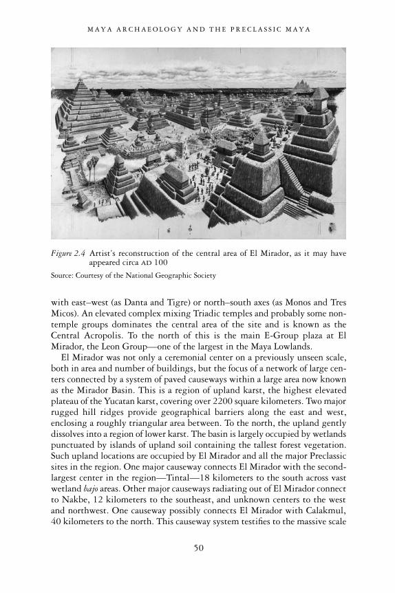
with east–west (as Danta and Tigre) or north–south axes (as Monos and TresMicos). An elevated complex mixing Triadic temples and probably some non-temple groups dominates the central area of the site and is known as theCentral Acropolis. To the north of this is the main E-Group plaza at ElMirador, the Leon Group—one of the largest in the Maya Lowlands.
El Mirador was not only a ceremonial center on a previously unseen scale,both in area and number of buildings, but the focus of a network of large cen-ters connected by a system of paved causeways within a large area now knownas the Mirador Basin. This is a region of upland karst, the highest elevatedplateau of the Yucatan karst, covering over 2200 square kilometers. Two majorrugged hill ridges provide geographical barriers along the east and west,enclosing a roughly triangular area between. To the north, the upland gentlydissolves into a region of lower karst. The basin is largely occupied by wetlandspunctuated by islands of upland soil containing the tallest forest vegetation.Such upland locations are occupied by El Mirador and all the major Preclassicsites in the region. One major causeway connects El Mirador with the second-largest center in the region—Tintal—18 kilometers to the south across vastwetland bajo areas. Other major causeways radiating out of El Mirador connectto Nakbe, 12 kilometers to the southeast, and unknown centers to the westand northwest. One causeway possibly connects El Mirador with Calakmul,40 kilometers to the north. This causeway system testifies to the massive scale
M A Y A A R C H A E O L O G Y A N D T H E P R E C L A S S I C M A Y A
50
Figure 2.4 Artist’s reconstruction of the central area of El Mirador, as it may haveappeared circa AD 100
Source: Courtesy of the National Geographic Society
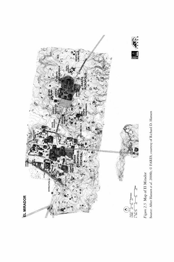
Fig
ure2
.5M
apof
ElM
irad
or
Sour
ce:A
fter
Han
sen
etal
.200
8b;©
FAR
ES;
cour
tesy
ofR
icha
rdD
.Han
sen

of ceremonial works in the region and the central role played by El Mirador inintegrating centers in other parts of the basin into a single ritual and perhapspolitical system (Hansen 2005).
Hansen’s reconnaissance in the Mirador Basin has produced a large inven-tory of Preclassic centers, work that has been matched by Ivan Spajc on theCampeche side of the border (Hansen et al. 2008b; Sprajc 2002). Most reachedtheir building apex during the Late Preclassic, before being subsequentlyabandoned, as at El Mirador. Each of these is impressive on its own terms forscale and complexity of architecture. Carved monuments in Lowland Preclassicstyle have been found at El Mirador, Nakbe and Tintal. The latter site isknown for its massive Triadic Group of temples, the second largest outside ofEl Mirador, and the huge watered ditch encircling its main plaza groups. Thesite of Wakna, with a 200-meter-long eastern platform and tall western pyra-mid, lies southeast of El Mirador and boasts major architecture as well as thelargest E-Group complex. Its Triadic Groups also house mural paintings yetto be completely uncovered. Other major sites are El Porvenir, La Florida, LaMuralla and Zacatal, all yet to be fully explored (Hansen 2005).
Perhaps the most striking new fact added to our presently limited knowl-edge of the Preclassic Lowland Maya is that the monumental architecture atthe site of Nakbe largely—as it has been mostly attributed to the late MiddlePreclassic Ox (late Mamom) phase (600–350 BC; Hansen 1992, 1998)—predated that of many other basin sites, including El Mirador. The earliestNakbe architecture includes a ball-court and an E-Group.
In Richard Hansen’s (2005) opinion, several centers emerged simulta-neously and then competed with one another in the Middle Preclassic period,with Nakbe perhaps being the largest. The relatively homogeneous ceramicsof this epoch, the Mamom pottery, would reflect the increased interaction andpolitical integration of the Maya Lowlands at this time around selected centers,such as Nakbe in the Mirador Basin. The process of centralization and inte-gration was accentuated during the Late Preclassic period, when El Miradorovershadowed all other centers and extended its trade connections far acrossthe Yucatan Peninsula. Other large centers with mainly Late Preclassic archi-tecture became known outside of the Mirador Basin. These were Seibal, in thePasion region of Peten (Willey 1970), Nohmul (Hammond 1985), Cerros(Freidel 1982) and Lamanai in northern Belize (Pendergast 1981), Becan insouthern Quintana Roo (Webster 1976), San Bartolo (Saturno et al. 2005b)and Cival in northeastern Peten (Estrada-Belli et al. 2003a, 2003b). All thesesites display a primary Late Preclassic occupation followed by permanent ortemporary abandonment. Some of them—Cerros, Becan and Cival—boastedlarge-scale defensive moats or stone walls. At other sites an important LatePreclassic building component was recognized by excavations such as those atSeibal, Altar de Sacrificios and Tikal, and more recently at Calakmul, Rio Azul,Yaxha and Naranjo, Caracol and Cahal Pech. Among these, Tikal’s sprawlingperiphery was enclosed within vast earthworks (moat and embankment) in
M A Y A A R C H A E O L O G Y A N D T H E P R E C L A S S I C M A Y A
52
the Late Classic period (Webster 2004). Curiously, the moat was apparentlymissing in large sections and the circle around the city may never have beenfinished.
The new political geography of the Late Preclassic Maya Lowlands and the great similarity in architecture and art were doubtless the result of inten-sive interaction. The possible prominence of El Mirador amid less organizedLowland polities, combined with the similarities in art and architecture andthe great homogeneity of the Chicanel phase ceramics across Lowland regions,led Hansen (Hansen and Guenter 2005) to speak of El Mirador as the firstMaya state. As El Mirador’s massive temples, carved monuments and hiero-glyphs clearly demonstrated, a Preclassic Maya state was no longer a fantasy.To state the matter more broadly, many lines of evidence now indicated that“Preclassic Maya civilization is no longer a contradiction in terms” (Hammond1980: 189).
M A Y A A R C H A E O L O G Y A N D T H E P R E C L A S S I C M A Y A
53

3
MAYA STATES BEFORE THE CLASSIC PERIOD
The rise of the first Lowland states
For Mayanists, as for experts in other ancient cultures, the scientific definitionof “civilization” is normally tied to several material traits. Among the mostcommonly mentioned are social hierarchy, craft specialization or forms ofinterdependence among population segments, monumental architecture, com-plex ideology and public rituals, and writing systems. Maya archaeologistslong believed the first appearance of these traits coincided with the onset ofthe Classic period (AD 300–900). For the Lowland Maya, the Classic period’sdefining criteria were held to be the first appearance of writing in the form ofcarved stelae, craft specialization in the form of polychrome painted ceramics,and masonry architecture in the form of corbeled-vault roofed buildings. Thesecategories were admittedly arbitrary and broad. They were largely based on the findings of these traits in the excavations of Uaxactun in the 1930s, andthe AD 292 date of Tikal Stela 29, which is the earliest monument bearing a calendar date in the Lowlands. For decades, these markers served to guidearchaeologists who attempted to make sense of disparate findings from 3000years of development throughout the Yucatan Peninsula.
As often happens, once fixed classifications are created, exceptions begin toemerge. Even as early as the Carnegie excavations at Uaxactun during the1930s, exceptions emerged that suggested that monumental architecture andpainted ceramics predated the AD 300 cut-off date. Even though the earliestwriting in the Lowlands dated to AD 292 (Tikal Stela 29), it appeared withsuch sophistication and complexity that many postulated that it must haveevolved long before Stela 29’s date. On the other hand, many scholars in the first half of the 20th century firmly believed in the greater antiquity ofwriting systems in the southern Highlands and the Pacific Coast of Guatemala.They were not surprised by the mature style of the early Lowland stelae andexplained it by proposing that the Lowland Maya had simply adopted thewriting system developed by their southern neighbors (an opinion still heldby some scholars even today, in spite of linguistic data to the contrary). Theadoption of writing necessarily had to coincide with the time in which the
54

Lowland Maya had reached a sufficient level of complexity for them to makeuse of such an advanced tool. As we will see in the following section, thisexpectation was recently put to rest by the discovery of Preclassic texts in stone and other media. But even prior to these discoveries, many scholarschallenged this position by pointing out that many “higher civilizations” ofthe ancient world had little or no use for a writing system. One often-invokedexample was the great Mesoamerican civilization of Teotihuacan, where mostresearchers find no signs of a fully functioning writing system, despite theglyph-like signs used in iconography. Many have pointed out that the contentof Mesoamerican writing systems was related to dynastic histories and propa-ganda. The absence of writing at Teotihuacan and the absence of any imagesof rulers were found to fit with the prevailing model of Teotihuacan beingruled by a corporate system (Pazstory 1997). Other ready examples of greatcivilizations lacking writing were the Inca and the Andean civilizations thatpreceded them. (The Inca did, however, have a complex recording system, thequipu, which combined the recording of tribute and economic transactionswith oral communications in encoded messages that only the elite coulddecipher.)
Until recently, many scholars agreed that the Lowland Maya lacked severalimportant characteristics of “civilization” prior to AD 300. The most impor-tant was the non-existence of kings or other individualized and centralizedinstitutions. Many adduced the Classic period’s custom of burying rulers inunderground chambers with rich furnishings and human sacrificial victims asterms of reference. When such elaborate tombs failed to appear at Preclassicsites, despite intensive excavation, many felt forced to conclude that thePreclassic Maya must have had forms of rulership that did not include indi-vidual kings until the end of the Preclassic period. It was thought that thesepeople were probably ruled by a class of religious leaders (theocracy) such asthe one postulated to have ruled over Teotihuacan (Thompson 1970), or by asystem similar to the multepal, an assembly of lineage leaders who ruled thestatelets of northern Yucatan just prior to the arrival of the Spanish conquerors(Roys 1957: 6; Marcus 1993: 118–120). Replacing a corporate system withan individualized system of governance would represent a significant culturalchange—a “conjuncture,” a term used by Annalist historians for a moment ofsocial change with widespread ramifications for the organization of economic,ritual and power relations (Knapp 1992b).
In the line of the founder: Preclassic royal burials
The excavations at Tikal by the University of Pennsylvania began to turn upevidence that challenged earlier assumptions about the lack of kings in Mayasociety prior to the Classic period. Beneath the massive Late Classic templesof the North Acropolis, archaeologists documented a sequence of rich burials(tombs) dating to the Late Preclassic period (Coe 1990). These were often
M A Y A S T A T E S B E F O R E T H E C L A S S I C P E R I O D
55
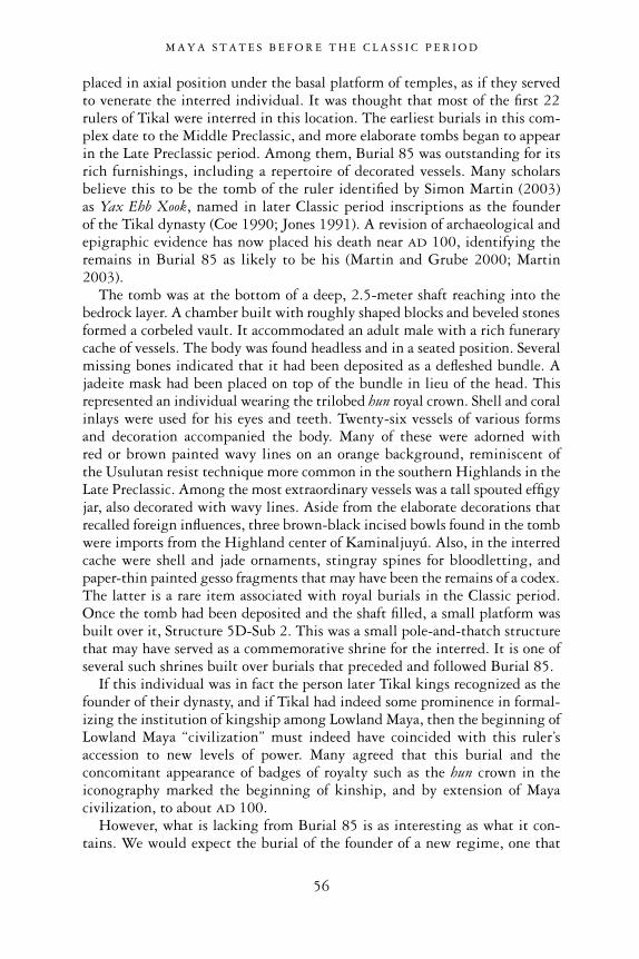
placed in axial position under the basal platform of temples, as if they servedto venerate the interred individual. It was thought that most of the first 22rulers of Tikal were interred in this location. The earliest burials in this com-plex date to the Middle Preclassic, and more elaborate tombs began to appearin the Late Preclassic period. Among them, Burial 85 was outstanding for itsrich furnishings, including a repertoire of decorated vessels. Many scholarsbelieve this to be the tomb of the ruler identified by Simon Martin (2003) as Yax Ehb Xook, named in later Classic period inscriptions as the founder of the Tikal dynasty (Coe 1990; Jones 1991). A revision of archaeological andepigraphic evidence has now placed his death near AD 100, identifying theremains in Burial 85 as likely to be his (Martin and Grube 2000; Martin2003).
The tomb was at the bottom of a deep, 2.5-meter shaft reaching into thebedrock layer. A chamber built with roughly shaped blocks and beveled stonesformed a corbeled vault. It accommodated an adult male with a rich funerarycache of vessels. The body was found headless and in a seated position. Severalmissing bones indicated that it had been deposited as a defleshed bundle. Ajadeite mask had been placed on top of the bundle in lieu of the head. Thisrepresented an individual wearing the trilobed hun royal crown. Shell and coralinlays were used for his eyes and teeth. Twenty-six vessels of various forms and decoration accompanied the body. Many of these were adorned with red or brown painted wavy lines on an orange background, reminiscent of the Usulutan resist technique more common in the southern Highlands in theLate Preclassic. Among the most extraordinary vessels was a tall spouted effigyjar, also decorated with wavy lines. Aside from the elaborate decorations thatrecalled foreign influences, three brown-black incised bowls found in the tombwere imports from the Highland center of Kaminaljuyú. Also, in the interredcache were shell and jade ornaments, stingray spines for bloodletting, andpaper-thin painted gesso fragments that may have been the remains of a codex.The latter is a rare item associated with royal burials in the Classic period.Once the tomb had been deposited and the shaft filled, a small platform wasbuilt over it, Structure 5D-Sub 2. This was a small pole-and-thatch structurethat may have served as a commemorative shrine for the interred. It is one ofseveral such shrines built over burials that preceded and followed Burial 85.
If this individual was in fact the person later Tikal kings recognized as thefounder of their dynasty, and if Tikal had indeed some prominence in formal-izing the institution of kingship among Lowland Maya, then the beginning ofLowland Maya “civilization” must indeed have coincided with this ruler’saccession to new levels of power. Many agreed that this burial and theconcomitant appearance of badges of royalty such as the hun crown in theiconography marked the beginning of kinship, and by extension of Mayacivilization, to about AD 100.
However, what is lacking from Burial 85 is as interesting as what it con-tains. We would expect the burial of the founder of a new regime, one that
M A Y A S T A T E S B E F O R E T H E C L A S S I C P E R I O D
56
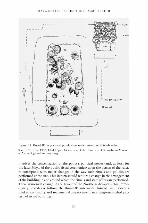
involves the concentration of the polity’s political power (and, at least for the later Maya, of the public ritual ceremonies) upon the person of the ruler,to correspond with major changes in the way such rituals and politics areperformed at the site. This in turn should require a change in the arrangementof the building in and around which the rituals and state offices are performed.There is no such change in the layout of the Northern Acropolis that imme-diately precedes or follows the Burial 85 interment. Instead, we discover amarked continuity and incremental improvement in a long-established pat-tern of ritual buildings.
M A Y A S T A T E S B E F O R E T H E C L A S S I C P E R I O D
57
Figure 3.1 Burial 85 in plan and profile view under Structure 5D-Sub 2-2nd
Source: After Coe 1990, Tikal Report 14; courtesy of the University of Pennsylvania Museumof Archaeology and Anthropology
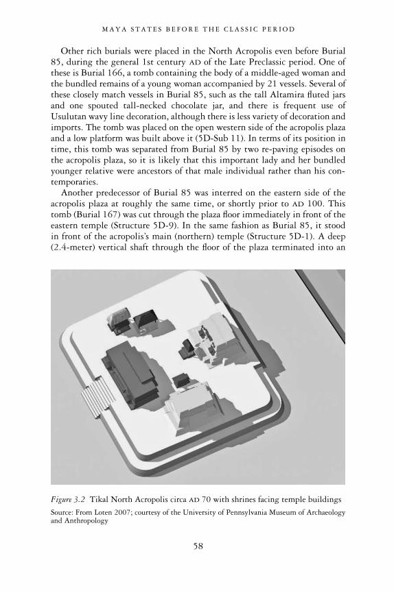
Other rich burials were placed in the North Acropolis even before Burial85, during the general 1st century AD of the Late Preclassic period. One ofthese is Burial 166, a tomb containing the body of a middle-aged woman andthe bundled remains of a young woman accompanied by 21 vessels. Several ofthese closely match vessels in Burial 85, such as the tall Altamira fluted jarsand one spouted tall-necked chocolate jar, and there is frequent use ofUsulutan wavy line decoration, although there is less variety of decoration andimports. The tomb was placed on the open western side of the acropolis plazaand a low platform was built above it (5D-Sub 11). In terms of its position intime, this tomb was separated from Burial 85 by two re-paving episodes onthe acropolis plaza, so it is likely that this important lady and her bundledyounger relative were ancestors of that male individual rather than his con-temporaries.
Another predecessor of Burial 85 was interred on the eastern side of theacropolis plaza at roughly the same time, or shortly prior to AD 100. Thistomb (Burial 167) was cut through the plaza floor immediately in front of theeastern temple (Structure 5D-9). In the same fashion as Burial 85, it stood in front of the acropolis’s main (northern) temple (Structure 5D-1). A deep(2.4-meter) vertical shaft through the floor of the plaza terminated into an
M A Y A S T A T E S B E F O R E T H E C L A S S I C P E R I O D
58
Figure 3.2 Tikal North Acropolis circa AD 70 with shrines facing temple buildings
Source: From Loten 2007; courtesy of the University of Pennsylvania Museum of Archaeologyand Anthropology

east–west-oriented chamber. The walls and the vault were built with roughlysquared and beveled stones and covered with a coat of dark mud. In it werethree individuals: a principal adult male, in extended position; a bundledfemale arranged in a pot on the chest and right arm of the male; and an infantlaid in a vessel at the male’s side. The 17 accompanying vessels resembled the Burial 85 assemblage in variety of form and decoration. In addition to thewavy line Usulutan decorated tall-necked bowls and jars, there was an exampleof two imported black-brown incised bowls identical to the three in Burial 85.
These correspondences in the artifacts contained in Burials 166 and 167 areundoubtedly due to the close spacing in time of these interments, as well astheir close familiarity during their lifetimes. According to the plaza’s stratig-raphy, Burial 167 was an important male, possibly a ruler, whose date fell inthe years between the women in Burial 166 and the male (founder) in Burial85. His body was not adorned with jade ornaments, as in the others’ inter-ments, but with shell necklaces and pendants. However, his tomb was markedby a more substantial platform shrine than the others. Above the burial shaftwas a small vaulted building (Structure 5D-Sub 10-1st). The preserved rearwall of this two-room building was decorated with a beautifully colored muraldepicting two figures standing amid red cloud-like scrolls below a sky-bandmotif. The iconography seems to be evoking the celestial deities whom theinterred was to join in the afterlife. As in the other two examples describedabove, this shrine stood in front of a major temple, effectively occupying aprominent position within the plaza.
These tombs of the end of the Late Preclassic period were but a sample ofseveral earlier interments in this location within the main acropolis plaza.Indeed, the individual in Burial 167 could be the ruler immediately precedingBurial 85, the Tikal dynasty’s founder. Because of similarities in the furnishingsand honorific placements of these tombs, we must assume that no significantbreaks in the genealogy of Tikal’s rulers occurred when the “founder” took thethrone. Instead, these elites buried in the North Acropolis were the inheritorsof high status from a long line of rulers, reaching back into the beginning ofthe Late Preclassic. This leads to several questions. Why was Burial 85, or YaxEhb Xook, or another ruler from the period around AD 100, proclaimed the“founder” of the dynasty by later kings? What was his relation to the severalearlier rulers buried in the North Acropolis and elsewhere at Tikal? And whydid his reign not result in any extensive renovation of the North Acropolis, butrather a continuation of the status quo?
Approximately 100 years passed after the deposition of the “founder” inBurial 85 before significant renovations occurred on the acropolis, in whatTikal archaeologists’ refer to as Time Span 10 (Coe 1990). The next construc-tion episode in the acropolis involves the massive burial of all existing templesup to their roofs, with over 5 meters of vertical infilling, and the expansion ofthe platform area. New temples were built on this higher and wider spaceabove the older ones, denoting great continuity in ritual behavior. This episode
M A Y A S T A T E S B E F O R E T H E C L A S S I C P E R I O D
59

of major renovation certainly reflects a period of prosperity and politicalintegration at Tikal, if not consolidation of power in the hands of the rulers.More than one ruler must have been responsible for this renovation, but onlyone was found buried in the central axial location that earlier rulers had chosen,Burial 125. This burial was placed in front of the new northern temple of theNorth Acropolis, in the most prominent location, as was his Burial 85 pre-decessor. The tomb was cut deeply into the acropolis and the shaft sealed by alow, south-facing platform (5D-Sub 7), in all ways similar to the one aboveBurial 85 (5D-Sub 2). According to William Coe (1990), who directed theTikal excavations, this individual may have been one of the successors of the founder who commissioned the final stages of the renovation; although,given the lengthy period evident from the various additions, other rulersbefore him must have contributed to it. There was also a stark absence of anyofferings in Burial 125. This led Coe (1990) to propose that it could representa non-royal individual or a sacrificial victim interred as a dedicatory offeringto the new building. In either case, this deposition would represent the finaloutcome of an extended period of prosperity rather than being the result of asingle watershed project. The other most important ritual area of Tikal—theMundo Perdido astronomical complex—experienced significant renovationand increase in the size of its buildings and in the elaboration of the art that decorated them. High-status burials were deposited there after AD 200(Laporte and Fialko 1990).
The significance of later kings at Tikal naming a founder around AD 100 isstill not clear. The date of his death is indeed independently corroborated byseveral king lists and the best candidate for Burial 85 remains Yax Ehb Xook.
M A Y A S T A T E S B E F O R E T H E C L A S S I C P E R I O D
60
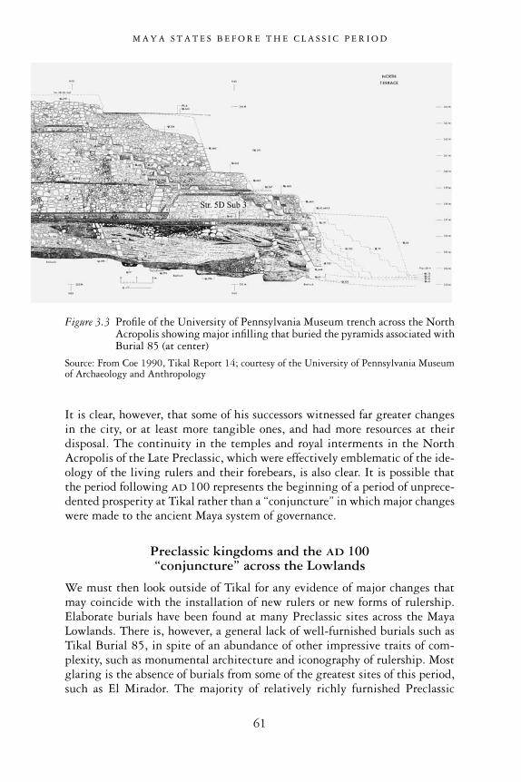
It is clear, however, that some of his successors witnessed far greater changesin the city, or at least more tangible ones, and had more resources at theirdisposal. The continuity in the temples and royal interments in the NorthAcropolis of the Late Preclassic, which were effectively emblematic of the ide-ology of the living rulers and their forebears, is also clear. It is possible thatthe period following AD 100 represents the beginning of a period of unprece-dented prosperity at Tikal rather than a “conjuncture” in which major changeswere made to the ancient Maya system of governance.
Preclassic kingdoms and the AD 100 “conjuncture” across the Lowlands
We must then look outside of Tikal for any evidence of major changes that may coincide with the installation of new rulers or new forms of rulership.Elaborate burials have been found at many Preclassic sites across the MayaLowlands. There is, however, a general lack of well-furnished burials such asTikal Burial 85, in spite of an abundance of other impressive traits of com-plexity, such as monumental architecture and iconography of rulership. Mostglaring is the absence of burials from some of the greatest sites of this period,such as El Mirador. The majority of relatively richly furnished Preclassic
M A Y A S T A T E S B E F O R E T H E C L A S S I C P E R I O D
61
Figure 3.3 Profile of the University of Pennsylvania Museum trench across the NorthAcropolis showing major infilling that buried the pyramids associated withBurial 85 (at center)
Source: From Coe 1990, Tikal Report 14; courtesy of the University of Pennsylvania Museumof Archaeology and Anthropology

burials come from some of the smaller sites of the period, and the richness oftheir funerary offerings is often commensurate with the size and relativeimportance of the site in which they are found. The smaller Lowland sites havehistorically received far more research than the larger ones of the centralLowlands (i.e. in northern Peten, and adjoining remote areas of Campeche andQuintana Roo, Mexico). This is due to the difficulties of accessing architectureand interments deeply buried underneath massive construction at large sites.
One must consider the possibility that different burial practices that did not require the disposal of personal wealth with the ruler’s body and the place-ment in public buildings may have been in operation prior to the end of thePreclassic period. Generations of archaeologists have been accustomed to the richness of Classic Maya royal burials but one must question whether thoselevels of personal display of wealth represent an absolute standard or acharacteristic typical of the Classic period (i.e. tombs are equally rare in thePostclassic period). Nevertheless, there are several indications that relativelyelaborate burials were not as uncommon in most Late Preclassic sites as is gen-erally believed. While most Preclassic burials do not include the spectaculararray of artifacts found in Tikal’s tombs, this lack may also be due to the natureof the excavated sample, biased as it is towards main temple groups and plazas.In addition to being located at the base of temples, there is a good possibilitythat earlier generations of rulers were buried in residential contexts and thatthese remain covered under less obvious constructions, as is the case in smallersites.
The best examples of burials of Preclassic high-ranking individuals havebeen found in residential contexts at smaller sites, such as Cuello, an unas-suming Preclassic community in northern Belize. Here, thanks to more than20 years of excavations, indicators of social status have been found in burialsdating to the earliest phases of the Middle Preclassic (1000–800 BC) includingjade and shell ornaments associated with both children and adults. Severalhigh-status burials appear in a sequence in specific residential loci over periodsof time. Among them, one stands out, Burial 160, which dates to 500–400BC. The individual was buried in a simple cist and was accompanied by twoceramic vessels and ornaments. Of particular note were tubes made of deerbone decorated with the mat design later associated with royal power, and aplaque carved into a face from the top part of a human skull. Thus, the exca-vators concluded that this individual, like others buried with such symbols ofpower, was among the Middle Preclassic rulers of the small Cuello community.That the locus of these burials had special significance for this community wasdemonstrated by the later conversion of the residential patio into a raised cere-monial platform supporting a small pyramid temple (Hammond et al. 1992).
The discovery of a rich burial at San Bartolo offers another significantexample of Preclassic elite mortuary practices. San Bartolo Tomb 1 was foundin a residential group (Grupo Jabali), located to the northwest of the mainpublic site core (Pellecer 2006). The tomb was placed in front of the western
M A Y A S T A T E S B E F O R E T H E C L A S S I C P E R I O D
62

structure of the group, an elite residential platform, in a chamber sealed byhorizontal slabs. In the funerary cache were six vessels, including an unusualorange effigy censer, effigy bowls decorated with Usulutan style wavy lines andother Late Preclassic vessels of the finest quality among Lowland burials of theperiod (e.g. see Tikal Burial 85). Also with the body was a small greenstonefigure similar to several examples of “royal” diadem jewels from Cerros andNohmul, Belize (cf. “bib-heads”, Freidel et al. 2002; Justeson et al. 1988).Judging from these funerary offerings, this person may have been one of theLate Preclassic rulers of San Bartolo. Another high-status burial was recentlyfound in the residential area of K’o—a site with significant ceremonial archi-tecture on the outskirts of Holmul. The funerary offerings included eight finevessels and a small effigy bowl depicting the maize god head wearing the royalhun jewel (Estrada-Belli 2009). These sporadic finds of high-status burials inunassuming residential locations indicate that rulers and elites were not buriedin temple-pyramids prior to AD 100.
We might then expect that discoveries of ruler burials from the LatePreclassic period may be forthcoming, as research progresses at the greatercenters of the Mirador Basin and central Peten, on both residential and cere-monial platforms. Many of the high-ranking burials may have been lost tolooting and erosion but some may lay undetected. Good examples of the sortsof tomb that may have remained undetected at large centers until now areTombs 1, 2 and 3 at Wakna, reported by Richard Hansen (1998) and dated to the Terminal Preclassic period (AD 150–300). Unfortunately, these inter-ments had already been looted at the time of discovery. The three tombs wereplaced at the base of each of the temples atop a Triadic complex. The now half-emptied tombs were built with finely cut blocks to form an unusualpentagonal cross-section vault and their interiors were lined with stucco. Themost elaborate of the three, located under the northern temple, was builtwithin a series of recessed walls at the entrance, adding to the effect of monu-mentality. The contents included Late Preclassic vessels of the Sierra, Flor andPolvero groups. Hansen noted that this type of vault matched a TerminalPreclassic tomb in the Mundo Perdido at Tikal (PNT-021 in Structure 5D-86;Laporte and Fialko 1990). This suggests an estimated Late Preclassic–TerminalPreclassic date for the Wakna tombs as well. Hansen also noted that the lootershad excavated many additional trenches in other Triadic Groups across theMirador Basin in the hope of locating similar tombs, but to no avail. Giventhat monumental construction was fairly common throughout the Preclassicperiod at these sites, and the earlier patterns of residential interments notedabove, the overall absence of tombs in monumental settings could indicate thatthe pattern of burying important individuals under major temples was a latedevelopment.
Elaborate Preclassic burials have been encountered at several other sites.Some of these have unfortunately been looted and emptied of their contents,so their classification as “tomb” relies on the presence of a vaulted chamber. In
M A Y A S T A T E S B E F O R E T H E C L A S S I C P E R I O D
63

other cases the context is well documented by the richness of the furnishings.But in general the classification of the interred as a ruler or member of a high-ranking elite is dubious. Among the sites with vaulted chambers, those at Cival, Seibal, Rio Azul, Holmul and Altun Ha are among the bestknown (Krejci and Culbert 1999; Estrada-Belli 2004). We must await furtherresearch at the largest sites in the Lowlands before ruling out the presence ofroyal burials in the earlier Preclassic periods.
The dawning of a new era: Tikal
There are other important changes to consider in the period following AD 100that might shed some light on the events leading to the formal founding of adynasty at Tikal. Around AD 100 most of the greatest and longest-lived cen-ters of the Mirador Basin, including El Mirador, Tintal and many other centersacross the Maya Lowlands, entered a period of decisive decline. Shortly afterthe burial in Wakna Tomb 1, and those in similar high-ranking tombs at other sites, many areas of the central Lowlands appear to have experienced
M A Y A S T A T E S B E F O R E T H E C L A S S I C P E R I O D
64
Figure 3.4 Late Preclassic tomb in Building B’s Room 8 at Holmul, photographed byRaymond Merwin in 1911
Source: Merwin and Vaillant 1932; courtesy of Peabody Museum, Harvard University
devastating population losses. The large Triadic Groups and plazas at ElMirador, Tintal, Wakna, Uaxactun, Cival, Cerros and Becan, to name a few,received their last renovation around this time and then were left to decay. Inthe course of the following 100 years, many of these sites would be completelyabandoned. In some cases, small populations continued to occupy a selectedportion of the once-public plazas, but with a much reduced profile. Some ofthese groups appear to have maintained their privileged standard of living, butthe vast majority of the population seems to have migrated to better pastures(Hansen et al. 2008a). Recent studies have correlated the clear and widespreaddecline between AD 100 and 200 with environmental stresses, such as defor-estation, soil erosion and water shortages induced by overuse of the landscape(Hansen et al. 2002, 2008a; Wahl et al. 2006b).
It is not clear, however, why certain sites and not others were affected bythis phenomenon. Defensive works of various kinds were built at manyPreclassic sites, suggesting civil unrest and endemic warfare as possible causesof their demise (see Chapter 6). While the debate continues, it is fairly clearthat Tikal made the transition through the second and third centuries AD
unscathed. Quite remarkably, this period corresponds with increased pros-perity and some of the most ambitious construction projects of all Maya timesin the North Acropolis at Tikal, as was noted above. New polychrome ceramicsbegin to appear at this time (after AD 150), and their distribution is highlyskewed to the east of the Tikal area. Many have concluded from this correlationthat Tikal may have contributed, at least in part, to the failures of other LatePreclassic centers in northern and eastern Peten by controlling important traderoutes and therefore restricting competing sites’ access to trade (Hansen et al.2008b; Reese-Taylor and Walker 2002; also see Chapter 6). This would cer-tainly have resulted in greater prosperity and a population increase at Tikal.After AD 100, the Tikal rulers claimed greater status than their predecessors,and required larger ritual spaces while keeping with the old tradition. The newlayout of the acropolis certainly reflected the rulers’ heightened success andambition, but also continuity in the location and orientation of the main tem-ples. The successes of Tikal’s rulers in the century that followed the “founding”of the dynasty enabled them to stand as equals among the rulers of the greatestcenters in the Maya Lowlands for the first time.
Perhaps the more elaborate treatment of rulers’ interments with richofferings and location under temples is a symptom of stresses on the system of governance at the end of the Late Preclassic. The founding of new dynastiesrepresented more idealized renewals of power than mere shifts in power rela-tions. But we must await more adequate evidence with respect to powerrelations during and after the Preclassic period. Possibly, once extensivetrenching and tunneling has been done at the largest Preclassic sites, as hasbeen done at Tikal, we may better understand the treatment reserved fordeceased rulers and high-ranking individuals, and how these features of Mayasociety may or may not be correlates of political institutions.
M A Y A S T A T E S B E F O R E T H E C L A S S I C P E R I O D
65
In sum, there are good indications that Tikal’s new dynasty emerged as afresh player among long-established and more powerful states in the 2ndcentury AD. These same indicators demonstrate that civilization in the MayaLowlands began much earlier than the widely accepted date for the “founding”of Tikal’s dynasty—AD 100. As noted earlier, these indicators include craftspecialization, monumental architecture, complex ideology, writing, site plan-ning and ritual performance—all of which correlate not only with complexitybut with the known symbols and ritual ceremonies of the Classic period. Thesefeatures of civilizations are known to be present at large and small Preclassicsites prior to AD 100 and to be preceded by an earlier and equally complextradition dating back several centuries.
M A Y A S T A T E S B E F O R E T H E C L A S S I C P E R I O D
66

4
PLANTING THE SEED OF CIVILIZATION
The making of sacred ground
Preclassic Maya site planning
In general, the layouts of Preclassic sites appear to follow a more regularpattern than those of the Classic period. This is immediately noticeable whenobserving a site map, especially when the Preclassic architecture is not con-cealed by later substantial constructions. During the Classic period, centuriesof incremental accretion and the addition of new temples and platforms mayhave distorted or completely transformed the original plaza arrangements ofPreclassic times. One obvious commonality in the layout of Lowland sites withlargely undisturbed Late Preclassic architecture, such as El Mirador, Tintal,Nakbe, Wakna, Cival, San Bartolo and Cerros, among many others, is thegeneral arrangement along an east–west axis. Despite centuries of accretionsof buildings, this pattern is generally maintained and elaborated. A primaryeast–west pattern has also been noted at early sites in neighboring regions of Highland Chiapas, and has led to some discussion of migrations to, orHighland influences on the early developments of, Lowland Maya civilization(Lowe 1989; Clark et al. 2000; Clark and Hansen 2001).
Another commonality of Preclassic sites, especially in the central Lowlandregion (Peten, southern Campeche, Quintana Roo and Belize), is the presenceof two distinct types of building arrangement. These are known as E-Groupsand Triadic Groups and are known to have served ritual functions. Both have widespread distribution at large and small sites. E-Groups are generallyformed by a western pyramid with radial stairways to the west and an elon-gated platform with one or three small substructures on the east side of theplaza. Their name is derived from Group E of Uaxactun, which was the firstof this type to be recognized (Morley 1946; Ricketson and Ricketson 1937;Smith 1950a). Triadic Groups are normally situated on an elevated platformand are formed by a main pyramidal temple flanked by two smaller ones facingeach other. The most common orientation of Triadic Groups is west-facing,although other cardinal orientations are not uncommon, especially at siteswhere several Triadic Groups are present (such as El Mirador, Nakbe, Lamanai,Cerros and Cival).
67

E-Group architectural arrangements appear to have greater antiquity thanthe Triadic Group, at least in its monumental form, and it seems that bothtypes continued to be built upon during the Late Preclassic and Early Classicperiods. While the first to be recognized, Uaxactun’s Group E, dates to theLate Preclassic and Early Classic, this type of complex has great antiquity and is demonstrably the earliest form of space for public rituals in theLowlands. The earliest examples of E-Groups have been dated to the MiddlePreclassic period (800–600 BC) at several sites, including Nakbe, Tikal
P L A N T I N G T H E S E E D O F C I V I L I Z A T I O N
68
Figure 4.1 Map of Cival showing E-Group sightlines
Source: © F. Estrada-Belli and Holmul Archaeological Project
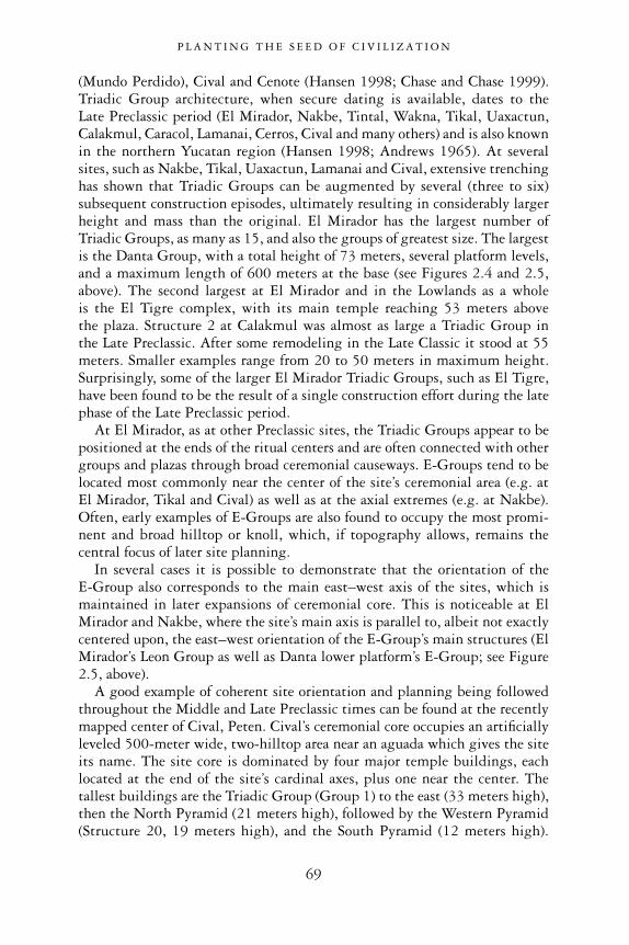
(Mundo Perdido), Cival and Cenote (Hansen 1998; Chase and Chase 1999).Triadic Group architecture, when secure dating is available, dates to the Late Preclassic period (El Mirador, Nakbe, Tintal, Wakna, Tikal, Uaxactun,Calakmul, Caracol, Lamanai, Cerros, Cival and many others) and is also knownin the northern Yucatan region (Hansen 1998; Andrews 1965). At severalsites, such as Nakbe, Tikal, Uaxactun, Lamanai and Cival, extensive trenchinghas shown that Triadic Groups can be augmented by several (three to six)subsequent construction episodes, ultimately resulting in considerably largerheight and mass than the original. El Mirador has the largest number ofTriadic Groups, as many as 15, and also the groups of greatest size. The largestis the Danta Group, with a total height of 73 meters, several platform levels,and a maximum length of 600 meters at the base (see Figures 2.4 and 2.5,above). The second largest at El Mirador and in the Lowlands as a whole is the El Tigre complex, with its main temple reaching 53 meters above the plaza. Structure 2 at Calakmul was almost as large a Triadic Group in the Late Preclassic. After some remodeling in the Late Classic it stood at 55meters. Smaller examples range from 20 to 50 meters in maximum height.Surprisingly, some of the larger El Mirador Triadic Groups, such as El Tigre,have been found to be the result of a single construction effort during the latephase of the Late Preclassic period.
At El Mirador, as at other Preclassic sites, the Triadic Groups appear to bepositioned at the ends of the ritual centers and are often connected with othergroups and plazas through broad ceremonial causeways. E-Groups tend to belocated most commonly near the center of the site’s ceremonial area (e.g. at El Mirador, Tikal and Cival) as well as at the axial extremes (e.g. at Nakbe).Often, early examples of E-Groups are also found to occupy the most promi-nent and broad hilltop or knoll, which, if topography allows, remains thecentral focus of later site planning.
In several cases it is possible to demonstrate that the orientation of the E-Group also corresponds to the main east–west axis of the sites, which ismaintained in later expansions of ceremonial core. This is noticeable at ElMirador and Nakbe, where the site’s main axis is parallel to, albeit not exactlycentered upon, the east–west orientation of the E-Group’s main structures (ElMirador’s Leon Group as well as Danta lower platform’s E-Group; see Figure2.5, above).
A good example of coherent site orientation and planning being followedthroughout the Middle and Late Preclassic times can be found at the recentlymapped center of Cival, Peten. Cival’s ceremonial core occupies an artificiallyleveled 500-meter wide, two-hilltop area near an aguada which gives the siteits name. The site core is dominated by four major temple buildings, eachlocated at the end of the site’s cardinal axes, plus one near the center. Thetallest buildings are the Triadic Group (Group 1) to the east (33 meters high),then the North Pyramid (21 meters high), followed by the Western Pyramid(Structure 20, 19 meters high), and the South Pyramid (12 meters high).
P L A N T I N G T H E S E E D O F C I V I L I Z A T I O N
69
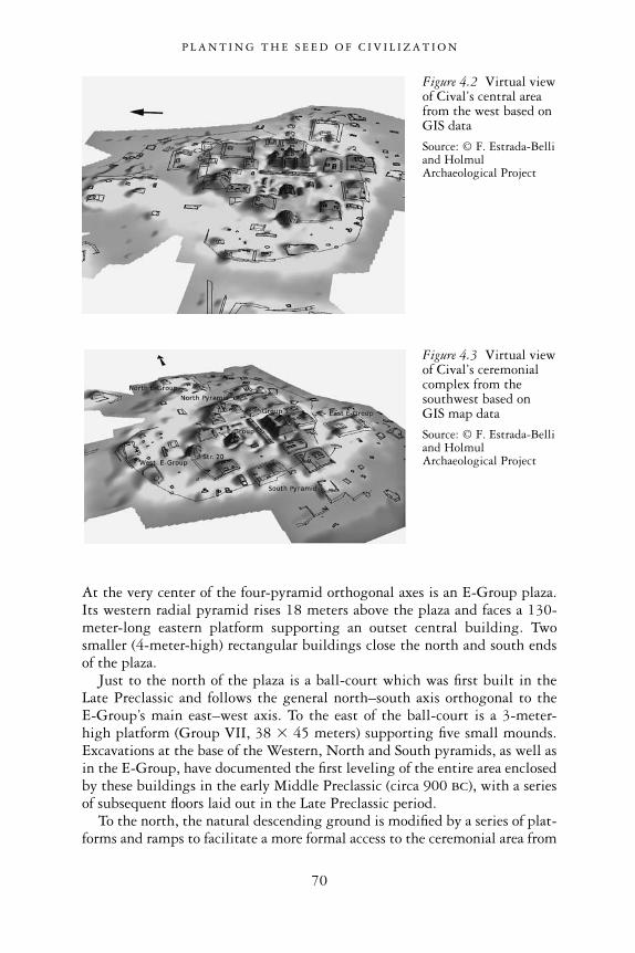
At the very center of the four-pyramid orthogonal axes is an E-Group plaza.Its western radial pyramid rises 18 meters above the plaza and faces a 130-meter-long eastern platform supporting an outset central building. Twosmaller (4-meter-high) rectangular buildings close the north and south endsof the plaza.
Just to the north of the plaza is a ball-court which was first built in the Late Preclassic and follows the general north–south axis orthogonal to the E-Group’s main east–west axis. To the east of the ball-court is a 3-meter-high platform (Group VII, 38 3 45 meters) supporting five small mounds.Excavations at the base of the Western, North and South pyramids, as well asin the E-Group, have documented the first leveling of the entire area enclosedby these buildings in the early Middle Preclassic (circa 900 BC), with a seriesof subsequent floors laid out in the Late Preclassic period.
To the north, the natural descending ground is modified by a series of plat-forms and ramps to facilitate a more formal access to the ceremonial area from
P L A N T I N G T H E S E E D O F C I V I L I Z A T I O N
70
Figure 4.2 Virtual viewof Cival’s central areafrom the west based onGIS data
Source: © F. Estrada-Belliand HolmulArchaeological Project
Figure 4.3 Virtual viewof Cival’s ceremonialcomplex from thesouthwest based on GIS map data
Source: © F. Estrada-Belliand HolmulArchaeological Project

that direction. On the north side of this depressed area the ground rises againto a knoll occupied by a small plaza with a distinctive E-Group-type arrange-ment of buildings. The 8-meter-high Western Pyramid faces a 48-meter-longplatform with a central outset building at the opposite end of the plaza. Twosmaller structures close the north and south sides.
Cival’s east–west axis was maintained for the duration of the Late Preclassicby subsequent residential and ritual platforms. Immediately to the east of theTriadic Group is a large platform (Group II, 52 3 52 meters) supporting an8-meter-high temple on its far eastern end and a number of low platforms formasonry buildings. The main site axis passes through the center of this temple,as well as the Triadic Group’s main pyramids, Structure 7 and the WesternPyramid (see Figure 4.1, above). Behind Group II, the ground drops sharply.At the base of the slope one finds a plaza area (the Far East Plaza) with twosmall temple buildings (8 meters and 5 meters high) also aligned with themain east–west axis.
The orientation and distance between major buildings along the site’s axesdenote deliberate planning.
Structure 20 and the Triadic Group form the east–west end points of a cross-shaped pattern with the North and South pyramids. The distance betweenthese two pyramids is 308 meters, while the distance between the westernStructure 20 and the Triadic Group’s eastern structure is 259 meters (from topto top). The orthogonal axes of these temples effectively form a kan-crosspattern. The center of this idealized kan cross falls in the center of the E-Groupplaza, as defined by the intersection of the axes of its north and south buildingsand the Western Pyramid with the eastern platform. The arms of the idealizedkan cross formed by the four outer pyramids are unequal. On the other hand,their distances bear direct relationship to the distances between opposingbuildings of the E-Group and appear to be an expansion upon that original(earlier) pattern. In the E-Group, the distance from Structure 9 to the easternplatform is 86 meters and the distance between the north and the south endstructures is 103 meters. The nourt–south (308 meters) and east–west (259meters) arms of the cross formed by the outer pyramids are therefore exactlythree times the corresponding axial distances of the E-Group structures.Because the stratigraphy at the four extremes of the site cores shows that theseareas were leveled at one time in the Middle Preclassic—that is, at roughly thesame time as the first version of the E-Group was laid out—it is possible tosurmise that the axial relationship was the result of the site’s initial planning.This would have involved the laying out of additional plazas outside of the E-Group, whose cardinal extremes perpetuated not only the axial orientationestablished by the E-Group but the harmonious relationships among the fourparts of the E-Group extrapolated onto the entire ceremonial area.
These sorts of canonical proportions are also found at other Late Preclassicsites in the Cival region (also known as the Holmul region), such as T’ot,Hahakab and Holmul (Estrada-Belli 2003a).
P L A N T I N G T H E S E E D O F C I V I L I Z A T I O N
71

Fig
ure4
.4M
apof
Hol
mul
Sour
ce:©
F.E
stra
da-B
elli
and
Hol
mul
Arc
haeo
logi
calP
roje
ct

At Holmul, the layout of the East Plaza in its current form dates to the Late Classic. Test excavations showed, however, that at its base are earlier LatePreclassic buildings and plaza floors. The orientation and distance between thewestern pyramid (Ruin X) and eastern platform (Structure 7), as well as thenorth and south end structures in this plaza, replicate the axial distances (102meters north–south and 86 meters east–west) of Cival’s main plaza E-Group.The only exception in this case is that the south end structure is not present,due perhaps to its removal at a later time to expand the plaza area in thatdirection. However, the 51-meter distance between the north structure andthe plaza’s midpoint (Stela 1) possibly indicates that the original north–southlength of the plaza was 102 meters, as at Cival.
Other smaller versions of E-Groups exist at the minor centers in the sameregion, denoting a consistently shared pattern of site planning among neigh-boring centers during the Late Preclassic, as mentioned above.
The orientation and general size of E-Groups are highly variable across theMaya Lowlands, and such patterns of standardized planning as observed in the
P L A N T I N G T H E S E E D O F C I V I L I Z A T I O N
73
Figure 4.5 View of sites with E-Group complexes in the Holmul region
Source: Topography based on AIRSAR data courtesy of NASA; © F. Estrada-Belli and HolmulArchaeological Project
Note: 1 = Holmul; 2 = Cival; 3 = Hahakab; 4 = Sisia’; 5 = Hamontun; 6 = T5; 7 = Riverona,8 = T’ot.

Cival surrounding area probably reflect political integration or interaction aswell as religious conformity. We might expect a similar regional recurrence ofsite planning patterns across the Lowlands, when adequate data are available.In a recent study of E-Groups, Aveni et al. (2003) note that the general astro-nomical alignments of E-Groups are highly variable across the Lowlands andwere likely subject to change over time as well as space. In this sense, many ofthe modifications variously made to E-Groups across the Lowlands during theEarly and Late Classic periods would effectively obscure any regional regu-larities in their proportions.
In its basic forms, the E-Group’s western-pyramid-facing-the-eastern-platform layout is also known outside of the Lowlands, even at earlier times.Similarly arranged early Middle Preclassic examples occur in HighlandChiapas (e.g. Chiapa de Corzo, Finca Arizona, San Isidro; Lowe 1977, 1981,1989) and can even be detected in the layout of sites in Pacific Coastal andHighland Guatemala (Takalik Abaj; Popenoe de Hatch 2002).
The earliest monumental works and the making of a civilization
As noted above, E-Groups first appear in the Lowlands in the Middle Preclassicperiod and are demonstrably the earliest forms of large plazas where publicrituals were likely performed. Archaeological evidence connects E-Groupritual complexes with the later emergence of monumentality and several otherelements of what we recognize as hallmarks of Maya civilization.
Cival’s earliest E-Group plaza floors document one of the largest and oldestsuch complexes in the Lowlands (Estrada-Belli 2002a; Estrada-Belli et al.2003b). A looters’ trench in Structure 7 demonstrates that the first version ofthis E-Group’s eastern platform was actually a modified bedrock knoll, an early feature also noted at Tikal and other sites (Coe 1990; Laporte and Fialko1990). Altogether, the Cival eastern platform and its central outset structure(Structure 12) were remodeled six times, the last two dating to the TerminalPreclassic period—AD 150–250. The first construction, however, was muchearlier and may take us back to a very early period of Maya sedentary life—the9th century BC.
Archaeological excavations have shown that the construction of the Cival E-Group and of other E-Groups across the Lowlands in the Middle Preclassicperiod (Tikal, Nakbe and elsewhere) are intimately related to the actual found-ing of centers of ceremonialism. The birth of Cival as a ceremonial center wasthe result of the laborious leveling and infilling of a broad (500-square-meter)hill. At times, this involved raising the surface by as much as seven meters inthe south, and by about 4 meters in the north and west. At the same time, in the middle of this vast hilltop plaza, a modest-sized E-Group architecturalcomplex was built (Estrada-Belli 2006). In it, a small (1–2-meter-high) radialplatform faced a low platform on the east. The latter was not built of masonry
P L A N T I N G T H E S E E D O F C I V I L I Z A T I O N
74

but carved out of a natural rise in the soft limestone bedrock, and was itself nomore than 1–2 meters in height.
The stratigraphy of various parts of the hill reveals that the leveling of thehill and the construction of the low-profile E-Group complex to its presentheight did result from a gradual process of accretion through Preclassic eras,as might be expected. Instead, it seems that there was a single episode of con-struction over a very short period of time—probably as little as 50 years. Thedate of this construction episode probably centers on the year 800 BC, but itcould be as early as 900 BC. It is bracketed by two anchoring dates. The firstof these is an 840–800 BC AMS radiocarbon date derived from a well-preservedhuman skeleton (Burial 33,1 buried unceremoniously in a storage chamberbeneath the first paving of the plaza under the North Pyramid). The secondcomes from a piece of charcoal from the plaster capping of the jade offering(Cache 4; see below) for the inauguration of the E-Group complex. Its mostprobable date range is 790–760 BC.2
The amount of material brought in to fill the sides of the hill and thus createa wide, flat, open space was estimated by comparing the shape of the under-lying bedrock surface and observed strata of fill and floors in plaza excavations.3
The calculated volume of the single Middle Preclassic plaza leveling projectobserved in the excavation profiles, including the material used in the E-Groupeastern platform (carved in bedrock) and the small (2-meter-tall) western radial pyramid, is 1,304,026 cubic meters. The areas of the hill where greateramounts of fill were deposited are along the hillsides. The maximum depth ofthe fill was about 7 meters in the south and 4.5 meters in the north. Unlikelater construction projects composed mostly of oversized limestone boulders,the type of material used consisted of rocks too large for one person to lift and haul. Little marl was added to the rocks. The first floor of the plaza was5–10 centimeters thick and of great quality and hardness, compared to laterexamples. It was laid out throughout the hilltop, forming a 500-meter wideplaza, including the E-Group platforms in its center. Our limited soundingsof the lowest levels of the plaza do not permit us to determine whether otherstructures existed on the hilltop outside the E-Group. So, at the moment, wecan also surmise that this modest, astronomically oriented complex lay in themiddle of an immense white plaza.
The Middle Preclassic construction of the E-Group and associated plazaleveling project were greater than all subsequent construction projects com-bined. In the Late Preclassic period, beginning at roughly 350 BC, severalpyramid complexes were built on each side of the plaza: Triadic Group I at theeast; the North Pyramid; the South Pyramid; and Structure 20 (the WesternPyramid) at the western end. Each pyramid lay axially with another pyramidat the opposing end of the plaza at the exact distance of 305 meters (see Figure4.3, above). Once again, the pyramids were laid out in a cross pattern. Each oftheir present-day volumes is the result of multiple incremental constructionepisodes occurring throughout the Late Preclassic period—from 300 BC to
P L A N T I N G T H E S E E D O F C I V I L I Z A T I O N
75
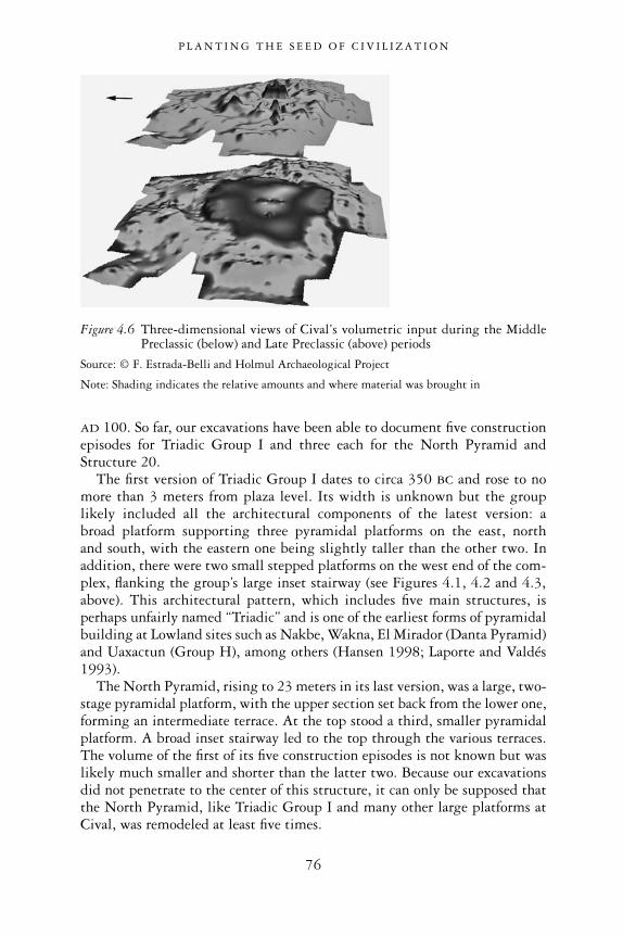
AD 100. So far, our excavations have been able to document five constructionepisodes for Triadic Group I and three each for the North Pyramid andStructure 20.
The first version of Triadic Group I dates to circa 350 BC and rose to nomore than 3 meters from plaza level. Its width is unknown but the grouplikely included all the architectural components of the latest version: a broad platform supporting three pyramidal platforms on the east, north and south, with the eastern one being slightly taller than the other two. Inaddition, there were two small stepped platforms on the west end of the com-plex, flanking the group’s large inset stairway (see Figures 4.1, 4.2 and 4.3,above). This architectural pattern, which includes five main structures, isperhaps unfairly named “Triadic” and is one of the earliest forms of pyramidalbuilding at Lowland sites such as Nakbe, Wakna, El Mirador (Danta Pyramid)and Uaxactun (Group H), among others (Hansen 1998; Laporte and Valdés1993).
The North Pyramid, rising to 23 meters in its last version, was a large, two-stage pyramidal platform, with the upper section set back from the lower one,forming an intermediate terrace. At the top stood a third, smaller pyramidalplatform. A broad inset stairway led to the top through the various terraces.The volume of the first of its five construction episodes is not known but waslikely much smaller and shorter than the latter two. Because our excavationsdid not penetrate to the center of this structure, it can only be supposed thatthe North Pyramid, like Triadic Group I and many other large platforms atCival, was remodeled at least five times.
P L A N T I N G T H E S E E D O F C I V I L I Z A T I O N
76
Figure 4.6 Three-dimensional views of Cival’s volumetric input during the MiddlePreclassic (below) and Late Preclassic (above) periods
Source: © F. Estrada-Belli and Holmul Archaeological Project
Note: Shading indicates the relative amounts and where material was brought in

In sum, the currently visible mass of Late Preclassic architecture is thecumulative result of several construction episodes between 350 BC and AD
100. The calculated combined volume of all Late Preclassic buildings andplatforms on the Cival main hill, not including the first Middle Preclassicversion of the E-Group, is 555,721.3 cubic meters. Therefore, the volume ofthe single Middle Preclassic construction phase is 2.45 times greater than thecombined volume of all subsequent architectural projects.
In terms of construction volume per labor investment, the frequent remod-eling of pyramids and platforms during the Late Preclassic period meant thatthe investments in each episode were much more modest. The volume ofconstruction per 50-year period was 61,726 cubic meters or a mere 1234 cubicmeters per year. The population of Cival responsible for the public works ofthe Middle and Late Preclassic periods can be estimated from the availablemaps of over 200 residential groups (patio hilltop groups) located in thesurrounding area. A preliminary population estimate for the Late Preclassicranges between 2000 and 5000 people. A maximum figure of 10,000 peopleis not out of the question for the greater supporting area of Cival in a 3-kilometer radius. In our mapping and excavation sample about one-fifth of allresidential groups revealed Middle Preclassic occupation. These simple figuresemphasize even further the extraordinary investment in material and labor ofthe initial, smaller Cival community when they established a ceremonialcenter.
The longevity of the first plaza layout and E-Group is also remarkable. Anestimated 400-year period saw only one remodeling of the E-Group platformsand plaza floor. Thus, all the above elements may reflect fundamental differ-ences in kind and scale between the first and all subsequent constructionprojects at Cival. The difference in scale is obvious. The difference in kind hasto do with the fact that the foundation of the hilltop complex representedsomething new and grandiose, certainly oversized for the modest Cival com-munity. We must surmise that it served as a gathering place during religiousfunctions for a much greater community of residents from beyond the 2-kilometer radius of the Cival settlement we have mapped. The nearest largeMiddle Preclassic center, Yaxha, lay 30 kilometers to the south; Tikal is 35kilometers to the west. Emerging centers such as Cival, Yaxha and Tikal layat the center of communities of widely dispersed hamlets and villages withina half-day walk. The first construction project marked a threshold moment inthe creation of these broad communities: the foundation of regional politieswithin bounded landscapes which, once established, were constantly recreatedthrough ritual practices.
In sum, perhaps the most important juncture in the long-term history ofthe Lowland Maya occurred when several villages convened to modify theCival hilltop and created a large plaza for ritual performances. I see this typeof major construction project, with associated architecture and offerings, as laying the foundations for a new form of community with local ties and
P L A N T I N G T H E S E E D O F C I V I L I Z A T I O N
77
identity. At the same time, the earliest monumental architecture, with astro-nomical orientation and cosmological symbolism evoking cosmic forces,appeared in similar forms across the Maya Lowlands. These similarities in formand ritual (and in an increased similarity in ceramics across the Lowlands) sug-gest a new narrative—perhaps introduced by emerging elites—and a strongerinterconnectedness across regional boundaries.
The earliest plaza rituals: activating the Maya cosmos
The position of the rising sun behind buildings on E-Group plazas had longbeen noted and was often cited to describe E-Groups as astronomical obser-vatories (Blom 1924; Ruppert 1940). Several scholars have been skeptical oftheir functionality as time-reckoning devices, due to the fact that too muchvariability exists around the “canonical” equinoctial alignment.
As noted earlier, E-Group types of building arrangement have greatantiquity in the Lowlands and were used and expanded upon for more than amillennium. A great deal of variation in basic features is therefore not sur-prising. The size and axial alignments of E-Groups can be highly variable fromsite to site as well as over time. A survey of the alignments of a large sampleof E-Groups from the southern Lowlands by Aveni et al. (2003) has shown thatin the majority of cases the sightlines through buildings do not target theequinoctial or solstitial sunrise but other, intermediate points on the horizon.This study showed that in spite of the variability of orientations, E-Groups as a class were used to target points on the horizon separated by regular dayintervals. The intervals between sightline targets were shown to correspondwith specific day intervals in multiples of 20 preceding and following thepassage of the sun through the zenith. Also, at Uaxactun, devices were incisedon the floors of the Early Classic A-V elite group. These are known as “peckedcrosses” and mark the divisions of the year based on the passage of the sunthrough the zenith in relation to the equinox (inner circle) and the fourintervals between the equinoxes and the solstices (outer circles). While in the sample of Lowland E-Groups analyzed in this study the equinoctial andsolstitial target points were generally found not to be the norm, the targetedpositions did mark specific 20-day intervals (or multiples of) in relation to thesun’s passage to the zenith, thus underscoring the paramount importance ofthis solar phenomenon in providing meaningful time-markers in the calendar(as expressed in pecked crosses) and public rituals (as indicated by E-Groupplaza offerings).
The first passage of the sun at its zenith in the southern Lowlands roughlycorresponds with the advent of the rainy season, near May 10. The secondpassage of the sun at its zenith occurs near August 2, corresponding to thearrival of the second wave of monsoons in the Maya Lowlands. A short (10-day) period of diminished rain precedes the second part of the rainy season,known today in Guatemala as “canicula” (after the constellation Canis), which
P L A N T I N G T H E S E E D O F C I V I L I Z A T I O N
78
tends to occur in late July/early August. In ancient times, as in the present,Maya farmers plant their first maize plot in April in preparation for the arrivalof the rains in May, and plant the second crop in July taking advantage of thecanicula.
Both the pecked crosses and the E-Group plaza layout underscore theimportance of tracking the sun’s movement in relation to its zenith for the Lowland Maya, with the aim of correctly scheduling the rituals associatedwith the agricultural and solar cycles. Through the use of these devices, theLowland Maya were able to maintain the congruence of the ritual tzolkincalendar and haab solar calendars with the pace of the seasonal and agriculturalcycles (Girard 1966). Thus E-Group plazas with their buildings aligned to thecardinal position and also their mainly east–west alignments underscored the quadripartite construct of the calendar and served as the environment for rituals related to it. Unsurprisingly, once the alignment of an E-Group was established at a site, this positioning was carefully followed by mostsubsequent site planning episodes, reinforcing the E-Group’s importance inreflecting the Maya’s most fundamental cosmological vision.
Evidence of public rituals of great antiquity is often found in E-Groups. Theearliest evidence occurs in the form of caches or ritual deposits placed in cists,stone boxes or lip-to-lip vessel pairs, dating to the Middle Preclassic. Theofferings are often placed along the major east–west axis in connection withthe stairway of the eastern platform. In the later phases of the Late Preclassicand Early Classic periods, burials are placed along this axis or at the summitof the eastern platforms, in the place usually occupied by offertory deposits.Such burials can be interpreted as dedicatory in themselves (Chase and Chase1999). Good examples of this practice are child burials and mass graves. Stelaewere dedicated in the plaza area in front of the eastern platform in the LatePreclassic and Early Classic periods at Uaxactun, Tikal, Nakbe Wakna andCival, for example. In many cases the stelae found in E-Groups are among theearliest to be found in all of the Lowlands. Stela 1 at Nakbe and Stela 2 atCival, for example, date to the Late Preclassic period. Although these were notfound in situ, they were likely erected on the E-Group main axis. The patternof stela dedication in E-Groups continued through the early part of the EarlyClassic period. At Tikal, Stela 29, carved in AD 292, is believed to have beenplaced originally in the Mundo Perdido E-Group complex in front of theeastern platform and later thrown into a nearby ravine (Laporte and Fialko1990); Stela 39 (AD 376) was found broken and buried in the upper room ofthe eastern temple of the Mundo Perdido complex (5D-86-5th). At Uaxactun,Stela 9, the site’s earliest, is believed to have been originally erected in GroupE before being moved later (Valdés et al. 1999). The earliest ritual offeringsthat so consistently occur in the E-Groups’ axial location, beginning in theMiddle Preclassic, were perhaps dedicated to building renovations and inmany cases were specifically connected with calendar event rituals (e.g. CivalCache 4; see below). This pattern continued in the Early Classic period, as this
P L A N T I N G T H E S E E D O F C I V I L I Z A T I O N
79

location was the primary ritual space for calendar rituals such as the commem-oration of katun cycle completions (katuns 8.14 through 8.17) marked bymonuments and Long Count inscriptions dedicated by royal individuals(Coggins 1980).
In sum, there was a progression of ritual behavior in E-Group plazas fromcache offerings to carved monuments through the Preclassic and Early Classicphases.
This phenomenon is perhaps best illustrated by recent finds at Cival. Severalmajor features deposited in the plaza floors in front of the E-Group’s easternstructure (Structure 7) mark major stages in the history of this sacred space.The first evidence of ritual activity dates to the Middle Preclassic, between 700and 600 BC4 and comes in the form of five water jars, five upright celts, and114 jade pebbles placed in a three-level cruciform cut in the soft limestonebedrock. The second event, also in the Middle Preclassic, was the burial of alarge, defaced stela across the center line of the eastern platform. Subsequently,at the beginning of the Late Preclassic period, a low rectangular platform wasbuilt on this axial space in front of the eastern platform’s stairway. Thisplatform was used to elevate Stela 2. Later, in connection with an enlargement,
P L A N T I N G T H E S E E D O F C I V I L I Z A T I O N
80
Figure 4.7 View of Cache 4 at Cival with jars deposited in k’an-cross-shaped pit on theeast–west axis of the E-Group
Source: © F. Estrada-BelliNote: Inserts show the pit’s peculiar profile and arrangement of jades in the lowest cavity

four large timber posts were placed in cardinal arrangement around Stela 2. Inthe final stage, the monuments were toppled and some were smashed, with thefragments buried in this platform. Low platforms in front of E-Group plazas’eastern structures have been documented at Tikal and Uaxactun. The platformin the Mundo Perdido at Tikal was also associated with a mass burial (Laporteand Fialko 1990). These and other signs of violent events and drastic changesacross the Lowlands are perhaps symptomatic of the tumult at the end of thePreclassic period.
P L A N T I N G T H E S E E D O F C I V I L I Z A T I O N
81
Figure 4.8 Rendering of Cache 4 at Cival (circa 800 BC)
Source: © F. Estrada-Belli
Figure 4.9 Rendering of Cival’s E-Group Plaza, Structure 7, Stela 2 and wooden posts(300–200 BC)
Source: Drawing by Joel Zovar; © Holmul Archaeological Project

The symbolism of the offerings in the Cival E-Group plaza is fascinatingtestimony to the development of the Preclassic Maya’s complex ideology.Cache 1 was placed in a cruciform pit. The space inside the pit was furthersubdivided in three levels. The first level was a shelf on the outer arms of the cross dropping 40 centimeters from the original bedrock surface. Threeblack jars and a red one (in the south) were laid on these shelves. The secondlevel was a squared pit in the center of the cross-shaped opening in which afifth (black) jar was placed. Next to this central jar four 25-centimeter-longcelts were placed upright in correspondence with each of the cross’s arms.Underneath the jar were an additional 30 green-blue jade pebbles and 84green jade pebbles. Finally, a round hole in the center of the squared pit formedthe third level of the cruciform pit. Here was a magnificent green-blue jadecelt, the finest of the assemblage. After these objects were deposited, the jarswere smashed and the pit filled with gray marl up to the level of the originalbedrock surface. Finally, a round post was erected in the center of the filled pit.
The carefully oriented pit and its contents of various materials and shapespresent an intriguing cosmological message and are clearly the result of asumptuous ritual which involved the arranging and burying of these objectsin the earth. The jars most likely contained water but other fluids—such asbalche (mead) and chicha (a maize-based brew)—were sometimes used in Mayarituals. According to Taube (2000), Olmec jade celts represent sprouting cornplants. Celts or axes are also related to the rain god. The Maya lightning godK’awiil is represented as a personified axe, or with an axe sprouting from hisforehead. Aztec codices depict rituals dedicated to the birth of maize in whichfive Tlaloc rain gods holding axes pour water on axe-like maize sprouts. Theposition of axes in a quincunx represents the cosmological order and the axismundi often personified by Mesoamerican rulers (Reilly 1991). Therefore, thevessels and the jade celts placed in a symbolic primordial sea suggest a ritualdedicated to cosmological order, water as a life-giving substance for maize, theessence of human sustenance and the axis mundi.
This Maya construct has close parallels in Olmec rituals. According toCoggins’ (in press) interpretation of the Olmec statuette from Las Limas, thefour celtiform heads incised on its shoulders and knees possibly represent celtsand as such have calendrical significance by framing the central newborn baby-jaguar/maize god in a quincunx. As the centerpiece of this symbolic construct,the newborn represents the embodiment of the maize life cycle. Again, themaize cycle and the Mesoamerican calendar are closely related in religioussymbolism. In the Postclassic period, the Yucatec Maya celebrated the newyear as the birth of the winal, the basic 20-day unit of the Mesoamericancalendar. In Classic times the seating of a new Maya ruler was celebrated as thebirth of the new winal-based year and the rebirth of the maize god, all in one(Coggins in press).
In sum, Cival’s cruciform cache and the quadripartite sun-oriented space ofthe E-Group in which it is located relate not only to the quadripartite division
P L A N T I N G T H E S E E D O F C I V I L I Z A T I O N
82
of the Maya universe but to the fundamental construct of the Mesoamericancalendar and the agricultural cycle of maize.
The final act of the Cival Cache 4 ritual was to place a wooden post abovethe jade cache. Wooden posts, world trees and maize plants are often equatedin Olmec and Maya iconography (Taube 2003). Classic Maya rulers and theirOlmec precursors often portrayed themselves as world trees, as in the famousstatuette from Rio Pesquero and Pacal’s sarcophagous lid (Reilly 1991), or as a centerpiece of a quincunx in ritual landscapes, such as the La Milpacosmogram, of which the ceremonial core and the royal throne are the center(Tourtellot et al. 2003; Estrada-Belli 2003a).
The time–space cosmological vision of the Preclassic Maya was rooted inagrarian ways of life that their earliest rulers appropriated to form an ideologyof central authority based on the primacy of the maize god as the axis mundiand the giver of sustenance to the people. Early in this process, Preclassic Mayarulers began to portray themselves as the axis mundi of the Maya cosmos.
P L A N T I N G T H E S E E D O F C I V I L I Z A T I O N
83

5
EARTH–MOUNTAIN–CAVESAND SKY–SERPENT–BIRDS
Meta-narratives of Preclassic Maya art
Cival’s Preclassic Stela 2 was found a few centimeters away from the MiddlePreclassic Cache 4 jade offering along the east–west axis of the plaza. In style,it predates the earliest monuments from Nakbe and El Mirador (Estrada-Belli2003a). Although found on the surface, its oval-shaped setting pit was iden-tified during excavation. It originally stood on a small rectangular platform infront of the stairway of Structure 7, the E-Group’s eastern platform (see Figure4.9, above; Estrada-Belli et al. 2003a; Bauer 2005). A vessel found in anoffertory cache placed under the oval-shaped pit suggests a probable date forit of 300–200 BC. It is carved in simple low-relief outlines. The figure wearsa jade bird-head pectoral with three plaques. This avian motif is often wornby rulers as a pectoral or a headdress on Preclassic/Protoclassic monuments atKaminaljuyú, Abaj Takalik, in the Maya Highlands, on the Pacific Coast, andon the Gulf Coast of Mexico (e.g. La Mojarra, Stela 1; Parsons 1986; WinfieldCapitaine 1992). This image has many parallels with scenes of the maize godwearing the feather costume of the Principal Bird Deity (PBD; Bardawil 1976)and performing a dance described by Taube (2009). These images are common,for example, on Holmul dancer-style vessels produced in this same area duringthe Late Classic. In them, a maize god impersonator wears a feather backrack.In a famous Early Classic vessel from Kaminaljuyú an individual wears a fullavian costume and is captured in a spinning motion. The meaning of thisdance may have to do with the superior importance of the PBD among allMaya supernaturals (see below) and the taking of his headdress and otheraccouterments by the maize god in Classic and Postclassic Maya mythology.The Late Preclassic mural of the West Wall of the Pinturas Sub1A structureat San Bartolo may depict an early version of this myth that culminates withthe crowning of the maize god with the foliated headdress of the PBD. Thisscene in turn serves as mythological precedent for the accession ceremony of amortal ruler vested with the avian crown by the maize god himself wearing anavian cape and headdress as well (Taube 2009). Traditionally, scenes in whichthe maize god faces the PBD are most readily compared to the mythologicalepisode of the triumph of the maize god over the avian impostor Vukub Qakix
84

“Seven Macaw” of the Popol Vuh creation story (Tedlock 1996). However, theactions and identities of the characters in Classic and especially Preclassic artmay refer to mythologies not preserved or only partially preserved in the PopolVuh and thus unknown to us (see, for example, interpretations of the PBDalternative to Vukub Qakix in Bassie-Sweet 2008). Regardless of the exactmythological reference, the Cival stela could be the oldest representation ofthe ritual dance performance that was so important to Maya royal ceremony.Finally, it is also worth noting that this stela’s tapered shape recalls upturnedjade celts such as those in the cruciform cache, a feature noted in early stelamonuments in the Gulf Coast as well, suggesting once again a ruler/maizegod/world tree identification in the person of the ruler (Taube 2000). In sum,at the time of the Cival Stela 2 dedication, circa 300–200 BC, the ideologicalcharter of Maya kings was fully in place.
The first monumental sculpture and the first portraits of rulers appear at theonset of the Late Preclassic period in the Maya Lowlands. At Cival the dedi-cation of Stela 2 in the 3rd century BC coincides with the construction of thesite’s Triadic Group (Group 1) platform.
Large platforms supporting Triadic Group temples were built across theLowlands at this time and throughout the Late Preclassic period. These three-pyramid complexes often stood to the east of E-Groups and followed the same
M O U N T A I N – C A V E S A N D S E R P E N T – B I R D S
85
Figure 5.1 Cival Stela 2
Source: Drawing by N. Grube; courtesy ofNikolai Grube
Figure 5.2 La Mojarra Stela 1
Source: Drawing by G. Stuart; courtesy ofGeorge Stuart

east–west alignment. The main structure typically faces west. Examples of thisdistinctive arrangement of pyramids on a site’s east side are found at Nakbe(Eastern Group), El Mirador (Danta Group) and Yaxha (Northeast Acropolis).At many sites, however, Triadic Groups also exist independently of E-Groupcomplexes and can face in any direction. Few of these complexes have beenexcavated, so there is a limited amount of evidence to give clues to theirfunction. It appears that the three upper buildings, often supported by steeppyramidal platforms, served a ritual rather than an elite residential function.All three temples, or sometimes just the major (eastern) one, were decoratedwith monumental sculpture. The decoration typically includes a low-relieffrieze on the upper half of the temple building, painted designs on the outerwalls, and large deity masks adorning the platform’s terraces alongside thecentral stairway. These monumental sculptures are rarely completely pre-served, and even in those fortunate cases where they are, their complexityrenders their interpretation difficult without the aid of direct written sources(but see below for a discussion of their iconography).
In the southern Lowlands, some of the best-known examples of Preclassicmonumental sculpture are found at El Mirador, Nakbe, Calakmul, Tikal,Uaxactun, San Bartolo, Cerros and Cival. Several studies have attempted inter-pretations of the rich imagery of masks and friezes, proposing that these arethe personified or zoomorphic versions of places of creation, such as the sacredmountain, or celestial bodies and deities identified with them, such as the sunor Venus and the hero twin sons of the maize god. But the stories of Maya cre-ation that have come down to us are of much later date and any interpretationis bound to be revised when more adequate data become available. The so-called masks are usually large-scale, often gigantic representations ofanthropomorphic or zoomorphic beings. The best-known examples feature thePrincipal Bird Deity (Nakbe Structure 1; Bardawil 1976; Hansen 1992), anavian/reptilian creature characterized by a long snout or down-curving beak,and various versions of a personified mountain (witz, “flower mountain” or
M O U N T A I N – C A V E S A N D S E R P E N T – B I R D S
86
Figure 5.3 Avian dance on Kaminaljuyú vessel
Source: After Kidder, Jennings and Shook 1946; courtesy of the Pennsylvania State UniversityPress

“cleft mountain”; e.g. at Uaxactun and Tikal; see Taube 2004). Both types ofbeing represent important places and actors of the first creation. Also repre-sented are other deities that are more difficult to identify, usually described assun gods or the sun god of the underworld. These masks often have some felinetraits. Some long-nosed masks combine avian and feline traits and have beenvariously attributed to Venus or other celestial bodies (e.g. the Cerros masks;Schele 1998). Some more anthropomorphic masks may be identifiable withthe maize god because of their more human appearance (Calakmul Structure2; Carrasco and Colon 2005). In summary the themes expressed by thesemonumental sculptures seem to recall the places and actors of creation and thebirth of the maize god, as told in the Classic period inscriptions and in theColonial period Popol Vuh book of the Maya-Kiche’ (Freidel et al. 2002). Inspecific cases, the meaning of the masks has been related to rituals performedin the temple with which they are associated (Reese-Taylor 2002). Theseinterpretations stimulate more in-depth analysis of the function of Preclassictemples as foci of rituals related to the ideology of kingship, and thereforeserving political as well as religious purposes.
The Nakbe Structure 1 masks of a long-nosed creature identified as thePrincipal Bird Deity by Richard Hansen (1992) are the largest stone-and-stucco examples of Preclassic monumental art, measuring 11 meters in widthand 5 meters in height. Here, the PBD combines avian and serpent traits.1 Itis sometimes identified as a scarlet macaw, and thus equated with the “false”sun god of the Popol Vuh creation story, Vukub Qakix (Tedlock 1996). In LatePreclassic Lowland Maya art, it has a massive beak, squarish or L-shaped eyes,
M O U N T A I N – C A V E S A N D S E R P E N T – B I R D S
87
Figure 5.4 PBD mask on Nakbe Structure 1
Source: Drawing by T. Routledge; courtesy of Richard Hansen
flamed eyebrows, J-shaped fangs, and large ear flares decorated with circles in each corner. Its full-bodied forms can include widely spread wings thatterminate in serpent heads, as in Nakbe Structure 1 bird masks, for example(Hansen 1992). The wings are sometimes subsumed into a rectilinear set ofsymbols known as the “skyband.” The band stretches on either side of thePBD’s head and terminates in serpents’ heads at its ends. The wings may carrycartouches containing the k’in glyph (for sun) on one side and the akbal sign(for darkness) on the other. These signs may convey the dual essence of thisentity as the daytime and nighttime sky. The akbal sign—often worn by thisdeity (as God D, see below) as a flowery jewel—may be associated with divina-tion (Taube 1992a) or “dark waters” of creation (Bassie-Sweet 2008). Suchtraits strongly suggest that this creature is a celestial deity or the personifica-tion of the various aspects of the creator god of the sky, and a cognate to anumber of separate Mesoamerican deities, such as the feathered serpent deityand the wind god. Among other attributes often associated with its full-figured form are a jade necklace and a yax shell jewel. Twisted ropes are oftenheld in the mouth. In some cases, these twisted ropes are represented as twointertwined serpents, a motif which is believed to be related to rain-makingrituals (Guernsey Kappelman and Reilly 2001); and in the context of the PBD,twisted ropes may relate to the source of rain.
On Altar 10 at Kaminaljuyú, the Late Preclassic Highland Maya carved acartouche containing a sign that some refer to as God C on the belly of thePBD. As a glyph, this sign is read as ku, the generic word for “god.” It is alsofound in a quatrefoil-shaped cartouche on world trees, and is clearly shown onthe bodies of rulers impersonating world trees and wearing the PBD headdress,as on Kaminaljuyú Stela 11 (where a tree sprouts from a shell on the head-dress). In Preclassic and Classic Maya art the PBD is often perched atop worldtrees, suggesting that these may be different aspects of the same entity. InPacific Coast Maya art, the PBD is represented either in full figure at the top of the composition to represent the sky or in zoomorphic form as a headwith a skyband in lieu of wings terminating in serpents’ heads (Takalik AbajAltar 12; Hansen 1992). In Late Preclassic Izapan art, the PBD is stylized andreplaced by its basic identifying attributes—the outflaring J-fangs, U eyelidand flamed eyebrow—and is known as the Izapan skyband (e.g. Izapa Stela 12).In the Classic period the PBD is also associated with the old god (God N), GodD (Taube 1992a; Guernsey 2006) and Itzamnaaj, who, among the Colonialperiod Yucatec Maya, was the high god. In Classic period art he is sometimesdepicted on a throne as an aged king. He wears an oversize necklace and theyax diadem (Taube 1992a; Martin 2006; Thompson 1970). In other instances,the aged god wears a net headdress and an akbal flower and is associated withscribes, the art of divination and pool water (dew). Based on the overlappingassociations between God D, God N and the PBD and the Maya bird–serpent,Karen Bassie-Sweet (2008) has argued that these may actually be differentmanifestations of the same deity. This would be equivalent to the creator god
M O U N T A I N – C A V E S A N D S E R P E N T – B I R D S
88

identified as “First Father” in the Popol Vuh, and to the present-day TzutuhilMaya god Mam, the old god of the mountains, rain and childbirth (see alsoThompson 1950, 1970; Carlsen and Prechtel 1991).2 In addition to the qual-ities listed above, this creator deity is associated with mountains and rain, theessence of divinity. As such, in its primordial form, it possibly also correspondswith the first among the Maya creators Kukumatz and Tepeu (Quetzal Serpentand Sovereign; Tedlock 1996) to appear at the moment of creation in the firstpages of the Popol Vuh myth, as well as with the personification of kingship.The various associations of the old god and the PBD underscore the multi-faceted nature of Maya deities that have often been misinterpreted as separategods by western scholars.
The Nakbe Structure 1 avian mask closely follows the pattern of LatePreclassic PBD imagery. Above its main avian head component is a massivefrieze consisting of J-fangs, straight teeth and diagonal brackets representingthe skyband, as noted earlier. In addition, at each end of this frieze are twomassive ear flares. Below them are the eroded profile heads of two serpentsemerging from the skyband. In essence, the Nakbe mask repeats the motif ofavian–serpent creature in flight posture with fully spread wings arching abovethe bird’s head and forming the arch of the sky, and represented by a double-headed serpent in a fashion that is similar to Late Preclassic Takalik Abaj Altar12 (Graham et al. 1978) and Classic period building façades such as Palenque’sHouse E (Maudslay 1889–1902: Plate 43).
M O U N T A I N – C A V E S A N D S E R P E N T – B I R D S
89
Figure 5.5 KaminaljuyúAltars 9 (above) and 10
Source: After Parsons 1986;courtesy of the DumbartonOaks Research Library andCollections, Washington, D.C.

The avian–serpent attributes of the PBD are the badge of royal power inClassic period iconography. In Late Preclassic monumental art, they are com-bined with the maize god as the personification of kingship. This is seen inPreclassic headdresses and costumes combining avian features with maize god attributes, such as in a Kaminaljuyú stucco vessel (Kidder et al. 1946; see Figure 5.3, above) and in the costume of the Holmul dancer as painted onLate Classic polychrome vases (Merwin and Vaillant 1932). On Cival Stela 2,the ruler, now unfortunately headless, wears a long-nosed avian pectoral. AtCerros, four masks adorned the terraces alongside the stairway of south-facingStructure 5C-2nd. Schele and Freidel (1990) have interpreted the lower masksas the jaguarian sun god Yax Balam while the upper long-nosed avian masksare believed to be two aspects of the PBD, as the celestial bird Itzamnaaj andas the water fowl of the underworld (see Freidel et al. 2002 for alternativeinterpretations of the Cerros masks).
M O U N T A I N – C A V E S A N D S E R P E N T – B I R D S
90
Figure 5.6 Kaminaljuyú Stela 11
Source: After Parsons 1986;courtesy of Dumbarton OaksResearch Library and Collections
Figure 5.7 Izapa Stela 12
Source: After Norman 1973; courtesy of the NewWorld Archaeological Foundation

At Uaxactun, masks adorned every building on the Late Preclassic TriadicGroup H. Many of these masks are difficult to identify, but they fall in thebroad categories of deities and places of creation outlined above. One set ofthese masks on Structure H Sub-3 is especially well preserved. At Uaxactun,as at Cerros, two masks are stacked on terraces alongside the frontal stairwayleading to a temple. The lower mask appears to be an anthropomorphic crea-ture with reptilian flamed eyebrows. Flower sprouts emerge from the sides ofits head. Wavy scrolls emerge from the sides of its open maw while either fishor turtle heads3 float within them. A third fish or turtle head is inside thecreature’s open mouth. The flower sprouts and the fish motifs identify thismask as “flower mountain”—the place of creation emerging from the primor-dial sea (Taube 2004). The turtle heads are references to both the old god aswitz (“mountain”) and the earth, which is often represented as a turtle’s cara-pace.4 On the upper terrace and also conceptually at a higher level is another
M O U N T A I N – C A V E S A N D S E R P E N T – B I R D S
91
Figure 5.8 Easternmasks on the terraces of Structure 5C-2nd atCerros (circa 50 BC)
Source: Courtesy of DavidFreidel

mask with its mouth open. A serpent emerges from each side of the mask.Inside the mouth is a small deity’s head with L-shaped eyes and a mirror overthe mouth.5 The mask in which it is contained could be the celestial versionof the flower mountain or another cosmic entity associated with the sky, such as the PBD. These masks adorned the easternmost and dominant templein the triadic Group H at Uaxactun. The meaning expressed by this art isstrongly related to the creation story and creator deities as both zoomorphs andmountain locations.
One example of monumental sculpture from Holmul is among the earliestand more striking variants of the pyramid-as-sacred-mountain theme inPreclassic Maya iconography.
Two large witz masks decorate the earliest version of one of the longestoccupied buildings at Holmul, Building B, dating to 400 BC, and remodeledfive subsequent times in the following 800 years. Building B’s first phase wasa beautiful six-room temple edifice standing atop a 6-meter-tall, three-terracepyramid. Its front measured 13 meters at the summit and stood one step lowerthan the rear half of the building. This rising of rear rooms one step above the
M O U N T A I N – C A V E S A N D S E R P E N T – B I R D S
92
Figure 5.9 Masks on the terraces of Structure Sub 3 in Group H at Uaxactun (LatePreclassic)
Source: Drawing by Linda Schele; courtesy of David Schele
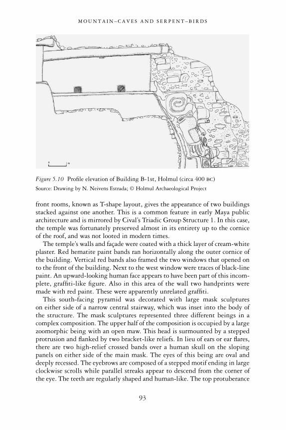
front rooms, known as T-shape layout, gives the appearance of two buildingsstacked against one another. This is a common feature in early Maya publicarchitecture and is mirrored by Cival’s Triadic Group Structure 1. In this case,the temple was fortunately preserved almost in its entirety up to the corniceof the roof, and was not looted in modern times.
The temple’s walls and façade were coated with a thick layer of cream-whiteplaster. Red hematite paint bands ran horizontally along the outer cornice ofthe building. Vertical red bands also framed the two windows that opened onto the front of the building. Next to the west window were traces of black-linepaint. An upward-looking human face appears to have been part of this incom-plete, graffiti-like figure. Also in this area of the wall two handprints weremade with red paint. These were apparently unrelated graffiti.
This south-facing pyramid was decorated with large mask sculptures on either side of a narrow central stairway, which was inset into the body ofthe structure. The mask sculptures represented three different beings in acomplex composition. The upper half of the composition is occupied by a largezoomorphic being with an open maw. This head is surmounted by a steppedprotrusion and flanked by two bracket-like reliefs. In lieu of ears or ear flares,there are two high-relief crossed bands over a human skull on the slopingpanels on either side of the main mask. The eyes of this being are oval anddeeply recessed. The eyebrows are composed of a stepped motif ending in largeclockwise scrolls while parallel streaks appear to descend from the corner ofthe eye. The teeth are regularly shaped and human-like. The top protuberance
M O U N T A I N – C A V E S A N D S E R P E N T – B I R D S
93
Figure 5.10 Profile elevation of Building B-1st, Holmul (circa 400 BC)
Source: Drawing by N. Neivens Estrada; © Holmul Archaeological Project

M O U N T A I N – C A V E S A N D S E R P E N T – B I R D S
94
Figure 5.11 Façade of Holmul Building B-1st
Source: Drawing by N. Neivens Estrada; © Holmul Archaeological Project
Figure 5.12 Masks and temple room, Building B-1st, Holmul (circa 350 BC)
Source: © F. Estrada-Belli

and the side bracket motifs help identify this carved head as a witz (mountain),in many ways similar to those from Uaxactun H Sub-3, described earlier.
From the open mouth of the witz monster emerges a human head, also withhis mouth wide open. Deep lines are incised on either side of the mouth as ifto represent age lines. Inside this man’s mouth is a low-relief symbol made ofa down-turned “Y” sign and two diagonally placed dots. This sign appears tobe unique to this composition and remains undeciphered, although it mayrepresent a mirror, as the Uaxactun Sub-3 upper mask does. His hands graspthe edge of the orifice as if he were literally pulling himself out of an openingon the head of the third entity in this composition. This is a pointy-nosedzoomorph with almond-shaped eyes and no lower jaw. Contrary to the witzmonster, deeply carved scrolls are below the corners of the eyes while straightcarved lines stretch upward from them, resembling the familiar flamed-eyebrow motif. No teeth are visible in the upper part of its mouth, nor is thelower part of the mouth represented.
Like the Uaxactun H Sub-3 masks, the Holmul sculpture appears to rep-resent a sacred mountain. This, however, does not appear to be the flowermountain of creation, but a mountain associated with the dead (as symbolizedby skulls), from which an old man emerges. The crossed-bands motif is often
M O U N T A I N – C A V E S A N D S E R P E N T – B I R D S
95
Figure 5.13 View of zoomorphichead in profile (from west) and human skull (lower left),Building B-1st, Holmul (circa 400 BC)
Source: © F. Estrada-Belli
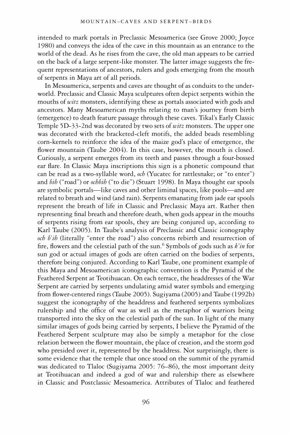
intended to mark portals in Preclassic Mesoamerica (see Grove 2000; Joyce1980) and conveys the idea of the cave in this mountain as an entrance to theworld of the dead. As he rises from the cave, the old man appears to be carriedon the back of a large serpent-like monster. The latter image suggests the fre-quent representations of ancestors, rulers and gods emerging from the mouthof serpents in Maya art of all periods.
In Mesoamerica, serpents and caves are thought of as conduits to the under-world. Preclassic and Classic Maya sculptures often depict serpents within themouths of witz monsters, identifying these as portals associated with gods andancestors. Many Mesoamerican myths relating to man’s journey from birth(emergence) to death feature passage through these caves. Tikal’s Early ClassicTemple 5D-33-2nd was decorated by two sets of witz monsters. The upper onewas decorated with the bracketed-cleft motifs, the added beads resemblingcorn-kernels to reinforce the idea of the maize god’s place of emergence, theflower mountain (Taube 2004). In this case, however, the mouth is closed.Curiously, a serpent emerges from its teeth and passes through a four-bossedear flare. In Classic Maya inscriptions this sign is a phonetic compound thatcan be read as a two-syllable word, och (Yucatec for rattlesnake; or “to enter”)and bih (“road”) or ochbih (“to die”) (Stuart 1998). In Maya thought ear spoolsare symbolic portals—like caves and other liminal spaces, like pools—and arerelated to breath and wind (and rain). Serpents emanating from jade ear spoolsrepresent the breath of life in Classic and Preclassic Maya art. Rather thenrepresenting final breath and therefore death, when gods appear in the mouthsof serpents rising from ear spools, they are being conjured up, according toKarl Taube (2005). In Taube’s analysis of Preclassic and Classic iconographyoch b’ih (literally “enter the road”) also concerns rebirth and resurrection of fire, flowers and the celestial path of the sun.6 Symbols of gods such as k’in forsun god or actual images of gods are often carried on the bodies of serpents,therefore being conjured. According to Karl Taube, one prominent example ofthis Maya and Mesoamerican iconographic convention is the Pyramid of theFeathered Serpent at Teotihuacan. On each terrace, the headdresses of the WarSerpent are carried by serpents undulating amid water symbols and emergingfrom flower-centered rings (Taube 2005). Sugiyama (2005) and Taube (1992b)suggest the iconography of the headdress and feathered serpents symbolizesrulership and the office of war as well as the metaphor of warriors beingtransported into the sky on the celestial path of the sun. In light of the manysimilar images of gods being carried by serpents, I believe the Pyramid of theFeathered Serpent sculpture may also be simply a metaphor for the closerelation between the flower mountain, the place of creation, and the storm godwho presided over it, represented by the headdress. Not surprisingly, there issome evidence that the temple that once stood on the summit of the pyramidwas dedicated to Tlaloc (Sugiyama 2005: 76–86), the most important deity at Teotihuacan and indeed a god of war and rulership there as elsewhere in Classic and Postclassic Mesoamerica. Attributes of Tlaloc and feathered
M O U N T A I N – C A V E S A N D S E R P E N T – B I R D S
96
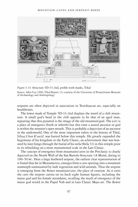
serpents are often depicted in association in Teotihuacan art, especially onheaddresses.
The lower mask of Temple 5D-33-2nd displays the motif of a cleft moun-tain. A small god’s head in the cleft appears to be that of an aged man,repeating that this pyramid is the image of the old mountain/god. The witz isa place of emergence (birth or rebirth) but this time a seated ancestor or godis within the monster’s open mouth. This is probably a depiction of an ancestorin the underworld. One of the most important rulers in the history of Tikal,Sihyaj Chan K’awiil, was buried below this temple. He greatly expanded thehegemony of his kingdom in the Early Classic, an achievement that was hon-ored by later kings through the burial of his stela (Stela 31) in this temple priorto its rebuilding on a more monumental scale in the Late Classic.
The concept of emergence from mountains/caves in the Preclassic is clearlydepicted on the North Wall of the San Bartolo Structure 1A Mural, dating to100–50 BC. Here a large feathered serpent, the earliest clear representation ofit found thus far in Mesoamerica, emerges from a cave opening into a mountainzoomorph surmounted by lush vegetation and wild animals. Thus the serpentis emerging from the flower mountain/cave, the place of creation. As it exitsthe cave the serpent carries on its back eight human figures, including themaize god and his female attendants, recalling the myth of emergence of themaize god retold in the Popol Vuh and in Late Classic Maya art. The flower
M O U N T A I N – C A V E S A N D S E R P E N T – B I R D S
97
Figure 5.14 Structure 5D-33-2nd, profile with masks, Tikal
Source: After Coe 1990, Tikal Report 14; courtesy of the University of Pennsylvania Museumof Archaeology and Anthropology

mountain is the place of birth and the origin of all things (Taube et al. 2004).In Classic and Postclassic Mesoamerica the feathered serpent is often depictedas transporting figures of warriors and merchants (see the Cacaxtla Portico Aand Red Temple murals, for example; Uriarte 1999). Through the breathemanating from its mouth, the feathered serpent conveys the idea of steam and rain-clouds emerging from mountains/caves.7 Streams meandering out ofmountains also mimic snakes and pathways into the underworld. The lattermetaphor has an epigraphic correspondence. Taube et al. (2004) equate the(smaller) serpent emerging from the San Bartolo Mural’s cave with the ClassicMaya inscriptions’ lok-yi glyph for “to emerge.” In Classic Maya texts, thisword is expressed by a serpent rising from a cleft sign (Houston 1993: Figure4-11). In the Madrid Codex the skeletal death god emerges from a serpentaccompanied by a textual caption that includes the lok-yi sign “to emerge”(Taube et al. 2004).
The old man emerging from the mountain on the Holmul masks couldrepresent the old god, God N, who differs from God D in having almond-shaped (as opposed to L-shaped) eyes. As was noted above, in Classic periodimagery the aged god is often associated with the sky and Itzamnaaj and thePrincipal Bird Deity (known to us as God D). Here, instead, is an aged god associated with mountains and the earth and thus the world of the dead (known to us as God N; Taube 1992a). When he appears with kawak(“stone” or “earth”) signs on his body, the aged god is identified with the fourdirectional pawatuns (or mountains that support the sky).8 The Classic Mayarepresented this old god supporting the sky as emerging from a mountain, ora monster with kawak (earth) symbols. One such representation is on thecorners of the entrance of Copan’s Temple 22. Similarly, in the SepolturasGroup at Copan, he is carved on the supports of a bench holding it as if it werethe sky. Here this deity literally holds up the skyband. As was mentionedearlier, this old god was referred to as Mam by several Colonial period andmodern Maya peoples. Among them, as well as among the Classic Maya, he
M O U N T A I N – C A V E S A N D S E R P E N T – B I R D S
98
Figure 5.15 San Bartolo North Wall mural: mountain/cave scene
Source: Courtesy of William Saturno
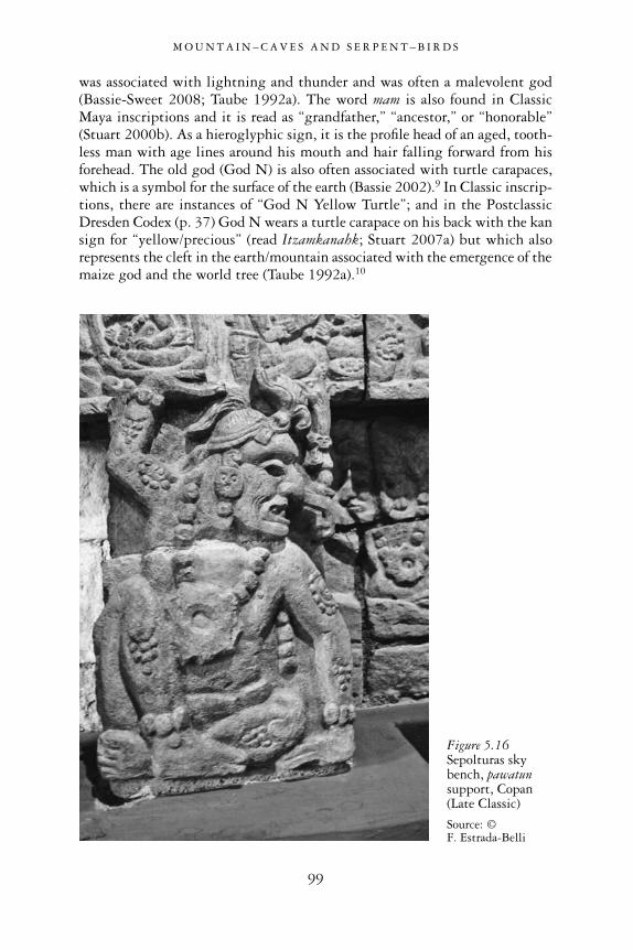
was associated with lightning and thunder and was often a malevolent god(Bassie-Sweet 2008; Taube 1992a). The word mam is also found in ClassicMaya inscriptions and it is read as “grandfather,” “ancestor,” or “honorable”(Stuart 2000b). As a hieroglyphic sign, it is the profile head of an aged, tooth-less man with age lines around his mouth and hair falling forward from hisforehead. The old god (God N) is also often associated with turtle carapaces,which is a symbol for the surface of the earth (Bassie 2002).9 In Classic inscrip-tions, there are instances of “God N Yellow Turtle”; and in the PostclassicDresden Codex (p. 37) God N wears a turtle carapace on his back with the kansign for “yellow/precious” (read Itzamkanahk; Stuart 2007a) but which alsorepresents the cleft in the earth/mountain associated with the emergence of themaize god and the world tree (Taube 1992a).10
M O U N T A I N – C A V E S A N D S E R P E N T – B I R D S
99
Figure 5.16Sepolturas skybench, pawatunsupport, Copan(Late Classic)
Source: © F. Estrada-Belli

Karen Bassie (2002; Bassie-Sweet 2008) and Allen Christenson (2000) havealso argued that God N is associated with the god of lightning, K’awiil, andthe “First Father” god, Xpyacoc. The association with lightning stems fromGod N emerging from the leg/serpent of K’awiil. In this aspect he appears tobe evoked during births and healings in Classic Maya art and among the mod-ern Maya as well (Stuart 2000b; Foster and Wren 1996). In Classic Maya textsthe glyph for Mam is sometimes substituted by a bird. As an old man, heappears in scenes depicting women giving birth emerging from the serpent/legof K’awiil (Stuart 2000b). In addition, in some contexts, elements of God Nappear as a mix of the Principal Bird Deity, feathered serpent with water-lilyflowers, and the God N net headdress. In Classic inscriptions the elements of the water-lily feathered serpent are combined to spell phonetically the nameYax Chit or “First Father” (who is the same creator/grandfather as the PopolVuh’s Xpyacoc): Water Bird Serpent. Thus the feathered serpent and the creator grandfather god were aspects of the same deity to the Classic Maya andmost probably to the Preclassic Maya as well. In other words, what westernscholars may have perceived as a collection of separate deities associated withdifferent parts of the Maya cosmos may have been understood by the Maya asa multifaceted supernatural entity that had manifestations in the three cosmicdomains of earth, sky and underworld.
Because of the various related aspects of the Maya old god, Holmul’sBuilding B imagery, displayed as a badge on the front of the structure, seemsto identify this pyramid with the old god/mountain of creation and the worldof the dead. It was also possibly a place in which to evoke ancestors. Enablingcommunication between the world of the living and the world of ancestors andsupernaturals was one of the prerogatives of the Maya ruler, as axis mundi,and it is possible that this temple materialized the link between dead rulers,the supernatural world and living rulers who identified with them in thepresent world. When rulers wore the iconographic elements of the old god—the PBD headdress, the large yax diadem, the water lily, the hair net and soon—they claimed his overarching powers as creator. We can imagine a rulerstanding at the entrance of this temple wearing the insignia of the PrincipalBird Deity (as the old god and creator) as the embodiment of the supremedeity of sky and earth.
The fact that other Mesoamerican cultures of the Middle Preclassic leftimages of their rulers in just this type of iconographic composition supportsour hypothetical reconstruction of Building B’s function associated with royalpower. The large Olmec stone monuments that are believed to be massivethrones—such as Altar 4 at La Venta, for example—may have been stood orsat upon by Middle Preclassic Olmec rulers. Altar 4’s iconography identifiesit as a mountain saurian monster with flowers emerging on the sides of itsmouth/cave. From it emerges a human being, possibly a dead ruler or a god,wearing a bird headdress. Any individual standing or seated atop this thronewould have formed an axis between the living and the ancestor/god appearing
M O U N T A I N – C A V E S A N D S E R P E N T – B I R D S
100
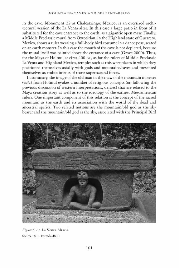
in the cave. Monument 22 at Chalcatzingo, Mexico, is an oversized archi-tectural version of the La Venta altar. In this case a large patio in front of itsubstituted for the cave entrance to the earth, as a gigantic open maw. Finally,a Middle Preclassic mural from Oxtotitlan, in the Highland state of Guerrero,Mexico, shows a ruler wearing a full-body bird costume in a dance pose, seatedon an earth monster. In this case the mouth of the cave is not depicted, becausethe mural itself was painted above the entrance of a cave (Grove 2000). Thus,for the Maya of Holmul at circa 400 BC, as for the rulers of Middle PreclassicLa Venta and Highland Mexico, temples such as this were places in which theypositioned themselves axially with gods and mountains/caves and presentedthemselves as embodiments of those supernatural forces.
In summary, the image of the old man in the maw of the mountain monster(witz) from Holmul evokes a number of religious concepts (or, following theprevious discussion of western interpretations, deities) that are related to theMaya creation story as well as to the ideology of the earliest Mesoamericanrulers. One important component of this relation is the concept of the sacredmountain as the earth and its association with the world of the dead andancestral spirits. Two related notions are the mountain/old god as the skybearer and the mountain/old god as the sky, associated with the Principal Bird
M O U N T A I N – C A V E S A N D S E R P E N T – B I R D S
101
Figure 5.17 La Venta Altar 4
Source: © F. Estrada-Belli

Deity, the iconic symbol of kingship among the Preclassic and Classic Maya.Thus the pyramid as the image of the mountain/old god straddles the threecosmic dimensions of the Maya worldview—sky, earth and underworld. Aswas noted earlier, among the present-day Maya the old god is a god of healingand birth as well as of malevolent magic. These aspects relate to his powers ascreator of life, reinforced by the specific association with the omnipresent
M O U N T A I N – C A V E S A N D S E R P E N T – B I R D S
102
Figure 5.18 Chalcatzingo Monument 22
Source: After Grove 2000; courtesy of David Grove
Figure 5.19 Oxtotitlan cave painting
Source: Drawing by A. Moreno; courtesy of the New World Archaeological Foundation

water-lily feathered serpent and “First Father,” the supreme creator of theuniverse depicted in Classic and Postclassic Maya iconography.
The above examples show several common traits that help in the identi-fication of the main ideological program behind the construction of PreclassicLowland Maya monumental art. It is apparent that most traits are related tothe story of creation, at least as much of it as we can see reflected in the PopolVuh account of the Colonial period and in Classic period inscriptions andpainted ceramics. It is rare to find a series of archaeological features, such ascaches or burials associated with monumental art, that can provide a morecoherent view of the development through time of such buildings and of theritual activity that took place among them than those at Cival, north ofHolmul.
The discovery of stucco sculptures at Cival decorating one of the Triadictemples facing the E-Group plaza, where many caches were deposited, offersmore details to illustrate the ideological program of Preclassic monumentalart from the time of its earliest manifestations. The Triadic Group 1 of Civalis a steep-sided platform rising 20 meters from the plaza. It measures 70meters on the front and 39 meters on the sides. It supports three temple pyra-mids forming a Triadic Group (see Figures 4.1, 4.2 and 4.3, above). The maintemple on the eastern side is 13 meters high. Two stepped temples flanking iton the north and south sides of the platform are 5 meters high. Attached tothe eastern and southern temples are two low rises which could be the remainsof low rectangular building platforms. In addition to these three main tem-ples, on the west there are two 4-meter-high pyramidal structures flanking aninset stairway on the front of the platform. Finally, on the northwest andsoutheastern corners are two small rises, which could be the remains of smallsingle-room buildings (5 3 3 meters wide). Because of its imposing volumeand location blocking the eastern horizon on the site’s east–west center line,this new Triadic Group was probably the most important focus of ritualperformance at Cival during the reminder of the Late Preclassic period. Overat least 400 years it underwent five major remodeling episodes, the last onearound AD 100. The construction of this group represented a major change inthe scale and nature of ritual architecture at Cival, from horizontal to vertical.It may have made some rituals secluded, but nevertheless a large audiencestanding in the plaza would have had an impressive view of the ceremoniescarried out on this elevated space framed by towering temples.
The second-to-last stage of the eastern temple of the Triad consisted of atemple pyramid fully enclosed within the latest stage of construction. Itsupper temple would have risen 6 meters from the platform’s top and 26 metersfrom the plaza below it. Its pyramidal platform consisted of three terracesdecorated with sloping apron-moldings and a 2-meter-wide inset centralstairway, all of which were coated with a 5-centimeter thick stucco lining. Thispyramid is decorated with two large and identical stucco masks, each of whichmeasures 5 meters in width and 3 meters in height. They are placed on the
M O U N T A I N – C A V E S A N D S E R P E N T – B I R D S
103

sloping face of the upper (third) terrace of the stepped pyramid. It is interest-ing to note that while the upper sloping terrace measures 3 meters in height,the first two are only about 1.3 meters high. The first terrace (1.1 meters wide)was much narrower than the second. The terrace above it (4.15 meters wide)clearly created a broader space in front of the mask to accentuate it.
The giant masks are anthropomorphic. Their identifying characteristics aredown-turned, L-shaped slit eyes, a single tooth (central incisor) with bifur-cated ends, cross-band signs on the cheeks, flamed-eyebrow and curled motifson the cheeks, and ear-flare assemblage. The L-shaped slit eye is often relatedto solar and sky deities.11 This mask closely resembles Cerros’s lower masksfrom Structure 5C-2nd, in spite of being separated by at least two centuries(Cerros’s masks date to about 50 BC; Freidel 1986). However, there are alsoapparent differences, especially in the cross-band motif on the face, instead ofa k’in sign, but these are often interchangeable in early Maya art. Moreover,the slit-eye and flaming-eye compound of the Cival masks is similar to that ofan unidentified bundled figure appearing in the San Bartolo Mural and severalexamples of Olmec sky dragons/serpents (Taube et al. 2004: Figure 2; seeFigure 5.15, above). On a carved vase from Tlapacoya, the cross-band motif isinside the mouth, identifying this being as the sky or the center of the sky, the
M O U N T A I N – C A V E S A N D S E R P E N T – B I R D S
104
Figure 5.20 Northern mask on Cival Structure 1–4th
Source: © F. Estrada-Belli
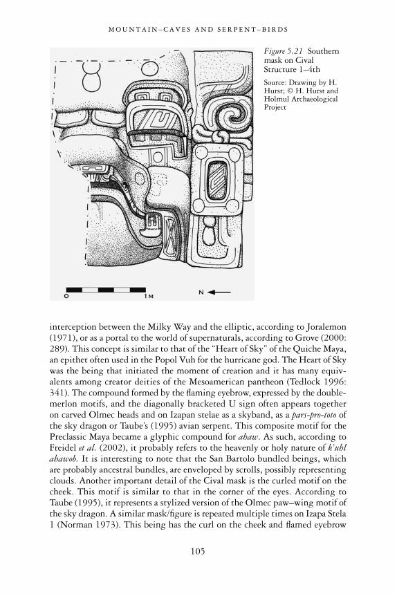
interception between the Milky Way and the elliptic, according to Joralemon(1971), or as a portal to the world of supernaturals, according to Grove (2000:289). This concept is similar to that of the “Heart of Sky” of the Quiche Maya,an epithet often used in the Popol Vuh for the hurricane god. The Heart of Skywas the being that initiated the moment of creation and it has many equiv-alents among creator deities of the Mesoamerican pantheon (Tedlock 1996:341). The compound formed by the flaming eyebrow, expressed by the double-merlon motifs, and the diagonally bracketed U sign often appears together on carved Olmec heads and on Izapan stelae as a skyband, as a pars-pro-toto ofthe sky dragon or Taube’s (1995) avian serpent. This composite motif for thePreclassic Maya became a glyphic compound for ahaw. As such, according toFreidel et al. (2002), it probably refers to the heavenly or holy nature of k’uhlahawob. It is interesting to note that the San Bartolo bundled beings, whichare probably ancestral bundles, are enveloped by scrolls, possibly representingclouds. Another important detail of the Cival mask is the curled motif on thecheek. This motif is similar to that in the corner of the eyes. According toTaube (1995), it represents a stylized version of the Olmec paw–wing motif ofthe sky dragon. A similar mask/figure is repeated multiple times on Izapa Stela1 (Norman 1973). This being has the curl on the cheek and flamed eyebrow
M O U N T A I N – C A V E S A N D S E R P E N T – B I R D S
105
Figure 5.21 Southernmask on CivalStructure 1–4th
Source: Drawing by H.Hurst; © H. Hurst andHolmul ArchaeologicalProject

(Taube 1995). Diagonal brackets are upturned on the forehead rather than onthe eyelid, perhaps due to the profile view, and it has a scrolled ear-flare com-pound. It has a decidedly anthropomorphic appearance, with its puffy cheeksand furrowed forehead, like the Cival masks. It has been interpreted by Taube(1995) initially as an early form of rain god (chaak). However, the bracketedU signs on eyelids and ear spools may be related to the idea of shiningbrilliance (Taube personal communication 2010), which would be consistentwith other solar attributes on this mask, such as the k’in-cross bands and L-shaped eyes, although not sufficient to identify it with the Preclassic sun god.Finally, it should be noted that two dots and an exclamation-point water sign are incised on the Cival mask forehead and two bracketed dots are incisedbelow the mask’s eye. In Olmec iconography this motif is interpreted asrepresenting teardrops from the rain gods (Reilly 1991).
The Cival masks were placed atop the highest temple on the plaza’s easthorizon, the direction of the rain-laden storm winds. As such, they couldrepresent the earliest surviving Maya representations of the rain/lightning skygods of creation (Tedlock and Tedlock 1985).
In addition, two blocks found in the rubble covering the masks showremains of black-painted signs. These appear to be representations of theLamat or Venus star sign, common in Preclassic Isthmian and Maya scripts.Finally, in two separate locations, painted on the temple terrace aprons and ona block in the rubble above the masks, were two profile almond-eyed faces withsquared mouths similar to the masks and wearing elaborate headdresses.
Above these masks was a temple room painted in red on the outside andwith polychrome figures and black star signs in the interior walls. The paintedblocks found in the rubble covering the masks may be remains of doorjambstossed down at the moment of the termination and rebuilding of the temple.
Although much of this temple was destroyed by looters, parts of the wallsare sufficiently preserved for us to determine that this structure was a two-room vaulted building. The front room was accessed by three wide doorways.The rear room was accessed through a central doorway and was raised 30centimeters above the front room. The front walls were painted red, while thedoorjambs, now largely lost, were painted with polychrome murals. Inside, thelateral walls were painted white, while the frontal wall(s) were painted in a tancolor. On the inner (east) side of the wall separating the front (west) from therear (east) room of the temple, several small figures were painted in black.Fifteen of these have survived on a section of this wall. Four are situated about50 centimeters from the floor and three more are aligned at about a meterabove it. Figure 1 is the best preserved. It is a human figure in striding positionfacing left. He has almond-shaped eyes with dark facial paint in the upper noseand eye areas. His mouth consists of a straight upper lip and fangs; he has curlson either cheek and wears nose beads and a large four-dotted ear flare. Belowthe chin is a trilobed ornament (or bib) that may be a form of shell or yax(first/green) sign. These facial traits are consistent with those of the maize god.
M O U N T A I N – C A V E S A N D S E R P E N T – B I R D S
106

He wears a foliage-shaped cap and a large headdress consisting of a long-beaked avian head, with L-shaped eye and flamed eyebrow, bifid tongue, andan ahaw sign as ear ornament. He has a long hair braid emerging from the topof his head. The only ornaments on his body are a large-bead belt and braceletson the upper arms. Overall, this figure is consistent with other images of the maize god in Late Preclassic Maya art. In this case, he wears the PBD/Itzamnaaj headdress, indicating his identification with the concept of the oldgod reviewed above, the world tree, the axis mundi, and the supreme power ofthe creator. This image directly recalls the portrait of the ruler on Cival Stela2 wearing the PBD royal pectoral, which was erected in the plaza below thistemple. According to available evidence, Stela 2 may be 100 years earlier thanFigure 1 (300–200 BC), but in the absence of more precise dating, they shouldbe considered contemporary.
Figure 13 is a full-figure portrait of the maize god in a striding posture,wearing a feathered cape (see Figure 5.27, below, for a similar costume). Thestyle of Figures 1 and 13 is particularly similar to the roughly coeval paintedimages of the maize god in the North and West Wall murals of San BartoloStructure 1. In the West Mural, the saga of the maize god culminates in hiswearing the avian headdress and ascending to absolute power as a result of his defeat of the PBD. In Figure 2 from Cival Mural 1 we have a similar facialportrait. This time a simple headband is worn by the maize god with a central
M O U N T A I N – C A V E S A N D S E R P E N T – B I R D S
107
Figure 5.22 Figure 1 of Mural 1 on Cival Structure1–4th (circa 200 BC)
Source: Drawing by H. Hurst; © H. Hurst and HolmulArchaeological Project

trilobed diadem, the hunal, which is the royal symbol par excellence in Mayaiconography. Figure 3 of Cival Mural 1 is a portrait of the maize god wearingthe simple foliage-shaped cap. In Figure 4 only the facial traits are preserved,and in Figure 5 only the upper part of the head is preserved, revealing a cross-band sign on the foliage-shaped headdress.
These figures reveal a certain variance in particular traits when representingthe common theme of the maize god as the axis mundi and the image of divinekingship itself. Judging from the slight variations in line styles, differentartists participated in painting these images, or they were painted at differ-ent times by several artists. Given the highly restricted location of thepainting, it was conceivably visible only to a small, elite group involved inperforming rituals at this location. Given their extemporaneous arrangement,it is likely that the paintings resulted from repeated rituals evoking the maizegod, rather than a single planned mural composition.
Altogether, the masks and the mural fragments are evidence of the cosmo-logical theme of this Cival temple: rain-bearing sky gods supporting a templedecorated with images and symbols associated with the sky, making thispyramid the image of the center of the world of creation and birthplace of themaize god. In a review of the iconography of the Cerros masks, Freidel et al.(2002) propose that the masks may represent constellations of the night skyduring the birth of the maize god prior to the day of creation, August 14, 3114BC, and leading to the birth of the maize god. At Cival, celestial beings repre-sented on the masks and the star symbols decorating the upper temple do
M O U N T A I N – C A V E S A N D S E R P E N T – B I R D S
108
Figure 5.23 Figure 13 of Mural 1 onCival Structure 1–4th (circa 200 BC)
Source: Drawing by H. Hurst; © H. Hurstand Holmul Archaeological Project
Figure 5.24 Figure 2 of Mural 1 on CivalStructure 1–4th (circa 200 BC)
Source: Drawing by H. Hurst; © H. Hurstand Holmul Archaeological Project

appear to relate to various elements of the Itzamnaaj/PBD/old god, the sky-and-earth creator deity. According to Kathryn Reese-Taylor (2002), LatePreclassic Triadic pyramid complexes, such as Uaxactun Group H and CerrosGroup 6, mirror a place described in the Palenque texts as the Raised-up-Sky/Eight House Partitions, where the three realms of the universe wereseparated as the sky was being raised. The Cival example appears to supportthis interpretation in the sense that its focal pyramid represents the main deityof the first creation who elevated and supports the sky (see also Freidel et al.1993).
To summarize, in light of the above-discussed offertory caches and monu-mental sculptures, it is apparent that, across the Maya Lowlands and as earlyas the Middle Preclassic (circa by 900–800 BC), the E-Group plazas are the earliest monumental settings for rituals related to the Maya worldview, the agricultural cycle, the maize god as axis mundi, the creator deity (the PDB) and their centrality in Maya ideology as the prototype and patron ofkingship. While monumentality by itself does not equate with civilization,the appearance of a programmatic new narrative that coopted creation storiesand symbolism in the 9th century BC reflects a new sense of communitythroughout the Maya Lowlands at that time. What used to be a patchwork of regional ceramic styles, in the Pre-Mamom phase, was replaced by a morewidespread phenomenon, place-making at ritual centers and setting a newcommunal identity across regions accompanied by more widely shared ceramicstyles (i.e. broad regional variants of the Mamom ceramic style). The presenceof monumentality, elite rituality and a novel narrative does not necessarilycorrespond with the existence of a fully articulated hierarchical (stratified)society of the sort we typically associate with the term “civilization.” Rather,from the reconstruction of the timing of adoption of ceramics, the formationof villages and the creation of ritual space at Cival, I see the appearance of these elements as signaling the accelerated development of Maya civilizationaround 900 BC. The monumentality and associated narrative provide thecatalyst for this process. But the rise of hierarchical structures in their societylikely was a drawn-out process for the duration of the Middle Preclassic period.Subsequently, during the early part of the Late Preclassic period (circa 300 BC),as the resources available to Maya communities increased, large temple com-plexes were erected and the themes of creation focused more on the maize godas the source of worldly power. These themes were expressed more evidentlyin the context of royal ideology. The greatest monumental complexes of thistime were erected in the Mirador Basin, at such sites as Nakbe, El Mirador,Tintal, Xulnal and Wakna.
In the region surrounding the Mirador Basin, Cival was but one amongmany ceremonial centers in which monumental construction took place. Theprogression seen in the Cival record, from E-Group rituals to the monumentalart of Triadic temples, provides a particularly compelling case for the con-tinuity of ideological programs associated with the elite narrative from which
M O U N T A I N – C A V E S A N D S E R P E N T – B I R D S
109
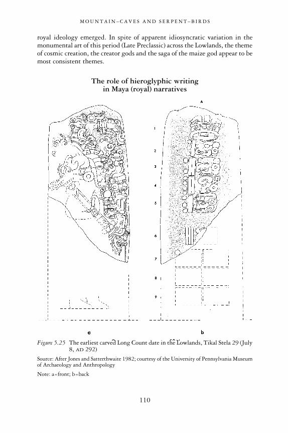
royal ideology emerged. In spite of apparent idiosyncratic variation in themonumental art of this period (Late Preclassic) across the Lowlands, the themeof cosmic creation, the creator gods and the saga of the maize god appear to bemost consistent themes.
The role of hieroglyphic writing in Maya (royal) narratives
M O U N T A I N – C A V E S A N D S E R P E N T – B I R D S
110
Figure 5.25 The earliest carved Long Count date in the Lowlands, Tikal Stela 29 (July8, AD 292)
Source: After Jones and Satterthwaite 1982; courtesy of the University of Pennsylvania Museumof Archaeology and Anthropology
Note: a=front; b=back

The earliest-known dated inscription12 in the Maya Lowlands remains that of Stela 29 at Tikal, having a Long Count date of July 8, AD 292 (8.12.14.8.15 13 Men 3 Zip). On it is a portrait of the Tikal king Foliated Jaguar(Proskouriakoff 1993; Martin 2003). While this is the earliest Long Countdate to be found, hieroglyphic writing predates it in the Maya Lowlands bycenturies. There are unreadable hieroglyphs on El Mirador Stela 2. Its date isdifficult to establish without knowing its original placement, but stylisticallyit appears to date to the Late Preclassic period and certainly prior to AD 150:that is, before El Mirador was finally abandoned. On El Mirador Stela 2’s sur-viving fragment is a large head figure of the PBD floating amid scrolls. To the right is a vertical panel with two columns of small, incised hieroglyphs(Hansen 1991). What remains of the inscription suggests a historical text(Hansen 2001).
M O U N T A I N – C A V E S A N D S E R P E N T – B I R D S
111
Figure 5.26 Stela 2, El Mirador (Late Preclassic)
Source: Drawing by J. Hansen; courtesy of Richard Hansen
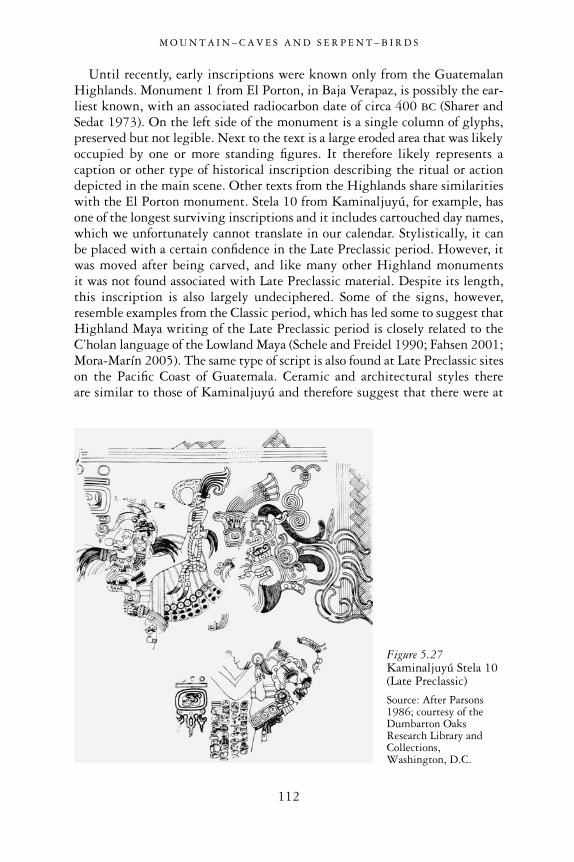
Until recently, early inscriptions were known only from the GuatemalanHighlands. Monument 1 from El Porton, in Baja Verapaz, is possibly the ear-liest known, with an associated radiocarbon date of circa 400 BC (Sharer andSedat 1973). On the left side of the monument is a single column of glyphs,preserved but not legible. Next to the text is a large eroded area that was likelyoccupied by one or more standing figures. It therefore likely represents acaption or other type of historical inscription describing the ritual or actiondepicted in the main scene. Other texts from the Highlands share similaritieswith the El Porton monument. Stela 10 from Kaminaljuyú, for example, hasone of the longest surviving inscriptions and it includes cartouched day names,which we unfortunately cannot translate in our calendar. Stylistically, it can be placed with a certain confidence in the Late Preclassic period. However, itwas moved after being carved, and like many other Highland monuments it was not found associated with Late Preclassic material. Despite its length,this inscription is also largely undeciphered. Some of the signs, however,resemble examples from the Classic period, which has led some to suggest thatHighland Maya writing of the Late Preclassic period is closely related to theC’holan language of the Lowland Maya (Schele and Freidel 1990; Fahsen 2001;Mora-Marín 2005). The same type of script is also found at Late Preclassic siteson the Pacific Coast of Guatemala. Ceramic and architectural styles there are similar to those of Kaminaljuyú and therefore suggest that there were at
M O U N T A I N – C A V E S A N D S E R P E N T – B I R D S
112
Figure 5.27Kaminaljuyú Stela 10(Late Preclassic)
Source: After Parsons1986; courtesy of theDumbarton OaksResearch Library andCollections,Washington, D.C.

least enclaves of Maya speakers on the coast at these sites. The distribution ofearly texts on the coast is quite spotty and may also denote the presence of Maya enclaves amid non-Maya speakers. The earliest carved dates are fromChiapa de Corzo, El Baul (AD 37; Parsons 1986) and Takalik Abaj (AD 126).Interestingly, to the west and south of these sites are many centers that boastsculptural art but no inscriptions (e.g. Izapa, Ujuxte and Monte Alto), as if theuse of writing were tied to ethnic affiliation and/or elite connections withHighland centers. These few dated monuments are complemented by manyundated ones that may be stylistically earlier. At Chalchuapa, El Salvador, for example, is an undated but stylistically Preclassic inscribed monument(Monument 1; Sharer and Sedat 1973). This suggests that there was an exten-sive tradition of hieroglyphic writing in the Highlands and Pacific Coast bythe 1st century AD. This likely developed primarily at sites occupied by Mayaspeakers since the Middle Preclassic Period. The El Porton text seems to dateto the period in which Maya writing was first developed.
It is reasonable to conclude from the above that the art of hieroglyphicwriting was known to Maya-speaking people just to the south of the MayaLowlands for quite a long time. Until recently, it was believed that before thebeginning of the Christian era the Lowland Maya did not have the sufficientsocio-political complexity to require the use of a writing system. However, therecent discovery of several texts at the site of San Bartolo has confirmed the existence of a Lowland writing tradition coeval with the earliest Highland
M O U N T A I N – C A V E S A N D S E R P E N T – B I R D S
113
Figure 5.29 Chalchuapa Monument 1
Source: After Sharer and Sedat 1973; courtesy ofR. Sharer
Figure 5.28 El Baul Stela 1, 7.19.7.8.12 12 Eb 0 Muan (May 5, AD 37)
Source: After Coe 2005; courtesy of M. D. Coe

texts discussed above. At San Bartolo, several columns of hieroglyphic textsaccompany the figures in the North and West Wall murals, as captions ordescriptors of the figures. These texts have been dated by radiocarbon samplesassociated with the murals to the 1st century BC (Saturno et al. 2006). Anotherinscription was found on a painted block that was associated with an earlierconstruction stage of the same temple where the well-known murals arelocated (the Pinturas structure). Charcoal samples found in the rubble thatcontained the painted block date to between 400 and 100 BC (Saturno et al.2006). While it is difficult to ascertain the exact date of the inscription evenin this well-documented case, it is clear that there was writing prior to the 2ndcentury BC in the Maya Lowlands. This writing system appears to be coevalwith the great architecture of the Triadic Groups of El Mirador, Nakbe andmany of the other major sites, and with the monumental sculptures thatadorned them.
Given that the currently known earliest texts, those from San Bartolo, areconservatively estimated to date from 300–200 BC and represent a well-developed usage of signs, it is likely that future research will uncover evenearlier Maya texts attesting to the earliest stages of development of the writingsystems. Elsewhere in Mesoamerica, in Oaxaca and on the Gulf Coast, the
M O U N T A I N – C A V E S A N D S E R P E N T – B I R D S
114
Figure 5.30 Hieroglyphs from a painted stone block foundin the rubble of the Pinturas structure at SanBartolo
Source: After Saturno et al. 2006; courtesy of William Saturno
earliest writing appears to have developed out of simple calendrical and icono-graphic signs around 500–400 BC (Marcus 1992; Pohl et al. 2002). This wasa time when monumental buildings adorned with complex iconography wereerected at Nakbe in the Maya Lowlands. It is possible that the earliest formsof writing in the Lowlands also developed in the 5th century BC. Because weknow that complex forms of glyph-like iconographic motifs were alreadybeing used on a monumental scale at the Highland Maya site of El Porton by400 BC, it is possible that future research will uncover earlier Lowland inscrip-tions.
The relationship between the Preclassic Maya writing system and theClassic period hieroglyphic script is not clear. Some epigraphers have notedthat the Preclassic Lowland and Highland scripts are closely related (possiblytwo stages of development in the same writing tradition), and that they may have been used by speakers of the same C’holan–Maya language family(Fahsen 2001). Others have pointed out that the Lowland texts have greatersimilarities with the epic-Olmec script used to the west, along the Gulf Coast(Saturno et al. 2006). This similarity may simply be due to the early date ofthe San Bartolo text. Although many of the Preclassic signs are unintelligibleto us, others are easily recognizable as precursors of Classic types. The ahawsign, for example, is repeated several times in the San Bartolo texts and is clearly recognizable as an archetype of the Classic period sign (Saturno et al. 2006). Other examples of Preclassic signs with a Classic equivalent arethose for accession to the throne, or “be seated” (chum-laj), expressed by a sim-ple seated figure in profile, and the signs for month or twenty (winal) andmountain (witz; Fahsen 2001). Verbs are also expressed in similar ways byhand-signs in the Preclassic and Classic scripts.
There is very strong evidence, therefore, that the Preclassic and Classic Maya scripts represent stages of development in a single Maya writing system. The Maya script underwent major changes from the Classic period to the Postclassic. The same might be expected from the Preclassic period tothe Classic. One problem is that our Preclassic sample is too small and thereis a two-century gap between the Preclassic and Classic scripts, so we appearto be missing a transitional phase. As new texts are uncovered, it is likely that additional equivalent signs will be found. These in turn will facilitate thedecipherment of even more signs. But only when a sizable corpus of text isavailable will we be able to begin deciphering them in earnest.
While the Preclassic and Classic scripts may have been read in the samelanguage, and while one appears to be ancestral to the other, the small sampleswe have of Preclassic writing remain largely unreadable. The Preclassic scriptappears to have been in use until approximately AD 150, after which a largenumber of Preclassic centers were abandoned and the Maya Lowlands wereaffected by a general reorganization of the centers of power. There was then aperiod of between 100 and 150 years for which we do not have texts, betweenthe last securely dated Preclassic inscriptions and the earliest Classic Maya text
M O U N T A I N – C A V E S A N D S E R P E N T – B I R D S
115

on Tikal Stela 29 (AD 292), although a number of unprovenienced texts onportable objects may date to this period. At the end of the Preclassic period,Maya hieroglyph writing was in widespread use from the northern Lowlands(e.g. the Loltun Cave; see Andrews 1981a) to the southern Lowlands, and thesouthern Highlands.
In the Preclassic period, the knowledge associated with writing wascertainly restricted to a small group of high-ranking specialists within Mayasociety, perhaps more so than in the Classic period. Early scribes probablypreferred paper books or other perishable media to stone, which might explainthe paucity of surviving inscriptions from this period. Its highly restricted useand the fragile media in which it was transmitted may also explain the rapidchanges in many of its notational signs before the Classic period. Based onavailable evidence, it is possible to surmise that knowledge of writing quicklyevolved during the 150-year span of the Terminal Preclassic. During thisperiod, the carving and painting of inscriptions may have been interrupted bywidespread warfare and a generalized crisis in Maya society, which uprootedelites from their palaces. Whatever the causes, this short but intense period ofturmoil would effectively have resulted in the loss of many inscriptions, espe-cially those written on perishable material, in a way similar to the deliberatedestruction of Maya books by Spanish missionaries. As the literate elites wereevicted from power in favor of non-literate or semi-literate military factions,books and any knowledge relating to them may have quickly been lost.
After this brief dark age around AD 250, order and elite tradition wererestored within the Lowlands when new dynasties consolidated their power at sites outside of the Mirador Basin, such as Tikal. The new elites simplyadopted what knowledge had survived of the ancient writing system and thencontinued in a new tradition.
M O U N T A I N – C A V E S A N D S E R P E N T – B I R D S
116

6
THE PRECLASSIC–CLASSICMAYA TRANSITION
A new beginning?
A “Protoclassic” or “Terminal Preclassic” to Classic transition
The Preclassic and Classic periods are arbitrary temporal divisions set byarchaeologists half a century ago, at a time when we knew little about theantiquity of Maya civilization (Willey and Sabloff 1974). These divisions werebased on the occurrence of certain traits in Maya culture around the year AD
300. The perception was that, with the appearance of these traits, the Mayahad reached full-blown civilization. Tikal Stela 29 carried the earliest LongCount date (AD 292) and provided a convenient fixed, if completely artificial,boundary between the two periods. In addition, it was recognized that atroughly the same time, polychrome-painted ceramics and corbel-vault build-ings also made their appearance.
Archaeologists have since recognized that a temporal division at AD 300does not accurately reflect the actual first appearance of those traits in the MayaLowlands. For example, it has been known for some time that polychromeceramics and vaulted architecture existed in the Preclassic period, at least acouple of centuries before the first inscriptions (Hammond 1992). Moreover,Long Count date inscriptions that pre-existed Stela 29 by at least a couple ofcenturies had been known from the southern Maya Highlands and PacificPiedmont (Sharer and Sedat 1973; Hammond 1977), and some early butunprovenienced examples can be attributed with some level of confidence tothe Maya Lowlands (e.g. the Hauberg stela; Hammond 1977). Nevertheless,archaeologists chose to ignore these problematic indications in favor of thewell-established chronological divisions. However, it is now widely acceptedthat the appearance of those cultural traits (and others) in the centuriespreceding the Classic period indicate that the beginnings of Classic Mayacivilization occurred considerably earlier, in the Preclassic period.
The decipherment of hieroglyphs during the 1980s steered the debatetowards the iconographic symbols and hieroglyphic systems used by ClassicMaya kings, and to the question of origin: that is, where and when they were
117

developed. In a series of influential articles published at the end of that decade,archaeologists and epigraphers pronounced that the institution of divine king-ship so closely associated with Classic Maya civilization was a likely productof the intense population growth at many Lowland centers during the LatePreclassic period and of the attendant “crystallization” of social norms thatoccurred in the last century prior to the Christian era (Freidel and Schele 1988;Stuart 1988; Fields 1986).
At the same time, as research at El Mirador (Matheny et al. 1980), Becan(Ball 1977), Cerros (Freidel 1986) and other Preclassic sites began to produceresults in the late 1970s and early 1980s, new issues regarding the timing ofspecific site histories emerged but were largely overlooked. For example,neither Cerros nor El Mirador showed signs of Classic period occupation,Preclassic Becan was encircled by a moat, and polychrome ceramics appearedat some very specific locations in the two centuries from AD 100 to 300. A newdebate ensued on the nature of this transitional period. Was it a dark age or aperiod of innovations spurred by migrants, who, along with ceramics, broughta new political system—Maya kingship? In the same influential article inwhich David Freidel and Linda Schele (1988) suggested that the “crystalliza-tion” of Maya kingship, the institution of the ahaw, occurred in the 1st centuryBC, they also echoed the widely shared perception that the subsequenttransition of the Preclassic into the Classic period fundamentally altered thatinstitution. But how this alteration should be manifested in the archaeologicalrecord was not clear. An important ingredient of this transformation was thestela cult and the associated Long Count calendrical system, which were saidto have travelled from the Maya Highlands to the Lowlands. In Freidel andSchele’s view, the mixing of the esoteric knowledge of Lowland village-levelshamans with the writing and calendrical system of Highland elites gave riseto the Classic form of Maya kingship. As noted earlier, though, the recentdiscovery of a parallel Lowland writing tradition in the Late Preclassic periodput this idea to rest (Saturno et al. 2006).
The idea of migrations from the Highland regions of Guatemala and ElSalvador, where polychrome and modeled ceramics (as well as Long Countdates) prevailed prior to the Lowland Classic tradition, was another point ofgreat contention. The debate was stimulated by an ever-improving data set ofceramics from good, datable contexts (architecture and ritual cave deposits)and continued through the 1990s, when finally an agreement (of sorts) wasreached. Brady et al. (1998) proposed that polychrome bowls and vases withdistinctive supports (mammiform modeled) and orange glossy backgroundpaint were products of a local development (see Figure 2.3, above). The propo-sition that the so-called “Protoclassic” orange polychrome ceramics compriseda full ceramic complex (i.e. a full set of storing, cooking and serving wares)rather than a ritual/burial sub-complex was viewed with great suspicion.Indeed, numerous documented site contexts showed this proposition to be untenable. The new polychromes served a minority of ritual and burial
T H E P R E C L A S S I C – C L A S S I C M A Y A T R A N S I T I O N
118
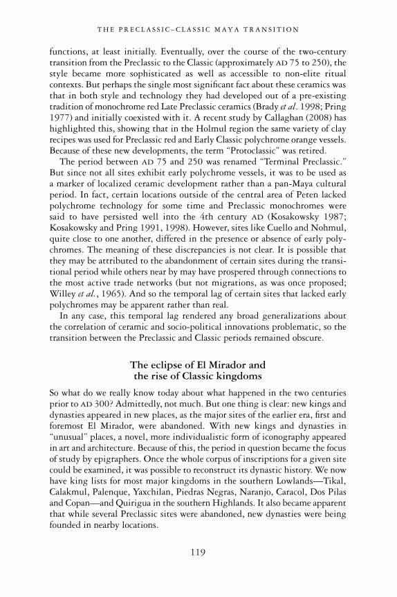
functions, at least initially. Eventually, over the course of the two-centurytransition from the Preclassic to the Classic (approximately AD 75 to 250), thestyle became more sophisticated as well as accessible to non-elite ritualcontexts. But perhaps the single most significant fact about these ceramics wasthat in both style and technology they had developed out of a pre-existingtradition of monochrome red Late Preclassic ceramics (Brady et al. 1998; Pring1977) and initially coexisted with it. A recent study by Callaghan (2008) hashighlighted this, showing that in the Holmul region the same variety of clayrecipes was used for Preclassic red and Early Classic polychrome orange vessels.Because of these new developments, the term “Protoclassic” was retired.
The period between AD 75 and 250 was renamed “Terminal Preclassic.” But since not all sites exhibit early polychrome vessels, it was to be used as a marker of localized ceramic development rather than a pan-Maya culturalperiod. In fact, certain locations outside of the central area of Peten lackedpolychrome technology for some time and Preclassic monochromes were said to have persisted well into the 4th century AD (Kosakowsky 1987;Kosakowsky and Pring 1991, 1998). However, sites like Cuello and Nohmul,quite close to one another, differed in the presence or absence of early poly-chromes. The meaning of these discrepancies is not clear. It is possible thatthey may be attributed to the abandonment of certain sites during the transi-tional period while others near by may have prospered through connections tothe most active trade networks (but not migrations, as was once proposed;Willey et al., 1965). And so the temporal lag of certain sites that lacked earlypolychromes may be apparent rather than real.
In any case, this temporal lag rendered any broad generalizations about the correlation of ceramic and socio-political innovations problematic, so thetransition between the Preclassic and Classic periods remained obscure.
The eclipse of El Mirador and the rise of Classic kingdoms
So what do we really know today about what happened in the two centuriesprior to AD 300? Admittedly, not much. But one thing is clear: new kings anddynasties appeared in new places, as the major sites of the earlier era, first andforemost El Mirador, were abandoned. With new kings and dynasties in“unusual” places, a novel, more individualistic form of iconography appearedin art and architecture. Because of this, the period in question became the focusof study by epigraphers. Once the whole corpus of inscriptions for a given sitecould be examined, it was possible to reconstruct its dynastic history. We nowhave king lists for most major kingdoms in the southern Lowlands—Tikal,Calakmul, Palenque, Yaxchilan, Piedras Negras, Naranjo, Caracol, Dos Pilasand Copan—and Quirigua in the southern Highlands. It also became apparentthat while several Preclassic sites were abandoned, new dynasties were beingfounded in nearby locations.
T H E P R E C L A S S I C – C L A S S I C M A Y A T R A N S I T I O N
119

There were exceptions to this rule. The Mirador Basin, a large sector of theMaya Lowlands, is largely devoid of Early Classic occupation. Given that the last 20 years of continued research in this region have not uncovered anyEarly Classic inscriptions, it is doubtful that this is an accident of discovery.To the east and to the north, there were inscriptions dating to the 4th and 5thcenturies AD, at Naachtun and Uxul, for example. As a result, new researchwas initiated there to establish the link between these sites and the abandon-ment of El Mirador (Grube and Paap 2008; Reese-Taylor and Walker 2002).But, the fact remains that most of the Mirador Basin was largely abandonedat the onset of the Early Classic period. Remarkably, Uxul and Naachtun liejust outside its geographic margins and it is not yet clear whether their envi-ronment was different than the Mirador Basin’s and whether that played a rolein these sites’ survival.
Tikal was another exception that might require explaining. It thrivedduring this transition and most importantly, at the end of it, boasted theearliest dated inscriptions among all Maya centers. As we saw earlier, Tikal’s
T H E P R E C L A S S I C – C L A S S I C M A Y A T R A N S I T I O N
120
Figure 6.1 Preclassic sites, including those walled and abandoned at the onset of theClassic period
Source: © F. Estrada-Belli, Topographic data courtesy of NASA SRTM mission

Classic period scribes’ retrospective texts referred to a ruler named Yax Eb Xook as the first in the line and therefore founder of the same dynasty that controlled the kingdom during the Classic period (Jones 1991; Martin2003). Unfortunately, we do not have inscriptions from his reign, estimatedat circa AD 100, and his identification as first in line occurs centuries later, and
T H E P R E C L A S S I C – C L A S S I C M A Y A T R A N S I T I O N
121
Figure 6.2 Lowland sites with carved monuments bearing Baktun 8 (Cycle 8) LongCount dates (i.e. earlier than AD 435)
Source: © F. Estrada-Belli, Topographic data courtesy of NASA SRTM mission

therefore remains tenuous, at best. Whether Yax Ehb Xook was revered as thefirst “real” king of Tikal by his own contemporaries, as he was much later byhis successors, remains to be determined.
Tikal’s is perhaps the most ancient Classic period dynasty in the Lowlands.Few other sites appear to have had rulers who carved inscriptions prior to AD 435 (the Long Count Date 9.0.0.0.0), including those kingdoms (such as Naranjo) with dynastic founding dates set far back in mythological time(Grube 2004). All of the Lowlands’ early inscriptions and kingdoms arelocated within a short distance—a day’s march—from Tikal. It is possible thatTikal’s ruling lineage may have been the first to adopt a new royal ideologyafter the fall of the great El Mirador kingdom. Indeed, because of their distri-bution and chronological sequence, subsequent early inscriptions of the centralPeten appear to be spin-offs from this innovating center. The process may havebeen one of political expansionism by the Tikal elites. We know from laterinscriptions that such a process was an ongoing feature of the Tikal kingdomthroughout the Classic period. The Terminal Preclassic and Early Classic elitesof Tikal were also the possessors of some of the finest new polychrome ceramicsof this era, the orange gloss wares (Culbert 1993). This innovative style was adeparture (albeit not a technological one) from the waxy red monochromes of the previous era. We now know, after several stylistic and proveniencestudies, that in the Late Classic period, polychrome ceramics were exchangedby elites across kingdoms, to solidify friendly relations and to build reciprocityduring ritualized visits. As an innovation, orange polychrome ceramics werethe result of a similar motivation—the desire of emerging elites to solidify anew network of political alliances and friendly relationships by exchangingand imitating a new style of ceramics. Tikal may have been one such center ofinnovation, and the ceramics either distributed or imitated within developingtrade and alliance networks (see Reese-Taylor and Walker 2002 for a discussionof this scenario in greater detail).
The rise of new Maya kings and the Teotihuacan “entrada”
Tikal, then, is the rising star of the turbulent post-Mirador interlude yearsfrom AD 100 to 376. During this period, the kings of Tikal, after a reorgani-zation of their own kingdom around new elite lineages (possibly unrelated tothe El Mirador alliance networks of the previous era), established a hegemonicnetwork of friendly smaller kingdoms around themselves. These were thekingdoms with Cycle (baktun) 8 inscriptions and/or places in which the earlyorange polychrome ceramics were traded and imitated. Intensity of commit-ment varied with distance and level of shared economic and political interests,but the network may have included a great number of large and small placesin the northeastern Peten and southeastern regions. These were located alongthe main trade routes to and from the Caribbean. The development of this
T H E P R E C L A S S I C – C L A S S I C M A Y A T R A N S I T I O N
122

hegemony was not an entirely peaceful process, as is indicated by captiveimagery on the early Tikal monuments (Stela 39, for example). Tikal’s expan-sionism came to a culminating moment with the appearance in the Lowlandsof Teotihuacan warrior imagery and textual references to a legendary man from“the west” named Siyaj K’ahk’ (Proskouriakoff 1993; Stuart 2000a). After the
T H E P R E C L A S S I C – C L A S S I C M A Y A T R A N S I T I O N
123
Figure 6.3 Early Classic sites related to Tikal or Teotihuacan “entrada” and least-effortroutes computed by GIS algorithm
Source: © F. Estrada-Belli and Holmul Archaeological Project, Topographic data courtesy ofNASA SRTM mission

so-called Teotihuacan “entrada” in the Lowlands, Tikal appears to enjoy muchgreater direct and indirect control over much of the southtern Lowlands andits trade routes. Tikal-style architecture and/or Teotihuacan imagery oftenaccompany textual references involving 4th-century Tikal kings outside Tikal.Siyaj K’ahk’ himself is mentioned at a number of sites strategically located to control the main routes (see Figure 6.3). El Peru/Waka’, Bejucal, ElEncanto, Uaxactun, Holmul and Rio Azul are among the places where he isnamed (Stuart 2000a; Estrada-Belli et al. 2009). Other sites simply displayTeotihuacan-style imagery in stone or ceramics. Among these are Tres Islas(Tomasic and Fahsen 2004), Yaxha, in Peten, and Santa Rita Corozal (Chaseand Chase 1981), Altun Ha (Pendergast 1971) and Baking Pot (Colas et al.2002) along the Rio Hondo and Belize River routes.
First identified as a possible Teotihuacan conqueror by pioneering epig-rapher Tatiana Proskouriakoff in the 1960s (Proskouriakoff 1993), the figureof Siyaj K’ahk’ has remained elusive and the nature of the Teotihuacan-style
T H E P R E C L A S S I C – C L A S S I C M A Y A T R A N S I T I O N
124
Figure 6.4 Tikal Stela 39showing ruler Chak TokIchaak standing above a captive (Early Classicperiod)
Source: Courtesy of SimonMartin

imagery controversial for a long time. Thanks to a great deal of new informa-tion gained from excavations at Tikal and other sites, as well as the reading ofMaya hieroglyphs, we can now safely rule out speculations that Siyaj K’ahk’was a mythological figure or a title of the ruling Tikal king Yax Nuun Ayiin.Both the archaeology and epigraphy agree on certain aspects of this issue.According to several Early Classic monuments, Siyaj K’ahk’ arrived at Tikal(from the west), bringing with him several insignia of power (such as theeighteen-snake-headed “manikin sceptre” headdress of the god K’awiil1). Theday of his arrival is expressed by the shortened date 11 Eb 15 Mak, and isrecalled by many Maya kings (not only at Tikal) as a milestone in Maya history.On this day, the ruling king of Tikal Chaak Tok Ichaak died. One year later, aboy named Yax Nuun Ayiin would take the throne, having traveled to anunknown location in which he was ritually invested with the symbols of royalpower (possibly Teotihuacan). It is during his one-katun reign that Teotihuacanimagery and his likeness are found outside of Tikal. About this point, the textsdo not tell us all that was going on, of course. In fact, excavations in variouselite residential compounds at Tikal (Groups 6C-16, 6C-5 and others) showthat there was a substantial, if small, resident population that built its homesand made use of material culture carrying Teotihuacan symbolism at least fromAD 250 (Laporte and Fialko 1990; Laporte et al. 1992). So the arrival may
T H E P R E C L A S S I C – C L A S S I C M A Y A T R A N S I T I O N
125
Figure 6.5 Uaxactun Stela 5—apossible portrait of Siyaj K’ahk’
Source: Drawing by Ian Graham, Corpusof Maya Hieroglyphic Inscriptions,Volume 5, Part 3, Uaxactun; courtesy of the President and Fellows of HarvardCollege.

not have been literal but figurative, meaning the accession to power of a newfaction, perhaps with the foreigners’ support. Some have suggested a Tikaltakeover by a foreign army. Although that is possible, and there are indicationsof raids at Early Classic Tikal (e.g. early monuments are missing), based on theavailable data and known practices of later Mesoamerican states (and empires),it is perhaps more likely that foreign help was sought by a local faction aspir-ing to dethrone an existing ruler. And thus a long-distance alliance withTeotihuacan was probably more a by-product of a local struggle than a motiva-tion for or cause of it. In the end, though, these various details do not changethe substance of what happened next.
T H E P R E C L A S S I C – C L A S S I C M A Y A T R A N S I T I O N
126
Figure 6.6 Tikal Stela 31 depicting Siyaj Chan K’awiil and his father (left) Yax NuunAyiin (dedicated in AD 445, or 9.0.10.0.0)
Source: After Jones and Satterthwaite 1982; courtesy of the University of Pennsylvania Museumof Archaeology and Anthropology

During approximately the next 100 years, Tikal, with the support of its Teotihuacan allies, successfully consolidated its hegemonic control overmuch of the Lowlands by securing key places. Aside from obvious episodes ofconquest, part of this process may have involved inserting new dynastic centers(with one of their own as founder) in areas void of occupation or betweenunfriendly neighbors. The most notable case is that of Copan, Honduras,whose founder, the Teotihuacan-affiliated Yax K’uk’ Mo’, in the year AD 426made an arrival similar to that of Siyaj K’ahk’ at Tikal, displaced the existingruler, and founded a new royal center a short distance from the earlier cere-monial plaza (Figure 1.15, above). He thus secured a distant province near an important Lowland–Highland trade route. Along it traveled such vitalresources as obsidian and jade. The nearby kingdom of Quirigua was foundedby a vassal of the Copan king shortly thereafter to secure this same route.Following the Motagua River, it was now possible to travel the route from theHighlands to the Caribbean Sea and coastal Yucatan, encountering variousTikal–Teotihuacan-friendly kingdoms along the way.
Both inscriptions and archaeology seem in agreement on the central Petenorigin of these kingdom founders (Sharer 2003; Looper 2003; Martin andGrube 2008). A surprising new discovery came when an obscure early textfrom Caracol, one of the most fearsome enemies of Tikal in the Late Classic,indicated that it was first established through the influence of Tikal. Thisinformation, and the occurrence of the Witz’/Caracol place name near that ofYax K’uk Mo’, led David Stuart to hypothesize that the Copan founder mayhave originated there, rather than at Tikal itself, as might be expected2 (Martinand Grube 2008; Stuart 2007b; Buikstra et al. 2004; Sharer 2003). This newdiscovery, while reinforcing the notion of early Tikal aggressiveness in estab-lishing outposts and a new hegemonic order in the Lowlands, also underscoresthe short-lived nature of political allegiances in the Maya Lowlands.
But did the rapid ascent of Tikal bring down the colossal kingdom of ElMirador? Even with the help of the greatest foreign power, this would perhapshave been an impossible feat for an upstart kingdom such as Tikal in the 2ndcentury AD. There is some evidence that El Mirador may have come underattack, and that the attacker left many green obsidian points and blades fromcentral Mexico on the ground. The evidence is currently confined to the Tigreand Danta pyramid complexes, but absent from much of the rest of the site(Hansen 1990; Hansen et al. 2008b). This evidence could have been createdby a massive attack or a skirmish on the slopes of two of the greatest complexesfairly late in the history of El Mirador, possibly around AD 300. At that timethe great kingdom was already on its knees for undetermined reasons and its population was likely confined to the high-rise areas of the site. Why theattack? It may have been an attempt by the rising power (Tikal) to squash the last elites of this great and previously all-powerful kingdom. Their mereexistence and influence could have represented a formidable obstacle for Tikalkings as they were establishing their kingdom as the new powerhouse in the
T H E P R E C L A S S I C – C L A S S I C M A Y A T R A N S I T I O N
127

Maya Lowlands, with the help of Teotihuacan, the greatest powerhouse in the whole of Mesoamerica.
The puzzling end of El Mirador
This plausible political scenario does not provide all the answers, by anymeans. The other side to this story concerns the causes for the decline of ElMirador, independent of the ascent of Tikal. These causes may be found inchanges in the Mirador Basin climate and environment. These alone, as currentconsensus suggests, could have caused the collapse of the Preclassic colossusand initiated a chain reaction of failing centers of power throughout its alliancenetworks. Environmental science has found evidence for certain changes at thisjuncture, but neither their causes nor their effects on the local population areeasily inferred. More data are needed. From what we know, at El Mirador, asat Cival, large and small water sources contracted towards the end of thePreclassic period (Wahl et al. 2006a, 2006b; Estrada-Belli et al. 2007; Wahland Estrada-Belli 2009). The changes in water level and concomitant droughtsmay have affected the hydrological regime of the swamps, causing majorproblems in agriculture. Some scholars argue that increased sedimentation ofswamps and lakes, providing the sustenance for most sites in the MiradorBasin and elsewhere at this time, may also have reduced their productivity(Jacob 1995; Beach et al. 2006; Kunen et al. 2000; Hansen et al. 2002).Simultaneously, the population may have reached critical levels at least in themore populated areas (El Mirador). The environmental crisis, when it mani-fested itself, may have been too great and too rapid for the ruling class tohandle effectively. This scenario is controversial, even though the availableevidence points to environmental changes at this time. The complete and utterabandonment of not only the Mirador Basin centers but much of that water-rich environment (in spite of relative reductions in water level) in which theywere located is certainly dramatic, as well as puzzling.
Whatever the exact causes, a much-weakened power structure seems to havepersisted at El Mirador through the 4th century, before eventually comingunder fatal attack. The archaeology of El Mirador is clearer about this. Thefinal abandonment of the site happened rapidly—domestic utensils were even left inside buildings (e.g. Structure 34; Hansen et al. 2008a), a patterntypically associated with Maya sieges (see the Aguateca rapidly abandonedstructures; Inomata et al. 2002). Its diminished hegemonic reach beyond theMirador Basin may have left some of its allies and trade partners to fend forthemselves, thus causing a more widespread decline of centers across theLowlands. The diminished influence of El Mirador on its allies may also haveenabled Tikal’s Teotihuacan-supported local faction to gain power.
Warfare was probably a frequent affair in Maya politics, even in thePreclassic period. It is possible that El Mirador may have enforced a relativepeace within its hegemonic sphere of influence. Although that may have been
T H E P R E C L A S S I C – C L A S S I C M A Y A T R A N S I T I O N
128

accomplished through military action (just as the Pax Romana was in the 1st-century Mediterranean). But conflict appears to have spiraled upwardduring the final centuries of the Preclassic period. With the failure of the greathegemony and the rise of new centers, new technological and ritual innova-tions led to new material culture and new iconography in the Maya Lowlands.
It is fair to conclude that these scenarios are not mutually exclusive, asdecades of debate in the field of Maya studies have implied. Taken together,they may provide a more informed explanation than the outright rejection ofone or the other.
Environment, politics and friends in high places
In the Holmul region, we have found concrete evidence of the interplay ofenvironmental and political changes at the end of the Preclassic era. Eventhough we do not have all the answers, some preliminary inferences can bedrawn. The environment of Cival is similar in all respects to that of El Mirador,and their occupation ended at the same time. Some parallels should be drawnfrom these two, among many sites that fared similarly. Cival, like many otherPreclassic centers, is located on a broad hill, overlooking a vast seasonal swamp
T H E P R E C L A S S I C – C L A S S I C M A Y A T R A N S I T I O N
129
Figure 6.7 View of the topography of Cival
Source: © F. Estrada-Belli and Holmul Archaeological Project
Note: Dark spots identify built areas. Terrain data courtesy of NASA
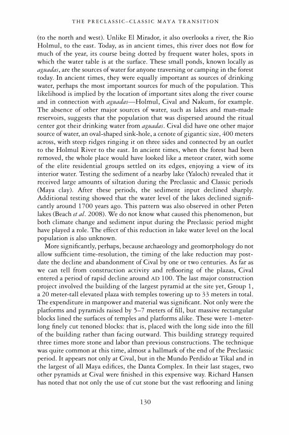
(to the north and west). Unlike El Mirador, it also overlooks a river, the RioHolmul, to the east. Today, as in ancient times, this river does not flow formuch of the year, its course being dotted by frequent water holes, spots inwhich the water table is at the surface. These small ponds, known locally asaguadas, are the sources of water for anyone traversing or camping in the foresttoday. In ancient times, they were equally important as sources of drinkingwater, perhaps the most important sources for much of the population. Thislikelihood is implied by the location of important sites along the river courseand in connection with aguadas—Holmul, Cival and Nakum, for example.The absence of other major sources of water, such as lakes and man-madereservoirs, suggests that the population that was dispersed around the ritualcenter got their drinking water from aguadas. Cival did have one other majorsource of water, an oval-shaped sink-hole, a cenote of gigantic size, 400 metersacross, with steep ridges ringing it on three sides and connected by an outletto the Holmul River to the east. In ancient times, when the forest had beenremoved, the whole place would have looked like a meteor crater, with someof the elite residential groups settled on its edges, enjoying a view of itsinterior water. Testing the sediment of a nearby lake (Yaloch) revealed that itreceived large amounts of siltation during the Preclassic and Classic periods(Maya clay). After these periods, the sediment input declined sharply.Additional testing showed that the water level of the lakes declined signifi-cantly around 1700 years ago. This pattern was also observed in other Petenlakes (Beach et al. 2008). We do not know what caused this phenomenon, butboth climate change and sediment input during the Preclassic period mighthave played a role. The effect of this reduction in lake water level on the localpopulation is also unknown.
More significantly, perhaps, because archaeology and geomorphology do notallow sufficient time-resolution, the timing of the lake reduction may post-date the decline and abandonment of Cival by one or two centuries. As far aswe can tell from construction activity and reflooring of the plazas, Civalentered a period of rapid decline around AD 100. The last major constructionproject involved the building of the largest pyramid at the site yet, Group 1,a 20 meter-tall elevated plaza with temples towering up to 33 meters in total.The expenditure in manpower and material was significant. Not only were theplatforms and pyramids raised by 5–7 meters of fill, but massive rectangularblocks lined the surfaces of temples and platforms alike. These were 1-meter-long finely cut tenoned blocks: that is, placed with the long side into the fillof the building rather than facing outward. This building strategy requiredthree times more stone and labor than previous constructions. The techniquewas quite common at this time, almost a hallmark of the end of the Preclassicperiod. It appears not only at Cival, but in the Mundo Perdido at Tikal and inthe largest of all Maya edifices, the Danta Complex. In their last stages, twoother pyramids at Cival were finished in this expensive way. Richard Hansenhas noted that not only the use of cut stone but the vast reflooring and lining
T H E P R E C L A S S I C – C L A S S I C M A Y A T R A N S I T I O N
130

of buildings and plazas must have consumed immense resources, especiallyfirewood to make lime plaster (Clark et al. 2000). However, in our Civalexcavations, we observed that, while the use of stone in the final period showedgreat expenditure by the leadership, the thickness of plaster floors was actuallygreater in the Middle Preclassic and it progressively diminished in the LatePreclassic. This is evident at all other Preclassic sites in the Holmul region,too: Holmul K’o, Hamontun and T’ot. So it is unclear if the consumption ofwood and stone—or, as Richard Hansen puts it, the conspicuous consumptionof natural (and human) resources—led the environment and all settlements tothe brink of collapse (Clark et al., 2000).
At Cival, at least, we find other reasons to believe that neither the over-consumption of resources nor the diminished water in the lake was the primarycause of abandonment. Shortly after the AD 100 landmark renovations of mosttemples, the city apparently came under siege. On the main hill, the plaza, themain temples and elite palace platforms were encircled by a 2-meter-highstone wall (see Figure 4.2, above). On top of the stone base was probably atimber palisade reaching several meters in height. The wall ran on all sides ofthe hill except one, the northwest, for a length of 1.3 kilometers. This fortifi-cation left out many important elite platforms, especially those that were
T H E P R E C L A S S I C – C L A S S I C M A Y A T R A N S I T I O N
131
Figure 6.8 Tenoned blocks on Group 1 main stairway, Cival (circa AD 100)
Source: © F. Estrada-Belli

outside the main hill. But the way the wall was laid out around the edges ofthe main hill is peculiar. Rather than being as close as possible to the edge ofplatforms and hilltop, it was placed a few meters from the edge. This layoutmay have been adopted because of an obscure military strategy. The otherpeculiar aspect of the wall is that, in some cases, it was built not flush withbuildings but bisecting them. The apparent purpose was to use the stone from the buildings as construction material for the wall, while also using theremaining rubble to restrict attackers’ movement. The well-known walls builtin the Late Classic period by the besieged Dos Pilas elites are a very similarexample of this technique. The stone was ripped from surrounding buildingsand laid down without mortar, suggesting that the builders did not havesufficient time to build a proper foundation. Moreover, the fact that one sideof the site was left unprotected suggests that the building project was nevercompleted. In other words, the Civaleños may have been attacked while theywere building their defenses.
Though the Cival wall was never completed, the site was not immediatelyabandoned. In the main plaza, the E-Group complex was rebuilt at least onemore time. The renovations were not substantial, but this at least tells us that
T H E P R E C L A S S I C – C L A S S I C M A Y A T R A N S I T I O N
132
Figure 6.9 Map of Cival’s main structures and topography (circa AD 100)
Source: © F. Estrada-Belli and Holmul Archaeological Project
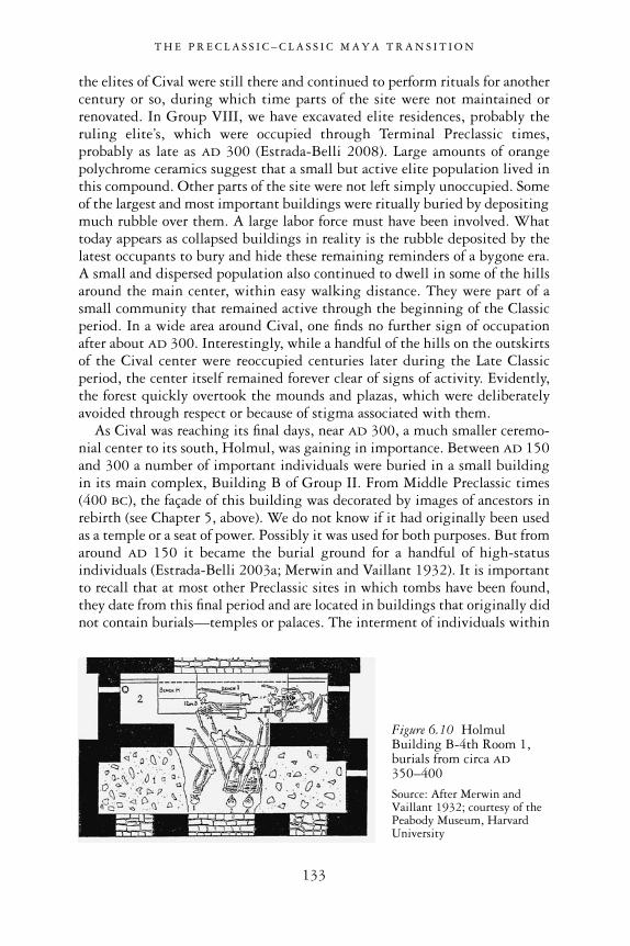
the elites of Cival were still there and continued to perform rituals for anothercentury or so, during which time parts of the site were not maintained orrenovated. In Group VIII, we have excavated elite residences, probably theruling elite’s, which were occupied through Terminal Preclassic times,probably as late as AD 300 (Estrada-Belli 2008). Large amounts of orangepolychrome ceramics suggest that a small but active elite population lived inthis compound. Other parts of the site were not left simply unoccupied. Someof the largest and most important buildings were ritually buried by depositingmuch rubble over them. A large labor force must have been involved. Whattoday appears as collapsed buildings in reality is the rubble deposited by thelatest occupants to bury and hide these remaining reminders of a bygone era.A small and dispersed population also continued to dwell in some of the hillsaround the main center, within easy walking distance. They were part of asmall community that remained active through the beginning of the Classicperiod. In a wide area around Cival, one finds no further sign of occupationafter about AD 300. Interestingly, while a handful of the hills on the outskirtsof the Cival center were reoccupied centuries later during the Late Classicperiod, the center itself remained forever clear of signs of activity. Evidently,the forest quickly overtook the mounds and plazas, which were deliberatelyavoided through respect or because of stigma associated with them.
As Cival was reaching its final days, near AD 300, a much smaller ceremo-nial center to its south, Holmul, was gaining in importance. Between AD 150and 300 a number of important individuals were buried in a small buildingin its main complex, Building B of Group II. From Middle Preclassic times(400 BC), the façade of this building was decorated by images of ancestors inrebirth (see Chapter 5, above). We do not know if it had originally been usedas a temple or a seat of power. Possibly it was used for both purposes. But fromaround AD 150 it became the burial ground for a handful of high-statusindividuals (Estrada-Belli 2003a; Merwin and Vaillant 1932). It is importantto recall that at most other Preclassic sites in which tombs have been found,they date from this final period and are located in buildings that originally didnot contain burials—temples or palaces. The interment of individuals within
T H E P R E C L A S S I C – C L A S S I C M A Y A T R A N S I T I O N
133
Figure 6.10 HolmulBuilding B-4th Room 1,burials from circa AD350–400
Source: After Merwin andVaillant 1932; courtesy of thePeabody Museum, HarvardUniversity
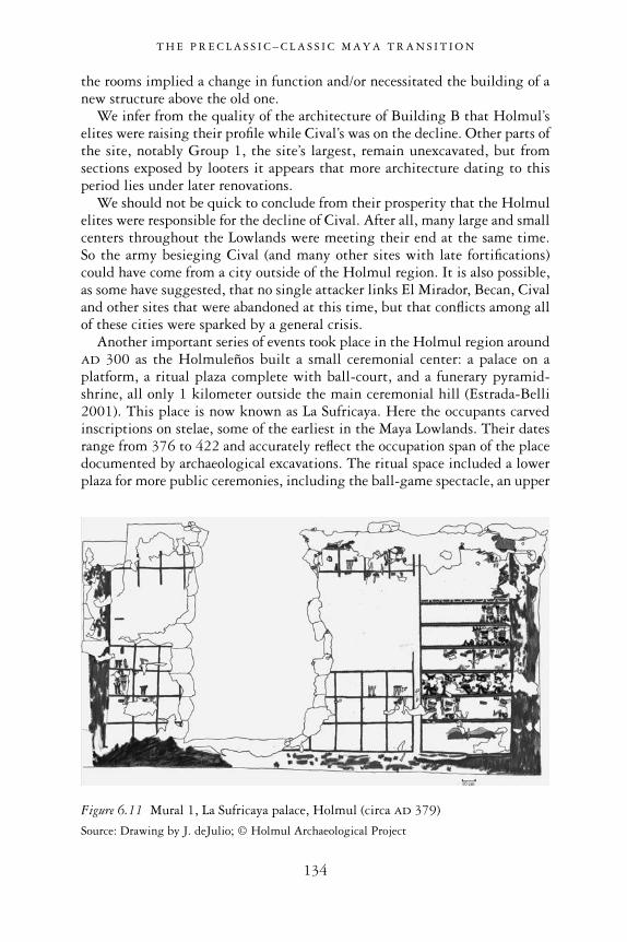
the rooms implied a change in function and/or necessitated the building of anew structure above the old one.
We infer from the quality of the architecture of Building B that Holmul’selites were raising their profile while Cival’s was on the decline. Other parts ofthe site, notably Group 1, the site’s largest, remain unexcavated, but fromsections exposed by looters it appears that more architecture dating to thisperiod lies under later renovations.
We should not be quick to conclude from their prosperity that the Holmulelites were responsible for the decline of Cival. After all, many large and smallcenters throughout the Lowlands were meeting their end at the same time. So the army besieging Cival (and many other sites with late fortifications)could have come from a city outside of the Holmul region. It is also possible,as some have suggested, that no single attacker links El Mirador, Becan, Civaland other sites that were abandoned at this time, but that conflicts among allof these cities were sparked by a general crisis.
Another important series of events took place in the Holmul region aroundAD 300 as the Holmuleños built a small ceremonial center: a palace on aplatform, a ritual plaza complete with ball-court, and a funerary pyramid-shrine, all only 1 kilometer outside the main ceremonial hill (Estrada-Belli2001). This place is now known as La Sufricaya. Here the occupants carvedinscriptions on stelae, some of the earliest in the Maya Lowlands. Their datesrange from 376 to 422 and accurately reflect the occupation span of the placedocumented by archaeological excavations. The ritual space included a lowerplaza for more public ceremonies, including the ball-game spectacle, an upper
T H E P R E C L A S S I C – C L A S S I C M A Y A T R A N S I T I O N
134
Figure 6.11 Mural 1, La Sufricaya palace, Holmul (circa AD 379)
Source: Drawing by J. deJulio; © Holmul Archaeological Project

terrace that was probably reserved for a more select audience of high-statusindividuals, and the palace itself, which housed the ruling elite.
But who were the new rulers who chose to build their seat of power awayfrom the traditional ritual space of the Holmul hill? The inside and the outsideof the palace were decorated with colorful murals. Painted on the walls of oneof the rooms in the palace are scores of warriors dressed in Teotihuacan styleand holding Teotihuacan-style weapons, such as trilobed-tipped darts andatlatl (Estrada-Belli 2003b; Estrada-Belli et al. 2009). They appear to be seatedon the steps of a platform, perhaps that of the palace itself. Other individuals,wearing a mix of Maya and Teotihuacan garb, bring offerings or simply stand.We interpret these images as illustrations of a ceremony carried out at LaSufricaya.
The mural’s main character is largely eroded, but enough remains to suggestthat the warriors were attending a ceremony performed by a priest or a ruler.In another image, a Maya individual follows a path from one pyramid toanother with a Teotihuacan-style façade. Here, he appears to receive somethingfrom a seated individual (see Figure 6.13). Other rooms were decorated withpurely Maya images, such as one of the old god addressing his bird/humanmessenger, and another showing human sacrifice—a captive bound to a scaf-fold is about to be decapitated in re-enactment of a well-known ritual of royalaccession (Estrada-Belli 2002b; Tomasic and Estrada-Belli 2003). The palacewas therefore decorated with images suggestive of royal ceremonies and visit-ing dignitaries and it is possible that these events occurred locally. On anotherroom’s wall was an inscription recording the dedication of a stone, possibly the
T H E P R E C L A S S I C – C L A S S I C M A Y A T R A N S I T I O N
135
Figure 6.12 Warrior figure fromMural 1, La Sufricaya palace (circaAD 379)
Source: Drawing by J. Ebersole; © Holmul Archaeological Project

inauguration of the palace or part of it (Three-Temple House). We are told itwas done two years after the close of the 1 ahaw katun, and one year (364 days)after the K’awiil arrived at Mutal (Tikal), after Siyaj K’ahk’ had arrived. Theprotagonist was identified by a long series of titles including, chak tok wayaab(cloud-red diviner; Estrada-Belli et al. 2009). This rare title is only knownfrom another Holmul individual buried at roughly the same time in BuildingB. A stone stela found outside the palace (Stela 6) also may record the name
T H E P R E C L A S S I C – C L A S S I C M A Y A T R A N S I T I O N
136
Figure 6.13 Mural6N, La Sufricayapalace (circa AD 379)
Source: Drawing by H.Hurst; © H. Hurst andHolmul ArchaeologicalProject
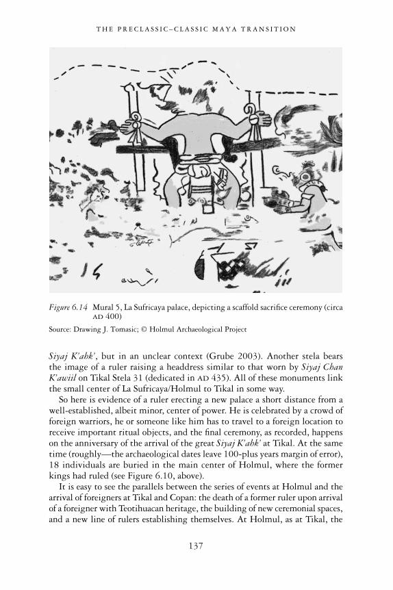
Siyaj K’ahk’, but in an unclear context (Grube 2003). Another stela bears the image of a ruler raising a headdress similar to that worn by Siyaj ChanK’awiil on Tikal Stela 31 (dedicated in AD 435). All of these monuments linkthe small center of La Sufricaya/Holmul to Tikal in some way.
So here is evidence of a ruler erecting a new palace a short distance from awell-established, albeit minor, center of power. He is celebrated by a crowd offoreign warriors, he or someone like him has to travel to a foreign location toreceive important ritual objects, and the final ceremony, as recorded, happenson the anniversary of the arrival of the great Siyaj K’ahk’ at Tikal. At the sametime (roughly—the archaeological dates leave 100-plus years margin of error),18 individuals are buried in the main center of Holmul, where the formerkings had ruled (see Figure 6.10, above).
It is easy to see the parallels between the series of events at Holmul and thearrival of foreigners at Tikal and Copan: the death of a former ruler upon arrivalof a foreigner with Teotihuacan heritage, the building of new ceremonial spaces,and a new line of rulers establishing themselves. At Holmul, as at Tikal, the
T H E P R E C L A S S I C – C L A S S I C M A Y A T R A N S I T I O N
137
Figure 6.14 Mural 5, La Sufricaya palace, depicting a scaffold sacrifice ceremony (circaAD 400)
Source: Drawing J. Tomasic; © Holmul Archaeological Project

written dedication date for the palace should not be taken as the actual date offirst occupation, since the archaeological evidence suggests the first buildingstones at La Sufricaya could have been laid a few decades before. The date shouldbe taken figuratively, signaling the rising of a new ruler and the dedication ofhis palace as a royal seat. At Holmul, as at Tikal and Copan, it was necessary forthe new ruler to journey to a distant location to receive the insignia of power,and to display the military support of Teotihuacan. In all iconographicreferences to Teotihuacan and textual references to Siyaj K’ahk’ in the EarlyClassic we see the hand of Tikal rulers. At Holmul it is evident in the similarityof mixed Maya–Teo architectural and decoratives styles, and in the iconographyof one of its monuments (La Sufricaya Stela 1 and Tikal Stela 31; see Figure 6.6,above). Tikal was the source of the Holmul incursion, in all likelihood to securethe east and northeast routes to ports on the Caribbean Coast.
This Tikal-backed coup established Holmul as a new center of power thatquickly rose to prominence in the region, finally eclipsing Cival. As for thedecline of Cival itself, following the raid, we lack evidence about the attackers.In contrast to El Mirador, we have found no signs of Teotihuacan-styleweaponry at this site. More targeted excavations may rectify this. As we knownow, the siege could pre-date the La Sufricaya palace by as much as 150 years.Unfortunately, our dating methods do not allow us sufficient resolution todetermine if the two were close enough in time to establish causality. But allindicators point to these events being fairly close in time and possibly linked.It is likely that the same people who built La Sufricaya had previously attackedCival. The attackers were a mix of locals backed by a powerful Tikal contingentand foreigners, a combination quite common in Mesoamerica. Or the Holmulelites could have simply taken over an area left void by a declining Cival.
At this point, it is a matter of choice which of these scenarios seems morelikely. However, if we place these events in a wider context, we see the samepattern repeating itself. At El Mirador, there are signs of a last-ditch battleinvolving Teotihuacan weaponry. At Becan, a fortified center is largely aban-doned but the last occupants are still sufficiently well connected to place eliteceramics with Teotihuacan-style decoration in ritual offerings. Further to thenorth, just inland from the coastal lagoon of Bacalar, is the city of Dzibanché,the Early Classic capital of the Snake Kingdom (Martin 2005; see Figure 6.3,above). Here, in the 5th century, the largest pyramid (the CormoranesPyramid) serves as the burial place of at least one important Snake king, SkyWitness, and is decorated with Teotihuacan talud-tablero and red-paintedstucco friezes with Teotihuacan-style symbols (Nalda 2003). At Cerros, in Belize, the old seaport and ceremonial center is abandoned and a newneighboring port, Santa Rita Corozal, is established. There, too, ceramics andpaintings indicate links with Teotihuacan. The other major Belizean coastalcity, Altun Ha, while neither sacked nor abandoned, in AD 250 receives a hoard of Teotihuacan obsidian figurines, projectiles and vessels honoring one of its deceased rulers. In northern Yucatan, the old Preclassic center of
T H E P R E C L A S S I C – C L A S S I C M A Y A T R A N S I T I O N
138

Komchen is largely abandoned and Teotihuacan-style architecture appears nearby, in the Mirador Group at Dzibilchaltun (Andrews and Andrews 1980).Oxkintok and Chac are two of several northern sites with central Mexican linksthat also share architectural traits with Tikal (Smyth 2008; Varela Torrecillaand Braswell 2003; see Figure 6.3, above).
Until Teotihuacan began its own decline, Tikal remained the main hub ofan immense network of political hegemony and trade connections within thesouthern Lowlands, for at least the first two centuries of the Classic period.Then, Tikal’s rulers also began to run into trouble. In an intriguing twist offate, the historical defeat of Tikal in AD 562, may have come at the hands ofone of its former allies and, judging from the decoration of its funerary temple,a former participant in the Teotihuacan–Tikal connection: Sky Witness ofDzibanché (Martin and Grube 2008: 90).
T H E P R E C L A S S I C – C L A S S I C M A Y A T R A N S I T I O N
139
Figure 6.15CormoranesPyramid, Dzibanché,containing the tombof King Sky Witness(circa AD 500–600)
Source: © F. Estrada-Belli

7
CONCLUSION
Maya civilization is alive and well. Modern Maya men and women walk thestreets of Mexican, Honduran and Guatemalan towns today (see Figure 1.17,above). Their culture has neither collapsed nor gone through anything likedevolution. It has simply mutated into a new form incorporating western ideasand religion. It has done so not because of long-term laws of behavior or envi-ronmental forces. It has changed since the Spanish conquest because of and atthe pace of changing historical, political and economic circumstances. In thisbook I have tried to move away from our own hitherto accepted assumptionsabout cultural change in general and about Maya civilization in particular. Fortoo long these have caused us to misunderstand the Preclassic Maya, to devaluetheir achievements, to search in vain for the correlates of idealized social typesin the archaeological record, chiefdom and state, so that at times we could fitthe Maya into one or other category. And we are constantly playing catch-upfrom the expected correlates to institutions. Institutions are always believedto precede the correlate in development. Without the material correlate, theinstitution is invisible and unknowable to us. Therefore, by chasing institu-tions through their material correlates, we play a self-defeating game (Yoffee2005; Pauketat 2007: 20). But the old assumptions of earlier generations ofarchaeologists are bending and breaking under the weight of an avalanche of new data.
In my view, what led to Maya civilization (as with any other civilization)was fundamentally a historical process, having little to do with universalcauses of cultural evolution, laws of environmental adaptation, populationgrowth, craft specialization or the invention of new forms of government.Rather, that process was mainly composed of such elements as communitycreation, place-making, formulating new identities, and co-opting existingsymbols into a new discourse that gave meaning to life in the community.When we look at the life history of individual places like Cival, the crucialelements of this process appear in sharp focus.
It may seem surprising to speak of Maya civilization existing as early as 900BC. In this book, I used the term “civilization” loosely to identify not a higherform of culture, a qualitative improvement on earlier conditions, but a
140
historical process (Pauketat 2007: 17), one that has been ongoing since theonset of the first millennium BC in the Maya Lowlands. The Preclassic Mayashould not be understood as constituting some evolutionary stage prior to aqualitative superior entity (the Classic Maya), but as a people who created newtraditions, new communities and new narratives of identity. Within a shorttime, what were once distinct local groupings converged to form ever largerentities, eventually incorporating all the Maya Lowlands. The city of ElMirador may have been the culmination of this historical process, rather thanits beginning.
A new beginning for Maya studies
This book proposes a perspective that challenges a number of old theoriesabout the emergence of Maya civilization. This perspective can be describedas “historical-processual,” a term borrowed from Fernand Braudel’s AnnalesSchool of historians (Braudel 1986; Peebles 1990; Knapp 1992a). It has theadvantage of allowing for the analysis of historical detail made of events and short-term changes, interlaced with longer-term socio-economic and/orenvironmental processes drawn out over centuries or millennia. Long-termprocesses also provide the “big picture” context for historical action at the locallevel in which communities are made and remade. This approach departs fromthe linear perspective and ideal social categories of cultural evolutionism andthe universal laws of behavior and ideal social types that have been part andparcel of the paradigm of the “New Archaeology” for the last 50 years. Witha long-term perspective and with a wealth of localized data, we have examinedthe history of places like Cival not because this particular site had a moresignificant role than other locales in shaping Maya civilization, but because,through accidents of preservation, we have a very long and accessible recordthere of the relevant period—the first millennium BC. Other, perhaps moreimportant sites have only partially accessible or truncated sequences.
With the support of our new data and perspective we confronted the oldnotions about the Preclassic Maya—that the Maya of the first millennium BC
were 1) recent immigrants; 2) simple farmers; and 3) culturally stagnant—until a threshold point was reached in the first century BC. A corollary to allthis was that the Lowland environment was unsuitable for generating a civil-ization, so everything significant about such a civilization had to come fromother regions of Mesoamerica. In fact, these theories began to falter some timeago. Long-term excavations at sites such as Cuello, Cahal Pech, Kaxob, Colha,Cerros and even the much earlier Carnegie Institution’s Uaxactun excavationshad given us a feel for the complexity of the Preclassic Maya and the oppor-tunities offered by Lowland soils. But because many studied sites were small,they also helped reinforce the notions that the Preclassic era was characterizedby small-scale village farming lacking any monumentality until a very latedate. It was when monumental Middle Preclassic architecture was excavated
C O N C L U S I O N
141

at Nakbe in the 1990s that we began to see things differently. But even so, ashift in perspective was necessary—one that abandons the search for correlatesof our own abstractions and suppositions and focuses on what actually mayhave happened then and there.
One of the main points in our shift in perspective has involved theinstitution of kingship, a key ingredient of ancient state-level societies. Theneo-evolutionary/processualist perspective that has dominated our field favors“universal” processes of change and denies the relevance of specific historicaland ethnographic details almost as if they were undesired random “noise”(Wylie 1991; Yoffee 2005). Because the Maya of the Classic period had clearlyinherited such institutions from the preceding phase, we were told it wascrucial to find its antecedent, simpler forms. The difficulty of separating small-time kings from chiefs and, for that matter, of identifying either in the Mayaarchaeological record has been obvious to many. I have circumvented thisproblem here by looking at other manifestations of cultural change. I iden-tified place-making as a crucial process. It involves the creation of a new senseof community wider then the village or town (Kolb and Snead 1997), a newidentity, with a new narrative and new political and cultural practices. It is not about inventing new forms, but about elaborating or co-opting existingsymbols in the service of new practices and meanings, in order to create newperceptions of world order. Not coincidentally, the narratives of Preclassicceremonial centers are in most respects echoed by the royal narratives of theClassic period, thereby underscoring both the continuity and transformationsof Maya civilization through time.
Long-term and life histories
Instead of feverishly looking for the correlates of early kings (tombs andpalaces), I have identified important “moments” or, to use a Braudelian word,conjunctures, in the long-term history of the Lowlands. These are transitionalphases, in which short-term social and economic changes occur, with far-reaching implications for other aspects of culture. In the first such moment,around 1000 BC, previously semi-itinerant farming populations clusteredaround dominant hilltops to form the original villages, at such places as Seibal,Holmul, Cival, Tikal, Cahal Pech, Yaxha and Komchen, among others. Fromsuch villages grew regional communities, using iconographic symbols that we can recognize as cosmological. The distribution of the Lowlands’ earliestceramic styles into distinct but somewhat similar groups underscores theexistence of several “ethnic”1 groups within the entire Yucatan Peninsula. Theform and function of the ceramics, far from being evidence of foreign migra-tions or trade, are best understood as indicators of a new elite narrative, onethat appropriated cosmic symbols and promoted feasting and reciprocity toreinforce communal belonging (and inequality). These are two common strate-gies in farming societies in many parts of the world. The goal was to establish
C O N C L U S I O N
142

cohesion and solidarity on a grander scale than the village permits. Here theystimulated a new level of integration for what may have been previously dis-persed and autonomous hamlets.
The second, perhaps most crucial “moment” in the long history of Mayacivilization can be dated within the 100–200 years following the appearanceof the earliest ceramics. It involves the foundation of sacred ground, accom-panied by the carving of elite narratives onto a man-made landscape. Thecenter-building process happened on an unprecedented scale. It required themastery of a huge labor force and served broad communities of sizes approxi-mating those of Classic period kingdoms, drawing hundreds of laborers froma one-day walking distance, at least.
Within a few decades of the first foundation events, the elite narrative seen in the E-Groups of Nakbe, Tikal and Cival became the narrative of many other Middle Preclassic centers in the Lowlands. This was the first pan-Maya phenomenon. Maya civilization was blooming. It may have happenedspontaneously at any number of places. Or we may soon find an older Lowland
C O N C L U S I O N
143
Figure 7.1 Preclassic Lowland Maya sites with E-Groups
Source: © F. Estrada-Belli, Topographic data courtesy of NASA SRTM mission

site that is the source of innovation, much as Cahokia was the source ofMississippian art and architecture in North America between AD 1050 and1150. Whatever the case, this process of incorporating and homogenizing, likethe process of Mississippianization in North America, brought togetherformerly independent communities under the umbrella of a new identity tiedto sacred mounded places, ritual practices, and beliefs that mitigated bothsocial inequality and ethnic diversity. All this was Maya civilization. It was nota form of government or a collection of social institutions, although kingshipwas part of it.
The underlying diversity in Maya civilization seen in the regionalism of thefirst millennium BC ceramic styles, however, was never completely suppressedand emerged every now and again as subtle local artistic variations. We see itgradually and superficially suppressed in ceramic styles with the advent of theMiddle Preclassic Mamom style by 700 BC in the Mirador Basin, at Tikal, inBelize, and in northern Yucatan: its red and cream slips were made throughoutthe Lowlands but vessels came in diverse forms. By 600 BC Mamom ceramicswere in use wherever there were people in the Lowlands.
In the Late Preclassic period, the Lowlands reached almost completehomogenization. We see this not only in the ubiquitous Chicanel-style waxyfinish ceramics, but in architectural and sculptural styles. Distinct identitiesre-emerged after El Mirador had collapsed or elapsed. Even within inscriptionsof the Classic period, epigraphers have noted a significant number of idiosyn-crasies in each polity’s or region’s royal narratives. These testify to ethnicdiversity2 among Classic Maya kingdoms. The Maya may have conceived ofthe Lowlands as a patchwork of ethnic regions that cut across the individualkingdoms, with their own distinct histories and patron deities. For example,the area roughly corresponding to the central Peten was referred to as the“thirteen provinces,” while the northeastern Peten was known as the “sevenprovinces” (Beliaev 2000).
Another conjuncture in Maya long-term history may have coincided withthe creation of new architectural forms—the Triadic Group pyramids—and anew art form—sculpture in stone and stucco. This same moment marks theestablishment of a new center, El Mirador, circa 300 BC, which may well havebeen the source of architectural innovations at this time. As noted earlier, thisphase marks the greatest degree of cultural homogenization of art and ceramicstyles in the Maya Lowlands. All indicators point to the rise of El Mirador as the greatest political power of its time in all of Mesoamerica, for this citywith its 20-plus square kilometers of inhabited area, was several times largerand more populous than any other site in the Maya region. Kaminaljuyú, the largest center in the Maya Highlands, was only about half its size. Even in central Mexico, no site of this size existed at the time. If there was ever atime in which Maya civilization coincided with a single hegemonic politicalorder, this might have been it. Size may not be the only indicator of power butit does matter, especially when seen together with stylistic similarities in
C O N C L U S I O N
144
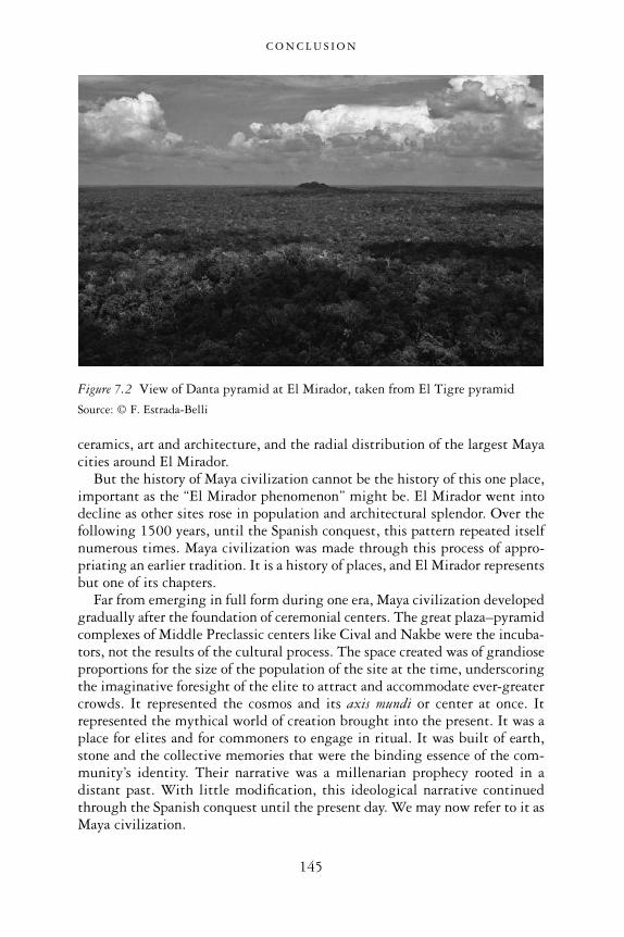
ceramics, art and architecture, and the radial distribution of the largest Mayacities around El Mirador.
But the history of Maya civilization cannot be the history of this one place,important as the “El Mirador phenomenon” might be. El Mirador went intodecline as other sites rose in population and architectural splendor. Over thefollowing 1500 years, until the Spanish conquest, this pattern repeated itselfnumerous times. Maya civilization was made through this process of appro-priating an earlier tradition. It is a history of places, and El Mirador representsbut one of its chapters.
Far from emerging in full form during one era, Maya civilization developedgradually after the foundation of ceremonial centers. The great plaza–pyramidcomplexes of Middle Preclassic centers like Cival and Nakbe were the incuba-tors, not the results of the cultural process. The space created was of grandioseproportions for the size of the population of the site at the time, underscoringthe imaginative foresight of the elite to attract and accommodate ever-greatercrowds. It represented the cosmos and its axis mundi or center at once. Itrepresented the mythical world of creation brought into the present. It was aplace for elites and for commoners to engage in ritual. It was built of earth,stone and the collective memories that were the binding essence of the com-munity’s identity. Their narrative was a millenarian prophecy rooted in adistant past. With little modification, this ideological narrative continuedthrough the Spanish conquest until the present day. We may now refer to it asMaya civilization.
C O N C L U S I O N
145
Figure 7.2 View of Danta pyramid at El Mirador, taken from El Tigre pyramid
Source: © F. Estrada-Belli

Where do we go from here?
In previous chapters I have been able to suggest the contours of these processesonly in broad brush strokes, adducing a minimum of detail from the archi-tecture and art of those few places that are fairly well documented. We finallyhave the perspective to see these large-scale processes. We can now also see howwe have made incredible progress since the publication of Origins of MayaCivilization in 1977. Then, the whole process of “origins” seemed obscure andunknowable, because the data were too fragmentary for scholars to connect thedots meaningfully. But today, with much more data, we have been able to pushback the founding dates of ceremonial centers and the beginnings of Mayacivilization, aligning it with the rest of early Mesoamerican history. And wealso have better theoretical frameworks to contextualize the function andmeaning of Preclassic Maya ritual centers.
Nevertheless, as great as recent discoveries at Cival, San Bartolo and ElMirador are, the most exciting new discoveries are surely still to come. Notonly does the built mass of El Mirador remain almost completely unexplored,but hundreds of other cities and sites of every size lie around the MiradorBasin, still untouched by archaeologists. At our current pace, the job of fullydocumenting even the most salient of these sites is daunting, partly becausethe tropical forest keeps them out of reach, partly because of lack of resourcesfor archaeology.
C O N C L U S I O N
146
Figure 7.3 Map of southern Lowlands showing known sites and unexplored areas innorthern Guatemala, southern Campeche and Quintana Roo
Source: © F. Estrada-Belli, Topographic data courtesy of NASA SRTM mission

Fortunately, new radar technology exists that can record ancient featuresbelow the forest canopy. If the promise of these techniques is realized, we willsoon be able to produce meter-by-meter maps of Maya settlement for most ofthe northern Peten area, which at present remains largely uncharted. This willbe an unprecedented data set that will generate a shockwave in Maya studiescomparable only to that brought about by the decipherment of hieroglyphs.Places like Cival, Holmul, San Bartolo, Cuello, Cerros and Nakbe have beenproductive for our understanding of early Maya civilization, but giant sites likeTintal, Wakna, Xulnal and dozens more lying undocumented in northernGuatemala and neighboring Mexican states hold an untold number of secrets.We will finally be able to branch out to the periphery of these early sites tocapture the life histories of the people who built them.
In short, we have only just begun to uncover ancient Maya civilization.Fortunately, for those who will study it, the best is yet to come.
C O N C L U S I O N
147
NOTES
1 MAYA CIVILIZATION IN PERSPECTIVE
1 Estimates vary depending on how one defines language difference. But accordingto Guatemalan linguist Sergio Romero (personal communication 2010) there arebetween 31 and 35 Maya languages.
2 These occurred in the wake of the explorations by pioneers of Maya archaeologysuch as Alfred Maudslay (1889–1902), Teobert Maler (1911), the Comte dePerigney and Thomas Gann (1926) a few decades before.
3 Natural well.4 The first elite burials in the North Acropolis (the preferred burial ground for Tikal
kings) date to the Late Preclassic (circa 1st century AD) and the last stelaedepicting the Tikal emblem glyph date to AD 889.
5 A katun is a 20-year period in the Maya Long Count.
4 PLANTING THE SEED OF CIVILIZATION
1 Beta-234440, Conventional radiocarbon age: 2670±40 BP, 2 Sigma calibratedresult: (95% probability) Cal BC 900 to 790 (Cal BP 2850 to 2740), 1 Sigmacalibrated result: (68% probability) Cal BC 840 to 800.
2 Beta-213528, Conventional radiocarbon age: 2520±40 BP, 2 Sigma calibratedresult: (95% probability) Cal BC 800 to 520, 1 Sigma calibrated results: (68%probability) Cal BC 790 to 760 and Cal BC 680 to 550.
3 The comparison of volumetric maps was done in 3D GIS analytical environmentusing open-source software: http://www.osgeo.org.
4 Beta-213528, Conventional radiocarbon age: 2520±40 BP, 2 Sigma calibratedresult: (95% probability) Cal BC 800 to 520, 1 Sigma calibrated results: (68%probability) Cal BC 790 to 760 and Cal BC 680 to 550. From a piece of charcoalrecovered from the floor (CIV.T08.43).
5 EARTH–MOUNTAIN–CAVES AND SKY–SERPENT–BIRDS
1 Its wings are often represented as serpents’ heads in profile, and are thus referredto as serpent-wings. Bardawil (1976) was the first to identify this composite beingand named it the Principal Bird Deity.
2 See Thompson (1950) for the identification of God N with Mam, and Thompson(1970) for identification of the same god with the bacabs—the four directionalgods supporting the sky. See also Taube (1992a) and Bassie-Sweet (2008) for adiscussion of the phonetic reading of God N’s name as pawatun. See Tozzer (1941:
148

137) for Mam and bacabs as aspects of pawatun in Colonial period Yucatan. For adiscussion of present-day Maya myths of death and rebirth associated withancestral gods, mountains and world trees, see also Carlsen and Prechtel (1991).
3 The turtle head interpretation is favored by this author based on direct obser-vation.
4 The turtle as earth and turtle shells are associated with the PBD in the West Wallmural of the Pinturas Sub1A structure at San Bartolo (see Taube 2009), where animage of the maize god wearing the PBD headdress is seen through a quatrefoil-shaped opening in the shell of a turtle, symbol of the underworld, playing a turtleshell drum accompanied by the rain god and the god of standing water. Turtleshells are also an important attribute of the old god as Itzamkanahk. See Altar 4 at Tikal (Jones and Satterthwaite 1982: Figure 58) for a depiction of an old godwith a turtle shell on his back emerging from a cave/witz monster; Stuart 2007afor a glyphic reading of the turtle shell as ahk as part of the old god’s name; andthe discussion of Holmul witz masks below.
5 Karl Taube and David Stuart suggest this motif means shining brilliance, and this character “shiner,” therefore associated with sky and solar brilliance. Taubebelieves the Cival mask represents this same variant of the solar deity (personalcommunication 2010; Leonard and Taube 2007).
6 As och b’ih, smoke rising from censers or bowls (or ear spools) appears to be equatedwith the rising soul of ancestors when it is depicted as serpents passing throughear spools with ancestors emerging from their mouth (Taube 2005: 45–47). Whendeity symbols (heads, headdresses or glyphic symbols) rest on the body of theemerging serpent, they represent gods being conjured (Taube 2005: 42, Figure18a).
7 See the Chalcatzingo “El Rey” Monument 1 rock carving for an even earlier(Middle Preclassic) example of the Mesoamerican notion of rain-clouds emanatingfrom mountains/caves/quatrefoils and ancestors or gods (Grove 2000: Figure 2,frontispiece).
8 See Taube (1992a) and Bassie-Sweet (2008) for a discussion of the phonetic read-ing of the God N portrait glyphs (T1014, T64:548 T64:528) as pawatun (but seeStuart 2007a for a challenge to this reading).
9 See note 4 above.10 God N’s portrait glyph paired with the signs for kan (yellow) and ahk (turtle) may
correspond to the name Itzamkanahk, known from Classic inscriptions and Yucateccolonial sources. See Stuart 2007a for a discussion of its phonetic reading andchallenge to the pawatun reading.
11 Beta-1995-70, Conventional radiocarbon age: 2170±40, 2 Sigma calibratedresult: (95% probability) Cal BC 360 to 90, 1 Sigma calibrated result: (68%probability) Cal BC 260 to 160. From a piece of charcol embedded in one of themasks’ stucco lining (calibrated with Oxcal v. 2.0).
12 Tikal Stela 29 remains the earliest Long Count date inscription with anarchaeologically documented provenience. Other unprovenienced sculptures ofslightly earlier date exist in private collections.
6 THE PRECLASSIC–CLASSIC MAYA TRANSITION: A NEW BEGINNING?
1 K’awiil is the Maya god of lightning, also known as God K. A sceptre known asthe God K sceptre or the manikin sceptre is an image of K’awiil. It has a humanbody, with one leg turning into a snake. The head is that a long-snouted animalwearing a mirror at the front. It emits smoke from a torch stuck in its mirror-like forehead. In Maya inscriptions the expression “he took the K’awiil” means the
N O T E S
149
king took office. “Eighteen are the snake heads” is a translation of the Maya nameUxaclajuun Ubah Kan. This is the name of the so-called “War Serpent” headdressoften worn by Maya kings and it is perhaps an allusion to the serpents’ heads onthe Pyramid of the Feathered Serpent at Teotihuacan (Stuart 2000a: 493). K’awiilwas to the Maya what Tlaloc was to Teotihuacaños: the god of rain and lightningand the symbol of absolute political power. While the “War Serpent” headdressadorned Teotihuacan’s Pyramid of the Feathered Serpent, the upper temple wasapparently decorated with Tlaloc imagery (Sugiyama 2005: 86).
2 Initially, he was thought to have been a Teotihuacan-born conqueror, based on theTeotihuacan iconography associated with him. Then Tikal was proposed becauseof the strong connection it had with Teotihuacan and because strontium isotopeanalysis of the bones of Yax K’uk Mo’ indicated that, in his early years, he had livedin the limestone environment of the Lowlands but never at Teotihuacan (Buikstraet al. 2004). However, Caracol has a strontium signature that denotes a limestone-rich environment, so it is also a match for the sample of Yax K’uk Mo’.
7 CONCLUSION
1 “Ethnic” here is used in the sense of a community of more intense interaction of peoplewithin its boundaries, but which also shares much of its cultural background withneighboring groups. An example of this concept can be applied to the linguisticallydistinct but largely culturally homogeneous Maya groups of present-day Mexico andGuatemala.
2 Here, “ethnic diversity” among Maya Classic period kingdoms relates to local (regionalor kingdom-specific) ideological narratives, including origin myths of dynasties,patron gods, certain rituals and sacred locations specific to the capital or landscape, notto linguistic differences.
N O T E S
150

REFERENCES
Adams, R. E. W. (1971) The Ceramics of Altar de Sacrificios. Cambridge, MA: HarvardUniversity Press.
—— (ed.) (1977) The Origins of Maya Civilization. Albuquerque: University of NewMexico Press.
Adams, R. E. W. and Culbert, T. P. (1977) “The Origins of Civilization in the MayaLowlands,” in: Adams, R. E. W. (ed.) The Origins of Maya Civilization. Albuquerque:University of New Mexico, 3–24.
Andrews, A. P. (1981a) “‘Guerrero’ de Loltun: comentario analítico.” Boletín de laEscuela de Ciencias Antropológicas de la Universidad de Yucatán, 8–9, 36–50.
Andrews, E. W. (1965) Progress Report on the 1960–64 Field Seasons: NationalGeographic–Tulane University Dzibilchaltun Program. New Orleans: Middle AmericanResearch Institute, Tulane University.
—— (1981b) “Komchen: An Early Maya Community in Northwest Yucatan.” Paperpresented at the Sociedad Mexicana de Antropología, San Cristobal, Chiapas, June21–27.
—— (1990) Early Ceramic History of the Lowland Maya. Albuquerque: University ofNew Mexico Press.
Andrews, E. W. and Hammond, N. (1990) “Redefinition of the Swasey Phase atCuello, Belize.” American Antiquity, 55, 570–584.
Andrews, E. W. and Ringle, W. M. (1992) “Mayas tempranos en Yucatán:investigaciones arqueológicas en Komchén.” Mayab, 8, 5–17.
Andrews, E. W. I. and Andrews, E. W. (1980) Excavations at Dzibilchaltun, Yucatan,Mexico. New Orleans: Middle American Research Institute, Tulane University.
Andrews, G. F. (1995) Pyramids and Palaces, Monsters and Masks: The Golden Age ofMaya Architecture: The Collected Works of George F. Andrews. Lancaster, CA:Labyrinthos.
Ashmore, W. and Knapp, A. B. (1999) Archaeologies of Landscape: ContemporaryPerspectives. Malden, MA: Blackwell.
Aveni, A. F., Dowd, A. S. and Vining, B. (2003) “Maya Calendar Reform? Evidencefrom Orientations of Specialized Architectural Assemblages.” Latin AmericanAntiquity, 14(2), 159–178.
Awe, J., 1992. Dawn in the Land between the Rivers: Formative Occupation at Cahal Pech,Belize and its Implications for Preclassic Development in the Maya Lowlands. Ph.D.Dissertation. University College, London.
151
Ball, J. W. (1977) “The Rise of the Northern Maya Chiefdoms: A SocioprocessualAnalysis,” in: Adams, R. E. W. (ed.) The Origins of Maya Civilization. Albuquerque:Univeristy of New Mexico, 101–132.
Bardawil, L. W. (1976) “The Principal Bird Deity in Maya Art: An Iconographic Study of Form and Meaning,” in: Greene Robertson, M. (ed.) Segunda Mesa Redondade Palenque, 1974. Peeble Beach, CA: Precolumbian Art Research Institute,195–209.
Bassie, K. (2002) “Maya Creator Gods.” Mesoweb. Online. Available from: <http://www.mesoweb.com/features/bassie/CreatorGods/CreatorGods.pdf> [accessed March2008].
Bassie-Sweet, K. (2008) Maya Sacred Geography and the Creator Deities. Norman:University of Oklahoma Press.
Bauer, J. (2005) “El Pasado Preclásico y Monumental de Holmul: Resultados de lasTemporadas de Excavación 2003 y 2004 en Cival, Petén,” in: Laporte, J. P.,Arroyo, B., Escobedo, H. L. and Mejia, H. E. (eds) XVIII Simposio de InvestigacionesArqueológicas en Guatemala. Guatemala: Ministerio de Cultura y Deporte, 201–214.
Beach, T., Dunning, N. P., Luzzadder-Beach, S. and Cook, D. E. (2006) “Impacts ofthe Ancient Maya on Soils and Soil Erosion in the Central Maya Lowlands.” Catena,65, 166–178.
Beach, T., Luzzadder-Beach, S., Dunning, N. and Cook, D. (2008) “Human andNatural Impacts on Fluvial and Karst Depressions of the Maya Lowlands.”Geomorphology, 101(1–2), 308–331.
Beliaev, D. (2000) “Wuk Tsuk and Oxlahun Tsuk: Naranjo and Tikal in the LateClassic,” in: Colas, P. R., Delvendahl, K., Kunhert, M. and Schubart, A. (eds) TheSacred and the Profane: Architecture and Identity in the Southern Maya Lowlands. 3rdEuropean Maya Conference, University of Hamburg, November 1998. Markt Schwaben:Verlag Anton Saurwein, 63–81.
Bellwood, P. S. (2005) First Farmers: The Origins of Agricultural Societies. Malden, MA:Blackwell.
Bey, G. J., III, Bond, T. M., Ringle, W. M., Hanson, C. A., Houck, C. W. and PerazaLope, C. (1998) “The Ceramic Chronology of Ek Balam, Yucatan, Mexico.” AncientMesoamerica, 9(1), 101–120.
Blanton, R. E., Kowalewski, S. A., Peregrine, P. N. and Feinman, G. M. (1996)“Dual-Processual Theory for the Evolution of Mesoamerican Civilization.” CurrentAnthropology, 37(1), 1–14.
Blom, F. (1924) “Report on the Preliminary Work at Uaxactun, Guatemala.” CarnegieInstitution of Washington Year Book, 23, 217–219.
Borhegyi, S. F. D. (1965) Archaeological Synthesis of the Guatemalan Highlands. Austin:University of Texas Press.
Brady, J. E., Ball, J. W., Bishop, R. L., Pring, D. C., Hammond, N. and Housley, R. A. (1998) “The Lowland Maya ‘Protoclassic’: A Reconsideration of its Natureand Significance.” Ancient Mesoamerica, 9(1), 17–38.
Braudel, F. (1986) La Méditerranée et le monde mediterranéen a l’époque de Philippe II. Paris:A. Colin.
Buikstra, J. E., Price, D. T., Wright, L. E. and Burton, J. A. (2004) “Tombs from theCopan Acropolis: A Life-History Approach,” in: Bell, E. E., Canuto, M. A. andSharer, R. J. (eds) Understanding Early Classic Copan. Philadelphia: University ofPennsylvania Museum of Archaeology and Anthropology, 191–212.
R E F E R E N C E S
152

Callaghan, M. G. (2006) “Cerámica del Proyecto Arqueológico Holmul, muestras de2004 y 2005,” in: Estrada-Belli, F. (ed.) Investigaciones arqueológicas en la region deHolmul, Petén, Guatemala. Informe preliminar de la temporada 2005. Boston, MA:Boston University, 225–328.
—— (2008) Technologies of Power: Ritual Economy and Ceramic Production in the Terminal Preclassic Period Holmul Region, Guatemala. Ph.D. Dissertation. VanderbiltUniversity.
Canuto, M. A. (2004) “The Rural Settlement of Copan: Changes through the EarlyClassic,” in: Bell, E. E., Canuto, M. A. and Sharer, R. J. (eds) Understanding EarlyClassic Copan. Philadelphia: University of Pennsylvania Museum of Archaeologyand Anthropology, 29–49.
Carlsen, R. S. and Prechtel, M. (1991) “The Flowering of the Dead: An Interpretationof Highland Maya Culture.” Man, 26(1), 23–42.
Carr, R. F. and Hazard, J. E. (1961) Map of the Ruins of Tikal, El Peten, Guatemala.Philadelphia: University Museum, University of Pennsylvania.
Carrasco, R. (1996) “Calakmul.” Arqueología Mexicana, 3(18), 46–51.Carrasco, R. and Colon, M. (2005) “El Reino de Kaan y la antigua ciudad maya de
Calakmul.” Arqueología Mexicana, 13(75), 40–47.Caso, A. (1947) Calendario y escritura de las antiguas culturas de Monte Alban. Mexico,
D.F.: Talleres de la Nacion.Chase, A. F. and Chase, D. Z. (1981) “Archaeological investigations at Nohmul and
Santa Rita, Belize: 1979–1980.” Mexicon, 3, 42–44.—— (1998) “Scale and Intensity in Classic Period Maya Agriculture: Terracing and
Settlement at the ‘Garden City’ of Caracol, Belize.” Culture and Agriculture,20(2–3), 60–77.
—— (1999) “External Impetus, Internal Synthesis, and Standardization: E-GroupAssemblages and the Cristallization of Classic Maya Society in the SouthernLowlands,” in: Grube, N. (ed.) The Emergence of Lowland Maya Civilization. MarktSchwaben: Verlag Anton Surwein, 87–102.
—— (2001) “Ancient Maya Causeways and Site Organization at Caracol, Belize.”Ancient Mesoamerica, 12(2), 273–281.
Cheetham, D. (1998) Interregional Interaction, Symbol Emulation, and the Emergence ofSocio-Political Inequality in the Central Maya Lowlands. MA Thesis. University ofBritish Columbia.
—— (2005) “Cunil: A Pre-Mamom Horizon in the Southern Maya Lowlands,” in:Powis, T. (ed.) New Perspectives on Formative Mesoamerican Cultures. Oxford:Archaeopress, 27–38.
Childe, V. G. (1929) The Danube in Prehistory. Oxford: Clarendon Press.Christenson, A. J. (2000) Popol Vuh: The Mythic Sections. Provo, UT: Brigham Young
University Press.Clark, J. E. and Cheetham, D. (2002) “Mesoamerica”s Tribal Foundations,” in:
Parkinson, W. A. (ed.) The Archaeology of Tribal Societies. Ann Arbor: InternationalMonographs in Prehistory, 278–339.
Clark, J. E. and Hansen, R. D. (2001) “The Architecture of Early Kingship:Comparative Perspective and the Origins of the Maya Royal Court,” in: Inomata,T. and Houston, S. D. (eds) Royal Courts of the Ancient Maya. Boulder, CO:Westview Press, 1–45.
Clark, J. E., Hansen, R. D. and Perez Suarez, T. (2000) “La Zona Maya en el
R E F E R E N C E S
153

Preclasico,” in: Manzanilla, L. and Lopez Lujan, L. (eds) Historia antigua de México:Volumen 1: El México antiguo, sus áreas culturales, los origenes, y el horizonte Preclásico.Mexico, D.F.: Instituto de Antropología e Historia, 437–510.
Clark, J. E. and Pye, M. E. (2000) Olmec Art and Archaeology in Mesoamerica.Washington, D.C., and New Haven, CT: National Gallery of Art and YaleUniversity Press.
Cobos, R. (2003) “Ancient Community Form and Social Complexity at Chichen Itza,Yucatan = Antiguas formas de comunidad y complejidad social en Chichen Itzá,Yucatán,” in: Sanders, W. T., Mastache, A. G. and Cobean, R. H. (eds) Urbanismoen Mesoamérica = Urbanism in Mesoamerica. Mexico, D.F.: Instituto de Antropologíae Historia, 451–472.
—— (2004) “Chichén Itzá: Settlement and Hegemony during the Terminal ClassicPeriod,” in: Demarest, A. A., Rice, P. M. and Rice, D. S. (eds) The Terminal Classicin the Maya Lowlands: Collapse, Transition and Transformation. Boulder: UniversityPress of Colorado, 517–544.
Coe, M. D. (1966) The Maya. 1st edn. New York: Thames & Hudson.—— (2005) The Maya. 7th edn. New York: Thames & Hudson.Coe, W. R. (1965) “Tikal, Guatemala, and Emergent Maya Civilization.” Science,
147(3664), 1401–1419.—— (1990) Excavations in the Great Plaza, North Terrace, and Acropolis of Tikal.
Philadelphia: University Museum, University of Pennsylvania.Coggins, C. (1975) Painting and Drawing Styles at Tikal: An Historical and
Iconographical Reconstruction. Ph.D. Dissertation. Harvard University.—— (1980) “The Shape of Time: Some Political Implications of a Four-Part Figure.”
American Antiquity, 45(4), 727–739.—— (in press) “The Measure of Man,” in: Urton, G. and Ruggles, C. (eds)
Cultural Astronomy in New World Cosmologies. Boulder: University Press ofColorado.
Colas, P. R., Helmke, C. G. B., Awe, J. J. and Powis, T. G. (2002) “Epigraphic andCeramic Analyses of Two Early Classic Maya Vessels from Baking Pot, Belize.”Mexicon, 2, 33–39.
Covarrubias, M. (1946) Mexico South, the Isthmus of Tehuantepec. 1st edn. New York: A. A. Knopf.
Cowgill, U. M., Hutchinson, G. E., Racek, A. A., Goulden, C. E., Patrick, R. andTsukada, M. (1966) The History of Laguna de Petenxil, a Small Lake in NorthernGuatemala. New Haven: Connecticut Academy of Arts and Sciences.
Culbert, P. T. (ed.) (1973) The Classic Maya Collapse. Albuquerque: University of NewMexico Press.
Culbert, T. P. (1977) “Early Maya Development at Tikal, Guatemala,” in: Adams, R. E. W. (ed.) The Origins of Maya Civilization. Albuquerque: University of NewMexico Press, 27–43.
—— (1993) The Ceramics of Tikal. Philadelphia: University Museum, University ofPennsylvania.
Demarest, A. A. (1984) “The Harvard El Mirador Project, l982–l983: PreclassicCeramics of El Mirador: Preliminary Results and Ongoing Analysis.” Mesoamerica,5(7), 53–92.
—— (1993) “The Violent Saga of a Maya Kingdom.” National Geographic, 183(2),94–111.
R E F E R E N C E S
154

—— (1997) “The Vanderbilt Petexbatun Regional Archaeological Project1989–1994: Overview, History, and Major Results of a Multidisciplinary Study ofthe Classic Maya Collapse.” Ancient Mesoamerica, 8(2), 209–227.
Demarest, A. A., Rice, P. M. and Rice, D. S. (2004) The Terminal Classic in the MayaLowlands: Collapse, Transition, and Transformation. Boulder: University Press ofColorado.
Diehl, R. A. (2004) The Olmecs: America’s First Civilization. New York: Thames &Hudson.
Dull, R. A., Southon, J. R. and Sheets, P. (2001) “Volcanism, Ecology and Culture:A Reassessment of the Volcan Ilopango TBJ Eruption in the Southern MayaRealm.” Latin American Antiquity, 12(1), 25–44.
Estrada-Belli, F. (2001) “Maya Kingship at Holmul, Guatemala.” Antiquity, 75(290),685–686.
—— (2002a) “Anatomía de una ciudad Maya: Holmul. Resultados de investigacionesarqueológicas en 2000 y 2001.” Mexicon, 24(5), 107–112.
—— (2002b) Investigaciones arqueológicas en la region de Holmul, Petén, Guatemala.Informe preliminar de la temporada 2002. Boston University. Online. Available from:<http://www.bu.edu/holmul/reports/>.
—— (2003a) “Anatomia de Holmul: Su ciudad y territorio,” in: Laporte, J. P., Arroyo,B., Escobedo, H. and Mejía, H. (eds) XVI Simposio de Investigaciones de Arqueología deGuatemala. Guatemala: Museo Nacional de Arqueología y Etnología, 265–274.
—— (2003b) “La Pintura mural de la Sufricaya.” La Pintura Mural Prehispánica enMexico. Buletín Informativo, 9(18), 38–42.
—— (2004) Investigaciones arqueológicas en la region de Holmul, Petén, Guatemala. Informepreliminar de la temporada 2004. Boston University. Online. Available from:<http://www.bu.edu/holmul/reports/>.
—— (2006) Investigaciones arqueológicas en la region de Holmul, Petén, Guatemala. Informepreliminar de la temporada 2005. Boston University. Online. Available from: <http://www.bu.edu/holmul/reports/>.
—— (2008) Investigaciones Arqueológicas en la region de Holmul, Peten, Guatemala. Informepreliminar de la temporada 2007. Boston University. Online. Available from: <http://www.bu.edu/holmul/reports/>.
—— (2009) Investigaciones Arqueológicas en la region de Holmul, Peten, Guatemala. Informepreliminar de la temporada 2008. Boston University. Online. Available from:<http://www.bu.edu/holmul/reports/>.
Estrada-Belli, F., Grube, N., Wolf, M., Gardella, K. and Guerra-Librero, C. (2003a)“Preclassic Maya Monuments and Temples at Cival, Petén, Guatemala.” Antiquity.Online. Available from: <http://antiquity.ac.uk/ ProjGall/belli/belli.html>.
Estrada-Belli, F., Bauer, J., Morgan, M. and Chavez, A. (2003b) “Symbols of EarlyMaya Kingship at Cival, Petén, Guatemala.” Antiquity. Online. Available from:<http://antiquity.ac.uk/ProjGall/estrada_belli/ index.html>.
Estrada-Belli, F., Tokovinine, A., Foley, J., Heather, H., Ware, G., Stuart, D. andGrube, N. (2009) “A Maya Palace at Holmul, Peten, Guatemala and theTeotihuacan ‘Entrada’: Evidence from Murals 7 and 9.” Latin American Antiquity,20(2), 228–259.
Estrada-Belli, F. and Koch, M. (2007) “Remote Sensing and GIS Analysis of a MayaCity and its Landscape: Holmul, Guatemala,” in: Wiseman, J. R. and El-Baz, F.(eds) Remote Sensing in Archaeology. New York: Plenum Press.
R E F E R E N C E S
155

Estrada-Belli, F., Neivens De Estrada, N. and Wahl, D. (2007) “Prehistoric Human–Environment Interactions in the Maya Lowlands: The Holmul Region’s case.”Paper presented at 73rd Annual Meeting of the Society for American Archaeology,Austin, TX.
Fahsen, F. (2001) “From Chiefdoms to Statehood in the Highlands of Guatemala,” in:Grube, N. (ed.) Maya: Divine Kings of the Rain Forest. Cologne: Koenneman, 86–95.
Fash, W. L., Tokovinine, A. and Fash, B. W. (2009) “The House of New Fire atTeotihuacan and its Legacy in Mesoamerica,” in: Fash, W. L. and Lopez Lujan, L.(eds) The Art of Urbanism: How Mesoamerican Kingdoms Represented Themselves inArchitecture and Imagery. Washington, D.C.: Dumbarton Oaks Research Library andCollections, 201–229.
Fields, V. M. (1986) “Iconographic Heritage of the Maya Jester God,” in: Fields, V.M. (ed.) Sixth Palenque Round Table. Norman: University of Oklahoma Press,167–174.
Flannery, K. V. and Marcus, J. (1994) Early Formative Pottery of the Valley of Oaxaca.Ann Arbor: Museum of Anthropology, University of Michigan.
Folan, W. J., Fletcher, L. A., May Hau, J. and Florey Folan, L. (2001) Las ruinas deCalakmul, Campeche, México: un lugar central y su paisaje cultural. Campeche:Universidad Autónoma de Campeche, Centro de Investigaciones Históricas ySociales.
Folan, W. J., Kintz, E. R. and Fletcher, L. A. (1983) Cobá, a Classic Maya Metropolis.New York: Academic Press.
Ford, A. (1986) Population Growth and Social Complexity: An Examination of Settlementand Environment in the Central Maya Lowlands. Tempe: Arizona State University.
Foster, L. and Wren, L. (1996) “World Creator and World Sustainer: God N atChichen Itzá,” in: Marcri, M. J. and Mchargue, J. (eds) Eight Palenque Round Table,1993. San Francisco: The Pre-Columbian Art Research Institute.
Freidel, D. A. (1982) “The Maya City of Cerros.” Archaeology, 35(4), 12–21.—— (1985) “New Light on the Dark Age: A Summary of Major Themes,” in: Chase,
A. F. and Rice, P. M. (eds) Lowland Maya Postclassic. Austin: University of TexasPress, 285–310.
—— (1986) “The Monumental Architecture,” in: Robertson, R. and Freidel, D. A.(eds) Archaeology at Cerros, Belize. Central America. Volume I: An Interim Report. Dallas,TX: Southern Methodist University Press, 1–22.
Freidel, D. A., Reese-Taylor, K. and Mora-Marín, D. (2002) “The Origins of MayaCivilization: The Old Shell Game, Commodity, Treasure and Kinship,” in:Masson, M. A. and Freidel, D. A. (eds) Ancient Maya Political Economies. WalnutCree, CA: Altamira Press, 41–87.
Freidel, D. A. and Schele, L. (1988) “Kingship in the Late Preclassic Maya Lowlands:The Instruments and Places of Ritual Power.” American Anthropologist, 90(3),547–567, ill.
Freidel, D. A., Schele, L. and Parker, J. (1993) Maya Cosmos: Three Thousand Years onthe Shaman’s Path. New York: Morrow and Co.
Fuentes Y Guzmán, F. A. D., Villacorta, C. J. A., Salazar, R. A. and Aguilar, S. (1932)Recordación Florida. Discurso historial y demostración natural, material, militar y políticadel reyno de Guatemala. Guatemala: Tipografía nacional.
Gann, T. W. F. (1926) Ancient Cities and Modern tribes: Exploration and Adventure inMaya Lands. New York: Charles Scribner’s Sons.
R E F E R E N C E S
156

Garber, J. F., Brown, K. M., Awe, J. and Hartman, C. (2004) “Middle FormativePrehistory of the Central Belize Valley: An Examination of Architecture, MaterialCulture, and Sociopolitical Change at Blackman Eddy,” in: Garber, J. F. (ed.) TheAncient Maya of the Belize Valley: Half a Century of Archaeological Research. Gainsville:University Press of Florida, 25–47.
Gifford, J. (1965) “Ceramics,” in: Willey, G. R., Bullard, W. R., Glass, J. B. andGifford, J. (eds) Prehistoric Maya Settlement Patterns in the Belize Valley. Cambridge,MA: Peabody Museum of Archaeology and Ethnology, Harvard University.
Gill, R. B. (2000) The Great Maya Droughts: Water, Life, and Death. Albuquerque:University of New Mexico Press.
Girard, R. (1966) Los Mayas: su civilizacion, su historia, sus vinculaciones continentales.Mexico, D.F.: Libro Mex.
Golden, C., Scherer, A. K., Muñoz, A. R. and Vásquez, R. (2008) “Piedras Negras andYaxchilan: Divergent Political Trajectories in Adjacent Maya Polities.” LatinAmerican Antiquity, 3, 249–274.
Graham, J. A., Heizer, R. F. and Shook, E. M. (1978) Abaj Takalik 1976: ExploratoryInvestigations. Berkeley: University of California Archaeological Research Facility.
Grove, D. C. (2000) “Faces of the Earth at Chalcatzingo, Mexico: Serpents, Caves, andMountains in Middle Formative Period Iconography,” in: Clark, J. E. (ed.) OlmecArt and Archaeology. Washington. D.C.: National Gallery of Art, 277–295.
Grube, N. (2003) “Monumentos jeroglíficos de Holmul, Petén, Guatemala,” in: Laporte,J. P., Arroyo, B. Escobedo, H. and Mejía, H. (eds) XVI Simposio de Investigaciones deArqueología de Guatemala. Guatemala: Museo Nacional de Arqueología y Etnología,701–710.
—— (2004) “La Historia Dinastica de Naranjo, Peten.” Beitrage zur Allgemeinen undVergleichenden Archaeologie, 24, 197–213.
Grube, N. and Paap, I. (2008) “La exploración de Uxul, Petén Campechano: resultadosde las investigaciones en el 2007,” in: Los investigadores de la cultura Maya.Campeche: Universidad Autonoma de Campeche, 267–287.
Guernsey, J. (2006) Ritual & Power in Stone: The Performance of Rulership in MesoamericanIzapan Style Art. Austin: University of Texas Press.
Guernsey Kappelman, J. and Reilly, K. F. (2001) “Paths to Heaven, Ropes to Earth:Birds, Jaguars and Cosmic Cords in Formative Mesoamerica.” Ancient America, (2),1–52.
Hammond, N. (1973) British Museum–Cambridge University Corazal Project, 1973Interim Report. Cambridge: Cambridge University Centre of Latin AmericanStudies.
—— (1974) “Preclassic to Postclassic in Northern Belize.” Antiquity, 48, 177–189.—— (ed.) (1977) Social Process in Maya Prehistory: Studies in Honour of Sir Eric Thompson.
London: Academic Press.—— (1980) “Early Maya Ceremonial at Cuello, Belize.” Antiquity, 54(212), 176–190.—— (1982) Ancient Maya Civilization. New Brunswick, NJ: Rutgers University
Press.—— (1985) Nohmul, a Prehistoric Maya Community in Belize: Excavations, 1973–1983.
Oxford: BAR.—— (1992) “Preclassic Maya Civilization,” in: Danien, E. C. and Sharer, R. J. (eds)
New Theories on the Ancient Maya. Philadelphia: University Museum of Archaeologyand Anthropology, University of Pennsylvania, 137–144.
R E F E R E N C E S
157
Hammond, N., Estrada-Belli, F. and Clarke, A. (1992) “Middle Preclassic MayaBuildings and Burials at Cuello, Belize.” Antiquity, 66(253), 955–964.
Hammond, N., Pring, D., Berger, R., Switzer, V. R. and Ward, A. P. (1976)“Radiocarbon Chronology for Early Maya Occupation at Cuello, Belize.” Nature,44, 92–110.
Hansen, R. (1990) Excavations in the Tigre Complex, El Mirador, Petén, Guatemala.Provo, UT: New World Archaeological Foundation, Brigham Young University.
—— (1991) “Resultados preliminares de las investigaciones arqueológicas en el sitioNakbé, Petén, Guatemala,” in: Laporte, J. P. and Escobedo, H. L. (eds) II Simposiode Investigaciones Arqueológicas en Guatemala: Museo Nacional de Arqueología yEtnología, 1988. Guatemala: Ministerio de Cultura y Deportes, Asociación Tikal,IDAEH, 160–174.
—— (1992) The Archaeology of Ideology: A Study of Maya Preclassic Architectural Sculptureat Nakbe, Peten, Guatemala. Ph.D. Thesis. University of California.
—— (1998) “Continuity and Disjunction: The Preclassic Antecedents of Pre-ClassicMaya Architecture,” in: Houston, S. D. (ed.) Function and Meaning in Classic MayaArchitecture. Washington, D.C.: Dumbarton Oaks.
—— (2001) “The First Cities—The Beginnings of Urbanization and State Formationin the Maya Lowlands,” in: Grube, N. (ed.) Maya: Divine Kings of the Rain Forest.Cologne: Koenneman, 51–64.
—— (2005) “Perspectives on Olmec–Maya Interaction in the Middle FormativePeriod,” in: Powis, T. (ed.) New Perspectives on Formative Mesoamerican Cultures.Oxford: Archaeopress, 51–72.
Hansen, R. and Guenter, S. P. (2005) “Early Social Complexity and Kingship in theMirador Basin,” in: Fields, V. M. and Reents-Budet, D. (eds) Lords of Creation: TheOrigins of Sacred Maya Kinship. Los Angeles: Los Angeles County Museum of Art,60–61.
Hansen, R. D., Bozarth, S., Jacob, J., Wahl, D. and Schreiner, T. (2002) “Climaticand Environmental Variability in the Rise of Maya Civilization: A PreliminaryPerspective from the Northern Peten.” Ancient Mesoamerica, 13, 273–295.
Hansen, R. D., Fahsen, F. and Bishop, R. L. (1991) “Notes on Maya Codex-StyleCeramics from Nakbe, Peten, Guatemala.” Ancient Mesoamerica, 2(2), 225–243.
Hansen, R. D., Howell, W. K. and Guenter, S. P. (2008a) “Forgotten Structures,Haunted Houses, and Occupied Hearts: Ancient Perspectives and ContemporaryInterpretations of Abandoned Sites and Buildings in the Mirador Basin,Guatemala,” in: Stanton, T. W. and Mignoni, A. (eds) Ruins of the Past: The Use andPerception of Abandoned Structures in the Maya Lowlands. Boulder: University Press ofColorado, 25–64.
Hansen, R. D., Suyuc, E. and Mejia, H. (2008b) Mirador Basin 2008: A Field Reportof the 2008 Season. Palo Alto, CA: Global Heritage Fund.
Haug, G. H., Gunther, D., Petersen, L. C., Sigman, D. M., Hughen, K. A. andAeschlimann, B. (2003) “Climate and the Collapse of Maya Civilization.” Science,299(5613), 1731–1735.
Healy, P. F., Cheetham, D., Powis, T. and Awe, J. (2004a) “Cahal Pech, Belize: TheMiddle Formative Period,” in: Garber, J. F. (ed.) The Ancient Maya of the BelizeValley: Half a Century of Archaeological Research. Gainsville: University of FloridaPress, 103–124.
Healy, P. F., Hohmann, B. and Powis, T. (2004b) “The Ancient Maya Center of
R E F E R E N C E S
158

Pacbitun,” in: Garber, J. F. (ed.) The Ancient Maya of the Belize River Valley: Half aCentury of Archaeological Research. Gainsville: University Press of Florida, 207–228.
Hermes, B. (1993) “Dos reportes del laboratorio cerámico: vasijas miniatura yadiciones tipológicas para la Epoca Preclásica,” in: Laporte, J. P. and Valdés, J. A.(eds) Tikal y Uaxactun en el Preclásico. Mexico, D.F.: Universidad NacionalAutonoma de Mexico, 47–52.
Hodell, D. A., Curtis, J. H. and Brenner, M. (1995) “Possible Role of Climate in theCollapse of Classic Maya Civilization.” Nature, 375, 391–394.
Houston, S. (1993) Hieroglyphs and History at Dos Pilas: Dynastic Politics of the ClassicMaya. Austin: University of Texas Press.
Hurst, H. (2005) “San Bartolo, Petén: Técnicas de pintura mural del PreclásicoTardío,” in: Laporte, J. P., Arroyo, B. and Mejía, H. E. (eds) XVIII Simposio deInvestigaciones Arqueológicas en Guatemala, 2004. Guatemala: Ministerio de Culturay Deportes, Asociacion Tikal, IDAEH, FAMSI, 639–646.
Inomata, T., Triadan, D., Ponciano, E., Pinto, E., Terry, R. E. and Eberl, M. (2002)“Domestic and Political Lives of Classic Maya Elites: The Excavation of RapidlyAbandoned Structures at Aguateca, Guatemala.” Latin American Antiquity, 3,305–330.
Jacob, J. S. (1995) “Archaeological Pedology in the Maya Lowlands,” in: Collins, M. E., Carter, B. J., Gladfelter, B. G. and Southard, R. J. (eds) Pedological Perspectivesin Archaeological Research. Madison, WI: Soil Science Society of America, 51–80.
Jiménez Moreno, W. (1966) “Mesoamerica before the Toltecs,” in: Paddock, J. (ed.)Ancient Oaxaca. Stanford, CA: Stanford University Press, 1–82.
Jones, C. (1991) “Cycles of Growth at Tikal,” in: Culbert, T. P. (ed.) Classic MayaPolitical History. Cambridge: Cambridge University Press, 102–128.
Jones, C. and Satterthwaite, L. (1982) The Monuments and Inscriptions of Tikal: The Carved Monuments. Philadelphia: University of Pennsylvania Museum ofArchaeology and Anthropology.
Jones, G. D. (1998) The Conquest of the Last Maya Kingdom. Stanford, CA: StanfordUniversity Press.
Joralemon, P. D. (1971) A Study of Olmec Iconography. Washington, D.C.: DumbartonOaks Research Library and Collections.
Joyce, R. (1980) “Crossed Bands in Olmec, Maya and Izapa Art.” Paper presented atMeeting of Midwestern Mesoamericanists, University of Iowa, Iowa City.
Justeson, J. S., Norman, W. M. and Hammond, N. (1988) “The Pomona Flare: APreclassic Maya Hieroglyphic Text,” in: Benson, E. and Griffin, G. (eds) MayaIconography. Princeton, NJ: Princeton University Press, 94–151.
Kidder, A. V. (1950) “Introduction,” in: Smith, A. L. (ed.) Uaxactun, Guatemala:Excavations of 1931–1937. Washington, D.C.: Carnegie Institution of Washington,1–12.
Kidder, A. V., Jennings, J. D. and Shook, E. M. (1946) Excavations at Kaminaljuyu.Washington, D.C.: Carnegie Institution of Washington.
Knapp, A. B. (1992a) “Archaeology and Annales: Time, Space, and Change,” in:Knapp, A. B. (ed.) Archaeology, Annales, and Ethnohistory. Cambridge: CambridgeUniversity Press, 1–21.
—— (1992b) Archaeology, Annales and Ethnohistory. Cambridge: Cambridge UniversityPress.
Kolb, M. J. and Snead, J. E. (1997) “It’s a Small World after All: Comparative
R E F E R E N C E S
159

Analyses of Community Organization in Archaeology.” American Antiquity, 62(4),609–628.
Kosakowsky, L. J. (1987) Preclassic Maya Pottery at Cuello, Belize. Tucson: Universityof Arizona Press.
Kosakowsky, L. J. and Pring, D. (1991) “Ceramic Chronology and Typology,” in:Hammond, N. (ed.) Cuello: An Early Maya Community in Belize. Cambridge:Cambridge University Press, 60–69.
—— (1998) “The Ceramcis of Cuello, Belize: A New Evaluation.” Ancient Mesoamerica,9(1), 55–66.
Krejci, E. and Culbert, T. P. (1999) “Preclassic and Classic Burials and Caches in theMaya Lowlands,” in: Grube, N. (ed.) The Emergence of Lowland Maya Civilization.Markt Schwaben: Verlag Anton Saurwein, 103–116.
Kunen, J. L., Culbert, T. P., Fialko, V. Mckee, B. R. and Grazioso, L. (2000) “BajoCommunities: A Case Study from the Central Peten.” Culture & Agriculture, 22(3),15–31.
Laporte, J. P., Hermes, B., Zea, L. D. and Iglesias, M. J. (1992) “Nuevos Entierros yEscondites de Tikal, Subfases Manik 3a y 3b,” in: Kirkpatrick, M. and Gifford, C.A. (eds) Ceramica de Cultura Maya et al. Philadelphia: Laboratory of Anthropology,Temple University, 30–68.
Laporte, J. P. and Fialko, V. (1990) “New Perspectives on Old Problems: DynasticReferences for the Early Classic Maya,” in: Clancy, F. S. and Harrison, P. D. (eds)Vision and Revision in Maya Studies. Albuquerque: University of New Mexico Press,33–66.
—— (1993) “El Preclásico de Mundo Perdido: Algunos aportes sobre los orígenes deTikal,” in: Laporte, J. P. and Valdés, J. A. (eds) Tikal y Uaxactun en el Preclásico.Mexico, D.F.: Universidad Nacional Autonoma de Mexico, 9–47.
Laporte, J. P. and Valdés, J. A. (1993) Tikal y Uaxactun en el Preclasico. Mexico, D.F.:Universidad Nacional Autonoma de Mexico.
Leonard, D. and Taube, K. A. (2007) “The God C Variant: A Reappraisal.” Paperpresented at the 72nd Annual Meeting for the Society for American Archaeology,Austin, TX, April 26.
Lohse, J. C., Awe, J., Griffith, C., Rosenwig, R. M. and Valdez, F. Jr (2006)“Preceramic Occupations in Belize: Updating the Paleoindian and ArchaicRecord.” Latin American Antiquity, 17(2), 209–226.
Looper, M. G. (2003) Lightning Warrior: Maya Art and Kingship at Quirigua. 1st edn.Austin: University of Texas Press.
Loten, H. S. (2007) Additions and Alterations: A Commentary on the Architecture of theNorth Acropolis, Tikal, Guatemala. Philadelphia: University of PennsylvaniaMuseum of Archaeology and Anthropology.
Lowe, G. W. (1977) “The Mixe-Zoque as Competing Neighbors of the Early LowlandMaya,” in: Adams, R. E. W. (ed.) Origins of Maya Civilization. Albuquerque:University of New Mexico Press, 197–248.
—— (1981) “Olmec Horizons Defined in Mound 20, San Isidro, Chiapas,” in: Benson,E. (ed.) Olmec and Their Neighbors. Washington, D.C.: Dumbarton Oaks, 231–255.
—— (1989) “Algunas aclaraciones sobre la presencia olmeca y maya en el Preclásicode Chiapas,” in: Macias, M. C. (ed.) Preclásico o Formativo: Avances y Perspectivas.Mexico, D.F.: Museo Nacional de Antropología, Instituto Nacional de Antroplogíae Historia, 363–383.
R E F E R E N C E S
160

Maler, T. (1911) Explorations in the Department of Peten, Guatemala, Tikal. Cambridge,MA: Peabody Museum of Archaeology and Ethnology, Harvard University.
Manahan, T. K. (2004) “The Way Things Fall Apart: Social Organization and theClassic Maya Collapse of Copan.” Ancient Mesoamerica, 1, 107–125.
Marcus, J. (1992) Mesoamerican Writing Systems: Propaganda, Myth, and History in FourAncient Civilizations. Princeton, NJ: Princeton University Press.
—— (1993) “Ancient Maya Political Organization,” in: Sabloff, J. and Henderson, J.(eds) Lowland Maya Civilization in the Eighth Century AD. Washington, D.C.:Dumbarton Oaks, 111–183.
Martin, S. (2003) “In Line of the Founder: A View of Dynastic Politics at Tikal,” in:Sabloff, J. A. (ed.) Tikal: Dynasties, Foreigners, and Affairs of State. Santa Fe, NM:School of American Research Press.
—— (2005) “Of Snakes and Bats: Shifting Identities at Calakmul.” The PARI Journal.Online. Available from: <http://www.mesoweb.com/pari/publications/journal/602/SnakesBats_e.pdf> [Accessed April 2009].
—— (2006) “The Great Sustainer: God N in Ancient Maya Religion.” Paperpresented at the Maya Weekend, University of Pennsylvania Museum ofArchaeology and Anthropology.
Martin, S. and Grube, N. (2000) Chronicle of the Maya Kings and Queens: DecipheringDynasties of the Ancient Maya. London: Thames & Hudson.
—— (2008) Chronicle of the Maya Kings and Queens: Deciphering the Dynasties of theAncient Maya. 2nd edn. London: Thames & Hudson.
Matheny, R. T., Hansen, R. D., Gurr, D. L. and Matheny, R. T., (1980) PreliminaryField Report, El Mirador, 1979 Season Update, Project El Mirador, Peten, Guatemala.Provo, UT: New World Archaeological Foundation.
Maudslay, A. P. (1889–1902) Biologia Centrali-Americana: Archaeology. London: R. H.Porter and Dulau & Co.
McAnany, P. A. and Yoffee, N. (2008) Questioning Collapse: Human Resilience, EcologicalVulnerability, and the Aftermath of Empire. Cambridge: Cambridge University Press.
Merwin, R. E. and Vaillant, G. (1932) The Ruins of Holmul. Cambridge, MA: PeabodyMuseum of American Archaeology and Ethnology, Harvard University.
Mora-Marín, D. (2005) “Kaminljuyu Stela 1: Script Classification and LinguisticAffiliation.” Ancient Mesoamerica, 16(1), 63–87.
Morley, S. G. (1920) The Inscriptions at Copan. Washington, D.C.: The CarnegieInstitution of Washington.
—— (1943) “Archaeological Investigations of the Carnegie Institution ofWashington in the Maya Area of Middle America, during the Past Twenty-EightYears.” Proceedings of the American Philosophical Society, 86(2), 205–219.
—— (1946) The Ancient Maya. Palo Alto, CA: Stanford University Press.Nalda, E. (2003) “Prácticas funerarias en Dzibanché, Quintana Roo: los entierros en
el Edificio de los Cormoranes.” Arqueología, 31, 25–37.Neff, H., Pearsall, D. M., Jones, J. G., Arroyo, B., Collins, S. K. and Freidel, D. E.
(2006) “Early Maya Adaptive Patterns: Mid–Late Holocene PaleoenvironmentalEvidence from Pacific Guatemala.” Latin American Antiquity, 17(3), 287–315.
Norman, G. V. (1973) Izapa Sculpture. Part I: Album. Provo, UT: Brigham YoungUniversity Press.
Parsons, L. A. (1986) The Origins of Maya Art: Monumental Sculpture of Kaminaljuyú,
R E F E R E N C E S
161
Guatemala and the Southern Pacific Coast. Washington, D.C.: Dumbarton OaksResearch Library and Collections.
Pauketat, T. R. (2007) Chiefdoms and Other Archaeological Delusions. Lanham, MD:AltaMira Press.
Pazstory, E. (1997) Teotihuacan. An Experiment in Living. Norman: University ofOklahoma Press.
Peebles, C. S. (1990) “From History to Hermeneutics: The Place of Theory in the LaterPrehistory of the Southeast.” Southeastern Archaeology, 9(1), 23–34.
Pellecer, M., (2006) “El Grupo Jabalí: un complejo arquitectónico de patrón triadicoen San Bartolo, Peten,” in: Laporte, J. P., Arroyo, B. and Mejía, H. E. (eds) XIXSimposio de Investigaciones Arqueológicas en Guatemala, 2005. Guatemala: Ministeriode Cultura y Deportes, Asociación Tikal, Fundación Reinhart, 937–948.
Pendergast, D. M. (1971) “Evidence of Early Teotihuacan Lowland Maya Contact atAltun Ha.” American Antiquity, 36(4), 455–460.
—— (1981) “Lamanai, Belize: Summary of Excavation Results, 1974–1980.” Journalof Field Archaeology, 8(1), 29–53, ill.
Pohl, M. D., Pope, K. O., Jones, J. G., Jacob, J. S., Piperno, D. R., Defrance, S. D.,Lentz, D., Gifford, J. A., Denforth, M. E. and Josserand, K. J. (1996) “EarlyAgriculture in the Maya Lowlands.” Latin American Antiquity, 7, 355–372.
Pohl, M. E. D., Pope, K. O. and Nagy, C. V. (2002) “Olmec Origins of MesoamericanWriting.” Science, 298(5600), 1984–1987.
Pollock, H. E. D., Roys, R. R., Proskouriakoff, T. and Smith, A. L. (1962) Mayapan,Yucatan, Mexico. Washington, D.C.: Carnegie Institution of Washington.
Popenoe de Hatch, M. (2002) “Evidencia de un observatorio astronomico en AbajTakalik,” in: Laporte, J. P., Arroyo, B. and Escobedo, H. L. (eds) XV Simposio de Investigaciones Arqueológicas en Guatemala. Guatemala: Museo Nacional deArqueología y Etnología, 437–458.
Popenoe Hatch, M. (1997) Kaminaljuyu/San Jorge. Evidencia Arqueologica de la ActividadEconomica en el Valle de Guatemala 300 a.C. a 300 d.C. Guatemala City: Universidaddel Valle de Guatemala.
Pring, D. (1977) “Influence or Intrusion? The ‘Protoclassic’ in the Maya Lowlands,”in: Hammond, N. (ed.) Social Process in Maya Prehistory. New York: Academic Press,135–165.
—— (1979) “The Swasey Complex of Northern Belize: A Definition and Discussion,”in: Graham, J. A. (ed.) Studies in Ancient Mesoamerica. Berkeley: University ofCalifornia Press, 215–229.
—— (2000) The Protoclassic in the Maya Lowlands. Oxford: John and Erica Hedges Ltd.Proskouriakoff, T. (1993) Maya History. Austin: University of Texas Press.Puleston, D. E. (1973) Ancient Maya Settlement and Environment at Tikal: Implications
for Subsistence Models. Ph.D. Thesis. University of Pennsylvania.—— (1983) The Settlement Survey of Tikal. Philadelphia: University Museum,
University of Pennsylvania.Puleston, O. S. and Puleston, D. E. (1971) “A Processual Model for the Rise of Classic
Maya Civilization in the Southern Lowlands,” in: Atti del XL Congresso Internazionaledegli Americanisti, Genoa: Tilger, 119–124.
Rathje, W. L. (1971) “The Origin and Development of Lowland Classic MayaCivilization.” American Antiquity, 36(3), 275–285.
Reese-Taylor, K. (2002) “Ritual Circuits as Key Elements in Maya Civic Center
R E F E R E N C E S
162

Design,” in: Stone, A. (ed.) Heart of Creation. Tuscaloosa: University of AlabamaPress, 143–165.
Reese-Taylor, K. and Walker, D. S. (2002) “The Passage of the Late Preclassic intothe Early Classic,” in: Masson, M. and Freidel, D. A. (eds) Ancient Maya PoliticalEconomies. New York: Altamira Press, 87–122.
Reilly, K. (1991) “Olmec Iconographic Influences on the Symbols of Maya Rulership:An Examination of Possible Sources,” in: Greene Robertson, M. and Fields, V. (eds)Sixth Palenque Round Table, 1986. Norman: University of Oklahoma Press, 51–166.
Rice, D. S. (1976) A Historical Ecology of Lakes Yaxha and Sacnab, El Peten, Guatemala.Ph.D. Thesis. Pennsylvania State University.
—— (1979) “Introduction and the Middle Preclassic Ceramics of Lake Yaxha-Sacnab,Guatemala.” Ceramica de Cultura Maya, 10, 1–36.
Ricketson, O. G. and Ricketson, E. B. (1937) Uaxactun, Guatemala: Group E—1926–1931. Washington, D.C.: Carnegie Institution of Washington.
Rivera Dorado, M. (1987) “Proyecto Oxkintok: introducción.” Oxkintok, 1, 8–17.Robles Castellanos, F. and Andrews, A. P. (1986) “A Review and Synthesis of Recent
Postclassic Archaeology in Northern Yucatan,” in: Sabloff, J. A. and Andrews, E. W. (eds) Late Lowland Maya Civilization. Albuquerque: University of NewMexico Press, 53–98.
Roys, R. L. (1952) Conquest Sites and the Subsequent Destruction of Maya Architecture in the Interior of Northern Yucatan. Washington, D.C.: Carnegie Institution ofWashington.
—— (1957) The Political Geography of the Yucatan Maya. Washington, D.C.: CarnegieInstitution of Washington.
Ruppert, K. (1940) “A Special Assemblage of Maya Structures,” in: Linton, R.,Lothrop, S. K., Shapiro, H. and Vaillant, G. (eds) The Maya and Their Neighbors.New York: D. Appleton-Century, 222–231.
Ruz Lhuillier, A. (1955) “Exploraciones en Palenque,” in: 30th International Congressof Americanists, Cambridge, England. London: Royal Anthropological Institute,5–22.
Sabloff, J. (1975) “Ceramics,” in: Willey, G. R. (ed.) Excavations at Seibal, Departmentof Peten, Guatemala. Cambridge, MA: Harvard University Press.
Sanders, W. T. (1977) “Environmental Heterogeneity and the Evolution of LowlandMaya Civilization,” in: Adams, R. E. W. (ed.) The Origins of Maya Civilization.Albuquerque: University of New Mexico Press, 287–298.
Sanders, W. T. and Michels, J. W. (1969) The Pennsylvania State UniversityKaminaljuyu Project—1968 Season. Part I: The Excavations. University Park:Department of Anthropology, Pennsylvania State University.
—— (1977) Teotihuacan and Kaminaljuyu: A Study in Prehistoric Culture Contact.University Park: Pennsylvania State University Press.
Sanders, W. T. and Price, B. J. (1968) Mesoamerica: The Evolution of Civilization. NewYork: Random House.
Saturno, W., Sever, T. L., Irwin, D. E., Howell, B. F. and Garrison, T. G. (2007)“Putting Us on the Map: Remote Sensing Investigation of the Ancient MayaLandscape,” in: Wiseman, J. R. and El-Baz, F. (eds) Remote Sensing in Archaeology.New York: Springer, 137–160.
Saturno, W. A., Stuart, D. and Beltran, B. (2006) “Early Maya Writing at San Bartolo,Guatemala.” Science, 311(5795), 1281–1283.
R E F E R E N C E S
163

Saturno, W. A., Stuart, D. and Taube, K. (2005a) “La identificación de las figuras delMuro Oeste de Pinturas Sub-1, San Bartolo, Petén,” in: Laporte, J. P., Arroyo, B.and Mejía, H. E. (eds) XVIII Simposio de Investigaciones Arqueológicas en Guatemala,2004. Guatemala: Ministerio de Cultura y Deportes, Asociación Tikal, IDAEH,FAMSI, 647–656.
Saturno, W. A., Taube, K. and Stuart, D. (2005b) “The Murals of San Bartolo, ElPetén, Guatemala. Part 1: The North Wall.” Ancient America, 7, 1–56.
Schele, L. (1998) “The Iconography of Maya Architectural Façades during the LateClassic Period,” in: Houston, S. (ed.) Function and Meaning in Classic MayaArchitecture. Washington, D.C.: Dumbarton Oaks, 479–517.
Schele, L. and Freidel, D. A. (1990) A Forest of Kings. New York: William Morrow andCo.
Schele, L. and Mathews, P. (1998) The Code of Kings: The Language of Seven Sacred MayaTemples and Tombs. New York: Scribner.
Sedat, D. W. and Sharer, R. J. (1972) “Archaeological Investigations in the NorthernMaya Highlands: New Data on the Maya Preclassic.” Contributions of the Universityof California Archaeological Research Facility, 16, 23–35.
Sharer, R. J. (2003) “Founding Events and Teotihuacan Connections at Copán,Honduras,” in: Braswell, G. E. (ed.) The Maya and Teotihuacan: Reinterpreting EarlyClassic Interaction. Austin: University of Texas Press, 143–166.
—— (2004) “External Interaction at Early Classic Copan,” in: Bell, E. E., Canuto, M. A. and Sharer, R. J. (eds) Understanding Early Classic Copan. Philadelphia:University of Pennsylvania Museum of Archaeology and Anthropology, 297–318.
Sharer, R. J. and Gifford, J. (1970) “Preclassic Ceramics from Chalchuapa, El Salvador,and their Relationships with the Maya Lowlands.” American Antiquity, 35(4),441–462.
Sharer, R. J. and Sedat, D. (1973) “Monument 1, El Porton, Guatemala and theDevelopment of Maya Calendrical and Writing Systems.” Berkeley: University ofCalifornia Press, 177–194.
Sharer, R. J. and Traxler, L. P. (2006) The Ancient Maya. 6th edn. Stanford, CA:Stanford University Press.
Sheets, P. D. (1971) “An Ancient Natural Disaster.” Expedition, 14(1), 24–31.Sheets, P. D. and Grayson, D. K. (1979) Volcanic Activity and Human Ecology. New
York: Academic Press.Shook, E. M. (1957) “The Tikal Project.” University Museum Bulletin, 21, 36–52.Shook, E. M. and Smith, R. E. (1950) “Descubrimientos arqueológicos en Poptún.”
Antropología e Historia de Guatemala, 2, 3–15.Smith, L. A. (1950a) Uaxactún, Guatemala: Excavations of 1931–1937. Washington,
D.C.: Carnegie Institution of Washington.Smith, R. E. (1950b) Ceramic Sequence at Uaxactun, Guatemala. New Orleans, LA:
Middle American Research Institute, Tulane University.Smyth, M. P. (2008) “Beyond Economic Imperialism: The Teotihuacan Factor in
Northern Yucatan.” Journal of Anthropological Research, 3, 395–409.Spinden, H. J. (1928) Ancient Civilizations of Mexico and Central America. New York:
Anthropological Handbook Fund.Sprajc, I. (2002) “Maya Sites and Monuments in SE Campeche, Mexico.” Journal of
Field Archaeology, 4, 385–407.
R E F E R E N C E S
164

Stirling, M. W. (1940) An Initial Series from Tres Zapotes, Vera Cruz, Mexico.Washington, D.C.: National Geographic Society.
Strelow, D. and LeCount, L. (2001) “Regional Interaction in the Formative SouthernMaya Lowlands: Evidence of Olmecoid Stylistic Motifs in a Cunil CeramicAssemblage from Xunantunich, Belize.” Paper presented at 66th Annual Meetingof the Society for American Archaeology, New Orleans, LA.
Stromsvik, G. (1946) Actividades arqueológicas desarrolladas en Copán por el Gobierno deHonduras en cooperación con la Institución Carnegie de Washington. Tegucigalpa:Secretaría de Educación Pública.
Stuart, D., (1988) “Blood Symbolism in Maya Iconography,” in: Benson, E. and Griffin,G. G. (eds) Maya Iconography. Princeton, NJ: Princeton University Press, 175–221.
—— (1998) “‘The Fire Enters His House’: Architectural and Ritual in Classic MayaTexts,” in: Houston, S. D. (ed.) Function and Meaning in Maya Architecture.Washington, D.C.: Dumbarton Oaks Research Library and Collections, 373–425.
—— (2000a) “The Arrival of Strangers: Teotihuacan and Tollan in Classic MayaHistory,” in: Carrasco, D. S., Jones, L. and Sessions, S. (eds) Mesoamerica’s ClassicHeritage: Teotihuacan to the Aztecs. Boulder: University Press of Colorado, 465–513.
—— (2000b) “The Maya Hieroglyphs for Mam, ‘Grandfather, Grandson, Ancestor.’”Online. Available from: <http://decipherment.files.wordpress.com/2007/09/mam-glyph.pdf> [Accessed March 2009].
—— (2004) “A Foreign Past: The Writing and Representation of History on a RoyalAncestral Shrine at Copan,” in: Andrews, W. E. and Fash, W. L. (eds) Copan: TheHistory of an Ancient Maya Kingdom. Santa Fe, NM: School of American ResearchPress, 373–394.
—— (2007a) “Old Notes on the Possible ITZAM Sign.” Online. Available from:<http://decipherment.wordpress.com/2007/09/29/old-notes-on-the-possible-itzam-sign/> [Accessed September 2009].
—— (2007b) “The Origin of Copan’s Founder.” Online. Available from: <http://decipherment.wordpress.com/2007/06/25/the-origin-of-copans-founder/>[Accessed November 2009].
Sugiyama, S. (2005) Human Sacrifice, Militarism, and Rulership: Materialization of StateIdeology at the Feathered Serpent Pyramid, Teotihuacan. Cambridge: CambridgeUniversity Press.
Taube, K. (1992a) The Major Gods of Ancient Yucatan. Washington, D.C.: DumbartonOaks.
Taube, K. A. (1992b) “The Temple of Quetzalcoatl and the Cult of Sacred War atTeotihuacan.” RES, 21, 53–87.
—— (1995) “The Rainmakers: The Olmec and Their Contribution to MesoamericanBelief and Ritual,” in: Benson, E. (ed.) The Olmec World: Ritual and Rulership.Princeton, NJ: The Art Museum, Princeton University, 83–103.
—— (2000) “Lightning Celts and Corn Fetishes: The Formative and the Developmentof Maize Symbolism in Mesoamerica and the American Southwest,” in: Clark, J. E.and Pye, M. E. (eds) Olmec Art and Archaeology in Mesoamerica. Washington, D.C.:National Gallery of Art.
—— (2003 ) “Ancient and Contemporary Maya Conceptions about Field and Forest,”in: Gómez-Pompa, A., Allen, M. F., Fedick, S. L. and Jimenez-Osornio, J. J. (eds)The Lowland Maya: Three Millennia at the Human–Wildland Interface. New York:Haworth Press, 461–492.
R E F E R E N C E S
165
—— (2004) “Flower Mountain: Concepts of Life, Beauty and Paradise among theClassic Maya.” RES, 45, 69–98.
—— (2005) “The Symbolism of Jade in Classic Maya Religion.” Ancient Mesoamerica,16(1), 23–50.
—— (2009) “The Maya Maize God and the Mythic Origins of Dance,” in: Le Fort,G., Gardiol, R., Matteo, S. and Helmke, C. G. B. (eds) The Maya and Their SacredNarratives: Text and Context in Maya Mythologies. Markt Schwaben: Verlag AntonSaurwein, 41–51.
Taube, K. A., Saturno, W. A. and Stuart, D. (2004) “Identificación mitológica de lospersonajes en el muro norte de la piramide de Las Pinturas sub-1, San Bartolo,Petén,” in: Laporte, J. P., Arroyo, B., Escobedo, H. and Mejía, H. (eds) XVIISimposio de Investigaciones Arqueológicas en Guatemala. Guatemala: Museo Nacionalde Arqueología y Etnología, Ministerio de Cultura y Deportes, Asociación Tikal,871–880.
Tedlock, D. (1996) Popol Vuh: The Maya Book of the Dawn of Life. New York: Simon& Schuster.
Tedlock, B. and Tedlock, D. (1985) “Text and Textile: Language and Technology in the Arts of the Quiché Maya.” Journal of Anthropological Research, 41, 121–146.
Thompson, J. E. S. (1950) Maya Hieroglyphic Writing: An Introduction. Washington,D.C.: Carnegie Institution of Washington.
—— (1954) The Rise and Fall of Maya Civilization. 1st edn. Norman: University ofOklahoma Press.
—— (1970) Maya History and Religion. Norman: University of Oklahoma Press.Tomasic, J. and Estrada-Belli, F. (2003) “Nuevos datos sobre el Clasico Temprano en
el area de Holmul: el caso de La Sufricaya,” in: Laporte, J. P., Arroyo, B., Escobedo,H. and Mejía, H. (eds) XVI Simposio de Investigaciones de Arqueología de Guatemala.Guatemala: Museo Nacional de Arqueología y Etnología 275–280.
Tomasic, J. and Fahsen, F. (2004) “Exploracione preliminares en Tres Islas, Peten,”in: Laporte, J. P., Arroyo, B., Escobedo, H. and Mejía, H. (eds) XVII Simposio de Investigaciones Arqueológicas en Guatemala. Guatemala: Museo Nacional deArqueología y Etnología, 819–822.
Tourtellot, G., Estrada-Belli, F., Rose, J. and Hammond, N. (2003) “Late ClassicMaya Heterarchy, Hierarchy, and Landscape at La Milpa, Belize,” in: Scarborough,V. L., Valdez, J. F. and Dunning, N. (eds) Heterarchy, Political Economy, and theAncient Maya: The Three Rivers Region of the East–Central Yucatan Peninsula. Tucson:Arizona University Press.
Tozzer, A. M. (1911) A Preliminary Study of the Prehistoric Ruins of Tikal, Guatemala: AReport of the Peabody Museum Expedition, 1909–1910. Cambridge, MA: PeabodyMuseum of American Archaeology and Ethnology, Harvard University.
——(1941) Landa’s Relacíon de las cosas de Yucatán: A Translation. Cambridge, MA:Peabody Museum of Archaeology and Ethnology, Harvard University.
—— (1957) Chichen Itza and its Cenote of Sacrifice: A Comparative Study ofContemporaneous Maya and Toltec. Cambridge, MA: Peabody Museum.
Trik, A. S. (1963) “The Splendid Tomb of Temple I at Tikal, Guatemala.” Expedition,6(1), 2–18.
Uriarte, M. T. (1999) “The Painting of Cacaxtla,” in: De La Fuente, B., Falcon, T.,Ruiz Gallut, M. E., Solis, F., Staines Cicero, L. and Uriarte, M. T. (eds)
R E F E R E N C E S
166

The Pre-Columbian Painting: Murals of the Mesoamerica. Mexico: Jaca Books/CONACULTA Direccion General de Publicaciones, 71–134.
Vaillant, G. C. (1947) “Tiger Masks and Platyrrhine and Bearded Figures from MiddleAmerica,” in: Proceedings of the 27th International Congress of Americanists, Mexico City,1939, 131–135.
Valdés, J. A., Fahsen, F. and Escobedo, H. L. (1999) Reyes Tumbas y Palacios: la historiaDinástica de Uaxactún. Mexico, D.F.: Universidad Nacional Autonoma.
Varela Torrecilla, C. and Braswell, G. E. (2003) “Teotihuacan and Oxkintok: NewPerpectives from Yucatan,” in: Braswell, G. E. (ed.) The Maya and Teotihuacan:Reinterpreting Early Classic Interaction. Austin: University of Texas Press, 249–272.
Wahl, D., Schreiner, T., Hansen, R. D. and Starratt, S. (2006a) “Evidence of HoloceneEnvironmental Change from Lago Paixban, a Maya Wetland in Northern Peten.”Paper presented at the 102nd Annual Meeting of the Association of AmericanGeographers, Chicago, IL.
Wahl, D., Byrne, R., Schreiner, T. and Hansen, R. (2006b) “ Holocene VegetationChange in the Northern Peten and its Implications for Maya Prehistory.”Quaternary Research, 65, 380–389.
Wahl, D. and Estrada-Belli, F., (2009) “Human–Environment Interactions in theHolmul Region, Peten, Guatemala, from the Preclassic to Postclassic.” Paperpresented at the 74th Annual Meeting of the Society for American Archaeology,Atlanta, GA.
Webb, M. C. (1973) “The Peten Maya Decline Viewed in the Perspective of StateFormation,” in: Culbert, P. T. (ed.) The Classic Maya Collapse. Albuquerque:University of New Mexico Press, 367–404.
Webster, D. L. (1976) Defensive earthworks at Becan, Campeche, Mexico: Implications forMaya Warfare. New Orleans, LA: Middle American Research Institute, TulaneUniversity.
—— (1977) “Warfare and the Evolution of Maya Civilization,” in: Adams, R. E. W.(ed.) The Origins of Maya Civilization. Albuquerque: University of New MexicoPress, 335–372.
—— (2002) The Fall of the Ancient Maya: Solving the Mystery of the Maya Collapse. NewYork: Thames & Hudson.
—— (2004) The Tikal Earthworks Revisited. University Park: Department ofAnthropology, Pennsylvania State University.
Willey, G. R. (1953) Prehistoric Settlement Patterns in the Virú Valley, Perú. Washington,D.C.: Smithsonian Institution.
—— (1970) The Real Xe Ceramics of Seibal, Peten, Guatemala. Cambridge, MA:Peabody Museum of Archaeology and Ethnology, Harvard University.
—— (1973) The Altar de Sacrificios Excavations: General Summary and Conclusions.Cambridge, MA: Peabody Museum of Archaeology and Ethnology, HarvardUniversity.
—— (1977) “The Rise of Maya Civilization: A Summary View,” in: Adams, R. E. W.(ed.) The Origins of Maya Civilization. Albuquerque: University of New MexicoPress, 383–423.
Willey, G. R., Coe, W. R. and Sharer, R. J. (1975) Un proyecto para el desarrollo deinvestigación y preservación arqueológica en Copán (Honduras) y vecindad, 1976–81.Tegucigalpa: Instituto Hondureño de Antropología e Historia.
Willey, G. R., Bullard, W. R., Glass, J. B. and Gifford, J. (1965) Prehistoric Maya
R E F E R E N C E S
167
Settlements in the Belize Valley. Cambridge, MA: Peabody Museum Archaeology andEthnology, Harvard University.
Willey, G. R. and Gifford, J. (1961) “Pottery of the Holmul I Style from BartonRamie, British Honduras,” in: Lothrop, S. K. (ed.) Essays in Precolumbian Art andArchaeology. Cambridge, MA: Harvard University Press, 151–170.
Willey, G. R. and Sabloff, J. A. (1974) A History of American Archaeology. San Francisco,CA: W. H. Freeman.
Willey, G. R., Smith, A. L. and Sabloff, J. A. (1982) Excavations at Seibal, Departmentof Peten, Guatemala. Cambridge, MA: Peabody Museum of Archaeology andEthnology, Harvard University.
Winfield Capitaine, F. (1992) La Estela 1 de La Mojarra. Mexico, D.F.: UniversidadNacional Autonoma de Mexico.
Wylie, A. (1991) “Gender Theory and the Archaeological Record: Why Is There NoArchaeology of Gender?” in: Gero, J. M. and Conkey, M. W. (eds) EngenderingArchaeology: Women and Prehistory. Cambridge, MA: Blackwell, 31–54.
Yoffee, N. (2005) Myths of the Archaic State: Evolution of the Earliest Cities, States andCivilizations. Cambridge: Cambridge University Press.
M A Y A C I V I L I Z A T I O N I N P E R S P E C T I V E
168

Abaj Takalik 84, 189, 113abandonment of sites 27, 65, 119, 120,
128–9, 134, 138agriculture (see also farmers) 14, 22, 34,
38–9Aguateca 25, 27Ah Pam ceramics 37Ahaw symbol 105, 107,115, 118Ahaw katun 135akbal symbol 88Alta Verapaz 47Altar de Sacrificios 37, 41, 44, 46, 52Altun Ha 48, 64, 124, 138ancestors 29, 100; depiction of 19, 96,
97, 99, 133, 149aguadas 69, 130archaeology see Maya archaeologyArchaic period 31architectural decoration (see also
monumental sculpture) 16, 17, 22,43, 44
architecture (see also pyramids; temples)35, 52; masonry 44, 54, 130;Teotihuacan-style 48; vaultedbuildings 54, 63, 64, 117
art: Classic 88, 97–8; Izapan 88; LatePreclassic 85, 86, 88; Teotihuacan96–7
astronomy see cosmologyAveni, A.F. 74, 78avian motifs 42, 43, 84, 87–8, 89, 90axes, ceremonial 40, 82
Baking Pot 124, 138ball-courts 24, 52, 70, 134Bardawil, L.W. 148n
Bassie-Sweet, K. 88, 100Bat emblem 25Becan 52, 65, 118, 134, 138Bejucal 124Belize 1, 4, 28, 40, 48, 67; ceramics 37,
52; stone tools from 38Belize River Valley 37, 44, 45, 46Blackman Eddy 39, 42Brady, J.E. 118burials (see also tombs) 61, 62–3;
dedicatory 79; elite 55–6, 58–9, 60,62–3, 65, 148n; funerary offerings17, 19, 62, 63, 79, 82; LatePreclassic 55–6, 58, 59, 61–4; mass79, 81
caches 43, 56, 63, 79, 82–3, 103; ink’an cross-shaped pits 40, 43; Pre-Mamom 40
Cahal Pech 39, 42, 52, 141Calakmul 15–17, 25, 52, 69, 86; Chiik
Nahb 16, 17; kings 119; La Corona17; paintings 17; royal tomb 6;Structure 2 pyramid 16, 16
calendars (see also Long Court) 2, 3, 79;ritual associated with 79–80, 82–3
Callaghan, M.G. 119Campeche 15, 28, 52, 62, 67Caracol 12–15, 52, 69, 119, 127, 150n;
Altar 21 14–15, 15; causeways 14;Kaana’ pyramid 14, 14
Carnegie Institution of Washington 4,32
Carrasco 6Caso, A. 33Catholicism 26
169
INDEX
Page numbers in bold refer to illustrations
causeways 14, 69; El Mirador 50, 52caves 96, 97, 101celts 82, 85Cenote 69Central Zone 34ceramics (see also motifs; vessels) 17,
143; Chicanel Preclassic 45, 53;Cival 133; codex-style 17; Cunil 38,39; as elite objects 17, 44, 142;Holmul 45–6, 47–8; Lowland 34,36–8, 39–40; 41–2, 44; Mamom 32,45, 52, 144; early polychrome 45–6,47–8, 65, 117, 118–19, 122, 133;Pre-Mamom 36–7, 39–40, 41, 42;regionalism of 37, 40, 144; andstatus differentiation 42, 44;Swasey/Bladen 37; tecomate jars 40,42; Tzakol 45; Xe 46
ceremonial centers 16, 23, 28, 39, 109,142; Calakmul 16; Cival 74, 77;Copan 23; El Mirador 49, 50, 69;Holmul 134
Cerros 52, 118, 141; in decline 64–5,138; masks 104; monumentalsculpture 43, 86, 90, 91, 104; sitelayout 67, 69; Triadic complex 109
Chaak Tok Ichaak (king) 125Chac 139chak tok wayaab 136Chalcatzingo 101, 102Chalchuapa 28, 31, 46, 47; inscriptions
113, 113Cheetham, D. 37Chiapa de Corzo 74, 113Chiapas region 21, 22, 26, 33, 40, 32;
site layouts 67, 74Chicanel ceramics 45, 53Chichén Itzá 25–6, 27–8; excavations 4C’holan language 112, 115Cival 52, 64, 129, 132, 145; ball-court
70; Cache 1 82, 83; Cache 4 80, 81;as ceremonial center 74, 77; declineof 130, 131, 132–3, 134, 138; E-Group plaza 40, 70, 71, 74–5, 77,82, 132; Group I pyramid 130;masks 103–4, 104, 105–6, 108;monumental sculpture 86, 103;North Pyramid 69, 75, 76;population 77; Pre-Mamom ceramics40, 42, 43; renovations 130, 132;ritual activity 80, 82–3, 103, 109;siege of 131, 132, 134, 138; site
layout 67, 68, 69–71; South Pyramid69, 75; Stela 2 84, 85, 85, 90, 107;stelae 79, 80–1; Structure 1–4th 104,105, 106–7, 108; Structure 7 71, 74,80; Structure 12 74; Structure 20 71;Triadic Groups 65, 69, 71, 76, 103;water sources 129–30; WesternPyramid 69, 71, 75
civilization (see also Maya civilization)54, 55, 109, 140–1
clans 42Clark, J.E. 37Classic Maya 1, 2, 3, 28, 48, 117;
archaeological research 4–8; collapseof 25–8; ethnic diversity 144;masonry architecture 44, 54;polychrome ceramics 44–5, 54;Principal Bird Deity 88; royal burials62; transition to 47; script 115
Cobá 6, 25codex 56Coe, M. 33Coe, W. 6, 60Coggins, C. 82Colha 141communities, creation of 2, 29, 77–8,
109, 140, 142 construction of pyramids 74–7, 85–6,
130–1Copan 6, 22–4, 25, 137; Altar Q 23;
Great Plaza 24; kings 119, 138;Sepolturas Group 98, 99; takeover byTikal 127; Temple 22 98; Temple26 23–4
cosmology 78, 82–3, 108–9, 145Covarrubias, M. 32creation myths 43, 86–7, 89, 92,
101–3, 105, 109, 145creator deities 43, 89, 92, 100, 105,
108–9 cross-band motif 42, 43, 93, 95–6, 104,
106Cuello 38, 62, 119, 141; Burial 160 62Cunil 37, 41; ceramics 38, 39
date inscriptions 48, 110, 111, 117,120–1, 122, 134
defensive works 35, 52–3, 65, 131–2deforestation 38, 65deities (see also creator deities; maize
god) 87, 88–9, 98–100;anthropomorphic 87, 104; of the
I N D E X
170

mountains 89, 91, 97, 98; old god88, 98, 99, 102, 107; rain gods 43,82, 89, 106; representations of 86–7;sun gods 87, 90, 96; symbols of 88,96, 100, 108–9; zoomorphic 86–7,88, 92, 93, 95
Demarest, A. 27Dos Pilas 12, 25, 27, 119Dzibanché 16, 138; Cormoranes
Pyramid 138, 139Dzibilchaltun 6, 47, 139
E-Groups 52, 67, 68–9; as astronomicalobservatories 78–9; at Cival 70, 71,74–5, 77, 82, 132; at El Mirador 49,50; orientation of 69, 71, 73–4, 78;and ritual activity 79–80, 109; atUaxactun 67, 68
ear spools 96, 106Early Classic 120Eb ceramics 37Ek Balam 6El Baul 113El Encanto 124El Mirador 8, 15, 28, 50, 51, 64, 118,
146; abandonment of 65, 119, 120,128–9, 134, 138; attack on 127,138; as ceremonial center 49, 50, 52;Danta Group 49, 69, 76, 86; E-Group plaza 49, 50; El Tigre 49,69; excavations 49; Leon Group 50;Monos Group 50; monumentalsculpture 86; rise of 144–5; site of50, 67; Stela 2 111, 111; temples49–50, 109; Triadic Group 49–50,53, 109
El Peru 124El Porton 112, 115El Porvenir 52El Salvador 21, 22; ceramics 42;
eruption of Ilopango volcano 47elites 44, 122; alliance networks 122;
burials 55–6, 58–9, 60, 62–3, 65,148n; foreign 22, 24; and trade 44,122
environment 65, 128; and politicalchange 129–34; as reason for collapse27, 28, 65, 128
ethnic diversity 144
farmers 34, 38–9, 142, 143Finca Arizona 74
First Father 89, 100, 103Flannery, K.V. 42Floral Park ceramic complex 45–6 (see
also polychrome ceramics)‘flower mountain’ 91–2, 97–8Ford, A. 7Freidel, D. 90, 105, 108, 118friezes 43, 86, 89, 138funerary offerings 17, 19, 62, 63;
symbolism of 79, 82
Gifford, J. 40, 46God C 88God D 88, 98God N (old god) 88, 98, 99, 100, 102,
107Graham, I. 8, 49Guatemala 1, 6, 21, 26, 31, 147;
Highlands 4, 22, 31, 35, 40, 41, 74Gulf Coast 32–3, 35, 41, 84, 85;
ceramics 40, 42; inscriptions 114–15
Hahakab 71Hammond, N. 48, 53Hamontun 131Hansen, R. 49, 52, 63, 87, 130, 131headdresses 22, 43, 84, 90, 96, 100,
107; War Serpent 125, 150nHeart of Sky 105hieroglyphics 9, 23, 110–16, 117; in
Highlands 41Highlands 21–2, 27,28, 84; ceramics
40, 41, 46–7; E-Groups 74;Guatemalan 4, 22, 32, 35, 40, 41,74; migration to Lowlands 31–2, 33,40–1, 44–8, 118–19; writing system41, 54, 118
Holmul 4, 130; Building B 92–6, 93,94, 95, 98, 100, 133–4; East Plaza73; gaining in importance 133, 134,138; La Sufricaya palace 134, 134,135–7, 135, 136, 137, 138; LatePreclassic tomb 64; masks 92, 94,95–6, 98, 101; monumentalsculpture 92–6; polychrome ceramics45–7; Pre-Mamon ceramics 37, 40,41, 41, 42; relationship with Tikal136–8; ritual space 134; and SiyahK’ahk 124; Stela 6 136
Honduras 1, 4, 6, 21, 22household status 42hunters and gatherers 38, 39
I N D E X
171
iconography 32, 35, 44, 59, 83, 96,117–18; Classic 119; cosmological108–9
identity 109, 140, 142, 145Ilopango volcano 47imagery 17, 35, 43, 86–110;
Teotihuacan-style 123–4, 125, 135,138
Inca 55inscriptions 4, 9, 31, 32, 111–12; with
dates 48, 110, 111, 117, 120–1,122, 134; Gulf Coast 114–15; inHighlands 112; in Lowlands 134;Pacific Coast 112–13; Peten region122; San Bartolo 113–14, 114
integration 52intermediate culture 35Itzamkanahk 149nItzamnaaj (high god) 88, 90, 98Izapa 33, 35, 105, 113; art 88; stela 12
90
jade 23, 40, 43, 82, 85, 127jaguar (sun god) 90Jasaw Chan K’awiil 12, 25; tomb of 9,
12
Kaminaljuyú 21–2, 31, 33, 46, 47, 144;Altar 10 88, 89; motifs 84, 88, 90;Stela 10 112, 112; Stela 11 43, 88,90; Teotihuacan-style architecture48
k’an-cross pattern 40, 41, 42, 43, 71K’awiil (lightning god) 82, 100,
149–50nKaxob 141key sign 88Kidder, A. 31, 32, 33k’in symbol 88, 96, 104kings 17, 25, 26, 27, 29, 55, 119;
rituals associated with 87; royalpower symbols 90, 125, burials of61–4, 148n
kingship 118, 142, 144; alliances of122–3; in Lowlands 56, 119;symbolism of 102, 108, 109, 125
Kinich Janaab Pakal 18; tomb of 18–19,20
K’o 63, 131Komchen 139K’uk Balam 18Kukumatz 89
La Florida 52La Muralla 52La Venta 32, 35; Altar 4 100, 101;
Olmec sculptures 32lakes, siltation of 130Lamanai 26, 52, 67, 69Laporte, J.P. 6Late Preclassic Maya 44, 47, 52–3, 144;
architecture 75–7; art 85, 86, 88;burials 55–6, 58, 59, 61–4;polychrome ceramics 45, 119
Long Count calendar 22, 27, 118; dateinscriptions 48, 110, 111, 117, 121,122
Los Alacranes 17Lowe, G.W. 40Lowlands 4, 28, 141, 144; burials 61–3;
ceramics 34, 36–8, 39–40, 41–2, 45,47, 144; civilization 54–5, 66, 117;colonization of 32, 33, 34, 35, 36;early villages 39; farmers 34, 38–9;migration from Highlands 31–2, 33,40–1, 44–8, 118–19; populationgrowth 118; rulership 61–4;Teotihuacan interest in 48; writingsystem 54–5
Madrid Codex 98maize 39, 79, 82, 83; and religious
symbolism 82, 87, 108maize god 43, 84, 90, 97, 107–8, 109;
as axis mundi 107, 108; birth of 87,97, 108
Maler, Teobert 4Mam (god) 89, 98–9, 100Mamom ceramics 32, 45, 52, 144Marcus, J. 42masks 43, 86, 87–8, 91, 92, 93; bird
87–8, 89, 90; Cival 103–4, 105–6,108; Holmul 92, 94, 95–6, 98, 101;stucco 32, 44; witz 92, 93, 95, 96
mat motif 43Maudslay, Alfred 4Maya archaeology 4, 6–8; inter-site
transect mapping 7; Preclassic 31–3;‘total-coverage survey’ 7, 147;transect survey 7
Maya civilization 54; Classic 54; earlytheories of origins 31–3; latertwentieth-century theories 33–5; inLowlands 54–5, 66, 117
Mayapan 4, 27
I N D E X
172

Merwin, R.E. 4Mesoamerican culture 33, 96; writing
systems 55Mexico (see also Gulf Coast) 1, 21, 22,
101, 147; Central Highlands 31, 48;ceramics 40, 42; excavations in 4, 6
Middle Preclassic Maya 52, 141–2, 143,144, 145
migration theory 31–2, 33, 40–1, 44–8,118–19
Mirador Basin 52, 64; abandonment of120, 128; ceramics 37
moats 49, 52, 118Monte Alto 113monumental sculpture (see also masks)
23, 63, 85, 86–109; Cerros 43, 86,90, 91, 104; Cival 86, 103; Holmul92–6; Preclassic 86–110; stucco 63,103, 144; temples 43, 86–93; Tikal9, 12, 44, 86
Morley, S.G. 4, 7, 31, 32, 33, 48Motagua River 23Mother Culture theory 33, 35motifs 17, 41–2, 42–3; avian 42, 43,
84, 87–8, 89, 90; cross-band 42, 43,93, 95–6, 104, 106; maize god 84;serpent 87, 88, 89, 92; shark-tooth/bloodletter 42, 43; turtle 91, 99,149n
mountains 89, 91, 92, 100, 101;associated with dead 95–6; flowermountain 91–2, 96, 97–8; god of 89,91, 97, 98
multepal 55murals 44, 52, 59, 84, 101, 149n; at
Holmul 134, 135, 135, 136, 137; atSan Bartolo 97–8, 98, 104, 105, 107
mythology (see also creation myths) 84–5
Naachtun 120Nakbe 8, 17, 50, 109, 141–2; ball-court
52; dedication of stelae 79; E-Group52, 68; Eastern Group 86;iconography 115; Mamom ceramics52; monumental sculpture 43, 52,86, 87–8, 87, 114; Ox ceramiccomplex 37; site layout 67, 68, 69,76; Structure I mask 86, 87–8, 89
Nakum 130Nalda, E. 16Naranjo 52, 119
Nohmul 52, 119
Oaxaca 41, 42, 115obsidian 23, 127Olmec 32–3, 35, 106; monuments 100,
105; rituals 82, 83Ox ceramic complex 37Oxkintok 6, 139Oxpemul 25Oxtotitlan 101, 102
Pacbitun 40Pacific Coast 33, 35, 84; art 88;
ceramics 40, 142; inscriptions112–13
painting (see also murals) 17, 44; cave101, 102; double-slip 47–8
palaces 9, 14, 18, 134–5Pakal the Great 18–19Palenque 9, 17–20, 25, 119; House E
18, 89; Palace 18, 19; Temple of theInscriptions 18, 18
Paleoindian remains 31Pasion River region 37, 48Peabody Museum 4Peten region 28, 32, 52, 62, 67, 127,
144; ceramics 40, 41, 46;inscriptions 122; lakes 38, 130;Teotihuacan traders in 48
Petexbatun 12, 27; dynasty 25Piedras Negras 19, 25, 119place-making 28, 29, 109, 140, 142platforms 52, 62, 63, 134; over burials
56, 58; E-Groups 67, 70, 74, 80;house 39; Triadic Groups 49, 67, 71,76, 85–6, 103
plaza-pyramid complexes 17, 22, 29,145
political change 129–34polychrome ceramics 65, 117, 118–19,
122; in Cival 133; Holmul 45–6,47–8
Popul Vuh 85, 87, 89, 103, 105 population 14, 22, 34, 46, 64–5, 128Postclassic Maya 1–2, 3, 8, 22, 25, 27,
28; site planning 67–74power, badges of 90, 100, 109, 125Preclassic Maya 1–2, 8, 22, 28–9, 53,
141; kingdoms 61–4; transition toClassic 117, 118
Preclassic sites 8, 28, 31, 49, 120, 141;abandonment of 119, 120; burials
I N D E X
173

62–4; layout and planning 67–74;monumental sculpture 86–110; royaltombs 55–61, founding ritual74–75, 146
Pre-Mamom ceramics 36–7, 39–40, 41,42
Price, B.J. 48Principal Bird Deity 98, 100, 101–2,
109; avian-serpent attributes 43,87–8, 89, 90; headdress 84, 88, 100,107, pectoral 43, 84
Proskouriakoff, T. 124Protoclassic period 47, 118, 119Puleston, O. & D. 7, 34pyramids (see also E-Groups; under names
of sites; Triadic Groups) 35, 49, 52;construction of 76, 77, 85–6, 130–1;symbolism of 102, 103–4;
Quintana Roo 62, 67Quirigua 119
rain gods 43, 82, 89, 106rainforest 31rainmaking 88Reese-Taylor, K. 109religious leaders 55Ricketson, O.G. 7Rio Azul 52, 64, 124Rio Hondo 124ritual activity 39, 40, 77, 78–83, 103,
145; solar cycle and 78–9, 80, 108–9
ritual dances 85, 86ritual deposits see cachesritual spaces 23, 134royal ideology 109rulers (see also kings) 55, 61, 88;
accession ceremonies 84, 85; as axismundi 100, 107, 108; burials of55–64, 65; Holmul 92–6; portraitsof 85, 90, 100; Preclassic 142; Tikal59, 60–1, 65
Sakajut 40Salama 47San Bartolo 43, 52, 67; burials 62–3;
inscriptions 113–14, 114;monumental sculpture 86, 97;Pinturas structure 114, 149n;Structure 1A mural 97–8, 98, 104,105, 107
San Isidro 74San Lorenzo 35Sanders, W.T. 48Santa Rita Corozal 124, 138Schele, L. 90, 118sculpture (see also monumental
sculpture) 23, 32, 33, 35; stucco103, 144
Seibal 25, 44, 52, 64; ceramics complex37, 40, 41, 43, 46
serpents see snake emblemsSharer, R.J. 40, 46Shook, E. 6shrines 56, 59, 134Sihyaj Chan K’awiil (ruler) 97site locations 12, 14, 16; astronomical
orientation 78–9; East–West axis 67,69, 86
Siyaj K’ahk 123–5, 136–7, 138sky-monster symbol 42, 43Sky Witness 14, 16, 138, 139skyband 88, 105Smith, A.L. 4snake emblems 17, 25, 87, 88, 89, 92,
96–7Snake Kingdom 15–17, 25, 138solar cycle, and ritual activity 78–9, 80,
108–9Spajc, I. 52Spanish Conquest 25, 26, 27Spinden, H. 31state formation 48status differentiation 42, 48stelae 33, 43, 47, 54; cult of 47, 48,
118; dedication of 79Stirling, M. 32stone tools 38Stuart, D. 127, 149nstucco 43, 44, 63, 103, 144Sugiyama, S. 96sun gods 87, 90, 96swamps, siltation of 128Swasey/Bladen ceramic complex 37symbolism, religious (see also motifs) 82,
108
Taube, K. 82, 96, 98, 105–6, 149nTayasal 27temples (see also under names of sites) 22,
23, 26; decoration of 43, 86–93,108; Triadic Groups 49, 52
Teotihuacan 22, 23, 48, 55, 137; and
I N D E X
174

Holmul 137, 138; imagery in style of 123–4, 125, 135, 138;influence on Tikal 23, 123–4,125–6; Pyramid of the FeatheredSerpent 96, 150n; Pyramid of theSun 22–3
Tepeu 89Terminal Preclassic era 63, 119, 122tetrapod vessels 46, 46Thompson, E.H. 4, 7Thompson, J.E. 32Tikal 2, 9–12, 65, 77, 122; Burial 85
56–7, 57, 60; Burial 125 60; Burial166 58; Burial 167 58–9; ceramics37, 41, 47–8, 65; Danta Group 130;defeat of 139; dynasty 59, 65, 66,122; earthworks 52–3; elite burials55–61, 148n; excavations 4, 6, 7, 44,55; expansionism 48, 122–4, 125,126–7, 139; inscriptions 9, 32, 48;masks 44, 48; monumental sculpture9, 12, 44, 86; Mundo Perdido 39,60, 63, 81, 130; Northern Acropolis39, 55, 57–8, 58, 60, 61, 65;political alliances 122; prosperity of60, 61, 65; renovation 59–60; sitelayout 68, 69; and Siyaj K’ahk’123–4, 125; stelae 9, 48 (Stela 2954, 79, 110, 111, 117; Stela 31 126;Stela 39 79, 124); temples 12, 59–60(Temple 5D-33-2nd 96, 97, 97); andTeotihuacan 23, 123–4, 125–6, 139;tombs 55–6, 58, 60 (Tomb 116 9,12, 13)
Tintal 50, 64, 65, 109; site layout 67,69; Triadic Group 52
Tlaloc (god) 82, 96–7Tlapacoya 104tombs (see also burials) 31, 33, 44, 47,
62–4; furnishings 56, 59, 62; royal9, 18–19, 55–61, 149n; vaultedchambers 64; vessels in 56, 58, 59,62, 63, 84
Tonina 25T’ot 71, 131Tozzer, Alfred 4, 31trade 27, 34, 48, 52, 65, 123, 127Tres Islas 124Tres Zapotes 32Triadic Groups 49, 67, 69, 144; at Cival
76; platforms 85–6turtle motif 91, 99, 149n
Tzakol Preclassic ceramics 45
Uaxaclajuun Ubah K’awiil 23–4, 25Uaxactun 32–3, 43, 65; ceramics 32,
37, 45; E-Group 67, 68; earlyexcavations 4, 32; monumentalsculpture 86, 91–2, 92; and SiyakK’ahk 124, 125; Stela 9 79; temple32; time markers 78; Triadic GroupH 91–2, 109
Ujuxte 113underworld 96, 97, 100, 102University of Pennsylvania, excavations
at Tikal 7, 44Uolantun 40Usulutan decoration 47, 56, 58, 59, 63Usumacinta region 25, 48Uxmal 25, 27Uxtetun see CalakmulUxul 120Uxwitzá see Caracol
Vaillant, G. 32Valdés, J.A. 4 vases 9, 17, 45vaulted buildings 54, 63, 64, 117Verapaz 28vessels, in tombs 56, 58, 59, 62, 63, 84;
tetrapod 46, 46Vukub Qakix 84, 85, 87
Wakna 52, 65, 109; site layout 67, 69,76; stelae 79; tombs 63
warfare 128; as cause of collapse 27water, sources of 129–30were-jaguar symbol 42, 43Willey, G.R. 7, 45, 47, 48Wite’ Naah 22witz (mountain monster) 86, 91, 92, 93,
95, 96, 97, 101writing systems (see also hieroglyphics;
stelae) 4, 35, 54, 118
Xcabal 15–16Xe ceramics 37, 46Xpyacoc (god) 100, 103Xulnal 109
Yahaw Te’ Kinich (king) 14Yax Balam (god) 90Yax Ehb Xook (ruler) 56, 60, 121–2Yax K’uk’ Mo’ (ruler) 22–3, 127
I N D E X
175

Yax Nuun Ayiin (ruler) 23, 125Yaxchilan 25, 119Yaxha 52, 77, 124; Northeast Acropolis
86Yaxha-Sacnab lake 37
Yucatan 1, 15, 26, 27, 28, 52, 55,138–9, 142
Yuknoom (ruler) 16
Zacatal 52
I N D E X
176