the forest practices system in british columbia report on a short
TRANSCRIPT

The Forest Practices System in British Columbia
Report on a short Study Tour
PD McIntosh Forest Practices Authority, Hobart, Tasmania
2009

2
CONTENTS
Introduction 3
Forest Practices in British Columbia 3
Scope of the visit to Vancouver Island and British Columbia 3
The Forest Practices system in Tasmania 4
Background information on forests in southern British Columbia 5
How the British Columbia system works in practice 8
Research and monitoring 11
Government‐initiated research 12
Industry‐funded research 13
Examples of research and monitoring 14
Landslides 14
Stream protection 21
Hal Creek and Woodward Creek ‐ a case study 24
Comparison of Tasmanian and British Columbian forest practices systems 24
Acknowledgements 26
Appendix 1. Summary of the Clayoquot Sound Scientific Panel’s recommendations concerning planning and practices in Clayoquot Sound: recommendations relating to silvicultural systems, April 1995
27
Appendix 2. Classification of streams in British Columbia 34
Appendix 3. The Private Managed Forest Land Act 2003 and Regulations 2004 41

3
INTRODUCTION This report summarises my observations made on a study tour to look at the forest practices system on Vancouver Island on 21–24 April 2009. It also includes discussion of forest practices issues raised in a seminar held with University of British Columbia staff and students on 28 April and observations made on the field trips associated with the Canadian Quaternary Geology (CANQUA) conference I attended on 29 April–8 May 2009. In addition to making observations and enquiries on the forest practices system in British Columbia I was introduced to scientific studies in three subject areas: landslides and land stability; fan development in streams; and organic matter inputs into streams. Notes from these studies are presented in this report. FOREST PRACTICES IN BRITISH COLUMBIA Scope of the visit to Vancouver Island and British Columbia During my visit I met the following people:
• Gordon Butt (Principal and Consultant, Madrone Environmental Services, Duncan); geotechnical consulting and coupe planning
• Tom Millard (geomorphologist, Ministry of Forests1, Nanaimo); erosion and fan development.
• Rick Guthrie (geomorphologist, Ministry of Environment, Nanaimo); landslides and slope stability
• Warren Warttig (biologist, Interfor, Campbell River); nutrient cycling in streams; fauna rehabilitiation; road deactivation
• David Campbell (geologist/hydrologist, Ministry of Forests, Nanaimo); hydrology and erosion • Erik Krogh (chemist, University of Vancouver Island, Nanaimo) and students; environmental
chemistry • Jim Dunkley (geologist, Ministry of Forestry, Nanaimo); FREP2 coordinator and forest
practices monitoring • Todd Thompson (Dynamite Logging, Port Alberni); forester and contractor • Domenico Iannidinardo (Manager, Integrated Resource Analysis Section, Environment and
Sustainability section, TimberWest); planning and environmental monitoring • Clayton Gillies (FP Innovations, FERIC3, Vancouver); roading and erosion control. • Bob Chen (PhD student, University of British Columbia); C and N cycles in catchments, and
hydrological models • Martin van Leuwin (PhD student, University of British Columbia); light efficiency of forests. • Steve Mitchell (Associate Professor, University of British Columbia); windthrow and
rehabilitation of forests • Jim McDonald (MSc student, Simon Fraser University); effects of harvest and windthrow on
landslide initiation Field visits were made to the Lake Horne area in the eastern part of the island; to Hal Creek, which has been the subject of several investigations concerning stream erosion; and to the Port Alberni‐Tofino area (western Vancouver Island). I joined a field trip organised by Olav Lian (University of the Fraser Valley) and Tracy Brennand (Simon Fraser University) looking at the geomorphology and Quaternary geology of the southern interior of British Columbia and another field trip (led by Andrée Blais‐Stevens, Canadian Geological Survey) looking at slope stability and landslides along the coast
1 The full name is Ministry of Forests and Range; it is referred to as Ministry of Forests in this report. 2 Forest and Range Evaluation Program 3 Forest Engineering Research Institute of Canada
4
from North Vancouver to Whistler. Relevant observations from these excursions are included in this report. This report is based on a short visit and not all the key people concerned with the forest practices system on Vancouver Island could be consulted. Consequently the observations are somewhat anecdotal and the report is not a comprehensive review. It does not represent the official view of the Tasmanian Forest Practices Authority. As this report refers to the forest practices system in Tasmania, a summary of how the Tasmania forest practices system works is included below, for the benefit of Canadian foresters and scientists. The Forest Practices System in Tasmania In Tasmania Forest Practices Officers (FPOs) (trained by the Forest Practices Authority (FPA) and accredited under the Forest Practices Act) are central to the effective operation of the Forest Practices Code. The FPA’s CEO is the Chief Forest Practices Officer (CFPO). The Forest Practices Act 1985 covers all land tenures and FPOs work in both public and private forests. Some FPOs are private advisors or consultants. When issues are identified in a forest coupe (a ‘cut block’ in Canadian terminology) during preparation of a Forest Practices Plan (FPP), and outside assistance is necessary, the FPO’s first contact will often be one of the scientific and advisory staff of the FPA. FPOs may contact the FPA informally for advice, but once a coupe is being planned a formal notification system is used: various triggers (e.g. the presence of highly erodible soils on a coupe, or threatened fauna) make notification obligatory. Not all coupes require notification, so a proportion of FPPs are not seen by FPA staff, although all have to be registered. FPA specialist staff have expertise in the Geoscience, Cultural Heritage, Landscape and Biodiversity fields. FPA staff and overheads are paid for from two sources: direct government funding and a ‘fee for service’ for each FPP. The FPP fee is paid by the applicant and the costs relate to coupe size and complexity – advice and fieldwork is not charged for by the hour. As a result, the cost of obtaining advice does not discourage FPOs from making contact with FPA specialists. The total costs of running the FPA as the independent regulator is approximately $3 m per year, with the income being derived approximately equally from government and applicant fees. The FPA’s scientific and advisory staff are not necessarily members of registered professional organisations, although they may choose to be. Where FPA staff are not able to provide answers on issues raised (either because of limitations of expertise or time available) they may recommend that an outside professional consultant is used. Given the high level of expertise amongst FPOs and the diverse skills within the FPA, outside consultancy is infrequently required when planning at the coupe level. If a company or individual disagrees with recommendations made by the FPA, an application may be made to the Forest Practices Tribunal for the recommendations to be overturned. The recourse to the tribunal is also open to individuals or organisations that are not part of the FPP process, e.g. people living on land adjacent to a coupe being planned. It is the responsibility of the FPO to collate and assess all information and recommendations received and to incorporate prescriptions into the FPP. FPPs can include roading, quarrying, harvesting, clearing and reforestation as individual operations or as several discrete operations. FPA recommendations are generally incorporated into plans unless later consultations between FPOs and the FPA scientists/advisors show that they are impractical to implement. Once the plan has been prepared it is signed by the FPO, landowner, applicant and contractor and becomes a legal document. In most instances the applicant is the landowner. Forest operations must conform to the plan. By default all mandatory requirements of the Forest Practices Code must be complied with irrespective of whether or not they are included in the FPP. Variations to the FPP may be written

5
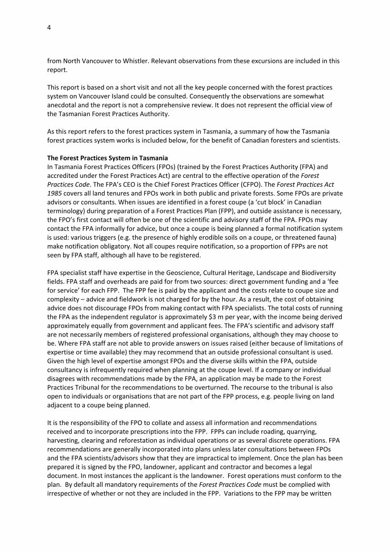
during the course of operations, to cover unforeseen circumstances (e.g. extra crossings required over streams). Variations cannot include an area greater than 10% of the original coupe area or 20 ha, whichever the lesser. This prevents large additional areas being added to an FPP by variation. Small breaches of plans may be noticed during supervision of operations or immediately after operations when the FPO is making obligatory compliance checks. Such breaches are dealt with between the FPO and contractors by the FPO issuing ‘Section 41’ notices requiring corrective action. The FPA formally audits about 15% of operations, as required under the Act, by visiting randomly selected coupes. More significant breaches (reported by FPOs or picked up in audits) that have no off‐site effects are often dealt with by means of a warning letter from the CFPO and a request for corrective action. Serious breaches of plans may be actionable in a court of law, but in many cases of breaches the expensive option of legal procedures is avoided and the company or individual involved may choose to pay the FPA a fine and complete remedial work where applicable. If an unacceptable environmental outcome results from an FPO certifying a poorly prepared plan, the CFPO (in consultation with the FPA Board) has the power to withdraw this FPO’s accreditation. Such action is generally taken only after repeated poor performances. If poor environmental outcomes on coupes (resulting either from poor plans or mistakes in implementation of plans) are covered by related legislation (e.g. the Threatened Species Protection Act 1995 or Water Management Act 1999) it is possible that the departments responsible for administering these acts, rather than the FPA, would initiate court proceedings, but in practice this rarely happens. Because FPOs are central to the successful operation of the Tasmanian forest practices system, the FPA places great emphasis on FPO education and training. Every year courses are held to train new FPOs in the fields of expertise required to assess coupes: biodiversity, earth sciences, cultural heritage and landscape. Refresher courses are held periodically for already‐accredited FPOs. Specialist courses may be held by request or where a need is identified, e.g. rock type identification, stream erosion assessment, eagle nest searches. The FPA also runs courses for supervisors of forest operations, with the aim of maintaining high standards. There are currently 180 FPOs. In general it is true to say that most FPOs working for commercial companies achieve the requirement to achieve good environmental outcomes while ensuring that coupes are profitably managed for the company for which they work. The Tasmanian forest practices system is therefore ‘self‐policing’ and non‐confrontational: for its success it does not entirely depend on the independent checking and enforcing of standards by the FPA or an outside agency. Instead it relies on the professionalism of FPOs to achieve good environmental outcomes. Background information on forests in southern British Columbia The forests on low‐ and mid‐altitude Vancouver Island are mostly in the wettest part of British Columbia and are classified as the Coastal Western Hemlock Biogeoclimatic Zone (Figure 1). In the lowland part of this zone rainfall varies from about 3000 mm to 1200 mm. Western hemlock (Tsuga heterophylla) dominates in its zone, but Douglas fir (Pseudotsuga menziesii) is common on well drained sites and western red cedar (Thujia plicata) occurs on wetter poorly drained sites, especially riparian areas. Western hemlock is often found growing on humus‐rich areas and old stumps or logs, and has the ability to withstand shade: it will grow very slowly for some years waiting for a gap in the canopy, and then develop into a full‐grown tree. All three trees are valuable for their timber. Some Douglas fir trees can be 1000 years old, and cedar can be even older. A large proportion of the forests are on hilly and steep ground. A narrow belt of drier forest on the southeast coastal area of Vancouver Island, from Campbell River to Victoria, plus a small area on the coastal mainland, is classified as Coastal Douglas Fir
6
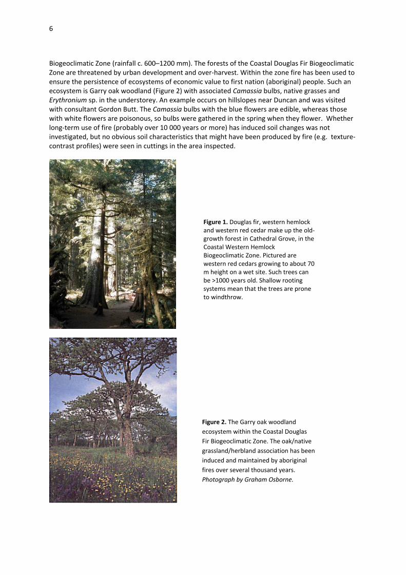
Biogeoclimatic Zone (rainfall c. 600–1200 mm). The forests of the Coastal Douglas Fir Biogeoclimatic Zone are threatened by urban development and over‐harvest. Within the zone fire has been used to ensure the persistence of ecosystems of economic value to first nation (aboriginal) people. Such an ecosystem is Garry oak woodland (Figure 2) with associated Camassia bulbs, native grasses and Erythronium sp. in the understorey. An example occurs on hillslopes near Duncan and was visited with consultant Gordon Butt. The Camassia bulbs with the blue flowers are edible, whereas those with white flowers are poisonous, so bulbs were gathered in the spring when they flower. Whether long‐term use of fire (probably over 10 000 years or more) has induced soil changes was not investigated, but no obvious soil characteristics that might have been produced by fire (e.g. texture‐contrast profiles) were seen in cuttings in the area inspected.
Figure 2. The Garry oak woodland ecosystem within the Coastal Douglas Fir Biogeoclimatic Zone. The oak/native grassland/herbland association has been induced and maintained by aboriginal fires over several thousand years. Photograph by Graham Osborne.
Figure 1. Douglas fir, western hemlock and western red cedar make up the old‐growth forest in Cathedral Grove, in the Coastal Western Hemlock Biogeoclimatic Zone. Pictured are western red cedars growing to about 70 m height on a wet site. Such trees can be >1000 years old. Shallow rooting systems mean that the trees are prone to windthrow.
7
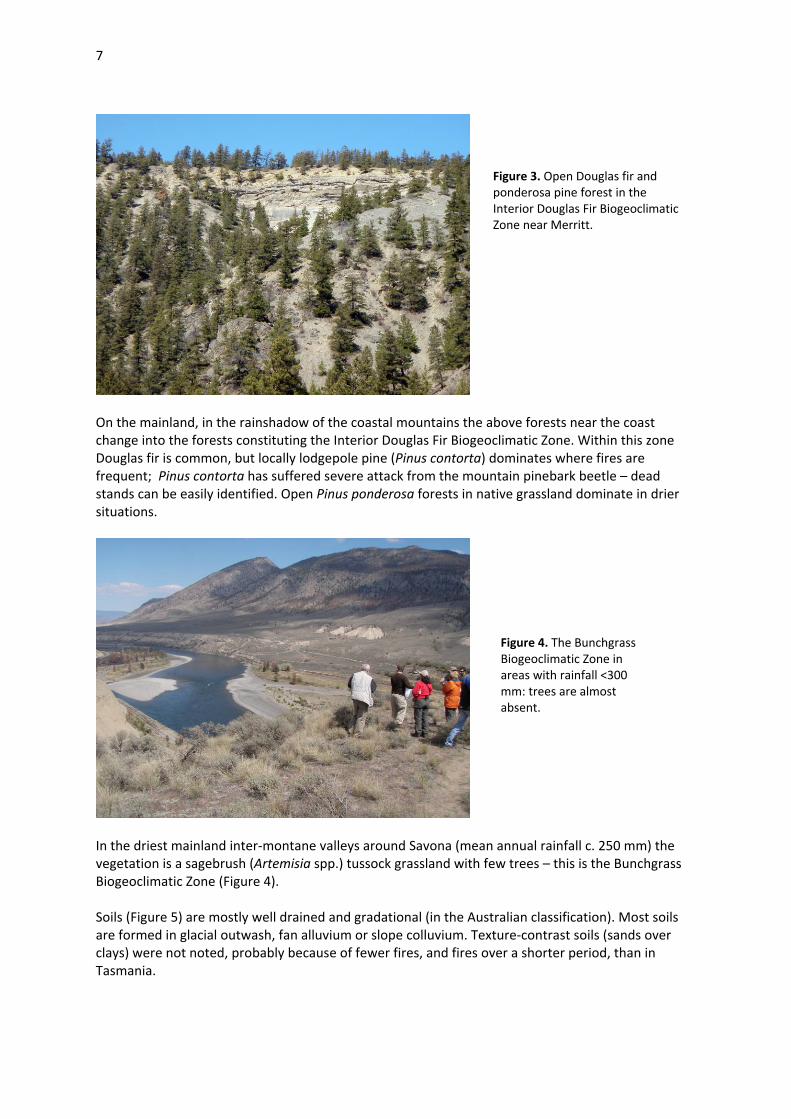
On the mainland, in the rainshadow of the coastal mountains the above forests near the coast change into the forests constituting the Interior Douglas Fir Biogeoclimatic Zone. Within this zone Douglas fir is common, but locally lodgepole pine (Pinus contorta) dominates where fires are frequent; Pinus contorta has suffered severe attack from the mountain pinebark beetle – dead stands can be easily identified. Open Pinus ponderosa forests in native grassland dominate in drier situations.
In the driest mainland inter‐montane valleys around Savona (mean annual rainfall c. 250 mm) the vegetation is a sagebrush (Artemisia spp.) tussock grassland with few trees – this is the Bunchgrass Biogeoclimatic Zone (Figure 4). Soils (Figure 5) are mostly well drained and gradational (in the Australian classification). Most soils are formed in glacial outwash, fan alluvium or slope colluvium. Texture‐contrast soils (sands over clays) were not noted, probably because of fewer fires, and fires over a shorter period, than in Tasmania.
Figure 3. Open Douglas fir and ponderosa pine forest in the Interior Douglas Fir Biogeoclimatic Zone near Merritt.
Figure 4. The Bunchgrass Biogeoclimatic Zone in areas with rainfall <300 mm: trees are almost absent.

8
History of the Forest Practices System in British Columbia A forest practices code was published in British Columbia in 1995. A Forest Practices Board was established at the same time. The incentive to produce the Code was concern about unacceptable practices, particularly regarding streams. The Code was administered by the both the Ministry of Forests and the Ministry of Environment. The Ministry of Forests has a mandate to sustain a forest industry while maintaining high environmental standards. The Ministry of Environment has a conservation and protection mandate. Historically staff of the two ministries have been at odds over environmental issues. The exceptional number of detailed rules that were drafted to protect environmental values for the controversial proposed harvest in one region alone (Clayoquot Sound; Appendix 1)4 illustrate the prescriptive mentality of the time. During its tenure, which concluded on 29 May 1995, the 19‐member Clayoquot Sound panel produced five reports, containing over 170 recommendations for sustainable forest practices. There was a strong emphasis on rules rather than principles and outcomes. On 6 June 1995, the BC government announced its intent to fully implement all of the Scientific Panel's recommendations. However, not all of the recommendations
4 The full recommendations of the Clayoquot Sound Scientific Panel can be found in Report 5 of the panel, and are available at http://www.ilmb.gov.bc.ca/slrp/lrmp/nanaimo/clayoquot_sound/archive/reports/panel.html . Note that this panel, which operated for two years, from October 1993 to May 1995, was active before the establishment of the 1995 Forest Practices Code, but the period of development of its recommendations coincided with the period of development of the Code.
Figure 5.Most soils in the parts of the the interior of Vancouver Island that I visited are formed in glacial outwash deposits (weathered gravelly sands), fan alluvium or slope colluvium. These parent materials are indicative of the large amounts of erosion that occurred once the ice cover melted c. 10 000 years ago. The soils developed in these parent materials are generally deep and friable and provide little impediment to roots. A. Deep soil profile in slope colluvium was in the bank of a stream near Horne Lake. B. Deep soil profile from the same area showing the cross bedding caused by the stream changing direction while depositing sediment in an alluvial fan. A
B

9
were in fact followed. Some rules would have required very large resources to implement: for example, recommendation R3.1, concerned with hydrology and erosion, took little account of natural climatic variation and the lack of available baseline data:
In any watershed larger than 500 ha in total area (and primary watersheds of 200–500 ha in total area) in which harvest has occurred, [we] require a watershed sensitivity analysis and stream channel audit once every five years. Where such assessments identify hydrological disturbance, substantial increase in sediment yield, or significant deterioration in aquatic habitat, cease harvesting until these conditions are relieved. If such conditions are recognized at any other time, sensitivity analysis and/or stream channel audit shall be undertaken immediately.
In 2002, under pressure from the industry, a Liberal provincial government broke up the Ministry of Environment and Ministry of Forests into three units: The Integrated Land Management Bureau, the Sustainable Resource Management unit, and the Water Land and Air unit. This reorganisation reduced staff numbers by about 40%. In 2002 the 1995 Forest Practices Code, which was seen as too prescriptive and rule‐based, was abandoned in favour of a ‘results based Code’ specified in the Forest and Range Practices Act 2004 (see government announcement in panel below.) The Forest Practices Board was retained as an audit and compliance organisation. The Code itself continues to be administered jointly by the Ministry of Environment and the Ministry of Forestry. Many of the guideline documents governing forest operations under the old Code are still used as standard advisory documents by foresters and consultants but have ceased to have formal legal standing. An example of such a document is Riparian Management Area Guidebook (1995)5. The philosophy behind the 2002 Code is that companies and their professional advisors should take responsibility for achieving good environmental outcomes. In the words of one manager I met, who is responsible for environmental regulation by his company:
‘. . . the operators in British Columbia forests must not only operate to desired results, but they must also demonstrate that the results are effective . . . They must ensure recent science is included to prove due diligence, should [anticipated] results not be met. This is intended to encourage performance in a province where forestry, biology, and engineering [expertise] is essentially restricted to professionals. They are held personally accountable for performance and effectiveness of their prescriptions, much like a medical doctor would be for surgery results.’
The following British Columbia government news release (January 2004) gives the official view of the ‘results‐based forest management system’ now in operation:
5 http://www.for.gov.bc.ca/tasb/legsregs/fpc/fpcguide/riparian/rip‐toc.htm
WHAT IS RESULTS‐BASED FOREST MANAGEMENT? In its New Era document, government promised to streamline the Forest Practices Code to establish a workable, results‐based code, with tough penalties for non‐compliance.
British Columbia will achieve high‐quality forest management as a result of the results‐based forest and range practices regime. It offers a new way of doing business––it encourages innovation and it holds industry responsible for outcomes.
Under the forest and range practices legislation, government and industry resource professionals are more interested in on‐the‐ground results and resource protection than process and paperwork. Government sets objectives and desired outcomes, and forest companies propose results or strategies that reflect these. The companies are then accountable for the results through a rigorous government compliance and enforcement regime.

10
How the British Columbia system works in practice In British Columbia forest harvest plans on public land, in tree farm licence areas, woodlot licence areas and community forests are prepared by registered professional foresters, who accept responsibility and liability for the harvest plans. If the signing forester identifies an environmental issue on a coupe he or she may consult a professional advisor (e.g., a professional forester qualified to do the work, an engineer, geoscientist or biologist). Such advisors are routinely used to assess landslide risk, rare plants etc. and may be used to prepare the entire harvest plan. In the geoscience field independent consultants must by law be members of the Association of Professional Engineers and Geoscientists. In the biodiversity field the professional advisors may be members of the College of Biologists, but as membership of this college is optional, some consultant biologists are not members of a professional organisation. This difference regarding membership of professional associations reflects the much greater financial risk taken by geoscientists: if their advice turns out to be incorrect, lives and property may be affected. Recognising that the results and effectiveness of forest operations must be judged in a scientific and ecosystem context, the British Columbia government‐adopted Ecosystem Based Management (EBM) as the principle guiding which forests
British Columbia has the ingredients needed to achieve success, including: • skilled resource professionals in industry and government who understand the importance of careful, innovative forest management;
• stakeholders who demonstrated during the results‐based code consultation that they are prepared to play a thoughtful role in the process;
• a forest industry with the ability to provide high‐quality and sustainable forest management; and • a credible third‐party auditor, the Forest Practices Board, that will ensure the environment is protected.
The Forest and Range Practices Act and regulations focus the attention of government and the forest sector to actual work on the ground, rather than complex paper processes. The Forest Practices Code improved environmental protection but allowed little operational flexibility. When it was introduced in 1995, it required that government approve six operational plans––of which three still remain.
Under the Forest and Range Practices Act, a forest company submits one comprehensive plan––the forest stewardship plan––for approval before receiving a cutting permit to authorize harvesting. The forest stewardship plan can be for a term of up to five years, where existing forest development plans must be approved every one or two years.
The forest stewardship plan must be consistent with the objectives of local land use plans or other objectives such as those set by the Ministry of Water, Land and Air Protection for species at risk. Even where land use plans are not yet in place, there are legally binding objectives for high‐priority biodiversity values such as old growth, management of streamside areas, maximum cutblock size, and retention of coarse woody debris and wildlife trees.
British Columbia is a leader in moving from a prescriptive forest management regime to one that is more adaptable to site‐specific conditions. It is one of the first in North America that requires companies to pursue sustainable forest management planning and to provide measurable results. It is also one of the first to require that companies specifically address biodiversity.
And, like other jurisdictions, British Columbia continues to ensure public views are addressed early in the planning process and to maintain a strong independent auditing system through the Forest Practices Board. The Forest Practices Board has noted continuous improvements in forest practices as a general trend in the six years it has been conducting audits.
British Columbia forest companies are actively acquiring independent third‐party forest management certification, recognizing they need to provide proof that they practise sustainable forest management to attract the all‐important international markets. Under the new results‐based regime, some companies may apply even stricter standards to address the demands of a specific export market.

11
can be logged. The background information for EBM can be found at the Coast Information Team website (http://ilmbwww.gov.bc.ca/citbc/ebm.html) which summarises the official view of EBM: One researcher summarised the system to me: ‘in theory the EBM system identifies all ecosystem values, companies can look up these values, they can identify the high‐value areas, and what is left is where the company can go. In practice there are problems because: (1) the inventory is not always accurate; (2) the government is poor at working with industry; and (3) the radical green movement did not endorse the system.’ However, another researcher was more circumspect and remarked that ‘EBM (rightly or wrongly) is not supported by a large group of the concerned public because of various perceived deficiencies.’ Without working within the detail of the system it is hard for an outsider to judge EBM’s effectiveness, but such comments from senior researchers do appear to indicate that while the principle behind EBM is laudable the mechanism for delivering outcomes has not been fully worked out. On private land The Private Managed Forest Land Act 2003 (Appendix 3) covers forestry operations. It contains objectives but the systems or protocols for legal enforcement are very few and relate mainly to wildlife, and prescriptions relating to streams and soils are minimal and far less stringent than those on public lands. In British Columbia the forester preparing a forest harvest plan is ultimately responsible for the accuracy and defensibility of the plan, but when plans are written with expert input, the experts (consultants) who provide advice assume the responsibility for their advice being accurate and scientifically and environmentally sound. Should environmental harm occur, the consultants may be (and have been) sued. Consequently the insurance premium for a small consultancy employing 10‐20 people may be c. $100 000 per year. (In contrast, in Tasmania, most expert advice is provided by scientists in the Forest Practices Authority but the responsibility for the accuracy and defensibility of the plan remains with the signing Forest Practices Officer.) In British Columbia the Forest Practices Board (FPB) undertakes audits of forest activities, investigates complaints and may make recommendations to government. It does not conduct research or educate or train foresters. It is concerned mainly with correct process. The ‘reports in
‘The purpose of ecosystem‐based management (EBM) is to achieve healthy ecosystems and healthy human communities. In April 2001, as part of several agreements between the Province of British Columbia, First Nations, local governments, and non‐government interests, a coastal consensus on the definition, principles and goals of ecosystem‐based management was established for what would become the Coast Information Team (CIT) analysis area. The CIT built on the April 2001 agreement to define EBM as:
. . . an adaptive approach to managing human activities that seeks to ensure the coexistence of healthy, fully functioning ecosystems and human communities. The intent is to maintain those spatial and temporal characteristics of ecosystems such that component species and ecological processes can be sustained, and human wellbeing supported and improved.
This definition extends the scope of EBM beyond protecting ecosystem integrity to include the wellbeing of human communities. It also expands the policy environment in which EBM takes place, linking EBM to broader policy, planning, and decision‐making concerned with building and maintaining healthy communities, such as education, health, incomes, transportation, equity, and economic development and diversification . . . the EBM Framework . . . lists the maintenance of ecological integrity and the application of the precautionary principle to ecological risk among its guiding principles.’

12
progress’ list below shows the nature of the FPB investigations undertaken; they are more general in scope than the coupe assessments forming the bulk of the compliance work done by the Tasmanian FPA. Research and Monitoring Research and monitoring is done by the Ministry of Environment and Ministry of Forests, but big companies like TimberWest and Interfor also have strong research and monitoring sections. One researcher remarked that the big companies probably do more research than strictly necessary because they must be seen to be on top of environmental issues, in order to keep their environmental accreditation through the Sustainable Forests Initiative (SFI) and the Program for Endorsement of Forest Certification (PEFC). Effectiveness monitoring by government agencies is primarily done through the Forest and Range Evaluation Program (FREP). Government‐initiated research The Ecology and Earth Sciences research group in the Ministry of Forests is an interdisciplinary team of researchers with expertise in plant ecology, range ecology, soil conservation, silviculture systems, climatology, hydrology, fish and wildlife habitat, geomorphology, and non‐timber forest resources. Activities include: (1) developing best practices through FREP to support the implementation of the Forest and Range Practices Act; and (2) the Future Forest Ecosystems Initiative (FFEI); and (3) the mountain pine beetle control program. Ecology and Earth Sciences researchers also provide technical expertise in the fields of Ecosystem Based Management (EBM), sustainable biomass harvesting, coastal second‐growth management, mountain pine beetle management, adaptation to climate change, and management of non‐timber forest resources. Most research is directed towards genetics, timber quality and ecology of timber trees. Specific research in the earth sciences includes studies of debris flow initiation in coastal forests of British Columbia (Tom Millard), alluvial processes on fans (Tom Millard), and road deactivation (Jim Dunkley). The Ministry of Forests has responsibility for monitoring forest practices on public land through the Forest and Range Evaluation Program (FREP). FREP is conducted in partnership with the Ministry of Environment and the Integrated Land Management Bureau and is the primary mechanism for checking the environmental effects of forest operations. The FREP effectiveness monitoring program is coordinated by Jim Dunkley, who is coordinating a monitoring staff of 20 people for approximately half of their time. The main function of FREP is to raise awareness and to disseminate information to consultants and foresters. The FREP program differs from the audit program of the Forest Practices
FPB Reports in ProgressAudits
• Western Forest Products' TFL 39 ‐ Queen Charlotte Islands Forest District • Audit of Forestry, Range and Oil & Gas Activities near Dawson Creek • BCTS operations in the Sunshine Coast • Recreation Management in Central Cariboo • BCTS operations in Quesnel • Skeena‐Stikine District Forest Service Roads • Mission Creek and Penticton Creek Watersheds
Special Investigations
• Effectiveness of Range Use Planning under the Forest and Range Practices Act (FRPA) • A Cumulative Effects Assessment of the Kiskatinaw Planning Unit, Dawson Creek, BC • Forest Retention in Mountain Pine Beetle Areas: Has there been a conservation uplift? • Special Investigation of Soil Disturbance from Forest Activities

13
Board in that it looks at environmental outcomes, not process. Selected publications of FREP show the applied and outcomes‐oriented nature of the organisation’s research: Forest‐related research conducted by the Ministry of Environment includes work on landslides, effects of herbicides on amphibians, smoke control, water quality, off‐site effects of pine beetle infestation (including hydrological impacts effects) and management of wetlands. Recent reports may be accessed at http://www.env.gov.bc.ca/main/publications.html. The chief researcher on landslides is Rick Guthrie, who works from the Nanaimo office. His work is considered under the heading ‘Landslides’ below. Industry‐funded research
Interfor Warren Warttig is a research scientist for Interfor at Campbell River and is active in two fields of research: road rehabilitation and stream ecology. Abstracts of his road rehabilitation papers were published in the Coastal Forest Site Rehabilitation Workshop, November 16, 17 1nd 18, 1999 (Nanaimo, BC): ‘Lessons learned in Coastal Road Deactivation’ and ‘Effectiveness Monitoring in Road Deactivation’. Road deactivation is important for limiting runoff‐induced erosion (including landslides), and can cost as much as $65 000 per kilometre. Presently he is investigating the effects of forest harvest on leaf litter inputs and nutrient cycling into small streams. This is a joint project with students at the Vancouver Island University at Nanaimo; the university component is supervised by Dr Erik Krogh, researcher in environmental chemistry. Dr Krogh’s students sort litter samples collected in containers suspended over streams in Warren Warttig’s study area into components (e.g. leaves, twigs) and chemically analyse each at Vancouver Island University. A progress report has been written and is entitled ‘Monitoring allochthonous input (leaf litter) on small streams in coastal British Columbia forests under different harvesting regimes and chronosequence age classes’. Preliminary results from one year’s study indicated that 5 m buffers may be sufficient to maintain close to maximum leaf litter inputs into streams, but further monitoring is required to confirm this conclusion. The report is available from Warren Warttig on request.
Baseline Datasets for Evaluating Wildlife Tree Patches ‐ November 2004 FREP Report #1. Preliminary Assessment of the Effectiveness of Wildlife Tree Retention on Cutblocks Harvested between
1999 and 2001 under the Forest Practices Code ‐ February 2005 FREP Report #2. Evaluation of Cutblock Sizes Harvested under the Forest Practices Code: 1996‐2002 ‐ July 2005 FREP
Report #3. An Evaluation of Rangeland Health and Effectiveness of Plant Residue in Protecting Resource Values ‐
March 2005 FREP Report #8. An Evaluation of the Reforestation Strategies of the Fort St. John Pilot Project ‐ September 2006 FREP
Report #9. Stand‐level Biodiversity Monitoring in 44 Large Cutblocks in the Central Interior of British Columbia ‐
September 2007 FREP Report #10. Timber‐Focussed Evaluation of Partially Harvested Areas: Are Stand Conditions Consistent with
Government’s Objectives for Timber? ‐ March 2007 FREP Report #11. Tree Species Composition and Diversity in British Columbia ‐ August 2008 FREP Report #14. Resource Stewardship Monitoring: Stand‐level Biodiversity Analysis of 2005/2006 Field Season Data by
Biogeoclimatic Zone ‐ November 2008 FREP Report #17. A Review of Forest Stewardship Plan Results and Strategies for the Cultural Heritage Resource Value ‐
November 2008 FREP Report #18.

14
FERIC
Clayton Gillies is a forest scientist and geologist working for FERIC (Forest Engineering Research Institute of Canada), a subsidiary of FPInnovations, which is the largest forest research organisation in Canada, funded jointly by the federal government and industry. FERIC is based in Quebec but the local group is based in Vancouver. FERIC publishes several research reports each year. Many relate to forest engineering and log extraction rather than Soil and Water or Geoscience issues but a selection of the reports have special relevance to issues also found in Tasmania – examples are:
Bradley, A and VanBuskirk, C 2009, Geotextile‐reinforced soil structures for stream crossings on resource roads, Advantage Report 10 (11).
Tran, E 2007, LIDAR Digital Elevation Model to improve stream mapping, Advantage Report 8(3). Desrochers, L 2007, Mechanized harvesting in riparian zones using a long‐reach single‐grip harvester,
Advantage Report 9(1). Gillies, C 2007, Erosion and sediment control practices for forest roads and stream crossings, Advantage
Report 9(5). The last‐mentioned report is especially useful and is liberally illustrated with examples of how to improve road construction and associated drainage structures6. I was given a copy. Other research at FPInnovations is funded by the provincial government, e.g. the woody debris management program.
TimberWest
Domenico Iannidinardo is the Environment and Sustainability officer for TimberWest, the largest private forest owner in British Columbia. It owns 322 000 ha of land on Vancouver Island and meets the sustainability criteria of the Sustainable Forest Initiative. TimberWest have funded a number of initiatives to improve water quality derived from their land7 as well as funding several conservation initiatives including funding of mapping of high‐conservation value land with a view to establishing permanent reserves and funding restoration of salmon habitat in steams.
FORREX
FORREX (the Forum for Research and Extension in Natural Resources) is a British Columbian extension organisation committed to linking land‐users with scientific research. FORREX is funded by the government of Province of British Columbia and by individuals, foundations, agencies and corporations. Regular publications include (1) the BC Journal of Ecosystems and Management (JEM) which includes extension articles, research articles and reviews; (2) LINK Newsletter; and (3) the Streamline Watershed Management Bulletin. FORREX has 3 extension officers in British Columbia who are employed fulltime in forestry. An innovative idea the FORREX uses is an electronic ‘extension request’ form so that people can request advice electronically. The form is available at: http://www.forrex.org/create_ext.asp . Examples of Research and Monitoring Landslides Landslides are a major problem in British Columbia (Figure 6), because of the steepness of many forested slopes and the high rainfall. Many landslides are natural but some have been induced by roading or clearfelling. Rick Guthrie (Ministry of Environment) and others have produced a series of papers on landslides and landslide risk in British Columbia: 6For a summary see http://www.feric.ca/index.cfm?objectid=32C14A28‐AD06‐F3D4‐69F4DCCCA1918E11 . 7 Details at http://www.timberwest.com/enviro_watershed.cfm

15
BC Ministry of Forests 2004, Landslide Risk Case Studies in Forest Development Planning and
Operations, Land Management Handbook 56 (M Wise, G Moore and D Van Dine, eds), BC Ministry of Forests.
Chatwin, S 2005, Managing landslide risk from forest practices in British Columbia, Forest Practices Board, Special Investigation, Victoria, BC, FPB/SIR/14, 32 p.
Guthrie, RH 2002, The effects of logging on frequency and distribution of landslides in three watersheds on Vancouver Island, British Columbia, Geomorphology 43 (2002), 273–292.
Guthrie, RH 2005, Geomorphology of Vancouver Island [electronic resource]: extended legends to nine thematic map, BC Ministry of Environment, Victoria, BC, Research Report No. RR02.
Guthrie, RH 2005, Geomorphology of Vancouver Island [electronic resource]: mass wasting potential. BC Ministry of Environment, Victoria, BC. Research Report No RR01.
Guthrie, RH and SG Evans 2004, Analysis of Landslide Frequencies and Characteristics in a Natural System, Coastal British Columbia, Earth Surf. Process. Landforms 29, 1321–1339.
Guthrie, RH and SG Evans 2004, Magnitude and frequency of landslides triggered by a storm event, Loughborough Inlet, British Columbia, Natural Hazards and Earth System Sciences 4, 475–483.
Guthrie, RH and SG Evans 2005, The role of magnitude‐frequency relations in regional landslide risk analysis. In Landslide Risk Management. (Hungr, O, R Fell, R Couture and E Eberhardt, eds).
Horel, G and S Higman 2006, Terrain Management Code of Practice. Streamline Watershed Management Bulletin Vol. 9/No. 2 Spring 2006.
Rollerson T, TH Millard and DA Collins 2006, Debris Flows and Debris Avalanches in Clayoquot Sound – Chapter 23 in Debris Flow Hazards and Related Phenomena (M Jakob and O Hungr, eds), Praxis Springer Berlin Heidelberg .
Guthrie, RH and SG Evans 2007, Work, persistence, and formative events: the geomorphic impact of landslides, Geomorphology 88, 266–275.
Guthrie, RH and KJ Brown 2008, Denudation and landslides in coastal mountain watersheds: 10,000 years of erosion, Geographica Helvetica 1/2008, 26–35.
Guthrie, RH, PJ Deadman, AR Cabrera and SG Evans, 2008, Exploring the Magnitude Frequency distribution: A cellular automata model for landslides, Landslides 5, 151–159.
Guthrie, RH, 2009, Forestry and Landslides: What is acceptable in BC? Forestry Chronicle 85, 25–31.
Figure 6. These landslides (debris flows) have been produced by the combined effects of forest harvest and roading. Photograph provided by Warren Warttig.

16
Although retrospective studies have identified a broad combination of characteristics that are associated with landslides, predicting landslides at the local level has been difficult, as shown by the conclusion of a study by Rollerson (1992)8 in the Queen Charlotte Islands:
. . . results indicate that certain landscape attributes correspond clearly with landslide frequency and likelihood of occurrence (percentage of units experiencing failure). These include landscape position, slope angle, slope morphology, and the presence or absence of natural landslides. These results can be used to develop predictive landslide risk maps. Such maps can present landslide risk as the expected frequency of failure per unit area as a simple likelihood of occurrence. The general lack of clearly defined homogeneous groups . . . both for individual attributes and the multifactor classes, suggests that site specific application of these results should be done with caution.
In relation to this conclusion R. Guthrie reports (pers. comm.) that prediction methods have improved through the application of new technological approaches. In 2005 Steve Chatwin of the Forest Practices Board of British Colombia reported on landslide frequency associated with forest operations in British Colombia9. He tried to answer the specific question: ‘Has the Forest Practices Code reduced the frequency of post‐logging landslides?’ (The Code to which Chatwin is referring is the 1995 Code and the subsequent modified Code of 2002.) When he counted landslides over an 8‐year period in 3 study areas (455 coupes) he found that post‐Code landslides were occurring, on average, at a rate of one landslide for every 14 km2 of coupes. This was three times the natural rate, but less than the pre‐Code rate which had been nine times the natural rate. (Since the writing of the report further failures are likely to have occurred, so the natural rate of landslides has probably been increased by more than three times.) Not counted in the above tally were a large number of landslides (164) which had occurred in the 8‐year study period but had been initiated from old roads constructed prior to the introduction of the 1995 Code; these landslides had occurred despite extensive work to deactivate and rehabilitate roads. (Deactivation involves restoring drainage to its natural flow pattern and returning cut and fill roads to something like their original slope conditions.) Pre‐harvest Terrain Stabilty Field Assessments had been carried out on 92% of the steepland coupes where a field assessment was required by law, but the FPB found that in about half of the cases, the recommendations of the TSFA were ignored when silvicultural prescriptions, cutting permits or road design documents were written. The full report by S. Chatwin is entitled Managing Landslide Risk from Forest Practices in British Columbia and can be found at: http://www.fpb.gov.bc.ca/s_investigations.htm . In another report by Guthrie (2005)10, who investigated 665 landslides on Vancouver Island (without separating pre‐ and post‐Code landslides), the effect of forest operations on landslide incidence was estimated to be higher than recorded by Chatwin:
Results indicate that logging activities increase landslide frequencies by more than 10 times, and the presence of roads increases landslide area by 22 to 43 times.
A recent study by J McDonald et al. presented at the CANQUA conference investigated the incidence of landslides initiated during the storms of winter 2006/2007 in the Klanawa, Sarita and Nitinat River
8 Rollerson, T 1992, Relationships between landscape attributes and landslide frequencies after logging: Skidegate Plateau, Queen Charlotte Islands, BC Ministry of Forestry Land Management Report 76. 9 Chatwin, S 2005, Managing landslide risk in the forest sector of BC. Island Geoscience 2(3). 10 http://www.forrex.org/events/lfvoi/pdf/Guthrie%202005%20Van%20Island%20mass%20wasting%20potential.pdf

17
Valleys of southwestern coastal Vancouver Island. The study found that root numbers and quality were correlated with harvest age: soils in areas harvested >4–12 years previously had the lowest number and lowest quality of roots (Figure 7), but control areas had the most landslides (Figures 7 and 8). This relationship indicates the predominant role of windthrow in causing landslides.
Figure 7. Number of landslides related to quality of 0–5 mm diameter roots and harvest age (0 years is a control sample). Note the decline in root numbers and root quality immediately after harvest and the long time (>12 years) taken for the roots to re‐establish.
Figure 8. Landslide frequency versus harvest age.

18
Some examples of notable landslides noted during the study tour and CANQUA conference are shown below (Figures 9–12).
B. The same landslide photographed in 2009. The clearly visible joints in the rock are approximately parallel to the surface exposure of the cutting, so undercutting by road building and lubrication by heavy rain made failure almost inevitable.
Figure 9.A. A rock fall on the Vancouver to Whistler road. The Canadian Press, 30 July 2008 reported the comments of British Columbian Premier Gordon Campbell: ‘It looked like a cliff face fell off, to me. I'm not a geotechnical engineer but that's what it looked like happened.’ Photograph by Jonathan Hayward . A
B

19
Figure 10. This recent landslide (debris flow) on the Port Alberni‐Tofino road was natural. Many landslides form when rain falls on melting snow, causing saturation
Figure 11. The Barrier at Squamish, looking east. The cliff face at the top left of this photograph is called The Barrier and is the backwall of a very large landslide (rock fall and subsequent debris flow) that occurred in the Rubble Creek catchment in the winter of 1855‐56. The landslide volume is estimated to have been 30–36 million m3 and the debris flowed 6 km down the creek at velocities exceeding 20‐25 m s‐1 and possibly as high as 60 m s‐1 (Blais‐Stevens 2009: CANQUA 2009 Field Trip Guide).
The scarp in the foreground shows the depth of burial of the original land surface at the point where the debris accumulated as an alluvial fan. The Barrier consists of volcanic rock (dacite) that forms a natural dam for Lake Garibaldi, behind and east of The Barrier. Any further collapse of the cliff would probably cause catastrophic drainage of Lake Garibaldi.
The risk of further landslides is considered to be very high and consequently any urban development on the fan deposits (which are extensive downstream, behind the photographer) has been prohibited.

20
In urban areas two methods are used to prevent damage to infrastructure from debris flows originating in adjacent steeplands: debris dams and concrete chutes (Figure 12). The former are very expensive to build (>CAN $1m) and maintain: debris must be cleared after each debris flow. The ‘tide mark’ in Figure 12A shows the amount of debris that has been removed from behind this dam. Concrete‐lined chutes (Figure 12B) ensure that debris is directed in a controlled and rapid manner towards the sea. They are preferred where low bridges do not span the debris flow path.
Figure 12. A. Looking downstream at a debris dam, built to protect downstream infrastructure from devastating debris flows resulting from landslides in the steeplands bordering the coast on the Vancouver‐Whistler highway. This dam has filled twice, and volume of the recent debris can be seen from the ‘tide mark’ near the top of the overflow gap on the dam wall. B. The alternative to using dams to stop debris flows is to control the flow of debris downstream by building a chute. C. On curves interlocking concrete blocks are used to protect infrastructure.
A
B
C

21
Stream protection The classification of streams in British Columbia is complex (Appendix 2). The Riparian Management Area Handbook (1995)11 presents the rationale and methods for applying protection to streams in the forest estate. After the demise of the Forest Practices Code of British Columbia Act 1995 the handbook was deprived of legal status but is still used extensively as an advisory document. Stream protection is governed partly by stream size and partly by the presence or absence of fish (Table 1). Table 1. Specified minimum Riparian Management Areas slope distances for stream riparian classes
Note that ‘Reserve Zone Width’ corresponds to ‘Streamside Reserve’ (SSR) in the Tasmanian system and but the definition of the ‘Management Zone’ (applied either in addition to the Reserve Zone or separately) is not equivalent to the Tasmanian ‘Machinery Exclusion Zone’ but covers several desired outcomes and is therefore complex to apply:
11 http://www.for.gov.bc.ca/tasb/legsregs/fpc/fpcguide/riparian/Ripar5.htm#link101
To achieve riparian management area objectives, forest practices within the management zone should: • Where a riparian management area has both a management zone and a reserve zone:
– reduce the risk of windthrow to the reserve zone – retain important wildlife habitat attributes including wildlife trees, large trees, hiding and resting cover, nesting sites, structural diversity, coarse woody debris, and food sources characteristic of natural riparian ecosystems.
• Where a riparian management area has only a management zone: – retain sufficient vegetation along streams to provide shade, reduce bank microclimate changes, maintain natural channel and bank stability and, where specified, maintain important attributes for wildlife – adjacent to wetlands and lakes, retain key wildlife habitat attributes characteristic of natural riparian ecosystems.

22
It is noteworthy (and surprising for a Tasmanian) that the geomorphological characteristics of streams (other than size) play no part in the decision as to how much protection the stream should receive. In fact foresters or consultants classifying streams are actively discouraged from allowing erosion in streams to cloud their judgement:
Determination of stream riparian classes is based on normal, non‐disturbed, channel widths. Be careful not to use a disturbed or unnaturally wide channel to determine the RMA [Riparian Management Area]. Further, recent debris torrents may cause oversized channels, resulting in a higher classification than is required. [my italics]
In forest operations near Hal Creek, Vancouver Island, the differences between the application of the Tasmanian and British Columbian systems was evident. Headwater streams were given reserves in places, but these were discontinued downstream (Figure 13). For large units (e.g. braided rivers, fans) the British Columbian system depends on identifying the total unit as an ‘active geomorphological unit’ in situations where the Tasmanian system depends on the identification of individual components (i.e. streams within the unit). So in a complex fluvial zone such as a fan or floodplain with parallel streams the Tasmanian system builds up a protection zone by amalgamating protection given to different components (e.g. parallel active and non‐active Class 3 stream channels would both be given a 20 m SSR), but in the British Columbian system the entire active fan would be recognised as a feature requiring protection. Such differences in approach reflect the size and number of the British Columbian geomorphological units (i.e. more fans, and common occurrence of braided rivers in the British Columbian landscape) and their greater activity (generally steeper slopes and more active erosion processes). An effect of the British Columbian requirement to identify geomorphological units in the forested landscape is that foresters and consultants require more geomorphological expertise in recognising landforms than foresters working in Tasmania.
Figure 13. Discontinuous streamside reserve applied to a headwater stream near Hal Creek.

23
Figure 14. A. The Hal Creek catchment has a landslide in its headwaters. As Hal Creek flows out of a confined valley into less steep terrain which is being actively harvested, it forms an alluvial fan consisting of multiple channels. A shows a channel that was active during the 2006–2007 storms. B shows the presently active channel which was cut through standing forest during the same storms. C. There was major damage to culverts on the forestry road so a major culvert which was blocked during the storm was replaced by a bridge. D. Downcutting by storm flows appeared to be threatening a neighbouring property and house; using excavators, the Ministry of Forests responded to neighbour concern by using excavators to build boulder dams across the stream, to trap sediment (arrows mark emplaced boulders) at a cost of c. CAN$150 000. Several boulder dams were built at intervals down the stream reach. These have apparently stopped downcutting but whether the dams would survive extreme events is doubtful. E. During the 2006–2007storms Woodward Creek (about 1 km southeast of Hal Creek) deposited >2 m of debris around standing trees.
D
B
A
E
C

24
Hal Creek and Woodward Creek – a case study Both these creeks near Port Alberni drain steeplands but then flow over fans supporting commercial forests having adjacent residential developments . As in Tasmania, forest operations tend to be blamed for erosion, and staff of the Ministry of Forests and Ministry of Environment were involved is determining causes of erosion associated with the streams. Hal Creek (Figure 14), equivalent to a Class 2 stream in the Tasmanian classification, suffered erosion in 1986–96, when it cut down into its fan by about 4 m (and by about 7 m in the lower fan area), and again in the 2006‐07storms, when it changed course at the point where the channel left a confined gorge and flowed over an alluvial fan. During the same storms some areas of existing forests on a nearby fan of Woodward Creek were covered in c. 2–3 m of gravels (Figure 14E) and elsewhere temporary channels formed. A natural landslide in Hal Creek’s headwaters contributed fresh sediment to the stream. Forest operations were taking place on the Hal Creek fan in 1989–90. In 1995 a resident complained that downcutting by Hal Creek was threatening his property and a dispute arose as to who was responsible for the erosion. Sequential air photographs showed that downcutting by Hal Creek had occurred in 1986 before forest harvest, so harvest had not initiated the downcutting. Although the air photograph records indicated that the erosion was probably due to a previous owner removing gravel from the fan and river channel (and thereby lowering the base level of the stream), the Ministry of Forests responded in 1996–97 by building boulder dams across the main channel to trap sediment. The Ministry of Environment declined to contribute. By 1999 the check dams were full of sediment and gravel was removed from the river channel to stop excessive build up of sediment. Finally, in 2003 a new owner took over the property and was unconcerned about the state of the stream; gravel removal stopped. The erosion events indicate the unpredictable nature of stream movement on fans and the risks involved when interfering with natural drainage on active geomorphological units. The tendency of the stream to change its channel and to have varying sediment input depending on rainfall and sediment supply is natural and virtually impossible to control in the long term. Streamside reserves on the fan itself have little ability to stabilise the stream channel as erosion and rainfall in the stream headwaters are the primary determinants of stream activity on the fan. Likewise forest harvest on the fan is likely to have only small effects on channel stability, because upstream and climatic influences are so dominant. COMPARISON OF TASMANIAN AND BRITISH COLUMBIAN FOREST PRACTICES SYSTEMS The major two differences between the Tasmanian and British Columbian systems are: (1) the British Columbian system enshrines a ‘results based’ philosophy whereas the Tasmanian system is ‘rule based’; (2) accredited Forest Practices Officers are responsible for the successful implementation of plans in the Tasmanian system whereas in British Columbia more responsibility is distributed to consultants specialising in different fields such as geotechnics and biodiversity. The first of these differences is probably more apparent than real. Although it may suit policy makers to contrast ‘rule‐based’ and ‘results‐based’ systems, with the implication that ‘results‐based’ systems are superior (because everybody wants results, but few people want rules) this over‐simplistic contrast ignores two facts: (1) that reasonable rules are put in place to achieve results; and (2) that a results‐based system still depends on rules – for example, rules and guidelines (some derived from the old 1995 Code, others like the FERIC operations guide for erosion and sediment control being more recent) are used routinely in planning coupes in British Columbia, and that consultants like Madrone Environmental Services apply their own rules to assess risks, for example,

25
when assessing land instability. The question ‘Is a results‐based system superior to a rule‐based system?’ should therefore be more subtly phrased: ‘Do the rule based system and the results‐based system produce comparable results, i.e. satisfactory environmental outcomes?’ The limited observations made on this study tour do not allow me to answer the above question with confidence, as I was not able to visit sensitive areas like Clayoquot Sound or to make surveys of strictly comparable harvested terrain in British Columbia and Tasmania. However, there have been large improvements in landslide risk assessment in British Columbia, and improved understanding and recording of the effects of roads on land stability, and in regards to these two issues there is an ongoing expensive and large initiative to rehabilitate old roads. In the important environmental area of slope stability the present British Columbian Code therefore is effective. However, on the subject of stream erosion, it is surprising that British Columbian streams are given protection only for their fish value, and that geomorphological criteria are not used routinely when assessing whether streamside reserves should be specified on streams within coupes, although on landforms like alluvial fans (the example shown in Figure 14) the absence of guidelines for streams is partly made up for by classifying the landform itself as an active unit. However, in the more actively‐eroding British Columbian geomorphological terrain I suspect that some erosion from forestry‐related activities goes undetected because severe stream erosion is considered to be natural process. Greater application of streamside reserves might prevent some erosion, particularly in headwater streams. The decentralisation of responsibilities in the British Columbian system is almost certainly more costly for forest companies than a centralised system like that operating in Tasmania, where one institution (the Tasmanian Forest Practices Authority) provides most of the scientific advice necessary for planning coupes. (The FPA has an active research programme, but much research used when giving advice is done elsewhere, e.g. in the University of Tasmania and the Department of Primary Industries and Water, or by mainland universities and research centres.) An additional cost to industry in British Columbia is that the companies themselves (rather than a central government authority) must do the research and monitoring necessary to keep abreast of environmental issues, and may employ scientific specialists of their own in order to be able to discuss matters with consultants. As one British Columbian timber company spokesperson said to me:
You have discovered why [company name] has decided to keep a small group of specialists to develop internal operating procedures and manage the pool of consultants. This way we keep flexibility up and give consultants more comfort in providing reasonable prescriptions because they can bounce sensitive topics around with informed staff personnel. It works extremely well for us and I think it would work well for almost any forestry application. Can you see this setup working with the timber companies in Tasmania?
The effects of a decentralized system are also evident within government agencies: because Code‐based rules are not so important in British Columbia, the Forest Practices Board’s audit and monitoring programme is relatively small. Conversely there are large external programmes concerned with scientific monitoring and research, and with assisting practical developments such as better roading: these are run by FREP (the Forest and Range Evaluation Programme) and FERIC (the Forest Engineering Research Institute of Canada). In addition there are programmes within government ministries (Ministry of Forestry and Ministry of Environment) undertaking geomorphological and soil and water research – notably on landslides and alluvial fan development. Thus a positive by‐product of the British Columbian system is the stimulation of research and monitoring by a variety of agencies, some private and some public. However, the generous funding of research and monitoring also reflects the good financial state of the forest industry and of provincial and federal governments, up until the reversal of fortunes in the global financial turmoil of
26
the last 18 months. While such funding appears to indicate that the British Columbian system is working well, it is possible that in less favourable economic conditions funding for research and monitoring could be regarded as optional by government and private companies alike, and work essential to effectiveness monitoring could be dropped. Thus, because the British Columbian system depends on its success on effectiveness monitoring (to ensure that satisfactory environmental results are actually achieved) rather than regulations, in difficult economic times a rule‐based system such as that practised in Tasmania may be more capable of surviving financial pressures and therefore more likely to achieve consistent outcomes. A further disadvantage of the British Columbian forest practices system is that there is no clear pathway for incorporating improvements and modifications to the Forest practices Code; consultants and foresters and individual companies over time may develop better systems for achieving good environmental outcomes in their area of operations but because there is no common rule set, uptake of such improved practices by others is relatively haphazard, although it is acknowledged that a large of amount of research and practical advice is regularly disseminated by private companies and government agencies by means of scientific articles, reports and guides and semi‐popular publications and also on websites . However, where a single central body is responsible for developing rules and guidelines, as in Tasmania, the collation of Code revisions, and the procedures for consulting industry and the public on their usefulness, implementation and effectiveness, are relatively simple and streamlined. Code revision is part of the Tasmanian forest practices system (and required by the Forest Practices Act), and formal Code revision occurs every 7–10 years. Changes can also be effected by Forest Practices Authority specialists making recommendations and developing new guidelines in consultation with the industry between formal revisions of the Code. A valid question to ask of any regulatory system is: ‘If the system were being put in place today, what form would it take?’ This question forces administrators to evaluate how much historical ‘baggage’ no longer relevant to a system’s effective operation has been inherited. It also serves to identify gaps. As an outside observer, it seems likely to me that the present decentralised forest practices system in British Columbia is an over‐reaction to the excessive regulation attempted under the Forest Practices Code of British Columbia Act 1995. It is unlikely that a system designed today would share responsibility for environmental protection between two government departments (Ministry of Forestry and Ministry of Environment) and spread funding for forest practices research and monitoring over several government agencies (provincial and federal). As one senior British Columbian researcher put it to me: ‘I wouldn’t advise this as a model.’ ACKNOWLEDGEMENTS The generosity of the researchers, consultants and foresters listed on page 2, who showed me around forest sites in British Columbia and shared their experiences with me is gratefully acknowledged. I would like especially to thank R Guthrie and T Millard who commented on a draft of the report and corrected errors. I am also grateful to the organisers of the CANQUA field trips (Olav Lian, Tracey Brennand and Andrée Blais‐Stevens for explaining many geological and geotechnical features. Mick Schofield (FPA) assisted with the writing of the text on the forest practices system in Tasmania. This study tour and report was made possible through the financial support of the Forest Practices Authority, and I would like to thank Board members and the Chief Forest Practices Officer for this support.

27
Appendix I. Summary of the Clayoquot Sound Scientific Panel’s recommendations concerning planning and practices in Clayoquot Sound: recommendations relating to silvicultural systems, April 1995. R3.1 Within the watershed planning unit, determine a rate‐of‐cut based on the watershed area. Specifically: • Limit the area cut in any watershed larger than 500 ha in total area to no more than 5% of the
watershed area within a five‐year period. • In primary watersheds of 200–500 ha in total area, limit the area cut to no more than 10% of the
watershed area within a 10‐year period. (This prescription provides flexibility for harvesting within small watersheds.)
• In any watershed larger than 500 ha in total area, and primary watersheds of 200–500 ha in total area in which harvest has exceeded 20% of the watershed area in the most recent 10 years, allow no further harvest until the watershed conforms with the specified rate‐of‐cut.
• In any watershed specified in the previous recommendations and in which the recent harvest is greater than 5% in the last five years, but less than 20% in the last 10 years, allow no further cutting until a watershed sensitivity analysis and stream channel audit have been completed. If these assessments indicate significant hydrological disturbance, substantial or chronic increase in sediment yield, or significant deterioration in aquatic habitat, cease harvesting until undesirable conditions are relieved. Otherwise, harvest may continue at a rate which will bring the drainage unit within the recommended rate‐of‐cut limits within five years.
• In any watershed larger than 500 ha in total area (and primary watersheds of 200–500 ha in total area) in which harvest has occurred, require a watershed sensitivity analysis and stream channel audit once every five years. Where such assessments identify hydrological disturbance, substantial increase in sediment yield, or significant deterioration in aquatic habitat, cease harvesting until these conditions are relieved. If such conditions are recognized at any other time, sensitivity analysis and/or stream channel audit shall be undertaken immediately.
• In watersheds where the harvestable area is less than 30% of the total area, allow resource managers to use professional judgement to vary these standards without changing the intent to regulate rate of harvest to minimize hydrological change.
• Periodically review these recommendations and reformulate as the results of monitoring accumulate.
• In watersheds important for their scenic values, complying with the visual landscape management objectives may restrict the rate‐of‐cut below the limits specified above.
R3.2 Within the harvestable areas, determine the size and configuration of cutting units based on consideration of topography, site and stand conditions, adjacent reserve areas, visual landscape management objectives and design principles, and operational constraints. • Once an annual rate‐of‐cut (in hectares per year) from the watershed is determined, no arbitrary
limit on the size and adjacency of individual cutting units within a watershed is needed because the rate‐of‐cut limits proposed (R3.1) restrict the amount and rate of disturbance within a watershed. Exceptions occur where size and adjacency must be considered in relation to visual landscape management objectives. Riparian and other reserve areas established at the watershed planning level will protect values that require reserve forest.
R3.3 Adopt new terms to describe non‐conventional silvicultural systems. • Conventional terms are inappropriate to describe systems designed to protect multiple values,
maintain ecosystem function, and produce a diversity of forest products. R3.4 Replace conventional silvicultural systems in Clayoquot Sound with a “variable retention

28
silvicultural system.” The purpose of this system is to preserve, in managed stands, far more of the characteristics of natural forests. The variable‐retention system provides for the permanent retention after harvest of various forest “structures” or habitat elements such as large decadent trees or groups of trees, snags, logs, and downed wood from the original stand that provide habitat for forest biota. Forest structures are retained to meet the following specific ecological objectives: • to provide, immediately after harvest, habitat (e.g., large trees, snags, and logs) important to the
survival of organisms and processes that would otherwise be lost from the harvested area either temporarily or permanently;
• to enrich current and future forests by maintaining some remnant structural features and organisms from the previous stands. These features might otherwise be absent from the cutting unit for decades after logging; and
• to improve “connectivity” between cutting units and forest areas by facilitating the movement of organisms through the cutover areas.
Retention silvicultural systems facilitate protection of culturally important sites (e.g., culturally modified trees), and scenic and recreational values. The variable retention silvicultural system provides for a range of retention levels. The type, amount, and spatial pattern of the retained material depend on site characteristics and management objectives. R3.5 Specify prescriptions for variable‐retention cutting units in terms of the types, spatial distribution, and amount of forest structures that are to be retained. “Types of structures” refers to the kind of material that is selected for retention (e.g., snags, large live trees). “Spatial distribution of structures” refers to whether retained trees are aggregated in small intact patches or strips of forest, or are dispersed as individual structures over the cutting unit. Aggregates are particularly useful in providing opportunities for safely retaining snags and “danger trees” important to biological diversity. “Amounts of structures” refers to their density or cover within the cutting unit. The amount of live tree retention is described in terms of numbers of stems when retention is dispersed , and in terms of area when retention is aggregated. R3.6 On cutting units with significant values for resources other than timber (e.g., visual, cultural, or wildlife resources), or with sensitive areas, implement high levels of retention. Examples of sensitive areas include dry floodplains (outside of riparian reserves), areas with high visual landscape management objectives (currently described by visual quality objectives of “preservation, retention, or partial retention”), steep slopes, and marginally stable slopes and soils (stability class IV). On such units: • retain at least 70% of the forest in a relatively uniform distribution; • when harvest occurs in small patches, limit opening sizes to 0.3 ha or less; • retain at least some larger diameter, old, and dying trees; snags; and downed wood throughout
the forest (but not necessarily in harvested patches); and • identify “no‐work zones” representing a minimum of 15% of the cutting unit area (i.e., areas
including snags and other danger trees) before any harvesting takes place. R3.7 On cutting units without significant values for resources other than timber, or without sensitive areas (e.g., with no steep slopes or unstable soils), implement low levels of retention. On such units:

29
• retain at least 15% of the forest; • retain most material as forest aggregates of 0.1–1.0 ha well dispersed throughout the cutting
unit; • ensure aggregates are representative of forest conditions in the cutting unit (i.e., should not be
disproportionately located in less productive portions of the cutting unit); • retain aggregates intact as “no‐work zones”; • regardless of retention level, ensure that no place in an opening is greater than two tree heights
from the edge of an existing aggregate or stand; and • when dispersed retention is employed, select the most windfirm, dominant trees present on the
unit. R3.8 Tailor prescriptions for retention to stand characteristics, topographic conditions, and other resource values on the working unit. • In general, retain a representative cross‐section of species and structures of the original stand. • Select specific structures and patches to meet ecological objectives (e.g., provide future habitat
for cavity‐using species). • Select patches to protect culturally important features (e.g., culturally modified trees, recreation
sites, scenic features). • Determine appropriate amounts of retention based on ecological sensitivity and forest values
within the working unit. R3.9 Exempt very small working units (i.e., less than four tree heights across) from the minimum 15% retention requirement in R3.7. R3.10 Do not salvage blowdown in retention cutting units except where it threatens desired values (e.g., by establishing the potential for unnaturally large or frequent debris flows, especially ones that might threaten special sites such as spawning areas). Areas of blowdown provide live trees, snags, downed wood, or wood in streams which are habitat for many organisms in present and future stands. Abundant coarse woody debris is an important element in the forests and stream channels of Clayoquot Sound; its removal is potentially disruptive to the objectives of retention and, in most cases, is unnecessary. R3.11 Design the size, shape, and location of areas to be harvested within a cutting unit to comply with topography and visual landscape management objectives established for the area. R3.12 Develop restoration plans for areas where forest values have been degraded. Restoration plans should initially target: • the restoration of hydroriparian zones; and • large areas which have been clearcut in the past without retention of late successional features
(e.g., large, old living trees; snags; and downed logs). One feature of these plans would be to restore or hasten late successional conditions within the harvestable area through either extended “rotations” or appropriate stand tending (e.g., R3.16). R3.13 In applying the variable‐retention system, augment understanding of retention objectives with judgement and local experience. For example, use aggregated retention, mitigative measures, and local knowledge to reduce risks of windthrow, especially when mid‐levels of retention are prescribed.

30
R3.14 Initiate training programs in new techniques (e.g., wildlife tree assessment, nowork zones, and riparian management) for forest workers. R3.15 Provide incentives for tenure holders to implement the variable‐retention system and to apply greater than minimum levels of retention. For example, incorporate flexibility in the stumpage appraisal system so that innovation is not discouraged by undue reliance on historic costs. R3.16 Encourage innovative approaches to silvicultural practices throughout the stand rotation to promote diverse forest structure and habitats, and to attain structural features of old‐growth forests. For example, patches of wide spacing during precommercial and commercial thinning can encourage more rapid development of characteristics similar to old growth in both the overstory and understory. R3.17 Post‐harvest silvicultural treatments should approximate natural patterns. For example, regeneration of naturally occurring species mixes should be encouraged and prescribed burning should be limited to small areas. R3.18 Devise methods of monitoring the multiple objectives of retention silvicultural prescriptions (i.e., expand the Pre‐harvest Silviculture Prescription (PHSP) beyond the current emphasis on attaining regeneration). R3.19 Implement an adaptive management strategy to incorporate new knowledge and experience. Establish research and monitoring programs to assess effectiveness of these initial recommendations in meeting ecological, cultural, scenic, and economic objectives, and to improve recommendations on an ongoing basis. R3.20 Because innovative practices may have unanticipated consequences, policy also must be adaptive. Establish policies to modify standards and practices when consequences contrary to the objectives of sustainable ecosystem management are clearly documented or when alternative approaches for achieving objectives are recognized. Act to ensure that monitoring procedures anticipate surprise and that regulations can be quickly modified to reflect new information. R3.21 Phase in the variable‐retention silvicultural system in Clayoquot Sound over a five‐year period, according to the following schedule of minimum achievements: • 20% of the annual area harvested by end of 1996; • 50% of the annual area harvested by end of 1998; and • 100% of the annual area harvested by end of 1999. R3.22 Fast‐track watershed‐level planning. While the Panel recognizes that some harvesting by the variable‐retention system will be undertaken before appropriate watershed‐level planning can be completed, harvest without requisite watershed‐level planning should be minimized. Recommendations Relating to Harvesting Systems

31
R4.1 Select a harvesting system that meets safety and other specified objectives (e.g., minimal ground disturbance) consistent with variable‐retention silvicultural prescriptions. R4.2 Plan and implement yarding to minimize soil disturbance, site degradation, and damage to retained trees. Restrict ground‐based logging to hoe forwarding or similar low‐impact yarding methods appropriate to the prevailing weather and soil conditions in Clayoquot Sound. Use partial or full suspension cable yarding and helicopter logging as required to minimize detrimental soil disturbance and damage to retained trees. R4.3 Undertake operational trials of harvesting with the variable‐retention silvicultural system at a range of levels and distributions of retention to establish design parameters and procedures for cutblock layout, falling, and yarding, particularly for skyline methods involving lateral yarding. Because this information is needed to support the recommended phase‐in of a variable retention silvicultural system, a cooperative effort (e.g., B.C. Ministry of Forests Engineering Branch, Forest Engineering Research Institute of Canada, and members of the forest industry) is warranted, including consultation with experienced operators in the Pacific Northwest. R4.4 Develop education and training programs to provide forest engineers, technicians, and forest workers with the knowledge and skills required to plan and implement harvesting operations appropriate to a variable‐retention silvicultural system in Clayoquot Sound. Provide continuing education opportunities to encourage development of a skilled, motivated, and stable workforce. Training must address silvicultural objectives (e.g., habitat, biological diversity, regeneration) and operational constraints (e.g., harvesting system requirements, windfirmness, yarding patterns, falling patterns) at all levels, including: • professional foresters who prescribe the level, type, and distribution of retention in the Pre‐
harvest Silviculture Prescription; • forest engineers who formulate logging plans, and technicians who lay out retention cutting
units; and • fallers who make on‐site decisions about safe and efficient falling, bucking, and yarding, and
other forest workers involved in harvesting. This education and training is urgent in view of the recommended phase‐in schedule. R4.5 A university‐level program of study in forest engineering that would qualify its graduates for professional registration in both forestry (registered professional forester) and engineering (professional engineer) is needed to fulfil the greater demands for complex forest engineering and planning that the Panel’s recommendations require. R4.6 Government, forest companies, and labour, through discussion, must address issues of increased manpower requirements, reduced productivity (i.e., cubic metres per shift), and increased costs involved with the variable‐retention silvicultural system. Recommendations Relating to Transportation Systems R5.1 Respect the following priorities in resolving conflicts related to road location: • Where irreplaceable values or highly sensitive features are on or near a proposed road location,
select another road location or do not build a road. Such features and values include special or rare habitats (including habitats known to be occupied by endangered, rare, and vulnerable species), heritage and cultural features, active floodplain areas and channels, areas mapped as stability class V or Es1, and all but highly localized areas of marginally stable terrain.

32
• Where damage to watershed integrity and ecosystem function is possible, construct roads only if: no alternative route is available; the road is required to access a substantial harvestable area; and mitigating measures (e.g., special construction, rehabilitation) are biologically and physically feasible.
• Seek professional advice from appropriate specialists approved by the B.C. Ministry of Forests (e.g., professional agronomists (soil scientists),professional biologists, professional engineers, professional geoscientists)whenever road construction is contemplated in areas including: mapped stability class IV terrain; highly erodible soils; mapped Es2 areas; localized areas of marginally stable terrain; or areas where significant impact on growing sites, riparian zones, or aquatic ecosystems can be anticipated.
• Where significant damage to visual or recreational values is possible, use the proposed location only where mitigating measures are feasible according to appropriate specialists.
R5.2 Improve on‐the‐ground performance in construction and maintenance of road drainage structures (ditches, culverts, bridges) to meet the demands of the wet climate. Reduce the impact of roads on hydrological regimes by constructing roads that allow the passage of shallow subsurface groundwater. Achievement of this recommendation will require research. R5.3 Require an overall road deactivation plan that addresses and effectively integrates the needs for long‐term access for stand tending, protection, and recreation. The plan should reflect the fact that roads are a long‐term investment, often needed to facilitate future land management. R5.4 For main or branch roads on slopes consistently greater than 55%, use full bench cuts and endhaul construction, or seek professional advice to ensure that slope stability is maintained and potentially affected resource values are not diminished. In rock cuts, use controlled blasting techniques and follow manufacturers’ specifications to: avoid damage to standing timber, retain shotrock on the right‐of‐way, maximize the utility of the rock for subgrade or rip‐rap, minimize over‐breakage, and prevent blast‐triggered slides. R5.5 Revegetate all disturbed areas associated with roads. Promptly apply erosion control, grass‐legume (or equivalent) seed mixes to all denuded mineral soil surfaces (i.e., surfaces other than clean shot‐rock or bedrock associated with road construction), including cutslopes, fillslopes, borrow pits, and waste disposal areas. Use indigenous, non‐invasive species for revegetation wherever possible to avoid deleterious effects on non‐forest communities (e.g., white clover, Trifolium repens, can invade saltmarsh communities and replace the native springbank clover, Trifolium wormskjoldii). Research is anticipated to increase the number of indigenous species available for rehabilitation. R5.6 With the increased skyline yarding to central landings, and helicopter yarding that are expected to accompany the variable‐retention silvicultural system, many roads will serve only transportation requirements (i.e., will not be used as a landing). Therefore, determine required road widths based on anticipated vehicles (i.e., vehicles that will use the road) and traffic volumes. Road widths should not exceed 4.25 m except as required on curves for sidetracking of trailer units and for turnouts. Wider or higher standard roads may be justified by special needs or safety, such as heavy industrial or recreational use, or regular use by local communities. R5.7 Determine the percentage of the productive forest landbase to be converted to permanent access (roads and landings) on a watershed‐specific basis during watershed‐level planning. The

33
maximum percentage of the harvestable area designated for permanent access should normally be less than 5%. All other temporary roads and access trails must be rehabilitated to a productive state. R5.8 Standards are required for dryland sort and log dump construction, operation and maintenance. Construct and operate dryland sorts to ensure that: • the surface of the dryland sort slopes landward, rather than seaward; and • surface runoff is intercepted by a ditch on the landward side of the dump. The ditch should direct runoff to a collecting basin from which solids are filtered and regularly removed. R5.9 On all proposed log dump sites, undertake an ecological assessment that permits DFO to evaluate productivity and sensitivity of the system (including non‐commercial species); a physical assessment to determine site exposure to waves and storms, anticipated wave velocities and direction, and near‐shore terrain conditions; and an assessment of probable impacts (including noise) on heritage, scenic, wildlife, and recreational values. R5.10 Minimize time logs are in the water, especially shallow water, by sorting on land and storing log bundles in deep water. R5.11 Locate log dumps at sufficient distances from sensitive areas such as herring spawning sites, shellfish beds, estuaries, or eelgrass beds, to preclude physical disturbance or deposition of deleterious organic materials. R5.12 Ensure log dump sites are deep enough to avoid problems with the propeller wash of dozer boats and grounding of booms or bundles. R5.13 Restore sites that have been damaged by excessive accumulations of bark, woody material, or fine organic material.

34
Appendix 2. Classification of streams in British Columbia. (Note: only selected Tables and Figures are reproduced)
Streams
In the Operational Planning Regulation, a stream is a watercourse, having an alluvial sediment bed, formed when water flows on a perennial or intermittent basis between continual definable streambanks (see Figure 2). The key to identifying a stream is evidence of fluvial processes (sands, gravel, etc.) that have been deposited by moving water. Some smaller streams may have discontinuous streambanks, particularly in the interior, although the channel should be detectable throughout the extent of the stream reach being defined.
Some existing man‐made channels, excluding ditchlines, that have significant fish and wildlife values may also require the same level of protection given natural watercourses. Consult with the B.C. Ministry of Forests, BC Environment and the Department of Fisheries and Oceans to confirm the value of these man‐made channels.
Classifying streams
There are six stream riparian classes designated S1 to S6. Each stream reach receives a stream riparian classification based on:
• presence of fish • occurrence in a community watershed • average channel width.
A stream reach is a relatively homogeneous section of a stream having a sequence of repeating structural characteristics (or processes) and fish habitat types. The key physical factors used to determine reaches in the field are channel pattern, channel confinement, gradient, and streambed and bank materials. Stream reaches generally show uniformity in those characteristics and in discharge. The characteristics of stream reaches are described further in the Fish Stream Identification Guidebook.
Figure 3. Key to stream riparian classification.

35
A key to the riparian classification of streams is shown in Figure 3. S1 to S4 streams are fish streams or streams in a community watershed. S5 and S6 streams are not fish streams and are not in a community watershed. The estuarine portion of a stream should be classified the same as the stream that has formed the estuary, as shown in Figure 4.
Determining fish streams
For the purposes of stream riparian classification, a fish stream means that portion of a stream that is either:
• frequented by species of: – anadromous salmonids – rainbow trout, cutthroat trout, brown trout, bull trout, Dolly Varden char, lake trout, brook trout, kokanee, largemouth bass, smallmouth bass, mountain whitefish, lake whitefish, arctic grayling, burbot, white sturgeon, black crappie, yellow perch, walleye, or northern pike – identified threatened or endangered fish – regionally important fish as determined by the district manager and the Deputy Minister of the Ministry of Environment, Lands and Parks or a person authorized by the deputy minister, or
• unless otherwise identified in a fish inventory acceptable to the district manager, as follows: – before June 15, 1996 has a slope gradient of less than 20 per cent on the coast and 12 per cent in the interior and flows directly into:
~ a stream referred to in the above paragraph, "frequented species of:" ~ the Pacific Ocean ~ a lake known to support fish or
– on or after June 15, 1996 has a slope gradient of less than 20 per cent and flows directly into:
~ a stream referred to in the above paragraph, "frequented species of:" ~ the Pacific Ocean ~ a lake known to support fish.
Fish presence is confirmed by the occurrence of any life phase of each species, and includes:
• spawning and holding adults (e.g., anadromous salmonids enter freshwater from several months prior to just prior to the spawning season)
• incubating eggs • overwintering and rearing juveniles and adults • migrating juveniles and adults.
When stream classifications are assigned, documentation should be included that specifies whether classes are designated on the basis of either (a) an acceptable, existing fish inventory, (b) the completion of an acceptable fish inventory by the proponent, or (c) gradient criteria alone.
Approved stream inventory methods are outlined in the Fish Stream Identification Guidebook (Forest Practices Code). Supplementary information is available in the Stream Inventory Manual prepared by

36
BC Environment, and the Stream Survey Field Guide produced jointly by BC Environment and the Department of Fisheries and Oceans.
Determining community watershed status
To determine whether a particular stream is within a community watershed and to locate watershed intakes, consult the Community Watershed Guidebook and contact the local BC Environment Regional Water Manager.
Determining average channel width
The average channel width for each stream reach partially determines the stream riparian class for that stream reach (along with fish presence and community watershed status). Once a stream is broken into reaches the following methodology can be applied to determine the average channel width for the reach. Once the average channel width has been determined, it can be used to classify the entire stream reach.
Stream channel widths vary depending on where in a watershed the channel is located. Generally, channels are relatively narrow in headwater areas and relatively wide downstream, near the mouth. The normal channel width can be greatly altered by both natural and man‐induced factors. Channel width can be enlarged beyond the natural undisturbed channel width by debris torrents or flows, bank disturbances from logging operations, or by the removal of instream large woody debris (LWD).
Determination of stream riparian classes is based on normal, non‐disturbed, channel widths. Be careful not to use a disturbed or unnaturally wide channel to determine the RMA. Further, recent debris torrents may cause oversized channels, resulting in a higher classification than is required.
Field indicators of channels recently affected by a debris torrent include:
• extensively eroded banks (over 80 per cent of both banks are eroded) • complete loss of undercut banks • extensive lengths of runs or riffles (channel consists of less than 20 per cent pool or deep
water areas) • expansive bars and relatively little flowing water (wetted width is less than about 20 per
cent of the channel cross section) • LWD levees lying along the channel margin • minimal instream LWD • woody debris incorporated in the sediment accumulations.
If the channel displays evidence of recent debris torrents the classification of the stream should be discussed with the appropriate resource agencies.
Figure 5. Debris torrented channel – photo of Landrick Creek, QCI.
Undisturbed channels
Average channel width is often obvious enough to determine the respective stream riparian classification. Where the channel width is close to a stream riparian class break (i.e., 5 or 20 m) the following methodology should be employed.

37
• Stream channel width is defined as the horizontal distance between the tops of the streambanks on opposite sides of the stream, measured at right angles to the general orientation of the banks (Figure 6). The top of the bank is usually indicated by a distinct change in vegetation and sediment texture. Above the top of the bank, the soils and terrestrial plants appear undisturbed by recent stream erosion. Bank areas below the top of the bank typically have freshly moved sediment (e.g., clean sands, gravels, and cobbles) and show signs of both sediment deposition and scouring.
• Vegetated islands are not included. Where multiple channels are separated by one or more islands, the width is the sum of all separate channel widths.
• Unvegetated channel bars are included in the measured width. • The average width of the stream channel is calculated from six width measurements within a
homogeneous reach. Each measurement should be spaced a distance approximately equal to the channel width from the previous one. This is accomplished by using the first measurement as a guide. For example, if the first stream channel width measurement is 16 m, the next five measurements should be spaced approximately 16 m apart (measured in a straight line down the centre of the channel), with the same alignment as the channel.
Additional stream modifiers
In addition to the six stream riparian classes there are several modifiers or conditions that do not affect classification but do influence the prescription for the stream riparian class.
Large rivers
There is a category of the S1 stream riparian class designated as a 'large river' that has, on average, over a 1 km length of a stream:
• an average channel width of 100 m or greater • an active floodplain width (on one or both sides of the river combined) of 100 m or greater.
See the section "Large rivers and active floodplains," and Tables 6 and 7 for information pertaining to large rivers.
Gullies
Another modifier of stream classes is the gully. Gullies are defined as follows:
1. overall stream gradient is at least 25 per cent; and, 2. a reach of the stream, greater than 100 m long that has:
o a sidewall greater than 3 m o a side slope greater than 50 per cent o a stream channel gradient greater than 20 per cent.
Streams in gullies, due to their steep gradients, are generally not fish streams. The Operational Planning Regulation requires that gullies on the coast be assessed using the Gully Assessment Procedure Guidebook. However, silviculture prescriptions and logging plans for gully management must not only address gully stability but also incorporate the wildlife provisions, pertinent to the stream class, outlined in Tables 5 through 13 in "Forest practices within the RMA, fisheries‐sensitive zones, and marine‐sensitive zones" of this document.

38
Watershed assessment procedure
A watershed assessment using the Interior Watershed Assessment Procedure (IWAP) and the Coastal Watershed Assessment Procedure (CWAP) may be required for community watersheds or watersheds with high fishery values (as determined by B.C. Forest Service and BC Environment). The results of these assessments may influence the best management practice within these RMAs. However, RMA objectives found in this guidebook should not be compromised. Consult the WAP guidebooks for the specific recommendations that apply.
Identifying large woody debris /root network dependent streams
The stability of some stream channels and streambanks is dependent on the continued presence of woody debris and live tree root networks in the channel and bank. The size of woody debris that functions in stream channels that help to maintain or create stream channel characteristics varies as a function of stream size. Logs or pieces of logs, in streams, larger than 0.5 m in diameter and greater than 1.5 m in length, are referred to as large woody debris (LWD).
LWD requirements for S1 to S3 streams are provided for by the reserve zone. Some S4 to S6 streams require the determination of the need for LWD and live tree root networks in the channel and bank.
Channels with the following features are generally dependent on LWD or live roots for channel and bank stability:
• lower gradient channels • channels not controlled by boulders or bedrock • unconfined channels with potential lateral movement • channels controlled by pool riffle morphology.
Identifying temperature sensitive streams
Streams in relatively dry, warm climates may experience significant increases in water temperature following extensive removal of streamside vegetation. Increased temperatures can detrimentally affect the timing of fish development, result in mortality of aquatic organisms including fish, and decrease the quality of water for domestic consumption. These types of streams are considered to be temperature sensitive. Management strategies (see the section "Forest practices within the RMA, fisheries‐sensitive zones, and marine‐sensitive zones") have generally been developed to maintain overall stream shading for fish streams.
However, some streams may require further provisions in especially sensitive portions of the province. Streams where water temperatures are especially sensitive to vegetation removal occur primarily in the southern portions of British Columbia in the IDF, ICH, PP, BG, and CDF biogeoclimatic zones. Proponents should consult BC Environment and the Department of Fisheries and Oceans for specific information on local watersheds.
Streams that have low seasonal flows, wide/shallow channels, and minimum topographic shading from the south side are most sensitive to temperature change. Streams that have a large portion of the streamside vegetation removed should also be considered temperature sensitive.
Establishing stream RMA boundaries

39
The riparian management area adjacent to streams extends from the top of the streambank to the greater of:
• a slope distance as specified in Table 1, or • the top of the inner gorge, or • the outer edge of the active floodplain, or • the outer edge of non‐classified wetlands.
Specified slope distance
Table 1 shows the specified slope distance of the respective reserve and management zone associated with each stream riparian class. In all cases, the reserve zone extends from the top of the streambank to the specified slope distance.
The management zone extends from the outer edge of the reserve zone, where one is present, or from the top of the streambank where no reserve zone is required.
Table 1. Specified minimum RMA slope distances for stream riparian classes
Top of the inner gorge
Where an inner gorge extends beyond the slope distances shown in Table 1, the RMA extends to the top of the inner gorge. An inner gorge is present where a stream is incised into a hillslope or valley bottom. Sidewall slopes are usually steeper than 60 per cent gradient. The top of the inner gorge occurs where the sidewall slope breaks to less than 50 per cent (Figure 7). Surface materials on the slopes of an inner gorge can be unstable and erodible.
Outer edge of the active floodplain
Where an active floodplain extends beyond the total RMA width shown in Table 1, the management zone of the RMA extends to the outer edge of the active floodplain. An active floodplain is any level area with alluvial soils, adjacent to streams, which is flooded by stream water on a periodic basis and is at the same elevation as areas showing evidence of:

40
• flood channels free of terrestrial vegetation • rafted debris or fluvial sediments newly deposited on the surface of the forest floor or
suspended on trees or vegetation • recent scarring of trees by material moved by flood waters.
Riparian vegetation present in areas that are flooded plays an important role in reducing the water transport potential of flood flows. Vegetation reduces bank erosion, loss of soils in overbank areas, and the formation and migration of stream channels. Management strategies in this portion of the RMA are directed toward retaining sufficient riparian vegetation to meet these hydrological requirements.
The management of active floodplain (Figures 8, 9, and 10) provides larger trees for the site that will retain LWD/tree root networks to:
• maintain natural channel morphology • reduce the potential for accelerated channel migration • stabilize newly formed channels.
The active floodplain is typically flooded every few years and may be less extensive than a broader floodplain that is bounded by a distinct terrace or slope break. The outer boundary of the active floodplain should be determined from field surveys. In cases where the outer edge of the active floodplain is unclear, contact the appropriate resource agencies for advice.

41
Appendix 3. The Private Managed Forest Land Act 2003 and Regulations 2004.
PRIVATE MANAGED FOREST LAND ACT [SBC 2003] CHAPTER 80
Assented to November 17, 2003Contents
Section
Part 1 — Interpretation
1 Definitions
2 Interpretation
3 Application
Part 2 — Private Managed Forest Land Council
4 Council established
5 Object of council
6 Council members
7 Staff of council
8 Operation of council
9 Annual administration fee, levy and surplus
10 Financial and corporate matters
11 Minister may order audit of council performance
Part 3 — Forest Management
Division 1 — Management Objectives on Private Managed Forest Land
12 Soil conservation
13 Water quality
14 Fish habitat
15 Critical wildlife habitat
16 Reforestation
Division 2 — Private Managed Forest Land
17 Application for private managed forest land
18 Withdrawal of management commitment
19 Exit fee
20 Annual declaration
21 Restriction on local government authority regarding uses of private managed forest land
Part 4 — Compliance and Enforcement
Division 1 — General
22 Production of records
23 Right of entry of council
24 Right of entry of government

42
Division 2 — Administrative Remedies
25 Consent agreements
26 Penalties
27 Remediation orders
28 Limitation on proceedings
29 Defences to administrative proceedings
30 Stop work orders
31 Notification to assessor
32 Power of the council to rescind or vary orders, decisions or determinations
33 Appeal to commission
34 Appeal to court
Division 3 — Offences
35 Offences
36 Court orders
37 Defences to a prosecution
38 Remedies preserved
39 Powers cumulative
Part 5 — General
40 Service and receipt of documents
41 Penalties into the consolidated revenue fund
42 Power to make regulations
43 Power of council to make regulations
Part 6 — Transitional
44 Repealed
45 Transitional — existing managed forest land classification
46 Transitional — council members
Part 7 — Consequential Amendments and Repeals
47–62 Consequential Amendments and Repeals
63 Commencement
Part 1 — Interpretation
Definitions
1 In this Act: "assessor" means an assessor appointed under the Assessment Authority Act; "board" has the same meaning as in section 1 (1) of the Forest Practices Code of British Columbia Act; "commission" means the Forest Appeals Commission continued under the Forest Practices Code of British Columbia Act; "council" means the Private Managed Forest Land Council established under section 4; "exit fee" includes interest that is calculated in accordance with the regulations; "management commitment" means a management commitment that, as determined by the council, meets the applicable requirements of section 17 and includes any

43
amendment made to the management commitment that, as determined by the council, meets the applicable requirements of section 17; "owner" means the person registered in the records under the Land Title Act as owner of the land in respect of which there is a management commitment and that is classified as managed forest land under the Assessment Act; "private managed forest land" means private land
(a) in respect of which there is a management commitment, and (b) that is classified as managed forest land under the Assessment Act.
Interpretation
2 (1) Nothing in this Act restricts a person from carrying out fire suppression activities in accordance with the Wildfire Act and the regulations under that Act. (2) An owner or a contractor, employee or agent of the owner does not contravene a provision of this Act or the regulations because of an activity that if carried out by the owner or a contractor, employee or agent of the owner would be a contravention, if the activity is carried out by a person who is authorized under another enactment
(a) to be on the owner's private managed forest land, and (b) to carry out the activity.
Application
3 This Act applies to private managed forest land other than land that is in a tree farm licence area, a woodlot licence area or a community forest agreement area.
Part 2 — Private Managed Forest Land Council
Council established
4 The Private Managed Forest Land Council is established as a corporation consisting of the members appointed under section 6.
Object of council
5 The object of the council is to encourage forest management practices on private managed forest land, taking into account the social, environmental and economic benefits of those practices.
Council members
6 (1) The minister must (a) appoint 2 council members, and (b) establish the terms of their appointment.
(2) Subject to subsection (3), the owners must appoint 2 council members in accordance with the procedures set out in bylaws of the council and establish the terms of the appointment of those members. (3) If the owners do not appoint the council members referred to in subsection (2), the council members may be appointed by the minister in accordance with the regulations. (4) Council members appointed by the minister or by the owners must be knowledgeable in matters relating to
(a) forest management practices, or (b) local government.
(5) The council members appointed under this section must appoint an additional person as a member of the council and designate that person to be the chair of the council. (6) If, within 60 days after the expiry of the term of the chair, the council members do not appoint a new chair, the minister may appoint an additional person to the council, designate that person to be the chair and set the terms of the chair's appointment, as long as
(a) the chair is selected from a list of persons provided by the remaining council members, and (b) the appointment is for no longer than 6 months.
(7) If the minister considers it necessary or advisable (a) a chair appointed under subsection (6) may be reappointed for a further period of 6 months, or (b) another chair may be appointed, as long as subsection (6) (a) and (b) applies.

44
(8) The council must designate one of its members as vice chair. (9) A council member or former council member may be reappointed to the council. (10) A council member appointed by the owners may be removed in accordance with the procedures set out in bylaws of the council. (11) The council members are the board of directors of the council.
Staff of council
7 (1) The council may appoint employees necessary for its purposes and may determine their duties and remuneration. (2) The council may retain consultants as it considers advisable and may set their remuneration.(3) The Public Service Act, the Public Sector Pension Plans Act and the Public Service Labour Relations Act do not apply to the council or its employees.
Operation of council
8 (1) The council may pass resolutions and bylaws it considers necessary or advisable for the management and conduct of its affairs, the performance of its duties and the exercise of its powers. (2) Subject to subsection (4), the council may refer a matter that is before the council to a panel established by the council consisting of one or more council members as determined by the council. (3) A panel established under subsection (2) has all the powers and duties of the council and a decision of the panel is, for all purposes, a decision of the council. (4) The council must not refer the making of a resolution, bylaw or regulation to a panel of the council.
Annual administration fee, levy and surplus
9 (1) In this section, "bare land assessed value" means the value of managed forest land as determined under section 24 (4) (a) of the Assessment Act. (2) An owner must pay an annual administration fee to the council on or before the date established by regulation of the council for each year during which the owner's land is private managed forest land. (3) The council must set the rate of the annual administration fee payable under subsection (2) for each fiscal year
(a) as a percentage of the bare land assessed value of private managed forest land, and (b) so that the total amount of the annual administration fee collected proportionally from all of the owners and any other revenue of the council are sufficient to fund the council's operations for that fiscal year.
(4) If at any time during the fiscal year for which the annual administration fee has been calculated and collected, the total calculated and collected appears to the council to be insufficient to fund the council's operations for the months remaining in that fiscal year, the council
(a) must notify the owners of, and provide information to the owners about, the insufficiency, and (b) may establish a levy to pay for the insufficiency.
(5) A levy established by the council under subsection (4) (b) must be set as a percentage of the bare land assessed value of private managed forest land and collected proportionally from all of the owners. (6) If at the end of a fiscal year for which the annual administration fee or a levy has been collected there is a surplus, the council may do one or more of the following:
(a) return the surplus or part of it to the owners who contributed to it, in proportion to their contributions; (b) set the surplus or part of it off from the total amount referred to in subsection (3) (b) for the following fiscal year; (c) retain the surplus or part of it and dispose of it to further the fulfillment of the council's object.
(7) The council must, in accordance with the regulations of the council, notify the owners as soon as practicable of
(a) the amount of the annual administration fee or a levy and the date by which

45
the fee or levy must be paid, and (b) the following with respect to any surplus:
(i) the amount of the surplus; (ii) the disposition of the surplus.
Financial and corporate matters
10 (1) The fiscal year of the council begins on April 1 of each year and ends on March 31 of the following year. (2) The council must publish an annual report for each year of operation of the council that contains information about the following:
(a) the number of owners; (b) the number of hectares subject to the Act; (c) the number of management commitments withdrawn; (d) the number and nature of inspections performed; (e) the number and nature of consent agreements; (f) the amount of penalties collected and the amount of penalties owing; (g) the number and nature of remediation orders made; (h) the number and nature of stop work orders made; (i) new regulations enacted by the council; (j) any other information the council considers relevant to the fulfillment of its object or the exercise of its powers and performance of its functions and duties under this Act.
(3) The council must submit the report under subsection (2) to the minister and publish it. (4) Subject to subsection (5), the Business Corporations Act does not apply to the council. (5) The Lieutenant Governor in Council may, by order, declare that specified provisions of the Business Corporations Act apply to the council. (6) The council may acquire and dispose of property and borrow and invest money for the purposes of fulfilling its object, exercising its powers and performing its functions and duties under this Act.
Minister may order audit of council performance
11 (1) The minister may order an independent audit by the board or other auditor, of the performance of the council in fulfilling its object or exercising its powers and performing its functions and duties under this Act. (2) The minister must provide terms of reference for the audit. (3) If requested by the auditor appointed under subsection (1), the council must submit records in its possession that are relevant to the audit. (4) Before an audit report is finalized, the auditor must provide to the council
(a) a copy of the draft audit report, and (b) a reasonable opportunity to review and comment on the report.
(5) As soon as practicable after completing an audit, the auditor must submit the final audit report and any comments of the council to
(a) the minister, and (b) the council.
(6) The minister must publish the final audit report and any comments of the council.
Part 3 — Forest Management
Division 1 — Management Objectives on Private Managed Forest Land Soil conservation
12 The forest management objective for private managed forest land with respect to conservation of soil for areas where harvesting has been carried out is to protect soil productivity on those areas by minimizing the amount of area occupied by permanent roads, landings and excavated or bladed trails.
Water quality
13 (1) The forest management objective for private managed forest land with respect to water quality is to protect human drinking water, both during and after harvesting.

46
(2) Nothing in subsection (1) requires an owner to retain additional streamside trees or additional understory vegetation to address problems with water quality that originate outside ofthe owner's private managed forest land.
Fish habitat 14 (1) The forest management objective for private managed forest land with respect to the protection of fish habitat, both during and after harvesting, is to retain sufficient streamside mature trees and understory vegetation to protect all of the following:
(a) a natural variation in water temperatures; (b) sufficient cover for fish; (c) a continual source of large woody debris for stream channel stability purposes; (d) a vigorous mass of roots capable of controlling stream bank erosion; (e) a filter to prevent the transport of sediment into stream channels; (f) woody debris sufficient for in-stream habitat; (g) a source of nutrients to the stream through litter fall.
(2) Nothing in subsection (1) requires an owner to retain additional streamside trees or additional understory vegetation to address problems with fish habitat that originate outside of the owner's private managed forest land.
Critical wildlife habitat
15 The forest management objective for private managed forest land with respect to critical wildlife habitat is to facilitate the long term protection of that habitat by
(a) providing a reasonable opportunity for a person designated in writing by the deputy minister to the minister responsible for the administration of the Wildlife Act to assess whether critical wildlife habitat is present on private managed forest land, and (b) fostering efforts of the government and the owners to enter into agreements for the protection of any critical wildlife habitat identified under paragraph (a).
Reforestation
16 The forest management objective for private managed forest land with respect to reforestation of areas where timber has been harvested or destroyed is to promptly regenerate the areas with a healthy, commercially valuable stand of trees that is not impeded by competition from plants or shrubs.
Division 2 — Private Managed Forest Land
Application for private managed forest land
17 (1) Before private land may be classified as private managed forest land under this Act or managed forest land under the Assessment Act, the landowner or owner must submit to the council a proposed management commitment that is in the prescribed form and contains
(a) the legal description of the land to which the management commitment relates and any other information specified in regulations of the council, and (b) an acknowledgement of the requirements to
(i) pay the annual administration fee under section 9 (ii) pay the exit fee under section 19, if applicable, and (iii) otherwise comply with this Act and the regulations.
(2) An owner may at any time submit to the council an amendment to a management commitment that meets the applicable requirements of subsection (1) and the regulations of the council. (3) The council must
(a) review the proposed management commitment or amendment to determine if it complies with the applicable requirements of subsection (1) and the regulations of the council, and (b) notify the landowner or owner of its determination under paragraph (a) and if the council concludes that the management commitment or amendment does not comply with the applicable requirements, provide reasons.
(4) If the council determines that a proposed management commitment or amendment meets the applicable requirements of subsection (1) and complies with the regulations of the council, the

47
council must notify the assessor and recommend to the assessor that the land that is the subject of the management commitment or amendment be classified as managed forest land under the Assessment Act. (5) After classifying land that is the subject of a management commitment as managed forest land under the Assessment Act, the assessor must notify the council and the owner. (6) A management commitment that the council determines meets the requirements of subsection (1) and the regulations is ineffective to the extent that
(a) it contains information in addition to the information required under subsection (1), and (b) the additional information conflicts with a provision of this Act or the regulations in effect on the date of the council's determination.
Withdrawal of management commitment
18 An owner may give written notice in the prescribed form and with the prescribed content to the council that the owner is withdrawing his or her management commitment.
Exit fee
19 (1) Except when exempted by regulation or in prescribed circumstances, an owner must pay an exit fee in accordance with the regulations if the assessor declassifies the land under section 24 (3) (b) of the Assessment Act. (2) If an owner from whom an exit fee is recoverable is an owner of property that is subject to property taxation under the Local Government Act, Taxation (Rural Area) Act or Vancouver Charter, the exit fee may be recovered as follows:
(a) in the case of property within a municipality, the council must file a notice of the amount of the exit fee with the municipality, which may collect the amount in the same manner as taxes against the property under the Local Government Act or the Vancouver Charter, as applicable; (b) in the case of other property, the council must file a notice of the amount of the exit fee with the Surveyor of Taxes appointed under the Taxation (Rural Area) Act, who may collect the amount in the same manner as taxes against the property under that Act.
(3) If an amount is to be collected under subsection (2), the amount is deemed to be a municipal or Provincial tax, as applicable, and must be dealt with in the same manner as taxes against the property would be under the Local Government Act, Taxation (Rural Area) Act or Vancouver Charter, as applicable, and the following apply:
(a) in the case of property within a municipality, the municipality may retain the amount collected as though it were a tax against property; (b) in the case of other property, the Surveyor of Taxes must deposit the amount collected in the consolidated revenue fund.
(4) The minister must conduct a review of the manner in which the exit fee is calculated under the regulations at least once every five years.
Annual declaration
20 An owner must submit to the council on or before May 1 of each year, a declaration in the prescribed form that contains all of the following information with respect to the private managed forest land of the owner for the preceding operating season:
(a) the location and size of areas where timber was harvested; (b) the location and size of areas where timber was destroyed and the cause or probable cause of the destruction; (c) the location and approximate length of roads constructed; (d) any other information prescribed by the council.
Restriction on local government authority regarding uses of private managed forest land
21 (1) A local government must not (a) adopt a bylaw under any enactment, or (b) issue a permit under Part 21 or 26 of the Local Government Act
in respect of land that is private managed forest land that would have the effect of restricting, directly or indirectly, a forest management activity. (2) For certainty, this section applies if the bylaw or permit would have the effect described in

48
subsection (1) even though the bylaw or permit does not directly apply to land referred to in that subsection.
Part 4 — Compliance and Enforcement
Division 1 — General
Production of records
22 The council may require that an owner or a contractor, an employee or an agent of the owner submit records in that person's custody or control if the council considers it necessary in determining whether the owner or a contractor, an employee or an agent of the owner has contravened or is contravening a provision of this Act or the regulations.
Right of entry of council
23 (1) For any purpose related to the administration of this Act or the regulations, including administrative remedies under this Part, the council or a person authorized in writing by the council may enter on private managed forest land at any reasonable time if the council has reasonable grounds to believe that the private managed forest land is the site of an activity regulated under this Act. (2) A person who enters on private managed forest land under this section
(a) may inspect any thing or activity that is reasonably related to the purpose for which the council entered on the private managed forest land, (b) may require production for inspecting or copying either or both of the following:
(i) an authorization to engage in the activity; (ii) a record required to be kept in accordance with a provision of this Act or the regulations, and
(c) on the request of the person who has apparent custody or control of the property or activity being inspected, must provide proof of identity to that person.
(3) An owner or a contractor, employee or agent of the owner must admit the council or authorized person to all parts of the private managed forest land for the purposes of this section.
Right of entry of government
24 (1) For any purpose related to the management of critical wildlife habitat on private managed forest land, the minister responsible for the administration of the Wildlife Act or any person authorized in writing by the minister may enter on private managed forest land at any reasonable time if the minister has reasonable grounds to believe that critical wildlife habitat is present on private managed forest land. (2) The minister or authorized person who enters on private managed forest land under this section
(a) may inspect any thing or activity that is reasonably related to the purpose for which the person entered on the private managed forest land, (b) may require production for inspecting or copying either or both of the following:
(i) an authorization to engage in the activity; (ii) a record required to be kept in accordance with a provision of this Act or the regulations, and
(c) on the request of the person who has apparent custody or control of the property or activity being inspected, must provide proof of identity to that person.
(3) An owner or a contractor, employee or agent of the owner must admit the minister or authorized person to all parts of the private managed forest land for the purposes of this section.
Division 2 — Administrative Remedies
Consent agreements
25 (1) If the council and an owner agree that the owner or a contractor, employee or agent of the owner may have contravened or is contravening a provision of this Act or the regulations,

49
the council and the owner may enter into a consent agreement under which (a) the owner agrees to
(i) carry out any remedial measures specified in the agreement, (ii) take any measures specified in the agreement to prevent the contravention from continuing or a similar contravention occurring in the future, and (iii) pay to the council a penalty, not greater than $5 000, that is specified in the agreement, and
(b) the council agrees not to make any further determinations or orders under this Division with respect to the contravention unless the owner does not comply with the terms of the agreement.
(2) An owner who enters into a consent agreement under subsection (1) must comply with the agreement.
Penalties
26 (1) The council, after giving an owner or a contractor, employee or agent of the owner who is alleged to have contravened a provision of this Act or the regulations an opportunity to be heard, may determine whether the person has contravened a provision of this Act or the regulations. (2) After giving a person an opportunity to be heard under subsection (1), or after one month has elapsed after the date on which the person was given the opportunity, the council
(a) if it determines that the person has contravened the provision, (i) may levy an administrative penalty against the person in an amount that does not exceed $25 000, or (ii) may refrain from levying an administrative penalty against the person if the council considers that the contravention is trifling, or
(b) may determine that the person has not contravened a provision of this Act or the regulations.
(3) If a corporation contravenes a provision of this Act or the regulations, a director or an officer of the corporation who authorized, permitted or acquiesced in the contravention also commits the contravention. (4) The time limit for levying a penalty against a person under subsection (2) is 2 years after the facts on which the penalty is based first came to the knowledge of a council member or a contractor, an employee or an agent of the council. (5) Before the council levies a penalty under subsection (2), it must consider all of the following:
(a) any previous contravention of a similar nature by the person if the contravention was the subject of
(i) a determination under this section in the previous 10 years, or (ii) a consent agreement under section 25 in the previous 12 months;
(b) the gravity and magnitude of the contravention; (c) whether the contravention was repeated or continuous; (d) whether the contravention was deliberate; (e) any economic benefit derived by the person from the contravention; (f) the person's cooperation and efforts to remedy the contravention; (g) the person's efforts to prevent the contravention; (h) whether relevant forest management objectives specified in Division 1 of Part 3 are being achieved despite the contravention.
(6) If the council levies a penalty under subsection (2), the council must give a notice of determination to the person, and the owner if the owner is not the person against whom the penalty is levied, and the notice must set out
(a) the nature of the contravention, (b) the amount of the penalty, (c) the date by which the penalty must be paid, (d) the person's right to request that the council reconsider the penalty, and (e) the person's right to appeal the penalty to the commission.
(7) If the council levies a penalty under subsection (2), the council must give particulars of the penalty to the Minister of Finance as soon as practicable
(a) if there is no appeal of the penalty, after the end of the appeal period, and

50
(b) if there is an appeal of the penalty, after the person who is the subject of the penalty has no further right of appeal.
(8) The council must not levy a penalty under this section on an owner if the council has entered into a consent agreement under section 25 with the owner and the owner is complying with the agreement. (9) An order under subsection (2) (a) (i) that is filed in the court registry has the same effect as an order of the court for the recovery of a debt in the amount stated in the order against the person named in it, and all proceedings may be taken as if the order were an order of the court.
Remediation orders
27 (1) The council, after giving an owner or a contractor, employee or agent of the owner who is alleged to have contravened a provision of this Act or the regulations an opportunity to be heard, or after one month has elapsed after the date on which the person was given the opportunity, may determine whether the person has contravened a provision of this Act or the regulations. (2) If the council determines that an owner or a contractor, employee or agent of the owner has contravened a provision of this Act or the regulations, the council may order the person to remedy the contravention by
(a) carrying out a requirement of this Act or the regulations that the person has failed to carry out, or (b) repairing or mitigating damage to private managed forest land caused by the contravention,
and the person must comply with the order. (3) The time limit for making an order under subsection (2) is 2 years after the facts on which the order is based first came to the knowledge of a council member or a contractor, an employee or an agent of the council. (4) If the council makes an order under subsection (2), the council must give a copy of the order to the person named in the order, and the owner if the owner is not the person named in the order, and the order must set out
(a) the nature of the contravention, (b) the nature of the work to be done to remedy the contravention, (c) the date by which the work must be completed, (d) the person's right to request that the council reconsider the order, and (e) the person's right to appeal the order to the commission.
(5) An owner must not obstruct a person who is complying with a remediation order. (6) If the council makes an order under subsection (2) against a person other than the owner of the private managed forest land, the owner may, on written notice to the council in the prescribed form and in the prescribed manner, assume responsibility for complying with the order and the order is deemed to be an order naming the owner instead of the other person. (7) If an owner gives written notice to the council under subsection (6), the council must serve notice on the person who is named in the order that the owner has assumed responsibility for complying with the order and the person named in the order is not responsible for complying with that order.
Limitation on proceedings
28 (1) The council must not levy a penalty under section 26 for a contravention in respect of which the government has proceeded with a prosecution of the contravention under a regulation that provides the contravention is an offence. (2) The government must, in accordance with the regulations, stay a proceeding for an administrative remedy under section 26 in respect of a contravention if the government has proceeded with a prosecution of the contravention under a regulation that provides the contravention is an offence.
Defences to administrative proceedings
29 For the purposes of a determination of the council under sections 26 and 27, a person must not be found to have contravened a provision of this Act or the regulations if the person establishes that
(a) the person exercised all due diligence to prevent the contravention, (b) the person reasonably and honestly believed in the existence of facts that if

51
true would establish that the person did not contravene the provision, or (c) the person's actions relevant to the provision were the result of an officially induced error.
Stop work orders
30 (1) If the council or a person authorized in writing by the council considers that an owner or a contractor, employee or agent of the owner is contravening a provision of this Act or the regulations, the council or authorized person may order that the contravention cease, or cease to the extent specified by the order. (2) An order under this section may be made to apply generally or to one or more owners or persons named in the order. (3) An order under this section must be in writing and include
(a) the nature of the contravention, (b) the extent to which the contravention must cease, and (c) the date by which the requirement of paragraph (b) must be met,
and the person named in the order must comply with that order. (4) Despite subsection (3), if the council or authorized person is of the opinion that the contravention is causing, or may imminently cause, serious damage to the environment, the council or authorized person may order that the contravention cease, or cease to a specified extent, and subject to subsection (5), the order need not be in writing. (5) Within 96 hours of making a stop work order under subsection (4), the council or authorized person must issue the order in writing, as specified in subsection (3), or the order ceases to be effective. (6) The council or authorized person may
(a) rescind a stop work order if the council or authorized person determines that there were insufficient grounds for issuing the order, or (b) vary a stop work order
(i) on new information being provided, and (ii) with the consent of the owner or person who is the subject of the order.
(7) Despite subsection (6), the council or authorized person may not rescind or vary a stop work order that is the subject of a decision of the council under section 32.
Notification to assessor
31 (1) The council may notify the assessor that an owner or a contractor, employee or agent of the owner, in the course of carrying out the contract, employment or agency, has contravened or is contravening a provision of this Act or the regulations. (2) On September 30 of each year the council must notify the assessor of
(a) the names of the owners and the legal descriptions of private managed forest land, and (b) the names of the owners and the legal descriptions of land in respect of which a management commitment has been withdrawn under section 18 during the preceding 12 months.
Power of the council to rescind or vary orders, decisions or determinations 32 (1) On the request of an owner or a contractor, employee or agent of the owner, or on its own initiative, the council may rescind an order, a decision or a determination made by the council or an authorized person under this Act if the council determines that there were insufficient grounds for making the order, decision or determination. (2) On the request of an owner or a contractor, employee or agent of the owner, or on its own initiative, the council may vary an order, a decision or a determination made by the council or authorized person under this Act
(a) on new information being provided to the council, and (b) with the consent of the person who was the subject of the order, decision or determination.
(3) Despite subsections (1) and (2), the council may not rescind or vary an order, a decision or a determination that is the subject of an appeal under section 33 after the conclusion of the

52
appeal. (4) If the council rescinds or varies an order, a decision or a determination under this section and the order, decision or determination is the subject of an appeal under section 33 that is not yet concluded, the council must notify the commission.
Appeal to commission
33 (1) A person who is the subject of an order, a decision or a determination of the council under section 26 (1), 27 (1) and (2), 30, 31 (1) or 32 may appeal the order, decision or determination to the commission in accordance with the regulations. (2) An order, a decision or a determination that may be appealed under this section, other than a stop work order, is stayed until the person who is the subject of the order, decision or determination has no further right to have the order, decision or determination appealed. (3) The commission must conduct an appeal in accordance with this section and the regulations.(4) The appellant and the council are parties to the appeal and may be represented by counsel. (5) At any stage of an appeal, the commission or a member of it may direct that a person who may be directly affected by the appeal be added as a party to the appeal. (6) The commission may invite or permit any person who may be materially affected by the outcome of an appeal to take part in the appeal as an intervenor in the manner and to the extent permitted or ordered by the commission. (7) The commission or a member of it may order the parties to an appeal to deliver written submissions. (8) If the appellant does not deliver a written submission ordered under subsection (7) within the time specified in the order or the regulations, the commission may dismiss the appeal. (9) The commission must ensure that each party to the appeal has the opportunity to review written submissions from the other party or any intervenor and an opportunity to rebut the written submissions. (10) The commission or a member of it may make an interim order in an appeal. (11) Hearings of the commission are open to the public. (12) The commission or a member of it has the same power as the Supreme Court has for the trial of civil actions
(a) to summon and enforce the attendance of witnesses, (b) to compel witnesses to give evidence on oath or in any other manner, and (c) to compel witnesses to produce records and things.
(13) The failure or refusal of a person (a) to attend, (b) to take an oath, (c) to answer questions, or (d) to produce the records or things in the person's custody or possession,
makes the person, on application to the Supreme Court, liable to be committed for contempt as if in breach of an order or judgment of the Supreme Court. (14) The commission may retain, call and hear an expert witness. (15) An appeal under this section to the commission is a new hearing and at the conclusion of the hearing, the commission may
(a) by order, confirm, vary or rescind the order, decision or determination, (b) refer the matter back to the council or authorized person for reconsideration with or without directions, (c) order that a party or intervenor pay another party or intervenor any or all of the actual costs in respect of the appeal, or (d) make any other order the commission considers appropriate.
(16) An order under subsection (15) that is filed in the court registry has the same effect as an order of the court for the recovery of a debt in the amount stated in the order against the person named in it, and all proceedings may be taken as if the order were an order of the court.
Appeal to court
34 (1) A party to the appeal before the commission may appeal, within 3 weeks of being given the decision of the commission in writing and by application to the Supreme Court, the decision of the commission on a question of law or jurisdiction. (2) After an application is brought to the Supreme Court, a judge may order, on terms he or she considers appropriate, that all or part of the decision of the commission be stayed.

53
(3) An appeal from a decision of the Supreme Court lies with the Court of Appeal with leave of a justice of the Court of Appeal.
Division 3 — Offences
Offences
35 (1) The Lieutenant Governor in Council may provide, by regulation, that (a) a contravention of a regulation of the Lieutenant Governor in Council or a regulation of the council is an offence, and (b) a person convicted of an offence contravening a regulation is liable to a fine not exceeding $500 000.
(2) The time limit for laying an information respecting an offence under the regulations is 2 years after the facts on which the information is based first came to the knowledge of a council member or a contractor, an employee or an agent of the council. (3) In a prosecution of an offence for contravention of the regulations, it is sufficient proof of the offence to establish that it was committed by the defendant's employee or agent even if the employee or agent has not been identified or prosecuted for the offence. (4) If a corporation commits an offence for contravening the regulations, a director or an officer of the corporation who authorized, permitted or acquiesced in the offence also commits the offence. (5) A proceeding, conviction or penalty for an offence under the regulations does not relieve a person from any other liability. (6) Section 5 of the Offence Act does not apply to this Act or the regulations.
Court orders
36 (1) If a person is convicted of an offence under this Act, in addition to any other punishment that may be imposed, the court may order the person to do one or more of the following:
(a) refrain from doing anything that may result in the continuation or repetition of the offence; (b) take any action the court considers appropriate to remedy or avoid any harm to the environment that may result from the act or omission that constituted the offence; (c) publish, at the person's own cost, the facts relating to the conviction; (d) pay court costs; (e) pay costs of the investigation; (f) pay compensation to make restitution.
(2) The court that convicts a person of an offence under this Act may increase a fine imposed on the person by an amount equal to the court's estimation of the amount of the economic benefit derived by the person as a result of having committed the offence. (3) A fine increase under subsection (2)
(a) applies despite any enactment that provides for a maximum fine, and (b) is in addition to any other fine under this Act.
(4) Nothing in this section prevents a court that is determining the amount of a fine from taking into consideration
(a) the payment of an administrative penalty, or (b) actions taken by the person before, during and after the commission of the offence.
Defences to a prosecution
37 The following are defences to the prosecution of a person under this Act: (a) the person exercised all due diligence to prevent the commission of the offence; (b) the person reasonably and honestly believed in the existence of facts that if true would establish that the person did not commit the offence; (c) the person's actions relevant to the offence were the result of an officially induced error.
Remedies preserved
38 The provisions of this Part are in addition to the provisions of any other enactment or rule of

54
law under which (a) a remedy or right of appeal is provided, or (b) a procedure is provided for inquiry into or investigation of a matter,
and nothing in this Act limits or affects that remedy, right or procedure. Powers cumulative
39 Subject to section 28, the powers in this Act and the regulations for the council or the commission to
(a) make an order, a decision or a determination, (b) impose a fine or penalty, or (c) commence a proceeding
may be exercised separately, concurrently or cumulatively and do not affect the powers of the government under this or any other enactment.
Part 5 — General
Service and receipt of documents
40 If this Act or the regulations require or authorize the council to serve a notice or other document on a person, the service may be effected in one of the following ways:
(a) by personal service, in which case service is effected when the person is served; (b) by registered mail to the person's last known address, in which case service is deemed to be effected on the 14th day after the document was sent by registered mail; (c) if the person or address is not known, by publication once in a newspaper having general circulation in the locality in which the private managed forest land is situated, in which case service is deemed to be effected on the 7th day after the date of publication.
Penalties into the consolidated revenue fund
41 Penalties under sections 25 and 26 must be paid into the consolidated revenue fund. Power to make regulations
42 (1) The Lieutenant Governor in Council may make regulations referred to in section 41 of the Interpretation Act. (2) Without limiting subsection (1), the Lieutenant Governor in Council may make regulations as follows:
(a) prescribing procedures for appointment of council members in accordance with section 6 (3); (b) respecting the custodianship and disposition of property held by the council, including revenue from annual administration fees and levies charged to and collected from owners, if the Lieutenant Governor in Council considers it necessary or advisable; (c) respecting the management of critical wildlife habitat on private managed forest land, and without limitation, including the following:
(i) identification of critical wildlife habitat; (ii) notification to prescribed persons; (iii) limitation on an activity within critical wildlife habitat provided that the limitation on activity, unless otherwise agreed to by the owner, does not exceed
(A) 1% of the total area of private managed forest land owned by that person, and (B) a period of one year;
(d) specifying (i) the manner in which an exit fee to be paid in accordance with section 19 is to be calculated, (ii) to whom notification of an exit fee and its amount must be given by the council and the manner in which the council must give the notification,

55
(iii) when the exit fee must be paid, and (iv) the rate of interest that may be charged on exit fees and the manner of calculating the interest;
(e) exempting an owner from paying an exit fee in accordance with section 19 or prescribing circumstances when an exit fee is not required to be paid; (f) prescribing the form of notices and manner in which notice is given by an owner under section 27 (6); (g) respecting stays of proceedings under section 28 (2); (h) specifying rules of practice and procedure for appeals to the commission, including time limits, extension of time limits, rules of evidence, notices and forms; (i) specifying records that must be transferred from the Provincial Agricultural Land Commission established under section 4 of the Agricultural Land Commission Act to the council for the purposes of this Act and when the records must be transferred; (j) subject to subsection (3), providing that contravention of a regulation of the Lieutenant Governor in Council or of a regulation of the council is an offence.
(3) The Lieutenant Governor in Council must not make a regulation under subsection (2) (j), unless regulations are also made or enacted respecting stays of proceedings referred to in section 28 (2). (4) The Lieutenant Governor in Council may make regulations respecting matters that are
(a) referred to in this Act as having to be in accordance with the regulations, or (b) indicated by this Act as being a matter for regulation.
(5) The Lieutenant Governor in Council may make a regulation defining a word or expression used but not defined in this Act. (6) In making a regulation under this Act, the Lieutenant Governor in Council may do one or more of the following:
(a) delegate a matter to a person; (b) confer a discretion on a person; (c) make different regulations for different persons, places, things, transactions or special concerns, or classes of persons, places, things or transactions.
(7) The Lieutenant Governor in Council may make regulations establishing criteria that a person must use when exercising a discretionary power conferred on the person by this Act or the regulations. (8) The Lieutenant Governor in Council may make regulations exempting a person, place or thing, or class of persons, places or things, from a requirement of this Act or the regulations and may make the exemption subject to conditions. (9) The Lieutenant Governor in Council may make regulations respecting the recovery of money that is required to be paid to the government under this Act.
Power of council to make regulations
43 (1) The council may make regulations as follows: (a) prescribing procedures and rules for notification to the owners about the amount of the annual administration fee, a levy or a surplus under section 9 and time limits for payment of a fee or levy; (b) respecting information that must be included in a management commitment under section 17 and the form of management commitments; (c) prescribing the form and content of the notification of withdrawal under section 18; (d) respecting information that must be included in an annual declaration under section 20 and prescribing the form and content of declarations; (e) respecting requirements for and constraints on management of soil conservation, water quality and fish habitat on private managed forest land; (f) respecting the requirement to reforest, including, without restriction,
(i) the attributes, including species, density and distribution of crop trees, that must be attained by a crop of trees on an area before the area is considered to be reforested, and (ii) the time period within which the area must be reforested;
(g) exempting a person, place or thing, or class of persons, places or things, from

56
a requirement of the regulations under paragraph (e) or (f) and may make the exemption subject to conditions; (h) prescribing circumstances in which regulations under paragraph (e) or (f) do not apply.
(2) A regulation made by the council under subsection (1) (e), (f), (g) or (h) must not be inconsistent with the forest management objectives in Division 1 of Part 3 unless
(a) the regulation is made under subsection (1) (g) or (h) to address the management of forest health factors, (b) the forest health factors must be managed in a unique manner in order to preserve resource values on private managed forest land or on surrounding land, and (c) the management of the forest health factors cannot be accomplished in a manner that is consistent with the forest management objectives in Division 1 of Part 3.
(3) The council may make regulations concerning its practices and procedures for the purposes of section 32. (4) In making a regulation under this section, the council may do one or more of the following:
(a) delegate a matter to a person; (b) confer a discretion on a person; (c) make different regulations for different persons, operations, places, things, transactions or special concerns, or classes of persons, operations, places, things or transactions.
Part 6 — Transitional
Repealed
44 [Repealed 2003-80-44 (3).] Transitional — existing managed forest land classification
45 (1) On the coming into force of this section, any land that was classified as managed forest land under section 24 of the Assessment Act, as it read immediately before its re-enactment by this Act, is deemed to be private managed forest land under this Act and managed forest land under the Assessment Act without the owner having to submit a management commitment under section 17 of this Act, and the owner must comply with this Act and the regulations. (2) If an owner referred to in subsection (1) notifies the council and the assessor that he or she is withdrawing his or her private managed forest land within one year of the coming into force of this section, the owner is not required to pay the exit fee under section 19.
Transitional — council members
46 (1) Despite section 6, this section applies for the first 6 months of operation of the council inrespect of appointment of the council members. (2) The minister must appoint a chair of the council for a term of no longer than six months and set the other terms of appointment of the chair. (3) The minister may appoint council members for a term of no longer than six months and set the other terms of appointment of the council members.
Part 7 — Consequential Amendments and Repeals
Consequential Amendments and Repeals
[Note: See Table of Legislative Changes for the status of sections 47 to 62.]
Section(s) Affected Act
47-49 Assessment Act 50 Community Charter 51 Environmental Assessment Act 52 Forest and Range Practices Amendment Act, 2003 53 Forest Land Reserve Act

57
54 Forest Practices Code of British Columbia Act 55 Freedom of Information and Protection of Privacy Act
56-58 Local Government Act 59 Miscellaneous Statutes Amendment Act, 2000
60-61 Private Managed Forest Land Act 62 Vancouver Charter
Commencement
63 This Act comes into force by regulation of the Lieutenant Governor in Council.
Copyright (c) Queen's Printer, Victoria, British Columbia, Canada
Private Managed Forest Land Act
PRIVATE MANAGED FOREST LAND REGULATION
[includes amendments up to B.C. Reg. 539/2004, December 3, 2004]
Contents
1 Definitions 2 Exit fees 3 Exemption from exit fees 4 Entry onto land 5 Critical wildlife habitat 6 An owner may be required to provide information 7 Requirements if critical wildlife habitat is determined to be present 8 Previously unrecognized critical wildlife habitat 9 Notice of appeal 10 Deficient notice of appeal 11 Offences for contravening this regulation Schedule A: Forest Management Activities Schedule B: Exit Fee Adjustment Factors Schedule C: Species at Risk
Definitions
1 (1) For the purpose of the Act and this regulation: "Act" means the Private Managed Forest Land Act; "critical wildlife habitat" means critical wildlife habitat established or varied under section 5; "local government" means
(a) in relation to land within a municipality, the municipal council, (b) in relation to land within an electoral area, the board of the regional district, and (c) in relation to land within a local trust area under the Islands Trust Act, the local trust committee or the executive committee acting as local trust committee for that area;
"species at risk" means a species listed in Schedule C; "wildlife minister" means the minister responsible for the administration of the Wildlife Act and includes a person authorized in writing by that minister. (2) For the purpose of section 21 (1) of the Act, "forest management activity" means an activity, process or use, including structures and facilities that support the activity, process or use, that is described in Schedule A and that is related to or carried out for the production or harvesting of forest resources on or from the owner’s private managed forest lands, for as long as the land is classified under the Assessment Actas managed forest land.

58
Exit fees
2 (1) Subject to section 45 (2) of the Act and section 3 (1), if the assessor declassifies managed forest land under section 24 (3) (b) of the Assessment Act, the council must
(a) determine, in accordance with subsection (2), the amount of the exit fee that the owner of the land is required to pay under section 19 (1) of the Act, and (b) notify the owner of the amount of the exit fee.
(2) For the purpose of subsection (3) the assessor may determine the total annual property tax that would have been due for the property that is being removed from the managed forest land class, had that property not been valued and classified as managed forest land for the immediately preceding tax year roll, less the total property tax that was payable for the immediately preceding tax year on the property that is being removed from the managed forest land class. (3) The exit fee referred to in subsection (1) is the amount determined by finding the product of the following:
Total annual property tax as determined under subsection (2) Multiplied by
Number of consecutive years ending in the current tax year that the property has been classified as managed forest land
Multiplied by Adjustment Factor noted in Schedule B for the number of years classified as managed forest land for assessment purposes.
(4) If the estimated total annual property taxes for the property for the immediately preceding tax year based on reclassification out of the managed forest land class is less than the total annual property taxes payable for the property in the managed forest land class for the immediately preceding tax year, no exit fee is payable. (5) If the property has been classified managed forest land for 15 or more years, no exit fee is payable. (6) In determining the number of years a property was classified as managed forest land for the purposes of the calculation under subsection (3), the time the property was classified as managed forest land before the coming into force of this section will be included.
Exemption from exit fees
3 (1) For the purpose of section 19 (1) of the Act, the circumstances in which an owner is not required to pay an exit fee in respect of a portion of land that has been declassified under section 24 (3) of the Assessment Act are that the portion of land
(a) is subject to a right of way or easement, (b) is expropriated, (c) is gifted to the government or local government, or (d) is subject to a land exchange with the government or local government.
(2) Despite subsection (1), if land is declassified as a result of notification to the assessor under section 31 (1) of the Act, the owner must pay the exit fee calculated under section 2.
Entry onto land
4 For the purpose of section 24 (1) of the Act, "reasonable time" means the time that begins on the earlier of
(a) the date 14 days after the wildlife minister notifies the owner in writing, (b) the date, less than 14 days after the wildlife minister notifies the owner in writing, specified by the wildlife minister on the basis that the public interest so requires, and (c) the date, less than 14 days after the wildlife minister notifies the owner in writing, agreed to by the owner.
Critical wildlife habitat
5 (1) The wildlife minister, in accordance with section 7, may (a) establish or vary an area of private managed forest land as critical wildlife habitat if
(i) the habitat of one or more species at risk is located on the land, and (ii) the habitat on the land is required for the survival of one or more of the species at risk because there is insufficient suitable habitat found on Crown lands within that ecoregion, or
(b) cancel the establishment of an area as critical wildlife habitat. (2) Within an area of critical wildlife habitat, an owner must carry out any timber harvesting and related activities, and any road construction, in accordance with the requirements of the notice given or amended

59
under section 7. An owner may be required to provide information
6 (1) If the wildlife minister has reasonable cause to believe that there may be an area of private managed forest land that qualifies for establishment as critical wildlife habitat, the wildlife minister, in writing, may notify the owner that an area of the owner's private managed forest land may qualify for establishment as critical wildlife habitat. (2) An owner who receives a notice under subsection (1) must give the wildlife minister information respecting any road construction or timber harvesting and related activities that the owner is proposing for the area during the 30 day period immediately following receipt of the notice.
Requirements if critical wildlife habitat is determined to be present
7 (1) Before critical wildlife habitat is established or varied under section 5, the wildlife minister must give a notice in writing to the owner of the private managed forest land
(a) describing the location, nature and extent of the critical wildlife habitat, (b) specifying the amount of habitat required for the survival of the affected species at risk, and (c) specifying the area within the critical wildlife habitat where road construction and timber harvesting and related activities must be modified and the extent of that modification.
(2) Unless otherwise agreed to by the owner, an area referred to in subsection (1) (c) (a) must not have been previously described in a notice to the owner given or amended under this section, (b) must not exceed, in combination with any other areas identified in notices to the owner given or amended under this section, an amount of area that is the lesser of
(i) 1% of all the land identified in that management commitment, or (ii) the area required for the survival of the species at risk, and
(c) must not be subject to a period of modified operations exceeding one year from the date the notice is received by the owner.
(3) The establishment of the area of critical wildlife habitat identified in the notice to the owner given or amended under this section becomes effective on the date the notice is received by the owner of the private managed forest land. (4) The requirements, if any, to modify road construction, timber harvesting and related activities on an area, specified in a notice to the owner given or amended under this section, becomes effective
(a) subject to paragraph (b), 14 days after the notice is received by the owner, or (b) on a date specified by the minister.
(5) The wildlife minister may, in writing, at any time after issuing a notice under subsection (1), (a) amend the content of the notice that is in effect provided that the content of the amended notice complies with the requirements of subsection (2), or (b) cancel the notice that is in effect.
(6) An amendment or cancellation referred to in subsection (5) becomes effective on the date the notice is received by the owner. (7) If the wildlife minister determines, at any time after issuing a notice under subsection (1), that a portion of the area that is subject to the notice
(a) is not required for the survival of the species at risk, or (b) is no longer critical wildlife habitat,
the minister must immediately cancel the notice. Previously unrecognized critical wildlife habitat
8 (1) The ministry responsible for the administration of the Wildlife Act may publish, from time to time, a list of species at risk that specifies, by ecoregion, those species for which the wildlife minister determines there is insufficient suitable habitat on Crown lands within that ecoregion. (2) If an owner knows that there may be, on the owner's land, habitat for a species specified on the list referred to in subsection (1), the owner must
(a) promptly notify the wildlife minister, and (b) refrain from carrying out any road construction or timber harvesting and related activities that could negatively impact the habitat until the earliest to occur of the following:
(i) the expiry of 14 days from the time the wildlife minister receives the notice under paragraph (a); (ii) being advised by the wildlife minister that the activity may be carried out;

60
(iii) receiving a notice under section 7. (3) The wildlife minister may relieve the owner of a requirement to notify the wildlife minister under subsection (2) (a) with respect to one or more species at risk.
Notice of appeal
9 (1) A person who, under section 33 (1) of the Act, may appeal an order, decision or determination to the commission must submit a notice of appeal to the commission that is signed by, or on behalf of, the appellant and contains all of the following:
(a) the name and address of the appellant, and the name of the person, if any, making the request on the appellant's behalf; (b) the address for service of the appellant; (c) the grounds for appeal; (d) the relief requested.
(2) The appellant must deliver the notice of appeal to the commission not later than 3 weeks after the later of the date of
(a) the decision of the council under section 32 (2) of the Act, and (b) the order, decision or determination referred to in section 33 (1) of the Act.
(3) Before or after the time limit in subsection (2) expires, the commission may extend it. (4) A person who does not deliver a notice of appeal within the time specified loses the right to an appeal.
Deficient notice of appeal
10 (1) If a notice of appeal does not comply with section 9 the commission may deliver a written notice of deficiencies to the appellant, inviting the appellant, within a period specified in the notice, to submit further material remedying the deficiencies. (2) If the commission delivers a notice under subsection (1), the appeal may proceed only after the earlier of
(a) the expiry of the period specified in the notice of deficiencies, and (b) the submission to the commission of further material remedying the deficiencies.
Offences for contravening this regulation
11 (1) A person who contravenes section 5 (2) commits an offence and is liable on conviction to a fine not exceeding $50 000. (2) A person who contravenes section 6 (2) commits an offence and is liable on conviction to a fine not exceeding $25. (3) A person who contravenes section 8 (2) commits an offence and is liable on conviction to a fine not exceeding
(a) $1 000 for a first offence, and (b) $5 000 for a second or any subsequent offence.
Schedule A
Forest Management Activities [Section 1 (2)]
1 Forest management activities include the following: (a) silviculture and timber harvesting activities; (b) transportation, delivery, handling and sale; (c) dryland sorting and scaling; (d) road, bridge and trail construction and maintenance; (e) drilling and blasting; (f) aggregate production and processing; (g) storage and repair of equipment and vehicles; (h) slash and prescribed burning; (i) treatment of noxious weeds, introduced plants, competing vegetation, other pests and damaging agents; (j) protection of forest crops including but not limited to fire protection and suppression and wildlife management; (k) safety and security measures; (l) water storage, including reservoirs for providing water for fire protection purposes or other use; (m) agroforestry and silvopasture systems; (n) soil production, improvement or processing; (o) site rehabilitation and improvement;

61
(p) disposal of wood waste; (q) harvesting and sale of botanical forest products; (r) portable processing of forest resources; (s) one dwelling per registered parcel unless additional dwellings are permitted under applicable local bylaws; (t) forest management administration, including accommodation of personnel.
Schedule B
Exit Fee Adjustment Factors [Section 2]
Number of Years Assessed asManaged Forest Adjustment Factor
1-5 1.00
6 0.80
7 0.65
8 0.53
9 0.43
10 0.34
11 0.26
12 0.19
13 0.13
14 0.075
15 0.025
More than 15 0.00
Schedule C Species at Risk
English Name Scientific Name
Fish
Vananda Lake Limnetic Stickleback Gasterosteus sp. 16
Vananda Lake Benthic Stickleback Gasterosteus sp. 17
Amphibians
Great Basin Spadefoot Spea intermontana
Tiger Salamander Ambystoma tigrinum
Red-legged Frog Rana aurora
Rocky Mountain Tailed Frog Ascaphus montanus
Northern Leopard Frog Rana pipiens
Coastal Giant Salamander Dicamptodon tenebrosus
Coastal Tailed Frog Ascaphus truei
Coeur d'Alene Salamander Plethodon idahoensis
Reptiles
"Great Basin" Gopher Snake Pituophis catenifer deserticola
Birds
62
Ancient Murrelet Synthliboramphus antiquus
Burrowing Owl Athene cunicularia
Flammulated Owl Otus flammeolus idahoensis
Great Blue Heron Ardea herodias fannini
Lewis's Woodpecker Melanerpes lewis
Long-billed Curlew Numenius americanus
Marbled Murrelet Brachyramphus marmoratus
"Queen Charlotte" Goshawk Accipiter gentilis laingi
Sage Thrasher Oreoscoptes montanus
Short-eared Owl Asio flammeus
Spotted Owl Strix occidentalis
"Interior" Western Screech-owl Otus kennicottii macfarlanei
White-headed Woodpecker Picoides albolarvatus
Yellow-breasted Chat Icteria virens
Mammals
Keen's Long-eared Myotis Myotis keenii
Pacific Water Shrew Sorex bendirii
Fringed Myotis Myotis thysanodes
Badger Taxidea taxus jeffersonii
Vancouver Island Marmot Marmota vancouverensis
Caribou (3 populations — mountain, boreal and northern)
Rangifer tarandus caribou
Spotted Bat Euderma maculatum
Grizzly Bear Ursus arctos
Wolverine (2 subspecies) Gulo gulo luscus Gulo gulo vancouverensis
Plants
Scouler's Corydalis Corydalis scouleri
Tall Bugbane Cimicifuga elata Note: this regulation repeals B.C. Reg. 318/99 made under the Forest Land Reserve Act. [Provisions of the Private Managed Forest Land Act, S.B.C. 2003, c. 80, relevant to the enactment of this regulation: sections 42 and 44]