the forest service proposes to amend our internal policy ...atfiles.org/files/doc/fd_tcs.doc · web...
TRANSCRIPT

[3410-11-P]
DEPARTMENT OF AGRICULTURE
Forest Service
RIN 0596-AC47
National Trail Classification System, FSM 2350, and FSH 2309.18
AGENCY: Forest Service, USDA.
ACTION: Notice of proposed policy and directives; request for comment.
________________________________________________________________________
SUMMARY: The Forest Service is publishing for public notice and comment proposed
revisions to the agency’s national trail classification system (TCS), including the Trail
Class Matrix and Design Parameters, and proposed implementing directives. On May 13,
2005, the Backcountry Horsemen of America filed a lawsuit against the Forest Service
challenging revision of the TCS without public notice and comment. In an order dated
March 29, 2006, the U.S. District Court found that the Forest Service failed to provide
public notice and comment as required by the National Forest Management Act, 16
U.S.C. 1612. In accordance with the Court’s order, the Forest Service is publishing the
proposed revisions to the TCS and proposed implementing directives for public notice
and comment.
DATES: Comments must be received in writing by [insert date 60 days from date of
publication in the Federal Register ].
ADDRESSES: Send written comments to Jonathan Stephens, National Program
Manager for Trails and Congressionally Designated Areas, USDA Forest Service,
Recreation and Heritage Resources Staff, 1400 Independence Avenue, S.W., Stop 1125,
1

Washington, D.C. 20250; or by facsimile to 202-205-1145. Comments also may be
submitted by following the instructions at the Federal rulemaking portal at
http://www.regulations.gov.
All comments, including names and addresses when provided, will be placed in
the record and will be available for public inspection and copying. The public may
inspect comments received on the proposed TCS and directives in the USDA Forest
Service Headquarters in Washington, D.C., on business days between 8:30 a.m. and
4:30 p.m. Those wishing to inspect comments are encouraged to call ahead at 202-205-
1701 to facilitate entry into the building.
FOR FURTHER INFORMATION CONTACT: Jonathan Stephens, Recreation and
Heritage Resources Staff, (202) 205-1701.
SUPPLEMENTARY INFORMATION:
1. Background
The Forest Service is responsible for managing 192 million acres of National
Forest System (NFS) lands. On these lands, approximately 133,000 miles of NFS
trails are managed by the Forest Service. An NFS trail is a forest trail other than a trail
which has been authorized by a legally documented right-of-way held by a State,
county, or other local public road authority (36 CFR 212.1). A forest trail is a trail
wholly or partly within or adjacent to and serving the NFS that the Forest Service
determines is necessary for the protection, administration, and utilization of the NFS
and the use and development of its resources (36 CFR 212.1). Design, construction,
operation, and maintenance of NFS trails fall under the authority of Forest and
Grassland Supervisors.
2

In the early 1990s, the Forest Service began developing a new information
management process and database for inventorying and managing NFS trail data. This
process included identification of national trail classifications and associated physical
characteristics of trails.
Development of Trail Classes
Since the mid-1980s, the Forest Service has been concerned that there was no
system for gathering consistent, comprehensive data on real property inventory, facility
conditions, program priorities, and budget needs for Forest Service resources. Therefore,
in 1991, the Chief of the Forest Service directed managers of the Forest Service’s
national trails program to develop a system for identifying real property inventory, the
condition of facilities, and the cost of maintaining those facilities to standard and
reducing maintenance backlogs.
In 1991, the Forest Service established three categories for classifying NFS trails
based on their difficulty level. These categories, which are enumerated in the Forest
Service Handbook (FSH), are most difficult, more difficult, and easiest. In addition,
since 1991, the FSH has contained technical guidelines, called trail guides, for specific
types of uses, including hiking and pack and saddle stock use. For each of the three
difficulty levels, each trail guide contains design, construction, and maintenance
guidelines for the physical characteristics of trails. The physical characteristics include
maximum pitch grade and length, clearing width and height, tread width, and surface.
The difficulty levels in the trail guides encompass trails ranging from the least developed,
which are typically steep or narrow, to the most highly developed, which are typically
wide with minimal grades.
3

Trail management and use were (and still are) based on trail management
objectives (TMOs), as determined by the applicable land management plan, travel
management plan, and trail-specific decisions. At the same time local managers
identified a trail’s management and use, they identified the applicable difficulty level.
Once managers determined the applicable trail management and use and difficulty level,
applicable technical guidelines from the appropriate trail guide could be identified.
Development of the National Trail Database
In 1994, the Forest Service implemented a trails module in Infrastructure (Infra),
the Forest Service’s national database, which operated on the agency’s Data General
(DG) computer system. The DG Infra Trails Module provided a national repository for
information related to the inventory and management of NFS trails. The DG Infra Trails
Module included numerous trail attributes, including the three difficulty levels and three
new trail classes roughly based on a trail’s development scale: way (minimally
developed), secondary (native surface with moderate level of development), and mainline
(most developed). However, these three trail classes did not correlate with the difficulty
levels in the FSH for categorizing the technical guidelines for NFS trails.
In 1997, the Forest Service adopted Meaningful Measures (MM), a spreadsheet
system that tracked the condition of agency facilities, including trails, and the cost of
meeting national standards for those facilities. The MM system included spreadsheets
with data entry fields identifying NFS trails as way, secondary, or mainline, using
definitions for those classes from the DG Infra Trails Module.
Revision of the DG Infra Trails Module
In 1994, the Forest Service reconfigured and updated the DG Infra Trails
4

Module to a new IBM system providing greater functionality and user-friendliness and
refined and expanded sets of data attributes. Recognizing the inefficiency of having
expansive amounts of related but unintegrated information, in addition to the mounting
confusion in terminology, in 1998 the Forest Service identified the need to integrate
data from the MM system and the IBM Infra Trails Module. The agency concluded
that providing seamless functionality between the Infra Trails Module and the MM
spreadsheets would greatly improve agency efficiency and data accuracy and
consistency. Therefore, in 1998, the Forest Service determined that a more uniform
national trail classification system, applicable to both the MM cost data and the Infra
trails inventory data, would improve information management and make the Infra Trails
Module a truly useful and effective tool for local trail managers.
In 1999, the Forest Service transitioned from the three way, secondary, and
mainline trail classes to five trail classes keyed more precisely to the physical
characteristics of NFS trails. The Forest Service replaced the way, secondary, and
mainline data fields in the MM spreadsheets with data fields for the five trail classes.
The 2000 MM User Guide included a matrix of the five trail classes and a set of physical
characteristics of trails, including tread, immediate environs, obstacles, signing, and
constructed features. The MM User Guide explained that “[t]he five Trail Management
Classes separate trails into broad categories which help stratify the Trail System for
various projects including Infra inventory, Forest Planning Objectives, Visitor
Information, and helping to establish coefficients for MM costing.” From 1999 to 2001,
these five trail classes were incorporated nationwide in MM data requirements and
costing efforts.
5

In 2000, the Forest Service formed the national Trails Development Team (TDT)
to improve the Infra Trails Module. The primary objectives of the TDT were to integrate
and build upon trail reference materials to enhance trail inventory, tracking of trail
condition and needs, and accuracy and accountability of trail inventory and costing; to
minimize confusion and inconsistency in terminology, definitions, and interpretation; and
to improve the communication, quality, and utility of trail data.
In revising the Infra Trails Module, the TDT refined five concepts that are now
collectively known as the “Trail Fundamentals,” including Trail Type, Trail Class,
Managed Use, Designed Use, and Design Parameters. The Trail Fundamentals provide
an updated and more effective means for consistently recording and communicating the
intended design and management guidelines for trail design, construction, maintenance,
survey, and assessment. This refinement clarified the five Trail Classes and their
associated terminology, and integrated the trail class concept with technical guidelines,
called Design Parameters, for the design, construction, maintenance, survey, and
assessment of NFS trails. Relevant facts pertaining to development of the Trail
Fundamentals follow.
Trail Class
On June 15, 2001, the 1999 Trail Class Matrix was reformatted and refined to
include expanded descriptors for each category. Like the previous three difficulty levels
and 1999 Trail Classes, the 2001 Trail Classes range from minimally developed (Trail
Class 1) to fully developed (Trail Class 5):
Trail Class 1: Minimal/Undeveloped Trail
Trail Class 2: Simple/Minor Development Trail
6

Trail Class 3: Developed/Improved Trail
Trail Class 4: Highly Developed Trail
Trail Class 5: Fully Developed Trail
Each Trail Class has descriptors for the physical characteristics of trails, including
tread and traffic flow, obstacles, constructed features and tread elements, signs, and
typical recreational environment and experience.
The 2001 Trail Class Matrix included three sets of additional criteria specific to
particular types of uses (motorized, snowmobile, and water uses), which were applied in
addition to the general criteria in the five Trail Classes. In 2005, a fourth set of additional
criteria was added to the Trail Class Matrix for pack and saddle stock use. The primary
intent of the original sets of additional criteria was to address considerations specific to
those uses that were not addressed by the general criteria. A secondary intent was to
indicate the applicability of each Trail Class to use types.
The agency is proposing to remove the four sets of additional criteria because
they duplicate the user-specific guidance in the Design Parameters. The agency is
proposing to include a new chart in the FSH that shows the relationship between Trail
Class and Managed Use.
In addition, attached to the 2001 Trail Class Matrix is a chart entitled, “Trail
Operation and Maintenance Considerations.” While these considerations are a useful tool
for trail managers, they are not part of the 2001 Trail Class Matrix or Design Parameters.
Rather, they are provided to assist managers in the development of trail prescriptions,
program management, and trail operation and maintenance. The considerations offer a
general starting point and will likely be adapted locally to reflect site-specific financial
7

limitations and applicable district, forest, and regional circumstances. To clarify this
distinction, the agency is severing this chart from the Trail Class Matrix and addressing
its context and purpose in Forest Service Manual 2353 and FSH 2309.18.
Managed Use
A Managed Use is a mode of travel that is actively managed and appropriate on a
trail, considering its design and management. There may be more than one Managed Use
per trail or trail segment. As indicated by use of the word “actively,” the term “Managed
Use” reflects a management decision or intent to accommodate a particular use through
trail design, maintenance, and management. As with the previous classification system,
the applicable Managed Uses of a trail are based on the trail’s TMOs. A trail’s TMOs are
determined by the applicable land management plan, travel management plan, and trail-
specific decisions.
The concepts of Trail Class and Managed Use are
interdependent. Determining the desired development scale or Trail
Class requires consideration of the Managed Uses of a trail. Likewise,
determining the Managed Uses of a trail requires consideration of the
development scale of the trail. Therefore, the applicable Trail Class is
usually identified in conjunction with the Managed Uses of a trail.
Designed Use
The Designed Use is the Managed Use of a trail that requires the most
demanding design, construction, and maintenance parameters. The Designed Use
determines which design, construction, and maintenance parameters will apply to a
trail.
8
While there may be more than one Managed Use, there can be only one
Designed Use per trail or trail segment. For example, if a trail has a Managed Use of
Hiker/Pedestrian and Pack and Saddle, Pack and Saddle would be the Designed Use or
design driver because it requires more stringent trail design, construction, and
maintenance parameters.
As with the prior classification system, once the Trail Class, Managed Uses,
and Designed Use are determined for a trail or trail segment, the corresponding set of
technical guidelines or design parameters can be applied.
Design Parameters
The Design Parameters were released agency-wide in 2004. The Design
Parameters are the technical guidelines for trail design, construction, maintenance,
surveying, and assessment, based on Designed Use and Trail Class. They reflect the
dominant physical criteria that most define the geometric shape of a trail, including tread
width, surface, grade, cross slope, clearing width and height, and turning radius. Some of
the variables in the Design Parameters identify a specific value, while others identify a
range of values. In the latter case, managers are instructed to narrow the range, selecting
the specific value that best reflects the TMOs for the trail.
The Design Parameters do not indicate the types of uses that can occur or are
allowed on NFS trails, but rather establish general guidelines for the design, construction,
maintenance, survey, and assessment of NFS trails, based on their physical characteristics
and Designed Use, as determined by preexisting management decisions. All non-
motorized uses are allowed on any NFS trail unless specifically prohibited (motorvehicle
use is covered by 36 CFR part 212, subpart B. In addition, local deviations from any
9

Design Parameter may be established based on trail-specific conditions, topography, or
other factors, provided that the deviations reflect the general intent of the corresponding
Trail Class.
The Forest Service is proposing to replace the trail guides in the FSH with the
Design Parameters. The proposal would include Design Parameters for Hiker/Pedestrian,
Pack and Saddle, Bicycle, All-Terrain Vehicle (ATV), Motorcycle, Cross-Country Ski,
and Snowmobiles. In addition, the agency is proposing to remove the barrier-free trail
guide because it has been superseded by the Forest Service Trail Accessibility
Guidelines.
2. Need for Proposed Directives
The Forest Service provides internal direction to field units through its Directives
System, consisting of the Forest Service Manual (FSM) and Forest Service Handbooks
(FSH). Directives provide guidance to field units in implementing programs established
by statute and regulation. Forest Service directives establish agency polices for
delegations of authority, consistent definitions of terms, clear and consistent
interpretation of regulatory language, and standard processes.
The Forest Service is proposing to revise the FSM and FSH to incorporate the
national Trail Classes, Design Parameters, and other components of the Trail
Fundamentals, along with pertinent definitions and direction on use of these management
concepts. Although the Trail Fundamentals are national management concepts, they are
applied and implemented at the local level.
Summary of Proposed Changes to the Directives
10
The Trail Fundamentals ─ Trail Type, Trail Class, Managed Use, Designed Use,
and Design Parameters ─ are the cornerstones for trail planning and management. The
proposed directives would revise and update the definitions in FSM 2353.05 and
FSH 2309.18, section 05, to include terminology applicable to the Trail Fundamentals. A
new section in the FSM and FSH would describe the Trail Fundamentals and how they
should be used for trail planning and management. The proposed directives also would
provide direction on how the Trail Fundamentals should be applied at the local level.
In addition, a new chart would be included that shows the relationship between Trail
Classes and Managed Uses. The trail guides would be replaced with the seven sets of
Design Parameters (Hiker/Pedestrian, Pack and Saddle, Bicycle, All-Terrain Vehicle,
Motorcycle, Cross-Country Ski, and Snowmobiles). The Trail Class Matrix, Trail Class
and Managed Use Application Guide, Trail Operation and Maintenance Considerations,
and Design Parameters would be included in the directives as exhibits. Modifications
also would be made to the FSM and FSH to reflect the direction in the Forest Service
Trails Accessibility Guidelines (FSTAG). Additional nonsubstantive revisions would be
made to the FSM and FSH to clarify and to remove redundancy.
Section-by-Section Analysis of Proposed Changes
Proposed Changes to FSM 2353
2353.04g ─ Forest Supervisors. An additional responsibility for Forest
Supervisors would be added requiring the use of the five Trail Fundamentals (Trail Type,
Trail Class, Managed Use, Designed Use, and Design Parameters) for the planning,
management, and operation of all NFS trails.
11

2353.05 ─ Definitions. Definitions for the following terms would be added
alphabetically to FSM 2353.05: Design Parameters, Designed Use, Managed Use, Trail
Class, Trail Fundamentals, Trail Management Objectives, and Trail Type. In addition,
the definition for difficulty levels would be revised to exclude trails with a Designed Use
of Hiker/Pedestrian because these trails are now addressed in the FSTAG.
2353.19 ─ Trail Objective. The title of this section would be changed to “Trail
Management Objectives.” This section would be modified to incorporate the
identification and documentation of TMOs, including the five Trail Fundamentals and
travel management strategies.
2353.2 ─ Types of Trails. This section would be renamed, “Trail
Fundamentals,” and would be revised to include direction on identifying and applying the
five Trail Fundamentals. The content of existing FSM 2353.2 would be incorporated into
the new sections on Managed Use and Designed Use in FSH 2309.18, section 1.4, and
the reference to trail guides would be replaced with a reference to the Design Parameters.
2353.21 ─ Difficulty Levels. This section would be renumbered FSM 2353.3,
and would be modified to state that trails with a Designed Use of Hiker/Pedestrian are
addressed in the FSTAG.
Proposed Changes to FSH 2309.18, Trail Management Handbook
Zero Code
05 ─ Definitions. Definitions for the following terms would be added
alphabetically to section 05: Design Parameters, Designed Use, General Forest Area,
Managed Use, Maximum Pitch Density, Short Pitch Maximum, Target Grade, Trail
Class, Trail Fundamentals, Trail Management Objectives, and Trail Type.
12

The definition for difficulty levels would be modified to exclude hiker/pedestrian
accessible trail use because accessibility of hiker/pedestrian trails is addressed in the
FSTAG.
For consistency with current agency terminology, the definition for “forest
development trail” would be replaced with the definition for “National Forest System
trail” from 36 CFR 212.1. In addition, the definition for “forest trail” from 36 CFR 212.1
would be added.
The definition for “four-wheel drive way” would be removed because it is
inconsistent with the definition for “four-wheel drive way” in FSM 2353.05.
The definition for “snow trail” would be revised and included in the definition for
Trail Type.
Chapter One
1.2 ─ Planning Concept. This section would be renamed, “Planning,” and would
be amended to address identification and documentation of TMOs.
1.4 ─ Trail Fundamentals. This new section would identify the five Trail
Fundamentals. Current section 1.4, Analysis Process, would be renumbered section 1.5.
1.41 ─ Trail Types. This new section would address the intent and application of
Trail Types.
1.42 ─ Trail Classes. This new section would address the intent and application
of the Trail Classes and would reference a new exhibit in the FSH containing the Trail
Class Matrix.
1.42, Exhibit 01 ─ Trail Class Matrix. This new exhibit would contain the Trail
Class Matrix, which would contain several modifications. Nonsubstantive modifications
13

would be made to the introductory paragraphs and to footnote 1 to enhance clarity and
reduce redundancy. Minor, nonsubstantive changes would be made to the text in the
bulleted item for tread and traffic flow in Trail Class 3 to enhance clarity. Footnote 2
would be removed to reduce redundancy, as the intent of this footnote is conveyed by the
caveats “often” and “typically” in the bulleted text for Typical Recreation Environs and
Experience. The four tables containing additional criteria for pack and saddle trails,
motorized trails, snow trails, and water trails would be removed. The intent of these
tables was to provide additional descriptors to address substantial differences based on
use type that are not addressed by the descriptors in the Trail Class Matrix. This goal is
accomplished more effectively through the Design Parameters, which are keyed to use
type, and through inclusion of a new exhibit called, “Trail Class and Managed Use
Application Guide,” which is described below.
1.43 ─ Managed Use. This new section would address the intent and application
of Managed Use and would reference the exhibit containing the Trail Class and Managed
Use Application Guide.
1.43, Exhibit 02 ─ Trail Class and Managed Use Application Guide.
This section would include the Trail Class and Managed Use Application Guide. This
exhibit would be added to communicate more succinctly and effectively the relationship
between the Trail Classes and Managed Uses, which was one of the objectives of the
additional criteria in the current Trail Class Matrix that are being removed.
1.44 ─ Designed Use. This new section would address the intent and application
of Designed Use.
14

1.45 ─ Design Parameters. This new section would address the intent and
application of the Design Parameters and would reference the exhibits for the Design
Parameters, which would replace the trail guides (currently in exhibits 2.31a through d,
2.32a through b, 2.32d, and 2.33a).
1.54 ─ Opportunities and Constraints. Question number 11 would be revised
to replace the reference to difficulty levels with a reference to Trail Classes. Per the
FSTAG, the concept of difficulty levels is no longer applicable to trails with a Designed
Use of Hiker/Pedestrian.
1.55 ─ Relation to Existing Facilities. Question number 4 would be revised to
replace the reference to barrier-free trails with a reference to accessible trails in
accordance with the FSTAG.
1.6 ─ Establishment of Priorities and Management Requirements. A
sentence referencing the Operation and Maintenance Considerations in section 1.6,
Exhibit 01, would be added to the end of this section.
1.6, Exhibit 01 ─ Trail Operation and Maintenance Considerations. An
exhibit entitled, “Trail Operation and Maintenance Considerations” would be added to
section 1.6. This exhibit is based on the Operation and Maintenance Considerations that
are attached to the current Trail Class Matrix. These considerations would be included in
a separate exhibit from the Trail Class Matrix because they are not part of the Trail Class
Matrix. Rather, they are merely a reference for trail planning, management, operation,
and maintenance.
1.7 ─ Example of Planning Decisions in a Trail Plan. This section would be
renumbered section 1.8, and would be renamed, “Considerations for Trail Planning.” The
15

four examples provided in this section would be revised to include the concepts of Trail
Class, Managed Use, and Design Use. The third example would be revised to include a
snow trail only, rather than a snow trail combined with a standard/terra trail.
1.7, Exhibit 02 ─ Summit District Trail Inventory. This exhibit would be
removed because it contains management concepts that have been replaced by the Trail
Fundamentals.
Chapter 2 ─ Trail Development
2.03 ─ Policy. This section would be revised to incorporate the concepts of
Managed Use and Designed Use.
2.21 ─ Trail Management Objectives. This new section would address TMOs,
including the five Trail Fundamentals.
2.22 ─ Difficulty Levels. This section would be replaced with the Trail Classes
being incorporated into the FSM and FSH.
2.23a ─ Locations. The title of this section would be changed to “Trailhead
Location,” and the content would be modifed to incorporate the concepts of development
scale and Trail Class. Additionally, this section would be revised to reflect current
accessibility guidelines.
2.23b ─ Parking. The title of this section would be changed to “Trailhead
Parking,” and a statement would be added to reflect requirements for compliance with the
FSTAG.
2.23c ─ Pack and Saddle Stock. The title of this section would be changed to
“Pack and Saddle Stock Trailheads.”
16

2.23d ─ Barrier Free Design. This section would be renamed, “Application of
Forest Service Trail Accessibility Guidelines,” and redesignated section 2.23e. The
content would be revised because the current text has been superseded by the FSTAG.
2.23e ─ Snow Removal. This section would be renamed, “Snow Removal at
Trailheads,” and renumbered section 2.23d.
2.24 ─ Accessibility for Facilities and Associated Constructed Features Along
Trails. This new section would address compliance with accessibility guidelines for
facilities and associated constructed features along trails.
2.24 ─ Wilderness Considerations. This section would be renumbered section
2.25. The phrase in paragraph 8 would be replaced with the phrase, “to provide trail
treads that do not exceed the tread widths identified for wilderness areas in the Design
Parameters.”
2.3 ─ Trail Construction and Maintenance Guides. This section would be renamed,
“Design Parameters.” A statement regarding the intent and application of the Design Parameters
would be added. The Design Parameters would be listed in the order presented in the following
sections. A reference to Managed Use and Designed Use would be added in the first sentence.
The word “guides” would be replaced with the phrase “Design Parameters.”
2.31 ─ Non-Motorized Trails. This section would be renamed, “Standard/Terra
Non-Motorized Trails.”
2.31 ─ Hiker Trail Guide. This section would be renamed, “Hiker/Pedestrian
Design Parameters.” Paragraph 1, “Design and Location Considerations,” would be
revised to incorporate the concepts of Hiker/Pedestrian Designed Use, Managed Use, and
Design Parameters. In the last paragraph, the phrase, “mountaineering scramble trails”
17

would be replaced with the phrase, “mountaineering scramble routes.” In the next
sentence, “trails” would be replaced with “routes” and “hiker trail category” would be
replaced with “Hiker/Pedestrian category.”
2.31a, Exhibit 01 ─ Hiker Trail Guide. This exhibit would be revised and
renamed, “Hiker/Pedestrian Design Parameters.” The following changes would be made
to this exhibit and all other Design Parameter exhibits.
Nonsubstantive changes would be made to the introductory paragraphs, bulleted
text, and footnotes to enhance clarity and reduce redundancy. “Target Range” would be
renamed “Target Grade” to clarify the intent of this trail characteristic. The values for
Target Grade would be preceded by “less than or equal to,” rather than “less than,” to
reflect more clearly and accurately the continuum of Trail Classes. Definitions would be
added as footnotes for “target grade,” “short pitch maximum,” and “maximum pitch
density.”
In addition, the value for short pitch maximum in Trail Class 5 would be preceded
by “less than or equal to” and the value for clearing height in Trail Class 5 would be
preceded by “more than or equal to,” so as to reflect more accurately the maximum or
minimum tolerance identified for accessible Hiker/Pedestrian trails in the FSTAG.
2.31b ─ Pack and Saddle Trail Guide. This section would be renamed, “Pack
and Saddle Design Parameter,” The last sentence in paragraph 1, “Design and Location
Considerations,” would be replaced with the sentence, “For minimum bridge widths and
railing heights, refer to FSH 7709.56b, section 7.69, exhibit 01, Trail Bridge Design
Criteria.”
18

2.31b, Exhibit 01 ─ Pack and Saddle Trail Guide. This exhibit would be
renamed, “Pack and Saddle Design Parameters” and would be revised as discussed above
regarding section 2.31a, exhibit 01.
2.31c ─ Mountain Bike. This section would be renamed, “Bicycle Design
Parameters.” The content of this section would be removed, and the section would be
reserved for updating at a later time.
2.31c, Exhibit 01 ─ Mountain Bike Trail Guide. This exhibit would be
renamed, “Bicycle Design Parameters,” and would be revised as discussed above
regarding section 2.31a, exhibit 01. In addition, under clearing height for Trail Class 1
and Trail Class 2, the erroneous unit of measure of inches would be changed to feet.
2.31d ─ Cross Country Ski Trail Guide. This section would be renamed,
“Cross-Country Ski Design Parameters,” and renumbered 2.33a.
2.32 ─ Motorized Trails. This section would be renamed, “Standard/Terra
Motorized Trails.”
2.32a ─ Bike Trail Guide. This section would be renamed, “Motorcycle Design
Parameters.” All references to “bike” or “biking” would be replaced with “motorcycle”
or “motorcycling.”
In the introductory text and third and eighth paragraphs of paragraph 1, “Design
and Location Considerations,” “easiest trails” would be replaced with “Trail Class 4.” In
the fourth and fifth paragraphs, “easiest to most difficult” would be replaced with “Trail
Class 4 to Trail Class 2.” In the seventh paragraph, the second sentence would be
removed because this information would be addressed in the Motorcycle Design
19
Parameters. In the eleventh paragraph, the second sentence would be replaced with a
reference to FSH 7709.56b, section 7.69, exhibit 01, Trail Bridge Design Criteria.
2.32a, Exhibit 01 ─ Motorized Bike Trail Guide. This exhibit would be
renamed, “Motorcycle Design Parameters,” and would be revised as discussed above
regarding section 2.31a, exhibit 01. Additionally, the tread widths for Trail Class 3 and
Trail Class 4 switchbacks would be preceded by “greater than or equal to,” instead of
“greater than.”
2.32b ─ All-Terrain Vehicles (ATV) Trail Guide. This section would be
renamed, “All-Terrain Vehicle Design Parameters.”
2.32b, Exhibit 01 ─ ATV Trail Guide. This exhibit would be renamed, “All-
Terrain Vehicle Design Parameters” and would be revised as discussed above regarding
section 2.31a, exhibit 01. Additionally, the tread widths for switchbacks for Trail Class 4
would be preceded by “greater than or equal to,” instead of “greater than.”
2.32c ─ Four-Wheel Drive Way Guide. The content of this section would be
removed, and this section would be reserved for future development because the content
is no longer current.
2.32d ─ Snowmobile Trail Guide. This section would be renamed,
“Snowmobile Design Parameters,” and would be renumbered section 2.33b.
2.33 ─ Snow Trails. This new section would address snow trails. Existing
section 2.33, Special Trails, would be renumbered section 2.35.
2.33a ─ Cross Country Ski Trail Guide. This section would be renamed,
“Cross-Country Ski Design Parameters.” Paragraph 1, “Design and Location
Considerations,” would be revised to address snow trails overlaying standard terra trails.
20

Paragraph 1c, “Height,” would be revised to reflect the clearing heights identified in the
Cross-Country Ski Design Parameters. Paragraph d, “Bridges,” would be revised to
replace the minimum bridge width with a reference to FSH 7709.56b, section 7.69,
exhibit 01, Trail Bridge Design Criteria.
2.31d, Exhibit 01 ─ Cross-Country Trail Guide. This exhibit would be
renamed, “Cross-Country Ski Design Parameters,” would be renumbered section 2.33a,
exhibit 01, and would be revised as discussed above regarding section 2.31a, exhibit 01.
Additionally, the values for Trail Class 3, Two-Lane Tread Width, Trail Class 3 and 4,
Design Clearing Widths, and Trail Class 2 and 3, Design Clearing Heights, would be
preceded by “greater than or equal to,” instead of “greater than.” The note regarding
obstacles would be removed because it is self-evident. The note regarding radius would
be removed because it would be addressed in the narrative section corresponding to this
exhibit.
2.32d, Exhibit 01 ─ Snowmobile Trail Guide. This exhibit would be renamed,
“Snowmobile Design Parameters,” would be renumbered section 2.33b, exhibit 01, and
would be revised as discussed above regarding section 2.31a, exhibit 01. Additionally,
the values for Trail Class 3 and Trail Class 4, One-Lane Widths, Trail Class 2 through
Trail Class 4, Two-Lane Widths, Trail Class 3 and Trail Class 4, Design Clearing
Widths, Trail Class 2 and Trail Class 3, Design Clearing Heights, and Trail Class 4,
Turning Radius, would be preceded by “greater than or equal to,” instead of “greater
than.” The note for obstacles would be removed because it is self-evident. The note for
radius would be removed because it would be covered in the narrative section
corresponding to this exhibit.
21

2.33 ─ Special Trails. This section would be renumbered section 2.35.
2.33a ─ Barrier-Free Trail Guide. This section would be renamed, “Accessible
Trails,” would be renumbered section 2.35a, and would be revised to address
implementation of the FSTAG.
2.33a, Exhibit 01 ─ Barrier-Free Trail Guide. This exhibit would be removed
because it has been superseded by the FSTAG.
2.33b ─ Interpretive Trail Guide. This section would be renamed, “Interpretive
Trails” and would be renumbered section 2.35b. A sentence would be added to the
beginning of paragraph 1, “Design and Location Considerations,” to indicate that
interpretive trails usually fall into Trail Class 4 or Trail Class 5, but may occasionally fall
into Trail Class 3, and have a Designed Use of Hiker/Pedestrian.
2.33c ─ Water Routes. This section would be renamed, “Water Trails,” would
be renumbered section 2.34, and would be reserved for future development.
2.33d ─ Snowmobile Trail Guide. This section would be renamed,
“Snowmobile Design Parameters,” and would be renumbered section 2.33b.
Chapter 3 ─ Trail Preconstruction and Reconstruction
3.1 ─ Preconstruction. In the first paragraph, “hiker trail” would be replaced
with “Hiker/Pedestrian Trail” and “barrier-free” would be replaced with “fully
developed.”
3.11 ─ Reconnaissance. The first sentence of this section would be revised to
address Managed Use and Designed Use.
3.12b ─ Grade. In the sixth paragraph of this section, “hikers” would be
replaced with “Hiker/Pedestrians.” In the ninth paragraph, “any grade less than the
22

maximum preferred grade for the trail type” would be replaced with “any grade within
the range of target grades identified for the Designed Use,” and “relate to the difficulty
level provided by the trail” would be replaced with “correlate to the Designed Use and
the Trail Class.”
Chapter 4 ─ Trail Operation and Maintenance
The introductory paragraph would be modified to address the Trail Fundamentals,
TMOs, Trail Class, Managed Use, Designed Use, and the Design Parameters. The
reference to difficulty levels would be removed.
4.1 ─ Trail Operations. This section would be revised to add Managed Use to
the first sentence. In the second sentence, “the type of use” would be replaced with “the
managed and accepted uses.”
4.13 ─ Public Information. This section would be revised to add a sentence at
the beginning stating that general guidance on the appropriate level and type of signage is
contained in the Design Parameters, and that specific guidance on these topics is
contained in FSM 7160, Signs and Posters, and EM-7100-15, Standards for Forest
Service Signs and Posters. Additional guidance on signs for accessible trails is contained
in the FSTAG, which is posted at http://www.fs.fed.us/recreation/programs/accessibility.
4.14 ─ Signs. This section would be revised to include a reference to the
technical provisions for signs in the FSTAG.
4.22 ─ Recording Maintenance. This section would be revised to replace
“objectives” with “Trail Management Objectives” and “trail guides” with “Design
Parameters.”
23
4.23 ─ Maintenance Activity Groups. This section would be revised to replace
“current assigned and planned guide” with “assigned Design Parameters.”
4.24 ─ Exhibit 01. This exhibit, entitled “Trail Log and Condition Survey,”
would be removed, and this section would be reserved.
4.25 ─ Condition and Prescription Surveys. This section would be renamed,
“Condition Assessment and Prescription Surveys.” The second paragraph of this section
would be removed and would be reserved. In the third paragraph, “management
objectives” would be replaced with “Trail Management Objectives.” In the third
paragraph, item number 2, “Planned Use of a Trail,” the first sentence would be revised
to address Trail Class, Managed Use, Designed Use, and the Design Parameters.
3. Regulatory Certifications
Environmental Impact
Section 31.12, paragraph 2, of FSH 1909.15 (67 FR 54622, August 23, 2002)
excludes from documentation in an environmental assessment or environmental impact
statement “rules, regulations, or policies to establish Service-wide administrative
procedures, program processes, or instructions.” The agency has concluded that the
proposed revision of the TCS and proposed implementing directives fall within this
category of actions and that no extraordinary circumstances exist which would require
preparation of an environmental assessment or environmental impact statement (see Back
Country Horsemen of America v. Johanns, No. 05-0960 (ESH) (D.D.C. Mar. 29, 2006),
slip op. at 16-18).
Regulatory Impact
24

The proposed revision to the TCS and proposed implementing directives have
been reviewed under USDA procedures and Executive Order 12866 on regulatory
planning and review. The Office of Management and Budget (OMB) has determined that
the proposed TCS and implementing directives are not significant. Accordingly, the
proposed TCS and implementing directives are not required to be reviewed by OMB.
Moreover, the proposed TCS and implementing directives have been considered
in light of the Regulatory Flexibility Act (5 U.S.C. 602 et seq.). It has been determined
that the proposed TCS and implementing directives would not have a significant
economic impact on a substantial number of small entities as defined by the act because
the proposed TCS and implementing directives would not impose record-keeping
requirements on them; would not affect their competitive position in relation to large
entities; and would not affect their cash flow, liquidity, or ability to remain in the market.
The proposed TCS and implementing directives would have no direct effect on small
businesses.
No Takings Implications
The proposed TCS and implementing directives have been analyzed in
accordance with the principles and criteria contained in Executive Order 12630. It has
been determined that the proposed TCS and implementing directives would not pose the
risk of a taking of private property.
Civil Justice Reform
The proposed TCS and implementing directives have been reviewed under
Executive Order 12988 on civil justice reform. After adoption of the proposed TCS and
implementing directives, (1) all State and local laws and regulations that conflict with the
25

proposed TCS and implementing directives or that impede their full implementation
would be preempted; (2) no retroactive effect would be given to the proposed TCS and
implementing directives; and (3) administrative proceedings would not be required before
parties could file suit in court challenging their provisions.
Unfunded Mandates
Pursuant to Title II of the Unfunded Mandates Reform Act of 1995 (2 U.S.C.
1531-1538), which the President signed into law on March 22, 1995, the agency has
assessed the effects of the proposed TCS and implementing directives on State, local, and
Tribal governments and the private sector. The proposed TCS and implementing
directives would not compel the expenditure of $100 million or more by any State, local,
or Tribal government or anyone in the private sector. Therefore, a statement under
section 202 of the act is not required.
Federalism and Consultation and Coordination with Indian Tribal Governments
The agency has considered the proposed TCS and implementing directives under
the requirements of Executive Order 13132 on federalism and has determined that the
proposed TCS and implementing directives conform with the federalism principles set
out in this Executive Order; would not impose any compliance costs on the States; and
would not have substantial direct effects on the States, the relationship between the
Federal government and the States, or the distribution of power and responsibilities
among the various levels of government. Therefore, the agency has determined that no
further assessment of federalism implications is necessary.
Moreover, the proposed TCS and implementing directives would not have Tribal
implications as defined by Executive Order 13175, “Consultation and Coordination with
26

Indian Tribal Governments,” and therefore advance consultation with Tribes is not
required.
Energy Effects
The proposed TCS and implementing directives have been reviewed under
Executive Order 13211 of May 18, 2001, “Actions Concerning Regulations That
Significantly Affect Energy Supply, Distribution, or Use.” It has been determined that
the proposed TCS and implementing directives would not constitute a significant energy
action as defined in the Executive order.
Controlling Paperwork Burdens on the Public
The proposed TCS and implementing directives do not contain any record-
keeping or reporting requirements or other information collection requirements as defined
in 5 CFR part 1320 that are not already required by law or not already approved for use.
Accordingly, the review provisions of the Paperwork Reduction Act of 1995 (44 U.S.C.
3501 et seq.) and its implementing regulations at 5 CFR part 1320 do not apply.
______/s/ Dale N. Bosworth________________ ___6/26/06______________Chief Dated Forest Service
27

4. Proposed Directives
The Forest Service organizes its directives system by alphanumeric codes and
subject headings. Only those sections of the FSM and FSH that are the subject of this
notice are set out here. The intended audience for this direction is Forest Service
employees charged with administering the agency’s trails program.
FOREST SERVICE MANUALFSM 2300 ─ RECREATION, WILDERNESS, AND RELATED RESOURCE MANAGEMENT
FSM 2353 ─ NATIONAL FOREST SYSTEM TRAILS
* * * * *
2353.04g ─ Forest Supervisors
* * * * *
2. Apply the Trail Fundamentals in accordance with FSM 2353 for planning, management, and operation of National Forest System trails.
* * * * *
2353.05 ─ Definitions
* * * * *
Design Parameters. Technical guidelines for trail survey, design, construction, maintenance, and assessment that are based on Designed Use and Trail Class.
Designed Use. The Managed Use of a trail that requires the most demanding design, construction, and maintenance parameters and that determines which design, construction, and maintenance parameters will apply to a trail.
Difficulty Level. The degree of challenge a trail presents to an average user’s physical ability and skill, based on trail condition and route location factors such as alignment, steepness of grades, gain and loss of elevation, and amount and kind of natural barriers that must be crossed.
* * * * *
28

Managed Use. A mode of travel that is actively managed and appropriate on a trail, considering its design and management.
* * * * *
Trail Class. The prescribed scale of trail development, representing the intended design and management standards of the trail.
Trail Fundamentals. The five concepts that are the cornerstones of Forest Service trail management, consisting of Trail Type, Trail Class, Managed Use, Designed Use, and the Design Parameters.
Trail Management Objective. Documentation of the intended purpose and management of a National Forest System trail based on management area direction and access management objectives.
Trail Type. A category that reflects the predominant trail surface and general mode of travel accommodated by a trail.
* * * * *
2353.19 ─ Trail Management Objectives
Manage each trail to meet the trail management objectives (TMOs) identified for that trail, based on land management plan direction, travel management plan direction, trail-specific decisions, and other related direction. For each National Forest System trail or trail segment, identify and document its TMOs including the five Trail Fundamentals, Recreation Opportunity Spectrum classifications, design criteria, travel management strategies, and maintenance criteria.
2353.2 ─ Trail Fundamentals
Identify the five Trail Fundamentals for each National Forest System trail or trail segment based on applicable land management plan direction, travel management plan direction, trail-specific decisions, and other related direction. Each Trail Fundamental is addressed in FSH 2309.18, section 1.4.
2353.3 ─ Difficulty Levels
1. For trails with a Designed Use of Hiker/Pedestrian, refer to the direction on signs in section 7.3.10 of the FSTAG.
2. For other trail uses, as deemed appropriate and based on Trail Class, Designed Use, and other management considerations, use difficulty levels to communicate to trail users what to expect when using a trail and to broaden their recreation experience by introducing various degrees of challenge. If used, difficulty level symbols may be displayed on maps, brochures, and signs (see FSH 2309.18, ch. 2).
29

3. The three difficulty levels are:
a. Easiest. Requiring limited skill and involving limited challenge to traverse.
b. More Difficult. Requiring some skill and involving some challenge to traverse.
c. Most Difficult. Requiring a high degree of skill and involving a high degree of challenge to traverse.
FOREST SERVICE HANDBOOKFSH 2309.18 ─ TRAIL MANAGEMENT HANDBOOKZero CodeSection 05 ─ Definitions
Design Parameters. Technical guidelines for trail survey, design, construction, maintenance, and assessment that are based on Designed Use and Trail Class.
Designed Use. The Managed Use of a trail that requires the most demanding design, construction, and maintenance parameters and that determines which design, construction, and maintenance parameters will apply to a trail.
Difficulty Level. The degree of challenge a trail presents to an average user’s physical ability and skill, based on trail condition and route location factors such as alignment, steepness of grades, gain and loss of elevation, and amount and kind of natural barriers that must be crossed.
Forest Trail. A trail wholly or partly within or adjacent to and serving the NFS that the Forest Service determines is necessary for the protection, administration, and utilization of the NFS and the use and development of its resources (36 CFR 212.1).
General Forest Area. National Forest System lands available for recreational use, other than wilderness areas, developed recreation sites, and administrative sites.
Managed Use. A mode of travel that is actively managed and appropriate on a trail, considering its design and management.
Maximum Pitch Density. The maximum percentage of the total trail length that falls within 5 percent (+/-) of the Short Pitch Maximum Grade.
National Forest System Trail. A forest trail other than a trail which has been authorized by a legally documented right-of-way held by a State, county, or other local public road authority (36 CFR 212.1).
30

Short Pitch Maximum, The steepest grade expected along the trail, in lengths not exceeding 200 feet and not exceeding the Maximum Pitch Density.
Target Grade. The trail grade expected over the majority (at least 90 percent) of the trail length.
Trail Class. The prescribed scale of trail development, representing the intended design and management standards of the trail.
Trail Fundamentals. The five concepts that are the cornerstones of Forest Service trail management, consisting of Trail Type, Trail Class, Managed Use, Designed Use, and the Design Parameters.
Trail Management Objective. Documentation of the intended purpose and management of a National Forest System trail based on management area direction and access management objectives.
Trail Type. A category that reflects the predominant trail surface and general mode of travel accommodated by a trail.
* * * * *
Chapter One
1.2 ─ Planning
1. Many of the general objectives for trails are in the applicable land management plan or in more detailed travel management decisions. These decisions may lack the detail needed to guide field operations. Analyze specific concerns to determine standards for a specific trail or trail system, maintenance schedules, funding, management of trail use, and priorities for construction and reconstruction.
2. Recognize the need for more detailed analysis when resource conditions change, new recreation opportunities are discovered, conflicts among uses arise, or new public issues emerge.
3. Consider trail management in the context of a land unit. Establish and document trail management objectives and associated management requirements by examining the interaction of resource activities, recreation opportunities, and constraints of the area.
* * * * *
1.4 ─ Trail Fundamentals
31

For each National Forest System trail or trail segment, apply the Trail Fundamentals in accordance with FSM 2353.2 and FSH 2309.18, sections 1.41 through 1.45.
1.41 ─ Trail Types
1. There are three Trail Types applicable to National Forest System trails:
a. Standard/Terra Trails: Trails which have a surface consisting predominantly of the ground, and which are designed and managed to accommodate use on that surface.
b. Snow Trails: Trails, as opposed to winter play areas or other areas of concentrated public use, which have a surface consisting predominantly of snow or ice, and which are designed and managed to accommodate use on that surface.
c. Water Trails: Trails, as opposed to stretches of whitewater that are managed for river-based recreation., which have a surface consisting predominantly of water, which are designed and managed to accommodate use on that surface, and which may include land-based portages.
2. Trail Types are an inventory convention that allows managers to identify trail-specific Design Parameters, management needs, and the cost of managing the trail for particular uses or seasons.
3. There can be only one Trail Type identified per trail or trail segment. Identify the applicable Trail Type for each National Forest System trail based on applicable land management plan direction, travel management plan direction, trail-specific decisions, and other related direction.
4. When there is an overlap in Trail Types (such as, a snow trail overlaps a standard/terra trail), inventory the trail under both Trail Types in the Infra Trails Module.
1.42 ─ Trail Classes
1. The five trail classes range from least developed (Trail Class 1) to most developed (Trail Class 5):
Trail Class 1: Minimal/Undeveloped Trail
Trail Class 2: Simple/Minor Development Trail
Trail Class 3: Developed/Improved Trail
Trail Class 4: Highly Developed Trail
32

Trail Class 5: Fully Developed Trail
2. Trail Classes are an inventory convention used to identify applicable Design Parameters and to determine the cost to meet the National Quality Standards for trails.
3. Trail Class descriptors reflect typical attributes of trails in each class. Trail-specific exceptions may occur for any Trail Class descriptor, provided that the general intent of the corresponding Trail Class is retained.
4. There is a direct relationship between Trail Class and Managed Use: one cannot be determined without consideration of the other.
5. There can be only one Trail Class identified per trail or trail segment.
6. Identify the applicable Trail Class for each National Forest System trail or trail segment based on applicable land management plan direction, travel management plan direction, trail-specific decisions, and other related direction. The appropriate Trail Class should be determined at the trail-specific level. Apply the Trail Class that most closely matches the trail’s TMOs.
7. See the Trail Class Matrix (FSH 2309.18, sec. 1.42, ex. 01).
33

FSH 2309.18, section 1.42, Exhibit 01
Trail ClassesTrail Classes are general categories reflecting trail development scale, arranged along a continuum.1 Trail Classes are used to identify applicable Design Parameters and are used in determining the cost to meet National Quality Standards. Trail Class descriptors reflect typical attributes of trails in each class. Exceptions may occur for any Trail Class descriptor, provided that the general intent of the corresponding Trail Class is retained.
Each National Forest System trail or trail segment is assigned an appropriate Trail Class to reflect the management direction established for the trail. The appropriate Trail Class should be determined at the trail-specific level, based on land management plan direction and other considerations. Apply the Trail Class that most closely matches the managed objectives of the trail.
Trail Attributes
Trail Class 1Minimal/Undeveloped Trail
Trail Class 2Simple/Minor Development Trail
Trail Class 3Developed/Improved Trail
Trail Class 4Highly Developed Trail
Trail Class 5Fully Developed Trail
Tread&
Traffic Flow
Tread intermittent and often indistinct
May require route finding
Native materials only
Tread discernible and continuous, but narrow and rough
Few or no allowances constructed for passing
Native materials
Tread obvious and continuous
Width accommodates unhindered one-lane travel with occasional constructed passing sections
Typically native materials
Tread wide and relatively smooth with few irregularities
Width may consistently accommodate two-lane travel
Native or imported materials
May be hardened
Width generally accommodates two-lane and two-directional travel, or provides frequent passing turnouts
Commonly hardened with asphalt or other imported material
Obstacles Obstacles common
Narrow passages; brush, steep grades, rocks and logs present
Obstacles occasionally present
Blockages cleared to define route and protect resources
Vegetation may encroach into trailway
Obstacles infrequent
Vegetation cleared outside of trailway
Few or no obstacles exist
Grades typically < 12%
Vegetation cleared outside of trailway
No obstacles
Grades typically < 8%
Constructed Features
&Trail
Elements
Minimal to non-existent
Drainage is functional
No constructed bridges or foot crossings
Structures are of limited size, scale, and number
Drainage is functional
Structures adequate to protect trail infrastructure and resources
Primitive foot crossings and fords
Trail structures (walls, steps, drainage, raised trail) may be common and substantial
Trail bridges as needed for resource protection and appropriate access
Generally native materials used in Wilderness
Structures frequent and substantial
Substantial trail bridges are appropriate at water crossings
Trailside amenities may be present
Structures frequent or continuous; may include curbs, handrails, trailside amenities, and boardwalks
Drainage structures frequent; may include culverts and road-like designs
34

Trail Attributes
Trail Class 1Minimal/Undeveloped Trail
Trail Class 2Simple/Minor Development Trail
Trail Class 3Developed/Improved Trail
Trail Class 4Highly Developed Trail
Trail Class 5Fully Developed Trail
Signs Minimum required
Generally limited to regulation and resource protection
No destination signs present
Minimum required for basic direction
Generally limited to regulation and resource protection
Typically very few or no destination signs present
Regulation, resource protection, user reassurance
Directional signs at junctions, or when confusion is likely
Destination signs typically present
Informational and interpretive signs may be present outside of Wilderness
Wide variety of signs likely present
Informational signs likely (outside of Wilderness)
Interpretive signs possible (outside of Wilderness)
Trail Universal Access information likely displayed at trailhead
Wide variety of signage is present
Information and interpretive signs likely
Trail Universal Access information is typically displayed at trailhead
TypicalRecreationEnvirons
&Experience
Natural, unmodified
ROS: Often Primitive setting, but may occur in other ROS settings
WROS: Primitive
Natural, essentially unmodified
ROS: Typically Primitive to Semi-Primitive setting
WROS: Primitive to Semi–Primitive
Natural, primarily unmodified
ROS: Typically Semi-Primitive to Roaded Natural setting
WROS: Semi-Primitive to Transition
May be modified
ROS: Typically Roaded Natural to Rural setting
WROS: Transition (rarely present in Wilderness)
Can be highly modified
ROS: Typically Rural to Urban setting
Commonly associated with Visitor Centers or high-use recreation sites
Not present in Wilderness
1 For the Trail Class and Managed Use Application Guide, Design Parameters, and other related guidance, refer to Forest Service Manual 2353, Forest Service Handbook 2309.18, and other applicable agency references.
The National Quality Standards are posted under the Trails link at www. fs.fed.us/r3/measures.
35

1.43 ─ Managed Use
1. Managed Use indicates a management intent to accommodate a specific use.
2. The Managed Uses for a trail are usually a small subset of all the accepted uses on the trail (i.e., uses that are allowed unless specifically prohibited). For example, on a trail that is closed to all motorized use, but open to all non-motorized use, the Managed Uses could be Hiker/Pedestrian and Pack and Saddle. The accepted uses, however, would also include bicycles, llamas, and all other non-motorized uses.
3. There can be more than one Managed Use per trail or trail segment.
4. Identify the applicable Managed Use or Managed Uses for each National Forest System trail or trail segment based on applicable land management plan direction, travel management plan direction, trail-specific decisions, and other related direction. Develop trails for a variety of Managed Uses, such as hiking, horseback riding, and motorcycling.
5. There is a direct relationship between Managed Use and Trail Class: one cannot be determined without the other. Not all Trail Classes are applicable to all Managed Uses. For guidance on the potential applicability of each Trail Class to each Managed Use, see FSH 2309.18, section 1.43, exhibit 01, Trail Class and Managed Use Application Guide. The combinations presented in this matrix are generally applicable agency-wide, although trail-specific exceptions may occur.
36
FSH 2309.18, section 1.43, Exhibit 01
Trail Class and Managed Use Application Guide
The Trail Classes identify the full spectrum of National Forest System trails by development scale, from minimum/undeveloped trails to fully developed trails. Managed Use identifies the uses that are actively managed and appropriate, considering the design and management of each trail. Not all Trail Classes are applicable to all Managed Uses. The matrix below provides guidance on the potential applicability of each Trail Class to each Managed Use. These combinations are generally applicable agency-wide, although trail-specific exceptions may occur.
ManagedUse
Trail Class 1Minimal/Undeveloped Trail
Trail Class 2Simple/Minor Development Trail
Trail Class 3Developed/Improved Trail
Trail Class 4Highly Developed Trail
Trail Class 5Fully Developed Trail
Stan
dard
/Ter
raN
on-M
otor
ized
Hiker/ Pedestrian
Potentially applicable Managed Use
Potentially applicable Managed Use
Potentially applicable Managed Use
Potentially applicable Managed Use
Potentially applicable Managed Use
Bicycle Potentially applicable Managed Use
Potentially applicable Managed Use
Potentially applicable Managed Use
Potentially applicable Managed Use
Potentially applicable Managed Use
Pack and Saddle
Typically not a Managed Use, although use may be accepted
Potentially applicable Managed Use
Potentially applicable Managed Use
Potentially applicable Managed Use
Typically not a Managed Use, although use may be accepted
Stan
dard
/Ter
raM
otor
ized
All-Terrain Vehicle (ATV)
Typically not a Managed Use, although use may be accepted
Potentially applicable Managed Use
Potentially applicable Managed Use
Potentially applicable Managed Use
Typically not a Managed Use, although use may be accepted
Motorcycle Typically not a Managed Use, although use may be accepted
Potentially applicable Managed Use
Potentially applicable Managed Use
Potentially applicable Managed Use
Typically not a Managed Use, although use may be accepted
4-Wheel Drive Way
(Trail Class and Manage Use Guidance to be developed)
Snow
Tra
il Cross-Country Ski
Typically not a Managed Use Potentially applicable Managed Use
Potentially applicable Managed Use
Potentially applicable Managed Use
Typically not a Managed Use
Snowmobile Typically not a Managed Use Potentially applicable Managed Use
Potentially applicable Managed Use
Potentially applicable Managed Use
Typically not a Managed Use
W
ater
Tra
il
Motorized Watercraft
(Trail Class and Manage Use guidance to be developed)
Non-Motorized Watercraft
(Trail Class and Manage Use guidance to be developed)
37

1.44 ─ Designed Use
1. There is only one Designed Use per trail or trail segment. Although a trail or trail segment may have more than one Managed Use and numerous uses may be allowed, only one Managed Use is identified as the design driver or Designed Use.
2. Determine the Designed Use for a trail or trail segment from the Managed Uses identified for that trail.
1.45 ─ Design Parameters
1. Design Parameters reflect the design objective for a trail and determine the dominant physical criteria that most define its geometric shape. These physical criteria include:
a. Design Tread Width.
b. Design Surface, expressed in terms of type and obstacles.
c. Design Grade, expressed as:
(1) Target Grade;
(2) Short Pitch Maximum; and
(3) Maximum Pitch Density.
e. Design Cross-Slope, expressed as a target range and maximum.
f. Design Clearing, expressed as width and height.
g. Design Turns, expressed as the radius.
2. Local exceptions to any Design Parameter can be established based on specific trail conditions, topography, and other factors, provided that the exceptions reflect the general intent of the corresponding Trail Class.
3. The complete set of Design Parameters is contained in section 2.31a, exhibit 01, through section 2.33b, exhibit 01, of this handbook.
4. Based on the Trail Class and Designed Use for a National Forest System trail or trail segment, identify the applicable Design Parameters for that trail or trail segment. For a Design Parameter expressed as a range of values (e.g., Design Tread Width, Design Clearing Width, and Design Turns), identify a specific value applicable to the trail or trail segment.
38

1.5 ─ Analysis Process
* * * * *
1.6 ─ Information Needs
* * * * *
1.64 ─ Opportunities and Constraints
* * * * *
11. What Trail Classes does the trail system offer?
* * * * *
1.65 ─ Relation to Existing Facilities
* * * * *
4. Are accessible trails in the area?
* * * * *
1.7 ─ Establishment of Priorities and Management Requirements
1. In addition to Trail Class, Managed Uses, Designed Use, and the Designed Parameters, consider the following when establishing priorities and management requirements for trail projects:
a. Safety hazards to users.
b. Potential for or occurrence of resource damage.
c. Intensity of trail use.
d. Whether the trail is located in such a way as to affect or benefit from other resource activities.
e. Preliminary cost estimates for construction or reconstruction.
f. Preliminary requirements for supplemental trailhead and other trail-related facilities needed to complement the trail system.
g. Program funding, availability of volunteer support, and scheduling of work.
39

h. Public desires.
2. FSH 2309.18, section 1.6, exhibit 01, Trail Operation and Maintenance Considerations, offers general guidelines that assist in developing trail prescriptions and in subsequent program management, operation, and maintenance. The considerations are a general starting point and will likely be adapted to reflect local financial limitations and site-specific district, forest, or regional circumstances. Exceptions may occur at the trail-specific, district, forest, or regional level.
40

FSH 2309.18, section 1.6, Exhibit 01
Trail Operation and Maintenance ConsiderationsTrail Operation and Maintenance Considerations are general guidelines that assist in development of trail prescriptions, program management, and trail operation and maintenance. These considerations offer a general starting point and will likely be adapted locally to reflect site-specific financial limitations and applicable district, forest, or regional circumstances.
Trail Attributes
Trail Class 1Minimal/Undeveloped Trail
Trail Class 2Simple/Minor Development Trail
Trail Class 3Developed/Improved Trail
Trail Class 4Highly Developed Trail
Trail Class 5Fully Developed Trail
TrailManagement
Typically managed to accommodate:
Low use levels.
Highly skilled users, comfortable off-trail.
Users with high degree of orienteering skill.
Some travel modes and ability levels may be impractical or impossible, and may not be encouraged.
Water Trails: users require high level of navigation/orientation and paddling skills.
Typically managed to accommodate:
Low-to-moderate use levels.
Mid-to-highly skilled users, capable of traveling over awkward condition/obstacles.
Users with moderate orienteering skill.
Trail suitable for many user types, but challenging and involves advanced skills.
Water Trails: moderate to high level of navigation/orientation and paddling/piloting skills required.
Typically managed to accommodate:
Moderate to heavy use.
Users with intermediate skill level and experience.
Users with minimal orienteering skills.
Moderately easy travel by managed use types.
Random potential for accessible use.
Water Trails: basic to moderate navigation and paddling/piloting skills required.
Typically managed to accommodate:
Very heavy use.
Users with minimal skills and experience.
Users with minimal or no orienteering skills.
Easy/comfortable travel by managed use types.
May be (or has potential to be made) accessible.
Water Trails: basic navigation and paddling/piloting skills required.
Typically managed to accommodate:
Intensive use.
Users with limited trail skills and experience.
Trail typically meets agency requirements for accessibility.
MaintenanceIndicators
Resource protection.
Safety commensurate with targeted recreational experience.
Resource protection.
Safety commensurate with targeted recreational experience.
Resource protection.
User convenience.
Safety commensurate with targeted recreational experience.
User comfort and ease.
Resource protection.
Safety commensurate with targeted recreational experience.
User comfort and ease.
High level of accessibility for key recreational pportunities.
Safety commensurate with targeted recreational experience.
Maintenance Frequency
andIntensity1
Infrequent or no scheduled recurring maintenance.
Maintenance interval is typically 5 or more years, or in response to reports of unusual resource problems requiring repair.
Maintenance scheduled to preserve the trail facility and route location.
Maintenance interval typically 3-5 years, or in response to reports of unusual problems.
Trail cleared to make available early in season of use and to preserve trail integrity.
Maintenance interval typically 1-3 years, or in response to reports of trail or resource damage or significant obstacles to managed use type and experience level.
Trail cleared to make available for use at earliest opportunity in season of use.
Typically, maintenance performed at least annually.
Maintenance performed at least annually, or as needed to meet posted conditions.
Major damage or safety concerns typically corrected or posted < 24 hours of notice.
1 Maintenance frequency does not include routine trail condition assessment surveys.
41

1.8 ─ Considerations for Trail Planning
1. The following section provides an example of a district trail plan resulting from the analysis process. Section 1.8, exhibit 01, illustrates the plotting of projects on a map; section 1.8, exhibit 02, shows the incorporation of a trail plan into the district trail inventory; section 1.8, exhibit 03, illustrates how a trail plan is addressed in the budget process.
2. The following four trails in the trail plan illustrate how safety, protection of wilderness values, availability of resources, need for preconstruction, and availability to the user influence priority, scheduling, and management requirements.
a. Big Rock Trail. This trail currently is managed for motorcycles, with a Designed Use of Motorcycle. Motorcycle use on the trail is high and increasing. The lower 5 miles meet the Motorcycle Design Parameters, except for brushing out. The upper 5 miles are less than standard and would require major reconstruction to meet the Motorcycle Design Parameters. The trail falls into Trail Class 3. The area is managed for a roaded natural experience. There are limited opportunities for motorcycle trails in the area.
Analysis resulted in a decision to reconstruct the trail to meet the Motorcycle Design Parameters for Trail Class 3, so as to provide a high-volume, motorcycle trail consistent with the roaded natural character of the area. Preconstruction is necessary for the reconstruction.
b. Kawishiwi Trail. This is an unauthorized, four-wheel drive road in a wilderness area. The trail use is low-volume, four-wheel driving and moderate-volume hiking. The management goal for the area is to eliminate illegal motorized use in this wilderness area and to naturalize sections of the four-wheel drive way. Inadequate parking at the trailhead is also a problem. If this trail were linked to the Moraine Trail, a single trailhead could serve both trails.
Analysis resulted in a decision to close the route to vehicles and to allow it to revert to a moderate-volume, Trail Class 3 trail. Barriers to close the route are needed, and the parking facilities need to be decreased in order for the trail to qualify as Trail Class 3. Informational and regulatory signs are also needed. Actions are identified to hasten the return of this trail to a more primitive character. A short (1/3-mile) trail connecting the Kawishiwi Trail with the Moraine Trail will be constructed to allow use of a common trailhead. Planned use is consistent with the semiprimitive character and wilderness designation.
c. Moraine Ski Trail. This trail currently is used for cross-country skiing in the winter. Cross-country skiing on the trail is increasing rapidly, but users complain of a 3-mile segment that falls into Trail Class 2 on a long trail that generally falls into Trail Class 3. Preliminary reconnaissance indicates that minor clearing of brush and small trees has occurred and that marking of the trail is
42

necessary. A local nordic club has volunteered to help on the project. This is one of few areas in this drainage where plowed roads provide winter access.
Analysis resulted in a decision to change the Trail Class for the 3-mile section from Trail Class 2 to Trail Class 3. Increased maintenance of those 3 miles will be required. Space is identified to expand the parking area and provide adequate parking to the shared trailhead with the Kawishiwi Trail. The desired recreation experience is consistent with the semiprimitive, non-motorized character of the area.
d. Meadows Trail. The District identified a need and opportunity to construct a relatively short, interpretive hiking trail to provide day hiking near a major campground.
Analysis based on estimated use resulted in a decision to construct a high-volume,
Class 4 trail designed and managed for hiker/pedestrian use only. Other uses are prohibited. Planned use is consistent with the roaded natural character of the area.
Chapter Two
* * * * *
2.03 ─ Policy
In determining the Designed Use of a National Forest System trail or trail segment, consider all Managed Uses that occur during all seasons of use of the trail or trail segment.
* * * * *
2.21 ─ Trail Management Objectives (TMOs)
Consider and incorporate trail-specific TMOs in the design, development, maintenance, and condition assessment of all National Forest System trails.
* * * * *
2.23a ─ Trailhead Location
1. Provide trailheads in locations that allow access to the greatest number and types of trails. Match the development scale and size of the trailhead facility to the carrying capacity of the area and to the Trail Classes of the trails to be served.
2. Consider snow use as well as non-snow use where appropriate, along with opportunities for using existing facilities. Other considerations include pull-through
43

parking for vehicles with trailers, space for unloading trailers and stock trucks, and safety of vehicles while unattended.
3. Use visual resource management principles to minimize the visual impacts of a trailhead on trail users.
4. All constructed features must comply with the applicable technical provisions of the Architectural Barriers Act Accessibility Standards (ABAAS) or the Forest Service Outdoor Recreation Accessibility Guidelines (FSORAG). The routes connecting trailhead constructed features must comply with the technical provisions for outdoor recreation access routes in the FSORAG. The FSORAG is available electronically at http://www.fs.fed.us/recreation/programs/accessibility.
2.23b ─ Trailhead Parking
1. When space is available, consider separate parking facilities for certain uses, such as horseback riding and hiking. Provide separate facilities within walking distance of areas of concentrated public use, such as campgrounds. Locate the trailhead next to the trail so that non-highway- legal vehicles (for example, non-highway- legal motorcycles and snowmobiles) are not forced to travel on roads that may be used only by highway- legal vehicles.
2. When 5 or more designated parking spaces are provided at a trailhead, they must comply with the technical provisions in the ABAAS for accessible parking spaces.
2.23c ─ Pack and Saddle Trailheads
* * * * *
2.23d ─ Snow Removal at Trailheads
* * * * *
2.23e ─ Application of Forest Service Trail Accessibility Guidelines (FSTAG)
Ensure that all new or altered trails with a Designed Use of Hiker/Pedestrian that connect directly to a currently accessible trail or to a trailhead comply with the Forest Service Trail Accessibility Guidelines. The FSTAG is available electronically at http://www.fs.fed.us/recreation/programs/accessibility.
2.24 ─ Facilities and Associated Constructed Features Along Trails
1. Associated constructed features along trails include shelters, toilets, and other structures that provide support for trail users. These associated constructed features must comply with the FSORAG. Under the Forest Service’s universal design policy, with few exceptions, all new or altered facilities and associated constructed features must comply
44

with the technical provisions of the FSORAG or ABAAS, rather than only a certain percentage of those facilities.
2. These associated constructed features must be designed appropriately for the setting and in compliance with the FSORAG to ensure that the facility can be used for its primary purpose by all hikers, including hikers with disabilities. See the FSORAG for specific technical provisions. This requirement applies but is not limited to:
a. Pit toilets With No Walls in a General Forest Area (GFA). The total height of the toilet seat and the riser it sits on must be 17 to 19 inches above the ground or floor. A clear floor or ground space complying with section 6.6.6 of the FSORAG must be provided adjacent to the riser. Since walls are not provided, grab bars are not required.
b. Trail Shelters or Lean-Tos With Three Walls in a GFA. Where the constructed finished floor elevation is above the ground, a shelter or lean-to must be located so that at least one section of the floor on the open side of the shelter or lean-to is 17 to 19 inches above ground to facilitate transfer from a wheelchair.
2.25 ─ Wilderness Considerations
* * * * *
8. To provide trail treads that do not exceed the tread widths specified for a wilderness area in the Design Parameters.
* * * * *
2.3 ─ Design Parameters
1. The Design Parameters reflect the design objective for a trail and determine the dominant physical criteria that most define its geometric shape. These physical criteria include tread width, surface, grade, cross-slope, clearing width and height, and turning radius.
2. Although a variety of Trail Types, Managed Uses, and Designed Uses are discussed in this handbook, not every administrative unit or Ranger District must offer all Trail Types, Managed Uses, Designed Uses, or any combination of them. Planning should determine specific needs. A variety of other trail activities exists, including cave, glacier, underwater, and dogsled opportunities. Regional Design Parameters may be developed for these opportunities as needed. If a particular activity becomes common, a national set of Design Parameters will be developed.
3. The following sets of Design Parameters are included as exhibits in sections 2.31 through 2.33:
a. Standard/Terra Trails: Non-Motorized
45

(1) Hiker/Pedestrian
(2) Pack and Saddle
(3) Bicycle
b. Standard/Terra Trails: Motorized
(1) Motorcycle
(2) All-Terrain Vehicle (ATV)
c. Snow Trails
(1) Cross-Country Ski
(2) Snowmobile
d. Water Trails
[Reserved]
2.31 ─ Standard/Terra Trails: Non-Motorized
2.31a ─ Hiker/Pedestrian Design Parameters
1. Trails with a Designed Use of Hiker/Pedestrian generally require less development than trails with other Designed Uses and offer maximum opportunity to bring users close to nature. Tread width, clearing width and height, alignment, and structures for crossing streams normally are of a smaller scale.
2. On trails with a Designed Use of Hiker/Pedestrian, grades leading to and away from switchbacks should not be less than 10 percent. Reduce the grade on the turn to less than 10 percent for a distance of 5 to 6 feet. The radius of switchbacks for these trails can be very tight, e.g., 2 feet to 4 feet. When needed, ensure the prevention of cross-cutting by installing rocks, logs, native vegetation, or other material.
3. When trails with a Designed Use of Hiker/Pedestrian cross wet areas or streams, select routes that require the fewest structures. In designing structures to cross wet areas, the tread, whether in the form of stepping stones or flattened logs, should be at least 12 inches wide. Set stepping stones no more than 24 inches apart.
4. Design bridges to prevent overloading, especially if they are located in areas used by pack and saddle stock.
46

5. The upper limit for grade for trails with a Designed Use of Hiker/Pedestrian reaches the lower limit for grade for mountaineering scramble routes. These routes, which require the use of non-constructed hand and toe holes or ropes, should not be included in the Hiker/Pedestrian trail category.
47

FSH 2309.18, section 2.31a, Exhibit 01
Design ParametersThe Design Parameters are technical guidelines for assessment, survey, design, construction, repair, and maintenance of trails, based on Trail Class and Designed Use. These parameters reflect the design objective for the trail. Local exceptions can be established based on specific trail conditions, topography, and other factors, provided that the exceptions reflect the general intent of the corresponding Trail Class.
Designed UseHIKER/PEDESTRIAN Trail Class 1 Trail Class 2 Trail Class 31 Trail Class 41 Trail Class 51
Design Tread Width
Wilderness 0” – 12” 6” – 18” 12” – 24”Exception: may be 36” – 48” at switchbacks, turnpikes, fords and steep side slopes
24”Exception: may be 36” – 48” at switchbacks, turnpikes, fords and steep side slopes
Not applicable
Non-Wilderness 0” – 12” 6” – 18” 18” – 48” 32” – 96” 36” – 120”
Design Surface
Type Native, un-graded;Intermittent, rough
Native with limited grading;Continuous, rough
Native with some on-site borrow or imported materials
Imported materials or hardening is common
Uniform, firm, and stable
Obstacles Roots, rocks, logs, steps to 24”
Roots, rocks, and log protrusions to 6”; steps to 14”
Generally clear;Protrusions to 3”; steps to 10”
Smooth, few obstacles;Protrusions 2” – 3”; steps to 8”
Smooth, no obstacles;Protrusions <2”
Design Grade2
Target Grade3
(>90% of Trail)</= 25% </= 18% </= 12% </= 10% </= 5%
Short Pitch Max4
(Up to 200’ lengths)40% 35% 25% 15% </=10%
Max Pitch Density5 < 10% of trail < 5% of trail < 5% of trail < 3% of trail < 3% of trail
Design Cross-Slope
Target Range Not applicable 5% – 20% 5% – 10% 3% – 7% 2% – 3% (or crowned)
Maximum Up to natural side-slope Up to natural side-slope 15% 10% 3%
Design Clearing
Width Sufficient to define trail corridor
24” – 36”, with some encroachment into clearing area
12” – 18” outside of tread edge
12” – 18” outside of tread edge
12” – 24” outside of tread edge
Height 6’ 6’ – 7’ 8’ 8’ >/= 8’
Design Turns
Radius No minimum 2’ – 3’ 3’ – 6’ 4’ – 8’ 6’ – 12’
1 Trail Class 3, Trail Class 4, and Trail Class 5, in particular, have the potential to provide accessible passage. If assessing or designing trails for accessibility, refer to the Forest Service Trail Accessibility Guidelines (FSTAG) for more specific technical provisions and tolerances.
2 Grade variances should be based upon soils, hydrological conditions, use levels, and other factors contributing to surface stability and erosion potential. 3 The trail grade expected over the majority (at least 90%) of the trail.4 The steepest grade expected, in lengths of up to 200 feet and not exceeding the Maximum Pitch Density.5 The maximum percentage of the trail that is within 5% (+/-) of the Short Pitch Maximum Grade.
48

2.31b ─ Pack and Saddle Design Parameters
1. Trails with a Designed Use of Pack and Saddle are designed and maintained to accommodate a wide variety of pack and saddle animals, including horses, mules, donkeys, and burros. Some trails are simple day-use bridle paths and others are built to accommodate long strings of pack animals on journeys lasting many days. The combination of shorter and longer trails affords opportunities for natural experiences for the greatest range in user ability and knowledge.
2. Give special consideration to the care and safety of livestock and their riders when locating trails with a Designed Use of Pack and Saddle. If practicable, provide access to streams or lakes for stock watering at intervals no greater than 10 miles. Notify users if water intervals are excessive. Avoid locations near campgrounds or other concentrated-use areas where dogs or loud noises could startle pack and saddle animals. If the trail must cross highways or railroads, select sites with adequate sight distance.
3. Consider the use of climbing turns if the terrain permits. Design switchbacks with a curve radius that is as long as possible, but no less than 5 feet. To discourage short-cutting, design grades of at least 10 to 15 percent for a distance of 100 feet to and from switchbacks. Consider using a rock or log barrier for a distance of 15 to 30 feet back from the turning point.
4. Clearing needs vary depending on whether trails are designed for day rides or pack animals. Pack clearance normally is measured at a point 30 inches above the center of the tread. Three feet on both sides of the centerline is the minimum clearance for pack trails.
5. Additional widening is needed to accommodate pack clearance on trails cut through solid rock on steep sidehills. Along a precipice or other hazardous area, the trail base should be at least 48 to 60 inches wide to be safe for both animals and riders.
6. Pack and saddle animals can cause severe wear and tear on the trail tread, especially when soils are wet. When possible, locate trails on stable soil types or on side-slopes where water can be drained away. Gravel surfacing, turnpiking, or puncheon may be needed on wet sections.
7. Fords are preferred to bridges for stream crossings, provided the velocity and depth of the water are acceptable during the normal season of use. Route the trail to natural fords, rather than building fords. Generally, streams can be forded safely if they are less than 24 inches in depth. Construction of a ford requires widening the trail base to at least 36-inches, removing large rocks, and leveling the stream bottom to make a relatively smooth and level crossing. If necesssary, widen the streambed to reduce depth and velocity to make the ford viable. Ice buildup during late fall may be an important factor to consider.
49
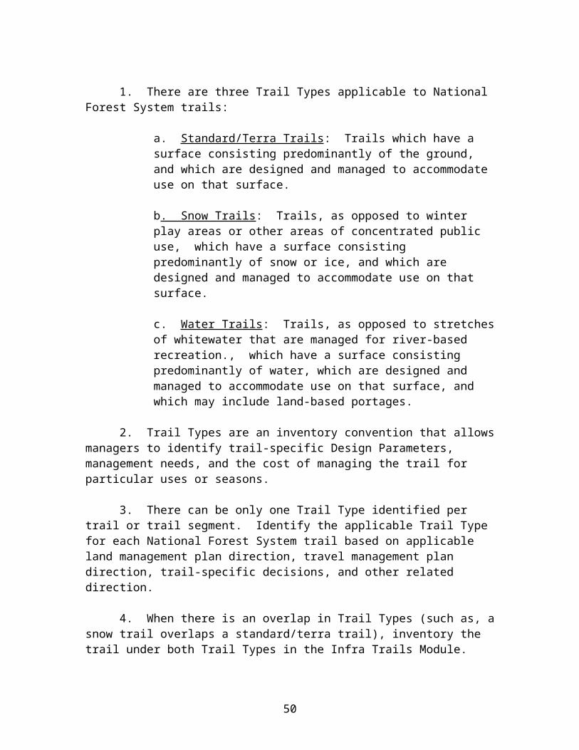
8. If a decision is made to build a bridge for pack and saddle animals, select a bridge site with an adequate foundation for abutments and stream piers. The bridge must have a load-carrying capacity equal to the maximum number of loaded animals that can occupy it at one time or the maximum anticipated snow load, whichever is greater. Design railings to prevent packs from getting caught. For minimum bridge widths and railing heights, see FSH 7709.56b, section 7.69, exhibit 01, Trail Bridge Design Criteria.
50
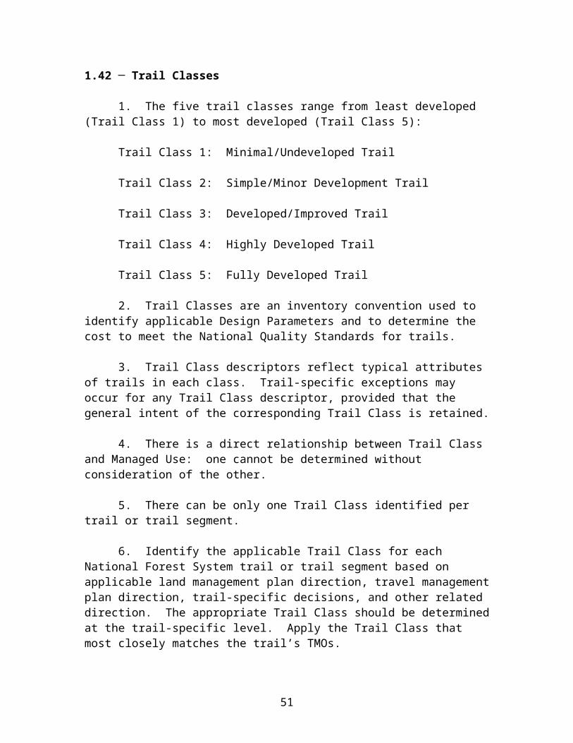
FSH 2309.18, section 2.31c, Exhibit 01
Design Parameters The Design Parameters are technical guidelines for assessment, survey, design, construction, repair, and maintenance of trails, based on Trail Class and Designed Use. These parameters reflect the design objective for the trail. Local exceptions can be established based on specific trail conditions, topography and other factors, provided that the exceptions reflect the general intent of the corresponding Trail Class.
Designed UsePACK AND SADDLE Trail Class 1 Trail Class 2 Trail Class 3 Trail Class 4 Trail Class 5Design Tread Width
Wilderness Typically not designed or actively managed for equestrians, although use may be accepted
12” – 18”Exception: may be to 48” at switchbacks, turn-pikes, fords and steep side slopes
12” – 24”Exception: may be to 48” at switchbacks, turn-pikes, fords and steep side slopes; up to 60” along precipices
24”Exception: may be to 48” at switchbacks, turn-pikes, fords and steep side slopes; up to 60” along precipices
Typically not designed or actively managed for equestrians, although use may be accepted
Non-Wilderness 12” – 24” (with above exceptions)
18” – 48” (with above exceptions)
36” – 96”
Design Surface
Type Native, with limited grading
Native with some on-site borrow or imported materials
Native with some imported materials or stabilization
Obstacles Roots, rocks, logs to 12” Generally clear;Occasional protrusions to 6”
Smooth, few obstacles;Occasional protrusions 2” – 3”
Design Grade1
Target Grade2
(>90% of Trail)</= 20% </= 12% </= 10%
Short Pitch Max3
(Up to 200’ lengths)30% 20% 15%
Max Pitch Density4 < 5% of trail < 5% of trail < 3% of trail
Design Cross-Slope
Target Range 5 – 10% 5% 5%
Maximum Natural side-slope 10% 10%
Design Clearing
Width 36” – 48” 60” – 78” 72” – 96”
Height 8’ – 10’ 10’ 10’ - 12’
Design Turns
Radius 4’ – 5’ 5’ – 6’ 6’ – 10’
1 Grade variances should be based upon soils, hydrological conditions, use levels, and other factors contributing to surface stability and erosion potential.2 The trail grade expected over the majority (at least 90%) of the trail.3 The steepest grade expected, in lengths of up to 200 feet and not exceeding the Maximum Pitch Density.4 The maximum percentage of the trail that is within 5% (+/-) of the Short Pitch Maximum Grade.
51

2.31c ─ Bicycle Design Parameters [Reserved]
52

FSH 2309.18, section 2.31c, Exhibit 01
Design Parameters The Design Parameters are technical guidelines for the assessment, survey, design, construction, repair, and maintenance of trails, based on Trail Class and Designed Use. These parameters reflect the design objective for the trail. Local exceptions can be established based on specific trail conditions, topography, and other factors, provided that the exceptions reflect the general intent of the corresponding Trail Class.
Designed UseBICYCLE Trail Class 1 Trail Class 2 Trail Class 3 Trail Class 4 Trail Class 5Design Tread Width
One Lane 6” – 12” 12” – 24” 18” – 30” 24” – 48” 36” – 60”
Two Lane Not applicable Not applicable 48 ” – 60” Accommodate two-lane travel with passing lanes
60” – 84” 72” – 120”
Design Surface
Type Native;Rough, unstable or soft tread
Native, with limited grading;Unstable or soft sections likely
Native with some on-site borrow or imported material;.Some soft areas
Likely imported or stabilized tread;Few, if any, loose or soft surfaces
Firm, hardened surface
Obstacles Rocks, logs and roots up to 6 – 12” common;Forced portages likely
Embedded rock, protrusions to 6”; Some portages may be needed
Generally smooth with few protrusions exceeding 3”
Smooth, few obstacles;1 – 2” protrusions
No obstacles to wheeled transport
Design Grade1
Target Grade2
(>90% of Trail)15% – 18% </= 12% </= 10% </= 8% </= 5%
Short Pitch Max3
(Up to 200’ lengths)30%50% on downhill-only travel
25%35% on downhill-only travel
15% 10% 8%
Max Pitch Density4 < 10% of trail < 5% of trail < 5% of trail < 3% of trail < 3% of trail
Design Cross-Slope
Target Range 5% – 10% 5% – 10% 5% 3% – 5% 3% – 5%
Maximum
Design Clearing
Width 24” – 36”Some vegetation may encroach into clearing area
36” – 48”Some light vegetation may encroach into clearing area
12” – 18” outside of tread edge
12” – 18” outside of tread edge
18” – 24” outside of tread edge
Height 6’ – 7’ 7’ – 8’ 8’ 8’ - 9’ 8’ - 9’
Design Turns
Radius 3’ - 4’ 4’ – 6’ 6’ – 8’ 8’ – 10’ 8’ - 12’
1 Grade variances should be based upon soils, hydrological conditions, use levels, and other factors contributing to surface stability and erosion potential. 2 The trail grade expected over the majority (at least 90%) of the trail.3 The steepest grade expected, in lengths of up to 200 feet and not exceeding the Maximum Pitch Density.4 The maximum percentage of the trail that is within 5% (+/-) of the Short Pitch Maximum Grade.
53

2.32 ─ Standard/Terra Trails: Motorized
2.32a ─ Motorcycle Design Parameters
1. Generally, motorcycling on National Forest System lands is a trail-based activity with an emphasis on the National Forest setting.
2. Avoid locating motorcycle trails on National Forest System roads where state laws require motorcycles to be highway-legal vehicles.
3. Designate suitable closed roads as National Forest System trails open to motorcycle use.
4. On Trail Class 4 trails, alignment is moderate, with no sharp curves combined with steep grades. Novice riders may be subjected to sharp curves, but not in combination with rough surfaces or steep grades.
5. Trail alignment should exhibit increasing randomness as the rating progresses from Trail Class 4 to Trail Class 2.
6. User needs for different distances and experiences can be accommodated by providing cutoffs on a system of loop trails. An experienced rider can ride approximately 50 miles in an average day. Some riders can cover over 100 miles of trail. This travel normally includes trails ranging from Trail Class 2 to Trail Class 4.
7. Favor drainage dips over water bars.
8. Use climbing turns, and avoid switchbacks whenever possible. Design turns to minimize excavation and cutbank exposure.
9. For trails in Trail Class 4, locate turns on level ground or on slopes of less than 6 percent. The minimum radius of a switchback is 8 feet. Tread width should be increased to 36 inches for switchbacks with a 4-foot radius. On novice and intermediate trails, provide a 4 to 6-foot barrier on the downhill exit of the switchback.
10. The radii of turns should vary depending on the speed of the motorcycle entering the turns. The trail designer can slow the speed of the motorcycle by decreasing the turning radius. The designer also may increase the length of a trail in a limited area by increasing the number of turns.
11. Hardening of switchback or climbing turns on sensitive soils is recommended. Suggested hardening materials include concrete blocks, soil, and cement.
12. For minimum bridge widths and railing heights, refer to FSH 7709.56b, section 7.69, exhibit 01, Trail Bridge Design Criteria. Bridges should have a straight
54

approach and should not change directions. Special decking may be necessary to accommodate wheeled vehicles.
13. Locate trail junctions so that no more than 2 trails intersect at one point.
55

FSH 2309.18, section 2.32a, Exhibit 01
Design Parameters The Design Parameters are technical guidelines for the assessment, survey, design, construction, repair, and maintenance of trails, based on Trail Class and Designed Use. These parameters reflect the design objective for the trail. Local exceptions can be established based on specific trail conditions, topography, and other factors, provided that the exceptions reflect the general intent of the corresponding Trail Class.
Designed UseMOTORCYCLE Trail Class 1 Trail Class 2 Trail Class 3 Trail Class 4 Trail Class 5Design Tread Width(If side-slope >50%, increase widths by 6” – 18”)
One Lane Typically not designed or actively managed for motorcycles, although use may be accepted
8” – 24”At switchbacks, 36” – 48”
18” – 36”At switchbacks, >/= 48”
30” – 48”At switchbacks, >/= 48”
Typically not designed or actively managed for motorcycles, although use may be acceptedTwo Lane Typically not designed
for two-lane travel;Passing areas (uncommon) up to 60”
48 ” – 60” Occasional passing lanes to 72”
60” – 72”
Design Surface
Type Native, with limited or no grading;Commonly unstable and soft
Native with some on-site borrow, pavers, or imported materials;Some loose or soft areas
Gravel, pavers or other imported materials possible;Relatively firm, stable surface
Obstacles Soft sand and embedded rock, steps and protrusions up to 12”
Generally smooth with few protrusions exceeding 6”
Smooth, few obstacles;Few 2” – 4” protrusions
Design Grade1
Target Grade2
(>90% of Trail)</= 25% </= 15% </= 10%
Short Pitch Max3
(Up to 200’ lengths)40%Rarely to 50% on downhill-only travel
25% 15%
Max Pitch Density4 < 10% of trail < 10% of trail < 5% of trail
Design Cross- Slope
Target Range 5% – 10% 5% 3% – 5%
Maximum 15% 10% 10%
Design Clearing
Width(On steep side-hills, increase clearing on uphill side by 6” – 12”)
36” – 48”Some vegetation may encroach into clearing area
12” – 18” outside of tread edge
> 18” outside of tread edge
Height 7’ – 8’ 8’ 8’ - 9’
Design Turns Radius 4’ – 5’ 5’ – 6’ 6’ – 8’
1 Grade variances should be based upon soils, hydrological conditions, use levels, and other factors contributing to surface stability and erosion potential. 2 The trail grade expected over the majority (at least 90%) of the trail.3 The steepest grade expected, in lengths of up to 200 feet and not exceeding the Maximum Pitch Density.4 The maximum percentage of the trail that is within 5% (+/-) of the Short Pitch Maximum Grade.
56
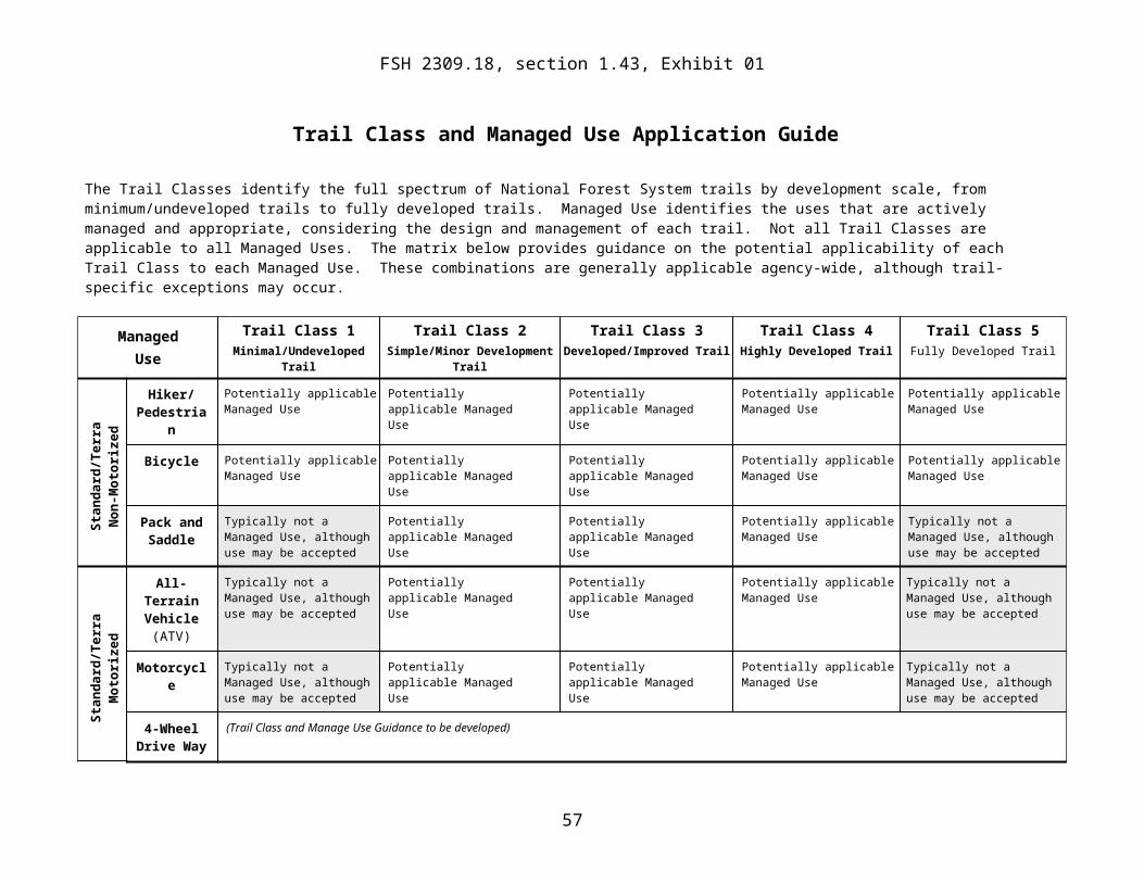
2.32b ─ All-Terrain Vehicle Design Parameters
* * * * *
57

FSH 2309.18, section 2.32b, Exhibit 01
Design Parameters The Design Parameters provide guidance for the assessment, survey, design, construction, repair, and maintenance of trails, based on Trail Class and Designed Use. These parameters reflect the design objective for the trail. Local exceptions can be established based on specific trail conditions, topography, and other factors, provided that the exceptions reflect the general intent of the corresponding Trail Class.
Designed UseALL-TERRAIN VEHICLE Trail Class 1 Trail Class 2 Trail Class 3 Trail Class 4 Trail Class 5
Design Tread Width[If sideslopes are >50%, increase widths by 6” – 18”]
One Lane Typically not designed or actively managed for ATVs, although use may be accepted
30” – 48”At switchbacks, >/= 48”
42” – 60”At switchbacks, >/=60”
54” – 72”At switchbacks, >/=60”
Typically not designed or actively managed for ATVs, although use may be acceptedTwo Lane Typically not designed
for two-lane travel; Passing areas (uncommon) - 60”
60” and/or accommodate with passing areas 60” – 78”
72”-96”
Design Surface
Type Native with limited or no grading; commonly soft and unstable
Native with some onsite barrow or imported materials; some loose or soft sections
Relatively firm and stable; gravel, pavers or other imported materials possible
Obstacles Embedded rock, steps, waterbars, holes and protrusions to 6”
Generally smooth, with few protrusions exceeding 4”; drain dips and low waterbars
Smooth, few obstacles; 1” – 3” protrusion; drain dips or waterbars with low-angle approach
Design Grade1
Target Grade2
(>90% of Trail)</=25% </=15% </=10%
Short Pitch Max3
(Up to 200’ lengths)35% 25% 15%
Max Pitch Density4 < 10% of trail < 5% of trail < 5% of trail
Design Cross- Slope
Target Range 5% – 10% 3% – 5% 3% – 5%
Maximum 15% 10% 8%
Design Clearing
Width(On steep side hills, increase clearing on uphill side by 6” – 12”)
36”– 48”Some vegetation may encroach into clearing area
8” – 12” outside of tread edge
>/=12” outside of tread edge
Height 5’ – 6’ 6’ – 7’ 8’
Design Turns Radius(Use climbing turns versus switchbacks for ATVs whenever possible)
6’ – 8’ 8’ – 10’ >/=10’
1 Grade variances should be based upon soils, hydrological conditions, use levels, and other factors contributing to surface stability and erosion potential. 2 The trail grade expected over the majority (at least 90%) of the trail.3 The steepest grade expected, in lengths of up to 200 feet and not exceeding the Maximum Pitch Density.
58

4 The maximum percentage of the trail that is within 5% (+/-) of the Short Pitch Maximum Grade.
59

2.33 ─ Snow Trails
2.33a ─ Cross-Country Ski Design Parameters
1. Trails with a Designed Use of Cross-Country Ski are snow trails that are designed specifically for winter travel. They may, however, also coincide with or overlay a standard/terra trail that is managed during the non-snow season of use. When this occurs, identification of applicable Design Parameters should be based on consideration of both the Designed Use identified for the standard/terra trail and the Designed Use identified for the Snow Trail. Select the Design Paramaters with the most demanding design, construction, and maintenance requirements.
2. Opportunities to enjoy the natural setting are generally enhanced in the winter, but should be considered under both winter and summer conditions. Locate or review potential trail locations during the winter months.
3. Locate cross-country ski trails where reliable snow conditions exist for 2 to 3 months. Utilize topography to extend the period of snow cover. Consider aspect, prevailing wind direction, shading, and microclimate factors.
4. Avoid avalanche hazards. Consult with those knowledgeable of local avalanche hazards before developing cross-country ski trails.
5. Avoid hazardous stream and lake crossings. Normally, six inches of hard blue ice is considered safe for cross-country ski trails.
6. Avoid locating trails under dense canopies, especially in tall, old-growth stands. The canopy intercepts much of the snowfall, and when the air temperature rises, large chunks of snow fall on the trail.
7. Like downhill ski runs, cross-country ski trails are rated by difficulty level: easiest, more difficult, and most difficult. Although this is a relative rating, trails rated as easiest should always be designed for novice skiers under normal snow conditions. Trails rated most difficult should provide challenges but no unusual difficulties to experienced skiers. More difficult trails will fall somewhere between these two extremes.
8. Provide only sweeping curves on downhill sections. Locate outruns to permit users to slow down before turning. A check-space in midslope is desirable on long downhill runs. Alignment must correlate with grade. Avoid sharp turns on snow trails.
a. Trail Width and Tread Considerations On trails with a Designed Use of Cross- Country Ski, widths vary depending on the terrain, steepness of the trail, sharpness of curves, amount of use, and number of tracks. On flat or gently rolling terrain (grades of up to 3 percent), single-track groomed trails are cleared to 6 to 8 feet wide, and double-track groomed trails are cleared to 10 to 12 feet wide. Steeper, uphill sections should include extra clearing width where
60

herringbone or sidestep skiing techniques might be used. The extra clearing width should be one-half times the normal width, up to 14 feet. Downhill sections require extra widening commensurate with the speed of the hill: the lower portions and runout require the most widening, while the upper portions require less. Normally, a downhill run is cleared to 1.5 times the normal width from approximately one-third to two-thirds of the way down the hill. From two-thirds of the way down to the bottom and through the runout, the trail is cleared to twice the normal width.
b. Trail Length. Accommodate user needs for different distances and degrees of challenge by providing cutoffs on a system of loop trails, as follows:
Recommended Lengths Half Day Full Day
Easiest Trail 3.2 miles 6.4 miles Most Difficult Trail 6.4 miles 9.5 miles
c. Height. Clear overhead branches and obstructions the full width of the trail to a height of 10 feet above the average peak season snow depth.
d. Bridges. For minimum bridge widths and railing heights, see FSH 7709.56b, section 7.69, Exhibit 01, Trail Bridge Design Criteria. All ski trail bridges must be designed to allow skiers to stop safely before crossing and must provide adequate track width under maximum snow cover. Bridges on groomed trails must accommodate the width of grooming equipment.
e. Intersections. Approaches to intersections must have grades of 5 percent or less to allow for speed control. Clear intersections to a diameter of twice the trail width.
f. Marking Standards. Cross-country ski trails should be marked so that travelers unfamiliar with the trails can follow them during poor weather conditions, with no tracks to follow, under relatively poor lighting conditions. See FSH 7109.11, Sign Handbook, for guidance on marking trails.
61

FSH 2309.18, section 2.33a, Exhibit 01
Design Parameters The Design Parameters are technical guidelines for the assessment, survey, design, construction, repair, and maintenance of trails, based on Trail Class and Designed Use. These parameters reflect the design objective for the trail. Local exceptions can be established based on specific trail conditions, topography, and other factors, provided that the exceptions reflect the general intent of the corresponding Trail Class.
Designed UseCROSS-COUNTRY SKI Trail Class 1 Trail Class 2 Trail Class 3 Trail Class 4 Trail Class 5
Design Groomed Width
One Lane Typically not designed or actively managed for cross-country skiing
3’ – 4’If groomed, width of grooming equipment
6’ – 8’(or minimum width of grooming equipment)
8’– 10”(but typically managed to accommodate two-way passage)
Typically not designed or actively managed for cross-country skiing
Two Lane Typically not designed for two-lane travel, except in steep sections accommodate passing areas of 6’ – 8’.
>/=8’ (or min width of grooming equipment) and/or accommodate with passing areas 8’ – 12’ wide
12’ – 14’
Design Grooming and Surface
Type Coarse compaction;Occasional or no grooming (may be ski-packed); over-snow vehicle packing sufficientTracklayer optional
Groomed or compacted using implements or tracklayer when packed surface is snow-covered, drifted, melted or skied out
Well-groomed with tiller or other implements;Groomed frequently, and when groomed surface becomes degraded or buried
Obstacles Dips, bumps, or ruts to 12” common and may be tightly spaced;Surface obstacles may occasionally require off-trail bypass
Generally smooth;Dips, bumps, or ruts to 8” uncommon and widely spaced; Surface obstructions not present
Consistently smooth;Small, rolling bumps, dips and rises; Surface obstructions not present
Design Grade1
Target Grade2
(>90% of Trail)</=15% </=10% </=8%
Short Pitch Max3
(Up to 200’ lengths)25% 20% 12%
Max Pitch Density4 <10% of trail <5% of trail <5% of trail
Design Cross-Slope
Target Range </=10% </=5% </=5%
Maximum[For up to 50’]
20% 15% 10%
62

Designed UseCROSS-COUNTRY SKI Trail Class 1 Trail Class 2 Trail Class 3 Trail Class 4 Trail Class 5
Design Clearing
Width 4’ – 6’ (or minimum width of grooming equipment, if larger);Light vegetation may encroach into clearing area
>/=1’ outside of groomed edge; Light vegetation may encroach slightly into clearing area
>/=2’ outside of tread edge;Widen clearing at turns or if increased sight distance needed
Height(Above normal maximum snow level)
>/= 6’ – 8’ (or height of grooming machinery if used)
>/=8’ (or height of grooming machinery)
10’
Design Turns
Radius 8’ – 10’ if not snowcat-groomed (provide sufficient radius for grooming equipment if used )
15’ – 20’ (provide sufficient radius for grooming equipment)
>/=25’
1 Grade variances should be based upon soils, hydrological conditions, use levels, and other factors contributing to surface stability and erosion potential.2 The trail grade expected over the majority (at least 90%) of the trail.3 The steepest grade expected, in lengths of up to 200 feet and not exceeding the Maximum Pitch Density.4 The maximum percentage of the trail that is within 5% (+/-) of the Short Pitch Maximum Grade.
63

2.33b ─ Snowmobile Design Parameters* * * * *
64

FSH 2309.18, section 2.33b, Exhibit 01
Trail Design Parameters Trail Design Parameters provide guidance for the assessment, survey, design, construction, repair and maintenance of trails, based on the Trail Class and Designed Use identified for the trail. Local exceptions can be established based on specific trail conditions, topography and other factors, provided that the exceptions still reflect the general intent of the Trail Class.
Designed UseSNOWMOBILE Trail Class 1 Trail Class 2 Trail Class 3 Trail Class 4 Trail Class 5
Design Tread Width
One Lane Typically not designed or actively managed for snowmobiles.
Typically not groomed, but commonly signed. If groomed, 4’-6’ (or minimum width of grooming equipment.)
6’-8’ (or minimum width of grooming equipment). On tight-radius turns, increase groomed width to >/=10’.
8’-10’. On tight-radius turns, increase groomed width to >/=12’.
Typically not designed or actively managed for snowmobile.
Two Lane Typically not groomed, but commonly signed. If groomed, >/=8’ groomed width.
>/=11’ and/or accommodate with passing areas 12’-14’ wide.
12’-16’. On tight-radius turns, increase groomed width to >/=14’.
Design Surface
Type Occasional or no grooming or user-packed. Coarse compaction with cat or snowmobile. Use of implements optional.
Groomed or compacted after significant snow accumulations or when moguled/rutted. Use of implements likely.
Well-groomed with tiller and/or other implements. Groomed frequently, soon after significant snow accumulations and before surface is degraded.
Obstacles Dips/bumps/ruts to 24” common and may be tightly spaced. Obstacles may occasionally require off-trail bypass.
Generally smooth. Dips, bumps, ruts to 12” infrequent and widely spaced. Surface obstacles not present.
Consistently smooth. Small, rolling bumps, dips and rises. Surface obstacles not present.
Design Grade1
Target Grade2
(>90% of Trail)</=20% </=15% </=10%
Short Pitch Max3
(Up to 200’ lengths)35% 25% 20%
Max Pitch Density4 <10% of trail <5% of trail <5% of trail
Design Cross-Slope
Target Range </=15% </=10% </=5%
Maximum 25% 15% 10%
65

Designed UseSNOWMOBILE Trail Class 1 Trail Class 2 Trail Class 3 Trail Class 4 Trail Class 5
Design Clearing
Width 4’-6’ (or minimum width of grooming equipment if used). Some vegetation may encroach into clearing area
>/=1’ outside of groomed trail edge. Light vegetation may encroach into clearing area.
>/=2’ outside of groomed trail edge. Widen clearing at turns or if increased sight distance needed.
Height[Above normal maximum snow level]
>/=6’ (Provide sufficient clearance for grooming equipment if used).
>/=7’ (Provide sufficient clearance for grooming equipment).
10’ (Provide sufficient clearance for grooming equipment).
Design Turns
Radius 8’-10’ if not groomed. (Provide sufficient radius for grooming equipment if used – typically 15-20’)
15’-20’ (Provide sufficient radius for grooming equipment).
>/=25’
1 Grade variances should be based upon soils, hydrological conditions, use levels, and other factors contributing to surface stability and erosion potential. 2 The trail grade expected over the majority (at least 90%) of the trail.3 The steepest grade expected, in lengths of up to 200 feet, and not exceeding the Maximum Pitch Density.4 The maximum percentage of the trail that is within 5% (+/-) of the Short Pitch Maximum Grade.
66

2.34 ─ Water Trails [Reserved]
2.35 ─ Special Trails
2.35a ─ Accessibility
1. The Forest Service Trail Accessibility Guidelines (FSTAG) provide guidance for maximizing accessibility of trails in the National Forest System, while recognizing and protecting the unique characteristics of their natural setting. Appropriate application of the FSTAG will ensure that the full range of trail opportunities continues to be provided, from primitive long-distance trails to highly developed trails and popular scenic overlooks. Application of FSTAG is not intended to change the Trail Class or Designed Use prescribed for a trail. The FSTAG is available electronically at www.fs.fed.us/reacreation/programs/accessibility.
2. To ensure integration between this handbook and the FSTAG, a synposis of application of the FSTAG to trails in the National Forest System follows.
3. Refer to the FSTAG for direction on assessment, development, and management of trails that are subject to the FSTAG.
4. The FSTAG applies to trails in the National Forest System that:
a. Are new or altered (an alteration is a change in the original purpose, intent, or design of a trail);
b. Have a Designed Use of Hiker/Pedestrian; and
c. Connect directly to a currently accessible trail or to a trailhead.
5. While trail designers and managers are encouraged to look for opportunities where accessibility may be improved beyond those trails where it is required, the uniqueness of each trail must be preserved. The FSTAG contains conditions for departure and exceptions that apply when application of a technical provision would cause a change in a trail’s setting or the purpose or function for which a trail was designed.
6. The FSTAG probably will not apply to most portions of existing primitive, long-distance trails. However, the FSTAG may apply to some segments of those trails, such as where they pass through a more developed area. The FSTAG contains exceptions that will prevent accessibility from being pointlessly applied in a piecemeal fashion along a trail when access between trail segments is not possible. The FSTAG also contains requirements to provide accessibility to special features where possible.
7. If materials need to be obtained from or manipulated on a sign or kiosk, the sign or kiosk must be designed to meet the reach ranges in 308 of the ABAAS.
67

8. In accordance with the Forest Service policy of universal design, trail information must be provided in a manner that will permit users to evaluate the appropriateness of a trail for their ability, resources, and the type of trail experience they are seeking.
9. Signs must be posted at the trailhead of new or altered trails and trail segments that fall into Trail Class 4 or Trail Class 5, as well as at the trailhead of trails that have been evaluated for accessibility. At a minimum, in addition to the standard information including the name and length of the trail, these signs must include the typical and maximum trail grade, typical and maximum cross-slope, typical and minimum tread width, surface type and firmness, and obstacles. These signs also should state that the posted information reflects the condition of the trail when it was constructed or assessed and should include the date of the construction or assessment.
10. Where more extensive trail information is provided (e.g., an aerial map of the trail and related facilities), the location of specific trail features and obstacles that do not comply with the FSTAG’s technical provisions should be identified and a profile of the trail grade should be included.
11. The international symbol of accessibility,( the wheelchair symbol), should not be used in trail signage.
12. Local managers have the discretion to decide whether to post FSTAG signage on newly constructed or altered trails that fall into Trail Class 1, Trail Class 2, or Trail Class 3.
2.35b ─ Interpretive Trails
1. While interpretive trails may be managed for a variety of uses, they most often fall into Trail Class 4 or Trail Class 5, with a Designed Use of Hiker/Pedestrian, but sometimes fall into Trail Class 3.
2. Interpretive trails offer access to areas with natural geologic, historical, or cultural significance. They provide a recreation experience to enrich visitors’ understanding of the environment and fulfill national forest management objectives through interpretation. Consider providing interpretive trails in a wide range of forest settings with maximum interaction between users and the environment.
3. An interpretive plan is recommended as the basis for development of most interpretive trails. Interpretive plans vary in complexity and scope, depending on the trail being developed. In developing an interpretive plan, consider the following at a minimum:
a. Determine the audience to be reached. Invite user participation in development of the trail.
b. Determine the specific objectives of the message.
68

c. Determine the appropriate media (for example, trail signing, audio stations, or brochures) that are best suited to the message and audience.
d. Evaluate all sites that provide the intended message and theme. Consider population proximity, amount of expected use, adjacent facilities and services, and general desirability of the area.
e. Evaluate what the area has to offer and what visitors want. Develop the trail message to enhance visitors’ knowledge.
f. Inventory the selected site to identify its limitations, opportunities, and fragile areas. Inventorying may be accomplished by developing a grid with parallel strips representing every 50 to 100 feet. On each strip the surveyor would note items of interest or map items. These rudimentary maps then would be refined into a more detailed map.
g. Use a multidisciplinary approach in developing an interpretive plan.
4. Avoid critical wildlife habitats and other fragile, unusual, and sensitive areas unless they can be adequately protected or conduct only guided walks through these areas.
5. The standard interpretive trail is usually less than 1 mile long. Additional shorter loops can be part of the longer section. Interpretation of special areas can be provided on any trail.
6. Locate interpretive trails near population centers or near heavily used national forest developments. However, locate the trail area away from noise and distracting activities. Some distracting conditions can be mitigatedby a vegetation screen.
7. Select a route with a wide range of special features or one that illustrates a single purpose (sometimes known as a theme trail). This approach is preferred.
8. The following design criteria apply to most interpretive trails:
a. Design the message or theme of the trail to achieve management objectives, develop user awareness, and promote enjoyment of the area.
b. Space stops to allow users to absorb ideas. Plan for approximately 10 to 15 signs or stops per trail, with stops at least 200 feet apart. If more than 15 stops are planned, consider using brochures.
c. Separate trailheads may be located within walking distance from areas of concentrated public use, such as campgrounds.
69

d. Take special care in designing entry signs, registration stations, brochure distribution boxes, and other signs to present a positive image and a pleasant entrance experience.
e. Write the message at the educational and social level of the anticipated users. Indicate in the message why the item is important. Test stops and text on representatives of the intended audience before final development. Redesign as necessary.
f. Do not interpret all items on the trail. Those items not interpreted can be added later to vary the message. Consider a seasonal approach, if possible.
g. Call attention to items to observe between stops, such as birds and animals, by noting them on signs or in brochures.
Chapter 3 ─ Trail Preconstruction and Reconstruction
3.1 ─ Preconstruction
1. Preconstruction must begin early and must be completed prior to construction. The scope of preconstruction depends upon the type of facility being designed. A minimally developed hiker/pedestrian trail may require less preconstruction than a fully developed trail. Regardless of the level of development, the series of steps remains the same and begins with reconnaissance.
2. Determine whether the FSTAG will apply to the trail being constructed or reconsructed. If the FSTAG applies, it must be followed from initiation of reconnaissance. See the Process Overview in Appendix A of the FSTAG.
3.11 ─ Reconnaissance
Reconnaissance includes identification and evaluation of alternative routes and leads to selection of the best possible routes and facility to meet established objectives for Trail Class, Managed Uses, and Designed Use. Application of sound principles of trail location, alignment, and grade will minimize future operation and maintenance problems.
* * * * *
3.12b ─ Grade
1. Early reconnaissance and environmental analysis should provide the range of preferred grades for a specific trail. The location of the grade line on the ground is the most important element of trail development: trail grade influences the length of trail, level of difficulty, and drainage and maintenance requirements. Therefore, grade usually is the controlling factor for trail location. Undulate the grade to provide natural drainage and variation and to eliminate long, steady grades, which are tiring to the user.
70

2. A slight downhill grade is necessary to provide cross -drainage and to provide grade undulations for drainage purposes. These sections of grade must be designed to avoid excessively steep sections of trail grade.
3. In areas where there is a potential for trail erosion, roll the grade to create natural-appearing drainage dips at appropriate intervals to divert water from the trail.
4. Spacing of drainage facilities to intercept water running down a trail is influenced by soil type and grade, which affect water velocity. Determine the appropriate spacing before locating the trail and establishing cross drainage from rolling gradeline. Section 3.12, Exhibit 02, shows spacing requirements for various soil types and grade percentages.
5. Where soil types or tread-hardening techniques provide necessary resource protection, steeper grades may be permitted.
6. Some trails with a Designed Use of Hiker/Pedestrian could have runs of rock steps for 30 percent or more of the total trail length. A trail could have some short, steep pitches to take advantage of an area of hightly stable terrain that can be easily protected from erosion. Use runs of steps for certain types of trails when grades between control points would exceed either user comfort or soil stability.
7. Avoid flat grades where possible. Trails that must be located through meadows, savannahs, and other low areas should be considered for walkways, puncheon, or tread stabilization.
8. Increase grades 10 to 15 percent at approaches to switchbacks to avoid cross-cutting by trail users.
9. A level-off grade should be located at the end of steep, sustained grades. A level-off grade is any grade within the range of target grades identified for the Designed Use. The length and grade of the level-off section should correlate to the Designed Use and the Trail Class.
Chapter 4 ─ Trail Operation and Maintenance
Trail management objectives, including the five Trail Fundamentals, provide the basis for developing trail operation and maintenance strategies. In addition to the Trail Fundamentals identified for the trail, some key considerations are expected amount, type, and timing of use.
4.1 ─ Trail Operation
Trail operation involves management of the type, volume, and season of use for the Managed Uses of a trail to achieve its TMOs. Elements of trail operation include
71

monitoring the volume of use, the type of use, and the effects of use on the TMOSs; implementing trail restrictions; and informing users through guides and signs of the intended use for each trail.
* * * * *
4.13 ─ Public Information
General guidance on the appropriate level and type of signing by Trail Class is provided in the Design Parameters. Specific direction on signing and public information is contained in FSM 7160, Signs and Posters, and EM-7100-15, Standards for Forest Service Signs and Posters. Additional direction on signs for accessible trails is contained in the FSTAG, which is available electronically at www.fs.fed.us/reacreation/programs/accessibility.
* * * * *
4.14 ─ Signs
Signs should follow the direction contained in FSM 7160, Signs and Posters, and EM-7100-15, Standards for Forest Service Signs and Posters. Additional direction on signs for accessible trails is contained in Section 7.3.10 of the FSTAG.
* * * * *
4.22 ─ Recording Maintenance
Maintenance shall be recorded as standard when a trail is maintained in a manner adequate to meet its TMOs. Maintenance shall be recorded as less than standard when some needed maintenance activities are not performed, resulting in a trail that does not meet its TMOs. Refer to the Design Parameters (chapter 2) to determine whether maintenance is preserving the trail to a standard adequate to meet its TMOs.
4.23 ─ Maintenance Activity Groups
Five activity groups are described below, along with a list of each maintenance activity. These maintenance activities (or others as desired by local units) should be used to maintain trails based on applicable Design Parameters. These maintenance activities are only a suggested list; different lists may be developed at the regional, forest, or district level.
4.25 ─ Condition Assessment and Prescription Surveys
1. The condition assesment and prescription survey is the backbone of maintenance management. Those who perform condition surveys must be knowledgeable of the entire maintenance management process. The data gathered and
72
the decisions made during the condition survey provide the information needed for subsequent trail management decisions. The condition survey also may be used for scheduling and reporting work accomplishments.
2. Review the TMOs for each trail prior to performing condition surveys. TMOs are used in development of the annual maintenance plan and generally include the following considerations:
a. Requirements to protect adjacent resources or improvements, such as streams, lakes, meadows, vegetation, scenic strips, viewing areas, experimental forests, and facilities.
b. The planned use of the trail. The Trail Type, Trail Class, Managed Use, Designed Use, Design Parameters, season of use, volume of use, and trail restrictions and regulations are examples of the type of information that must be known before conducting a condition survey. Use this information to determine whether a trail is adequately providing for planned use.
3. Condition surveys are conducted to provide current information about the condition of all physical features that are of concern to the trail manager. Prior surveys provide information to forecast work requirements that are used in formulating the annual maintenance plan. Examples of possible deficiencies that should be noted in condition surveys include:
a. Inlets and outlets of culverts that are plugged.
b. Location of hazard trees.
c. Brushing growth within cleared limits.
d. Sluffing backslope.
e. Missing or damaged signs.
f. Subgrade failures.
g. Stone retaining wall failures.
h. Slide encroachment along the trail.
i. Trail tread erosion.
These surveys also provide data for reporting deficiencies and corrective measures that can be used in planning reconstruction projects.
73
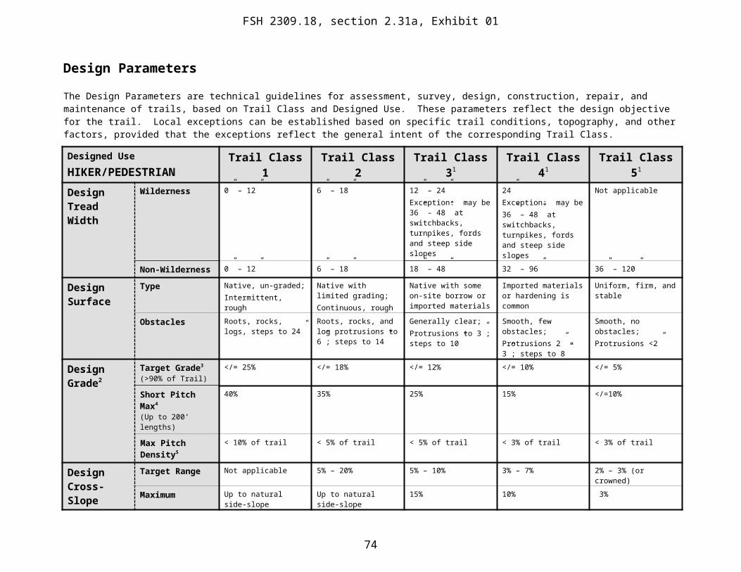
4. The prescription survey identifies actions needed to correct the deficiencies noted on the ground. A qualified person can prescribe the action needed to correct the deficiency at the same time the condition survey is made. Specific maintenance activities or tasks should be noted in the survey.
5. A detailed condition survey may not be needed when trails are opened in the spring. (opening trails in the spring normally only involves removing logs and drainage maintenance). However, trail inspectors need to identify and verify the type and extent of work needed before dispatching crews or awarding contracts for trail maintenance.
74