the future of mineral exploration drilling and sampling
TRANSCRIPT

1
The Future of Mineral Exploration Drilling and SamplingExploration ’17 Thursday 26 October Totonto, Ontario


1
THURSDAY 26 OCTOBER 2017 MTCC (METRO TORONTO CONVENTION CENTRE)
1.00 PM IntroductionDavid Giles, University of South Australia/DET CRC
1.05 PM Coiled Tubing Drilling in Mineral ExplorationDavid Giles, University of South Australia /DET CRC
1.30 PMLogging-While-Drilling in Mineral Exploration: State-of-the-Research
Anton Kepic, Curtin University/DET CRC
1:50 PM Sampling for Coiled Tubing DrillingBen van der Hoek, University of South Australia/DET CRC
2.00 PMTop-of-Hole Geochemistry and Mineralogy: State-of-the-Research
Yulia Uvarova, CSIRO/DET CRC
2.20 PM Coffee
2.40 PMSeismic Pre-Drilling and Sampling: State-of-the-Research
Milovan Urosevic, Curtin University/DET CRC
3.00 PM Assay-While-Drilling: State-of-the-Products James Cleverley, Imdex
3.20 PM Geological Logging with X-ray Vision Aaron Baensch, Olympus
3.40 PM The Future of Geological Survey DrillingSteve Hill, Geological Survey of South Australia
4.00 PM Close
PROGRAMME

THE FUTURE OF MINERAL EXPLORATION DRILLING AND SAMPLINGTHURSDAY 26 OCTOBER 2017 TORONTO, ONTARIO
2
YOUR SPEAKERS

3
Prof David Giles is Strand Leader and John Ralston Chair of Minerals and Resources Engineering at the Future Industries Institute, University of South Australia. Prof Giles has over 20 years’ experience in minerals exploration spanning the boundaries of industry and academia. He is Leader of Program 3 (Targeting) within the Deep Exploration Technologies CRC.
Ben van der Hoek is a key researcher in DET CRC Project 3.2 Lab-At-Rig® Futures at the University of South Australia. Ben completed his PhD at the University of Adelaide with DET CRC in 2013 in the field of regolith geochemistry and has since pursued his interests in geochemistry and engineering as a researcher within the Lab-At-Rig® team.
Currently the Boart Longyear Chair in Geophysical Instrumentation in Curtin University, Anton has been with Curtin University since 1999. Anton previously held positions within WMC in Exploration and Technology group, and holds degrees from University of Western Australia (BSc. Hon) and a PhD in Geophysics from the University of British Columbia.
Yulia is a Principal Research Scientist, Research Group Leader and Project Leader at CSIRO Mineral Resources. Currently, Yulia is leading Project 3.2 Lab-at-Rig® Futures, which will lay the foundations of future Lab-at-Rig® platforms that will take advantage of new sensor technologies and develop the application beyond current deployment in greenfields exploration.
DAVID GILESProgram 3 Leader University of South Australia/DET CRC
BEN VAN DER HOEKResearcher, University of South Australia/DET CRC
ANTON KEPICProject 2.2 Leader, Curtin University/DET CRC
YULIA UVAROVAProject 3.2 Leader CSIRO/DET CRC
YOUR SPEAKERS

THE FUTURE OF MINERAL EXPLORATION DRILLING AND SAMPLINGTHURSDAY 26 OCTOBER 2017 TORONTO, ONTARIO
4
Milovan Urosevic received BSc (Hons) in geophysics from the University of Belgrade in 1980, MSc in geophysics from the University of Houston in 1985 and PhD in geophysics from the Curtin University of Technology in 2000. He acquired over ten years of industry experience working in areas of seismic data processing, AVO, inversion, multi-component seismology and seismic anisotropy.
After joining Curtin University in 1991 he has taken part in various industry projects related to the oil, coal and mineral exploration. His main interest is in the utilisation of new technologies to advance exploration of natural resources.
He is currently involved in two major Australian corporative research centres (CO2CRC and DET CRC). He is also leading a large ANLEC R&D (Australian National Low Emissions Coal Research and Development) project that is investigating and evaluating the applicability of novel, alternative seismic methodologies for rock characterisation. Milovan is associate editor of the Exploration Geophysics Journal.
James Cleverley is currently Global Product Manager – Geosciences for REFLEX, a leading brand of ASX-listed Imdex Ltd, (Perth, Australia). James has been involved in two industry-led research cooperatives dating back to his second post-doc at James Cook University with the Predictive Mineral Discovery CRC and then heading up projects in phase 1 of the Deep Exploration Technologies CRC as Research Group Leader in CSIRO, before moving to Imdex in mid-2014.
James was the project lead for the DET CRC Lab-at-Rig® project, a collaboration between REFLEX, Olympus and CSIRO, which was commercialised by Imdex in September 2015. More recently James has taken over product management of technologies designed to provide near real-time decision support in the geosciences in the Imdex In-Field Geoanalysis solution. He is passionate about the use of geochemical data, data analytics, sensor and real-time technology, and the understanding of hydrothermal systems for exploration targeting and mine optimisation, but has been lucky enough to work on everything from large gold deposits to chondritic meteorites.
MILOVAN UROSEVICResearcher, Curtin University/DET CRC
JAMES CLEVERLEYResearcher, Imdex

5
YOUR SPEAKERS
Dr Steve Hill is Chief Government Geologist and Director of the Geological Survey of South Australia, where his role is to oversee and coordinate the Geological Survey’s research and generation and delivery of pre-competitive geoscience data. Before joining the Public Service in 2013, Dr Hill spent more than 20 years in academia at the University of Adelaide, University of Canberra and Australian National University.
STEVE HILLDirector/Chief Government Geologist Geological Survey of South Australia
Aaron is the Principal Geologist – International Mining Group (IMG) for Olympus Scientific Solutions Americas (OSSA) headquartered in Boston, MA, USA. He is also an embedded researcher & project manager at the Deep Exploration Technologies – Commonwealth Research Cooperative (DET CRC) based in Adelaide, Australia & co-inventor of the recently commercialized Lab-At-Rig® product.
Aaron has been working with Olympus (formerly Innov-X Systems) since 2008 and has become an Industry Specialist in the application of field portable x-ray fluorescence, x-ray diffraction and microscopy for mineral exploration, mining, mineral processing, environmental and petroleum applications. He is currently focused on the research & development and business development of real-time mineral analysis technologies, including the adaption of systems used by NASA on the Mars Curiosity Rover for terrestrial mineral analysis.
AARON BAENSCHResearcher, Olympus

9/10/2017
1
Coiled Tubing Drilling for Mineral Exploration
David GilesDET CRC Program 3 LeaderFuture Industries Institute, UniSA
The Future of Mineral Exploration Drilling and SamplingExploration ’17, Toronto
26 October 2017
Why Coiled Tubing Drilling?
Magnetics (TMI)
0 100 200
kilometresPrevious Drilling
457 holesUnevenly distributedSource: OESP depth-to-basement study
Mt Isa How do we characterise and explore within this search space?
How is your sense of scale?
UK
We need more drill holes!!
How do we characterise and explore within this search space?
How is your sense of scale?

9/10/2017
2
Why Coiled Tubing Drilling?• CTD achieves 2x ~1,000m Alberta gas
wells per day in soft, predictable sedimentary rocks
• 2-3 hours move in and rig up time• Penetration rates: up to100m/hr• No drill rod connections
• Safer, more time drilling, rapid tripping, maintain hole balance
• Small footprint, contained fluids• CTD offers improved cost, safety, and
environmental impact in mineral exploration
= More drill holes
DET CRC Coiled Tubing Strategy
• Key challenges for CT drilling in mineral exploration:
• Coil durability• Ground up rig design• ROP with low weight-on-bit drilling• Hole integrity / fluid loss• Sample representivity
• DET CRC’s target: • greenfields rig to 500m, weight less
than 10 tonnes and $50/m
Challenge: Coil durability Challenge: Ground up designand build a new rig
https://youtu.be/C4iClIDGsg8
Challenge: Rate of PenetrationBottom Hole Assembly
0
200
400
600
800
1000
1200
1400
Jan-
13
Ma
r-13
Ma
y-13
Jul-1
3
Se
p-1
3
No
v-13
Jan-
14
Ma
r-14
Ma
y-14
Jul-1
4
Se
p-1
4
No
v-14
Jan-
15
Ma
r-15
Ma
y-15
Jul-1
5
Se
p-1
5
High RPM ROP mm/min
Percussive ROP mm/min
Range of ROP inField Trials
Challenge: Clean Fluid
Dam water pumped and trucked to the drill site, cleaned, treated and recycled - again and again.
Up to 240L/min recycled and cleaned during drilling –system volume 7700 litres (2000 Gallons)
Managing salinity, PH and additives while cleaning.
Reliable water cleaning in the field proven to work in very dusty conditions.
Sourced During Recycled

9/10/2017
3
Challenge: Hole Integrity / Fluid Loss
Axxon Rig, Brukunga Nov 2014Water drilling, no intervention, 100% loss
RoXplorer® Stavely trials May 2017Water loss improved from 40-100% to ~5% using DET CRC mitigation strategies
Challenge: Cuttings Return / Representative Sampling
RoXplorer® Field Trials Selected KPI’s
• Drill 20m in 1 hour• Drill 400m in 4 consecutive 12 hour shifts• Ensure borehole stability and condition during drilling
process• Fluid and sample return >70% over 200 m of drilling• Representative samples at 1m resolution, able to
identify key lithological boundaries• Chip samples at 1m resolution for entire drill hole
Port Augusta Field TrialFeb-March 2017
Twinned drill holesMSDP02 Diamond
MSDP15 Coiled Tubing
400m of flat lying, consolidated, Proterozoic sedimentary cover, overlying basalt
Stavely Field TrialMay-June 2017
Twinned drill holesStavely12 Sonic
Stavely21 Coiled Tubing
https://www.youtube.com/watch?v=ZRdT6PI5m_I&t=78s
136m of flat lying, unconsolidated (running sands, swelling clays) Cainozoic sedimentary cover, overlying mafic and intermediate volcanics
MSDP15 Selected Results
• First 20m below casing drilled in 56 mins (357mm/min)• 367m in first 4 shifts, average ROP 245mm/min (cf. 14.5
shifts to drill 376 with Diamond)• Stable and clean borehole• Fluid and sample return maintained at >98% below casing• 110m of continuous sampling at <1m depth resolution and
average depth resolution of 34 cm • Chip samples at 1m resolution for 90% of drill hole• Consistent deviation of ~2.6o (kicked from bottom of casing
and then straight)

9/10/2017
4
Stavely21 Selected Results
• Rotary drilling to 42m and installation of PQ steel casing• Drilled to 140m (base of unconsolidated) using CT with
blade bit and installed HQ steel casing in three 12 hour shifts
• Drilled a further 267m of basement using CT with percussion bit in three 12 hour shifts
• Water loss improved from 40-100% to ~5% using DET CRC mitigation strategies
• Chip samples at 1m resolution for entire basement interval• Total deviation of 10m in 425m (average 1.35o)
500m
250m
Coiled Tubing Drilling
RotaryDrilling
Drilling Type Diameter Tubing/Rod Depth
Casing114.3mm76.2mm76.2mm
PQ (Collar)3” SFJ LWPVC
30m250m250m
Rotary Drilling
Soft Rock: Blade bit
Hard Rock: W70
98 -120mm
82-89mm
NQ 250m
Coiled Tubing Drilling
Soft Rock:DHM & blade bit
Hard Rock:DHM & W50DHM & W70
60 - 98mm
60 - 65mm82 - 89mm
1 ¾” BlueCoil®
500m
RoXplorer® Capability
60o
Experimental site layout 800m2
Commercial site operation:1 x Driller2 x Offsider (water truck driver, fitter, fluid management, sampling)¼ x Supervisor
Next Generation SRU, LAR and fluid processing.
Commercial site layout 225m2
RoXplorer® Site layout RoXplorer®
Where to from here?
Q:What do we do with a rig that is mobile, small footprint, safer, quicker, cheaper
…and returns a sample which is representative, with <1m depth resolution and little smearing and amenable to visual logging, Lab-at-Rig assay, archiving sub-sampling for mineral separates (e.g. for mineral tracers or geochronology)
A: Drill a lot of holes!
0 100 200
kilometres
10 x 10 km patternMax depth-to-basement 1000 mExcluding previous drilling
Depth to basement 500 m 1000 m
Number of drill holes 426 964
Total meters drilled 132,400 527,800
Drilling cost @ $75/m $9.9 M $39.6 M
Area covered (km2) 64,900 122,300
Cost per km2 $152 $324
In-ground value of current and mined resources from the exposed Mt Isa Inlier is ~$194 B or ~$3.08 M/km2. *
Mt Isa

9/10/2017
5

9/10/2017
6
Logging-While-Drilling in Mineral Exploration
Anton Kepic
Project Leader of DET CRC Project 2.2Sensors for Rapid Downhole Characterisation
Exploration 17 WorkshopOctober 2017
LWD how to do it and what’s out there?
• Logging While Tripping Rods Inside rods – RC and Percussive
EZ Gamma – Reflex
Protruding through the bit – Diamond Drilling
AutoSonde - DET CRC / Truprobe - Boart Longyear
Shuttle - DMT
• Measurement While Drilling or LWDMeasure through outer rods
AutoShuttle – DET CRC for Diamond Drilling
Incorporated into outer rods/Bottom-Hole-Assembly
Geosub – DET CRC for Coiled Tube drilling
• Novel “platform” for measuring rock properties whilst drilling for Diamond drilling
• Work seamlessly with drill rigs common in mineral exploration and development
• Easy to operate but robust information
• Reduce costs vs wireline
DET CRC AutoSonde and AutoShuttle
AutoShuttle is Measurement-While-Drilling by seeing through the outer rods
AutoSonde is Logging-While-Tripping
Natural Radioactivity
Chargeability
Electrical Conductivity
Magnetic Properties
Multi-Sensor Sonde – 4 logs for 1 effort
Tools are mechanically coupled and synchronised with a single handset
TC Gamma
MagSusc
Galvanic
Multi-Sensor AutoSondeDH08 Brukunga test facility , Australia
ElectricalResistance
ChargeableSulphides
NaturalRadioactivity
Magnetic Formations
MSDP10 -
Autosondedeployed during 2 bit
changes + EOH
Rhyolite
Rhyodacite
Thin interval at
~112m
Sharp boundary at ~120m
Magsus(from handheld
meter)
Iron concentration (from Lab-at-Rig®)
Auto-Depth ability with Accuracy – yes we can
??

9/10/2017
7
Magsusc and TC Gamma AutoSonde – as good as wireline logging?
Wireline deployed5m/min logging
Auto-depth deployment35m/min logging
2017 CommercialWire line .
2017New Mag Sucs.Sensor(Uncalibrated)
Resolution Advantages of a New Approach - AutoSonde
From Brett Harris2017
AutoShuttle with Spectral Gamma Shuttle
WirelessMast-headsensor
LWD Spectral Gamma Collected over 35m
ThUK
Large crystal with 6.5% energy resolution at 662 keV
Able to clearly extract the usual K, U, Thplus now Heavy Mineral Index
Logging performed at approx 0.3m/min
1024 ch data
Spatial resolution is about 0.3m
Reliable and robust during tests
2m
HMI
Spectral Gamma – New Capability
0
0.2
0.4
0.6
0.8
1
1.2
1.4
1.6
1.8
2
0
5
10
15
20
25
30
35
40
45
50
90 100 110 120 130 140 150 160 170 180
Depth m
New Capabilities: HMI from Spectral Gamma Data vs Core Assay: Brukunga RD01
Fe2O3 %
HMI

9/10/2017
8
Coiled Tube LWD - GeoSub in BHA
Coiled Tubing& wireline
Hammer + bit
FTP Sub
GeoSub
• GeoSub located between CT and FTP Sub
• Power and comms via existing wireline
• CT rig runs with/without GeoSub
CT Geosub Sensors/Electronics
Tilt sensor
SiPM amp
Gamma sensor
FSK modulator comms
Signal Conditioning
Pwr supply
10 cm
GeoSub inner GeoSub outer
Conclusions
• Reflex and DMT have commercially available systems for logging while tripping (RC and Diamond)
• DET CRC has created two viable petrophysical logging tool types AutoSonde and AutoShuttle that can be deployed on diamond drilling rigs
• A critical element is to have auto-depth capability
• Data quality must be similar to wireline or offer new capabilities
• Replacement of wireline logging for less cost in many applications
• Issues with hole collapse largely eliminated
• New measurements possible with LWD

9/10/2017
9
Geological sampling from coiled tubing drilling
Ben van der HoekUniversity of South Australia / DET CRC
Exploration ‘17The Future of Mineral Exploration Drilling andSampling Workshop
Lab-At-Rig®
RoXplorer®
Representative Sampling
The challenge
• No core• ~7.5 kg/m cuttings• 80-150 L/min fluid
• 200-500 mm/min ROP• 300-500 L/m drilling fluid
• Fluid additives• Broad/coarse cutting size (0-5 mm)
Sub-sampling
• Split 1Conducted wet (i.e. 95% fluid)12.5% of 7.5 kg
~900 g coarse cuttings (<5 mm)– Dewater, dry, pulverise 900 g solids
___________________________________________
• Split 2Conducted dry~10% of 900 g
~100 g fine material (<100 µm)– Lab-At-Rig® XRF/XRD (Olympus)
Sub-sampling equipment
• Designed modified cone splitter
• Sub-sample fluid and cuttings
• DET CRCProvisional Patent Application ✔Registered Design ✔
CT drilling sample

9/10/2017
10
Treg
ola
na
Sh
ale
Nu
ccal
een
aD
olo
mit
e
Yer
elin
aS
ub
gro
up
(sa
nd
sto
ne
and
sh
ale)
Tap
ley
Hill
Fo
rmat
ion
(d
olo
mit
ic s
hal
e)
Be
da
Ba
sa
lt
0-6.25 Pooraka Fm6.25-136.58 Tregolana Shale136.58-146.89 Nuccaleena Dolomite146.89-224.5 Yerelina Subgroup224.5-397.95 Tapley Hill Fm397.95-564.5 Beda Basalt
Sample depth• Depth algorithm
Hole depth (rig data)
Annulus Area (bit diameter)
Flow rate (top-of-hole sensors)
• Deviation (survey-while-drilling tools)
MSDP 15 MSDP 02
Yerelina Subgroup
Tapley Hill Formation
224.5
Yerelina Subgroup
Tapley Hill Formation
224.5 m
Sharp geological contacts
Identification of features (geochemistry)
398 m
0% 20% 40% 60% 80% 100%
386.0387.9389.9392.9395.3396.7396.8398.2399.0399.5402.0405.8
MSDP15
Quartz Albite Dolomite Chamosite Calcite Ankerite Oligoclase Clinochlore Muscovite Chalcopyrite Sylvite Almandine Cubanite Tetrahedrite Rutile Zircon
~3% chalcopyrite by XRD
Identification of features (mineralogy)
XRD
23 samples
3 hrs data acquisition with Olympus BTX II
3 sec solve time with SwiftMin™

9/10/2017
11
Acknowledgements
Thank you to the P3.2 team: Fred Blaine, Caroline Tiddy, David Giles, Yulia Uvarova, James Cleverley, Aaron Baensch, Neil Francis
The work has been supported by the DeepExploration Technologies CRC whose activities are
funded by the Australian Government's CRCProgramme.
This is DET CRC Presentation 2017/ ???.

9/10/2017
12
Top-of-Hole Geochemistry and Mineralogy: State-of-the-Research
Yulia Uvarova CSIRO/DET CRCand Project 3.2 Team (CSIRO, Imdex, Olympus, DET CRC)Exploration’17The Future of Mineral Exploration Drilling and Sampling Workshop
Portable X-ray Fluorescence (pXRF) spectroscopy
pXRF
• Little to no sample preparation• Fast - min reading time 10s per beam• Elements from (Mg) to U
Industrial quality and process control; phase identification;
mineralogy research
Portable X-ray Diffraction (pXRD)
Portable X-ray Diffraction (pXRD)
Piezo-harmonic vibrating cell (Sarazzin et al. 2010)
• Portable and robust
• Little sample required (~ 10 mg)• Very little sample preparation –crushing to <150 µm particle size
• Data collection time – 10 mins
• Unique piezo-harmonic vibrating cell eliminates the problem of preferred orientation
SwiftMin® - XRD data processing challenge solved!
Automated batch-processing of powder XRD data, results in seconds

9/10/2017
13
Quality of pXRD data + SwiftMin®
0
10
20
30
40
50
60
Na feldspar K feldspar Quartz
Mix 1C
Refined values Known values
0102030405060
Mix 2B
Refined values Known values
0
10
20
30
40
50
60
70
80
Na feldspar Biotite Hornblende Quartz
Mix3C
Refined values Known values
0
5
10
15
20
25
30
Albite Biotite Muscovite Quartz
Mix4
Refined values
Turning a waste stream to good
1 meter composite:
8.8 Kg powder9.8 Kg core
0
10
20
30
40
50
60
70
80
90
>500µm 250‐500µm 125‐250µm 63‐125µm 38‐63µm <38µm
Fraction %
Fraction size
Particle size distribution
0
5
10
15
20
25
30
35
40
45
50
>500 µm 250‐500 µm 125‐250 µm 63‐125 µm 63‐38 µm <38 µm
Fraction %
Fraction size
Diamond drilling cuttings – new sample medium
Chemistry and mineralogy in near real
time
Proof-of-concept at Brukunga, South Australia Laser-Induced Breakdown Spectroscopy (LIBS)
Sample

9/10/2017
14
Advantages of LIBS
• No sample preparation• Solids, liquids and gases• Rapid analysis – both online and offline• Almost all elements (light elements and elements that are problematic for pXRF!)
• Continuous analysis (kinetics)• Depth profiling• Mapping• Chemometrics• Portable (on Mars!)
Customised software for processing of LIBS data
GeoLIBS®Machine Learning – Elastic Net Pixels
Conclusions
• pXRF, pXRD and LIBS sensors available for top-of-hole analysis;
• Algorithms for data processing are being developed;
• Combined XRD-XRF-LIBS analyses offer rapid andlow-cost characterization of geologic materials formineral exploration and mining industry and deliverelemental and mineralogical information of high qualitywhere appropriate QA/QC protocols are followed.
Acknowledgements
I’d like to thank the wonderful and brilliant Project 3.2 Team: Neil Francis, Steve Tassios, Doug Body,
Monica leGras, June Hill, Chris Ryan, Nathan Reid, Aaron Baensch, James Cleverley, Fred Blaine, David
Giles and many more.
The work has been supported by the Deep Exploration Technologies CRC whose activities are
funded by the Australian Government's CRC Programme.
This is DET CRC Presentation 2017/1060.

9/10/2017
15
Seismic in the window of pre-drilling and sampling: state of the research
Milovan Urosevic on behalf of the team from the Department of Exploration Geophysics, Curtin University and HiSeis, Perth, WAAndrej Bona, Roman Pevzner, Sasha Ziramov, Roman Egorov, Konstantin Tertyshnikov, Anton Kepic, Sinem Yavuz and others from Curtin Uni & Jai Kinkela and the team from HiSeis P/L
Seismic & mineral exploration• Many different seismic surveys, investigations and studies
conducted over several decades• Seismic has not been established as the primary exploration
method in mineral industry Why?• Cost• Mineral prospecting with seismic methods is not straightforward • Imaging issues (complex geology)• Recording difficulties (ground conditions)• Cumbersome to analyze/interpret • Nobody likes wiggles• Other natural and human obstacles...
20th century seismic windows
• 3D seismic acquisition on the rise - brownfields• 3D – PreStackTimeMigration (PSTM) - standard imaging technique
• Seismic calibration through cores and log correlation• Borehole imaging on the rise• Seismic data/image analysis incorporates impedance inversion, cooperative analysis/inversion,volumetric interpretation, immersive environment…
Uptake of seismic surveys for mineral exploration 2010-2017, an example
HiSeis = A small company, dedicated to application of seismic for mineral exploration, span-off by Curtin Geophysics in 2010
0
5
10
15
20
25
30
2010 2011 2012 2013 2014 2015 2016 2017
Number of HiSeis surveys
3D exp. 3D 2D exp. 2D VSP exp. VSP
2018?
High quality 3D seismic image depicting very complex geology: Yilgarn, WA
Beautiful to a geophysicistBut wiggles…
What rock units do we have here? What depth? Where is the target? Need calibration…
The Vp, Vs and Density changes with formations. The purple diamonds represent the VMS units and the green dots show the STWK formation with the surrounding rock units variously coloured.
Cu
Stwk
Core samples -Rock properties
Stwk
Cu
StwkCu

9/10/2017
16
Formation’s AI and AI vs EI
AI background trend
VMS
Stwk
EI background trend
Targeting VMS from seismic data
AI versus EI can provide close to unique separation of VMS
Need true relative amplitude processing to utilise AI-EI relationship
Log correlation for lithology Strike and dip – borehole correlation
Well tie - value for seismic to geology correlation
Joint analysis, Inversion, Volumetric interpretation…
Mag and Seismic
2D seismic

9/10/2017
17
Model-based Acoustic Impedance Inversion
Ore shoots
AI inversion to target Uranium ore-shoots
Volumetric Interpretation – from “wiggles” to geology, Cracow 3D
Hossain, 2016
Very promising but can we do better?
21st century seismic windows
• New sensors (DAS, MEMS…)• Many thousands of surface autonomous sensors• Instrumented fields
• Full Waveform Inversion (FWI)• Depth imaging• No Wiggles – physical properties, lithology,geological models
Data acquisition - New developments
Distributed Acoustic Sensing (DAS)
• Measures along the whole cable length at once (up to ~10km)• Outperforms hydrophones (and in some cases geophones)• Cheap (<$5/m) and disposable – could go to every borehole• Can be used to measure temperature, stress changes• Embed in coil tubing
drill bit vibration sensing, fluid flow/cutting transport monitoring?seismic while drilling?
InterrogatorOptical Fibre
Why use DAS?
• Continuous receivers - borehole or surface • Order of magnitude cheaper than any other seismic sensor
First test in borehole at Curtin (DEG)
Borehole and surface seismic using DAS
Interrogator
Geology
Exceptionally high data density, portability; can record 40,000 plus channels with a single interrogator
A concept - frequent CT boreholes for high resolution imaging
DAS technology very attractive for the mineral sector!
Surface DASBorehole DAS

9/10/2017
18
First field test in the world - SA
• Fracture zones correspond to core observations
• Reflections agree with lithologyOrder of
magnitude faster acquisition
Reflections
Tim
e (ms)
tube waves: fractures
1
0 50 100 150 200 250 300 350 400
BASALTCONGLOMERATECORELOSSDOLOMITE ROCKSANDSANDSTONESHALESILTSTONE
Loose DAS Lithology
Benefits to mineral industryDAS is likely to become a key new technology that could revolutionize in the first instance borehole and then surface seismic in mineral exploration
• New technology will greatly increase data density (by an order of magnitude)
• Will provide detailed 3D geological model from single and multi-well VSP surveys yielding improved targeting of extensions of mineralised bodies
• Significant cost cutting of exploration drilling
• Enable permanently instrumented mines at a very low cost (on demand imaging and constant monitoring of mine operations)
• Of particular interest to hypersaline environments where standard recording equipment will be significantly damaged or impossible to implement (mineralisation under salt lakes – widespread in WA)
• Make reflection seismic economical for green fields exploration
Data processing - New developments
Full-waveform inversion (FWI) – iterative matching of the entire recorded wavefield by forward modelling
Most suitable for borehole data due to:- presence of direct waves (known velocity-initial model) - high signal to noise ratio- Broad band signal
FWI for hard rocks: P-wave velocity recovery
Starting model1 well + fibre optic16 shots at the surface
“Geology”Recovered“Geology” that isP wave velocity
Egorov et al., 2017)
Sunrise Dam model
FWI for hard rocks: density recovery
Starting model1 well + fibre optic5 shots at the surface
“Geology”Recovered“Geology” that is DENSITY
Conclusions
General growth in 3D surface seismic and borehole seismic acquisition,advanced processing and interpretation already in practiceAnd then?Next generation seismic = DAS + FWINext generation drilling = Coil Tubing (CT)Next generation logging = Behind the Drill Bit (BDB)Next generation sampling = Lab At the Rig (LAR)
21st century exploration: CT + BDB + LAR + DAS + FWI

9/10/2017
19
Progress in delivering Assay‐While‐Drilling
October | 2017
James Cleverley, Global Product Manager – Geosciences
Industry Challenge
I need to make a decision
Industry Challenge
Data
Information
SamplesDecisions
Collaboration Communication
Change
I need to make a decision
What is the Assay?Tophole and Downhole Integration
Top of Hole Assay ‐ DDLab‐at‐Rig®
• Manual Proof of concept of workflow and sub‐systems (TRL4), communications and data integration systems
• Delivered near‐real time assay information from diamond drilling with excellent depth fidelity and resolution
Trial deployment with Barrick as part of Kickstarter partnership
Information ProductsNear‐real time ME data into information for decision support
DP1 DP2 DP3
Self Organising Map classification of Discriminant Projection of Lithological elements
9/10/2017
20
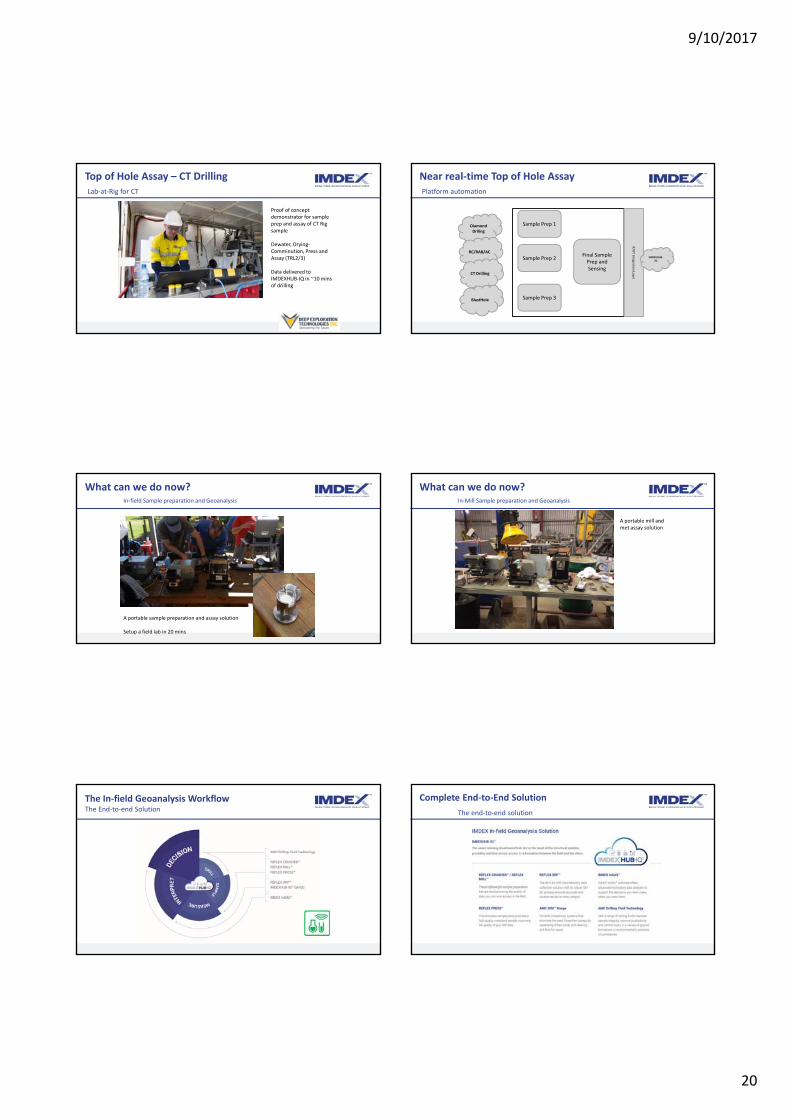
Top of Hole Assay – CT DrillingLab‐at‐Rig for CT
Proof of concept demonstrator for sample prep and assay of CT Rig sample
Dewater, Drying‐Comminution, Press and Assay (TRL2/3)
Data delivered to IMDEXHUB‐IQ in ~10 mins of drilling
Near real‐time Top of Hole AssayPlatform automation
Final Sample Prep and Sensing
Sample Prep 1
Sample Prep 2
Sample Prep 3
Diamond Driling
RC/RAB/AC
CT Drilling
BlastHole
IT/OT In
tegratio
n Layer
IMDEXHUB‐IQ
What can we do now?In‐field Sample preparation and Geoanalysis
A portable sample preparation and assay solution
Setup a field lab in 20 mins
What can we do now?In‐Mill Sample preparation and Geoanalysis
A portable mill and met assay solution
The In‐field Geoanalysis Workflow The End‐to‐end Solution
Complete End‐to‐End Solution
The end‐to‐end solution

9/10/2017
21
IMDEXHUB‐IQ™
Delivering confidence in your data wherever you are
IMDEXHUB‐IQ QA/QC Approval workflows give you confidence in the data you have collected, wherever in the world you are.
Real‐time decisions?Where should I drill hole number 2 and 3?
Regulatory Processes
Internal Business Processes
Shareholder Value
People and Skills
© REFLEX 2017 Exploration 17

9/10/2017
22
Geological Logging with X-ray VisionOlympus X-ray based Sensors & Lab-At-Rig®
Aaron Baensch – Principal Geologist, International Mining Group
Olympus Scientific Solutions Americas (OSSA)
The Future of Mineral Exploration Drilling and Sampling Workshop 26th October 2017 – Toronto, Canada OLYMPUS Scientific Solutions
Thank you to the Sponsors, Researchers & Affiliates (Past & Present)
OLYMPUS Scientific Solutions
Olympus Involvement with DET CRC
Coil Tube Drill(500m/day @ $50/m)
Downhole Sensors(Autonomous Sonde)
Lab-At-Rig® - Top-of-Hole Sensing(Real-Time Geochemistry & Mineralogy)
Three Core Research Projects:
Olympus & Olympus Scientific Solutions Americas (OSSA)
Olympus = Long history in Optics, Imaging & Sensor Technology – 40,000 Employees, Market Cap ~US$12B, Founded Japan 1919
– Core Businesses:
– Cameras & Audio
– Medical, Surgical & Life Sciences (End, GI, Gyn, Urol…etc.)
– Industrial = OSSA (HQ = Boston & Quebec)
» Non Destructive Testing (NDT)
» Ultrasonic
» Phased Array
» Eddy Current
» Advanced NDT Solutions & Systems
» Industrial Borescopes & Videoscopes
» Microscopy & Optical Metrology
» Analytical Instruments
» X-ray Fluorescence (XRF)
» X-ray Diffraction (XRD)
OLYMPUS Scientific Solutions
OLYMPUS Scientific Solutions
0 10 20 30
Quartz
Pentlandite
Violarite
Talc
Pyrrhotite
Pyrite
Anorthite
Chalcopyrite
Biotite
Cummingtonite
Mineral wt %
Combining XRD + XRF + Microscopy = Integrated Geoscience Solution
OLYMPUS Scientific Solutions
Physics 101 - X-ray fluorescence (XRF) & X-ray Diffraction (XRD)
R² = 0.993
45
50
55
60
65
70
75
45 50 55 60 65 70 75
LAB (%)
pXRF (%)
Fe
www.ruby.colorado.edu
www.mdpi.com
XRF => Elemental Chemistry (Energy Dispersive Spectroscopy)
XRD => Quantitative Mineralogy (Fundamental Crystallography)

9/10/2017
23
OLYMPUS Scientific Solutions
HAND-HELD PORTABLE / MOBILE PROCESS / ONLINE
BENCH-TOP / CUSTOM AUTOMATED / CONVEYOR
X-50GoldXpert
Mesa / LambdaSea-Mate
REDWAVE Sorter
X-STREAMSorter
Fox-IQ Series
X-5000
Olympus – XRF Products Overview (Chemistry)
**NEW** VANTA Series
DELTA Series
Rugged IP67 Rated – Dust & Water Proof
High Temperature Rating ~50C
Drop Tested
“Eye-Lid” Detector Shutter
Revolutionary Stable Hardware & Better Resolution
More Precise & Accurate
No Cal Check – Patented “Pulse”
Screw-less Window Change
Productive New DPP – Fast HCR
Wi-Fi – Cloud Enabled
Embedded GPS
New Software, Methods, Modes & GUI
Handheld XRF – VANTA (5th Gen Hand-Held)
OLYMPUS Scientific Solutions
OLYMPUS Scientific Solutions
“Revolutionary”
OLYMPUS Scientific Solutions
“Productive”
OLYMPUS Scientific Solutions
Olympus – XRD Systems (Mineralogy)
Terra XRD = Worlds Only “Truly Portable” XRD
BTX II = Worlds Smallest & Lowest Cost Bench-Top XRD
TERRA Portable XRD BTX II Bench-Top XRD
Web Based GUI

9/10/2017
24
OLYMPUS Scientific Solutions
Mars Rover Link to Olympus
MSL Curiosity is the 3rd Generation of Mars Rovers
– Significantly larger Rover, powered by Radioisotope Thermoelectric Generator (RTG) to support Advanced Geo-Scientific payload and sampling tools
OLYMPUS Scientific Solutions
Sojourney (1997)11.5 kg
MER (2004)185 kg
MSL Curiosity (2012)900 kg
• Spirit• Opportunity
OLYMPUS Scientific Solutions
• CheMin: XRD/XRF
• APXS: Alpha Particle XRF• ChemCam: LIBS• MastCam: Spectral & Optical• MAHLI: Optical / Hand Lens• SAM
• Gas Chromatography• Quad Pole Mass-Spec• Raman Laser Spectrometer
Mars Rover Link to Olympus
OLYMPUS Scientific Solutions
NASA CheMin Video(2min 34secs)
OLYMPUS Scientific Solutions
XRD Development – Two Key Areas: Sample Loading & SwiftMin™
OLYMPUS Scientific Solutions OLYMPUS Scientific Solutions
LAB-AT-RIG® - Near Real-Time pXRD & pXRF for Drillhole Logging
LAR v2.0 (Manual for Diamond Drilling)Deployed to SA in 2015-2016 on
Mineral Systems Drilling Program (MSDP) with SA-DSD, Minotaur & Kingston Resources
Reflex Lab-At-Rig® Platform• Developed within DET CRC• Now Commercialised by Imdex
(Reflex Division)• Part of New Assay While Drilling
(AWD) Business• Includes module for adaption to
CT-Drilling (sample handling, preparation & presentation
OLYMPUS Scientific Solutions
Real-Time Cloud Based Data Delivery via REFLEXHUB-IQ

9/10/2017
25
OLYMPUS Scientific Solutions
LAB-AT-RIG® - What Can it Achieve? (Results from Brukunga SA)
OLYMPUS Scientific Solutions
Data Quality
OLYMPUS Scientific Solutions
Automated “Geology”
OLYMPUS Scientific Solutions
LAR Field Trials “Extremely Valuable” for Product Development
OLYMPUS Scientific Solutions
Delivered “New, Rich Data Sets” in Real 24/7 Working Environments
OLYMPUS Scientific Solutions
Partner Developments – REFLEX: Press & BYOD (ReflexHub-IQ)

9/10/2017
26
OLYMPUS Scientific Solutions
What’s Next? End-to-End Solutions (Reflex @ PDAC 2017)
OLYMPUS Scientific Solutions
The Future? RoXplorer & Lab-At-Rig®…?
OLYMPUS Scientific Solutions
Further Reading:Uvarova, Gazley, Cleverley, Baensch, Lawie & leGras; Representative, high spatial resolution geochemistry from diamond drill fines (powders): An example from Brukunga, South Australia; JGE Volume 170, P1-9, August 2016
OLYMPUS Scientific Solutions
Further Reading:Uvarova, Cleverley, Baensch & Verrall, Coupled XRF and XRD analyses for rapid and low-cost characterisation of geological materials in the mineral exploration and mining industry, AAG Explore Vol. 162, March 2014
OLYMPUS Scientific Solutions
Further Reading:Hillis et al; Coiled Tubing Drilling and Real-Time Sensing— Enabling Prospecting Drilling in the 21st Century? Society of Economic Geology - Special Publication, No. 18, 2014
OLYMPUS Scientific Solutions
Thank you to the Sponsors, Researchers & Affiliates (Past & Present)

9/10/2017
27
OLYMPUS Scientific Solutions
Thankyou for your attendance & attention…

9/10/2017
28
The Future of Geological Survey Drilling
Dr Steve HillSouth Australia Chief Government Geologist
Geological Survey of South Australia
The role of Government….
1. Just let it happen?– “They are big boys and girls … let competitive nature take care of it … we don’t pick winners … good luck, let us know when you are successful ….”
2. Attract, stimulate and partner?– “Attracting exploration investment is competitive so
what can we do to give us the edge? How can we make a difference? United we stand….”
The Case for Pre‐competitive Geoscience…
• Royalties on minerals are charged by state and territory governments, as the owners of the minerals in the ground
• Further incentives for state/territory governments to have a strong mining industry also includes employment, community economic benefit, infrastructure development, critical mass, offer best‐practice resource recovery etc.….
• Pre‐competitive geoscience reduces exploration investment risk and provides more informed decision making
• Highlights the state/territory prospectus for mineral exploration opportunities
• Objective to host the best quality and quantity of mineral exploration for the best potential for mineral discovery and thereby sustain a strong mineral industry
• Can we afford not to support this?
Government / Private Drivers of Discovery (a.k.a. “The Magna Carter”)
Land Access
g
Human & Intellectual CapitalEducation and trainingR&D – new exploration and processing technologies
Precompetitive Geoscientific Data and Information
Capture and DeliveryValue‐add ResearchUnderexplored / Covered RegionsTargeted Programs Discovery
Quality of Exploration
Quantity of Exploration
Geo
scie
nce
Aust
ralia
; CSI
RO
, U o
f A; S
ACO
ME;
GSS
A
Availability of Finance
GREENFIELDS
Adapted from Derek Carter
Moon Plain, Stuart Shelf, SA (Photo S.Hill)
The DISCOVERY challenge…The covered minerals search space across 80% of South Australia!
Decreasing Discovery success• Poorly constrained geology in covered areas
• Poor integration of geology with exploration targeting

9/10/2017
29
Geoscience initiatives / strategies in support of future mineral discoveries in Australia
http://www.uncoverminerals.org.au/
Addressing the discovery challenge…• Pre‐competitive surface geology mapping, geophysics, geochemistry, mineralogy, drilling…
We need to….
• Better understand and map geology in covered areas
• Map and test mineral systems under cover
• Retrieve samples from under cover for further analysis
• Develop a degree of confidence for geophysics
Geological Survey Drilling…
1. Stratigraphic Drilling2. Collaborative Drilling3. Mineral System Drilling4. National Drilling Initiative?
Stratigraphic Drilling
• Traditional regional drilling to better characterise lithology and stratigraphic relationships
– Very often the first drill hole into many rock types or settings
– Typically become key “type” or representative sections
• $3M collaborative program• between GSSA and GA
• Targeting different • geophysical domains
• Boart Longyear selected • as drilling service provider
• Drilling commenced 9th
• April 2017 for ~ 5 month • program
Example: PACE Copper – Coompana DrillingPart of Western Gawler Craton / Coompana targeted geoscience program
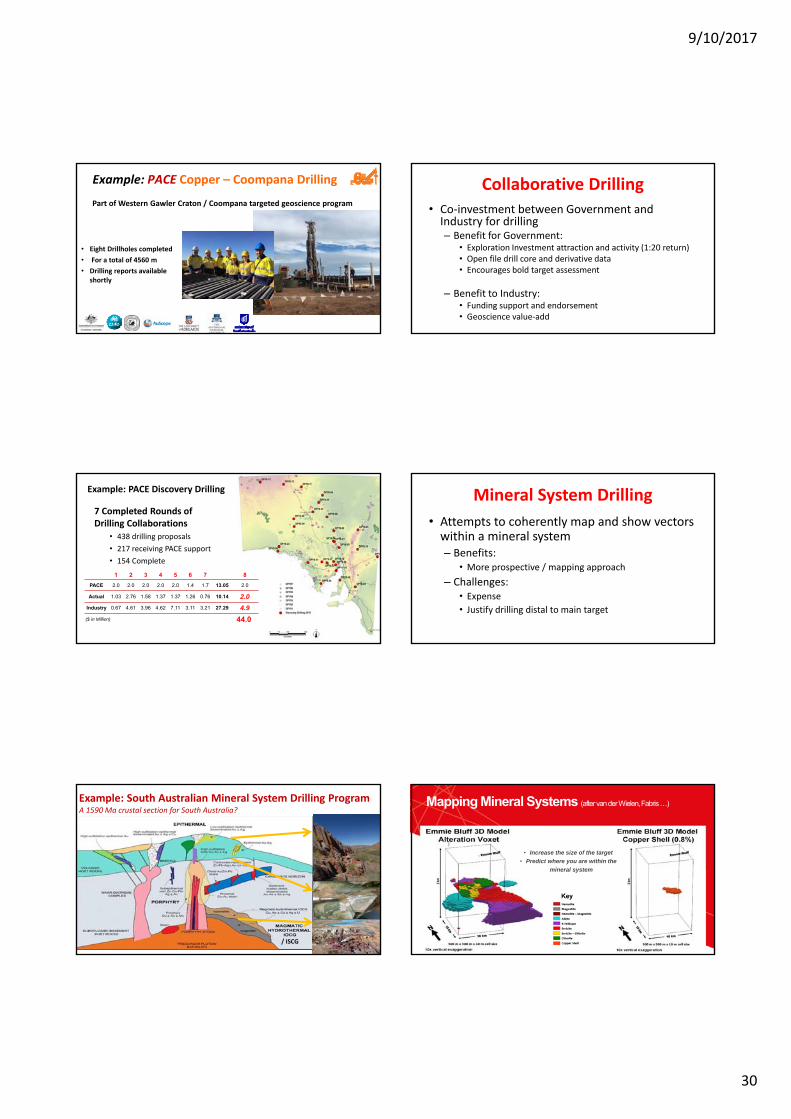
9/10/2017
30
• Eight Drillholes completed
• For a total of 4560 m
• Drilling reports available shortly
Example: PACE Copper – Coompana Drilling
Part of Western Gawler Craton / Coompana targeted geoscience program
Collaborative Drilling• Co‐investment between Government and Industry for drilling– Benefit for Government:
• Exploration Investment attraction and activity (1:20 return)• Open file drill core and derivative data• Encourages bold target assessment
– Benefit to Industry:• Funding support and endorsement• Geoscience value‐add
7 Completed Rounds of Drilling Collaborations
• 438 drilling proposals
• 217 receiving PACE support
• 154 Complete
1 2 3 4 5 6 7 8
PACE 2.0 2.0 2.0 2.0 2.0 1.4 1.7 13.05 2.0
Actual 1.03 2.76 1.58 1.37 1.37 1.26 0.76 10.14 2.0
Industry 0.67 4.61 3.96 4.62 7.11 3.11 3.21 27.29 4.9
($ in Million) 44.0
Example: PACE Discovery Drilling Mineral System Drilling
• Attempts to coherently map and show vectors within a mineral system– Benefits:
• More prospective / mapping approach
– Challenges:• Expense
• Justify drilling distal to main target
Example: South Australian Mineral System Drilling Program A 1590 Ma crustal section for South Australia?
/ ISCG180
• Increase the size of the target
• Predict where you are within the
mineral system
Mapping Mineral Systems (after van der Wielen, Fabris …)

9/10/2017
31
SA Mineral Systems Drilling Program
Further understanding of 1590 Ma mineral systems• $2.5m + $0.65m + in-kind = $8m• 14 cored holes, 7868m, ~ 8 months • Collaborative partners: GSSA with Deep
Exploration Technologies CRC, Kingston Resources, Minotaur Exploration, service sector
CarriewerlooPeltabinna
Mt Double
Key questions for 1590Ma Mineral Systems in South Australia
1. Prospectivity of the Gawler Range Volcanics(GRV)?
2. Depth of cover? (what is cover here?)3. What was the nature of mineralizing fluid-flow?4. What are the characteristics of mineralisation trap
sites?
Mineral Systems Drilling Program
Want to know more?
• MSDP webpage - video series
• Core now available for inspection!
• Core display - MSDP05, MSDP10, MSDP11, MSDP12
minerals.statedevelopment.sa.gov.au/msdp
183
Where to from here?National Drilling Initiative (NDI)
• MSDP set the scene with concept and CT Drilling Rig trials – cheaper and faster drilling…
• Regional mapping (undercover) using a drill rig instead of a geological hammer
• The next major step change for Australian pre‐competitive geoscience?
Eastern Gawler (Olympic Province)
0 100 200
kilometres
Nominal Drill Pattern
Task 1: Drilling and resampling program to identify and map key aspects of the mineral systems under cover
• Crustal level at time of 1590 Ma mineralisation event
• Fe-oxide alteration (esp. magnetite to hematite transition)
• Patterns of sericite-chlorite alteration
• Trace element alteration index as pathfinder
• Regional illite-chlorite-dravite alteration associated with Unconformity U in Pandurra Formation
Combine resampling of previous drilling with ~10 x 10 km drill program
10 x 10 kmMax DTB 1000 m
Previous Drilling
337 holesSource: SARIGHyLogger Drill holes
Known Mineralisation
GeophysicalExtent
0 100 200
kilometres
10 x 10 km pattern less previous drilling(5 x 5 km infill to 1000 m)
10 x 10 km pattern5 x 5 km infill in central corridorMax depth-to-basement 1000 mExcluding previous drilling
Depth to basement 500 m 1000 m 5 x 5 km
Number of drill holes 113 217 255
Total meters drilled 30,400 113,700 147,100
Drilling cost @ $75/m $2.3 M $8.5 M $11.0 M
Area covered (km2) 23,500 41,600 14,000
Cost per km2 $97 $205 $790
Task 1: Drilling and resampling programTask 3: Close down spacing in priority areas
Drilling Depth (m)
Indicative Costs
In-ground value of current and mined resources from the exposed Mt Isa Inlier is ~$250 B.*
* Resources from Geoscience Australia OzMindatabase. In ground value calculated in AUD on
commodity prices at 20 May 2016
0
50
100
150
200
250
0 200 400 600 800 1000
Cummulative AreaTested, 1000 km2CummulativeDrilling, km

9/10/2017
32
National Drilling Initiative
• Define NDI workflow and accreditation
• Components / Themes
1. NDI from our drilling legacy
2. NDI in new frontiers
3. From NDI to Knowledge
South Australian Drill Core Reference Library operations
Woodall Laboratory Holloway Geoscience TheatreNelson Discovery Hall
Summary / Key Points
• Evolution of Geological Survey Drilling has taken place alongside evolution of:– drilling and analytical technology
– Industry requirements as they enter new exploration search space
– The role of government and competitive investment attraction in the minerals industry
To find out more….
DisclaimerThe information contained in this presentation has been compiled by the Department of the Premier and Cabinet (DPC) and originates from a variety of sources. Although all reasonable care has been taken in the preparation and compilation of the information, it has been provided in good faith for general information only and does not purport to be professional advice. No warranty, express or implied, is given as to the completeness, correctness, accuracy, reliability or currency of the materials.
DPC and the Crown in the right of the State of South Australia does not accept responsibility for and will not be held liable to any recipient of the information for any loss or damage however caused (including negligence) which may be directly or indirectly suffered as a consequence of use of these materials. DPC reserves the right to update, amend or supplement the information from time to time at its discretion.
www.minerals.dpc.sa.gov.au
Disclaimer

Location 26 Butler Boulevard Burbridge Business Park Adelaide Airport SA 5950
Postal Address PO Box 66 Export Park Adelaide Airport SA 5950
Contact +61 8 8375 8483 detcrc.com.au