the geographical setting and pre-historic …download.nos.org/srsec315new/history book_l02.pdf ·...
TRANSCRIPT

10 HISTORY
MODULE - 1Ancient India
THE GEOGRAPHICAL SETTING ANDPRE-HISTORIC CULTURES OF INDIA
2Notes
The history of any country or region cannot be understood without some knowledgeof its geography. The history of the people is greatly conditioned by the geographyand environment of the region in which they live. The physical geography and envi-ronmental conditions of a region include climate, soil types, water resources andother topographical features. These determine the settlement pattern, populationspread, food products, human behaviour and dietary habits of a region. The Indiansubcontinent is gifted with different regions with their distinct geographical featureswhich have greatly affected the course of its history.
Geographically speaking the Indian subcontinent in ancient times included thepresent day India, Bangladesh, Nepal, Bhutan and Pakistan. On the basis ofgeographical diversities the subcontinent can be broadly divided into the follow-ing main regions. These are:
(i) The Himalayas
(ii) The River Plains of North India
(iii) The Peninsular India
OBJECTIVESAfter studying this lesson, you will be able to:
explain the physical divisions of Indian subcontinent;
recognize the distinct features of each region;
understand why some geographical areas are more important than the others;
define the term environment;
establish the relationship between geographical features and the historical devel-opments in different regions;
define the terms prehistory, prehistoric cultures, and microliths;
distinguish between the lower, middle and upper Palaeolithic age on the basis ofthe tools used;
explain the Mesolithic age as a phase of transition on the basis of climate and the

11
MODULE - 1Ancient India
Notes
HISTORY
The Geographical Setting and pre-historic
tools used;
explain the Neolithic age and its chief characteristics;
differentiate between Palaeolithic and Neolithic periods and
learn about the Prehistoric Art.
2.1 THE HIMALAYAS
The Himalayas are the world’s largest and the highest mountain ranges. These areapproximately 2,400 kilometers long. (Map 2.1). These ranges have not only checkedinvasions but have also protected us from the cold winds coming from north. Theyalso stop the monsoon winds from the seas which results in rainfall in the northernplains. However, there are some mountain passes which, though difficult, have
64° 68° 72° 76° 80° 84° 88° 92° 96° 100°E
72° 76° 80° 84° 88° 92° 96° 100°
0°
4°
8°
12°
16°
20°
24°
28°N
0°
4°
8°
12°
16°
20°
24°
28°
ARABIAN
SEA
BAY
OF
BENGAL
Hindu Kunsh
Sul
aim
an
Kirth
ar
TharDesert
Ara
valli
Vindhyas
Satpuras
D E C C A N
P L A T E A U
NO
RT
HE
RN
PL
AI
NS
WE
ST
ER
NG
HA
TS
EA
ST
ER
N
GH
AT
S
H
I
M
A
L
A
Y A
R. Indus
R. SatlujR. Ravi
R. Chenab
R. Jhelum
R.Ja
muna
R. GangesR. Cham
bal
R. Narmada
R. TaptiR. Mahanadi
R. Godavari
R. Brahmaputra
R. Krishna
R. Kaveri
Mala
bar
Coast
Coro
mandal C
oast
Sri
Lanka
LA
KS
HA
DW
EE
P
(IND
IA)
AN
DA
MA
NA
ND
NIC
OB
AR
ISLA
ND
S
(IND
IA)
100 0 100 200 300 400 500Km.Km.
THE PHYSICAL
FEATURES OF INDIA
I N D I A N O C E A N
Map 2.1 The Great Northern Mountains
12 HISTORY
MODULE - 1Ancient India
Notes
The Geographical Setting and pre-historic
provided access to determined invaders, traders, missionaries. These have helped indeveloping cultural contacts with Central Asia, China and Tibet in ancient times.
In the north-western direction the broken Himalayan ranges contain the major routeslinking the Indian plains with Iran and Central Asia through Afghanistan. These passthrough the Gomal, Bolan and Khyber passes. The Greeks, Shakas, Kushanas, Hunasand other foreign tribes reached India following these routes. Likewise, Buddhismand other Indian elements were carried out to Afghanistan and Central Asia throughthese mountain passes.
2.2 THE RIVER PLAINS OF NORTH INDIA
The Himalayas also provide India with three river systems dominated by the Indus,the Ganges and the Brahmaputra. These rivers made their respective regions fertileand attracted both settlers and invaders.
The Indus plains include the regions of Punjab and Sind. Irrigated by the tributaries ofthe river Indus, they form a vast fertile plain which have made the region the ‘bread-basket’ of the subcontinent. It is called so because this region is very important forwheat cultivation. The strategic location and richness of the Punjab region has at-tracted foreign invaders since ancient past. The Sind region includes the lower IndusValley and the delta. It is the Indus plains which witnessed the development of anurbanized culture called the Harappan culture for the first time in the subcontinent.(see lesson 3)
The Gangetic basin receives more rainfall and is more humid than the Indus region.The Gangetic plains is divided into three sub-regions: Upper, Middle and Lower. TheUpper plains of the river Ganges constitute the western and southern parts of UttarPradesh. This region has seen active cultural developments since the ancient period.This was inhabited by the Aryans in the Later Vedic period, during which they prac-tised agriculture. The Middle Gangetic plains, which is more fertile and has morerainfall, include eastern Uttar Pradesh and Bihar. It is the region where mahajanpadas(territorial states) like Kosala, Kasi and Magadha were established in the 6th centuryBC. The two main religions of India, Jainism and Buddhism, also took their birth here.
The lower Gangetic plains constitute the Bengal region. Its northern part is irrigated bythe Brahmputra. The high rainfall in this region created dense forest and marshy landwhich made it difficult for the development of settlements in the beginning. But itscoastal areas served as important channels of communication with other regions of thesubcontinent and also with the South-east Asian countries. Tamralipti or Tamluk was animportant seaport of this region which played a significant role in commercial activities.
The Eastern India normally refers to the coastal plains formed by the river Mahanadiand other streams. The fertile coastal plains of this region helped in the developmentof agriculture, society and culture. This came into contact with the Gangetic culturefrom the time of the Nandas and the Mauryas (4th century BC). Around AD 1000Orissa began to develop her distinct linguistic and cultural identity.
The Western India refers to the regions of the modern states of Rajasthan and Gujarat.It is known for its black soil which is good for cotton cultivitation. The Thar desert ofRajasthan, surrounded by the semi-arid regions, was not as fertile as the Gangeticplains. As a result, this region was not much favourable for cultivation. However, laterin the 8th century AD, with the growth of irrigation mechanism in the form of Persian

13
MODULE - 1Ancient India
Notes
HISTORY
The Geographical Setting and pre-historic
wheel (rehat), many settlements emerged here. Rajasthan is also the home of theRajput clans. In Gujarat the fertile plains of the rivers Sabarmati, Mahi, Narmada andTapti brought prosperity. A very long coastal line too helped Gujarat to develop con-tacts with other countries through its ports. The most important sea port of this regionhas been Brigukaccha or Bharuch (Broach).
2.3 THE PENINSULAR INDIA
Peninsular India includes the Deccan plateau and the coastal plains of South India(Map 2.2). The plateau is situated to the south of the Vindhya mountains. It is dividedinto three major regions which largely correspond to the modern states of Maharashtra,Andhra Pradesh and Karnataka. The northern Deccan plateau comprises of a part ofMaharashtra. A number of Chalcolithic sites inhabited by people using copper andstone tools have been found in this region. Karnataka includes the southwestern
Map 2.2 Peninsular India

14 HISTORY
MODULE - 1Ancient India
Notes
The Geographical Setting and pre-historic
Deccan. This region with the availability of water and other resources had been moresuitable for human settlements than the northern part. The Raichur doab for its ricecultivation has been known as the ‘rice-bowl’ of South India. It has been the bone ofcontention between different kingdoms. These regions were inhabited right from theprehistoric times.
The plateau region also has hilly terrains in the Western and Eastern Ghats. TheWestern Ghats rise sharply close to the western coast, tapering eastwards into theplateau. They are cut by a series of passes at Junnar, Kanheri and Karle. Theseserved as trade routes connecting the ports along the west coast. At the southern endof the Western Ghats is the Palghat pass which linked the west coast to the Kaverivalley and played an important role in the Indo-Roman trade in ancient period. TheEastern Ghats merge more gradually into the plateau and the coastal plain.
The coastal plains constitute the states of Tamil Nadu in east and Kerala on west. InTamil Nadu the rivers are seasonal. As a result, the people of this region have de-pended more on the tank irrigation since the early times. However, Kaveri delta hasbeen the major region of human attraction. It provided opportunity for the cultivationof rice and witnessed the flourishing of the Sangam culture in the early historicalperiod. The ports such as Arikamedu and Kaveripattinam gave impetus to the Indo-Roman Trade in early centuries of Christian era. The Tamil region evolved a distinctlinguistic and cultural identity of its own.
INTEXT QUESTIONS 2.11. Name the important mountain passes in the north-western part of the Indian
subcontinent.
2. Who inhabited the upper plains of the river Ganges during the later Vedic period.
3. What were the two important religions which took birth in the middle Gangeticplains.
4. In which state has tank irrigation been popular since the ancient period.
5. The Kaveri delta is famous for which crop?
6. Name any two foreign tribes that reached India through north-western mountainpasses in ancient times.
7. Which region is known as the ‘breadbasket’ of the subcontinent?

15
MODULE - 1Ancient India
Notes
HISTORY
The Geographical Setting and pre-historic
2.4 INFLUENCE OF ENVIRONMENT
The settlement of people in any region is very much dependent on its environmentalconditions. Environment is taken as the surroundings or conditions in which variousspecies (men, animals and plants) exist and function. The environment mainly com-prises of elements such as climate, landscape, rivers, species of plants and animals(flora and fauna), etc. Now, let us see how environment has influenced the life ofpeople and their history since ancient past.A semi-arid region is advantageous to people for settlement purpose. For example,the Sind region having this type of climate in ancient period, resulted in the flourishingHarappan civilization. It also helped the growth of urban settlements. Similarly, therise of Pataliputra and the importance of Magadha in Bihar can also be explained inrelation to its physical features and environment. Pataliputra was surrounded by therivers namely the Ganges, Son and Gandak which provided natural defence as well asinternal communication. Moreover, the fertile Indo-Gangetic plains helped in themaintenance of a strong population base.The environmental conditions also determine the resource potential of a region. Theforested region can be a rich source of timber, whereas the coastal regions yield thesea products. The hilly regions with rocks containing the mineral ores can lead to thedevelopment of metallurgy. The extraction of metals and their use for tools and otherpurposes may add to the standard of living. For example, Magadha was located inproximity to the iron ore mines and sources of stone and timber in the region ofChhotanagpur plateau. This strengthened the position of Magadha.The subsistence pattern is also influenced by the environmental conditions. The re-gions covered by the river plains have alluvial soil. The fertility of soil helps in surplusproduction. The type of soil also determines the crop pattern. For example, black soilis good for growing cotton. The surplus production results in exchange activities whichdevelop into trade on a larger scale.An area gifted with navigable rivers has well developed trade and communicationnetworks. Our ancient literature like the Jatakas and other texts, mention many riv-erine routes in ancient India. Similarly, the coastal routes promote the long distancetrade with different countries. The mountain passes are also very important in thiscontext. For example, the Palghat pass linked the east and west coasts and thushelped in the growth of Indo-Roman trade in ancient times.Thus, we find that the physical features and environment help us to unfold the histori-cal processes of a region. The diversity of Indian subcontinent presents an unevenpattern of historical developments. The areas which were rich became importantwhile those with less resources lagged behind. It is important to observe that thesettlement pattern and mode of life depend on the local resource utilization which inturn is dependent on the technological developments in that region.
INTEXT QUESTIONS 2.21. Name the rivers which provided a natural defence to Pataliputra (modern Patna).
2. Which region supplied iron ore and timber to Magadha?

16 HISTORY
MODULE - 1Ancient India
Notes
The Geographical Setting and pre-historic
3. Which type of soil is good for growing cotton? (Black / Red / Sandy).
4. Which famous mountain pass linked the east and west coasts of India?
2.5 PREHISTORIC CULTURES
Prehistoric period is that period of our ancient past for which we do not have writtenrecords. Therefore our knowledge of the cultures, which developed in this period, isbased only on the materials found in the archaeological excavations. The earliest manliving during this period made tools and implements of stone found in his surroundings.These tools helped him to hunt and gather food in order to satisfy his hunger. Since theearliest tools used by humans were made of stones, this phase of human developmentis known as the Stone Age. In this lesson we shall trace the evolution of prehistoricman from a hunter and food-gatherer to a food producer. This change did not takeplace all of a sudden and took several hundred thousand years. On the basis of thedifferent type of tools and techniques the stages of human development in prehistoricperiod are described as the Palaeolithic or Old Stone Age, the Mesolithic or MiddleStone Age, and the Neolithic or New Stone Age.
2.6 THE PALAEOLITHIC CULTURES
The term Palaeolithic is derived from the Greek word ‘palaeo’, which means old and ‘lithic’meaning stone. Therefore, the term Palaeolithic age refers to the old stone age. The archae-ologists have dated this culture to the Pleistocene period about two million years ago. ThePleistocene period is the geological period of the age when the earth’s surface was coveredwith ice, and weather was so cold that human or plant life could not survive. But in thetropical region, where ice melted, the earliest species of men could exist.
The people lived near the hillocks and used only stone tools for hunting and their protec-tion. However, the choice of raw material used for tool-making varied from region toregion and depended upon its availability. The material used was quartzite available inhilly areas of different regions, basalt found in Maharashtra region and limestone inKarnataka region. On the basis of the nature of progress made in tool types and tech-niques the Palaeolithic cultures have been divided into three phases. These are – (i)Lower or Early Palaeolithic, (ii) Middle Palaeolithic, (iii) Upper or Late Palaeolithic.These phases covered a long period ranging broadly from 5,00,000 to 10,000 B.C.
(a) Tools of the Palaeolithic Period
The main tools of lower Palaeolithic phase were handaxes, cleavers and choppers.(Fig 2.1) These are called chopping tools. These were rough and heavy and weremade by chipping the sides of the stones. Gradually, sharper and less heavy toolscame to be made.
The flake tools or chipped pieces were the chief tools during the middle Palaeolithicperiod. (Fig 2.2) The tools of the upper Palaeolithic period primarily consisted ofburins and scrapers. (Fig 2.3)
Let us now discuss in brief the chief features and uses of some of the tools mentionedabove. In handaxes, the butt end is broader and the working edge is narrow. These

17
MODULE - 1Ancient India
Notes
HISTORY
The Geographical Setting and pre-historic
were used for cutting the trees or digging the roots. The cleavers had a bifaced edge.These were meant for splitting objects like the trunks of trees. The choppers were themassive core tools with a unifacial working edge, and were used for chopping pur-poses. The burins were like flakes or blades. These were used for engraving on softstones, bones or rocks. The scrapers were also made of flakes. These tools servedthe purpose of obtaining barks of trees and skins of animals.
Fig 2.1 Chopping Tools & Hand Axes of Lower Paleolithic Age
Fig 2.2 Chopping Tools & Hand Axes of Lower Paleolithic Age
Fig 2.3 Chopping Tools & Hand Axes of Lower Paleolithic Age
18 HISTORY
MODULE - 1Ancient India
Notes
The Geographical Setting and pre-historic
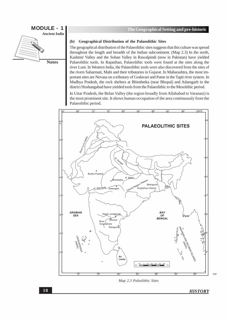
(b) Geographical Distribution of the Palaeolithic SitesThe geographical distribution of the Palaeolithic sites suggests that this culture was spreadthroughout the length and breadth of the Indian subcontinent. (Map 2.3) In the north,Kashmir Valley and the Sohan Valley in Rawalpindi (now in Pakistan) have yieldedPalaeolithic tools. In Rajasthan, Palaeolithic tools were found at the sites along theriver Luni. In Western India, the Palaeolithic tools were also discovered from the sites ofthe rivers Sabarmati, Mahi and their tributaries in Gujarat. In Maharashtra, the most im-portant sites are Nevasa on a tributary of Godavari and Patne in the Tapti river system. InMadhya Pradesh, the rock shelters at Bhimbetka (near Bhopal) and Adamgarh in thedistrict Hoshangabad have yielded tools from the Palaeolithic to the Mesolithic period.In Uttar Pradesh, the Belan Valley (the region broadly from Allahabad to Varanasi) isthe most prominent site. It shows human occupation of the area continuously from thePalaeolithic period.
64° 68° 72° 76° 80° 84° 88° 92° 96° 100°E
72° 76° 80° 84° 88° 92° 96° 100°
0°
4°
8°
12°
16°
20°
24°
28°N
0°
4°
8°
12°
16°
20°
24°
28°
ARABIAN
SEA
BAY
OF
BENGAL
R. Gangai
R. Narmada
RiverTung abhdra
Sri
Lanka
LA
KS
HA
DW
EE
P
(IND
IA)
AN
DA
MA
NA
ND
NIC
OB
AR
ISLA
ND
S
(IND
IA)
100 0 100 200 300 400 500Km.Km.
Renigunta
Kurnool
Nagar Junakenda
Adamgarh
Bhimbetka
Budha Pushkar
R. Belan
Midnapore
Singhbhum DistrictChhota
Nagpur Plateau
PALAEOLITHIC SITES
Riv
er
Soan
Valle
y
Map 2.3 Paleolithic Sites
Soh
an

19
MODULE - 1Ancient India
Notes
HISTORY
The Geographical Setting and pre-historic
Towards the east, Assam and neighbouring areas including Meghalaya (Garo Hills)have yielded prehistoric artifacts. Palaeolithic tools have also been found at varioussites in Bengal, Orissa and Bihar. In Peninsular India, Palaeolithic tools have beenreported from Andhra Pradesh and Karnataka. In Tamil Nadu, an important site isAttirampakkam in Chingleput region. The subsistence of the Palaeolithic cultureswas based mainly on hunting animals and gathering fruits and roots. In other words,the people were primarily hunters and gatherers with no settled habitation.
On the basis of above discussion, we can conclude that the Palaeolithic cultures ofthe prehistoric period were wide spread throughout the Indian subcontinent. The studyof the tools indicates a gradual progress in tool technology which must have led tobetter availability of resources.
(b) Subsistence Pattern
The Palaeolithic people practised hunting and food-gathering for their subsistence.They made simple stone tools for hunting, cutting, digging and other purposes. Theyled a nomadic life and migrated to places where plant and animal resources alongwith water were easily available.
INTEXT QUESTIONS 2.31. Which were the two main occupations of man in Palaeolithic age?
2. What were the various purposes for which prehistoric man made tools?
3. Name the main tools of the Lower Palaeolithic age:
(a) (b) (c)
2.7 THE MESOLITHIC CULTURES
The term Mesolithic is the combination of two words, meso and lithic. In Greek ‘meso’means the middle and ‘lithic’ means stone. Hence, the Mesolithic stage of prehistory isalso known as the Middle Stone Age. It was the transitional phase between the Palaeolithicand the Neolithic Ages. On the basis of archaeological discoveries, the beginning of theMesolithic Age in Indian subcontinent is dated to around 10,000 BC.
This period witnessed the rise in temperature, as a result of which the climate becamewarm. These changes further resulted in melting of ice of the earlier period and broughtabout changes in flora and fauna. Though man was still in hunting-gathering stage, henow started fishing and some domestication of animals. The main tools they used arecalled the microliths or small stone tools. The Rock paintings found at Bhimbetka (nearBhopal) belonging to the period indicate the artistic taste of the people.
(a) Tools of the Mesolithic Period
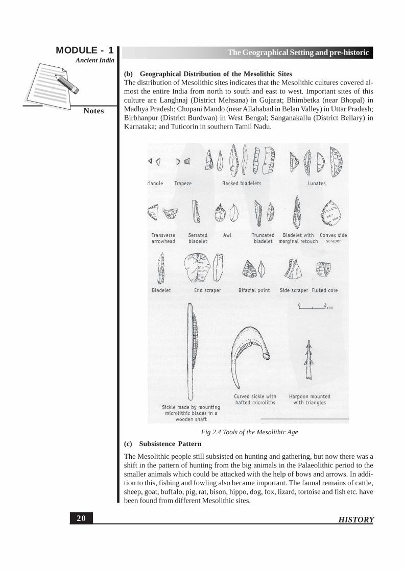
The microliths used during the mesolithic period were very small in size varying inlengths from 1 to 8 centimeters and were largely made out of chipped or flaked pieces.(Fig 2.4) Some of these tools have geometric forms such as triangles, lunates and tra-pezes. There tools could be tied or fixed in other objects to form an arrow or a spear.
20 HISTORY
MODULE - 1Ancient India
Notes
The Geographical Setting and pre-historic
(b) Geographical Distribution of the Mesolithic SitesThe distribution of Mesolithic sites indicates that the Mesolithic cultures covered al-most the entire India from north to south and east to west. Important sites of thisculture are Langhnaj (District Mehsana) in Gujarat; Bhimbetka (near Bhopal) inMadhya Pradesh; Chopani Mando (near Allahabad in Belan Valley) in Uttar Pradesh;Birbhanpur (District Burdwan) in West Bengal; Sanganakallu (District Bellary) inKarnataka; and Tuticorin in southern Tamil Nadu.
(c) Subsistence Pattern
The Mesolithic people still subsisted on hunting and gathering, but now there was ashift in the pattern of hunting from the big animals in the Palaeolithic period to thesmaller animals which could be attacked with the help of bows and arrows. In addi-tion to this, fishing and fowling also became important. The faunal remains of cattle,sheep, goat, buffalo, pig, rat, bison, hippo, dog, fox, lizard, tortoise and fish etc. havebeen found from different Mesolithic sites.
Fig 2.4 Tools of the Mesolithic Age

21
MODULE - 1Ancient India
Notes
HISTORY
The Geographical Setting and pre-historic
INTEXT QUESTIONS 2.41. What name has been given to the tools of the Mesolithic Age?
2. Name a few tools made during the Mesolithic period?
3. Name any two sites of the Mesolithic period?
2.8 THE NEOLITHIC CULTURES AND THE ADVENT OF FOODPRODUCTION
The last phase of prehistory is termed as Neolithic. The term Neolithic is derivedfrom Greek ‘neo’ which means new, and ‘lithic’ meaning stone. Thus, the term‘neolithic Age’ refers to the ‘New Stone Age’ of human culture. In Indian subconti-nent it is dated back to around 8000 BC. The term ‘Neolithic’ was coined by JonnLubbock. The chief characteristic of this age was the new type of ground and pol-ished stone tools. This period also marked the beginning of cultivation of plants andthe domestication of animals. It led to the beginning of settled life and the growth ofvillage settlements. The Neolithic culture had following characteristics:
(i) Beginning of agricultural activities
(ii) Domestication of animals
(iii) Grinding and polishing of stone tools having sharper edges
(iv) Use of pottery
(a) Meaning of the ‘Neolithic Revolution’
Some times this period is termed as the ‘Neolithic Revolution’ on the basis of impor-tant changes in man’s socio-economic life. The use of the sharp and polished neolithictools made it easier to cultivate the soil. It was accompanied by the practice of do-mestication of animals. These changes in turn resulted in the emergence of settledagricultural communities. The Neolithic people also produced pottery for the purposeof storing grains. As the redevelopment in the Neolithic phase greatly affected thehuman life, some scholars have used the term “the Neolithic Revolution” to signifythose changes. But most of the scholars believe that these changes though significant,should be viewed in the context of earlier progress during Paleolithic and Mesolithicages, and thus, should be considered as ‘evolution’ rather than ‘revolution’.
(b) Tools of the Neolithic Period
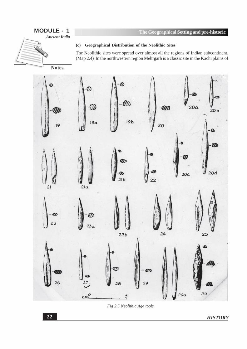
The Neolithic tools consist of the ground tools having smooth surfaces, and well-rounded and symmetrical shapes. The grinding made the tools sharper, polished andmore effective than those in the earlier period. (Fig. 2.5) The ground stone tools of theNeolithic period included different types of axes called ‘celt’. Besides the stone tools,the sites of this period have also yielded various types of bone objects such as needles,scrapers, borers, arrowheads, pendants, bangles and earrings. (Fig 2.6)
22 HISTORY
MODULE - 1Ancient India
Notes
The Geographical Setting and pre-historic
(c) Geographical Distribution of the Neolithic Sites
The Neolithic sites were spread over almost all the regions of Indian subcontinent.(Map 2.4) In the northwestern region Mehrgarh is a classic site in the Kachi plains of
Fig 2.5 Neolithic Age tools

23
MODULE - 1Ancient India
Notes
HISTORY
The Geographical Setting and pre-historic
Baluchistan. The excavations at Mehrgarh have revealed the evidence of housesbuilt by Neolithic people. These were built of sun-dried bricks. These houses weredivided into small rooms. The evidence of cultivation of crops like wheat, barley andcotton were discovered from here. The important sites in Kashmir Valley include
Fig 2.6 Neolithic Bone tools from Burzahom

24 HISTORY
MODULE - 1Ancient India
Notes
The Geographical Setting and pre-historic
Burzahom and Gufkral. The dwelling pits, either circular or rectangular, at these sitesform an important feature of Neolithic culture. The Belan Valley along the edge ofVindhyan plateau near Allahabad in Uttar Pradesh also has many Neolithic sites suchas Koldihwa and Mahagara. The Neolithic tools (both stone and bone), pottery, otherartefacts, floral and faunal remains have been found from these sites. In Bihar andmid-Gangetic Valley region Chirand is the most popular Neolithic site. Several Neolithicsites are present covering the hills of Assam, Meghalaya and Nagaland. The tools likeNeolithic celts, small ground axes alongwith the remains of pottery have been foundfrom this area. In South India the Neolithic settlements were discovered along therivers Bhima, Krishna, Tungabhadra and Kaveri. Some important sites areSanganakallu, Brahmagiri, Maski, Piklihal, Hallur in Karnataka; Utnur, Nagarjunakonda,Budihal in Andhra Pradesh; and Paiyampalli in Tamil Nadu. These sites have yieldeddwelling pits alongwith the evidence of cultivation of cereals and domestication of
Map 2.4 Neolithic Sites
64° 68° 72° 76° 80° 84° 88° 92° 96° 100°E
72° 76° 80° 84° 88° 92° 96° 100°
0°
4°
8°
12°
16°
20°
24°
28°N
0°
4°
8°
12°
16°
20°
24°
28°
ARABIAN
SEA
BAY
OF
BENGAL
Sri
Lanka
LA
KS
HA
DW
EE
P
(IND
IA)
AN
DA
MA
NA
ND
NIC
OB
AR
ISLA
ND
S
(IND
IA)
100 0 100 200 300 400 500Km.Km.
NEOLITHIC SITES
EXCAVATED NEOLITHIC SITESMODERN TOWNSPresent External Boundary of India
CHALIGAI
SARAI KHOLA
BURZAHOM
KILE GUL MOHAMMAD
MEHRGARH
CHIRAND SARUTARU
MAAKDOLA
DACUALI-HADING
BARUDIH
KUCHA
NAGARJUNAKONDA
PAIYAMPALLI
HEMMGE
T. NARSHIPUR
BRAHMAGIRIPALAVOYHALLUR
SANGANAKALLUKUPGAL
TERDAL
MASKI
DTNUR
TEKKALKODA
KODEKAL
Calcutta
Delhi
Patna
Nagpur
Bombay
Madras
Quetta
Islamabad
Srinagar
Gaumati
(Kolkata)
(Chennai)
(Mumbai)

25
MODULE - 1Ancient India
Notes
HISTORY
The Geographical Setting and pre-historic
animals. Millet (Ragi) was one of the earliest crops cultivated by the villagers ofSouth India.
(d) Subsistence Pattern
The advent of agriculture marked a significant change in Neolithic phase. Thepeople cultivated various kinds of crops such as wheat, barley, rice, millet, lentils,etc,. depending on the geographical conditions. Agriculture gave impetus to ani-mal domestication. Hunting still remained an important occupation. The peopledomesticated animals which included sheep, goat, cattle, etc. and also huntedwild animals such as boar, nilgai, gazells, etc. Different kinds of stone tools weremade by Neolithic people, which has already been discussed. The Neolithic peoplealso manufactured pottery, which was initially hand made and later turned onwheel and fired in large kilns. These were the major means of storage for grains.In nutshell, we can say that the Neolithic cultures were characterised by changefrom hunting and gathering to cultivation of plants and domestication of animals.The new polished tools made it easier for humans to cultivate, hunt and performother activities in a better manner. It led to greater availability of food resourcesas well as to an increase in population, which in turn resulted in the increase in thenumber of village settlements. The Neolithic cultures created the conditions whichhelped in the growth of towns in the later period.
INTEXT QUESTIONS 2.51. Who coined the term ‘Neolithic’?
2. Mention the chief characteristics of Neolithic cultures.
(a)
(b)
(c)
(d)
3. Name an important Neolithic site of northwestern region.
2.9 THE PREHISTORIC ART
The rock paintings were an important and distinct feature of the Mesolithic peoplethough their beginning may be traced to the upper Palaeolithic period. These paintingsare made on the walls of rock shelters, maximum of which have been found atBhimbetka in Madhya Pradesh. These throw light on the social and economic life onMesolithic people. The main subjects of paintings are hunting, fishing and food gath-ering. Animals like boar, buffalo, monkey and nilgai are often depicted in these paint-ings. (Fig. 2.7) The social activities like the child birth, rearing of a child and burialceremony are also shown in the rock paintings. The scenes of hunting in a groupsuggest that Mesolithic people lived in small groups. Thus, we can say that the

26 HISTORY
MODULE - 1Ancient India
Notes
The Geographical Setting and pre-historic
Fig 2.7 Prehistoric Art
Mesolithic society was more stable than the one in Palaeolithic age, though hunting-gathering still remained its main preoccupation.
INTEXT QUESTIONS 2.61. Rock Painting or Rock Art was a distinct feature of which period?
2. Name the site in Madhya Pradesh which has the maximum number of rockpaintings in India.
3. Point out the main subjects highlighted in prehistoric rock art.
WHAT YOU HAVE LEARNTThe history of India has been greatly influenced by its geographical features andenvironmental conditions. Different regions are characterized by their distinct topo-graphical features which determine the historical changes in those regions. TheHimalayas have protected us both from the invaders and harsh cold winds. The moun-tain passes have provided the ways for political, social, economic and cultural interac-tion. The fertile River Plains of North India have helped in rich agricultural production

27
MODULE - 1Ancient India
Notes
HISTORY
The Geographical Setting and pre-historic
leading to the emergence of powerful states in the 6th century BC. The Plateau re-gion, the Coastal Plains and the hilly terrains of Peninsular India have encouraged theagricultural settlements and foreign contacts since ancient times. Different environ-mental conditions and varying availability of resources have resulted in distinct socio-economic and cultural formations in different regions.
Since his appearance in Prehistoric period, the humans have passed through manystages of cultural growth. Archaeological sources show his existence and subsistencepattern at various sites in different parts of the subcontinent. He was a hunter-gath-erer in the Paleolithic and Mesolithic periods. By the Neolithic period he learnt culti-vation of crops and domestication of animals. He could also manufacture pottery bythen. These developments led to the establishment of village settlements. The stonetools used in different periods also underwent change. The crude and blunt tools ofthe Palaeolithic period were developed into sharper and polished ones in the Neolithicperiod. The Mesolithic period was characterized by very small stone tools called themicroliths. In other words, the hunter-gatherer of the Paleolithic period evolved intothe food producer of the Neolithic period.
TERMINAL QUESTIONS1. On a map of India, mark out the following:
(i) The Himalayan ranges(ii) The Eastern and the Western Ghats(iii) Rivers -the Ganges, the Narmada and the Kaveri(iv)Arikamedu (Pondicherry), Tamluk (Tamralipti) and Bharuch (Broach)(v) Pataliputra (Patna) and Palghat(vi)Adamgarh, Bhimbetka and Koldihwa
2. Assess the influence of the geographical features of India on its history withspecial reference to the Himalayas and the Peninsular India.
3. How does the environmental conditions of a region determine the resource po-tential? Give examples.
4. What were the chief features and uses of the tools used during the Palaeolithicperiod?
5. How did the climatic changes during the Mesolithic period result in the shift in thepattern of hunting?
6. Describe the geographical distribution of Neolithic sites.7. Give an account of the life of the Neolithic people.8. Why do some scholars use the term ‘Neolithic Revolution’ for this period?
ANSWERS TO INTEXT QUESTIONS2.11. Gomal pass, Bolan pass and Khyber pass2. Aryans3. (a) Jainism (b) Buddhism

28 HISTORY
MODULE - 1Ancient India
Notes
The Geographical Setting and pre-historic
4. Tamil Nadu5. rice6. Kushanas and Huns7. Punjab and Sind in the Indus plains
2.2
1. The Ganges, Son and Gandak
2. Chhotanagpur
3. Black
4. Palghat pass
2.3
1. hunting, gathering
2. hunting, cutting, digging and other purposes.
3. (a) handaxes (b) cleavers (c) choppers
2.4
1. microliths
2. triangles, lunates and trapazes
3. Bhimbetka and Chopani Mando
2.5
1. John Lubbock
2. (a) Beginning of agricultural activities
(b) Domestication of animals
(c) Grinding and polishing of stone tools
(d) Use of pottery
3. Mehrgarh
2.6
1. Mesolithic
2. Bhimbetka
3. Hunting, Fishing, Food gathering, Child birth, Rearing of a child and Burial cer-emony.
HINTS TO TERMINAL QUESTIONS
1. See Maps 2.1 and 2.2
2. Refer to the sections 2.1 and 2.3
3. Refer to the section 2.4
4. Refer to the section 2.6(a)

29
MODULE - 1Ancient India
Notes
HISTORY
The Geographical Setting and pre-historic
5. Refer to the section 2.7(c)
6. Refer to the section 2.8(c)
7. Refer to the section 2.8(d)
8. Refer to the section 2.8(a)
GLOSSARY
Aryans – the nomadic groups of people who came from CentralAsia.
Butt end – the portion of the tool, which is generally broad and isused for holding it.
Celt – a type of stone axe made during the Neolithic period.Fauna – the animal life of any region.Flora – the plant life of any region.Jatakas – Buddhist texts with tales related to Buddha’s life.Microliths – very small and narrow tools used by man in the
Mesolithic period.Mountain pass – the gap between mountains which help in easy access
to the other side.Prehistory – that period of our past that does not have written records.