the geological surveys of europe, for · pdf filethe geological surveys of europe, for europe...
TRANSCRIPT

The Geological Surveys of Europe,
for Europe
The EuroGeoSurveys vision towards a
Geological Service for Europe
The Geological Surveys of Europe
Table of Contents
Executive Summary ..................................................................................................................................1
Position Paper of the Geological Surveys of Europe united in EuroGeoSurveys: State-of-the-Art of the European Geological Knowledge Base ............................................................................................. 4
Vision Paper of the Geological Surveys of Europe united in EuroGeoSurveys: Developing a joint Geological Service for Europe .................................. 9
Introduction .....................................................................................................................................................................9
1. Scope .............................................................................................................................................................................9
2. The changing role of Geosciences: Opportunities and Challenges ........................................................10
3. Vision and Goals – Maximizing added value and minimizing impact of using the subsurface .... 13
4. Realising the Vision: Strategy based on 3 Pillars .........................................................................................14
5. Implementation ........................................................................................................................................................16
Appendices / Tables / Figures ............................................................................................................................... 20
EuroGeoSuverys - The Geological Surveys of Europe 1
Europe is facing a number of grand challenges. For many
of them knowledge of the subsurface is of vital importance.
The need to stimulate economic growth and recovery poses
the question to what extent Europe’s industries will remain
dependent on imports of critical raw materials. To answer
this question we have to know if we can cover this demand
from own resources. Europe’s need for reliable, clean and ef-
ficient energy asks for a sound, seamless overview of ener-
gy resources in Europe. To develop a European strategy to
mitigate the effects of climate change it is important to un-
derstand the relationship between climate and natural haz-
ards like floods, draughts, land subsidence, landslides etc. To
reduce the release of CO2 to the atmosphere it is necessary
to know where, and to what extent, CO2 can be safely stored
in the subsurface. To guarantee a sufficient supply of food
and water Europe needs to know the location, quantity and
quality of its groundwater resources and soils. The need to
provide EU’s citizens with a healthy and clean living environ-
ment asks for a clear, unambiguous understanding of the re-
silience and vulnerability of Europe’s subsurface to human
interference. To protect EU’s citizens against natural hazards
it is important to know under which geological conditions ar-
eas are subject to risks.
The economic significance of the subsurface1 is enormous:
sectors worth € 1 324 billion and 30 million jobs in Europe
rely on the steady supply of non-energy minerals derived
from the subsurface . For energy derived from the subsurface
the figures are similar. At the same time, reinsurance costs
1 Critical Raw Materials for the EU, Report of the ad-hoc working
group on defining critical raw materials, 2010
to cover damages caused by natural disasters have steadily
increased over the last decades, to up to 119 billion US$ (99
billion €) in 2011 (Source: Munich Re). Recent examples, such
as the soaring prices of critical raw materials, or the shale
gas revolution in the US, demonstrate that geological data
and knowledge have the potential to significantly stimulate
innovation, growth and economic recovery.
Geological data, information, knowledge and expertise are
needed to address the challenges raised above. As recently
noted by a.o. the European Parliament in the framework of
the Raw Materials Initiative2, there is clear and urgent need
for a common European Geological Service to support na-
tional and EU institutions in effective policy- and decision
making and strategic planning related to the subsurface. It is
currently not possible, or extremely difficult to get answers to
the above mentioned questions.
2 Proposal for a European Innovation Partnership on Raw Materi-
als” (COM(2012) 82
Strategic Vision of the Geological Surveys of Europe united in EuroGeoSurveys
Executive Summary
EuroGeoSuverys - The Geological Surveys of Europe
2
The national custodians of geological information and
knowledge are the National Geological Surveys (NGSs).
These organisations have a long tradition (more than 100
years) in collecting data, preparing information and conduct-
ing research focused on their national subsurface. Through
their umbrella organisation EuroGeoSurveys, Europe’s NGSs
have over the past decades developed good relationships
and a growing cooperation, notably within numerous trans-
national R&D and policy support projects aimed at harmoniz-
ing and sharing data or developing new knowledge. Due to
geological, economic, political and historical circumstances
however, there are still large differences between NGSs in
Europe. For this reason there are still a number of gaps and
bottlenecks that need to be resolved to allow the creation of
a common European Geological Service. These include:
• The need for a common vision and approach towards
organising geological knowledge on a European level,
as well as a mechanism to align national responsibil-
ities of geological surveys and integrate national re-
search programmes in applied geology on a European
level;
• The need for complete, up-to-date, pan-European in-
teroperable data services as well as a joint, sustainable
infrastructure to guarantee their continued availability
and accessibility;
• The need for a clear organizational framework as well
as sufficient capacity in all European countries to pro-
vide independent and sustainable policy support to EU
institutions and other stakeholders.
In this documents and the accompanying position and vi-
sion paper, the Geological Surveys of Europe united in Eu-
roGeoSurveys present their joint vision and action plan
towards establishing, by 2020, a common European Geolog-
ical Knowledge Base and to jointly provide a Geological Ser-
vice for Europe. This Service will guarantee Europe access
to objective and seamless data and knowledge on geology
and wider geosciences. It will be developed through an inte-
grated geological research and innovation agenda aimed at
filling critical gaps. The vision is based on three main pillars:
Pillar I: A joint research programme with a focus on EU policy
level describes the development of a coordinated common
programme of geoscientific research for the next 7-10 years,
with focus on tackling Societal Challenges and Needs that
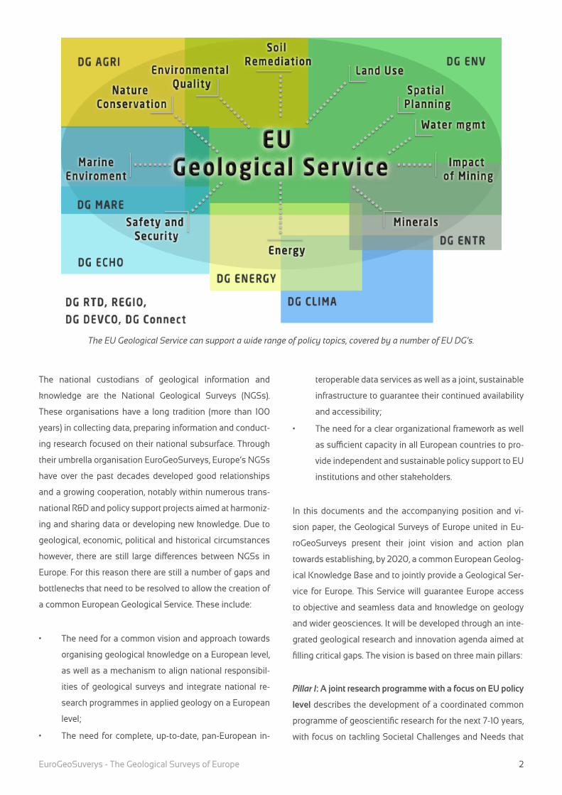
The EU Geological Service can support a wide range of policy topics, covered by a number of EU DG’s.
EuroGeoSuverys - The Geological Surveys of Europe 3
require knowledge of Subsurface Properties and Conditions.
Pillar II: Completing, harmonizing, sharing and provid-
ing pan-European geological data addresses the need for
pan-European, interoperable geoscientific information. It
will focus on building a common European Geological Data
Infrastructure. This infrastructure will form the backbone for
delivering multinational, distributed, derived spatial and tem-
poral datasets, in line with INSPIRE and other international
standards.
Pillar III: Sharing knowledge, capacities and infrastructure ad-
dresses capacity building through training and participation
in multinational and multidisciplinary research; multination-
al exchange of researchers and of best practices; and shar-
ing of laboratories, facilities and infrastructures. It addresses
the very different starting points and capabilities which cur-
rently seriously hamper some Member States and regions
to unlock their scientific and innovative potential; the need
for sufficient professionals in the field; and the need for opti-
misation of the European applied geoscience research area.
The action plan to implement the vision includes the follow-
ing main elements:
• An ERA-NET on Applied Geoscience as a preparatory
step towards developing an Article 185 initiative, inte-
grating national applied geology research programmes
in analogy with the European Metrology Research Pro-
gramme;
• Establishing the European Geological Data Infrastruc-
ture, building on an on-going feasibility study (EG-
DI-Scope) as well as several other on-going initiatives;
• A series of measures and activities to mutually open
up capacities and infrastructure, and to train profes-
sionals.

EuroGeoSuverys - The Geological Surveys of Europe
4
The need for a European Geological Knowl-edge Base
Geological data, information, knowledge and expertise un-
derpin our responses to many of the key social and econom-
ic challenges facing the European and global communities in
the 21st century. The composition, properties and dynamics
of the subsurface (including the (sub) sea floor) determine
a.o. the distribution of vital earth resources (including energy,
mineral resources, soil and groundwater); its suitability for
safe and sound underground storage of e.g. energy resourc-
es, CO2 and nuclear waste; the vulnerability of citizens and
vital infrastructure to geological hazards; and the vulnera-
bility of soils, groundwater and other subsurface ecosystem
services to pollution and degradation.
At this time of unprecedented economic stresses within
Europe and globally, geological data and knowledge have
the significant potential to provide new impetus to existing
industry and commerce, and to stimulate innovation and
growth in the knowledge economy3. To fully benefit from this
potential there is clear need for a common European Geolog-
ical Knowledge Base, allowing a common European explo-
ration effort for natural resources as well as effective policy-
and decision making related to the subsurface. Although the
need for such a Knowledge Base, or at least for information
related to the subsurface, is recognized by EU institutions in
several policy areas (e.g. the Raw Materials Initiative, Ground-
3 This is recognized a.o. in the European Competitiveness Report
2011 (SEC(2011) 1188).
water Directive, CCS Directive), much is to be gained by ap-
proaching geology as a horizontal theme addressing a wide
range of topics. However, there is currently no permanent
structure with sustainable funding and capacity to provide the
European Union with access to objective and seamless data
and knowledge on geology and wider geosciences.
EuroGeoSurveys and the Geological Sur-veys of Europe
The National Geological Surveys (NGSs) are the institutions
responsible for the collection, management, interpretation
and delivery of data and information relating to the land and
marine subsurface. NGSs have gathered those data over
many decades, resulting in vast and unique databases and
physical collections. These data underpin the authoritative
national geological knowledge bases. These core tasks of
data collection, interpretation (in the form of geological maps
and models) and dissemination (to industry, policy makers
and the public) are highly knowledge and applied research
intensive. Consequentially, most geological surveys are re-
search organisations, providing expert knowledge and tech-
nical advice to their stakeholders.
Geological information can be of very sensitive nature, for
instance in the case of competitive information on energy
and natural resources, or information on geological risks or
environmental contamination. Such information is also cru-
cial to inform many national and EU policies (see table 1 for
an overview). The Geological Surveys of Europe are thus the
Position Paper of the Geological Surveys of Europe united in EuroGeoSurveys
State-of-the-Art of the European Geological Knowledge Base

EuroGeoSuverys - The Geological Surveys of Europe 5
key players – together, in certain countries, with national and
regional sister organisations that have partial or full respon-
sibility for specific (e.g. marine, soil, groundwater, minerals)
geological data types – to build a common European Geolog-
ical Knowledge Base.
EuroGeoSurveys (EGS), a not-for-profit organization based
in Brussels, represents 33 NGSs and some regional surveys
in Europe, and an overall workforce of several thousand ex-
perts. The EGS mission is “to provide public Earth science
knowledge to support the EU’s competitiveness, social
well-being, environmental management and international
commitments”.
What have we done so far?
EGS coordinates a number of Expert Groups and temporary
Task Forces that integrate information, knowledge and ex-
pertise deriving from the member NGSs in fields including
natural hazards, water, soils, energy, mineral resources, ma-
rine geology, spatial data, carbon capture and storage, geo-
chemistry, Earth observation and international cooperation.
These Expert Groups have contributed significantly – as has
been recognised by the European Commission - to the defi-
nition of some fundamental legislative initiatives and policy
provisions, such as the INSPIRE Directive; the Raw Materials
Initiative; the Directive on the geological storage of CO2; the
EC’s Maritime Policy; the Soil Thematic Strategy; the Water
Framework Directive; the Mining Waste Directive; the Re-
source Efficiency Policy; the Coastal Zone Policy.
NGSs have also participated in a substantial number (over
250 since 1998) of EU funded R&D and policy support proj-
ects that contributed to solving important societal challenges
and promoting sustainable and competitive growth. A num-
ber of notable and recent examples are given in table 1 below.
Gaps and Bottlenecks
Despite the important work already carried out by the NGSs,
both separately and collaboratively, there are still a number
of gaps and bottlenecks that need to be resolved to allow the
creation of a common European Geological Knowledge Base
and associated specific services in support of EU policies,
possibly in the form of a permanent network structure - ‘the
European Geological Service’:
• A common European Geological Knowledge Base is
crucial to a wide range of societal issues, including
resource security/sustainability (energy, minerals, wa-
ter), environmental monitoring, health and safety of
citizens, and the development of secure infrastructure
(natural hazards). Currently, geological data and knowl-
edge relevant to these issues are fragmented and thus
not easily and interoperably available for interpreta-
tion. There is a need for a common vision and approach
towards organising geological knowledge on a Europe-
an level;
• NGSs have widely differing mandates (areas of activ-
ity/responsibility as well as freedom to operate), lev-
els of embedding (within ministries of environment,
economy, research, or otherwise), legal frameworks
(including accessibility of data), resources, capacities,
and more. EGS and its expert groups have successful-
ly bundled these institutions, identified geoscientific
topics important for European policies, and initiated
pilot actions to address these. However, this effort is
still voluntary and largely depends on research proj-
ects which are usually concentrated on test areas rath-
er than the entire EU (although regional area covering
assessments exist); data and experts are usually not
available after these projects have been finalised. Thus,
available data for all of Europe and the response time
by experts to policy demand still lag behind its poten-
tial for Europe
• The mandate of NGSs is strictly national, meaning that
they do not themselves have the freedom to make re-
sources and manpower available to durably integrate
their activities on a European level. A mechanism is
needed to align the national responsibilities of geo-
logical surveys and to integrate national research
programmes in applied geology on a European level,
building on the knowledge, expertise, infrastructure
and data of the National Geological Surveys and relat-
ed organisations.
• Geological Surveys have an indispensable role to play

EuroGeoSuverys - The Geological Surveys of Europe
6
in the common geological knowledge base, but there
are many other national organisations (universities, re-
search institutes, other governmental and non-govern-
mental institutions, industry) that hold important infor-
mation and expertise as well. The network needs to be
expanded to include these as appropriate.
• Although the NGSs have very actively contributed to
the development of INSPIRE, and have successfully
performed a number of projects in the areas of spatial
data harmonisation and dissemination (modelling, in-
frastructure, web services), much remains to be done as
there is:
o incomplete geographical coverage of interoper-
able data services, since most projects have in-
volved only a limited number of surveys;
o no continuity of EU project results (maintenance
and updating of portals and data services) as
there is no mandate or funding for structural sup-
port;
o no joint, sustainable information infrastructure to
facilitate continuity of EU project results.
• The current operative model of EGS does not constitute
a central organization but a loose association facilitat-
ing dialogue and cooperation between NGSs. It does
not have the capacity to coordinate joint projects and
programs. There is a need for a clear organizational
framework that fulfils the following roles and demands:
1) maintenance of the national mandates of NGSs and
strengthening of link to European policies;
2) identification of pan-European research challenges and
responding programmes and overseeing joint research
programming;
3) providing a platform for data storage and dissemina-
tion;
4) providing independent and sustainable policy support
to EU institutions and other stakeholders. In short, a
“European geological service”.
Conclusion
Europe’s NGSs vary in size, capacity, expertise, resources and
infrastructure, and operate under different mandates and re-
mits. Thus their abilities to support the common European
Geological Knowledge Base differ. Further, existing national
resources and infrastructures are under pressure because of
the current economic crisis. Since national data coverage as
well as national geological knowledge is indispensable for
the objectives of establishing the common European Geo-
logical Knowledge Base with the purpose to serve European
citizens, measures are needed to address this, and to provide
support and best utilise limited resources at European Level.

EuroGeoSuverys - The Geological Surveys of Europe 7
TopicShort name &
linkMain objective / deliverable Period
EU
Programme
Geology OneGeology
-EuropeCreation of a geoportal serving 1:1million scale harmon-
ised geological map data from 20 European countries
in 18 European languages.
2007-2010
(finished)
CIP ICT-PSP
EGDI-Scope Designing a sustainable e-infrastructure for serving
pan-European geological datasets.
2012-2014
(on-going)
FP7
Capacities
Minerals
& Energy
Pro-Mine Pan-European GIS-based database containing known
and predicted metalliferous and non-metalliferous re-
sources, which together define the strategic reserves
(including secondary resources) of the EU.
2009-2013 FP7-NMP
EuroGeoSource Data portal, allowing access to aggregated geograph-
ical information on geo-energy and mineral resources
in 10 EU countries.
2010-2013 CIP ICT-PSP
EURARE Characterize the potential REE resources in Europe,
and research, develop, optimize and demonstrate
technologies for the efficient and economically via-
ble exploitation of currently available European REE
deposits with minimum consequences to the environ-
ment.
2013-2016 FP7-NMP
SARMa /
SNAP-SEEDevelop and disseminate tools for primary and sec-
ondary aggregates management planning in South-
east Europe
2009-2011/
2012-2015
SEE
Minerals4EU Develop a user-centred intelligence network struc-
ture for delivering data, information and knowledge
on mineral resources in the European Union and on
a global scale
2013-2015?
(proposed)
FP7-NMP
Next stepsThis document addresses stakeholders with the need for
geoscience knowledge in Europe. Based on their feedback
a separate vision statement will follow which will focus on a
European Geological Service in more detail.
Any feedback is welcome at
Table 1: overview of recently finished, on-going and recently submitted or granted projects of direct relevance to various activity
areas and involving a significant number of National Geological Surveys as project partners.

EuroGeoSuverys - The Geological Surveys of Europe
8
TopicShort name &
linkMain objective / deliverable Period
EU
Programme
Marine
Geology
EMODnet -Ge-
ologyAssemble fragmented marine geology data into in-
teroperable, contiguous and publicly available data-
sets for whole maritime basins
2009-2020?
(phase 1 fin-
ished, phase
2 approved
DG MARE
Geo-Seas e-infrastructure enabling users to identify, locate and
access pan-European, harmonised and federated ma-
rine geological and geophysical datasets and derived
data products through a single common data portal.
2009-2012
(finished)
FP7
Capacities
Geo-Hazards PanGeo Provide information on ground stability hazards in Ur-
ban areas in all EU countries
2011-2014 FP7 Space
SubCoast Developing a GMES-downstream service for assessing
and monitoring subsidence hazards in coastal lowland
areas around Europe.
2010-2013 FP7 Space
SAFELAND Develop generic quantitative risk assessment and man-
agement tools and strategies for landslides at local, re-
gional, European and societal scales
2009-2012 FP7 ENV
DORIS Advanced downstream service for the detection, map-
ping, monitoring and forecasting of ground deforma-
tions, including landslides and ground subsidence,
at different temporal and spatial scales and in various
physiographic and environmental settings.
2010-2013 FP7 Space
CCS GeoCapacity Assess the European Capacity for Geological Storage of
Carbon Dioxide
2002-2006 FP6
ECCSEL Preparatory project aimed at forming a new distributed
research infrastructure devoted to world-class exper-
imental research pertaining to CCS (phase 1 finished;
phase 2 started 01-01-2013).
2011-2014 FP7 Capaci-
ties
Water e-Water Multilingual cross-border access to groundwater data-
bases
2006-2008 e-Content
-plus
Geochemistry &
Soils
GEMAS Comprehensive mapping of the geochemical properties
of agricultural soil and grazing lands throughout Europe
Na Self-Funded

EuroGeoSuverys - The Geological Surveys of Europe 9
Introduction
Geology aims to provide a detailed understanding of our sol-
id Earth (the geosphere): its origin and history; its physical
and chemical structure and dynamics; and its interaction
with the hydrosphere, biosphere, cryosphere, atmosphere
and increasingly the anthroposphere. A good understanding
of the solid Earth is key to managing wealth generation and
promoting well-being. It provides knowledge on the occur-
rence and exploitability of natural resources, as well as on
risks and impacts of natural and human-induced process-
es. The fast-growing global population places ever more
demands on limited natural resources and ecosystem ser-
vices. As a result, European society faces great challenges
for which ecologically, economically and socially sound solu-
tions and scientific advice are required. In particular, these
challenges include geo-energy, raw materials, groundwater,
and geohazards.
The National Geological Surveys (NGSs) are national enti-
ties responsible for policy support in all subsurface-related
survey and management activities, including mitigation and
exploration research, vulnerability and risk assessments,
forecasts and statistics. The NGSs of Europe, united in Eu-
roGeoSurveys (EGS), jointly represent the critical mass of
knowledge, research capacity and capability, data and facili-
ties needed to fulfil that same role on a European level.
This vision paper provides the strategic framework for the
development of a European Geological Service, building on
the EU’s public-public partnering initiatives. It supports the
premise that integrated and transnationally accessible geo-
logical knowledge and information will serve Europe’s needs
to manage its resource potential in such a way that the ability
of future generations to meet their own needs is not compro-
mised, safeguarding vulnerable resources and environments.
It will allow the existing network of the national surveys, EGS,
and their partner institutions in research, to combine and co-
ordinate existing national research and policy activities con-
cerning the subsurface.
1. Scope
This paper presents the joint vision, mission and action plan
of the Geological Surveys of Europe united in EGS for the pe-
riod of 2013-2025. The action plan aims to develop knowl-
edge and information to support policy makers, industry,
academia and the general public, covering all transnational
issues related to the subsurface and the geosphere thus de-
livering the EGS mission:
‘EGS provides public Earth science knowledge to support
the EU’s competitiveness, social well-being, environmental
management and international commitments’.
In realising this vision, EGS and the NGSs will align with other
relevant initiatives and work with all interested stakeholders.
The area of competence of NGSs encompasses the geo-
sphere (the solid parts of the Earth), both on- and offshore,
with a focus on the “zone of human interaction” (Figure 1): the
upper 5-7 km of the Earth’s crust.
Vision Paper of the Geological Surveys of Europe united in EuroGeoSurveys
Developing a joint Geological Service for Europe
EuroGeoSuverys - The Geological Surveys of Europe
10
This Vision Paper builds on the Position Paper “State-of-
the-Art of The European Geological Knowledge Base”. The
latter document describes the need for developing a com-
mon European Geological Knowledge Base, the current state
of collaboration between Europe’s NGSs, and the gaps and
bottlenecks that need to be overcome to optimise that col-
laboration. This paper describes the vision of the Geological
Surveys of Europe towards overcoming existing bottlenecks,
and thus improving knowledge, infrastructure and data bas-
es in support of European policies, directives and research &
development related to the Earth’s subsurface.
2. The changing role of Geosciences: Op-portunities and Challenges
Geological data, information, knowledge, intelligence and
expertise underpin the responses to many of the key social
and economic challenges facing the European and global
communities in the 21st century. Innovations in the field of
geology have the significant potential to provide new impe-
tus to existing industry and commerce, and to stimulate in-
novation and growth in the knowledge economy4.
4 This is recognized a.o. in the European Competitiveness Report
2011 (SEC(2011) 1188).
New geological knowledge can lead to the discovery and
safe and sustainable exploitation of new energy, mineral
and other resources. At the same time, knowledge and infor-
mation on the dynamic geosphere are indispensible in help-
ing European citizens cope with anthropogenic pressures,
climate change and natural hazards. They are also key ele-
ments in protecting the European environment.. The subsur-
face, including soils and groundwater, is increasingly used
and therefore under pressure. Many human activities have
positive effects, increasing safety, generating renewable en-
ergy or creating valuable habitats. Some others affect the
Earth negatively. Essential parts of Europe are facing pollu-
tion, erosion, soil sealing and loss of fertility as a result of ur-
banization, industrialization and land-use change. These af-
fect the availability and access to food, drinking water, clean
air and other benefits from resources and processes that are
supplied by ecosystems (ecosystem services) for Europe’s
citizens. Exposure to naturally occurring toxic substances
like arsenic, mercury or radioactive materials (e.g. radon) or
harmful minerals (e.g. asbestos) may also endanger human
health. In short, geological knowledge and information are
essential to allow us to make optimal use of the geosphere
without compromising it for future generations.
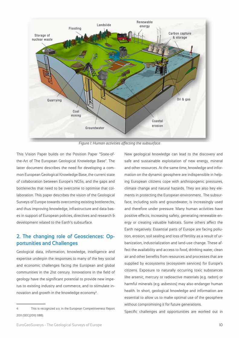
Specific challenges and opportunities are worked out in
Figure 1: Human activities affecting the subsurface
EuroGeoSuverys - The Geological Surveys of Europe 11
more detail below:
Non-energy raw materials: The Earth’s crust contains the
vast majority of all non-biological resources, and the eco-
nomic and strategic significance of the subsurface domain
is tremendous. Sectors worth € 1 324 billion and 30 million
jobs in Europe rely on the steady supply of non-energy min-
erals. For some of these minerals Europe is 100% import de-
pendent5. These include some base metals (e.g. magnesium,
tin), as well as rare earth elements (REE), platinum group ele-
ments and other elements that are crucial for green technol-
ogy, mobility, communication and high-tech products ( ICT
hardware, batteries for electrical cars, windmills, etc.).
Bulky raw materials such as industrial minerals and aggre-
gates (sand, clay, gravel) are of significant importance for
national and local economies, industry and infrastructure. Al-
though mainly produced locally, for some of these materials
European Countries are among the top ten global producers
(e.g. feldspar, gypsum and anhydrite, magnesite, potassi-
um, perlite). Apart from producing such materials, Europe is
also leading in associated technologies, such as marine ex-
traction of sand e.g. for harbor extensions and coastal nour-
ishments.
There is still high potential for exploration of new European
resources, both onshore and especially offshore as appro-
priate technology becomes available. Geological knowledge
will facilitate the discovery of new European resources, and
innovation in exploration and green mining technologies will
contribute to their safe and environmentally sound retrieval.
Reliable mineral resource statistics and mineral intelligence
are needed for policy making and raw materials strategy de-
velopment.
Energy: Fossil fuels contained in the Earth’s crust (oil, gas,
coal, peat, gas hydrates) still provide roughly 80% of the
world’s energy, and are projected to remain the main glob-
al energy source at least until 2050. Technological innova-
tions will allow much more efficient use of known reserves
and will make the exploitation of unconventional reserves
5 Critical Raw Materials for the EU, Report of the ad-hoc working
group on defining critical raw materials, 2010
(e.g. shale gas, coal bed methane, gas hydrates) possible
and economically viable. This will make a significant contri-
bution to resource efficiency, and potentially shift “peak oil”
further into the future, thus safeguarding existing resources
for future generations. Simultaneously, the geosphere pro-
vides a potential storage space for CO2, as well as a source
of renewable geothermal energy. Nuclear fuels (U, Th) are
also sourced from the subsurface, and geological storage of
spent radioactive fuels is the only realistic option for long
term disposal at present. Finally, innovative technologies are
being developed to use subsurface space for temporarily
storing other forms of sustainable energy (e.g. compressed
air in salt caverns).
Environmental impact of resource exploitation: Although the
Earth’s resources are necessary for everyday life and of enor-
mous economic significance, there is increasing concern
among Europe’s population over the safety and environmen-
tal impact of their exploitation. These concerns have recently
surfaced particularly in the fields of storage of CO2 and the
exploration for shale gas, but also in connection to mining
and industrial facility accidents such as the red mud spill in
Hungary and the Baia Mare disaster in Romania. These is-
sues highlight the need for developing a detailed geological
knowledge base on these topics, to support the development
of much more severe risk assessments, and for developing
new mining technologies for safe exploitation, production,
monitoring, inspection and restoration. Better communica-
tion of geological knowledge to the general public and im-
proved public involvement in decision making processes are
of great importance as well.
Underground spatial planning: The multiple uses of the sub-
surface for geological storage, exploitation of both fossil and
sustainable energy, and exploitation of other resources, re-
sults in potential conflicts for the use of subsurface space.
There is an increasing need for the development of subsur-
face spatial planning policies, as well as the data, knowledge
and tools to underpin them. This is particularly the case in
densely populated areas, where e.g. near surface mining,
waste deposition, geothermal energy applications, under-
ground building and storage may conflict with environmental
issues, nature protection, agriculture and water supply and
EuroGeoSuverys - The Geological Surveys of Europe
12
other infrastructure. Resources may also be effectively steril-
ised (become inaccessible) by urban – residential – land use.
Environmental pressures on near-surface geology: Soils
are the most important substrate for agriculture, farming
and forestry. Without soils, most life on land would not be
possible. Moreover soils play an important role as filter and
storage space for groundwater, which itself is the most crit-
ical raw material worldwide. Seabed sediments are also of
great importance as they form the basis supporting marine
habitats. Pressures on the seabed include large scale sand
movements, fisheries that directly disturb the seabed, beach
heads, etc.
Soils and groundwater are increasingly under pressure. They
are threatened by pollution, erosion, soil sealing and loss
of organic carbon and fertility as a result of urbanization,
industrialization and land use change. These threaten the
availability and access to food, drinking water, fresh air and
ecosystem services of Europe’s citizens. In addition, soils
and shallow deposits may contain naturally occurring tox-
ic substances like arsenic, mercury or radioactive materials
(e.g. radon), or harmful mineral shapes (e.g. asbestos). The
exposure to these substances may endanger human health.
Natural and man-made hazards: The socio-economic im-
pact of natural and man-made hazards has increased sig-
nificantly over the last decades – to a large extent as a result
of increasing urbanisation and concentration of population
and infrastructures, particularly in vulnerable regions such
as coastal lowland areas and along fault zones. Reinsurance
costs have increased significantly, to up to 119 billion US$ (99
billion €) in 2011 (Source: Munich Re). In addition, and part-
ly due to the instantaneous diffusion of images of disasters
in the media, the sensibility of citizens to such hazards has
increased. There are new demands for detailed hazard and
risk mapping, as well as mitigation and adaptation measures
to optimise security, respond to emergencies and manage
disasters. These in turn require better understanding of nat-
ural and man-made processes and related geohazards,. New
and more effective tools are required to improve mitigation
and resilience policies. And adequate legislation for building
resilient housing and infrastructures needs to be based on
up-to-date risk assessments.
Climate change: A significant reduction of greenhouse gas
emissions – as expressed e.g. in the “20-20-20” reduction
targets of the EU’s Climate and Energy Package– is needed
to prevent climate change from transgressing critical thresh-
olds. Possible alternative, sustainable energy sources impor-
tantly include geothermal energy,. The large scale and safe
deployment of these requires new geological knowledge
and expertise, as well as renewed technologies. Geological
storage remains an option for reducing CO2 emissions from
burning fossil fuels, which are likely to remain the primary
global energy source at least for the next decade (see also
above). Policies for adaptation to climate change require new
tools for protective coastal management, landslide mitiga-
tion, as well as new approaches for soils and groundwater.
Geodiversity and geoheritage: Both geodiversity, a crucial
factor conditioning biological, cultural and landscape diver-
sity, and geoheritage, those geological elements with high
scientific, educational or touristic value, must be preserved
for future generations. We must protect the most vulnerable
and representative elements of nature, whether biotic or abi-
otic, keeping in mind that while most species, habitats and
ecosystems may be resilient and undergo recovery, most
geological heritage is non-renewable and irreplaceable. Eu-
ropean NGSs are leading the latest advances in geodiversity
characterization and geoheritage inventory and assessment.
Natural protected areas need to incorporate the geological
record of climate change and the evolution of life, and Eu-
ropean legislation is also steadily moving forward towards
the integrated protection of natural diversity and natural her-
itage. EGS has the capacity to assess in these aspects, and
the increasing demand from society needs to be answered.
The international dimension: Due to the dispersion at na-
tional level of regulatory and technical capabilities related to
natural resources and risks assessment, there is no single
coherent support for EU policy development on these glob-
al issues. There is a need for a shared EU view of the world
based on permanent survey and assessment capabilities
akin to the US, China and other emerging global economies,
e.g. BRICs. Whilst the world population continues to in-
crease, and many third world / developing countries enter a
path of increased social and economic development towards

EuroGeoSuverys - The Geological Surveys of Europe 13
Western European and US standards, new inequities are in-
evitable. Globally we are far from the objective of eradication
of poverty championed by successive world summits. NGSs
are in a particularly difficult position in this respect as the
exploitation of mineral and energy resources are frequent-
ly condemned as a “malediction” for the producing country,
when they – the NGSs - should be recognised as key facili-
tators of development. This raises the issue of “good gover-
nance”, implying the need for training and capacity building
in the countries concerned. A link between the EU develop-
ment policy and raw materials strategies, based on geosci-
entific information including reliable mineral resources sta-
tistics, in order to ensure a sustainable supply is essential.
The EU strategy on raw materials needs to be prioritized in
respect to trade, domestic mining and recycling.
Virtual Earth: Information technology pervades both the sci-
entific world and everyday society and provides immense
potential for advancement in the geosciences. 2D, 3D and
even 4D (dynamic) models can now be constructed in order
to map, model, understand and manage the subsurface and
to predict, fuel debate and inform on potential use. Modern
technology allows visualisation of potential raw material de-
posits, groundwater bodies and potential pathways. Through
the development of interoperable spatial data services and
open data policies, they can be linked to other information
concerning infrastructure developments, agriculture and
other special uses.
Public resources under pressure: NGSs, as part of the public
sector, are facing increasing budget cuts resulting in reduced
staff levels and other cuts, whilst at the same time there is
increased demand for their data and information. Research
and innovation, as well as specialized training, offer new op-
portunities in sectors which, in the recent past, were not nec-
essarily favoured by public policy priorities. Improved syner-
gies with academic research as well as better coupling with
demanding private and public sectors are essential.
3. Vision and Goals – Maximizing added value and minimizing impact of using the subsurface
In the “Proposal for a European Innovation Partnership on
Raw Materials” (COM(2012) 82) the European Commission
notes that:
“For many years the basic geological exploration and map-
ping in the EU has been carried out by national geological
surveys that have to operate within the constraints of nation-
al frameworks and regulations. Today, the full benefits of an
appropriate coordination or even integration of some of the
activities of the EU’s different 27 geological surveys has not
been achieved. Yet, innovative thinking based on increased
networking and cooperation offers a huge potential to move
forward. Setting European standards will facilitate the cre-
ation of a uniform EU geological knowledge base, and can
also lead to a more cost-effective development and use of re-
quired modern technologies, such as satellite-based resource
information and advanced 4D computer modelling systems.”
The Strategy laid down in this Vision Document responds
directly to this call for enhanced collaboration between the
individual NGSs. It aims to mobilise and coordinate the
NGSs human resources, expertise scientific capacities, and
research infrastructures to establish a common EU “geolog-
ical knowledge base”. Although the current vision is formu-
lated from a geological surveys’ perspective, existing linkag-
es will be exploited and, where necessary, new linkages will
be forged with industrial, academic and policy stakeholders
and partners both within and outside Europe, to create crit-
ical mass.
The vision of the Geological Surveys of Europe united in Eu-
roGeoSurveys will make a significant contribution to the EU
2020 Strategy objectives of Smart, Sustainable and Inclusive
Growth. In particular the vision is relevant to the flagship ini-
tiatives of “Innovation Union”, “Resource Efficient Europe”,
and “An industry policy for the globalization area”. It will con-
tribute to the Raw Materials Initiative objective of securing
reliable and unimpeded access to raw materials for Europe’s
industries, and to the 20-20-20 by 2020 objectives of Eu-
rope’s Energy 2020 strategy.
The vision will also contribute to good environmental status
of the subsurface, (ground) water and seas, in line with the
EU’s Water Framework Directive, Groundwater Directive, Ma-
rine Strategy Framework Directive and Soil Thematic Strat-
egy.
EuroGeoSuverys - The Geological Surveys of Europe
14
The vision will contribute to the INSPIRE directive through
harmonizing and sharing of pan-European geological data.
Specific impacts on key policy drivers at regional, European
and global scale are given in Appendix A.
4. Realising the Vision: Strategy based on 3 Pillars
The vision of EuroGeoSurveys and the Geological Surveys of
Europe towards establishing a European Geological Service
is based on three main pillars (Figure 2):
• Establishing a joint research programme with signifi-
cant impact at EU policy level
• Completing, harmonizing, sharing and providing
pan-European geological data
• Sharing knowledge, expertise, capacities and infra-
structure.
Pillar I: A joint research programme with significant impact at
EU policy level describes the development of a coordinated
common programme of geological research for the next 7-10
years, with focus on tackling Societal Challenges and Needs
that require knowledge of Subsurface Properties and Condi-
tions. This research programme will:
• Support innovation, industrial development and com-
petitive growth;
• Support European policy-making to improve quality of
life and safety for European citizens;
• Maximize the sustainability of exploration, exploitation
and management of the subsurface and its natural re-
sources;
• Strengthen the capacity of the geoscientific communi-
ty and using it to its fullest advantage, with a greater
focus on pan-European issues.
Pillar II: Completing, harmonizing, sharing and provid-
ing pan-European geological data addresses the need for
pan-European, interoperable geoscientific information. It will
focus on building a common European Geological Data Infra-
structure (EGDI). This infrastructure will form the backbone
for delivering multinational, distributed, derived spatial and
temporal datasets, in line with INSPIRE and other interna-
tional standards. As such, it will be the foundation for the
common EU geological knowledge base. Key to this pillar is
the long-term operationality of the infrastructure.
Pillar III: Sharing knowledge, capacities and infrastructure ad-
VISION STATEMENT
By 2020 the Geological Surveys of Europe united in EuroGeoSurveys, together with relevant partners, will have es-
tablished a common European Geological Knowledge Base and will jointly provide a Geological Service for Europe.
This Service will provide the European Union with access to objective and seamless data, knowledge and exper-
tise on geology and wider geosciences. It will be developed through an integrated geological research and innova-
tion agenda aimed at filling critical gaps. This Knowledge Base and Service will contribute to the following goals:
• Enable optimal use and management of – including optimising planning of activities in - the subsurface,
maximising its added value for raw materials, soil and groundwater, storage, and ecosystem services, while mini-
mising environmental impacts and footprints;
• Contribute to good environmental status of the subsurface, including (ground)water, soils, and the ocean
floor;
• Optimise Society’s resilience to natural (geological) hazards, including those induced by land use and
climate change, thus reducing the loss of human life and environmental, economic and material damage resulting
from them.

EuroGeoSuverys - The Geological Surveys of Europe 15
dresses capacity building through training and participation
in multinational and multidisciplinary research; multination-
al exchange of researchers and of best practices; and sharing
of laboratories, facilities and infrastructures. It addresses the
very different starting points and capabilities which currently
seriously hamper some Member States and regions to un-
lock their scientific and innovative potential; the need for
sufficient professionals in the field; and the need for optimi-
sation of the European Applied Geoscience Research area.
This pillar aims to build capacity across the Applied Geosci-
ence ERA:
• in European countries were this capacity is currently
underdeveloped;
• across the ERA in order to provide NGSs but also ac-
ademia, industry and relevant policy institutions with
sufficient work force (particularly in the field of Raw
Materials);
• to jointly preserve knowledge and know-how that is
critical, but too limited in scope or too expensive to ef-
fectively maintain it on a national level.
Together, the three pillars form the basis for creating an en-
during European Geological Service to be developed, main-
tained and delivered by the National Geological Survey Orga-
nizations of Europe. They will allow the Geological Surveys of
Europe and related national organizations to take their exist-
ing collaboration to the next level, and work towards integra-
tion of national programmes in the field of applied geology.
Relationships between different elements of the strategy
The joint research programmes (Pillar I) will deliver data and
information products that will be made accessible by the
EGDI (Pillar II). At the same time, pan-European, harmonised
geological data and information served through the EGDI
may enable joint research in Pillar I. Similarly, joint research
projects (Pillar I) will facilitate exchange of staff, training, and
capacity building, and will make use of shared infrastructure
and capacities (Pillar III). In addition, many Pillar III activities
will directly relate to the development and maintenance of
the EGDI (Pillar II). The European Geological Service will ulti-
mately provide a common single access point for EU bodies
and other stakeholders.
Figure 2: The three pillars of the EGS vision for an integrated pan-European Geological Service.

EuroGeoSuverys - The Geological Surveys of Europe
16
5. Implementation
5.1 Aligning national efforts: Building the Geological Service
ERA (Pillar I)
The central aim of the Vision described in this paper is the
coordination and integration of activities and expertise of
Europe’s NGSs. In a very similar setting to that of NGSs, the
National Metrology Institutes of Europe and the European
Commission have in 2007 launched the European Metrol-
ogy Research Programme (EMRP) under Art. 185 TFEU. This
initiative was recently very positively evaluated. According to
the evaluators, the programme has significantly contributed
to modernizing the scientific metrology base and enabling
it to have much broader impacts; to pooling resources and
capacities on a European level; and to opening the metrolo-
gy system to the best science available in Europe. In March
2012 the EGS General Meeting agreed that Art. 185 TFEU is
a most suited tool to achieve the required European integra-
tion of geological survey abilities outlined above.
In analogy to the EMRP, we propose and seek support for
an ERA-NET project on Applied Geoscience as a necessary
preparatory step towards developing an Article 185 initiative.
The objectives of this ERA-NET project will be to:
• Bring together NGSs (as programme managers of geo-
logical survey research programmes) and their govern-
ing ministries (as programme owners) to:
o Systematically exchange information and best
practices;
o Build the environment and processes, particular-
ly amongst the programme “owners”, to facilitate
joint activities (including the identification and
overcoming of legal and other barriers);
• Develop a joint Strategic Research Agenda, building
on a systematic and on-going foresight process and
including clear and SMART goals and objectives;
• Develop the organisational structures needed to im-
plement and execute joint activities (where EuraMet
e.V., which runs the EMRP 185 programme, will serve as
an example);
• Develop modalities within the joint activities that will
allow and guarantee exchange of researchers and
knowledge, training and capacity building, and shared
use and development of infrastructures (Pillar III);
• Initiate jointly planned research projects in selected pi-
lot areas on a shared-funding basis through a first joint
call;
• Secure financial and political commitment for an Arti-
cle 185 programme in applied geoscience, take a go/
no-go decision for such a programme, and explore pos-
sible alternatives for implementation of this vision.
Many of the prerequisites for the successful development
and implementation of the proposed ERA-NET and Article
185 programmes are already in place. The collaboration of
the Europe’s NGSs through in EGS is well established dat-
ing back to 1971. EGS is now a non-profit international orga-
nization under private law in Belgium, and has a dedicated
Secretariat in Brussels. It has well-established connections
to European institutions and DGs (partly through its Expert
Groups), to industry (in particular through the European
Technology Platform on Sustainable Mineral Resources), as
well as to international sister organisations throughout the
globe.
The resources available to European NGSs represent a sig-
nificant portion of total public spending on geological R&D in
Europe. EGS members are currently in the process of identi-
fying which other organizations by country should be taken
on board the proposed initiative in order to generate critical
mass, as well as mapping out what resources could be made
available to an Article 185 initiative. In parallel, the outline of
the Strategic Research Agenda is being developed, and dis-
cussions on prioritisation of topics, programme modalities
and targets for knowledge exchange, capacity building and
sharing of infrastructures are ongoing.
5.2 Establishing the European Geological Data In-
frastructure (Pillar II)
Over the last 10 years, European NGSs have participated
jointly (i.e. 2 or more surveys) in a large number of European
and international projects aimed at spatial and temporal data
collection, harmonisation and dissemination. These include
projects on digital geological maps and thematic maps on
non-energy minerals, geo-energy, geo-hazards, CCS, marine
geology, groundwater quality and quantity, shallow subsur-
EuroGeoSuverys - The Geological Surveys of Europe 17
face quality and chemistry, etc. (see the EGS Position Paper
for an overview). Many of these projects have developed data
standards, web portals, data infrastructures, information ser-
vices etc. However, much remains to be done in this field as
there is:
• incomplete geographical coverage of interoperable
data services, since most projects have involved only
a limited number of surveys;
• no continuity of EU project results (maintenance and
updating of portals and data services) as there is no
mandate or funding for structural support;
• no joint, enduring information infrastructure to facili-
tate continuity and sustainability of EU project results.
In order to tackle these issues, a scoping study was recently
started under FP7 with the aim of designing a pan-European
Geological Data Infrastructure (EGDI-Scope). When realized
the EGDI will provide the backbone for sustainably serving
interoperable, pan-European geological data currently held
by the Geological Surveys of Europe, along with data from
past, ongoing and future European projects. The objectives
of the scoping studies are to:
• Develop connections with and gather user require-
ments from EGDI end-users;
• Select and prioritize datasets producing maximum so-
cietal benefit;
• Work out the Technical design of the infrastructure;
• Develop models for governance and future, sustain-
able funding of the EGDI
The EGDI-Scope project will finish mid-2014, and will have
as its key deliverable an implementation plan for the EGDI.
This vision paper calls for further commitment to the estab-
lishment of the EGDI as a solid foundation for Pillar II of the
strategy. Funding for implementation of the EGDI will primar-
ily be sought through the e-Infrastructures programme of
Horizon 2020.
5.3 Unlocking Member States’ and regions’ scien-
tific and innovative potential (Pillar III)
The primary aims of Pillar III are:
• to share best practices and exchange know-how;
• to make effective and efficient joint use of the capaci-
ties and infrastructures available at individual NGSs;
• to aid individual NGSs in developing expertise and
building capacity they currently don’t have;
• to jointly preserve knowledge and know-how that is
critical, but too limited in scope or too expensive to ef-
fectively maintain it on a national level.
The achieve these aims, action is needed to develop train-
ing programmes; to develop fora for systematic knowledge
exchange; to work out agreements for the joint use of in-
frastructures; to identify expertises that are threatened to
disappear; to develop modalities for the mutual exchange
of staff; etc. Many of these activities can be incorporated as
mandatory elements in joint research projects resulting from
ERA-NET and Article 185 calls. However, experience from
similar previous programmes (e.g. the EMRP 185) show that
Pillar III aims are difficult to achieve within such a setting and
require special effort.
In addition, actions in this pillar may make use of region-
al funds, special funds for capacity building (e.g. the Marie
Skłodowska-Curie programme), and others.
5.4 Alignment with on-going initiatives
In the field of Non-Energy Raw Materials, NGSs are actively
contributing to the development of the Raw Materials initia-
tive and the European Innovation Platform on Raw Materi-
als. This initiative specifically calls for the development of a
European Geological Knowledge Base, and in particular for
improved Minerals Intelligence. The recently approved MIN-
ERALS4EU project, involving 25 European Geological Sur-
veys together with EuroGeoSurveys, the EC’s Joint Research
Centre and several other partners, aims to develop a Euro-
pean Mineral Intelligence Network. This project builds on
results from recent minerals related projects such as Euro-
GeoSource, ProMine, EURARE, SARMa/SNAP-SEE, etc. The
proposal is explicitly aligned with the EGDI-Scope project.
In the field of Geo-Energy, NGSs are and have been actively
involved in many projects related to Geothermal energy, CO2
storage (e.g. contribution to the development of the CCS di-
rective), storage of nuclear waste, and hydrocarbon explora-

EuroGeoSuverys - The Geological Surveys of Europe
18
tion and production (including so-called unconventionals).
Through these activities, NGSs are well positioned to keep
contributing to future developments in the field of energy.
This includes the “New climate & energy framework for the
period up to 2030” and notably the “Environmental climate
and energy assessment framework to enable safe and se-
cure unconventional hydrocarbon extraction”6.
In the field of Natural and Man-made hazards, initiatives of
particular relevance are the Copernicus (formerly GMES),
GEO and GEOSS programmes, as well as the EPOS Research
Infrastructure project. Although all these initiatives have a
wider focus than hazards, NGS involvement in the past has
particularly been related to geohazard monitoring, including
subsidence, landslides, mining related hazards, earthquakes,
volcanoes, etc. Close connections with GMES, GEO and GEO-
SS have been developed in the past in particular through
the EGS Earth Observation Expert Group. Connections with
EPOS are being developed through the EGDI-Scope project.
In the field of Marine Geology, the NGS community has col-
laborated transnationally for decades, for two main reasons.
First, seabed mapping is expensive and can be done more
efficiently when vessel time is shared among partners. Sec-
ondly, marine environments are generally highly dynamic
and processes do not stop at national borders. The EGS Ma-
rine Expert Group is very active in the context of the Euro-
pean Marine Observation and Data Network (EMODnet). A
jointly produced seabed-sediment map for the Greater North
Sea, the Celtic Seas and the Baltic Sea has already been
used by the European seabed-habitat community, and will
be extended to the rest of the European marine waters in
the coming years. The partnership will also extend its har-
monized data products concerning subsurface lithology and
stratigraphy, coastal behaviour, geohazards and natural re-
sources to all European seas, using OneGeology-Europe as
a common platform.
In the field of Geoheritage and geodiversity, NGSs are con-
tributing to integrated natural heritage and natural diversity
conservation, governance of protected areas and sustain-
able use of geoheritage, including the promotion of global
6 Commission Work Programme 2013, COM(2012) 629 final
initiatives through the International Union for the Conserva-
tion of Nature (resolutions 4.040 and 5.048).
In the field of Spatial Data Harmonisation and Standardisa-
tion, the NGS community has been one of the most active
contributors to the development of INSPIRE. This relates
specifically to the data domains of Geology (Annex II), Ener-
gy, Minerals and Natural Risk Zones (Annex III). Delivery of
INSPIRE compliant data is a specific objective of many past
data-related projects. Also, most NGS are actively involved in
the implementation of INSPIRE at national level.
5.5 Working together with partners
International cooperation
The societal challenges which are addressed in the proposed
Article 185 initiative (and which are in line with Horizon 2020
and EU2020) are not restricted to Europe alone. Security of
supply of sustainable energy and earth resources, as well as
climate change mitigation, are all global problems requiring
global solutions. However, Europe is losing relevance glob-
ally, particularly with respect to Asian and African countries.
Cooperation with Asian and African countries might not be
based on their raw material potential only but should be
based on common activities and programs including capac-
ity building, mutual learning for a sustainable use and pro-
tection of soils, ground water and natural resources and the
prevention and mitigation of geohazards. The future is for
joint research and exchange.
The Geological Surveys of Europe have numerous bilateral
agreements with sister organisations around the world and
a long record of capacity building projects in the field of ge-
ology/geoscience. An Article 185 initiative on Applied Geo-
science will strengthen the position of the Geological Sur-
veys of Europe and EGS as the natural and equal European
counterpart of such international organisation. International
cooperation activities within the proposed initiative will ad-
dress:
• Direct participation of international partners in re-
search projects of the programme;
• Promoting the (bi-directional) international mobility of
researchers and staff;
EuroGeoSuverys - The Geological Surveys of Europe 19
• Alignment of standardization efforts with relevant
global initiatives, and promoting the acceptance and
deployment of European solutions outside Europe;
• Providing geoscientific data, information and advice to
EU bodies in support of negotiations with third coun-
tries;
• International development and capacity building ac-
tivities, particularly in bordering countries and in Afri-
ca.
Specific activities in the latter areas, even if funded outside
the framework of the Article 185 programme - e.g. through
the Development Funds - should be closely linked to it, in
order to maximise the impact of EU investments.
Collaboration with industry and academia
Most geological surveys have well-established connec-
tions with industry and academia, both at national and Eu-
ropean level (as demonstrated in many past and on-going
EU funded projects and the concerted actions through ETP
partnerships). There are a number of industries that directly
benefit from or even depend on geological knowledge and
information – in particular the energy and mineral resources
industry, and to a lesser extent the building industry. In addi-
tion, there is an ever greater dependence in many sectors on
earth resources, including minerals and aggregates, but also
energy and heat (e.g. for greenhouses). Geoscientists in turn
rely more and more on ICT (Information and Communication
Technologies), which are often developed in collaboration
with specialist SME’s.
Many geological surveys are Research and Technology fo-
cused organizations, and as such function as intermediaries
between academia on the one hand and industry and poli-
cy makers on the other hand. Well-established connections
with both sides will be further enhanced through the Article
185 initiative, in line with the Innovation Union principles. In
particular, EGS and its Member Organizations will seek ac-
tive – including financial – support from industry to the ar-
ticle 185 programme, particularly with respect to the Energy
and Mineral Resources components of the Research Agen-
da.
Communication, dissemination and awareness raising
The programme proposed here has a strong focus on provid-
ing applied knowledge to policy makers, authorities, NGOs,
industry and the general public. Close cooperation with
these parties will therefore be a necessity in all elements of
the programme. In addition, communication activities will
contribute to the visibility of geosciences in general and the
European Geological Service and Data Infrastructure in par-
ticular. Promoting geoscience among the public and policy
makers is also necessary to make rational choices in envi-
ronmental, energetic and geohazard matters, and to obtain
political and financial support for investment in geoscientific
research.
EuroGeoSuverys - The Geological Surveys of Europe
20
Appendices / Tables / Figures
Appendix A impacts on key policy drivers at regional, Euro-
pean and global scale.
EuroGeoSuverys - The Geological Surveys of Europe 21
EuroGeoSurveys - The Geological Surveys of Europe
36-38, Rue Joseph II - 1000 Brussels - Belgium
Tel : +32 2 888 75 53 - Fax : +32 2 503 50 25
E-mail: [email protected]
www.eurogeosurveys.org
The Geological Surveys of Europe