the geology of the east albany–fraser orogen — a field guide
TRANSCRIPT

7/25/2019 THE GEOLOGY OF THE EAST ALBANY–FRASER OROGEN — A FIELD GUIDE
http://slidepdf.com/reader/full/the-geology-of-the-east-albanyfraser-orogen-a-field-guide 1/106
RECORD 2011/23
THE GEOLOGY OF THE EAST ALBANY
OROGEN — A FIELD GUIDE
Government of Western AustraliaDepartment of Mines and Petroleum

7/25/2019 THE GEOLOGY OF THE EAST ALBANY–FRASER OROGEN — A FIELD GUIDE
http://slidepdf.com/reader/full/the-geology-of-the-east-albanyfraser-orogen-a-field-guide 2/106
Government of Western Australia
Department of Mines and Petroleum
Record 2011/23
THE GEOLOGY OF THE EAST ALBANY–FROROGEN — A FIELD GUIDE
7/25/2019 THE GEOLOGY OF THE EAST ALBANY–FRASER OROGEN — A FIELD GUIDE
http://slidepdf.com/reader/full/the-geology-of-the-east-albanyfraser-orogen-a-field-guide 3/106
MINISTER FOR MINES AND PETROLEUMHon. Norman Moore MLC
DIRECTOR GENERAL, DEPARTMENT OF MINES AND PETROLEUMRichard Sellers
EXECUTIVE DIRECTOR, GEOLOGICAL SURVEY OF WESTERN AUSTRALIARick Rogerson
7/25/2019 THE GEOLOGY OF THE EAST ALBANY–FRASER OROGEN — A FIELD GUIDE
http://slidepdf.com/reader/full/the-geology-of-the-east-albanyfraser-orogen-a-field-guide 4/106
Contents
Preface .............................................................................................................................................................The Albany–Fraser project: scope, collaborative work, and progress ......................................................
The geology of the east Albany–Fraser Orogen — a field guide: part 1
Tectonic setting of the Albany–Fraser Orogen ....................................... ....................................... ...................
Eastern Goldfields Superterrane — subdivisions and geology ....................................... .........................
Structural history of the Eastern Goldfields Superterrane ................................................................Isotopic constraints of the Eastern Goldfields Superterrane ..................................... .........................
Gold mineralization in the Eastern Goldfields Superterrane ............................................................Eucla basement ........................................................................................................................................
Tectonic subdivisions of the Albany–Fraser Orogen ................................................. ......................................
Northern Foreland ....................................................................................................................................
Munglinup Gneiss .............................................................................................................................Barren Basin — Cycle 1 sediments ..........................................................................................................
Stirling Range Formation ..................................................................................................................
Mount Barren Group .........................................................................................................................
Woodline Formation..........................................................................................................................
Unnamed metasedimentary units ......................................................................................................Fly Dam Formation ...........................................................................................................................

7/25/2019 THE GEOLOGY OF THE EAST ALBANY–FRASER OROGEN — A FIELD GUIDE
http://slidepdf.com/reader/full/the-geology-of-the-east-albanyfraser-orogen-a-field-guide 5/106
Stop 8. Fraser Fault Zone .......................................................................................................................5
Directions to Stop 9 ........................................................................................................................5
Stop 9. The Eddy Suite ..........................................................................................................................5
Directions to Stop 10 ......................................................................................................................5Stop 10. Granitic gneisses — Eddy Suite? ............................................................................................5
Directions to Kalgoorlie ..................................................................................................................5Excursion 2: Tropicana in a regional context ..................................... ....................................... ........................... 6
Directions to Tropicana ...................................................................................................................6
Geological overview .....................................................................................................................................6
Tropicana Gold Project ..........................................................................................................................6
Tropicana joint venture ownership ...................................... ........................................ .................... 6Discovery and project history .........................................................................................................6
Project geology ...............................................................................................................................6
Host rocks .......................................................................................................................................6
Stratigraphic architecture ................................................................................................................6Mineral deposit architecture ...........................................................................................................6
Mineralization .................................................................................................................................7
Day 1 .............................................................................................................................................................7
Stop 1. Havana South ............................................................................................................................7Stop 2. Hat Trick Hill .............................................................................................................................7
Locality 2.1. Hat Trick Hill ............................................................................................................7
Locality 2.2. Hat Trick ridge ..........................................................................................................7Locality 2.3. Hat Trick ridge ..........................................................................................................7
Day 2 .............................................................................................................................................................7
Directions to Stop 3 ........................................................................................................................7
Stop 3. Mafic to ultramafic rocks — Archean greenstone?...................................................... ..............7Directions to Stop 4 ........................................................................................................................7
Stop 4. Bobbie Point Metasyenogranite ..................................... ....................................... ..................... 7
Di ti t St 5 7
7/25/2019 THE GEOLOGY OF THE EAST ALBANY–FRASER OROGEN — A FIELD GUIDE
http://slidepdf.com/reader/full/the-geology-of-the-east-albanyfraser-orogen-a-field-guide 6/106
21. Initial-Hf evolution plot comparing the Biranup Zone to the Northern Foreland and
Archean fragment ..................................................................................................................................
22. The 1800–1550 Ma hafnium evolution of the Biranup Zone .................................... .............................
23. Initial-Hf evolution plot comparing the Fraser Zone and Recherche Supersuite to theBiranup Zone .........................................................................................................................................
24. Probability density diagram of Lu–Hf model ages: Fraser and Biranup Zones, andRecherche Supersuite ...........................................................................................................................
25. Schematic tectonic evolution diagram for the Biranup Zone .................................... .............................
26. Route and stops for Excursion 1 ........................................ ....................................... .............................
27. Route and stops for Excursion 1, superimposed on the pre-Mesozoic interpreted bedrock geology ....
28. Route and stops for Excursion 1, superimposed on a gravity data................................................ .........29. Route and stops for Excursion 1, superimposed on reduced-to-pole aeromagnetic data .......................
30. Photographs of the Munglinup Gneiss (Excursion 1, Stop 1) ................................... .............................
31. Photographs of Biranup Zone migmatite and Archean metasyenogranite (Excursion 1,
Stops 2 and 4). ........................................................................................................................................32. Compilation of pseudosections from semipelites from Gnamma Hill and Mount Malcolm .................
33. Tera–Wasserberg concordia plots and U–Pb ages of monazite analyses from Gnamma Hill
and Mount Malcolm ..............................................................................................................................
34. Photographs of the Fraser Range Metamorphics and Newman Shear Zone (Excursion 1,Stops 6 and 7). ........................................................................................................................................
35. Aeromagnetic image, showing strong to mylonitic fabric in the Fraser Zone .................................... ...
36. Photographs of the Fraser Fault Zone (Excursion 1, Stop 8) .................................... .............................37. Photographs of the Eddy Suite (Excursion 1, Stop 9). ....................................... ....................................
38. Photographs of the Eddy Suite (Excursion 1, Stop 10) ...................................... ....................................
39. Route and stops for Excursion 2 ........................................ ....................................... .............................
40. Route and stops for Excursion 2, superimposed on the pre-Mesozoic interpreted bedrockgeology ..................................................................................................................................................
41. Route and stops for Excursion 2, superimposed on gravity data .................................... .......................
42 R t d t f E i 2 i d ti d t

7/25/2019 THE GEOLOGY OF THE EAST ALBANY–FRASER OROGEN — A FIELD GUIDE
http://slidepdf.com/reader/full/the-geology-of-the-east-albanyfraser-orogen-a-field-guide 7/106
Spaggiari et al.
7/25/2019 THE GEOLOGY OF THE EAST ALBANY–FRASER OROGEN — A FIELD GUIDE
http://slidepdf.com/reader/full/the-geology-of-the-east-albanyfraser-orogen-a-field-guide 8/106
GSWA Record 2011/23 The geology of the east Albany–Fraser O
The geology of the east Albany–Fraser Orogen — a field
by
CV Spaggiari, CL Kirkland, MJ Pawley, RH Smithies, MTD Wingate, MG DoTG Blenkinsop2, C Clark 3, CW Oorschot3, LJ Fox1, and J Savage1
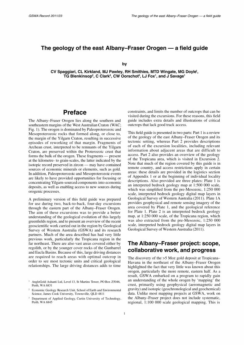
PrefaceThe Albany–Fraser Orogen lies along the southern and
southeastern margins of the West Australian Craton (WAC;Fig. 1). The orogen is dominated by Paleoproterozoic and
constraints, and limits the number of ovisited during the excursions. For thesguide includes extra details and illus
outcrops that lack good track access.Thi fi ld id i t d i t t

7/25/2019 THE GEOLOGY OF THE EAST ALBANY–FRASER OROGEN — A FIELD GUIDE
http://slidepdf.com/reader/full/the-geology-of-the-east-albanyfraser-orogen-a-field-guide 9/106
Spaggiari et al.
Gawler
Musgrave
L a c h l a n
O r o g
e n
Albany Fraser
PatersonOrogen
WestAustralian
Craton CP
Cambrian and younger orogens:
Ross–Delamerian, Lachlan, Thomson, and New England Orogens
Neoproterozoic to Cambrian Orogens:
Pinjarra Orogen
East African Orogen
Paleo-to Mesoproterozoic provincesin Australo–Antartica:
Albany–Fraser–Wilkes Orogen
Mawson Craton
Possible extensions ofthe Mawson Craton
2 0 S
3 0 S
1 4 0
E
1 3 0 E
1 2 0 E
1000 k
D e l a
m e r i a n
O
r o g e n
T h o m s o n
O r o g
e n
Proterozoic basins
Proterozoic orogens,undifferentiated
Archean cratonsPilbara
Yilgarn
North Australian
Craton
South Australian
Craton
Australian elements:
CCr
M–F–W
Arunta Orogen
Capricorn Orogen
7/25/2019 THE GEOLOGY OF THE EAST ALBANY–FRASER OROGEN — A FIELD GUIDE
http://slidepdf.com/reader/full/the-geology-of-the-east-albanyfraser-orogen-a-field-guide 10/106
GSWA Record 2011/23 The geology of the east Albany–Fraser O
due to the vast area that the orogen covers (Figs 1 and 2),and the minimal bedrock outcrop available in mostregions. The project commenced in 2006 with the releaseof the South Yilgarn aeromagnetic dataset, focusing on
the central part of the orogen (Geological Survey ofWestern Australia, 2007; Spaggiari et al., 2009). Theproject has since expanded to the eastern part of theorogen and includes the collection and interpretationof new geophysical datasets, collection and analysisof major- and trace-element geochemistry, and a moreextensive geochronology/isotopic analysis (U–Pb,Lu– Hf, and Sm–Nd) program funded in part throughthe Exploration Incentive Scheme (EIS). The Co-fundedDrilling Exploration Program of the EIS is also providingvaluable drillcore for sampling, and information fromthe various companies involved. In the past two years,GSWA has worked in collaboration with research staff atthe Department of Applied Geology, Curtin University,on understanding metamorphic P–T conditions and thetiming of metamorphism using monazite geochronology.
Two honours theses from this collabcompleted (Oorschot, 2011; Adams, 2
The project has focused on th
Paleoproterozoic areas adjacent to tmargin in the eastern part of the Albawith the aim being to gain an undcharacter of that margin and its relmineralization. We are also currently mwhich includes looking at the Mesoprotas we do so, the Proterozoic rocks beobscured beneath the Eucla and Bigand 3). The aim in this eastern regiointerpreted bedrock geology map of th
the Eucla Basin, utilizing drillcore and help define both the nature of that basemof the orogen. Through EIS funding, anco-funded drilling, several stratigraphito test interpretations and constrain the
7/25/2019 THE GEOLOGY OF THE EAST ALBANY–FRASER OROGEN — A FIELD GUIDE
http://slidepdf.com/reader/full/the-geology-of-the-east-albanyfraser-orogen-a-field-guide 11/106
Spaggiari et al.
The geology of the east Albany–Fraser Orogen — a field guid
This section outlines the tectonic setting and currentnomenclature for the Albany–Fraser Orogen, and definesand briefly describes its major tectonic units, lithologicalunits, and events. A geological history of the orogen andinterpreted tectonic models are also presented. Unlessstated otherwise, all geochronological dates reported inthis field guide are U–Pb age determinations from zircon
grains dated by ion microprobe (SHRIMP), and are quotedwith 95% confidence intervals. Published GeochronologyRecords for dated samples are referenced normally;uncited results should be considered as ‘in preparation’.
Tectonic setting of theAlbany–Fraser Orogen
The Albany–Fraser Orogen lies along the southern and
Supersuites (formerly the RecherchEsperance Granite), and three major baet al., 2009). The Kepa Kurl Booya Prodivided into the fault-bound tectonic unitZone (formerly the Biranup Complex), (formerly the Fraser Complex), and the (formerly the Nornalup Complex) (Fig.
1990a, 1995b; Spaggiari et al., 2009). described below in ‘Tectonic subdivisionFraser Orogen’.
The main tectonic events recognizedAlbany–Fraser Orogen (Fig. 4) are thePaleoproterozoic Biranup Orogeny, whic. 1680 Ma Zanthus Event (Kirkland et the Mesoproterozoic Albany–Fraser Otook place in two stages: 1345–1260 M
1215–1140 Ma (Stage II) (Clark et al., 200Cl k 2004 ) St I h b i t t

7/25/2019 THE GEOLOGY OF THE EAST ALBANY–FRASER OROGEN — A FIELD GUIDE
http://slidepdf.com/reader/full/the-geology-of-the-east-albanyfraser-orogen-a-field-guide 12/106
GSWA Record 2011/23 The geology of the east Albany–Fraser O
2
2
Co-funded d
Other
Loongana
Haig
Eucla DrillingProject
C u n d
e e l e
e F a u l t
F r a s e
r F a u l t
N e w m a n
S h
e a r
Z o n e
Sh e a r Z
o n
e
Trans–Australian Railway
E y r e H w y
A L B
A N Y – F R A S E R O
R O G E N
EUCLABASEMENT
MundrabillaShearZone
R o d
o n a
S h e a r
o Z
n e
N e w
m a n
S h e a r
Z o n e
1415 to 1407 Ma
114
1598 ±
Y I L G A R N
C R A T O N
FraserRangeNorth
Hannah1293 ± 18 Ma (inherited);1170 ± 4 Ma (metamorphic)
The Serpent
BurkinBig Red
MADURAPROVINCE
FP
NSD
1326 ± 6 Ma (magmatism);c. 1185 Ma (metamorphism)1167 ± 2 Ma (granite)
1478 ± 4 Ma (metamorphic)
Z o n e
7/25/2019 THE GEOLOGY OF THE EAST ALBANY–FRASER OROGEN — A FIELD GUIDE
http://slidepdf.com/reader/full/the-geology-of-the-east-albanyfraser-orogen-a-field-guide 13/106
Spaggiari et al.
Kurnalpi Terranes, which also have similar age patternsto the Youanmi and Burtville Terranes, suggests theincorporation of older crustal components into the rocksof the younger terranes.
Five main granite types have been recognized in theEastern Goldfields Superterrane (Champion and Sheraton,1997), with most felsic magmatism occurring betweenc. 2720 and 2630 Ma (older granites are scattered acrossthe superterrane). Although there is overlap in their ages,the magmatism responsible for the different granite types‘peaked’ at different times.
generally restricted to the Kurnalpi Terrane, and havea magmatic age peak between 2720 and 2680 Ma.
magmatic age peak between 2720 and 2680 Ma, andlesser volumes until <2655 Ma.
in age from 2675 to <2655 Ma, and are generally
This sequence of deformation events hato tectonic switching at a convergent bouet al., 2010). According to Blewett et al. deformation event, which occurred aft
produced locally developed, minor verticavariable extension vectors attributed to the
A major feature of the Eastern Goldfieldsthe development of north-northwesterly and faults. A deep-crustal seismic travcentral part of the Eastern Goldfields Supeet al., 2004) showed that the terrane-bounand Hootanui Fault systems, and the YZone, are large-scale, east-dipping, listri
extend to the base of the crust. Such strulong and complex histories. For examplShear Zone preserves three phases oincluding dextral strike-slip shearing itight to isoclinal folding and layer-parshearing in the greenstones adjacent twhich is demonstrably contemporaneous wdeformation; and sinistral strike-slip hangingwall to the east (Pawley et al., 200
age of the syn-kinematic Point Salvationlocated in the footwall of the shear zone, th

7/25/2019 THE GEOLOGY OF THE EAST ALBANY–FRASER OROGEN — A FIELD GUIDE
http://slidepdf.com/reader/full/the-geology-of-the-east-albanyfraser-orogen-a-field-guide 14/106
GSWA Record 2011/23 The geology of the east Albany–Fraser O
endowment, with structurally controlled mineralizationoccurring throughout most of its deformation history,and with some deposits recording multiple gold events(Blewett et al., 2010 and references therein). Only minor
gold deposition occurred during D1 (c. 2720 Ma andc. 2670 Ma) and D2 (c. 2665 Ma; e.g. the TarmoolaDeposit), but it is from D3 onwards that the volume of goldmineralization increased significantly. The developmentof the D3 extensional shear zones between c. 2665 andc. 2655 Ma provided crustal-scale conduits for the transferof mantle-derived magmas, fluids, and metals, and sitesfor gold deposition (e.g. Sons of Gwalia at Leonora).Several gold deposits, such as New Holland near Agnew,formed during D4a (c. 2655 Ma) reverse dip-slip faulting,
but it was the change in shortening direction during D4b (2655–2650 Ma) that led to the formation of the largestgold deposits (e.g. Kalgoorlie, Sunrise Dam, St Ives,Kanowna Belle, and Lawlers). Blewett et al. (2010)proposed that rotation of the stress axes at 2655– 2650 Maled to sinistral shearing and the development of a newnetwork of contractional and dilational jogs, whichwere favourable sites for fluid flow and traps for golddeposition. D5 (2650–2635 Ma) transtension resulted in
northerly trending, dextral shearing and development ofassociated brittle structures which host mineralization at
on the western margin of the Yilgarn Csignificant rotation drag of the westeAlbany–Fraser Orogen during the la(Beeson et al., 1995; Fitzsimons, 200
been correlated with other late-stage faFraser Orogen, such as the north-norsinistral mylonite zones that cut Biwest of Esperance, and c. 1140 Ma Esgranites nearby (Bodorkos and Clark,
Exploration drilling in the Maduintersected ultramafic, metagabbroicrocks at the Loongana prospect southvariably to strongly magnetic metagab
prospect; and heterogeneous gneissilayered quartz–chlorite–garnet schisbanded-iron formation (BIF), and aBurkin prospect (Fig. 3). Medium-grthe Loongana prospect yielded a dateinterpreted as the age of igneous crygranitic protolith that either intrudes,the mafic protolith in the same secLNGD0002, depth interval 363.52 –
178070, Nelson, 2005a). Pinkish-whigrained, unfoliated biotite microtona

7/25/2019 THE GEOLOGY OF THE EAST ALBANY–FRASER OROGEN — A FIELD GUIDE
http://slidepdf.com/reader/full/the-geology-of-the-east-albanyfraser-orogen-a-field-guide 15/106
Spaggiari et al.
Biranup
Zone
Fraser
Zone
Nor
Z
Northern
Foreland
ecnivorPayooBlruKapeKnotarCnragliY
Albany–Fraser Orogen
1200
1300
1400
1500
Age
(Ma)1100
BurnsideGranite
AlbanyGranite
STAGE II
STAGE I
Pelite
? ?? ?
? ?
? ?MetamorphicsFraser Range
CYCLE 2SEDIMENTS
? ?
1450
1350
1250
1150
CYGnowangerup–
Fraser dykes

7/25/2019 THE GEOLOGY OF THE EAST ALBANY–FRASER OROGEN — A FIELD GUIDE
http://slidepdf.com/reader/full/the-geology-of-the-east-albanyfraser-orogen-a-field-guide 16/106
GSWA Record 2011/23 The geology of the east Albany–Fraser O
to migmatization. Three analyses of zircon cores fromGSWA 182485 yielded dates of 2408–2293 Ma, possiblyreflecting the ages of sedimentary detritus in the protolith,if the gneiss is interpreted as a metasedimentary rock. Four
analyses of zircon cores from the same sample yieldeda weighted mean date of 1538 ± 17 Ma, which couldrepresent a maximum age of deposition.
East of the Mundrabilla Shear Zone, within the ForrestProvince, the Alliance Petroleum Eucla No. 1 welllies over a distinctly ovoid geophysical feature withhigh magnetic intensity, interpreted as a late graniticintrusion (Fig. 3). It forms part of a set of northeasterlytrending nested plutons with moderate to strong magnetic
signatures. Small rock chips and mineral fragments fromthe base of the well (from 215–222 m; GSWA 194773) areinterpreted to be derived from a granitic rock, and containoscillatory zoned zircon grains that yielded a date of1140 ± 8 Ma, interpreted as the magmatic crystallizationage of the inferred granite protolith (Kirkland et al.,2011j). A single analysis on an unzoned zircon crystalyielded a date of 1598 ± 14 Ma, interpreted as either theage of an inherited component within the granite, or theage of zircon incorporated from another rock unit (e.g.a sedimentary rock) within the drillhole. The magnetic
that indicate that much of it was oriYilgarn Craton (Spaggiari et al., 2002011k). The Munglinup Gneiss is intergrade, more strongly reworked compon
Foreland, bound by major faults.Reworking of the Yilgarn Craton in thevaried from moderate- to high-strain dunder amphibolite- to granulite-facconditions (Munglinup Gneiss and the Mount Barren Group), to low- to modersemi-brittle, greenschist to amphibolite et al., 1988; Myers, 1995a; Jones, 20in conditions generally reflects lowe
and lower metamorphic grade with ifrom the orogen (i.e. northwards), oof shallower crustal levels of the Nora section of the Pallinup River, west the central Albany–Fraser Orogen, Bdescribed an increase in deformation ito south, with progressive overprintinnorth-northwesterly trending ArchMesoproterozoic, Albany–Fraser Orogsouthwesterly trending dextral shear
foliations. The northern limit of the i d fi d b h f di
7/25/2019 THE GEOLOGY OF THE EAST ALBANY–FRASER OROGEN — A FIELD GUIDE
http://slidepdf.com/reader/full/the-geology-of-the-east-albanyfraser-orogen-a-field-guide 17/106
Spaggiari et al.
Orogeny (Myers et al., 1996). The Munglinup Gneiss isnow interpreted as a reworked part of the Yilgarn Cratonbased on similarities in lithologies, protolith ages (Fig. 5;Spaggiari et al., 2009), and Lu–Hf data (Kirkland et
al., 2011k). It represents the southernmost exposures ofthe craton within elongate, craton-parallel, fault-boundpackages of predominantly granitic gneiss. West ofRavensthorpe, in the central Albany–Fraser Orogen, theMunglinup Gneiss is part of the Northern Domain ofBeeson et al. (1988), where it is bounded by the linked,south-dipping Boxwood Hill and Yungunup Pool Thruststo the north, and the south-dipping Millers Point Thrustand Bremer Fault to the south (Geological Survey ofWestern Australia, 2007). The thrusts are high-strain zones
that locally contain leucosomes, and are interpreted asoblique thrust faults with a component of dextral strike-slip movement (Beeson et al., 1988). South of the MountBarren Group, the northern margin of the MunglinupGneiss is bounded by the Jerdacuttup Fault (Fig. 2), whichlinks with the Bremer Fault to the west. These faults areinterpreted to form the northern edge of a separate, easternfault-bound package of Munglinup Gneiss, with the MountBarren Group contained within a separate thrust packagebetween the two fault-bound slices of Munglinup Gneiss(cf. figs 2 and 15, Spaggiari et al., 2009).
The oldest granitic phases recognized inGneiss are a migmatitic granitic gneiss frwest of Quagi Beach (Stop 1 on Fi184334), and a medium- to dark-grey, s
monzogranitic gneiss with well-developelayering (GSWA 184120) outcropping alRiver, west of Bremer Bay, in the centraOrogen (Spaggiari et al., 2009). The miggneiss yielded an upper intercept date ofinterpreted as the magmatic crystallizagranitic protolith (GSWA 184334, KirklanThe monzogranitic gneiss from the Pallinan interpreted igneous crystallization date(GSWA 184120, Bodorkos and Wingate,
The most abundant phase in the Munglileucocratic, banded, tonalitic to monzoThe gneissic fabric appears to be intrudeporphyritic monzodiorite, and both grandate at least two episodes of folding (S2009). Zircons from the two phases, obsPoint, about 70 km west of Quagi BeacAlbany–Fraser Orogen, give igneous crysthat are within uncertainty of each otherfor the leucocratic tonalitic gneiss (G

7/25/2019 THE GEOLOGY OF THE EAST ALBANY–FRASER OROGEN — A FIELD GUIDE
http://slidepdf.com/reader/full/the-geology-of-the-east-albanyfraser-orogen-a-field-guide 18/106
GSWA Record 2011/23 The geology of the east Albany–Fraser O
NF
CBZ
ES
EBZ
NBZ
FZRS
AF
mmmdin
Biran
Stag
Stag
1000
1500
2000
2500
Age(Ma)
NW SErelative distance along NW–SE traverse
Major faults
Terrane boun
Geological bS l it
North AustralianCraton
O in e
a)
b)
7/25/2019 THE GEOLOGY OF THE EAST ALBANY–FRASER OROGEN — A FIELD GUIDE
http://slidepdf.com/reader/full/the-geology-of-the-east-albanyfraser-orogen-a-field-guide 19/106
Spaggiari et al.
b) c)
34°0
a) 121°30'
F3
F2
F2
F3F2
F3 F3
F3
R D
I S E
L A N D
E A S H
R Z O N E
BIRANUP
ZONE
MUNGLINUPGNEISS
C O R A
U M P S
H E R A Z
E O N
H E Y W
D – C H
O O E Y N
E F A U
L T Z O
N E
10 km
Excursion route
Excursion stop
Fold axial trace
1
Aeromagnetic trend line
1
7/25/2019 THE GEOLOGY OF THE EAST ALBANY–FRASER OROGEN — A FIELD GUIDE
http://slidepdf.com/reader/full/the-geology-of-the-east-albanyfraser-orogen-a-field-guide 20/106
GSWA Record 2011/23 The geology of the east Albany–Fraser O
Wingate, 2008b). Migmatitic gneiss from west of QuagiBeach (GSWA 184334, Kirkland et al., 2011b) yielded adate of 1184 ± 6 Ma from two analyses of zircon rims,indicative of high-grade metamorphism at this time.
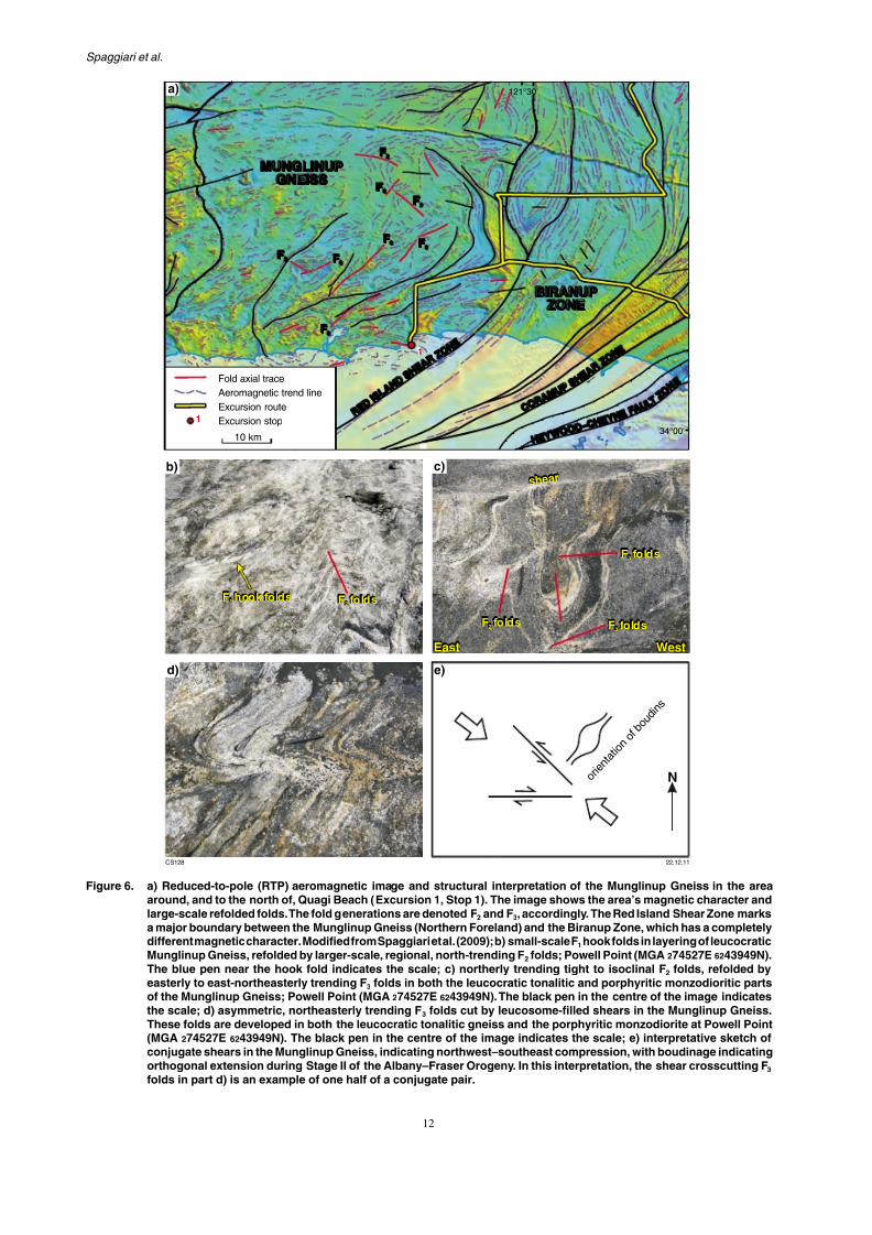
The Munglinup Gneiss has been affected by at least threephases of folding, and is locally sheared and boudinaged(Spaggiari et al., 2009). Megascale structures are well-defined in aeromagnetic imagery, particularly as foldinterference patterns, due to the presence of magnetitein the metamorphic fabrics (Fig. 6a). The fold patternscorrespond to mesoscale structures in outcrop, whereearly hook folds (F1) of gneissic banding in leucocratictonalitic gneiss are refolded into approximately north-
trending, open to tight folds (F2; Fig. 6b). These arerefolded by easterly to northeasterly trending tightfolds, which are parallel to the dominant trend of theorogen (F3; Fig. 6c). The F2 and F3 folds are interpretedto correlate with the megascale refolded folds visiblein the aeromagnetic imagery (Fig. 6a). These folds arecut by shears that locally contain leucosomes, whichindicates that this last phase of deformation took placeat high temperatures, probably at the upper amphiboliteto granulite facies (Fig. 6c,d). In outcrop, dextral shears
trend predominantly in an easterly direction, whereasi i l h d d i l h h B h
Formation, Mount Barren Group, and W(Woodline Sub-basin; Plate 1; Fig. 2). the Yilgarn Craton, and are interpreteremnants of a much larger basin syst
the Barren Basin — that evolved aloreaches of, the Yilgarn Craton margPaleoproterozoic (Fig. 4; Thom et al.,et al., 2008; Spaggiari et al., 2009). Isof quartzite and metaconglomerate, semipelitic rocks in the northeastern aFraser Orogen are interpreted to be basin system. The higher grade pelirocks of the Fly Dam Formation in thebelow) are interpreted to be somewh
distal components of the Barren Basipart of a separate, still younger, Messystem (Fig. 4). Together, the metaof the Barren Basin are interpreted series of related or linked basins forduring, the Biranup Orogeny. TheyCycle 1 sediments, to reflect the firbasin formation preserved in the Alba(Fig. 4). These Cycle 1 sediments
relate to active-margin, rift-, or backsubstantially modified the Yilgarn Cra

7/25/2019 THE GEOLOGY OF THE EAST ALBANY–FRASER OROGEN — A FIELD GUIDE
http://slidepdf.com/reader/full/the-geology-of-the-east-albanyfraser-orogen-a-field-guide 21/106
Spaggiari et al.
Mount Barren Group
The Mount Barren Group is exposed in the centralAlbany–Fraser Orogen, and consists of lower-greenschist to upper-amphibolite facies, Paleoproterozoicmetasedimentary rocks, which overlie the southern edge ofthe Yilgarn Craton along a strike length of about 120 km,extending from Bremer Bay to east of Ravensthorpe(Fig. 2; Plate 1; Thom et al., 1977, 1984b; Witt, 1997). Thegroup is divided into the Steere Formation, the KundipQuartzite, and the Kybulup Schist (Thom and Chin, 1984;Thom et al., 1984a).
The Steere Formation is the lowermost unit of this
group, and consists of a thin basal conglomerate withclasts of quartzite, chert, BIF, and felsic volcanic rocks,overlain by several metres of pebbly sandstone and 4 mof dolomitic limestone (Thom et al., 1977, 1984a; Witt,1997). At its type locality in the Western Steere River, theSteere Formation non-conformably overlies the ArcheanManyutup Tonalite of the Yilgarn Craton (Thom et al.,1977, 1984a).
The Kundip Quartzite consists predominantly of thickly
bedded pure quartzite, which is interbedded with mica-and magnetite bearing q art ite and m dstone and minor
between the Kundip Quartzite and the KThis phosphatic unit is thinly bedded alternating medium- to coarse-grainedcarbonaceous shale, enriched in phosp
Authigenic xenotime overgrowths on zfrom the phosphatic unit yielded four aof 1693 ± 4, 1645 ± 3, 1578 ± 10, and(Vallini et al., 2002, 2005). The datievidence of Stage I or II metamorphiswas interpreted as a shielded, low-strain its low permeability and porosity (ValliBased on detailed petrography and geochet al. (2005) deduced a paragenetic sequewhich provided a framework for the geoc
1693 ± 4 Ma date was interpreted to date of unconsolidated sediments, and therefthe depositional age of the unit. The onsepossible change to anaerobic conditions,to have commenced prior to c. 1654 Ma. Tage components of 1578 ± 10 and 1481interpreted to reflect periods of hydrothgrowth post-dating quartz cementation, further burial. Detrital zircon studies
Barren Group are consistent with this xyielding a maximum depositional age
7/25/2019 THE GEOLOGY OF THE EAST ALBANY–FRASER OROGEN — A FIELD GUIDE
http://slidepdf.com/reader/full/the-geology-of-the-east-albanyfraser-orogen-a-field-guide 22/106
GSWA Record 2011/23 The geology of the east Albany–Fraser O
siltstone tens of metres thick (Hall et al., 2008). Minorunits consist of pebble and cobble conglomerates, andmatrix- to clast-supported chert breccias. These rocksare folded into open, upright, northeasterly trendingfolds, and contain a weak to moderately developed,axial-planar spaced cleavage (Hall et al., 2008). Twodominant sets of paleocurrent directions were recorded,indicating both southeasterly and southwesterly directedflow. These paleocurrent readings have been interpretedeither as transverse and axial components in a foreland-basin setting, or as fluvial to deltaic and barrier islandsedimentary processes interacting with longshore currents(Hall et al., 2008). The depositional setting is interpretedas changing from a distal fluvial environment to a marine-
dominated setting (Hall et al., 2008).
The Woodline Formation has a maximum depositional ageof 1737 ± 28 Ma, permitting a similar depositional timeas the Mount Barren Group (Fig. 4; Hall et al., 2008).However, detrital zircon age spectra from the WoodlineFormation were interpreted as most similar to spectrafrom the upper section of the Earaheedy Group on thenortheastern margin of the Yilgarn Craton (Hall et al.,2008). Although there are significant differences between
the age components of the Woodline Formation and MountB G (H ll t l 2008 d f th i )
a quartz-rich, micaceous matrix, anrich laminated metasiltstone beds thdenoted UC on Fig. 4). Above this is a interbedded with metagritstone an
Bedding in the metaconglomerate dipcut by a weak to moderate foliation thaat a shallower angle. This indicates tha(direction to next antiform) is to the locality is in the overturned limb of plunging antiform. Preliminary geoc(GSWA 182416) indicate a maximage of 1752 ± 19 Ma (1), and olddates of 2835–1794 Ma, includincomponents at c. 2635 Ma and 1807
that the metaconglomerate, and bquartzites and metasandstones describof the same sedimentary cycle (CyclPaleoproterozoic metasedimentary roBasin (Stirling Range Formation, Moand Woodline Formation) (cf. Bunting
Along Ponton Creek, north of the Railway, is a psammitic gneiss tha
evidence of anatexis such as thin leintruded by coarse pegmatite. Howev
7/25/2019 THE GEOLOGY OF THE EAST ALBANY–FRASER OROGEN — A FIELD GUIDE
http://slidepdf.com/reader/full/the-geology-of-the-east-albanyfraser-orogen-a-field-guide 23/106
Spaggiari et al.
a) b)
c) d)
7/25/2019 THE GEOLOGY OF THE EAST ALBANY–FRASER OROGEN — A FIELD GUIDE
http://slidepdf.com/reader/full/the-geology-of-the-east-albanyfraser-orogen-a-field-guide 24/106
GSWA Record 2011/23 The geology of the east Albany–Fraser O
Within the eastern Nornalup Zone, preliminarygeochronology of drillcore samples of migmatitic gneissfrom the Big Red prospect (Fig. 3) (Hole BRDDH1,GSWA 182473 and 182475) yielded a large range of
predominantly Archean detrital ages, and a maximumdepositional age of 1729 ± 27 Ma (1). These migmatitesare tentatively interpreted as Barren Basin Cycle 1sediments, implying that some sediments from thisbasin system were deposited a substantial distance fromthe craton margin. Nonetheless, this interpretation isconsistent both with the presence of Paleoproterozoicbasement in the Nornalup Zone (see ‘Nornalup Zone’section), and the interpretation of the MesoproterozoicFraser Zone as possibly developing in a rift setting within
Archean to Paleoproterozoic crust (see ‘Fraser Zone’section). The preliminary geochronology shows that themigmatitic gneisses from Big Red were metamorphosedunder high-temperature conditions at 1193 ± 5 and1176 ± 10 Ma, and were intruded by Esperance Supersuitegranite at 1167 ± 2 Ma, during Stage II of the Albany–Fraser Orogeny (Fig. 4).
Fly Dam Formation
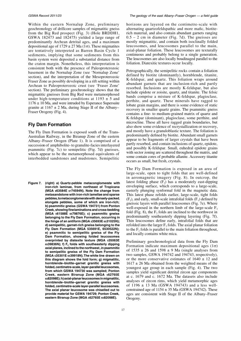
horizons are layered on the centialternating quartzofeldspathic and mrich material, and also contain abunda0.5 – 2 cm in diameter (Fig. 7d). mostly migmatitic, and contain bothleucosomes, and leucosomes paraaxial-planar foliation. These leucosocontinuous and probably belong to aThe leucosomes are also locally boudinfoliation. Diatexitic textures occur loca
Petrographically, the semipelitic rocksdefined by biotite (dominantly), hoK-feldspar, and quartz. This foliat
abundant garnets that are inclusioresorbed. Inclusions are mostly K-include epidote or zoisite, quartz, andbands comprise a mixture of K-feldperthite, and quartz. These minerallobate grain margins, and there is somrecovery in smaller quartz grains. Thecontains a fine- to medium-grained mK-feldspar (dominant), plagioclase, microcline. These all have ragged gra
also show some evidence of recrystalld tl h l bl ti t t

7/25/2019 THE GEOLOGY OF THE EAST ALBANY–FRASER OROGEN — A FIELD GUIDE
http://slidepdf.com/reader/full/the-geology-of-the-east-albanyfraser-orogen-a-field-guide 25/106
Spaggiari et al.
Beachcomber 1
Coonana / Jones
Fly Dam
31°00'
123°30'
c. 2680
c. 1680 Mac. 1683 Ma
1689 ± 6 Ma1666 ± 12 Ma
1667 ± 11 Ma
1683 ± 8 Ma
BIRANUPZONE
NORTHERNFORELAND
YILGARNCRATON
PontonCreek

7/25/2019 THE GEOLOGY OF THE EAST ALBANY–FRASER OROGEN — A FIELD GUIDE
http://slidepdf.com/reader/full/the-geology-of-the-east-albanyfraser-orogen-a-field-guide 26/106
GSWA Record 2011/23 The geology of the east Albany–Fraser O
Given the predominance of sandstone and mudstoneprotoliths, the metasedimentary rocks of the Fly DamFormation could be interpreted as turbidites, possiblyrepresenting the youngest known, more distal, and deeperwater component of the Barren Basin Cycle 1 sediments,deposited during the late stages of the PaleoproterozoicBiranup Orogeny. Alternatively, they could be muchyounger, Mesoproterozoic sediments, and therefore partof Cycle 2 (see ‘Arid Basin — Cycle 2 sediments’ section;Fig. 4). It is interesting to note that their provenanceappears to be dominated by Paleoproterozoic BiranupOrogeny aged components, suggesting derivation fromrelated volcanic sources, and/or the relatively rapidexhumation and exposure of the basement.
Kepa Kurl Booya Province
Myers (1990a) divided the Albany–Fraser Orogen intotwo major tectonic units: an inboard, intensely deformedcomponent named the Biranup Complex, and an outboardcomponent named the Nornalup Complex. In Myers’ earlydefinition, the Biranup Complex contained what were latercalled the Munglinup, Dalyup, and Coramup Gneisses(Myers, 1995b), as well as the Fraser Complex (Myers,
interlayered with reworked rocks of twithin the Northern Foreland (Figs 9et al., 2009).
The Biranup Zone is dominated by i
orthogneiss, metagabbro, and pararanging from c. 1800 to 1625 Ma (Flack of evidence for a Paleoproterotectonothermal event in the southern to the suggestion that the Biranup Zterrane accreted onto the Yilgarn CraStage I of the Albany–Fraser Orogeny1995; Clark et al., 2000; Spaggiari et arecent work has shown that the Biran
likely to have formed autochthonouslyCraton margin (Kirkland et al., 2011a). Zone, the presence of fragments ofwith ages typical of Yilgarn Craton grinterpretation (Plate 1; Fig. 5). These the ‘S-bend’ area around, and to the soAndrew, and possibly include rocks aSplinter prospect (Figs 9 and 10; see Ex3, and 4). This interpretation is furLu–Hf data from granitic rocks in the
‘Lu–Hf isotopes’ section), which indic

7/25/2019 THE GEOLOGY OF THE EAST ALBANY–FRASER OROGEN — A FIELD GUIDE
http://slidepdf.com/reader/full/the-geology-of-the-east-albanyfraser-orogen-a-field-guide 27/106
Spaggiari et al.
2684 ± 11 Ma
1668 ± 7 Ma
1297 ± 8 Ma
1695 ± 16 Ma
1658 ± 26 Ma
Zone B
123°00'122°30'
3 2 ° 3 0 '
N O R
T H E R N F O R E L A N D
BIRANUPZONE
FRASERZONE
Cave Rock
2
3

7/25/2019 THE GEOLOGY OF THE EAST ALBANY–FRASER OROGEN — A FIELD GUIDE
http://slidepdf.com/reader/full/the-geology-of-the-east-albanyfraser-orogen-a-field-guide 28/106
GSWA Record 2011/23 The geology of the east Albany–Fraser O
2684 ± 11 Ma
1668 ± 7 Ma
1297 ± 8 Ma
1695 ± 16 Ma
1658 ± 26 Ma
Zone B
123°00'122°30'
3 2 ° 3 0 '
N O R
T H E R N F O R E L A N D
BIRANUPZONE
FRASERZONE
Cave Rock
2
3
7/25/2019 THE GEOLOGY OF THE EAST ALBANY–FRASER OROGEN — A FIELD GUIDE
http://slidepdf.com/reader/full/the-geology-of-the-east-albanyfraser-orogen-a-field-guide 29/106
Spaggiari et al.
As described above, the Biranup Zone also containsmetasedimentary rocks, most of which are migmatiticparagneisses (see ‘Barren Basin — Cycle 1 sediments’section).
Eddy Suite
The Eddy Suite, which ranges from megacrysticmetamonzogranite and equigranular metasyenograniticgneiss, to rapakivi-textured metagranodiorite andmetagabbronoritic rocks, occurs in the eastern BiranupZone, and is well exposed west of Harris Lake (Fig. 8;see Excursion 1, Stop 9). These rocks have been dated atc. 1660 Ma, and represent the dominantly younger, more
juvenile, component of Biranup Zone magmatic rocks(Kirkland et al., 2011a,k). The metagranodiorite containsovoid K-feldspars up to 3 cm long, with a millimetre-wide mantle of more calcic feldspar, and rounded quartzphenocrysts up to 6 mm in diameter, within a medium-grained groundmass. These textures are typical of manyProterozoic A-type rapakivi granites (Rämö, 2005). Themetagabbronorite is fine to medium grained, and formsirregular enclaves within the metagranodiorite. These
enclaves have lobate, commonly gradational, boundarieswith the metagranodiorite suggesting that the two
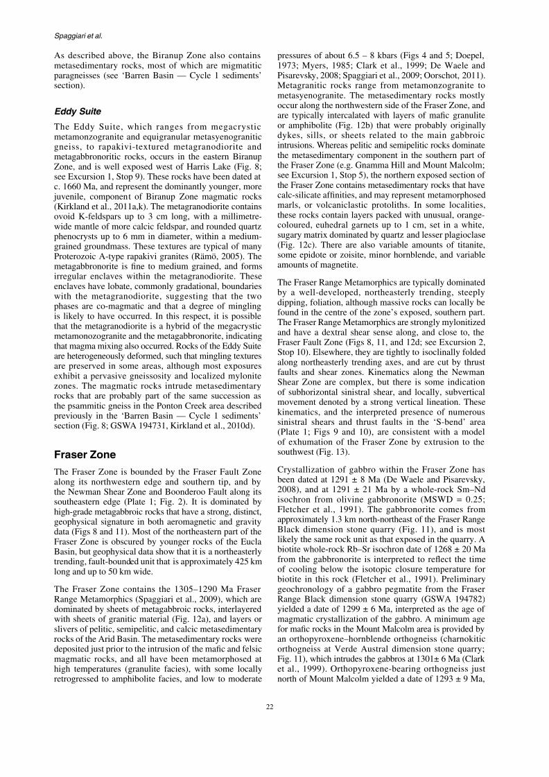
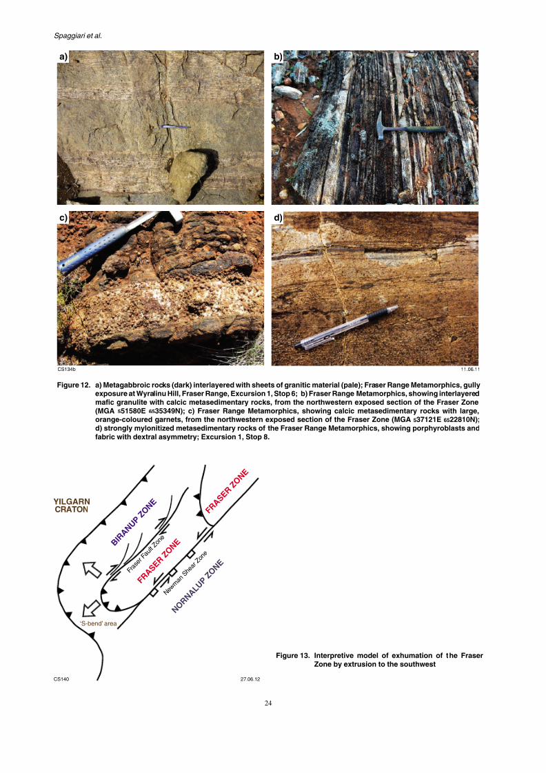
pressures of about 6.5 – 8 kbars (Figs 41973; Myers, 1985; Clark et al., 1999;Pisarevsky, 2008; Spaggiari et al., 2009; OMetagranitic rocks range from metammetasyenogranite. The metasedimentaroccur along the northwestern side of the Fare typically intercalated with layers of or amphibolite (Fig. 12b) that were prodykes, sills, or sheets related to the intrusions. Whereas pelitic and semipeliticthe metasedimentary component in the the Fraser Zone (e.g. Gnamma Hill and Msee Excursion 1, Stop 5), the northern exthe Fraser Zone contains metasedimentary
calc-silicate affinities, and may represent marls, or volcaniclastic protoliths. In these rocks contain layers packed with ucoloured, euhedral garnets up to 1 cm,sugary matrix dominated by quartz and le(Fig. 12c). There are also variable amosome epidote or zoisite, minor hornblenamounts of magnetite.
The Fraser Range Metamorphics are typi
by a well-developed, northeasterly tre
7/25/2019 THE GEOLOGY OF THE EAST ALBANY–FRASER OROGEN — A FIELD GUIDE
http://slidepdf.com/reader/full/the-geology-of-the-east-albanyfraser-orogen-a-field-guide 30/106
GSWA Record 2011/23 The geology of the east Albany–Fraser O
BIRANUPZONE
c.1295 Ma
1298 ± 5 Ma
1287 ± 14 Ma1466 ± 17 Ma
Phills
Brookman
American
Horseshoe
Heraclitus
Theofrastus
Similkameen
Yardilla East
Fraser Range 1
YardillaSouth
123°00'
32°00'
Fantasia
NORTHERN
FORELAND
7/25/2019 THE GEOLOGY OF THE EAST ALBANY–FRASER OROGEN — A FIELD GUIDE
http://slidepdf.com/reader/full/the-geology-of-the-east-albanyfraser-orogen-a-field-guide 31/106
Spaggiari et al.
a) b)
c) d)
7/25/2019 THE GEOLOGY OF THE EAST ALBANY–FRASER OROGEN — A FIELD GUIDE
http://slidepdf.com/reader/full/the-geology-of-the-east-albanyfraser-orogen-a-field-guide 32/106
GSWA Record 2011/23 The geology of the east Albany–Fraser O
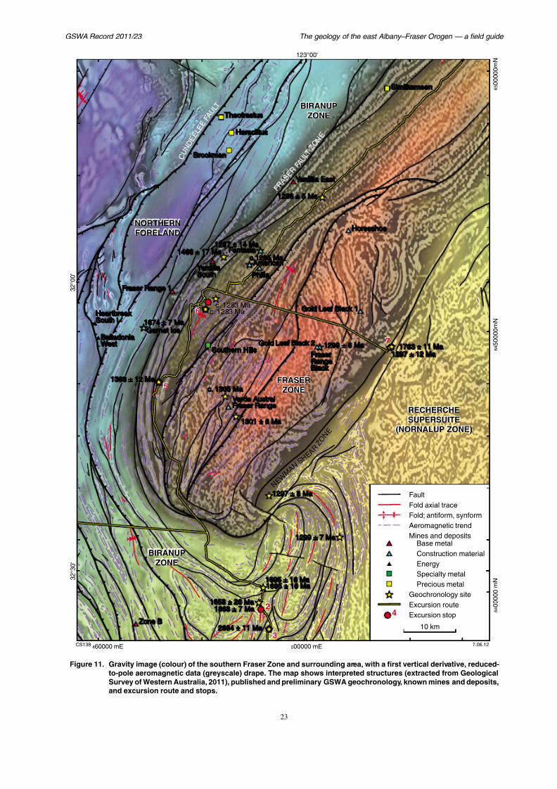
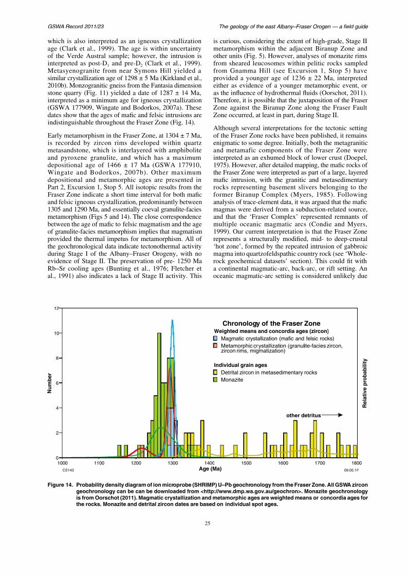
which is also interpreted as an igneous crystallizationage (Clark et al., 1999). The age is within uncertaintyof the Verde Austral sample; however, the intrusion isinterpreted as post-D1 and pre-D2 (Clark et al., 1999).Metasyenogranite from near Symons Hill yielded asimilar crystallization age of 1298 ± 5 Ma (Kirkland et al.,2010b). Monzogranitic gneiss from the Fantasia dimensionstone quarry (Fig. 11) yielded a date of 1287 ± 14 Ma,interpreted as a minimum age for igneous crystallization(GSWA 177909, Wingate and Bodorkos, 2007a). Thesedates show that the ages of mafic and felsic intrusions areindistinguishable throughout the Fraser Zone (Fig. 14).
Early metamorphism in the Fraser Zone, at 1304 ± 7 Ma,
is recorded by zircon rims developed within quartzmetasandstone, which is interlayered with amphiboliteand pyroxene granulite, and which has a maximumdepositional age of 1466 ± 17 Ma (GSWA 177910,Wingate and Bodorkos, 2007b). Other maximumdepositional and metamorphic ages are presented inPart 2, Excursion 1, Stop 5. All isotopic results from theFraser Zone indicate a short time interval for both maficand felsic igneous crystallization, predominantly between1305 and 1290 Ma, and essentially coeval granulite-facies
metamorphism (Figs 5 and 14) The close correspondence
is curious, considering the extent of hmetamorphism within the adjacent Bother units (Fig. 5). However, analysefrom sheared leucosomes within pelfrom Gnamma Hill (see Excursionprovided a younger age of 1236 ± 2either as evidence of a younger metaas the influence of hydrothermal fluidsTherefore, it is possible that the juxtapoZone against the Biranup Zone alonZone occurred, at least in part, during
Although several interpretations for tof the Fraser Zone rocks have been pu
enigmatic to some degree. Initially, boand metamafic components of the interpreted as an exhumed block of lo1975). However, after detailed mappingthe Fraser Zone were interpreted as parmafic intrusion, with the granitic androcks representing basement sliversformer Biranup Complex (Myers, analysis of trace-element data, it was armagmas were derived from a subduct
and that the ‘Fraser Complex’ repres
7/25/2019 THE GEOLOGY OF THE EAST ALBANY–FRASER OROGEN — A FIELD GUIDE
http://slidepdf.com/reader/full/the-geology-of-the-east-albanyfraser-orogen-a-field-guide 33/106
Spaggiari et al.
to the presence of Paleoproterozoic basement rocks inthe Nornalup Zone (see ‘Nornalup Zone’ below), and theBiranup-like Lu–Hf isotopic signature of the Fraser Zoneigneous rocks (see ‘Lu–Hf isotopes’ section).
Nornalup Zone
The Nornalup Zone is the southern- and easternmostunit of the Albany–Fraser Orogen (Fig. 2; Myers,1990a, 1995b). This zone is dominated and intruded bythe voluminous Recherche and Esperance Supersuites,which mask much of the original basement. In the easternAlbany–Fraser Orogen, the Nornalup Zone is separatedfrom the Biranup and Fraser Zones by the NewmanShear Zone and Boonderoo Fault, and from the MaduraProvince by the Rodona Shear Zone (Plate 1; Fig. 3).Supracrustal rocks in the Nornalup Zone comprise theMesoproterozoic Malcolm Metamorphics (previouslythe Malcolm Gneiss) and paragneissic rocks that occur inthe Albany region of the western Albany–Fraser Orogen.These supracrustal rocks belong to the Arid Basin, and arepart of the Cycle 2 sedimentary sequence (see ‘Arid Basin— Cycle 2 sediments’ section). Younger cover rocks are
Cycle 3 sediments which form part of the Ragged Basin
the Gwynne Creek Gneiss, and metasedof the Fraser Range Metamorphics (Figtheir close association with Fraser Zone mthe Fraser Range Metamorphics are coverZone’ section.
The Malcolm Metamorphics are dominatemetasedimentary rocks, including mafschist and minor calc-silicate rocks that ahad volcanic precursors (Plate 1; Fig. 1Malcolm Gneiss was reported to inclugranitic gneiss (Myers, 1995b), but recent has not found any evidence of this. The mrocks consist dominantly of muscovite–b
and quartzite, with subordinate garnet–bipelitic rocks that are locally migmatitic (Crecently dated samples of migmatitic seyielded maximum depositional ages ofand 1456 ± 21 Ma (Adams, 2011, 2012).these rocks are substantially younger thapublished maximum depositional age of(GSWA 112128, Nelson, 1995a), and alsuggestions of the presence of c. 1450 Min this area (Myers, 1995b) may reflect de
intrusive material Sample GSWA 11212
7/25/2019 THE GEOLOGY OF THE EAST ALBANY–FRASER OROGEN — A FIELD GUIDE
http://slidepdf.com/reader/full/the-geology-of-the-east-albanyfraser-orogen-a-field-guide 34/106
GSWA Record 2011/23 The geology of the east Albany–Fraser O
a)
CS134a
b)
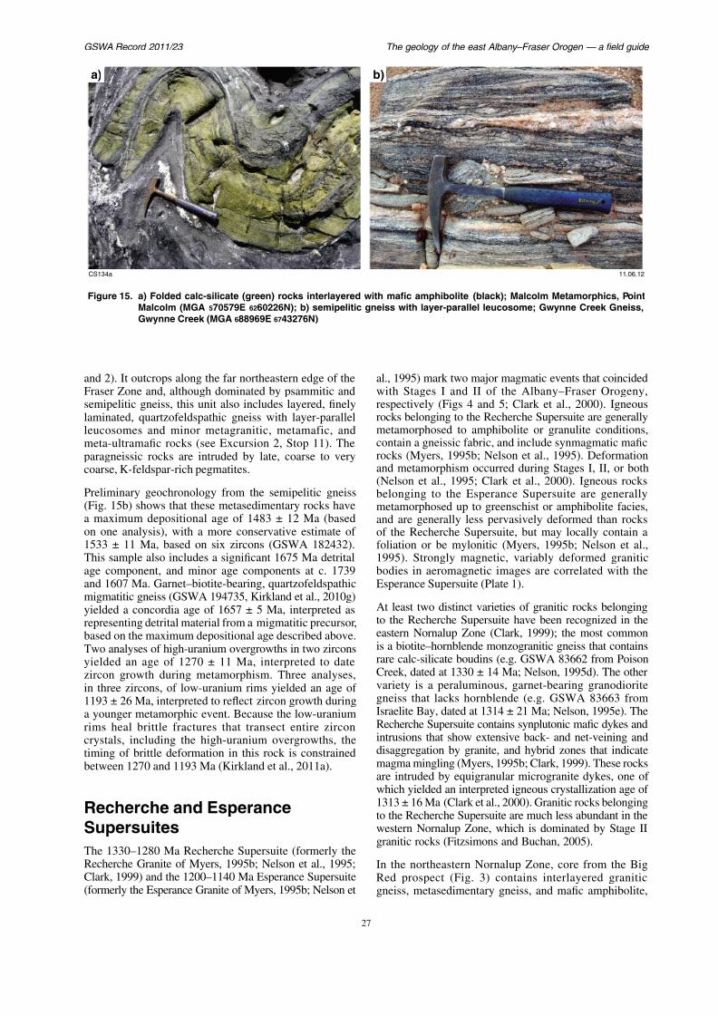
Figure 15. a) Folded calc-silicate (green) rocks interlayered with mafic amphibolite (black); Malcolm MMalcolm (MGA 570579E 6260226N); b) semipelitic gneiss with layer-parallel leucosome; GwyGwynne Creek (MGA 688969E 6743276N)
and 2) It outcrops along the far northeastern edge of theF Z d l h h d i d b i i d al 1995) mark two major magmatic evi h S I d II f h Alb

7/25/2019 THE GEOLOGY OF THE EAST ALBANY–FRASER OROGEN — A FIELD GUIDE
http://slidepdf.com/reader/full/the-geology-of-the-east-albanyfraser-orogen-a-field-guide 35/106
Spaggiari et al.
which are similar to rocks of the adjacent Fraser Zone.Migmatitic gneiss (hole BRDDH2, GSWA 182476),interpreted as a probable metagranitic rock, yielded amagmatic crystallization age of 1326 ± 6 Ma, consistentwith the age of early Recherche Supersuite intrusions.
The same sample also yielded a date of 1187 ± 9 Ma,interpreted as Stage II high-temperature metamorphism.Mafic granulite (hole BRDDH2, GSWA 182477) yieldeda date of 1188 ± 4 Ma, also interpreted as the age of high-temperature metamorphism.
Recherche Supersuite meta-igneous rocks are also presentin the southeastern parts of the Biranup Zone, and oneoccurrence is exposed within the Munglinup Gneiss ofthe Northern Foreland. This suggests a spatial connectionbetween the Northern Foreland and the Kepa Kurl BooyaProvince, and between the Biranup and Nornalup Zones,during Stage I of the Albany–Fraser Orogeny. However,the Northern Foreland spatial connection is rather tenuous,being based solely on one example of biotite granodioriticgneiss from near Bald Rock, which has an igneouscrystallization age of 1299 ± 14 Ma (see ‘MunglinupGneiss’).
In the southeastern Biranup Zone, biotite monzograniticgneiss from Mount Burdett hornblende biotite
although the supersuite appears to be min the Nornalup Zone. Preliminary geocmonzogranite at Mount Ridley (GSWA 1yielded a magmatic crystallization age ofAlthough the monzogranite appears
outcrop, aeromagnetic imagery indicatesare deformed, and that the central, moreof the granitic body defines a strain shastrongly deformed gneissic rocks of theA similar granitic body, also interpreted Esperance Supersuite, occurs to the soutsuggesting that the magmatism thatEsperance Supersuite was not confined to Stage II, but extended from at least c. 1200
Ragged Basin — Cycle 3sediments
In the eastern Albany–Fraser Orogen, theFormation was not deposited until after Sand is therefore interpreted as a cover unKepa Kurl Booya Province, here termed C
of the Ragged Basin (Figs 2 and 4) Ali hi h M d P i h S li b

7/25/2019 THE GEOLOGY OF THE EAST ALBANY–FRASER OROGEN — A FIELD GUIDE
http://slidepdf.com/reader/full/the-geology-of-the-east-albanyfraser-orogen-a-field-guide 36/106
GSWA Record 2011/23 The geology of the east Albany–Fraser O
S t a r t
E s
p e r a n c e
6 2 5 0 0 0 0 m N 6 3 0 0 0 0 0 m N
1 2 2 ° 0 0 '
1 2 8 8 ± 1 2 M a
1 2 9 9 ± 1 8 M a
1 2 8 3 ± 1 3 M a
1 1
3 8 ± 3 8 M a
1 3 2 2 ± 1 1 M a
1 6 8 8 ± 1 2 M a
1 1 9 6
± 1 1 M a
C
o r u m u p H i l l
M o u
n t B u r d e t t
M o u n t R i d l e y
O b s e r v a t o r y P o
i n t
UP E
B I R A N U P Z O N E
I n c l u d e s i n t r u s i o n s o f
R e c h e
r c h e a n d E s p e r a n c e
S u p e r s u i t e s
N O R N A L U P
Z O N E
I n c l u d e s i n t r u s
i o n s o f
R e c h e r c h e a n d E
s p e r a n c e
S u p e r s u i t e s
7/25/2019 THE GEOLOGY OF THE EAST ALBANY–FRASER OROGEN — A FIELD GUIDE
http://slidepdf.com/reader/full/the-geology-of-the-east-albanyfraser-orogen-a-field-guide 37/106
Spaggiari et al.
granitic gneiss, and a two-pyroxene metagabbro that isundeformed in its core but deformed and amphibolitic atits margins (Clark, 1999). Outcrops of migmatitic peliticgneiss contain mesosomes of biotite–sillimanite–garnet–cordierite–feldspar–quartz(–spinel), and leucosomes that
are K-feldspar-rich with localized garnet(–cordierite).These gneisses record granulite-facies metamorphicconditions of approximately 800°C and >5 kbar (Clark,1999; Clark et al., 2000). The depositional age of theSalisbury Gneiss is unknown, although a lack of evidencefor Stage I metamorphism suggests deposition afterthis event, and therefore that the unit is distinct fromthe Malcolm Metamorphics (Clark, 1999). Migmatiticleucosome derived from partial melting of the pelitic
gneiss yielded dates of 1214 ± 8 (18 core analyses) and1182 ± 13 Ma (six rim analyses; Clark et al., 2000). Theolder date is interpreted as the age of crystallization ofthe leucosome, whereas the younger date is interpretedto reflect zircon growth during decompression from peakmetamorphic conditions (Clark et al., 2000).
In the Malcolm Metamorphics, a late-stage pegmatiteyielded a SHRIMP U–Pb monazite age of 1165 ± 5 Ma.This was interpreted as the age of crystallization of the
pegmatite the age of shearing related to thrusting of the
older than an IDTIMS baddeleyite age ofrom the Binneringie Dyke (French et precise SHRIMP baddeleyite and zircoand 2407 Ma from the Jimberlana Noriteunpublished data). Dykes belonging to the
Dyke Suite crosscut Archean structuresCraton, but are in turn cut by structures foMesoproterozoic Albany–Fraser Orogeny
The Gnowangerup–Fraser Dyke Suitlargest of the five mafic dyke suites, exthe southern and southeastern parts Craton, and forming part of the c. 12Moorn Large Igneous Province (WingaIt includes northeasterly trending dykes fAlbany–Fraser Orogen and southeastern informally named the Fraser dykes, whicontinuous with those in the central Albanand southern Yilgarn Craton. Most dykthe Gnowangerup–Fraser Dyke Suite arstrongly magnetic. Their trend changes feast-northeasterly in the west, to northeast — parallel to the craton margin. Iimages, the dykes are visible as mult
with the two dominant trends overlapp

7/25/2019 THE GEOLOGY OF THE EAST ALBANY–FRASER OROGEN — A FIELD GUIDE
http://slidepdf.com/reader/full/the-geology-of-the-east-albanyfraser-orogen-a-field-guide 38/106
GSWA Record 2011/23 The geology of the east Albany–Fraser O
The Nindibillup Dyke Suite comprises mafic (dolerite)dykes with an east-southeasterly trend (Spaggiari et al.,2009). These dykes vary from strongly magnetic andextensive — some up to hundreds of kilometres long— to moderately or nonmagnetic varieties that are less
extensively developed. The dykes of this suite clearlycrosscut major structures of the Albany–Fraser Orogen,and post-date Stage II (1215–1140 Ma) of the Albany–Fraser Orogeny. Preliminary geochronology, based ona sample from one of the largest (over 400 km long),strongly magnetic dykes of this suite, has yielded a dateof c. 750 Ma, although additional geochronology will berequired to confirm this age.
The Beenong Dyke Suite comprises a set of northwesterlytrending dykes (Spaggiari et al., 2009), which are mostlymoderately magnetic and tend to be relatively short inlength, especially in comparison to dykes of the NindibillupDyke Suite. Their age is presently unknown, although theyclearly crosscut structures in the Albany–Fraser Orogen.Their composition is also unknown. Although these dykeshave the same trend as the c. 1210 Ma Boyagin dykes,which are part of the Marnda Moorn Large IgneousProvince in the western Yilgarn Craton (Wingate et al.,
2005) they are probably younger as they crosscut Stage II
scale, layer-parallel leucosomes (Fignorthwesterly trending isoclinal folds planar foliation. The axial planes weby a second generation of leucosomessampled for dating by chiselling out the
along the axial plane (Fig. 7h). The datwo generations of leucosomes are withianother. The structural observations indiinjection occurred during a period southwesterly directed shortening (prthe age of which is constrained by the zfrom these samples. The characteristic of the gneisses in the Ponton Creek with the trends in aeromagnetic data w
slice that contains the gneisses (Fig. preserves evidence of both the shortemigmatization that accompanied it; i.e.The northwesterly trending fabric isnortheasterly trending fabric of the Frasebounds the Mesoproterozoic Fraser Zon
The Albany–Fraser Orogeny is dtectonic events: Stage I (1345–1260(1215– 1140 Ma) (Clark et al., 2000; B
2004a) Stage I of the orogeny is wide

7/25/2019 THE GEOLOGY OF THE EAST ALBANY–FRASER OROGEN — A FIELD GUIDE
http://slidepdf.com/reader/full/the-geology-of-the-east-albanyfraser-orogen-a-field-guide 39/106
Spaggiari et al.
geochronological data, age-constrained ‘suites’ may berecognized both chemically and geographically. Thesedata not only help us to understand the petrogenesis ofthe specific magmatic units, but can form a powerfulmapping tool and provide critical information on the
geodynamic evolution of the orogen itself. Although ourgeochemical database is not extensive enough for rigorousinterpretation, the data currently available confirm thata larger and geographically more extensive dataset willgreatly contribute to the understanding of the evolution ofthe Albany–Fraser Orogen.
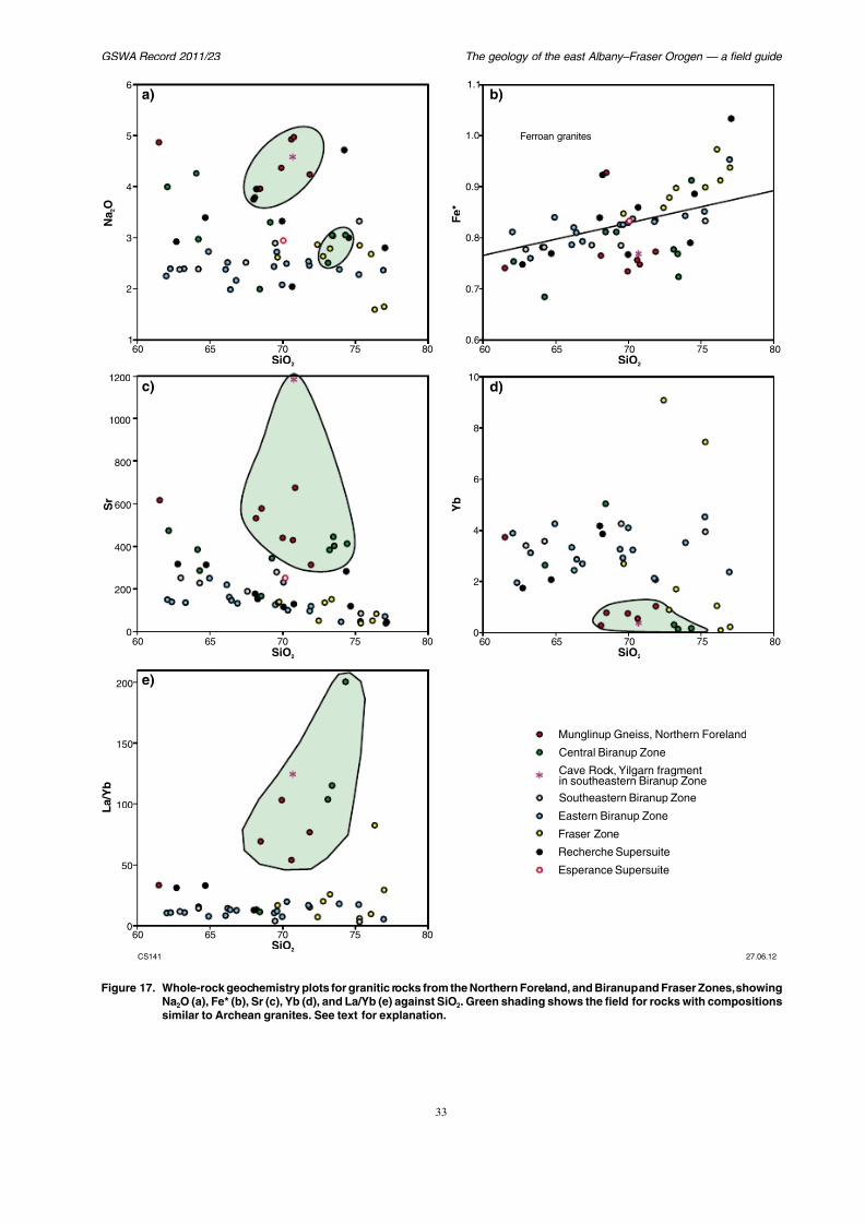
Granitic rocks of the Biranup and
Fraser ZonesBased on the geochemistry of a limited number ofsamples, granitic rocks from specific tectonic regionsand of particular ages appear to form relatively distinctgroups, permitting, as yet very cautious, petrogeneticinterpretations. For example, the 1700–1650 Ma granitesof the eastern Biranup Zone are sodium-poor calc-alkaline rocks (Fig. 17a). Their major and trace-element
compositions and their continuous range of silica values
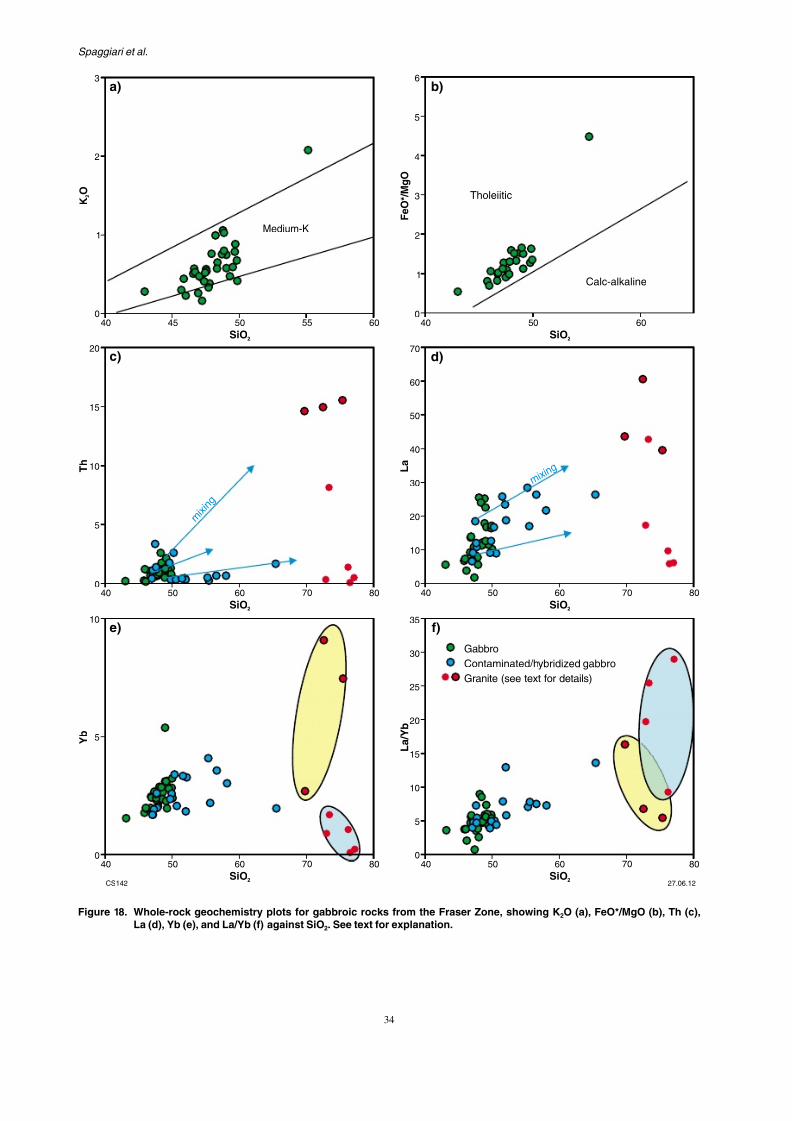
The most primitive gabbros are low- to metholeiites (Fig. 18a,b; green dots) withpatterns showing small to moderately nanomalies (not shown), which is consistearc, oceanic-arc, or fore-arc setting — o
with minor crustal contamination. The qurock between the gabbro sheets is cdiverse, but can essentially be subdiend-members: one with high thorium, ytterbium concentrations (Fig. 18c–e; redmargin, and field with yellow shade), fractionation of a mafic magma (possiitself); and the other with low lanthanumconcentrations, and high La/Yb ratios
dots, and field with blue shade), perhapstemperature partial melting of dry quamaterial. Interestingly, gabbros that showfor mingling or hybridization, or that weclose to lithological contacts (Fig. 18c–e; trends consistent with mixing between pmagmas and both felsic end-member cothree-component mixing). This type of mto be typical of a deep crustal ‘hot-zone’repeated gabbro intrusion eventually
temperatures above the solidus of both
7/25/2019 THE GEOLOGY OF THE EAST ALBANY–FRASER OROGEN — A FIELD GUIDE
http://slidepdf.com/reader/full/the-geology-of-the-east-albanyfraser-orogen-a-field-guide 40/106
GSWA Record 2011/23 The geology of the east Albany–Fraser O
1
2
3
4
5
6
60 65 70 75 80
NaO
2
SiO2 SiO2
a) b)
0.6
0.7
0.8
0.9
1.0
1.1
60 65 70
Fe*
Ferroan granites
800
1000
1200
8
10c) d)
7/25/2019 THE GEOLOGY OF THE EAST ALBANY–FRASER OROGEN — A FIELD GUIDE
http://slidepdf.com/reader/full/the-geology-of-the-east-albanyfraser-orogen-a-field-guide 41/106
Spaggiari et al.
0
1
2
3
40 4045 50 5055 60
KO
2
Medium-K
0
1
2
3
4
5
6
FeO*/MgO
Tholeiitic
Calc-a
15
20
50
60
70
SiO2 SiO2
a) b)
c) d)
7/25/2019 THE GEOLOGY OF THE EAST ALBANY–FRASER OROGEN — A FIELD GUIDE
http://slidepdf.com/reader/full/the-geology-of-the-east-albanyfraser-orogen-a-field-guide 42/106
GSWA Record 2011/23 The geology of the east Albany–Fraser O
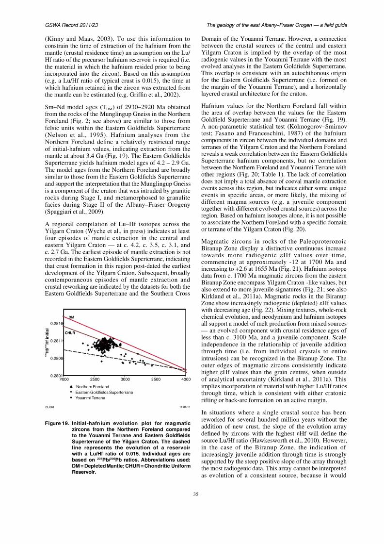
(Kinny and Maas, 2003). To use this information toconstrain the time of extraction of the hafnium from themantle (crustal residence time) an assumption on the Lu/ Hf ratio of the precursor hafnium reservoir is required (i.e.the material in which the hafnium resided prior to being
incorporated into the zircon). Based on this assumption(e.g. a Lu/Hf ratio of typical crust is 0.015), the time atwhich hafnium retained in the zircon was extracted fromthe mantle can be estimated (e.g. Griffin et al., 2002).
Sm–Nd model ages (TDM) of 2930–2920 Ma obtainedfrom the rocks of the Munglingup Gneiss in the NorthernForeland (Fig. 2; see above) are similar to those fromfelsic units within the Eastern Goldfields Superterrane(Nelson et al., 1995). Hafnium analyses from theNorthern Foreland define a relatively restricted rangeof initial-hafnium values, indicating extraction from themantle at about 3.4 Ga (Fig. 19). The Eastern GoldfieldsSuperterrane yields hafnium model ages of 4.2 – 2.9 Ga.The model ages from the Northern Foreland are broadlysimilar to those from the Eastern Goldfields Superterraneand support the interpretation that the Munglingup Gneissis a component of the craton that was intruded by graniticrocks during Stage I, and metamorphosed to granulite
facies during Stage II of the Albany Fraser Orogeny
Domain of the Youanmi Terrane. Howbetween the crustal sources of the cYilgarn Craton is implied by the ovradiogenic values in the Youanmi Terevolved analyses in the Eastern Goldfi
This overlap is consistent with an aufor the Eastern Goldfields Superterrathe margin of the Youanmi Terrane), layered crustal architecture for the crat
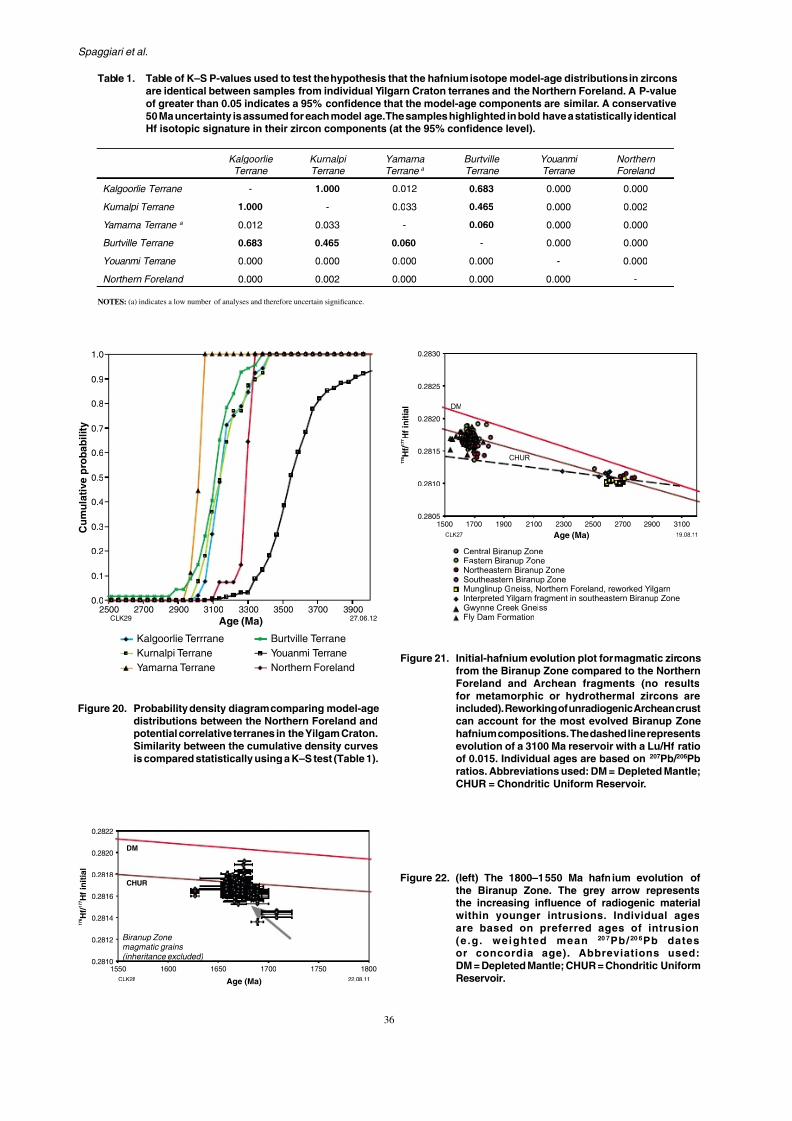
Hafnium values for the Northern Fothe area of overlap between the valuGoldfield Superterrane and Youanmi A non-parametric statistical test (Koltest; Fasano and Franceschini, 1987
components in zircon between the inditerranes of the Yilgarn Craton and the reveals a weak correlation between theSuperterrane hafnium components, between the Northern Foreland and Yoother regions (Fig. 20; Table 1). The does not imply a total absence of coevaevents across this region, but indicates events in specific areas, or more likdifferent magma sources (e.g. a juvt th ith diff t l d t l
7/25/2019 THE GEOLOGY OF THE EAST ALBANY–FRASER OROGEN — A FIELD GUIDE
http://slidepdf.com/reader/full/the-geology-of-the-east-albanyfraser-orogen-a-field-guide 43/106
Spaggiari et al.
0 7
0.8
0.9
1.0
y in
itial
0.2820
0.2825
0.2830
DM
KalgoorlieTerrane
KurnalpiTerrane
YamarnaTerrane a
BurtvilleTerrane
YouanmiTerrane
Kalgoorlie Terrane - 1.000 0.012 0.683 0.000
Kurnalpi Terrane 1.000 - 0.033 0.465 0.000
Yamarna Terrane a 0.012 0.033 - 0.060 0.000
Burtville Terrane 0.683 0.465 0.060 - 0.000
Youanmi Terrane 0.000 0.000 0.000 0.000 -
Northern Foreland 0.000 0.002 0.000 0.000 0.000
NOTES: (a) indicates a low number of analyses and therefore uncertain significance.
Table 1. Table of K–S P-values used to test the hypothesis that the hafnium isotope model-age distributioare identical between samples from individual Yilgarn Craton terranes and the Northern Forelanof greater than 0.05 indicates a 95% confidence that the model-age components are similar. A c50 Ma uncertainty is assumed for each model age. The samples highlighted in bold have a statisticHf isotopic signature in their zircon components (at the 95% confidence level).

7/25/2019 THE GEOLOGY OF THE EAST ALBANY–FRASER OROGEN — A FIELD GUIDE
http://slidepdf.com/reader/full/the-geology-of-the-east-albanyfraser-orogen-a-field-guide 44/106
GSWA Record 2011/23 The geology of the east Albany–Fraser O
176
177
Hf/
Hf
initial
CLK30 22.08.11Age (Ma)
Central Biranup ZoneEastern Biranup Zone
Northeastern Biranup ZoneSoutheastern Biranup Zone
Fraser Zone
Gwynne Creek GneissFly Dam Formation
0.2810
0.2812
0.2814
0.2816
0.2818
0.2820
0.2822
0.2824
1000 1100 1200 1300 1400 1500 1600 1700 1800
CHUR
DM
Recherche Supersuite0
10
20
30
40
50
2
4
6
8
10
12
Number
Number
Central Biranup Zone
Eastern Biranup Zone
Northeastern Biranup Zone
Southeastern Biranup Zone
RechercheSupersuite
Fraser Zoneintrusives
Fraser Zone
metasediment
60
Figure 23. Initial-hafnium evolution plot for magmatic zirconsfrom the Fraser Zone and Recherche Supersuitecompared to the Biranup Zone (no results formetamorphic or hydrothermal zircons are included).Reworking of Biranup Zone crust can accountfor the most evolved Fraser Zone and RechercheSupersuite hafnium compositions. Detrital zirconsfrom metasedimentary rocks in the Fraser Zone
indicate additional juvenile input into the orogen
7/25/2019 THE GEOLOGY OF THE EAST ALBANY–FRASER OROGEN — A FIELD GUIDE
http://slidepdf.com/reader/full/the-geology-of-the-east-albanyfraser-orogen-a-field-guide 45/106
Spaggiari et al.
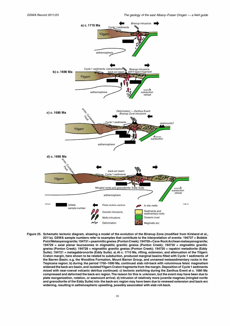
(Fig. 23). This juvenile signature indicates new crustgeneration prior to Stage I. Although speculative, thevariation through time towards more evolved values inthe Fraser Zone granites could imply oceanic subductionprior to crustal thickening, and melt interaction with a
larger volume of unradiogenic crustal material. This inturn could imply that active margin processes associatedwith the Fraser Zone could be extended back in time fromc. 1345 Ma (the beginning of Stage I) to at least 1400 Ma,although more data are needed to constrain this. Giventhat the Biranup Zone may have developed in a back-arc setting during the late Paleoproterozoic (Kirklandet al., 2011a), this may suggest a nearly continuousactive margin along the southern West Australian
Craton (in present coordinates) during most of the latePaleoproterozoic to Mesoproterozoic.
Tectonic modelsBased on current geochronological constraints, the tectonicevolution of the Albany–Fraser Orogen encompasses aninterval from at least 1800 Ma, through to 1140 Ma (Fig. 5).One of the difficulties in constraining tectonic models is thef h h f h d h dj i i
composed of exotic crust, with possiblethe Gawler Craton (Myers et al., 1996) Province of the southern Arunta Orogeal., 2009). These suggestions were also the interpretation that the southern an
Yilgarn Craton margin was passive atHall et al., 2008). However, more recentautochthonous models of the formationZone by modification of the Yilgarn Cractive-margin processes (Kirkland et al., connections to the Yilgarn Craton wrecognized in GSWA mapping and Rb–Sr(Bunting et al., 1976), in limited U–Pb(Black et al., 1992), and in limited S(Nelson et al., 1995).
The presence of Archean crustal fragmenlike ages, the extensive formation of relabasins (Barren Basin), hafnium and neodsignatures that indicate Yilgarn-like sPaleoproterozoic magmas, and a progrof juvenile material into Archean unraare all indicative of a continental-rift ssetting. This setting could have been pasystem, although the distance (to the sou
di t ) t f bd ti
GS / f O
7/25/2019 THE GEOLOGY OF THE EAST ALBANY–FRASER OROGEN — A FIELD GUIDE
http://slidepdf.com/reader/full/the-geology-of-the-east-albanyfraser-orogen-a-field-guide 46/106
GSWA Record 2011/23 The geology of the east Albany–Fraser O
subduction retreat
c) c. 1680 Ma
b) c. 1690 Ma back-arc basin
Yilgarn
Yilgarn
Biranup intrusions withY ilgarn fragment
Cycle 1 sediments
Cycle 1 sediments: volcaniclastics
asthenosphere
asthenosphere
Biranup intrusions
Deformation — Zanthus Event Biranup Zone intrusions
Cycle 1 sediments
p r o t o - C u n d e e l e e
F a u l t
seamounts?
a) c. 1710 Ma
194737
194731
194709
S i i t l
7/25/2019 THE GEOLOGY OF THE EAST ALBANY–FRASER OROGEN — A FIELD GUIDE
http://slidepdf.com/reader/full/the-geology-of-the-east-albanyfraser-orogen-a-field-guide 47/106
Spaggiari et al.
at 2634 ± 29 Ma, and interpreted to be part of anotherArchean fragment (Plate 1; Fig. 9; GSWA 179644,Wingate and Bodorkos, 2007c). Granitic rocks withc. 2680 Ma ages are widely recognized within the YilgarnCraton, including the high-Ca granites within the Eastern
Goldfields Superterrane (Cassidy et al., 2006; Championand Cassidy, 2007), the Southern Cross Domain of theYouanmi Terrane (e.g. GSWA 168963, Nelson, 2001), andwithin the Northern Foreland of the Albany–Fraser Orogen(Spaggiari et al., 2009).
East of Tropicana, the presence of rapakivi feldspar-bearing metasyenogranite with a magmatic crystallizationage of 1627 ± 4 Ma (GSWA 194736, Kirkland et al.,2010h) suggests back-arc extension may have continued
until about that time. After this, there is no record ofany tectonic activity within the present bounds of theAlbany–Fraser Orogen (west of the Rodona Shear Zone)until the commencement of the Albany–Fraser Orogenyat c. 1345 Ma (Fig. 4). However, in the adjacent MaduraProvince, the migmatization of gneissic rocks fromthe Burkin prospect, dated at 1478 ± 4 Ma (see ‘Euclabasement’ section; Fig. 3), indicates tectonic activityat that time, and the presence of pre- 1478 ± 4 Macrust beneath the Eucla Basin. Furthermore, there are
ti f j il t f ti b t 1450
Fraser Dyke Suite, emplaced at c. 1210 al., 2000, 2005), and the Esperance Suand 5). Stage II tectonic activity has beeintracratonic reactivation during the assembsupercontinent (Clark et al., 2000; Fitzsim
Stage I (1345–1260 Ma)
Stage I marks the time when the Nortand Biranup, Fraser, and Nornalup Zosynchronous tectonothermal or magmatic In previous models, this was taken as the the timing of the amalgamation of the variof the Kepa Kurl Booya Province, and of th
the Yilgarn Craton margin, in part via nothrusting (Myers et al., 1996; Clark et al., and Clark, 2004b; Spaggiari et al., 2009). with these models included a poor undespatial relationships between the differenover time, particularly for the early parts oand the question of whether to place thadjacent to the West Australian CratonMawson and South Australian Craton, or e
P i l lli i th ht t h
GSWA Record 2011/23 The geology of the east Albany Fraser O
7/25/2019 THE GEOLOGY OF THE EAST ALBANY–FRASER OROGEN — A FIELD GUIDE
http://slidepdf.com/reader/full/the-geology-of-the-east-albanyfraser-orogen-a-field-guide 48/106
GSWA Record 2011/23 The geology of the east Albany–Fraser O
which is most voluminous in the Nornalup Zone, mostlikely encompasses the same event, with Fraser Zonemagmas representing a shorter pulse. Within the BiranupZone, occurrences of Recherche Supersuite granites areconcentrated in, or possibly restricted to, the southeastern
exposed part (Plate 1; Fig. 16), suggesting that Stage Imagmatism was focused along the Mesoproterozoicsouthern and southeastern margins of the West AustralianCraton (present coordinates), but some distance from theYilgarn Craton component; i.e. within the outer parts ofthe Biranup Zone, as well as within the Nornalup Zone.
This scenario is seemingly at odds with models of cratoncollision during Stage I, although if the rift settingoccurred within a back-arc environment (as for the
Biranup Orogeny), the collision (or suture zone) mayhave been much farther outboard. Any model of collisionwith the combined Mawson and South Australian Cratonmust also account for the presence of the Madura, Forrest,Waigen, and Coompana Provinces (Figs 1 and 3), whichare poorly understood (see ‘Eucla basement’ section).In the scenario outlined above, the c. 1410 Ma rocksof the Madura Province could be interpreted as partof a magmatic arc. A dynamic back-arc setting for theFraser Zone would be consistent with the rapid burial of
i t i ll j il C l 2 di t f ll d l t
approximately 75 m.y. at high temperato granulite facies), on a major scaStage II could represent the effects(cf. Barquero-Molina, 2010), althougthe suture zone may have been a su
away from the margin of the West AIn either case, the structure of the obeen significantly modified during Staevent that appears mostly responsible northwest-vergent fold and thrust archthroughout most of the orogen.
The commencement of Stage II wastemperature metamorphism of the Sthe eastern Nornalup Zone and the so
Zone between c. 1225 and c. 1215 2000; Spaggiari et al., 2009). Metac. 1225 Ma, recorded in the southeasterButty Head), suggest that Stage II mayslightly earlier than previously propo(2000). This was followed by the widespof the c. 1210 Ma Gnowangerup–F(Clark et al., 2000; Wingate et al., 200geochronological data (Fig. 5), it is temperature metamorphism and asso
id d d i St II H
Spaggiari et al

7/25/2019 THE GEOLOGY OF THE EAST ALBANY–FRASER OROGEN — A FIELD GUIDE
http://slidepdf.com/reader/full/the-geology-of-the-east-albanyfraser-orogen-a-field-guide 49/106
Spaggiari et al.
The geology of the east Albany–Fraser Orogen — a field guid
Excursion 1: highlights of thegeology of the east Albany–
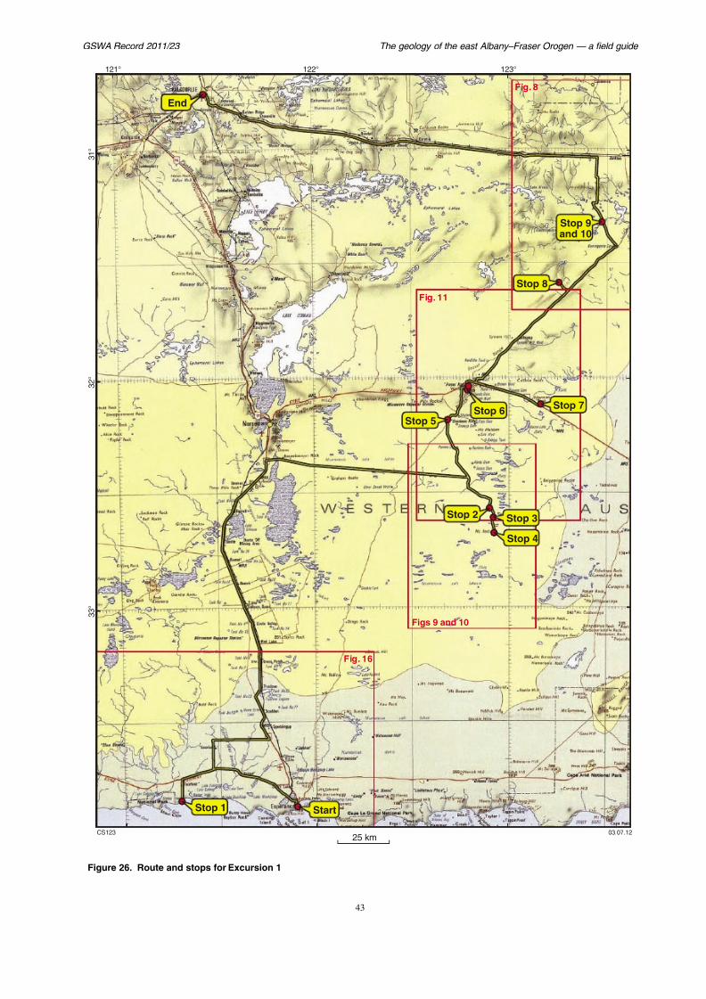
Fraser OrogenThis four-day excursion starts in Esperance and finishesin Kalgoorlie, covering a total distance of about 1040 km.
The geological sites in this excursion have been chosenbecause of their relative ease of access, quality of outcrop,and coverage of tectonic units, with the aim of providingan overview of the current work on the geology of theeast Albany–Fraser Orogen. To achieve this, large drivingdistances are necessary.
A general view of the excursion route is shown inFigures 26–29. Access to stops is via highways, shireroads, and four-wheel drive (4WD) tracks over a
bi i f l d l l d l d
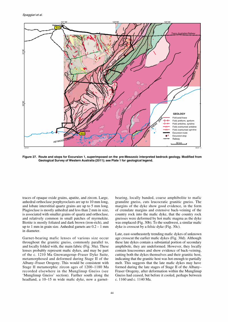
exposed section of the Munglinup Gneissby major faults. The Munglinup Gneiss isto granulite-facies, reworked componenCraton, and forms part of the Northern‘Munglinup Gneiss’ section; SpaggiarSoutheast of the exposure, structures withiGneiss are cut by the Red Island Shearand 16). The Red Island Shear Zone —
small rocky island, visible from the coasthat the shear zone passes through — is ithe present-day expression of the boundNorthern Foreland and the Biranup Zone oBooya Province (Geological Survey of W2007).
The Munglinup Gneiss comprises agranulite-facies granitic gneiss interlayeof metamorphosed mafic rocks, and wit
h (j ili ) hib li i hi
GSWA Record 2011/23 The geology of the east Albany Fraser O
7/25/2019 THE GEOLOGY OF THE EAST ALBANY–FRASER OROGEN — A FIELD GUIDE
http://slidepdf.com/reader/full/the-geology-of-the-east-albanyfraser-orogen-a-field-guide 50/106
GSWA Record 2011/23 The geology of the east Albany–Fraser O
Stop 8
End
Fig. 8
Fig. 11
121°
3 1 °
2 °
123°122°
Spaggiari et al
7/25/2019 THE GEOLOGY OF THE EAST ALBANY–FRASER OROGEN — A FIELD GUIDE
http://slidepdf.com/reader/full/the-geology-of-the-east-albanyfraser-orogen-a-field-guide 51/106
Spaggiari et al.
J E R D
A C U T T U P
F A U L T
124°30'123°00'121°30'
3 1 ° 3 0 '
3 3 ° 0 0 '
Fold
GEO
Fold
Trans–
End
Kalgoorlie
2
34
5
67
8
9,10
GSWA Record 2011/23 The geology of the east Albany–Fraser O

7/25/2019 THE GEOLOGY OF THE EAST ALBANY–FRASER OROGEN — A FIELD GUIDE
http://slidepdf.com/reader/full/the-geology-of-the-east-albanyfraser-orogen-a-field-guide 52/106
GSWA Record 2011/23 The geology of the east Albany Fraser O
J E R D
A C U T T U P
F A U L T
124°30'123°00'121°30'
3 1 ° 3 0 '
3 3 ° 0 0 '
T
End
Kalgoorlie
2
34
5
67
8
9,10
Spaggiari et al.
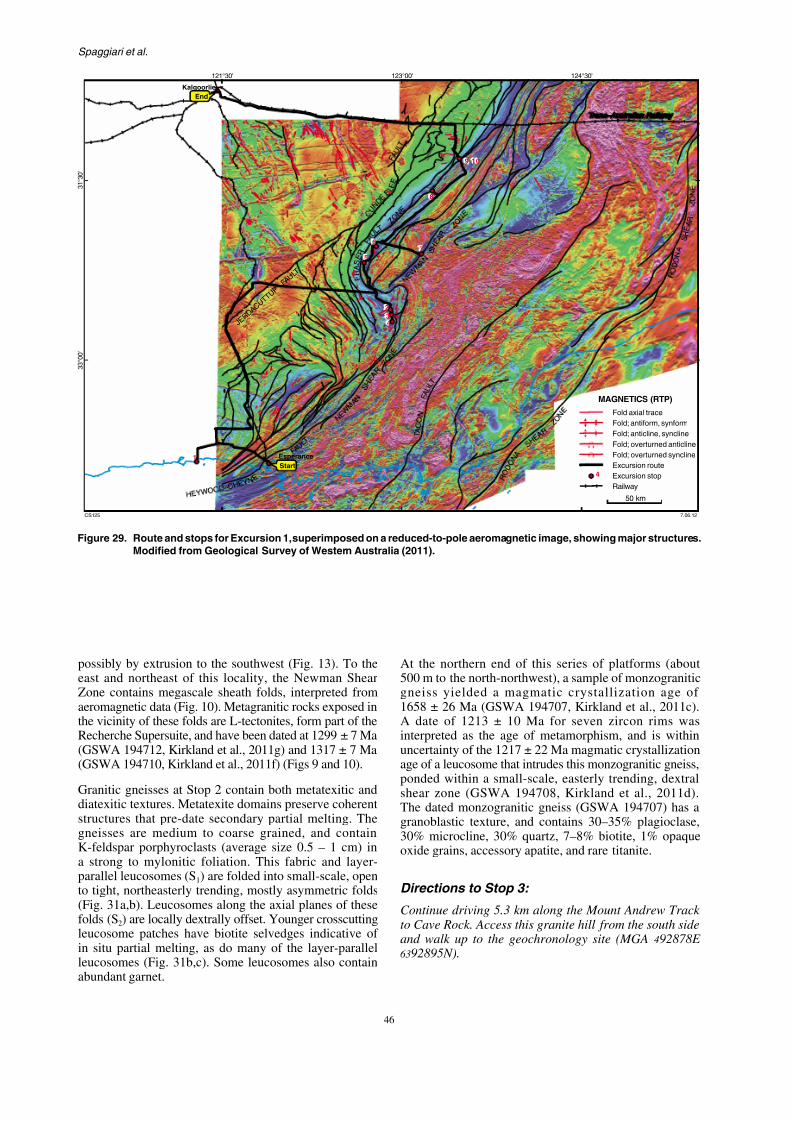
7/25/2019 THE GEOLOGY OF THE EAST ALBANY–FRASER OROGEN — A FIELD GUIDE
http://slidepdf.com/reader/full/the-geology-of-the-east-albanyfraser-orogen-a-field-guide 53/106
Spaggiari et al.
J E R D
A C U T
T U P
F A U L T
124°30'123°00'121°30'
3 1 ° 3 0 '
3 3 ° 0 0 '
F
MAG
F
Trans–A
End
Kalgoorlie
2
34
5
67
8
9,10
GSWA Record 2011/23 The geology of the east Albany–Fraser O
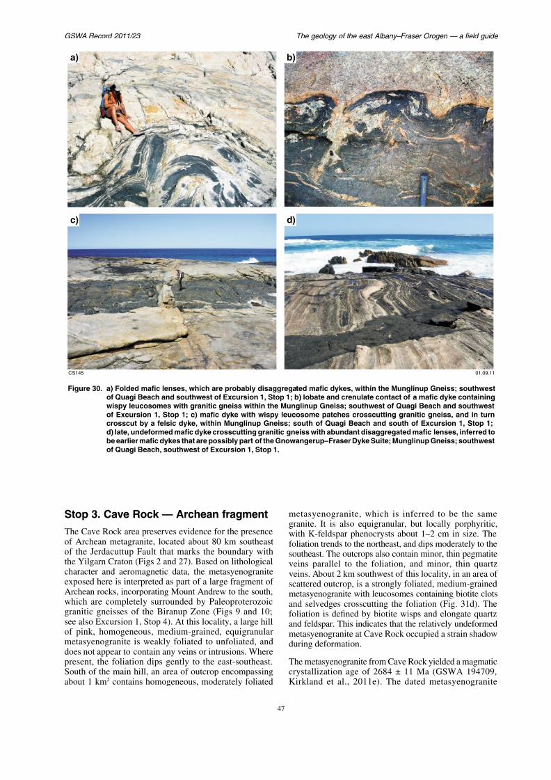
7/25/2019 THE GEOLOGY OF THE EAST ALBANY–FRASER OROGEN — A FIELD GUIDE
http://slidepdf.com/reader/full/the-geology-of-the-east-albanyfraser-orogen-a-field-guide 54/106
g gy y
a) b)
c) d)
Spaggiari et al.

7/25/2019 THE GEOLOGY OF THE EAST ALBANY–FRASER OROGEN — A FIELD GUIDE
http://slidepdf.com/reader/full/the-geology-of-the-east-albanyfraser-orogen-a-field-guide 55/106
p gg
contains about 60% mesoperthite, 30% quartz,4.5% hornblende, 2.5% plagioclase, 2% clay–limonitealtered ?pyroxene, and 1% biotite, magnetite, titanite,and apatite. Subparallel grains and lenses of hornblende,altered ?pyroxene, opaque oxide grains, and titanite
up to 2 mm long together define a weak foliation,with individual grains up to 7 mm long. Some quartzand mesoperthite grains are also elongate parallel tothe foliation and are up to 4 mm long. The quartz andplagioclase grains are anhedral, with some plagioclaseintergrown with mesoperthite, and some as discrete grains.Most titanite has been altered to leucoxene.
Directions to Stop 4:
Continue driving 9 km along the Mount Andrew Track to Mount Andrew (MGA 493910E 6385287N). From here,walk west for approximately 700 m to the outcrop area ofStop 4 (MGA 493278E 6385090N).
Stop 4. Mount Andrew — Archeanfragment
Day 3
Continue northwest on the Mount An13.9 km from the Telegraph Track interseas you enter Southern Hills Station. Dri
left. Drive 1.9 km, bear right. Drive 1straight ahead (slight left) to follow fencelto reach the intersection with the FraseTurn right. Drive 4 km to Gnamma Hill.
Stop 5. Gnamma Hill — Frase
Metamorphics
The purpose of this stop is to exam
metasedimentary rocks within thewhich has been subject to detailed megeochronological investigation (Oorscho194714, Kirkland et al., 2011h; GSWA 1et al., 2011i). The field descriptions of largely based on Oorschot (2011).
Lithologies
GSWA Record 2011/23 The geology of the east Albany–Fraser O
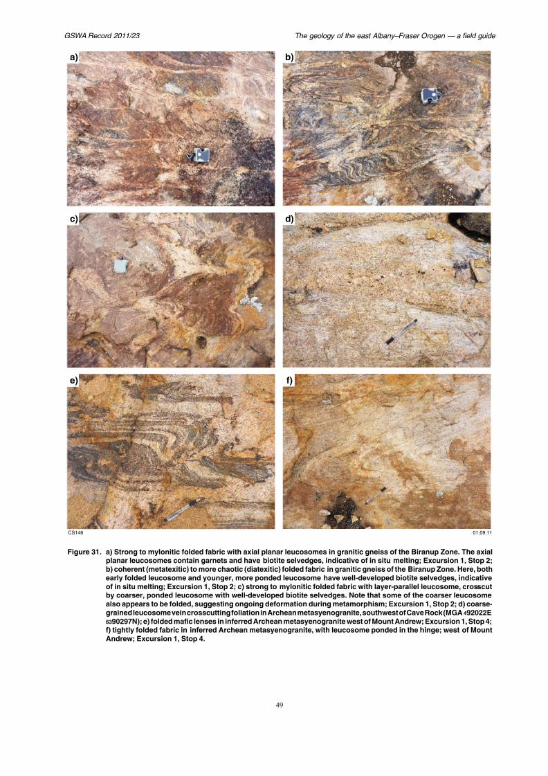
7/25/2019 THE GEOLOGY OF THE EAST ALBANY–FRASER OROGEN — A FIELD GUIDE
http://slidepdf.com/reader/full/the-geology-of-the-east-albanyfraser-orogen-a-field-guide 56/106
a) b)
c) d)
Spaggiari et al.
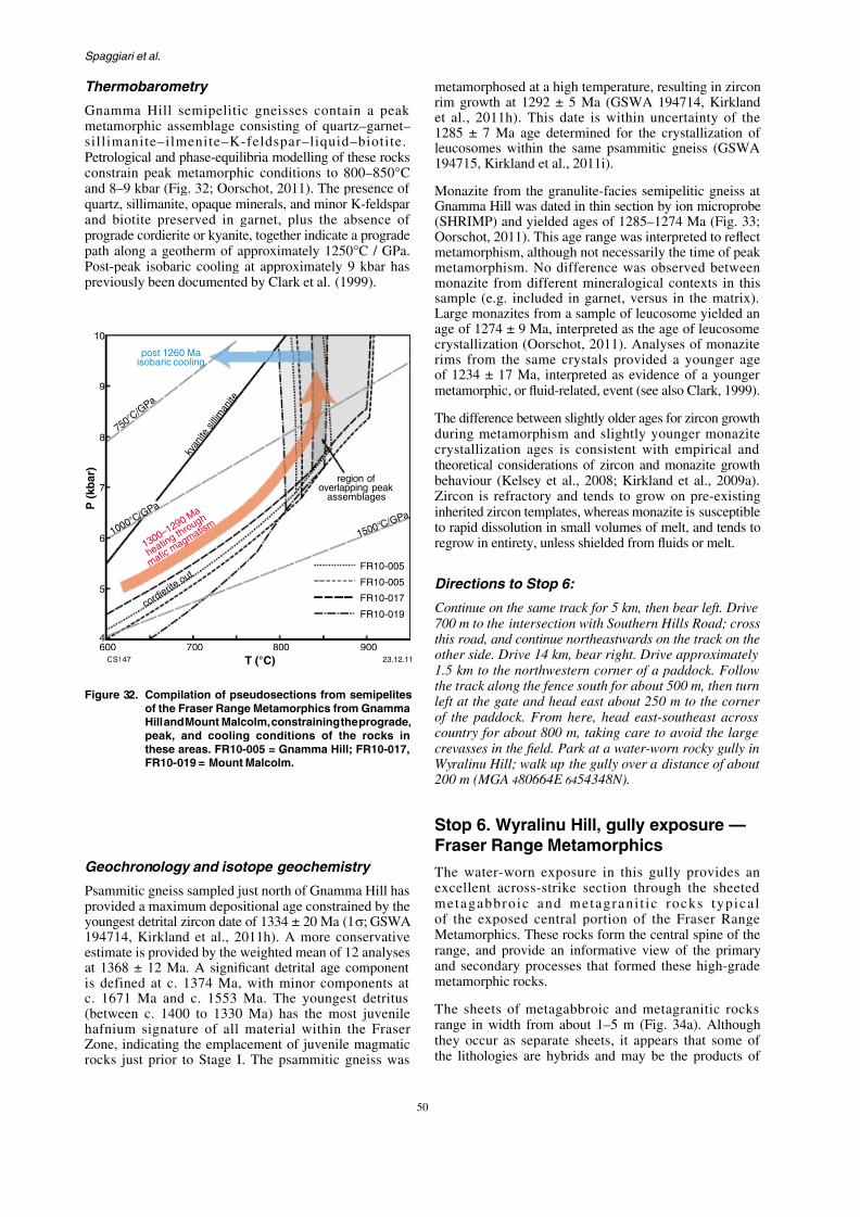
7/25/2019 THE GEOLOGY OF THE EAST ALBANY–FRASER OROGEN — A FIELD GUIDE
http://slidepdf.com/reader/full/the-geology-of-the-east-albanyfraser-orogen-a-field-guide 57/106
Thermobarometry
Gnamma Hill semipelitic gneisses contain a peakmetamorphic assemblage consisting of quartz–garnet–sillimanite–ilmenite–K-feldspar–liquid–biotite.Petrological and phase-equilibria modelling of these rocks
constrain peak metamorphic conditions to 800–850°Cand 8–9 kbar (Fig. 32; Oorschot, 2011). The presence ofquartz, sillimanite, opaque minerals, and minor K-feldsparand biotite preserved in garnet, plus the absence ofprograde cordierite or kyanite, together indicate a progradepath along a geotherm of approximately 1250°C / GPa.Post-peak isobaric cooling at approximately 9 kbar haspreviously been documented by Clark et al. (1999).
metamorphosed at a high temperature, rerim growth at 1292 ± 5 Ma (GSWA 19et al., 2011h). This date is within unc1285 ± 7 Ma age determined for the cleucosomes within the same psammitic
194715, Kirkland et al., 2011i).Monazite from the granulite-facies semiGnamma Hill was dated in thin section by(SHRIMP) and yielded ages of 1285–12Oorschot, 2011). This age range was intemetamorphism, although not necessarily metamorphism. No difference was obsmonazite from different mineralogical sample (e.g. included in garnet, versus
Large monazites from a sample of leucoage of 1274 ± 9 Ma, interpreted as the agcrystallization (Oorschot, 2011). Analyrims from the same crystals providedof 1234 ± 17 Ma, interpreted as evidenmetamorphic, or fluid-related, event (see a
The difference between slightly older ages fduring metamorphism and slightly youcrystallization ages is consistent with k y
a n i t e
s i l l i m
a n i t e
7 5 0 ° C / G P a
post 1260 Maisobaric cooling
10
9
8
GSWA Record 2011/23 The geology of the east Albany–Fraser O
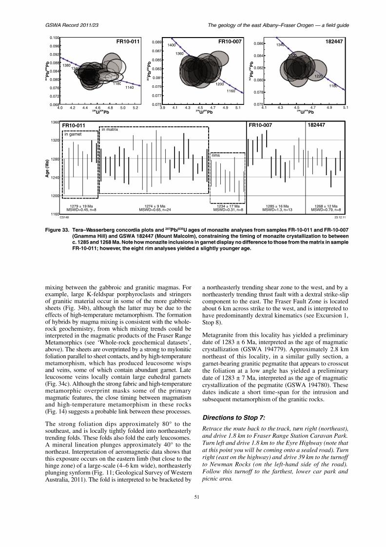
7/25/2019 THE GEOLOGY OF THE EAST ALBANY–FRASER OROGEN — A FIELD GUIDE
http://slidepdf.com/reader/full/the-geology-of-the-east-albanyfraser-orogen-a-field-guide 58/106
11401180
13401380
1300
1340
0.068
0.072
0.076
0.080
0.084
0.088
0.092
0.096
0.100
207
206
P
b/
Pb
4.0 4.2 4.4 4.6 4.8 5.0 5.2238 206
U/ Pb4.3 4.5
23
0.076
0.078
0.080
0.082
0.084
0.086
4.1
207
206
P
b/
Pb
1160
1200
1360
1400
0.075
0.077
0.079
0.081
0.083
0.085
0.087
0.089
3.9 4.1 4.3 4.5 4.7 4.9 5.1
207
206
P
b/
Pb
238 206U/ Pb
1200
1240
1280
1320
1360
in garnetin matrix
rims
FR10-011 FR10-007
Age(Ma)
FR10-007FR10-011
1274 ± 9 Ma1279 ± 19 Ma 1234 ± 17 Ma 1285 ± 16 Ma
Spaggiari et al.
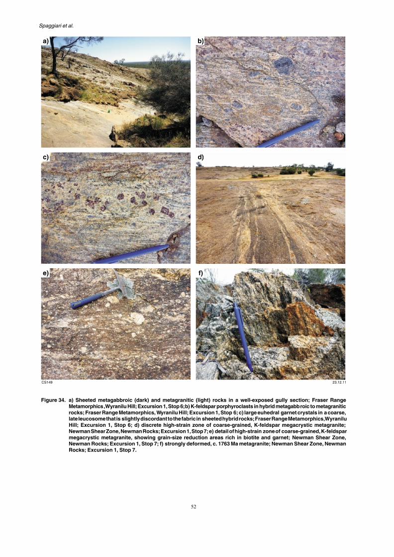
7/25/2019 THE GEOLOGY OF THE EAST ALBANY–FRASER OROGEN — A FIELD GUIDE
http://slidepdf.com/reader/full/the-geology-of-the-east-albanyfraser-orogen-a-field-guide 59/106
a) b)
c) d)
GSWA Record 2011/23 The geology of the east Albany–Fraser O
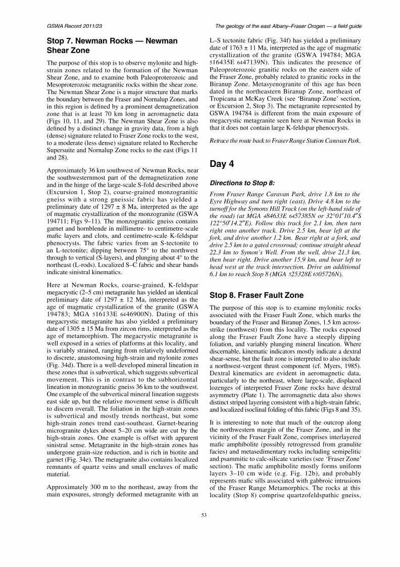
7/25/2019 THE GEOLOGY OF THE EAST ALBANY–FRASER OROGEN — A FIELD GUIDE
http://slidepdf.com/reader/full/the-geology-of-the-east-albanyfraser-orogen-a-field-guide 60/106
Stop 7. Newman Rocks — NewmanShear Zone
The purpose of this stop is to observe mylonite and high-strain zones related to the formation of the Newman
Shear Zone, and to examine both Paleoproterozoic andMesoproterozoic metagranitic rocks within the shear zone.The Newman Shear Zone is a major structure that marksthe boundary between the Fraser and Nornalup Zones, andin this region is defined by a prominent demagnetizationzone that is at least 70 km long in aeromagnetic data(Figs 10, 11, and 29). The Newman Shear Zone is alsodefined by a distinct change in gravity data, from a high(dense) signature related to Fraser Zone rocks to the west,to a moderate (less dense) signature related to Recherche
Supersuite and Nornalup Zone rocks to the east (Figs 11and 28).
Approximately 36 km southwest of Newman Rocks, nearthe southwesternmost part of the demagnetization zoneand in the hinge of the large-scale S-fold described above(Excursion 1, Stop 2), coarse-grained monzograniticgneiss with a strong gneissic fabric has yielded apreliminary date of 1297 ± 8 Ma, interpreted as the age
L–S tectonite fabric (Fig. 34f) has yiedate of 1763 ± 11 Ma, interpreted as thcrystallization of the granite (GSW516435E 6447139N). This indicatePaleoproterozoic granitic rocks on t
the Fraser Zone, probably related to gBiranup Zone. Metasyenogranite of dated in the northeastern Biranup ZTropicana at McKay Creek (see ‘Biraor Excursion 2, Stop 3). The metagranGSWA 194784 is different from themegacrystic metagranite seen here at that it does not contain large K-feldspa
Retrace the route back to Fraser Range S
Day 4
Directions to Stop 8:
From Fraser Range Caravan Park, d Eyre Highway and turn right (east). Dturnoff for the Symons Hill Track (on t
Spaggiari et al.

7/25/2019 THE GEOLOGY OF THE EAST ALBANY–FRASER OROGEN — A FIELD GUIDE
http://slidepdf.com/reader/full/the-geology-of-the-east-albanyfraser-orogen-a-field-guide 61/106
8
910
BIRANUPZONE
E D
D Y
S U I T E
Fly DamFormation
F r a
s e r F
a u l t
Z o n e
FRASERZONE
F
F
F
3 1 ° 3 0 '
123°30'123°00'
c. 1650 Ma
1670 ± 7 Ma
1660 ± 6 Ma
1665 ± 7 Ma
1665 ± 6 Ma
1668 ± 11 Ma
1671± 6 Ma
1617 ± 26 Ma
1640 ± 12 Ma
1666 ± 11 Ma
1677 ± 5 Ma
2656 ± 17 Ma
2684 ± 31 Ma
GSWA Record 2011/23 The geology of the east Albany–Fraser O
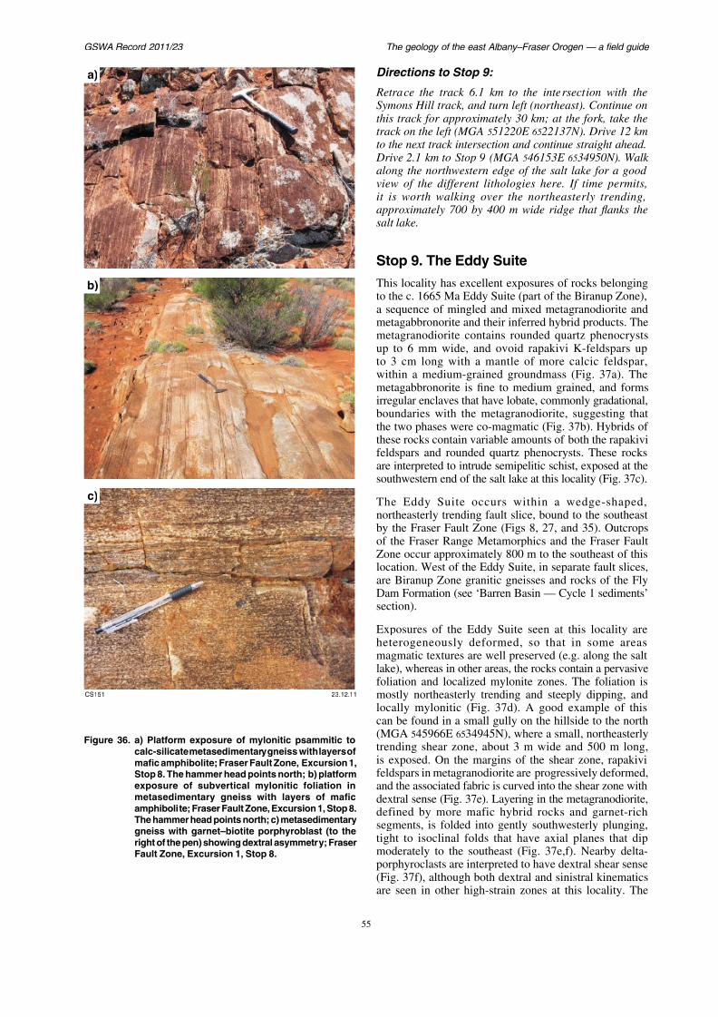
7/25/2019 THE GEOLOGY OF THE EAST ALBANY–FRASER OROGEN — A FIELD GUIDE
http://slidepdf.com/reader/full/the-geology-of-the-east-albanyfraser-orogen-a-field-guide 62/106
a)
b)
Directions to Stop 9:
Retrace the track 6.1 km to the inteSymons Hill track, and turn left (norththis track for approximately 30 km; atrack on the left (MGA 551220E 65221
to the next track intersection and conti Drive 2.1 km to Stop 9 (MGA 546153along the northwestern edge of the saview of the different lithologies herit is worth walking over the northeapproximately 700 by 400 m wide risalt lake.
Stop 9. The Eddy SuiteThis locality has excellent exposures to the c. 1665 Ma Eddy Suite (part of a sequence of mingled and mixed memetagabbronorite and their inferred hymetagranodiorite contains rounded qup to 6 mm wide, and ovoid rapakito 3 cm long with a mantle of morwithin a medium-grained groundma
Spaggiari et al.
7/25/2019 THE GEOLOGY OF THE EAST ALBANY–FRASER OROGEN — A FIELD GUIDE
http://slidepdf.com/reader/full/the-geology-of-the-east-albanyfraser-orogen-a-field-guide 63/106
garnet-rich segments and layers are interpreted to beintruded remnants of the semipelitic schist exposed at thesouthwestern end of the salt lake.
Metagranodiorite from this locality yielded a dateof 1665 ± 6 Ma, interpreted as the age of magmaticcrystallization (GSWA 194720, Kirkland et al., 2010j).The sample contains ovoid rapakivi feldspars, tabulareuhedral feldspars, and rounded quartz phenocrysts, allwithin a fine- to medium-grained groundmass. Visuallyestimated, the sample’s mineralogy includes about 35%plagioclase, 30% quartz, 25% microcline, 6–8% biotite,1–2% garnet, and 1–2% hornblende–epidote; accessoryminerals include apatite and zircon. The rapakivi textureis defined by grains up to 15 mm long and 10 mm wide,
with cores of microcline (up to 10 by 6 mm) rimmed byaggregates of quartz and inequigranular, coarse-grainedplagioclase. Discrete euhedral plagioclase grains arealso present in this sample, and contain small inclusionsand interstitial patches of microcline and quartz. Someplagioclase grains contain needles of epidote and minorsericitized cores. Aggregates of biotite(–hornblende)are developed within some plagioclase-rich rims onK-feldspar grains, but can also form discrete clots. Garnet,epidote, and hornblende are associated with the biotite
Semipelitic, garnet–micaceous schist inmetagranodiorite, exposed at the souththe salt lake (MGA 546046E 6534694N),moderately north-northeasterly plungingwith metagabbronorite in the core. T
inclined with a southeast-dipping axial folds a strong foliation (S1). A mineral lineon the S1 plane has the same orientataxis. The southeastern limb of the fold inortheasterly trending shear zone contaiand boudinaged rocks. A mineral lineatstrain zone plunges 62° towards 005. A cuts the fold parallel to the hinge. In sschist contains rounded porphyroclastsimilar to those in the rapakivi me
(Fig. 37c). The rounded K-feldspar porinterpreted to have been derived from passociated with intrusions of Eddy Suitsubsequently dispersed throughout the schstrain deformation. Late granitic to pegmthe foliation and folding, both here and elocality.
A sample collected from the sheared se(GSWA 194722, Kirkland et al., 2010c) yi
GSWA Record 2011/23 The geology of the east Albany–Fraser O

7/25/2019 THE GEOLOGY OF THE EAST ALBANY–FRASER OROGEN — A FIELD GUIDE
http://slidepdf.com/reader/full/the-geology-of-the-east-albanyfraser-orogen-a-field-guide 64/106
a) b)
c) d)
Spaggiari et al.
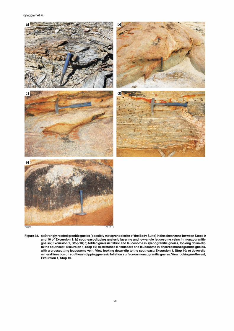
7/25/2019 THE GEOLOGY OF THE EAST ALBANY–FRASER OROGEN — A FIELD GUIDE
http://slidepdf.com/reader/full/the-geology-of-the-east-albanyfraser-orogen-a-field-guide 65/106
a) b)
c) d)
GSWA Record 2011/23 The geology of the east Albany–Fraser O
7/25/2019 THE GEOLOGY OF THE EAST ALBANY–FRASER OROGEN — A FIELD GUIDE
http://slidepdf.com/reader/full/the-geology-of-the-east-albanyfraser-orogen-a-field-guide 66/106
decametre-scale folds with moderately southeast-dippingaxial planes. Within the hinges are small-scale tight foldswith a similar trend, which fold both the gneissic fabricand thin leucosome layers. The tighter angle of these foldssuggests they may represent an earlier phase of co-axial
folding. The gneissic fabric is cut by pegmatitic veins5–10 cm wide.
Along strike to the northeast at this locality (Stop 10;MGA 545986E 6535986N), are two phases of graniticgneiss with a well-developed gneissic foliation that dipsconsistently and moderately to the southeast (Fig. 38b).As at the locality described above, thin leucosome veinsare tightly folded with this foliation (Fig. 38c). Locally,however, the folded leucosomes have an axial-planar
foliation that is parallel to the main foliation. Younger,coarser leucosome veins are slightly discordant to thegneissic foliation (Fig. 38b) or crosscut it at high angles(Fig. 38d). Apart from the late, high-angle leucosomeveins, the sequence suggests the possibility of continuedleucosome formation before and after folding, with theinjection of new (low angle) leucosome following folding.Coarse, late pegmatite also crosscuts the gneissic fabricand folding, as do quartz veins.
most of the quartz and feldspar grains long. Some of the plagioclase grains disseminated fine-grained epidote.
The other granitic phase at this localitysyenogranitic gneiss with sparse and leucosomes, both of which are gneissic foliation, and are folded wyielded a date of 1668 ± 11 Ma, inteof magmatic crystallization of the sye194724, Kirkland et al., 2010l). The about 45% microcline, 36% quartz,5–6% biotite, <1% hornblende, and oxide grains, titanite, apatite, and ziare less than 2 mm long, with a fo
dark yellow-brown biotite and very hornblende. Rare plagioclase containsand fine-grained muscovite of secondatitanite grains are largely altered to leu
Directions to Kalgoorlie:
Continue another 10.2 km along the snorthwest, to an intersection with aand turn right (to the east). Drive 2.1
Spaggiari et al.

7/25/2019 THE GEOLOGY OF THE EAST ALBANY–FRASER OROGEN — A FIELD GUIDE
http://slidepdf.com/reader/full/the-geology-of-the-east-albanyfraser-orogen-a-field-guide 67/106
Excursion 2: Tropicana in aregional context
This four-day excursion starts and finishes at Tropicana,covering a total distance of about 300 km, not includingdriving times and distances from Kalgoorlie. Thegeological stops described in this excursion have beenchosen based on their relative ease of access, quality ofoutcrop, coverage of the various tectonic units, and toprovide an understanding of our current interpretations ofthe geology of the Tropicana region.
A general view of the excursion route is shown inFigures 39–42. All access is via 4WD tracks situated on
crown land or DEC-managed lands (i.e. Plumridge LakesNature Reserve). Some tracks are located within an activeexploration and mining area (Tropicana Joint Venture,or JV), and access via drilling tracks requires an escortby staff from the Tropicana Gold Project. Although thisguide provides location details for use by anyone wishingto independently follow the excursion route, it must benoted that restrictions apply to DEC-managed lands.Please contact the relevant authorities before proceeding,especially as track conditions are subject to change,
Please note that substantive new infrasTropicana JV is currently in developmenreplacement of the existing access trackexploration camp, and the provision of thand communications requirements for a m Access to the Tropicana mine site, airfi access roads requires prior written appGeneral Manager, Tropicana Mine.
Geological overview
The Tropicana region covers the noexposures of the Albany–Fraser Orogen and 40). It comprises rocks of the Nor
Biranup Zone, and Gwynne Creek GneCycle 2 sediments). In this region, Nornalup Zones are entirely under the coBasin. Outcrop is sparse throughout mucincluding around the Tropicana Deposilarge areas with no outcrop at all.
The Carboniferous to Permian Paterlocally overlies this part of the orogenunconformable contacts, mostly preserve
GSWA Record 2011/23 The geology of the east Albany–Fraser O
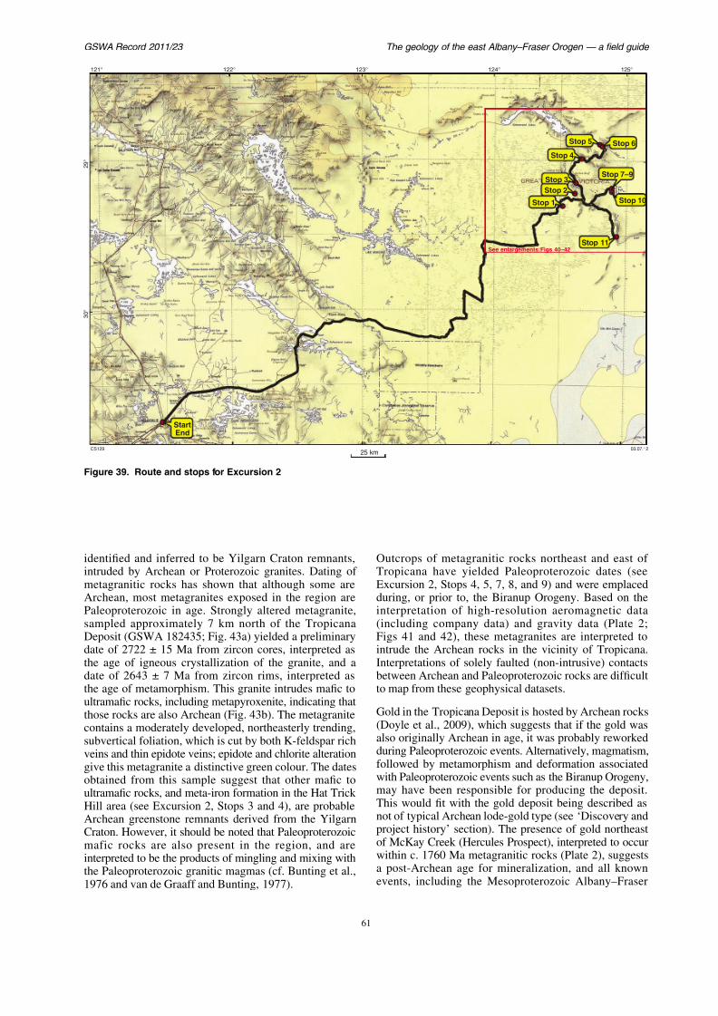
7/25/2019 THE GEOLOGY OF THE EAST ALBANY–FRASER OROGEN — A FIELD GUIDE
http://slidepdf.com/reader/full/the-geology-of-the-east-albanyfraser-orogen-a-field-guide 68/106
Sto
St
See enlargements:Figs 4
Sto
Stop 1
121°
2 9 °
3 0 °
124°123°122°
Spaggiari et al.
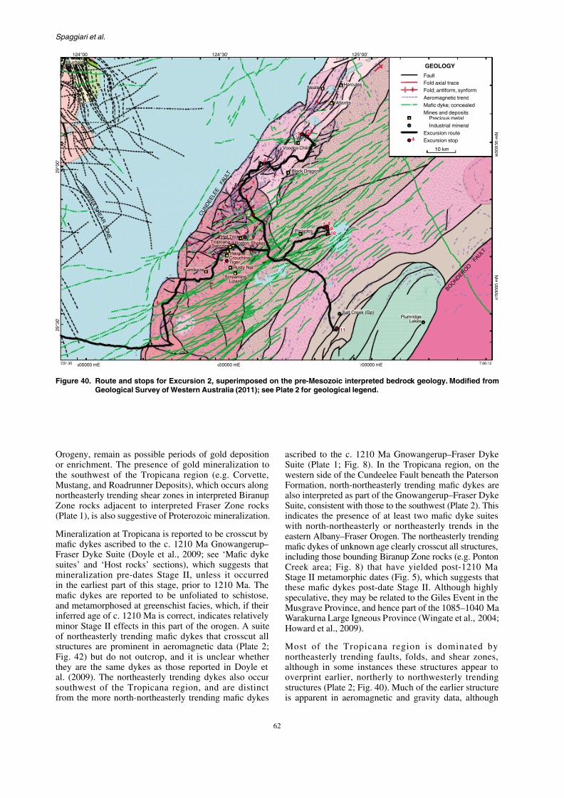
7/25/2019 THE GEOLOGY OF THE EAST ALBANY–FRASER OROGEN — A FIELD GUIDE
http://slidepdf.com/reader/full/the-geology-of-the-east-albanyfraser-orogen-a-field-guide 69/106
C U N D E E L E
E
F A U L T
125°00'124°30'124°00'
29°00'
1
Neale
Havana
Swizzler
CrouchingTiger
Atlantis
Pleiades
Hercules
Kamikaze
Hat Trick
Muirfield
Boston Shaker
Rusty Nail
Voodoo Child
Black Dragon
ScreamingLizard
Excurs
PreMines
Indu
Excurs
Fold a
Aerom
Mafic
Fault
GEO
Fold; a
4
Tropicana
7 8910
65
4
3
1
2
Y A M A R N A
S H E A R Z O N E
GSWA Record 2011/23 The geology of the east Albany–Fraser O
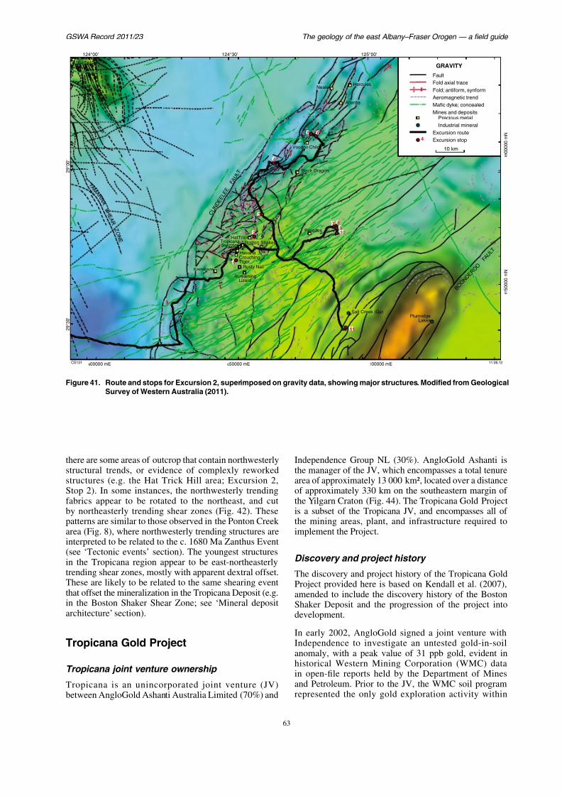
7/25/2019 THE GEOLOGY OF THE EAST ALBANY–FRASER OROGEN — A FIELD GUIDE
http://slidepdf.com/reader/full/the-geology-of-the-east-albanyfraser-orogen-a-field-guide 70/106
C U N D E E L E E
F A U L T
125°00'124°30'124°00'
29°00'
Neale
Havana
Swizzler
CrouchingTiger
Atlantis
Pleiades
Hercules
Kamikaze
HatTrick
Muirfield
Boston Shaker
Rusty Nail
Voodoo Child
Black Dragon
ScreamingLizard
E
M
E
A
F
F
4
Tropicana
F
M
7 8910
65
4
3
1
2
Spaggiari et al.
125°00'124°30'124°00'

7/25/2019 THE GEOLOGY OF THE EAST ALBANY–FRASER OROGEN — A FIELD GUIDE
http://slidepdf.com/reader/full/the-geology-of-the-east-albanyfraser-orogen-a-field-guide 71/106
C U
N D E E L E E
F A U L T
125°00'124°30'124°00'
29°00'
1
Neale
Havana
Swizzler
CrouchingTiger
Atlantis
Pleiades
Hercules
Kamikaze
HatTrick
Muirfield
Boston Shaker
Rusty Nail
Voodoo Child
Black Dragon
ScreamingLizard
Excurs
PreMines
Indu
Excurs
Aerom
Fault
MAGNET
Fold; a
4
Tropicana
Fold a
Mafic
7 8910
65
4
3
1
2
GSWA Record 2011/23 The geology of the east Albany–Fraser O
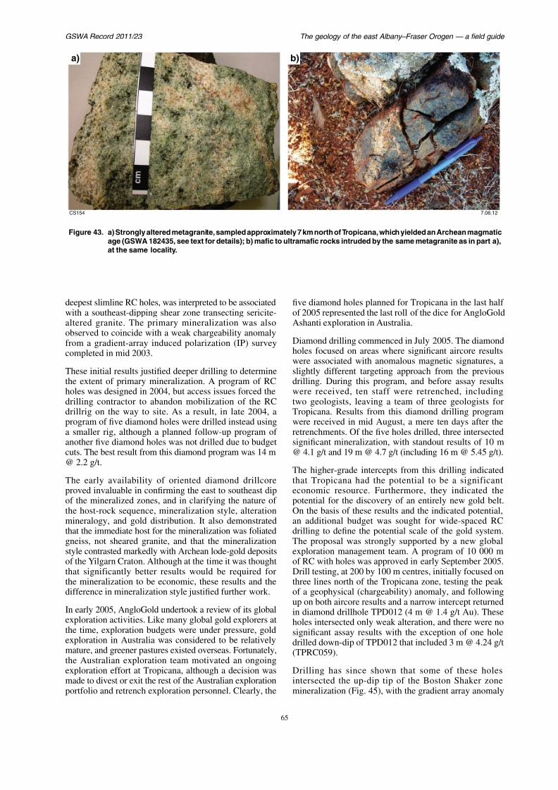
7/25/2019 THE GEOLOGY OF THE EAST ALBANY–FRASER OROGEN — A FIELD GUIDE
http://slidepdf.com/reader/full/the-geology-of-the-east-albanyfraser-orogen-a-field-guide 72/106
a)
CS154
b)
Figure 43. a) Strongly altered metagranite, sampled approximately 7 km north of Tropicana, which yielded anage (GSWA 182435, see text for details); b) mafic to ultramafic rocks intruded by the same metaat the same locality.
Spaggiari et al.
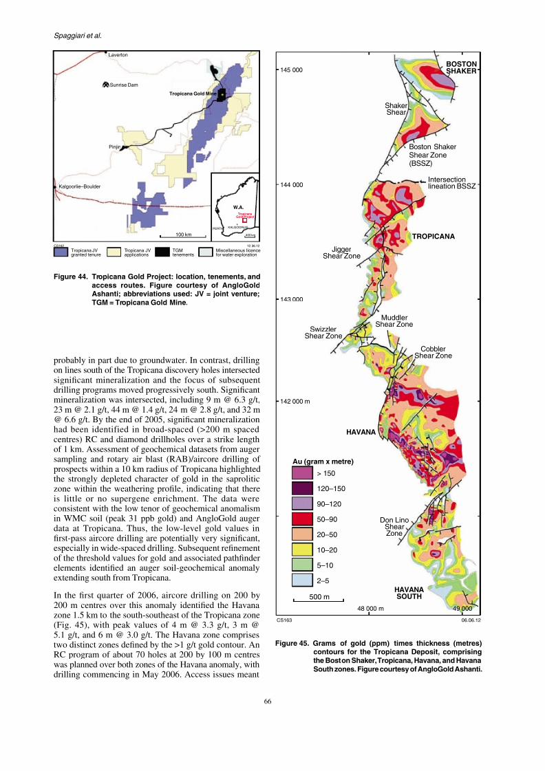
7/25/2019 THE GEOLOGY OF THE EAST ALBANY–FRASER OROGEN — A FIELD GUIDE
http://slidepdf.com/reader/full/the-geology-of-the-east-albanyfraser-orogen-a-field-guide 73/106
CS162 12.06.12
PERTH
400 km
KALGOORLIE
TropicanaGold Project
W.A.
100 km
Tropicana JVgranted tenure
Tropicana JVapplications
Miscellaneous licencefor water exploration
Kalgoorlie–Boulder
Pinjin
Sunrise Dam
Laverton
Tropicana Gold Mine
TGMtenements
Figure 44. Tropicana Gold Project: location, tenements, andaccess routes. Figure courtesy of AngloGoldAshanti; abbreviations used: JV = joint venture;
ShakerShear
BostShea(BSS
JiggerShear Zone
TRO
145 000
144 000
GSWA Record 2011/23 The geology of the east Albany–Fraser O
th t th t th t d ill d fi t A D illi i ti i i th S i l

7/25/2019 THE GEOLOGY OF THE EAST ALBANY–FRASER OROGEN — A FIELD GUIDE
http://slidepdf.com/reader/full/the-geology-of-the-east-albanyfraser-orogen-a-field-guide 74/106
that the stronger northern zone was not drilled first. Aswith the initial RC program at Tropicana, the first RCresults received were disappointing, despite the strongbiotite–pyrite alteration noted in most of the holes. Laterresults from the northern zone indicated that Havanahad the potential to be both larger and higher grade thanTropicana. Better results from this program included 26 m@ 2.0 g/t, 11 m @ 3.1 g/t, 21 m @ 4.0 g/t, 32 m @ 2.5 g/t,30 m @ 4.4 g/t, 41 m @ 3.7 g/t, and 18 m @ 6.0 g/t.Furthermore, several sections at Havana showed twomineralized zones, whereas only one zone was identifiedat Tropicana. The project now moved rapidly into aphase of resource delineation drilling. A project scopingstudy completed in April 2007 indicated the potential fora viable project and led to the commencement of pre-
feasibility studies in mid 2007. Approval to commencethe bankable feasibility study (BFS) was obtained in 2009.
During the fourth quarter of 2009, a program of sixholes was drilled to test for potential extensions alongthe northern margin of the Tropicana zone. Detailed3D modelling of the geology, combined with structuralanalysis of drillcore, suggested that the mineralizationmay have been offset along a major bounding shear,now known as the Boston Shaker Shear Zone (Fig. 45).
Drilling is continuing in the Swizzlerproposed Tropicana and Havana pits) anA pre-feasibility study is being carrieand underground mining options for mineralization, and this is anticipated toMineral Resource. The project remains its first gold in the December quarter o
Project geology
The Tropicana Deposit has a knoof about 5 km, and defines a nomineralized corridor approximately 1all grid references are relative to true otherwise; the Tropicana local grid n
east of true north). The deposit commineralized zones — from north to Shaker, Tropicana, Havana, and Ha(Fig. 45). The deposit as a whole is locextensive mineralized system, which 10 km along strike.
Neither the immediate metamorphmineralized zones are exposed at the presence of widespread Recent to
Spaggiari et al.
Table 2 Tropicana GoldProject: mineral resourceestimates 31 December2010 versus30 June2011 Tablecourt
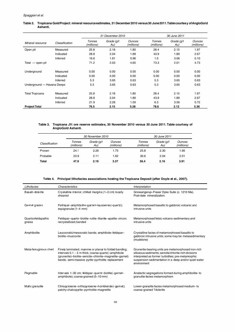
7/25/2019 THE GEOLOGY OF THE EAST ALBANY–FRASER OROGEN — A FIELD GUIDE
http://slidepdf.com/reader/full/the-geology-of-the-east-albanyfraser-orogen-a-field-guide 75/106
31 December 2010 30 June 201
Mineral resource Classification Tonnes
(millions) Grade (g/t
Au) Ounces
(millions) Tonnes
(millions) Grade (g/
Au)
Open pit Measured 25.8 2.18 1.80 28.4 2.15
Indicated 28.8 2.04 1.89 43.9 1.89
Inferred 16.6 1.81 0.96 1.0 3.06
Total — open pit 71.2 2.03 4.65 73.3 2.01
Underground Measured 0.00 0.00 0.00 0.00 0.00
Indicated 0.00 0.00 0.00 0.00 0.00
Inferred 5.3 3.65 0.63 5.3 3.65
Underground — Havana Deeps 5.3 3.65 0.63 5.3 3.65
Total Tropicana Measured 25.8 2.18 1.80 28.4 2.15
Indicated 28.8 2.04 1.89 43.9 1.89
Inferred 21.9 2.26 1.59 6.3 3.56
Project Total 76.5 2.15 5.28 78.6 2.12
Table 2. Tropicana Gold Project: mineral resource estimates, 31 December 2010 versus 30 June 2011. Table courtAshanti.
Table 3. Tropicana JV: ore reserve estimates, 30 November 2010 versus 30 June 2011. Table cour
GSWA Record 2011/23 The geology of the east Albany–Fraser O
The metamorphic rock associations and mineralized zones The mineralized zones are principa

7/25/2019 THE GEOLOGY OF THE EAST ALBANY–FRASER OROGEN — A FIELD GUIDE
http://slidepdf.com/reader/full/the-geology-of-the-east-albanyfraser-orogen-a-field-guide 76/106
The metamorphic rock associations and mineralized zonesare cut by younger, syn- to post-peak metamorphic maficintrusions. The dolerite intrusions display the effectsof greenschist-facies metamorphism and range fromnonfoliated to schistose. Mafic dykes with crystallineinteriors and thin (1–2 cm) chilled or weakly sheared
margins are ascribed to the c. 1210 Ma Gnowangerup–Fraser Dyke Suite, providing a minimum age formineralization.
Stratigraphic architecture
The immediate host rocks to the mineral deposit haveundergone polyphase deformation resulting in a complexarrangement of lithofacies and significant thickening of
the package. Nevertheless, the distribution of lithofaciesassociations remains predictable at the deposit scale, andserves as a useful guide for planning drilling and proposedmining operations. The garnet gneiss facies associationdominates the immediate hangingwall of the mineralizedzones, forming a structurally thickened stratigraphicinterval up to 200 m thick at Havana (Figs 46 and 47).
Chert and former ferruginous chert units (metasedimentaryfacies association), are interleaved with the garnet
The mineralized zones are principarocks of the quartzofeldspathic gnefacies associations. This stratigraphicto herein as the ‘favourable horizon’) along the strike length of the deposhorizon is underlain by a mixed stra
comprising rocks of the quartzofegarnet gneiss, granulite, and amphibThe top of the footwall package is mappearance of garnet gneiss, amphibGold mineralization, generally of lin both the footwall and hangingwpackages as thin (typically <3 m) leof the metasedimentary facies, gquartzofeldspathic gneiss associations.thin intercepts up to 10 g/t gold hahowever, the continuity of these zoncurrent drillhole spacing (typically 25–
Mineral deposit architecture
Together, the Boston Shaker, TropicHavana South zones define a northeast-tcorridor approximately 1.2 km wide bybeen tested to a vertical depth of up t
Spaggiari et al.
W
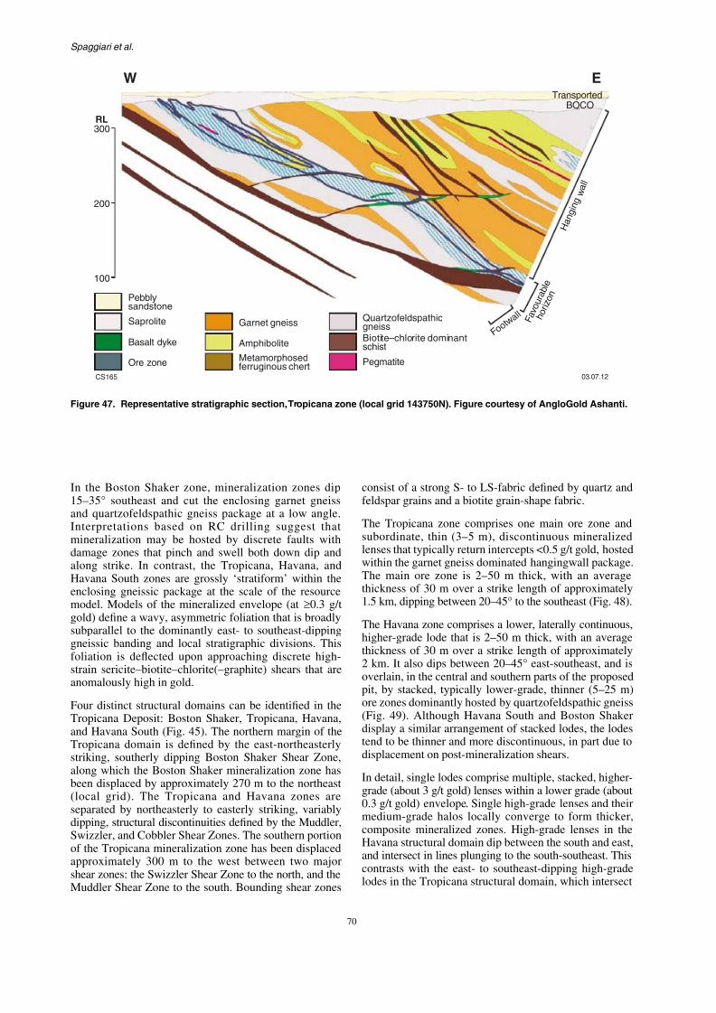
7/25/2019 THE GEOLOGY OF THE EAST ALBANY–FRASER OROGEN — A FIELD GUIDE
http://slidepdf.com/reader/full/the-geology-of-the-east-albanyfraser-orogen-a-field-guide 77/106
Ore zone
Saprolite
Pebblysandstone
Basalt dyke
Garnet gneiss
Amphibolite
Metamorphosedferruginous chert
Pegmatite
T
F a v o u r a b l e
h o r i z
o n
F o o t w
a l l
W
CS165
300
Biotite chlorite dominantschist
–
Quartzofeldspathicgneiss
200
100
RL
GSWA Record 2011/23 The geology of the east Albany–Fraser O
47900 48000 48100 48200 48300

7/25/2019 THE GEOLOGY OF THE EAST ALBANY–FRASER OROGEN — A FIELD GUIDE
http://slidepdf.com/reader/full/the-geology-of-the-east-albanyfraser-orogen-a-field-guide 78/106
CS166
Section line
T P A 0
1 3 1
T P A 0
1 3 2
T P A 0
1 3 3
T P R C
0 1 9
T P D 0
0 9
T P A 0
1 3 4
T P R C
0 5 7
T P D 0
1 0
T P D 0
1 8
T P R C
0 2 0
4 m
@ 1 . 0 1
g / t
5 m
@ 1 . 3 1
g / t
6 m
@ 2 . 6 5
g / t
2 4 m
@ 2 . 7 9
g / t
i n c . 8
m @ 1 . 7 4
g / t
a n d
1 0 m
@ 4 . 1
g / t
4 4 m
@ 1 . 4
g / t
i n c . 1 5
m @
2 . 8
g / t
2 m @ 1
5 . 0 g / t
1 9 m @
4 . 7 g / t
1 7 m @
1 . 4 g / t
3 2 m @
1 . 5 5
g / t
i n c . 8 m @ 1
. 1 6 g / t
a n d 1 8
m @ 2 . 0
6 g / t
1 6 m @
1 . 1 g
/ t
1 5 m @
1 . 0 g / t
3 0 m @ 2 . 3 1
g / t
i n c . 1 5
m @ 3 . 4 9
g / t 2 9 m @
4 . 3 7
g / t
i
1 9 m @
6 2
2 4
Transported
BOCO
> 0.5 g/t Au
Significant intercepts
300RL
200
100
47900 48000 48100 48200 48300
Figure 48. Simplified cross section,Tropicana zone (local grid 143500N). Figure courtesy of AngloGold A
Spaggiari et al.
a generally east-plunging line. Higher-grade lodes in the grade threshold, K-feldspar rich gneiss

7/25/2019 THE GEOLOGY OF THE EAST ALBANY–FRASER OROGEN — A FIELD GUIDE
http://slidepdf.com/reader/full/the-geology-of-the-east-albanyfraser-orogen-a-field-guide 79/106
a generally east plunging line. Higher grade lodes in theHavana South and Boston Shaker structural domains arelaterally discontinuous and many are displaced on shears,making interpretation of the RC drillholes difficult.
In sections parallel to the plunge direction, higher-grade
(about 3 g/t gold) lodes are enveloped by lower-gradeshells and are oriented at a slightly steeper angle than themodelled approximately 0.3 g/t gold envelope (Fig. 50). Insections orthogonal to the plunge direction, approximately3 g/t gold lodes comprise steeper bounding domains andflatter linking segments, the intersection of which definesthe principal lineation (Fig. 51). The resultant geometryis interpreted as a linked shear system that manifests indrillcore as discontinuous biotite–sericite–pyrite shearsdeveloped on the millimetre to centimetre scale, andare characterized by asymmetric S–C fabrics and sigmaporphyroclasts.
Mineralization
Two mineralization styles are identifiable in the TropicanaDeposit, based on sulfide mineral occurrence and host rocktype. They are:
grade threshold, K feldspar rich gneissfacies contain a higher proportion of gold within the quartzofeldspathic gneiss assocSulfides within the ore zones are domi(2–8%; grain size <0.2 mm), with acceschalcopyrite, electrum, and telluride min
minerals including, but not limited to, spand bornite. Free gold occurs mostly (typically 10–30 µm) inclusions within commonly along biotite–sericite fractureminerals. Visible gold has been obserdrillcore from the Boston Shaker zone, quartz veins are notably absent. The penveloped by a disseminated pyrrhotite(–is locally more strongly developed in t
particularly at Havana. Within the minerapyrrhotite inclusions in pyrite suggest variable, oxidation states.
Mineralized zones are enclosed within aalteration envelope. The alteration envemineralogical zonation, with central biotcalcite(–siderite) zones passing outward thbiotite > chlorite(–calcite) zones, into sebiotite–calcite) zones at the margins (Fig.
GSWA Record 2011/23 The geology of the east Albany–Fraser O
outward from controlling thrusts into a rheologically and and gold mineralization formed from
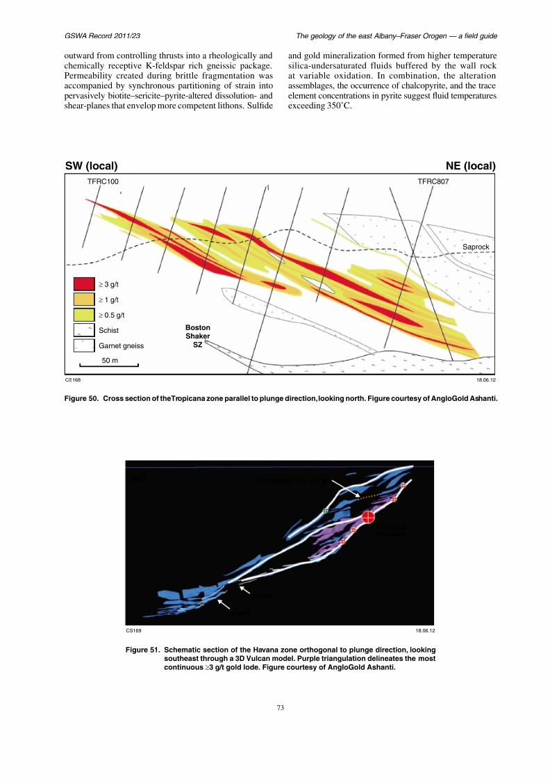
7/25/2019 THE GEOLOGY OF THE EAST ALBANY–FRASER OROGEN — A FIELD GUIDE
http://slidepdf.com/reader/full/the-geology-of-the-east-albanyfraser-orogen-a-field-guide 80/106
3 g/t
SW (local)
TFRC100 TF
w g g ychemically receptive K-feldspar rich gneissic package.Permeability created during brittle fragmentation wasaccompanied by synchronous partitioning of strain intopervasively biotite–sericite–pyrite-altered dissolution- andshear-planes that envelop more competent lithons. Sulfide
gsilica-undersaturated fluids bufferedat variable oxidation. In combinatiassemblages, the occurrence of chalcopelement concentrations in pyrite suggesexceeding 350˚C.
Spaggiari et al.

7/25/2019 THE GEOLOGY OF THE EAST ALBANY–FRASER OROGEN — A FIELD GUIDE
http://slidepdf.com/reader/full/the-geology-of-the-east-albanyfraser-orogen-a-field-guide 81/106
Ore zone
Saprolite
Pebblysandstone
Basalt dyke
Garnet gneiss
Metamorphosedferruginous chert (ANC)
Quartzofeldspathic gneiss (ANF)
Transp
BOC
H a n g i n
g w a l l
F a v o u r a b l e
h o r i z o n
F o o t w a l l
W
300
200
100
RL
F ld hib l t / bi tit i (ANFA)
GSWA Record 2011/23 The geology of the east Albany–Fraser O
Day 1 A prominent hill 2.6 km northeast

7/25/2019 THE GEOLOGY OF THE EAST ALBANY–FRASER OROGEN — A FIELD GUIDE
http://slidepdf.com/reader/full/the-geology-of-the-east-albanyfraser-orogen-a-field-guide 82/106
Day 1
Stop 1. Havana South
This stop (MGA 6 49300E 67 60100N) is located within an
active exploration and mining area. Access is via drillingtracks and requires an escort by staff from the TropicanaGold Project.
Use of hammers and removal of samples at this localityis strictly prohibited, as the exposures are located within the bounds of a registered archeological site.
Rubbly outcrop on a low ridgeline southeast of the HavanaSouth orebody marks the position of a major shear zone
(Crouching Tiger Shear Zone) that can be traced forseveral kilometres in RC and diamond drilling. Domainsof sericite and chlorite schist 5–10 m wide locally containlithons of lower-strain rock showing greater preservation ofearlier deformation fabrics. Within schistose domains, thefoliation dips moderately to the east-southeast, with an S–Cintersection lineation plunging approximately 30° towards110–130. S–C fabric relationships are contradictory, asboth dextral and sinistral kinematics are identifiable,altho gh de tral kinematics are more ab ndant
pDeposit provides a rare opportunitybasement rocks within this sand-coTrick Hill lies at the southern end of a that has been mapped in detail (Fox, 2section of the guide summarizes the d
described by Fox (2010).
The geology of the Hat Trick Hill areBIF, amphibolite, granulite, and feldipping BIF units cap many of thcoincide with hinge regions of open,and synforms. Banding within the BIFparallel to original stratification, but modified by metamorphism, isoclpegmatite intrusion. Evidence of early the BIF is recorded by asymmetricalfolds (F1). In some locations, F1 folds aan axial planar cleavage (S1) that is sub(bedding; S0) along the limbs, and dbetween cherty and carbonate-rich baF1 folds plunge to the north and south the hinge surfaces dip approximately strong mineral elongation lineation (Lthe banding plane parallel to the F1 fo
Spaggiari et al.
INDEX MAP 655000 mE 6
7/25/2019 THE GEOLOGY OF THE EAST ALBANY–FRASER OROGEN — A FIELD GUIDE
http://slidepdf.com/reader/full/the-geology-of-the-east-albanyfraser-orogen-a-field-guide 83/106
MAIN MAP
INDEX MAP 655000 mE
THE SOUTH
T-JUNCTION
Quartz vein
Monzonite/gabbro — inferred
Monzonite/gabbro, aeromagnetic inference
Banded iron-formation locally ±hematite / magnetite
Granite, locally ± pyroxene, migmatite
Granite, locally ± pyroxene, migmatite — inferred
Pegmatite
Dacite
Monzonite/gabbro
2 km
6
GSWA Record 2011/23 The geology of the east Albany–Fraser O
sheared contacts. L1 dominantly plunges to the southeast, actinolitic amphibole, minor quartz, ti

7/25/2019 THE GEOLOGY OF THE EAST ALBANY–FRASER OROGEN — A FIELD GUIDE
http://slidepdf.com/reader/full/the-geology-of-the-east-albanyfraser-orogen-a-field-guide 84/106
and small-scale F1 folds display a well-developed axialplanar cleavage. F2 folds and a weak stretching lineationdefined by aligned magnetite plunge gently to the south.Combined, the minor fold vergence and reverse faultseparation of the BIF units are inconsistent with refolding
of a large-scale F1 fold around northeast-trending F2 folds.
Locality 2.3. Hat Trick ridge
This locality (MGA 6 55900E 67 66900N) is accessible fromthe Tropicana exploration camp via active explorationtracks within the Tropicana Gold Project mining leases.
Lying at the northern end of Hat Trick ridge is an outcroparea of high structural complexity. Strings of BIF areinterleaved with schist that locally contains lithons ofgranitic gneiss. Banding (bedding) within the BIF dipsboth to the west and to the east, marking the position ofa northeast-oriented fold with a hinge surface dippingapproximately 50° towards 110. Folds are ascribed toF3 on the basis of rotation of L1 around the northeast-trending axes. Gentle, upright F4 folds are evident on themetre scale, and cause widespread warping of the outcroppattern at this locality and throughout the Hat Trick area.
oxide grains. The pyroxenes (dominaand lesser orthopyroxene) are partlrimmed by amphibole and chlorite,also relict hornblende overgrown by pamphiboles are acicular and range from
to blue-green, to blue, with the latter insodic composition. Large cracks in thwith chlorite and locally, epidote. Tovergrown with epidote and zoisite, avein is present. This rock may have beup to granulite facies, and subsequenamphibolite–greenschist facies.
A second sample of metagabbro (Gcomposed mostly of plagioclase andclinopyroxene but possibly minor orpyroxene is overgrown by blue-greeamphibole, although minor relict hpresent. The plagioclase is overgrowminor zoisite, and there is also minooxide grains, quartz, apatite, and posA foliation is defined by amphibole metagabbro may have been metamorphfacies (based on the presence of ?orth
Spaggiari et al.
Granite, locally ±i i
7/25/2019 THE GEOLOGY OF THE EAST ALBANY–FRASER OROGEN — A FIELD GUIDE
http://slidepdf.com/reader/full/the-geology-of-the-east-albanyfraser-orogen-a-field-guide 85/106
Figure 55. Detailed geological map of the Hat Trick Hill area, showing banded iron-formation (in yellow), granitic gneiss (in purple), and the main F2 fold
6766300 mN
655500 mE
25 m
655600 mE
CS160 03.07.12
Bedding, inclined
F1
F2
F3
ShearThrust
F syncline2
F anticline2
Banded iron-formation ±hematite / magnetite
ypyroxene, migmatiteGranite, locally ± pyrox-ene, migmatite inferred—
GSWA Record 2011/23 The geology of the east Albany–Fraser O
a) b)
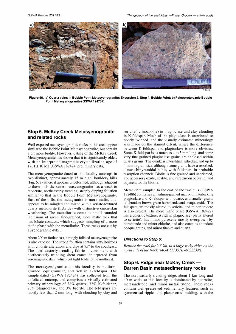
7/25/2019 THE GEOLOGY OF THE EAST ALBANY–FRASER OROGEN — A FIELD GUIDE
http://slidepdf.com/reader/full/the-geology-of-the-east-albanyfraser-orogen-a-field-guide 86/106
Cs172
Figure 56. a) Quartz veins in Bobbie Point Metasyenogranite; Excursion 2, Stop 4, Bobbie Point; b) PaleoPoint Metasyenogranite (GSWA 194737).
Spaggiari et al.
latter indicating younging to the southeast (Fig. 57b,c).B ddi f th ti t t h lf t
basin formation along the margin of thed i ifti i t d d i th B

7/25/2019 THE GEOLOGY OF THE EAST ALBANY–FRASER OROGEN — A FIELD GUIDE
http://slidepdf.com/reader/full/the-geology-of-the-east-albanyfraser-orogen-a-field-guide 87/106
Bedding ranges from the centimetre to half-metrescale, and its orientation varies from vertical to steeplysoutheast-dipping. The metasedimentary rocks contain aweak, low angle cleavage dipping steeply to the northwest.The facing direction, bedding cleavage relationships, and
intersection all indicate a northeasterly plunging anticlinewith its hinge to the northwest; i.e. this ridge is in theeastern limb of an upright anticline.
Across strike to the east is sparse rubbly outcrop ofstrongly foliated phyllitic schist. At the easternmost partof this section, just below a small rise of laterite, is astrongly deformed quartzite with a northeasterly trending,vertical foliation that contains a mineral lineation plunging37° towards 028. This coincides with a minor shear zone
interpreted in the aeromagnetic data (Plate 2; Fig. 42),which is parallel to the major northeasterly trending shearzones that occur in the vicinity of gold mineralization tothe northeast (e.g. Hercules Prospect).
Preliminary geochronology of a quartzite sample (GSWA182405) from this locality has yielded a maximumdepositional age of 1990 ± 15 Ma, based on a weightedmean date from two analyses from a single zircon. A
i i f h i f
during rifting, prior to and during the B(see ‘Barren Basin — Cycle 1 sedimQuartzite mapped to the west at LindsGraaff and Bunting, 1977), adjacent toFault (Plate 2), is inferred to be anot
Barren Basin Cycle 1 sediments. A pos1760–1750 Ma detrital maxima, whichthese sediments, are the c. 1760 Ma gthe Biranup Zone. This indicates mixingdetritus from the Yilgarn Craton (i.e. fromwith Biranup Zone granitic rocks (potentsources, or from the opposite direction, o
Although this field guide does not inclumetaconglomerate locality southeast o
(there is no track to it), it is includedcomparison to the metasedimentary at Stop 6. The pebbles in the metacosubangular to subrounded, and range fromlong) and closely packed (clast-supp(0.5 – 2 cm long) and more sparse (maThey are commonly black and white anhave magnetic susceptibility measuring uunits. There are distinctive iron-rich la
GSWA Record 2011/23 The geology of the east Albany–Fraser O
a) b)
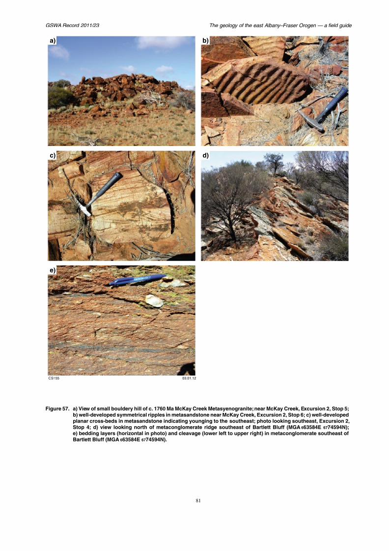
7/25/2019 THE GEOLOGY OF THE EAST ALBANY–FRASER OROGEN — A FIELD GUIDE
http://slidepdf.com/reader/full/the-geology-of-the-east-albanyfraser-orogen-a-field-guide 88/106
c) d)
Spaggiari et al.
long, occur mostly within the micaceous lamellae, whereasrare patches rich in microcrystalline tourmaline occur in
parallel to the axial plane of the fold. dense finely layered strongly foliated roc
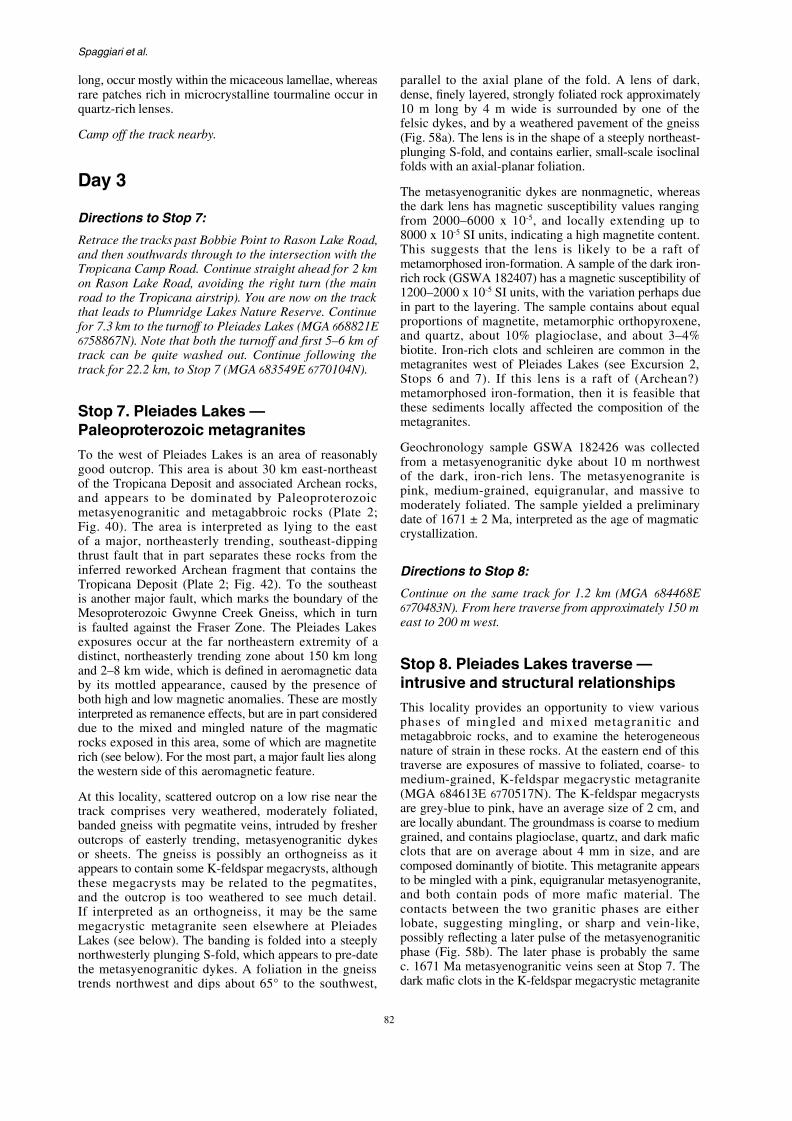
7/25/2019 THE GEOLOGY OF THE EAST ALBANY–FRASER OROGEN — A FIELD GUIDE
http://slidepdf.com/reader/full/the-geology-of-the-east-albanyfraser-orogen-a-field-guide 89/106
rare patches rich in microcrystalline tourmaline occur inquartz-rich lenses.
Camp off the track nearby.
Day 3
Directions to Stop 7:
Retrace the tracks past Bobbie Point to Rason Lake Road,and then southwards through to the intersection with theTropicana Camp Road. Continue straight ahead for 2 kmon Rason Lake Road, avoiding the right turn (the main
road to the Tropicana airstrip). You are now on the trackthat leads to Plumridge Lakes Nature Reserve. Continue for 7.3 km to the turnoff to Pleiades Lakes (MGA 6 68821E67 58867N). Note that both the turnoff and first 5–6 km oftrack can be quite washed out. Continue following thetrack for 22.2 km, to Stop 7 (MGA 6 83549E 67 70104N).
Stop 7. Pleiades Lakes —Paleoproterozoic metagranites
dense, finely layered, strongly foliated roc10 m long by 4 m wide is surroundedfelsic dykes, and by a weathered paveme(Fig. 58a). The lens is in the shape of a stplunging S-fold, and contains earlier, sma
folds with an axial-planar foliation.
The metasyenogranitic dykes are nonmathe dark lens has magnetic susceptibilityfrom 2000–6000 x 10-5, and locally e8000 x 10-5 SI units, indicating a high maThis suggests that the lens is likely metamorphosed iron-formation. A samplerich rock (GSWA 182407) has a magnetic1200–2000 x 10-5 SI units, with the varia
in part to the layering. The sample contaproportions of magnetite, metamorphic and quartz, about 10% plagioclase, anbiotite. Iron-rich clots and schleiren are metagranites west of Pleiades Lakes (sStops 6 and 7). If this lens is a raft metamorphosed iron-formation, then it these sediments locally affected the commetagranites.
GSWA Record 2011/23 The geology of the east Albany–Fraser O
yielded moderate to high magnetic susceptibility readingsthat range from 200 1800 x 10-5 SI units indicating the
secondary muscovite and sericite, inamphibolite-facies metamorphism
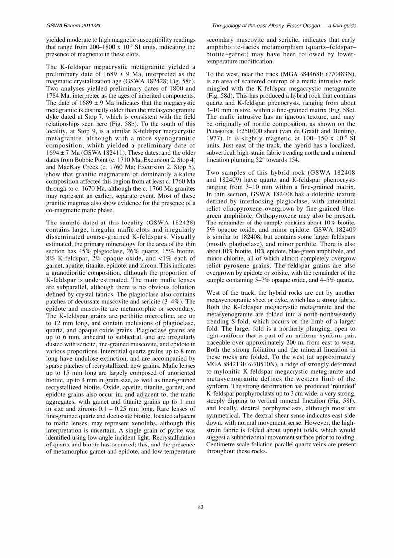
7/25/2019 THE GEOLOGY OF THE EAST ALBANY–FRASER OROGEN — A FIELD GUIDE
http://slidepdf.com/reader/full/the-geology-of-the-east-albanyfraser-orogen-a-field-guide 90/106
that range from 200–1800 x 10 SI units, indicating thepresence of magnetite in these clots.
The K-feldspar megacrystic metagranite yielded apreliminary date of 1689 ± 9 Ma, interpreted as the
magmatic crystallization age (GSWA 182428; Fig. 58c).Two analyses yielded preliminary dates of 1800 and1784 Ma, interpreted as the ages of inherited components.The date of 1689 ± 9 Ma indicates that the megacrysticmetagranite is distinctly older than the metasyenograniticdyke dated at Stop 7, which is consistent with the fieldrelationships seen here (Fig. 58b). To the south of thislocality, at Stop 9, is a similar K-feldspar megacrysticmetagranite, although with a more syenograniticcomposition, which yielded a preliminary date of
1694 ± 7 Ma (GSWA 182411). These dates, and the olderdates from Bobbie Point (c. 1710 Ma; Excursion 2, Stop 4)and MacKay Creek (c. 1760 Ma; Excursion 2, Stop 5),show that granitic magmatism of dominantly alkalinecomposition affected this region from at least c. 1760 Mathrough to c. 1670 Ma, although the c. 1760 Ma granitesmay represent an earlier, separate event. Most of thesegranitic magmas also show evidence for the presence of aco-magmatic mafic phase.
amphibolite-facies metamorphism biotite–garnet) may have been foltemperature modification.
To the west, near the track (MGA 68
is an area of scattered outcrop of a mmingled with the K-feldspar megac(Fig. 58d). This has produced a hybridquartz and K-feldspar phenocrysts, r3–10 mm in size, within a fine-grainedThe mafic intrusive has an igneous be originally of noritic compositionPLUMRIDGE 1:250 000 sheet (van de G1977). It is slightly magnetic, at 1units. Just east of the track, the hybr
subvertical, high-strain fabric trending nlineation plunging 52° towards 154.
Two samples of this hybrid rock and 182409) have quartz and K-felranging from 3–10 mm within a finIn thin section, GSWA 182408 has defined by interlocking plagioclaserelict clinopyroxene overgrown by
Spaggiari et al.
a) b)

7/25/2019 THE GEOLOGY OF THE EAST ALBANY–FRASER OROGEN — A FIELD GUIDE
http://slidepdf.com/reader/full/the-geology-of-the-east-albanyfraser-orogen-a-field-guide 91/106
c) d)
GSWA Record 2011/23 The geology of the east Albany–Fraser O
Day 4 Stop 10. Mylonite and ultrazones

7/25/2019 THE GEOLOGY OF THE EAST ALBANY–FRASER OROGEN — A FIELD GUIDE
http://slidepdf.com/reader/full/the-geology-of-the-east-albanyfraser-orogen-a-field-guide 92/106
Directions to Stop 9:
Drive cross-country, approximately 300 m to the south(MGA 6 84379E 67 69891N).
Stop 9. Pleiades Lakes —Paleoproterozoic metagranite
The purpose of this stop is to view small whalebacks andboulders of metasyenogranite, one of which was sampledfor geochronology. The metasyenogranite is pink togrey, coarse grained, and seriate textured to porphyritic.
It contains tabular feldspars up to 2 cm long, within acoarse-grained, seriate groundmass of feldspar, quartz,and biotite. Quartz phenocrysts are typically mauve incolour, and biotite occurs in clots up to 4 mm in diameterthat also locally contain magnetite. These clots sometimesform millimetre- to centimetre-scale, wispy, irregularschlieren that are strongly magnetic (Fig. 59a). Themetasyenogranite also contains strongly magnetic maficpods that appear to have disaggregated and dispersed asmafic clots throughout the rock The metasyenogranite
zones
This stop is in an area of good ouseveral ridges. At this locality, K-femetagranite is interlayered (or mingled
The metagabbro is fine grained (averagand although foliated, has a relict ignmoderately magnetic, up to about 20Metagabbro sample GSWA 18242 complagioclase and minor perthite, withovergrown by complex mixtures ogreen amphibole, epidote, opaque oxiand ?chlorite. Some of the opaqueby amphibole. As metagranite sampwas cut perpendicular to the lineationthe mylonitic fabric. The porphyrK-feldspar, microcline, or perthite, acoarse muscovite within the fabric. Tfine grained, and consists of feldspaabundant, tiny, aligned biotite flakessection was cut, the feldspar and quarecrystallized with recovery textures.
The K-feldspar megacrystic metagran
Spaggiari et al.
a) b)

7/25/2019 THE GEOLOGY OF THE EAST ALBANY–FRASER OROGEN — A FIELD GUIDE
http://slidepdf.com/reader/full/the-geology-of-the-east-albanyfraser-orogen-a-field-guide 93/106
c) d)
GSWA Record 2011/23 The geology of the east Albany–Fraser O
thereby constraining the timing of brittle deformation inthis rock to between 1270 and 1193 Ma (Kirkland et al.,
a)
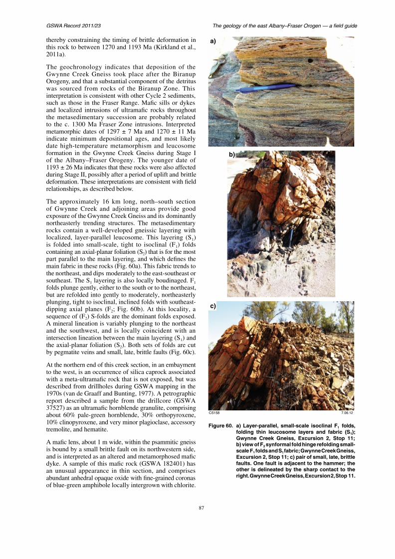
7/25/2019 THE GEOLOGY OF THE EAST ALBANY–FRASER OROGEN — A FIELD GUIDE
http://slidepdf.com/reader/full/the-geology-of-the-east-albanyfraser-orogen-a-field-guide 94/106
( ,2011a).
The geochronology indicates that deposition of theGwynne Creek Gneiss took place after the Biranup
Orogeny, and that a substantial component of the detrituswas sourced from rocks of the Biranup Zone. Thisinterpretation is consistent with other Cycle 2 sediments,such as those in the Fraser Range. Mafic sills or dykesand localized intrusions of ultramafic rocks throughoutthe metasedimentary succession are probably relatedto the c. 1300 Ma Fraser Zone intrusions. Interpretedmetamorphic dates of 1297 ± 7 Ma and 1270 ± 11 Maindicate minimum depositional ages, and most likelydate high-temperature metamorphism and leucosome
formation in the Gwynne Creek Gneiss during Stage Iof the Albany–Fraser Orogeny. The younger date of1193 ± 26 Ma indicates that these rocks were also affectedduring Stage II, possibly after a period of uplift and brittledeformation. These interpretations are consistent with fieldrelationships, as described below.
The approximately 16 km long, north–south sectionof Gwynne Creek and adjoining areas provide good
b)
Spaggiari et al.
Some of this amphibole is quite blue and is probablyreibeckite. Another amphibole is pleochroic pale-green to
Beeson, J, Delour, CP and Harris, LB 1988
metamorphic traverse across the Albany Mo
A li P b i R h 40
7/25/2019 THE GEOLOGY OF THE EAST ALBANY–FRASER OROGEN — A FIELD GUIDE
http://slidepdf.com/reader/full/the-geology-of-the-east-albanyfraser-orogen-a-field-guide 95/106
p p p gvery bright emerald green, and is locally intergrown withfibrous amphibole. Some of the opaque oxide grains haverims of small garnets, and there are also sparse, small,euhedral garnets throughout the matrix. There appears to
be some relict pyroxene (orthopyroxene?), which is veryaltered and overgrown with fine amphibole and chlorite.These are set within a matrix of interlocking plagioclase,some of which may be anorthite (no albite twinning). Thesample also possibly includes rare titanite and accessoryapatite.
Semipelitic gneiss (GSWA 184399; sampled adjacent tothe track turnoff to this locality) is fine to medium grained,and has a strong to mylonitic foliation. It comprises about
10–15% biotite and 8–10% garnet, with the remaindercontaining K-feldspar, plagioclase, and quartz, withaccessory epidote, opaque oxide, and zircon. Biotite ispale to medium brown, and is aligned in the foliation.Garnet is clear, partly overgrown, and is locally wrappedby the foliation, or has pressure shadows. The quartz andfeldspars have mostly lobate or ragged grain boundaries,although some grains show recovery textures and 120°
junctions. The thin section also contains textures in the
Australia: Precambrian Research, v. 40–
doi:10.1016/0301-9268(88)90064-2.
Beeson, J, Harris, LB and Delour, CP 1995, StruAlbany Mobile Belt (south-western Austra
overprinting by Neoproterozoic shear zones of
Belt: Precambrian Research, v. 75, p. 47–639268(95)00017-Y.
Black, LP, Harris, LB and Delour, CP 1992, Rew
and Early Proterozoic components during a p
Proterozoic tectonothermal event in the Albany M
Australia: Precambrian Research, v. 59, p. 95–1
Blewett, RS, Czarnota, K and Henson, PA 201framework for the eastern Yilgarn Craton, We
its implications for orogenic gold: Precambria
p. 203–209.
Bodorkos, S and Clark, DJ 2004a, Evolutiontranspressive shear zone in the Albany Fraser Or
1. P–T conditions of Mesoproterozoic metamorph
Gneiss: Journal of Metamorphic Geology, v. 22
doi: 10.1111/j.1525-1314.2004.00543.x.
Bodorkos, S and Clark, DJ 2004b, Evolution transpressive shear zone in the Albany Fraser Or
2. Tectonic history of the Coramup Gneis
framework for Mesoproterozoic collision of t
GSWA Record 2011/23 The geology of the east Albany–Fraser O
Clark, DJ, Kinny, PD, Post, NJ and Hensen, BJ 1999, Relationships
between magmatism, metamorphism and deformation in the Fraser
C l W t A t li t i t f SHRIMP U Pb
Elias, M and Bunting, JA 1982, Wiluna, W.A.
Western Australia, 1:250 000 Geological Series

7/25/2019 THE GEOLOGY OF THE EAST ALBANY–FRASER OROGEN — A FIELD GUIDE
http://slidepdf.com/reader/full/the-geology-of-the-east-albanyfraser-orogen-a-field-guide 96/106
Complex, Western Australia: constraints from new SHRIMP U–Pb
zircon geochronology: Australian Journal of Earth Sciences, v. 46,p. 923–932.
Clark, DJ, Hensen, BJ and Kinny, PD 2000, Geochronological constraints
for a two-stage history of the Albany–Fraser Orogen, Western
Australia: Precambrian Research, v. 102, no. 3, p. 155–183.
Clark, WC 1995, Granite petrogenesis, metamorphism andgeochronology of the western Albany–Fraser Orogen, Albany,
Western Australia: Curtin University of Technology, Perth, Western
Australia, BSc Honours thesis (unpublished).
Collins, WJ, Belousova, EA, Kemp, AIS and Murphy, J 2011, Two
contrasting Phanerozoic orogenic systems revealed by hafniumisotope data: Nature Geoscience, v. 4, p. 333–337.
Condie, KC and Myers, JS 1999, Mesoproterozoic Fraser Complex:
geochemical evidence for multiple subduction-related sources oflower crustal rocks in the Albany–Fraser Orogen, Western Australia:Australian Journal of Earth Sciences, v. 46, p. 875–882.
Cruse, T 1991, The sedimentology, depositional environment and
Ediacaran fauna of Mondurup and Barnett Peaks, Stirling Range
Formation, Western Australia: University of Western Australia, Perth,
Western Australia, BSc Honours thesis (unpublished).
Cruse, T and Harris, LB 1994, Ediacaran fossils from the Stirling Range
Formation, Western Australia: Precambrian Research, v. 67, p. 1–10.
C Ch i C G b l S C id
Evans, T 1999, Extent and nature of the 1.2 Ga
Yilgarn Craton, Western Australia: Universit
Perth, Western Australia, BSc Honours thesi
Fasano, G and Franceschini, A 1987, A multidim
Kolmogorov–Smirnov test: Monthly Notes ofSociety, v. 225, p. 155–170.
Fitzsimons, ICW 2003, Proterozoic basement
and southwestern Australia and their correGeological Society of London Special Public
Fitzsimons, ICW and Buchan, C 2005, Geology
Fraser Orogen, Western Australia — a field g
of Western Australia, Record 2005/11, 32p.
Fitzsimons, ICW, Kinny, PD, Wetherley, S and HBulk chemical controls on metamorphic mo
schists and implications for U–Pb age data: JGeology, v. 23, p. 261–277.
Fletcher, IR, Libby, WG and Rosman, KJR 1
the 2411 Ma Jimberlana dyke, Yilgarn BloAustralian Journal of Earth Sciences, v. 34, p
Fletcher, IR, Myers, JS and Ahmat, AL 1991, I
age and origin of the Fraser Complex, Wester
Mid-Proterozoic lower crust: Chemical Geolov. 87, p. 197–216.
Spaggiari et al.
Griffin, WL, Wang, X, Jackson, SE, Pearson, NJ, O'Reilly, SY, Xu, X and
Zhou, X 2002, Zircon chemistry and magma genesis, SE China: in-
situ analysis of Hf isotopes Pingtan and Tonglu igneous complexes:
Kirkland, CL, Wingate, MTD, Spaggiari, CV
2010f, 194733: porphyritic metamonzogran
Geochronology Record 854: Geological Survey o

7/25/2019 THE GEOLOGY OF THE EAST ALBANY–FRASER OROGEN — A FIELD GUIDE
http://slidepdf.com/reader/full/the-geology-of-the-east-albanyfraser-orogen-a-field-guide 97/106
situ analysis of Hf isotopes, Pingtan and Tonglu igneous complexes:
Lithos, v. 61, p. 237–269.
Hall, CE, Jones, SA and Bodorkos, S 2008, Sedimentology, structureand SHRIMP zircon provenance of the Woodline Formation, Western
Australia: implications for the tectonic setting of the West Australian
Craton during the Paleoproterozoic: Precambrian Research, v. 162,p. 577–598, doi:10.1016/j.precamres.2007.11.001.
Hawkesworth, CJ, Dhuime, B, Pietranik, AB, Cawood, PA, Kemp, AIS
and Storey, CD 2010, The generation and evolution of the continental
crust: Journal of the Geological Society, v. 167, no. 2, p. 229–248.
Howard, HM, Smithies, RH, Kirkland, CL, Evins, PM and Wingate,
MTD 2009, Age and geochemistry of the Alcurra Suite in the westernMusgrave Province and implications for orthomagmatic Ni–Cu–PGE
mineralization during the Giles Event: Geological Survey of Western
Australia, Record 2009/16, 16p.
Jones, SA 2006, Mesoproterozoic Albany–Fraser Orogen-relateddeformation along the southeastern margin of the Yilgarn Craton:
Australian Journal of Earth Sciences, v. 53, p. 213–234.
Kelsey, DE, Clark, C and Hand, M 2008, Thermobarometric modelling
of zircon and monazite growth in melt-bearing systems: examples
using model metapelitic and metapsammitic granulites: Journal ofMetamorphic Geology, v. 26, p. 199–212.
Kemp, AIS, Foster, GL, Schersten, A, Whitehouse, MJ, Darling, J and
Storey CD 2009 Concurrent Pb–Hf isotope analysis of zircon by
Geochronology Record 854: Geological Survey o
4p.
Kirkland, CL, Wingate, MTD, Spaggiari, CV and194735: quartzofeldspathic gneiss, Gwynne Cr
Record 867: Geological Survey of Western Aust
Kirkland, CL, Wingate, MTD, Spaggiari, CV and
194736: metasyenogranite, Bartlett Bluff; Geo849: Geological Survey of Western Australia, 4p
Kirkland, CL, Wingate, MTD, Spaggiari, CV and
194737: metasyenogranite, Bobbie Point; Geo
866: Geological Survey of Western Australia, 4p
Kirkland, CL, Wingate, MTD, Spaggiari, CV and194720: rapakivi metadiorite, Harris Lake; Geo
852: Geological Survey of Western Australia, 4p
Kirkland, CL, Wingate, MTD, Spaggiari, CV and194723: metamonzogranite, Harris Lake; Geo
851: Geological Survey of Western Australia, 4p
Kirkland, CL, Wingate, MTD, Spaggiari, CV and194724: metasyenogranite, Harris Lake; Geochro
Geological Survey of Western Australia, 4p.
Kirkland, CL, Spaggiari, CV, Pawley, MJ, Winga
RH, Howard, HM, Tyler, IM, Belousova, EA anOn the edge: U–Pb, Lu–Hf, and Sm–Nd data su
h il C i d i f i f
GSWA Record 2011/23 The geology of the east Albany–Fraser O
Krapež, B and Barley, ME 2008, Late Archaean synorogenic basins
of the Eastern Goldfields Superterrane, Yilgarn Craton, Western
Australia Part III Signatures of tectonic escape in an arc continent
Nelson, DR 2005b, 178071: recrystallized bio
Cave; Geochronology Record 597: Geolog
Australia 4p
7/25/2019 THE GEOLOGY OF THE EAST ALBANY–FRASER OROGEN — A FIELD GUIDE
http://slidepdf.com/reader/full/the-geology-of-the-east-albanyfraser-orogen-a-field-guide 98/106
Australia. Part III. Signatures of tectonic escape in an arc–continent
collision zone: Precambrian Research, v. 161, p. 183–199.
Krapež, B, Barley, ME and Brown, SJA 2008, Late Archaeansynorogenic basins of the Eastern Goldfields Superterrane, Yilgarn
Craton, Western Australia. Part I. Kalgoorlie and Gindalbie Terranes:
Precambrian Research, v. 161, p. 135–153.
Love, GJ 1999, A study of wall-rock contamination in a tonalitic gneissfrom King Point, near Albany, Western Australia: Curtin University
of Technology, Perth, Western Australia, BSc Honours thesis
(unpublished).
Muhling, PC and Brakel, AT (compilers) 1985, Mount Barker – Albany,
Western Australia: Geological Survey of Western Australia, 1:250 000Geological Series Explanatory Notes, 21p.
Myers, JS 1985, The Fraser Complex: a major layered intrusion in
Western Australia, in Professional papers for 1983: Geological Surveyof Western Australia, Report 14, p. 57–66.
Myers, JS 1990a, Albany–Fraser Orogen, in Geology and mineralresources of Western Australia: Geological Survey of Western
Australia, Memoir 3, p. 255–263.
Myers, JS 1990b, Yilgarn Craton — mafic dyke swarms, in Geology and
mineral resources of Western Australia: Geological Survey of WesternAustralia, Memoir 3, p. 126–127.
Myers, JS 1995a, Geology of the Albany 1:1 000 000 sheet: Geological
S f A li 1 1 000 000 G l i l S i
Australia, 4p.
Nelson, DR 2005c, 178072: tonalitic gneiss, Hai
Record 598: Geological Survey of Western A
Nelson, DR, Myers, JS and Nutman, AP 1995, C
of the Middle Proterozoic Albany–Fraser OroAustralian Journal of Earth Sciences, v. 42, p
Nemchin, AA and Pidgeon, RT 1998, Precise con
baddeleyite U–Pb age for the Binneringie
Western Australia: Australian Journal of
p. 673–675.
Oorschot, CW 2011, P–T–t evolution of the Fras
Orogen, Western Australia: Geological Surv
Record 2011/18, 101p.
Pawley, MJ, Romano, SS, Hall, CE, Wyche, S an
The Yamarna shear zone: a new terrane boun
Yilgarn Craton?, in Geological Survey of W
Review 2007–08: Geological Survey of W
Western Australia, p. 27–33.
Pawley, MJ, Wingate, MTD, Kirkland, CL, Wych
SS and Doublier, MP in press, Adding piece
crustal growth and a new terrane in the no
Western Australia: Australian Journal of E
no. 5.
Spaggiari et al.
Thom, R, Chin, RJ and Hickman, AH (compilers) 1984a, Newdegate,
Western Australia: Geological Survey of Western Australia, 1:250 000
Geological Series Explanatory Notes 24p
Wetherley, S 1998, Tectonic evolution of the M
Albany–Fraser Province, Western Australia: Un
Australia Perth Western Australia PhD thesis (
7/25/2019 THE GEOLOGY OF THE EAST ALBANY–FRASER OROGEN — A FIELD GUIDE
http://slidepdf.com/reader/full/the-geology-of-the-east-albanyfraser-orogen-a-field-guide 99/106
Geological Series Explanatory Notes, 24p.
Thom, R, Hickman, AH and Chin, RJ 1984b, Newdegate, WA Sheet
SI50-8: Geological Survey of Western Australia, 1:250 000Geological Series.
Turek, A 1966, Rubidium–strontium isotopic studies in the Kalgoorlie–Norseman area, Western Australia: Australian National University,
Canberra, Australian Capital Territory, PhD thesis (unpublished).
Tyler, IM 2005, Australia: Proterozoic, in Encyclopedia of Geologyedited by RC Selley, LRM Cocks and IR Plimer: Elsevier, Oxford,
UK, Volume 1, p. 208–221.
Vallini, DA, Rasmussen, B, Krapež, B, Fletcher, IR and McNaughton, NJ
2002, Obtaining diagenetic ages from metamorphosed sedimentaryrocks: U–Pb dating of unusually coarse xenotime cement in
phosphatic sandstone: Geology, v. 30, p. 1083–1086.
Vallini, DA, Rasmussen, B, Krapež, B, Fletcher, IR and McNaughton, N2005, Microtextures, geochemistry and geochronology of authigenic
xenotime constraining the cementation history of a Paleoproterozoicmetasedimentary sequence: Sedimentology, v. 52, p. 101–122.
van de Graaff, WJE and Bunting, JA (compilers) 1975, Neale, Western
Australia: Geological Survey of Western Australia, 1:250 000
Geological Series Explanatory Notes, 23p.
van de Graaff, WJE and Bunting, JA (compilers) 1977, Plumridge,Western Australia: Geological Survey of Western Australia, 1:250 000
G l i l S i l 28
Australia, Perth, Western Australia, PhD thesis (
Wingate, MTD 2007, Proterozoic mafic dykes in in Proceedings edited by FP Bierlein and CMGeoscience Australia; Kalgoorlie '07 conference,
Australia, 25 September 2007; Record 2007/14,
Wingate, MTD and Bodorkos, S 2007a, 177909: m
Yardilla Bore; Geochronology Record 659: GWestern Australia, 4p.
Wingate, MTD and Bodorkos, S 2007b, 177910: m
sandstone, Peters Dam; Geochronology Reco
Survey of Western Australia, 6p.
Wingate, MTD and Bodorkos, S 2007c, 179644: foMount Andrew; Geochronology Record 676: G
Western Australia, 4p.
Wingate, MTD, Campbell, IH and Harris, LB 2000, Sage for the Fraser Dyke Swarm, southeast Yilg
Australia: Australian Journal of Earth Sciences,
Wingate, MTD, Pirajno, F and Morris, PA 2004, Warprovince: a new Mesoproterozoic large igneou
central Australia: Geology, v. 32, no. 2, p. 105–1
Wingate, MTD, Morris, PA, Pirajno, F and Pidge
large igneous provinces in late MesoproteroSupercontinents and Earth Evolution Sympos
i d SA i k G l i l S
GSWA Record 2011/23 The geology of the east Albany–Fraser O
7/25/2019 THE GEOLOGY OF THE EAST ALBANY–FRASER OROGEN — A FIELD GUIDE
http://slidepdf.com/reader/full/the-geology-of-the-east-albanyfraser-orogen-a-field-guide 100/106
Logistics
These field excursions are designed on a safari-style, self-drive, self-cater basis; i.e. participants are responsible fortheir own transport (see notes below regarding vehiclesuitability), camping equipment, food, and water. Although
this guide provides location details and driving directions,which can be used by anyone wishing to independentlyfollow the excursion routes, it is also recommended thattravelers take topographic maps and a GPS for navigation.
The excursions involve several nights of camping. In mostof the camping areas, there are no facilities of any kindavailable. It is important that participants bring enoughfood and water to last the duration of each excursion,
Appendix
Field trip logistics
fitted or supplied with fire extinguisand all repair and recovery equipmentduring off-road driving, including trepair, and bog recovery equipment. fitted with long-range fuel tanks, careproperly store any portable fuel tanks (
drivers should be suitably certified or road (4WD) driving.
Convoy procedure
This section applies to all GSWA-ledcan involve large numbers (as many travelling for long distances. Norma
Spaggiari et al.
Excursion 1
Day 1:
Day 3:
AM: intersection of the Rason L

7/25/2019 THE GEOLOGY OF THE EAST ALBANY–FRASER OROGEN — A FIELD GUIDE
http://slidepdf.com/reader/full/the-geology-of-the-east-albanyfraser-orogen-a-field-guide 101/106
Day 1:
AM: corner of Farrell’s Road and South CoastHighway — 33°44′18.2″ S, 121°17′53.7″ E
PM: intersection of the Coolgardie–EsperanceHighway and Telegraph Track — 32°21′16.4″ S,121°45′34.0″ E
Day 2:
AM: Stop 2 — MGA 492094E 6395845N
PM: intersection of the Mount Andrew Trackand Telegraph Track — MGA 481033E 6411397N
Day 3:
AM: Stop 5, Gnamma Hill —MGA 471530E 6439471N
PM: Fraser Range Station —MGA 480565E 6456426N
Day 4:
AM: intersection of the Rason LTropicana Camp Road —MGA 663957E 6762255N
PM: Stop 8, Pleiades Lakes area
MGA 684468E 6770483N
Day 4:
AM: Stop 7, Pleiades Lakes areaMGA 683549E 6770104N
PM: Start of Plumridge Lakes — MGA 681534E 6753770N
Travel from Tropicana to Kalgoorlie:
AM(1): intersection of the TropiArgus Corner Road — MGA 629
PM(1): Argus Corner (about 5 hTropicana) — 30°10′05″ S, 123°
PM 2: Pinjin, left-hand turnoff oKurnalpi Road — MGA 472830
GSWA Record 2011/23 The geology of the east Albany–Fraser O
Camping
The excursion involves several nights of camping
7/25/2019 THE GEOLOGY OF THE EAST ALBANY–FRASER OROGEN — A FIELD GUIDE
http://slidepdf.com/reader/full/the-geology-of-the-east-albanyfraser-orogen-a-field-guide 102/106
The excursion involves several nights of camping.Participants are responsible for bringing their owncamping equipment, including swags, tents, and food.Potential hazards involved in collecting firewood and
around open fires are to be noted and appropriate caretaken. All rubbish is to be removed. All participants arerequested to exercise appropriate care and discretion withrespect to ablutions, and all waste is to be buried andtissues disposed of by burning (noting bushfire hazardsin doing so, particularly in high winds). Please be awareof the potential to become disoriented and detached fromthe camp whilst seeking privacy for ablutions. If you getlost, stay where you are and wait for your absence to benoticed. Always carry a box of matches or a lighter in case
you need to light a signal fire.
Other potential hazards involved with camping in theAlbany–Fraser region include snake bites, and scorpion,centipede, spider, and other insect bites or stings.
Note that wild camels represent a threat, and should neverbe approached.
7/25/2019 THE GEOLOGY OF THE EAST ALBANY–FRASER OROGEN — A FIELD GUIDE
http://slidepdf.com/reader/full/the-geology-of-the-east-albanyfraser-orogen-a-field-guide 103/106
This Record is published in digital format (PDF) and is available as a freedownload from the DMP website at<http://www.dmp.wa.gov.au/GSWApublications>.
Information CentreDepartment of Mines and Petroleum100 Plain StreetEAST PERTH WESTERN AUSTRALIA 6004Phone: (08) 9222 3459 Fax: (08) 9222 3444http://www dmp wa gov au/GSWApublications
Further details of geological products produced by theGeological Survey of Western Australia can be obtained by contacting:
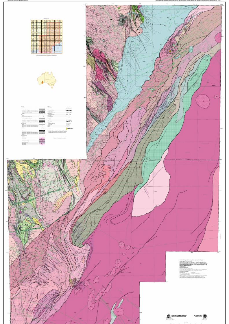
7/25/2019 THE GEOLOGY OF THE EAST ALBANY–FRASER OROGEN — A FIELD GUIDE
http://slidepdf.com/reader/full/the-geology-of-the-east-albanyfraser-orogen-a-field-guide 104/106
PATERSON FORMATION: conglomerate(includingdiamictite),sandstone,andsiltstone;largelyglacigene
Albany–Fraser Orogeny StageII (1215–1140Ma)
Doleriteandgabbrodykes;east-northeast- tonortheast-trending;mostlyinterpretedfromaeromagneticdata;concealedwheredashed
ìÒBN-odìÒNB-odìÒNW-od
maficdykes;northwesterlytrending;interpretedfromaeromagneticdatamaficdykes;west-northwesterlytrending,variablymagnetic;someexceeding400km long;mostlyinterpretedfromaeromagneticdata
northwest-trendingmaficdykes;interpretedfromaeromagneticdata;concealedwhere dashed
BeenongDykeSui te:Nindibillup DykeSuite:Cosmo NewberyDykeSu ite:
ìEP-gìEP-gm
Graniticrock;undeformedtomoderatelydeformed
Monzogranite;undeformedtomoderatelydeformed;includesmagnetite-richvarieties
318–270Ma
1200–1140Ma
c.1210Ma
n g e r u p –
F r a s e r
y k e S u i t e
ìoìod
Maficintrusiverock
Doleritedyke,sill,orplug;fine- tomedium-graineddoleriteandgabbro;concealedwheredashed
E s p e r a n c e S u p e r s u i t e
C A R B
O N I F E R O U S –
P
E R M I A N
P A L E O Z O I C
P H
A N E R O Z O I C
P R O T E R O Z O I C –
P H A N E R O Z O I C
G U N
B A R R E L B A S I N
A L B A N Y – F R A S E R O R O G E N
ìo
ìEP-g
ìod
ìGF-od
ì ÒB N- o d ì ÒN B- od ìÒNW-od
ìEP-gm
æåpa-sepg
REDUCED-TO-POLE AEROMAGNETIC IMAGE
123° 124°
29°
30°
125°
GEOLOGICAL SURVEY OF WESTERN AUSTRALIA GEOPHYSICAL AND REMOTE SENSING IMAGERY AND REFERENCE FOR PLA

7/25/2019 THE GEOLOGY OF THE EAST ALBANY–FRASER OROGEN — A FIELD GUIDE
http://slidepdf.com/reader/full/the-geology-of-the-east-albanyfraser-orogen-a-field-guide 105/106
Albany–Fraser Orogeny StageI (1345–1260Ma)
Metagabbroicrocks;mayincludefelsicgranulite,metagraniticandìmogFR
ìxmog-mgnFR Metagabbroicandmetamaficrocks;mayincludemetagraniteand
GWYNNE CREEK GNEISS: psammiticgneisswithminorsemipeliticlayers;includesminormetagranitic,metamafic,andmeta-ultramaficrocks
ìmgBRìxmg-mogBR
ìxmgn-mogBR
Metagranite
Graniticgneissintrudedbycoarsepegmatite;undivided;mayincludeinterleavedFraserZonerocks
K-feldsparmegacrysticmetagraniteandmetasyenogranite,mingledwithmetagabbroicrocks;hybridrocks;
Quartziteandmetasandstone,interbeddedwithmetasiltstone;locallyinterbedded
Doleriteandgabbro;includescumulateandgranophyricdifferentiates;concealedwheredashed
ðxmgn-mwaAFON ðxmg-moAFON
ðxmin-mogAFON
Graniticgneiss;quartzofeldspathicgneiss,locallywithgarnet;amphibolite;metagranite;minor metabandediron-formation;mayinclude BiranupZone intrusions
Metagraniticandmetamaficrocks;ArcheangraniteandgreenstoneandProterozoicgraniticandmaficrocksdeformedand
Metabandediron-formation,metagabbro,andmetaleucogabbro;mayincludemetagraniteand BiranupZone intrusions
c.1305–1290Ma
metasedimentaryrocks,maficandfelsicgranulite
metasedimentaryrocks;undivided
withmetaconglomerateandpebblymetasandstone
MOUNT RAGGED FORMATION: psammiticschistandquartziteinterbeddedwiththinlayersofpeliticrocks
ìRE-mgìRE-mgm
Metagranite;heterogeneous;evengrainedorporphyritic;moderatelytostronglydeformed;mayincludeintrusionsof EsperanceSupersuite
Monzograniticgneiss;maycontainremnantsof BiranupZone rocks
1305–1290MaFRASER RANGE METAMORPHICS:sheetedandmostlystronglydeformedmetagabbro,
metagranite,andminormetasedimentaryrocks;includeshybridrocksandmaficandfelsicgranulite
1335–1290Ma
FRASER RANGE METAMORPHICS
ìFM-xmdn-mhn
ìFM-xmhn-mno
Sedimentarygneiss;psammitic,semipelitic,andlocallycalc-silicatelayers;
Sedimentarygneiss;interlayeredpsammitictopelitic,amphibolite-togranulite-faciesgneiss,commonlyinterlayered withbandsofamphibolite,or maficandfelsicgranulite
commonlyinterlayeredwithbandsofamphibolite,ormaficand felsicgranulite
ìgk-xmtn-moìmm-xmh-mws MALCOLMMETAMORPHICS:interbeddedpsammiticandpeliticschist;maficamphiboliticschist;minorcalc-silicaterocks;mayincludegraniticdykesandintrusions
Metagraniticandmetamaficrocks,undivided;mayincludemetasedimentaryrocks
Biranup Orogeny(1710–1620Ma)
ìxmgn-mdnBR Graniticandmetasedimentarygneissesdominant;includesintrusionsof Recherche and EsperanceSupersuites;mayincluderemnantsof Archeanrocksìxmgni-mhnBR Migmatitic,monzogranitictosyenograniticgneissesdominant;commonlygarnet-bearing;mayincluderemnantsofArcheanrocks
FLY DAMFORMATION: interbeddedpsammitictopeliticgneisswithleucosomes;c .1620Ma
1321–1150Ma
1330–1280Ma
1700–1620Ma
1480–1345Ma
c.1665MaMetagranodiorite,metadioriteandmetagabbro,graniticgneiss,lensesofmetasedimentaryrocks,
andpegmatite;mayincluderemnantsof other BiranupZoneunits
c .1708Ma
c.1760Ma
c.2410Ma
c.1750Ma WOODLINE FORMATION:quartzmetasandstone,quartzmetaconglomerate,
ðmgBR Metagraniticrocksdominant;mayincluderemnantsofArcheanrocks
Metagraniticandgneissicrocksdominant,locallywithmaficamphibolitelenses;mayincluderemnantsofArcheanrocks ðmgnBR ðmgniBR ðxmgss-mwaBR ðxmwa-mgssBR
Migmatitic,monzogranitictosyenograniticgraniticgneissesdominant;mostaregarnet-bearing;mayincluderemnantsof Archeanrocks
Foliatedmetagraniticrockswithlensesofmaficamphibolite;mayincluderemnantsof Archeanrocks
Maficamphibolitedominant;intrudedbyfoliatedmetagraniticrocks;mayincluderemnantsof Archeanrocks
2700–1650Ma
2800–1330Ma
Metamonzogranite;foliated ñmgmBR
ñmgrBR Metasyenogranite;mostlyhomogeneous;weaklytostronglyfoliated;localfolded maficamphibolitelenses;sparseleucosomes
2700–2630Ma
2710–1330Ma
metamorphosedduringthe Albany–Fraser Orogeny
ñxmu-mdAFON
ñxmb-muAFON
ñxmi-mdAFON
ñmbAFON
ñxmog-maeAFON ñmoAFON
Meta-ultramaficrocks,quartzite,metaconglomerate,andmetasandstone
Greenstones,undivided;mayincludeironformation
Metabandediron-formation,metachert,metasedimentaryrocks,andamphibolite
Metamaficvolcanicrocks,undivided
Metagabbroandmeta-ultramaficrocks;intrudedbymetagranite
Meta-igneousmaficintrusiverock,undivided
Biotitemetamonzogranite;mediumtocoarsegrained ñmgmY ñmgnY ñmgssY ñgY ñgmY
Graniticgneiss,locallymigmatitic;includeslocalmaficbandsand enclaves
Foliatedmetagranite,locallygneissic;mayincludeamphibolitelenses;includesdeeplyweatheredrockGraniticrock,undivided;metamorphosed
Monzogranite;commonbiotiteandrarelocalhornblende;minorgranodioriteandsyenogranite;fine tocoarsegrained;equigranular toporphyritic;
massivetoweaklyfoliated;metamorphosed
Gneiss;protolithunknown
Siliciclasticsedimentaryrock,undivided;includessandstone,siltstone,shale,and chert;metamorphosed
G n o w a n D y
mayincluderemnantsofArcheanrocks
W i d g i e m o o l t h a
D y k e S u i t e
graniticgneiss,heterogeneous,andminormetamaficrocks;Archeangraniteandgreenstoneand
Proterozoicgraniticandmaficrockdeformedandmetamorphosedduringthe Albany–Fraser Orogeny
MUNGLINUP GNEISS:
2900–2660Ma
c.2706Ma 1
2716–2638Ma 2
2679–2634Ma
R e c h e r c h e S u p e r s u i t e
P R O T E R O Z O
I C
A R C H E A N – P R O T E R O Z O I C
N E O A R C H E A N – P A L E O P R O T E R O Z O I C
M E S O P R O T E R O Z O I C
P A L E O P R O T E R O Z O I C –
M E S O P R O T E R O Z O I C
P A L E O P R O T E R O Z O I C
E d d y S u i t e
peliticlayersgarnet- andbiotite-rich
andmetasiltstone
R A G G E D B A S I N
A R I D B A S I N
B A R R E N B A S I N
F r a s e r a n d N o r n a l u p Z o n e s
M A D U R A P R O V I N C E
B i r a n u p Z o n e
B i r a n u p Z o n e
B i r a n
u p Z o n e
N o r t h e r n F o r e l a n d
A L B A N Y – F R A S E R O R O G E N
A L B A N Y – F R A S E R O R O G E N
A L B A N Y – F R A S E R O R O G E N
ìmgBR
ñgY
ðmgBR
ìWI-o
ñgmY
ìRE-mg
ñsYKA
ñmgnY
ìrg-mh
ìwo-mt
ñmgmY
ìbt-mgr
ñmgssY
ñmgrBR
ìmogFR
ñmnYKA
ñmgmBR
ìfd-mhng
ñmoAFON ñmbAFON
ðmgnBR
ìRE-mgm
ðmgniBR
ìxmg-mwMD
ìgk-xmtn-mo
ìkc-xmgr-mgi
ñxmi-mdAFON
ìxmog-mgnFR
ìxmt-mtqAFOB
ñxmb-muAFON ñxmu-mdAFON
ðmu-xmgn-mo
ìEY-xmgg-mog
ìmm-xmh-mws
ìFM-xmhn-mnoìFM-xmdn-mhn
ìFM-xmog-mgn
ðxmg-moAFON
ìxmgn-mogBR
ðxmin-mogAFON
ñxmog-maeAFON
ðxmgn-mwaAFON
ìxmgni-mhnBRì xm g- mo gB R ì xm gn -m dn BR
ðxmgss-mwaBR ðxmwa-mgssBR
metasyenogranite;weaklyfoliatedto mylonitic;includesminormingledmaficrocksandBOBBIE POINT METASYENOGRANITE:minorbandediron-formationrafts
MCKAY CREEK METASYENOGRANITE: metasyenogranite,mingledwithmetagabbro;localizedhybridsof metagranodioriteand
metadiorite;mayincludeintrusionsof BOBBIE POINT METASYENOGRANITE andremnantsofArcheanrocks
125°
123°122°
122°31°
32°
33° 33°
34° 34°
124°
0 200
Kilometres
SCALE 1:3000000
RADIOMETRICTERNARY IMAGE
124°
125°
125°
122°
29°
30°
31°
32°
123°
C u n d
e e l e e
F a u
l t
ìÒNW-od
ìod
ìÒNW-od
ìÒNW-od
ìod
ìod
ìod
ìod
ìod ìod
ìGF-od
ìÒNW-od
ìGF-od
ìod
ìod
ìGF-od
ìGF-odìÒNW-od
ìod
ìÒNW-od
ìGF-od
ìod
ìod
ìÒNW-od
ìod
AgY
ìbt-mgr
ðmgBR
Atp-xf-s
AmbYYA
AgY
Atp-xf-s
æåpa-sepg
æåpa-sepg
AmwYYA
AmgnY
AmbYYA
æåpa-sepg
Atp-xf-s
Atb-xs-c
AmbYYA
Atb-xs-c
æåpa-sepg
ìxmg-mogBR
Neale
Atlantis
Hercules
Muirfield
St Andrews
Carnoustie
PineValley
Purple Haze
PebbleBeachAu
Au
Au
Au
Au
Au
Au
Au
Au
R A S O N
LAK E
R O A D
124°0' 124°30' 125°0'620 660 700 740
INTEGEOLOGICAL SURVEY OF WESTERNAUST RALIA
PATERSON FORMATION:conglomerate (including diamictite),sandstone,andsiltstone;largelyglacigene
Northwest-trendingmafic dykes; interpreted from aeromagnetic data; concealed where dashed
Doleritedyke,sill,or plug;f ine- tomedium-graineddolerite andgabbro;concealedwheredashed
Graniticrocks;undeformed tomoderatelydeformed
Albany–Fraser OrogenyStage II(1215–1140Ma)
Doleriteandgabbrodykes;east-northeast- tonortheast-trending;mostly interpretedfromaeromagneticdata
Albany–Fraser OrogenyStage I(1345–1260Ma)
Metagranite;heterogeneous;even grainedorporphyritic;moderately tostronglydeformed;mayinclude intrusions of Esperance Supersuite
GWYNNE CREEK GNEISS:psammitic gneiss withminorsemipelitic layers;includes minor metagranitic,metamafic,and meta-ultramaficrocks
ìmgBRìxmg-mogBR
MetagraniteK-feldsparmegacrysticmetagranite andmetasyenogranite,mingledwith metagabbroicrocks;hybridrocks;
mayinclude remnants ofArchean rocks
1
CosmoNewbery
DykeSuite
Esperance
Supersuite
Gnowangerup–Fraser
DykeSuite
Recherche
Supersuite
CARBONIFEROUS–
PERMIAN
PALEOZOIC
PHANEROZOIC
Biranup Orogeny(1710–1620Ma)
MESOPROTEROZOIC
PROTEROZOIC
C
318–270 Ma
1200–1140Ma
c.1210Ma
1330–1280Ma
1480–1300Ma
1700–1620Ma
ìod
ìmgBR
ìEP-g
ìGF-od
ìRE-mg
ìÒNW-od
æåpa-sepg
ìgk-xmtn-mo
ìxmgn-mogBRìxmg-mogBR
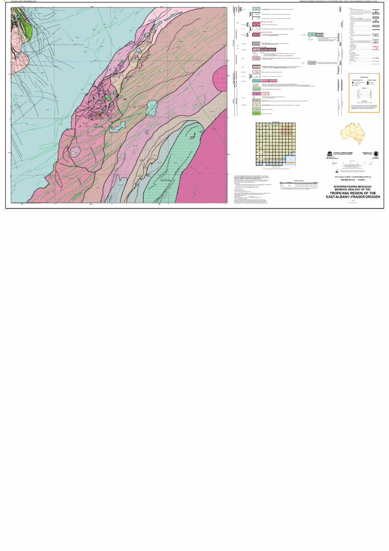
7/25/2019 THE GEOLOGY OF THE EAST ALBANY–FRASER OROGEN — A FIELD GUIDE
http://slidepdf.com/reader/full/the-geology-of-the-east-albanyfraser-orogen-a-field-guide 106/106
F a u
l t
Y a m
a r n a
F r a s
e r F a
u l t
Z o n
e
C u n d
e e l e
e
C u n d e
e l e e
Cobbler Shear Zone
DonLinoShearZone
F a u
l t
S h e a r
Z o n e
F a u l t
C u n d e e l e e
F aul t
B o o n d
e r o o
F a u l t
B o o n d e r o o
ìGF-od
ìWI-o
ìod
ìÒNW-od
ìod
ìWI-o
ìÒNW-od ìÒNW-od
ìod
ìod
ìod
ìod
ìod
ìod
ìod
ìod
ìÒNW-od
ìod
ìGF-od
ìod
ìod
ìÒNW-od
ìod
ìGF-od
ìod
ìod
ìod
ìod
ìod
ìod
ìod
ìod
ìod
ìod
ìod
ìod
ìod
æåpa-sepg
ìxmg-mogBR
ìRE-mg
ìmogFR
ìxmgn-mogBR
ðxmgn-mwaAFON
ìgk-xmtn-mo
ðxmg-moAFON
ìxmog-mgnFR
ìEP-g
ìkc-xmgr-mgi
ìxmog-mgnFR
æåpa-sepg
ìmgBR
æåpa-sepg
ñxmog-maeAFON
æåpa-sepg
æåpa-sepg
ðxmin-mogAFON
æåpa-sepg
ñxmog-maeAFON
æåpa-sepg
ðxmin-mogAFON
æåpa-sepg
ìxmt-mtqAFOB
ìxmt-mtqAFOB
æåpa-sepg
æåpa-sepg
æåpa-sepg
ðxmin-mogAFON
æåpa-sepg
æåpa-sepg
ìxmt-mtqAFOB
æåpa-sepg
æåpa-sepg
ìxmt-mtqAFOB
ìxmg-mogBR
ìgk-xmtn-mo
ìxmgn-mogBR
Ninja
Havana
Airstrip
Swizzler
Pleiades
Kamikaze
AngelEye
BlackOak
Hat Trick
RustyNail
AngelsKiss
HavanaSouth
VoodooChild
BlackDragon
ChromiteCreek
CrouchingTiger
ScreamingLizard
Medusa –Peninsula
BostonShaker TropicanaGroup
Au
Au
Au
Au
Au
Au
Au
Au
Au
Au
Au
Au
Cr, Pt
Cr, Pt
Cr,P t
Cr, Ni,Cu, Au, Pt, Pd, HM
Au
Au
Au
Au
R A S O
N
L A K E
R O A D
124°0' 124°30' 125°0'
29°0'
29°0'
29°30'
29°30'
620000mE 660 700 740
6 7 2 0 0 0 0 m N
6720
6760
6760
6800
6800
ìxmgn-mogBR Graniticgneissintruded bycoarse pegmatite; undivided;may include interleavedFraser Zone rocks
BOBBIE POINT METASYENOGRANITE:metasyenogranite;weaklyfoliatedto mylonitic;includesminormingledmafic rocksand
MCKAY CREEK METASYENOGRANITE:metasyenogranite,mingledwithmetagabbro;localizedhybrids ofmetagranodioriteand
metadiorite;mayincludeintrusionsof BOBBIE POINT METASYENOGRANITE and remnants of Archean rocks
minor bandediron-formation rafts
Metagraniticrocks dominant;mayinclude remnants ofArcheanrocks
Dolerite and gabbro;includes cumulateand granophyricdifferentiates
ðxmg-moAFON
ðxmin-mogAFON
ðxmgn-mwaAFON
Metagraniticandmetamaficrocks;Archean graniteand greenstone andProterozoicgranitic andmafic rocks deformedand metamorp
Meta banded iron-formation,metagabbroandmetaleucogabbro;mayincludemetagranite and Biranup Zone intrusionsGraniticgneiss;quartzofeldspathicgneiss,locally withgarnet;amphibolite;metagranite;minor bandedmetairon-formation; mayinclu
Metagabbroandmeta-ultramaficrocks;intrudedby metagranite
ñmgnY ñgY
Graniticgneiss,locallymigmatitic;includeslocalmaficbandsand enclaves
Graniticrock,undivided;metamorphosed
TOBIN FORMATION:wacke,lithic sandstone,siltstone,abundantchert andbanded iron-formation,and minorfelsic volcaniclasticrocks
TOPPIN HILL FORMATION: felsic volcanic andvolcaniclastic rocks,withminorsiliciclasticsedimentary rocks; metamorphosed
Meta-igneous mafic rock; undivided
Metamaficvolcanic rock,undivided
c.
Widgiemooltha
DykeSuite
NEOARCHEAN–PALEOPROTEROZOIC
ARCHEAN–PROTEROZOIC
PALEOPROTEROZOIC
NEOARCHEAN
ARCHEAN
1708 Ma
1760 Ma
2700–1650 Ma
c. 2410 Ma
2800–1330 Ma
c. 2706 Ma1
2699–2682Ma23
ñgY ñmgnY
ñtp-xf-s
ìbt-mgr
ðmgBR
ñtb-xs-c
ñmbYYA
ñmwYYA
ìkc-xmgr-mgi
ðxmg-moAFON ðxmin-mogAFON
ñxmog-maeAFON
ðxmgn-mwaAFON
ìWI-o
SOUTHERN OCEAN
GSWARECORD2011/23 PLATE1
TAY
3032
ROE
3436
LORT
3131
HOPE
2932
PRICE
3833
NAMBI
3241
PINJIN
3437
DIMER
3937
YILMIA
3135
LEECH
4038
TRANS
4035
TOLGA
3934
HELMS
4039
BOYCE
3238
BAILEY
3540
RASON
3740
BINNJA
3940
DOVER
4032
HARMS
3533
MELITA
3139
TOPPIN
3640
WEEBO
3141
COWAN
3234
WILBAH
3040
MEINYA
3739
CULVER
3832
HOWICK
3430
YERILLA
3239
MINERIE
3240
ARNOLD
4040
DUNDAS
3232
JENKINS
3733
YABBOO
3438
BARDOC
3137
PONTON
3537
MULLINE
2938
NARNOO
3638
YARDINA
3334
MENZIES
3138
BOWDEN
3838
GWYNNE
3939
WILDARA
3041
CAIGUNA
3933
BALLARD
3039
CLAYPAN
3837
ERAYINIA
3435
ZANTHUS
3635
BURDETT
3331
RIVERINA
3038
NARETHA
3835
DOONGIN
4037
YARDILLA
3434
CARLISLE
3737
SCADDAN
3231
JARLEMAI
3639
LEONORA
3140
OLDFIELD
3030
McMILLAN
3441
MALCOLM
3630
YEOLAKE
3741
EDJUDINA
3338
BULDANIA
3333
KURNALPI
3336
SEEMORE
3936
CHARLINA
3532
COONANA
3535
MINIGWAL
3538
MERIVALE
3330
GODDARD
3736
BARTLETT
3839
CAVE HILL
3134
KANOWNA
3236
RAWLINNA
3935
GINDALBIE
3237
CAPE ARID
3529
LAVERTON
3340
MOOLYALL
2931
MONDRAIN
3329
BURTVILLE
3440
JOHNSTON
3033
KANANDAH
3836
EMU POINT
3734
ROCKHOLE
3932
SALISBURY
3629
KAKAROOK
3738
BEAUMONT
3431
ROUNDTOP
2933
MUNJEROO
2941
CAUSEWAY
3229
GAMBANCA
3732
LIGHTFOOT
3539
KITCHENER
3735
NORSEMAN
3233
MULGABBIE
3337
BURAMINYA
3531
PLUMRIDGE
3938
YANDALLAH
3636
BOORABBIN
2935
COWALINYA
3332
NOONDIANA
3634
CUNDEELEE
3536
DAVYHURST
3037
ESPERANCE
3230
DUNNSVILLE
3036
LAKE PERCY
2934
LAKE CAREY
3339
BALLADONIA
3633
RECHERCHE
3429
NORTHOVER
3031
KALGOORLIE
3136
CARDANUMBI
4033
MOUNT DEAN
3631
NEARANGING
2937
MOONYOORA
3637
SYMONS HILL
3534
WESTISLAND
2929
SANDY BIGHT
3530
MOUNT CELIA
3439
LAKE LEFROY
3235
WOOLGANGIE
3035
MARDARBILLA
3632
DOUBLE TANK
3834
COCKLEBIDDY
4034
STOKES INLET
3130
WATTLE CAMP
3731
INVESTIGATOR
3029
RAVENS-
THORPE
2930
EASTERN
GROUP
3730
MOUNT
MASON
2939
PEAK
CHARLES
3132
MOUNT
ALEXANDER
2940
S
DIAMOND
ROCK
3034
MORTON
CRAIG
3841
FRASER
RANGE
3433
SCHERK
RANGE
3840
DOROTHY
HILLS
3641
MOUNT
VARDEN
3341
MOUNT
WALTER
2936
MOUNT
ANDREW
3432
BRONZITE
RIDGE
3133
NEALE
JUNCTION
4041
MOUNT
BELCHES
3335
YELLOWTAIL
BORE
4036
DISAPPOINTED
HILL
3941
MULGABIDDY
CREEK
3541
BAILLY
SI 51-8
RASON
SH51-3
NEALE
SH 51-4
CULVER
SI 51-4
MENZIES
SH51-5
ZANTHUS
SH 51-15
NARETHA
SH 51-16
LEONORA
SH51-1
MALCOLM
SI 51-7
EDJUDINA
SH51-6
SEEMORE
SH 51-12
KURNALPI
SH 51-10
MINIGWAL
SH51-7
CAPE ARID
LAVERTON
SH51-2
NORSEMAN
SI 51-2
PLUMRIDGE
SH51-8
BOORABBIN
SH 51-13
CUNDEELEE
SH 51-11
ESPERANCE
SI 51-6
BALLADONIA
SI 51-3
KALGOORLIE
SH51-9
RAVENSTHORPE
SI 51-5
LAKEJOHNSTON
SI 51-1
WIDGIEMOOLTHA
SH51-14
MONDRAINISL ANDINVESTIGATOR ISLAND
1:250000maps showninbrown
Searchfor currentGSWAmapproducts online<http://www.dmp.wa.gov.au/GSWApublications>
1:100000mapsshown inblack
SHEET INDEX
* DMP datacanbe viewedinteractivelyviaGeoVIEW.WA<http://www.dm downloadedfromthe GSWADataandSoftwareCentre<http://www.d
Mineralsites*
Geology * 2011
JAN 2012
GeologicalSurveyofW
GeologicalSurveyofW
Theme Data Currency
DATADICTIONA
Therecommendedreferenceforthismapis:Spaggiari,CV andPawley,MJ2012,Interpretedpre-Mesozoicbedrock geology oftheTropicanaregion of
theeastAlbany–Fraser Orogen (1:250000), inThegeologyoftheeastAlbany–FraserOrogen—afieldguidecompiled by CVSpaggiari, CLKirkland,MJPawley,RHSmithies,MTDWingate,MG Doyle,TGBlenkinsop,
CClark,CWOorschot,LJFox, and JSavage:GeologicalSurveyofWesternAustralia,Record 2011/23,Plate2.
Cartography byAK Jones
GeologybyCV Spaggiariand CLKirkland 2008–11,and MJPawley2008 (Albany–Fraser); CMDoyleand S Jones2005,MJ Pawleyand SS Romano 2008(east Yilgarn)
Compiled byCV Spaggiari2009–11(Albany–Fraser) and MJPawley2010–11( east Yilgarn)
Edited byK Greenberg and SKMartin
GeochronologyfromGSWA data (published and inpreparation) andinterpretedfromexternalsources(listedbelow).
SomeGSWAgeochronologymaycomefromsamplesobtainedon adjoiningmapsheets.GSWAgeochronology
data areavailableonlineat<http://www.dmp.wa.gov.au/geochron>.
Geochronologyby:
(1) Cassidy,KF 2007,GA SampleID 98967050B:Geoscience Australia'sgeochronologydatabase,July2007datarelease.
(2) Sircombe,KN etal. 2007, GeoscienceAustralia,Record2007/1,p.169–174.
(3)Sircombe,KN etal.2007,GeoscienceAustralia,Record2007/1,p.175–180.
PublishedbytheGeologicalSurvey ofWesternAustralia
This map ispublishedin digitalformat(PDF)andis available onlineat<http://www.dmp.wa.gov.au/GSWApublications>.Copiesofthis map are availablefromtheInformationCentre,DepartmentofMinesandPetroleum,
100 Plain Street,East Perth, WA 6004.
Phone(08) 92223459
Website <http://www.dmp.wa.gov.au/gswa>
Fax(08) 9222 3444
Email [email protected]