the great sussex way - home
TRANSCRIPT

LEWES
BOGNOR REGIS
BRIGHTON & HOVE
MIDHURST PULBOROUGH
PORTSMOUTH
PETERSFIELDROWLANDS
CASTLE
EASTBOURNE
WINCHESTER
SOUTHAMPTON
CHICHESTER
StationRailwayNational Park Area
TAKE THE LEADFor a safe and fun visit with your dog please remember to keep them on a lead around livestock and wildlife. Always bag and bin your dog poo – any public bin will do!
GETTING HEREBy Bus: Emsworth & District service stopping at Funtington, Route 54 between Petersfield and Chichester on B2146, at the Fox and Hounds. Kingley Vale is a 2.2 mile walk along a country lane (Downs Road) out of Funtington (east). Visit traveline.info or call 08457 484960 for details.
By Rail: Southern south coast services. The nearest railway station with a direct bus link is Chichester. Kingley Vale is 3.5 miles from Bosham station via quiet lanes through East Ashling and West Stoke. Visit nationalrail.co.uk for details.
Walk/Cycle: Take the NCR 2 which runs along the A259, from Bosham head north through East Ashling to West Stoke picking up signs for Kingley Vale NNR.
Details correct at time of publication. Please be aware that routes are shared with other users (vehicles, pedestrians, dogs, horses etc.) and users follow this route at their own risk. SDNPA do not accept any responsibility for loss, damage or injury, however caused, arising directly or indirectly from use of this route.
SDNPA/fluiddesignstudio.com/June ‘17. Front cover photos: ©SDNPA/Mischa Haller. ©SDNPA/Anne Purkiss. Contains Ordnance Survey data. © SDNPA Crown copyright and database rights 2017. Printed on FSC certified paper.
With thanks to: Stewart Angell, James Dodd, Mike Kallaway, James Kenny, Chichester District Council, Steve Walker, Natural England.
KINGLEY VALE
©SDNPA
©SDNPA
©SDNPA
SOUTH DOWNS NATIONAL PARKThe South Downs National Park is rich in landscape, culture and wildlife. Discover ancient woodlands and enjoy spectacular views as you explore the open downs and heathlands. Within these landscapes lie bustling market towns and peaceful rural villages, historic houses and the remains of ancient settlements.
YOUR COUNTRYSIDE CODE:RESPECT. PROTECT. ENJOY.Respect other people✦Leave gates and property as you find them✦Keep to the path unless on open access land
Protect the natural environment✦Take your litter home✦Keep dogs under effective control
Enjoy the outdoors✦Plan ahead and be prepared✦Follow advice and local signs
KINGLEY VALE – THE COUNTRY'S FIRST NATIONAL NATURE RESERVEKingley Vale was designated one of the country’s first National Nature Reserves in 1952. It is owned by Natural England and the West Dean Estate, who manage the Reserve protecting its special habitats, wildlife and heritage.
Kingley Vale is known for its twisted and ancient yew trees and includes a grove of veteran trees which are among the oldest living things in Britain. Several are at least 500 years old, with the oldest measuring more than five metres in girth. It also has superb chalk grassland with an abundance of chalk-loving plants like birds foot trefoil, kidney vetch and fairy flax. You can also find 11 different species of orchid in the Reserve including bee, common spotted, frog and fly orchids.
Look out for red kites and buzzards soaring above you. Breeding birds at Kingley Vale include the nightingale, grasshopper warbler, blackcap, marshtit and green woodpecker. Of the 58 species of butterfly that breed in England, 39 have been recorded at Kingley Vale, including chalkhill blue, holly blue and brimstone.
The Reserve also contains one of the most important concentrations of well-preserved archaeological sites in southern England, including 14 Scheduled Monuments of which the Devil's Humps and Goosehill are the most prominent.
FIND YOUR WAY
Cuckmere Haven, ©SDNPA/Sam Moore ©SDNPA ©SDNPA/James Giles Photography
WORLD WAR II (1939–1945)Home Guard Auxiliary UnitsIn 1940 the country braced itself for a threatened German invasion. By July a planned ‘British Resistance’ was put in place to counter any offensive. Known as the Home Guard Auxiliary Units, they formed small patrols around the coastline to sabotage the invaders' supply lines, equipment and communications. The West Stoke Patrol was based at Kingley Vale with their underground patrol base near the bottom of the valley, linked by telephone to an observation post (OP) midway up the western ridge. The remains of the patrol’s hidden OP can still be seen on the western ridge. Whilst it now looks out onto trees, aerial photographs from the period show the site was then more open, giving clear views. Please approach this site with care.
Down the RangeIn the late 1800s the enclosed hills of Kingley Vale were used as a military rifle range. The peace of the valley was disturbed again for live firing training activities throughout World War II. The training at Kingley Vale probably reached its peak in the months running up to D-Day from late 1943 onward. Evidence of this can still be seen in shrapnel damage on some of the ancient trees and craters on the ground. The training also left large numbers of unexploded munitions; it was not until 1990 that a proper clearance of the site was made resulting in 6,000 munitions of various types being removed.
Munitions are still found to this day, in the unlikelihood of finding any old munitions don’t touch, mark it and report it to the Reserve Manager or police.
Ancient yew tree
The Devil's Humps
LiDAR Image of the bell barrows
Auxiliary patrol WW2Goosehill Camp
SECRETS OF THE HIGH WOODSBeneath the ancient woods of the South Downs National Park lies a secret landscape littered with traces of the people who have lived, visited and worked here. The woods have protected this hidden landscape with features unseen and unknown for many years, even by the frequent visitor.
Using a laser light surveying method called LiDAR, the Secrets of the High Woods (SHW) project has revealed the features and landscape beneath the trees. Capturing 305km2 of laser scanned data, the result was a detailed terrain model showing the landscape hidden by the woods.
Through the hard work and dedication of volunteers and partners we have begun the process of researching the revealed features and can now begin to tell some of their stories.
This Hidden Landscape Trail leaflet introduces you to the Secrets of the High Woods at Kingley Vale.
The route focuses on the Devil’s Humps, Goosehill Camp and the little know Auxiliary units of WWII, while highlighting other hidden ancient features that the casual walker might miss. The woods do not give up their secrets easily and some features take a keen eye, imagination and careful navigation to locate.
LiDAR mapping is now available online for you to explore more hidden features.
For more information on the project visit: southdowns.gov.uk/secrets-of-the-high-woods
South Downs National Park Authority, South Downs Centre, North Street, Midhurst, West Sussex, GU29 9DH
01730 814810 [email protected] southdowns.gov.uk @SDNPA /SDNPA @southdownsnp
CONTACT
GOOSEHILL CAMPOn the hillside and hidden within the woods of Kingley Vale lie the remains of an Iron Age settlement called Goosehill Camp. Long hidden in the woods these ancient remains have been protected from the plough.
The camp was made up of two concentric banks and ditches which may have had fencing on top, creating an inner enclosure for the family and an outer one for their animals. In the central enclosure there were three round platforms, suggesting there may have been three roundhouses there. It was a small settlement, probably for just one family group of relatively high status who may not have lived there all year round. They may have only lived in the camp when their sheep flocks needed to be watched or protected – perhaps while they were lambing. When previously excavating one of the roundhouses, archaeologists discovered a collection of pebbles that once lay in a jar or basket. These pebbles might have been a store of ammunition for a slingshot – the weapon of choice to keep wolves and other intruders at bay, or for herding sheep on the South Downs.
The views from Goosehill in 500 BC would have been spectacular, stretching right across the valley. On a fine day it would have been possible to see the Trundle hillfort, with its gleaming white chalk banks and colourful palisade, on the top of St Roche’s Hill. Goosehill is one of only a few well preserved examples on the South Downs of a wider Iron Age community that once occupied this area.
THE DEVIL'S HUMPSThe Devil’s Humps on the summit of Bow Hill at Kingley Vale Nature Reserve are fine examples of Bronze Age burial mounds, and are amongst the most visited in the south-east. Barrows of this size and prominence in the landscape may have been reserved for people of high status such as chiefs and priests.
The western pair are of a type known as 'bell barrows', where the ditch is separated from the mound by a narrow step, whereas the eastern pair are 'bowl barrows', whose ditches are at the edges of their mounds and take the shape of an upturned bowl. There are a number of other different types of barrows in the vicinity, some hidden in the woods, others reduced by ploughing, all of which indicate the high level of Bronze Age activity in this area.
The barrows may be the most familiar archaeological feature at Bow Hill, however there are many more archaeological features which are hidden from the casual observer. The LiDAR survey not only allows us to view these features in greater clarity, it also allows us to view the individual sites in the context of the wider landscape. This will enable further research which will open up a window into how people lived in the ancient landscape.
HIDDEN LANDSCAPE TRAIL
KINGLEY VALE
E
HIDDEN LANDSCAPE TRAIL
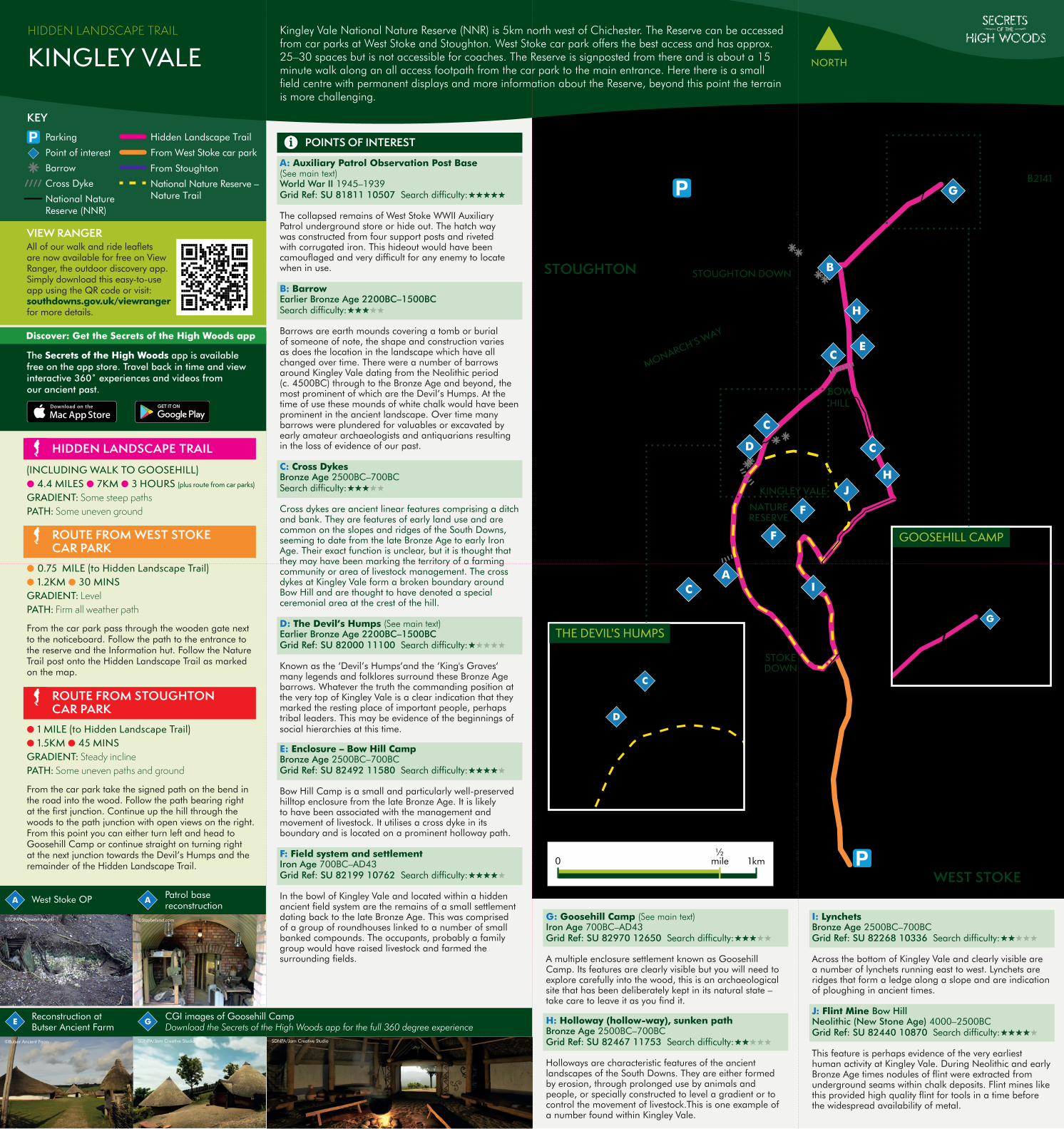
(INCLUDING WALK TO GOOSEHILL) ●4.4 MILES ●7KM ●3 HOURS (plus route from car parks) GRADIENT: Some steep pathsPATH: Some uneven ground
ROUTE FROM WEST STOKE CAR PARK
●0.75 MILE (to Hidden Landscape Trail) ●1.2KM ●30 MINS GRADIENT: LevelPATH: Firm all weather path
From the car park pass through the wooden gate next to the noticeboard. Follow the path to the entrance to the reserve and the Information hut. Follow the Nature Trail post onto the Hidden Landscape Trail as marked on the map.
ROUTE FROM STOUGHTONCAR PARK
●1 MILE (to Hidden Landscape Trail) ●1.5KM ●45 MINS GRADIENT: Steady inclinePATH: Some uneven paths and ground
From the car park take the signed path on the bend in the road into the wood. Follow the path bearing right at the first junction. Continue up the hill through the woods to the path junction with open views on the right. From this point you can either turn left and head to Goosehill Camp or continue straight on turning right at the next junction towards the Devil’s Humps and the remainder of the Hidden Landscape Trail.
VIEW RANGERAll of our walk and ride leaflets are now available for free on View Ranger, the outdoor discovery app. Simply download this easy-to-use app using the QR code or visit:southdowns.gov.uk/viewranger for more details.
From Stoughton
From West Stoke car park
National Nature Reserve – Nature Trail
Point of interest
Parking
Barrow
Cross Dyke
National NatureReserve (NNR)
Hidden Landscape Trail
SotHWKingleyVale1-RouteCard_V04
Car Parks
WestStoke-KingleyVale
Stoughton-KingleyVale
Westdean-KingleyVale
KingleyValeNT
KingleyValeA
SotHWKingleyVale-Barrows
KingleyValeFeatures
National Nature Reserves (NNRs)
Legend
© Crown copyright and database rights 2017Ordnance Survey 100050083
Scale at A4
STOUGHTON DOWN
B2141
BOWHILL
KINGLEY VALENATURERESERVE
STOUGHTON
STOKEDOWN
WEST STOKE
MONARCH’S WAY
D
CA
C
C
G
JH
H
B
I
E
F
F
C
HIDDEN LANDSCAPE TRAIL
KINGLEY VALE NORTH
GCGI images of Goosehill CampDownload the Secrets of the High Woods app for the full 360 degree experience
SDNPA/Jam Creative Studio SDNPA/Jam Creative Studio
Reconstruction at Butser Ancient Farm
©Butser Ancient Farm
A West Stoke OP
©SDNPA/Stewart Angell
APatrol basereconstruction
©Staybehind.com
KEY
POINTS OF INTEREST
A: Auxiliary Patrol Observation Post Base (See main text) World War II 1945–1939Grid Ref: SU 81811 10507 Search difficulty:_____
The collapsed remains of West Stoke WWII Auxiliary Patrol underground store or hide out. The hatch way was constructed from four support posts and riveted with corrugated iron. This hideout would have been camouflaged and very difficult for any enemy to locate when in use.
B: Barrow Earlier Bronze Age 2200BC–1500BCSearch difficulty:_____
Barrows are earth mounds covering a tomb or burial of someone of note, the shape and construction varies as does the location in the landscape which have all changed over time. There were a number of barrows around Kingley Vale dating from the Neolithic period (c. 4500BC) through to the Bronze Age and beyond, the most prominent of which are the Devil’s Humps. At the time of use these mounds of white chalk would have been prominent in the ancient landscape. Over time many barrows were plundered for valuables or excavated by early amateur archaeologists and antiquarians resulting in the loss of evidence of our past.
C: Cross Dykes Bronze Age 2500BC–700BCSearch difficulty:_____
Cross dykes are ancient linear features comprising a ditch and bank. They are features of early land use and are common on the slopes and ridges of the South Downs, seeming to date from the late Bronze Age to early Iron Age. Their exact function is unclear, but it is thought that they may have been marking the territory of a farming community or area of livestock management. The cross dykes at Kingley Vale form a broken boundary around Bow Hill and are thought to have denoted a special ceremonial area at the crest of the hill.
D: The Devil’s Humps (See main text)Earlier Bronze Age 2200BC–1500BCGrid Ref: SU 82000 11100 Search difficulty:_____
Known as the ‘Devil’s Humps‘and the ‘King's Graves‘ many legends and folklores surround these Bronze Age barrows. Whatever the truth the commanding position at the very top of Kingley Vale is a clear indication that they marked the resting place of important people, perhaps tribal leaders. This may be evidence of the beginnings of social hierarchies at this time.
E: Enclosure – Bow Hill Camp Bronze Age 2500BC–700BCGrid Ref: SU 82492 11580 Search difficulty:_____
Bow Hill Camp is a small and particularly well-preserved hilltop enclosure from the late Bronze Age. It is likely to have been associated with the management and movement of livestock. It utilises a cross dyke in its boundary and is located on a prominent holloway path.
F: Field system and settlement Iron Age 700BC–AD43Grid Ref: SU 82199 10762 Search difficulty:_____
In the bowl of Kingley Vale and located within a hidden ancient field system are the remains of a small settlement dating back to the late Bronze Age. This was comprised of a group of roundhouses linked to a number of small banked compounds. The occupants, probably a family group would have raised livestock and farmed the surrounding fields.
G: Goosehill Camp (See main text) Iron Age 700BC–AD43Grid Ref: SU 82970 12650 Search difficulty:_____
A multiple enclosure settlement known as Goosehill Camp. Its features are clearly visible but you will need to explore carefully into the wood, this is an archaeological site that has been deliberately kept in its natural state – take care to leave it as you find it.
H: Holloway (hollow-way), sunken path Bronze Age 2500BC–700BCGrid Ref: SU 82467 11753 Search difficulty:_____
Holloways are characteristic features of the ancient landscapes of the South Downs. They are either formed by erosion, through prolonged use by animals and people, or specially constructed to level a gradient or to control the movement of livestock.This is one example of a number found within Kingley Vale.
I: Lynchets Bronze Age 2500BC–700BCGrid Ref: SU 82268 10336 Search difficulty:_____
Across the bottom of Kingley Vale and clearly visible are a number of lynchets running east to west. Lynchets are ridges that form a ledge along a slope and are indication of ploughing in ancient times.
J: Flint Mine Bow Hill Neolithic (New Stone Age) 4000–2500BCGrid Ref: SU 82440 10870 Search difficulty:_____
This feature is perhaps evidence of the very earliest human activity at Kingley Vale. During Neolithic and early Bronze Age times nodules of flint were extracted from underground seams within chalk deposits. Flint mines like this provided high quality flint for tools in a time before the widespread availability of metal.
i
The Secrets of the High Woods app is available free on the app store. Travel back in time and view interactive 360˚ experiences and videos from our ancient past.
Discover: Get the Secrets of the High Woods app
SotHWKingleyVale1-RouteCard_V04
Car Parks
WestStoke-KingleyVale
Stoughton-KingleyVale
Westdean-KingleyVale
KingleyValeNT
KingleyValeA
SotHWKingleyVale-Barrows
KingleyValeFeatures
National Nature Reserves (NNRs)
Legend
© Crown copyright and database rights 2017Ordnance Survey 100050083
Scale at A4
STOUGHTON DOWN
B2141
BOWHILL
KINGLEYVALE
NATURERESERVE
STOUGHTON
STOKEDOWN
WEST STOKE
MONARCH’S WAY
D
C
A
C
C
G
J
H
H
B
B
I
E
F
F
C
SotHWKingleyVale1-RouteCard_V04
Car Parks
WestStoke-KingleyVale
Stoughton-KingleyVale
Westdean-KingleyVale
KingleyValeNT
KingleyValeA
SotHWKingleyVale-Barrows
KingleyValeFeatures
National Nature Reserves (NNRs)
Legend
© Crown copyright and database rights 2017Ordnance Survey 100050083
Scale at A4
STOUGHTON DOWN
B2141
BOW HILL
KINGLEY VALENATURERESERVE
STOUGHTON
STOKEDOWN
WEST STOKE
MONARCH’S WAY
D
C
A
C
C
G
JH
H
B
B
I
E
F
F
C
GOOSEHILL CAMP
THE DEVIL'S HUMPS
Kingley Vale National Nature Reserve (NNR) is 5km north west of Chichester. The Reserve can be accessed from car parks at West Stoke and Stoughton. West Stoke car park offers the best access and has approx. 25–30 spaces but is not accessible for coaches. The Reserve is signposted from there and is about a 15 minute walk along an all access footpath from the car park to the main entrance. Here there is a small field centre with permanent displays and more information about the Reserve, beyond this point the terrain is more challenging.