the great wagon road of the carolinas - college of william
TRANSCRIPT

W&M ScholarWorks W&M ScholarWorks
Dissertations, Theses, and Masters Projects Theses, Dissertations, & Master Projects
1974
The Great Wagon Road of the Carolinas The Great Wagon Road of the Carolinas
Richard George Remer College of William & Mary - Arts & Sciences
Follow this and additional works at: https://scholarworks.wm.edu/etd
Part of the United States History Commons
Recommended Citation Recommended Citation Remer, Richard George, "The Great Wagon Road of the Carolinas" (1974). Dissertations, Theses, and Masters Projects. Paper 1539624870. https://dx.doi.org/doi:10.21220/s2-w0y7-0655
This Thesis is brought to you for free and open access by the Theses, Dissertations, & Master Projects at W&M ScholarWorks. It has been accepted for inclusion in Dissertations, Theses, and Masters Projects by an authorized administrator of W&M ScholarWorks. For more information, please contact [email protected].

THE GREAT WAGON ROAD OF THE CAROLIRAS
A Thesis Presented to
The Faculty of the Department of History The College of William and Mary in Virginia
In Partial Fulfillment Of the Requirements for the Degree of
Master of Arts
byRichard George Reiner
1974

APPROVAL SHEET
This thesis is submitted in partial fulfillment of the requirements for the degree of
Master of Arts
HcUU'Author
Approved, August 1974
/ f ? > O QRichard Maxwell Brown
. - „ vEdward M. R i l e y /
James Thompson
sos s
TABLE OF CONTENTSPage
ACKNOWLEDGEMENTS...................................... ivLIST OF M A P S ........................................... vABSTRACT............................................... viINTRODUCTION ......................................... 1CHAPTER I. THE ROAD IN THE NORTH................... 6CHAPTER II. THE ROAD IN NORTH CAROLINA............... 27CHAPTER III. THE ROAD IN SOUTH CAROLINA............. 78APPENDIX................................................. 105BIBLIOGRAPHY ........................................... 106

ACKNOWLEDGMENTS
The writer wishes to express his appreciation to Professor Richard Maxwell Brown, under whose guidance this investigation was conducted, for his advice and criticism throughout the investigation; to Professor Edward M. Riley and Professor James Thompson for their careful reading and criticism of the manuscript, the latter also for his common sense and encouragement during the research portion of the project; and to my parents, for their unbounded assistance to a needy scholar.
iv

LIST OF MAPS
Map Page1. The G-reat Philadelphia Wagon Road. . Between 2-32. The Carolina Piedmont, 1972....... Between 77-783. The Carolina Back Country, 1775. . - Between 77-78

ABSTRACT
The purpose of this study is to trace the evolution of the G-reat Wagon Road from an Indian trail to its status, at the close of the American colonial period, as the major route of transportation through the Back Country of the Carolinas.
Auxiliary paths, ox-bow formations in the road bed, and the gradual development of county seats and towns all combined to keep the actual route in a state of flux throughout the colonial period. The G-reat Wagon Road, therefore, has been arbitrarily defined as those portions of the route which were first travelled on and improved by white settlers from the northern provinces of British America, and in whose immediate vicinity seminal settlements were established.
Ethnic concentrations and church congregations have been analyzed to highlight the settlement pattern of a frontier where most of the population was highly transient and widely dispersed.
In little more than a decade, the G-reat Wagon Road funneled thousands of pioneers, among them a large percentage of Scotch-Irish and German immigrants, into the Piedmont district of the Carolinas. The original Indian trail that preceded the Road was transformed both physically and conceptually by the passage of this migration. Individual efforts and, eventually, organized labor under official supervision, widened and reshaped the route to accommodate the burden of traffic; the length of this intercolonial route, from Philadelphia in Pennsylvania to Camden in South Carolina, and the tremendous volume of traffic it bore made it the "great" thoroughfare of colonial America. At Camden, the Great Wagon Road passed Into previously settled districts and lost its identity as a frontier route.
The accompanying plates Illustrate the approximate location of the Great Wagon Road at the time of the outbreak of the American Revolution.
vi

THE GREAT WAGON ROAD OF THE CAROLINAS

INTRODUCTION
Of all the colonial maps in existence, one of the most celebrated and influential in the settlement of America is the Pry and Jefferson Map of the Most Settled Farts of Virginia. Originally drafted by Joshua Fry, a former professor of mathematics at the College of William and Mary, and Colonel Peter Jefferson, the father of Thomas Jefferson and a long-time associate of Fry in surveying expeditions, this map gave the most accurate and complete portrayal of Virginia’s Back Country topography and settlements until later maps replaced it at the time of the
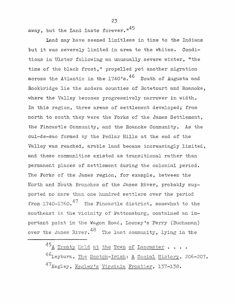
2Revolution.One of the most prominent features on the 1755 edi
tion of the map is ’’The G-reat Wagon Road from the Yadkin River through Virginia to Philadelphia distant 435 miles." From its northern terminus at the Schuylkill River Ferry in
■ Thomas Jefferys, The American Atlas: Or a Geographical Description of the Whole Continent of North America (London: Sayer and Bennett, 1778), Plate #22.
2Richard L. Morton, Westward Expansion and Prelude to War, Vol. II of Colonial Virginia (Chapel Hill: University of North Carolina Press, I960), 553-554; William P. Cumming, The Southeast in Early Maps (Chapel Hill: University of North Carolina Press, 19^2)7 219.

2Philadelphia, the road originally took a rolling path west to Lancaster, proceeded to Harrisburg (Harris' Ferry) on the Susquehanna River, then continued down to Williamsport (William's Ferry) on the Potomac River, at the entrance to the Valley of Virginia. (doing up (that is, to the southwest) the Valley by way of Winchester, Strasburg, Harrisonburg, Staunton, and Lexington, it crossed the James River at Buchanan (Looney's Ferry), and changing its course from southwest to south, it came to Roanoke (Big Lick), where it again swerved, this time to the east and the Staunton River Gap, where it passed through the Blue Ridge Mountains. Once past this barrier, the Road turned south, crossing the Black- water, Pigg, and Irvine Rivers in Southside Virginia, the Dan River in Worth Carolina, and ended at "Unitas" orWachovia, the Moravian community on Gargals Creek, a branch
3of the great Yadkin River.The Road itself was an amalgam of old Indian trails,
animal paths, and recent trading routes. One of the greatWarrior Paths, used by the Iroquois, Shawnee, Cherokee, andCatawba tribes in their forays against one another, formeda large portion of the Road, specifically from Harrisburg,
4Pennsylvania, to Salisbury, North Carolina. From here,
3Carl Bridenbaugh, Myths and Realities: Societies of the Colonial South (Baton Rouge: Louisiana State University Press , 1952)", 129.
^Charles E. Kemper, "Some Valley Notes," Virginia Magazine of History and Biography, XXIX (Oct. 1921), 417;Paul A. Wallace, Indian Paths of Pennsylvania (Harrisburg: Pennsylvania Historical and Museum Commission, i960). 180.

Hie Great Philadelphia Wage
LANCASTER ^ > 1
lNOVER
LEXINGTON Virginiaroanoke
MARTINSVIUU
SALISBURY1
South Carolina

3the Road incorporated parts of the Trading Path to theIndians. From Salisbury, this route went on to Concord,Forth Carolina, where it forked. The western fork, orCatawba Path, crossed the Catawba River at Ration Ford,South Carolina, then continued on towards Augusta, Georgia.The eastern fork, or Waxhaw Path, remained on the eastbank of the Catawba, followed the river to where its namechanged to the Wateree, then ended in central South Caro-
• 5lina in the vicinity of Camden.These segments are only the oldest and most important
stretches of the route, for in places, a veritable maze of trails appears paralleling them. As new settlements were made, new routes were blazed and cleared to guarantee access to the Road, diverting, sometimes permanently, the route of travel. What must constantly be kept in mind, then, is that there was not one great Road, tunneling through the wilderness, but rather many trails, paths, and routes in the same general direction, and that as settlement proceeded, the course of travel was at times multiplied and at other times, altered.
The region traversed by this Road was commonly referred to as either the "Back Parts" or "the Back Country."It was, in general, the great Piedmont district that lies
Douglas L. Rights, "The Trading Path to the Indians," North Carolina Historical Review, VIII (Oct. 1931), 404.

4between the coastal plains of the eastern United States and the sprawling mass of the Appalachian Mountains. This Piedmont district stretches as far east as the western banks of the Delaware River and the Chesapeake Bay. Its northern and western limits are the foothills of the Appalachian Mountains, known as the Alleghenies in Pennsylvania. The only interruptions in this exceedingly fertile and gently undulating region are the South and Blue Ridge Mountains, an older and considerably eroded mountain chain that parallels the Appalachians to the east. Between the South Mountain and the Alleghenies lies the Cumberland Valley of Pennsylvania, the northeastern extension of the Valley of Virginia, which, in turn, lies between the Blue Ridge and Appalachian Mountains.
The Piedmont district continues south on both sides of the Blue Ridge until that chain merges with the Appalachians in southern Virginia. In the Carolinas, the Appalachians recede to the southwest, ending in the C-reat Smokies of G-eorgia and Alabama, while the coastal plain widens simultaneously. In North Carolina, the sandy western portions of the coastal plain, in ancient times, the shore line of the Atlantic, set the Piedmont region off sharply from, the Albemarle, Pamlico, and Cape Pear districts. In South Carolina, this division is even more pronounced; a ridge of sand hills extends across the state’s

5mid-section that retarded and discouraged early penetration into the Back Country.^ Viewed overall, the Back Country is a vast, triangular tract, varying in width from 20 to 160 miles, with its base on the Savannah River, from where it stretches northeastward into upper Virginia, then curves rapidly eastward to its termination in southeastern Pennsylvania .
Robert Ramsey, in his monograph on the settlement ofthe North Carolina frontier, states:
American historians have erred grievously in emphasizing the westward movement after the Revolution, while virtually ignoring the vital population shifts before 1754 . . . virtually nothing has been done totrace the southward migration of thousands of persons from the Chesapeake Bay-Delawrare Valley region during the second quarter of the eighteenth century. During the century prior to 1830, the entire piedmont South was settled by those who took part in „ this migration, or by their sons and gransons . . .This thesis will hopefully contribute to the reevalu-
tion of these events by tracing the major artery of colonial migration to the piedmont South, the G-reat Wagon Road.
^Bridenbaugh, Myths and Realities, 120-121.7Robert Ramsey, Carolina Cradle: The Settlement of
the Northwest Carolina Frontier, 1747-1762 (Chapel Hill: University of North Carolina Press, 1964") 7 xi-xii.

CHAPTER I
THE ROAD IN THE NORTH
To the province of Pennsylvania, in the late seventeenth and early eighteenth centuries, came a number of migrations. The first to reach the area were the English, Welsh, and Irish Quakers, establishing the colony in 1682 and settling the original counties of Philadelphia, Bucks, and Chester. The combination of religious freedom, civil liberties, amazingly fertile soil, and excellent relations with the Indians of this "Holy Experiment” seemed little short of miraculous, and following the publication and distribution of reports on these conditions overseas, the
gpeople of Europe responded eagerly.Among the earliest to follow the British Quakers were
Germans from the Rhenish Palatine and the neighboring Rhineland districts in western Germany. This area had, from the time of the ruinous Thirty Years War (1618-1648), seen little peace or prosperity, and was to repeatedly
gEor a detailed analysis of these conditions, see James T. Lemon, The Best Poor ManTs Country: A Geographical Study of Early Southeastern Pennsylvania (Baltimore: Johns Hopkins University Press, 1972^7

7figure as the battleground of Europe in the War of the League of Augsburg (1689-97), the War of the Spanish Succession (1702-14), and the War of the Austrian Succession (1741-48). Religious persecution increased during these years, particularly as the Pietist movement spread throughout the numerous German principalities, each with its own established church. News of Pennsylvania and the relief and opportunity it promised prompted a number of pietist groups, among them, Mennonites, Dunkards, Amish, andSchwenkfelders, to emigrate as early as 1683, founding
9Germantown as the initial German settlement. Heavier immigration after the War of the Spanish Succession broke out brought in the more established denominations, so that by the 1740's, the main sectarian components of the Pennsy- vania Germans were the Lutherans under Heinrich Muhlenberg,the German Reformed under Michael Schlatter, and the Morav-
10ians under Nicholas, Count Zinzendorf.Religious and economic difficulties in Ulster, mean
while, were launching another mass migration to the Delaware Valley. The Scots in these six northern counties of Ireland had labored under English mercantile restric-
^Frederic Klees, The Pennsylvania Dutch (New York: The Macmillan Co., 1951), 137-139.
■^Carl Hammer, Rhine1anders on the Yadkin: The Story of the Pennsylvania Germans in Rowan and Cabarrus Counties, North Carolina, 2nd ed. rev.TSalisbury, N.C.: Rowan Printing Co., 1965), 22.
tions since the days of Cromwell. Woolen manufacture,northern Ireland’s staple industry, had been devastatinglyshut off from foreign markets by an act forbidding its ex-
11portation to any part of the world save England. The hardships increased as time passed. In 1702, the Ulster Test Act placed a number of penalties on the practice of the Presbyterian religion of these Scotch-Irish. Dissenters from the Established Church of Ireland were forbidden to teach, denied positions in the Army, the local militia, posts in the civil service, and seats in municipal corporations. Ministers were imprisoned for preaching the gospel at informal gatherings, and individual members were liable to corporal punishment for their beliefs. On top of all this, in the midst of a severe economic depression in the 1710’s, a number of long-term leases fell due, and rents were raised to unheard of heights. Wholesale ejections followed, and the resulting dislocation set off a periodof famines and smallpox epidemics among both the people
12and their stock.'Small wonder, then, that so many left so eagerly for
a new life in the New World. The religious and economic
Hgeorge Wesley Troxler, ’’The Establishment of Pres- byterianism in North Carolina" (unpublished Ph.D. dissertation, University of North Carolina, 1966), 8.
3 2"Ernest T. Thompson, Presbyter!ans in the South (Richmond: John Knox Press, 196317 i! 41 •

9benefits of life in Pennsylvania brought settlers flockingto the colony, landing at ports along the Delaware Riverlike hew Castle and Chester, as well as Philadelphia. TheGerman and Scotch-Irish immigrants were primarily farmers,rather than artisans or laborers, and unless indenturesbound them for a time, they headed immediately for thefrontier lands beyond the settled districts. The earliestGerman immigrants had settled in those areas peripheral tothe more expensive and populated Quaker regions aroundPhiladelphia. Accordingly, the Scotch-Irish began to takeup land further to the north and west. Not only was thisa practical economic procedure but it fit in well with theprovincial plans for frontier defense. James Logan, theprovincial secretary, wrote that about the year 1720,
a considerable number of good, sober people came in from Ireland, who wanted to be settled. At the time . . . we were under some apprehension of the Northern Indians . . . I therefore thought it might be prudent to plant a settlement of such men as those who had so bravely defended Londenderry and Inniskillen, as a frontier, in the case of any disturbance . . . These people . . . if kindly usedwill, I believe, be orderly, as they have hitherto been, and easily dealt with.-*-Logan, Scotch-Irishman though he was, seems to have
gravely misjudged his countrymen, for they were anything but easily managed. Rather than calm the frontiers, they
13James Logan, ’’Letter of Instructions on Provincial Affairs, James Logan to James Steel, November 18, 1729,"Pennsy1vania Magazine of - History and Biography, XXIV (1900), 495.

10embroiled them by constantly squabbling with their German neighbors. By 1723, settlement had pushed out onto the east bank of the Susquehanna River, which would be organized as Lancaster County in 1729- Rivalry between the two groups in this region is evident in their settlement patterns; no sooner would the Scotch-Irish move into one part of a river valley than the Germans would move into another. The newest arrivals simply advanced beyond settlement to repeat the process. The language barrier, religion, cultural attitudes, social heritage, and temperament all militated against intimacy, and the race for the best lands became an issue of ethnic security as well as economic neces-. , 14sity.
If continued immigration kept the pace of settlement at a brisk pace, internal migration accelerated it. Moving up from the Chesapeake Bay region into the lower Susquehanna Valley and Lancaster County came settlers from Maryland and Delaware. Maryland had been established much earlier than Pennsylvania, but population growth was now making up for slower rates of immigration. The port of New Castle has already been cited as a point of entry for immigrants, and in a small district like the Lower Counties (as Delaware was then known), land had been quickly parcelled
James G. Leyburn, The Scotch-Irish: A Social History (Chapel Hill: University, of North Carolina Press, 1962""7"| 190-191.

11out. Consequently, newcomers looked to the northern frontier
15in Pennsylvania for settlement.Under this pressure, the migration surged over the
Susquehanna River into the Cumberland Valley. As early as 1721, squatters had entered these lands, asserting that "it was against the laws of God and Nature, that so much land should be idle while so many Christians wanted it to labor on and to raise their b r e a d . N o Indian title had been secured by the Penns to these lands west of the Susquehanna, and the squatters were ordered to leave. By the 1750's, however, squatting had become so widespread that Samuel Blunston of Wright’s Ferry was authorized to grant a restricted number of licenses for the Cumberland Valley.
The movement into this region was aided by the use of a new innovation, the Conestoga Wagon. The earliest mention of this transport vehicle is found in a ledger account of James Logan in 1716. By that time, settlement had proceeded so far to the west that daily trips to Philadelphia for trade or supplies had become impractical, and accumulated goods had to be transported by wagon. Combining features of eighteenth-century English road wagons and the larger farm wagons of western Germany, their production
15Ramsey, Carolina Cradle, 12.■^Charles A. Hanna, The Scotch-Irish or The Scotch in
North Britain, North Ireland and North America, II, 63, as cited in Thompson, Presbyterians in the South, 4-4.

centered in the Conestoga Valley of Lancaster County, andsoon, standardized features and details to suit taste and
17needs were developed.The Conestoga wagons were masterpieces of design and
craftsmanship. The Indian trails that served as early roads between Philadelphia and the Lancaster district were incredibly rough, and only a flexible, yielding structure could stand the strain of a shifting load. Accordingly, the box of the wagon was designed as a giant basket that would yield under stress. furthermore, this ’’basket on wheels” grew more and more concave to nimimize load shifting as the terrain of travel changed. The short hills of the Piedmont presented a relatively minor problem, but in the foothills of the Alleghenies, the shift of a four-ton load could prove disastrous.
The wagons, however, could not float across rivers or even ford the deeper streams because of the loose, woven- like construction of the wagon box. The high bluffs of the Susquehanna also prevented random crossings of the river, so that two ferries played an important role in the growth of the Wagon Road. Harris’ Perry (Harrisburg) was early
17George Shumway, Edward Durell, and Howard C. Prey, The Conestoga Wagon: 1730-1650 (York, Pa.: The Early American Industries Association and George Shumway, 1964), 14-15.

13favored by the Scotch-Irish, since it lay near their settlements in upper Lancaster County. Thirty miles to the south lay Wright’s Ferry (Columbia), used increasingly after 1745 as travelers took a shorter route to Winchester in Virginia, via York, G-ettysburg (the Marsh Creek settlement), then Frederick and Williams’ Ferry (Williamsport)
19in Maryland.Improved transportation only accelerated settlement
and hastened the close of the frontier in Pennsylvania.By 1730, the population movement had reached the Alleghenies, and geographical obstacles as well as provincial opposition brought a partial halt to further encroachment.The Indians were growing extremely hostile at the continued westward movement of the whites, and the Assembly in Philadelphia refused to support the frontiersmen in their de-
20mands for more western lands. Temporarily checked, the population continued to mass in the Cumberland Valley. In 1735? petitions were presented to the county court at Lancaster for the formation of two Valley townships, Penns- boro and Hopewell. What was more important, in November, the court appointed a commission to lay out a road from
19• Charles E. Kemper, "Historical Notes from the Records of Augusta County, Virginia," Papers and Addresses of the Lancaster County Historical Society, XXV (Dec. 192177 151.
20Wayland Fuller Dunaway, "Pennsylvania as an Early Distribution Center of Population," Pennsylvania Magazine of History and Biography, LV (Apr. 1931)? 136.
14Harris1 Ferry toward the Potomac to answer the needs of the inhabitants.^
This outlet to western Maryland came none too soon. Land prices, driven up by the increasing scarcity of new acreage, had jumped from £2 per hundred acres in 1713 to £ 13 per hundred in 1732. The average acreage held in Pennsylvania at that time was 128 acres; Maryland, in thesame year, offered grants of 200 acres to heads of families
£ 22w 5 .
German settlement early claimed much of the land inwestern Maryland. Following the old Indian trail that laterbecame known as the Monocacy Road, they peopled the areaalong the Monocacy River in northern Frederick County, thefirst group settling near Creagerstown about 1729. Fromhere, they penetrated westward, through the South Mountainat Compton's Gap, into the area around Hagerstown in
23Washington County. The pattern of settlement remained much the same as in Pennsylvania, and as it was to continue
21Frederick Bittle Kegley, Kegley's Virginia Frontier: The Beginning of the Southwest; The Roanoke of Colonial Days, 1710-1763 (Roanoke: South-West Virginia Historical Society, 193877 37.
p pBridenbaugh, Myths and Realities, 138; Ray Allen Billing!on, Westward Expansion: A History of the American Frontier (Hew York: Macmillan Co., 194977 90.
23AJ-bert Bernhardt Faust, The German Element in the United States (New York: Arno Press and New York Times,196977 TTT67.

15in Virginia and the Carolinas— along the upper reaches of a creek and convenient to a land route. Towns were formed years after the initial settlements had "been made. Hagerstown, for example, despite its strategic position on the route to the Valley of Virginia (or Shenandoah Valley, as it came to be called), was not founded until 1762. By the close of the colonial period, the Germans had completely settled the territory from the Monocacy to the ConococheagueRiver at the head of the Shenandoah Valley, and formed the
24predominant ethnic element in western Maryland.Scattered ventures in the Shenandoah Valley itself
occurred as early as 1726, when a group led by Jacob Stoverlocated on the south branch of the Shenandoah River near
25modern Strasburg. Widespread settlement in the Valley dates from 1751 when Joist Hite, a former settler in the Monocacy area, and his Scotch-Irish partner, Robert McKay, bought out a number of land grants from John and Issac Van Meter. The latter had originally obtained the land in 1750 from Governor Gooch, an enthusiastic supporter of frontier
26settlement, on the promise of occupation within two years. Hite proceeded to settle approximately sixteen families on
24Dunaway, "Pennsylvania as an Early Distribution Center of Population," 157.
25ibid., 139.26Morton, Westward Expansion, 542-544.

16his Opequon Creek tract, just south of modern Winchester. Somewhat to the’north and west, a settlement of Quakers from Pennsylvania was organized by Morgan Bryan and Alexander Ross about this time. Its rapid growth allowed theHopewell Meeting House of Friends to be organized in 1754,
27the first Quaker congregation in the Vallay. While a sizable number of Quakers of English and Welsh descent migrated into the area, the Germans continued to constitute the major portion of settlers moving into this region during the 1750's. Berkeley and Jefferson counties in modern West Virginia attracted few Germans, as well as Clarke County in Virginia, but further south in Frederick, Shenandoah, and Rockingham counties, they became and remained the
28predominant ethnic element.The success of Hite and the German settlements prompted
Gooch to issue two more grants in 1756 for the settlement of the central and southern portions of the Valley. As mentioned earlier, settlement of the Cumberland Valley by the Scotch-Irish at this time had come to an impasse, and it is not surprising that these new grants soon attracted them in large numbers. A few Scotch-Irish families had already entered the area, but a grant of 118,491 acres of land to
27Ramsey, Carolina Cradle, 155.28Runaway, "Pennsylvania as an Early Distribution
Center of Population," 140.

17Sir John Randolph and his associates prepared the way for heavier settlement. William Beverly, an enterprising planter-merchant of Essex County, Virginia, saw the opportunities and Bought out the Randolph group, setting up
29what came to he called the "Beverly Grant." The tractembraced the northern portion of modern Augusta County,
30including the modern towns of Staunton and Waynesboro.A few months later, the second patent was issued to
Benjamin Borden, a native of hew Jersey, at this time residing near the site of modern Winchester. Beginning at the southern boundary of the Beverly Grant and stretching across the headwaters of the Shenandoah and James Rivers, it encompassed nearly 500,000 acres in all, occupying the southern portion of Augusta County and nearly all of Rockbridge County to the south. Both Beverly and Borden sent agents and distributed advertisements of their holdings to Pennsylvania, which they offered at the compellingly low price of £3 per hundred acres.^
The rich, rolling savanna lands of the Valley offered few of the obstacles that earlier settlers had encountered when clearing their way through the forests of Pennsylvania
29Kemper, "Botes from Augusta County," 149*30Leyburn, The Scotch-Irish: A Social History, 204.31Kemper, "Notes from Augusta County," 149; Leyburn,
The Scotch-Irish: A Social His tor.y, 204-205.

18and Maryland. The Scotch-Irish passed through the recentlysettled German districts in the north, and establishedthemselves in Augusta and Rockbridge Counties, the lattersometimes called "the most Scotch-Irish county in theUnited States."
Travel up and down the Valley was primarily directedover the old Warrior Path that ran its length. A paralleltrail, east of the Blue Ridge Mountains and later known as"the Lower Pennsylvania Road," had served as the main north-south Indian route until white settlement pushed west ofthe Virginia fall line in the early eighteenth century. Toprotect both red and white Virginians from the intertribalwarfare carried on over this route, a treaty was signed atAlbany, hew York, in September of 1722, wherein the Six
32Nations agreed to restrict their travels to the western side of the Blue Ridge Mountains, i.e., through the Shenan-
rZ 'Zdoah Valley.As white migration pushed down from Pennsylvania and
Maryland into the Valley, the settlers readily followed the old trail, since Indian trails normally took a dry, level,
32The Six Nations consisted of the Mohawks, Oneidas, Onandagas, Cayugas, Senecas, and, after 1713, the Tuscaro- ras.
33E. B. 0 ’Callaghan, ed., Documents Relative to the Colonial History of the State of New York (Albany: Weed, Parsons & Co., 1835), V, 670-671.

1954and direct route. As settlement increased and traffic
became heavier, however, the trails deteriorated and theneed arose for systematic road improvement and maintenance.A Virginia legislative act of 1705 outlined the generalprocedure to be followed. Court appointed surveyors "intheir several precincts" were to lay out public roads
from such places as shall be most convenient for passing to and from the City of Williamsburg, the court house of every country, the parish churches, and such public mills and ferries as now are or hereafter shall be erected, and from one county to another.35
Commissioners for roads were also appointed by thecourts to direct this construction and to supervise theirmaintenance. A typical appointment from the Augusta CountyConstruction Records of 1746 noted that
Robt. Armstrong is appointed Overseer of the Road from Jenning's G-ap to Daniel McAnairfs— thence to John Fenla’s Cooper— thence to the Court House— all tithables within 4 miles on each side to workthe road.36Although specifications and procedures for good roads
were clearly outlined in the law, a system based on local responsibility was bound to fail since frontier conditions
54Paul A. Wallace, Historic Indian Paths of Pennsylvania , Pennsylvania Historical Reprints (Harrisburg: Pennsylvania Museum and Historical Commission, 1952), 4.
55Morton, Westward Expansion, 550.56_lyman Chalkley, ed. Chronicles of the Scotch-
Irish Settlements in Virginia: Extracted from the Original Court Records of Augusta County, 174 5-1600 (Rosslyn, Va. : Commonwealth Printing Co., 1912), I, 530.

20precluded the necessary financial resources and engineer-
37ing skills needed for proper construction and maintenance. The Great Wagon Road, thus, remained little more than a single track trail, winding through the Valley, until
ZZ Oafter the Revolution.Just how heavy settlement was in these early years
is difficult to determine from first-hand accounts. Most population was rural and widely dispersed along the numerous creeks and streams that flowed into the Shenandoah and James Rivers. Lands were cleared, cabins built, crops planted, and game killed. It was a bountiful land, and only one component was lacking to make this Scotch-Irish microcosm complete— their "Kirk.”
In 1738, the Presbyterian Synod of Philadelphia wrote to Governor Gooch
in behalf of a considerable number of our brethren who are meditating a settlement in the remote parts of your government and are of the same persuasion with the Church of Scotland. We thought it our duty to acquaint your honor with their design, and to ask your favor in allowing them the liberty of their conscience, and of worshipping God in a way agreeable to the principles of their education.. . . 8
• Edward G. Roberts, "The Roads of Virginia, 1607- 1840" (unpublished Ph.D. dissertation, University of Virginia, 1950), 11.
38 Kegley, Kegley *s Virginia Erontier, 180.39 Edwin S. Gaustad, ed., Records of the Presbyterian
Church in the United States of America, 1706-1788 (New York: Arno Press, 1969), 141.

21Gooch, in reply, "always inclined to favor the people whohave lately moved from other provinces, to settle on thewestern side of our great mountains," willingly assuredthem that there would he no interference as long as troubleor controversy were avoided, and registration regulations
40concerning Dissenters were observed.Presbyterian missionaries had already organized a
congregation in the Hite settlement at Cedar Creek in 1737, the oldest extant church with a continuous history in the Southern Presbyterian Church. In 1740, the Revernnd John Craig arrived to become the pastor of the Augusta (Old Stone) and Tinkling Spring congregations serving the Beverly and Borden tracts, the first settled pastor in western Virginia.
Yet, even as religious institutions were beginning to bring a more civilized atmosphere to these Scotch-Irish settlements, new incidents revealed how close they still were to the wilderness. In March of 1743, the South Carolina Gazette reported that thirty Indians, coming down the Susquehanna River, had stolen canoes at Harris' Ferry, raided "the Irish settlement, the Beverly Grant, in the back part of Virginia," killed a number of horses and
42cattle, and left three traders "shot dead in the Road."
4QIbid., 145.^Thompson, Presbyterians in the South, I, 48.
South Carolina Gazette (Charleston, March 7, 1743*
22The Indians had their own complaints ahout conditions
in the Valley. The prairie lands of the Shenandoah had been created by the Indians who, after hunting in this excellent game district, would fire the new undergrowth as they left in order to ensure continued grassy plains for the buffaloes. White settlers rapidly depleted the game and converted grazing lands into farm lands. As the Indians saw it:
We had not been long in the Use of this new Road before your People came, like Flocks of Birds, and sat down on both sides of it, and yet we never made a Complaint to you, tho you must be sensible those things must have been done by your People in manifest Breach of your own Proposal made at Albany.43
To settle the outstanding grievances of both sidesover western affairs, the governments of Pennsylvania,Maryland, and Virginia held a conference with the offendedSix Nations at the courthouse of Lancaster, Pennsylvaniafrom June 22 to July 4, 1744. At this conference, theIndians relinquished any territorial claims to the Valleyfor some English goods and an assurance of unrestricted
44usage of their "Virginia Road,” as they called it. One of the Indians was later heard to remark, all too knowingly, that ". . . what little we have had for the Land goes soon
4 bA Treaty Held at the Town of Lancaster in Pennsylvania . . . with the Indians of the Six Nations, In June,1744 (Philadelphia: Benjamin Franklin at the New Printing Office near the Market, 1744), 17.
^Morton, Westward Expansion, 533-554.
2345away, but the Land lasts forever.”
Land may have seemed limitless in time to the Indians but it was severely limited in area to the whites. Conditions in Ulster following an unusually severe winter, "the time of the black frost,” propelled yet another migration across the Atlantic in the 1740*s.^ South of Augusta and Rockbridge lie the modern counties of Botetourt and Roanoke, where the Valley becomes progressively narrower in width.In this region, three areas of settlement developed; from north to south they were the Forks of the James Settlement, the Fincastle Community, and the Roanoke Community. As the cul-de-sac formed by the Pedlar Hills at the end of the Valley was reached, arable land became increasingly limited, and these communities existed as transitional rather than permanent places of settlement during the colonial period.The Forks of the James region, for example, between the North and South Branches of the James River, probably supported no more than one hundred settlers over the period
47from 1740-1760. The Fincastle district, somewhat to the southeast in the vicinity of Pattonsburg, contained an important point in the Wagon Road, Looney's Ferry (Buchanan)
48over the James River. The last community, lying in the
45A Treaty Held at the Town of Lancaster . . . .^leyburn, The Scotch-Irish: A Social History, 206-207.47Kegley, Kegley's Virginia Frontier, 137-138.
24watershed of the Roanoke River, formed the terminus of the Valley segment of the Road. Here, the rugged escarpment of the Pedlar Hills closes off the Shenandoah Valley. Except for this barrier, migration might have continued on
49down to the Cumberland Gap and into Kentucky and Tennessee.As it was, the route passed eastward through the
Staunton River Gap then veered south, crossing the Black-water, Pigg, and Irvine Rivers in modern Franklin andHenry Counties. A court order of 1745, referring to the’’Valley Road’1 as it approached its end, ordered
the clearing of the Same as it is already Blazed and laid off with Two Knotches and a Cross and when cleared to keep the same in repair and it is further ordered that the same Several Overseers do set up posts of Direction if necessary. . . .50
South of the Roanoke Community, the road remained little more than a blazed trail, as in the above court order, until the end of the 1740’s.
By the time of the French and Indian War (1754-1765), most of the choice land in the Valley had been claimed, understandably since there was only approximately 7,500 square miles of land suitable for farming. As the migrants from the Horth came out of the Valley, they met with westward moving Virginians from the Tidewater districts. Hemmed
49Nevin M. Fenneman, Physiography of the Eastern United States (New York: McGraw-Hill Book Co., Inc., 1958), 248-249-
50Kegley, Kegley’s Virginia Frontier, 144.

25in by mountains to the west, and settlement to the northand east, they could only continue their trek south alongthe Indian trail to the Carolina frontier.
During the years 1749-1750, the partially surveyedboundary between Virginia and North Carolina was extendedby commissioners from both provinces. Joshua Fry and PeterJefferson served for Virginia, while William Churton andDaniel Weldon represented North Carolina. The Virginiansreturned from their expedition with news of the expandingsettlement of the Back Country, and eventually incorporated
51the changing frontier conditions in a series of maps.The first Fry and Jefferson Map of the Inhabited Parts
of Virginia outlined the Great Wagon Road and settlement tothe central portion of the Shenandoah Valley, but simply
52noted geographical features in the southern portion. The second edition (1755) benefited from information probably provided by William Churton, who, as surveyor for the Granville District in North Carolina, was able to pinpoint the extent of settlement on the frontier as far to the southwest as the forks of the Yadkin River. On this edition, the Great Wagon Road continues through the entire Valley,
51Delf Norona, ed., "Joshua Fry's Report on the Back Settlements of Virginia," Virginia Magazine of History and Biography, LVI. (1948), 22-41; Cumming, Southeast in Early Maps, 52-53.
52Joshua Fry and Peter Jefferson, Map of the Inhabited Parts of Virginia (London, 1751).

26passes into the areas around modern Martinsville and Rocky Mount in Virginia, then on to the new Moravian settlement at "Unitas” or '’Wachovia,” the nucleus of modern Winston- Salem, Worth Carolina. The Road ends slightly to the west
53of this community, at the Shallow Ford of the Yadkin River.The Fry and Jefferson Map remained the authoritative
guide to the northern Back Country until later maps replaced it around the time of the American Revolution. By that time, the frontier had been pushed back to the foothills of the Appalachians in South as well as Worth Carolina. The rapidity and density of Piedmont settlement in the South were largely the results of continued migration over the Great Wagon Road of the Carolinas.
-^Ibid .

CHAPTER II
THE ROAD IN NORTH CAROLINA
The conditions that caused continuous expansion of settlement in the Back Country of Pennsylvania, Maryland, and Virginia remained unchanged throughout the colonial period. Heavier emigrations from the Rhineland provinces, northern Ireland, and the rest of the British Isles, the gradual decrease of arable frontier land and the corresponding rise of land prices, increasing friction between the settlers and Indians over further western expansion, the ever-present lure of cheaper and unhindered settlement in the South, made increasingly feasible by the presence of the Great Wagon Road— all these factors ensured the necessary momentum to fill the vast grasslands of the Carolina Piedmont.
Looking back over the migrations that began to filterinto this region during the 1740’s, a colonial journalistwas prompted to remark:
There is scarce any history, either antient or modern, which affords an account of such a rapid and sudden increase of inhabitants in a back frontier country, as that of North Carolina. To justify the truth of this observation, we need only to inform our readers, that 20 years ago, there
27

28were not 20 taxable persons within the limits of the above mentioned County of Orange; in which there are now 4000 taxables. The increase of inhabitants, and flourishing state of the other back Counties, are no less surprising and astonishing. 54Contemporary population statistics for this period
are fragmentary and often contradictory. A recent study puts the total population of North Carolina in 1740 at 50,000, in 1760 at 115,000, while by 1775-1776, it had reached 247,000, making it the fourth most populous province in America at the outbreak of the Revolution. This great spurt in growth was largely the result of migration, and most population gains occurred in the piedmont districts rather than the coastal districts.
Until 1728, the Carolinas had been held by eight Lord Proprietors, who did relatively little active promotion of their holdings. Population in North Carolina remained concentrated around Albemarle and Pamlico Sounds, and the mouth of the Cape Pear River. The western portions of the inhabited coastal plains tended to be sandy and covered with scrub pine. In addition to this discouraging terrain, the abysmal conditions of North Carolina roads, running through swampy and thinly populated lowlands, frustrated
54South Carolina and American G-enerai Gazette (Charleston^ March 11, 1768).
J. Potter, "The Growth of Population in America, 1700-1860," in Population in History: Essays in Historical Demography, ed. D. V. Glass and D. E. C. Eversley (Chicago: Aldine Publishing Co., 1965), 658.

29westward movement by the coastal settlers. Roads to theinterior were further delayed in the making by the factthat the principal rivers flow from the northwest to thesoutheast, obstructing the routes which such roads would
56necessarily follow. Considering the primitive means of transportation at hand, and the deterrents they faced, the isolation of the Back Country from the coastal inhabitants throughout most of the eighteenth century becomes quite intelligible.
Yet, if the North Carolinians were strangers to theirown western lands, the enterprising Virginia traders cameto know this region more intimately and longer than theirown piedmont district. On May 22, 1670, a German physiciannamed John Lederer led an expedition from the falls of theJames River to seek out a passage through the distantAppalachian Mountains, and to explore the lands beyond.Lederer proceeded under the authority of Governor WilliamBerkeley of Virginia, one of the Lord Proprietors ofCarolina, but after a few days' journey, a disagreement aroseamong the explorers that left only Lederer and a Susquehanna
57scout, Jacksetavon, to carry on the expedition.
5 6Charles C. Crittenden, The Commerce of North Carolina: 1765-1787 (New Haven: Yale University Press, 1936), 23-24.
57Douglas L. Rights and William P. Cumming, eds., The Discoveries of John Lederer with Unpublished Letters by and about Lederer to Governor John Winthrop, Jr., and an Essay

3 0
Lederer's path of exploration eventually developedinto the important Trading Path to the Indians, thatstretched southwestwardly from the falls of the James River(Richmond) and Pt. Henry (Petersburg) in Virginia to theCatawba and Cherokee lands in central and western South
58Carolina. When the migration of settlers from the northern provinces first began to enter Horth Carolina, it was this Path that they originally followed, winding through their early settlements in modern Durham, Orange, Alamance, and Guilford Counties.
The Path crossed the Yadkin River at the aptly named Trading Pord, six miles northeast of modern Salisbury, where lederer, in his journal, commented on a large village of the Sara, or Saura, Indians. Prom the Sara village, he continued on a south-southwest course until June 25, whenhe reached "Wisacky," or the region commonly referred to as
59"The Waxhaws," along the present South Carolina boundary. Apparently, lederer took the southern fork of the Trading Path directly to the Waxhaw Indian lands; another fork led southwest to the Catawba Indian towns along the banks of the
on the Indians of Lederer's Discoveries (Charlottesville: University of Virginia Press and Wachovia Historical Society, 1958), vii; Rights, "Trading Path to the Indians," 421-422.
58Rights, "Trading Path to the Indians," 404.59Rights and Cumming, Discoveries of Lederer, 29-30.
31Catawba River.
The Waxhaw Indians were subject and related to the Catawbas. In lederer’s time, they maintained separate settlements along Twelve Mile, Waxhaw, and Cane Creeks but after a severe smallpox epidemic in the late 1730's, they merged with the Catawbas.^ It is probable that the early traders from Virginia visited both Waxhaw and Catawba villages, and that as the tribes consolidated, the Waxhaw Path fell into disuse. It is certain, however, that the earliest settlements made by the northern migrants were located along this fork and its extension down to Camden in South Carolina.
On June 26th, lederer came to the main Catawba townof "Ushery." The Ushery, Iswa, Esah, or Catawba Indians,as they are referred to generically, were a compendium oftribes inhabiting the areas embraced by York and LancasterCounties in South Carolina, with villages on both banksof the Catawba River. During his stay, Lederer talked with
61"some Sara Indians that came to trade." It has been previously noted that one of the main purposes of Indian routes was for warfare, but trade was an equally important determinant. The Catawba Indians, in particular, were noted for their trading contacts among other tribes, and their reputation, no doubt, influenced the passage of the
60Ibid■, 123.61Ibid., 31.
32& 2Trading Path through their lands.
Lederer returned to Virginia by a more easterly route, without having ever approached the Appalachians, but he brought back a wealth of information on the lands, inhabitants, and resources of the Carolinas in the journal he kept during his explorations, A hew Voyage to Carolina.His route quickly appeared in print on Thomas Basset’s map,A New Description of Carolina (1676), as "The Virginia Trading Path.
As trade increased with the Carolina Back Country, so did reports of the environment. New physical features, as well as corrections of the old, appeared on the succeeding maps of the cartographers of London, Paris, and Amsterdam. One of the foremost cartographers of the time, Guillaume Delisle, relied heavily on such first hand accounts as Lederer's New Voyage, along with rigorous scientific methods, to compose maps of the highest quality. His Carte de la Louisiane (1718), a most meticulous map of the North American continent, contained a unique feature— a path from the "Kitaba," passing through a mountain corridor, and swinging eastward through Pennsylvania. As far as can
62Charles M. Hudson, The Catawba Nation (Athens, Ga.: University of Georgia Press, 1970), 38.
63Collier Cobb, Transportation in North Carolina (n.p.: n. pub., n.d.), Plate III.
^Cumming, Southeast in Early Maps, Plate #47.

33be ascertained, this is the earliest representation of the original Indian path that preceded the G-reat Wagon Road. Until this time, no other map had pictured a route so close to the Appalachians, nor one within the Shenandoah Valley and continuous all the way to Pennsylvania.
In addition to explorers and cartographers, government officials also constituted an important source of information on the interior of the Carolinas. While most administrative officials remained in the coastal capitals, surveyors and boundary commissioners often ventured far into the hinterlands, bringing back reports of the virgin lands they saw.
Perhaps the most famous account of this variety incolonial history is William Byrd II's The History of the
6 5Dividing Line betwixt Virginia and Worth Carolina. During the course of the second expedition in 1728, the commissioners from Worth Carolina and Virginia passed through the region where the future Wagon Read would run. At the time, of course, the route would exhibit little direct evidence of its existence, but if Byrd’s account is examined with the presence of an Indian path in mind, it becomes quite revealing.
Louis B. Wright, ed., The Prose Works of William Byrd of Westover: Narratives of a Colonial Virginian(Cambridge, Mass.: Belknap Press of Harvard University, 1966), 155-336.

34On October 16th, as the commission surveyed the seg
ment of the line that was to become the northern boundary of Rockingham County (North Carolina), Byrd noted several abandoned Indian clearings, or "old fields," in the area, formerly inhabited by the Sauro (Saura, Sara, Cheraw) Indians. These sites, in the vicinity of Leaksv-ille (now Eden, North Carolina), formed what was known as Lower Sauratown. The other lands of the Sauras, Upper Sauratown, stood thirty miles up the Dan River in Stokes County, near Walnut Cove, North Carolina. This tribe had repeatedly been forced to relocate. From the Trading Ford, where Lederer had come upon them, the Sauras had moved to the Towns along the Dan River. Repeated attacks by the Senecas and other Iroquoian tribes over the nearby Warrior Path to the South forced them to leave these lands around 1710 and join the Keyawee Indians to the southeast. A few years later, they moved on to the Pee Dee River basin in South Carolina, where they gave their name to the region known as "The Old Cheraws." They finally settled among the Catawbas, numbering around fifty or sixty members in 1768.67
For the next few days, the party wound its way through
66Ibid., 251.C r y
Douglas L. Rights, The American Indian In North Carolina (Winston-Salem, N.C.: John F. Blair, 195771 116- 118.
35dense underbrush and saplings, "the woods whereof had been
68burnt not long before." By October 20th, with MatrimonyCreek a short distance to the east, "the atmosphere was sosmoky all around us that the mountains were again growninvisible. This happened not from the haziness of thesky but from the firing of the woods by the Indians, forwe were now near the route the northern savages take whenthey go out to war against the Catawbas and other southern
69nations."Byrd commented at length on the "implacable hatred"
of the northern, i.e., Iroquoian (Six Nations), Indians for those of the South, lasting four generations over what seemed to be the slightest of provocations. The motivation for maintaining a route was certainly present, but the Warrior Path itself was less apparent. The next day's entry contains more references to copse-woods, bushes, thickets— all terms of recent or scattered vegetation. It would seem likely the commission was crossing the general bounds of the route prior to its firing by the Indians to rid it of recent undergrowth, for Byrd remarks that the commissioners "were apprehensive' lest the woods should beburnt in the course of our line before us or happen to
70take fire behind us." Neither event occurred, and the
^Wright, Prose Works of William Byrd, 254.69Ibid., 257. 70Ibid., 261.

36commission proceeded on to Peter's Creek in modern Surry County, where the mission was concluded, 241 miles from the coastline.
The pristine lands he saw on this trip so impressedByrd that he purchased 20,000 acres from North Carolina,surrounding the Lower Sauratown, and christened it "TheLand of Eden." His purchases continued until by 1744 hehad amassed 105,000 acres of frontier land on the borders
71of North Carolina. Byrd had hoped to colonize the area eventually with Swiss immigrants, but the project never materialized. The lands were open to the advancing Scotch- Irish, whom Byrd ruefully envisioned approaching "like the Goths and Vandals of old."^
Other land speculators were equally aware of the oncoming migration from the North. In 1736, Henry McCulloh, a London merchant, and his associates were granted 1,200,000 acres of land in the interior of North Carolina, lying along the Catawba, Yadkin, and Eno Rivers. Their efforts at bringing in settlers failed, also, but the promotion of these ventures undoubtedly brought the opportunities of settlement in Carolina to a growing audience. More directly
^Ibid . , 28.72Richard Croom Beatty and William J. Mulloy, ed.
and trans., William Byrd 1s Natural History of Virginia or The Newly Discover1d Eden (Richmond: The Dietz Press, 1940), xxii.

37involved in promotion were the chief executives of North Carolina from 1734 to 1765 : G-abriel Johnston, a native of Scotland, and Matthew Rowan and Arthur Dobbs, both Scotch- Irishmen from Ulster* All exerted themselves personally to
73induce Scotch-Irish immigrants to settle in their province.The rolling prairies and uplands of the Piedmont
offered little resistance to the first pioneers. Pew, if any, Indians remained in the immediate area in the late 1730’s. Within the bounds of the present state, only the Catawbas to the south and the Cherokees, in the foothills of the Appalachians, remained formidable. Bishop Augustus Spangenburg summarized the general condition of the resident tribes as deplorable. "It would seem that a curse
74were resting upon them and oppressing them."Settlement by northern migrants began in the late
1730’s. During the following decade, most of the settlers seem to have followed the Lower Pennsylvania Road, the route parallel to, and east of, the Blue Ridge Mountains in Virginia. Entering through Granville County, they could easily guide their way to the interior by following
73Marvin L. Skaggs, "North Carolina Boundary Disputes Involving Her Southern Line," James Sprung Historical Series, XXV, no. 1 (1941), 11; R. D. W. Connor, The History of North Carolina: The Colonial and Revolutionary Periods, 1584~1783~Tchicago and New York: Lewis Publishing Co., 1919)? 167.
74William L. Saunders, ed., The Colonial Records of North Carolina (Raleigh: Josephus Daniels, State Printer, 1886-189CT7W7 1.

38the Trading Path from its junction with the Lower Pennsyl-
75vania Road near present day Oxford, North Carolina.There are a number of reasons for the original use
of this eastern route rather than the Great Wagon Road.To begin with, use of the old Warrior Path through the Shenandoah Valley was not officially permitted until after the Treaty of Lancaster in 1744. More practically, it was little more than a packhorse trail south of the Staunton River G-ap until the early 1750 !s. Even if conditions had been more favorable, it is doubtful that the pioneers would have ventured so far to the west of the line of contemporary settlement. At this date, settlers from the tidewater districts of Virginia and North Carolina had reached modern Warren, Pranklin, and Wake Counties in their westward movement, bordering the early settlements of the northern migrants in Granville, Durham, and Orange Counties. Another possible explanation for the eastern location of these early settlements credits rumors of a smallpox epidemic in the Yadkin and Catawba Valleys as a deter-
r7 C~\rent to pushing further westward. A devastating outbreak of smallpox did occur in 1738 among the Cherokees, the Catawbas, and their kindred tribes, lending some support
75Jethro Rumple, The History of Presb.yterianism in North Carolina (Richmond: Library of the Union Theological Seminary, 1966), 33.
rn r
Herbert S. Turner, Church in the Old Pields (Chapel Hill: University of North Carolina Press, 1962), 32.

3977to this thesis.
In any case, settlement began in the districtknown as the "Haw Old Fields," or simply "Hawfields,"lying within the watershed of the Eno and Haw Rivers.The "old fields" of Indian tribes were favored sites oflocation in colonial America, and these former lands ofthe Saxapahaw Indians were particularly well-situated.numerous creeks and brooks discharged into the two mainrivers, providing rich bottom lands along their margins
78and fresh water springs in the vicinity.The Scotch-Irish formed a major proportion of the
early settlers in the river valleys of the Hico, Eno, and Haw Rivers. As early as 1744, a petition from "many people of North Carolina" was received by the Presbyterian Synod of Philadelphia, "showing their desparate condition and requesting the Synod to take their estate intoconsideration and petitioning that we would appoint one
79of our number to correspond with them."Correspondence was about all that could be ex
pected from the northern Synods at this time. In 1741,
77Robert G-oodwyn Rhett, Charleston, An Epic of Carolina (Richmond: Carrett & Massie, 1940*77 83; Chapman J. Milling, Red Carolinians (Chapel Hill: University of North Carolina Press, 1940), 237-238.
^Turner, Old Fields, 3-4.79G-austad, Records of the Presbyterian Church,
175.

40a serious split had developed within the Presbyterian congregations, stemming from the impact of the G-reat Awakening. The Old Siders, centered in the Synod of Philadelphia, adhered to the more orthodox, established traditions, and insisted upon a rigorous education for their ministers. The New Siders, led by the Synod of New York, emphasized the necessity of a conversion experience, and supported the less formal, evangelical teaching of men like William Tennent of the "Log College" at Neshaminy, Pennsylvania. The schism adversely affected all phases of church activities, particularly thesupply of ministers for the rapidly expanding scope of
80missionary operations in the South.Despite these difficulties, the Scotch-Irish com
munities organized congregations and welcomed itinerant01Presbyterian ministers from Virginia as early as 1742.
Colonial Orange County became such a wellspring of Scotch-Irish Presbyterianism that when a petition was receivedin March of 1770 from the North Carolina members of theHanover (Virginia) Presbytery, asking for independentstatus, the action was quickly approved and the Presbytery
82of Orange was created the same year.
O OThompson, Presbyterians in the South, I, 50.81Ibid., 61.82Gaustad, Records of the Presbyterian Church, 409;
Rumple, Presbyterianism in North Carolina, 175•

41Though the Scotch-Irish Presbyterians dominated this
region, they were quickly joined on the frontier by suchgroups as the Welsh, to the south of the Eno River, andQuakers and Germans, to the west of the Haw River, theQuakers settling on Cane Creek, while the Germans favored
81the region of Stinking Quarter and Alamance Creeks.One of the rare accounts concerning travel in this
area describes the Trading Path route, along which settlement spread from the Hawfields to the Yadkin River. Johann Ramsour, a former resident of Lancaster County, Pennsylvania, followed the Lower Pennsylvania Road, in 1752, through Maryland and Virginia
to Cranwell court house 50 [miles, i.e., Granville Court House, or modern Oxford, North Carolina], to tare Rever [Tarr River] 16, to Elat Rever 15, to the hawe feales [Hawfields]58, to teep (Deep] Rever 50, to Abbents [Abbots] Creek 55? to the Yatkin [Yadkin]River 8.^4By the 1750's, migration to North Carolina had
reached a massive scale. Governor Gabriel Johnston wrote to the Secretary of the Board of Trade that
81Francis Nash, "History of Orange County," North Carolina Booklet, X (Oct. 1910), 69-71.
84Joseph R. Nixon, "The German Settlers in Lincoln County and Western North Carolina," James Sprunt Historical Series, XI (1912), 60; also William Eew, "The Autobiography of Colonel Few of Georgia," Magazine of American History, VII (1881), 540-558, for an excellent example of the type of settler and conditions in this region.

inhabitants flock in here daily, mostly from Pensilvania [sic] and other parts of America, who are overstocked with people and some directly from Europe, they commonly seat themselves toward the west and have got near the mountains. I am very sorry I cannot transmitt [sic] any other map of this Province than that of the late Col. Moseley’s^5 of which there is one in your office. It is very deficient, especially in the back settlements, many thousands persons having sat down there since that map was p u b l i s h e d .
Matthew Rowan, his successor, wrote that in 1753, therewere Mat least three thousand fighting men, for the mostpart Irish Protestants and Germans and dayley increasing.’
By 1765, the territory embraced by colonial OrangeCounty had reached an estimated population of 18,000; a
88year later it had risen to 21,000. In response to the continual increase in population density occurring in the central and western portions of North Carolina, new counties were created, among them Orange in 1732, Anson in 1750, Rowan in 1753, Mecklenburg in 1762, Tyron in 1768, and Surry in 1770.^
85Colonel Edward Moseley, a member of and commissioner in the Virginia-North Carolina boundary survey of 1728. His map, "A New and Correct Map of the Province of North Carolina" (London, 1733), may be found in Cumming, Southeast in Early Maps, Plate #52.
8 6Saunders, Colonial Records of North Carolina, IV, 1073-1074.
^ Ibid. , V, 22. ^Nash, "Orange County," 73*89H. Roy Me m e n s , Colonial No rth Carolina in the
Eighteenth Century (Chapel Hill: University of North Carolina, 1964 )~, 27 •

43The stream of settlers now began to push west, as
well as south. The Dan Diver basin afforded rich stretches of bottomland, numerous creeks, and the two Sauratown sites. Some time around the year 1750, the lands from the Lower to the Upper Sauratown were surveyed by Robert Jones, a future attorney general of the province, and Daniel Weldon, who had served as a boundarycommissioner on the extension of the Virginia-North
qOCarolina line in 1749- Several small hamlets eventually developed along the lands they sold; one centered around the Lower Sauratown in Rockingham County, another around the Upper Sauratown, known as the Rock House community, and one on Town Fork Creek, the nucleus of Germanton.
These last two lay in modern Stokes County, close by an isolated ridge of mountains, or monadnocks, that rise abruptly from the surrounding countryside. From east to west, they are Hanging Rock, Sauratown, and Pilot Mountains. Tradition alleges that this last mountain, visible at a distance of over sixty miles, received its name from the Indians, who used it as a landmark to conduct their excursions along their Warrior'
90A. R. Newsome, "Twelve North Carolina Counties in 1810-1811," North Carolina Historical Review, VI (July 1929), 295.”

44Path. "*- Whether based on fact or not, the Path, and later the G-reat Wagon Road, did bend to the southwest at this point, towards the Yadkin River and the great Moravian community of Wachovia.
The Unitas Fratrum, or Moravians, as they were commonly called, had been persecuted for centuries in their central European homelands and had found sympathy at the court of George II. In 1749, Parliament passed "An Act for Encouraging the People known by the name of UnitasFratrum, or United Brethren, to settle in His Majesty’s
92colonies in America.” Two years later, the Moravian Church tentatively purchased 150,000 acres from Lord Granville, the remaining Lord Proprietor of Carolina lands, out of his holdings along the Yadkin River, and instructed Bishop Augustus Spangenburg to locate and survey these lands. In August of 1752, Spangenburg and five companions left the Moravian community at Bethlehem, Pennsylvania and headed for the Carolina Back Coun-
95try. Arriving in Edenton, North Carolina, they followed the Trading Path to the Yadkin, then crossed the river and mistakenly headed northwest. Discovering
91Ibid., 303.92Douglas L. Rights, The Beginning of Bethabara. in
Wachovia; The First Moravian Settlement in North Carolina (Winston-Salem: Goslen Publishing Co., 195371 ~
93J Dunaway, "Pennsylvania as an Early Distribution Center of Population,” 151.

their error, the group headed east, and after reachingthe forks of Muddy Creek, began their surveys. In all,98,985 acres were taken up, of which
everyone who knows the land, says it is the only piece where so much good land may be found together, & among all the still vacant lands it is the best. And we rather believe that way also.94
On this confident note, Spangenburg and his company namedtheir lands Wachovia, in honor of their noble patron andleader, Nicholas, Count Zinzendorf, lord of the WachauValley in Austria.
The lands proved fertile, and, what was just asimportant, highly accessible. Wachovia lay
in Anson Co. [modern Forsyth] about 10 miles from the Yadkin, on the upper Pennsylvania road,
i.e., the Great Wagon Road, "upper” in that it traveledthrough the elevated Shenandoah Valley— some 20 miles from
9^the Va. line. A pioneer settling party of Single Brethrenset out from Bethlehem on October 8, 1753? for the new community in the South. Their diary on this trek is a detailed account of the Great Wagon Road and the regions through which it wound, unmatched by any other contemporary record in its description and scope. The crude condition of the Road, the difficulties caused by the mountainous terrain, the hazardous crossings at the numer-
9/i- Saunders, Colonial Records of North Carolina,V, 14.

46ous ferries— all point out the extremely rudimentary
9 6level of colonial land travel at this time.Along the way, the Moravians received good advice
and specific directions. Picking up the Great Wagon Road at Harris’ Ferry, they went by way of Carlisle and the Shenandoah Valley, passing through the Blue Ridge at Maggotty Gap. By November 8th, they encountered mountainous terrain along the border of modern Henry County, Virginia, which
the people had described . . . as very dangerous, telling us that we would hardly be able to cross . . . . Morgan Bryand [Bryan], who had first gone this way, had taken the wheels off his wagon and carried it piecemeal to the top.It had taken him three months to travel from the Shenandoah to the Edkin [Yadkin]. 97
This was the same Morgan Bryan who, with Alexander Ross, was instrumental In planting the Hopewell Friends community in the Shenandoah Valley. At this point, it is sufficient to note that at some time in 1748, he removed with his family to North Carolina, making his home
98on the south bank of Beep Creek. Thus, travel was proceeding due south from the Roanoke area over the Great Wagon Road by 1748, rather than southeast over the Lower
9 6William J. Hinke and Charles Kemper, ed., "Moravian Diaries of Travels through Virginia," Virginia Magazine of History and Biography, XII (1904-190571 154-153? 271-284.
9H bi d . , 276.Ramsey, Carolina Cradle, 31.

47Pennsylvania Road. Frontier settlement in North Carolina would take place farther to the west from this point on, and the Yadkin and Catawba river valleys would be its new locus.
To continue, the traveling party crossed the Smith and Mayo Rivers, then Crooked Creek along the provincial border, and finally arrived at the Dan River on November 13th. The river current was too rapid to allow their crossing, so two of the group left the next day for provisions at "Mr. Altem's," located between modern Walnut Cove and G-ermanton. The Single Brethren eventually crossed the Dan on November 16th, and the next day, dividing company,
several brethren preceded us with picks and axes to cut out a road and to level the banks of the creeks. A mile this side of Altem's we crossed the Down [Town] Fork Creek, and then we came to the new road, which runs through our land to the Etkin [Yadkin].99In this way, much of the original Warrior Path was
broadened and lengthened as the occasion demanded. Later travelers continued to beat back the brush and undergrowth that choked its route, blazing new trai3.s at times, so that the resulting Great Wagon Road became both a cause and effect of the ongoing migration.
qqHinke and Kemper, "Diaries," 280."^^Merrens, Colonial North Carolina, 67.

48Within the Moravian tract, communities were es
tablished at Bethabara ("House of Passage") in 1753, Friedberg in 1754, Bethania in 1759, Salem, the main village and nucleus of Winston-Salem, in 1766, Fried- land in 1769, and Hope in 1770. The model community the Moravians created in the wilderness was a microcosm of the colonial American frontier world, supplying goods and services for the surrounding area with its tanneries, tavern, general store, dairies, pottery, and saw mills, as well as produce from its many farms. The news of this prosperous settlement circulated throughout the whole Back Country, and Wachovia became a witness to the riches that could be reaped from the plains of the Caro- linas. A steady stream of Moravians passed up and down the Great Wagon Road, carrying mail for the North and Europe, along with trading goods and passengers to the mother colony at Bethlehem, returning with imported goods, new settlers, and overseas mail.
Conditions outside of this snug community soon introduced a number of new factors into the development of Wachovia, the growth of the Great Wagon Road, and even the settlement of the Carolinas. Beginning in 1753 and lasting until 1761, the entire Appalachian frontier was in turmoil over actual or anticipated attacks by the Indians. Grievances had multiplied rapidly with the growing proximity and intrusion of white settlement into

49Indian lands, among other factors, and when war broke out, those pioneers who had ventured furthest felt the first blows of retaliation and vengeance. The dispirited and uncoordinated defense mounted by the colonies during the early part of the French and Indian War had caused some settlers to retrench eastward or to seek safety to the south. With the defeat of General Braddock's forces on July 9, 1755, the whole frontier lay unprotected before the French and Indians, and rather than await the outcome of the next engagement, frontier settlers began a mass abandonment of lands on the western frontiers of Pennsylvania and Virginia.
Many of these refugees headed south for the Caro- linas where, despite some incidents along the Catawba River, safer conditions prevailed until the very end of the war. Some who came, on becoming acquainted with the lands about Pethabara, expressed an interest in settling in the vicinity without joining the community. At the same time, a number of Moravians, dissatisfied with the restrictive communal organization of Wachovia, desired to establish themselves independently.
A solution to these problems was reached in June of 1759, when lands in the valley known as the Black Walnut Bottom, three miles northwest of Bethabara, were surveyed for the site of a new village, Bethania. The town grew relatively quickly, so that by 1762, it num.-

50bered seventy-three, only one short of Bethabara’s
101seventy-four. The Great Wagon Road was directly responsible for much of this growth and the concurrent spread of settlers into nearby districts. Entering the Wachovia tract near modern Germanton, it proceeded southwesterly, passing midway between Bethania andBethabara, and went on to the great bend of the Yadkin
102River, where it came to the Shallow Ford.The new migration during the French and Indian War
placed a heavy strain on the condition of the road. Subsoils in the Piedmont region consist mostly of a dense, red clay, slippery when only slightly wet, but unbelievably cohesive when saturated. As traffic increased over the Road, the thin topsoil gave way to the clay, and after a long, rainy season, a freezing winter, and spring thaws, it resembled little more than a linear quagmire.
101' John Henry Clewell, The History of Wachovia in North Carolina; The Unitas Fratrum or Moravian Church in North Carolina during a Century and a Half, 1752- 1902, From the Original German and English Manuscripts FB-d Records in the Wachovia Archives, Salem, North Carolina ("hew York: Doubleday, Page & Co., 1902) , 64- 65.
102 For an excellent depiction of this portion of the Road, see Christian Reuter, "Wachovia or Dobbs Parish in Rowan County, North Carolina with some additional Surveys, August 1766," in Records of the Moravians in North Ca.rolina, ed*Adelaides L. Fries (Raleigh:Edwards & .Broughton, 1922), X, part 1, 310-311.

Efforts at organized road improvement began asearly as March 5, 1754, when
some of the Brethren improved the King's Road [a generic term, signifying a major thoroughfare] on our land from Benner’s to the Grassy Fork. Mr. Use [Hughes], Justice on the Etkin [Yadkin], kindly arranged for us to do our share of the road work alone . . .105
As in the rest of colonial America, responsibility for the construction and upkeep of roads lay with the county courts. These courts had the power to grant or refuse petitions presented to them asking for roads, bridges, or ferries; they selected juries to lay out the roads, and they appointed commissioners to oversee their construction and keep them in r e p a i r . I n this instance, Edward Hughes, the local justice of the peaceappointed by the newly established court of Rowan County,
105acted as commissioner; probably in consideration of the communal nature of Wachovia, Moravians alone were appointed for construction and maintenance of the Road through their lands. This modus operandi became regularized in 1764, when Wachovia was made a separate road district, and a Moravian, Brother George Holder, ap-
103Ibid•» 98.F. W. Clonts, "Travel and Transportation in
Colonial North Carolina," North Carolina Historical Review, III (Jan. 1925), 53•
105Ramsey, Carolina Cradle, 82, footnote 94.

52pointed Road Master. Along with these instructionscame word of
a new order . . . sent to Bryan’s Settlementbeyond the Yadkin, that a road shall be opened from . . . Bethabara . . . throughtheir section into the Charleston road. So Bethabara becomes more and more a ’house of passage'.166
The Shallow Ford on the Yadkin River and the Trading Ford, twenty-seven miles further downstream, were the only points where the Yadkin could be forded by wagons. Quite logically, a community developed at the Shallow Ford, known as the Bryan Settlement, at the gateway to the western plains that fan out from the Appalachians. One of the most prominent features in this particular region is the parallel course of the Yadkin and Catawba river systems, that drain the central portions of the Carolinas on their way to the sea. The wide rolling meadowlands watered by the headwaters of these rivers in North Carolina, easily cleared and somewhat removed from the Cherokee lands, seem almost too tailored to pioneer needs to be true. One of the unique features of the Wachovia tract was its stability and permanence of settlement. In the area to be presently discussed, no sooner had a concentration of population developed than a rapid turnover of settlers began. The
^"^Fries, Records of the Moravians, 284.
53best lands always lay over the next hill or horizon, and the first to find them would pick the choicest lands. To put this into perspective, from the time that northern settlers first entered the Yadkin Valley in North Carolina, until the first lands were taken up in the Back Country of South Carolina, 150 miles to the southwest, less than six years had passed.
By 1745? a few adventurous settlers had entered thecountry west of the Yadkin. Memoranda preserved by theClark family, who resided on the upper Cape Fear Riverprior to 1740, states that
a family, if not a company, of emigrants went to the west of the Yadkin, as all the upper country was then called, as early as the year 1746, to join some families that were sequestered in that fertile region.
The first settlers in the Shallow Ford region arrived soon afterward. Morgan Bryan, whose trek to the frontier had been followed by the Moravians, and George Forbush arrived with their families in the Fall of 1748, settling along the banks of Deep Creek. Bryan, for whom the settlement was named, soon became a quasipatriarch of the district. His daughter-in-law was Forbush's daughter, Mary, while his son-in-law, William Linville, took up lands along Linville1s Creek, on the
107Jamss W . Wall, History of Davie County in the Forks of the Yadkin (Mocksville, N.C.: Davie County Historical Publications Association, 1969)? 21.

54east bank of the Yadkin.
With these connections and his large land holdings in modern Yadkin and Wilkes Counties, Bryan quickly
\became an important personage. Along with Forbush,Edward Hughes, Samuel Davis, and James Carter, he controlled the Shallow Eord entrance into the larger Forks
109of the Yadkin region. Hughes, an enterprising Philadelphian and early justice of the peace in the area, established a profitable tavern at the Shallow Ford in 1753, where dusty travelers could be counted on to refresh themselves before crossing the river.^
Another former Pennsylvanian joined this clannish group in 1753• Squire Boone was a relative of Edward Hughes, friend of Morgan Bryan, and father-in-law of Mary Carter, the daughter of James Carter. Boone's famous son, Daniel, further compounded the family ties by marrying Rebecca Bryan, Morgan Bryan's granddaughter. Perhaps in recognition of these influential connections, Squire Boone became one of the justices of the first court session of Rowan County in June of 1753. The Boone family settled on Bear Creek, twelve miles south of the Shallow Ford.
108William E, Rutledge, Jr., An Illustrated History of Yadkin County, North Carolina (Yadkinviile, 1\T7C. : William E. Rutledge & Maxwell 0. Welborn, 1969), 7.
109. -wall, Davie County, 24.^'^Ramsey, Carolina Cradle, 34.

55The penchant for newer lands that led this group
to North Carolina from the earlier frontiers of Pennsylvania and Virginia had not yet died out. Daniel Boone's career as an explorer and pioneer would lead him on to Georgia, the Ploridas, and Kentucky within the next few decades. By the time of the First Federal Census in 1790, not a member of the Bryan or Forbush families would remain in the area, all having left for lands to the south or w e s t . ^
The river valley to the west and south of the Shallow Ford, roughly encompassed by modern Yadkin and Davie Counties, became known as "The Forks of the Yadkin" after its location between the main branch of that river and a large tributary, the South Yadkin River. Rockier, hillier, and less fertile than the neighboring lands to the south, it developed into a sparsely settled, marginal farming district. The success of Wachovia stimulated interest in the area and settlement gradually spread out from the rivers.
The earliest settlers were largely of English descent, many with Quaker backgrounds like the Bryans, Boones, and Linvilles. Few Scotch-Irish located here, but in the 1760's a substantial influx of Germans took up lands, particularly along Dutchman's Creek. A unique
111Rutledge, Yadkin County, 8-11.
56group settlement of Pennsylvania Germans, in contrastto the individual or family holdings common to the area,located along the eastern side of the creek about 1760,and organized the Dutch Meeting House, also called the
112Heidelberg Church after the name of their community.Another slightly exotic group along Dutchman’s
Creek were the German Baptist Brethren, or Dunkards as they were commonly called. According to Morgan Edward’s notes on the Baptists in colonial North Carolina, they originated in the region around Schwartzenau, in the German province of Wittgenstein, and emigrated to Pennsylvania during the 1720’s. The group on Dutchman's Creek probably arrived in the late 1750’s. Details about this community are rather scarce, partly because of Edwards' garbled account and partly because of the sect's own aversion to record keeping. They built no meeting house but, following the practice of the early Christians, held services in their own homes. Their existence as a distinct group was short-lived; the great Baptist conversion movement that swept the entire Back Country inthe decades before the Revolution seems to have merged
113them into the Separate Baptist fold.
112Cora C. Curry, "Heidelberg Evangelical Lutheran Church Records (Old Dutch Meeting House), Rowan County (now Davie), North Carolina," National Geographical Society Quarterly, XIX (Mar. 1939)> 4.
113See Roger E. Sappington, "Dunker Beginnings in North Carolina in the Eighteenth Century," North Carolina

57The Separate Baptists, or "New Lights" as many
called them, traced their origins to the Great Awakening, particularly as it affected eastern Connecticut. There, Shubal Stearns of Tolland began to lead' a group of Con- gregationalists and Regular Baptists in putting George Whitefield’s variety of teachings and service into practice. The Regular, or "Old Light," Baptists adhered to orthodox, Calvinistic tradition and doctrine, and formal confessions of faith. The New Lights repudiated confessions as man made, opted for a more emotional and revival-oriented practice of faith based on the Bible alone, and put special emphasis on a continuing enlightenment by the Holy Spirit.
Stearns and a small group of followers moved to Pennsylvania, then on to Virginia in 1754. After receiving a letter from New England friends who had gone on to North Carolina, however, he decided to join them in order to remedy the "spiritual desolation" they found in their new home.^^"
The region proved ripe for conversion, and the Sandy Creek Association Stearns organized in 1758
Historical Review, XLVI (July 1969), 214-238; Paschal, "Morgan Edwards," NCHR, VII (1930), 365-399.
11 4_.william L. Lumpkin, Baptist Foundations in the South (Nashville: Broadman Press, 1961)", 29.

58rapidly spread across central and western North Carolina. The Porks of the Yadkin developed into a Baptist stronghold, with the Separates claiming the Shallow Ford Church and the Timber Ridge and Fork Meeting Houses, while the Regular Baptists organized the Dutchman’sCreek Church and meetings at Boone's Ford and Mulberry
115Fields. After 1768, the declining Regulars increasingly sought union with the Separates, but a merger was
H 6not achieved until after the Revolution.The dazzling success of the Separate Baptists in
North Carolina was abruptly halted in the early 1770’s. The War of the Regulation in 1771 had been heavily supported by the Baptists. After the Regulators’ defeat at the Battle of Alamance, a series of punitive raids were made on Baptist centers, including the Forks of the Yadkin. Countless congregations either disbanded or disappeared because of migration. Some refugees headed west for the Tennessee region, but the majorityheaded south over the Great Wagon Road, flooding the
117South Carolina Back Country in the 1770’s.The Great Wagon Road traversed Davie County's
■ ■ Wall, Davie County, 242-247.^Lumpkin, Baptist Foundations, 69.
117For an excellent treatment and analysis of these events, see Lumpkin, Baptist Foundations, 72-85.

59Baptist region almost due south, crossing the South Yadkin River slightly above the shoals, near the site of modern Gooleemee. Here, it enters Rowan County, the remnant of a massive colonial county that once embraced all of North Carolina above Lord Granville’s line to the Virginia border, and from colonial Guilford County to the limitless West.
This region had long been an area of transit in one form or another. The Trading Path to the Indians crossed the Yadkin River at the shallow, island-studded Trading Ford. On the west bank stood the old Indian settlement of Sapona, six miles northeast of modern Salisbury. The Saura Indians had lived here as late as 1673 before moving north to the Sauratowns. The Saponi Indians then took up their vacated lands and remainedhere for some years, profiting in dealings with the
118passing Virginia traders.When white migration first began pushing into the
area in the late 1740’s, the settlers found the ’’oldfields" of the Saponi and well-worn paths leadingthroughout the river valley. One of these led out tothe headwaters of Second Creek, where by 1749 at leastfourteen families had secured lands in what was to be
119known as "The Irish Settlement." Governor Arthur
^^Rights, Indian in North Carolina, 79- 119Ramsey, Carolina Cradle, 37.
60Dobbs explained the presence of these Scotch-Irishpioneers to the Board of Trade as a result of
the Trade of Ireland being . . . limited tolinnens and Provisions, which we don’t want, and to Servants and Irish Protestants who choose to come to reside in this Climate, the Ships for want of Return carry them all generally to Pensylvania F sic 1 from whence at a great Expence 1 sic 1 they come by Land in Waggons to the Province . . .120
This pioneering settlement soon attracted many Presbyterian co-religionists from the Pennsylvania and Virginia frontiers, as well as a substantial number from the Chesapeake Bay region. The original "Irish Settlement" spread across the numerous headwaters of Grant’s and Second Creeks; newcomers moved on, forming other population centers along Davidson’s Creek (IredellCounty) to the southwest, and Fourth Creek to the
121northwest.All three communities in this western sector of
Rowan County were heavily Scotch or Scotch-Irish Presbyterian. Lacking ministers of their own, they began forwarding petitions for missionaries to the newly united Presbyterian Synod of New York and Philadelphia. The Minutes of the General Presbytery and General Synod of 1753 typical of the early replies.
■^^Saunders, Colonial Records of North Carolina,V, 318.
121See Ramsey, Carolina Cradle, 36, 45, 95.

61The supplications from Virginia and North Carolina were considered and the Synod orders Mr.Me Mordie to supply the vacancies in those parts for 10 weeks or longer if he find it needful and that he pay a greater regard to the larger societies that have supplicated this Synod from time to time, and at the same time do what he can to promote the benefit of younger settlements . . . especially betwixtAtkin [Yadkin] and Catoba [Catawba] rivers, in giving them a considerable part of the time spent in those back parts.-^^As time passed, missionaries were sent and a clear
er conception of conditions and particular congregations emerged. In May of 1763, MA supplication was brought in for supplies from . . . Coddle Creek, Rocky River, Davidson's Creek and the Lower Settlement near Atkin River, particularly for unsettled ministers or candidates.'
The "Lower Settlement," i.e., the "Irish Settlement,had erected a meeting house known as Cathey's or the LowerMeeting House in 1753, and held its first formal service
124in the Rail of 1755• The corresponding Upper MeetingHouse was located in the fourth Creek Community, and together with Cathey's, the two were organized as churches in 1764 by the Reverends Elihu Spencer and Alexander
122 Gaustad, Records of the Presbyterian Church, 210.12hbid. , 310.124Known as Thyatira Church since 1764; see Rev. C.
Alexander, An Historical Address Delivered at the Centennial Celebration of Thyatira Church, Rowan County, North Carolina , October 19, 1655 (Salisbury, N.C.: J. J.Bruner, 1855).
,123

62125Me Gorkle. The third congregation in the area,
Osborne’s or Centre Church, was organized sometime between 1752 and 1755, and served the communities on
~| Davidson’s and Coddle Creek, and the Rocky River.
The communities that fostered these congregations all originated before the summer of 1749- During the next few years, another cluster of settlers from the Chesapeake Bay took up lands in the area that hadonce served as the trading camp of the Virginia traders,
127six miles southeast of the Trading Ford.. To thesouth and southeast, a few German families from Pennsylvania began to slowly move into the area around the South Fork of Crane Creek and Dutch Second Creek.
It was these conditions of steady and widespread population growth along the banks of the Yadkin River that prompted the creation of Rowan County in 1755. The County Court of Pleas and Quarter Sessions met at an unrecorded location for its first sitting that June, and immediately set in motion the proceedings for administration. James Carter, mentioned earlier as one of the
125Rumple, Presbyterianism in North Carolina, 52.126Troxler, Establishment of Presbyterianism in
North Carolina, 56-37.1 27Ramsey, Carolina Cradle, 101, 108.128Ibid., 108.

63principal land holders in the Shallow Ford district, officiated at this session, and succeeded in having the future county seat located on one of his numerous tracts .-^9
A more ideal location for this new town of Salisbury can hardly be imagined. On the northeastern outskirts of the town, the Great Wagon Road united with the Trading Path to the Indians, promising commercial growth as travel to the interior rolled through the town. A network of roads, at this time really trackways, spread out from the town to the west, southwest, and southeast; in any event, Salisbury straddled all traffic.
As new settlers continued to locate away fromnavigable waterways in the western valleys of RowanCounty, the need for roads became imperative. In southernRowan, Governor Arthur Dobbs directed, in March of 1756,that a road be laid out from Salisbury to Charleston "byway of Cold Water [Creek] at the end of Lord Granville’sline." It was "to pass by Mr. Martin Phifer’s (formerlyArthur Patton's)," and was to be "as straight as pos-
130sible." Martin Pfifer, a Pennsylvania German, hadsettled along the Coldwater Creek, three miles west of
129James S. Brawley, The Rowan Story: 1755-1955:A Narrative History of Rowan Countv, North Carolina TSalis bury: Rowan Printing Co., 1953)? i>.
13°Ramsey, Carolina Cradle, 173-

64modern Concord, possibly as early as 1747. His propertyappears on Collet’s Compleat Map of North Carolina (1770)as MMr. Fif.fer’s," at the point where the Trading Pathto the Indians and the Great Wagon Road resume their
131separate identities. From this point, the GreatWagon Road proceeded almost due south through modern Cabarrus County, out through the eastern tip of Mecklenburg County, then wound through Union County until it came to the Waxhaw district on the South Carolina border.
As early as the Fall of 1756, definite trade connections had developed between Salisbury and Charleston. On October 18 of that year, William Glen and Charles Stevenson of Charleston, "but now at Salisbury," namedThomas Bashford and John Cathey their attorneys for the
132purpose of collecting their debts and dues. Furtherto the north, the Church Book of Wachovia recorded thevisit, in January of 1761, of "Mr. Henry Laurens, aColonel and Merchant from South Carolina," that markedthe beginning of regular trade between Charleston and
13^the Moravians. By 1763, their mail from Europe wasbeing forwarded via Charleston, to Pine Tree (Camden)
131For an excellent reproduction of A Compleat Map of North Carolina, see Capus Waynick, North CarolIra.Roads and Their Builders (Raleigh: Superior Stone Co., 1952), 246.
132Ramsey, Carolina Cradle, 173*13^Fries, Records of the Moravians, part 1, 234.

65and Salisbury to Wachovia. A Moravian chronicler wrote "we are delighted that the first package direct from Germany by way of Charleston has come safely and hope hereafter we may hear more quickly this way than through Bethlehem.
In July of that same year, 1763, the Rowan CountyCourt "ordered that a wagon road, the best and nearestway from the Shallow Ford upon the Yadkin to the town ofSalisbury . . ."be constructed. Among those liable forservice were Morgan Bryand, his son Samuel, and Edward
135Forbush, all from the Bryan Settlement.It is impossible to estimate the volume of traffic
passing over the road in these last years before theRevolution, but contemporary writers never failed to beawed. Writing in August of 1766 to the Board of Trade,Governor Tryon was
. . . of the opinion this province is settlingfaster than any on the continent, last autumn & winter, upwards of one thousand wagons passed thro’ Salisbury with families from the northward to settle in this province chiefly . . .156
In lower North Carolina, the Great Wagon Road became a crude boundary of sorts between German settlers
154rbid., 277.135Jordan K. Rouse, North Carolina. Pecadillo
(Salisbury: Rowan Business Forms, 1966), 71-72.1^6 Saunders, Colonial Records of North Carolina,
VII, 248.

66to the east and Scotch-Irish settlers to the west. The reasons for this division are debatable. Some writers claim that the Scotch-Irish obtained the best lands to the west before the Germans began arriving. On seeing this state of affairs, the G-ermans began settling closer to the Yadkin River, in southern and eastern Rowan. To this rather plausible thesis must be added more human factors. Throughout the colonial Back Country, the Germans and Scotch-Irish maintained separate communities. Part of this tendency can be traced to the Germans’ alien status in British America. They settled apart for mutual assistance and encouragement, as well as to maintain their cultural identity. The disharmony between the two groups, however, cannot be ignored. There was a certain amount of fear and dislike expressed by the Germans toward the Scotch-Irish. These people had survived under the harshest of conditions in Ulster, finding comfort only in each other and their Presbyterian faith. The abrupt transition to the lush lands and unrestricted environment of frontier America undoubtedly brought out some of their less admirable qualities; they were criticized as being contentious, self-righteous, and avaricious, and in some cases, the charges were true.The Germans, too, had their faults; they could be extremely obstinate and uncooperative.

67In any case, the two groups generally avoided each
other at the outset. The Germans usually remained longer in the North before moving on to newer lands in the South. After arriving in North Carolina, they rarely petitioned for warrants or surveys, and were seldom issued land grants, largely because of their inability to deal withthe English-speaking county clerks, tax assessors, and• +• 137justices.
Estimates based on tradition, Bible entries, andifamily records usually place the arrival of the firstGermans in Rowan County around the year 1745* The firstindisputable account- of a German settlement in modernRowan or Cabarrus Counties occurs in a report of GovernorDobbs in the year 1755. In it, he speaks of a settlementmade seven or eight years previously of
22 families of Germans or Swiss, who are all an industrious people, they raise horses, cows and hogs with a few sheep, they raise Indian corn, wheat, barley, rye and oats, make good butter and tolerable cheese, and they have gone into indigo with good success which they sell at Charles Town Tcharleston] having a wagon road to it . . .138
The traditional origin of this "Dutch" Buffalo Creek Settlement was the "Old Ovenshine Place," about one and a half miles northeast of Mt. Pleasant in Cabar-
137Ramsey, Carolina Cradle, 57.138Saunders, Colonial Records of North Carolina,
V, 355-356.
68l^Qrus County. About the same time of its foundation,
German families began settling along lower or "Dutch"140Second Creek in eastern Rowan County. The appellation
"Dutch," i.e., German, abounds throughout these districts, largely to distinguish geographical features in their neighborhood from their continuations or counterparts in nearby "Irish," or Scotch-Irish, localities.
These German settlers were for the most part members of the German Reformed (Calvinist) or Lutheran churches. Ministerial assistance from the nearest church associations in Pennsylvania was unthinkable since even there, the shortage of trained, German-speaking clergy was critical. As a temporary expedient, the two sects would form a common congregation, erect a "union" meeting house, and hold alternate informal services. Two of these "union churches" appear in surviving church records; the "Old Hickory" meetinghouse organized in 1747 and later known as "St. Peter's" or "Fulenwider's," from which finally developed Grace or lowerstone Reformed Church (1795) and the Organ or Zion Lutheran Church (1794), and
159General Rufus Barringer, Address of General Rufus Barringer at the Lutheran Commemoration in Concord, North Carolina, November 10, 1885, on The Early German Settlers in Eastern Cabarrus ("n.p.: n. pub., 1885), 4-5; William H. Gehrke, "The Beginnings of the Pennsylvania-German Element in Rowan and Cabarrus Counties, North Carolina," Pennsylvania Magazine of History and Biography, LVIII (Oct. 1954Vi 348.
140Gehrke, "Pennsylvania-German Element," 549«

69the "Dutch Buffalo Creek" congregation, of which only the Lutheran Church of St. John's Cabarrus survived.In addition to these "union" congregations, three strictly sectarian German congregations were organized: the Savage or Savitz Meeting at China Grove (now Mt.Zion Lutheran Church), the Coldwater Meeting (since relocated and now known as Mt. Gilead Reformed Church),
141and St. John's Lutheran Church in Salisbury.Despite this impressive organizational activity,
itinerant missionaries, let alone pastors, were years in coming. The first known resident, German-speaking minister, the Reverend Samuel Suther, preached to delighted Lutheran congregations as well as to his own Re-
142formed brethren. Not until the Fall of 1773 did theLutherans secure a resident minister of their own faith, and then only after sending a personal delegation to the Consistory Council of the Lutheran Church in Hanover,
" " For the rather intricate details of the early ecclesiastical history of these Germans in Rowan and Cabarrus Counties, see the appropriate sections in Hammer, Rhinelanders on the Yadkin, Brawley, The Rowan Story, Rev. Gotthardt D. Bernheim, German Settlements and the Lutheran Church in the Carolinas (Philadelphia: The Lutheran Book Store, 1872), and the appendix on German Reformed congregations in Vol. VIII of Saunders, Colonial Records of North Carolina.
Banks D. Shepherd, New Gilead Church: A History of the German Reformed People on Coldwater Creek (n.p.: private printing, 1966), 12-17.

70143Germany.
By 1771, there were approximately three thousandGerman families in colonial Rowan, Orange, Mecklenburg,and Tryon Counties, or roughly fifteen thousand peopleof German origin. In the same area, the Scotch-Irishnumbered slightly over twenty thousand. More than anyother group, the Scotch-Irish tended to locate on thewesternmost fringes of settlement. In the region westof the Wagon Road in what was Anson County in colonialtimes, the headwaters of the Rocky River early attractedsettlers. folklore names John Rogers of Pennsylvaniaas the original pioneer, arriving at the rather earlydate of 1732. The story adds that he was joined twoyears later by a former neighbor from Pennsylvania, Robert
144Harris. Another source claims James Sprot or Spratt asthe earliest resident, who arrived sometime in the early
1431740Ts. The fertile lands along the banks of Sugar,Steel, McAlpine's, Mallard, Reedy, Coddle, and Irish
143'G. H. Cox, Beginnings of the Lutheran Church in North Carolina, Delivered at the 120th Anniversary Convention of the United Evangelical Lutheran Synod of North Carolina (n.p.: Lutheran Synod of North Carolina, 1923 (?)), 6.
Troxler, Establishment of Presbvterianism inNorth Carolina, 37.
143V. C. King, The Origin of Charlotte, North Carolina: The Story of the City of Charlotte (Charlotte: Anderson Press, 1954), 3.

71Buffalo Creeks, as well as the Catawba River to the west, provided ample bottomlands for cultivation. This frontier region was relatively isolated from the court house of Anson County at Wadesboro, seventy-five miles to the east. Many of the early settlers felt that they had virtually created a new province.
Presbyterian congregations in this heavily Scotch- Irish region were rapidly organized and ministered to by various missionaries sent out by the Synod of New York and Philadelphia, but not until the Reverend Alexander Craighead was installed at Rocky River and Sugaw Creek churches, in November of 1758, did a minister reside in the area.“ ^ By 1770, nine congregations had been organized in what had then become Mecklenburg County; from east to west they were Rocky River, Coddle Creek, Philadelphia, Sugaw Creek, Providence, Hopewell, Steel Creek, Unity, and G-oshen.^^
As population increased in western Anson County, agitation for more ready access to the provincial government grew. Meeting for the most part in the congregations they had established, the inhabitants decided
"^^North Carolina Society of County and local Historians, A Tour of Mecklenburg County. October 16,1955 (n.p. : n. pub., .1955), 1.
147Troxler, Establishment of Presb.yterianism in North Carolina, 38.

that the best solution to the problem was the formation of a new county. Representatives from the area appeared, for the first time, at the North Carolina capital of New Bern in 1762, and by November 23rd of that year, a bill authorizing the creation of a new county was approved.It was to be named Mecklenburg, after the home of Britain's new Queen, Charlotte of Mecklenburg-Strelitz, but for years to come, it would be proudly called "McLenburg" by its Scotch-Irish residents.
The selection of a county seat proved to be a more time consuming and controversial task. Much of the population was concentrated in the older, northern and eastern sectors of the county, and favored a county seat along the Rocky River. Opposing them was a group of land speculators, led by Thomas Polk, who lobbied for their new western town, called Charlottesburg (later, Charlotte). The name found favor among the legislators, but it was not until the Polk group provided a small courthouse in the town, that the decision was made In their favor.
like Salisbury, Charlottesburg’s Importance as an administrative and trade center far exceeded its size as an "urban" center. A touring English gentleman, J. E. D. Smyth, passed through in 1775 and found it "an inconsiderable place, and in England would not be thought deserving

73of even the name of a village,” and so it would remain
149for years to come.South of Charlottesburg lay the remnants of the
Catawba Towns. The Catawba Path, as the western folk of the Trading Path to the Indians was known, passed through Charlottesburg and on to the Catawba lands, then headed southwest to the Cherokee lands in western South Carolina. The old Waxhaw Path, by now incorporated into the G-reat Wagon Road, passed ten miles to the east of Charlottesburg, and descended into modern Union County towards the disputed area of the Carolina border known as "The Waxhaws."
Here, among the lands abandoned by the Waxhaw Indians after they joined the Catawbas in 1740, an undeclared "border war" had simmered since the 1730fs between the two Carolinas. At that time, plans for the running of the boundary between their western lands had collapsed in a bitter dispute over the original charter provisions. By the time of the French and Indian War, the provinces had disavowed any cost-sharing for the survey, and had become embittered when the Crown forbade settlement by residents of either province near the
P. D. Smyth, A Tour in the United States of America (London: G. Robinson,. J. Robson, and J. Sewell,1784 5 7”I? 177.

74Catawba lands until the Indian boundaries were determined as well."^^
Settlement proceeded in spite of all the haggling at the capitals. The Waxhaw Settlement, to the east of the Catawba lands, spread over Jackson and Sandy Ridge Townships in Worth Carolina and portions of adjoining Lancaster County across the South Carolina boundary. The first group of settlers, perhaps six or seven families, arrived from the Worth in May of 1751* In the fail of the same year, a few more joined them, then a considerable number in 1752, chiefly from the Shenandoah Valley and the Pennsylvania frontier. The first land grant, to Robert McElhenny, was made in the year 1751, while many others were taken out in 1752, but just what colony
151these "Pennsylvania Irish" were in remained uncertain. Worth Carolina had tried to prevent confusion by stopping grants south of 55°, an early compromise line.South Carolina, repudiating this line, proceeded to grant lands freely in the disputed area while a rumor was circulated that the Surveyor General of the province would not demand quit rents for lands taken up by South Carolinians. This was quickly taken advantage of, and par-
150Skaggs, "Worth Carolina Boundary Disputes," 55.1^1■" Reverend George Howe, History of the Presbyter-
ian Church in South Carolina (Columbia: I. C. Morgan, 1850), 285.

75tially accounts for the rapid settlement of border areas
152like The Waxhaws.A meeting house was erected by the united Presby
terian congregations of Fishing Creek, South Carolina, and The Waxhaws in 1756. Passing by this region in 1767, the Reverend Charles Woodmason, an Anglican itinerant serving the Back County of South Carolina, gave a vivid description of the community.
This is a very fruitful fine Spot, thro’ which the dividing line between North and South Carolina runs.— The Heads of P.D. [Pee Dee] River,Lynch’s Creek, and many other Creeks take their Rise in this Quarter— so that a finer Body of Land is no where to be seen— But it is occupied by a Sett of the most lowest vilest Crew breathing— Scotch Irish Presbyterians from the North of Ireland— They have built a Meeting House and have a Pastor, a Scots Man among them . . .[Reverend William Richardson, whose ministry helped make the Waxhaws the Presbyterian center of South Carolina’s Back Country]. . . ThisTract of Land being most surprisingly thick settled beyond any spot in England of its extent— Seldom less than 9, 10, 1200 People assemble of a Sunday.5Despite the seeming importance and size of the
Waxhaw community, it fails to appear on John Collet’s great Compleat Map of North Carolina (1770). William Churton, Lord Granville’s chief surveyor, had begun col-
159Skaggs, "North Carolina Boundary Disputes," 54.155Richard J. Hooker, ed., The Carolina Back-
country on the Eve of the Revolution: The Journal and Other Writings of Charles Woodmason, Anglican Itinerant XChapel Hill: University of North Carolina Press, 1953), 13-14.

76lecting information for a new map of the province as early as 1757, after ten years of service in surveying new settlements in the Granville District. A preliminary draft of the District, primarily a revision of an earlier version he had contributed to the Fry and Jefferson Maps, was submitted to Governor Tryon, but before Churton could continue his work, he died in December of 1767.
His work and research was continued bv a vounv%J KJ K—J
Swiss, John Abraham Collet. In December of 1768, Collet sailed to England with a large draft of North Carolina in three parts, consisting of the Granville District, the coastal regions, and "Mecklenburg County." The resulting map, engraved by I. Bayly of London, provided the basis for most maps of North Carolina until wellafter the Revolution, including Henry Mouzon’s Map of
154the Carolinas (1772). Actually, it remained unequalled until Jonathan Price and John Strother published their Actual Survey of the State of North Carolina in 1808.155
154Gumming, Southeast in Early Maps, 55-56;Waynick, North Carolina Roads, 168.
155Jonathan Price and John Strother, "This First Actual Survey of the State of North Carolina . . .," inMary Lindsay Thronton, "The Price and Strother 'First Actual Survey of the State of North Carolina'," North Carolina Historical Review, XLI (1964), following 476.

77Collet's map, then, despite a number of distortions,
provides the most accurate, physical view of the North Carolina Back Country and the Great Wagon Road on the eve of the Revolution. Two features of the map are particularly significant. The Wachovia towns, Salisbury, and Charlottesburg,. all display spreading networks of roads in their vicinities. Where the Great Wagon Road had once provided sole access to a vast wilderness, new roadways now supplanted or shortened its route, while others headed westward to the receding frontier. North Carolina was still sparsely settled and overwhelmingly rural by modern standards, but virgin lands east of the Appalachians were becoming rarer in the province.
The Great Wagon Road was not limited by provincial bounds, however. The Waxhaw community had already spilled over the Road (labelled "The Road to Charles Town" by Collet) into South Carolina, and even united with a congregation (Fishing Creek) clearly within that provinces' territory. The migration from the North had simply followed the Road, and found another frontier.

PITTSYLVANIAMartinsville
PATRICK HENRY
SURRY rCASWELL•ROCKINGHAMSTOKES'
WILKESDAVIE FORSYTH
ORANGEGUILFORD ICEWinston-Salem
ALEXANDER
IREDELL DAVIDSON
Salisbury RANDOLPH CHATHAMCATAW3A
rncord LEE
MONTGOMERYSTANLY MOOREMECKLENBURG
Charlotte
CKEROKEJUNION
ANSONWaxhaw
LancasterLANCASTER
HeatJ^ Spring:
UNION CHESTERCHESTERFIELD
FAIRFIELD
Columbia
The Carolina Piedmont, (972

[Lower Saxratown
Upper Sauratown,SURRY COUNTY
Bethania
Shallow Ford. SalemGUILFORD COUNTY
ROWAN COUNTY
Trading FordSalisbury^
TPYON coun tyMECKLENBURGfCOUNTY
AN SON COC2JTY
The IvaAhaw:
CIIHSTY SIXV The Cheraws
CKERAWS JUDICIAL DISTRICT
The WatereesFREDERICKS BURG TWP
DISTRICT
10 30
ORANGEBURG JUDICIAL DISTRICT^ AFELIA TWP
The Carolina Bach Country, $775

CHAPTER III
THE ROAD IN SOUTH CAROLINA
The seemingly callous and insincere proceedings of South Carolina in her "border war” with North Carolina can be more readily understood when one realizes that for most of its existence, the province had consisted primarily of Charleston and the adjacent tidewater Low Country. As in North Carolina, geographic conditions had played a large part in determining the restriction of settlement to these areas, and would continue to do so in the peopling of the Back Country.
The Low Country, drained by the sluggish deltas of South Carolinafs extensive river system, was halfinundated daily by the tides of the sea, an optimum condition for the cultivation of rice and indigo. A slave-labor system, essential for the profitable production of these crops, fastened the plantation economy on the region. The plantation elite ruled from Charleston, an elegant and slightly exotic city, where, proud residents would one day claim "the Ashley and Cooper Rivers met to form the Atlantic."
78

79Behind this tidewater plantation district spread
the Middle Country, pine lands of such poor soil and limited drainage that few considered their cultivation.As if this landscape were not discouraging enough, beyond lay the sand hills, a rolling wasteland of coarse sand, covered with scrub oak and pine. Overland travel through this Middle Country was extremely hazardous, and navigation of the major rivers was blocked by outcroppings of rock that formed the shoals and low falls of the "fall line."^^^
The sand hills were the remnants of the ancient shoreline left by the sea after it had receded to the southeast. The former coastal plains now constituted the piedmont district, the Back or Up Country of South Carolina. As the sea had fallen back, the rivers had deepened their valleys across the plains, transforming them into plateaus. The arable land thus came to lie upon two levels, the river valleys with their adjoining creek bottoms, and the long, parallel stretches of
157plateau. The plateaus contained great stretches oflevel meadowlands, interspersed with forests of chestnut, oak, hickory, and other deciduous trees, while dense cane
156Robert L. Meriwether, The Expansion of South Carolina, 3.729-1765 (Kingsport, Tenn.: Southern Publishers Inc., 1940), 9-10; D. Huger Bacot, "The South Carolina Middle Country at the End of the Eighteenth Century," South Atlantic Quarterly, XXIII (3.924), 50.
157Meriwether, Expansion of South Carolina, 3_15.

80thickets flourished in the river valleys. Woodland game was plentiful; the abundance of deer, bear, and elk would soon draw white hunters and fur traders into the region to tap its riches.
Four major river systems drained this Back Country. The Catawba River, with its lower adjunct, the Wateree, flowed due south from its headwaters in North Carolina. The Broad and Saluda Rivers, rising in the foothills of the Appalachians, flowed southeasterly to the point where they combined to form the Congaree, which in turn united with the Wateree to form the tidewater Santee. The Savannah River, the most southerly of the four, formed the provincial boundary between South Carolina and Georgia. To these*'rivers must be added the upper reaches of Lynches Creek, Thompson’s Creek, and Black Creek, tributaries of the Pee Dee River, which drained the western area of the Cheraws district.
In the eighteenth century, the Catawba Indians and their kindred tribes dwelt along that portion of the Catawba River which intersects the modern border between the Carolinas. In earlier times, they had roamed the length of the river from the Appalachians to the fall line at Camden. Innumerable paths led from one "old field" to another, to neighboring tribes, and to far-
188Hudson, Catawba Natrons, 18-19; Joseph Moffatt, "The Scotch-Irish of the Up-Country," South Atlantic Quarterly, XXXIII (1934), 137.

81off enemies. To meet their traveling needs— for private visiting or public business, as war parties or hunting groups, as traders or even tourists— the Indians developed an intricate system of paths that covered the Piedmont. Painted or blazed trees, cabalistic signs, rock mounds, and even natural landmarks like the Hanging Rock in South Carolina, or Pilot Mountain in North Carolina, helped guide the Indians over these simplepaths that could quickly revert to brush and undergrowth
iqqunless annually fired.The major route through the Catawba lands accumu
lated many names over the years of its "discovery" and use by the whites. The oldest of these designations was the "Occaneechi Path." Later usage modified this to "The Trading Path to the Indians," or simply "The Catawba Trading Path," North of the Towns, it was also known as "The Virginia Path," while in upper South Carolina, it was often called the "Saluda Path" or "Carolina Road."^0^
1S9R. S. Cotterill, The Southern Indians: The Story of the Civilized Tribes Before Removal (Norman, Okla.: University of Oklahoma Press, 1954), 14-15; William Gerard Le Braehm, "Philosophico-Historico-Hydrogeography of South Carolina, Georgia and East Elorida," Documents Connected With the History of South Carolina, ed. Plowden C. J. Weston (London: private printing, 1856), 181.
^^Douglas S. Brown, The Catawba Indians: The People of the River (Columbia: University of South Carolina Press, 19 6*) 69-70; see also William E. Myer, "The Trail System of the Southeastern United States in the Early Colonial Period," in 42nd Annual Report of the U.S. Bureau of American Ethnology (1924-1925T"> Plate #15? 748.

82The seemingly endless list of names by which the
route was known simply reflects the varied intent and interests of the white travelers who used it at one time or another. Among the first to venture along the route were the traders of Virginia, hence such variants as "The Trading Path" or "Virginia Path." As early as 1643? the Virginia Assembly had officially encouraged parties of exploration to venture into the Southern Piedmont. John LedererTs expedition, discussed earlier, was in response to this policy and before long, private traders like Abraham Wood, William Byrd I, and Cad- wallader Jones were sending expeditions to trade with the Indian tribes along the Trading Path. The original route passed through North Carolina near the sites of Hillsboro, Salisbury, Concord, Charlotte, entered South Carolina a few miles northeast of Port Mill, and crossed the Catawba River at Nation Pord. Here, the Path divided— one route (the Cherokee Path) proceeded west to the Lower Cherokee towns in northwestern South Carolina, while the other trail (the Saluda Path) passed through eastern York County to Old Saluda Town on the Saluda River, and continued from there on to the Indian villages near modern Augusta, Georgia, on the Savannah
Wright, Prose Works of William Byrd, 29-32, 307-311; Douglas S. Brown, A City Without Cobwebs: A History of Rock Hill, South Carolina (Columbia: University of South Carolina Press, 1953), 31.

83The path described above was the main route of the
Trading Path. It is important to note, however, that there were numerous subsidiary routes that gained importance in time, while others fell into relative disuse. Lederer, during his expedition in 1670, seems to have followed one of these minor routes, for he wrote that "from Sara, I kept a South-Southwest course until the five and twentieth of June, and then I reached
~j ^ Wisacky." The Wisacky, a variant spelling of theWaxhaw tribal name, resided slightly to the east of theCatawba lands, on what was to be the provincial border.The town of Indian Trail in Union County, Worth Carolina,is one of the few surviving reminders of the route
163Lederer took, later known as the Waxhaw Path.Lederer's explorations went as far as the Catawba
Towns, from where he began his return trip to Virginia. Three years later in 1673, two traders connected with Abraham Wood, James Needham and Gabriel Arthur, followed the Trading Path and eventually reached the Cherokee l a n d s . T h i s discovery of a direct route to the prosperous Cherokees would eventually undermine the position
-j ^ Rights and Cumming, Discoveries of Lederer, 29.
~^^Ibid., 81, footnote 14.164Franklin W. Neil, "Virginia and the Cherokee
Indian Trade, 1673-1752," East Tennessee Historical Society Publications, IV (1932), 6.

84of the Catawbas as traders in their own right. TheCatawbas had originally acted as middleman in the Indiantrade with the Virginians; the skins, pottery, and otherIndian products of neighboring tribes like the Sugareesor Waterees, and even the far-off Cherokees would betraded to the Catawbas, who in turn bargained with theVirginians. Gradually, the Virginians increased directtrade with the Cherokees, and the Catawba trade began a
165long, slow decline.During the early years of the Virginia trade with
the Indians, South Carolina had been preoccupied with the more lucrative trade to the south and west. Trade with the Cherokees, for instance, remained insignificant during this period, ’’they being but ordinary Hunters and less Warriors," explained Governor Nathaniel Johnson in 1708, but steps were taken as early as 1698 to restrict the ambitious Virginians. Eventually, trading licences issued in Charleston became mandatory for trading privileges, warehouses for Carolina traders were established near the tribes, competing caravans were sent to the Cherokees and Catawbas, and interested Indian chiefs were lavishly feted in Charleston. By 1715, the Indian trade war had been won. The Trading Path eventually
l65Hudson, Catawba Hation, 58; Cotterill, Southern Indians, 15.

85fell into disuse until settlers from the North began traveling over it to The Hawfields. By 1740, the Virginia Traders had abandoned it altogether for a new route via the New, Nolichucky, and French Broad Rivers into the heart of the Overhill Cherokee country.'*"^
The main path of the Carolina traders to the Catawbas followed the "Occaneechi Path" along the west bank of the Wateree-Catawba river valley. An alternative route crossed the Wateree to the eastern side of the valley. Above the side of modern Camden, this eastern path forked, one trail following the line of the river, while the other wound along the ridge between the Wateree and Little Lynches Rivers, leading toward the Waxhaw and Catawba lands. It was this ridge trail that would eventually develop into the South Carolina segment of the Great Wagon Road."^^
Traders accounts of these new routes are almost nonexistent, since they rightly regarded details of their operations as trade secrets. It was the reports of explorers like John Lederer of Virginia and John Lawson of South Carolina that contained the earliest surviving
l66Verner W. Crane, The Southern Frontier: 1670- 175J (Durham, N.C.: Duke University Press, 1928), 154, 204-205; Meriwether, Expansion of South Carolina, 11; Brown, City Without Cobwebs, 54-55; Neil, "Virginia and the Cherokee Trade," 9, 18.
~1 *~7Meriwether, Expansion of South Carolina, 99*

information on the Back Country as it was first seen by the white man. Lawson, a newly appointed surveyor- general of North Carolina, began his thousand mile journey to the interior of the Carolinas in January of 1701. From Charleston, he headed for the Santee River, following its course until he reached the district known as the Congarees. Turning north, he proceeded up the west bank of the Wateree River until he came to the Wateree Indian lands, in the vicinity of Great Falls, South Carolina.
On January 20th, Lawson and his companions, now on the east bank of the river, "set forth toward the Waxsaws, going along clear’d Ground all the Way." Shortly after their arrival, at the Waxhaw towns, there came an "Ambassador from the King of Sapona, to treat with these Indians
168about some important affairs." The Sapona or SaponiIndians were then living at the Trading Ford of the Yadkin in North Carolina. The report repeatedly mentions facts of this nature that indicate the great mobility of life in the Back Country. On their way to the Esaws the next day, the party "accidentally met with a Southward Indian;" three days later, at "the Kadapau [Catawba] King’ House, . . . we met with one John Stewart, a Scot, then an
~^^Hugh Talmage Lefler, A New Voyage to Carolina by John Lawson (Chapel Hill: University of North Carolina Press, 1967), 59, 42.

87Inhabitant of James River in Virginia, who had traded there for many Years." Stewart was accidentally detained in his visit to the Catawbas, since he was alone "and hearing that the Sinnagers [Senecas, of the Six Nations] were abroad in the country, he durst not venture homewards . . . "^9
Lawson brought back glowing reports of the prosperous and well-populated Indian lands he saw:
It must be confessed that the most noble and sweetest Part of this Country is not inhabited by any but the Savages; and a great deal of the richest Part thereof, has no Inhabitants but the Beasts of the Wilderness . . . Towards theSea we have the Conveniency of Trade Transportation and other Helps the Water affords; but oftentimes those Advantages are attended with Indifferent Land, a thick Air, and other Inconveniences; when backwards, near the Mountains, you meet with the richest Soil, a sweet, thin Air, dry Roads, pleasant small murmuring Streams, and several beneficial productions and Species, which are unknown in the European World. One Part of this Country affords what the other is wholly a Stranger to.^-^
Conditions would abruptly change for the "savages"in a relatively short time. The Virginia and Carolinatraders brought liquor and smallpox as well as barteringgoods, undermined the Catawbas as traders and, in the longrun, introduced internal tensions and rivalries that far
^ ^ ibid . , 46 , 49 ."^^Lefler, New Voyage to Carolina, 89*

88exceeded the flexibility of Indian societies. The disastrous Yemassee War of 1715-1716, a revolt directed against the Carolina trading regime, broke most Indian power in South Carolina. The Yemassees, Congarees, Santees, Sugarees, Waxhaws, and Waterees were almost obliterated; remnants of the tribes either fled to Florida or merged with theCatawbas, who themselves emerged from the conflict com-
171pletely dependent on the provincial government. Thegovernment was quite willing to support them, since they found the Catawbas to be quite useful as a barrier to the marauding of the Six nations of the north, and adept as hunters of runaway Low Country slaves. Their civilization had been irreparably broken, however; by 1729, the combined tribes could muster only four hundred warriors. Despite the eventual addition of tribes such as the Cheraws and Peedees, they would continue to dwindle and recedebefore white civilization. Only the Creeks to the south
172and the Cherokees to the northwest remained formidable.A number of factors prompted the government to
initiate a program to expand settlement beyond the Low Country in the 1730's. The black population of the province was becoming omniously large, while the defeat of the Indians in the Yamassee War had left thousands of acres
1 71'Hudson, Catawba Nation, 42-43.17 2Rights, Indian in North Carolina, 119; Meri
wether, Expansion of South Carolina, 13.

89available for profitable sale and exploitation. Rapid white settlement in the interior would resolve both issues. Accordingly, Governor Johnson directed eleven townships to be laid out, each consisting of twenty thousand acres.Within the townships, land was subdivided into plots of fifty acres for every man, woman, and child who would occupy them, at four shillings per hundred acres, free of
173quit rents for the first ten years. The townships werestrategically placed throughout the Middle Country. Three townships, New Windsor (across the Savannah River from modern Augusta, Georgia), Saxe-Gotha (near modern Columbia), and Fredricksburg (surrounding modern Camden), actually straddled the physical boundary between the Middle and Back Country. Settlers from the Low Country gradually advanced to the northwest, aided by newly arrived Scotch- Irish and German immigrants who had debarked at Charleston. As this migration penetrated into the Back Country, however, it began to encounter the earliest arrivals of the overland migration from the northern colonies.
Matthew Lyons of Virginia and his family were listed as residents of New Windsor Township in 1742, while a number of land applications from Virginians and Pennsylvanians led Governor James Glen to purchase the Long Canes
3 73Edward McCrady, History of Upper South Carolina Under the Royal Government, 1719-1776 (Mew York: Macmillan Co., 1889), 121.*"

174district from the Cherokees in 1747. South Caroliniansfirst met the concentrated mass of Virginia and Pennsylvania emigrants, however, in the upper reaches of the
175Wateree-Catawba Valley in the early 1750’s.There seems to have been no real population growth
in this valley until that time. The first landholder in the Wateree region was a James Ousley, who purchased his
-I n jlands on January 17, 1755- Predricksburg Township waseventually laid out in 1757-1758, hut even as late as themid-1750's, no community nucleus had developed.
In 1758, a severe smallpox epidemic had broken out177among the Indians of South Carolina. After the attack
passed, the Waxhaw Indians abandoned their towns forever and joined the Catawbas. As these Indian tribes decreased in size and power, white settlers found less resistance to their extension, and moved in to reclaim the vacated lands. The location of the Waxhaw district along the disputed border of the Carolinas, and the efforts of both provinces to settle ’’loyal” subjects along it during the ’’border war,” accelerated the natural movement of settlers south-
174David Duncan Wallace, South Carolina: A Short History (Columbia: University of South Carolina Press, 1948) 219- 220.
175Meriwether, Expansion of South Carolina, 156.176Thomas J. Kirkland and Robert M. Kennedy, Historic
Camden (Columbia: The State Co., 1905-1926), I, 67.^'^Fliett, Charleston, 885; Milling, Red Carolinians,
257-258.

91ward. During the early 1750’s, Scotch-Irish emigrants from Pennsylvania and Virginia formed the largest population components in The Waxhaws and contemporary settlements across the Catawba River along Fishing Creek and
1 7RRocky River. These two streams flow into the CatawbaRiver at the "Great Falls" or shoals of the river, where a rocky ridge partially closes the Catawba Valley off from the Wateree Valley below.
lands above this ridge, on both sides of the river,would be taken up mostly by the Scotch-Irish. Passingthrough this area in 1767, Charles Woodmason found it
a most delightful healthy part of the country . . .but the people are already crowded together as thick as in England — They all come from Virginia and Pensylvania [sic 1 — Not an English person or Carolinan among them — .179
In 1752, William McKee was granted land below this region, along Hanging Rock Creek. For the next six years, surveys were made along this creek and neighboring streams like Lynches Creek, Little Lynches Creek, Flat Creek, Beaver Creek, and lower Camp Creek. In this area, however, families of English, Welsh, and German origin joined the Scotch-Irish in claiming lands that amounted to at least fifteen hundred acres by 1758."^^
Dunaway, "Pennsylvania as an Early Population District Center," 154.
179Hooker, Carolina Backcountry, 22-23.180Viola Caston Floyd, Lancaster County Tours (Lan
caster, S.C.: Lancaster County Historical Commission, 1956), 1-3; Meriwether, Expansion of South Carolina, 146.

92These pioneers undoubtedly entered upper South
Carolina over the old Waxhaw Path. As early as 1752, inhabitants of the Waterees petitioned for a road to the Catawba nation, claiming that it would foster trade withsettlements to the north, along the Catawba and Yadkin
181Rivers. Initial legislation for construction of apublic road, and the simultaneous clearing of the Wateree River, was passed on April 21, 1755- The road was to originate at Beard's Perry on the Santee (Columbia), pass through the hamlet of Pine Tree Hill (Camden) in Predricks- burg Township, and continue up the east bank of the Wateree and Catawba River to the Catawba Town on Twelve Mile Creek. This route has largely been incorporated into South Carolina's modern highway system. In Kershaw County, the route is known as the Plat Rock Road (S.C. 58). At Heath-Springsin Lancaster County, the G-reat Wagon Road bore to the north-
182west, the route now taken by U.S. 521.The colonial, system of local responsibility for road
construction and maintenance prevailed in South Carolina,
183.Meriwether, Expansion of South Carolina, 142.182Thomas Cooper and Pavid J . McCord, ed. The
Statutes at Large of South Carolina (Columbia: A.S. Johnston, 1856-1841), VII, Act No. 815, 504-506; W. L. Trenholm, "The History and Present Condition of Transportation in South Carolina," in South Carolina Resources and Population, Institutions and Industries, ed. Harry Hammond (Charleston: Walker, Evans and Cogswe,l, 1885), 40; Hope Boykin, "Kershaw County Names," Names in South Carolina, XVII (Winter 1970), 55.

93but despite the heavy demands this placed on communitylabor, resources, and skills, considerable progress wasmade in the construction of the projected road. The routereached Pine Tree Hill by 1755, and within five years, it
185had been completed to The Waxhaws. Once constructionwas over, however, the burden of maintenance began. SouthCarolina did not have the problem of heavy frosts thatcontinually buckled Worth Carolina's piedmont routes, butthe same heavy rains of the region quickly decomposed theclay-laden soil. Once the heavy Conestogas began usingthe route, grooves developed in the road bed which funneledthe water into destructive freshets whenever the rains
184came.The relatively small population living in the Wateree-
Catawba Valley before the Cherokee War soon found maintenance of the route under the original legislation impossible. The district road commissioners appealed to the Assembly for assistance. Finally, in 1762, a second act was passed dividing the road district into two parts, with the midpoint at Rafting Creek, fourteen miles below Camden, in
South Carolina Bound Land Plats, V, 4, 12, 439;VI, 27, 327; VII, 134, 269; South Carolina Archives Department, Columbia, South Carolina.
"1 P)ABenjamin F. Whitner, "Letter of the Superintend- ant of Public Works on Broad Wagon Wheels Etc.," in Correspondence Between the Governor and Superintendant of Public Works (Columbia, S.C.: D. W. Sims, State Printer,1829)7 4“5.

94Sumter County. The number of road commissioners was also
185increased. Despite these provisions, the territorycovered by the Road was still "so extensive that one board of commissioners are not sufficient for keeping the roads therein in repair." The district was again divided in 1778, this time at GrannyTs Quarter Creek, eight miles north of Camden.
The new route connected at Beard’s Ferry with the main east-west route of the province that ran from Charleston to the Cherokee lands. As transportation improved and routes spread, settlement expanded and increased. Between the decade 1750-1760, South Carolina's population is estimated to have risen from 68,000 to 95,000. By 1759, the Back Country contained approximately 7,000 whites and about 500 blacks. In the Wateree-Catawba Valley, the Waxhaw region numbered around 500 inhabitants, while the Rocky
1 R7River and Fishing Creek communities contained about 500.The Catawba tribes were among the first to feel the
effects of this new growth. Edinond Atkins, a Charleston merchant of the Indian trade, soon to be appointed Super- intendant of Indian Affairs in the Southern District, submitted a remarkably perceptive account of the changing
185Cooper and McCord, Statutes at large, IX, Act No. 916, 199-201.
186Ibid., Act No. 1073, 253-254. n 8 vPotter, "Growth of Population in America," in
Population in History, ed. Glass and Eversley, 658; Hud- son, Catawba Nation, 49; Meriwether, Expansion of South Carolina, 160-161.

95conditions among the Southern Indians on the eve of theFrench and Indian War. In his report on the Catawbas,Atkins noted that
of late Years abundance of people . . . have beeninduced by the extrordinary [sic] goodness of the Land and the Kindness of the Climate . . . to remove from the back settlements of the Northern Colonies, and settle thereabout; insomuch that those Indians are now in a fair way to be surrounded by White People. The Government of South Carolina hath indeed restrained the making of surveys of Land within 30 miles of them. But the surveyors of No. Carolina, imagining them to be within the bounds of that Province, have lately run lines by chain thro’ their very Towns, which must make them uneasy[!]; and will certainly end in determining them at least to remove.188Fortunately, a treaty was concluded with the Cherokees
in 1755 that released tribal lands for white settlement inthe present counties of Edgefield, Abbeville, Laurens,Newberry, Union, Spartansburg, York, Chester, Fairfield,
189and Richland. White settlers had never felt particularly constricted to avoid ’’squatting” in Indian lands, but with the new treaty in effect, the rush was on for grants in the extensive valleys of the Broad and Saluda Rivers.
Indian relations with the English colonial authorities were simultaneously collapsing. The outbreak of the
188Wilbur R. Jacobs, Indians of the Southern Colonial Frontier: The Edmond Atkin Report and Plan of 1755 (Columbia: University of South Carolina Press, 1954), 46-47.
189John Belton O ’Neall Landrum, Colonial and Revolutionary History of Upper South Carolina (Greenville, S.C.: Shannon Printers, 1897), 25.

96French and Indian War in 1754, and General Braddock’s defeat the following year, partially restricted travel on the Great Wagon Road. Many settlers abandoned their holdings in the Shenandoah Valley and on the Pennsylvania frontier, and relocated to the apparently peaceful regions of North and South Carolina. In both provinces, settlement began to move to the west of the Road and on toward the Appalachians. In South Carolina, this meant toward the Cherokee lands. This powerful tribe had originally sided with the English but by the late 1750’s, they had become enraged by the frauds perpetrated by the Carolina traders, and the repeated encroachment of white settlers along Long Cane Creek, Little River, and the Saluda River. In 1759, the devastating Cherokee War broke out, and warriors scattered throughout the southern Appalachians began to wreak havoc on the isolated frontier districts of the Carolinas. After repeated losses by militia forces, 1,500 British troops and 1,200 regulars launched an invasion that eventually broke the Cherokees’ resistance and left their towns
190m r u m s .With the termination of hostilities by the Treaty of
Paris on February 10, 1763, the temporary disruption of migration to the South ended, and emigrants from the North
190Jack Marvin Sosin, The Revolutionary Frontier, 1765-1783 (New York: Holt, Rinehart & Winston, 1967) , 5*

97flooded in to fill the old frontiers and push on to newones. By 1765, the population of South Carolina's Back
191Country had increased to approximately 35,000.The Catawbas, though allies and active partners of
the English in the Erench and Indian War, suffered evenmore than the Cherokees. In December of 1759, the SouthCarolina Gazette reported "it is pretty certain that thesmall pox has lately raged with great violence among the
192Catawba Indians." Governor Dobbs of North Carolinaestimated that from three hundred warriors, they were now
193reduced to around sixty fighting men and their families.A general conference to settle Indian affairs un
resolved by the French and Indian War was held at Augusta, Georgia, by John Stuart, the Superintendant of Indian Affairs, in November of 1763. Where once the Catawbas had ranged along the whole length of the Catawba River, they now petitioned for a reservation of thirty square miles.The final treaty granted them an area of fifteen square miles and local hunting rights. Their days as the guardians of the northern border were now past, and the Scotch-Irish
1 91Hudson, Catawba Nation, 49-50; Richard Maxwell Brown, The South Carolina Regulators (Cambridge, Mass.: Belknap Press of Harvard University, 1963), 12.
1 92 South Carolina Gazette (Charleston), December 8-15, 1759.
193Saunders, Colonial Records of North Carolina,VI, 616.

98looked more and more to their former lands for future ex-
194pansion.Ho such settlement of conditions was forthcoming for
the white settlers of the Back Country. The almost total absence of social stability or restraint on the frontier had been further aggravated by the Trench and Indian War. How, with a rapidly expanding population, the lack of local governmental or judicial systems, towns, or schools created a wildly chaotic and lawless society that would erupt in a political upheaval at the end of the 1760's.
One of the few institutions to offer any stability was the Protestant church. The Anglican Church, confined principally to the Low Country, was represented in the Back Country largely through the efforts of one man, the Reverand Charles Woodmason. This itinerant preacher, at first repulsed by the chaos and squalor he found on arrival, was able to overcome his initial disgust and remained to helporganize the Regulators, a vigilante group that attempted
195to provide some security for persons and property.WoodmasonTs influence, however, was greater as an
individual than as a proselytizer. Of greater importance was the work done by the itinerant Presbyterian ministers dispatched by northern synods. Hot only did they organize congregations and provide religious services for the heav-
^■■^Hudson, Catawba Nation, 50-51.195 /•Hooker, Carolina Backcountry, 116-117.

■99ily Scotch-Irish population of the Back Country, but in1766, they opened a school in Pine Tree Hill, the firstschool to appear in the region and the only one for years
196to come. By the outbreak of the Revolution, the Presbyterians boasted twenty-one congregations throughout the
197Back Country.Despite these impressive statistics, the Presbyter
ians were far from established and secure. A resolution on Carolina appointments, passed by the Synod of Hew York and Philadelphia in 1770, noted
inasmuch as appointments in times past have been too frequently not fulfilled according to expectation, it is enjoined on each of the gentlemen, who are appointed to supply to the southward, that they fulfill said appointments on pain of theSynod’s censure.198
Unable to supply the needs of scattered congregations, restricting themselves to their own professed members, and handicapped by ministerial education requirements, the Presbyterians were quickly outpaced by the Separate Baptists, who emerged as the leading denomination of the Back Country. As Woodmason remarked:
the most zealous among the Sects, to propagate their Notions, and form Establishments, are the Anabaptists . . . by their Address and Assiduity they have worm'd the Presbyterians out of all these their strong Holds, and drove them away— So that the Baptists are now the most numerous and formid-
196Thompson, presbyterians in the South, I, 83*197Brown, Regulators, 21.1°8 Gaustad, Records of the Presbyterian Church, 404.

100able Body of People which the Church of England has to encounter with, in the Interior and Back Parts of the Province.199The leading preacher of these Separate Baptists was
the Reverend Philip Mulkey, who had left the Deep River Church of North Carolina, with part of his congregation, in 1760. They settled on the Little River, a tributary of Broad River, and organized a congregation, but in December of 1762, Mulkey moved on to Eairforest Creek of the Tyger River. In rapid succession, he helped organize the Tyger River Church in 1765; Little River of Broad River in 1770; Little River of Saluda River in 1770; Enoree Church in 1772; and the Congaree Church in 1776. The churches united to form the Congaree Association in 1771, and although Regular Baptists had been active in South Carolina for nearly a century, the Separates claimed half of the Baptist membership of the province by 1772.^^
By the end of the 1760’s, the Back Country of South Carolina was becoming too heavily populated to be ruled exclusively by officials in distant Charleston. One sarcastic Regulator proposed that
whereas a terrible fogg has arisen . . . from theRice plantations which greatly affects the visual nerves of the Proprietors so that they cannot
199Hooker, Carolina Backcountry, 80.200pioyd Mulkey, "Reverend Philip Mulkey, Pioneer
Baptist Preacher in Upper South Carolina," Proceedings of the South Carolina Historical Association (1945), 5; Lumpkin, Baptist Foundations, 53-54.

101discern the pleasant hills, rising grounds, and beautiful prospects of the Back Country, nor can (thro1 the weakness of their sight) find the Roads that would lead . . . them to it . . .These are to offer a Post Chariott and Sett of Horses, to any ingenious oculist who can touch the eyes of such weak sighted mortals, or to any skilful Naturalist who can dispel the mist, so as to render the Back Country perceptible to the Gentry b e l o w . 201
It took the armed disturbances known as the RegulatorControversy of 1767-1769 to dispel Charleston's outmodedconceptions and provisions for the welfare of the interiorof the province. In the end, the dominant Low Countryfaction in the government was forced to recognize the newstatus quo and legitimate grievances of the Back Country.The Circuit Court Act of 1769, MAn Act for establishingCourts, building Gaols, and appointing Sheriffs and otherOfficers, for the more convenient Administration of Justicein the Province," created a system of circuit courts in six,new judicial districts beyond Charleston. Further actionin strengthening and expanding local government serviceswas disrupted by the controversies preceding the outbreak
202of the Revolution, but a start had been made.The Wateree-Catawba Valley, once a part of massive
Craven County, now became the heart of the Camden Judicial
201See Harvey Tolliver Cook, Rambles in the Pee Dee Basin (Columbia: The State Co., 1926), 215-216.
202Cooper and McCord, Statutes at Large, VII, 197-205.

102District, with headquarters in the thriving village of Camden, the former Pine Tree Hill of Fredricksburg Township. Camden owed much of its rapid development to Joseph Kershaw, the greatest merchant in the Back Country. As a representative of the Charleston mercantile firm of Ancrum, Lance, and Loocock, he had opened a general store in Pine Tree Hill in 1758. During the next few years, he had started grist and flour mills, an indigo works, a tobacco warehouse, a brewery, and a distillery. Venturing into real estate, he persuaded the local residents to lay outtheir lands into streets and lots, and secure a charter for
205the towrn they re-named Camden.In 1769, Kershaw, now a member of the Assembly com
mittee entrusted with establishing new parish bounds, reported that one-third of all white people in the province lived in the Back Country parish of St. Mark's (Kershaw, Sumter, Lee, Richland, Fairfield, Chester, York, Cherokee, Spartansburg, Union, Laurens, and Newberry counties)Modern estimates claim even higher figures for the Back Country: 80 percent of the white population and slightly
205Rachel Montgomery, Camden Heritage, Yesterday and Today (Columbia: R. L. Bryan Co., 1971*1, 8; James M. Burgess, Chronicles of St. Mark's Parish, Santee Circuit and Williamsburg Township, South Carolina (Columbia: Charles A. Calvo,Jr., 1888), 47-48.
Stella H. Sutherland, Population Distribution. in Colonial America (New York: Columbia University Press, 1936), 239.

103more than half of the total population of the province,or roughly 83,000.^^
Settlers in their Conestogas still came over theGreat Wagon Road, but its role as the direct route to thefrontier districts of the South had ceased. The frontiernow lay beyond its limits, further south in Georgia orthe Floridas, further west along the Appalachians. TheProclamation line of 1763 and its later provisions hadhelped to moderate the force and to alter the direction ofearlier settlement, but as the colonial period came to aclose, the people of the frontier pushed on heedlessly.The Moravians recorded, in September of 1765?
a company of men, . . . from Virginia. They saidthey represented some thousands more who wished to leave Virginia, and they were looking for land, and intended to go as far as Florida and Mississippi.206
Pressure continued, to build; on July 16, 1767, North Carolina issued a proclamation forbidding settlement in Indian lands to the west. A year later, however, a party of NorthCarolinians reached the Watauga River, beyond the crest of
207the Appalachians. The great American migrations to theWest had commenced.
And so, the frontier of the colonial South came to
205Bridenbaugh, Myths and Realities, 128; Sosin, Revolutionary Frontier, 66.
20 6Fries, Records of the Moravians, 304.207Connor, History of North Carolina, 291.

104an end. The Great Wagon Road would now develop into a major internal route of communication, commerce, and transportation. Other important frontier routes would push out from it, such as the Wilderness Road to Kentucky. Thousands had gone, and thousands more would go over the Road, always on to newer lands and farther valleys. Bitterly reflecting on the course of the southward migration, a member of the Provincial Council of Pennsylvania asked:
Was it ever known that any people came from Virginia to purchase here on account of the superior goodness or convenience of our land? On the contrary, have not many thousands of families gone from hence thither . . .? Have not thousandslikewise left us to settle in Carolina? Have not the exorbitant price . . . of lands in Pennsylvania . . . driven these people from us? . . . But theyare gone forever, and numbers are going after them!208

APPENDIX
105

®3e§ n jn vzvm gpn 'A lisa i mbsi
/. -: . S'/
i ' ' ' J
kv:. ,sn\ ' ' e&JLr:-
^iSr-r2% 4 / . i c r -'> • ■ - “- /,'. • ^ >
1'}^

~vwawn"NORTH CAROLINA"
P* t>b;c K. co’st& 5 >5
MOunt Airy
v- fv*m* NI cjfpp A**Vju# ta«#*fy» 'Hongrng J?ocfc o u n f a t
fx*Mit~toweri*s9s ;*» • . - 4 HANGING ROCK y .“ V y STATE PARK ,
Pilof Moyntoin;arOVYN MCi/HTAlM ■/*« w
StOf HQLKTAtH j
#0*7 \ Rofeur
%TOKE_S_FORSYTHSU K R]
T!efA«i
W IN STO N -SA LEM i*
■ TAOKtfl6av/e
f, PWoso£. f—-Nlyfjuccnti *;j fK*V
jPG.VijI
"3J-*rA„Vy

y*sa Ml \ML 1 g1:1 Clm d
KaVjna/olisM<sentw

mr-z
£•&V <?*■ ftd li, uutvV * /■ f.* s* S ^ T ^ * 9 V ' ^ w
f e l # P w
s >Sc
FV ? > ' l .. v*-~ ■* rplrf
^ a A S ^ t #Ct 'iJVi-V t-'-.nr' '/ ' ‘ - H „ ' . >' ••«»**»»w. >1 •-J V.£*&%& t-& .'. ! .••••■•tfSfc
y
f-Y'S&ls K-^ ■'F'VJ; >ii-“- ■'"■ - -\\? J A* •- T v
t-X-C. \A "»
CO U N T Y -
VorYA A
"" ~ \ ~ r " t— v __ip§Sr‘£ £ C s f a s S ^ ' .y-'vs,,. -3 tv
2 Ax fi UI' A '\-'/~ <*■'-•<'. * ^ 9 > ' \ \ r » * j j
hji\A. R\ v'•'•r'>-*.-vvs\\'- X£?7?? -'.>j: \'”** \..v.o/' --4'‘■ \ Iy • *r V- v \i r' ' JJ«$ -A<t:/vViHX Jjr'1 W - ; C ^ ^ r
f - svib''l-:>VjAaes:L r7 <t-- rvirJH';. \'"V's rVrA/*?
t - p l o t ^ ' T -s?
'.AT": <* V v,?
» 1 S ^ , ■ (<^(tv 'yf‘*'<£:- '^P /fe rr^^Arcl>£ ^'u:^Xvi % L t
/ r-qlr" — /--'• *r • .-V “ Q - J. ^ c T u w u / ' , - ' > * - ' . < X V"' v ^ ^ '
•A> ‘- 'T q S . ' . y <-• *• *-c.-"*.'V.q > "•-'/ • ./-».*«. Ml
\ rTV^>/v< ^P* <*A/l <''’■■■ X‘~*-~i‘~~vf'~ f*'j* ” X .- ,y >1 \' i \^-'.\ f.-f
k- < V-x ' v-^iV \ t l* * y . S+ . ♦' ^
. 22hrn
r ?’% ,'/v 2rtA-■‘Xj~sL*ia«lrqJiU. §»' ';»— • v />.t-v' »-~”«jqi|

BIBLIOGRAPHY
I. PRIMARY SOURCES, UNPRINTED
A * Public RecordsSouth Carolina Archives Department, Columbia.South Carolina Bound Land Plats and Index. 22 vols.South Carolina Council and Upper House of Assembly Jour
nals, 1761-1775. 9 vols.
B. Papers and Diaries of Private IndividualsSouth Carolinian Library, University of South Carolina,
Columbia.Chestnut—Milier-Manning. Papers.Manigault. Papers.Mathis, Samuel. Diary.
II. PRIMARY SOURCES, PRINTED
-A . Public RecordsChalkley, Lyman, ed. Chronicles of the Scotch-Irish
Settlements in Virginia. Vol. I. Rosslyn, Va.: Commonwealth Printing Co., 1912.
Cooper, Thomas, and David J. McCord, ed. The Statutes at Large of South Carolina. 10 vols. Columbia: A. S. Johnston, 1856-1841.
MacDowell, William L., Jr., ed. Documents relating toIndian Affairs: May 21, 1750 - August 7., 1754. Colonial Records of South Carolina, Series 2. Columbia: South Carolina Department of Archives and History, 1958.
106

107 ___ . Documents relating to Indian Affairs: 1754-1765.
Columbia: South Carolina Department of Archives and' History, 1970.
O ’Callaghan, E. B., ed. Documents Relative to the Colonial History of the State of New York. Vol. V. Albany:Weed, Parsons & Co., 1855.
Saunders, William L., ed. The Colonial Records of North Carolina. 10 vols. Raleigh: Josephus Daniels, StatePrinter, 1886-1890.
A Treaty Held at the Town of Lancaster in Pennsylvania, by the Honorable the Lieutenant-Governor of the Province, and the Honorable Commissioners for the Provinces of Virginia and Maryland with the Indians of the Six Nations, in June, 1744. Philadelphia: Benjamin Eranklin at the New Printing Office near the Market, 1744.
B. Church RecordsPries, Adelaide L., ed. Records of the Moravians in North
Carolina. In Publications of the North Carolina Historical Commission. Vol. X. Raleigh: Edwards & Broughton, 1922.
Gaustad, Edwin S., ed. Records of the Presbyterian Church in the United States of America, 1706-1788. Presbyterian Board of Publications and Sunday School Work. Reprint Edition. New York: Arno Press, 1969.
6* Papers, Diaries, Journals, and Memoirs of Private Individuals
Adair, James. The History of the American Indians Particularly Those Nations Adjoining to the Mississippi, East and West Plorida, Georgia, South and North Carolina, and Virginia. New York and London: Johnson Reprint Corp., 1968.
Bartram, John. Diary of a Journey Through the Carolinas, Georgia and Florida from July 1, 1765 to April 10,1766. Philadelphia: American Philosophical Society, 1942.
Beatty, Richard Groom, and William J. Mulloy, ed. William Byrd1s Natural History of Virginia or The Newly

108Discover!d Eden. Translated and edited from a German edition. Richmond: The Dietz Press, 1940.
Davis, Charles S., ed. "The Journal of William MoultrieWhile a Commissioner on the North and South Carolina Boundary Survey of 1772.” The Journal of Southern History, VIII (1942), 549-556.
DeBraehm, William Gerard. "Philosophico-Historico-Hydro-geography of South Carolina, Georgia and East Florida.” Documents Connected with the History of South Carolina . Edited by Plowden C. J. Weston.London: private printing, 1856, 225-259.
Few, William. "The Autobiography of Colonel William Few of Georgia.” Magazine of American History, VII (1881), 540-558.
Gordon, Lord Adam. "Journal of an Officer Who Travelled in America and the West Indies in 1764 and 1765.” Travels in the American Colonies. Edited by Newton D. Mereness. New York: Macmillan Co., 1916, 565- 455.
Hinke, William J., and Charles Kemper, ed. "MoravianDiaries of Travels through Virginia.” Virginia Magazine of History and Biography, XI (1905-1904). 115- 151, 225-242, 570-592; XII (1904-1905), 55-82,'154- 155, 271-284.
Hooker, Richard J., ed. The Carolina Backcountry on theEve of the Revolution: The Journal and Other Writings of Charles Woodmason, Anglican Itinerant. Chapel Hill: University of North Carolina Press, 1955*
Jacobs, Wilbur R., ed. Indians of the Southern Colonial Frontier: The Edmond Atkin Report and Plan of 1755. Columbia: University of South Carolina Press, 1954.
Lefler, Hugh Talmage, ed. A New Voyage to Carolina byJohn Lawson. Chapel Hill: University of North Carolina Press, 1967.
Logan, James. "Letter of Instructions on Provincial Affairs, James Logan to James Steel, November 18, 3.729.”Pennsy3.vania Magazine of History and Biography, XX.IVT1900), 495-499.
Milling, Chapman J., ed. Colonial South Carolina: Two Contemporary Descriptions by Governor James Glen

109and Doctor George Milligen-Johnson. Columbia: University of South Carolina Press, 1951.
Norona, Delf, ed. "Joshua Fry’s Report on the Back Settlements of Virginia." Virginia Magazine of History and Biography, LVI (1948*7 22-41.
Paschal, G-. ¥., ed. "Morgan Edwards’ Materials Towards a History of the Baptists in North Carolina.” North Carolina Historical Review, VII (1930), 365-399.
Rights, Douglas L., and William P. Cumming, ed. TheDiscoveries of John Lederer with Unpublished Letters
and about Lederer to G-overnor John Winthrop, Jr. , and an Essay on the Indians of Lederer’s Discoveries. Charlottesville and Winston-Salem: University of Virginia Press and Wachovia Historical Society, 1958.
"Scotus Americanus." "Informations Concerning the Province of North Carolina." Some Eighteenth Century Tracts Concerning North Carolina. Edited by William K.Boyd. Raleigh: Edwards & Broughton, 1927, 429-453-
Smyth, J. F. D. A Tour in the United States of America.2 vols. London: 0. Robinson, J. Robson, and J. Sewell, 1784-
Tennent, William. "Fragment of a Journal Kept by Reverend William Tennent." Documentary History of the American Revolution. Edited by R. W. G-ibbes. New York:D. Appleton & Co., 1855, I, 225-239-
Westergaard, Waldemar, trans. "Two Germantown Letters of 1738." Pennsylvania Magazine of History and Biog- raphy, IVI (1932),“S-14.
Wright, Louis B., ed. The Prose Works of William Byrd of Westover: Narratives of a Colonial Virginian. Cambridge, Mass.: Belknap Press of Harvard University, 1966.
D . NewpapersSouth Carolina and American General Gazette. Charleston,
South Carolina, 1766-1776.South Carolina Gazette. Charleston, South Carolina,
1743-1771.

110Virginia Gazette (Purdie and Dixon). Williamsburg, Virginia,
1750-1776.
E. Maps and AtlasesByrd, William. "My Plat of 20,000 Acres in No. Carolina.”
Reproduced in The Prose Works of William Byrd . . . . Edited by Louis B. Wright, 413*
Collet, John Abraham. A Compleat Map of North Carolina an actual survey by Carta11 Collet, Governor of Port Johnston. Engraved by 1. Bayly. London, 1770.
Cook, James. 4 Map of the Province of S.C. with all the Rivers, Creeks, Bays, Inletts, Islands_, Inland Navigation, Soundings, Time of High Water on the"Sea Coast, Roads, Marches, Perrys, Bridges, Swamps,Parishes, Churches, Towns, Townships, County parish District and Provincial Lines. Humbly inscribed to the Hon^- Lawlins Lowndes Esqr Speaker & the rest of the Members of the Hon016 the Commons House of Assembly of the Province by their most obed0 & faithfull Serv't' Jams Cook. London, 1773.
Delisle, Guillaume. Carte de la Louisiane et du Cours du Mississippi Dressee Sur on grand nombre de Memoires entrlitres sur ceux de Mr ie Ma.ire Par Gui 111 ^ 1 DelT isle de L 1 Academie Rie des Scienc^ M Paris, 1718.
Pry, Joshua, and Peter Jefferson. A Map of the Inhab. part of Va. containing the whole Province of Maryland with part of Pensidvania, New Jersey and North Carolina Drawn by JP and PJ in 1751. London, 1751.
________. Map of the Inhabited Parts of Virginia. DalrympleEdition (London, 175511
Jefferys, Thomas. The American Atlas: Or A GeographicalDescription of the Whole Continent of America. London: Sayer and Bennett, 1778.
Mayo, William. "The Courses of the Rivers Rappahannock & Potowmack in Virginia as surveyed according to Order in the Yee,rs 1736 & 1737." Reproduced in The Wilderness .Road. Edited by Charles A. Hanna, 156- 157."

IllMitchell, John. A Map of the British and French Dominions
in North America with the Roads, Distances, Limiis, ‘ and Extent of the Settlements, Humbly inscribed xo the Right Honorable the Earl of Halifax, and the Other Right Honorable The Lords Commrs to Trade & Plantations, By their Lordsh.ips Most Obliged, and very humble servant Jn° Mitchell. London, 1775.
Moseley, Ed. _To His Exceiy G-abriel Johnston, Esq . ,Captain General & Governour in Chief in and over His Ma,jesty 1 s Province of North Carolina in America.This map of the said Province is most humbly Dedicated and Presented by Your Excellency*s most obedient Humble servant Edwad Moseley. A New and Correct Map of the Province of N.CM By Edward Moseley, late Surveyor General of the said Province, 1755. London, 1755.
Mouzon, Henry, Jr. An Accurate Ma.n of N and SC, withtheir Indian Frontierss, Shewing in a distinct Mannerall the Mountains, Rivers, Swamps, Marshes, Bays, Creeks, Harbours, Sandbanks and Soundings on the Coasts; with the Roads and Indian Paths; a_s well as the Boundary or Provincial Lines, the Several Townships and other divisions of the Land In Both the Provinces; the whole from. A-ctual Surveys By Henry Mouzon and Others. London: Printed for Rob^ Sayer and J. Bennett Map and Print-sellers, No. _55 _in Fleet Street. Publsh1d as the Act directs May 50th, 1775.
Reuter, Christian Gottleib. Tractus _I der Wachau in Nord Carolina (n.p., 1760?).
________ . "Wachovia or Dobbs Parish in Rowan County,North Carolina with some additional Surveys.”Records of the Moravians in North Carolina. Edited by Adelaide L. Fries, Vol. X, Part I, 510-511.
________. "Wachovia of Dobbs Parish in Rowan County,North Carolina with some additional Surveys, August 1766." Records of the Moravians in North Carolina. Edited by Adelaide L. Fries, Vol. X, part II, 616-617
Speed, John. A New Description of Carolina. Sold by Tho: Dassett in Fleetstreet and Rio: Chiswell in St.Pauls Churchyard. London, 1676.

112III. SECONDARY SOURCES
A. BooksAlden, John R. John Stuart and the Southern Colonial
Frontier. Ann Arbor: University of Michigan Press, 1944.
Arthur, John Preston. Western North Carolina: A History. Raleigh: Edwards & Broughton Publishing Co., 1914.
Bernheim, Rev. G-otthardt Dellmann. G-erman Settlements and the Lutheran Church in the Carolinas. Philadelphia: The Lutheran Book Store, 1872.
Billington, Ray Allen. Westward Expansion: A History of the American Frontier. New York: Macmillan Co.,1949.
Blythe, Le Gette, and Charles R. Brockmann. Hornet1s Nest: The Story of Charlotte and Mecklenburg County. Charlotte, N.C.: McNally Publishing Co., 1961.
Brawley, James S. The Rowan Story: 1755-1955: A Narrative History of Rowan County, North Carolina. Salisbury, N.C.: Rowan Printing Co., 1955*
Bridenbaugh, Carl. Myths and Realities: Societies of theColonial South. Baton Rouge: Louisiana University Press, 1952.
Brown, Cecil Kenneth. The State Highway System of North Carolina: Its Evolution and Present Status. Chapel Hill: University of North Carolina Press, 1951.
Brown, Douglas Summers. The Catawba Indians: The Peopleof the River. Columbia: University of South Carolina Press, 1966.
. A City Without Cobwebs: A History of Rock Hill,South Carolina. Columbia: University of South Carolina Press, 1955-
Brown, Richard Maxwell. The South Carolina Regulators.Cambridge, Mass.: Belknap Press of Harvard University, 1965.
Burgess, James M. Chronicles of St. Mark1s Parish, Santee Circuit and Williams burg Township, ,South Carolina: 1751-1885♦ Columbia: Charles A. Calvo, Jr., 1888.

113Caruthers, Eli Washington. A Sketch of the Life and Char
acter of the Reverend David Caldwell. Greensborough, W.C.: Swaim & Sherwood, 1842.
Clewell, John Henry. The History of Wachovia in WorthCarolina; the Unitas Eratrum or Moravian Church in North Carolina during a Century and a Half, 1752- 1902, From the Original German and English Manuscripts and Records in the Wachovia Archives, Salem, North Carolina. New York: Doubleday, Page & Co., 1902.
Coe, Joffre Lanning. "The Cultural Sequence of the Carolina Piedmont." Archeology of the Eastern United States. Edited by James G. Griffin. Chicago: University of Chicago Press, 1952.
Connor, R. D. W. The History of North Carolina: The Colonial and Revo1utionary Periods, 1584-1785. Chicago and New York: Lewis Publishing Co., 1919.
Cook, Harvey Tolliver. Rambles in the Pee Dee Basin. Columbia, S.C.: The State Co., 1926.
Corbitt, David Leroy. The Formation of the North Carolina Counties, 1665-1945. Raleigh: North Carolina State Department of Archives and History, 1950.
Corkran, David H. The Cherokee Frontier - Conflict and Survival, 1740-1962. Norman, Okla.: University of Oklahoma Press, 1964.
Cotterill, R. S. The Southern Indians: The Story 'of the Civilized Tribes Before Removal. Norman, Okla.: University of Oklahoma Press, 1954.
Crane, Verner W. The Southern Frontier: 1670-1752.Durham, N.C.: Duke University Press, 19*28.
Crittenden, Charles C. The Commerce of North Carolina:1765-1787. New Haven: Yale University Press, 1936.
Cumming, William P. The Southeast in Early Maps. Chapel Hill: University of North Carolina Press, 1962.
Cunz, Dieter. The Maryland Germans: A History. Princeton: Princeton University Press, 1949*
Dalcho, Frederick. An Historical Account of the Protestant

114Episcopal Church in South Carolina from the First Settlement of the Province to uhe War of the Revolution. Charleston: E. Thayer, 1820.
De Yorsey, Louis. The Indian Boundary in the Southern Colonies, 1765-1775. Chapel Hill: University of North Carolina Press, 1966.
Douglas, Rev. John. The History of Steele Creek Church,Mecklenburg County, North Carolina. Charlotte, N.C.: Observer Printing Office, 1901.
Dunaway, Wayland F. The Scotch-Irish of Colonial Pennsylvania . Chapel Hill: University of North Carolina Press, 1944.
Eller, Ernest M. Bethania in Wachovia: Bicentennial of Bethania Moravian Church. Winston-Salem, N.C.:Bradford Printing Service, 1959.
Faust, Albert Bernhardt. The German Element in the United States. Vol. I. New York: Arno Press and New York Times, 1969.
Fenneman, Nevin M. Physiography of the Eastern UnitedStates. New York: McGraw-Hill Book Co., Inc., 1938.
Floyd, Viola Caston. Lancaster County Tours. Lancaster, S.C.: Lancaster County Historical Commission, 1956.
Foote, William Henry. Sketches of North Carolina, Histori- graphlcal and Biographical. New York: R. Carter,1846.
Fries, Adelaide L., et al. Forsyth, A County on the March. Cha.pel Hill: University of North Carolina Press,1949.
Friis, Herman R. A Series of Population Maps of the Colonial and United States, 1625-1790. American Geographical Society Mimeographed Publication, No. 3- New York: American Geographical Society, 1940.
Gollin, Gillian Lindt. Moravians in Two Worlds: A Studyof Changing Societies. New York: Columbia University Press, 1967.
Graham, Maj . William A. General Joseph Graham and His Papers on North Carolina Revolutionary History.Raleigh: Edwards & Broughton, 1904.
115Green, Edwin L. A History of Richland County. Columbia:
The R. L. Bryan Co., 1952.Greene, Evarts B., and Virginia D. Harrington. American
Population before the Federal Census of 1/790. Glouchester, Mass.: Peter Smith, 1966.
Gregg, Rt. Rev. Alexander. History of the Old Cheraws.Hew York: Richardson & Co., 1867.
Hammer, Carl. Rhinelanders on the Yadkin: The Story of the Pennsylvania Germans in Rowan and Cabarrus Counties, North Carolina. 2nd ed. rev. Salisbury, H.C.: Rowan Printing Co., 1965.
Hanna, Charles A. The Wilderness Road. Hew York: G. P. Putnam’s Sons, 1911.
Harper, Roland McMillan. The Regional Geography of South Carolina. Chapel Hill: University of North Carolina Press, 1920.
Hart, Freeman H. The Valley of Virginia in the American Revolution, 1765-1789. Chapel Hill: University of North Carolina Press, 1942.
Hawke, David. The Colonial Experience. Indianapolis and New York: The Bobbs-Merrill Co., Inc., 1966.
Hollingsworth, Jesse G. The History of Surry County or Annals of Northwest North Carolina. Greensboro,N.C.: W. H. Fisher Co., 1955.
Howe, Rev. George. History of the Presbyterian Church in South Carolina. Columbia: I. C. Morgan, 1850.
_______. The Scotch-Irish and Their First Settlementson the Tyger River and Other Neighboring Precincts in South Carolina. Columbia: Guardian Steam-Power Press, 1861.
Hudson, Charles M. The Catawba Nation. Athens, Ga.: University of Georgia Press, 1970.
Hunter, C. L. Sketches of Western North Carolina, Historical and Biographical. Raleigh: Raleigh News Steam Job Print, 1877.
Kegley, Frederick Bittle. Kegley1s Virginia Frontier:The Beginning of The Southwest: The Roanoke of

116Colonial lays, 1740-1783. Roanoke: South-West Virginia Historical Society, 1938.
Kirkland, Thomas J., and Robert M. Kennedy. Historic Camden. Columbia: The State Co., 1905-1926.
Klees, Frederic. The Pennsylvania Putch. Hew York: The Macmillan Co., 1951.
Klett, G-uy Soulliard. Presbyterians in Colonial Pennsylvania . Philadelphia: University of Pennsylvania Press, 1937.
Kohn, David, ed. Internal Improvement in South Carolina,1817-1828. Washington, D.C.: private printing, 1938.
Landrum, John Belton O ’Heall. Colonial and Revolutionary History of Upper South Carolina. G-reenville, S.C. : Shannon Printers, 1897.
Lefler, Hugh Talmage, and Albert Ray Newsome. HorthCarolina: The History of a Southern State. Chapel Hill: University of Horth Carolina Press, 1954.
Lemon, James T. The Best Poor Man* s Country: A G-eographical Study of Early South Eastern Pennsylvania. Baltimore: Johns Hopkins University Press, 1972.
Leyburn, James G. The Scotch-Irish: A Social History. Chapel Hill: University of Horth Carolina Press,1962.
Lingle, Walter Lee. Thyatira Presbyterian Church., Rowan County , Horth Carolina : ,1753-1948. Statesville,H.C.: Brady Printing Co., 1948.
Logan, John H. History of Upper South Carolina. Charleston: S. G. Courtenay & Co., 1859-
Lumpkin, William L. Baptist Foundations in the South. Hashville: Broadman Press, 1961.
Lunny, Robert M. Early Maps of Horth America. Hewark, H.J.: Hew Jersey Historical Society, 1961.
McCrady, Edward. History of Upper South Carolina Underthe Royal Government, 1719-1776. Hew York: Macmillan Co., 1899.
McMaster, Fitz Hugh. History of Fairfield County, South Carolina,"Before the White Man Came" to. 1942. Columbia: The State Commercial Printing Co., 1946.
117Meriwether, Robert L. The Expansion of South Carolina,
1729-1765. Kingsport, Tenn.: Southern Publishers Inc., 1940.
Merrens, H. Roy. Colonial Horth Carolina in the Eighteenth Century: A Study in Historical Geography. Chapel Hill: University of Horth Carolina Press, 1964.
Milling, Chapman James. Red Carolinians. Chapel Hill: University of Horth Carolina Press, 1940.
Montgomery, Rachel. Camden Heritage, Yesterday and Today. Columbia: R. L. Bryan Co., 1971.
Morton, Richard L. Westward Expansion and Prelude to War. Vol. II of Colonial Virginia. Chapel Hill: University of Horth Carolina Press, I960.
O’Heall, John Belton, and John A. Chapman. The Annals of Hewberry. Hewberry, S.C.: Aull & Houseal, 1892.
Potter, J. "The Growth of Population in America, 1700-1860.” In Population in History: Essays in Historical Demography. Edited by D. V. Glass and D. E. C. Eversley. Chicago: Aldine Publishing Co., 1965, 631-688.
Ramsay, David. /Ramsav,* S: History of South Carolina. Hewberry, S. C.: W.''“J. Duffie, 1858.
Ramsay, R. Carolina Cradle: The Settlement of the Horthwest Carolina Frontier, 1747-1762. Chapel Hill: University of Horth Carolina Press, 1964.
Reichel, Levin Theodore. The Moravians in Horth Carolina:An Authentic History. Reprint edition. Baltimore: Genealogical Publishing Co., 1968.
Rhett, Robert Goodwyn. Charleston, An Epic of Carolina. Richmond: Garrett & Massie, 1940.
Rice, Otis K. The Allegheny Frontier: West VirginiaBeginnings, 1760-1850. Lexington, Ky.: University Press of Kentucky, 1970.
Rights, Douglas L. The American Indian in Horth Carolina.V/ins ton--Salem , H.C.: John F. Blair, 1957.
Rouse, Jordan K. Horth Carolina Pecadillo. Salisbury,H.C.: Rowan Business Forms, 1966.

118Rumple, Jethro. The History of Presb.yterianism in North
Carolina. Richmond: Library of the Union Theological Seminary in Virginia, 1966.
________. A History of Rowan County, North Carolina.Salisbury, N.C.: J. J. Bruner, 1881.
Rutledge, William E., Jr. An Illustrated History ofYadkin County, North Carolina. Yadkinville, N.C.: William E. Rutledge & Maxwell 0. Welborn, 1969*
Savage, Henry, Jr. River of the Carolinas: The Santee. Chapel Hill: University of North Carolina Press,1968.
Semple, Ellen 0. American History and Its GeographicConditions. Boston: Houghton, Mifflin Co., 1955.
Shepherd, Banks D. New Gilead Church: A History of the German Reformed People on CoIdwater Creek. n .p.: private printing, 1966.
Shumway, George, Edward Durell, and Howard C. Frey. TheConestoga Wagon, 1750-1850. York, Pa.: Early American Industries Association and George Shumway, 1964.
Sirmans, M. Eugene. Colonial South Carolina: A Political History, 1665-1765. Chapel Hill: University of North Carolina Press, 1966.
Sommerville, Charles W. The History of Hopewell Presbyterian Church for 175 Years from the Assigned Date of Its Origin in 1762 . . . Charlotte, N.C.: Observer Printing House, Inc., 1959-
Sosin, Jack Marvin. The Revolutionary Frontier, 1765-1785. New York: Holt, Rinehart & Winston, 1967.
Speed, Thomas. The Wilderness Road. Prepared for theFilson Club. Louisville, Ky.: J. P. Morton & Co.,1886.
Sutherland, Stella H. Population Distribution in Colonial America. New York: Columbia University Press, 1956.
Thompson, Ernest T. Presbyterians in the South. Vol. I. Richmond: John Knox Press, 1965.
Townsend, Leah. South Carolina Baptists: 1670-1805.Florence, S.C.: The Florence Printing Co., 1955.

119Turner, Herbert S. Church in The Old Fields. Chapel Hill:
University of North Carolina Press, 1962.Waitley, Douglas. Roads of Destiny. Washington, D.C.:
Bob B. Luce, 1970.Walden, H. Nelson. History of Union County, North Carolina.
Monroe, N.C.: n. pub., 1964-Wall, James W. History of Davie County in the Porks of the
Yadkin. Mocksville, N.C.: Davie County Historical Publications Association, 1969*
Wallace, D. D. .Historical Background of Religion in South Carolina: Annual Addresses before the Upper South Carolina Conference Historical Society in Greenville, South Carolina, November 14, 1916, Before the South Carolina Conference Historical Society in Florence, South Carolina, November 28, 1916. Florence (?),S.C.: published by the order of the Societies, 1917 (?).
________. South Carolina: A Short History. Columbia:University of South Carolina Press, 1948.
Wallace, Paul A. Indian Paths of Pennsylvania. Harrisburg: Pennsylvania Historical and Museum Commission,1965.
Wayland, John W. The German Element in the Shenandoah.Valley of Virginia. Bridgewater, Va.: C. J. Carrier Co., 1907.
Waynick, Capus. North Carolina Roads and Their Builders. Raleigh: Superior Stone Co., 1952.
Weis, Frederick. The Colonial Clergy of Virginia, North Carolina, and South. Carolina. Boston: Publications of the Society of the Descendants of the Colonial Clergy, 1955.
Wertenbaker, Thomas J. The Old South: The Founding ofAmerican Civilization. New York: Scribners' Sons, 1942.
Wheeler, John Hill. Historical Sketches of North Carolina, 1584-1851. Philadelphia: Lippincott, G-rambo & Co., 1851.

120B. Pamphlets and BroadsidesAlexander, Rev. Samuel Caldwell. An Historical Address
Delivered at the Centennial Celebration of Th.yatira Church, Rowan County, Horth Carolina, October 19, 1855. Salisbury, N.C.: J. J. Bruner, 1855.
Andrew Jackson Association of the Carolinas. Waxhaw,Horth Carolina - Historic Southwest Corner of Union County. n.p., n. pub., 1966.
Barringer, Gen. Rufus. Address of General Rufus Barringer at the Lutheran Commemoration in Concord, North Carolina, November 1Q-, 1883, on The Early German Settlers in Eastern Cabarrus. n.p., n. pub., .1883.
Blythe, Le Gette. The Old Rock House. Charlotte, N.C.: Daughters of the American Revolution, Charlotte Chapter, n.d.
Brawley, James S. Old Rowan: Views and Sketches. Salisbury: Rowan Printing Co., 1959.
Cox, G. H. Beginnings of the Lutheran Church in North Carolina, Delivered at the 120th Anniversary Convention of the United Evangelical Lutheran Synod of North Carolina. n.p.: Lutheran Synod of North Carolina, 1923(?).
Cumming, William P. Cartography of Colonial Carolina - Address Delivered at the Formal Opening of the Kindall Memorial Room, South Caroliniana Library- University of South Carolina, October 29, IQol. n.p.: n. pub., 1961.
de Loach, John Kershaw. Historical Outline of Kershaw County, South Carolina. Radio Address. WBT Charlotte. November 10, 1933• Series of the South Carolina Economic Association. n.p.: n. pub., 1935.
Gardner, Bettie Sue. A Guide Book to "An Historical Map of Rockingham County." Reidsville, N.C.: n. pub., 1956.
Gehrke, William H. Ante-Bellum Agriculture of the Germans in North Carolina. Reprinted from Agricultural History, IX [UuXy 1935). n.p.: n. pub., 1935-
Harris, W. S. Historical .Sketch of Poplar Tent Church, Cabarrus County, North Carolina. Reprinted under
121the Auspices of Cabarrus Black Boys Chapter.Daughters of the American Revolution of Concord,B.C. Concord, N.C.: The Times Book & Job Presses, 1924.
Hunter, Rixie. Stokes County, Horth Carolina. Winston- Salem: Pepper Printing Co., 1963.
King, V . C . The Origin of Charlotte, Horth Carolina:The Story of the City of Charlotte. Charlotte,H.C.: Anderson Press, 1954.
Horth Carolina Society of County and Local Historians.A Tour of Mecklenburg County. October 16, 1955. n.p.: n. pub., 1955.
Powell, William Stevens. St. Luke's Episcopal Church, 1753-1953. Salisbury, H.C.: St. Luke's Church,1953.
Richards, J. P. The Background of the History of Lancaster County, South Carolina. Radio Address. WET Charlotte, December 1, 1955■ Series of the South Carolina Economic Association. n.p.: n. pub., 1933.
Rights, Douglas L. The Beginning of Bethabara in Wachovia: The Eirst Moravian Settlement in North Carolina. Published by Wachovia Historical Society and Old Salem, Inc. Winston-Salem: Goslen Publishing Co., 1953.
Ristow, Walter W. State Maps of the Southeast to 1855•Reprinted from Southeastern Geographer, Ho. 6 (1966).
Stiffev, Sidney D. A Brief History of St. Jchn's Evangelical Lutheran Church. Concord, H.C.: Times Steam Boiler & Job Presses, 1899.
Wallace, Paul A. Historic Indian Paths of Pennsylvania. Pennsylvania Historical Reprints. Harrisburg: Pennsylvania Museum and Historical Commission, 1952.
Whitner, Benjamin E. Letter of the Superintendant of Public Works on Broad Wagon Wheels Etc. In Correspondence Between the Governor and Superintendent of Public Works. Columbia, S.C.: D. W. Sims, State Printer, 1829-

122C. ArticlesBacot, D. Huger. "The South Carolina Middle Country at
the End of the Eighteenth Century." South Atlantic Quarterly, XXIII (1924), 50-60.
________. "The South Carolina Upcountry at the End of theEighteenth Century." American Historical Review, XXVIII (1922-1923), 682-698.
Boykin, Hope. "Kershaw County Names." Names in SouthCarolina. Publication of the Department of English, University of South Carolina, XVII (Winter 1970)., 35-39.
Carrier, Lyman. "The Veracity of John Lederer." William and Mary Quarterly. 2nd ser., XIX (October 1939), 435-445.
Clonts, E. W. "Travel and Transportation in ColonialNorth Carolina." North Carolina Historical Review,III (January 1925), 16-35.
Cumming, William P. "Geographic Misconceptions of theSoutheast in the Cartography of the Seventeenth and Eighteenth Centuries." Journal of Southern History,IV (November 1938), 476-492.
Curry, Cora C. "Heidelberg Evangelical Lutheran ChurchRecords (Old Dutch Meeting House), Rowan County (now Davie), North Carolina," National Geographical Society Quarterly, XIX (March 1931), 4-10.
De Vorsey, Louis. "The Pre-Revolutionary Southeast on 'An Accurate General Mao'.” The Southeastern Geographer, VI (1966), 20-32.
Dunaway, Wayland E. "Pennsylvania as an Early Distributing Center of Population." Pennsylvania Magazine of History and Biography, LV (April 1931), 134-164.
Ervin, Samuel J., Jr. "The Colonial History of RowanCounty." James Sprunt Historical Publication Series, University of North Carolina, XVI (1917), 1-54.
Eshleman, H. Frank. "The Great Conestoga Road." Papers and Addresses of the Lancaster County Historical Society, XII (June 1908), 215-238.

123Floyd, Viola Caston. "Lancaster County Place Names."
Names in South Carolina. Publication of the Department of English, University of South Carolina, XV (Winter 1968), 39-43.
Eord, Worthington C. "Early Maps of Carolina." Geographic Review, XVI (April 1926), 264-273.
Gagliardo, John G. "Germans and Agriculture in Colonial Pennsylvania." Pennsylvania Magazine of History and Biography, LXXXIII (April 1959), 192-201.
Gehrke, William H. "The Beginnings of the Pennsylvania-German Element in Rowan and Cabarrus Counties, North Carolina." Pennsylvania Magazine of History and Biography, LVIII (October 1934), 342-369.
Gould, Clarence P. "Money and Transportation in Maryland, 1720-1765.” Johns Hopkins University Series in History and Political Science, XXXIII, No. 1 T1915), 9-176.
Kemper, Charles E. "Historical Notes from the Records of Augusta County, Virginia." Papers and Addresses of the Lancaster Countv (Pa.) Historical Society, XXV TDeeember 1921], 147-155-
_______ . "The Indian Road." Virginia Magazine ofHistory and Biography, L (January 1942), 63-66.
_______ . "Some Valley Notes." Virginia Magazine ofHistory and Biography, XXIX (October 1921), 413- 422.
Koontz, L. K. "The Virginia Frontier, 1754-1763.” Johns Hopkins University Studies in History and Political Science,' XLIII (1925), 11-186.
McNeely, Robert Ney. "Union County and the Old Waxhaw Settlement." North Carolina Booklet, XII (July 1912), 6-20.
Moffatt, Josiah. "The Scotch-Irish of the Up-Country." South Atlantic Quarterly, XXXIII (1934), 137-151.
Mooney, James. "The Siouan Tribes of the East." Bulletin of the Bureau of American Ethnology, No. 22 (1894).
Mulkey, Floyd. "Reverend Philip Mulkey, Pioneer Baptist Preacher in Upper South Carolina." Proceedings of

124the South Carolina Historical Association (1945),3-13.
Myer, William E. "Indian Trails of the Southeast." 42nd Annual Report of the U.S. Bureau of American Ethnol- ogy (1924-192577 727-857.
Nash, Erancis. "History of Orange County." North Carolina Booklet, X (October 1910), 63-75.
Neil, Eranklin W. "Virginia and the Cherokee Indian Trade, 1673-1752." East Tennessee Historical Society Publications, IV (1932), 3-21.
Newsome, A. R. "Twelve North Carolina Counties in 1810- 1811." North Carolina Historical Review, VI (July 1929), 281-309.
Nixon, Joseph R. "The German Settlers in Lincoln Countyand Western North Carolina." James Sprurnt Historical Series, University of North Carolina, XI [1912),25- 62.
Oliphant, Mary C. Simms. "The Genesis of an Up-CountryTown." Proceedings of the South Carolina Historical Association (1933;> 50-62.
Patterson, Daisy Mac D. "Early History of St. John's Church, Cabarrus County." Historical Papers on Cabarrus County, North Carolina. Committee on North Carolina Colonial Dames, 1935-1936.
Ramsey, Robert W. "James Carter: Rounder of Salisbury."North Carolina Historical Review, XXXIX (1962), 131- 139.
Rand, James Hall. "The North Carolina Indians." JamesSprunt Historical Series, University of North Caro- lina, XII, Ho. 2 (1913), 1-40.
Rights, Douglas L. "The Trading Path to the Indians."North Carolina Historical Review, VIII (October 1931), 403-426.
Salley, A. S. "The Boundary Line Between North Carolina and South Carolina." Bulletin of the Historical Commission of South Carolina, No. 10 (1929).
Sappington, Roger E. "Dunker Beginnings In North Carolina in the Eighteenth Century." North Carolina Histori-
125cal Review, XLVI (July 1969), 214-238.
Sharpe, William P. "Cabarrus County." The State, Vol.19, no. 28 (December 9, 1951).
______ . "Porsyth County." The State, Vol. 21, no. 35("January 30, 1954).
______ . "Stokes County." The State, Vol. 31, no. 11(October 26, 1963).
Skaggs, Marvin L. "North Carolina Boundary Disputes Involving Her Southern Line." James Sprunt Historical Series, University of North Carolina, XXV, no. 1 (1941), 1-250.
Speck, Frank G. "The Catawba Nation and Its Neighbors." North Carolina Historical Review, XVI (1939), 404- 417.
Swanton, John R. "The Indians of the Southeastern United States." Bulletin of the U.S. Bureau of American Ethnology, no . 137 "("1946) .
Trenholm, W. L. "The History and Present Condition ofTransportation in South Carolina." In South Carolina Resources and Population, Institutions and Industries. Edited by Harry Hammond. Charleston: Walker, Evans and Cogswell, 1883-
Voight, Gilbert P. "The Germans and the German-Swiss InSouth Carolina, 1732-1765; Their Contributions to the Province." Proceedings of the South Carolina Historical Association (1935;, 17-25.
D . Unpublished ThesesLesesne, Joab M. "The Catawba Indians from Earliest Times
to the American Revolution." Unpublished Master's Thesis, University of South Carolina, 1932.
Robert, Edward G. "The Roads of Virginia, 1607-1840." Unpublished Ph.D. dissertation, University of Virginia, 1950.
Troxler, George Wesley. "The Establishment of Presbyter- ianism in North Carolina." Unpublished Ph.D. dissertation, University of North Carolina, 1966.

126E. Maps and AtlasesAndrew Jackson Association of the Carolinas. The Garden
of the Waxhaws and the Historic Waxhaw Settlement . . . (n.p., 1966).
Carey, Matthew. Carey's American Pocket Atlas . •. .(Philadelphia,Printed by H. Sweitzer for M. Carey, 1801).
Cobb, Collier. Transportation in Horth Carolina. (n.p.,n.d.).
Eshleman, H. Frank. MMap Showing Location and Date of the Earliest Highways Leading from the Delaware and Schuylkill Rivers to the Susquehanna River and its Branches." In Papers and Addresses of the Lancaster County Historical Society, XII (June 5, 1908), 214.
Gardner, Bettie Sue. An Historical Map of Rockingham County (Reidsville, N.C., 1956).
Graham, General Joseph. "A Plan of McLenburg and Portion of Joining Counties as Laid Down by a Scale of Five Miles to an Inch January 16th, 1789 by Maj. J. G."In General Joseph Graham and His Papers on North Carolina Revo1utionary History, Ma j . William A. Graham. Raleigh: Edwards & Broughton, 1904, following page 188.
Edward C. Griffin Construction Co. An Atlas of Union County. (Monroe, N.C., 1961).
Hammer, Carrie McCanless. An Historical Map of RowanCounty in the State of North Carolina. ("Salisbury, N.C., 195277”
Harper & Brothers. "A Map of North and South Carolina Accurately copied from the old maps of James Cook Published in 1771, and of Henry Mouzon in 1775•” Endpapers of B. R. Carroll, Historical Collections of South Carolina. New York: Harper & Brothers,1857-
Jefferson Standard Broadcasting Co. An Historical Map of Charlotte and Mecklenburg County. Research by E. II. Smith and H. S. Linton. (Charlotte, 1968).
Kegley, Frederick Bittle. "Map Showing Manor of BeverlyPatent . . . Benjamin Borden Grant, . . . in Relation

127to the Present Counties of Augusta and Rockbridge."In F. B. Kegley, Kegley * s Virginia Frontier . . .Roanoke; South-West Virginia Historical Society,1938, 42.
________. "Map of the Forks of the James Community."Kegley, Virginia Frontier, 138.
________. "Map of the Fincastle Community." Kegley,Virginia Frontier, 159*
________. "Map of the Roanoke Community." Kegley,Virginia Frontier, 176-177.
________. "Map Showing the Region South and West ofBorden’s Grant." Kegley, Virginia Frontier, 52.
Kizziah. William D. "Early Rowan County." Endpapers of James S. Brawley. The Rowan Story. Salisbury,H.C.: Rowan Printing Co., 195 3.
Leyburn, James G-. "Pennsylvania: The G-reat Valley." In J. G. Leyburn, 'The Scotch-Irish: A Social History. Chapel Hill: University of Horth Carolina Press,1962, 195.
________. "The Valley of Virginia, with Adjacent PresentDay Counties." Leyburn, The Scotch-Irish, 202.
________. "The Carolina Piedmont." Leyburn, The Scotch-Irish , 212.
Mills, Robert. Atlas of the State of South Carolina . . Baltimore: F. Lucas, Jr., 1825.
Myer, William E. "The Trail System of the SoutheasternUnited States in the Early Colonial Period." Plate 15 in W. E. Myer, 42nd Annual Report of the U.S. Bureau of American Ethnology (1924-192~5T, 748.
Horth Carolina Highway Commission. General Highway Mapsof the Counties of Cabarrus, Davie, Forsyth, Mecklenburg, Rockingham, Rowan, Stokes, Union, and Yadkin, Horth Carolina. Raleigh, various dates.
Price, Jonathan, and John Strother. "This First Actual Survey of the State of Horth Carolina . . . " In Mary Lindsay Thornton. "The Price and Strother ’First Actual Survey of the State of Horth Carolina'." Horth Carolina Historical Review, XLI (1964), following 476.

128Ramsey, Robert W. "The Bryan Settlement: 1747-48." In
R. W. Ramsey, Carolina Cradle . . . Chapel Hill:University of Horth Carolina Press, 1964, 32.
________. "Davidson's Creek Settlement, 1748-1751." Ramsey,Carolina Cradle, 45.
________. "Fourth Creek Settlement, 1750-1762." Ramsey,Carolina Cradle, 95.
________. "Irish Settlement, 1747-1749." Ramsey, CarolinaCradle, 36.
________. "Original Land Grants in the 'Irish' and 'Trading Camp’ Settlements, 1747-1762." Ramsey, Carolina Cradle, 108.
Rights, Douglas L. "The Trading Path to the Indians."Horth Carolina Historical Review, VIII (1931), 404.
Smith, Karl. A Bicentennial Commemorative Map of Rowan County, 1753-1953. Salisbury, H.C., 1953.
South Carolina Highway Department. General Highway Mapsof Lancaster County (1968) and Kershaw County (1971), South Carolina. Columbia, S.C.
Stenhouse, James Alan. Exploring Old Mecklenburg. Charlotte, H.C., 1952.
United States Department of the Interior, Geological Survey, 1:250,000 Series. Greensboro, Winston-Salem, Charlotte, and Spartansburg Quadrangle Maps.Washington, 1953*
Wall, Haney. "Historic Davie County." Endpapers of J.W. Wall, History of Davie County . . . Mocksville,H.C.: Davie County Historical Association Publications, 1969.
Wallace, Paul A. "The Allegheny Path." Indian Paths of Pennsylvania. Harrisburg: Pennsylvania Historical and Museum Commission, 1965, 21.
________• "The Great Minquas Path." Wallace, Indian Paths, 65.________• "The Monocacy Path." Wallace, Indian Paths, 105.________. "The Virginia Path." Wallace, Indian Paths, 177.

129"The Warriors laths to the Potomac.” Wallace. Indian Paths, 183,
White, William Boyce, Jr. "Map of a Portion of York Co.Showing Rock Hill as Situated in the Indian Land." In Douglas S. Brown? A City Without Cobwebs . . .Columbia: University of South Carolina Press, 1953, facing 1.
130
VITA
Richard George Remer
Born in Philadelphia, Pennsylvania, June 6, 1949. Graduated from Cardinal Dougherty High School in that city June 1967 and received the B.A. (Magna Cum Laude) from LaSalle College, Philadelphia, May 1971.
In September 1971 the author entered the College of William and Mary as a graduate assistant in the Department of History.