the history and archaeology of san agustÍn de …mentioned before, cieza de leon, described...
TRANSCRIPT
THE HISTORY AND ARCHAEOLOGY OF SAN AGUSTÍN DE CALLO
HISTORY
The hacienda San Agustín de Callo began its
life with the arrival of the Inka in central
Ecuador in the late 1400s. The Inka, who
originated in the Cusco valley of southern
Peru, conquered southern Ecuador by the mid
1400s, founding their northern capital where
the city of Cuenca now stands. Some of the
ruins of this former capital can still be seen
along the Calle Larga in Cuenca. The popular
tourist destination of Ingapirca, a short
distance north of Cuenca, is among the
remains of this early conquest.
After a few years spent consolidating their
southern holdings, the Inka marched north,
conquering the Ecuadorian highland regions
as far north as Quito. It was during this
period, between about 1470 and 1500, that
the Inka site of Callo, still visible in the chapel
and dining room of the hacienda, was
founded. The Inka compound at San Agustín
has been called a palace, a tambo or way
station along the Inka road, a sanctuary, and
even a local administrative center. Though we
may never know the whole story, Callo may
have served all of these functions at one time
or another. Though there is no direct
reference to Callo in the earliest documents,
the Spanish soldier and historian Pedro Cieza
de León, who visited San Agustín in the 1550s,
mentions fine buildings and storehouses at
Mulahalo, almost certainly a reference to
Callo. No Inka remains have been found at the
modern village of Mulaló, now about 4
kilometers south of Callo where the village
was relocated during the colonial era.
Prehispanic Mulaló may have been closer to
Callo during Inka times.
Archaeological evidence suggests that Callo
was abandoned by mid-1534 when the
Spanish conquistadors under Sebastián de
Benalcázar passed through the central
highlands, and it was probably still abandoned
when Cieza de León saw it. The ruins of Callo
may have been included in the lands of
Mulaló granted by the Spanish crown in 1548
to Diego de Sandoval, one of the founders of
Quito. By 1565, however, the area around
Callo belonged to Martín de Mondragón, also
a prominent early citizen of Quito.
By the early 1600s, Callo became part of a
large hacienda of the Augustinian order in
Quito. The Augustinians also had a large
hacienda in the Zumbagua area, west of
Latacunga, where sheep were raised for wool
some of which was made into textiles at
workshops located at San Agustín de Callo.
The long building immediately north of the
main compound at Callo lies on ancient
foundations and is one possible site for the
textile factory. The Augustinians owned the
hacienda for more than two centuries and it is
from this that Callo draws it modern name.
The Spanish Captains Jorge Juan and Antonio
de Ulloa, members of the French geodesic
expedition of the late 1730s and early 1740s,
visited the site during their astronomical
observations at Cotopaxi and drew the first
known map of Callo. A valuable contribution
to the history of the site, this map
nonetheless bears little resemblance to the
hacienda today or to the remains seen in
archaeological investigations. While, it is
possible that the Augustinians had divided the
hacienda into various small rooms with
partitions that were later removed, it also
may be that the illustration, published in
Madrid, may have been made from rough
field sketches or even drawn from memory.

San Agustín de Callo was buffeted by
devastating eruptions from the nearby
Cotopaxi volcano between the early 1740s
and the late 1760s. The remains of a mill
thought to date to this era were uncovered in
the 2000 investigations. Though smaller, it
features a similar design to the mill at the
Casa de Cultura in Latacunga, 20 kilometers
south of Callo. The remains of a segment of
stone-lined canal covered by volcanic mud
flows and ash just west of the Callo mill
echoes the 1757 news that 60 people were
killed in the textile factory from the volcanic
flows coming down off Cotopaxi that year.
Similar stone-lined canals still encircle the
modern hacienda and many may date to the
colonial era. In fact, the origins of these
canals, which come from streams fed by the
glaciers on Cotopaxi, could have been initially
laid out during the Inka occupation.
By the time that the famous German scientist
Alexander von Humboldt visited San Agustín
around 1800, the Augustinians were leasing
the site to private interests. Humboldt wrote
a brief description and drew a site plan and
sketches of some of the features that are very
close to what can be seen today as well as the
archaeological evidence. Humboldt was the
first to dispel the myth that the Callo hill, a
kilometer north of the hacienda, could have
been an ancient pyramid. He correctly
pointed out that it is a volcanic remnant
probably related to the nearby volcano.
A host of travelers and scientists visited the
site during the 19th century, contributing
descriptions and occasional drawings of the

site that provide important documentation of
its history. The descriptions and images vary
in detail and accuracy, such as the odd 19th-
century drawing by the Italian visitor
Villavicencio, which depicts the buildings as
much larger than they really are. These
differences suggest that the site may have
undergone a number of changes in use during
this period, but also indicate that some of the
travellers may have exaggerated what they
saw. This tendency to exaggerate or fantasize
can be seen in earlier documents, such as the
Juan and Ulloa drawing, and the von
Humboldt drawing of Ingapirca from around
1800 that shows palm trees and a Middle
Eastern camel, neither of which was ever
present at that site.
In the 19th century, the site passed through
the hands of several owners. During much of
this time the site seems to have fallen into
disrepair, and may have been abandoned for
brief periods. At one point, a traveler noted
that the owner was mining stone from the
ruins to build his house in another part of the
valley. In the early 1920s, the site was bought
by General Leonidas Plaza Gutierrez, twice
president of Ecuador and an important
military leader in the civil wars of the late
19th and early 20th centuries. The hacienda is
still owned by the Plaza family.
ARCHAEOLOGY
San Agustín de Callo has long been of interest
to archaeologists and historians, and has been
described in numerous sources through the
years. While some of this, such as the works
of von Humboldt, still serve as valuable
scientific references, some of the references
present myths and legends that have little
basis in fact, such as the early beliefs that the
Callo hill may have been an ancient pyramid.
Other myths about the site still persist today.
The first scientific excavations at Callo begin
in 1995 with the arrival of Dr. David O. Brown,
a specialist in Inka culture at the University of
Texas at Austin, in the United States. Several
phases of excavation and mapping have
revealed much about the hacienda’s past and
helped to dispel some of the myths.
Subsequent seasons of excavation by Dr.
Brown and his colleagues in 1999, 2000, 2008,
and 2009 as well as ongoing reconnaissance
and historic investigations in the broader
region have helped to better understand the
history of Callo and its role within the
relatively brief Inka occupation of Ecuador in
the late 15th and early 16th centuries. Some
of the more interesting findings are discussed
here.
One of the most persistent myths about San
Agustín de Callo is that the hacienda is located
on the site of ancient pre-Inka sanctuaries,
perhaps initiated by Father Juan de Velasco in
his late 18th-century history of Ecuador.
Nonetheless, the archaeological investigations
at the hacienda have clearly shown that pre-
Inka occupations in the immediate site area
are nearly non-existent. Stratigraphic
evidence from more than 100 square meters
of excavation around the hacienda have
found only one tiny ceramic fragment and one
fragment of stone tool debris from clear pre-
Inka contexts, far too little to suggest any
significant early use of the area.
In fact, much of the small hill on which the
hacienda lies was deposited as a result of a
volcanic mud flow less than 2,000 years ago.

Before that the hill was lower, much narrower
and surrounded by swampy terrain. In
contrast, a large number of what have been
occasionally identified as “prehistoric”
ceramic remains have been found in clear
colonial contexts, suggesting that these local
styles persisted long into the historic era,
probably made in the same pottery producing
areas as today, such as Pujilí and Saquisilí to
the west of Latacunga.
Little is known of the original function of the
Inka buildings at San Agustín de Callo but it
has been often described in the literature as a
royal palace, perhaps because of the fine
stonework, among the best examples of its
type in all of Ecuador. While the archaeology
has provided little direct insight into its early
function, comparison with other Inka sites is
helpful. First, though the Inka emperor may
have stayed at many different sites in his
travels, there are few examples of royal
palaces known outside of Quito.
A royal palace is described at Tomebamba,
now the southern Ecuadorian town of Cuenca,
but the actual location of this palace is still
debated. Another is described in colonial
chronicles at Caranqui, just south of Ibarra in
northern Ecuador. A large bath, recently
found there and still under study, features
beautiful Inka stonework and was likely part
of a large and impressive complex, much
larger and more elaborate than the existing
structures at Callo. Lesser “palaces” may have
been located at larger Inka sites such as
Latacunga and Quito, but few sites as small as
Callo show evidence of palace compounds
that are often large and elaborate with fine
stone baths and other ritual features.
Callo has also been described as a tambo, a
way station along the Inka royal highway, and
this description may have some merit. As
mentioned before, Cieza de Leon, described
well-built halls and storehouses at what is
now San Agustín de Callo rather than the
colonial town of Mulaló. The Inka stonework
at Callo does resemble some well-preserved
tambos along the Inka highway in Peru and it
is not impossible that portions of the site
indeed served this function. Archaeological
observations at the hacienda, however, have
shown alignments with the surrounding
volcanoes as well as possible astronomical
alignments.
The configuration of the compound itself, as
first mapped by von Humboldt and verified by
the recent archaeological investigations,
shows its similarities with the most sacred of
all Inka temples, the Korikancha of Cusco,
Peru. These observations, and the possibility
that the Inka road, which is thought to follow
the north-south entry road about a kilometer
east of the hacienda, did not actually pass
through the San Agustín hacienda area (which
it would have were the site a tambo or
administrative center), suggest that it could
have been primarily a sanctuary, possibly
dedicated to the nearby Cotopaxi volcano. At

least this much is in keeping with folk beliefs
that San Agustín was a sacred site.
Initial archaeological investigations at the
hacienda did not locate clear evidence of Inka
compounds beyond the modern main house
of the hacienda. More recent investigations
have revealed hints of other structures to the
north and northeast, as well as an apparent
scatter of Inka ceramics beyond the modern
configuration. The lack of intact Inka
foundations in these areas may suggest that
they were not built as well as the main
compound and did not survive the series of
earthquakes and volcanic eruptions that
devastated many nearby villages and towns.
The modern remains still reflect Humboldt’s
earlier drawing of the compound, suggesting
that any other Inka buildings may have been
removed or reconstructed before 1800.
In addition to the main compound, one
deeply buried wall foundation in the open
area to the west has been identified as Inka
based on its construction. Sealed by a colonial
volcanic ash layer, this large, thick wall,
probably being built to defend Callo, was
never finished. An earlier volcanic ash deposit
in and around the foundation are tentatively
identified as belonging to the first recorded
historic eruption in mid- 1534.
This massive eruption, one of the largest in
the few centuries before and after the Inka
occupation, was observed by the approaching
Spanish soldiers, marching north against the
remnants of the Inka empire still present in
Ecuador. The eruption, which rained ash for
several weeks as far as the coast, and whose
explosions were heard for many kilometers,
was reportedly taken as a bad omen by the
last Inka general Rumiñahui, who had dug in
to face the Spanish army west of modern
Riobamba, but hastily retreated to Quito after
seeing the eruption.
In his retreat, the general ordered Inka sites
burned to offer no supplies or shelter to the
advancing Spaniards. Burned Inka storehouses
at the Hacienda Guachalá near Cayambe,
northeast of Quito, echo this order, as does
the discovery of many burned Inka ceramic
fragments at Callo itself. Thus, while we may
never know the original date of construction
of the Inka compound at Callo, it now seems
that it was abandoned during the Inka retreat
before the Spanish in the summer of 1534.
Historians and archaeologists have speculated
that the buildings at Callo were continuously
occupied from the late 15th century through
today, making the buildings among the
longest ever occupied in the new world.
Recent investigations, however, suggest that
this may not be the case.
Historic traveler’s tales are quite variable,
describing it mostly as occupied, but
occasionally as an abandoned ruin. Among
the most recent archaeological investigations
undertaken in the context of the abandoned
defensive wall, suggest that Callo was only
minimally occupied, if at all, from the time of
the Spanish conquest in 1534 till the late
1600s. The first mention of the Augustinian
hacienda around Callo comes from this era,
and a 1691 Spanish real from the site may
well date that early reoccupation.
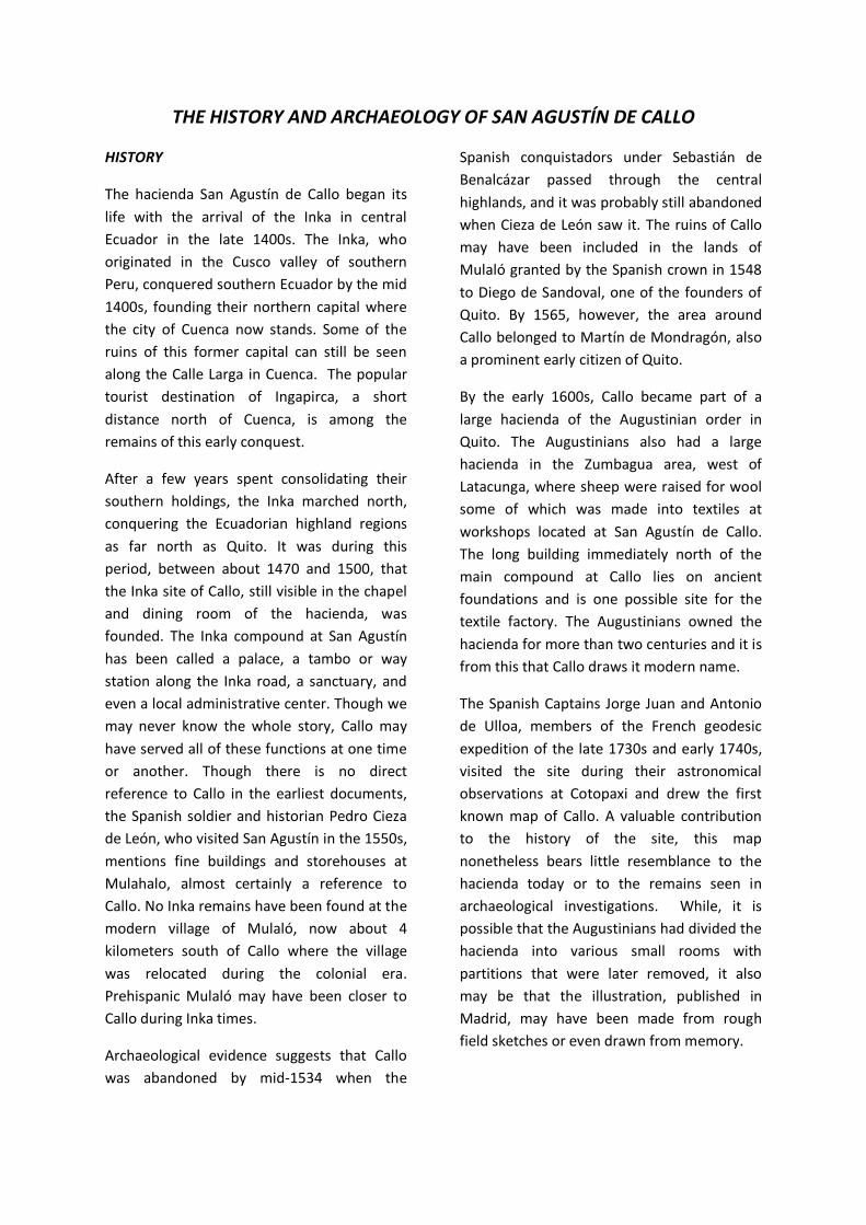
By contrast to some Inka sites in Ecuador, no
whole Inka vessels have ever been found,
perhaps a result of the intentional destruction
of Callo by the retreating Inka armies, or
perhaps the result of centuries of colonial
occupations. The most important
archaeological data at the site have come
from the well-preserved architectural remains
that have offered archaeologists a view of
Inka construction techniques on the far
northern frontier of the empire.
These observations suggest that large earthen
ramps were used to raise the blocks to the
height of the walls, and that blocks were slid
into place from the corners that were often
set in place. While the wall courses are level
across the buildings, apparently little concern
was given to the location of joints between
blocks, unlike modern masonry. Instead, the
Inkas occasionally set smaller blocks slightly
down into the lower course to lock blocks in
place. And while the wall blocks appear
massive, they are a façade, with tightly fitted
joints only along the wall face.
Between the wall faces, the interior is filled
with stone rubble, clay and ash from an
eruption of the Quilotoa volcano around AD
1250. This fine ash was mined out of a large
area around the hacienda by the Inka to use
as dry mortar for the construction.
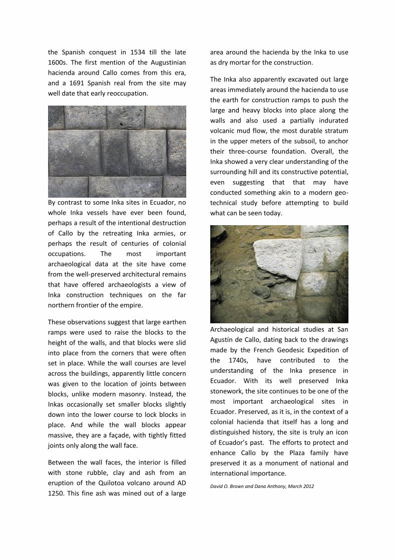
The Inka also apparently excavated out large
areas immediately around the hacienda to use
the earth for construction ramps to push the
large and heavy blocks into place along the
walls and also used a partially indurated
volcanic mud flow, the most durable stratum
in the upper meters of the subsoil, to anchor
their three-course foundation. Overall, the
Inka showed a very clear understanding of the
surrounding hill and its constructive potential,
even suggesting that that may have
conducted something akin to a modern geo-
technical study before attempting to build
what can be seen today.
Archaeological and historical studies at San
Agustín de Callo, dating back to the drawings
made by the French Geodesic Expedition of
the 1740s, have contributed to the
understanding of the Inka presence in
Ecuador. With its well preserved Inka
stonework, the site continues to be one of the
most important archaeological sites in
Ecuador. Preserved, as it is, in the context of a
colonial hacienda that itself has a long and
distinguished history, the site is truly an icon
of Ecuador’s past. The efforts to protect and
enhance Callo by the Plaza family have
preserved it as a monument of national and
international importance.
David O. Brown and Dana Anthony, March 2012