the history, archaeology and material culture of 105...
TRANSCRIPT

INTRODUCTION
Since the early 1930s the Japanese had been at war with theChinese and by 1941 the Japanese occupied Indo-China andThailand. At the end of December 1941 Japanese forces hadtaken Hong Kong, Malaya and the Australian territory of NewBriton. As such, the outbreak of World War II (WWII) had animmediate effect on Australia due to the threat posed byJapanese military actions in the Pacific.
By 1942 the imminent threat of Japanese attack and in-vasion was recognised by the Australian government. Militaryactions in Australia’s top end necessitated the reduction ofDarwin’s small population by 2000 civilians, leaving only acore of 2000 people, including around 100 women andchildren (Johnston 2006:7). On 19 February 1942 the threat ofa Japanese air based attack was realised when two waves ofJapanese warplanes bombed Darwin. At least 243 people werekilled in this first attack along with the widespread destructionof Darwin (Lockwood 2005). The 19 February attack was tobe the first of 64 air raids carried out over the following 22months – February 1942 to November 1943 (Alford 2005).
The commencement of an aerial bombardment took Aus-tralia’s defensive forces by surprise, and it became obviousthat a sea and/or land based attack would not be forthcoming.The aerial threat posed considerable issues for the localdefence force, which had put the limited resources for itsdefence in more traditional aspects such as shore basedbatteries (with 6 inch Mark XI guns), such as those at ElliotPoint, Emery Point, East Point, Waugite Beach and West Point,Darwin (Rayner 2001:4-6). The only other defensiveweaponry capable of defending Darwin against the JapaneseBetty bombers and Zero fighters were ground mounted Lewisand Vickers machine guns – guns that were fired from exposedpositions on top of trenches (Reid 2007:3). At the time of thefirst attack Darwin was not completely without air cover, asthe United States Army Air Force (USAAF) had ten Kittyhawkfighters based in Darwin. The surprising speed of the Japaneseattack meant that the US planes had little chance of becomingairborne to mount a counter attack and all bar one US Kitty-hawk were quickly destroyed (five on the ground and four inthe air) by the overwhelming numbers of Japanese Zeros.
Military analysis following the 19 February bombingshowed that minimal advanced warning of the air attack hadbeen possible (and the warning which did come had beenignored); it was apparent that for a successful defence of
Darwin to be made, an advanced warning system was essential(Lockwood 2005). Such warning needed to provide sufficienttime for allied planes to become airborne before the attackingforce arrived.
The obvious answer was the employment of the new rangeand direction finding (RDF) equipment, more commonlyknown as radar (radio detection and ranging). The need for thesystem was so great that by the end of February 1942 the firstearly warning radar had been flown from Sydney to Darwin.This system was installed at Dripstone (Lee Point) and inMarch 1942 ‘Radar Station 31’ (RS31) was operational. Thefirst array provided a limited range of detection, and lackedcoverage to the west of Darwin, so the decision was made thatfurther RDF sites needed to be quickly established. A secondRDF was established on the Cox Peninsula, at Charles Pointand on 22 April 1942 the radar became operational and on 25May 1942 the station was officially named 105 RDF.
THE COx PENINSULA
The Cox Peninsula is located to the west of Darwin, approx-imately six kilometres across the bay. Three defensivepositions were established on the peninsula, two obvious andone in some secrecy (Figure 1).
Two military camps were established on the north easternshoreline of the Cox Peninsula. West Point was initiallyestablished in 1939 with two 4 inch Mark VIII shore basedguns (Rayner 2001:5) to defend the western end of thesubmarine net which extended from East Point across Darwinharbour. In 1942 West Point was expanded with anti-aircraftdefences and an army camp that housed most soldiersstationed on the Peninsula.
Wagait Battery was established near to West Point in 1942with two 6 pounder anti-aircraft batteries. Both settlementsfeatured observation towers and numerous features set onconcrete slabs.
THE RADAR STATION (105 RDF) AT
CHARLES POINT
In February 1942 American forces (the 8th, 49th and 55thFighter Groups) arrived in Australia and brought with them awide range of equipment, including radar equipment, such asthe SCR268s (Simmonds and Smith 1995:49, 52). TheSCR268 was designed for use by the Army, but was quickly
92
The history, archaeology and material culture of 105 Radar Station,Cox Peninsula, Northern Territory
TIM OWEN and SHELLEY JAMES
The 105 Range and Direction Finding (RDF) Radar Station, Cox Peninsula, Northern Territory, wasestablished as the second radar site in Darwin during the Second World War. The site was established as aconsequence of a dire and urgent need to identify Japanese aircraft squadrons that were conducting bombingraids on Darwin and surrounds, which had commenced in February 1942. 105 RDF used a Modified AirWarning Device (MAWD) that allowed detection of planes up to 150 miles away. This paper tells the storyof the camp where the 119 men who operated 105 RDF lived for nineteen months in a remote and isolatedcorner of the Northern Territory, at the front line of Australian defence.
The harsh bush conditions were adapted with the erection of a number of buildings, including a mess, kitchen(with a fridge for cold beer) and a recreation hut. The remnant archaeological pattern at 105 RDF providesevidence for the habitation of this area and the intention of Australian Defence to protect the location of 105RDF, to ensure it remained unknown to the Japanese.
AUSTRALASIAN HISTORICAL ARCHAEOLOGY, 31, 2013

acquired by the Royal Australia Air Force (RAAF) whomodified it to become a land based system able to detectaircraft up to 160 kilometres away. After modification theSCR268 was known as the Modified Air Warning Device(MAWD). Eight MAWDs, numbered 101–105, 107 and 109,were set up in various defensive locations across Australia(Fenton 2000:10; Simmonds and Smith 1995). Simmonds andSmith describe the introduction of the MAWDs to the RAAF:
The RAAF obtained the SCR268s and ... modified themfor air warning radar increasing their range to 100miles ... There is no doubt that the MAWDs filled anurgent need in Australia. One has to admire theoperators of the ... MAWDs because they sat out in theopen exposed to all the elements, and hand turned theaerial with little complaint, even during tropicaldownpours, heavy winds etc (1995:49).
Simmonds and Smith emphasise the importance of 105Radar during 1942:
Of all the MAWDs, 105RS was probably the mostoutstanding due to its deployment to the NorthernTerritory. The situation in Darwin at the end of March1942 can only be described as being extremelydesperate. Certainly 31RS at Dripstone Caves wasoperating … but additional air warning was an urgent
necessity with more range towards the west beingrequested. The only piece of radar equipment availablewas a trailer-mounted MAWD, weighing around 20tons ...
On 24 March 1942 a start was made to dismantle theset, which extended to reducing heavy items such as thealternator into more management components so thatit could be transported in DC3 aircraft. By 6 April allof the essential elements had been completed and theunit was moved over 100 miles of bush track to PointCharles. W/Cdr Pither has stated that the unit wasoperational on 22 April and went further to claim that,‘this move must have established a record for airtransport at the time’.
The unit’s record at Point Charles was outstanding inthe field of air warning and it enhanced the credibilityof radar within Fighter Sector. [For instance] 105RShad alerted No. 5 FS when [a] Japanese raid had splitinto two with one section proceeding to Darwin and theother going south towards Katherine. The plots werenot believed until a telephone call was received fromKatherine irately telling Fighter Sector that they werebeing bombed without warning (Simmonds & Smith1995:51).
Flight Lieutenant Porter was a radar operator posted to theDarwin region in May 1942. Porter provided a description ofthe difference that radar technology was providing through theearly detection of enemy aircraft:
Radar was the watchword in the area and we swelledwith pride at its magic. Remember we had never seenradar actually locate a target but we were confident ofits ability, and we enjoyed confirmation …
Now people had a good fifty minutes to finish theirlunch, bring in their washing and disperse theirtransport …
The heavy ack-ack put up a deterrent barrage at thenight time, and American P40s (Kittyhawks) took to the
93
105 RDF
WagaitBattery
WestPoint
East Point
RS31
Figure 1: Key WWII Defences on the Cox Peninsula, East Point and RS31. Red line is the submarine net extending between East and West point
(Image source: Google Maps).
Figure 2: Exposed operators sat on a SCR 268 (NB this photograph is
not of 105 Radar Station) (www.vectorsite.net).

air for combat. Morale had risen in a phenomenal way(Porter 1988:58).
Whilst the primary objective of 105 RDF was identi-fication of Japanese aircraft, the men who lived and operatedthe station required basic facilities and accommodation if theywere to remain healthy and in a state fit for operation:
When 105 first arrived at Charles Point, Army tentswere the standard accommodation for sleeping andeating – in fact they were used for all station activitiesother than the Cook’s endeavours with stove andcopper. But in true radar fashion, the boys soon got towork, and large bark hut was the result – first knownas the ‘Gunyah’, afterwards perhaps as the ‘Wool-shed’ – where 6–8 men lived. Water was scarce, and atank appeared (a Darwin souvenir perhaps?) andevidently a popular nightly game of Monopoly wasinstituted. Again, in typical radar fashion, a newKitchen, Mess and Rec. [sic] hut were officially openedjust before the station closed (Fenton 2000:19).
Nearly half the station was suffering from tropicalulcers, four being in hospital ... It was very difficult tofind enough fit men to man the gear ... This state ofhealth was mainly due to walking in sandals andbarefooted. When boots and gaiters were available,and worn, the ulcers quickly disappeared. The ankle isparticularly susceptible to infection as it is exposed todirt, and sharp grass which abounds in the area. Withthe poor washing facilities trouble easily starts (Porter1988:64-65).
The 105 RDF site at Charles Point was always intended asa temporary site, rapidly established to meet an urgent need,whilst other more permanent and better equipped sites wereconstructed. However 105 RDF continued to defend Darwinfrom the Charles Point site until September 1943 when someof the crew was transferred to Station 59 at Lee Point (Fenton:2000:10). According to official records 105 RDF wasdisbanded on 20 October 1943 (Simmonds and Smith1995:52). Between March 1942 and October 1943 Fenton
records that an approximate total of 119 personnel manned105 RDF (Fenton 2000:25-26).
The history of radar at Charles Point did not cease at theend of 105’s operation in October 1943. Darwin’s first Radarsite, RS 31, suffered the loss of its foundations due to cliff fallin mid-1943. The immediate response was to relocate RS 31 tothe 105 RDF site at Charles Point.
In September 1943 ‘foundations’ were poured for theinstallation of the RS 31’s array. On 30 September Radar 31’saerial arrived and by 15 October Radar 31 became operational.A number of the 105 operators and site personnel weretransferred directly onto Radar 31’s crew and remained on siteuntil 14 January 1944, when Radar 31 also ceased operation.The short operation of Radar 31 (four months) did not seefurther building activity on site, and eventually the entire campwas demolished over a period of two weeks.
THE ARCHAEOLOGY OF 105 RDF
The identification of archaeological remains relating to 105RDF was a chance discovery. In September 2009, whilstundertaking an initial assessment for Aboriginal and historicalcultural heritage within Section 34, Cox Peninsula (Owen andJames 2010a), the authors were taken by the local AboriginalTraditional Owners through the former location of 105 RDF.The identification of what appeared to be a WWII era concreteslab aroused our attention and led to some rapid historicalresearch (e.g. Fenton 2000).
July 2010 saw the preliminary search extended and a totalof seven concrete slabs, a number of ancillary features andlarge quantity of material culture identified across the 105 site.In August 2010 the authors again returned to 105 RDF toundertake further archaeological investigations, with the aimof clarifying the extent of some archaeological remains, and toprepare an archival recording of salient site features (Owenand James 2010b). This work informed the Section 34Heritage Management Plan (Owen and James 2011).
A geophysical survey of the site was undertaken to identifyunexploded ordnance (UXO) (G-TEK 2010). This survey
94
Figure 3: Mud map of Camp 105 (Fenton 2000:47). This mud map was drawn by Don Hobbins as he remembered 105 RDF in mid-1943.

identified small metal items, particularly spent cartridge cases,which would otherwise not have been observed or recordeddue to the thick vegetation cover. In addition the pattern ofspent ammunition and weapons pits provided evidence for thespatial use of the wider bush zone, otherwise devoid of signsrelating to its WWII use.
ARCHAEOLOGICAL FEATURES
Hobbins’ mud-map (Figure 3) was used as the initial basis forinterpretation of the archaeological remains. It wasimmediately noticed that the spatial layout of items inHobbins’ plan were approximate and the location of features,such as the tents, had no readily definable archaeologicalsignature and therefore could not be accurately relocated.Figure 3 shows the camp’s features spread across a wide zone;however GIS based mapping (Figure 4) shows the primary sitefeatures were actually aligned North to South.
A total of 11 key archaeological features were identified at105 RDF:
• An entrance road – an alignment through the trees with theremains of a hard packed gravel surface;
• Entrance building (concrete slab A) – a concrete slab (4.1 m by 4.6 m) with associated brick footings. This slabhas been interpreted as a guard house (entrance) to the 105camp;
• Mess building (concrete slab B) – a large rectangular slab(11.15 m by 3.6 m), with a doorstep on the NE side, aconcrete water tank stand on the SW side and a gravitybased grey water system extending off the slab to the SW,running past Slab C. The slab did not contain evidence forinternal division of the rooms. This slab has beeninterpreted as a mess, with a small kitchen or bar to therear;
• Mess building (concrete slab C) – a small concrete slab
95
Figure 4: The layout of 105 RDF, as recorded in 2010, showing structures and ordnance (Owen and James 2010b:Figure 5).
Well
Structure
Entrance Road
UXO – Ammunition Pit
Weapon Pit
Legend
(6 m by 2.3 m), with four vertical wooden posts insertedinto the eastern end (possibly a support for a water tank)and a drainage channel set into the southern side of theslab;
• Kitchen building (concrete slab D) – a square concrete slab(3.9 m by 3.1 m) with a central drainage channel, whichflowed south into a grey water system. The function of theslab is suggested to be the kitchen, where food preparationbenches (with cut in half 44 gallon drums) would havebeen set over the drain (Figure 5);
• Store (concrete posts) – two concrete blocks (buildingsupport posts) set into the ground 3 m apart. The storebuilding would have been elevated for ventilation and toprevent vermin easily entering the building. A glass beerbottle dump was adjacent to the store’s entry;
• A Well – a thin metal pipe, set in concrete, sunk as a borehole adjacent to the store building;
• Recreation Hut (concrete slab E) – a shallow concrete slab(approximately 4 m by 4 m), set against metal edging;
• Possible ‘Gunyah’ location – a cleared area in the bush thatpossibly contained the wooden building designated the“Gunyah” (Fenton 2000:47). This location included a largeamount of material culture, including miscellaneous metal,service pipes and a lot of spent ammunition. It is possiblethat this area was also used for training and perhaps as thecamp cricket pitch and badminton court;
• Machine Gun Pit – a U-shaped concrete pit facing thenorth-east (towards the lighthouse and sea). The Radarstation diary (Fenton 2000) notes that two Vickers machineguns were mounted to defend 105 RDF, but the featuredoes not conform to the Vickers machine gun positionsrecorded at West Point, or in the Darwin area (which werecircular features (2 m diameter) with a sunken corrugatediron surround and vertical metal mount in the centre);
• Operations Hut (concrete slab F) – two adjoining concreteslabs (3.97 m by 1.75 m);
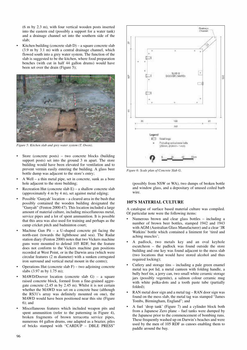
• MAWD/Doover location (concrete slab G) – a squareraised concrete block, formed from a fine-grained aggre-gate concrete (2.45 m by 2.45 m). Whilst it is not certainwhether the MAWD was set on a concrete base (althoughthe RS31’s array was definitely mounted on one), theMAWD would have been positioned near this site (Figure6); and
• Miscellaneous features which included weapon pits andspent ammunition (refer to the patterning in Figure 4),broken fragments of brown terracotta service pipes,numerous 44 gallon drums, one adapted as a brazier, pilesof bricks stamped with “CARDUP – DBLE PRESS”
(possibly from NSW or WA), two dumps of broken bottleand window glass, and a depositary of unused coiled barbwire.
105’S MATERIAL CULTURE
A catalogue of surface based material culture was compiled.Of particular note were the following items:
• Numerous brown and clear glass bottles – including anumber of brown beer bottles, stamped 1942 and 1943with AGM (Australian Glass Manufacturer) and a clear ‘JRWatkins’ bottle which contained a liniment for ‘tired andaching muscles’;
• A padlock, two metals key and an oval keyholeescutcheon – the padlock was found outside the storebuilding and one key was found adjacent to the mess slab(two locations that would have stored alcohol and thusrequired locking);
• Cutlery and storage tins – including a pale green enamelmetal tea pot lid, a metal canteen with folding handle, abully beef tin, a jerry can, two small white ceramic storagejars (possibly vegemite), a salmon colour ceramic mugwith white polka-dots and a tooth paste tube (partiallyfolded);
• RAN metal door sign and a metal tag – RAN door sign wasfound on the mess slab, the metal tag was stamped “JamesTombs, Birmingham, England”; and
• A fuel ‘drop tank’ (Figure 7) and a cylinder block bothfrom a Japanese Zero plane – fuel tanks were dumped bythe Japanese prior to the commencement of bombing runs.These frequently washed up on Darwin’s beaches and wereused by the men of 105 RDF as canoes enabling them topaddle around the bay.
96
Figure 5: Kitchen slab and grey water system (T. Owen).
Figure 6: Scale plan of Concrete Slab G.

INTERPRETATION
An archaeological interpretation of 105 RDF providesconsiderable evidence for a cultural landscape, where carefulconsideration appears to have been given to the camp’sconfiguration, whilst the material culture provides an insightinto the daily lives of the operators who lived in this remoteand harsh location.
The location for 105 RDF appears to have been selecteddue to its proximity to Darwin (enabling radar detection andefficient communication) but also its remoteness, whereJapanese planes were less likely to spot the radar, and once theinevitable detection occurred, a specific bombing run wasrequired to target the site (the Cox Peninsula was bombed on27 August 1942 by six bombers, 31 August 1942 by threebombers and 24 October by three bombers [Alford 2005:78-79] – the station diary does not record any loss of lifeattributable to these bombing events).
Archaeological recording of the structural remains (Figure4) provides evidence for the deliberately positioning ofbuildings; the layout of the camp was planned with theintention of preventing detection by the Japanese. Thealignment of all buildings on a north to south axis would havepresented a minimum view corridor; a single row of buildingswhen viewed from a northern airborne aspect. The stationdiary (Fenton 2000) records that three separate visits bycamouflage experts occurred between 1942 and 1943, with are-arrangement of the camp for camouflage purposes inDecember 1942. Additionally, all of 105 RDF’s infrastructureand buildings were constructed beneath the tree canopy, ratherthan in the open area adjacent to the Charles Point lighthouse(the lighthouse location contained pre-poured concrete bases,remnants of the former lighthouse buildings, which could havebeen reused by 105 RDF).
Within the 105 camp layout, it appears that the camp wasdivided into distinct zones. The first was a ‘working’ area, inthe north of the camp, near the cliffs. This is where the MAWDand operations hut were located. The second zone was a‘living’ area that held the mess, a store, a kitchen, the ‘gunyah’and presumably accommodation tents. This area would havebeen central to the lives of the men operating the camp andcontained the bulk of material culture, including all the beerbottles. The final zone was the ‘entrance’ area that containedthe entry building, possibly a fuel store and the road leading tothe central zone. It is suggested that these zones were devisedto provide the men of 105 RDF with daily structure separatingthe various aspects of their lives (i.e. maintaining a distancebetween periods of work and leisure time).
The distance between these zones, and the separationbetween the buildings within each zone, would have made it
more difficult to target 105 RDF during a bombing run. Had abomb scored a direct hit at 105 RDF then only a singlebuilding or facility, rather than a number of items, would havebeen impacted.
The spread of material culture (excluding the ammunition)across the site appears to show a focus within the living zone,where the majority of bottles and food items (plates, cutlery,etc) were recorded. No such items were recovered from theoperations zone; however, this zone did contain a number ofmiscellaneous metal objects, probably associated with con-struction, operation and maintenance of the MAWD. Outsidethe boundary of 105 RDF very little material culture wasrecorded, suggesting that the men did not venture far from thecamp’s location.
Ammunition was found across the site, but appears to beconcentrated within the area of the Gunyah and possiblelocation of the tents. The station dairy provides details of anumber of occasions when defence and weapons training wasprovided for the men of 105 RDF. The concentration of UXOwithin a cleared zone (Figure 4) possibly indicates the locationof this training.
Finally, there are a number of weapons pits located acrossthe wider site (Figure 4). It is suggested that small dug-outshad been excavated for use during the Japanese air raids.However, the station diary notes that the men of 105 RDFvaliantly remained at their posts during the air raids.
The quantity of remnant archaeology and material culturepresent was surprising for such an isolated location, but haspossibly been conserved due to its remoteness. The remnantmaterial culture of 105 RDF has shown that whilst theoperators of 105 RDF lived far from the regimented daily livesof soldiers in Darwin, they nonetheless lived within astructured camp, with designated zones for working andhabitation. 105 RDF appears to have been a place whereplanning, order and discipline was necessary for undertakingthe required task in an isolated corner of Australia throughadverse and perilous conditions.
ACkNOWLEDGEMENTS
The authors would like to acknowledge the assistance ofLauren Grey and Danielle Cox (from the Department ofFinance and Deregulation) and Irene Polski (United GroupLimited) who currently have responsibility for management ofSection 34. The project that saw the identification of the 105RDF was part of the Department of Finance and Deregulationsdue diligence program in meeting its obligations under theEnvironment, Protection and Biodiversity Conservation Act1999.
REFERENCES
ALFORD, B. 2005 Darwin’s Air War 1942–1945: AnIllustrated History, Fifth Edition, The Aviation HistoricalSociety of the Northern Territory, Darwin.
FENTON, M. 2000 The 105 Mobile RDF Station at CharlesPoint, 1942–1943, Self publication, Darwin.
G-TEK 2010 Post Activity Report: Unexploded OrdnanceField Validation Survey: Point Charles Lighthouse and 105Mobile RDF Station Cox Peninsula, Northern Territory,unpublished Report for OCTIEF Pty Ltd.
JOHNSTON, M. 2006 Australia’s Home Defence 1939–1945:Australians in the Pacific War, Department of Veterans’Affairs, Canberra.
LOCKWOOD, D. 2005 Australia Under Attack: The Bombingof Darwin – 1942, New Holland Publishers (Australia) PtyLtd, Sydney.
OWEN, T. and S. JAMES 2010a Section 34 and 41, Cox
97
Figure 7: Crumpled drop tank from a Japanese zero (T. Owen).

Peninsula, NT Heritage Assessment, unpublished ERMconsultancy report for the Department of Finance andDeregulation and United Group.
OWEN, T. and S. JAMES 2010b Cox Peninsula Section 34 –105 Radar Camp, Archival Recording and Material CultureInventory, unpublished ERM consultancy report for theDepartment of Finance and Deregulation and UnitedGroup.
OWEN, T. and S. JAMES 2011 Section 34 Heritage Manage-ment Plan, unpublished ERM consultancy report for theDepartment of Finance and Deregulation and UnitedGroup.
PORTER, F.H. 1988 Adventures In Radar, Leader Corpor-ation, Mona Vale.
RAYNER, R. 2001 Darwin and Northern Territory Force,Rudder Press, NSW.
REID, R. 2007 Australia Under Attack: Darwin and theNorthern Territory 1942–1945, Department of Veterans’Affairs, Canberra.
SIMMONDS, E. and D. SMITH 1995 Echoes Over ThePacific, EW & E Simmonds, Banora Point.
98