the identification of geomorphosites in different...
TRANSCRIPT

Volume 3 Number.1 , 2011Volume 3 Number.1 , 2011 Volume 3 Number.1 , 2011Volume 3 Number.1 , 2011
THE IDENTIFICATION OF GEOMORPHOSITES IN DIFFERENT CARTOGRAPHIC MATERIALS. THE
STUDY CAS- BUCEGI MTS (ROMANIA)
Laura COMANESCU, Robert DOBRE, Alexandru NEDELEA
Faculty of Geography, University of Bucharest, Roumania
Resume: Les géomorphosites sont des formes de relief ou des processus géomorphologiques qui reçoivent une importance spéciale grâce à la perception donnée par la société humaine. De cette manière, un géomorphosite a une valeur scientifique (centrale) et plusieurs valeurs adjacentes (culturelle, esthétique, écologique et économique). Dans l’ouvrage présenté on se propose de montrer la manière dans laquelle les géomorphosites peuvent être évalués en utilisant les techniques SIG et l’étude des images satellitaires. On peut obtenir des dates très importantes et exactes à partir de toutes les valeurs mentionnées sur les images satellitaires afin d’apprécier la valeur esthétique. Dans ce cas-i, on prend en considération le nombre de points de visibilité, la distance moyenne du point de bellevue (en mètres), la surface, la différence de niveau, le contraste de couleur en comparaison avec l’environnement observable. Afin de réaliser une évaluation complète on peut utiliser le scénario Scenary Management System - un outil créé pour l’analyse systématique du paysage et implicitement des géomorphosites, pour la détermination de leur importance relative et de leur valeur esthétique ayant comme but la gestion efficace du patrimoine naturel. Du point de vue méthodologique, on peut différencier deux phases : celle de l’inventaire et celle
de l’exécution. La première phase consiste dans le parcours de cinq étapes d’étude du territoire concerné et a comme résultat final la carte de la distribution des classes de valeur esthétique sur le territoire étudié(la détermination du spécifique du paysage a comme finalité un produit intermédiaire sous forme de description narrative, l’analyse de l’attractivité intrinsèque du paysage a comme résultat la carte de l’attractivité intrinsèque du paysage, l’analyse de la visibilité du paysage et la réalisation des cartes des régions visibles et des zones de distance et l’analyse finale suite à laquelle on établi les classes de valeur esthétique du paysage et on élabore la carte de la distribution des classes de valeur esthétique du paysage). Dans le cadre de la phase d’exécution, on introduit le SMS dans le processus d’aménagement du territoire en passant par plusieurs étapes, à partir de la création des alternatives jusqu’à la surveillance et l’évaluation.
Key words: geomorphosites, map, satellite imagery, georeference, spatial analysis, identification
IntroductionThe identification and the good assessment of
geomorphosites situated in a hard accessible area or in an extended areal proves to be an aim hard to achieve only by field study, and this is the reason why it is extremely useful to use some cartographic materials which are adequate for this purpose and for the validation of the information gathered (A. Carton, P. Coratza, M. Marchetti, 2005). The analysis of cartographic materials in electronic format, by modern techniques, provides additional information and a higher accuracy in an elegant manner (fig.1). This is the reason why choosing appropriate cartographic materials is extremely important. In the present study we aim to identify the
24 25

The
Egy
ptia
n Jo
urna
l Of E
nviro
nmen
tal C
hang
e
Volume 3 Number.1 , 2011Volume 3 Number.1 , 2011 Volume 3 Number.1 , 2011Volume 3 Number.1 , 2011
cartographic sources which can constitute a starting point for achieving an ample database for an as exact as possible evaluation of geomorphosites from mountainous area, which is hard to access.For exemplification, there were chosen three
areas which are characteristic for the area of the Bucegi Mountains, where geomorphosites constitute the base of attraction for tourists. Thus, it can be noticed that geomorphosites can be classified also by their way of identifying the information sources: visible, invisible, ambiguous or intuitive, only with a toponym. The Bucegi Mountains were chosen as a sample for the analysis, because this is the massive where geomorphosites have a great complexity, being well represented, the touristic activity is intense and the infrastructure is the best represented in the entire Carpathian area (L. Comănescu, A. Nedelea, 2010).The Bucegi massif is situated in the eastern
part of the Meridional Carpathians, between the Prahova valley in the east and the Rucar-Bran corridor, in the west (fig.2).Methodology, the database and softwareCartographic materials were acquired in a
physical or electronic format (table1). These were transformed in a raster and they were geo-differentiated in the projection “Stereo 70”, the datum “ Dealul Piscului ” with the help of the application “ Global Mapper 9 ”. The overlapping, arrangement, word processing and analysis of spatial information were done with the help of ArcGis 9.2 / Arc Map. Fig. 1 The steep of methodology
26 27

Volume 3 Number.1 , 2011Volume 3 Number.1 , 2011 Volume 3 Number.1 , 2011Volume 3 Number.1 , 2011
The topographic maps 1:25000 and 1:50000 were achieved by DTM (Department of Military Topography) on the basis of topographic researches in the period 1959 – 1970. For a good connection to external topographic maps it was used the Gauss – Kruger cylindrical projection from strategic and economic reasons (M. Rotaru, G. Anculete, 1989). The public authority in charge with the right for property and selling is the National Agency for Cadastre and Land Registration. The ortophotoplans were accomplished in the period 2003- 2005, between the months of May and September and they cover 98%. The scale is 1:5000 and the resolution is 50 cm in spectral RGB band, in the projection system Stereo 70. The public authority in charge with the right for property and selling is the National Agency for Cadastre and Land Registration (www.ancpi.ro).Landsat ETM+ Imagery can be freely
downloaded from the site Glovis (http://glovis.usgs.gov) in GeoTiff format. Most scenes are from the year 2000, and the period of time lasts from June until October. Austrian maps are at the scale 1:200000 and
they can be freely downloaded from the site of the Eötvös Loránd University. These were done on the basis of some military topographic
researches of the Hapsburg Empire, from the beginning of the last century, but without a known projection (source: Geospatial). Military master plan was done between the two World Wars at the scale 1:200.000, firstly in the conformable conic projection Lambert, and then in the Gauss – Kruger projection. The purpose was to accomplish a uniform cartographic system for Romania (source: Geospatial).Soviet maps are at the scale 1:100.000 and
they were done after the Second World War by the URSS regarding the entire terrestrial Globe. These can be freely downloaded or paid from different sites, one of these being http://poehali.org. The maps are georeferenced in projection Transverse Mercator projection, datum Pulkovo 1942. (source: Geospatial).Touristic map is a complex map, well
proportioned as information, which offers both data of touristic interest and some information with a scientific character. This is part of an important collection of touristic mountain maps called Our “ Mountains ”, considered to be a reference frame for the touristic process in Romania, even if information was gathered several scores of years ago.
Fig. 2 – The geographic positions of Bucegi Mts. in Romania
26 27

The
Egy
ptia
n Jo
urna
l Of E
nviro
nmen
tal C
hang
e
Volume 3 Number.1 , 2011Volume 3 Number.1 , 2011 Volume 3 Number.1 , 2011Volume 3 Number.1 , 2011
Table 2 Identification of geomorphosites
Table 1 The databases analysed in identifying the geomorphosites from the Bucegi Mountains
Data informationData base
Scale Edition Source Status
Ortophotoplans 1:5.000 2005 National Agency for Cadastre and Land Registration Payment
Topographic map 1:25.000 1980 Department of Military Topography Payment
Topographic map 1:50.000 1980 Department of Military Topography Payment
Landsat ETM+ Imagery 1:35.000 2000 GloVis For free
Austrian Map 1:20.000 1910Eötvös University, Department of Cartography and
GeoinformaticsFor free
Military master plan 1:2.000 1931 Army Geographical Service For free
Soviet map 1:100.000 1970 www.poehali.org For free
Maps Google 2009 Spot Image/Google For free
Touristic map 1:50.000 1974 Our Mountains Collection, Valeria Velcea Payment
Geomorphosites
Data setBabele Sfinxul Ialomita
caveOmul peak
Urlatoarea waterfall
Caraiman plateau
Franz Josef rock
Tatarului Gorges
Gaura Glacial
Cirque
Coltii Morarului
Shape point point point point point polygon point polygon polygon polyline
Ortophotoplans Yes Yes Intuitive Yes Intuitive Yes Intuitive Yes Yes Yes
Topographic map 1:25000 Yes Yes Yes Yes No Yes As
toponym Yes Yes Yes
Topographic map 1:50000 Yes Yes Yes Yes No Yes No Yes Yes Yes
Landsat ETM+ Imagery Intuitive No No Intuitive No Yes No Yes Yes Intuitive
Austrian Map No No As toponym Yes No Yes Yes No Yes No
Military master plan No No As
toponym Yes As toponym Yes Yes Yes Yes Yes
Soviet map Yes Yes Yes Yes No Yes As toponym Yes Yes No
Maps Google Yes Yes Intuitive Yes No Yes Intuitive Yes Yes Yes
Touristic Map Yes No Yes Yes Yes Yes No Yes Yes Yes
28 29
Volume 3 Number.1 , 2011Volume 3 Number.1 , 2011 Volume 3 Number.1 , 2011Volume 3 Number.1 , 2011
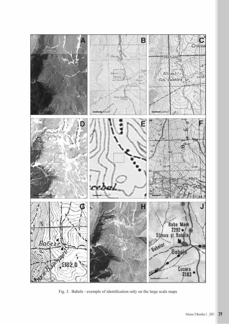
Fig. 3. Babele - exemple of identification only on the large scale maps
28 29

The
Egy
ptia
n Jo
urna
l Of E
nviro
nmen
tal C
hang
e
Volume 3 Number.1 , 2011Volume 3 Number.1 , 2011 Volume 3 Number.1 , 2011Volume 3 Number.1 , 2011
Fig. 4. Ialomiţa Cave - Exemple of proper identification on the basis of maps and toponyms
30 31

Volume 3 Number.1 , 2011Volume 3 Number.1 , 2011 Volume 3 Number.1 , 2011Volume 3 Number.1 , 2011
Fig.5. Gaura Cirques - Exemple of proper identification on maps and other data bases
30 31

The
Egy
ptia
n Jo
urna
l Of E
nviro
nmen
tal C
hang
e
Volume 3 Number.1 , 2011Volume 3 Number.1 , 2011 Volume 3 Number.1 , 2011Volume 3 Number.1 , 2011
Results The result of this study highlights the following
(table 2, fig 4-6):• In creating a database for the evaluation of
geomorphosites, older cartographic materials can be used, too (even older than a few scores of years) which can constitute important sources of information • The resolution of cartographic sources in
vectorial format has got an extremely important role• In case of ortophotoplans and aerophotograms,
a major role is held by the season (the degree of covering with vegetation) when the flights for data gathering were done (especially for punctiform geomorphosites, e.g. caves, waterfalls)• Toponymy is a good indicator for creating the
database• The way of representing a geomorphosite
under the form of a polygon is the most visible and easy to identify on the map compared to the representation under the form a point• Materials at low scale or rasters with
reduced resolution can be used intuitively (for the validation of some ground information), sometimes being difficult enough to work with them, offering ambiguous information• Touristic maps can be used with an orientation
character, as they do not offer a consistent scientific information (the lack of curves of level, defective hydrographic network, environmental information)• The map of geomorphosites from a mountains
region can be accomplished by ample field studies, corroborated with a judicious use of a database resulted from several bibliographic sources (fig. 4-6).Acknowledgements to all those who
supported the accomplishment and publication of this article, within the project: “ Inventoring,
Evaluation and Mapping of Geomorphosites. Case studies: the Dobrodjea plateau and the Southern Carpathians” , project manager Laura, financed by CNSIS/ NURC, category IDEI and Geospatial (www.geo-spatial.org)
Bibliography:Brancucci, G., Maniglio Calcagno, A.E.,
Mazzino, F. (2002), The geosites’ role and the landscape European convention, Geomorphological Sites: research, assessment and improvement, Modena (Italy), 19-22.06.2002, Università degli Studi di Modena e Reggio Emilia, Dipartimento di scienze della Terra, 1-8.Carton, A., Coratza, P., Marchetti, M. (2005),
Guidelines for geomorphological sites mapping: examples from Italy, Géomorphologie: relief, processus, environnement, 3/2005, 209-218.Comănescu, L., Nedelea, A. (2010), Analysis
of some representative geomorphosites in the Bucegi Mountains: between scientific evaluation and tourist perception, Area, Nr.4, 406-416.Coratza, P., Giusti, C. (2005), Methodological
proposal for the assessment of the scientific quality of geomorphosites, Il Quaternario, 18 (1), 307-313. Ilieș, D., Josan, N. (2009), Geosituri și
geopeisaje, Edit.Universității din Oradea.Panizza, M. (2001), Geomorphosites: Concepts,
methods and examples of geomorphological survey, Chinese Science Bulletin, 46, 4-6.Panizza, M., Piacente, S. (2008),
Geomorphosites and geoturism, Rev. Geogr. Academica, vol.2, nr.1, 5-9.Pralong, J.-P. (2005), A method for assessing
tourist potential and use of geomorphological sites, Géomorphologie: relief, processus, environnement, 3, 189-196.Reynard, E. (2005), Géomorphosites et
paysages, Géomorphologie: relief, processus,
32 33

Volume 3 Number.1 , 2011Volume 3 Number.1 , 2011 Volume 3 Number.1 , 2011Volume 3 Number.1 , 2011
environnement, 3/2005, 181-188.Reynard, E., Coratza P., Regolini- Bissig G.,
(2009), Geomorphosites, Verlag Friedrich Pfeil, Munchen, 240p.Rotaru M., Anculete, Ghe. (1989), The
evolution of military geodesic notion in Romania, Bucharest.*** Geospatial - www.geo-saptial.org*** National Agency for Cadastre and Land
Registration www.ancpi.ro*** U.S. Geological Survey http://glovis.usgs.gov
32 33