the informed and oriented transport system user
TRANSCRIPT

JOINT TRANSPORT RESEARCH CENTRE
Discussion Paper No. 2009-26December 2009
The Informed and Oriented Transport System User
Peter ZIMMERMANNManagement Consultant
Munich, Germany

2 Zimmermann – Discussion Paper 2009-26 - © OECD/ITF, 2009
TABLE OF CONTENTS
Summary
1 INTRODUCTION ...................................................................................................................... 4 1.1 The Idea ................................................................................................................................. 4 1.2 Co-ordination and Cooperation of the Federal Ministries of Transport, Building and Urban Affairs
and Economics and Technology ................................................................................................. 4 1.3 Previous Studies ..................................................................................................................... 5 1.4 Relevant Traffic Information Platforms ................................................................................. 6
2 SCOPE OF THE PROJECT ....................................................................................................... 6 2.1 Intermodal Transport .............................................................................................................. 6 2.2 The Approach ......................................................................................................................... 7
3 MISSING LINKS AND CONTRIBUTION OF METADATAPLATFORM............................ 9 3.1 Missing Links in Road Transport ........................................................................................... 9 3.2 Contribution of Metadataplatform Road Transport ............................................................. 13 3.3 Missing Links in Public Transport ....................................................................................... 14 3.4 Contribution of Metadataplatform Public Transport ............................................................ 14
4 ARCHITECTURE OF METADATAPLATFORM ROAD TRAFFIC ................................... 15 4.1 Metadataplatform – a Virtual Internet Portal ....................................................................... 15 4.2 Metadataplatform Enables Business for Content and Service Providers ............................. 16
5 NEXT STEPS ........................................................................................................................... 17 5.1 Metadataplatform Road Transport ....................................................................................... 17 5.2 Metadataplatform Public Transport ..................................................................................... 18

Zimmermann – Discussion Paper 2009-26 - © OECD/ITF, 2009 3
SUMMARY
The German Ministry of Transport, Building and Urban Affairs has set up a vision which shall improve the situation of the transport system user (in Germany). In order to make use of all resources an intensive co-ordination with the Ministry of Economics and Technology (transport research programme) was undertaken.
Originally the project was called Meta-Data-Platform. In course of time the vision of a benefit for an oriented and informed transport system user developed. The Meta-Data-Platform shall enable data exchange of various sources, shall provide common interfaces and protocols, shall allow for exchange of geographical data of different formats and enable business processes between service and content provider organizations. Traffic data shall become more reliable, be of higher quality and access to real time data shall be possible. State authorities for controlling traffic, broadcasting stations for traffic warning news, service providers for individual route recommendations and content owners can make use of the system. The services of the meta data platform can be used as a virtual internet portal. Centralized services for judgment of data quality transfer of different interfaces and protocols and transfer of different geographical formats will be offered separately.
Despite having intermodal transport in mind, there will be separate platforms for road and public transport. The realization has been splitted into a bunch of individual projects. Some of the projects have just been started. For some of them call for tenders are presently prepared. Development will take approximately four years. At the end of the development there will be test fields used for validation. Validation will be done with model services.

4 Zimmermann – Discussion Paper 2009-26 - © OECD/ITF, 2009
1. INTRODUCTION
1.1. The Idea
In 2006 the German government started the so-called high tech initiative. Federal ministry of transport, building and urban affairs (BMVBS) decided to support among others modern and innovative transport technologies and services. Securing mobility of persons and goods is vital for success and competitiveness of a modern society. Technologies and business models have been investigated quite often. However – especially for road traffic – the market for individual commercial services did not develop as expected. For this reason the ministry decided to push telematics applications and to lower barriers. The idea of a meta data platform was created. It should contribute to save resources and environment. It should make transport safer, more flowingly, more efficient and more undisturbed. Free access to information on all modes of transport should be enabled. Another argument was to secure mobility in a society which is growing older and the quality of traffic date should be improved.
The motivation was to improve the situation of transport systems users with respect to better and more reliable information, orientation and on the long run real time dynamic data. Middle of 2006 a project called “Meta-Data-Platform” was initiated. From the beginning both individual and public transport have been considered.
Potential users and experts have been involved in the definition of requirements. The platform should provide access to online traffic data by means of a virtual central internet portal without any discrimination, enable exchange of data from different partners by means of standardized interfaces, and enable access to data for service providers, for public authorities for collective traffic control, for broadcasting stations for traffic warning news. It should be user oriented and enable new business cases and optimize existing ones. It should serve as link between service providers and content owners and should not affect the competition between service providers.
Reference to the German situation does not mean that no cross boarder transport is considered. International standards have been analysed. The envisaged solution makes use of the international practice and development.
1.2. Co-ordination and Cooperation of the Federal Ministries of Transport, Building and Urban Affairs and Economics and Technology
From the beginning not only potential users and experts have been involved in the definition process. There are a lot of research and development projects for transportation technology supported and funded by the German federal ministry of economics and technology (BMWi). Therefore a co-ordination between both ministries was absolutely vital.
The burden was/is shared between the two ministries. Ministry of Transport, Building and Urban Affairs focuses e. g. on:

Zimmermann – Discussion Paper 2009-26 - © OECD/ITF, 2009 5
• Metadataplatform for Road Transport • Ownership and User Rights for Public Transport • Quality of Traffic Data for Public Transport • Further Development of Superregional Timetable Information and • Electronic Fare Management
Ministry of Economics and Technology focuses e. g. on:
• Quality of Traffic Data for Road Transport • Routing in Rail Traffic • In-Door-Routing in Interchange Stations • Requirements/Improvements of/for Handicapped People
During the next years additional specific research and development projects will be defined if there
are further missing links detected which have to be closed for the focused informed and oriented transport system user.
1.3. Previous Studies
In 2007 six studies have been carried out to analyse the state of the art and to identify existing missing links (most important results see chapter 3). These studies did also reflect the situation outside Germany. The reports are only available in German language.
Namely:
• Detection in road traffic (stationary and mobile) Florian Weichenmeier, Jan Körber, Thomas Meyer, Michael Ortgiese, Florian Schimandl, Ralf Weiss, Arnold Zwicker Forschungsbericht FE-Nr. 63.0002/2007/ im Auftrag des BMVBS Vorbereitende Begleituntersuchungen zur Metaplattform hier: Detektionsverfahren im Straßenverkehr, 2007
• Methods and practice for georeferencing Michael Ortgiese, Jan Körber, Andreas Schmid, Timo Hoffmann, Fritz Busch, Florian Schimandl Forschungsbericht FE-Nr. 63.0004/2007/ im Auftrag des BMVBS Vorbereitende Begleituntersuchungen zur Metaplattform hier: Georeferenzierungsverfahren für die Lokalisierung von Verkehrsnetzen, Verkehrsdaten und –informationen, 2007
• Existing data models, technical interfaces and protocols in road transport Josef Kaltwasser, Tilo Schön Forschungsbericht FE-Nr. 63.0005/2007 im Auftrag des BMVBS Vorbereitende Begleituntersuchungen zur Metaplattform hier: Analyse der technischen Rahmenbedingungen für die Integration von Verkehrsdaten in einer Metadatenplattform für Verkehrsinformation, 2007
• Methods and procedures to define quality of traffic data in road transport Michael Poschmann, Heribert Kirschfink Forschungsbericht FE-Nr. 63.0003/2007( im Auftrag des BMVBS

6 Zimmermann – Discussion Paper 2009-26 - © OECD/ITF, 2009
Vorbereitende Begleituntersuchungen zur Metaplattform hier: Qualität, Qualitätsstufen und deren Kategorisierung, 2007
• Analysis and survey of existing information platforms in road traffic Steffi Klinghammer, Jan Kätker, Wilke Reints, Heiko Jentsch, Olaf Carsten Schiewe Forschungsbericht FE-Nr. 63.0006/2007 im Auftrag des BMVBS Vorbereitende Begleituntersuchungen zur Metaplattform hier: Bestandsaufnahme abgeschlossener und laufender Projekte zu Verkehrsinformationsplattformen für den Straßenverkehr, 2007
• Analysis and survey of existing timetable information platforms in public transport
Volker Sustrate, Reinhold Pohl, Michael N. Wahlster, Bert Lange, Jürgen Roß, Jörg Janeke Forschungsbericht FE-Nr. 63.0007/2007 im Auftrag des BMVBS Vorbereitende Begleituntersuchungen zur Metaplattform hier: Bestandsaufnahme abgeschlossener und laufender Projekte zu Verkehrsinformationsplattformen für den öffentlichen Verkehr, 2007
The results of these projects have been included in the vision of the informed and oriented transport
system user. Improvement in Germany shall be reached but international tendencies and developments shall not be precluded.
1.4. Relevant Traffic Information Platforms
In Germany some superregional platforms exist. The meta data platform shall be the link between service an content providers and shall not act as a service provider. However these existing superregional platforms offer traffic information services. Examples are mobile in rhineland, ruhrpilot, traffic management centre Berlin, MoBIN in Baden-Württemberg, traffic information agency in Bavaria, traffic information in north-rhine-westphalia and traffic management centre Hesse.
European activities are e. g. CENTRICO, CORVETTE, EUROROADS, CERTI, streetwise, travel information highway Great Britain, national data warehouse the Netherlands, VIKING northern Europe and eMotion. EU-SPIRIT has to be mentions with respect to public transport.
2. SCOPE OF THE PROJECT
2.1. Intermodal Transport
The situation is quite different for individual road and public transport. From the beginning the ministry insisted to reflect intermodal transport mode. This is in line with the ground rules of German transport politics. The goal is to reduce individual road traffic and to strengthen public transport.
The next chart illustrates the basic situation. Most probably the available traffic data for individual road transport, public transport and services on demand will not be hosted on a common platform. But if an enterprise wants to offer intermodal transport services to customers the architecture of the metadataplatform shall not exclude this. By the way metadataplatform shall not be a physical platform
Zimmermann – Discussion Paper 2009-26 - © OECD/ITF, 2009 7
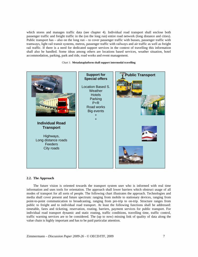
which stores and manages traffic data (see chapter 4). Individual road transport shall enclose both passenger traffic and freight traffic in the (on the long run) entire road network (long distance and cities). Public transport has – also on the long run – to cover passenger traffic with busses, passenger traffic with tramways, light rail transit systems, metros, passenger traffic with railways and air traffic as well as freight rail traffic. If there is a need for dedicated support services in the context of travelling this information shall also be handled. Some ideas among others are locations based services, weather situation, hotel accommodation, parking, park and ride, road works and event management.
Chart 1: Metadataplatform shall support intermodal travelling
2.2. The Approach
The future vision is oriented towards the transport system user who is informed with real time information and uses tools for orientation. The approach shall lower barriers which obstruct usage of all modes of transport for all sorts of people. The following chart illustrates the approach. Technologies and media shall cover present and future spectrum: ranging from mobile to stationary devices, ranging from point-to-point communication to broadcasting, ranging from pre-trip to on-trip. Structure ranges from public to freight and to individual road transport. At least the following functions shall be addressed: timetable, fares and ticketing, reservation, routing, barriers, payment services for public transport. For individual road transport dynamic and static routing, traffic conditions, travelling time, traffic control, traffic warning services are to be considered. The (up to now) missing link of quality of data along the value chain is highly important and has to be paid particular attention.
Road Transport
Individual Road Transport
Highways,
Long distance roads Feeders
City roads
Public Transport Support for Special offers
Location Based S.
Weather Hotels Parking
P+R Road works Big events
+ +

8 Zimmermann – Discussion Paper 2009-26 - © OECD/ITF, 2009
The lower part of the chart shows German project clusters/discrete projects (German project titles are
not translated) which are presently in progress or planned. The responsibility of both ministries is indicated.
Chart 2: The realization of the vision needs technology, functions and discrete projects
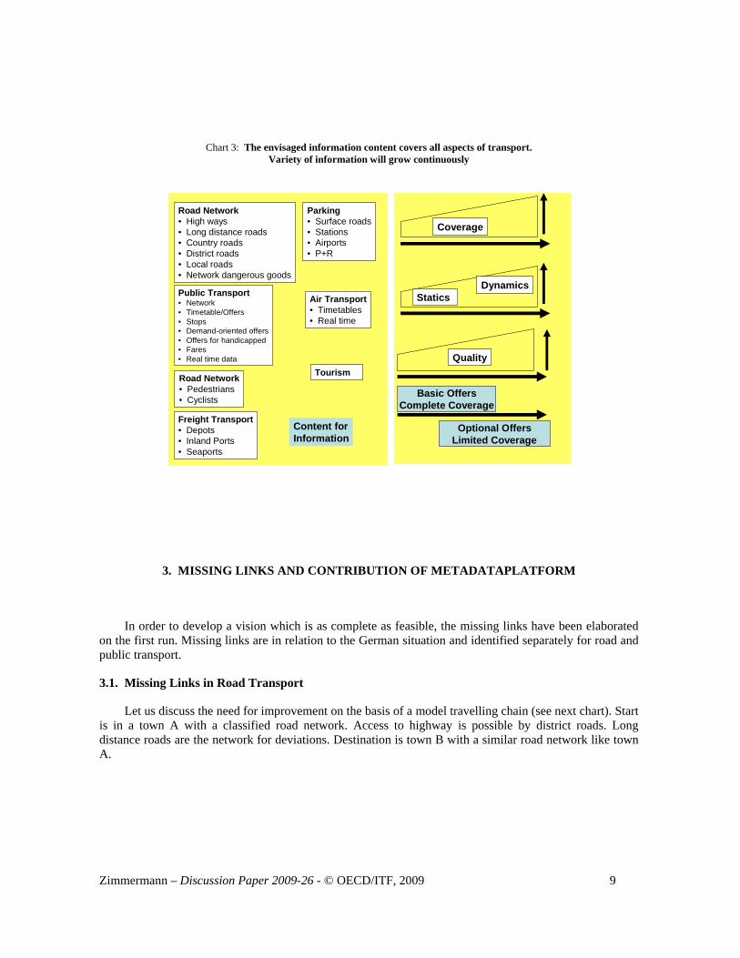
The following chart shows on the left hand side which information content will be needed. Road network also with consideration of hazardous goods. Public passenger transport from timetables and real time information, covering all present and future services. Pedestrians and cyclistes shall be served. On the right hand side of the chart is demonstrated that we envisage a continuously growing depth of information and quality. The geographical coverage will grow continuously. Static information will be expanded to dynamic data. Whereas quality of data is presently almost unknown, special attention will be payed in order to make information transparent and reliable for potential customers and users. The aim for basic services is a complete geographical coverage, whereas optional services could also be geographically limited.
The informed and oriented transport system user (Intermodal)
Smart Phone
GSM NFC Handy
Internet GPS RDS/TMC
On-Trip PTA
Public Transport Individual Road Transport
Timtable Fare
Ticketing
Seat Routing
Cope with Handicapp
Payment Services
Routing Traffic
Condition
Travelling Time Traffic Control
Services
Quality of Data
DELFI Electronic Fare Mgmt
IP-COM PT
Metadata Platform IT
Regional Platforms
Traffic Info
Freight Transport
Future Vision
Technology Media
Structure
Functions
Project Cluster
Projects
Ring&Ride DISTEL BAIM/plus KA CAIRO LUKA Door2Door ++++++
KA-Security RuR Pilot KA++ INNOS-Start Kolibri DELFI plus TarifDELFI ++++++++
BMVBS BMWi
General Conditions Public Relations System Architecture IT-Practise GEO-Converter Data-Converter Demo-Services Demo Operations
BMVBS/ BASt
Private Enterpr.
Zimmermann – Discussion Paper 2009-26 - © OECD/ITF, 2009 9
Chart 3: The envisaged information content covers all aspects of transport. Variety of information will grow continuously
Road Network• High ways• Long distance roads• Country roads• District roads• Local roads• Network dangerous goods
Parking• Surface roads• Stations• Airports• P+R
Public Transport• Network• Timetable/Offers• Stops• Demand-oriented offers• Offers for handicapped• Fares• Real time data
Air Transport• Timetables• Real time
Freight Transport• Depots• Inland Ports• Seaports
Road Network• Pedestrians• Cyclists
Tourism
Content forInformation
Coverage
Statics Dynamics
Quality
Basic OffersComplete Coverage
Optional OffersLimited Coverage
3. MISSING LINKS AND CONTRIBUTION OF METADATAPLATFORM
In order to develop a vision which is as complete as feasible, the missing links have been elaborated on the first run. Missing links are in relation to the German situation and identified separately for road and public transport.
3.1. Missing Links in Road Transport
Let us discuss the need for improvement on the basis of a model travelling chain (see next chart). Start is in a town A with a classified road network. Access to highway is possible by district roads. Long distance roads are the network for deviations. Destination is town B with a similar road network like town A.

10 Zimmermann – Discussion Paper 2009-26 - © OECD/ITF, 2009
Chart 4: Travelling from town A to town B
Town A
Start
Town B
Destination
Long Distance Road
Long Distance Road
District Road
Highway
What are the results of accidents, traffic jams and road works. The following chart describes these
situations.
Case 1: Accident on the highway in an area with variable message signs. The accident is recorded by detectors. Variable message signs will recommend an alternative rout via long distance roads. Cars with dynamic navigation get a recommendation for an alternative route via traffic message channel (TMC)
Case 2: Road works on the road network in town B (destination). In cities the detection is poor and road works are not recorded. Therefore no alternative route will be recommended via TMC (travel message channel). The driver has to search on his own for an alternative route.
Case 3: Additional to the accident on the highway (case 1) a severe traffic jam happens. As only a few long distance roads have detection, this situation is not recorded. No alternative route is recommended. The driver is either stuck or he has to search on his own for an alternative route.
This description shows that poor detection of the road network is one of the most important missing links for managing road traffic. Of course there are new methods of detection available – like floating car data or floating phone data. However improvement will take time and is not guaranteed for all applications.

Zimmermann – Discussion Paper 2009-26 - © OECD/ITF, 2009 11
Chart 5: Potential critical situations travelling from A to B
Town A
Start
Town B
Destination
#1:Variable Message Signs:Accident is detected – alternaterouting will be offered
Roadworks
????
#2:Not considered for routing.Poor detection on city roadsNot to be broadcasted by TMC
Traffic Data Quality not known and not yet defined
1
23
#3: Situation is not detectedWill result in traffic jam andmost probably in chaoticaltraffic situation
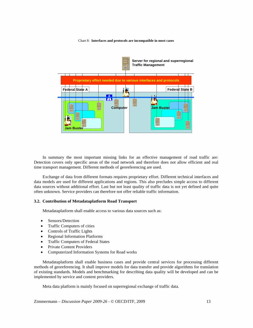
Besides insufficient detection on roads there is another weakness. The following chart shows a model case. Two federal states are connected by highways. Both states have different regions. Different cities are located in the regions.
Chart 6: Exemplary geographical situation
Federal State 1
Region A
Town a
b
c
Town a
Region B
b
c
Federal State 2

12 Zimmermann – Discussion Paper 2009-26 - © OECD/ITF, 2009
Any of these independent units (state, region and town) operates computers for traffic management. Both states operate computers along there sections of highway. If there are roadside detectors actual traffic situation is known in most cases with geographical reference. Broadcasting companies and German Automobile Association ADAC have established a network of jam busters. Traffic warning news is broadcasted via traffic message channel TMC with geographical reference.
Chart 7: Computers for traffic management are available and jam busters report actual traffic situations
Federal State 1Federal State 2
Jam Buster
On the first glance it seems to be an excellent starting point. However this conclusion is wrong. If a service provider wants to establish a routing service for this model geography a considerable proprietary effort is needed due to various technical interfaces and protocols which are used by the different content owners and service providers. This is partly due to different manufacturers supplying the computers/software. Sometimes also different generations of computers and data models are used which are not compatible. In any case proprietary effort is inefficient. Meta data platform will facilitate access to different data sources.
Zimmermann – Discussion Paper 2009-26 - © OECD/ITF, 2009 13
Chart 8: Interfaces and protocols are incompatible in most cases
Jam Buster
Jam BusterComputer
Federal State A Federal State B
Server for regional and superregionalTraffic Management
Proprietary effort needed due to various interfaces and protocols
In summary the most important missing links for an effective management of road traffic are: Detection covers only specific areas of the road network and therefore does not allow efficient and real time transport management. Different methods of georeferencing are used.
Exchange of data from different formats requires proprietary effort. Different technical interfaces and data models are used for different applications and regions. This also precludes simple access to different data sources without additional effort. Last but not least quality of traffic data is not yet defined and quite often unknown. Service providers can therefore not offer reliable traffic information.
3.2. Contribution of Metadataplatform Road Transport
Metadataplatform shall enable access to various data sources such as:
• Sensors/Detection • Traffic Computers of cities • Controls of Traffic Lights • Regional Information Platforms • Traffic Computers of Federal States • Private Content Providers • Computerized Information Systems for Road works
Metadataplatform shall enable business cases and provide central services for processing different
methods of georeferencing. It shall improve models for data transfer and provide algorithms for translation of existing standards. Models and benchmarking for describing data quality will be developed and can be implemented by service and content providers.
Meta data platform is mainly focused on superregional exchange of traffic data.
14 Zimmermann – Discussion Paper 2009-26 - © OECD/ITF, 2009
Potential users of metadatenplatform road transport are:
• Service providers which offer individual services to their customers • Administration for improvement of traffic management • Broadcasting stations for traffic warning news • Traffic planners for their daily field of actions • Town planning institutions for their daily tasks • Environmental institutions which can get access to a variety of data sources • Freight transport and logistics for rout planning and scheduling
3.3. Missing Links in Public Transport
Door-2-Door timetable information is needed for superregional travelling. In Germany 84 out of 99 investigated regional transport entities offer door-2-door timetable information.
Up-to-date information is getting increasing importance from the customers point of view. This requires access to mobile information. Mobile services are limited to a few large transport entities. Presently fare cannot be determined automatically by internet services of the transport entities for superregional travelling. The project Tarif-DELFI shall close this missing link. For handicapped people only strictly limited service are available. This situation has to be improved considerably. Also for public transport no common definition of data quality is available. Timetable information does not give an indication for quality.
Electronic fare management is presently being introduced with model field tests. Coverage in all areas has to be reached.
Special attention has to be given to properties and user rights in public transport.
All rights belong to transport entities. Rights of regional timetables are increasingly regulated. Exchange of superregional data is quite often not regulated. However the DELFI Consortium (16 federal states plus Deutsche Bahn AG) has regulated properties and user rights. The federal states and Deutsche Bahn agree to exchange their timetable information on a regular basis. In order to improve this situation BMVBS has initiated a relevant analysis to do the investigation in more detail.
3.4. Contribution of Metadataplatform Public Transport
Metadataplatform Public Transport is and will not be a single project but a bunch of separate projects. Those projects will be outlined in chapter 5 (Next Steps). Attention will be given to the co-ordination of these projects in order to reach the vision of the informed and oriented transport system user.
Potential users of the metadatenplatform public transport are:
• Customers of public transport via service providers (including air traffic) to match with customer needs.
• Companies which operate and plan/manage public transport. This is especially true for superregional travelling or operating integrated transport systems.
• Traffic planners for their daily field of actions • City planning institutions for their daily tasks • All other service providers

Zimmermann – Discussion Paper 2009-26 - © OECD/ITF, 2009 15
4. ARCHITECTURE OF METADATAPLATFORM ROAD TRAFFIC
4.1. Metadataplatform – a Virtual Internet Portal
Metadataplatform will represent the link between content owners and service providers. It will enable a more efficient dialogue and co-operation between both parties. As mentioned before service providers can be private and public ones.
Metadataplatform will be a virtual internet platform which offers a link list, brokerage services and establishes fixed rules for data exchange, registration, property rights, liability etc. In the course of the project business models will be developed and assessed.
Centralized services for conversion of various georeferences and data standards will be developed as well as algorithms which define quality of traffic data. This will not necessarily be integral part of the metadataplatform.
In order to use the metadataplatform following steps have to be performed:
Step1: Content owners/providers register in the metadataplatform and describe (type, origin, location, periods of update etc.) their data including quality indication
Step2: Service Providers which want to offer services to their customers also register and can search and find required content.
Step 3: Service provider and content provider come in direct contact with each other under the rules described above. No content provider can use the data of the content owner without accepting common rules.
Present situation (without meta data platform) would require that service providers have to negotiate and contract separately with all content owners.

16 Zimmermann – Discussion Paper 2009-26 - © OECD/ITF, 2009
Chart 9: Metadataplatform as virtual internet portal
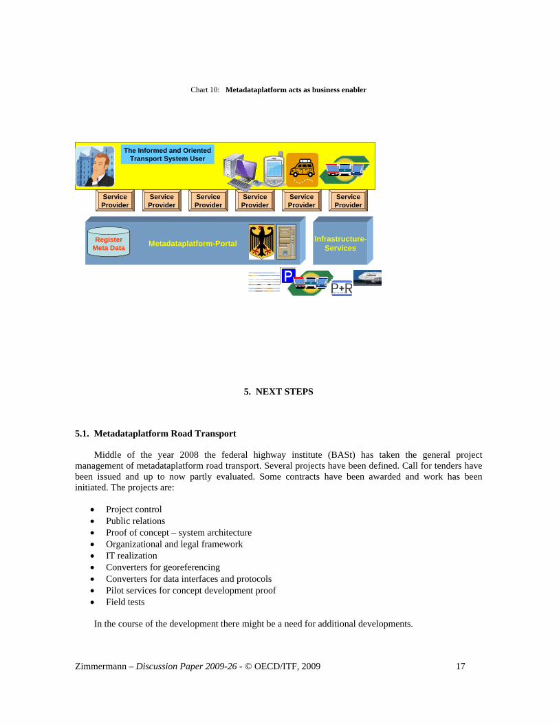
4.2. Metadataplatform Enables Business for Content and Service Providers
As shown in chapter 4.1 metadataplatform has content providers and service providers as customers. It will make b2b-business easier and therefore has the goal of enabling new business models and optimize existing ones.
Everything shall be servicing the informed and oriented transport system user. Easier access to data sources will allow for dynamic and high quality information. If demand exists for add-on services they can also be included e.g. weather conditions (actual conditions and forecast), parking situation (location, free capacity and tendency), park and ride capacities for public transport (location, free capacity and tendency). In case of road transport timetable information and real time situation of public transport can be offered and also timetable information and real time situation of airlines and airports may be required.
Metadatenplattform-Portal Als Business Enabler
Entdeckung und Nutzung Von Daten und Diensten
Metadataplatform Portal Enables Business
Discover and use of data and services
Register Meta Data
Portal
InfrastructureServices
Organization Security
Content Providers with Proprietary Data
Service Provider
Publish 1
Search/Find 2 Use 3
Zimmermann – Discussion Paper 2009-26 - © OECD/ITF, 2009 17
Chart 10: Metadataplatform acts as business enabler
The Informed and OrientedTransport System User
Infrastructure-ServicesMetadataplatform-PortalRegister
Meta DataRegister
Meta Data
ServiceProvider
ServiceProvider
ServiceProvider
ServiceProvider
ServiceProvider
ServiceProvider
5. NEXT STEPS
5.1. Metadataplatform Road Transport
Middle of the year 2008 the federal highway institute (BASt) has taken the general project management of metadataplatform road transport. Several projects have been defined. Call for tenders have been issued and up to now partly evaluated. Some contracts have been awarded and work has been initiated. The projects are:
• Project control • Public relations • Proof of concept – system architecture • Organizational and legal framework • IT realization • Converters for georeferencing • Converters for data interfaces and protocols • Pilot services for concept development proof • Field tests
In the course of the development there might be a need for additional developments.

18 Zimmermann – Discussion Paper 2009-26 - © OECD/ITF, 2009
A project called traffic IQ (information quality) has also been started. It is financed and controlled by the ministry of economics and technology in close contact to the ministry of transport, building and urban affairs. Algorithms and benchmarking criteria will be developed for the entire value chain. Cities of Leipzig, Frankfurt, Düsseldorf and Nürnberg will be test areas. Highways of southern Bavaria and Baden-Württemberg are also included.
The overall period of development and verification is expected to be 4 years.
5.2. Metadataplatform Public Transport
The development projects for metadataplatform public transport will be shared among the ministries of transport, building and urban affairs (BMVBW) and economics and technology (BMWi). Key projects are e. g.:
• Further development of German timetable information system (DELFI) • Further development of electronic fare management modules (in total 8 projects) • Initiation of TarifDELFI (automated fare information across different transport entities via
internet) • Analysis of ownership and user rights • Initiation of data quality modules for public transport • Definition of a door2door-programm and initiation of developments • Indoor routing in great interchange stations • Initiation of internet protocol communications for public transport • Further development of modules which make public transport more attractive for handicapped
persons
The overall period of development and verification is expected to be 4 years.