the institute of seismological research - a premier...
TRANSCRIPT

Institutional Report
The Institute of Seismological Research - A Premier Research Centerfor Seismology in IndiaPALLABEE CHOUDHURY* and M RAVI KUMARInstitute of Seismological Research, Department of Science and Technology, Government of Gujarat,Raisan, Gandhinagar 382 009, India
(Received on 10 April 2016; Accepted on 25 June 2016)
*Author for Correspondence: E-mail: [email protected]
Proc Indian Natn Sci Acad 82 No. 3 July Spl Issue 2016 pp. 1049-1060 Printed in India. DOI: 10.16943/ptinsa/2016/48503
Introduction
The tragedy caused by the January 26, 2001 Mw 7.8earthquake marked a turning point in the disasterawareness and preparedness in the state of Gujarat,northwest India. This earthquake took the lives of14,000 people, injured almost 170,000 or more,damaged 1.2 million houses and destroyed thousandsof classrooms and numerous other essential facilities.The state of Gujarat has been aggressive in it’sreconstruction program and made immense progresswithin a short time span of the disaster. In view of the
large scale development envisaged across the state,an acute need for an institute fully dedicated toseismological research was perceived to enablesustaining accelerated development. To fulfil thisrequirement, the Government of Gujarat approved theestablishment of the Institute of SeismologicalResearch (ISR) in the year 2003. Subsequently, theDepartment of Science and Technology (DST-GoG)with funding from the World Bank and Gujarat StateDisaster Management Authority (GSDMA)established ISR as a centre of excellence in modernseismological research in 2006. The ISR is unique in

1050 Pallabee Choudhury and M Ravi Kumar
India being the only institute fully dedicated toEarthquake Studies.
The vision of the institute is to understand thescience of earthquake occurrences in intraplate andother regions and use this knowledge to save livesand minimize damage due to earthquakes. Currently,the strategic thrusts of the institute are:
l Earthquake monitoring through standardizedsurface observations. The use of modern digitaltechnology in establishment of regional seismicnetworks including strong motion instruments,data acquisition and dissemination by exchangeof catalogues, databases and bulletins fromvarious sources.
l Developing new knowledge based techniquesof probabilistic earthquake forecasting, microand macro zoning of various vulnerable zones.
l Making recommendations relating to reductionof earthquake losses and using sound disastermitigation policies and practices.
l Improve seismic safety and performance in builtin environment especially in highly vulnerableurban areas.
l Undertaking steps and efforts to communicateearthquake science to engineers and use theknowledge base for creating public awarenessby various methods in modern communicationand media methodologies in society.
l Using multidisciplinary development in geological,geodetic, archaeological, physical sciences, geo-chronological and paleo-seismic studies forunderstanding the seismo-tectonic frameworkunder plate tectonics theory and nonlineardynamics.
l Accurate fault characterization, global andregional forecasting, fault system dynamics,earthquake source physics and ground motionprediction.
The current activities of ISR include
l Seismicity monitoring of the Gujarat State andthe Narmada Dam area using a network of 60broadband seismological stations. With the datareceived by VSAT and an auto location facility,the epicenter and magnitude of an earthquakeare provided within minutes.
l Seismic microzonation and seismic hazard
studies for different cities to suggest seismicfactor for earthquake-resistant designing of lowto high-rise buildings in different areas.
l Understanding the physical processes relatedto earthquake genesis, with emphasis onintraplate regions.
l Long-term earthquake hazard assessment ofdifferent geological faults of Gujarat through adense network of 22 GPS receivers, whichdetects minute deformation of 1 mm/year.
l Paleoseismology to unravel the record ofhistorical earthquakes during the last 40,000years.
l Palaeoclimatic research to decipher the climaticfluctuations in Gujarat during the last 10,000years.
l Investigating the crustal and lithosphericstructure and imaging the faults throughmultidisciplinary studies involving PassiveSeismology, Gravity, Magneto-Tellurics andResistivity.
l Earthquake precursory research using data fromthree multi-parametric geophysical observatoriesin Kachchh in which 11 different types ofparameters are being observed.
l Assessment of Tsunami hazard and providingsafety factors for Tsunami resistant designingof different types of structures, such as nuclearpower plants, ports, jetties, oil pipelines andestimation of the arrival time and height oftsunami in the coastal areas.
l Creating awareness among people and allay theirfear and anxieties about earthquakes. The ISRparticipates in mega events and demonstratesthe online seismic data acquisition and locationprotocols, tsunami animation, earthquake effectson buildings and how to safeguard against them.
l Imparting training to students and guidingresearchers. Every year ISR trains about 100students from all over India by way of MSc/MTech dissertation and PhD thesis.
l Exploring and disseminating new terrains ofresearch on Seismology by organizingInternational Symposia and training courses. TheISR regularly organizes International symposiaand training courses which are attended byparticipants from all over the country. Eminent
The ISR-A Premier Research Center for Seismology in India 1051
and young scientists from the country and abroadcontribute by presenting their valuable and stateof the art research studies.
Noteworthy Contributions of ISR During 2011-2015
Highlights of the Research Outcomes During2011-15 are given below:
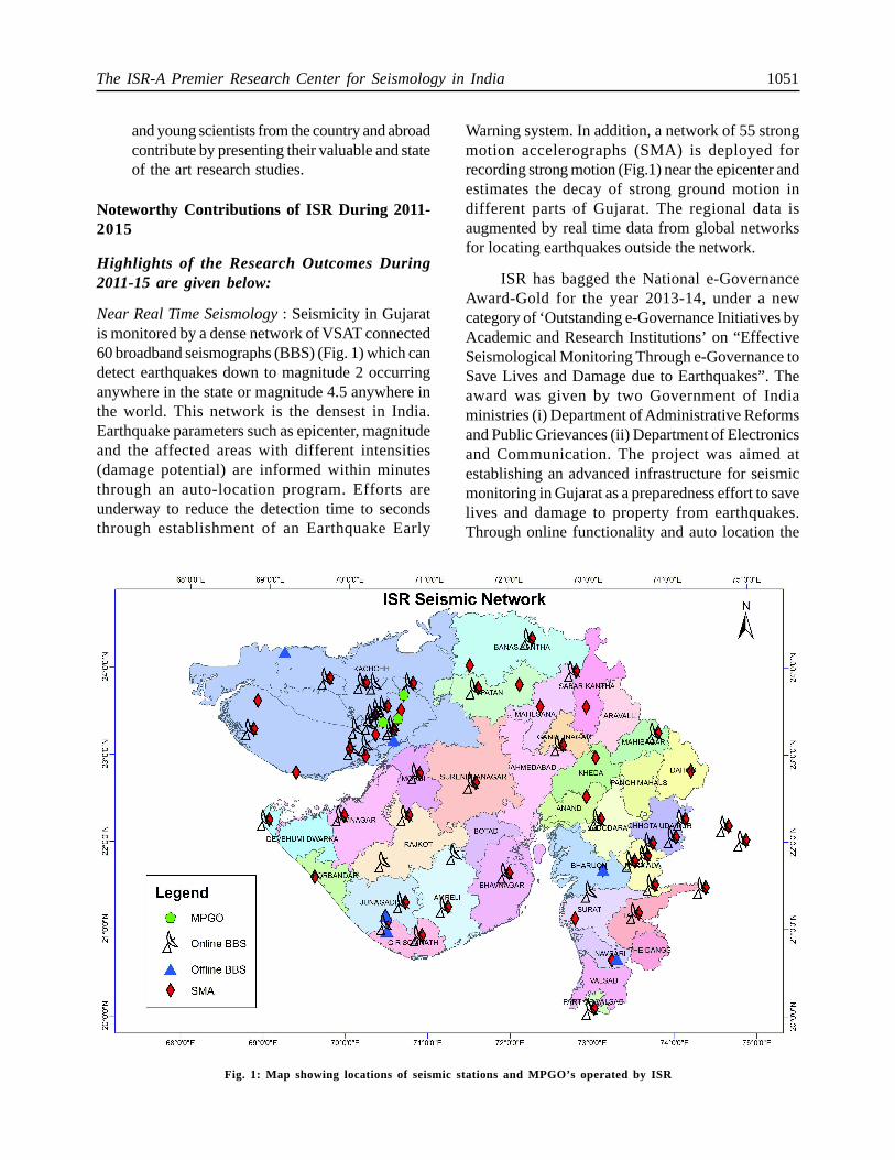
Near Real Time Seismology : Seismicity in Gujaratis monitored by a dense network of VSAT connected60 broadband seismographs (BBS) (Fig. 1) which candetect earthquakes down to magnitude 2 occurringanywhere in the state or magnitude 4.5 anywhere inthe world. This network is the densest in India.Earthquake parameters such as epicenter, magnitudeand the affected areas with different intensities(damage potential) are informed within minutesthrough an auto-location program. Efforts areunderway to reduce the detection time to secondsthrough establishment of an Earthquake Early
Warning system. In addition, a network of 55 strongmotion accelerographs (SMA) is deployed forrecording strong motion (Fig.1) near the epicenter andestimates the decay of strong ground motion indifferent parts of Gujarat. The regional data isaugmented by real time data from global networksfor locating earthquakes outside the network.
ISR has bagged the National e-GovernanceAward-Gold for the year 2013-14, under a newcategory of ‘Outstanding e-Governance Initiatives byAcademic and Research Institutions’ on “EffectiveSeismological Monitoring Through e-Governance toSave Lives and Damage due to Earthquakes”. Theaward was given by two Government of Indiaministries (i) Department of Administrative Reformsand Public Grievances (ii) Department of Electronicsand Communication. The project was aimed atestablishing an advanced infrastructure for seismicmonitoring in Gujarat as a preparedness effort to savelives and damage to property from earthquakes.Through online functionality and auto location the
Fig. 1: Map showing locations of seismic stations and MPGO’s operated by ISR

1052 Pallabee Choudhury and M Ravi Kumar
earthquake parameters are disseminated withinminutes to state authorities, disaster management teamand general public through SMS, email and website.The quick availability of earthquake information aswell as potential damage map and shake map increasethe ability and efficiency of decision makers andsignificantly reduces the time delay in start of the reliefwork. The reliable and immediate reports provided tomedia allay the anxiety / fear among the people. Duringthe last 5 years nearly 9000 shocks of M0.5-5.1 havebeen recorded (Fig. 2). The data available on websiteis used nationwide for M. Tech. dissertations and PhDtheses. The outcome is also in terms of tsunami alert;earthquake hazard and loss assessment, basic as wellas applied research in seismology and engineering.
The knowledge of scaling relationships is crucialfor both probabilistic and deterministic seismic hazardanalysis. Such scaling relations allow estimatingseismic energy or faulting parameters from measuredseismic magnitude or moment. The seismic sourcesdiffer not only in their size and average slip, but stressconditions differ from region to region. Events ofsame seismic moment may release seismic energythat differs by 2 to 3 orders. The use of global scalingrelations may not be appropriate. So, the site specific
regional scaling laws need to be developed and usedfor seismic hazard analysis. In this regard, regionalscaling laws for Kachchh and Jungadh regions havebeen developed. Also, static stress drop and highfrequency decay parameter ‘kappa’ have beenestimated for Kachchh, Junagadh and Jamnagarregions of the state. In order to provide high qualitydata for source and earth structure studies, the SeismicBackground Noise (SBN) levels should be as low aspossible. The utility of seismic data is greatly increasedwhen noise levels are reduced. A study of the SBNvariations at 14 permanent BBS stations reveals largevariations as a function of period, time and geographiclocation.
An attempt towards developing an EarthquakeEarly Warning System (EEWS) is made. The objectiveof EEWS is to forewarn urban centres a few secondsto tens of seconds prior to the arrival of destructiveshear waves generated by a strong earthquake. Thesetypes of works are being initiated on a pilot basis inmost countries of the world prone to strongearthquakes. ISR has developed a new methodologyfor rapid detection of events and estimation of themagnitude. Testing and validation of the relationshipsdeveloped for Gujarat region with those of othercountries is in process.
Basic Research
Paleoseismology is the study of prehistoricearthquakes, especially their location, time and size.This study is done by interpreting geological evidencecreated during individual paleoearthquakes and helpsto understand the regional pattern of tectonicdeformation and the long term behaviour of a specificfault. The strong earthquakes often leave geologicalevidences that are mainly related to surface faulting,folding or other deformation. A fault showing someactivity in recent times is considered as active in termsof seismogenic potential and risk. Paleoseismology,Geomorphology and dating of recent tectonic featuresestablish return periods of earthquakes and help inforecasting of earthquakes by determining ages ofpre-historic earthquakes in Kachchh and rates ofmovements along geological faults.
ISR has been doing such studies since the timeof its establishment. In the last few years, fault lineshave been mapped by geological and geophysicalsurveys as well as remote sensing and their relative
Fig. 2: Seismotectonic Map of Gujarat (Seismicity fromearliest time to 2014). NPF: Nagar Prakar Fault, ABF:Allah Bund Fault, KMF: Kutch Mainland Fault, SWF:South Wagad Fault, NWF: North Wagad Fault, IBF:Island Belt Fault, KHF: Katrol Hill Fault, BF: BanniFault, GF: Gedi Fault, NKF: North Kathiwar Fault,SNF: Son Narmada Fault

The ISR-A Premier Research Center for Seismology in India 1053
activeness has been assessed by dating of prehistorictectonic episodes and paleoseismologicalinvestigations. Potential sites are identified with thehelp of remote sensing, geomorphometric studies,identification of signs of active movement on the sites,which indicate proximity to fault like pressure ridgesand abrupt termination of river delta etc. Severalgeophysical surveys are also used to detect thesubsurface faults. Analysis of samples collected fromtrenches is done in the OSL Lab for determining theages of the sediments and how they were formed.The estimated deformation is corroborated with GPSand RTK results. The same study is extended to innerKumaun Lesser Himalaya, Uttarakhand regions.
Approaches followed are as below:
l Integrated remote sensing (CORONA images,etc) and field surveys for identification ofpressure ridges, drainage offsets and youngerscarps.
l Geomorphic indices coupled with tectono-geomorphology and shallow subsurfacegeophysical surveys (GPR) for site selection.
l Trenching at shortlisted sites.
l Sedimentological, geochemical, mineralmagnetic and chronological (OSL and 14C AMS)studies from fluvial sequences.
Allah Bund (ABF), Kutch Mainland (KMF),South Wagad (SWF), Island Belt (IBF) and KatrolHill (KHF) Faults in Kachchh are found to be activeas observed by Quaternary movements in trenches.This indicates that different faults are neotectonicallyactive. Spatial variability in tectonic activity alongKMF, KHF suggests that the central parts of thesemajor faults are more active compared to the rest ofthe segments. Active fault studies along Gedi Fault,SWF shows its active nature during the HolocenePeriod.
ISR has performed seismic tomography studieson a local as well as regional scale, for Kachchh andSaurashtra regions of the Gujarat state as well as forthe Himalayan region. ISR has evolved a techniqueof 3D fault mapping by Magnetotelluric investigations.Such surveys were done in the Kachchh region foridentification of faults and in mainland Gujarat forlocating geothermal sources. Broadband and longperiod Magnetotelluric (MT) investigations in theeastern part of the Kachchh basin are carried out to
map the deep electrical resistivity structure of theregion. The aim of the study is to obtain 2-D/3-Dgeoelectric structure of the region, which will beintegrated with the available seismological informationto understand the migration of seismicity towards thenorth-eastern part of the basin, characteristics ofvarious active faults, map the possible presence ofdeep partial melts/fluids in the region and understandtheir role in geodynamics of the region. To obtaininformation on the deeper structure, long period (4– 5days, >1000 sec) data is acquired. Till date, ISR hasacquired MT data at 150 locations in Kachchh.Delineation of faults and basement structure is alsodone using high resolution gravity surveys. So far,measurements have been made at about 1800locations. Usually, the observations are made at 1 kminterval, but for detection of faults, the interval is assmall as 50 or 100m. The Bouguer Anomaly contourmap was prepared at 1mgal interval for the Kachchhrift and Cambay basins and used to decipher the natureof known faults and some hidden faults. Thecoordinates of gravity stations obtained using RTK(GPS), with excellent accuracy.
Societal Research
Earthquake hazard assessment is done at ISR frommacro to micro level. At the macro level, the institutehas updated the Probabilistic Seismic HazardAssessment map of India. Vulnerability of coastalinstallations from earthquakes and tsunami is studiedalong coasts of Gujarat. Also, the Seismic HazardMap of Gujarat has been prepared based on pastseismicity and the maximum possible magnitude alongdifferent fault lines. A map of shear-wave velocity to30m depth, Vs30, of Gujarat state has been prepared,which indicates relative soil strength with depth fordifferent geological regimes. Vs30 has been measuredat about 500 locations by shallow seismic and PSlogging methods in different types of groundconditions. Maps of resonance frequencies andamplifications corresponding to them are prepared,which indicate amplification of seismic waves fordifferent periods (or level of seismic hazard fordifferent heights of buildings) for the entire state.Geotechnical studies are done through numerousboreholes to 50m depth. Soil properties at every 1.5mdepth are measured in a well-equipped geotechnicallab. The Neo-Deterministic method developed by theMathematics and Geosciences group of Trieste

1054 Pallabee Choudhury and M Ravi Kumar
University, Italy determines the ground motion basedon the velocity structure of the entire path. Thismethod has been used for Gujarat also and hazard isestimated.
Gujarat is the only state outside Himalayan andSumatra-Andaman region which has a high seismichazard due to earthquakes of magnitude 6 to 8. Eventhen, earthquake resistant high-rise buildings can beconstructed with only 5-7% extra cost. Hence, theareas of rapid growth in Gujarat need to have priorinformation about earthquake safety factor to beconsidered. Moreover, due to different groundconditions or soil distribution with depth, seismic wavesamplify differently for different heights of buildings,which has to be assessed. For this purpose, ISR iscarrying out Seismic Microzonation of different citiesand providing knowledge for seismic safety factor tobe considered for each region of Gujarat for differentheights of buildings. From this study, the structuralresponse curves are determined which indicateacceleration for different natural periods in a 250-500m grid. This analysis involves geotechnicalinvestigations through numerous boreholes andgeophysical measurements of seismic wave velocitiesby seismic survey and PS logging. The liquefactionpotential is also assessed. ISR has well-equippedgeotechnical and geophysical labs for different laband on-site tests. At micro level, earthquake hazardassessment is made for critical structures like NuclearPower Plants, LNG Terminals and clusters ofSkyscrapers. The institute has a unique expertise ofcarrying out all aspects of seismic microzonation.
To understand the tectonic process fromdeformational pattern of different fault systems in theGujarat region, a dense network of geodetic gradeDifferential GPS stations is deployed. Since the year2006, crustal deformation in Gujarat is being monitoredby this network. A permanent network of 22 stationsis being operated across different faults continuouslytill today. In addition, ISR is also running 11 GPSstations in campaign mode since 2006. The campaignmode surveys are being done twice a year. Mappingof paleo river-channels to find source of potable waterwith the aid of remote sensing and ground check bygeological and geophysical surveys are also carriedout. A horizon of potable water at 250 m depth belowthe layer of saline water in Ramgarh area near Jaipur,Rajasthan was discovered. Finding water in perchedRajasthan is like finding gold.
An effective and economical way of mappingshallow and deep soil shear wave velocity structureand estimate the sediment thickness is by Microtremormeasurements. ISR has occupied 450 singleMicrotremeor sites in 8 districts of Gujarat and groundvibrational characteristics such as predominantfrequency and amplification at these sites areestimated. Microtremor array measurements (MAM)were carried out over diverse geological formationsand liquefaction sites in the Kachchh seismic zone ofwestern India, which is host to the deadliest intraplateearthquake (Mw 7.7). The MAM were made usingtriangular arrays with sensors kept at 30-90 m radii.The 1-D shear wave velocity structure is determinedby inversion. A good correlation between surfacegeology, resonant frequency, amplification and shearwave velocity is found. The ground vulnerability indexvalues in the liquefied areas are found to be higherthan those in the adjacent areas devoid of liquefaction.The results of microtremor analysis corroborate theobservations from available geophysical, geologicaland borehole data.
Earthquake prediction research is being carriedout through three Multi-parametric GeophysicalObservatories (MPGO) in Kachchh region atBadargadh,Vamka and Desalpar (Fig.1). MPGO sitesare in east and northeast of the aftershock zone of2001 Bhuj earthquake (Mw 7.7), where the activityhas migrated from the year 2006 onwards. Magnitude5 earthquakes are still occurring in Kachchhoccasionally and 70 shocks of magnitude “>1” arerecorded on an average, per month. A Very BroadbandSeismometer, Strong Motion Accelerograph, GPS andRadon recorders are installed at all the three sites.Fluxgate magnetometers are installed at Desalpar andVamka. Only two water level recorders at Desalparand Badargadh are installed at the confined aquiferzone and all the others are installed at shallow depth(below 5 m). Three Overhauser Magnetometers, threeDeclination/Inclination Magnetometers, three ULFMagnetometers are installed and recording data.Some anomalies in the magnetic, radon and gravitymeasurements are observed, correlated well withsmall to moderate earthquakes in the region.
ISR has conducted Site specific Seismic hazardstudies for the 182 m Sardar Patel Statue, which isthe tallest statue in Asia, a planned 15-storey Hospitalat Ahmedabad, Multi-storey commercial and

The ISR-A Premier Research Center for Seismology in India 1055
residential complexes of Ahmedabad and Industrialsites in Kachchh. Seismic Microzonation of Areas ofrapid growth like Dholera Special Investment Regionwhere a number of cities with high-rise buildings,industrial hubs, an airport, a railway station are planned;cities like Gandhidham, Anjar, Gandhinagar andAhmedabad are completed. ISR has also completedseismotectonic study of the site for LNG storage tanksin Mundra and a cluster of skyscrapers coming up inGujarat International Finance Tec-city, which will havenumerous buildings of 30 to 100 storeys. An importantfinding is that the low-rise buildings of 3-7 stories needto have 60-70% higher seismic factor than thatrecommended in the National Code, to avoid a disasterakin to that caused by the 2001 earthquake. ISR alsoestimated response spectra for nuclear power plantslike Kakrapar and Rawatbhata and vulnerabilityassessment of ports of Gujarat. Study of surfacedeformation mapping using Differential SARInterferometry and Earthquake Precursory studies inKachchh is completed. A project on probabilisticanalysis of seismic losses for urban areas and lifelinenetworks in Kachchh is being carried out incollaboration with the Karlsruhe Institute ofTechnology, Germany. The Govt. of Gujarat hasplanned to start a 1 MW Geothermal plant in the statefor the first time. Through magnetotelluricinvestigations, ISR has identified two geothermalsource zones at Chabsar and Tuwa. Through thesecommercial projects ISR is connecting research withlives and society as these works have societalimportance and useful for saving lives and damage ofproperties due to earthquakes.
Research on Paleotsunami and Paleoclimate
ISR has initiated Paleotsunami studies in the westcoast of India. Several large boulders are seen in thewest coast which are possibly results of paleotsunami.The study aims to ascertain whether these aretransported by a tsunami and if so, the source.Possibility of transportation by storm or by humanactivity is ruled out on the basis of the biologicalfeatures present on the boulders and the physical orgeomorphological field characteristics. The westerncoast of India is susceptible to tsunamis generatedfrom multiple sources such as the Makran SubductionZone (MSZ), Owen Fracture Zone (OFZ) andCarlsberg ridge. The work also tried to examine thepossibility of an earthquake-cum-landslide generated
tsunami along the Owen Fracture zone. Althoughseveral studies from around the world have identifiedsubmarine landslides as a source of tsunami, therehave been fewer studies documenting theirimplications in coastal hazard scenarios. Direction andforce of transport of boulders were estimated whichare lying along the coast. Measurements of the boulderdimensions, namely the (a) long, (b) medium and (c)shorter axis were recorded in addition to their distancefrom the high tide line. Also, their respective shapeand orientation of along long axis were recorded.Samples of some boulders were collected and theirdensity was measured in the laboratory of ISR. Inorder to evaluate the characteristics of wavesresponsible for the boulder deposits, evaluation of theminimum wave height capable of dislodging andtransporting the boulders is first made followed bythe estimation of the inundation distance of the waves.ISR first reported boulder sized palaeotsunami depositsalong western coast of India during the last 3 ka witha wave height of 4 m along the Gujarat coast.
A broad correspondence of the monsoonreconstruction based on the valley-fill and the channel-fill deposits with that of the regional climate patternindicates that the Kachchh peninsula in the westernIndia responded in accordance with the regionalclimatic variability during the post-LGM period. Aprogressive strengthening of monsoon was observedbetween 17 and 12 ka and an overall strengthenedmonsoon with fluctuation is inferred between 12 kaand <8 ka. This was followed by a steady decline inmonsoon strength during 8 ka to 3 ka. Presence ofthe younger fill sequences proximal to the presentday river channel dated to ~1 ka indicates a short-lived phase of renewed and strengthened IndianSummer Monsoon before the onset of present dayaridity.
ISR has carried out aggradation and incisionstudies in the Kachchh region which reveal monsoonalfluctuations since the last 15 ka. Fluvial terraceformation is often regulated by external forcings likeclimate, tectonic and eustatic changes. The terracesedimentary record, particularly in a dry landenvironment, preserves the discrete signatures ofthese external forcings, thus enabling to reconstructthe fluvial response to late Quaternary palaeoenvironmental changes and factors governing them.Studies of ISR focused on reconstructing the

1056 Pallabee Choudhury and M Ravi Kumar
aggradation/incision phases in the Lotia River in theeastern segment of the Northern Hill Range (NHR)of the Kachchh Peninsula, which drains fromMesozoic rocks before cutting through the KachchhMainland Fault (KMF) to finally debouch in the BanniPlains. Reconstruction based on tectonicgeomorphology, sedimentology, sedimentgeochemistry, mineral magnetics, and OSL chronologysuggests the fluvial response to monsoon variabilityarchived during the last 15 ka. The time frame wasalso marked by incision enhanced by uplift along theKMF, which led to strath terrace formation. Theaccommodation space thus created was filled by theaggradational event between 14.8 ka and 10.6 ka.Sedimentological and geochemical parameters alsosuggested that the time period between 12.5 ka and11.5 ka showed a decline in monsoon strength, whichcoincides with ‘Younger Dryas’. Sediments spanningbetween 10.6 ka and 7.8 ka are absent from thearchive, which is most likely that the manifestation ofthe early Holocene optimum that led to severe erosionalprocesses. Based on the OSL chronology of bedrockstrath terrace, ISR reported a minimum uplift rate of1.04 mm/a for the eastern KMF during the LatePleistocene-Holocene period, hinting at the seismicallyactive nature of KMF during this period. The terraceformation in eastern Northern Hill Range is chieflyregulated by tectonic uplifts along the KMF.
Future Outlook
l To pursue research in exploration for mineralsand ground water using interdisciplinaryapproaches involving terrestrial and airborneobservations.
l To undertake application of high performancecomputational seismology, modeling andinterpretations, including use of artificialintelligence tools for visualization of earthprocesses, delineating hydrocarbon reservoirsand other resources for sustainable development.
l To undertake research in EarthquakeMechanics and Engineering for development ofnew concepts, new algorithms and numericalsimulation of geological structures. The chaoticnature of brittle deformation and detection ofvarious kinds of precursory signals.
l To undertake, promote and encourage variouslevels of long term original research, educationand training in pure and applied seismology. Thefocus will be on developing earthquake systemscience to understand origins, properties andconsequences of earthquakes.
l To evolve and participate in the development ofseismic policies, seismology syllabus in academicinstitutions, study tours at regional, national andinternational organizations so as to developquantitative understanding of limits ofearthquake predictability and explain concernsto public institutions.
Publications
Aier I, Luirei K, Bhakuni S S, Thong G T and Kothyari G C
(2011,) Geomorphic evolution of Medziphema
intermontane basin and Quaternary deformation in the
schuppen belt, Nagaland, NE India Zeitschrif fur
Geomorphologie 55 247-265
Basavaiah N, Mahesh Babu J L V, Gawali P B, Nagakumar K Ch
V, Demudu G, Prizomwala S P, Hanamgond P T and Rao K
N (2015) Late Quaternary environmental and sea level
changes from Kolleru Lake, SE India: Inferences from
mineral magnetic, geochemical and textural analysis
Quaternary International 371 197-208
Bayrak Y, Yadav R B S, Kalafat D, Tsapanos T M, Çýnar H,
Singh A P, Bayrak E, Yýlmaz Þ, Öcal F and Koravos G
(2013) Seismogenesis and earthquake triggering during the
Van (Turkey) 2011 seismic sequence Tectonophysics 601
163-176
Bhakuni S S, Luirei K and Kothyari G C (2013) Neotectonic
Fault in the middle part of Lesser Himalaya, Arunachal
Pradesh: a study based on structural and morphotectouic
analyses Himalayan Geology 34 57-64
Bhattarchya F, Rastogi B K and Kothyari G C (2013)
Morphometric evidences of Seismicity around Wagad and
Gedi Faults, Eastern Kachchh, Gujarat Journal of
Geological Society of India 81 113-121
Bhattacharya F, Rastogi B K, Mgangom M, Thakkar M G and
Patel R C (2013) Late Quaternary climate and seismicity
in the Katrol Hill Range, Kachchh, Western India Journal
of Asian Earth Sciences 73 114-120
Bhattacharya F, Rastogi B K, Thakkar M G, Patel R C and Juyal

The ISR-A Premier Research Center for Seismology in India 1057
N (2014) Fluvial landforms and their implication towards
understanding the past climate and seismicity in the
northern Katrol Hill range, Western India Quaternary
International DOI: 10.1016/j.quaint.2014.03.002
Chopra S, Chang T M, Saikia S, Yadav R B S, Choudhury P and
Roy K S (2014) Crustal structure of the Gujarat region,
India: New constraints from the analysis of teleseismic
receiver functions Journal of Asian Earth Sciences 96 237-
254
Chopra S and Choudhury P (2011) A study of response spectra
for different geological conditions in Gujarat, India Soil
Dynamics and Earthquake Engineering 3 1551-5164
Chopra S, Kumar D and Rastogi B K (2011) Attenuation of high
frequency P and S waves in the Gujarat Region, India Pure
and Applied Geophysics 168 797-813
Chopra S, Kumar D, Rastogi B K, Choudhury P and Yadav R B
S (2012) Deterministic seismic scenario in Gujarat, India
Natural Hazards 60 517-540
Chopra S, Kumar D, Rastogi B K, Choudhury P and Yadav R B
S (2013) Estimation of site ampliûcation functions in
Gujarat region, India Natural Hazards 65 1135-1155
Chopra S, Kumar D, Rastogi B K, Choudhury P and Yadav
(2013) Estimation of seismic hazard in Gujarat region,
India Natural Hazards 65 1157-1178
Chopra S, Kumar D, Choudhury P and Yadav R B S (2012)
Stochastic Finite Fault Modeling of Mw 4.8 Earthquake
in Kachchh, Gujarat, India Journal of Seismology 16 435-
449
Chopra S, Sharma J, Sutar A and Bansal B K (2014) Estimation of
Source Parameters of Mw 6.9 Sikkim Earthquake and
Modeling of Ground Motions to Determine Causative
Fault Pure and Applied Geophysics DOI: 10.1007/s00024-
013-0722-6
Choudhury P, Catherine J K, Gahalaut V K, Chopra S, Dumka R
and Roy K S (2013) Post Seismic deformation associated
with the 2001 Bhuj earthquake Natural Hazards 65 1109-
1118
Choudhury P, Chopra S, Roy K S and Rastogi B K (2014) A
review of strong motion studies in Gujarat State of western
India Natural Hazards 71 1241-1257
Dumka R K, Kotlia B S, Kumar K, Satyal G and Joshi L (2014)
Crustal deformation revealed by GPS in Kumaun Himalaya
Journal of Mountain Science 11 41-50
Dumka R K, Kotlia B S, Miral M S, Joshi L M, Kumar K and
Sharma A K (2013) Global Positioning System (GPS)
derived Recession Rate in Milam Glacier, Higher Central
Himalaya, India, Research Inventory: International
Journal of Engineering and Science 2 58-63
Gandhi D, Prajapati P, Prizomwala S P, Bhatt N and Rastogi B K
(2014) Delineating the spatial variability in Neotectonic
Activity along the Southwestern Saurashtra using Remote
Sensing Approach Zeitschrif fur Geomorphologie DOI:
10.1127/0372-8854/2014/0122
Gupta A, Sutar A, Chopra S, Kumar S and Rastogi B K (2012)
Attenuation Characteristics of coda waves in Mainland
Gujarat (India) Tectonophysics 530 264-271
Gupta S, Mahesh P, Sivaram K and Rai S S (2012) Active fault
beneath the Tehri dam, Garhwal Himalaya- seismological
evidence Current Science 103 1343-1347
Jade S, Mukul M, Gaur V K, Kumar K, Dumka R, Satyal G,
Saigetth J, Ananda M B and Kumar D (2014)
Contemporary deformation in the Kashmir-Himachal,
Garhwal-Kumaun Himalaya: insights from 1995-2008 GPS
time series Journal of Geodesy 1 1-9
Jaiswal R K, Singh A P, Rastogi B K and Murty T (2011)
Aftershock sequences of two great Sumatran earthquakes
of 2004 and 2005 and simulation of the minor tsunami
generated on September 12, 2007 in the Indian Ocean and
its effect Natural Hazards 57 7-26
Jaiswal R K and Rastogi B K (2012) Next Tsunami in India in the
Arabian Sea? Journal of Geophysics 33 111-115
Joshi A, Kumar A, Mohan K and Rastogi B K (2013) Hybrid
attenuation model for estimation of peak ground
acceleration in the Kutch region, India Natural Hazards
68 249-269
Joshi S and Kothyari G C (2015) Possibility of induced seismicity
in Pancheshwar dam site on Kali river, Uttarakhand
International Journal of Engineering Research and
Technology 4 380-383
Kothyari G C (2014) Morphometric analysis of Tectonically
active Pindar and Saryu River Basins, Central Kumaun
Himalaya, India Zeitschrif fur Geomorphologie
DOI:10.1127/zfg/2014/0162
Kothyari G C and Juyal N (2013) Implication of Fossil Valleys
and Associated Epigenetic Gorge in part of the Central
Himalaya Current Science 105 383-388
Kothyari G C and Rastogi B K (2013) Tectonic Control on drainage
network evolution in the Upper Narmada Valley Implication
to Neotectonics Geography Journal DOI: 10.1155/2013/
325808
Kothyari G C, Pant P D and Luirei K (2012) Landslides and
Neotectonic Activities in the Main Boundary Thrust
(MBT)zone: Southeastern Kumaun, Uttarakhand Journal
of Geological Society of India 79 1-10
Kothyari G C, Rastogi B K, Dumka R K and Chauhan M (2015)
Secondary Surface Deformation along the North Wagad

1058 Pallabee Choudhury and M Ravi Kumar
Fault zone in Kachchh Rift Basin, Western Peninsular
India Journal of Comunicações Geológicas 102 DOI:
CG13-24-2211
Kumar S, Chopra S, Choudhury P, Singh A P, Yadav R B S and
Rastogi B K (2012) Ambient noise levels in Gujarat state
(India) seismic network, Geomatics Natural Hazards and
Risk 1-13
Kumar S, Kumar D and Rastogi B K (2014) Source Parameters
and Scaling Relations for Small earthquakes in the Kachchh
Region of Gujarat, India Natural Hazards DOI 10.1007/
s11069-014-1133-4
Luirei K, Bhakuni S S and Kothyari G C (2015) Drainage response
to active tectonics and evolution of tectonic
geomorphology across the Himalayan Frontal Thrust,
Kumaun Himalaya Geomorphology 239 58-72
Luirei K, Bhakuni S S, Kothyari G C, Tripathi K and Pant P D
(2015) Quaternary extensional and compressional tectonics
revealed from Quaternary landforms along Kosi River
valley, outer Kumaun Lesser Himalaya, Uttarakhand
International Journal of Earth Sciences DOI: 10.1007/
s00531-015-1204-0
Luirei K, Bhakuni S S, Suresh N, Kothyari G C and Pant P D
(2014) Tectonic Geomorphology and Morphometry of
the frontal part of Kumaun Sub-Himalaya: Appraisal of
tectonic activity Zeitschrif fur Geomorphologie DOI:
10.1127/0372-8854/2014/0134
Mahesh P, Catherine J K, Gahalaut V K, Kundu B, Ambikapathy
A, Bansal A, Premkishore L, Narsaiah M, Ghavri S, Chadha
R K, Choudhary P, Singh D K, Singh S K, Kumar S,
Nagarajan B, Bhatt B C, Tiwari R P, Kumar A, Kumar A,
Bhu H and Kalita S (2012) Rigid Indian plate: Constraints
from GPS measurements Gondwana Research 22 1068-
1072
Mahesh P, Gupta S, Rai S S and Sarma R (2012) Fluid driven
earthquakes in the Chamoli region, Garhwal Himalaya:
evidence from local earthquake tomography Geophysical
Journal International 191 1295-1304
Mahesh P, Rai S S, Sivaram K, Paul A, Gupta S, Sarma R and
Gaur V K (2013) One dimensional reference velocity model
and precise locations of earthquake hypocenters in the
Kumaon-Garhwal Himalaya Bulletin of Seismological
Society of America 103 p.328-339
Mishra O P, Singh A P, Kumar D and Rastogi B K (2014) An
insight into crack density, saturation rate, and porosity
model of the 2001 Bhuj earthquake in the stable continental
region of western India Journal of Asian Earth Science 83
48-59
Mohan K (2014) Seismic-Hazard Assessment in the Kachchh
Region of Gujarat (India) through Deterministic Modeling
Using a Semi-Empirical Approach Seismological Research
Letters 85 117-125
Mohan K and Joshi A (2011) Role of attenuation relationship in
shaping the seismic hazard Natural Hazards 60 649-670
Mohan K and Joshi A (2013) Simulation of Strong ground motion
due to Great earthquake in the central seismic gap region
of Uttarakhand Himalaya Natural Hazards 69 1733-1749
Mohan K, Rastogi B K and Chaudhary P (2015) Magnetotelluric
studies in the epicenter zone of 2001, Bhuj
earthquake Journal of Asian Earth Science 98 75-84
Patel V M, Dholakia M B and Singh A P (2014) Emergency
preparedness in the cast of Makran tsunami: a case study
on tsunami risk visualization for the western parts of
Gujarat, India, Geomatics Natural Hazards and Risk DOI:
10.1080/19475705.2014.983188
Patel V M, Patel H S and Singh A P (2011) Comparative Study
of Earthquake and Tsunami Loading on Vertical Evacuation
Structure at Dwaraka International Journal of Earth Science
and Engineering 4 659-668
Pavankumar G, Manglik A and Thiagrajan S (2014) Crustal
geoelectric structure of the Sikkim Himalaya and adjoining
Gangetic basin Tectonophysics 637 238-250
Phartiyal B, Kaira R and Kothyari G C (2015) Late-Quaternary
geomorphic scenario due to changing depositional regimes
in the Tangtse valley, Trans-Himalaya, NW India
Palaeogeography, Palaeoclimatology, Palaeoecology 422
11-24
Phartiyal B and Kothyari G C (2012) Impact of Neotectonics on
drainage network evolution reconstructed from
morphometric indices: case study from NW Indian
Himalaya Zeitschrif fur Geomorphologie 56 121-140
Phartiyal B, Sharma A and Kothyari G C (2013) Damming of
River Indus during Late Quaternary in Ladakh region of
Trans Himalaya, NW India: Implications to Lake
formation-climate and tectonics Chinese Science Bulletin
58 142-155
Prabhin S, Rajshekhar C, Sant D A and Krishnan K (2012) Late
Holocene Storm Records from Lower Reaches of Narmada
Valley, western India Journal of Geological Society of India
80 403-408
Prabhin S, Sant D A, Krishnan K and Rangarajan G (2012) High
resolution facies record on Late Holocene Flood plain
sediments from Lower Reaches of Narmada Valley, Western
India Journal of Geological Society of India 79 41-52
Prajapati S, Chauhan M, Gupta A K, Pradhan R, Suresh G and
Bhattacharya S N (2011) Shield-Like Lithosphere of the
Lower Indus Basin Evaluated from Observations of Surface-

The ISR-A Premier Research Center for Seismology in India 1059
Wave Dispersion Bulletin of the Seismological Society of
America 101 859-865
Prajapati S, Suresh G and Bhattacharya S N (2011) Crustal
Structure of the northwestern deccan Volcanic Provinces,
India and Adjoining Continental Shelf through Inversion
of Observed Surface Wave Dispersion Bulletin of the
Seismological Society of America 101 1106-1113
Prizomwala S P, Bhatt N and Basavaiah N (2014) Understanding
the sediment routing system along the Gulf of Kachchh
coast, Western India: Significance of small ephemeral rivers
Journal of Earth System Science 123 121-133
Prizomwala S P, Bhatt N P and Basavaiah N (2014) Sediment
fluxes from a dry land fluvial regime: An example from
Rukmawati river basin, Kachchh, western India
International journal of Sediment Research 29 109-119
Prizomwala S P, Gandhi D, Ukey V M, Bhatt N and Rastogi B K
(2015) Coastal Boulders as evidences of high-energy marine
events from Diu Island, west coast of India: storm or
palaeotsunami Natural Hazards 75 1187-1203
Rao C N, Rao N P C and Rastogi B K (2013) Evidence for Right-
Lateral Strike-Slip Environment in the Kutch basin of
Northwestern India from Moment Tensor Inversion studies
Journal of Asian Earth Science 64 158-167
Rao K M, Kumar M R and Rastogi B K (2015) Crust beneath the
northwestern Deccan volcanic, India: Evidence for uplift
and magmatic underplating, Journal of Geophysical
Research Solid Earth 120 1-21
Rao K M, Kumar M R, Singh A and Rastogi B K (2013) Two
distinct shear wave splitting directions in the northwestern
Deccan Volcanic Province Journal of Geophysical Research,
Solid Earth 118 1-13
Rana N, Bhattacharya F, Basavaiah N, Pant R K and Juyal N
(2013) Paleoseismic implications of Soft Sediment
Deformation structure in the Tethyan Himalaya,
Uttrakhand, India Tectonophysics 592 165-174
Rastogi B K (2012) Indo-US Workshop on Intraplate Seismicity
Journal of Geological Society of India 79 316-317
Rastogi B K (2012) Comments on the paper by Bilham and Gaur
Current Science 103 1-2
Rastogi B K (2013) Report on 2nd International Symp. “Advances
in Earthquake Sc.” (AES-2013) and Intl. School on “Use
of e-infrastructures for Advanced Seismic Hazard
Assessment in Indian Sub-continent Journal of Geological
Society of India 81 724-726
Rastogi B K, Aggrawal S K, Rao N and Choudhury P (2013)
Triggered migrated seismicity due to the 2001 Mw7.6 Bhuj
earthquake, Western India Natural Hazards 65 1085-1107
Rastogi B K, Kayal J R and Harinaryana T (2013) Introduction
to the special volume on Bhuj earthquake Natural Hazards
65 1023-1025
Rastogi B K, Kumar S and Aggrawal S K (2013) Seismicity of
Gujarat Natural Hazards 65 1027-1044
Rastogi B K, Kumar S, Aggrawal S K, Mohan K, Rao N, Rao N
P and Kothyari G C (2013) The October 20, 2011 Mw 5.1
Talala Earthquake in the Stable Continental Region of India
Natural Hazards 65 1197-1216
Rastogi B K, Singh A P, Sairam B, Jain S K, Kaneko F, Segawa S
and Matsuo J (2011) The Possibility of Site Effects: The
Anjar Case, following Past Earthquakes in Gujarat, India,
Seismological Research Letters 82 59-68
Sairam B, Rastogi B K, Aggarwal S, Chauhan M and Bhonde U
(2011) Seismic site characterization using Vs30 and site
amplification in Gandhinagar region, Gujarat, India,
Current Science 100 754-761
Sati S P, Ali S N, Rana N, Bhattacharya F, Bhushan R, Shukla A
D, Sundriyal Y P and Juyal N (2014) Timing and extent of
Holocene glaciations in the monsoon dominated Dunagiri
valley (Bangni glacier), Central Himalaya, India Journal of
Asian Earth Sciences 91 125-136
Sharma B, Kumar D, Teotia S S, Rastogi B K, Gupta A K and
Prajapati S (2011) Attenuation of Coda Wave in the
Saurashtra Region, Gujarat India Pure and Applied
Geophysics 169 89-100
Sharma B and Rastogi B K (2014) Spatial distribution of scatterers
in the crust of Kachchh region, Western India by inversion
analysis of coda envelopes Disaster Advances 7 84-93
Sharma J, Chopra S and Roy K S (2014) Estimation of Source
parameters, Quality factor (Qs) and Site characteristics
using accelerograms: Uttarakhand Himalaya region Bulletin
of Seismological Society of America 104 360-380
Singh A P (2015) Seismic Hazard Evaluation in Anjar City Area
of Western India: Microtremor Array Measurement Soil
Dynamics and Earthquake Engineering DOI: 10.1016/
j.soildyn.2015.01.009
Singh A P, Annam N and Kumar S (2014) Assessment of
predominant frequencies using ambient vibration in the
Kachchh region of western India: implications for
earthquake hazards Natural Hazards DOI: 10.1007/
s11069-014-1135-2
Singh A P and Mishra O P (2015) Seismological evidence for
Monsoon induced micro to moderate earthquake sequence
beneath the 2011 Talala, Saurashtra earthquake, Gujarat,
India Tectonophysics 661 38-48
Singh A P, Mishra O P, Kumar S, Kumar D and Yadav R B S

1060 Pallabee Choudhury and M Ravi Kumar
(2012) Spatial Variation of the Aftershock Activity across
the Kachchh Rift Basin and Its Seismotectonic Implications
Journal of Earth System Science 121 439-451
Singh A P, Mishra O P, Rastogi B K and Kumar D (2011) 3-D
seismic structure of the Kachchh, Gujarat, and its
implications for the earthquake hazard mitigation Natural
Hazards 57 1-23
Singh A P, Mishra O P, Rastogi B K and Kumar S (2013) Crustal
heterogeneities beneath the 2011 Talala, Saurashtra
earthquake, Gujarat, India source zone: Seismological
evidence for neo-tectonics Journal of Asian Earth sciences
62 672- 684
Singh A P, Mishra O P, Yadav R B S and Kumar D (2012) A new
Insight into Crustal Heterogeneity beneath the 2001 Bhuj
Earthquake Region of Northwest India and its Implications
for Rupture Initiations Journal of Asian Earth sciences 48
31-42
Singh A P, Murty T S, Rastogi B K and Yadav R B S (2012)
Earthquake generated tsunami in the Indian Ocean and
probable vulnerability assessment for the east coast of
India Journal of Marine Geodesy 35 49-65
Singh A P, Roy I G, Kumar S and Kayal J R (2013) Seismic source
characteristics in Kachchh and Saurashtra regions of
western India: b-value and fractal dimension mapping of
aftershock sequences Natural Hazards DOI: 10.1007/
s11069-013-1005-3
Singh A P, Singh R P, Raju P V S and Bhatla R (2011) The impact
of three different cumulus parameterization schemes on
the Indian summer monsoon circulation International
Journal of Ocean and Climate Systems 21 27-44
Simha C P, Kumar G P, Mahesh P, Navneeth A, Rao K M,
Rastogi B K, Sridhar V N and Shukla A K (2014)
Ionospheric disturbances with the time of Occurrence,
magnitude and location of the earthquakes (M6.5) near the
Indian sub-continent Natural Hazards 70 935-940
Sridhar A, Chamyal L S, Bhattacharya F and Singhvi A K (2013)
Early Holocene fluvial activity from the sedimentology
and paleohydrology of gravel terrace in the semi-arid Mahi
River Basin, India Journal of Asian Earth Sciences 66 240-
248
Yadav R B S, Bayrak Y, Tripathi J N, Chopra S, Singh A P and
Bayrak E (2011) A Probabilistic Assessment of Earthquake
Hazard Parameters in NW Himalaya 2 and the Adjoining
Regions Pure and Applied Geophysics 169 1619-1639
Yadav R B S, Papadimitriou E E, Karakostas V G, Shanker D,
Rastogi B K, Chopra S, Singh A P and Kumar S (2011) The
2007 Talala, Saurashtra, western India earthquake sequence:
Tectonic implications and seismicity triggering Journal of
Asian Earth Sciences 40 303-314
Yadav R B S, Tripathi J N, Rastogi B K, Das M C and Chopra S
(2011) Probabilistic assessment of earthquake recurrence
in northeast India and adjoining regions Pure and Applied
Geophysics 56 145-167.