the integrated geospatial information framework ......quantified market impacts ref impact evidence...
TRANSCRIPT

THE INTEGRATED GEOSPATIALINFORMATION FRAMEWORK :IMPLEMENTATION IN GUYANA
DISSEMINATING THE INTEGRATED FRAMEWORK OF GEOSPATIALINFORMATION. USES AND APPLICATIONS IN CHILE
12 SEPTEMBER 2019SANTIAGO, CHILE

GREETINGS FROM GUYANA!!!•We live on the same continent!
•Population: 779,000 (2018)*
•Official Language: English
• Total Area: 215,000 km²
•Per Capita Income: US$4,635 (2018)*
• Traditional Economic Base:• Agriculture
• Forestry
• Mining
• Emerging Oil Economy
•On a Green State Trajectory*Source: World Bank, 2018


NATIONAL PASTIMESCRICKET
FOOTBALL REPUBLIC DAY CELEBRATIONS
(2019 – 49TH YEAR AS REPUBLIC)

OUTLINE – IMPLEMENTATION OF THE IGIF IN GUYANA
1. BACKGROUND AND CONTEXT1. Political Commitment to Sustainable Development (Political Support)
2. Mandate of Guyana Lands and Surveys Commission (Institutional Champion)
3. Sustainable Land Development and Management (SLDM) Project (Assisted Execution)
2. TOWARDS IMPLEMENTATION OF IGIF IN GUYANA1. National Geospatial Policy
2. NSDI Action Plan – Methodology and Content
3. IMPLEMENTATION STATUS OF THE IGIF1. Overview
2. Strategic Pathways 1-9
4. REFLECTIONS ON IGIF EXPERIENCE TO-DATE

THE INTEGRATED GEOSPATIAL INFORMATIONFRAMEWORK : IMPLEMENTATION IN GUYANASOME CONTEXT

CONTEXT: 1. POLITICAL COMMITMENT TO SUSTAINABLEDEVELOPMENT
The Green State Development Strategy (GSDS):Vision 2040 is Guyana’s 20-year, nationaldevelopment policy that reflects the guiding vision andprinciples of the ‘green agenda’
The Strategy promotes 3 key messages:· Sustainably manage natural resource wealth;· Support economic resilience; and· Build human capital and institutional capacity.

CONTEXT: 2. MANDATED LEAD GEOSPATIAL AGENCY -GUYANA LANDS & SURVEYS COMMISSION (GLSC)
• Under the Guyana Lands and Surveys Commission Act of 1999, GLSC islegally mandated:
• To have charge of and act as guardian over all public lands, rivers and creeksof Guyana;
• To function as Guyana’s -• National Mapping and Geospatial Agency• National Surveying and Cadaster Authority• National Public Land Administration Agency (Land Tenure administration, Land Use
Planning, Land Development, Land Valuation)• Lead Agency Liaison among land agencies• Advisor to Government on geospatial related Policy
• “To formulate policy on geographic and land information and set standards inrelation to digital data, establish the framework for a national network of geographicinformation systems and develop and maintain a parcel-based land informationsystem;” – Function (n) Section 4 (1) of the GLSC Act 15 of 1999 / Cap. 59:05
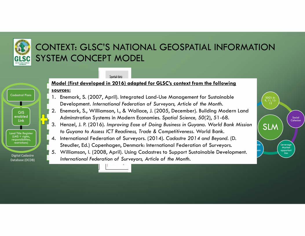
CONTEXT: GLSC’S NATIONAL GEOSPATIAL INFORMATIONSYSTEM CONCEPT MODEL
GISenabled
Link
Cadastral Plans
Land Title Register(LMS + rights,responsibilities,
restrictions)
VHR sateliite imagery
topography
land tenure
land use
rental porfolio
environmental issues
risks
. . .
Public Sector
NGOs, CSOs
Private Sector
Academia
Stakeholders
Land TenureAdministration
Land UsePlanning
Land Valuation LandDevelopment
IntegratedLand
AdministrationFunctions
Geoportalplatforms:Delivering
•geospatial datainventory w/metadata
•solutions for usecases
•land administrationservices
•data for policydecisions
•citizen participation(e.g. crowdsourcing)
•
SLM
SDG's 6-9, 11, 13-
15
SocialCohesion
LeverageMarket
opportunities
Environmental
Management
Govern-ance
Model (first developed in 2016) adapted for GLSC’s context from the followingsources:1. Enemark, S. (2007, April). Integrated Land-Use Management for Sustainable
Development. International Federation of Surveyors, Article of the Month.2. Enemark, S., Williamson, I., & Wallace, J. (2005, December). Building Modern Land
Adminstration Systems in Modern Economies. Spatial Science, 50(2), 51-68.3. Henzel, J. P. (2016). Improving Ease of Doing Business in Guyana. World Bank Mission
to Guyana to Assess ICT Readiness, Trade & Competitiveness. World Bank.4. International Federation of Surveyors. (2014). Cadastre 2014 and Beyond. (D.
Steudler, Ed.) Copenhagen, Denmark: International Federation of Surveyors.5. Williamson, I. (2008, April). Using Cadastres to Support Sustainable Development.
International Federation of Surveyors, Article of the Month.Digital Cadastre
Database (DCDB)

Nat’lGeospatialPolicy (forCabinet
Approval)
MarineSDI
LDN TSP
GLSCLand Parcel
System
NationalLand Policy
(draft)
CONTEXT: Geospatial Information Development in GuyanaGeodeticReference
Frame (CORSNetwork)
National&
RegionalLand Use
Plans
EnvironmentalInfo.
Monitoringand Mngt.Systems
NSDI & IGIFACTIONPLAN
Natl. E-Governance
Platform RoadMap
Digitisation ofLand
Records
Reviewof
NauticalCharts
DEM byHydroMet

CONTEXT: 3. SLDM PROJECT -MAINSTREAMING SUSTAINABLE LAND DEVELOPMENT ANDMANAGEMENT IN THE CO-OPERATIVE REPUBLIC OF GUYANA
Executing Agency: Guyana Lands & Surveys Commission on behalf of the Government of Guyana
Implementing Partner: United Nations Food and Agriculture Office (UNFAO)
Source of Financing: Performance-based payments for avoided deforestation received from Kingdomof Norway under the Guyana REDD+ Investment Fund (GRIF)
Project Period: Mid 2017- Mid 2021 (4 years)
Indicative OutcomesOutcome 1: Sustainable Land Development and Management (SLDM)Mainstreamed In Policy, Institutional and Governance Mechanisms to PreventDegradation and Restore Degraded Lands
Outcome 2: Strengthened Institutional and Human Capacity for Participatory andIntegrated SLDM
Outcome 3: Local Governance Strengthened in 3 Regions for Implementing SLDM
CD(6

Diapositiva 11
CD(6 SLDMCromeyer, Diego (RLCXD), 28-06-2019

THE INTEGRATED GEOSPATIAL INFORMATIONFRAMEWORK : IMPLEMENTATION IN GUYANATOWARDS IMPLEMENTATION OF THE IGIF IN GUYANA

TOWARDS IGIF IMPLEMENTATION:NATIONAL GEOSPATIAL POLICY
• July 3-5, 2018 ECLAC Workshop inGeorgetown - Towards a National
Geospatial Framework and Policy in
Guyana
• 5th iteration of National GIS Policy wasreviewed using the IGIF OverarchingStrategic Framework
• Policy was revised and sent to GoGCabinet in January 2019, where it ispending approval.

TOWARDS IGIF IMPLEMENTATION: NSDI ASSESSMENTMETHODOLOGY WITH ACCOMPANYING ANALYTICAL TOOLS(UNGGIM, WB, UNFAO)
• Step 1: Baseline Assessment - NSDI Current State Diagnostic
• Step 2: Impact Assessment - NSDI Alignment to Government Policy Drivers,NSDI Socio-economic Analysis, NSDI Action Plan
• Step 3: Investment and Implementation- Plan of Action against timelines andcosts for implementation

DELIVERABLES FROM ASSESSMENT METHODOLOGY AND TOOLS
15

NSDI DIAGNOSTIC SUMMARY, JANUARY 2019
50
33
42
371921
35
26
0
10
20
30
40
50
60
70
80
90
100Policy & Strategy
GovernanceArrangements
Legal
Accessibility andTechnical
Socio-economic
CapacityDevelopment
Innovation andPartnership
Core Data

NSDI ALIGNMENT TO POLICY DRIVERS
Key Policy and Reference Documents
- Framework for the Green State DevelopmentStrategy (GSDS)
- Digital Governance Roadmap
- Guyana Energy Strategy
- SLDM Project Document
- National Action Plan (NAP) to combat LandDegradation
- National Land Use Plan
- SDGs
- Integrated Geospatial InformationFramework (IGIF) Part 1
- ECLAC Geospatial Policy Consultation
-World Bank ICT Assessment Report 2016
- And others…
Thematic Drivers for Investment
1. Green State and Low CarbonDevelopment
2. Sustainable Land Management
3. E-Government
4. Support for monitoring andreporting on Sustainable DevelopmentGoals
5.Climate change and disaster riskmanagement
6.Environmental Management
7. Improve Capacity and skills ofHuman Resources
8. Managing Economic Growth
Geospatial Use Cases
Theme No. of Use Cases(Investment Priority)
1 3 (M x2, L x1)
2 5 (H x5)
3 4 (H x3, M x1)
4 2 (H x2)
5 3 (H x2, M x1)
6 2 (M x2)
7 4 (H x2, M x2)
8 5 (H x5)

NSDI SOCIO-ECONOMIC ASSESSMENT:QUANTIFIED MARKET IMPACTS
Ref Impact Evidence Methodology Net Undiscounted Value ofImpacts (US$)
1 Improved National GeospatialData Sharing
Usage assessment Multiplier effect of information sharing 5.2 million
2 Land Market Growth Comparable studies Benefits transfer from Bulgarian Study 5.7 million
3 Increasing Revenue from Leasingof State Land
Current revenues plus expert opinion Business process modelling 3.3 million
4 New Geospatial Products andServices
Global Study Scaling based on size and maturity ofGuyanese economy
15.9 million
5 Improved Forestry Revenues National Statistics and expert opinion Estimated uplift to current levels of income 2.1 million
6 Reduced Loss and Damage fromBetter Flood Prediction
Internationally reported economic costs offloods
Expert judgement (4% improvement) fromimproved Digital Elevation Models
2.2 million
7 Integration of Marine andTerrestrial NSDI
Expert opinion and International studies Reduced shipping insurance costs and extracruise ship visits 2.5 million

PROVISIONAL RETURN ON INVESTMENT ANALYSIS
19
• Benefit to Cost Ratio:2.7:1 (RoI of 270%)• Net Present Value:US$ 13m• Project Life Cycle:5 years development7 years operation• Discount Rate: 6%

NSDI SOCIO-ECONOMIC ASSESSMENT:UN-QUANTIFIED BENEFITS
1) Reduced Number of Land and Property-related Court Cases
2) Cost Savings in Infrastructure Design and Construction
3) Improved Water Services
4) Smarter Development Planning
5) More accurate Land Valuation
6) Higher accuracy Land Surveys from Re-established CORS Network
7) Improved SDG Reporting and Population Census
8) Support for Climate Change Adaptation
9) Optimized Site Selection
10)Reduced Data Procurement Costs
11)Enhanced support for Aviation Industry

IGIF - NSDI ACTION PLAN• Developed under the SLDM Project, Approved by UNFAO &
GLSC in January 2019 following highly consultative andreview period (5 months).
• This document presents an Action Plan, based on the IGIF,for development of a National Spatial Data Infrastructure(NSDI) for Guyana over a 5-year period and outlines itssocio-economic benefits.
• The implementation of the action plan will require anindicative level of investment of US$7.8m for the 5-yearperiod.
• It is a living document!
• 80 pages
• Guyana is one of the first countries globally to startimplementing the UNGGIM IGIF

ACTION PLAN’S ALIGNMENT TO THE UNGGIM IGIF
• The Action plan sets out24 key Actions groupedaccording to the 9 IGIFstrategic pathways andaddresses the 14UNGGIM fundamentalgeospatial data themes
• Prioritizes the Actions andidentifies KPIs for eachPathway.
PerformanceIndicators
SpecificActions
NationalStrategicPosition
CountryOverview
IGIFStrategicPathways
Guyana’sCountry LevelAction Plan

THE INTEGRATED GEOSPATIAL INFORMATIONFRAMEWORK : IMPLEMENTATION IN GUYANACURRENT STATUS ON IMPLEMENTING IGIF IN GUYANA
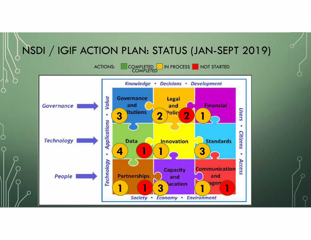
NSDI / IGIF ACTION PLAN: STATUS (JAN-SEPT 2019)
24
3
COMPLETED IN PROCESS NOT STARTED
1
1
22
4 31
1 3
ACTIONS:COMPLETED
1
11

NSDI / IGIF ACTION PLAN: STATUS (JAN-SEPT 2019)
25
COMPLETED IN PROCESS NOT STARTEDACTIONS:COMPLETED
3 1
1
22
4 31
1 3
1
11

NSDI / IGIF ACTION PLAN: STATUS (SEPTEMBER 2019)STRATEGIC PATHWAY 1:
GOVERNANCE & INSTITUTIONSACTIONS KPIs
Ministerial Approval of NationalGeospatial Policy (High Priority)
Establish Geospatial AdvisoryCommittee (GAC) (High Priority)
Establish Working Groups (MediumPriority)
Geospatial Policy (approvalwithin 3 months)
GAC and working groupsestablished and operationalwithin 6 months
COMPLETED IN PROCESS NOT STARTED

STRATEGIC PATHWAY 2:POLICY AND LEGAL ACTIONS
• Update Land Surveys legislationto support cadastral upgrading
• Create Data Sharing Agreement(High Priority)
• NSDI Regulations (MediumPriority)
• Data Protection and Pricing andLicensing (Low Priority)
Update Land Surveyslegislation within 12 months.
Data sharing agreement inplace and regular operationalsharing between 5organisations within 12 months.
Regular operational sharingbetween all majorstakeholders within 3 years.
KPIs
NSDI / IGIF ACTION PLAN: STATUS (SEPTEMBER 2019)COMPLETED IN PROCESS NOT STARTED

STRATEGIC PATHWAY 3:
FINANCIAL Actions KPIs
Develop long-term GLSCBusiness Model (MediumPriority)
Long-term GLSC BusinessModel approved within18 months
NSDI / IGIF ACTION PLAN: STATUS (SEPTEMBER 2019)COMPLETED IN PROCESS NOT STARTED
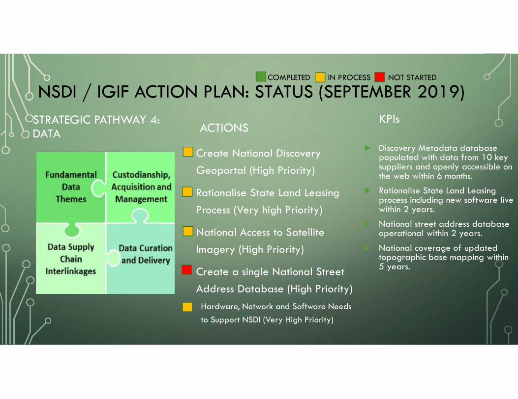
STRATEGIC PATHWAY 4:DATA ACTIONS
• Create National DiscoveryGeoportal (High Priority)
• Rationalise State Land LeasingProcess (Very high Priority)
• National Access to SatelliteImagery (High Priority)
• Create a single National StreetAddress Database (High Priority)
• Hardware, Network and Software Needsto Support NSDI (Very High Priority)
Discovery Metadata databasepopulated with data from 10 keysuppliers and openly accessible onthe web within 6 months.
Rationalise State Land Leasingprocess including new software livewithin 2 years.
National street address databaseoperational within 2 years.
National coverage of updatedtopographic base mapping within5 years.
KPIs
NSDI / IGIF ACTION PLAN: STATUS (SEPTEMBER 2019)COMPLETED IN PROCESS NOT STARTED

Data themes linked to Sustainable Development Goals

STRATEGIC PATHWAY 5:INNOVATION ACTIONS
• Guyana Centre of GeospatialExcellence (High Priority)
Centre of Excellence terms ofreference, funding andrecruitment plans approved byGAC within 12 months
Centre of Excellence fullyoperational within 2 years.
KPIs
NSDI / IGIF ACTION PLAN: STATUS (SEPTEMBER 2019)COMPLETED IN PROCESS NOT STARTED
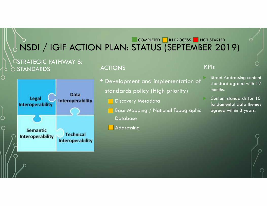
STRATEGIC PATHWAY 6:STANDARDS ACTIONS
• Development and implementation ofstandards policy (High priority)
• Discovery Metadata
• Base Mapping / National TopographicDatabase
• Addressing
Street Addressing contentstandard agreed with 12months.
Content standards for 10fundamental data themesagreed within 3 years.
KPIs
NSDI / IGIF ACTION PLAN: STATUS (SEPTEMBER 2019)COMPLETED IN PROCESS NOT STARTED

STRATEGIC PATHWAY 7:
PARTNERSHIP
Actions KPIs
Define Scope of a Partnership withInternational NSDI Organisations
Support creation of GuyanaAssociation for GeospatialInformation
Study visits to two countries completedwithin 12 months.
Guyana Association of GeospatialInformation formed within 2 years
NSDI / IGIF ACTION PLAN: STATUS (SEPTEMBER 2019)COMPLETED IN PROCESS NOT STARTED

STRATEGIC PATHWAY 8:
CAPACITY & EDUCATION ACTIONS
• Consolidate National Geospatialand Land Administration Capabilitiesat Tertiary Level (High Priority)
• Geospatial Information in the SchoolCurriculum (Medium Priority)
• Foster Geospatial Entrepreneurship(Medium Priority)
GIS Laboratory atUniversity of Guyanaopened within 12 months
3 new geospatial topicswithin senior schoolcurriculum within 2 years
Land management andland valuation coursesgraduating studentswithin 3 years
KPIs
NSDI / IGIF ACTION PLAN: STATUS (SEPTEMBER 2019)COMPLETED IN PROCESS NOT STARTED

STRATEGIC PATHWAY 9:COMMUNICATION &ENGAGEMENT
Actions KPIs
Create Outreach Group(High Priority)
Monitoring and EvaluationFramework (High Priority)
Monitoring and Evaluationframework approved by GAC within6 months
Outreach group staffed andcommunications plan approved within12 months
NSDI / IGIF ACTION PLAN: STATUS (SEPTEMBER 2019)COMPLETED IN PROCESS NOT STARTED

THE INTEGRATED GEOSPATIAL INFORMATIONFRAMEWORK : IMPLEMENTATION IN GUYANAREFLECTIONS

REFLECTIONS ON THE IGIF IN GUYANA
1. Incorporation of IGIF began in Guyana (July 2018 with ECLAC workshop,Sept. 2018 with start of NSDI diagnostic) before and right after formaladoption of IGIF Part 1: Overarching Strategic Framework (August 2018)and without reference to IGIF Part 2: Implementation Guide.
2. IGIF Strategic Framework proved to be a useful, potent and easilycommunicated tool to lay out an approach to a daunting national project –the NSDI

CONTEXT: GLSC’S NATIONAL GEOSPATIALINFORMATION SYSTEM CONCEPT MODEL
GISenabled
Link
Cadastral Plans
Land Title Register(LMS + rights,responsibilities,
restrictions)
VHR sateliite imagery
topography
land tenure
land use
rental porfolio
environmental issues
risks
. . .
Public Sector
NGOs, CSOs
Private Sector
Academia
Stakeholders
Land TenureAdministration
Land UsePlanning
Land Valuation LandDevelopment
IntegratedLand
AdministrationFunctions
Geoportalplatforms:Delivering
•geospatial datainventory w/metadata
•solutions for usecases
•land administrationservices
•data for policydecisions
•citizen participation(e.g. crowdsourcing)
•
SLM
SDG's 6-9, 11, 13-
15
SocialCohesion
LeverageMarket
opportunities
Environmental
Management
Govern-ance
Digital CadastreDatabase (DCDB)

REFLECTIONS ON THE IGIF I N GUYANA3. Provided an opportunity to ‘leapfrog’ to innovations that will drive digitaltransformation (e.g. creating the national topographic database not justupdating base mapping)

REFLECTIONS ON THE IGIF I N GUYANA
4. Significant gaps in capacity and education relating to geospatial sector havebeen highlighted and are being addressed. Partnerships are being sought inacademic and technical areas.
- Creation of NSDI Geoportal using open source technology;
- Acquiring, assessing, consuming, managing OE data like LiDAR

REFLECTIONS ON THE IGIF I N GUYANA
5. A convergence of a legally mandated institutional leader (led by achampion), political support and international partnerships (Norway, UNFAO,UNGGIM, ELCLAC) made this journey possible so far.
- Challenge will be to sustain such a recipe and at the same time rapidlyinnovate and build capacity to adopt to the inevitable changes in theingredients.

Kaieteur Falls
• Guyana Lands and Surveys Commission• Email: [email protected]
• Website: http://www.glsc.gov.gy
MUCHAS GRACIAS!PREGUNTAS?