the international forum to advance first responder innovation
TRANSCRIPT

The International Forum to Advance
Capability Gap 2 ldquoDeep Diverdquo Analysis Synopsis
September 2017
First Responder Innovation
Effort sponsored in whole or in part by the Department of Homeland Security (DHS) Science and Technology Directorate (SampT) and the Air Force Research Laboratory (AFRL) under Memorandum of UnderstandingPartnership Intermediary Agreement No FA8650-09-3-9400 The US government is authorized to reproduce and distribute reprints for governmental purposes notwithstanding any copyright notation thereon
The views and conclusions contained herein are those of the authors and should not be interpreted as necessarily representing the official policies or endorsements either expressed or implied of the DHS SampT or the AFRL
The following study was completed by FirstLink It represents the best efforts of the FirstLink team to gather assimilate and assess certain information pertaining to this report It is recognized that this study analyzes certain economic conditions As these conditions are in constant flux neither FirstLink nor its members (Pittsburgh Gateways Corp AMTV LLC or its affiliates) can be responsible for these conditions Any decisions actions or investment made on the subject covered are solely those of the client
This document has been checked for accuracy by the International Forum to Advance First Responder Innovation and accords with our aims to inform and guide industry and provide unbiased information on first responder technologies However the views and conclusions contained herein are those of the authors and should not be interpreted as necessarily representing the official policies either expressed or implied by the Forum While this material has been through a Forum quality assurance process the Forum does not accept responsibility for the content contained herein
Analysis Conducted by
Sponsored by
Forum Endorsement
02
03
Table of ContentsIntroduction
Forum Background04
Forum Membership05
Common Global Capability Gaps List06
Methodology08
Synopsis Overview10
Market Overview12
Market Figures14
Market Highlights
Automated Red-Force Tracking17
Remote Monitoring of Threats and Hazards18
Combined Effects Assessment19
Market Factors20
Competitive Landscape21
Appendix33
Glossary38
References40
04
IntroductionThis analysis activity intends to characterize markets and identify technology solutions relevant to the International Forum to Advance First Responder Innovationrsquos (Forum) Common Global Capability Gaps List to garner interest from researchers in industry and academia to develop affordable innovative technology solutions addressing the various capability gaps for first responders This publication represents a summary of analysis activity for Capability Gap 2ndashThe Ability to Detect Monitor and Analyze Passive and Active Threats and Hazards at Incident Scenes in Real Time It is anticipated that the remaining capability gaps will be analyzed and published in a similar fashion
1 Working with the global first responder community to define a list of common high priority capability gaps
2 Providing a platform for international collaboration on innovative RampD initiatives and solutions3 Characterizing global first responder markets to inform and guide industry and academia about
market opportunities and to incentivize them to develop and produce innovative technology solutions to capability gaps
4 Providing information about relevant and available first responder technologies to the first responder community while not endorsing any specific technology product or manufacturer
Established in 2014 the Forum is an organization of government leaders from across the globe focused on enhancing and expanding the development of affordable innovative technology for first responders worldwide
In order to respond more safely efficiently and effectively to everyday and catastrophic emergencies first responders around the globe need technologically advanced tools and equipment that are affordable However there is no centralized mechanism for responders to identify and discuss shared needs and requirements In addition overall purchasing of tools and equipment is fragmented into smaller quantities which provides little incentive for industry to commercialize innovative technologies Therefore the lack of consolidated requirements for first responders along with fragmented purchasing results in an inadequate amount of affordable new technology being available This leads to an insufficient amount of research and development (RampD) being conducted in the first responder market
The Forum addresses this challenge by
Forum Background
The Forum is currently composed of members from 13 different countries and the European Commission (EC) including Australia Canada Finland Germany Israel Japan the Netherlands New Zealand Singapore Spain Sweden the United Kingdom and the United States France and Mexicorsquos participation in the Forum is pending
Forum Membership
Australia
Canada
Finland
France Germany
European Commission
Israel
Japan
United Kingdom
United States
Mexico
New Zealand
Netherlands
Singapore
Spain
Sweden
05
06
Common Global Capability Gaps List BackgroundIn 2016 the Forum agreed to a Common Global Capability Gaps list presented below
Capability Gap 1 The ability to know the location of responders and their proximity to risks and hazards in real time
Capability Gap 2 The ability to detect monitor and analyze passive and active threats and hazards at incident scenes in real time
Capability Gap 3 The ability to rapidly identify hazardous agents and contaminants
Capability Gap 4 The ability to incorporate information from multiple and nontraditional sources (eg crowdsourcing and social media) into incident command operations
To arrive at this initial set of gaps Forum participants conducted analyses of first responder capability gaps in their countries Some of the Forum participants used the methodology presented in the US Department of Homeland Security (DHS) Science and Technology Directorate (SampT) Project Responder 4 (PR4) report as a guide in their gap analyses PR4 is the fourth in a series of studies that started in 2003 to focus on identifying capability needs shortfalls and priorities for catastrophic incident response The methodology is based upon discussions with federal state and local first responders as well as technical subject matter experts
After submission of gaps from Forum participants a comparative analysis of all submitted gaps was conducted The analysis found a significant level of overlap among the various countriesrsquo gaps which resulted in the proposal and adoption of the Forumrsquos Common Global Capability Gaps List This publication represents a general characterization of the global industries and market trends specifically regarding potential solutions to Capability Gap 2 The purpose for analyzing and presenting this data is to identify potential areas of RampD where there may be opportunity for industry and academia to market an innovative solution It is anticipated that the remaining two gaps will be analyzed in a similar fashion The following table presents the status of current and future Capability Gap ldquoDeep Diverdquo Analyses publications
Capability Gap ldquoDeep Diverdquo Analyses Current and Future Publications
Capability Gap 1 Published January 2017
Capability Gap 2 Published September 2017
Capability Gap 3 Published September 2017
Capability Gap 4 To be published in 2018
07
The definition of Capability Gap 2 is the ability to detect monitor and analyze passive and active threats and hazards at incident scenes in real time This capability gap involves the development of responder-specific detection monitoring and analysis solutions to enhance situational awareness at incident scenes These solutions may also include subsequent software or devices enabled to display data and analysis on an intuitive user interface
As Forum participants examined gaps within their countries first responders consistently stated there is a need to continuously detect monitor and analyze threats and hazards During an incident threats and hazards may increase decrease or evolve over time while new or unexpected risks can emerge increasing the potential danger to both civilians and first responders In order to improve first responder safety efficiency and effectiveness first responders need the ability to continuously detect monitor and analyze passive and active threats and hazards at incident scenes in real time The ability to detect monitor and analyze threats and hazards and understand real-time changes to these risks may help to improve situational awareness and decision-making
This analysis uses the Response Technology Objectives (RTOs) identified in PR4 as a starting point for further defining and segmenting Capability Gap 2 As stated in the PR4 report RTOs translate capability statements or needs into actionable technology-centric objectives Each RTO identifies a high-level technology solution (or part of a solution) designed to improve the capabilities of the response community Capability Gap 2 consists of three corresponding RTOs presented below
Capability Gap 2
RTO Remote Monitoring of Threats and Hazards
Further definitions of these RTOs are provided in the Glossary
Capability Gap 2Response Technology Objectives (RTO)
RTO Automated Red-Force Tracking
RTO Combined Effects Assessment
08
Methodology
The key objective of this analysis activity is to characterize the markets relevant to Capability Gap 2 to garner interest from researchers in industry and academia to develop affordable innovative technology addressing the gap for responders In other words it is intended that this information will serve to inform and guide research and development efforts supporting the overall goals of the Forum
Objective
The following section provides a brief overview of the processes used to obtain and assess the findings presented in this synopsis
Data presented in this report was gathered primarily using secondary research methodologies Research consisted of gathering publicly available information from various sources including market reports and company Web sites among others Secondary research methodologies were chosen for this analysis because information gathered using primary research would likely have been proprietary in nature and therefore not suitable for publishing With that in mind data presented in this report should not be considered exhaustive Furthermore regarding potential solutions this analysis relies upon information that is publicly available from manufacturersrsquo Web sites but it does not validate the claims made thereon
Research Methods
This analysis uses the Response Technology Objectives (RTOs) developed by PR4 as a starting point for further defining and segmenting Capability Gap 2 More specifically relevant market segments for each RTO were identified through secondary research with primary markets being identified for each one
Market Definition and Segmentation
All relevant markets are quantified utilizing overall revenue figures for the forecast period 2015 to 2020 The Compound Annual Growth Rate (CAGR) within each segment is used to measure growth within the forecast period and to extrapolate data when figures were not publicly available As the first responder segments of these relevant markets appear to be underdeveloped overarching market figures are present Data for the primary markets is used in the aggregated findings presented in the body of this report
Market Quantification
09
Market phase is determined using factors in the Industry Life Cycle model The adapted market phase definitions are as follows
Market Phase and Factors
Nascent New market need with dominant solutions not yet determined growth begins increasing toward end of cycle
Growth Dominant solutions begin to emerge high growth rates Mature Typically fewer firms than growth phase as dominant solutions continue to capture the majority of market share and market consolidation occurs lower growth rates that are typically on par with the general economy
Decline Further market consolidation rapidly declining growth rates
Market factors are assessed by examining barriers to entry and market opportunities as determined through secondary research
This analysis also examines the competitive landscape within each market accounting for the total number of firms along with the number of responder-specific solutions Total number of firms was estimated using the number of key players given within publicly available market reports for each segment while responder-specific solutions were identified using a more tailored search This search included examining the key players listed by the publicly available market reports and conducting targeted keyword searches for solutions from companies not mentioned in these reports
Competitive Landscape
Dominant solutions are determined by examining market share breakdown Solutions capturing the majority of the market share are considered to be dominant
Dominant Solutions
This synopsis begins by presenting a Market Overview that summarizes the overall market and provides the market quantification data for each segment It then presents the key findings for each market segment in the Market Highlights section with a one-page summary for each segment Finally the Technology Landscape section further categorizes the total number of firms participating in the market by segment and highlights responder-specific solutions available or in development
Presentation
10
Synopsis OverviewIn order to meet its objectives of defining and publishing a global set of capability gaps and informing and guiding industry the Forum has been conducting an ongoing global capability gaps market analysis The key objective of this analysis activity is to characterize the markets relevant to Capability Gap 2 to garner interest from researchers in academia and industry to develop affordable innovative technology addressing the gap for responders This synopsis represents a summary of this activity to date
This analysis activity begins by defining and segmenting the relevant markets for each Response Technology Objective (RTO) within Capability Gap 2 A primary market is identified for each RTO and is used for market quantification Each RTO and its corresponding primary market is presented below
Market Definitions and Segmentation
Further definitions of these RTOs are provided in the Glossary
Market Definitions and Segmentation
Capability Gap 2The ability to detect monitor
and analyze passive and active threats at incident
scenes in real time
Response Technology Objective (RTO) Primary Market
Automated Red-Force Tracking
Remote Monitoring of Threatsand Hazards
Combined Effects Assessment
Physical Security Market
Remote Sensing Technologies Market
Incident and EmergencyManagement Market
Each market both primary and secondary is quantified utilizing overall revenue figures Growth is measured using Compound Annual Growth Rate (CAGR) In this analysis it was found that the identified primary markets accounted for approximately $1550 billion in revenue in 2015
Market Quantification
In this analysis activity it was found that there are 124 key global firms including innovators working within the primary markets identified for Capability Gap 2 However the number of responder-specific solutions identified is comparably low This presents an opportunity for those firms already developing solutions in the broader market as in some cases they may be able to make slight adaptations to existing solutions or those in development to meet first responder needs By engaging with responders particularly on a global level through the Forum firms can begin to further assess how close they are to providing meaningful solutions for responders
Competitive Landscape
11
The aspects of each market which include dominant solutions market factors and market phase are summarized within the Market Highlights section of this synopsis Notably it appears that each market has a similar market phase falling right within the innovation window of the S-Curve Life Cycle model During an S-Curve life cycle the performance of a new technology is poor and improve slowly to early adoption Then as the technology become more familiar its performance improves rapidly during its growth phase Eventually the technology reaches a ceiling or maturity point and plateaus to a decline However an innovation window for a new wave or enhancement of the original technology exists during maturity and the cycle repeats
All three of the primary markets examined by this assessment appear to be positioned within the S-curve innovation window which is encouraging for new solutions Within the Physical Security market Closed-Circuit Television (CCTV) appears to have reached its maturity point while enhancements in the form of smart cameras and integration of media analysis software are making their way to market Within the Remote Sensing Technologies market conventional space-based sensing platforms such as satellites appear to be reaching their maturity point while new products such as unmanned vehicles are gaining popularity within the market Finally the Incident and Emergency Management market experiences this same phenomenon as dated incident simulation tools give rise to capabilities that integrate Geographic Information System (GIS) overlays to map potential threats and hazards on the incident scene in real-time Given this information each market phase is categorized as ldquoMature + Growthrdquo because some subsegments of the market are mature while other subsegments are in the growth phase
Dominant Solutions Market Factors and Market Phase
It appears that the number of first responder-specific solutions is low when compared with the total number of firms working on and providing solutions in the broader market Therefore in general there is a potential opportunity for firms to adapt their solutions for responder needs This opportunity appears to align with the current phase of the markets examined in this assessment Each of the primary markets appears to have reached a period of potential innovation during which improvement to current capabilities will be encouraged Solutions that exhaust or replicate current capabilities are not expected to thrive in the market Firms that provide new and innovative technologies that enhance existing capabilities of matured solutions will likely experience the greatest market opportunity The factors impacting the ability to capture these opportunities varies by market and are depicted in the following sections of this synopsis
Summary
Innovation S-Curve Video Surveillance Market Example
InnovationWindow
InnovationWindow
InnovationWindow
Time
Rev
enue
amp P
rodu
ct
Early Adoption
Maturity Point
Plateau amp Decline
Original Product or StrategyClosed-Circuit Television (CCTV)
New Product orGrowth StrategySmart cameras and integration of media analysis software
New Product orGrowth Strategy
Grow
th
Grow
th
Grow
th
12
Market OverviewMarket DefinitionCapability Gap 2 is defined as the ability to detect monitor and analyze passive and active threats and hazards at incident scenes in real time The corresponding RTOs identified for this gap align in part with detection monitoring and analysis capabilities The figure below presents the overarching segmentation of the Capability Gap 2 market as identified in this analysis
DetectMonitor and Analyze
Threats and Hazards
Combined Effects Assessment
AutomatedRed-Force Tracking
Remote Monitoringof Threats and
Hazards
Market Segmentation
The Physical Security Market is used to quantify Automated Red-Force Tracking This market includes video surveillance (eg closed-circuit television [CCTV] video analytics) perimeter intrusion detection and prevention physical security information management (PSIM) and facial recognition technologies
The Remote Sensing Technologies Market is used to quantify Remote Monitoring of Threats and Hazards This market includes precisely calibrated instruments mounted on airborne aquatic space-based and terrestrial platforms that capture data for multiple applications such as preventing catastrophic events
The Incident and Emergency Management Market is used to quantify Combined Effects Assessment This market is composed of many emergency mitigation preparedness response and recovery solutions Most notably it includes hazard propagation and incident simulation tools
DetectAnalyze
Monitor
13
Capability Gap 2 - The Ability to Detect Monitor and Analyze Passive and Active Threats and Hazards at Incident Scenes in Real Time
During an incident threats and hazards may increase decrease or evolve over time while new or unexpected risks can emerge increasing the potential danger to both civilians and first responders First responders stated there is a need for the ability to continuously detect monitor and analyze passive and active threats and hazards at incident scenes in real time The ability to detect monitor and analyze threats and hazards and understand real-time changes to these risks may help to improve situational awareness and decision-making
A myriad of detection monitoring and analysis solutions currently exist within the market However there appears to be a limited number of technologies suitable for enhanced first responder use It is acknowledged that the identified market figures and growth rates are likely to be more reflective of the broader threat and hazard detection monitoring and analysis market among all industries rather than the responder-specific market segment
Remote Monitoring of Threats and Hazards appears to be the most mature market However included in this market are unmanned systems (eg UAVs UGVs and UUVs) Unmanned systems are well suited to carry sensors that detect threats and hazards However use of these systems has been limited within the emergency response community Adoption of these solutions will likely lead to new dominating growth in the market
54
As of 2015 the market for Remote Monitoring of Threats and Hazards captures 54 percent of the market followed by Automated Red-Force Tracking at 40 percent and Combined Effects Assessment at 5 percent
Automated Red-Force Tracking is expected to grow at the highest CAGR of 103 percent during the forecast period of 2015 to 2020 followed by Remote Monitoring of Threats and Hazards at 84 percent and Combined Effects Assessment at 52 percentDetect Monitor and Analyze Threats and Hazards
Market (CAGR) 2015 to 2020
12
0
Remote Monitoring of Threats and Hazards
Automated Red-Force Tracking
Combined Effects Assessment
Remote Monitoring of Threats and Hazards
Automated Red-Force Tracking
Combined Effects Assessment
52
84
103
8
6
4
2
10
Detect Monitor and Analyze Threats and HazardsMarket 2015
40
5
Note Figures may not add up due to rounding
The Public Safety Drones Market is expected to reach approximately $115
billion in revenues by 2022 growing at an estimated CAGR of 1025 percent between
2017 and 2022
14
Market Figures
Disclaimer
The following tables present the estimated revenue figures for the various sub-markets identified for each RTO segment within the Capability Gap 2 market The figures in the colored rows represent the primary markets used to quantify each segment in this analysis activity
All figures have been rounded to the nearest hundred thousand The market forecast period examined is 2015 to 2020 When a market value was not available it was estimated using the corresponding CAGR given over the forecast period 2015 to 2020 to represent growth or decline For consistency data that fell outside of the forecast period 2015 to 2020 has been extrapolated as denoted by an asterisk () A more detailed explanation of how the extrapolated figures were estimated can be found in the Appendix at the end of this synopsis
Automated Red-Force TrackingRevenue by Year (in $1000000)
CAGR2015 2016 2017 2018 2019 2020
Physical Security Market $62600 $69600 $76600 $84300 $92800 $102200 103
Physical Security Information Mangement (PSIM) Market
$8231 $9765 $1200 $1400 $1600 $1900 182
Facial Recognition Market $2800 $3400 $3900 $4500 $5100 $5900 161
Video Surveillance Market $24400 $30400 $35400 $41200 $47900 $55800 17
Video Analytics Market $1100 $1700 $2600 $3500 $4700 $6200 413
Border Security Systems Market $31500 $33900 $36500 $39300 $42400 $45600 77
Military Electro-OpticsInfrared Systems Market
$9600 $10200 $10700 $11400 $12000 $12700 58
Augmented Reality (AR) Market $3100 $5500 $10000 $17900 $32200 $57700 795
Head-Mounted Display (HMD) Market $1700 $2500 $3700 $5600 $8300 $12400 488
Revenue by Year (in $1000000)CAGR
2015 2016 2017 2018 2019 2020
Remote Sensing Technologies Market $8400 $8900 $9700 $10600 $11600 $12600 84
Market Segment Space-Based (ie Conventional) Platforms
$3300 $3400 $3600 $3800 $3900 $4100 44
Market Segment Airborne (ie Unmanned) Platforms
$503 $648 $8349 $1100 $1400 $1800 29
Market Segment Other Platforms $4600 $4800 $5300 $5800 $6300 $6700 78
Security Robots Market $1300 $1500 $1600 $1700 $1900 $2000 9
Market Segment Unmanned Aerial Vehicle (UAV) Market
$1000 $1100 $1200 $1300 $1400 $1600 99
Market Segment Unmanned Ground Vehicle (UGV) Market
$1168 $1253 $1346 $1445 $1552 $1666 74
Market Segment Unmanned Underwater Vehicle (UUV) Market
$2041 $2154 $2308 $2473 $2649 $2839 68
3D Printing Market $3700 $5000 $6300 $7700 $9300 $11200 248
Market Segment Aerospace Industry
$723 $9457 $1200 $1400 $1700 $2100 238
Video Surveillance Market $25400 $30400 $35400 $41200 $47900 $55800 17
Video Analytics Market $1100 $1700 $2600 $3500 $4700 $6200 413
15
Remote Monitoring of Threats and Hazards
16
Revenue by Year (in $1000000)CAGR
2015 2016 2017 2018 2019 2020
Incident and Emergency Management Market
$84000 $88600 $93200 $98000 $103100 $108400 52
3D Mapping and 3D Modeling Market $1900 $2900 $4600 $7100 $11000 $17000 550
Computer-Aided Design (CAD) Market $8800 $9400 $10100 $10800 $11500 $12300 69
Governmental Geospatial Intelligence (GEOINT) Solutions Market
$10500 $11400 $12300 $13300 $14400 $15600 82
Geospatial Analytics Market $24800 $30700 $36600 $43600 $52000 $62000 201
Geospatial Imagery Analytics Market $1900 $2800 $3600 $4700 $6100 $7900 330
Geographic Information System (GIS) Market
$8500 $9500 $10600 $11800 $13100 $14600 114
Combined Effects Assessment
17
OPPORTUNITIES BARRIERS
PRIMARY MARKETPhysical Security
Market Phase
Automated Red-Force TrackingAutomated Red-Force Tracking involves the automatic identification and surveillance of red forces In the emergency response community a red force may represent a specific threat or hazard such as a person (eg active shooter suspect) or an object (eg weapon explosive device) In order to improve first responder safety efficiency and effectiveness responders need the ability to know the location and movement of red forces and their proximity to other response personnel critical resources and infrastructure in real time The ability to automatically identify and track red forces is likely to improve response situational awareness and decision-making
Market Quantification
Figures for Competitive Landscape are not all encompassing it is likely that additional firms and solutions exist
Compound Annual Growth Rate (2015-2020) 103
Competitive Landscape
Dominant Solution
Market Factors
Market Size (2015) $626 Billion
Number of Firms 80
Video Surveillanceand Analysis Platforms
Defined Physical security can be defined as a combination of physical and procedural measures designed to prevent or mitigate threats or attacks against people information and assets Video surveillance and analysis platforms are often used to identify monitor and track threats and hazards in this market
Current Capability
Integration with responder locationtracking systems and other situational awareness tools
Solutions that address accuracy mobility speed and cost
The evolution of ldquoSmart Citiesrdquo and theInternet of Things (IoT)
Market Highlights
There appears to be little integrated capability to track red forces First responders often use multiple platforms including close-circuit television (CCTV) and other video cameras social media visual surveillance and facial recognition software to identify and track threats and hazards
Number of Responder-SpecificRampD Initaitives 5
Number of Responder-SpecificExisting Solutions 6
Mature + Growth
Legal and privacy concerns regarding facial recognition and other surveillance platforms
Device vulnerability and chances of systems being hacked
Lack of synergy among security solutions
18
OPPORTUNITIES BARRIERS
PRIMARY MARKETRemote Sensing
Technologies
Market Phase
Remote Monitoring of Threats and HazardsRemote Monitoring of Threats and Hazards focuses on the development of multiple platforms to support remote ongoing surveillance and monitoring of threats and hazards on the incident scene and potentially affected areas In order to improve first responder safety efficiency and effectiveness responders need the ability to continuously evaluate existing emerging and potential threats and hazards in areas affected by an incident Remote monitoring of threats and hazards can provide incident command with pertinent information throughout an incident without exposing responders to additional risk
Market Quantification
Figures for Competitive Landscape are not all encompassing it is likely that additional firms and solutions exist
Compound Annual Growth Rate (2015-2020) 84
Competitive Landscape
Dominant Solution
Market Factors
Market Size (2015) $84 billion
Number of Firms 19
Space-based (ie conventional) Platforms
Current Capability
Mature + Growth
Dominance of large defense-related firms
Legal restrictions liability concerns and cost of unmanned systems
Market Highlights
First responders appear to rely on multiple fixed and mobile platforms for remote monitoring of the incident scene including sensor networks traffic and surveillance cameras and unmanned systems
Defined Remote sensing can be obtained through multiple platforms such as space-based or satellite systems Earth observation satellites are equipped with remote sensing instruments that capture a spectrum of imagery data which can be used to detect monitor and analyze potential threats and hazards
Number of Responder-SpecificRampD Initaitives 6
Number of Responder-SpecificExisting Solutions 7
Development of free data and software platforms encouraged in the US and EuropePotential widespread adoption of low cost drones and small satellite platformsThe evolution of ldquoSmart Citiesrdquo and theInternet of Things (IoT)
19
BARRIERS
PRIMARY MARKETIncident and Emergency
Management
Market Phase
Combined Effects AssessmentCombined Effects Assessment involves the integration of data and analysis to inform incident command of potential secondary or cascading effects during an incident In order to improve first responder safety efficiency and effectiveness responders need the ability to understand the potential for secondary effects the conceivable impacts of all incident effects and how those effects combine to mitigate or exacerbate the situation The availability of this data and analysis is likely to help incident command prioritize threats and hazards on the incident scene allocate appropriate personal protective equipment (PPE) and support other response decision-making needs
Market Quantification
Figures for Competitive Landscape are not all encompassing it is likely that additional firms and solutions exist
Compound Annual Growth Rate (2015-2020) 52
Competitive Landscape
Dominant Solution
Market Factors
Market Size (2015) $84 Billion
Number of Firms 25
None to date Defined Incident and Emergency Management is composed of many emergency mitigation preparedness response and recovery solutions Most notably it includes hazard propagation and incident simulation tools
The Incident and Emergency Management Market is used to quantify this segment
Current Capability
There may be a disconnect between disaster risk reduction policy and emergency management in
practice
Hardware infrastructure can be prone to single point of failure
Market Highlights
There appears to be little integrated capability to understand and assess combined incident effects First responders often use pre-event assessment platforms to predict threats and hazards These systems can be equipped with Geographic Information System (GIS) overlay to map potential threats and hazards on the incident scene However these systems do not provide incident-specific information based on real-time conditions
Lack of seamless integration due to outdated Incident and Emergency Management infrastructure
Number of Responder-SpecificRampD Initaitives 4
Number of Responder-SpecificExisting Solutions 7
Mature + Growth
OPPORTUNITIES
Situational awareness tools deployable for both daily and catastrophic incidents Integration of social media with incident and mergency managementThe evolution of ldquoSmart Citiesrdquo and theInternet of Things (IoT)
Graphic-related enhancements to display interfaces
20
Market Factors
Combined Effects Assessment
AutomatedRed-Force Tracking
Remote Monitoringof Threats and
Hazards
The ability to detect monitor and analyze passive and active threats and hazards at incident scenes in real time
Market Barriers
Market Opportunities
Legal and privacy concerns regarding facial recognition and other surveillance platformsDevice vulnerability and chances of systems being hacked
Integration with responder locationtracking systems and other situational awareness tools
Lack of synergy among security solutions
Solutions that address accuracy mobility speed and cost
The evolution of ldquoSmart Citiesrdquo and the Internet of Things (IoT)
x
x
x
Market Barriers
Market Opportunities
Dominance of large defense-related firms
Legal restrictions liability concerns and cost of unmanned systems
Development of free data and software platforms encouraged in the US and Europe
Potential widespread adoption of low cost drones and small satellite platforms
The evolution of ldquoSmart Citiesrdquo and the Internet of Things (IoT)
x
x
There may be a disconnect between disaster risk reduction policy and emergency management in practice
Lack of seamless integration due to outdated incident and emergency management infrastructure
Situational awareness tools deployable for both daily and catastrophic incidents
Integration of social media with incident and emergency management
The evolution of ldquoSmart Citiesrdquo and the Internet of Things (IoT)
x
x
Hardware infrastructure can be prone to single point of failure
x
Graphic-related enhancements to display interfaces
Market Barriers
Market Opportunities
21
Competitive LandscapeA total of 124 global firms were recognized as key players and innovators within the primary of Capability Gap 2 Specifically the breakdown of each market is as follows
The following seven firms were identified as key players and innovators in at least two of the three market segments regarding rapidly identification and detection of hazardous agents and contaminants
BAE Systems plc (United Kingdom)Boeing Company (US)General Dynamics Corporation (US)General Electric Corporation (US) Honeywell International Inc (US) andRaytheon Company (US)
These figures are not all encompassing it is likely that additional firms and solutions exist within each market
Detect Monitor and Analyze Threats and Hazards MarketKey Players and Innovators 2015
Multi-Sensor Integration and Analysis
Improved Standoff Detection and Identification of Hazards
Risk Assessment and Decision Support to Command
19
6
37
7
17
7
16
5 64
12
6
Commercial
First Responder-Specific
Existing Solutions Research and Development (RampD)
Technology Landscape SummaryThis analysis activity has identified a total of 71 existing solutions and 34 research and development (RampD) initiatives related to Capability Gap 2 - The Ability to Detect Monitor and Analyze Passive and Active Threats and Hazards at Incident Scenes in Real Time
Among the exisiting and developing solutions identified 20 solutions appear to be readily deployable for first responder use and 15 solutions appear to be in development for first responder use
0
10
20
30
40
90
50
40
30
20
10
0
19
80
25
Remote Monitoring of Threats and Hazards
Automated Red-Force Tracking
Combined Effects Assessment
80
70
60
Research and Development (RampD) by SectormdashIndustry Academia and Government
Remote Monitoring of Threats and Hazards
Automated Red-Force Tracking
Combined Effects Assessment
IndustryAcademiaGovernment
0 10 20 30 40 50 60 70 80 90 100
This analysis activity identified 34 RampD initiatives related to Capability Gap 2 - The Ability to Detect Monitor and Analyze Passive and Active Threats and Hazards at Incident Scenes in Real Time
Among the developing solutions identified 13 solutions (38 percent) appear to be initiated by industry firms 12 solutions (35 percent) appear to be initiated by academic institutions and 9 solutions (26 percent) appear to be initiated by government organizations
Based upon the data presented there is a comparatively low number of responder-specific solutions identified given the number of firms operating in each segment This presents an opportunity for those firms already developing solutions in the broader market as in some cases they may be able to make slight adaptations to existing solutions to meet first responder needs By engaging with responders particularly on a global level through the Forum firms can begin to assess how close they are to providing meaningful solutions for responders Furthermore they can engage responders throughout their process to ensure that their developments will meet responder needs
For questions or comments related to the information presented in this assessment please contact the Forum at infointernationalresponderforumorg
The majority (56 percent) of existing solutions identified by this analysis activity appear to be designed for various commercial industries while 28 percent of solutions appear to be designed for first responder use and 16 percent of solutions appear to be designed for defense-related initiatives
There may be an opportunity for firms with existing commercial solutions to compete in the first responder market by adapting existing solutions to meet the needs of first responders
56
16
28
First Responder-Specific
Commercial
Defense-Specific
Existing Solutions by SectormdashCommercial First Responder-Specific Defense-Specific
22
23
The following section presents some of the potential first responder-specific solutions by segment as identified by this assessment It is likely that there are additional potential solutions that exist or are in development and therefore this section should not be considered exhaustive A complete list of solutions identified by this assessment can be found in the Appendix at the end of this synopsis
The data presented in this section represents information that is publicly available from manufacturersrsquo Web sites This information is not further validated by this assessment
Automated Red-Force Tracking
Domo Tactical Communications (DTC) Ltd (United States) offers customized solutions for emerging surveillance and situational awareness challenges within border control internal security and critical infrastructure protection areas
DTC states its Orion trackers provide law enforcement military and intelligence agencies with a scalable technically advanced Radio Direction Finding (RDF) and Global Positioning System (GPS) solution to locate and track mission critical assets in challenging environments RDF systems offer covert tagging tracking and locating within a dedicated secure network without a reliance on commercial infrastructure such as GPS cellular or satellite foundations The range of Orion tracking options and tags include body worn solutions vehicle solutions airborne solutions fixed site solutions and city and country wide solutions
Information regarding price and specific deployment within the first responder community does not appear to be publicly available for this solution
Domo Tactical Communications (DTC) Ltd
Airbox Systems Limited (United Kingdom) is a computer software company that offers systems integration and consultancy to law enforcement emergency services military and search and rescue (SAR) organizations
Airbox Systems states its Mission Optimized Situational Awareness Information amp Collaboration (MOSAIC) application solution enables users to identify the location of team members key assets resources and infrastructure as well as access full profile and visual details relative to a mission or incident location including live video feeds
In addition MOSAIC appears to support various tracking capabilities including blue force red force and asset tracking
Information regarding price and specific deployment within the first responder community does not appear to be publicly available for this solution
Airbox Systems Limited
Airbox Systemsrsquo MOSAIC
First Responder-Specific Technologies
24
Honeywell International Inc (United States) is a Fortune 100 company that offers hardware and software solutions that address global energy safety security productivity and urbanization challenges
The Honeywell Radar Video Surveillance (RVS) solution is described as a wide area security system that provides advanced surveillance capabilities through the integration of ground or waterside radar Global Positioning System (GPS) Automatic Identification System (AIS) video and thermal sensor data RVS is often paired with Honeywellrsquos Digital Video Manager (DVM) to leverage existing security infrastructure
Honeywellrsquos RVS radar sensors automatically detect potential threats in user defined Alarm Zones Following detection an alarm alerts security personnel and connected pan-tilt-zoom (PTZ) cameras are directed to identify and track the potential threats Video recording is distributed over a Local Area Network to provide real-time situational awareness to security personnel
The components of the RVS are presented in the figure below
Information regarding price and deployment within the first responder community does not appear to be publicly available for this solution
Honeywell International Inc Radar Video Surveillance (RVS)
Honeywell International Inc
The Institute of Anthropometrics amp Robotics at the Karlsruhe Institute of Technology (Germany) explores the science of symbiosis between human and humanoid The Institute focuses on human-centered environments with an aim to research and develop people-friendly systems using informatics The Institute studies topics such as multimodal interaction of people with technical systems humanoid robots language understanding image perception learning recognizing and understanding situations generating knowledge through experience and processing biosignals
Computer scientists from the Institute of Anthropometrics amp Robotics developed a new type of facial-recognition system that uses nontraditional methods Infrared spectrum thermal signatures emitted by skin tissues can be captured through passive thermal sensors without using any active light source Thus images or faces can be identified in the dark
In the study a ldquodeep neural networkrdquo computer system analyzed numerous infrared images of individual faces and compared the images to a repository of photos taken in daylight According to study results the proposed approach improved the state-of-the-art by more than 10 percent However further accuracy is warranted When presented with multiple comparative images the system was accurate about 80 percent of the time while when presented with one comparative image the system was accurate about 55 percent of the time
The Institute of Anthropometrics amp Robotics at the Karlsruhe Institute of Technology
25
According to study results the proposed approach improved the state-of-the-art by more than 10 percent However further accuracy is warranted When presented with multiple comparative images the system was accurate about 80 percent of the time while when presented with one comparative image the system was accurate about 55 percent of the time
The study was partially funded by the German Federal Ministry of Education and Research (BMBF) Additional information regarding funding and Technology Readiness Level (TRL) does not appear to be publicly available for this project
Deep Perceptual Mapping (DPM) Densely computed features from the visible domain are mapping through the learned DPM network to the corresponding thermal domain
26
SRI International (United States) is an independent nonprofit research center that provide basic and applied research development deployment and commercialization services SRI collaborates across various technical and scientific disciplines including
Biosciences Health and Medical SystemsChemistry Materials and EnergyComputing and Information TechnologyDefense and SecurityEducation and LearningOcean and SpaceRobotics andCustom Solutions
Researchers from SRI the University of Leeds (United Kingdom) and the University of Maryland (United States) are developing a system to enhance remote threat surveillance These efforts appear to be funded by the Mindrsquos Eye Program initiated by the US Defense Advanced Research Projects Agency (DARPA) The Mindrsquos Eye Program promotes the development of smart cameras for real-time threat detection and analysis
The system under development known as Visual Intelligence Grounded in Learning (VIGIL) combines vision analysis automatic reasoning and machine learning to identify and report unusual interactions between people and objects SRI states VIGIL is being designed to use probabilistic reasoning statistical and relational learning as well as other artificial intelligence approaches to detect recognition and describe behavior and activities observed in video The goal of the program is to construct a compact field-portable system compatible for rapid cost-effective deployment on unmanned vehicles Additional information regarding funding and Technology Readiness Level (TRL) does not appear to be publicly available for this project
SRI International
27
Vidsys Inc (United States) offers Converged Security Information Management (CSIM) software for various industry sectors including government education energy transportation enterprise public safety and healthcare
Vidsys CSIM software is described as a browser-based platform that collects correlates and converts vast amounts of data into meaningful and action information based on a userrsquos risk policy standards and compliance requirements The software can be rapidly deployed to provide real-time situational awareness and information management capabilities to remote users and first responders
Vidsys states its CSIM software can provide the following advantages to public safety personnel
In 2014 Vidsys CSIM software was deployed in the City of Baltimore Maryland for the ldquoStar Spangled Spectacularrdquo This event was designated as a Level 2 Special Event by the US Department of Homeland Security (DHS) In Baltimore Vidsys CSIM software generated a common operating picture that connected nearly 50 local state and federal agencies in one command center Further the platform integrated approximately 1500 security cameras mapping technology weather alerts social media monitoring mass notification radar and other technologies to enhance public safety and ensure rapid response
Information regarding price does not appear to be publicly available for this solution
Vidsys Inc
Centralize security monitoring to enhance situational awareness among various agencies
Provide more accurate details to first responders en route and on the scene
Improve collaboration among state and local police emergency medical service (EMS) responders and other agencies
Improve response time by leveraging location based assets and
Archive situation management for the purpose of training and after action analysis
Vidsys Converged Security Management (CSIM) Software
28
Remote Monitoring of Threats and Hazards
The Environment and Sustainability Institute (ESI) DroneLab at the University of Exeter (United Kingdom) designs manufactures and tests lightweight fixed wing and multi-rotor aircraft and related systems
According to ESI DroneLab smartphones are equipped with a broad suite of sensors (eg cameras microphones light sensors accelerometer compass gyroscope and Global Positioning System [GPS]) and on-board microcomputers Therefore there may be an untapped opportunity in converting smartphones into all-inclusive or self-containing remote sensing devices
In 2016 scientists from the ESI DroneLab began development of an android-based smartphone application programed to automatically capture aerial photographs and spatial metadata The smartphone equipped with the application could then be fixed onto a lightweight portable platform such as a drone or a kite for grassroot mapping scenarios For example ESI DroneLab states in the aftermath of a humanitarian disaster the ability to rapidly and cheaply survey environmental damage and search for survivors is more readily achieved from a drone or a kite than from a piloted aircraft or satellite In addition the resolution of data from low-flying platforms such as drones and kites enables more useful and easily interpreted data
All coding for the intial app is available via GIThub In addition the app can be freely downloaded via the Google Store Initial funding to develop the app was provided by the European Social Fund The Natural Environment Research Council (NERC) supported further testing and development through its ldquoImpact Acceleratorrdquo fund Additional information regarding funding Technology Readiness Level (TRL) and deployment within the first responder community does not appear to be publicly available for this project
The Environment and Sustainability Institute (ESI) DroneLab at the University of Exeter
FLIRreg Systems Inc (United States) designs develops manufactures markets and distributes solutions for enhanced perception and situational awareness In 1978 FLIRreg offered infrared imaging systems to be used for energy audits FLIRreg systems and components have since evolved for use in security (eg airborne and ground-based surveillance) condition monitoring navigation drug interdiction transportation safety and efficiency border and maritime patrol environmental monitoring and chemical biological radiological nuclear and explosives (CBRNe) threat detection
Launched in 2016 the FLIRreg Aerial First Responder Kit includes a DJI Inspire 1 drone DJI Zenmuse XT thermal camera DJI Zenmuse X3 4k visible light camera and a variety of accessories to provide fire fighters and first responders with airborne thermal imaging capabilities
FLIRreg states the solution offers incident commanders the ability to see through smoke and keep track of personnel in large fire-related incident scenes In addition the system can be deployed for search and rescue (SAR) missions regardless of the time of day
FLIRreg Systems Inc
FLIRreg Aerial First Responder Kit
29
FLIRreg Aerial First Responder Kit package specifications are presented in the table below
ModelFLIRreg Aerial First
Responder Basic KitFLIR Aerial First
Responder Advanced Kit
Thermal CameraDJI Zenmuse XT Thermal Camera amp Stabilized Gimbal
DJI Zenmuse XT Thermal Camera amp Stabilized Gimbal
Thermal Camera Configuration
68 mm lens (45deg x 35deg) 336 x 256 resolution
13 mm lens (45deg x 37deg) 640 x 512 resolution
Aircraft Type DJI Inspire 1 (V 20) DJI Inspire 1 (V 20)
Controller(s) One Two
Batteries Included Three Three
Color Video CameraDJI Zenmuse X3 4k Video Camera amp Stabilized Gimbal
DJI Zenmuse X3 4k Video Camera amp Stabilized Gimbal
FLIRreg Tools+ Image Analysis Software
Yes Yes
Apple iPad Mini 4 (64GB WiFi)
One Two
Monitor Hood(s) One Two
Rugged Carrying Case Yes Yes
FLIRreg Landing Pad Yes Yes
FLIRreg Aerial First Responder Kits are available to purchase starting at approximately $10450 per kit Information regarding specific deployment within the first responder community does not appear to be publicly available
Lockheed Martin Corporation (United States) is a global security innovation and aerospace company with specialties in aeronautics missiles and fire control rotary and mission systems and space systems The majority of Lockheed Martinrsquos business is with the US Department of Defense (DoD) and US federal government agencies However Lockheed Martin also engages with international government and commercial users
The Lockheed Martin Procerus Technologies Indago quadrotor unmanned aerial system (UAS) provides military civil and commercial users with aerial reconnaissance capabilities The solution is adaptable to a variety of payloads for precision agriculture mapping surveying and inspection and reconnaissance Lockheed Martin states the solution is collapsible weighs less than five pounds and folds into a man-packable unit that requires no tools for assembly In addition the UAS solutions includes a weather-resistant wireless hand controller to provide an intuitive interface and untethered UAS operation
Lockheed Martin Corporation
Procerus Technologies Indago Quadrotor UAS Wireless Hand Controller
30
In regards to the first respond community the Indago quadrotor UAS can be equipped with location antenna and tracking system capabilities Project Lifesaver International a public safety nonprofit organization works with first responders to deploy the system to locate and track individuals with Alzheimerrsquos disases Autism and Down syndrome
Information regarding price does not appear to be publicly available for this solution
Procerus Technologies Indago Quadrotor UAS
Mouser Electronics Inc (United States) is an authorized global distributor of semiconductors and electronic components for design engineers In 2014 Mouser Electronics initiated its Empowering Innovation Togethertrade campaign The campaign was founded in partnership with Grant Imahara a celebrity engineer best known for his roles on Mythbusters and Battlebots To promote campaign initiatives Grant Imahara hosts a series of webisode videos that highlight innovative and creative engineers worldwide with new products and technical expertise One such series features Mouser Electronicsrsquo Project First Responders
The recently complete Project First Responders was an initiative to develop a fleet of connected drones for public safety applications Specifically Project First Responders showcased the proof of concept for an autonomous cloud-based drone platform for use in search and rescue or surveillance operations The developed network of drones were equipped with GlobalARC communication GlobalARC (United States) offers a full service unmanned aerial vehicle (UAV) deployment and management system with integrated airspace compliance and live video feed from drones The service enables autonomous robot communication (ARC) or peer-to-peer communication between autonomous vehicles via cellular networks
During testing the developed drone network was deployed in a wildfire scenario Mouser Electronics states the solution provided key data to first responders such as wind speed and direction fuel types around existing fire and the location of trapped civilians
Project First Responders is sponsored by Intel Corporation (United States) and TE Connectivity Ltd (Switzerland) However additional information regarding funding Technology Readiness Level (TRL) and deployment within the first responder community does not appear to be publicly available
Mouser Electronics Inc
31
Environmental Systems Research Institute (Esri) Inc (United States) is an information technology and services company specialized in geographic information system (GIS) and mapping software The companyrsquos premier solution that appears to dominate the GIS industry is ArcGIS ArcGIS provides contextual tools for mapping and spatial reasoning that enable users to explore data and share location-based insights Specifically ArcGIS capabilities include
Spatial Analytics
Mapping and Visualization
3D and Real-Time GIS
Imagery and Remote Sensing and
Data Collection and Management
ArcGIS for Emergency Management includes multiple applications to map and model potential plans determine their potential impacts visualize critical vulnerabilities and plan for special events
Notably ArcGIS for Emergency Management includes a CAMEO Tools application to import critical data for chemical emergencies The Computer-Aided Management of Emergency Operations (CAMEO) software suite is used to prepare for and response to chemical emergencies The solution was developed by the US Environmental Protection Agency (EPA) and the National Oceanic and Atmospheric Administration (NOAA) CAMEO Tools imports information from the CAMEO system into ArcGIS to support critical analysis and emergency management
ArcGIS is available to multiple users on a subscription basis ranging from $45000 to $500 per year Information regarding specific deployment within the first responder community does not appear to be publicly available for this solution
Environmental Systems Research Institute (Esri) Inc
PREDICT Overlay historical incidents with operational data to anticipate where future events are most likely to occur
MODEL Run sophisticated what-if scenarios to understand how a chemical spill or sudden flood will affect a community and environment
PREPARE Pre-position assets to the most vulnerable areas of a community to improve response when an incident occurs
ArcGIS Capabilities
ArcGIS Solutions
Combined Effects Assessment
32
SimTable LLC (United States) provides agent-based modeling distributed mobile computing and real-time Geographic Information System (GIS) platforms as described below
In the US Simtables are deployed in more than 85 city state and federal agencies and academic institutions In regards to pricing each client is quoted individually However packages can range from $35000 to $79000 per client
SimTable LLC
Agent-Based Modeling SimTable develops agent-based modeling frameworks to explore and visualize complex scenarios for both physical and social incidents Specifically SimTable designs customized agent-based models based on local community data for wildfire flood evacuation storms airborne particulates as well as biological and ecological behaviors Distributed Mobile Computing SimTable enables mobile phone and tablet communication across disparate networks for real-time data sharing
Real-Time Geographic Information System (GIS) SimTable enables the integration of GIS for use in simulation and planning applications SimTable Training Exercise for Fire Services
33
Appendix
Automated Red-Force Tracking
Existing SolutionsIndustry Academia and Government Solution
Airbox Systems IncMission Optimized Situational Awareness Information amp Collaboration (MOSAIC)
Domo Tactical Communications (DTC) Ltd DTC Orion
International Business Machines Corporation (IBM)
Intelligent Operation Center for Emergency Management
ResponderX Inc ResponderX
Vidsys IncConverged Security Information Management (CSIM)
Visual Semantics Real-Time Intelligence
Developing (RampD) SolutionsIndustry Academia and Government Solution
Analog DevicesSensor Fusion Approach to Precision Location and Tracking for First Responders
Commandwear Systems Inc CommandWear
Electronic Warfare Associates IncBiometric Optical Surveillance System (BOSS)
National Aeronautics and Space Administration (NASA) Jet Propulsion Lab (JPL)
Precision Outdoor and Indoor Navigation and Tracking for Emergency Responders (POINTER)
University of Michigan (MconneX) Weapons-Detecting Radars
The following section includes tables that list the potential first responder-specific solutions both existing and in development as identified by this assessment It is likely that there are additional potential solutions in the market and therefore this section should not be considered exhaustive
34
AppendixRemote Monitoring of Threats and Hazards
Existing SolutionsIndustry Academia and Government SolutionCovidence AS Video Surveillance
FLIRreg Systems Inc
Aerial First Responder Kits (UAS)
Aerial Thermal Imaging Kits
KF6 Thermal Imaging Solution
HAAS IncIntelligent Operation Center for Emergency Management
Lockheed Martin Corporation ResponderX
SeSys LtdConverged Security Information Management (CSIM)
Developing (RampD) SolutionsIndustry Academia and Government Solution
Aditya College of EngineeringAutomatic Fire Alarm System based on Wireless Sensor
Mouser Electronics Inc Project First Responders
RAE Systems IncWirelessly-Connected Monitoring Equipment
Research Center on Software Technologies and Multimedia Systems for Sustainability (CITSEM) at Universidad Politeacutecnica de Mardrid (UPM)
Forest Fire Detection Drones
The Environment and Sustainability Institute (ESI) DroneLab at the University of Exeter
Grassroots Remote Sensing Toolkit
35
AppendixCombined Effects Assessment
Existing SolutionsIndustry Academia Government Solution
Hexagon ABMobile Responder
Public Safety Analytics
International Business Machines Corporation (IBM)
Intelligent Operation Center for Emergency Management
Lawrence Livermore National Laboratory HotSpot
National Oceanic and Atmospheric Administration
Computer-Aided Management of Emergency Operations (CAMEO)
SimTable LLC SimTable
US Defense Threat Reduction Agency (DTRA)
Hazard Prediction and Assessment Capability (HPAC)
Developing (RampD) SolutionsIndustry Academia Government Solution
Hendrix CollegeDetection of Atmospheric Infrasound with a Ring Laser Interferometer
Idaho National Laboratory Robotics 3D Mapping
Oak Ridge National Laboratory (ORNL)Incident Management Preparedness and Coordination Toolkit (IMPACT)
TransVoyant LLC Continuous Decision Intelligencetrade (CDItrade)
36
Appendix
RTO Automated Red-Force Tracking Border Security System Marketmdashthe border security system market forecast period is 2016 to 2022 with a market figure available for 2022 The CAGR of 716 percent was used to estimate the revenue values for 2015 to 2020 The figure for 2015 was extrapolated outside of the forecast period of 2016 to 2022 Facial Recognition Marketmdashthe facial recognition market forecast period is 2016 to 2021 with market figures available for 2016 and 2021 The CAGR of 153 percent was used to estimate the revenue values for 2015 to 2020 The figure for 2015 was extrapolated outside of the forecast period of 2016 to 2021
Head-Mounted Display (HMD) Marketmdashthe HMD market forecast period is 2016 to 2020 with market figures available for 2015 and 2020 The CAGR of 489 percent (2015 to 2020) was used to estimate the revenue values for 2016 to 2019
Military Electro-OpticsInfrared Systems Marketmdashthe military electro-opticsinfrared systems market forecast period is 2016 to 2022 with market figures available for 2016 and 2022 The CAGR of 576 percent was used to estimate the revenue values for 2015 to 2020 The figure for 2015 was extrapolated outside of the forecast period of 2016 to 2022
Physical Security Information Management (PSIM) Marketmdashthe PSIM market forecast period is 2016 to 2024 with market figures available for 2015 and 2024 The CAGR of 186 percent (2015 to 2024) was used to estimate the revenue values for 2016 to 2023 Physical Security Marketmdashthe physical security market forecast period is 2016 to 2021 with market figures available for 2016 and 2021 The CAGR of 101 percent was used to estimate the revenue values for 2015 to 2020 The figure for 2015 was extrapolated outside of the forecast period 2016 to 2021
Video Analytics Marketmdashthe video analytics market forecast period is 2017 to 2022 with market figures available for 2017 and 2022 The CAGR of 337 percent was used to estimate the revenue values for 2015 to 2020 The figures for 2015 and 2016 were extrapolated outside of the forecast period 2017 to 2022
Video Surveillance Marketmdashthe video surveillance market forecast period is 2016 to 2022 with market figures available for 2016 and 2022 The CAGR of 164 percent was used to estimate the revenue values for 2015 to 2020 The figure for 2015 was extrapolated outside of the forecast period 2016 to 2022
RTO Combined Effects Assessment 3D Mapping amp 3D Modeling Marketmdashthe 3D mapping amp 3D modeling market forecast period is 2015 to 2020 with market figures available for 2015 and 2020 The CAGR of 550 percent was used to estimate the revenue values for 2016 to 2019
Computer-Aided Design (CAD) Marketmdashthe CAD market forecast period is 2017 to 2021 with market figures available for 2016 and 2021 The CAGR of 70 percent (2016 to 2021) was used to estimate the revenue values for 2015 and 2017 to 2020 The figure for 2015 was extrapolated outside of the forecast period of 2016 to 2021
Market Figure Disclaimers
37
Geospatial Analytics Marketmdashthe geospatial analytics market forecast period is 2016 to 2021 with market figures available for 2016 and 2021 The CAGR of 192 percent was used to estimate the revenue values for 2015 and 2017 to 2020 The figure for 2015 was extrapolated outside of the forecast period of 2016 to 2021
Geospatial Imagery Analytics Marketmdashthe geospatial imagery analytics market forecast period is 2016 to 2021 with market figures available for 2016 and 2021 The CAGR of 298 percent was used to estimate the revenue values for 2015 and 2017 to 2020 The figure for 2015 was extrapolated outside of the forecast period of 2016 to 2021
Governmental Geospatial Intelligence (GEOINT) Solutions Marketmdashthe GEOINT solutions market for defense and HLS market forecast period is 2015 to 2020 with market figures available for 2014 and 2016 The CAGR of 82 percent (2014 to 2026) was used to estimate the revenue values for 2015 and 2017 to 2020
RTO Remote Monitoring of Threats and Hazards Remote Sensing Technologies Marketmdashthe remote sensing technologies market forecast period is 2016 to 2021 with market figures available for 2015 2016 and 2021 The CAGR of 92 percent was used to estimate the revenue values for 2017 to 2020
Security Robots Marketmdashthe security robots market forecast period is 2016 to 2022 with market figures available for 2015 and 2022 The CAGR of 84 percent (2015 to 2022) was used to estimate the revenue values for 2016 to 2020
Unmanned Aerial Vehicle (UAV) Marketmdashthe UAV market was calculated as a percentage of the total security robots market based on a publicly available market report
Unmanned Ground Vehicle (UGV) Marketmdashthe UGV market was calculated as a percentage of the total security robots market based on a publicly available market report
Unmanned Underwater Vehicle (UAV) Marketmdashthe UUV market was calculated as a percentage of the total security robots market based on a publicly available market report
Video Analytics Marketmdashthe video analytics market forecast period is 2017 to 2022 with market figures available for 2017 and 2022 The CAGR of 337 percent was used to estimate the revenue values for 2015 to 2020 The figures for 2015 and 2016 were extrapolated outside of the forecast period 2017 to 2022
Video Surveillance Marketmdashthe video surveillance market forecast period is 2016 to 2022 with market figures available for 2016 and 2022 The CAGR of 164 percent was used to estimate the revenue values for 2015 to 2020 The figure for 2015 was extrapolated outside of the forecast period 2016 to 2022
38
GlossaryCompound Annual Growth Rate (CAGR)
First Responder
Project Responder 4 (PR4)
Response Technology Objective (RTO)
RTO Automated Red-Force Tracking
The average annual growth rate when compounding is taken into account its formula is as follows
CAGR = (FVPV)^(1n) - 1 where FV is the future or ending value PV is the present or starting value and n is the number of years between PV and FV
A person among those responsible for going immediately to the scene of an accident or emergency to provide assistance The first responder market is to include law enforcement fire services and emergency medical services
The fourth in a series of studies that commenced in 2003 to focus on identifying capability needs shortfalls and priorities for catastrophic incident response in the United States Findings including a set of enduring and emerging capability needs technology objectives and state of science and technology to meet capability needs are based on discussions with federal state and local first responders as well as technical subject matter experts (SMEs)
A term used within Project Responder 4 (PR4) to translate a capability statement into an actionable technology-centric objective
Automated Red-Force Tracking involves the automatic identification and surveillance of red forces In the emergency response community a red force may represent a specific threat or hazard such as a person (eg active shooter suspect) or an object (eg weapon explosive device) In order to improve first responder safety efficiency and effectiveness responders need the ability to know the location and movement of red forces and their proximity to other response personnel critical resources and infrastructure in real time The ability to automatically identify and track red forces is likely to improve response situational awareness and decision-making
39
RTO Combined Effects Assessment
RTO Remote Monitoring of Threats and Hazards
Combined Effects Assessment involves the integration of data and analysis to inform incident command of potential secondary or cascading effects during an incident According to PR4 advances in technology for this RTO are primarily focused on the graphic display of threats and hazards for improved situational awareness In order to improve first responder safety efficiency and effectiveness responders need the ability to ldquounderstand the potential for secondary effects the conceivable impacts of all incident effects and how those effects combine to mitigate or exacerbate the situationrdquo The availability of this data and analysis is likely to help incident command prioritize threats and hazards on the incident scene allocate appropriate personal protective equipment (PPE) and support other response decision-making needs
This RTO focuses on the development of multiple platforms to support remote ongoing surveillance and monitoring of threats and hazards on the incident scene and potentially affected areas In order to improve first responder safety efficiency and effectiveness responders need the ability to continuously evaluate existing emerging and potential threats and hazards in areas affected by an incident Remote monitoring of threats and hazards can provide incident command with pertinent information throughout an incident without exposing responders to additional risk
40
ReferencesldquoAbout ArcGISrdquo Esri nd Web 15 March 2017 lthttpwwwesricomarcgisabout-arcgis gtldquoAbout Esrirdquo Esri nd Web 15 March 2017 lthttpwwwesricomabout-esrigtldquoAboutrdquo GlobalARC nd Web 15 March 2017 lthttpswwwglobalarcusgt ldquoAbout Usrdquo Mouser Electronics Inc nd Web 15 March 2017 lthttpwwwmousercomaboutusgt ldquoAbout SimTablerdquo SimTable nd Web 15 March 2017 lthttpswwwsimtablecomaboutgtldquoAbout Usrdquo SRI International nd Web 15 March 2017 lthttpswwwsricomaboutgtldquoAbout Vidsysrdquo Vidsys Inc nd Web 15 March 2017 lthttpwwwvidsyscomaboutgtldquoAerial Thermal Imaging Unleashedrdquo FLIRreg Systems Inc nd Web 15 March 2017 lthttpwwwflircomsuas aerial-thermal-imaging-kitsgtldquoAirbox Systems History amp Awardsrdquo Airbox Systems nd Web 15 March 2017 lthttpairboxsystemscomhis tory-and-awardsgtldquoAirbox Systems MOSAICrdquo Airbox Systems nd Web 15 March 2017 lthttpairboxsystemscomwp-content uploads201608AirboxMOSAICpdfgtAnderson Dr Karen et al A Grassroots Remote Sensing Toolkit Using Live Coding Smartphones Kites and Light weight Drones The University of Exeter Environment and Sustainability Institute (ESI) DroneLab 4 May 2016 Web 15 March 2017 lthttpswwwncbinlmnihgovpmcarticlesPMC4856374gtldquoCAMEO Toolsrdquo Environmental Systems Research Institute Inc nd Web 15 March 2017 lthttpsolutionsarc giscomemergency-managementhelpcameo-toolsgtConverged Security Information Management (CSIM) Brochure Washington DC nd Web 15 March 2017 lthttpwww vidsyscomsectorspublic-safetygtDouglass Jason ldquoDARPA Kicks Off Mindrsquos Eye Programrdquo Infowars Free Speech Systems LLC 6 Jan 2011 Web 15 March 2017 lthttpswwwinfowarscomdarpa-kicks-off-minds-eye-programgtldquoESI DroneLabrdquo University of Exeter Environment and Sustainability Institute nd Web 15 March 2017 lthttp wwwexeteracukmediauniversityofexeteresipdfsESI_Concertina_12pp_version_6-FINALpdfgtldquoFirst Responders Buy Complete Drone Packages Through FLIRrdquo FLIRreg Systems Inc 19 April 2016 Web 15 March 2017 lthttpwwwflircomhomenewsdetailsID=75100gtldquoFLIR Systemsrdquo LinkedIn nd Web 15 March 2017 lthttpswwwlinkedincomcompany-beta163847path Wildcard=163847gtldquoHoneywellrsquos Innovative Technologies Are Making Our World Cleaner and More Sustainable More Secure Con nected Energy Efficient and Productiverdquo Honeywell International Inc nd Web 15 March 2017 lthttpswwwhoneywellcomwho-we-areoverviewour-companygtldquoIAR ndash Institute for Anthropomatics and Roboticsrdquo Karlsruhe Institute of Technology nd Web 15 March 2017 lthttpswwwinformatikkiteduenglish1323phpgtldquoIndago UASrdquo Lockheed Martin Corporation nd Web 15 March 2017 lthttpwwwlockheedmartincomus productsprocerusindago-uashtmlgtldquoIntegrated Surveillance Solutionsrdquo Domo Tactical Communications Ltd nd Web 15 March 2017 lthttp wwwdomotacticalcomproductsintegrated-surveillance-solutionsgtldquoMouser Electronics Announces New Partnership with Grant Imahara of Mythbusters Fame to lsquoEmpower Innova tion Togethertradersquordquo Mouser Electronics Inc 11 Nov 2014 Web 15 March 2017 lthttpwwwmouser compublicrelationsmouserempoweringinnovationfinal2014gtldquoProductsrdquo Domo Tactical Communications Ltd nd Web 15 March 2017 lthttpwwwdomotacticalcom productsgtldquoProject Lifesaver Case Studyrdquo Lockheed Martin Corporation nd Web 15 March 2017 lthttpwwwlock heedmartincomusproductsprocerusindago-uasproject-lifesaver-case-studyhtmlgt
41
ReferencesProject Responder 4 2014 National Technology Plan for Emergency Response to Catastrophic Incidents Washington DC Homeland Security Studies and Analysis Institute 2014 PDF 10 Jan 2017 lthttpswwwdhsgovsitesdefault filespublicationsProject20Responder204_1pdfgtPublic Safetyrdquo Vidsys Inc nd Web 15 March 2017 lthttpwwwvidsyscomsectorspublic-safetygtRadar Video Surveillance (RVS) Brochure Orlando Honeywell International Inc 2006 Web 15 March 2017 lthttpswwwhoneywellintegratedcomproductsintegrated-securityvideo97630htmlgtldquoRadar Video Surveillance (RVS) Systemrdquo Honeywell International Inc nd Web 15 March 2017 lthttpswww honeywellintegratedcomproductsintegrated-securityvideo97630htmlgtSarfraz Saquib M and Bainer Stiefelhagen Deep Perceptual Mapping for Thermal to Visible Face Recognition Karlsruhe Institute of Technology Institute of Anthropometrics amp Robotics 2015 Web 15 March 2017 lthttpsarxivorgpdf150702879v1pdfgtSchneider Steven ldquoNew Facial Recognition System Works in the Darkrdquo Tech Times 27 July 2015 Web 15 March 2017 lthttpwwwtechtimescomarticles7230220150727new-thermal-based-facial-recognition- system-works-in-the-darkhtmgtldquoTagging Tracking Locate amp Interceptrdquo Domo Tactical Communications Ltd nd Web 15 March 2017 lthttp wwwdomotacticalcomproductstagging-tracking-locate-interceptgtldquoVisual Intelligence Grounded in Learning (VIGIL)rdquo SRI International nd Web 15 March 2017 lthttpswww sricomworkprojectsvisual-intelligence-grounded-learning-vigilgtldquoWho We Arerdquo Lockheed Martin Corporation nd Web 15 March 2017 lthttpwwwlockheedmartincomus who-we-arehtmlgt
RTO Automated Red-Force TrackingldquoAugmented Reality Market by Component (Sensor Display amp Software) Display Type (Head Mounted Head-Up Handheld amp Spatial) Application (Aerospace amp Defense Consumer Commercial) and Geography - Global Forecast to 2020rdquo MarketsandMarkets Nov 2015 Web 10 Jan 2017 lthttpwwwmarketsandmarkets comMarket-Reportsaugmented-reality-market-82758548htmlgtldquoBorder Security System Market by Environment (Ground Aerial Naval) System (Laser Radar Camera Wide Band Wireless Communication Perimeter Intrusion Unmanned Vehicles C2C Biometric Systems) and Geography - Global Forecast to 2022rdquo MarketsandMarkets April 2016 Web 10 Jan 2017lthttpwww marketsandmarketscomMarket-Reportsborder-security-system-market-103309188htmlgtErguumlrel Deniz ldquoLower Costs Will Drive the Head Mounted Display Marketrdquo Haptical 14 Sept 2016 Web 10 Jan 2017 lthttpshapticalhead-mounted-display-report-technavio-2016-a5ee5fe36bafgtldquoFacial Recognition Market by Component Software Tools (2D 3D and Thermal) and Services (Training amp Con sulting Services and Cloud-Based Facial Recognition Services) Technology Use Case and Application Area - Global Forecast to 2021rdquo MarketsandMarkets Nov 2016 Web 10 Jan 2017 lthttpwwwmarketsand marketscomMarket-Reportsfacial-recognition-market-995htmlgtldquoPhysical Security Market by Type (System (Access Control Video Surveillance PSIM Perimeter Intrusion De tection amp Prevention Security Scanning Imaging amp Metal Detection Fire amp Life Safety) amp Service) Vertical and Region - Global Forecast to 2021rdquo MarketsandMarkets March 2017 Web 15 March 2017 lthttp wwwmarketsandmarketscomMarket-Reportsphysical-security-market-1014htmlgt
42
ReferencesldquoPhysical Security Information Management Market (Component - Software (Off-the-Shelf and Customized) and Service End User - Residential Retail BFSI Telecom and IT Transportation and Logistics Government and Defense Sector Hospitality Industrial Manufacturing Energy and Utility Healthcare Educational Insti tutions Religious Buildings and Stadiums) - Global Industry Analysis Size Share Growth Trends and Forecast 2016 ndash 2024rdquo Transparency Market Research 22 Nov 2016 Web 10 Jan 2017 lthttpwww transparencymarketresearchcomphysical-security-information-managementhtmlgtldquoGlobal Head-Mounted Display Market 2016-2020rdquo Technavio Aug 2016 Web 10 Jan 2017 lthttpswww technaviocomreportglobal-embedded-systems-global-head-mounted-display-market-2016-2020gtldquoMilitary Augmented Reality (MAR) Technologies Market Report 2016-2026rdquo visiongain 1 July 2016 Web 10 Jan 2017 lthttpswwwvisiongaincomReport1678Military-Augmented-Reality-(MAR)-Technolo gies-Market-Report-2016-2026gtldquoMilitary Electro-OpticsInfrared (EOIR) Systems Market by Platform System (Targeting Imaging) Technology (Uncooled Cooled) Sensor Technology (Staring Scanning) Imaging Technology (Hyperspectral Mul tispectral) and Region - Global Forecast to 2022rdquo MarketsandMarkets Dec 2016 Web 10 Jan 2017 lthttpwwwmarketsandmarketscomMarket-Reportselectro-optical-market-234736604htmlgtldquoVideo Analytics Market by Type (Software and Services) Application (Intrusion Management Incident Detection CrowdPeople Counting Traffic Monitoring ANPR Facial Recognition) Deployment Model Vertical and Region - Global Forecast to 2022rdquo MarketsandMarkets April 2017 Web 5 April 2017 lthttpwww marketsandmarketscomMarket-Reportsintelligent-video-analytics-market-778htmlgtldquoVideo Surveillance Market by System (Analog IP Biometrics) Hardware (Camera Monitors Servers Storage Devices) Software (Video Analytics VMS) and Service (VSaaS Installation amp Maintenance) Vertical and Region - Global Forecast to 2022rdquo MarketsandMarkets March 2017 Web 15 March 2017 lthttpwww marketsandmarketscomMarket-Reportsvideo-surveillance-market-645htmlgt
RTO Combined Effects Assessmentldquo3D Mapping and 3D Modeling Market by Application in 3D Mapping (3D Projection Mapping Mapping and Navigation and Others) by Vertical (Healthcare Building and Construction and Others) and by Geog raphy - Forecast to 2020rdquo MarketsandMarkets Oct 2015 Web 10 Jan 2017 lthttpwwwmarketsand marketscomMarket-Reports3d-mapping-market-819htmlgtldquoComputer-Aided Design Market ndash Drivers and Forecasts by Technaviordquo Business Wire Inc 27 Jan 2017 Web 15 March 2017 lthttpwwwbusinesswirecomnewshome20170127005528enComputer-aided-De sign-Market-ndash-Drivers-Forecasts-TechnaviogtldquoGlobal Computer-Aided Design Market 2017-2021rdquo Technavio Jan 2017 Web 15 March 2017 lthttps wwwtechnaviocomreportglobal-product-lifecycle-management-global-computer-aided-design-mar ket-2017-2021utm_source=T3amputm_campaign=Mediaamputm_medium=BWgtldquoGeospatial Analytics Market by Type (Surface Analytics Network Analytics amp Geovisualization) Technology (Re mote Sensing GPS amp GIS) Application (Surveying Medicine amp Public Safety and Others) Vertical and Re gion - Global Forecast to 2021rdquo MarketsandMarkets Jan 2017 Web 15 March 2017 lthttpwwwmar ketsandmarketscomMarket-Reportsgeospatial-analytics-market-198354497htmlgtldquoGeospatial Imagery Analytics Market by Type (Image and Video) Collection Medium (GIS Satellite UAV) Vertical (Defense amp Security Insurance Agriculture Healthcare amp Life Sciences) and Region - Global Forecast to 2021rdquo MarketsandMarkets Oct 2016 Web 10 Jan 2017 lthttpwwwmarketsandmarketscomMar ket-Reportsgeospatial-imagery-analytics-market-221633264htmlgt
43
ReferencesldquoGlobal Geographic Information System (GIS) Market (Size of $7613 million in 2014) to Witness 11 CAGR During 2015 ndash 2020rdquo PampS Market Research Feb 2016 Web 10 Jan 2017 lthttpswwwpsmarket researchcompress-releaseglobal-geographic-information-system-marketgtldquoGlobal Geographic Information System (GIS) Market Size Share Development Growth and Demand Forecast to 2020 - Industry Insights by Type (Hardware Software Services) by Industry Vertical (Aerospace amp De fense Oil amp Gas Exploration Water amp Wastewater Government Transportation amp Logistics Engineering amp Business Services Oil amp Gas Refining Telecommunications Healthcare Other) by Project Size (Small (lt$250K) Medium ($250K to1 Million) Large (gt$1 Million))rdquo PampS Market Research Feb 2016 Web 10 Jan 2017 lthttpswwwpsmarketresearchcommarket-analysisgeographic-information-sys tem-marketgtldquoGovernmental Geospatial Intelligence (GEOINT) Solutions Market 2014-2024rdquo visiongain 22 Oct 2014 Web 10 Jan 2017 lthttpswwwvisiongaincomReport1336Governmental-Geospatial-Intelli gence-(GEOINT)-Solutions-Market-2014-2024gtldquoGovernmental Geospatial Intelligence (GEOINT) Solutions Market Report 2016-2026rdquo visiongain 9 Dec 2015 Web 10 Jan 2017 lthttpswwwvisiongaincomReport1547Governmental-Geospatial-Intelli gence-(GEOINT)-Solutions-Market-Report-2016-2026gtldquoIncident and Emergency Management Market by System and Solution (Web-Based Emergency Management Mass Notification) Professional Service Simulation Communication Tool and Device Vertical and Region - Global Forecast to 2021rdquo MarketsandMarkets Oct 2016 Web 10 Jan 2017 lthttpwwwmarketsand marketscomMarket-Reportsincident-emergency-management-market-1280htmlgt
RTO Remote Monitoring of Threats and HazardsColumbus Louis ldquo2015 Roundup of 3D Printing Market Forecasts and Estimatesrdquo Forbes 31 March 2015 Web 10 Jan 2017 lthttpswwwforbescomsiteslouiscolumbus201503312015-round up-of-3d-printing-market-forecasts-and-estimates37a0b1041b30gtldquoGlobal 3D Printing Market (Technology Material Services Application and Geography) - Size Share Global Trends Company Profiles Demand Insights Analysis Research Report Opportunities Segmentation and Forecast 2013 ndash 2020rdquo Research and Markets Allied Analytics LLP July 2014 Web 10 Jan 2017 lthttp wwwresearchandmarketscomresearch9cv6shglobal_3dgtldquoGlobal Remote Sensing Technologies Market Analysis amp Trends - Industry Forecast to 2025rdquo Research and Markets Accuray Research LLP Sept 2016 Web 10 Jan 2017 lthttpwwwresearchandmarketscomre ports3861630global-remote-sensing-technologies-marketpos-1gtldquoPublic Safety Drones Market (2017-2022)rdquo Arcluster 4 Jan 2017 Web 15 March 2017 lthttpsarclustercom researchstudiespublic-safety-drones-marketgtRemote Sensing Technologies and Global Markets Boston BCC Research 2016 PDF 10 Jan 2017 lthttpswwwbccre searchcommarket-researchinstrumentation-and-sensorsremote-sensing-technologies-markets-re port-ias022ehtmlgtldquoSecurity Robots Market by Type (Unmanned Aerial Vehicles Unmanned Ground Vehicles Unmanned Underwater Vehicles) Component (Sensors Controller Systems Camera Systems Navigation Systems) Application and Geography - Forecast to 2022rdquo MarketsandMarkets June 2016 Web 10 Jan 2017 lthttpwwwmarket sandmarketscomMarket-Reportssecurity-robots-market-242305735htmlgt
44
ReferencesldquoUnmanned Aerial Vehicle (UAV) Market by Application Class (Mini Micro Nano Tactical MALE HALE UCAV) SubSystem (GCS Data Link Software) Energy Source Material Type Payload and Region - Global Forecast to 2022rdquo MarketsandMarkets Nov 2016 Web 10 Jan 2017 lthttpwwwmarketsandmarketscomMar ket-Reportsunmanned-aerial-vehicles-uav-market-662htmlgtldquoUnmanned Ground Vehicle (UGV) Market by Application (Defense (ISR EOD Crew Integration Physical Secu rity) Commercial (Field Agriculture Chemical Oil amp Gas)) Mobility Size Component Modes of Opera tion Payload amp Region - Global Forecast to 2021rdquo MarketsandMarkets Feb 2017 Web 15 March 2017 lthttpwwwmarketsandmarketscomMarket-Reportsunmanned-ground-vehicles-market-72041795 htmlgtldquoUnmanned Underwater Vehicles (UUV) Market by Type (Remotely Operated Vehicle amp Autonomous Underwater Vehicle) ROV amp AUV Market by Application by Product by Propulsion System by Payload amp by Geogra phy - Global Forecasts to 2020rdquo MarketsandMarkets March 2016 Web 10 Jan 2017 lthttpwwwmar ketsandmarketscomMarket-Reportsunmanned-underwater-vehicles-market-140710720htmlgtldquoVideo Analytics Market by Type (Software and Services) Application (Intrusion Management Incident Detection CrowdPeople Counting Traffic Monitoring ANPR Facial Recognition) Deployment Model Vertical and Region - Global Forecast to 2022rdquo MarketsandMarkets April 2017 Web 5 April 2017 lthttpwww marketsandmarketscomMarket-Reportsintelligent-video-analytics-market-778htmlgtldquoVideo Surveillance Market by System (Analog IP Biometrics) Hardware (Camera Monitors Servers Storage Devices) Software (Video Analytics VMS) and Service (VSaaS Installation amp Maintenance) Vertical and Region - Global Forecast to 2022rdquo MarketsandMarkets March 2017 Web 15 March 2017 lthttpwww marketsandmarketscomMarket-Reportsvideo-surveillance-market-645htmlgtldquoWorldwide Public Safety Drones Market [by Segments (Hardware Software Services) by Applications (Law En forcement Emergency Management Firefighting Search and Rescue Medical Others) by Regions] Mar ket Size and Forecasts (2017- 2022)rdquo PR Newswire Association LLC 12 Jan 2017 Web 15 March 2017 lthttpwwwprnewswirecomnews-releasesworldwide-public-safety-drones-market-by-seg ments-hardware-software-services-by-applications-law-enforcement-emergency-management-firefight ing-search-and-rescue-medical-others-by-regions-market-size-and-forecasts--300390497htmlgt

10
Synopsis OverviewIn order to meet its objectives of defining and publishing a global set of capability gaps and informing and guiding industry the Forum has been conducting an ongoing global capability gaps market analysis The key objective of this analysis activity is to characterize the markets relevant to Capability Gap 2 to garner interest from researchers in academia and industry to develop affordable innovative technology addressing the gap for responders This synopsis represents a summary of this activity to date
This analysis activity begins by defining and segmenting the relevant markets for each Response Technology Objective (RTO) within Capability Gap 2 A primary market is identified for each RTO and is used for market quantification Each RTO and its corresponding primary market is presented below
Market Definitions and Segmentation
Further definitions of these RTOs are provided in the Glossary
Market Definitions and Segmentation
Capability Gap 2The ability to detect monitor
and analyze passive and active threats at incident
scenes in real time
Response Technology Objective (RTO) Primary Market
Automated Red-Force Tracking
Remote Monitoring of Threatsand Hazards
Combined Effects Assessment
Physical Security Market
Remote Sensing Technologies Market
Incident and EmergencyManagement Market
Each market both primary and secondary is quantified utilizing overall revenue figures Growth is measured using Compound Annual Growth Rate (CAGR) In this analysis it was found that the identified primary markets accounted for approximately $1550 billion in revenue in 2015
Market Quantification
In this analysis activity it was found that there are 124 key global firms including innovators working within the primary markets identified for Capability Gap 2 However the number of responder-specific solutions identified is comparably low This presents an opportunity for those firms already developing solutions in the broader market as in some cases they may be able to make slight adaptations to existing solutions or those in development to meet first responder needs By engaging with responders particularly on a global level through the Forum firms can begin to further assess how close they are to providing meaningful solutions for responders
Competitive Landscape
11
The aspects of each market which include dominant solutions market factors and market phase are summarized within the Market Highlights section of this synopsis Notably it appears that each market has a similar market phase falling right within the innovation window of the S-Curve Life Cycle model During an S-Curve life cycle the performance of a new technology is poor and improve slowly to early adoption Then as the technology become more familiar its performance improves rapidly during its growth phase Eventually the technology reaches a ceiling or maturity point and plateaus to a decline However an innovation window for a new wave or enhancement of the original technology exists during maturity and the cycle repeats
All three of the primary markets examined by this assessment appear to be positioned within the S-curve innovation window which is encouraging for new solutions Within the Physical Security market Closed-Circuit Television (CCTV) appears to have reached its maturity point while enhancements in the form of smart cameras and integration of media analysis software are making their way to market Within the Remote Sensing Technologies market conventional space-based sensing platforms such as satellites appear to be reaching their maturity point while new products such as unmanned vehicles are gaining popularity within the market Finally the Incident and Emergency Management market experiences this same phenomenon as dated incident simulation tools give rise to capabilities that integrate Geographic Information System (GIS) overlays to map potential threats and hazards on the incident scene in real-time Given this information each market phase is categorized as ldquoMature + Growthrdquo because some subsegments of the market are mature while other subsegments are in the growth phase
Dominant Solutions Market Factors and Market Phase
It appears that the number of first responder-specific solutions is low when compared with the total number of firms working on and providing solutions in the broader market Therefore in general there is a potential opportunity for firms to adapt their solutions for responder needs This opportunity appears to align with the current phase of the markets examined in this assessment Each of the primary markets appears to have reached a period of potential innovation during which improvement to current capabilities will be encouraged Solutions that exhaust or replicate current capabilities are not expected to thrive in the market Firms that provide new and innovative technologies that enhance existing capabilities of matured solutions will likely experience the greatest market opportunity The factors impacting the ability to capture these opportunities varies by market and are depicted in the following sections of this synopsis
Summary
Innovation S-Curve Video Surveillance Market Example
InnovationWindow
InnovationWindow
InnovationWindow
Time
Rev
enue
amp P
rodu
ct
Early Adoption
Maturity Point
Plateau amp Decline
Original Product or StrategyClosed-Circuit Television (CCTV)
New Product orGrowth StrategySmart cameras and integration of media analysis software
New Product orGrowth Strategy
Grow
th
Grow
th
Grow
th
12
Market OverviewMarket DefinitionCapability Gap 2 is defined as the ability to detect monitor and analyze passive and active threats and hazards at incident scenes in real time The corresponding RTOs identified for this gap align in part with detection monitoring and analysis capabilities The figure below presents the overarching segmentation of the Capability Gap 2 market as identified in this analysis
DetectMonitor and Analyze
Threats and Hazards
Combined Effects Assessment
AutomatedRed-Force Tracking
Remote Monitoringof Threats and
Hazards
Market Segmentation
The Physical Security Market is used to quantify Automated Red-Force Tracking This market includes video surveillance (eg closed-circuit television [CCTV] video analytics) perimeter intrusion detection and prevention physical security information management (PSIM) and facial recognition technologies
The Remote Sensing Technologies Market is used to quantify Remote Monitoring of Threats and Hazards This market includes precisely calibrated instruments mounted on airborne aquatic space-based and terrestrial platforms that capture data for multiple applications such as preventing catastrophic events
The Incident and Emergency Management Market is used to quantify Combined Effects Assessment This market is composed of many emergency mitigation preparedness response and recovery solutions Most notably it includes hazard propagation and incident simulation tools
DetectAnalyze
Monitor
13
Capability Gap 2 - The Ability to Detect Monitor and Analyze Passive and Active Threats and Hazards at Incident Scenes in Real Time
During an incident threats and hazards may increase decrease or evolve over time while new or unexpected risks can emerge increasing the potential danger to both civilians and first responders First responders stated there is a need for the ability to continuously detect monitor and analyze passive and active threats and hazards at incident scenes in real time The ability to detect monitor and analyze threats and hazards and understand real-time changes to these risks may help to improve situational awareness and decision-making
A myriad of detection monitoring and analysis solutions currently exist within the market However there appears to be a limited number of technologies suitable for enhanced first responder use It is acknowledged that the identified market figures and growth rates are likely to be more reflective of the broader threat and hazard detection monitoring and analysis market among all industries rather than the responder-specific market segment
Remote Monitoring of Threats and Hazards appears to be the most mature market However included in this market are unmanned systems (eg UAVs UGVs and UUVs) Unmanned systems are well suited to carry sensors that detect threats and hazards However use of these systems has been limited within the emergency response community Adoption of these solutions will likely lead to new dominating growth in the market
54
As of 2015 the market for Remote Monitoring of Threats and Hazards captures 54 percent of the market followed by Automated Red-Force Tracking at 40 percent and Combined Effects Assessment at 5 percent
Automated Red-Force Tracking is expected to grow at the highest CAGR of 103 percent during the forecast period of 2015 to 2020 followed by Remote Monitoring of Threats and Hazards at 84 percent and Combined Effects Assessment at 52 percentDetect Monitor and Analyze Threats and Hazards
Market (CAGR) 2015 to 2020
12
0
Remote Monitoring of Threats and Hazards
Automated Red-Force Tracking
Combined Effects Assessment
Remote Monitoring of Threats and Hazards
Automated Red-Force Tracking
Combined Effects Assessment
52
84
103
8
6
4
2
10
Detect Monitor and Analyze Threats and HazardsMarket 2015
40
5
Note Figures may not add up due to rounding
The Public Safety Drones Market is expected to reach approximately $115
billion in revenues by 2022 growing at an estimated CAGR of 1025 percent between
2017 and 2022
14
Market Figures
Disclaimer
The following tables present the estimated revenue figures for the various sub-markets identified for each RTO segment within the Capability Gap 2 market The figures in the colored rows represent the primary markets used to quantify each segment in this analysis activity
All figures have been rounded to the nearest hundred thousand The market forecast period examined is 2015 to 2020 When a market value was not available it was estimated using the corresponding CAGR given over the forecast period 2015 to 2020 to represent growth or decline For consistency data that fell outside of the forecast period 2015 to 2020 has been extrapolated as denoted by an asterisk () A more detailed explanation of how the extrapolated figures were estimated can be found in the Appendix at the end of this synopsis
Automated Red-Force TrackingRevenue by Year (in $1000000)
CAGR2015 2016 2017 2018 2019 2020
Physical Security Market $62600 $69600 $76600 $84300 $92800 $102200 103
Physical Security Information Mangement (PSIM) Market
$8231 $9765 $1200 $1400 $1600 $1900 182
Facial Recognition Market $2800 $3400 $3900 $4500 $5100 $5900 161
Video Surveillance Market $24400 $30400 $35400 $41200 $47900 $55800 17
Video Analytics Market $1100 $1700 $2600 $3500 $4700 $6200 413
Border Security Systems Market $31500 $33900 $36500 $39300 $42400 $45600 77
Military Electro-OpticsInfrared Systems Market
$9600 $10200 $10700 $11400 $12000 $12700 58
Augmented Reality (AR) Market $3100 $5500 $10000 $17900 $32200 $57700 795
Head-Mounted Display (HMD) Market $1700 $2500 $3700 $5600 $8300 $12400 488
Revenue by Year (in $1000000)CAGR
2015 2016 2017 2018 2019 2020
Remote Sensing Technologies Market $8400 $8900 $9700 $10600 $11600 $12600 84
Market Segment Space-Based (ie Conventional) Platforms
$3300 $3400 $3600 $3800 $3900 $4100 44
Market Segment Airborne (ie Unmanned) Platforms
$503 $648 $8349 $1100 $1400 $1800 29
Market Segment Other Platforms $4600 $4800 $5300 $5800 $6300 $6700 78
Security Robots Market $1300 $1500 $1600 $1700 $1900 $2000 9
Market Segment Unmanned Aerial Vehicle (UAV) Market
$1000 $1100 $1200 $1300 $1400 $1600 99
Market Segment Unmanned Ground Vehicle (UGV) Market
$1168 $1253 $1346 $1445 $1552 $1666 74
Market Segment Unmanned Underwater Vehicle (UUV) Market
$2041 $2154 $2308 $2473 $2649 $2839 68
3D Printing Market $3700 $5000 $6300 $7700 $9300 $11200 248
Market Segment Aerospace Industry
$723 $9457 $1200 $1400 $1700 $2100 238
Video Surveillance Market $25400 $30400 $35400 $41200 $47900 $55800 17
Video Analytics Market $1100 $1700 $2600 $3500 $4700 $6200 413
15
Remote Monitoring of Threats and Hazards
16
Revenue by Year (in $1000000)CAGR
2015 2016 2017 2018 2019 2020
Incident and Emergency Management Market
$84000 $88600 $93200 $98000 $103100 $108400 52
3D Mapping and 3D Modeling Market $1900 $2900 $4600 $7100 $11000 $17000 550
Computer-Aided Design (CAD) Market $8800 $9400 $10100 $10800 $11500 $12300 69
Governmental Geospatial Intelligence (GEOINT) Solutions Market
$10500 $11400 $12300 $13300 $14400 $15600 82
Geospatial Analytics Market $24800 $30700 $36600 $43600 $52000 $62000 201
Geospatial Imagery Analytics Market $1900 $2800 $3600 $4700 $6100 $7900 330
Geographic Information System (GIS) Market
$8500 $9500 $10600 $11800 $13100 $14600 114
Combined Effects Assessment
17
OPPORTUNITIES BARRIERS
PRIMARY MARKETPhysical Security
Market Phase
Automated Red-Force TrackingAutomated Red-Force Tracking involves the automatic identification and surveillance of red forces In the emergency response community a red force may represent a specific threat or hazard such as a person (eg active shooter suspect) or an object (eg weapon explosive device) In order to improve first responder safety efficiency and effectiveness responders need the ability to know the location and movement of red forces and their proximity to other response personnel critical resources and infrastructure in real time The ability to automatically identify and track red forces is likely to improve response situational awareness and decision-making
Market Quantification
Figures for Competitive Landscape are not all encompassing it is likely that additional firms and solutions exist
Compound Annual Growth Rate (2015-2020) 103
Competitive Landscape
Dominant Solution
Market Factors
Market Size (2015) $626 Billion
Number of Firms 80
Video Surveillanceand Analysis Platforms
Defined Physical security can be defined as a combination of physical and procedural measures designed to prevent or mitigate threats or attacks against people information and assets Video surveillance and analysis platforms are often used to identify monitor and track threats and hazards in this market
Current Capability
Integration with responder locationtracking systems and other situational awareness tools
Solutions that address accuracy mobility speed and cost
The evolution of ldquoSmart Citiesrdquo and theInternet of Things (IoT)
Market Highlights
There appears to be little integrated capability to track red forces First responders often use multiple platforms including close-circuit television (CCTV) and other video cameras social media visual surveillance and facial recognition software to identify and track threats and hazards
Number of Responder-SpecificRampD Initaitives 5
Number of Responder-SpecificExisting Solutions 6
Mature + Growth
Legal and privacy concerns regarding facial recognition and other surveillance platforms
Device vulnerability and chances of systems being hacked
Lack of synergy among security solutions
18
OPPORTUNITIES BARRIERS
PRIMARY MARKETRemote Sensing
Technologies
Market Phase
Remote Monitoring of Threats and HazardsRemote Monitoring of Threats and Hazards focuses on the development of multiple platforms to support remote ongoing surveillance and monitoring of threats and hazards on the incident scene and potentially affected areas In order to improve first responder safety efficiency and effectiveness responders need the ability to continuously evaluate existing emerging and potential threats and hazards in areas affected by an incident Remote monitoring of threats and hazards can provide incident command with pertinent information throughout an incident without exposing responders to additional risk
Market Quantification
Figures for Competitive Landscape are not all encompassing it is likely that additional firms and solutions exist
Compound Annual Growth Rate (2015-2020) 84
Competitive Landscape
Dominant Solution
Market Factors
Market Size (2015) $84 billion
Number of Firms 19
Space-based (ie conventional) Platforms
Current Capability
Mature + Growth
Dominance of large defense-related firms
Legal restrictions liability concerns and cost of unmanned systems
Market Highlights
First responders appear to rely on multiple fixed and mobile platforms for remote monitoring of the incident scene including sensor networks traffic and surveillance cameras and unmanned systems
Defined Remote sensing can be obtained through multiple platforms such as space-based or satellite systems Earth observation satellites are equipped with remote sensing instruments that capture a spectrum of imagery data which can be used to detect monitor and analyze potential threats and hazards
Number of Responder-SpecificRampD Initaitives 6
Number of Responder-SpecificExisting Solutions 7
Development of free data and software platforms encouraged in the US and EuropePotential widespread adoption of low cost drones and small satellite platformsThe evolution of ldquoSmart Citiesrdquo and theInternet of Things (IoT)
19
BARRIERS
PRIMARY MARKETIncident and Emergency
Management
Market Phase
Combined Effects AssessmentCombined Effects Assessment involves the integration of data and analysis to inform incident command of potential secondary or cascading effects during an incident In order to improve first responder safety efficiency and effectiveness responders need the ability to understand the potential for secondary effects the conceivable impacts of all incident effects and how those effects combine to mitigate or exacerbate the situation The availability of this data and analysis is likely to help incident command prioritize threats and hazards on the incident scene allocate appropriate personal protective equipment (PPE) and support other response decision-making needs
Market Quantification
Figures for Competitive Landscape are not all encompassing it is likely that additional firms and solutions exist
Compound Annual Growth Rate (2015-2020) 52
Competitive Landscape
Dominant Solution
Market Factors
Market Size (2015) $84 Billion
Number of Firms 25
None to date Defined Incident and Emergency Management is composed of many emergency mitigation preparedness response and recovery solutions Most notably it includes hazard propagation and incident simulation tools
The Incident and Emergency Management Market is used to quantify this segment
Current Capability
There may be a disconnect between disaster risk reduction policy and emergency management in
practice
Hardware infrastructure can be prone to single point of failure
Market Highlights
There appears to be little integrated capability to understand and assess combined incident effects First responders often use pre-event assessment platforms to predict threats and hazards These systems can be equipped with Geographic Information System (GIS) overlay to map potential threats and hazards on the incident scene However these systems do not provide incident-specific information based on real-time conditions
Lack of seamless integration due to outdated Incident and Emergency Management infrastructure
Number of Responder-SpecificRampD Initaitives 4
Number of Responder-SpecificExisting Solutions 7
Mature + Growth
OPPORTUNITIES
Situational awareness tools deployable for both daily and catastrophic incidents Integration of social media with incident and mergency managementThe evolution of ldquoSmart Citiesrdquo and theInternet of Things (IoT)
Graphic-related enhancements to display interfaces
20
Market Factors
Combined Effects Assessment
AutomatedRed-Force Tracking
Remote Monitoringof Threats and
Hazards
The ability to detect monitor and analyze passive and active threats and hazards at incident scenes in real time
Market Barriers
Market Opportunities
Legal and privacy concerns regarding facial recognition and other surveillance platformsDevice vulnerability and chances of systems being hacked
Integration with responder locationtracking systems and other situational awareness tools
Lack of synergy among security solutions
Solutions that address accuracy mobility speed and cost
The evolution of ldquoSmart Citiesrdquo and the Internet of Things (IoT)
x
x
x
Market Barriers
Market Opportunities
Dominance of large defense-related firms
Legal restrictions liability concerns and cost of unmanned systems
Development of free data and software platforms encouraged in the US and Europe
Potential widespread adoption of low cost drones and small satellite platforms
The evolution of ldquoSmart Citiesrdquo and the Internet of Things (IoT)
x
x
There may be a disconnect between disaster risk reduction policy and emergency management in practice
Lack of seamless integration due to outdated incident and emergency management infrastructure
Situational awareness tools deployable for both daily and catastrophic incidents
Integration of social media with incident and emergency management
The evolution of ldquoSmart Citiesrdquo and the Internet of Things (IoT)
x
x
Hardware infrastructure can be prone to single point of failure
x
Graphic-related enhancements to display interfaces
Market Barriers
Market Opportunities
21
Competitive LandscapeA total of 124 global firms were recognized as key players and innovators within the primary of Capability Gap 2 Specifically the breakdown of each market is as follows
The following seven firms were identified as key players and innovators in at least two of the three market segments regarding rapidly identification and detection of hazardous agents and contaminants
BAE Systems plc (United Kingdom)Boeing Company (US)General Dynamics Corporation (US)General Electric Corporation (US) Honeywell International Inc (US) andRaytheon Company (US)
These figures are not all encompassing it is likely that additional firms and solutions exist within each market
Detect Monitor and Analyze Threats and Hazards MarketKey Players and Innovators 2015
Multi-Sensor Integration and Analysis
Improved Standoff Detection and Identification of Hazards
Risk Assessment and Decision Support to Command
19
6
37
7
17
7
16
5 64
12
6
Commercial
First Responder-Specific
Existing Solutions Research and Development (RampD)
Technology Landscape SummaryThis analysis activity has identified a total of 71 existing solutions and 34 research and development (RampD) initiatives related to Capability Gap 2 - The Ability to Detect Monitor and Analyze Passive and Active Threats and Hazards at Incident Scenes in Real Time
Among the exisiting and developing solutions identified 20 solutions appear to be readily deployable for first responder use and 15 solutions appear to be in development for first responder use
0
10
20
30
40
90
50
40
30
20
10
0
19
80
25
Remote Monitoring of Threats and Hazards
Automated Red-Force Tracking
Combined Effects Assessment
80
70
60
Research and Development (RampD) by SectormdashIndustry Academia and Government
Remote Monitoring of Threats and Hazards
Automated Red-Force Tracking
Combined Effects Assessment
IndustryAcademiaGovernment
0 10 20 30 40 50 60 70 80 90 100
This analysis activity identified 34 RampD initiatives related to Capability Gap 2 - The Ability to Detect Monitor and Analyze Passive and Active Threats and Hazards at Incident Scenes in Real Time
Among the developing solutions identified 13 solutions (38 percent) appear to be initiated by industry firms 12 solutions (35 percent) appear to be initiated by academic institutions and 9 solutions (26 percent) appear to be initiated by government organizations
Based upon the data presented there is a comparatively low number of responder-specific solutions identified given the number of firms operating in each segment This presents an opportunity for those firms already developing solutions in the broader market as in some cases they may be able to make slight adaptations to existing solutions to meet first responder needs By engaging with responders particularly on a global level through the Forum firms can begin to assess how close they are to providing meaningful solutions for responders Furthermore they can engage responders throughout their process to ensure that their developments will meet responder needs
For questions or comments related to the information presented in this assessment please contact the Forum at infointernationalresponderforumorg
The majority (56 percent) of existing solutions identified by this analysis activity appear to be designed for various commercial industries while 28 percent of solutions appear to be designed for first responder use and 16 percent of solutions appear to be designed for defense-related initiatives
There may be an opportunity for firms with existing commercial solutions to compete in the first responder market by adapting existing solutions to meet the needs of first responders
56
16
28
First Responder-Specific
Commercial
Defense-Specific
Existing Solutions by SectormdashCommercial First Responder-Specific Defense-Specific
22
23
The following section presents some of the potential first responder-specific solutions by segment as identified by this assessment It is likely that there are additional potential solutions that exist or are in development and therefore this section should not be considered exhaustive A complete list of solutions identified by this assessment can be found in the Appendix at the end of this synopsis
The data presented in this section represents information that is publicly available from manufacturersrsquo Web sites This information is not further validated by this assessment
Automated Red-Force Tracking
Domo Tactical Communications (DTC) Ltd (United States) offers customized solutions for emerging surveillance and situational awareness challenges within border control internal security and critical infrastructure protection areas
DTC states its Orion trackers provide law enforcement military and intelligence agencies with a scalable technically advanced Radio Direction Finding (RDF) and Global Positioning System (GPS) solution to locate and track mission critical assets in challenging environments RDF systems offer covert tagging tracking and locating within a dedicated secure network without a reliance on commercial infrastructure such as GPS cellular or satellite foundations The range of Orion tracking options and tags include body worn solutions vehicle solutions airborne solutions fixed site solutions and city and country wide solutions
Information regarding price and specific deployment within the first responder community does not appear to be publicly available for this solution
Domo Tactical Communications (DTC) Ltd
Airbox Systems Limited (United Kingdom) is a computer software company that offers systems integration and consultancy to law enforcement emergency services military and search and rescue (SAR) organizations
Airbox Systems states its Mission Optimized Situational Awareness Information amp Collaboration (MOSAIC) application solution enables users to identify the location of team members key assets resources and infrastructure as well as access full profile and visual details relative to a mission or incident location including live video feeds
In addition MOSAIC appears to support various tracking capabilities including blue force red force and asset tracking
Information regarding price and specific deployment within the first responder community does not appear to be publicly available for this solution
Airbox Systems Limited
Airbox Systemsrsquo MOSAIC
First Responder-Specific Technologies
24
Honeywell International Inc (United States) is a Fortune 100 company that offers hardware and software solutions that address global energy safety security productivity and urbanization challenges
The Honeywell Radar Video Surveillance (RVS) solution is described as a wide area security system that provides advanced surveillance capabilities through the integration of ground or waterside radar Global Positioning System (GPS) Automatic Identification System (AIS) video and thermal sensor data RVS is often paired with Honeywellrsquos Digital Video Manager (DVM) to leverage existing security infrastructure
Honeywellrsquos RVS radar sensors automatically detect potential threats in user defined Alarm Zones Following detection an alarm alerts security personnel and connected pan-tilt-zoom (PTZ) cameras are directed to identify and track the potential threats Video recording is distributed over a Local Area Network to provide real-time situational awareness to security personnel
The components of the RVS are presented in the figure below
Information regarding price and deployment within the first responder community does not appear to be publicly available for this solution
Honeywell International Inc Radar Video Surveillance (RVS)
Honeywell International Inc
The Institute of Anthropometrics amp Robotics at the Karlsruhe Institute of Technology (Germany) explores the science of symbiosis between human and humanoid The Institute focuses on human-centered environments with an aim to research and develop people-friendly systems using informatics The Institute studies topics such as multimodal interaction of people with technical systems humanoid robots language understanding image perception learning recognizing and understanding situations generating knowledge through experience and processing biosignals
Computer scientists from the Institute of Anthropometrics amp Robotics developed a new type of facial-recognition system that uses nontraditional methods Infrared spectrum thermal signatures emitted by skin tissues can be captured through passive thermal sensors without using any active light source Thus images or faces can be identified in the dark
In the study a ldquodeep neural networkrdquo computer system analyzed numerous infrared images of individual faces and compared the images to a repository of photos taken in daylight According to study results the proposed approach improved the state-of-the-art by more than 10 percent However further accuracy is warranted When presented with multiple comparative images the system was accurate about 80 percent of the time while when presented with one comparative image the system was accurate about 55 percent of the time
The Institute of Anthropometrics amp Robotics at the Karlsruhe Institute of Technology
25
According to study results the proposed approach improved the state-of-the-art by more than 10 percent However further accuracy is warranted When presented with multiple comparative images the system was accurate about 80 percent of the time while when presented with one comparative image the system was accurate about 55 percent of the time
The study was partially funded by the German Federal Ministry of Education and Research (BMBF) Additional information regarding funding and Technology Readiness Level (TRL) does not appear to be publicly available for this project
Deep Perceptual Mapping (DPM) Densely computed features from the visible domain are mapping through the learned DPM network to the corresponding thermal domain
26
SRI International (United States) is an independent nonprofit research center that provide basic and applied research development deployment and commercialization services SRI collaborates across various technical and scientific disciplines including
Biosciences Health and Medical SystemsChemistry Materials and EnergyComputing and Information TechnologyDefense and SecurityEducation and LearningOcean and SpaceRobotics andCustom Solutions
Researchers from SRI the University of Leeds (United Kingdom) and the University of Maryland (United States) are developing a system to enhance remote threat surveillance These efforts appear to be funded by the Mindrsquos Eye Program initiated by the US Defense Advanced Research Projects Agency (DARPA) The Mindrsquos Eye Program promotes the development of smart cameras for real-time threat detection and analysis
The system under development known as Visual Intelligence Grounded in Learning (VIGIL) combines vision analysis automatic reasoning and machine learning to identify and report unusual interactions between people and objects SRI states VIGIL is being designed to use probabilistic reasoning statistical and relational learning as well as other artificial intelligence approaches to detect recognition and describe behavior and activities observed in video The goal of the program is to construct a compact field-portable system compatible for rapid cost-effective deployment on unmanned vehicles Additional information regarding funding and Technology Readiness Level (TRL) does not appear to be publicly available for this project
SRI International
27
Vidsys Inc (United States) offers Converged Security Information Management (CSIM) software for various industry sectors including government education energy transportation enterprise public safety and healthcare
Vidsys CSIM software is described as a browser-based platform that collects correlates and converts vast amounts of data into meaningful and action information based on a userrsquos risk policy standards and compliance requirements The software can be rapidly deployed to provide real-time situational awareness and information management capabilities to remote users and first responders
Vidsys states its CSIM software can provide the following advantages to public safety personnel
In 2014 Vidsys CSIM software was deployed in the City of Baltimore Maryland for the ldquoStar Spangled Spectacularrdquo This event was designated as a Level 2 Special Event by the US Department of Homeland Security (DHS) In Baltimore Vidsys CSIM software generated a common operating picture that connected nearly 50 local state and federal agencies in one command center Further the platform integrated approximately 1500 security cameras mapping technology weather alerts social media monitoring mass notification radar and other technologies to enhance public safety and ensure rapid response
Information regarding price does not appear to be publicly available for this solution
Vidsys Inc
Centralize security monitoring to enhance situational awareness among various agencies
Provide more accurate details to first responders en route and on the scene
Improve collaboration among state and local police emergency medical service (EMS) responders and other agencies
Improve response time by leveraging location based assets and
Archive situation management for the purpose of training and after action analysis
Vidsys Converged Security Management (CSIM) Software
28
Remote Monitoring of Threats and Hazards
The Environment and Sustainability Institute (ESI) DroneLab at the University of Exeter (United Kingdom) designs manufactures and tests lightweight fixed wing and multi-rotor aircraft and related systems
According to ESI DroneLab smartphones are equipped with a broad suite of sensors (eg cameras microphones light sensors accelerometer compass gyroscope and Global Positioning System [GPS]) and on-board microcomputers Therefore there may be an untapped opportunity in converting smartphones into all-inclusive or self-containing remote sensing devices
In 2016 scientists from the ESI DroneLab began development of an android-based smartphone application programed to automatically capture aerial photographs and spatial metadata The smartphone equipped with the application could then be fixed onto a lightweight portable platform such as a drone or a kite for grassroot mapping scenarios For example ESI DroneLab states in the aftermath of a humanitarian disaster the ability to rapidly and cheaply survey environmental damage and search for survivors is more readily achieved from a drone or a kite than from a piloted aircraft or satellite In addition the resolution of data from low-flying platforms such as drones and kites enables more useful and easily interpreted data
All coding for the intial app is available via GIThub In addition the app can be freely downloaded via the Google Store Initial funding to develop the app was provided by the European Social Fund The Natural Environment Research Council (NERC) supported further testing and development through its ldquoImpact Acceleratorrdquo fund Additional information regarding funding Technology Readiness Level (TRL) and deployment within the first responder community does not appear to be publicly available for this project
The Environment and Sustainability Institute (ESI) DroneLab at the University of Exeter
FLIRreg Systems Inc (United States) designs develops manufactures markets and distributes solutions for enhanced perception and situational awareness In 1978 FLIRreg offered infrared imaging systems to be used for energy audits FLIRreg systems and components have since evolved for use in security (eg airborne and ground-based surveillance) condition monitoring navigation drug interdiction transportation safety and efficiency border and maritime patrol environmental monitoring and chemical biological radiological nuclear and explosives (CBRNe) threat detection
Launched in 2016 the FLIRreg Aerial First Responder Kit includes a DJI Inspire 1 drone DJI Zenmuse XT thermal camera DJI Zenmuse X3 4k visible light camera and a variety of accessories to provide fire fighters and first responders with airborne thermal imaging capabilities
FLIRreg states the solution offers incident commanders the ability to see through smoke and keep track of personnel in large fire-related incident scenes In addition the system can be deployed for search and rescue (SAR) missions regardless of the time of day
FLIRreg Systems Inc
FLIRreg Aerial First Responder Kit
29
FLIRreg Aerial First Responder Kit package specifications are presented in the table below
ModelFLIRreg Aerial First
Responder Basic KitFLIR Aerial First
Responder Advanced Kit
Thermal CameraDJI Zenmuse XT Thermal Camera amp Stabilized Gimbal
DJI Zenmuse XT Thermal Camera amp Stabilized Gimbal
Thermal Camera Configuration
68 mm lens (45deg x 35deg) 336 x 256 resolution
13 mm lens (45deg x 37deg) 640 x 512 resolution
Aircraft Type DJI Inspire 1 (V 20) DJI Inspire 1 (V 20)
Controller(s) One Two
Batteries Included Three Three
Color Video CameraDJI Zenmuse X3 4k Video Camera amp Stabilized Gimbal
DJI Zenmuse X3 4k Video Camera amp Stabilized Gimbal
FLIRreg Tools+ Image Analysis Software
Yes Yes
Apple iPad Mini 4 (64GB WiFi)
One Two
Monitor Hood(s) One Two
Rugged Carrying Case Yes Yes
FLIRreg Landing Pad Yes Yes
FLIRreg Aerial First Responder Kits are available to purchase starting at approximately $10450 per kit Information regarding specific deployment within the first responder community does not appear to be publicly available
Lockheed Martin Corporation (United States) is a global security innovation and aerospace company with specialties in aeronautics missiles and fire control rotary and mission systems and space systems The majority of Lockheed Martinrsquos business is with the US Department of Defense (DoD) and US federal government agencies However Lockheed Martin also engages with international government and commercial users
The Lockheed Martin Procerus Technologies Indago quadrotor unmanned aerial system (UAS) provides military civil and commercial users with aerial reconnaissance capabilities The solution is adaptable to a variety of payloads for precision agriculture mapping surveying and inspection and reconnaissance Lockheed Martin states the solution is collapsible weighs less than five pounds and folds into a man-packable unit that requires no tools for assembly In addition the UAS solutions includes a weather-resistant wireless hand controller to provide an intuitive interface and untethered UAS operation
Lockheed Martin Corporation
Procerus Technologies Indago Quadrotor UAS Wireless Hand Controller
30
In regards to the first respond community the Indago quadrotor UAS can be equipped with location antenna and tracking system capabilities Project Lifesaver International a public safety nonprofit organization works with first responders to deploy the system to locate and track individuals with Alzheimerrsquos disases Autism and Down syndrome
Information regarding price does not appear to be publicly available for this solution
Procerus Technologies Indago Quadrotor UAS
Mouser Electronics Inc (United States) is an authorized global distributor of semiconductors and electronic components for design engineers In 2014 Mouser Electronics initiated its Empowering Innovation Togethertrade campaign The campaign was founded in partnership with Grant Imahara a celebrity engineer best known for his roles on Mythbusters and Battlebots To promote campaign initiatives Grant Imahara hosts a series of webisode videos that highlight innovative and creative engineers worldwide with new products and technical expertise One such series features Mouser Electronicsrsquo Project First Responders
The recently complete Project First Responders was an initiative to develop a fleet of connected drones for public safety applications Specifically Project First Responders showcased the proof of concept for an autonomous cloud-based drone platform for use in search and rescue or surveillance operations The developed network of drones were equipped with GlobalARC communication GlobalARC (United States) offers a full service unmanned aerial vehicle (UAV) deployment and management system with integrated airspace compliance and live video feed from drones The service enables autonomous robot communication (ARC) or peer-to-peer communication between autonomous vehicles via cellular networks
During testing the developed drone network was deployed in a wildfire scenario Mouser Electronics states the solution provided key data to first responders such as wind speed and direction fuel types around existing fire and the location of trapped civilians
Project First Responders is sponsored by Intel Corporation (United States) and TE Connectivity Ltd (Switzerland) However additional information regarding funding Technology Readiness Level (TRL) and deployment within the first responder community does not appear to be publicly available
Mouser Electronics Inc
31
Environmental Systems Research Institute (Esri) Inc (United States) is an information technology and services company specialized in geographic information system (GIS) and mapping software The companyrsquos premier solution that appears to dominate the GIS industry is ArcGIS ArcGIS provides contextual tools for mapping and spatial reasoning that enable users to explore data and share location-based insights Specifically ArcGIS capabilities include
Spatial Analytics
Mapping and Visualization
3D and Real-Time GIS
Imagery and Remote Sensing and
Data Collection and Management
ArcGIS for Emergency Management includes multiple applications to map and model potential plans determine their potential impacts visualize critical vulnerabilities and plan for special events
Notably ArcGIS for Emergency Management includes a CAMEO Tools application to import critical data for chemical emergencies The Computer-Aided Management of Emergency Operations (CAMEO) software suite is used to prepare for and response to chemical emergencies The solution was developed by the US Environmental Protection Agency (EPA) and the National Oceanic and Atmospheric Administration (NOAA) CAMEO Tools imports information from the CAMEO system into ArcGIS to support critical analysis and emergency management
ArcGIS is available to multiple users on a subscription basis ranging from $45000 to $500 per year Information regarding specific deployment within the first responder community does not appear to be publicly available for this solution
Environmental Systems Research Institute (Esri) Inc
PREDICT Overlay historical incidents with operational data to anticipate where future events are most likely to occur
MODEL Run sophisticated what-if scenarios to understand how a chemical spill or sudden flood will affect a community and environment
PREPARE Pre-position assets to the most vulnerable areas of a community to improve response when an incident occurs
ArcGIS Capabilities
ArcGIS Solutions
Combined Effects Assessment
32
SimTable LLC (United States) provides agent-based modeling distributed mobile computing and real-time Geographic Information System (GIS) platforms as described below
In the US Simtables are deployed in more than 85 city state and federal agencies and academic institutions In regards to pricing each client is quoted individually However packages can range from $35000 to $79000 per client
SimTable LLC
Agent-Based Modeling SimTable develops agent-based modeling frameworks to explore and visualize complex scenarios for both physical and social incidents Specifically SimTable designs customized agent-based models based on local community data for wildfire flood evacuation storms airborne particulates as well as biological and ecological behaviors Distributed Mobile Computing SimTable enables mobile phone and tablet communication across disparate networks for real-time data sharing
Real-Time Geographic Information System (GIS) SimTable enables the integration of GIS for use in simulation and planning applications SimTable Training Exercise for Fire Services
33
Appendix
Automated Red-Force Tracking
Existing SolutionsIndustry Academia and Government Solution
Airbox Systems IncMission Optimized Situational Awareness Information amp Collaboration (MOSAIC)
Domo Tactical Communications (DTC) Ltd DTC Orion
International Business Machines Corporation (IBM)
Intelligent Operation Center for Emergency Management
ResponderX Inc ResponderX
Vidsys IncConverged Security Information Management (CSIM)
Visual Semantics Real-Time Intelligence
Developing (RampD) SolutionsIndustry Academia and Government Solution
Analog DevicesSensor Fusion Approach to Precision Location and Tracking for First Responders
Commandwear Systems Inc CommandWear
Electronic Warfare Associates IncBiometric Optical Surveillance System (BOSS)
National Aeronautics and Space Administration (NASA) Jet Propulsion Lab (JPL)
Precision Outdoor and Indoor Navigation and Tracking for Emergency Responders (POINTER)
University of Michigan (MconneX) Weapons-Detecting Radars
The following section includes tables that list the potential first responder-specific solutions both existing and in development as identified by this assessment It is likely that there are additional potential solutions in the market and therefore this section should not be considered exhaustive
34
AppendixRemote Monitoring of Threats and Hazards
Existing SolutionsIndustry Academia and Government SolutionCovidence AS Video Surveillance
FLIRreg Systems Inc
Aerial First Responder Kits (UAS)
Aerial Thermal Imaging Kits
KF6 Thermal Imaging Solution
HAAS IncIntelligent Operation Center for Emergency Management
Lockheed Martin Corporation ResponderX
SeSys LtdConverged Security Information Management (CSIM)
Developing (RampD) SolutionsIndustry Academia and Government Solution
Aditya College of EngineeringAutomatic Fire Alarm System based on Wireless Sensor
Mouser Electronics Inc Project First Responders
RAE Systems IncWirelessly-Connected Monitoring Equipment
Research Center on Software Technologies and Multimedia Systems for Sustainability (CITSEM) at Universidad Politeacutecnica de Mardrid (UPM)
Forest Fire Detection Drones
The Environment and Sustainability Institute (ESI) DroneLab at the University of Exeter
Grassroots Remote Sensing Toolkit
35
AppendixCombined Effects Assessment
Existing SolutionsIndustry Academia Government Solution
Hexagon ABMobile Responder
Public Safety Analytics
International Business Machines Corporation (IBM)
Intelligent Operation Center for Emergency Management
Lawrence Livermore National Laboratory HotSpot
National Oceanic and Atmospheric Administration
Computer-Aided Management of Emergency Operations (CAMEO)
SimTable LLC SimTable
US Defense Threat Reduction Agency (DTRA)
Hazard Prediction and Assessment Capability (HPAC)
Developing (RampD) SolutionsIndustry Academia Government Solution
Hendrix CollegeDetection of Atmospheric Infrasound with a Ring Laser Interferometer
Idaho National Laboratory Robotics 3D Mapping
Oak Ridge National Laboratory (ORNL)Incident Management Preparedness and Coordination Toolkit (IMPACT)
TransVoyant LLC Continuous Decision Intelligencetrade (CDItrade)
36
Appendix
RTO Automated Red-Force Tracking Border Security System Marketmdashthe border security system market forecast period is 2016 to 2022 with a market figure available for 2022 The CAGR of 716 percent was used to estimate the revenue values for 2015 to 2020 The figure for 2015 was extrapolated outside of the forecast period of 2016 to 2022 Facial Recognition Marketmdashthe facial recognition market forecast period is 2016 to 2021 with market figures available for 2016 and 2021 The CAGR of 153 percent was used to estimate the revenue values for 2015 to 2020 The figure for 2015 was extrapolated outside of the forecast period of 2016 to 2021
Head-Mounted Display (HMD) Marketmdashthe HMD market forecast period is 2016 to 2020 with market figures available for 2015 and 2020 The CAGR of 489 percent (2015 to 2020) was used to estimate the revenue values for 2016 to 2019
Military Electro-OpticsInfrared Systems Marketmdashthe military electro-opticsinfrared systems market forecast period is 2016 to 2022 with market figures available for 2016 and 2022 The CAGR of 576 percent was used to estimate the revenue values for 2015 to 2020 The figure for 2015 was extrapolated outside of the forecast period of 2016 to 2022
Physical Security Information Management (PSIM) Marketmdashthe PSIM market forecast period is 2016 to 2024 with market figures available for 2015 and 2024 The CAGR of 186 percent (2015 to 2024) was used to estimate the revenue values for 2016 to 2023 Physical Security Marketmdashthe physical security market forecast period is 2016 to 2021 with market figures available for 2016 and 2021 The CAGR of 101 percent was used to estimate the revenue values for 2015 to 2020 The figure for 2015 was extrapolated outside of the forecast period 2016 to 2021
Video Analytics Marketmdashthe video analytics market forecast period is 2017 to 2022 with market figures available for 2017 and 2022 The CAGR of 337 percent was used to estimate the revenue values for 2015 to 2020 The figures for 2015 and 2016 were extrapolated outside of the forecast period 2017 to 2022
Video Surveillance Marketmdashthe video surveillance market forecast period is 2016 to 2022 with market figures available for 2016 and 2022 The CAGR of 164 percent was used to estimate the revenue values for 2015 to 2020 The figure for 2015 was extrapolated outside of the forecast period 2016 to 2022
RTO Combined Effects Assessment 3D Mapping amp 3D Modeling Marketmdashthe 3D mapping amp 3D modeling market forecast period is 2015 to 2020 with market figures available for 2015 and 2020 The CAGR of 550 percent was used to estimate the revenue values for 2016 to 2019
Computer-Aided Design (CAD) Marketmdashthe CAD market forecast period is 2017 to 2021 with market figures available for 2016 and 2021 The CAGR of 70 percent (2016 to 2021) was used to estimate the revenue values for 2015 and 2017 to 2020 The figure for 2015 was extrapolated outside of the forecast period of 2016 to 2021
Market Figure Disclaimers
37
Geospatial Analytics Marketmdashthe geospatial analytics market forecast period is 2016 to 2021 with market figures available for 2016 and 2021 The CAGR of 192 percent was used to estimate the revenue values for 2015 and 2017 to 2020 The figure for 2015 was extrapolated outside of the forecast period of 2016 to 2021
Geospatial Imagery Analytics Marketmdashthe geospatial imagery analytics market forecast period is 2016 to 2021 with market figures available for 2016 and 2021 The CAGR of 298 percent was used to estimate the revenue values for 2015 and 2017 to 2020 The figure for 2015 was extrapolated outside of the forecast period of 2016 to 2021
Governmental Geospatial Intelligence (GEOINT) Solutions Marketmdashthe GEOINT solutions market for defense and HLS market forecast period is 2015 to 2020 with market figures available for 2014 and 2016 The CAGR of 82 percent (2014 to 2026) was used to estimate the revenue values for 2015 and 2017 to 2020
RTO Remote Monitoring of Threats and Hazards Remote Sensing Technologies Marketmdashthe remote sensing technologies market forecast period is 2016 to 2021 with market figures available for 2015 2016 and 2021 The CAGR of 92 percent was used to estimate the revenue values for 2017 to 2020
Security Robots Marketmdashthe security robots market forecast period is 2016 to 2022 with market figures available for 2015 and 2022 The CAGR of 84 percent (2015 to 2022) was used to estimate the revenue values for 2016 to 2020
Unmanned Aerial Vehicle (UAV) Marketmdashthe UAV market was calculated as a percentage of the total security robots market based on a publicly available market report
Unmanned Ground Vehicle (UGV) Marketmdashthe UGV market was calculated as a percentage of the total security robots market based on a publicly available market report
Unmanned Underwater Vehicle (UAV) Marketmdashthe UUV market was calculated as a percentage of the total security robots market based on a publicly available market report
Video Analytics Marketmdashthe video analytics market forecast period is 2017 to 2022 with market figures available for 2017 and 2022 The CAGR of 337 percent was used to estimate the revenue values for 2015 to 2020 The figures for 2015 and 2016 were extrapolated outside of the forecast period 2017 to 2022
Video Surveillance Marketmdashthe video surveillance market forecast period is 2016 to 2022 with market figures available for 2016 and 2022 The CAGR of 164 percent was used to estimate the revenue values for 2015 to 2020 The figure for 2015 was extrapolated outside of the forecast period 2016 to 2022
38
GlossaryCompound Annual Growth Rate (CAGR)
First Responder
Project Responder 4 (PR4)
Response Technology Objective (RTO)
RTO Automated Red-Force Tracking
The average annual growth rate when compounding is taken into account its formula is as follows
CAGR = (FVPV)^(1n) - 1 where FV is the future or ending value PV is the present or starting value and n is the number of years between PV and FV
A person among those responsible for going immediately to the scene of an accident or emergency to provide assistance The first responder market is to include law enforcement fire services and emergency medical services
The fourth in a series of studies that commenced in 2003 to focus on identifying capability needs shortfalls and priorities for catastrophic incident response in the United States Findings including a set of enduring and emerging capability needs technology objectives and state of science and technology to meet capability needs are based on discussions with federal state and local first responders as well as technical subject matter experts (SMEs)
A term used within Project Responder 4 (PR4) to translate a capability statement into an actionable technology-centric objective
Automated Red-Force Tracking involves the automatic identification and surveillance of red forces In the emergency response community a red force may represent a specific threat or hazard such as a person (eg active shooter suspect) or an object (eg weapon explosive device) In order to improve first responder safety efficiency and effectiveness responders need the ability to know the location and movement of red forces and their proximity to other response personnel critical resources and infrastructure in real time The ability to automatically identify and track red forces is likely to improve response situational awareness and decision-making
39
RTO Combined Effects Assessment
RTO Remote Monitoring of Threats and Hazards
Combined Effects Assessment involves the integration of data and analysis to inform incident command of potential secondary or cascading effects during an incident According to PR4 advances in technology for this RTO are primarily focused on the graphic display of threats and hazards for improved situational awareness In order to improve first responder safety efficiency and effectiveness responders need the ability to ldquounderstand the potential for secondary effects the conceivable impacts of all incident effects and how those effects combine to mitigate or exacerbate the situationrdquo The availability of this data and analysis is likely to help incident command prioritize threats and hazards on the incident scene allocate appropriate personal protective equipment (PPE) and support other response decision-making needs
This RTO focuses on the development of multiple platforms to support remote ongoing surveillance and monitoring of threats and hazards on the incident scene and potentially affected areas In order to improve first responder safety efficiency and effectiveness responders need the ability to continuously evaluate existing emerging and potential threats and hazards in areas affected by an incident Remote monitoring of threats and hazards can provide incident command with pertinent information throughout an incident without exposing responders to additional risk
40
ReferencesldquoAbout ArcGISrdquo Esri nd Web 15 March 2017 lthttpwwwesricomarcgisabout-arcgis gtldquoAbout Esrirdquo Esri nd Web 15 March 2017 lthttpwwwesricomabout-esrigtldquoAboutrdquo GlobalARC nd Web 15 March 2017 lthttpswwwglobalarcusgt ldquoAbout Usrdquo Mouser Electronics Inc nd Web 15 March 2017 lthttpwwwmousercomaboutusgt ldquoAbout SimTablerdquo SimTable nd Web 15 March 2017 lthttpswwwsimtablecomaboutgtldquoAbout Usrdquo SRI International nd Web 15 March 2017 lthttpswwwsricomaboutgtldquoAbout Vidsysrdquo Vidsys Inc nd Web 15 March 2017 lthttpwwwvidsyscomaboutgtldquoAerial Thermal Imaging Unleashedrdquo FLIRreg Systems Inc nd Web 15 March 2017 lthttpwwwflircomsuas aerial-thermal-imaging-kitsgtldquoAirbox Systems History amp Awardsrdquo Airbox Systems nd Web 15 March 2017 lthttpairboxsystemscomhis tory-and-awardsgtldquoAirbox Systems MOSAICrdquo Airbox Systems nd Web 15 March 2017 lthttpairboxsystemscomwp-content uploads201608AirboxMOSAICpdfgtAnderson Dr Karen et al A Grassroots Remote Sensing Toolkit Using Live Coding Smartphones Kites and Light weight Drones The University of Exeter Environment and Sustainability Institute (ESI) DroneLab 4 May 2016 Web 15 March 2017 lthttpswwwncbinlmnihgovpmcarticlesPMC4856374gtldquoCAMEO Toolsrdquo Environmental Systems Research Institute Inc nd Web 15 March 2017 lthttpsolutionsarc giscomemergency-managementhelpcameo-toolsgtConverged Security Information Management (CSIM) Brochure Washington DC nd Web 15 March 2017 lthttpwww vidsyscomsectorspublic-safetygtDouglass Jason ldquoDARPA Kicks Off Mindrsquos Eye Programrdquo Infowars Free Speech Systems LLC 6 Jan 2011 Web 15 March 2017 lthttpswwwinfowarscomdarpa-kicks-off-minds-eye-programgtldquoESI DroneLabrdquo University of Exeter Environment and Sustainability Institute nd Web 15 March 2017 lthttp wwwexeteracukmediauniversityofexeteresipdfsESI_Concertina_12pp_version_6-FINALpdfgtldquoFirst Responders Buy Complete Drone Packages Through FLIRrdquo FLIRreg Systems Inc 19 April 2016 Web 15 March 2017 lthttpwwwflircomhomenewsdetailsID=75100gtldquoFLIR Systemsrdquo LinkedIn nd Web 15 March 2017 lthttpswwwlinkedincomcompany-beta163847path Wildcard=163847gtldquoHoneywellrsquos Innovative Technologies Are Making Our World Cleaner and More Sustainable More Secure Con nected Energy Efficient and Productiverdquo Honeywell International Inc nd Web 15 March 2017 lthttpswwwhoneywellcomwho-we-areoverviewour-companygtldquoIAR ndash Institute for Anthropomatics and Roboticsrdquo Karlsruhe Institute of Technology nd Web 15 March 2017 lthttpswwwinformatikkiteduenglish1323phpgtldquoIndago UASrdquo Lockheed Martin Corporation nd Web 15 March 2017 lthttpwwwlockheedmartincomus productsprocerusindago-uashtmlgtldquoIntegrated Surveillance Solutionsrdquo Domo Tactical Communications Ltd nd Web 15 March 2017 lthttp wwwdomotacticalcomproductsintegrated-surveillance-solutionsgtldquoMouser Electronics Announces New Partnership with Grant Imahara of Mythbusters Fame to lsquoEmpower Innova tion Togethertradersquordquo Mouser Electronics Inc 11 Nov 2014 Web 15 March 2017 lthttpwwwmouser compublicrelationsmouserempoweringinnovationfinal2014gtldquoProductsrdquo Domo Tactical Communications Ltd nd Web 15 March 2017 lthttpwwwdomotacticalcom productsgtldquoProject Lifesaver Case Studyrdquo Lockheed Martin Corporation nd Web 15 March 2017 lthttpwwwlock heedmartincomusproductsprocerusindago-uasproject-lifesaver-case-studyhtmlgt
41
ReferencesProject Responder 4 2014 National Technology Plan for Emergency Response to Catastrophic Incidents Washington DC Homeland Security Studies and Analysis Institute 2014 PDF 10 Jan 2017 lthttpswwwdhsgovsitesdefault filespublicationsProject20Responder204_1pdfgtPublic Safetyrdquo Vidsys Inc nd Web 15 March 2017 lthttpwwwvidsyscomsectorspublic-safetygtRadar Video Surveillance (RVS) Brochure Orlando Honeywell International Inc 2006 Web 15 March 2017 lthttpswwwhoneywellintegratedcomproductsintegrated-securityvideo97630htmlgtldquoRadar Video Surveillance (RVS) Systemrdquo Honeywell International Inc nd Web 15 March 2017 lthttpswww honeywellintegratedcomproductsintegrated-securityvideo97630htmlgtSarfraz Saquib M and Bainer Stiefelhagen Deep Perceptual Mapping for Thermal to Visible Face Recognition Karlsruhe Institute of Technology Institute of Anthropometrics amp Robotics 2015 Web 15 March 2017 lthttpsarxivorgpdf150702879v1pdfgtSchneider Steven ldquoNew Facial Recognition System Works in the Darkrdquo Tech Times 27 July 2015 Web 15 March 2017 lthttpwwwtechtimescomarticles7230220150727new-thermal-based-facial-recognition- system-works-in-the-darkhtmgtldquoTagging Tracking Locate amp Interceptrdquo Domo Tactical Communications Ltd nd Web 15 March 2017 lthttp wwwdomotacticalcomproductstagging-tracking-locate-interceptgtldquoVisual Intelligence Grounded in Learning (VIGIL)rdquo SRI International nd Web 15 March 2017 lthttpswww sricomworkprojectsvisual-intelligence-grounded-learning-vigilgtldquoWho We Arerdquo Lockheed Martin Corporation nd Web 15 March 2017 lthttpwwwlockheedmartincomus who-we-arehtmlgt
RTO Automated Red-Force TrackingldquoAugmented Reality Market by Component (Sensor Display amp Software) Display Type (Head Mounted Head-Up Handheld amp Spatial) Application (Aerospace amp Defense Consumer Commercial) and Geography - Global Forecast to 2020rdquo MarketsandMarkets Nov 2015 Web 10 Jan 2017 lthttpwwwmarketsandmarkets comMarket-Reportsaugmented-reality-market-82758548htmlgtldquoBorder Security System Market by Environment (Ground Aerial Naval) System (Laser Radar Camera Wide Band Wireless Communication Perimeter Intrusion Unmanned Vehicles C2C Biometric Systems) and Geography - Global Forecast to 2022rdquo MarketsandMarkets April 2016 Web 10 Jan 2017lthttpwww marketsandmarketscomMarket-Reportsborder-security-system-market-103309188htmlgtErguumlrel Deniz ldquoLower Costs Will Drive the Head Mounted Display Marketrdquo Haptical 14 Sept 2016 Web 10 Jan 2017 lthttpshapticalhead-mounted-display-report-technavio-2016-a5ee5fe36bafgtldquoFacial Recognition Market by Component Software Tools (2D 3D and Thermal) and Services (Training amp Con sulting Services and Cloud-Based Facial Recognition Services) Technology Use Case and Application Area - Global Forecast to 2021rdquo MarketsandMarkets Nov 2016 Web 10 Jan 2017 lthttpwwwmarketsand marketscomMarket-Reportsfacial-recognition-market-995htmlgtldquoPhysical Security Market by Type (System (Access Control Video Surveillance PSIM Perimeter Intrusion De tection amp Prevention Security Scanning Imaging amp Metal Detection Fire amp Life Safety) amp Service) Vertical and Region - Global Forecast to 2021rdquo MarketsandMarkets March 2017 Web 15 March 2017 lthttp wwwmarketsandmarketscomMarket-Reportsphysical-security-market-1014htmlgt
42
ReferencesldquoPhysical Security Information Management Market (Component - Software (Off-the-Shelf and Customized) and Service End User - Residential Retail BFSI Telecom and IT Transportation and Logistics Government and Defense Sector Hospitality Industrial Manufacturing Energy and Utility Healthcare Educational Insti tutions Religious Buildings and Stadiums) - Global Industry Analysis Size Share Growth Trends and Forecast 2016 ndash 2024rdquo Transparency Market Research 22 Nov 2016 Web 10 Jan 2017 lthttpwww transparencymarketresearchcomphysical-security-information-managementhtmlgtldquoGlobal Head-Mounted Display Market 2016-2020rdquo Technavio Aug 2016 Web 10 Jan 2017 lthttpswww technaviocomreportglobal-embedded-systems-global-head-mounted-display-market-2016-2020gtldquoMilitary Augmented Reality (MAR) Technologies Market Report 2016-2026rdquo visiongain 1 July 2016 Web 10 Jan 2017 lthttpswwwvisiongaincomReport1678Military-Augmented-Reality-(MAR)-Technolo gies-Market-Report-2016-2026gtldquoMilitary Electro-OpticsInfrared (EOIR) Systems Market by Platform System (Targeting Imaging) Technology (Uncooled Cooled) Sensor Technology (Staring Scanning) Imaging Technology (Hyperspectral Mul tispectral) and Region - Global Forecast to 2022rdquo MarketsandMarkets Dec 2016 Web 10 Jan 2017 lthttpwwwmarketsandmarketscomMarket-Reportselectro-optical-market-234736604htmlgtldquoVideo Analytics Market by Type (Software and Services) Application (Intrusion Management Incident Detection CrowdPeople Counting Traffic Monitoring ANPR Facial Recognition) Deployment Model Vertical and Region - Global Forecast to 2022rdquo MarketsandMarkets April 2017 Web 5 April 2017 lthttpwww marketsandmarketscomMarket-Reportsintelligent-video-analytics-market-778htmlgtldquoVideo Surveillance Market by System (Analog IP Biometrics) Hardware (Camera Monitors Servers Storage Devices) Software (Video Analytics VMS) and Service (VSaaS Installation amp Maintenance) Vertical and Region - Global Forecast to 2022rdquo MarketsandMarkets March 2017 Web 15 March 2017 lthttpwww marketsandmarketscomMarket-Reportsvideo-surveillance-market-645htmlgt
RTO Combined Effects Assessmentldquo3D Mapping and 3D Modeling Market by Application in 3D Mapping (3D Projection Mapping Mapping and Navigation and Others) by Vertical (Healthcare Building and Construction and Others) and by Geog raphy - Forecast to 2020rdquo MarketsandMarkets Oct 2015 Web 10 Jan 2017 lthttpwwwmarketsand marketscomMarket-Reports3d-mapping-market-819htmlgtldquoComputer-Aided Design Market ndash Drivers and Forecasts by Technaviordquo Business Wire Inc 27 Jan 2017 Web 15 March 2017 lthttpwwwbusinesswirecomnewshome20170127005528enComputer-aided-De sign-Market-ndash-Drivers-Forecasts-TechnaviogtldquoGlobal Computer-Aided Design Market 2017-2021rdquo Technavio Jan 2017 Web 15 March 2017 lthttps wwwtechnaviocomreportglobal-product-lifecycle-management-global-computer-aided-design-mar ket-2017-2021utm_source=T3amputm_campaign=Mediaamputm_medium=BWgtldquoGeospatial Analytics Market by Type (Surface Analytics Network Analytics amp Geovisualization) Technology (Re mote Sensing GPS amp GIS) Application (Surveying Medicine amp Public Safety and Others) Vertical and Re gion - Global Forecast to 2021rdquo MarketsandMarkets Jan 2017 Web 15 March 2017 lthttpwwwmar ketsandmarketscomMarket-Reportsgeospatial-analytics-market-198354497htmlgtldquoGeospatial Imagery Analytics Market by Type (Image and Video) Collection Medium (GIS Satellite UAV) Vertical (Defense amp Security Insurance Agriculture Healthcare amp Life Sciences) and Region - Global Forecast to 2021rdquo MarketsandMarkets Oct 2016 Web 10 Jan 2017 lthttpwwwmarketsandmarketscomMar ket-Reportsgeospatial-imagery-analytics-market-221633264htmlgt
43
ReferencesldquoGlobal Geographic Information System (GIS) Market (Size of $7613 million in 2014) to Witness 11 CAGR During 2015 ndash 2020rdquo PampS Market Research Feb 2016 Web 10 Jan 2017 lthttpswwwpsmarket researchcompress-releaseglobal-geographic-information-system-marketgtldquoGlobal Geographic Information System (GIS) Market Size Share Development Growth and Demand Forecast to 2020 - Industry Insights by Type (Hardware Software Services) by Industry Vertical (Aerospace amp De fense Oil amp Gas Exploration Water amp Wastewater Government Transportation amp Logistics Engineering amp Business Services Oil amp Gas Refining Telecommunications Healthcare Other) by Project Size (Small (lt$250K) Medium ($250K to1 Million) Large (gt$1 Million))rdquo PampS Market Research Feb 2016 Web 10 Jan 2017 lthttpswwwpsmarketresearchcommarket-analysisgeographic-information-sys tem-marketgtldquoGovernmental Geospatial Intelligence (GEOINT) Solutions Market 2014-2024rdquo visiongain 22 Oct 2014 Web 10 Jan 2017 lthttpswwwvisiongaincomReport1336Governmental-Geospatial-Intelli gence-(GEOINT)-Solutions-Market-2014-2024gtldquoGovernmental Geospatial Intelligence (GEOINT) Solutions Market Report 2016-2026rdquo visiongain 9 Dec 2015 Web 10 Jan 2017 lthttpswwwvisiongaincomReport1547Governmental-Geospatial-Intelli gence-(GEOINT)-Solutions-Market-Report-2016-2026gtldquoIncident and Emergency Management Market by System and Solution (Web-Based Emergency Management Mass Notification) Professional Service Simulation Communication Tool and Device Vertical and Region - Global Forecast to 2021rdquo MarketsandMarkets Oct 2016 Web 10 Jan 2017 lthttpwwwmarketsand marketscomMarket-Reportsincident-emergency-management-market-1280htmlgt
RTO Remote Monitoring of Threats and HazardsColumbus Louis ldquo2015 Roundup of 3D Printing Market Forecasts and Estimatesrdquo Forbes 31 March 2015 Web 10 Jan 2017 lthttpswwwforbescomsiteslouiscolumbus201503312015-round up-of-3d-printing-market-forecasts-and-estimates37a0b1041b30gtldquoGlobal 3D Printing Market (Technology Material Services Application and Geography) - Size Share Global Trends Company Profiles Demand Insights Analysis Research Report Opportunities Segmentation and Forecast 2013 ndash 2020rdquo Research and Markets Allied Analytics LLP July 2014 Web 10 Jan 2017 lthttp wwwresearchandmarketscomresearch9cv6shglobal_3dgtldquoGlobal Remote Sensing Technologies Market Analysis amp Trends - Industry Forecast to 2025rdquo Research and Markets Accuray Research LLP Sept 2016 Web 10 Jan 2017 lthttpwwwresearchandmarketscomre ports3861630global-remote-sensing-technologies-marketpos-1gtldquoPublic Safety Drones Market (2017-2022)rdquo Arcluster 4 Jan 2017 Web 15 March 2017 lthttpsarclustercom researchstudiespublic-safety-drones-marketgtRemote Sensing Technologies and Global Markets Boston BCC Research 2016 PDF 10 Jan 2017 lthttpswwwbccre searchcommarket-researchinstrumentation-and-sensorsremote-sensing-technologies-markets-re port-ias022ehtmlgtldquoSecurity Robots Market by Type (Unmanned Aerial Vehicles Unmanned Ground Vehicles Unmanned Underwater Vehicles) Component (Sensors Controller Systems Camera Systems Navigation Systems) Application and Geography - Forecast to 2022rdquo MarketsandMarkets June 2016 Web 10 Jan 2017 lthttpwwwmarket sandmarketscomMarket-Reportssecurity-robots-market-242305735htmlgt
44
ReferencesldquoUnmanned Aerial Vehicle (UAV) Market by Application Class (Mini Micro Nano Tactical MALE HALE UCAV) SubSystem (GCS Data Link Software) Energy Source Material Type Payload and Region - Global Forecast to 2022rdquo MarketsandMarkets Nov 2016 Web 10 Jan 2017 lthttpwwwmarketsandmarketscomMar ket-Reportsunmanned-aerial-vehicles-uav-market-662htmlgtldquoUnmanned Ground Vehicle (UGV) Market by Application (Defense (ISR EOD Crew Integration Physical Secu rity) Commercial (Field Agriculture Chemical Oil amp Gas)) Mobility Size Component Modes of Opera tion Payload amp Region - Global Forecast to 2021rdquo MarketsandMarkets Feb 2017 Web 15 March 2017 lthttpwwwmarketsandmarketscomMarket-Reportsunmanned-ground-vehicles-market-72041795 htmlgtldquoUnmanned Underwater Vehicles (UUV) Market by Type (Remotely Operated Vehicle amp Autonomous Underwater Vehicle) ROV amp AUV Market by Application by Product by Propulsion System by Payload amp by Geogra phy - Global Forecasts to 2020rdquo MarketsandMarkets March 2016 Web 10 Jan 2017 lthttpwwwmar ketsandmarketscomMarket-Reportsunmanned-underwater-vehicles-market-140710720htmlgtldquoVideo Analytics Market by Type (Software and Services) Application (Intrusion Management Incident Detection CrowdPeople Counting Traffic Monitoring ANPR Facial Recognition) Deployment Model Vertical and Region - Global Forecast to 2022rdquo MarketsandMarkets April 2017 Web 5 April 2017 lthttpwww marketsandmarketscomMarket-Reportsintelligent-video-analytics-market-778htmlgtldquoVideo Surveillance Market by System (Analog IP Biometrics) Hardware (Camera Monitors Servers Storage Devices) Software (Video Analytics VMS) and Service (VSaaS Installation amp Maintenance) Vertical and Region - Global Forecast to 2022rdquo MarketsandMarkets March 2017 Web 15 March 2017 lthttpwww marketsandmarketscomMarket-Reportsvideo-surveillance-market-645htmlgtldquoWorldwide Public Safety Drones Market [by Segments (Hardware Software Services) by Applications (Law En forcement Emergency Management Firefighting Search and Rescue Medical Others) by Regions] Mar ket Size and Forecasts (2017- 2022)rdquo PR Newswire Association LLC 12 Jan 2017 Web 15 March 2017 lthttpwwwprnewswirecomnews-releasesworldwide-public-safety-drones-market-by-seg ments-hardware-software-services-by-applications-law-enforcement-emergency-management-firefight ing-search-and-rescue-medical-others-by-regions-market-size-and-forecasts--300390497htmlgt

12
Market OverviewMarket DefinitionCapability Gap 2 is defined as the ability to detect monitor and analyze passive and active threats and hazards at incident scenes in real time The corresponding RTOs identified for this gap align in part with detection monitoring and analysis capabilities The figure below presents the overarching segmentation of the Capability Gap 2 market as identified in this analysis
DetectMonitor and Analyze
Threats and Hazards
Combined Effects Assessment
AutomatedRed-Force Tracking
Remote Monitoringof Threats and
Hazards
Market Segmentation
The Physical Security Market is used to quantify Automated Red-Force Tracking This market includes video surveillance (eg closed-circuit television [CCTV] video analytics) perimeter intrusion detection and prevention physical security information management (PSIM) and facial recognition technologies
The Remote Sensing Technologies Market is used to quantify Remote Monitoring of Threats and Hazards This market includes precisely calibrated instruments mounted on airborne aquatic space-based and terrestrial platforms that capture data for multiple applications such as preventing catastrophic events
The Incident and Emergency Management Market is used to quantify Combined Effects Assessment This market is composed of many emergency mitigation preparedness response and recovery solutions Most notably it includes hazard propagation and incident simulation tools
DetectAnalyze
Monitor
13
Capability Gap 2 - The Ability to Detect Monitor and Analyze Passive and Active Threats and Hazards at Incident Scenes in Real Time
During an incident threats and hazards may increase decrease or evolve over time while new or unexpected risks can emerge increasing the potential danger to both civilians and first responders First responders stated there is a need for the ability to continuously detect monitor and analyze passive and active threats and hazards at incident scenes in real time The ability to detect monitor and analyze threats and hazards and understand real-time changes to these risks may help to improve situational awareness and decision-making
A myriad of detection monitoring and analysis solutions currently exist within the market However there appears to be a limited number of technologies suitable for enhanced first responder use It is acknowledged that the identified market figures and growth rates are likely to be more reflective of the broader threat and hazard detection monitoring and analysis market among all industries rather than the responder-specific market segment
Remote Monitoring of Threats and Hazards appears to be the most mature market However included in this market are unmanned systems (eg UAVs UGVs and UUVs) Unmanned systems are well suited to carry sensors that detect threats and hazards However use of these systems has been limited within the emergency response community Adoption of these solutions will likely lead to new dominating growth in the market
54
As of 2015 the market for Remote Monitoring of Threats and Hazards captures 54 percent of the market followed by Automated Red-Force Tracking at 40 percent and Combined Effects Assessment at 5 percent
Automated Red-Force Tracking is expected to grow at the highest CAGR of 103 percent during the forecast period of 2015 to 2020 followed by Remote Monitoring of Threats and Hazards at 84 percent and Combined Effects Assessment at 52 percentDetect Monitor and Analyze Threats and Hazards
Market (CAGR) 2015 to 2020
12
0
Remote Monitoring of Threats and Hazards
Automated Red-Force Tracking
Combined Effects Assessment
Remote Monitoring of Threats and Hazards
Automated Red-Force Tracking
Combined Effects Assessment
52
84
103
8
6
4
2
10
Detect Monitor and Analyze Threats and HazardsMarket 2015
40
5
Note Figures may not add up due to rounding
The Public Safety Drones Market is expected to reach approximately $115
billion in revenues by 2022 growing at an estimated CAGR of 1025 percent between
2017 and 2022
14
Market Figures
Disclaimer
The following tables present the estimated revenue figures for the various sub-markets identified for each RTO segment within the Capability Gap 2 market The figures in the colored rows represent the primary markets used to quantify each segment in this analysis activity
All figures have been rounded to the nearest hundred thousand The market forecast period examined is 2015 to 2020 When a market value was not available it was estimated using the corresponding CAGR given over the forecast period 2015 to 2020 to represent growth or decline For consistency data that fell outside of the forecast period 2015 to 2020 has been extrapolated as denoted by an asterisk () A more detailed explanation of how the extrapolated figures were estimated can be found in the Appendix at the end of this synopsis
Automated Red-Force TrackingRevenue by Year (in $1000000)
CAGR2015 2016 2017 2018 2019 2020
Physical Security Market $62600 $69600 $76600 $84300 $92800 $102200 103
Physical Security Information Mangement (PSIM) Market
$8231 $9765 $1200 $1400 $1600 $1900 182
Facial Recognition Market $2800 $3400 $3900 $4500 $5100 $5900 161
Video Surveillance Market $24400 $30400 $35400 $41200 $47900 $55800 17
Video Analytics Market $1100 $1700 $2600 $3500 $4700 $6200 413
Border Security Systems Market $31500 $33900 $36500 $39300 $42400 $45600 77
Military Electro-OpticsInfrared Systems Market
$9600 $10200 $10700 $11400 $12000 $12700 58
Augmented Reality (AR) Market $3100 $5500 $10000 $17900 $32200 $57700 795
Head-Mounted Display (HMD) Market $1700 $2500 $3700 $5600 $8300 $12400 488
Revenue by Year (in $1000000)CAGR
2015 2016 2017 2018 2019 2020
Remote Sensing Technologies Market $8400 $8900 $9700 $10600 $11600 $12600 84
Market Segment Space-Based (ie Conventional) Platforms
$3300 $3400 $3600 $3800 $3900 $4100 44
Market Segment Airborne (ie Unmanned) Platforms
$503 $648 $8349 $1100 $1400 $1800 29
Market Segment Other Platforms $4600 $4800 $5300 $5800 $6300 $6700 78
Security Robots Market $1300 $1500 $1600 $1700 $1900 $2000 9
Market Segment Unmanned Aerial Vehicle (UAV) Market
$1000 $1100 $1200 $1300 $1400 $1600 99
Market Segment Unmanned Ground Vehicle (UGV) Market
$1168 $1253 $1346 $1445 $1552 $1666 74
Market Segment Unmanned Underwater Vehicle (UUV) Market
$2041 $2154 $2308 $2473 $2649 $2839 68
3D Printing Market $3700 $5000 $6300 $7700 $9300 $11200 248
Market Segment Aerospace Industry
$723 $9457 $1200 $1400 $1700 $2100 238
Video Surveillance Market $25400 $30400 $35400 $41200 $47900 $55800 17
Video Analytics Market $1100 $1700 $2600 $3500 $4700 $6200 413
15
Remote Monitoring of Threats and Hazards
16
Revenue by Year (in $1000000)CAGR
2015 2016 2017 2018 2019 2020
Incident and Emergency Management Market
$84000 $88600 $93200 $98000 $103100 $108400 52
3D Mapping and 3D Modeling Market $1900 $2900 $4600 $7100 $11000 $17000 550
Computer-Aided Design (CAD) Market $8800 $9400 $10100 $10800 $11500 $12300 69
Governmental Geospatial Intelligence (GEOINT) Solutions Market
$10500 $11400 $12300 $13300 $14400 $15600 82
Geospatial Analytics Market $24800 $30700 $36600 $43600 $52000 $62000 201
Geospatial Imagery Analytics Market $1900 $2800 $3600 $4700 $6100 $7900 330
Geographic Information System (GIS) Market
$8500 $9500 $10600 $11800 $13100 $14600 114
Combined Effects Assessment
17
OPPORTUNITIES BARRIERS
PRIMARY MARKETPhysical Security
Market Phase
Automated Red-Force TrackingAutomated Red-Force Tracking involves the automatic identification and surveillance of red forces In the emergency response community a red force may represent a specific threat or hazard such as a person (eg active shooter suspect) or an object (eg weapon explosive device) In order to improve first responder safety efficiency and effectiveness responders need the ability to know the location and movement of red forces and their proximity to other response personnel critical resources and infrastructure in real time The ability to automatically identify and track red forces is likely to improve response situational awareness and decision-making
Market Quantification
Figures for Competitive Landscape are not all encompassing it is likely that additional firms and solutions exist
Compound Annual Growth Rate (2015-2020) 103
Competitive Landscape
Dominant Solution
Market Factors
Market Size (2015) $626 Billion
Number of Firms 80
Video Surveillanceand Analysis Platforms
Defined Physical security can be defined as a combination of physical and procedural measures designed to prevent or mitigate threats or attacks against people information and assets Video surveillance and analysis platforms are often used to identify monitor and track threats and hazards in this market
Current Capability
Integration with responder locationtracking systems and other situational awareness tools
Solutions that address accuracy mobility speed and cost
The evolution of ldquoSmart Citiesrdquo and theInternet of Things (IoT)
Market Highlights
There appears to be little integrated capability to track red forces First responders often use multiple platforms including close-circuit television (CCTV) and other video cameras social media visual surveillance and facial recognition software to identify and track threats and hazards
Number of Responder-SpecificRampD Initaitives 5
Number of Responder-SpecificExisting Solutions 6
Mature + Growth
Legal and privacy concerns regarding facial recognition and other surveillance platforms
Device vulnerability and chances of systems being hacked
Lack of synergy among security solutions
18
OPPORTUNITIES BARRIERS
PRIMARY MARKETRemote Sensing
Technologies
Market Phase
Remote Monitoring of Threats and HazardsRemote Monitoring of Threats and Hazards focuses on the development of multiple platforms to support remote ongoing surveillance and monitoring of threats and hazards on the incident scene and potentially affected areas In order to improve first responder safety efficiency and effectiveness responders need the ability to continuously evaluate existing emerging and potential threats and hazards in areas affected by an incident Remote monitoring of threats and hazards can provide incident command with pertinent information throughout an incident without exposing responders to additional risk
Market Quantification
Figures for Competitive Landscape are not all encompassing it is likely that additional firms and solutions exist
Compound Annual Growth Rate (2015-2020) 84
Competitive Landscape
Dominant Solution
Market Factors
Market Size (2015) $84 billion
Number of Firms 19
Space-based (ie conventional) Platforms
Current Capability
Mature + Growth
Dominance of large defense-related firms
Legal restrictions liability concerns and cost of unmanned systems
Market Highlights
First responders appear to rely on multiple fixed and mobile platforms for remote monitoring of the incident scene including sensor networks traffic and surveillance cameras and unmanned systems
Defined Remote sensing can be obtained through multiple platforms such as space-based or satellite systems Earth observation satellites are equipped with remote sensing instruments that capture a spectrum of imagery data which can be used to detect monitor and analyze potential threats and hazards
Number of Responder-SpecificRampD Initaitives 6
Number of Responder-SpecificExisting Solutions 7
Development of free data and software platforms encouraged in the US and EuropePotential widespread adoption of low cost drones and small satellite platformsThe evolution of ldquoSmart Citiesrdquo and theInternet of Things (IoT)
19
BARRIERS
PRIMARY MARKETIncident and Emergency
Management
Market Phase
Combined Effects AssessmentCombined Effects Assessment involves the integration of data and analysis to inform incident command of potential secondary or cascading effects during an incident In order to improve first responder safety efficiency and effectiveness responders need the ability to understand the potential for secondary effects the conceivable impacts of all incident effects and how those effects combine to mitigate or exacerbate the situation The availability of this data and analysis is likely to help incident command prioritize threats and hazards on the incident scene allocate appropriate personal protective equipment (PPE) and support other response decision-making needs
Market Quantification
Figures for Competitive Landscape are not all encompassing it is likely that additional firms and solutions exist
Compound Annual Growth Rate (2015-2020) 52
Competitive Landscape
Dominant Solution
Market Factors
Market Size (2015) $84 Billion
Number of Firms 25
None to date Defined Incident and Emergency Management is composed of many emergency mitigation preparedness response and recovery solutions Most notably it includes hazard propagation and incident simulation tools
The Incident and Emergency Management Market is used to quantify this segment
Current Capability
There may be a disconnect between disaster risk reduction policy and emergency management in
practice
Hardware infrastructure can be prone to single point of failure
Market Highlights
There appears to be little integrated capability to understand and assess combined incident effects First responders often use pre-event assessment platforms to predict threats and hazards These systems can be equipped with Geographic Information System (GIS) overlay to map potential threats and hazards on the incident scene However these systems do not provide incident-specific information based on real-time conditions
Lack of seamless integration due to outdated Incident and Emergency Management infrastructure
Number of Responder-SpecificRampD Initaitives 4
Number of Responder-SpecificExisting Solutions 7
Mature + Growth
OPPORTUNITIES
Situational awareness tools deployable for both daily and catastrophic incidents Integration of social media with incident and mergency managementThe evolution of ldquoSmart Citiesrdquo and theInternet of Things (IoT)
Graphic-related enhancements to display interfaces
20
Market Factors
Combined Effects Assessment
AutomatedRed-Force Tracking
Remote Monitoringof Threats and
Hazards
The ability to detect monitor and analyze passive and active threats and hazards at incident scenes in real time
Market Barriers
Market Opportunities
Legal and privacy concerns regarding facial recognition and other surveillance platformsDevice vulnerability and chances of systems being hacked
Integration with responder locationtracking systems and other situational awareness tools
Lack of synergy among security solutions
Solutions that address accuracy mobility speed and cost
The evolution of ldquoSmart Citiesrdquo and the Internet of Things (IoT)
x
x
x
Market Barriers
Market Opportunities
Dominance of large defense-related firms
Legal restrictions liability concerns and cost of unmanned systems
Development of free data and software platforms encouraged in the US and Europe
Potential widespread adoption of low cost drones and small satellite platforms
The evolution of ldquoSmart Citiesrdquo and the Internet of Things (IoT)
x
x
There may be a disconnect between disaster risk reduction policy and emergency management in practice
Lack of seamless integration due to outdated incident and emergency management infrastructure
Situational awareness tools deployable for both daily and catastrophic incidents
Integration of social media with incident and emergency management
The evolution of ldquoSmart Citiesrdquo and the Internet of Things (IoT)
x
x
Hardware infrastructure can be prone to single point of failure
x
Graphic-related enhancements to display interfaces
Market Barriers
Market Opportunities
21
Competitive LandscapeA total of 124 global firms were recognized as key players and innovators within the primary of Capability Gap 2 Specifically the breakdown of each market is as follows
The following seven firms were identified as key players and innovators in at least two of the three market segments regarding rapidly identification and detection of hazardous agents and contaminants
BAE Systems plc (United Kingdom)Boeing Company (US)General Dynamics Corporation (US)General Electric Corporation (US) Honeywell International Inc (US) andRaytheon Company (US)
These figures are not all encompassing it is likely that additional firms and solutions exist within each market
Detect Monitor and Analyze Threats and Hazards MarketKey Players and Innovators 2015
Multi-Sensor Integration and Analysis
Improved Standoff Detection and Identification of Hazards
Risk Assessment and Decision Support to Command
19
6
37
7
17
7
16
5 64
12
6
Commercial
First Responder-Specific
Existing Solutions Research and Development (RampD)
Technology Landscape SummaryThis analysis activity has identified a total of 71 existing solutions and 34 research and development (RampD) initiatives related to Capability Gap 2 - The Ability to Detect Monitor and Analyze Passive and Active Threats and Hazards at Incident Scenes in Real Time
Among the exisiting and developing solutions identified 20 solutions appear to be readily deployable for first responder use and 15 solutions appear to be in development for first responder use
0
10
20
30
40
90
50
40
30
20
10
0
19
80
25
Remote Monitoring of Threats and Hazards
Automated Red-Force Tracking
Combined Effects Assessment
80
70
60
Research and Development (RampD) by SectormdashIndustry Academia and Government
Remote Monitoring of Threats and Hazards
Automated Red-Force Tracking
Combined Effects Assessment
IndustryAcademiaGovernment
0 10 20 30 40 50 60 70 80 90 100
This analysis activity identified 34 RampD initiatives related to Capability Gap 2 - The Ability to Detect Monitor and Analyze Passive and Active Threats and Hazards at Incident Scenes in Real Time
Among the developing solutions identified 13 solutions (38 percent) appear to be initiated by industry firms 12 solutions (35 percent) appear to be initiated by academic institutions and 9 solutions (26 percent) appear to be initiated by government organizations
Based upon the data presented there is a comparatively low number of responder-specific solutions identified given the number of firms operating in each segment This presents an opportunity for those firms already developing solutions in the broader market as in some cases they may be able to make slight adaptations to existing solutions to meet first responder needs By engaging with responders particularly on a global level through the Forum firms can begin to assess how close they are to providing meaningful solutions for responders Furthermore they can engage responders throughout their process to ensure that their developments will meet responder needs
For questions or comments related to the information presented in this assessment please contact the Forum at infointernationalresponderforumorg
The majority (56 percent) of existing solutions identified by this analysis activity appear to be designed for various commercial industries while 28 percent of solutions appear to be designed for first responder use and 16 percent of solutions appear to be designed for defense-related initiatives
There may be an opportunity for firms with existing commercial solutions to compete in the first responder market by adapting existing solutions to meet the needs of first responders
56
16
28
First Responder-Specific
Commercial
Defense-Specific
Existing Solutions by SectormdashCommercial First Responder-Specific Defense-Specific
22
23
The following section presents some of the potential first responder-specific solutions by segment as identified by this assessment It is likely that there are additional potential solutions that exist or are in development and therefore this section should not be considered exhaustive A complete list of solutions identified by this assessment can be found in the Appendix at the end of this synopsis
The data presented in this section represents information that is publicly available from manufacturersrsquo Web sites This information is not further validated by this assessment
Automated Red-Force Tracking
Domo Tactical Communications (DTC) Ltd (United States) offers customized solutions for emerging surveillance and situational awareness challenges within border control internal security and critical infrastructure protection areas
DTC states its Orion trackers provide law enforcement military and intelligence agencies with a scalable technically advanced Radio Direction Finding (RDF) and Global Positioning System (GPS) solution to locate and track mission critical assets in challenging environments RDF systems offer covert tagging tracking and locating within a dedicated secure network without a reliance on commercial infrastructure such as GPS cellular or satellite foundations The range of Orion tracking options and tags include body worn solutions vehicle solutions airborne solutions fixed site solutions and city and country wide solutions
Information regarding price and specific deployment within the first responder community does not appear to be publicly available for this solution
Domo Tactical Communications (DTC) Ltd
Airbox Systems Limited (United Kingdom) is a computer software company that offers systems integration and consultancy to law enforcement emergency services military and search and rescue (SAR) organizations
Airbox Systems states its Mission Optimized Situational Awareness Information amp Collaboration (MOSAIC) application solution enables users to identify the location of team members key assets resources and infrastructure as well as access full profile and visual details relative to a mission or incident location including live video feeds
In addition MOSAIC appears to support various tracking capabilities including blue force red force and asset tracking
Information regarding price and specific deployment within the first responder community does not appear to be publicly available for this solution
Airbox Systems Limited
Airbox Systemsrsquo MOSAIC
First Responder-Specific Technologies
24
Honeywell International Inc (United States) is a Fortune 100 company that offers hardware and software solutions that address global energy safety security productivity and urbanization challenges
The Honeywell Radar Video Surveillance (RVS) solution is described as a wide area security system that provides advanced surveillance capabilities through the integration of ground or waterside radar Global Positioning System (GPS) Automatic Identification System (AIS) video and thermal sensor data RVS is often paired with Honeywellrsquos Digital Video Manager (DVM) to leverage existing security infrastructure
Honeywellrsquos RVS radar sensors automatically detect potential threats in user defined Alarm Zones Following detection an alarm alerts security personnel and connected pan-tilt-zoom (PTZ) cameras are directed to identify and track the potential threats Video recording is distributed over a Local Area Network to provide real-time situational awareness to security personnel
The components of the RVS are presented in the figure below
Information regarding price and deployment within the first responder community does not appear to be publicly available for this solution
Honeywell International Inc Radar Video Surveillance (RVS)
Honeywell International Inc
The Institute of Anthropometrics amp Robotics at the Karlsruhe Institute of Technology (Germany) explores the science of symbiosis between human and humanoid The Institute focuses on human-centered environments with an aim to research and develop people-friendly systems using informatics The Institute studies topics such as multimodal interaction of people with technical systems humanoid robots language understanding image perception learning recognizing and understanding situations generating knowledge through experience and processing biosignals
Computer scientists from the Institute of Anthropometrics amp Robotics developed a new type of facial-recognition system that uses nontraditional methods Infrared spectrum thermal signatures emitted by skin tissues can be captured through passive thermal sensors without using any active light source Thus images or faces can be identified in the dark
In the study a ldquodeep neural networkrdquo computer system analyzed numerous infrared images of individual faces and compared the images to a repository of photos taken in daylight According to study results the proposed approach improved the state-of-the-art by more than 10 percent However further accuracy is warranted When presented with multiple comparative images the system was accurate about 80 percent of the time while when presented with one comparative image the system was accurate about 55 percent of the time
The Institute of Anthropometrics amp Robotics at the Karlsruhe Institute of Technology
25
According to study results the proposed approach improved the state-of-the-art by more than 10 percent However further accuracy is warranted When presented with multiple comparative images the system was accurate about 80 percent of the time while when presented with one comparative image the system was accurate about 55 percent of the time
The study was partially funded by the German Federal Ministry of Education and Research (BMBF) Additional information regarding funding and Technology Readiness Level (TRL) does not appear to be publicly available for this project
Deep Perceptual Mapping (DPM) Densely computed features from the visible domain are mapping through the learned DPM network to the corresponding thermal domain
26
SRI International (United States) is an independent nonprofit research center that provide basic and applied research development deployment and commercialization services SRI collaborates across various technical and scientific disciplines including
Biosciences Health and Medical SystemsChemistry Materials and EnergyComputing and Information TechnologyDefense and SecurityEducation and LearningOcean and SpaceRobotics andCustom Solutions
Researchers from SRI the University of Leeds (United Kingdom) and the University of Maryland (United States) are developing a system to enhance remote threat surveillance These efforts appear to be funded by the Mindrsquos Eye Program initiated by the US Defense Advanced Research Projects Agency (DARPA) The Mindrsquos Eye Program promotes the development of smart cameras for real-time threat detection and analysis
The system under development known as Visual Intelligence Grounded in Learning (VIGIL) combines vision analysis automatic reasoning and machine learning to identify and report unusual interactions between people and objects SRI states VIGIL is being designed to use probabilistic reasoning statistical and relational learning as well as other artificial intelligence approaches to detect recognition and describe behavior and activities observed in video The goal of the program is to construct a compact field-portable system compatible for rapid cost-effective deployment on unmanned vehicles Additional information regarding funding and Technology Readiness Level (TRL) does not appear to be publicly available for this project
SRI International
27
Vidsys Inc (United States) offers Converged Security Information Management (CSIM) software for various industry sectors including government education energy transportation enterprise public safety and healthcare
Vidsys CSIM software is described as a browser-based platform that collects correlates and converts vast amounts of data into meaningful and action information based on a userrsquos risk policy standards and compliance requirements The software can be rapidly deployed to provide real-time situational awareness and information management capabilities to remote users and first responders
Vidsys states its CSIM software can provide the following advantages to public safety personnel
In 2014 Vidsys CSIM software was deployed in the City of Baltimore Maryland for the ldquoStar Spangled Spectacularrdquo This event was designated as a Level 2 Special Event by the US Department of Homeland Security (DHS) In Baltimore Vidsys CSIM software generated a common operating picture that connected nearly 50 local state and federal agencies in one command center Further the platform integrated approximately 1500 security cameras mapping technology weather alerts social media monitoring mass notification radar and other technologies to enhance public safety and ensure rapid response
Information regarding price does not appear to be publicly available for this solution
Vidsys Inc
Centralize security monitoring to enhance situational awareness among various agencies
Provide more accurate details to first responders en route and on the scene
Improve collaboration among state and local police emergency medical service (EMS) responders and other agencies
Improve response time by leveraging location based assets and
Archive situation management for the purpose of training and after action analysis
Vidsys Converged Security Management (CSIM) Software
28
Remote Monitoring of Threats and Hazards
The Environment and Sustainability Institute (ESI) DroneLab at the University of Exeter (United Kingdom) designs manufactures and tests lightweight fixed wing and multi-rotor aircraft and related systems
According to ESI DroneLab smartphones are equipped with a broad suite of sensors (eg cameras microphones light sensors accelerometer compass gyroscope and Global Positioning System [GPS]) and on-board microcomputers Therefore there may be an untapped opportunity in converting smartphones into all-inclusive or self-containing remote sensing devices
In 2016 scientists from the ESI DroneLab began development of an android-based smartphone application programed to automatically capture aerial photographs and spatial metadata The smartphone equipped with the application could then be fixed onto a lightweight portable platform such as a drone or a kite for grassroot mapping scenarios For example ESI DroneLab states in the aftermath of a humanitarian disaster the ability to rapidly and cheaply survey environmental damage and search for survivors is more readily achieved from a drone or a kite than from a piloted aircraft or satellite In addition the resolution of data from low-flying platforms such as drones and kites enables more useful and easily interpreted data
All coding for the intial app is available via GIThub In addition the app can be freely downloaded via the Google Store Initial funding to develop the app was provided by the European Social Fund The Natural Environment Research Council (NERC) supported further testing and development through its ldquoImpact Acceleratorrdquo fund Additional information regarding funding Technology Readiness Level (TRL) and deployment within the first responder community does not appear to be publicly available for this project
The Environment and Sustainability Institute (ESI) DroneLab at the University of Exeter
FLIRreg Systems Inc (United States) designs develops manufactures markets and distributes solutions for enhanced perception and situational awareness In 1978 FLIRreg offered infrared imaging systems to be used for energy audits FLIRreg systems and components have since evolved for use in security (eg airborne and ground-based surveillance) condition monitoring navigation drug interdiction transportation safety and efficiency border and maritime patrol environmental monitoring and chemical biological radiological nuclear and explosives (CBRNe) threat detection
Launched in 2016 the FLIRreg Aerial First Responder Kit includes a DJI Inspire 1 drone DJI Zenmuse XT thermal camera DJI Zenmuse X3 4k visible light camera and a variety of accessories to provide fire fighters and first responders with airborne thermal imaging capabilities
FLIRreg states the solution offers incident commanders the ability to see through smoke and keep track of personnel in large fire-related incident scenes In addition the system can be deployed for search and rescue (SAR) missions regardless of the time of day
FLIRreg Systems Inc
FLIRreg Aerial First Responder Kit
29
FLIRreg Aerial First Responder Kit package specifications are presented in the table below
ModelFLIRreg Aerial First
Responder Basic KitFLIR Aerial First
Responder Advanced Kit
Thermal CameraDJI Zenmuse XT Thermal Camera amp Stabilized Gimbal
DJI Zenmuse XT Thermal Camera amp Stabilized Gimbal
Thermal Camera Configuration
68 mm lens (45deg x 35deg) 336 x 256 resolution
13 mm lens (45deg x 37deg) 640 x 512 resolution
Aircraft Type DJI Inspire 1 (V 20) DJI Inspire 1 (V 20)
Controller(s) One Two
Batteries Included Three Three
Color Video CameraDJI Zenmuse X3 4k Video Camera amp Stabilized Gimbal
DJI Zenmuse X3 4k Video Camera amp Stabilized Gimbal
FLIRreg Tools+ Image Analysis Software
Yes Yes
Apple iPad Mini 4 (64GB WiFi)
One Two
Monitor Hood(s) One Two
Rugged Carrying Case Yes Yes
FLIRreg Landing Pad Yes Yes
FLIRreg Aerial First Responder Kits are available to purchase starting at approximately $10450 per kit Information regarding specific deployment within the first responder community does not appear to be publicly available
Lockheed Martin Corporation (United States) is a global security innovation and aerospace company with specialties in aeronautics missiles and fire control rotary and mission systems and space systems The majority of Lockheed Martinrsquos business is with the US Department of Defense (DoD) and US federal government agencies However Lockheed Martin also engages with international government and commercial users
The Lockheed Martin Procerus Technologies Indago quadrotor unmanned aerial system (UAS) provides military civil and commercial users with aerial reconnaissance capabilities The solution is adaptable to a variety of payloads for precision agriculture mapping surveying and inspection and reconnaissance Lockheed Martin states the solution is collapsible weighs less than five pounds and folds into a man-packable unit that requires no tools for assembly In addition the UAS solutions includes a weather-resistant wireless hand controller to provide an intuitive interface and untethered UAS operation
Lockheed Martin Corporation
Procerus Technologies Indago Quadrotor UAS Wireless Hand Controller
30
In regards to the first respond community the Indago quadrotor UAS can be equipped with location antenna and tracking system capabilities Project Lifesaver International a public safety nonprofit organization works with first responders to deploy the system to locate and track individuals with Alzheimerrsquos disases Autism and Down syndrome
Information regarding price does not appear to be publicly available for this solution
Procerus Technologies Indago Quadrotor UAS
Mouser Electronics Inc (United States) is an authorized global distributor of semiconductors and electronic components for design engineers In 2014 Mouser Electronics initiated its Empowering Innovation Togethertrade campaign The campaign was founded in partnership with Grant Imahara a celebrity engineer best known for his roles on Mythbusters and Battlebots To promote campaign initiatives Grant Imahara hosts a series of webisode videos that highlight innovative and creative engineers worldwide with new products and technical expertise One such series features Mouser Electronicsrsquo Project First Responders
The recently complete Project First Responders was an initiative to develop a fleet of connected drones for public safety applications Specifically Project First Responders showcased the proof of concept for an autonomous cloud-based drone platform for use in search and rescue or surveillance operations The developed network of drones were equipped with GlobalARC communication GlobalARC (United States) offers a full service unmanned aerial vehicle (UAV) deployment and management system with integrated airspace compliance and live video feed from drones The service enables autonomous robot communication (ARC) or peer-to-peer communication between autonomous vehicles via cellular networks
During testing the developed drone network was deployed in a wildfire scenario Mouser Electronics states the solution provided key data to first responders such as wind speed and direction fuel types around existing fire and the location of trapped civilians
Project First Responders is sponsored by Intel Corporation (United States) and TE Connectivity Ltd (Switzerland) However additional information regarding funding Technology Readiness Level (TRL) and deployment within the first responder community does not appear to be publicly available
Mouser Electronics Inc
31
Environmental Systems Research Institute (Esri) Inc (United States) is an information technology and services company specialized in geographic information system (GIS) and mapping software The companyrsquos premier solution that appears to dominate the GIS industry is ArcGIS ArcGIS provides contextual tools for mapping and spatial reasoning that enable users to explore data and share location-based insights Specifically ArcGIS capabilities include
Spatial Analytics
Mapping and Visualization
3D and Real-Time GIS
Imagery and Remote Sensing and
Data Collection and Management
ArcGIS for Emergency Management includes multiple applications to map and model potential plans determine their potential impacts visualize critical vulnerabilities and plan for special events
Notably ArcGIS for Emergency Management includes a CAMEO Tools application to import critical data for chemical emergencies The Computer-Aided Management of Emergency Operations (CAMEO) software suite is used to prepare for and response to chemical emergencies The solution was developed by the US Environmental Protection Agency (EPA) and the National Oceanic and Atmospheric Administration (NOAA) CAMEO Tools imports information from the CAMEO system into ArcGIS to support critical analysis and emergency management
ArcGIS is available to multiple users on a subscription basis ranging from $45000 to $500 per year Information regarding specific deployment within the first responder community does not appear to be publicly available for this solution
Environmental Systems Research Institute (Esri) Inc
PREDICT Overlay historical incidents with operational data to anticipate where future events are most likely to occur
MODEL Run sophisticated what-if scenarios to understand how a chemical spill or sudden flood will affect a community and environment
PREPARE Pre-position assets to the most vulnerable areas of a community to improve response when an incident occurs
ArcGIS Capabilities
ArcGIS Solutions
Combined Effects Assessment
32
SimTable LLC (United States) provides agent-based modeling distributed mobile computing and real-time Geographic Information System (GIS) platforms as described below
In the US Simtables are deployed in more than 85 city state and federal agencies and academic institutions In regards to pricing each client is quoted individually However packages can range from $35000 to $79000 per client
SimTable LLC
Agent-Based Modeling SimTable develops agent-based modeling frameworks to explore and visualize complex scenarios for both physical and social incidents Specifically SimTable designs customized agent-based models based on local community data for wildfire flood evacuation storms airborne particulates as well as biological and ecological behaviors Distributed Mobile Computing SimTable enables mobile phone and tablet communication across disparate networks for real-time data sharing
Real-Time Geographic Information System (GIS) SimTable enables the integration of GIS for use in simulation and planning applications SimTable Training Exercise for Fire Services
33
Appendix
Automated Red-Force Tracking
Existing SolutionsIndustry Academia and Government Solution
Airbox Systems IncMission Optimized Situational Awareness Information amp Collaboration (MOSAIC)
Domo Tactical Communications (DTC) Ltd DTC Orion
International Business Machines Corporation (IBM)
Intelligent Operation Center for Emergency Management
ResponderX Inc ResponderX
Vidsys IncConverged Security Information Management (CSIM)
Visual Semantics Real-Time Intelligence
Developing (RampD) SolutionsIndustry Academia and Government Solution
Analog DevicesSensor Fusion Approach to Precision Location and Tracking for First Responders
Commandwear Systems Inc CommandWear
Electronic Warfare Associates IncBiometric Optical Surveillance System (BOSS)
National Aeronautics and Space Administration (NASA) Jet Propulsion Lab (JPL)
Precision Outdoor and Indoor Navigation and Tracking for Emergency Responders (POINTER)
University of Michigan (MconneX) Weapons-Detecting Radars
The following section includes tables that list the potential first responder-specific solutions both existing and in development as identified by this assessment It is likely that there are additional potential solutions in the market and therefore this section should not be considered exhaustive
34
AppendixRemote Monitoring of Threats and Hazards
Existing SolutionsIndustry Academia and Government SolutionCovidence AS Video Surveillance
FLIRreg Systems Inc
Aerial First Responder Kits (UAS)
Aerial Thermal Imaging Kits
KF6 Thermal Imaging Solution
HAAS IncIntelligent Operation Center for Emergency Management
Lockheed Martin Corporation ResponderX
SeSys LtdConverged Security Information Management (CSIM)
Developing (RampD) SolutionsIndustry Academia and Government Solution
Aditya College of EngineeringAutomatic Fire Alarm System based on Wireless Sensor
Mouser Electronics Inc Project First Responders
RAE Systems IncWirelessly-Connected Monitoring Equipment
Research Center on Software Technologies and Multimedia Systems for Sustainability (CITSEM) at Universidad Politeacutecnica de Mardrid (UPM)
Forest Fire Detection Drones
The Environment and Sustainability Institute (ESI) DroneLab at the University of Exeter
Grassroots Remote Sensing Toolkit
35
AppendixCombined Effects Assessment
Existing SolutionsIndustry Academia Government Solution
Hexagon ABMobile Responder
Public Safety Analytics
International Business Machines Corporation (IBM)
Intelligent Operation Center for Emergency Management
Lawrence Livermore National Laboratory HotSpot
National Oceanic and Atmospheric Administration
Computer-Aided Management of Emergency Operations (CAMEO)
SimTable LLC SimTable
US Defense Threat Reduction Agency (DTRA)
Hazard Prediction and Assessment Capability (HPAC)
Developing (RampD) SolutionsIndustry Academia Government Solution
Hendrix CollegeDetection of Atmospheric Infrasound with a Ring Laser Interferometer
Idaho National Laboratory Robotics 3D Mapping
Oak Ridge National Laboratory (ORNL)Incident Management Preparedness and Coordination Toolkit (IMPACT)
TransVoyant LLC Continuous Decision Intelligencetrade (CDItrade)
36
Appendix
RTO Automated Red-Force Tracking Border Security System Marketmdashthe border security system market forecast period is 2016 to 2022 with a market figure available for 2022 The CAGR of 716 percent was used to estimate the revenue values for 2015 to 2020 The figure for 2015 was extrapolated outside of the forecast period of 2016 to 2022 Facial Recognition Marketmdashthe facial recognition market forecast period is 2016 to 2021 with market figures available for 2016 and 2021 The CAGR of 153 percent was used to estimate the revenue values for 2015 to 2020 The figure for 2015 was extrapolated outside of the forecast period of 2016 to 2021
Head-Mounted Display (HMD) Marketmdashthe HMD market forecast period is 2016 to 2020 with market figures available for 2015 and 2020 The CAGR of 489 percent (2015 to 2020) was used to estimate the revenue values for 2016 to 2019
Military Electro-OpticsInfrared Systems Marketmdashthe military electro-opticsinfrared systems market forecast period is 2016 to 2022 with market figures available for 2016 and 2022 The CAGR of 576 percent was used to estimate the revenue values for 2015 to 2020 The figure for 2015 was extrapolated outside of the forecast period of 2016 to 2022
Physical Security Information Management (PSIM) Marketmdashthe PSIM market forecast period is 2016 to 2024 with market figures available for 2015 and 2024 The CAGR of 186 percent (2015 to 2024) was used to estimate the revenue values for 2016 to 2023 Physical Security Marketmdashthe physical security market forecast period is 2016 to 2021 with market figures available for 2016 and 2021 The CAGR of 101 percent was used to estimate the revenue values for 2015 to 2020 The figure for 2015 was extrapolated outside of the forecast period 2016 to 2021
Video Analytics Marketmdashthe video analytics market forecast period is 2017 to 2022 with market figures available for 2017 and 2022 The CAGR of 337 percent was used to estimate the revenue values for 2015 to 2020 The figures for 2015 and 2016 were extrapolated outside of the forecast period 2017 to 2022
Video Surveillance Marketmdashthe video surveillance market forecast period is 2016 to 2022 with market figures available for 2016 and 2022 The CAGR of 164 percent was used to estimate the revenue values for 2015 to 2020 The figure for 2015 was extrapolated outside of the forecast period 2016 to 2022
RTO Combined Effects Assessment 3D Mapping amp 3D Modeling Marketmdashthe 3D mapping amp 3D modeling market forecast period is 2015 to 2020 with market figures available for 2015 and 2020 The CAGR of 550 percent was used to estimate the revenue values for 2016 to 2019
Computer-Aided Design (CAD) Marketmdashthe CAD market forecast period is 2017 to 2021 with market figures available for 2016 and 2021 The CAGR of 70 percent (2016 to 2021) was used to estimate the revenue values for 2015 and 2017 to 2020 The figure for 2015 was extrapolated outside of the forecast period of 2016 to 2021
Market Figure Disclaimers
37
Geospatial Analytics Marketmdashthe geospatial analytics market forecast period is 2016 to 2021 with market figures available for 2016 and 2021 The CAGR of 192 percent was used to estimate the revenue values for 2015 and 2017 to 2020 The figure for 2015 was extrapolated outside of the forecast period of 2016 to 2021
Geospatial Imagery Analytics Marketmdashthe geospatial imagery analytics market forecast period is 2016 to 2021 with market figures available for 2016 and 2021 The CAGR of 298 percent was used to estimate the revenue values for 2015 and 2017 to 2020 The figure for 2015 was extrapolated outside of the forecast period of 2016 to 2021
Governmental Geospatial Intelligence (GEOINT) Solutions Marketmdashthe GEOINT solutions market for defense and HLS market forecast period is 2015 to 2020 with market figures available for 2014 and 2016 The CAGR of 82 percent (2014 to 2026) was used to estimate the revenue values for 2015 and 2017 to 2020
RTO Remote Monitoring of Threats and Hazards Remote Sensing Technologies Marketmdashthe remote sensing technologies market forecast period is 2016 to 2021 with market figures available for 2015 2016 and 2021 The CAGR of 92 percent was used to estimate the revenue values for 2017 to 2020
Security Robots Marketmdashthe security robots market forecast period is 2016 to 2022 with market figures available for 2015 and 2022 The CAGR of 84 percent (2015 to 2022) was used to estimate the revenue values for 2016 to 2020
Unmanned Aerial Vehicle (UAV) Marketmdashthe UAV market was calculated as a percentage of the total security robots market based on a publicly available market report
Unmanned Ground Vehicle (UGV) Marketmdashthe UGV market was calculated as a percentage of the total security robots market based on a publicly available market report
Unmanned Underwater Vehicle (UAV) Marketmdashthe UUV market was calculated as a percentage of the total security robots market based on a publicly available market report
Video Analytics Marketmdashthe video analytics market forecast period is 2017 to 2022 with market figures available for 2017 and 2022 The CAGR of 337 percent was used to estimate the revenue values for 2015 to 2020 The figures for 2015 and 2016 were extrapolated outside of the forecast period 2017 to 2022
Video Surveillance Marketmdashthe video surveillance market forecast period is 2016 to 2022 with market figures available for 2016 and 2022 The CAGR of 164 percent was used to estimate the revenue values for 2015 to 2020 The figure for 2015 was extrapolated outside of the forecast period 2016 to 2022
38
GlossaryCompound Annual Growth Rate (CAGR)
First Responder
Project Responder 4 (PR4)
Response Technology Objective (RTO)
RTO Automated Red-Force Tracking
The average annual growth rate when compounding is taken into account its formula is as follows
CAGR = (FVPV)^(1n) - 1 where FV is the future or ending value PV is the present or starting value and n is the number of years between PV and FV
A person among those responsible for going immediately to the scene of an accident or emergency to provide assistance The first responder market is to include law enforcement fire services and emergency medical services
The fourth in a series of studies that commenced in 2003 to focus on identifying capability needs shortfalls and priorities for catastrophic incident response in the United States Findings including a set of enduring and emerging capability needs technology objectives and state of science and technology to meet capability needs are based on discussions with federal state and local first responders as well as technical subject matter experts (SMEs)
A term used within Project Responder 4 (PR4) to translate a capability statement into an actionable technology-centric objective
Automated Red-Force Tracking involves the automatic identification and surveillance of red forces In the emergency response community a red force may represent a specific threat or hazard such as a person (eg active shooter suspect) or an object (eg weapon explosive device) In order to improve first responder safety efficiency and effectiveness responders need the ability to know the location and movement of red forces and their proximity to other response personnel critical resources and infrastructure in real time The ability to automatically identify and track red forces is likely to improve response situational awareness and decision-making
39
RTO Combined Effects Assessment
RTO Remote Monitoring of Threats and Hazards
Combined Effects Assessment involves the integration of data and analysis to inform incident command of potential secondary or cascading effects during an incident According to PR4 advances in technology for this RTO are primarily focused on the graphic display of threats and hazards for improved situational awareness In order to improve first responder safety efficiency and effectiveness responders need the ability to ldquounderstand the potential for secondary effects the conceivable impacts of all incident effects and how those effects combine to mitigate or exacerbate the situationrdquo The availability of this data and analysis is likely to help incident command prioritize threats and hazards on the incident scene allocate appropriate personal protective equipment (PPE) and support other response decision-making needs
This RTO focuses on the development of multiple platforms to support remote ongoing surveillance and monitoring of threats and hazards on the incident scene and potentially affected areas In order to improve first responder safety efficiency and effectiveness responders need the ability to continuously evaluate existing emerging and potential threats and hazards in areas affected by an incident Remote monitoring of threats and hazards can provide incident command with pertinent information throughout an incident without exposing responders to additional risk
40
ReferencesldquoAbout ArcGISrdquo Esri nd Web 15 March 2017 lthttpwwwesricomarcgisabout-arcgis gtldquoAbout Esrirdquo Esri nd Web 15 March 2017 lthttpwwwesricomabout-esrigtldquoAboutrdquo GlobalARC nd Web 15 March 2017 lthttpswwwglobalarcusgt ldquoAbout Usrdquo Mouser Electronics Inc nd Web 15 March 2017 lthttpwwwmousercomaboutusgt ldquoAbout SimTablerdquo SimTable nd Web 15 March 2017 lthttpswwwsimtablecomaboutgtldquoAbout Usrdquo SRI International nd Web 15 March 2017 lthttpswwwsricomaboutgtldquoAbout Vidsysrdquo Vidsys Inc nd Web 15 March 2017 lthttpwwwvidsyscomaboutgtldquoAerial Thermal Imaging Unleashedrdquo FLIRreg Systems Inc nd Web 15 March 2017 lthttpwwwflircomsuas aerial-thermal-imaging-kitsgtldquoAirbox Systems History amp Awardsrdquo Airbox Systems nd Web 15 March 2017 lthttpairboxsystemscomhis tory-and-awardsgtldquoAirbox Systems MOSAICrdquo Airbox Systems nd Web 15 March 2017 lthttpairboxsystemscomwp-content uploads201608AirboxMOSAICpdfgtAnderson Dr Karen et al A Grassroots Remote Sensing Toolkit Using Live Coding Smartphones Kites and Light weight Drones The University of Exeter Environment and Sustainability Institute (ESI) DroneLab 4 May 2016 Web 15 March 2017 lthttpswwwncbinlmnihgovpmcarticlesPMC4856374gtldquoCAMEO Toolsrdquo Environmental Systems Research Institute Inc nd Web 15 March 2017 lthttpsolutionsarc giscomemergency-managementhelpcameo-toolsgtConverged Security Information Management (CSIM) Brochure Washington DC nd Web 15 March 2017 lthttpwww vidsyscomsectorspublic-safetygtDouglass Jason ldquoDARPA Kicks Off Mindrsquos Eye Programrdquo Infowars Free Speech Systems LLC 6 Jan 2011 Web 15 March 2017 lthttpswwwinfowarscomdarpa-kicks-off-minds-eye-programgtldquoESI DroneLabrdquo University of Exeter Environment and Sustainability Institute nd Web 15 March 2017 lthttp wwwexeteracukmediauniversityofexeteresipdfsESI_Concertina_12pp_version_6-FINALpdfgtldquoFirst Responders Buy Complete Drone Packages Through FLIRrdquo FLIRreg Systems Inc 19 April 2016 Web 15 March 2017 lthttpwwwflircomhomenewsdetailsID=75100gtldquoFLIR Systemsrdquo LinkedIn nd Web 15 March 2017 lthttpswwwlinkedincomcompany-beta163847path Wildcard=163847gtldquoHoneywellrsquos Innovative Technologies Are Making Our World Cleaner and More Sustainable More Secure Con nected Energy Efficient and Productiverdquo Honeywell International Inc nd Web 15 March 2017 lthttpswwwhoneywellcomwho-we-areoverviewour-companygtldquoIAR ndash Institute for Anthropomatics and Roboticsrdquo Karlsruhe Institute of Technology nd Web 15 March 2017 lthttpswwwinformatikkiteduenglish1323phpgtldquoIndago UASrdquo Lockheed Martin Corporation nd Web 15 March 2017 lthttpwwwlockheedmartincomus productsprocerusindago-uashtmlgtldquoIntegrated Surveillance Solutionsrdquo Domo Tactical Communications Ltd nd Web 15 March 2017 lthttp wwwdomotacticalcomproductsintegrated-surveillance-solutionsgtldquoMouser Electronics Announces New Partnership with Grant Imahara of Mythbusters Fame to lsquoEmpower Innova tion Togethertradersquordquo Mouser Electronics Inc 11 Nov 2014 Web 15 March 2017 lthttpwwwmouser compublicrelationsmouserempoweringinnovationfinal2014gtldquoProductsrdquo Domo Tactical Communications Ltd nd Web 15 March 2017 lthttpwwwdomotacticalcom productsgtldquoProject Lifesaver Case Studyrdquo Lockheed Martin Corporation nd Web 15 March 2017 lthttpwwwlock heedmartincomusproductsprocerusindago-uasproject-lifesaver-case-studyhtmlgt
41
ReferencesProject Responder 4 2014 National Technology Plan for Emergency Response to Catastrophic Incidents Washington DC Homeland Security Studies and Analysis Institute 2014 PDF 10 Jan 2017 lthttpswwwdhsgovsitesdefault filespublicationsProject20Responder204_1pdfgtPublic Safetyrdquo Vidsys Inc nd Web 15 March 2017 lthttpwwwvidsyscomsectorspublic-safetygtRadar Video Surveillance (RVS) Brochure Orlando Honeywell International Inc 2006 Web 15 March 2017 lthttpswwwhoneywellintegratedcomproductsintegrated-securityvideo97630htmlgtldquoRadar Video Surveillance (RVS) Systemrdquo Honeywell International Inc nd Web 15 March 2017 lthttpswww honeywellintegratedcomproductsintegrated-securityvideo97630htmlgtSarfraz Saquib M and Bainer Stiefelhagen Deep Perceptual Mapping for Thermal to Visible Face Recognition Karlsruhe Institute of Technology Institute of Anthropometrics amp Robotics 2015 Web 15 March 2017 lthttpsarxivorgpdf150702879v1pdfgtSchneider Steven ldquoNew Facial Recognition System Works in the Darkrdquo Tech Times 27 July 2015 Web 15 March 2017 lthttpwwwtechtimescomarticles7230220150727new-thermal-based-facial-recognition- system-works-in-the-darkhtmgtldquoTagging Tracking Locate amp Interceptrdquo Domo Tactical Communications Ltd nd Web 15 March 2017 lthttp wwwdomotacticalcomproductstagging-tracking-locate-interceptgtldquoVisual Intelligence Grounded in Learning (VIGIL)rdquo SRI International nd Web 15 March 2017 lthttpswww sricomworkprojectsvisual-intelligence-grounded-learning-vigilgtldquoWho We Arerdquo Lockheed Martin Corporation nd Web 15 March 2017 lthttpwwwlockheedmartincomus who-we-arehtmlgt
RTO Automated Red-Force TrackingldquoAugmented Reality Market by Component (Sensor Display amp Software) Display Type (Head Mounted Head-Up Handheld amp Spatial) Application (Aerospace amp Defense Consumer Commercial) and Geography - Global Forecast to 2020rdquo MarketsandMarkets Nov 2015 Web 10 Jan 2017 lthttpwwwmarketsandmarkets comMarket-Reportsaugmented-reality-market-82758548htmlgtldquoBorder Security System Market by Environment (Ground Aerial Naval) System (Laser Radar Camera Wide Band Wireless Communication Perimeter Intrusion Unmanned Vehicles C2C Biometric Systems) and Geography - Global Forecast to 2022rdquo MarketsandMarkets April 2016 Web 10 Jan 2017lthttpwww marketsandmarketscomMarket-Reportsborder-security-system-market-103309188htmlgtErguumlrel Deniz ldquoLower Costs Will Drive the Head Mounted Display Marketrdquo Haptical 14 Sept 2016 Web 10 Jan 2017 lthttpshapticalhead-mounted-display-report-technavio-2016-a5ee5fe36bafgtldquoFacial Recognition Market by Component Software Tools (2D 3D and Thermal) and Services (Training amp Con sulting Services and Cloud-Based Facial Recognition Services) Technology Use Case and Application Area - Global Forecast to 2021rdquo MarketsandMarkets Nov 2016 Web 10 Jan 2017 lthttpwwwmarketsand marketscomMarket-Reportsfacial-recognition-market-995htmlgtldquoPhysical Security Market by Type (System (Access Control Video Surveillance PSIM Perimeter Intrusion De tection amp Prevention Security Scanning Imaging amp Metal Detection Fire amp Life Safety) amp Service) Vertical and Region - Global Forecast to 2021rdquo MarketsandMarkets March 2017 Web 15 March 2017 lthttp wwwmarketsandmarketscomMarket-Reportsphysical-security-market-1014htmlgt
42
ReferencesldquoPhysical Security Information Management Market (Component - Software (Off-the-Shelf and Customized) and Service End User - Residential Retail BFSI Telecom and IT Transportation and Logistics Government and Defense Sector Hospitality Industrial Manufacturing Energy and Utility Healthcare Educational Insti tutions Religious Buildings and Stadiums) - Global Industry Analysis Size Share Growth Trends and Forecast 2016 ndash 2024rdquo Transparency Market Research 22 Nov 2016 Web 10 Jan 2017 lthttpwww transparencymarketresearchcomphysical-security-information-managementhtmlgtldquoGlobal Head-Mounted Display Market 2016-2020rdquo Technavio Aug 2016 Web 10 Jan 2017 lthttpswww technaviocomreportglobal-embedded-systems-global-head-mounted-display-market-2016-2020gtldquoMilitary Augmented Reality (MAR) Technologies Market Report 2016-2026rdquo visiongain 1 July 2016 Web 10 Jan 2017 lthttpswwwvisiongaincomReport1678Military-Augmented-Reality-(MAR)-Technolo gies-Market-Report-2016-2026gtldquoMilitary Electro-OpticsInfrared (EOIR) Systems Market by Platform System (Targeting Imaging) Technology (Uncooled Cooled) Sensor Technology (Staring Scanning) Imaging Technology (Hyperspectral Mul tispectral) and Region - Global Forecast to 2022rdquo MarketsandMarkets Dec 2016 Web 10 Jan 2017 lthttpwwwmarketsandmarketscomMarket-Reportselectro-optical-market-234736604htmlgtldquoVideo Analytics Market by Type (Software and Services) Application (Intrusion Management Incident Detection CrowdPeople Counting Traffic Monitoring ANPR Facial Recognition) Deployment Model Vertical and Region - Global Forecast to 2022rdquo MarketsandMarkets April 2017 Web 5 April 2017 lthttpwww marketsandmarketscomMarket-Reportsintelligent-video-analytics-market-778htmlgtldquoVideo Surveillance Market by System (Analog IP Biometrics) Hardware (Camera Monitors Servers Storage Devices) Software (Video Analytics VMS) and Service (VSaaS Installation amp Maintenance) Vertical and Region - Global Forecast to 2022rdquo MarketsandMarkets March 2017 Web 15 March 2017 lthttpwww marketsandmarketscomMarket-Reportsvideo-surveillance-market-645htmlgt
RTO Combined Effects Assessmentldquo3D Mapping and 3D Modeling Market by Application in 3D Mapping (3D Projection Mapping Mapping and Navigation and Others) by Vertical (Healthcare Building and Construction and Others) and by Geog raphy - Forecast to 2020rdquo MarketsandMarkets Oct 2015 Web 10 Jan 2017 lthttpwwwmarketsand marketscomMarket-Reports3d-mapping-market-819htmlgtldquoComputer-Aided Design Market ndash Drivers and Forecasts by Technaviordquo Business Wire Inc 27 Jan 2017 Web 15 March 2017 lthttpwwwbusinesswirecomnewshome20170127005528enComputer-aided-De sign-Market-ndash-Drivers-Forecasts-TechnaviogtldquoGlobal Computer-Aided Design Market 2017-2021rdquo Technavio Jan 2017 Web 15 March 2017 lthttps wwwtechnaviocomreportglobal-product-lifecycle-management-global-computer-aided-design-mar ket-2017-2021utm_source=T3amputm_campaign=Mediaamputm_medium=BWgtldquoGeospatial Analytics Market by Type (Surface Analytics Network Analytics amp Geovisualization) Technology (Re mote Sensing GPS amp GIS) Application (Surveying Medicine amp Public Safety and Others) Vertical and Re gion - Global Forecast to 2021rdquo MarketsandMarkets Jan 2017 Web 15 March 2017 lthttpwwwmar ketsandmarketscomMarket-Reportsgeospatial-analytics-market-198354497htmlgtldquoGeospatial Imagery Analytics Market by Type (Image and Video) Collection Medium (GIS Satellite UAV) Vertical (Defense amp Security Insurance Agriculture Healthcare amp Life Sciences) and Region - Global Forecast to 2021rdquo MarketsandMarkets Oct 2016 Web 10 Jan 2017 lthttpwwwmarketsandmarketscomMar ket-Reportsgeospatial-imagery-analytics-market-221633264htmlgt
43
ReferencesldquoGlobal Geographic Information System (GIS) Market (Size of $7613 million in 2014) to Witness 11 CAGR During 2015 ndash 2020rdquo PampS Market Research Feb 2016 Web 10 Jan 2017 lthttpswwwpsmarket researchcompress-releaseglobal-geographic-information-system-marketgtldquoGlobal Geographic Information System (GIS) Market Size Share Development Growth and Demand Forecast to 2020 - Industry Insights by Type (Hardware Software Services) by Industry Vertical (Aerospace amp De fense Oil amp Gas Exploration Water amp Wastewater Government Transportation amp Logistics Engineering amp Business Services Oil amp Gas Refining Telecommunications Healthcare Other) by Project Size (Small (lt$250K) Medium ($250K to1 Million) Large (gt$1 Million))rdquo PampS Market Research Feb 2016 Web 10 Jan 2017 lthttpswwwpsmarketresearchcommarket-analysisgeographic-information-sys tem-marketgtldquoGovernmental Geospatial Intelligence (GEOINT) Solutions Market 2014-2024rdquo visiongain 22 Oct 2014 Web 10 Jan 2017 lthttpswwwvisiongaincomReport1336Governmental-Geospatial-Intelli gence-(GEOINT)-Solutions-Market-2014-2024gtldquoGovernmental Geospatial Intelligence (GEOINT) Solutions Market Report 2016-2026rdquo visiongain 9 Dec 2015 Web 10 Jan 2017 lthttpswwwvisiongaincomReport1547Governmental-Geospatial-Intelli gence-(GEOINT)-Solutions-Market-Report-2016-2026gtldquoIncident and Emergency Management Market by System and Solution (Web-Based Emergency Management Mass Notification) Professional Service Simulation Communication Tool and Device Vertical and Region - Global Forecast to 2021rdquo MarketsandMarkets Oct 2016 Web 10 Jan 2017 lthttpwwwmarketsand marketscomMarket-Reportsincident-emergency-management-market-1280htmlgt
RTO Remote Monitoring of Threats and HazardsColumbus Louis ldquo2015 Roundup of 3D Printing Market Forecasts and Estimatesrdquo Forbes 31 March 2015 Web 10 Jan 2017 lthttpswwwforbescomsiteslouiscolumbus201503312015-round up-of-3d-printing-market-forecasts-and-estimates37a0b1041b30gtldquoGlobal 3D Printing Market (Technology Material Services Application and Geography) - Size Share Global Trends Company Profiles Demand Insights Analysis Research Report Opportunities Segmentation and Forecast 2013 ndash 2020rdquo Research and Markets Allied Analytics LLP July 2014 Web 10 Jan 2017 lthttp wwwresearchandmarketscomresearch9cv6shglobal_3dgtldquoGlobal Remote Sensing Technologies Market Analysis amp Trends - Industry Forecast to 2025rdquo Research and Markets Accuray Research LLP Sept 2016 Web 10 Jan 2017 lthttpwwwresearchandmarketscomre ports3861630global-remote-sensing-technologies-marketpos-1gtldquoPublic Safety Drones Market (2017-2022)rdquo Arcluster 4 Jan 2017 Web 15 March 2017 lthttpsarclustercom researchstudiespublic-safety-drones-marketgtRemote Sensing Technologies and Global Markets Boston BCC Research 2016 PDF 10 Jan 2017 lthttpswwwbccre searchcommarket-researchinstrumentation-and-sensorsremote-sensing-technologies-markets-re port-ias022ehtmlgtldquoSecurity Robots Market by Type (Unmanned Aerial Vehicles Unmanned Ground Vehicles Unmanned Underwater Vehicles) Component (Sensors Controller Systems Camera Systems Navigation Systems) Application and Geography - Forecast to 2022rdquo MarketsandMarkets June 2016 Web 10 Jan 2017 lthttpwwwmarket sandmarketscomMarket-Reportssecurity-robots-market-242305735htmlgt
44
ReferencesldquoUnmanned Aerial Vehicle (UAV) Market by Application Class (Mini Micro Nano Tactical MALE HALE UCAV) SubSystem (GCS Data Link Software) Energy Source Material Type Payload and Region - Global Forecast to 2022rdquo MarketsandMarkets Nov 2016 Web 10 Jan 2017 lthttpwwwmarketsandmarketscomMar ket-Reportsunmanned-aerial-vehicles-uav-market-662htmlgtldquoUnmanned Ground Vehicle (UGV) Market by Application (Defense (ISR EOD Crew Integration Physical Secu rity) Commercial (Field Agriculture Chemical Oil amp Gas)) Mobility Size Component Modes of Opera tion Payload amp Region - Global Forecast to 2021rdquo MarketsandMarkets Feb 2017 Web 15 March 2017 lthttpwwwmarketsandmarketscomMarket-Reportsunmanned-ground-vehicles-market-72041795 htmlgtldquoUnmanned Underwater Vehicles (UUV) Market by Type (Remotely Operated Vehicle amp Autonomous Underwater Vehicle) ROV amp AUV Market by Application by Product by Propulsion System by Payload amp by Geogra phy - Global Forecasts to 2020rdquo MarketsandMarkets March 2016 Web 10 Jan 2017 lthttpwwwmar ketsandmarketscomMarket-Reportsunmanned-underwater-vehicles-market-140710720htmlgtldquoVideo Analytics Market by Type (Software and Services) Application (Intrusion Management Incident Detection CrowdPeople Counting Traffic Monitoring ANPR Facial Recognition) Deployment Model Vertical and Region - Global Forecast to 2022rdquo MarketsandMarkets April 2017 Web 5 April 2017 lthttpwww marketsandmarketscomMarket-Reportsintelligent-video-analytics-market-778htmlgtldquoVideo Surveillance Market by System (Analog IP Biometrics) Hardware (Camera Monitors Servers Storage Devices) Software (Video Analytics VMS) and Service (VSaaS Installation amp Maintenance) Vertical and Region - Global Forecast to 2022rdquo MarketsandMarkets March 2017 Web 15 March 2017 lthttpwww marketsandmarketscomMarket-Reportsvideo-surveillance-market-645htmlgtldquoWorldwide Public Safety Drones Market [by Segments (Hardware Software Services) by Applications (Law En forcement Emergency Management Firefighting Search and Rescue Medical Others) by Regions] Mar ket Size and Forecasts (2017- 2022)rdquo PR Newswire Association LLC 12 Jan 2017 Web 15 March 2017 lthttpwwwprnewswirecomnews-releasesworldwide-public-safety-drones-market-by-seg ments-hardware-software-services-by-applications-law-enforcement-emergency-management-firefight ing-search-and-rescue-medical-others-by-regions-market-size-and-forecasts--300390497htmlgt

Revenue by Year (in $1000000)CAGR
2015 2016 2017 2018 2019 2020
Remote Sensing Technologies Market $8400 $8900 $9700 $10600 $11600 $12600 84
Market Segment Space-Based (ie Conventional) Platforms
$3300 $3400 $3600 $3800 $3900 $4100 44
Market Segment Airborne (ie Unmanned) Platforms
$503 $648 $8349 $1100 $1400 $1800 29
Market Segment Other Platforms $4600 $4800 $5300 $5800 $6300 $6700 78
Security Robots Market $1300 $1500 $1600 $1700 $1900 $2000 9
Market Segment Unmanned Aerial Vehicle (UAV) Market
$1000 $1100 $1200 $1300 $1400 $1600 99
Market Segment Unmanned Ground Vehicle (UGV) Market
$1168 $1253 $1346 $1445 $1552 $1666 74
Market Segment Unmanned Underwater Vehicle (UUV) Market
$2041 $2154 $2308 $2473 $2649 $2839 68
3D Printing Market $3700 $5000 $6300 $7700 $9300 $11200 248
Market Segment Aerospace Industry
$723 $9457 $1200 $1400 $1700 $2100 238
Video Surveillance Market $25400 $30400 $35400 $41200 $47900 $55800 17
Video Analytics Market $1100 $1700 $2600 $3500 $4700 $6200 413
15
Remote Monitoring of Threats and Hazards
16
Revenue by Year (in $1000000)CAGR
2015 2016 2017 2018 2019 2020
Incident and Emergency Management Market
$84000 $88600 $93200 $98000 $103100 $108400 52
3D Mapping and 3D Modeling Market $1900 $2900 $4600 $7100 $11000 $17000 550
Computer-Aided Design (CAD) Market $8800 $9400 $10100 $10800 $11500 $12300 69
Governmental Geospatial Intelligence (GEOINT) Solutions Market
$10500 $11400 $12300 $13300 $14400 $15600 82
Geospatial Analytics Market $24800 $30700 $36600 $43600 $52000 $62000 201
Geospatial Imagery Analytics Market $1900 $2800 $3600 $4700 $6100 $7900 330
Geographic Information System (GIS) Market
$8500 $9500 $10600 $11800 $13100 $14600 114
Combined Effects Assessment
17
OPPORTUNITIES BARRIERS
PRIMARY MARKETPhysical Security
Market Phase
Automated Red-Force TrackingAutomated Red-Force Tracking involves the automatic identification and surveillance of red forces In the emergency response community a red force may represent a specific threat or hazard such as a person (eg active shooter suspect) or an object (eg weapon explosive device) In order to improve first responder safety efficiency and effectiveness responders need the ability to know the location and movement of red forces and their proximity to other response personnel critical resources and infrastructure in real time The ability to automatically identify and track red forces is likely to improve response situational awareness and decision-making
Market Quantification
Figures for Competitive Landscape are not all encompassing it is likely that additional firms and solutions exist
Compound Annual Growth Rate (2015-2020) 103
Competitive Landscape
Dominant Solution
Market Factors
Market Size (2015) $626 Billion
Number of Firms 80
Video Surveillanceand Analysis Platforms
Defined Physical security can be defined as a combination of physical and procedural measures designed to prevent or mitigate threats or attacks against people information and assets Video surveillance and analysis platforms are often used to identify monitor and track threats and hazards in this market
Current Capability
Integration with responder locationtracking systems and other situational awareness tools
Solutions that address accuracy mobility speed and cost
The evolution of ldquoSmart Citiesrdquo and theInternet of Things (IoT)
Market Highlights
There appears to be little integrated capability to track red forces First responders often use multiple platforms including close-circuit television (CCTV) and other video cameras social media visual surveillance and facial recognition software to identify and track threats and hazards
Number of Responder-SpecificRampD Initaitives 5
Number of Responder-SpecificExisting Solutions 6
Mature + Growth
Legal and privacy concerns regarding facial recognition and other surveillance platforms
Device vulnerability and chances of systems being hacked
Lack of synergy among security solutions
18
OPPORTUNITIES BARRIERS
PRIMARY MARKETRemote Sensing
Technologies
Market Phase
Remote Monitoring of Threats and HazardsRemote Monitoring of Threats and Hazards focuses on the development of multiple platforms to support remote ongoing surveillance and monitoring of threats and hazards on the incident scene and potentially affected areas In order to improve first responder safety efficiency and effectiveness responders need the ability to continuously evaluate existing emerging and potential threats and hazards in areas affected by an incident Remote monitoring of threats and hazards can provide incident command with pertinent information throughout an incident without exposing responders to additional risk
Market Quantification
Figures for Competitive Landscape are not all encompassing it is likely that additional firms and solutions exist
Compound Annual Growth Rate (2015-2020) 84
Competitive Landscape
Dominant Solution
Market Factors
Market Size (2015) $84 billion
Number of Firms 19
Space-based (ie conventional) Platforms
Current Capability
Mature + Growth
Dominance of large defense-related firms
Legal restrictions liability concerns and cost of unmanned systems
Market Highlights
First responders appear to rely on multiple fixed and mobile platforms for remote monitoring of the incident scene including sensor networks traffic and surveillance cameras and unmanned systems
Defined Remote sensing can be obtained through multiple platforms such as space-based or satellite systems Earth observation satellites are equipped with remote sensing instruments that capture a spectrum of imagery data which can be used to detect monitor and analyze potential threats and hazards
Number of Responder-SpecificRampD Initaitives 6
Number of Responder-SpecificExisting Solutions 7
Development of free data and software platforms encouraged in the US and EuropePotential widespread adoption of low cost drones and small satellite platformsThe evolution of ldquoSmart Citiesrdquo and theInternet of Things (IoT)
19
BARRIERS
PRIMARY MARKETIncident and Emergency
Management
Market Phase
Combined Effects AssessmentCombined Effects Assessment involves the integration of data and analysis to inform incident command of potential secondary or cascading effects during an incident In order to improve first responder safety efficiency and effectiveness responders need the ability to understand the potential for secondary effects the conceivable impacts of all incident effects and how those effects combine to mitigate or exacerbate the situation The availability of this data and analysis is likely to help incident command prioritize threats and hazards on the incident scene allocate appropriate personal protective equipment (PPE) and support other response decision-making needs
Market Quantification
Figures for Competitive Landscape are not all encompassing it is likely that additional firms and solutions exist
Compound Annual Growth Rate (2015-2020) 52
Competitive Landscape
Dominant Solution
Market Factors
Market Size (2015) $84 Billion
Number of Firms 25
None to date Defined Incident and Emergency Management is composed of many emergency mitigation preparedness response and recovery solutions Most notably it includes hazard propagation and incident simulation tools
The Incident and Emergency Management Market is used to quantify this segment
Current Capability
There may be a disconnect between disaster risk reduction policy and emergency management in
practice
Hardware infrastructure can be prone to single point of failure
Market Highlights
There appears to be little integrated capability to understand and assess combined incident effects First responders often use pre-event assessment platforms to predict threats and hazards These systems can be equipped with Geographic Information System (GIS) overlay to map potential threats and hazards on the incident scene However these systems do not provide incident-specific information based on real-time conditions
Lack of seamless integration due to outdated Incident and Emergency Management infrastructure
Number of Responder-SpecificRampD Initaitives 4
Number of Responder-SpecificExisting Solutions 7
Mature + Growth
OPPORTUNITIES
Situational awareness tools deployable for both daily and catastrophic incidents Integration of social media with incident and mergency managementThe evolution of ldquoSmart Citiesrdquo and theInternet of Things (IoT)
Graphic-related enhancements to display interfaces
20
Market Factors
Combined Effects Assessment
AutomatedRed-Force Tracking
Remote Monitoringof Threats and
Hazards
The ability to detect monitor and analyze passive and active threats and hazards at incident scenes in real time
Market Barriers
Market Opportunities
Legal and privacy concerns regarding facial recognition and other surveillance platformsDevice vulnerability and chances of systems being hacked
Integration with responder locationtracking systems and other situational awareness tools
Lack of synergy among security solutions
Solutions that address accuracy mobility speed and cost
The evolution of ldquoSmart Citiesrdquo and the Internet of Things (IoT)
x
x
x
Market Barriers
Market Opportunities
Dominance of large defense-related firms
Legal restrictions liability concerns and cost of unmanned systems
Development of free data and software platforms encouraged in the US and Europe
Potential widespread adoption of low cost drones and small satellite platforms
The evolution of ldquoSmart Citiesrdquo and the Internet of Things (IoT)
x
x
There may be a disconnect between disaster risk reduction policy and emergency management in practice
Lack of seamless integration due to outdated incident and emergency management infrastructure
Situational awareness tools deployable for both daily and catastrophic incidents
Integration of social media with incident and emergency management
The evolution of ldquoSmart Citiesrdquo and the Internet of Things (IoT)
x
x
Hardware infrastructure can be prone to single point of failure
x
Graphic-related enhancements to display interfaces
Market Barriers
Market Opportunities
21
Competitive LandscapeA total of 124 global firms were recognized as key players and innovators within the primary of Capability Gap 2 Specifically the breakdown of each market is as follows
The following seven firms were identified as key players and innovators in at least two of the three market segments regarding rapidly identification and detection of hazardous agents and contaminants
BAE Systems plc (United Kingdom)Boeing Company (US)General Dynamics Corporation (US)General Electric Corporation (US) Honeywell International Inc (US) andRaytheon Company (US)
These figures are not all encompassing it is likely that additional firms and solutions exist within each market
Detect Monitor and Analyze Threats and Hazards MarketKey Players and Innovators 2015
Multi-Sensor Integration and Analysis
Improved Standoff Detection and Identification of Hazards
Risk Assessment and Decision Support to Command
19
6
37
7
17
7
16
5 64
12
6
Commercial
First Responder-Specific
Existing Solutions Research and Development (RampD)
Technology Landscape SummaryThis analysis activity has identified a total of 71 existing solutions and 34 research and development (RampD) initiatives related to Capability Gap 2 - The Ability to Detect Monitor and Analyze Passive and Active Threats and Hazards at Incident Scenes in Real Time
Among the exisiting and developing solutions identified 20 solutions appear to be readily deployable for first responder use and 15 solutions appear to be in development for first responder use
0
10
20
30
40
90
50
40
30
20
10
0
19
80
25
Remote Monitoring of Threats and Hazards
Automated Red-Force Tracking
Combined Effects Assessment
80
70
60
Research and Development (RampD) by SectormdashIndustry Academia and Government
Remote Monitoring of Threats and Hazards
Automated Red-Force Tracking
Combined Effects Assessment
IndustryAcademiaGovernment
0 10 20 30 40 50 60 70 80 90 100
This analysis activity identified 34 RampD initiatives related to Capability Gap 2 - The Ability to Detect Monitor and Analyze Passive and Active Threats and Hazards at Incident Scenes in Real Time
Among the developing solutions identified 13 solutions (38 percent) appear to be initiated by industry firms 12 solutions (35 percent) appear to be initiated by academic institutions and 9 solutions (26 percent) appear to be initiated by government organizations
Based upon the data presented there is a comparatively low number of responder-specific solutions identified given the number of firms operating in each segment This presents an opportunity for those firms already developing solutions in the broader market as in some cases they may be able to make slight adaptations to existing solutions to meet first responder needs By engaging with responders particularly on a global level through the Forum firms can begin to assess how close they are to providing meaningful solutions for responders Furthermore they can engage responders throughout their process to ensure that their developments will meet responder needs
For questions or comments related to the information presented in this assessment please contact the Forum at infointernationalresponderforumorg
The majority (56 percent) of existing solutions identified by this analysis activity appear to be designed for various commercial industries while 28 percent of solutions appear to be designed for first responder use and 16 percent of solutions appear to be designed for defense-related initiatives
There may be an opportunity for firms with existing commercial solutions to compete in the first responder market by adapting existing solutions to meet the needs of first responders
56
16
28
First Responder-Specific
Commercial
Defense-Specific
Existing Solutions by SectormdashCommercial First Responder-Specific Defense-Specific
22
23
The following section presents some of the potential first responder-specific solutions by segment as identified by this assessment It is likely that there are additional potential solutions that exist or are in development and therefore this section should not be considered exhaustive A complete list of solutions identified by this assessment can be found in the Appendix at the end of this synopsis
The data presented in this section represents information that is publicly available from manufacturersrsquo Web sites This information is not further validated by this assessment
Automated Red-Force Tracking
Domo Tactical Communications (DTC) Ltd (United States) offers customized solutions for emerging surveillance and situational awareness challenges within border control internal security and critical infrastructure protection areas
DTC states its Orion trackers provide law enforcement military and intelligence agencies with a scalable technically advanced Radio Direction Finding (RDF) and Global Positioning System (GPS) solution to locate and track mission critical assets in challenging environments RDF systems offer covert tagging tracking and locating within a dedicated secure network without a reliance on commercial infrastructure such as GPS cellular or satellite foundations The range of Orion tracking options and tags include body worn solutions vehicle solutions airborne solutions fixed site solutions and city and country wide solutions
Information regarding price and specific deployment within the first responder community does not appear to be publicly available for this solution
Domo Tactical Communications (DTC) Ltd
Airbox Systems Limited (United Kingdom) is a computer software company that offers systems integration and consultancy to law enforcement emergency services military and search and rescue (SAR) organizations
Airbox Systems states its Mission Optimized Situational Awareness Information amp Collaboration (MOSAIC) application solution enables users to identify the location of team members key assets resources and infrastructure as well as access full profile and visual details relative to a mission or incident location including live video feeds
In addition MOSAIC appears to support various tracking capabilities including blue force red force and asset tracking
Information regarding price and specific deployment within the first responder community does not appear to be publicly available for this solution
Airbox Systems Limited
Airbox Systemsrsquo MOSAIC
First Responder-Specific Technologies
24
Honeywell International Inc (United States) is a Fortune 100 company that offers hardware and software solutions that address global energy safety security productivity and urbanization challenges
The Honeywell Radar Video Surveillance (RVS) solution is described as a wide area security system that provides advanced surveillance capabilities through the integration of ground or waterside radar Global Positioning System (GPS) Automatic Identification System (AIS) video and thermal sensor data RVS is often paired with Honeywellrsquos Digital Video Manager (DVM) to leverage existing security infrastructure
Honeywellrsquos RVS radar sensors automatically detect potential threats in user defined Alarm Zones Following detection an alarm alerts security personnel and connected pan-tilt-zoom (PTZ) cameras are directed to identify and track the potential threats Video recording is distributed over a Local Area Network to provide real-time situational awareness to security personnel
The components of the RVS are presented in the figure below
Information regarding price and deployment within the first responder community does not appear to be publicly available for this solution
Honeywell International Inc Radar Video Surveillance (RVS)
Honeywell International Inc
The Institute of Anthropometrics amp Robotics at the Karlsruhe Institute of Technology (Germany) explores the science of symbiosis between human and humanoid The Institute focuses on human-centered environments with an aim to research and develop people-friendly systems using informatics The Institute studies topics such as multimodal interaction of people with technical systems humanoid robots language understanding image perception learning recognizing and understanding situations generating knowledge through experience and processing biosignals
Computer scientists from the Institute of Anthropometrics amp Robotics developed a new type of facial-recognition system that uses nontraditional methods Infrared spectrum thermal signatures emitted by skin tissues can be captured through passive thermal sensors without using any active light source Thus images or faces can be identified in the dark
In the study a ldquodeep neural networkrdquo computer system analyzed numerous infrared images of individual faces and compared the images to a repository of photos taken in daylight According to study results the proposed approach improved the state-of-the-art by more than 10 percent However further accuracy is warranted When presented with multiple comparative images the system was accurate about 80 percent of the time while when presented with one comparative image the system was accurate about 55 percent of the time
The Institute of Anthropometrics amp Robotics at the Karlsruhe Institute of Technology
25
According to study results the proposed approach improved the state-of-the-art by more than 10 percent However further accuracy is warranted When presented with multiple comparative images the system was accurate about 80 percent of the time while when presented with one comparative image the system was accurate about 55 percent of the time
The study was partially funded by the German Federal Ministry of Education and Research (BMBF) Additional information regarding funding and Technology Readiness Level (TRL) does not appear to be publicly available for this project
Deep Perceptual Mapping (DPM) Densely computed features from the visible domain are mapping through the learned DPM network to the corresponding thermal domain
26
SRI International (United States) is an independent nonprofit research center that provide basic and applied research development deployment and commercialization services SRI collaborates across various technical and scientific disciplines including
Biosciences Health and Medical SystemsChemistry Materials and EnergyComputing and Information TechnologyDefense and SecurityEducation and LearningOcean and SpaceRobotics andCustom Solutions
Researchers from SRI the University of Leeds (United Kingdom) and the University of Maryland (United States) are developing a system to enhance remote threat surveillance These efforts appear to be funded by the Mindrsquos Eye Program initiated by the US Defense Advanced Research Projects Agency (DARPA) The Mindrsquos Eye Program promotes the development of smart cameras for real-time threat detection and analysis
The system under development known as Visual Intelligence Grounded in Learning (VIGIL) combines vision analysis automatic reasoning and machine learning to identify and report unusual interactions between people and objects SRI states VIGIL is being designed to use probabilistic reasoning statistical and relational learning as well as other artificial intelligence approaches to detect recognition and describe behavior and activities observed in video The goal of the program is to construct a compact field-portable system compatible for rapid cost-effective deployment on unmanned vehicles Additional information regarding funding and Technology Readiness Level (TRL) does not appear to be publicly available for this project
SRI International
27
Vidsys Inc (United States) offers Converged Security Information Management (CSIM) software for various industry sectors including government education energy transportation enterprise public safety and healthcare
Vidsys CSIM software is described as a browser-based platform that collects correlates and converts vast amounts of data into meaningful and action information based on a userrsquos risk policy standards and compliance requirements The software can be rapidly deployed to provide real-time situational awareness and information management capabilities to remote users and first responders
Vidsys states its CSIM software can provide the following advantages to public safety personnel
In 2014 Vidsys CSIM software was deployed in the City of Baltimore Maryland for the ldquoStar Spangled Spectacularrdquo This event was designated as a Level 2 Special Event by the US Department of Homeland Security (DHS) In Baltimore Vidsys CSIM software generated a common operating picture that connected nearly 50 local state and federal agencies in one command center Further the platform integrated approximately 1500 security cameras mapping technology weather alerts social media monitoring mass notification radar and other technologies to enhance public safety and ensure rapid response
Information regarding price does not appear to be publicly available for this solution
Vidsys Inc
Centralize security monitoring to enhance situational awareness among various agencies
Provide more accurate details to first responders en route and on the scene
Improve collaboration among state and local police emergency medical service (EMS) responders and other agencies
Improve response time by leveraging location based assets and
Archive situation management for the purpose of training and after action analysis
Vidsys Converged Security Management (CSIM) Software
28
Remote Monitoring of Threats and Hazards
The Environment and Sustainability Institute (ESI) DroneLab at the University of Exeter (United Kingdom) designs manufactures and tests lightweight fixed wing and multi-rotor aircraft and related systems
According to ESI DroneLab smartphones are equipped with a broad suite of sensors (eg cameras microphones light sensors accelerometer compass gyroscope and Global Positioning System [GPS]) and on-board microcomputers Therefore there may be an untapped opportunity in converting smartphones into all-inclusive or self-containing remote sensing devices
In 2016 scientists from the ESI DroneLab began development of an android-based smartphone application programed to automatically capture aerial photographs and spatial metadata The smartphone equipped with the application could then be fixed onto a lightweight portable platform such as a drone or a kite for grassroot mapping scenarios For example ESI DroneLab states in the aftermath of a humanitarian disaster the ability to rapidly and cheaply survey environmental damage and search for survivors is more readily achieved from a drone or a kite than from a piloted aircraft or satellite In addition the resolution of data from low-flying platforms such as drones and kites enables more useful and easily interpreted data
All coding for the intial app is available via GIThub In addition the app can be freely downloaded via the Google Store Initial funding to develop the app was provided by the European Social Fund The Natural Environment Research Council (NERC) supported further testing and development through its ldquoImpact Acceleratorrdquo fund Additional information regarding funding Technology Readiness Level (TRL) and deployment within the first responder community does not appear to be publicly available for this project
The Environment and Sustainability Institute (ESI) DroneLab at the University of Exeter
FLIRreg Systems Inc (United States) designs develops manufactures markets and distributes solutions for enhanced perception and situational awareness In 1978 FLIRreg offered infrared imaging systems to be used for energy audits FLIRreg systems and components have since evolved for use in security (eg airborne and ground-based surveillance) condition monitoring navigation drug interdiction transportation safety and efficiency border and maritime patrol environmental monitoring and chemical biological radiological nuclear and explosives (CBRNe) threat detection
Launched in 2016 the FLIRreg Aerial First Responder Kit includes a DJI Inspire 1 drone DJI Zenmuse XT thermal camera DJI Zenmuse X3 4k visible light camera and a variety of accessories to provide fire fighters and first responders with airborne thermal imaging capabilities
FLIRreg states the solution offers incident commanders the ability to see through smoke and keep track of personnel in large fire-related incident scenes In addition the system can be deployed for search and rescue (SAR) missions regardless of the time of day
FLIRreg Systems Inc
FLIRreg Aerial First Responder Kit
29
FLIRreg Aerial First Responder Kit package specifications are presented in the table below
ModelFLIRreg Aerial First
Responder Basic KitFLIR Aerial First
Responder Advanced Kit
Thermal CameraDJI Zenmuse XT Thermal Camera amp Stabilized Gimbal
DJI Zenmuse XT Thermal Camera amp Stabilized Gimbal
Thermal Camera Configuration
68 mm lens (45deg x 35deg) 336 x 256 resolution
13 mm lens (45deg x 37deg) 640 x 512 resolution
Aircraft Type DJI Inspire 1 (V 20) DJI Inspire 1 (V 20)
Controller(s) One Two
Batteries Included Three Three
Color Video CameraDJI Zenmuse X3 4k Video Camera amp Stabilized Gimbal
DJI Zenmuse X3 4k Video Camera amp Stabilized Gimbal
FLIRreg Tools+ Image Analysis Software
Yes Yes
Apple iPad Mini 4 (64GB WiFi)
One Two
Monitor Hood(s) One Two
Rugged Carrying Case Yes Yes
FLIRreg Landing Pad Yes Yes
FLIRreg Aerial First Responder Kits are available to purchase starting at approximately $10450 per kit Information regarding specific deployment within the first responder community does not appear to be publicly available
Lockheed Martin Corporation (United States) is a global security innovation and aerospace company with specialties in aeronautics missiles and fire control rotary and mission systems and space systems The majority of Lockheed Martinrsquos business is with the US Department of Defense (DoD) and US federal government agencies However Lockheed Martin also engages with international government and commercial users
The Lockheed Martin Procerus Technologies Indago quadrotor unmanned aerial system (UAS) provides military civil and commercial users with aerial reconnaissance capabilities The solution is adaptable to a variety of payloads for precision agriculture mapping surveying and inspection and reconnaissance Lockheed Martin states the solution is collapsible weighs less than five pounds and folds into a man-packable unit that requires no tools for assembly In addition the UAS solutions includes a weather-resistant wireless hand controller to provide an intuitive interface and untethered UAS operation
Lockheed Martin Corporation
Procerus Technologies Indago Quadrotor UAS Wireless Hand Controller
30
In regards to the first respond community the Indago quadrotor UAS can be equipped with location antenna and tracking system capabilities Project Lifesaver International a public safety nonprofit organization works with first responders to deploy the system to locate and track individuals with Alzheimerrsquos disases Autism and Down syndrome
Information regarding price does not appear to be publicly available for this solution
Procerus Technologies Indago Quadrotor UAS
Mouser Electronics Inc (United States) is an authorized global distributor of semiconductors and electronic components for design engineers In 2014 Mouser Electronics initiated its Empowering Innovation Togethertrade campaign The campaign was founded in partnership with Grant Imahara a celebrity engineer best known for his roles on Mythbusters and Battlebots To promote campaign initiatives Grant Imahara hosts a series of webisode videos that highlight innovative and creative engineers worldwide with new products and technical expertise One such series features Mouser Electronicsrsquo Project First Responders
The recently complete Project First Responders was an initiative to develop a fleet of connected drones for public safety applications Specifically Project First Responders showcased the proof of concept for an autonomous cloud-based drone platform for use in search and rescue or surveillance operations The developed network of drones were equipped with GlobalARC communication GlobalARC (United States) offers a full service unmanned aerial vehicle (UAV) deployment and management system with integrated airspace compliance and live video feed from drones The service enables autonomous robot communication (ARC) or peer-to-peer communication between autonomous vehicles via cellular networks
During testing the developed drone network was deployed in a wildfire scenario Mouser Electronics states the solution provided key data to first responders such as wind speed and direction fuel types around existing fire and the location of trapped civilians
Project First Responders is sponsored by Intel Corporation (United States) and TE Connectivity Ltd (Switzerland) However additional information regarding funding Technology Readiness Level (TRL) and deployment within the first responder community does not appear to be publicly available
Mouser Electronics Inc
31
Environmental Systems Research Institute (Esri) Inc (United States) is an information technology and services company specialized in geographic information system (GIS) and mapping software The companyrsquos premier solution that appears to dominate the GIS industry is ArcGIS ArcGIS provides contextual tools for mapping and spatial reasoning that enable users to explore data and share location-based insights Specifically ArcGIS capabilities include
Spatial Analytics
Mapping and Visualization
3D and Real-Time GIS
Imagery and Remote Sensing and
Data Collection and Management
ArcGIS for Emergency Management includes multiple applications to map and model potential plans determine their potential impacts visualize critical vulnerabilities and plan for special events
Notably ArcGIS for Emergency Management includes a CAMEO Tools application to import critical data for chemical emergencies The Computer-Aided Management of Emergency Operations (CAMEO) software suite is used to prepare for and response to chemical emergencies The solution was developed by the US Environmental Protection Agency (EPA) and the National Oceanic and Atmospheric Administration (NOAA) CAMEO Tools imports information from the CAMEO system into ArcGIS to support critical analysis and emergency management
ArcGIS is available to multiple users on a subscription basis ranging from $45000 to $500 per year Information regarding specific deployment within the first responder community does not appear to be publicly available for this solution
Environmental Systems Research Institute (Esri) Inc
PREDICT Overlay historical incidents with operational data to anticipate where future events are most likely to occur
MODEL Run sophisticated what-if scenarios to understand how a chemical spill or sudden flood will affect a community and environment
PREPARE Pre-position assets to the most vulnerable areas of a community to improve response when an incident occurs
ArcGIS Capabilities
ArcGIS Solutions
Combined Effects Assessment
32
SimTable LLC (United States) provides agent-based modeling distributed mobile computing and real-time Geographic Information System (GIS) platforms as described below
In the US Simtables are deployed in more than 85 city state and federal agencies and academic institutions In regards to pricing each client is quoted individually However packages can range from $35000 to $79000 per client
SimTable LLC
Agent-Based Modeling SimTable develops agent-based modeling frameworks to explore and visualize complex scenarios for both physical and social incidents Specifically SimTable designs customized agent-based models based on local community data for wildfire flood evacuation storms airborne particulates as well as biological and ecological behaviors Distributed Mobile Computing SimTable enables mobile phone and tablet communication across disparate networks for real-time data sharing
Real-Time Geographic Information System (GIS) SimTable enables the integration of GIS for use in simulation and planning applications SimTable Training Exercise for Fire Services
33
Appendix
Automated Red-Force Tracking
Existing SolutionsIndustry Academia and Government Solution
Airbox Systems IncMission Optimized Situational Awareness Information amp Collaboration (MOSAIC)
Domo Tactical Communications (DTC) Ltd DTC Orion
International Business Machines Corporation (IBM)
Intelligent Operation Center for Emergency Management
ResponderX Inc ResponderX
Vidsys IncConverged Security Information Management (CSIM)
Visual Semantics Real-Time Intelligence
Developing (RampD) SolutionsIndustry Academia and Government Solution
Analog DevicesSensor Fusion Approach to Precision Location and Tracking for First Responders
Commandwear Systems Inc CommandWear
Electronic Warfare Associates IncBiometric Optical Surveillance System (BOSS)
National Aeronautics and Space Administration (NASA) Jet Propulsion Lab (JPL)
Precision Outdoor and Indoor Navigation and Tracking for Emergency Responders (POINTER)
University of Michigan (MconneX) Weapons-Detecting Radars
The following section includes tables that list the potential first responder-specific solutions both existing and in development as identified by this assessment It is likely that there are additional potential solutions in the market and therefore this section should not be considered exhaustive
34
AppendixRemote Monitoring of Threats and Hazards
Existing SolutionsIndustry Academia and Government SolutionCovidence AS Video Surveillance
FLIRreg Systems Inc
Aerial First Responder Kits (UAS)
Aerial Thermal Imaging Kits
KF6 Thermal Imaging Solution
HAAS IncIntelligent Operation Center for Emergency Management
Lockheed Martin Corporation ResponderX
SeSys LtdConverged Security Information Management (CSIM)
Developing (RampD) SolutionsIndustry Academia and Government Solution
Aditya College of EngineeringAutomatic Fire Alarm System based on Wireless Sensor
Mouser Electronics Inc Project First Responders
RAE Systems IncWirelessly-Connected Monitoring Equipment
Research Center on Software Technologies and Multimedia Systems for Sustainability (CITSEM) at Universidad Politeacutecnica de Mardrid (UPM)
Forest Fire Detection Drones
The Environment and Sustainability Institute (ESI) DroneLab at the University of Exeter
Grassroots Remote Sensing Toolkit
35
AppendixCombined Effects Assessment
Existing SolutionsIndustry Academia Government Solution
Hexagon ABMobile Responder
Public Safety Analytics
International Business Machines Corporation (IBM)
Intelligent Operation Center for Emergency Management
Lawrence Livermore National Laboratory HotSpot
National Oceanic and Atmospheric Administration
Computer-Aided Management of Emergency Operations (CAMEO)
SimTable LLC SimTable
US Defense Threat Reduction Agency (DTRA)
Hazard Prediction and Assessment Capability (HPAC)
Developing (RampD) SolutionsIndustry Academia Government Solution
Hendrix CollegeDetection of Atmospheric Infrasound with a Ring Laser Interferometer
Idaho National Laboratory Robotics 3D Mapping
Oak Ridge National Laboratory (ORNL)Incident Management Preparedness and Coordination Toolkit (IMPACT)
TransVoyant LLC Continuous Decision Intelligencetrade (CDItrade)
36
Appendix
RTO Automated Red-Force Tracking Border Security System Marketmdashthe border security system market forecast period is 2016 to 2022 with a market figure available for 2022 The CAGR of 716 percent was used to estimate the revenue values for 2015 to 2020 The figure for 2015 was extrapolated outside of the forecast period of 2016 to 2022 Facial Recognition Marketmdashthe facial recognition market forecast period is 2016 to 2021 with market figures available for 2016 and 2021 The CAGR of 153 percent was used to estimate the revenue values for 2015 to 2020 The figure for 2015 was extrapolated outside of the forecast period of 2016 to 2021
Head-Mounted Display (HMD) Marketmdashthe HMD market forecast period is 2016 to 2020 with market figures available for 2015 and 2020 The CAGR of 489 percent (2015 to 2020) was used to estimate the revenue values for 2016 to 2019
Military Electro-OpticsInfrared Systems Marketmdashthe military electro-opticsinfrared systems market forecast period is 2016 to 2022 with market figures available for 2016 and 2022 The CAGR of 576 percent was used to estimate the revenue values for 2015 to 2020 The figure for 2015 was extrapolated outside of the forecast period of 2016 to 2022
Physical Security Information Management (PSIM) Marketmdashthe PSIM market forecast period is 2016 to 2024 with market figures available for 2015 and 2024 The CAGR of 186 percent (2015 to 2024) was used to estimate the revenue values for 2016 to 2023 Physical Security Marketmdashthe physical security market forecast period is 2016 to 2021 with market figures available for 2016 and 2021 The CAGR of 101 percent was used to estimate the revenue values for 2015 to 2020 The figure for 2015 was extrapolated outside of the forecast period 2016 to 2021
Video Analytics Marketmdashthe video analytics market forecast period is 2017 to 2022 with market figures available for 2017 and 2022 The CAGR of 337 percent was used to estimate the revenue values for 2015 to 2020 The figures for 2015 and 2016 were extrapolated outside of the forecast period 2017 to 2022
Video Surveillance Marketmdashthe video surveillance market forecast period is 2016 to 2022 with market figures available for 2016 and 2022 The CAGR of 164 percent was used to estimate the revenue values for 2015 to 2020 The figure for 2015 was extrapolated outside of the forecast period 2016 to 2022
RTO Combined Effects Assessment 3D Mapping amp 3D Modeling Marketmdashthe 3D mapping amp 3D modeling market forecast period is 2015 to 2020 with market figures available for 2015 and 2020 The CAGR of 550 percent was used to estimate the revenue values for 2016 to 2019
Computer-Aided Design (CAD) Marketmdashthe CAD market forecast period is 2017 to 2021 with market figures available for 2016 and 2021 The CAGR of 70 percent (2016 to 2021) was used to estimate the revenue values for 2015 and 2017 to 2020 The figure for 2015 was extrapolated outside of the forecast period of 2016 to 2021
Market Figure Disclaimers
37
Geospatial Analytics Marketmdashthe geospatial analytics market forecast period is 2016 to 2021 with market figures available for 2016 and 2021 The CAGR of 192 percent was used to estimate the revenue values for 2015 and 2017 to 2020 The figure for 2015 was extrapolated outside of the forecast period of 2016 to 2021
Geospatial Imagery Analytics Marketmdashthe geospatial imagery analytics market forecast period is 2016 to 2021 with market figures available for 2016 and 2021 The CAGR of 298 percent was used to estimate the revenue values for 2015 and 2017 to 2020 The figure for 2015 was extrapolated outside of the forecast period of 2016 to 2021
Governmental Geospatial Intelligence (GEOINT) Solutions Marketmdashthe GEOINT solutions market for defense and HLS market forecast period is 2015 to 2020 with market figures available for 2014 and 2016 The CAGR of 82 percent (2014 to 2026) was used to estimate the revenue values for 2015 and 2017 to 2020
RTO Remote Monitoring of Threats and Hazards Remote Sensing Technologies Marketmdashthe remote sensing technologies market forecast period is 2016 to 2021 with market figures available for 2015 2016 and 2021 The CAGR of 92 percent was used to estimate the revenue values for 2017 to 2020
Security Robots Marketmdashthe security robots market forecast period is 2016 to 2022 with market figures available for 2015 and 2022 The CAGR of 84 percent (2015 to 2022) was used to estimate the revenue values for 2016 to 2020
Unmanned Aerial Vehicle (UAV) Marketmdashthe UAV market was calculated as a percentage of the total security robots market based on a publicly available market report
Unmanned Ground Vehicle (UGV) Marketmdashthe UGV market was calculated as a percentage of the total security robots market based on a publicly available market report
Unmanned Underwater Vehicle (UAV) Marketmdashthe UUV market was calculated as a percentage of the total security robots market based on a publicly available market report
Video Analytics Marketmdashthe video analytics market forecast period is 2017 to 2022 with market figures available for 2017 and 2022 The CAGR of 337 percent was used to estimate the revenue values for 2015 to 2020 The figures for 2015 and 2016 were extrapolated outside of the forecast period 2017 to 2022
Video Surveillance Marketmdashthe video surveillance market forecast period is 2016 to 2022 with market figures available for 2016 and 2022 The CAGR of 164 percent was used to estimate the revenue values for 2015 to 2020 The figure for 2015 was extrapolated outside of the forecast period 2016 to 2022
38
GlossaryCompound Annual Growth Rate (CAGR)
First Responder
Project Responder 4 (PR4)
Response Technology Objective (RTO)
RTO Automated Red-Force Tracking
The average annual growth rate when compounding is taken into account its formula is as follows
CAGR = (FVPV)^(1n) - 1 where FV is the future or ending value PV is the present or starting value and n is the number of years between PV and FV
A person among those responsible for going immediately to the scene of an accident or emergency to provide assistance The first responder market is to include law enforcement fire services and emergency medical services
The fourth in a series of studies that commenced in 2003 to focus on identifying capability needs shortfalls and priorities for catastrophic incident response in the United States Findings including a set of enduring and emerging capability needs technology objectives and state of science and technology to meet capability needs are based on discussions with federal state and local first responders as well as technical subject matter experts (SMEs)
A term used within Project Responder 4 (PR4) to translate a capability statement into an actionable technology-centric objective
Automated Red-Force Tracking involves the automatic identification and surveillance of red forces In the emergency response community a red force may represent a specific threat or hazard such as a person (eg active shooter suspect) or an object (eg weapon explosive device) In order to improve first responder safety efficiency and effectiveness responders need the ability to know the location and movement of red forces and their proximity to other response personnel critical resources and infrastructure in real time The ability to automatically identify and track red forces is likely to improve response situational awareness and decision-making
39
RTO Combined Effects Assessment
RTO Remote Monitoring of Threats and Hazards
Combined Effects Assessment involves the integration of data and analysis to inform incident command of potential secondary or cascading effects during an incident According to PR4 advances in technology for this RTO are primarily focused on the graphic display of threats and hazards for improved situational awareness In order to improve first responder safety efficiency and effectiveness responders need the ability to ldquounderstand the potential for secondary effects the conceivable impacts of all incident effects and how those effects combine to mitigate or exacerbate the situationrdquo The availability of this data and analysis is likely to help incident command prioritize threats and hazards on the incident scene allocate appropriate personal protective equipment (PPE) and support other response decision-making needs
This RTO focuses on the development of multiple platforms to support remote ongoing surveillance and monitoring of threats and hazards on the incident scene and potentially affected areas In order to improve first responder safety efficiency and effectiveness responders need the ability to continuously evaluate existing emerging and potential threats and hazards in areas affected by an incident Remote monitoring of threats and hazards can provide incident command with pertinent information throughout an incident without exposing responders to additional risk
40
ReferencesldquoAbout ArcGISrdquo Esri nd Web 15 March 2017 lthttpwwwesricomarcgisabout-arcgis gtldquoAbout Esrirdquo Esri nd Web 15 March 2017 lthttpwwwesricomabout-esrigtldquoAboutrdquo GlobalARC nd Web 15 March 2017 lthttpswwwglobalarcusgt ldquoAbout Usrdquo Mouser Electronics Inc nd Web 15 March 2017 lthttpwwwmousercomaboutusgt ldquoAbout SimTablerdquo SimTable nd Web 15 March 2017 lthttpswwwsimtablecomaboutgtldquoAbout Usrdquo SRI International nd Web 15 March 2017 lthttpswwwsricomaboutgtldquoAbout Vidsysrdquo Vidsys Inc nd Web 15 March 2017 lthttpwwwvidsyscomaboutgtldquoAerial Thermal Imaging Unleashedrdquo FLIRreg Systems Inc nd Web 15 March 2017 lthttpwwwflircomsuas aerial-thermal-imaging-kitsgtldquoAirbox Systems History amp Awardsrdquo Airbox Systems nd Web 15 March 2017 lthttpairboxsystemscomhis tory-and-awardsgtldquoAirbox Systems MOSAICrdquo Airbox Systems nd Web 15 March 2017 lthttpairboxsystemscomwp-content uploads201608AirboxMOSAICpdfgtAnderson Dr Karen et al A Grassroots Remote Sensing Toolkit Using Live Coding Smartphones Kites and Light weight Drones The University of Exeter Environment and Sustainability Institute (ESI) DroneLab 4 May 2016 Web 15 March 2017 lthttpswwwncbinlmnihgovpmcarticlesPMC4856374gtldquoCAMEO Toolsrdquo Environmental Systems Research Institute Inc nd Web 15 March 2017 lthttpsolutionsarc giscomemergency-managementhelpcameo-toolsgtConverged Security Information Management (CSIM) Brochure Washington DC nd Web 15 March 2017 lthttpwww vidsyscomsectorspublic-safetygtDouglass Jason ldquoDARPA Kicks Off Mindrsquos Eye Programrdquo Infowars Free Speech Systems LLC 6 Jan 2011 Web 15 March 2017 lthttpswwwinfowarscomdarpa-kicks-off-minds-eye-programgtldquoESI DroneLabrdquo University of Exeter Environment and Sustainability Institute nd Web 15 March 2017 lthttp wwwexeteracukmediauniversityofexeteresipdfsESI_Concertina_12pp_version_6-FINALpdfgtldquoFirst Responders Buy Complete Drone Packages Through FLIRrdquo FLIRreg Systems Inc 19 April 2016 Web 15 March 2017 lthttpwwwflircomhomenewsdetailsID=75100gtldquoFLIR Systemsrdquo LinkedIn nd Web 15 March 2017 lthttpswwwlinkedincomcompany-beta163847path Wildcard=163847gtldquoHoneywellrsquos Innovative Technologies Are Making Our World Cleaner and More Sustainable More Secure Con nected Energy Efficient and Productiverdquo Honeywell International Inc nd Web 15 March 2017 lthttpswwwhoneywellcomwho-we-areoverviewour-companygtldquoIAR ndash Institute for Anthropomatics and Roboticsrdquo Karlsruhe Institute of Technology nd Web 15 March 2017 lthttpswwwinformatikkiteduenglish1323phpgtldquoIndago UASrdquo Lockheed Martin Corporation nd Web 15 March 2017 lthttpwwwlockheedmartincomus productsprocerusindago-uashtmlgtldquoIntegrated Surveillance Solutionsrdquo Domo Tactical Communications Ltd nd Web 15 March 2017 lthttp wwwdomotacticalcomproductsintegrated-surveillance-solutionsgtldquoMouser Electronics Announces New Partnership with Grant Imahara of Mythbusters Fame to lsquoEmpower Innova tion Togethertradersquordquo Mouser Electronics Inc 11 Nov 2014 Web 15 March 2017 lthttpwwwmouser compublicrelationsmouserempoweringinnovationfinal2014gtldquoProductsrdquo Domo Tactical Communications Ltd nd Web 15 March 2017 lthttpwwwdomotacticalcom productsgtldquoProject Lifesaver Case Studyrdquo Lockheed Martin Corporation nd Web 15 March 2017 lthttpwwwlock heedmartincomusproductsprocerusindago-uasproject-lifesaver-case-studyhtmlgt
41
ReferencesProject Responder 4 2014 National Technology Plan for Emergency Response to Catastrophic Incidents Washington DC Homeland Security Studies and Analysis Institute 2014 PDF 10 Jan 2017 lthttpswwwdhsgovsitesdefault filespublicationsProject20Responder204_1pdfgtPublic Safetyrdquo Vidsys Inc nd Web 15 March 2017 lthttpwwwvidsyscomsectorspublic-safetygtRadar Video Surveillance (RVS) Brochure Orlando Honeywell International Inc 2006 Web 15 March 2017 lthttpswwwhoneywellintegratedcomproductsintegrated-securityvideo97630htmlgtldquoRadar Video Surveillance (RVS) Systemrdquo Honeywell International Inc nd Web 15 March 2017 lthttpswww honeywellintegratedcomproductsintegrated-securityvideo97630htmlgtSarfraz Saquib M and Bainer Stiefelhagen Deep Perceptual Mapping for Thermal to Visible Face Recognition Karlsruhe Institute of Technology Institute of Anthropometrics amp Robotics 2015 Web 15 March 2017 lthttpsarxivorgpdf150702879v1pdfgtSchneider Steven ldquoNew Facial Recognition System Works in the Darkrdquo Tech Times 27 July 2015 Web 15 March 2017 lthttpwwwtechtimescomarticles7230220150727new-thermal-based-facial-recognition- system-works-in-the-darkhtmgtldquoTagging Tracking Locate amp Interceptrdquo Domo Tactical Communications Ltd nd Web 15 March 2017 lthttp wwwdomotacticalcomproductstagging-tracking-locate-interceptgtldquoVisual Intelligence Grounded in Learning (VIGIL)rdquo SRI International nd Web 15 March 2017 lthttpswww sricomworkprojectsvisual-intelligence-grounded-learning-vigilgtldquoWho We Arerdquo Lockheed Martin Corporation nd Web 15 March 2017 lthttpwwwlockheedmartincomus who-we-arehtmlgt
RTO Automated Red-Force TrackingldquoAugmented Reality Market by Component (Sensor Display amp Software) Display Type (Head Mounted Head-Up Handheld amp Spatial) Application (Aerospace amp Defense Consumer Commercial) and Geography - Global Forecast to 2020rdquo MarketsandMarkets Nov 2015 Web 10 Jan 2017 lthttpwwwmarketsandmarkets comMarket-Reportsaugmented-reality-market-82758548htmlgtldquoBorder Security System Market by Environment (Ground Aerial Naval) System (Laser Radar Camera Wide Band Wireless Communication Perimeter Intrusion Unmanned Vehicles C2C Biometric Systems) and Geography - Global Forecast to 2022rdquo MarketsandMarkets April 2016 Web 10 Jan 2017lthttpwww marketsandmarketscomMarket-Reportsborder-security-system-market-103309188htmlgtErguumlrel Deniz ldquoLower Costs Will Drive the Head Mounted Display Marketrdquo Haptical 14 Sept 2016 Web 10 Jan 2017 lthttpshapticalhead-mounted-display-report-technavio-2016-a5ee5fe36bafgtldquoFacial Recognition Market by Component Software Tools (2D 3D and Thermal) and Services (Training amp Con sulting Services and Cloud-Based Facial Recognition Services) Technology Use Case and Application Area - Global Forecast to 2021rdquo MarketsandMarkets Nov 2016 Web 10 Jan 2017 lthttpwwwmarketsand marketscomMarket-Reportsfacial-recognition-market-995htmlgtldquoPhysical Security Market by Type (System (Access Control Video Surveillance PSIM Perimeter Intrusion De tection amp Prevention Security Scanning Imaging amp Metal Detection Fire amp Life Safety) amp Service) Vertical and Region - Global Forecast to 2021rdquo MarketsandMarkets March 2017 Web 15 March 2017 lthttp wwwmarketsandmarketscomMarket-Reportsphysical-security-market-1014htmlgt
42
ReferencesldquoPhysical Security Information Management Market (Component - Software (Off-the-Shelf and Customized) and Service End User - Residential Retail BFSI Telecom and IT Transportation and Logistics Government and Defense Sector Hospitality Industrial Manufacturing Energy and Utility Healthcare Educational Insti tutions Religious Buildings and Stadiums) - Global Industry Analysis Size Share Growth Trends and Forecast 2016 ndash 2024rdquo Transparency Market Research 22 Nov 2016 Web 10 Jan 2017 lthttpwww transparencymarketresearchcomphysical-security-information-managementhtmlgtldquoGlobal Head-Mounted Display Market 2016-2020rdquo Technavio Aug 2016 Web 10 Jan 2017 lthttpswww technaviocomreportglobal-embedded-systems-global-head-mounted-display-market-2016-2020gtldquoMilitary Augmented Reality (MAR) Technologies Market Report 2016-2026rdquo visiongain 1 July 2016 Web 10 Jan 2017 lthttpswwwvisiongaincomReport1678Military-Augmented-Reality-(MAR)-Technolo gies-Market-Report-2016-2026gtldquoMilitary Electro-OpticsInfrared (EOIR) Systems Market by Platform System (Targeting Imaging) Technology (Uncooled Cooled) Sensor Technology (Staring Scanning) Imaging Technology (Hyperspectral Mul tispectral) and Region - Global Forecast to 2022rdquo MarketsandMarkets Dec 2016 Web 10 Jan 2017 lthttpwwwmarketsandmarketscomMarket-Reportselectro-optical-market-234736604htmlgtldquoVideo Analytics Market by Type (Software and Services) Application (Intrusion Management Incident Detection CrowdPeople Counting Traffic Monitoring ANPR Facial Recognition) Deployment Model Vertical and Region - Global Forecast to 2022rdquo MarketsandMarkets April 2017 Web 5 April 2017 lthttpwww marketsandmarketscomMarket-Reportsintelligent-video-analytics-market-778htmlgtldquoVideo Surveillance Market by System (Analog IP Biometrics) Hardware (Camera Monitors Servers Storage Devices) Software (Video Analytics VMS) and Service (VSaaS Installation amp Maintenance) Vertical and Region - Global Forecast to 2022rdquo MarketsandMarkets March 2017 Web 15 March 2017 lthttpwww marketsandmarketscomMarket-Reportsvideo-surveillance-market-645htmlgt
RTO Combined Effects Assessmentldquo3D Mapping and 3D Modeling Market by Application in 3D Mapping (3D Projection Mapping Mapping and Navigation and Others) by Vertical (Healthcare Building and Construction and Others) and by Geog raphy - Forecast to 2020rdquo MarketsandMarkets Oct 2015 Web 10 Jan 2017 lthttpwwwmarketsand marketscomMarket-Reports3d-mapping-market-819htmlgtldquoComputer-Aided Design Market ndash Drivers and Forecasts by Technaviordquo Business Wire Inc 27 Jan 2017 Web 15 March 2017 lthttpwwwbusinesswirecomnewshome20170127005528enComputer-aided-De sign-Market-ndash-Drivers-Forecasts-TechnaviogtldquoGlobal Computer-Aided Design Market 2017-2021rdquo Technavio Jan 2017 Web 15 March 2017 lthttps wwwtechnaviocomreportglobal-product-lifecycle-management-global-computer-aided-design-mar ket-2017-2021utm_source=T3amputm_campaign=Mediaamputm_medium=BWgtldquoGeospatial Analytics Market by Type (Surface Analytics Network Analytics amp Geovisualization) Technology (Re mote Sensing GPS amp GIS) Application (Surveying Medicine amp Public Safety and Others) Vertical and Re gion - Global Forecast to 2021rdquo MarketsandMarkets Jan 2017 Web 15 March 2017 lthttpwwwmar ketsandmarketscomMarket-Reportsgeospatial-analytics-market-198354497htmlgtldquoGeospatial Imagery Analytics Market by Type (Image and Video) Collection Medium (GIS Satellite UAV) Vertical (Defense amp Security Insurance Agriculture Healthcare amp Life Sciences) and Region - Global Forecast to 2021rdquo MarketsandMarkets Oct 2016 Web 10 Jan 2017 lthttpwwwmarketsandmarketscomMar ket-Reportsgeospatial-imagery-analytics-market-221633264htmlgt
43
ReferencesldquoGlobal Geographic Information System (GIS) Market (Size of $7613 million in 2014) to Witness 11 CAGR During 2015 ndash 2020rdquo PampS Market Research Feb 2016 Web 10 Jan 2017 lthttpswwwpsmarket researchcompress-releaseglobal-geographic-information-system-marketgtldquoGlobal Geographic Information System (GIS) Market Size Share Development Growth and Demand Forecast to 2020 - Industry Insights by Type (Hardware Software Services) by Industry Vertical (Aerospace amp De fense Oil amp Gas Exploration Water amp Wastewater Government Transportation amp Logistics Engineering amp Business Services Oil amp Gas Refining Telecommunications Healthcare Other) by Project Size (Small (lt$250K) Medium ($250K to1 Million) Large (gt$1 Million))rdquo PampS Market Research Feb 2016 Web 10 Jan 2017 lthttpswwwpsmarketresearchcommarket-analysisgeographic-information-sys tem-marketgtldquoGovernmental Geospatial Intelligence (GEOINT) Solutions Market 2014-2024rdquo visiongain 22 Oct 2014 Web 10 Jan 2017 lthttpswwwvisiongaincomReport1336Governmental-Geospatial-Intelli gence-(GEOINT)-Solutions-Market-2014-2024gtldquoGovernmental Geospatial Intelligence (GEOINT) Solutions Market Report 2016-2026rdquo visiongain 9 Dec 2015 Web 10 Jan 2017 lthttpswwwvisiongaincomReport1547Governmental-Geospatial-Intelli gence-(GEOINT)-Solutions-Market-Report-2016-2026gtldquoIncident and Emergency Management Market by System and Solution (Web-Based Emergency Management Mass Notification) Professional Service Simulation Communication Tool and Device Vertical and Region - Global Forecast to 2021rdquo MarketsandMarkets Oct 2016 Web 10 Jan 2017 lthttpwwwmarketsand marketscomMarket-Reportsincident-emergency-management-market-1280htmlgt
RTO Remote Monitoring of Threats and HazardsColumbus Louis ldquo2015 Roundup of 3D Printing Market Forecasts and Estimatesrdquo Forbes 31 March 2015 Web 10 Jan 2017 lthttpswwwforbescomsiteslouiscolumbus201503312015-round up-of-3d-printing-market-forecasts-and-estimates37a0b1041b30gtldquoGlobal 3D Printing Market (Technology Material Services Application and Geography) - Size Share Global Trends Company Profiles Demand Insights Analysis Research Report Opportunities Segmentation and Forecast 2013 ndash 2020rdquo Research and Markets Allied Analytics LLP July 2014 Web 10 Jan 2017 lthttp wwwresearchandmarketscomresearch9cv6shglobal_3dgtldquoGlobal Remote Sensing Technologies Market Analysis amp Trends - Industry Forecast to 2025rdquo Research and Markets Accuray Research LLP Sept 2016 Web 10 Jan 2017 lthttpwwwresearchandmarketscomre ports3861630global-remote-sensing-technologies-marketpos-1gtldquoPublic Safety Drones Market (2017-2022)rdquo Arcluster 4 Jan 2017 Web 15 March 2017 lthttpsarclustercom researchstudiespublic-safety-drones-marketgtRemote Sensing Technologies and Global Markets Boston BCC Research 2016 PDF 10 Jan 2017 lthttpswwwbccre searchcommarket-researchinstrumentation-and-sensorsremote-sensing-technologies-markets-re port-ias022ehtmlgtldquoSecurity Robots Market by Type (Unmanned Aerial Vehicles Unmanned Ground Vehicles Unmanned Underwater Vehicles) Component (Sensors Controller Systems Camera Systems Navigation Systems) Application and Geography - Forecast to 2022rdquo MarketsandMarkets June 2016 Web 10 Jan 2017 lthttpwwwmarket sandmarketscomMarket-Reportssecurity-robots-market-242305735htmlgt
44
ReferencesldquoUnmanned Aerial Vehicle (UAV) Market by Application Class (Mini Micro Nano Tactical MALE HALE UCAV) SubSystem (GCS Data Link Software) Energy Source Material Type Payload and Region - Global Forecast to 2022rdquo MarketsandMarkets Nov 2016 Web 10 Jan 2017 lthttpwwwmarketsandmarketscomMar ket-Reportsunmanned-aerial-vehicles-uav-market-662htmlgtldquoUnmanned Ground Vehicle (UGV) Market by Application (Defense (ISR EOD Crew Integration Physical Secu rity) Commercial (Field Agriculture Chemical Oil amp Gas)) Mobility Size Component Modes of Opera tion Payload amp Region - Global Forecast to 2021rdquo MarketsandMarkets Feb 2017 Web 15 March 2017 lthttpwwwmarketsandmarketscomMarket-Reportsunmanned-ground-vehicles-market-72041795 htmlgtldquoUnmanned Underwater Vehicles (UUV) Market by Type (Remotely Operated Vehicle amp Autonomous Underwater Vehicle) ROV amp AUV Market by Application by Product by Propulsion System by Payload amp by Geogra phy - Global Forecasts to 2020rdquo MarketsandMarkets March 2016 Web 10 Jan 2017 lthttpwwwmar ketsandmarketscomMarket-Reportsunmanned-underwater-vehicles-market-140710720htmlgtldquoVideo Analytics Market by Type (Software and Services) Application (Intrusion Management Incident Detection CrowdPeople Counting Traffic Monitoring ANPR Facial Recognition) Deployment Model Vertical and Region - Global Forecast to 2022rdquo MarketsandMarkets April 2017 Web 5 April 2017 lthttpwww marketsandmarketscomMarket-Reportsintelligent-video-analytics-market-778htmlgtldquoVideo Surveillance Market by System (Analog IP Biometrics) Hardware (Camera Monitors Servers Storage Devices) Software (Video Analytics VMS) and Service (VSaaS Installation amp Maintenance) Vertical and Region - Global Forecast to 2022rdquo MarketsandMarkets March 2017 Web 15 March 2017 lthttpwww marketsandmarketscomMarket-Reportsvideo-surveillance-market-645htmlgtldquoWorldwide Public Safety Drones Market [by Segments (Hardware Software Services) by Applications (Law En forcement Emergency Management Firefighting Search and Rescue Medical Others) by Regions] Mar ket Size and Forecasts (2017- 2022)rdquo PR Newswire Association LLC 12 Jan 2017 Web 15 March 2017 lthttpwwwprnewswirecomnews-releasesworldwide-public-safety-drones-market-by-seg ments-hardware-software-services-by-applications-law-enforcement-emergency-management-firefight ing-search-and-rescue-medical-others-by-regions-market-size-and-forecasts--300390497htmlgt

16
Revenue by Year (in $1000000)CAGR
2015 2016 2017 2018 2019 2020
Incident and Emergency Management Market
$84000 $88600 $93200 $98000 $103100 $108400 52
3D Mapping and 3D Modeling Market $1900 $2900 $4600 $7100 $11000 $17000 550
Computer-Aided Design (CAD) Market $8800 $9400 $10100 $10800 $11500 $12300 69
Governmental Geospatial Intelligence (GEOINT) Solutions Market
$10500 $11400 $12300 $13300 $14400 $15600 82
Geospatial Analytics Market $24800 $30700 $36600 $43600 $52000 $62000 201
Geospatial Imagery Analytics Market $1900 $2800 $3600 $4700 $6100 $7900 330
Geographic Information System (GIS) Market
$8500 $9500 $10600 $11800 $13100 $14600 114
Combined Effects Assessment
17
OPPORTUNITIES BARRIERS
PRIMARY MARKETPhysical Security
Market Phase
Automated Red-Force TrackingAutomated Red-Force Tracking involves the automatic identification and surveillance of red forces In the emergency response community a red force may represent a specific threat or hazard such as a person (eg active shooter suspect) or an object (eg weapon explosive device) In order to improve first responder safety efficiency and effectiveness responders need the ability to know the location and movement of red forces and their proximity to other response personnel critical resources and infrastructure in real time The ability to automatically identify and track red forces is likely to improve response situational awareness and decision-making
Market Quantification
Figures for Competitive Landscape are not all encompassing it is likely that additional firms and solutions exist
Compound Annual Growth Rate (2015-2020) 103
Competitive Landscape
Dominant Solution
Market Factors
Market Size (2015) $626 Billion
Number of Firms 80
Video Surveillanceand Analysis Platforms
Defined Physical security can be defined as a combination of physical and procedural measures designed to prevent or mitigate threats or attacks against people information and assets Video surveillance and analysis platforms are often used to identify monitor and track threats and hazards in this market
Current Capability
Integration with responder locationtracking systems and other situational awareness tools
Solutions that address accuracy mobility speed and cost
The evolution of ldquoSmart Citiesrdquo and theInternet of Things (IoT)
Market Highlights
There appears to be little integrated capability to track red forces First responders often use multiple platforms including close-circuit television (CCTV) and other video cameras social media visual surveillance and facial recognition software to identify and track threats and hazards
Number of Responder-SpecificRampD Initaitives 5
Number of Responder-SpecificExisting Solutions 6
Mature + Growth
Legal and privacy concerns regarding facial recognition and other surveillance platforms
Device vulnerability and chances of systems being hacked
Lack of synergy among security solutions
18
OPPORTUNITIES BARRIERS
PRIMARY MARKETRemote Sensing
Technologies
Market Phase
Remote Monitoring of Threats and HazardsRemote Monitoring of Threats and Hazards focuses on the development of multiple platforms to support remote ongoing surveillance and monitoring of threats and hazards on the incident scene and potentially affected areas In order to improve first responder safety efficiency and effectiveness responders need the ability to continuously evaluate existing emerging and potential threats and hazards in areas affected by an incident Remote monitoring of threats and hazards can provide incident command with pertinent information throughout an incident without exposing responders to additional risk
Market Quantification
Figures for Competitive Landscape are not all encompassing it is likely that additional firms and solutions exist
Compound Annual Growth Rate (2015-2020) 84
Competitive Landscape
Dominant Solution
Market Factors
Market Size (2015) $84 billion
Number of Firms 19
Space-based (ie conventional) Platforms
Current Capability
Mature + Growth
Dominance of large defense-related firms
Legal restrictions liability concerns and cost of unmanned systems
Market Highlights
First responders appear to rely on multiple fixed and mobile platforms for remote monitoring of the incident scene including sensor networks traffic and surveillance cameras and unmanned systems
Defined Remote sensing can be obtained through multiple platforms such as space-based or satellite systems Earth observation satellites are equipped with remote sensing instruments that capture a spectrum of imagery data which can be used to detect monitor and analyze potential threats and hazards
Number of Responder-SpecificRampD Initaitives 6
Number of Responder-SpecificExisting Solutions 7
Development of free data and software platforms encouraged in the US and EuropePotential widespread adoption of low cost drones and small satellite platformsThe evolution of ldquoSmart Citiesrdquo and theInternet of Things (IoT)
19
BARRIERS
PRIMARY MARKETIncident and Emergency
Management
Market Phase
Combined Effects AssessmentCombined Effects Assessment involves the integration of data and analysis to inform incident command of potential secondary or cascading effects during an incident In order to improve first responder safety efficiency and effectiveness responders need the ability to understand the potential for secondary effects the conceivable impacts of all incident effects and how those effects combine to mitigate or exacerbate the situation The availability of this data and analysis is likely to help incident command prioritize threats and hazards on the incident scene allocate appropriate personal protective equipment (PPE) and support other response decision-making needs
Market Quantification
Figures for Competitive Landscape are not all encompassing it is likely that additional firms and solutions exist
Compound Annual Growth Rate (2015-2020) 52
Competitive Landscape
Dominant Solution
Market Factors
Market Size (2015) $84 Billion
Number of Firms 25
None to date Defined Incident and Emergency Management is composed of many emergency mitigation preparedness response and recovery solutions Most notably it includes hazard propagation and incident simulation tools
The Incident and Emergency Management Market is used to quantify this segment
Current Capability
There may be a disconnect between disaster risk reduction policy and emergency management in
practice
Hardware infrastructure can be prone to single point of failure
Market Highlights
There appears to be little integrated capability to understand and assess combined incident effects First responders often use pre-event assessment platforms to predict threats and hazards These systems can be equipped with Geographic Information System (GIS) overlay to map potential threats and hazards on the incident scene However these systems do not provide incident-specific information based on real-time conditions
Lack of seamless integration due to outdated Incident and Emergency Management infrastructure
Number of Responder-SpecificRampD Initaitives 4
Number of Responder-SpecificExisting Solutions 7
Mature + Growth
OPPORTUNITIES
Situational awareness tools deployable for both daily and catastrophic incidents Integration of social media with incident and mergency managementThe evolution of ldquoSmart Citiesrdquo and theInternet of Things (IoT)
Graphic-related enhancements to display interfaces
20
Market Factors
Combined Effects Assessment
AutomatedRed-Force Tracking
Remote Monitoringof Threats and
Hazards
The ability to detect monitor and analyze passive and active threats and hazards at incident scenes in real time
Market Barriers
Market Opportunities
Legal and privacy concerns regarding facial recognition and other surveillance platformsDevice vulnerability and chances of systems being hacked
Integration with responder locationtracking systems and other situational awareness tools
Lack of synergy among security solutions
Solutions that address accuracy mobility speed and cost
The evolution of ldquoSmart Citiesrdquo and the Internet of Things (IoT)
x
x
x
Market Barriers
Market Opportunities
Dominance of large defense-related firms
Legal restrictions liability concerns and cost of unmanned systems
Development of free data and software platforms encouraged in the US and Europe
Potential widespread adoption of low cost drones and small satellite platforms
The evolution of ldquoSmart Citiesrdquo and the Internet of Things (IoT)
x
x
There may be a disconnect between disaster risk reduction policy and emergency management in practice
Lack of seamless integration due to outdated incident and emergency management infrastructure
Situational awareness tools deployable for both daily and catastrophic incidents
Integration of social media with incident and emergency management
The evolution of ldquoSmart Citiesrdquo and the Internet of Things (IoT)
x
x
Hardware infrastructure can be prone to single point of failure
x
Graphic-related enhancements to display interfaces
Market Barriers
Market Opportunities
21
Competitive LandscapeA total of 124 global firms were recognized as key players and innovators within the primary of Capability Gap 2 Specifically the breakdown of each market is as follows
The following seven firms were identified as key players and innovators in at least two of the three market segments regarding rapidly identification and detection of hazardous agents and contaminants
BAE Systems plc (United Kingdom)Boeing Company (US)General Dynamics Corporation (US)General Electric Corporation (US) Honeywell International Inc (US) andRaytheon Company (US)
These figures are not all encompassing it is likely that additional firms and solutions exist within each market
Detect Monitor and Analyze Threats and Hazards MarketKey Players and Innovators 2015
Multi-Sensor Integration and Analysis
Improved Standoff Detection and Identification of Hazards
Risk Assessment and Decision Support to Command
19
6
37
7
17
7
16
5 64
12
6
Commercial
First Responder-Specific
Existing Solutions Research and Development (RampD)
Technology Landscape SummaryThis analysis activity has identified a total of 71 existing solutions and 34 research and development (RampD) initiatives related to Capability Gap 2 - The Ability to Detect Monitor and Analyze Passive and Active Threats and Hazards at Incident Scenes in Real Time
Among the exisiting and developing solutions identified 20 solutions appear to be readily deployable for first responder use and 15 solutions appear to be in development for first responder use
0
10
20
30
40
90
50
40
30
20
10
0
19
80
25
Remote Monitoring of Threats and Hazards
Automated Red-Force Tracking
Combined Effects Assessment
80
70
60
Research and Development (RampD) by SectormdashIndustry Academia and Government
Remote Monitoring of Threats and Hazards
Automated Red-Force Tracking
Combined Effects Assessment
IndustryAcademiaGovernment
0 10 20 30 40 50 60 70 80 90 100
This analysis activity identified 34 RampD initiatives related to Capability Gap 2 - The Ability to Detect Monitor and Analyze Passive and Active Threats and Hazards at Incident Scenes in Real Time
Among the developing solutions identified 13 solutions (38 percent) appear to be initiated by industry firms 12 solutions (35 percent) appear to be initiated by academic institutions and 9 solutions (26 percent) appear to be initiated by government organizations
Based upon the data presented there is a comparatively low number of responder-specific solutions identified given the number of firms operating in each segment This presents an opportunity for those firms already developing solutions in the broader market as in some cases they may be able to make slight adaptations to existing solutions to meet first responder needs By engaging with responders particularly on a global level through the Forum firms can begin to assess how close they are to providing meaningful solutions for responders Furthermore they can engage responders throughout their process to ensure that their developments will meet responder needs
For questions or comments related to the information presented in this assessment please contact the Forum at infointernationalresponderforumorg
The majority (56 percent) of existing solutions identified by this analysis activity appear to be designed for various commercial industries while 28 percent of solutions appear to be designed for first responder use and 16 percent of solutions appear to be designed for defense-related initiatives
There may be an opportunity for firms with existing commercial solutions to compete in the first responder market by adapting existing solutions to meet the needs of first responders
56
16
28
First Responder-Specific
Commercial
Defense-Specific
Existing Solutions by SectormdashCommercial First Responder-Specific Defense-Specific
22
23
The following section presents some of the potential first responder-specific solutions by segment as identified by this assessment It is likely that there are additional potential solutions that exist or are in development and therefore this section should not be considered exhaustive A complete list of solutions identified by this assessment can be found in the Appendix at the end of this synopsis
The data presented in this section represents information that is publicly available from manufacturersrsquo Web sites This information is not further validated by this assessment
Automated Red-Force Tracking
Domo Tactical Communications (DTC) Ltd (United States) offers customized solutions for emerging surveillance and situational awareness challenges within border control internal security and critical infrastructure protection areas
DTC states its Orion trackers provide law enforcement military and intelligence agencies with a scalable technically advanced Radio Direction Finding (RDF) and Global Positioning System (GPS) solution to locate and track mission critical assets in challenging environments RDF systems offer covert tagging tracking and locating within a dedicated secure network without a reliance on commercial infrastructure such as GPS cellular or satellite foundations The range of Orion tracking options and tags include body worn solutions vehicle solutions airborne solutions fixed site solutions and city and country wide solutions
Information regarding price and specific deployment within the first responder community does not appear to be publicly available for this solution
Domo Tactical Communications (DTC) Ltd
Airbox Systems Limited (United Kingdom) is a computer software company that offers systems integration and consultancy to law enforcement emergency services military and search and rescue (SAR) organizations
Airbox Systems states its Mission Optimized Situational Awareness Information amp Collaboration (MOSAIC) application solution enables users to identify the location of team members key assets resources and infrastructure as well as access full profile and visual details relative to a mission or incident location including live video feeds
In addition MOSAIC appears to support various tracking capabilities including blue force red force and asset tracking
Information regarding price and specific deployment within the first responder community does not appear to be publicly available for this solution
Airbox Systems Limited
Airbox Systemsrsquo MOSAIC
First Responder-Specific Technologies
24
Honeywell International Inc (United States) is a Fortune 100 company that offers hardware and software solutions that address global energy safety security productivity and urbanization challenges
The Honeywell Radar Video Surveillance (RVS) solution is described as a wide area security system that provides advanced surveillance capabilities through the integration of ground or waterside radar Global Positioning System (GPS) Automatic Identification System (AIS) video and thermal sensor data RVS is often paired with Honeywellrsquos Digital Video Manager (DVM) to leverage existing security infrastructure
Honeywellrsquos RVS radar sensors automatically detect potential threats in user defined Alarm Zones Following detection an alarm alerts security personnel and connected pan-tilt-zoom (PTZ) cameras are directed to identify and track the potential threats Video recording is distributed over a Local Area Network to provide real-time situational awareness to security personnel
The components of the RVS are presented in the figure below
Information regarding price and deployment within the first responder community does not appear to be publicly available for this solution
Honeywell International Inc Radar Video Surveillance (RVS)
Honeywell International Inc
The Institute of Anthropometrics amp Robotics at the Karlsruhe Institute of Technology (Germany) explores the science of symbiosis between human and humanoid The Institute focuses on human-centered environments with an aim to research and develop people-friendly systems using informatics The Institute studies topics such as multimodal interaction of people with technical systems humanoid robots language understanding image perception learning recognizing and understanding situations generating knowledge through experience and processing biosignals
Computer scientists from the Institute of Anthropometrics amp Robotics developed a new type of facial-recognition system that uses nontraditional methods Infrared spectrum thermal signatures emitted by skin tissues can be captured through passive thermal sensors without using any active light source Thus images or faces can be identified in the dark
In the study a ldquodeep neural networkrdquo computer system analyzed numerous infrared images of individual faces and compared the images to a repository of photos taken in daylight According to study results the proposed approach improved the state-of-the-art by more than 10 percent However further accuracy is warranted When presented with multiple comparative images the system was accurate about 80 percent of the time while when presented with one comparative image the system was accurate about 55 percent of the time
The Institute of Anthropometrics amp Robotics at the Karlsruhe Institute of Technology
25
According to study results the proposed approach improved the state-of-the-art by more than 10 percent However further accuracy is warranted When presented with multiple comparative images the system was accurate about 80 percent of the time while when presented with one comparative image the system was accurate about 55 percent of the time
The study was partially funded by the German Federal Ministry of Education and Research (BMBF) Additional information regarding funding and Technology Readiness Level (TRL) does not appear to be publicly available for this project
Deep Perceptual Mapping (DPM) Densely computed features from the visible domain are mapping through the learned DPM network to the corresponding thermal domain
26
SRI International (United States) is an independent nonprofit research center that provide basic and applied research development deployment and commercialization services SRI collaborates across various technical and scientific disciplines including
Biosciences Health and Medical SystemsChemistry Materials and EnergyComputing and Information TechnologyDefense and SecurityEducation and LearningOcean and SpaceRobotics andCustom Solutions
Researchers from SRI the University of Leeds (United Kingdom) and the University of Maryland (United States) are developing a system to enhance remote threat surveillance These efforts appear to be funded by the Mindrsquos Eye Program initiated by the US Defense Advanced Research Projects Agency (DARPA) The Mindrsquos Eye Program promotes the development of smart cameras for real-time threat detection and analysis
The system under development known as Visual Intelligence Grounded in Learning (VIGIL) combines vision analysis automatic reasoning and machine learning to identify and report unusual interactions between people and objects SRI states VIGIL is being designed to use probabilistic reasoning statistical and relational learning as well as other artificial intelligence approaches to detect recognition and describe behavior and activities observed in video The goal of the program is to construct a compact field-portable system compatible for rapid cost-effective deployment on unmanned vehicles Additional information regarding funding and Technology Readiness Level (TRL) does not appear to be publicly available for this project
SRI International
27
Vidsys Inc (United States) offers Converged Security Information Management (CSIM) software for various industry sectors including government education energy transportation enterprise public safety and healthcare
Vidsys CSIM software is described as a browser-based platform that collects correlates and converts vast amounts of data into meaningful and action information based on a userrsquos risk policy standards and compliance requirements The software can be rapidly deployed to provide real-time situational awareness and information management capabilities to remote users and first responders
Vidsys states its CSIM software can provide the following advantages to public safety personnel
In 2014 Vidsys CSIM software was deployed in the City of Baltimore Maryland for the ldquoStar Spangled Spectacularrdquo This event was designated as a Level 2 Special Event by the US Department of Homeland Security (DHS) In Baltimore Vidsys CSIM software generated a common operating picture that connected nearly 50 local state and federal agencies in one command center Further the platform integrated approximately 1500 security cameras mapping technology weather alerts social media monitoring mass notification radar and other technologies to enhance public safety and ensure rapid response
Information regarding price does not appear to be publicly available for this solution
Vidsys Inc
Centralize security monitoring to enhance situational awareness among various agencies
Provide more accurate details to first responders en route and on the scene
Improve collaboration among state and local police emergency medical service (EMS) responders and other agencies
Improve response time by leveraging location based assets and
Archive situation management for the purpose of training and after action analysis
Vidsys Converged Security Management (CSIM) Software
28
Remote Monitoring of Threats and Hazards
The Environment and Sustainability Institute (ESI) DroneLab at the University of Exeter (United Kingdom) designs manufactures and tests lightweight fixed wing and multi-rotor aircraft and related systems
According to ESI DroneLab smartphones are equipped with a broad suite of sensors (eg cameras microphones light sensors accelerometer compass gyroscope and Global Positioning System [GPS]) and on-board microcomputers Therefore there may be an untapped opportunity in converting smartphones into all-inclusive or self-containing remote sensing devices
In 2016 scientists from the ESI DroneLab began development of an android-based smartphone application programed to automatically capture aerial photographs and spatial metadata The smartphone equipped with the application could then be fixed onto a lightweight portable platform such as a drone or a kite for grassroot mapping scenarios For example ESI DroneLab states in the aftermath of a humanitarian disaster the ability to rapidly and cheaply survey environmental damage and search for survivors is more readily achieved from a drone or a kite than from a piloted aircraft or satellite In addition the resolution of data from low-flying platforms such as drones and kites enables more useful and easily interpreted data
All coding for the intial app is available via GIThub In addition the app can be freely downloaded via the Google Store Initial funding to develop the app was provided by the European Social Fund The Natural Environment Research Council (NERC) supported further testing and development through its ldquoImpact Acceleratorrdquo fund Additional information regarding funding Technology Readiness Level (TRL) and deployment within the first responder community does not appear to be publicly available for this project
The Environment and Sustainability Institute (ESI) DroneLab at the University of Exeter
FLIRreg Systems Inc (United States) designs develops manufactures markets and distributes solutions for enhanced perception and situational awareness In 1978 FLIRreg offered infrared imaging systems to be used for energy audits FLIRreg systems and components have since evolved for use in security (eg airborne and ground-based surveillance) condition monitoring navigation drug interdiction transportation safety and efficiency border and maritime patrol environmental monitoring and chemical biological radiological nuclear and explosives (CBRNe) threat detection
Launched in 2016 the FLIRreg Aerial First Responder Kit includes a DJI Inspire 1 drone DJI Zenmuse XT thermal camera DJI Zenmuse X3 4k visible light camera and a variety of accessories to provide fire fighters and first responders with airborne thermal imaging capabilities
FLIRreg states the solution offers incident commanders the ability to see through smoke and keep track of personnel in large fire-related incident scenes In addition the system can be deployed for search and rescue (SAR) missions regardless of the time of day
FLIRreg Systems Inc
FLIRreg Aerial First Responder Kit
29
FLIRreg Aerial First Responder Kit package specifications are presented in the table below
ModelFLIRreg Aerial First
Responder Basic KitFLIR Aerial First
Responder Advanced Kit
Thermal CameraDJI Zenmuse XT Thermal Camera amp Stabilized Gimbal
DJI Zenmuse XT Thermal Camera amp Stabilized Gimbal
Thermal Camera Configuration
68 mm lens (45deg x 35deg) 336 x 256 resolution
13 mm lens (45deg x 37deg) 640 x 512 resolution
Aircraft Type DJI Inspire 1 (V 20) DJI Inspire 1 (V 20)
Controller(s) One Two
Batteries Included Three Three
Color Video CameraDJI Zenmuse X3 4k Video Camera amp Stabilized Gimbal
DJI Zenmuse X3 4k Video Camera amp Stabilized Gimbal
FLIRreg Tools+ Image Analysis Software
Yes Yes
Apple iPad Mini 4 (64GB WiFi)
One Two
Monitor Hood(s) One Two
Rugged Carrying Case Yes Yes
FLIRreg Landing Pad Yes Yes
FLIRreg Aerial First Responder Kits are available to purchase starting at approximately $10450 per kit Information regarding specific deployment within the first responder community does not appear to be publicly available
Lockheed Martin Corporation (United States) is a global security innovation and aerospace company with specialties in aeronautics missiles and fire control rotary and mission systems and space systems The majority of Lockheed Martinrsquos business is with the US Department of Defense (DoD) and US federal government agencies However Lockheed Martin also engages with international government and commercial users
The Lockheed Martin Procerus Technologies Indago quadrotor unmanned aerial system (UAS) provides military civil and commercial users with aerial reconnaissance capabilities The solution is adaptable to a variety of payloads for precision agriculture mapping surveying and inspection and reconnaissance Lockheed Martin states the solution is collapsible weighs less than five pounds and folds into a man-packable unit that requires no tools for assembly In addition the UAS solutions includes a weather-resistant wireless hand controller to provide an intuitive interface and untethered UAS operation
Lockheed Martin Corporation
Procerus Technologies Indago Quadrotor UAS Wireless Hand Controller
30
In regards to the first respond community the Indago quadrotor UAS can be equipped with location antenna and tracking system capabilities Project Lifesaver International a public safety nonprofit organization works with first responders to deploy the system to locate and track individuals with Alzheimerrsquos disases Autism and Down syndrome
Information regarding price does not appear to be publicly available for this solution
Procerus Technologies Indago Quadrotor UAS
Mouser Electronics Inc (United States) is an authorized global distributor of semiconductors and electronic components for design engineers In 2014 Mouser Electronics initiated its Empowering Innovation Togethertrade campaign The campaign was founded in partnership with Grant Imahara a celebrity engineer best known for his roles on Mythbusters and Battlebots To promote campaign initiatives Grant Imahara hosts a series of webisode videos that highlight innovative and creative engineers worldwide with new products and technical expertise One such series features Mouser Electronicsrsquo Project First Responders
The recently complete Project First Responders was an initiative to develop a fleet of connected drones for public safety applications Specifically Project First Responders showcased the proof of concept for an autonomous cloud-based drone platform for use in search and rescue or surveillance operations The developed network of drones were equipped with GlobalARC communication GlobalARC (United States) offers a full service unmanned aerial vehicle (UAV) deployment and management system with integrated airspace compliance and live video feed from drones The service enables autonomous robot communication (ARC) or peer-to-peer communication between autonomous vehicles via cellular networks
During testing the developed drone network was deployed in a wildfire scenario Mouser Electronics states the solution provided key data to first responders such as wind speed and direction fuel types around existing fire and the location of trapped civilians
Project First Responders is sponsored by Intel Corporation (United States) and TE Connectivity Ltd (Switzerland) However additional information regarding funding Technology Readiness Level (TRL) and deployment within the first responder community does not appear to be publicly available
Mouser Electronics Inc
31
Environmental Systems Research Institute (Esri) Inc (United States) is an information technology and services company specialized in geographic information system (GIS) and mapping software The companyrsquos premier solution that appears to dominate the GIS industry is ArcGIS ArcGIS provides contextual tools for mapping and spatial reasoning that enable users to explore data and share location-based insights Specifically ArcGIS capabilities include
Spatial Analytics
Mapping and Visualization
3D and Real-Time GIS
Imagery and Remote Sensing and
Data Collection and Management
ArcGIS for Emergency Management includes multiple applications to map and model potential plans determine their potential impacts visualize critical vulnerabilities and plan for special events
Notably ArcGIS for Emergency Management includes a CAMEO Tools application to import critical data for chemical emergencies The Computer-Aided Management of Emergency Operations (CAMEO) software suite is used to prepare for and response to chemical emergencies The solution was developed by the US Environmental Protection Agency (EPA) and the National Oceanic and Atmospheric Administration (NOAA) CAMEO Tools imports information from the CAMEO system into ArcGIS to support critical analysis and emergency management
ArcGIS is available to multiple users on a subscription basis ranging from $45000 to $500 per year Information regarding specific deployment within the first responder community does not appear to be publicly available for this solution
Environmental Systems Research Institute (Esri) Inc
PREDICT Overlay historical incidents with operational data to anticipate where future events are most likely to occur
MODEL Run sophisticated what-if scenarios to understand how a chemical spill or sudden flood will affect a community and environment
PREPARE Pre-position assets to the most vulnerable areas of a community to improve response when an incident occurs
ArcGIS Capabilities
ArcGIS Solutions
Combined Effects Assessment
32
SimTable LLC (United States) provides agent-based modeling distributed mobile computing and real-time Geographic Information System (GIS) platforms as described below
In the US Simtables are deployed in more than 85 city state and federal agencies and academic institutions In regards to pricing each client is quoted individually However packages can range from $35000 to $79000 per client
SimTable LLC
Agent-Based Modeling SimTable develops agent-based modeling frameworks to explore and visualize complex scenarios for both physical and social incidents Specifically SimTable designs customized agent-based models based on local community data for wildfire flood evacuation storms airborne particulates as well as biological and ecological behaviors Distributed Mobile Computing SimTable enables mobile phone and tablet communication across disparate networks for real-time data sharing
Real-Time Geographic Information System (GIS) SimTable enables the integration of GIS for use in simulation and planning applications SimTable Training Exercise for Fire Services
33
Appendix
Automated Red-Force Tracking
Existing SolutionsIndustry Academia and Government Solution
Airbox Systems IncMission Optimized Situational Awareness Information amp Collaboration (MOSAIC)
Domo Tactical Communications (DTC) Ltd DTC Orion
International Business Machines Corporation (IBM)
Intelligent Operation Center for Emergency Management
ResponderX Inc ResponderX
Vidsys IncConverged Security Information Management (CSIM)
Visual Semantics Real-Time Intelligence
Developing (RampD) SolutionsIndustry Academia and Government Solution
Analog DevicesSensor Fusion Approach to Precision Location and Tracking for First Responders
Commandwear Systems Inc CommandWear
Electronic Warfare Associates IncBiometric Optical Surveillance System (BOSS)
National Aeronautics and Space Administration (NASA) Jet Propulsion Lab (JPL)
Precision Outdoor and Indoor Navigation and Tracking for Emergency Responders (POINTER)
University of Michigan (MconneX) Weapons-Detecting Radars
The following section includes tables that list the potential first responder-specific solutions both existing and in development as identified by this assessment It is likely that there are additional potential solutions in the market and therefore this section should not be considered exhaustive
34
AppendixRemote Monitoring of Threats and Hazards
Existing SolutionsIndustry Academia and Government SolutionCovidence AS Video Surveillance
FLIRreg Systems Inc
Aerial First Responder Kits (UAS)
Aerial Thermal Imaging Kits
KF6 Thermal Imaging Solution
HAAS IncIntelligent Operation Center for Emergency Management
Lockheed Martin Corporation ResponderX
SeSys LtdConverged Security Information Management (CSIM)
Developing (RampD) SolutionsIndustry Academia and Government Solution
Aditya College of EngineeringAutomatic Fire Alarm System based on Wireless Sensor
Mouser Electronics Inc Project First Responders
RAE Systems IncWirelessly-Connected Monitoring Equipment
Research Center on Software Technologies and Multimedia Systems for Sustainability (CITSEM) at Universidad Politeacutecnica de Mardrid (UPM)
Forest Fire Detection Drones
The Environment and Sustainability Institute (ESI) DroneLab at the University of Exeter
Grassroots Remote Sensing Toolkit
35
AppendixCombined Effects Assessment
Existing SolutionsIndustry Academia Government Solution
Hexagon ABMobile Responder
Public Safety Analytics
International Business Machines Corporation (IBM)
Intelligent Operation Center for Emergency Management
Lawrence Livermore National Laboratory HotSpot
National Oceanic and Atmospheric Administration
Computer-Aided Management of Emergency Operations (CAMEO)
SimTable LLC SimTable
US Defense Threat Reduction Agency (DTRA)
Hazard Prediction and Assessment Capability (HPAC)
Developing (RampD) SolutionsIndustry Academia Government Solution
Hendrix CollegeDetection of Atmospheric Infrasound with a Ring Laser Interferometer
Idaho National Laboratory Robotics 3D Mapping
Oak Ridge National Laboratory (ORNL)Incident Management Preparedness and Coordination Toolkit (IMPACT)
TransVoyant LLC Continuous Decision Intelligencetrade (CDItrade)
36
Appendix
RTO Automated Red-Force Tracking Border Security System Marketmdashthe border security system market forecast period is 2016 to 2022 with a market figure available for 2022 The CAGR of 716 percent was used to estimate the revenue values for 2015 to 2020 The figure for 2015 was extrapolated outside of the forecast period of 2016 to 2022 Facial Recognition Marketmdashthe facial recognition market forecast period is 2016 to 2021 with market figures available for 2016 and 2021 The CAGR of 153 percent was used to estimate the revenue values for 2015 to 2020 The figure for 2015 was extrapolated outside of the forecast period of 2016 to 2021
Head-Mounted Display (HMD) Marketmdashthe HMD market forecast period is 2016 to 2020 with market figures available for 2015 and 2020 The CAGR of 489 percent (2015 to 2020) was used to estimate the revenue values for 2016 to 2019
Military Electro-OpticsInfrared Systems Marketmdashthe military electro-opticsinfrared systems market forecast period is 2016 to 2022 with market figures available for 2016 and 2022 The CAGR of 576 percent was used to estimate the revenue values for 2015 to 2020 The figure for 2015 was extrapolated outside of the forecast period of 2016 to 2022
Physical Security Information Management (PSIM) Marketmdashthe PSIM market forecast period is 2016 to 2024 with market figures available for 2015 and 2024 The CAGR of 186 percent (2015 to 2024) was used to estimate the revenue values for 2016 to 2023 Physical Security Marketmdashthe physical security market forecast period is 2016 to 2021 with market figures available for 2016 and 2021 The CAGR of 101 percent was used to estimate the revenue values for 2015 to 2020 The figure for 2015 was extrapolated outside of the forecast period 2016 to 2021
Video Analytics Marketmdashthe video analytics market forecast period is 2017 to 2022 with market figures available for 2017 and 2022 The CAGR of 337 percent was used to estimate the revenue values for 2015 to 2020 The figures for 2015 and 2016 were extrapolated outside of the forecast period 2017 to 2022
Video Surveillance Marketmdashthe video surveillance market forecast period is 2016 to 2022 with market figures available for 2016 and 2022 The CAGR of 164 percent was used to estimate the revenue values for 2015 to 2020 The figure for 2015 was extrapolated outside of the forecast period 2016 to 2022
RTO Combined Effects Assessment 3D Mapping amp 3D Modeling Marketmdashthe 3D mapping amp 3D modeling market forecast period is 2015 to 2020 with market figures available for 2015 and 2020 The CAGR of 550 percent was used to estimate the revenue values for 2016 to 2019
Computer-Aided Design (CAD) Marketmdashthe CAD market forecast period is 2017 to 2021 with market figures available for 2016 and 2021 The CAGR of 70 percent (2016 to 2021) was used to estimate the revenue values for 2015 and 2017 to 2020 The figure for 2015 was extrapolated outside of the forecast period of 2016 to 2021
Market Figure Disclaimers
37
Geospatial Analytics Marketmdashthe geospatial analytics market forecast period is 2016 to 2021 with market figures available for 2016 and 2021 The CAGR of 192 percent was used to estimate the revenue values for 2015 and 2017 to 2020 The figure for 2015 was extrapolated outside of the forecast period of 2016 to 2021
Geospatial Imagery Analytics Marketmdashthe geospatial imagery analytics market forecast period is 2016 to 2021 with market figures available for 2016 and 2021 The CAGR of 298 percent was used to estimate the revenue values for 2015 and 2017 to 2020 The figure for 2015 was extrapolated outside of the forecast period of 2016 to 2021
Governmental Geospatial Intelligence (GEOINT) Solutions Marketmdashthe GEOINT solutions market for defense and HLS market forecast period is 2015 to 2020 with market figures available for 2014 and 2016 The CAGR of 82 percent (2014 to 2026) was used to estimate the revenue values for 2015 and 2017 to 2020
RTO Remote Monitoring of Threats and Hazards Remote Sensing Technologies Marketmdashthe remote sensing technologies market forecast period is 2016 to 2021 with market figures available for 2015 2016 and 2021 The CAGR of 92 percent was used to estimate the revenue values for 2017 to 2020
Security Robots Marketmdashthe security robots market forecast period is 2016 to 2022 with market figures available for 2015 and 2022 The CAGR of 84 percent (2015 to 2022) was used to estimate the revenue values for 2016 to 2020
Unmanned Aerial Vehicle (UAV) Marketmdashthe UAV market was calculated as a percentage of the total security robots market based on a publicly available market report
Unmanned Ground Vehicle (UGV) Marketmdashthe UGV market was calculated as a percentage of the total security robots market based on a publicly available market report
Unmanned Underwater Vehicle (UAV) Marketmdashthe UUV market was calculated as a percentage of the total security robots market based on a publicly available market report
Video Analytics Marketmdashthe video analytics market forecast period is 2017 to 2022 with market figures available for 2017 and 2022 The CAGR of 337 percent was used to estimate the revenue values for 2015 to 2020 The figures for 2015 and 2016 were extrapolated outside of the forecast period 2017 to 2022
Video Surveillance Marketmdashthe video surveillance market forecast period is 2016 to 2022 with market figures available for 2016 and 2022 The CAGR of 164 percent was used to estimate the revenue values for 2015 to 2020 The figure for 2015 was extrapolated outside of the forecast period 2016 to 2022
38
GlossaryCompound Annual Growth Rate (CAGR)
First Responder
Project Responder 4 (PR4)
Response Technology Objective (RTO)
RTO Automated Red-Force Tracking
The average annual growth rate when compounding is taken into account its formula is as follows
CAGR = (FVPV)^(1n) - 1 where FV is the future or ending value PV is the present or starting value and n is the number of years between PV and FV
A person among those responsible for going immediately to the scene of an accident or emergency to provide assistance The first responder market is to include law enforcement fire services and emergency medical services
The fourth in a series of studies that commenced in 2003 to focus on identifying capability needs shortfalls and priorities for catastrophic incident response in the United States Findings including a set of enduring and emerging capability needs technology objectives and state of science and technology to meet capability needs are based on discussions with federal state and local first responders as well as technical subject matter experts (SMEs)
A term used within Project Responder 4 (PR4) to translate a capability statement into an actionable technology-centric objective
Automated Red-Force Tracking involves the automatic identification and surveillance of red forces In the emergency response community a red force may represent a specific threat or hazard such as a person (eg active shooter suspect) or an object (eg weapon explosive device) In order to improve first responder safety efficiency and effectiveness responders need the ability to know the location and movement of red forces and their proximity to other response personnel critical resources and infrastructure in real time The ability to automatically identify and track red forces is likely to improve response situational awareness and decision-making
39
RTO Combined Effects Assessment
RTO Remote Monitoring of Threats and Hazards
Combined Effects Assessment involves the integration of data and analysis to inform incident command of potential secondary or cascading effects during an incident According to PR4 advances in technology for this RTO are primarily focused on the graphic display of threats and hazards for improved situational awareness In order to improve first responder safety efficiency and effectiveness responders need the ability to ldquounderstand the potential for secondary effects the conceivable impacts of all incident effects and how those effects combine to mitigate or exacerbate the situationrdquo The availability of this data and analysis is likely to help incident command prioritize threats and hazards on the incident scene allocate appropriate personal protective equipment (PPE) and support other response decision-making needs
This RTO focuses on the development of multiple platforms to support remote ongoing surveillance and monitoring of threats and hazards on the incident scene and potentially affected areas In order to improve first responder safety efficiency and effectiveness responders need the ability to continuously evaluate existing emerging and potential threats and hazards in areas affected by an incident Remote monitoring of threats and hazards can provide incident command with pertinent information throughout an incident without exposing responders to additional risk
40
ReferencesldquoAbout ArcGISrdquo Esri nd Web 15 March 2017 lthttpwwwesricomarcgisabout-arcgis gtldquoAbout Esrirdquo Esri nd Web 15 March 2017 lthttpwwwesricomabout-esrigtldquoAboutrdquo GlobalARC nd Web 15 March 2017 lthttpswwwglobalarcusgt ldquoAbout Usrdquo Mouser Electronics Inc nd Web 15 March 2017 lthttpwwwmousercomaboutusgt ldquoAbout SimTablerdquo SimTable nd Web 15 March 2017 lthttpswwwsimtablecomaboutgtldquoAbout Usrdquo SRI International nd Web 15 March 2017 lthttpswwwsricomaboutgtldquoAbout Vidsysrdquo Vidsys Inc nd Web 15 March 2017 lthttpwwwvidsyscomaboutgtldquoAerial Thermal Imaging Unleashedrdquo FLIRreg Systems Inc nd Web 15 March 2017 lthttpwwwflircomsuas aerial-thermal-imaging-kitsgtldquoAirbox Systems History amp Awardsrdquo Airbox Systems nd Web 15 March 2017 lthttpairboxsystemscomhis tory-and-awardsgtldquoAirbox Systems MOSAICrdquo Airbox Systems nd Web 15 March 2017 lthttpairboxsystemscomwp-content uploads201608AirboxMOSAICpdfgtAnderson Dr Karen et al A Grassroots Remote Sensing Toolkit Using Live Coding Smartphones Kites and Light weight Drones The University of Exeter Environment and Sustainability Institute (ESI) DroneLab 4 May 2016 Web 15 March 2017 lthttpswwwncbinlmnihgovpmcarticlesPMC4856374gtldquoCAMEO Toolsrdquo Environmental Systems Research Institute Inc nd Web 15 March 2017 lthttpsolutionsarc giscomemergency-managementhelpcameo-toolsgtConverged Security Information Management (CSIM) Brochure Washington DC nd Web 15 March 2017 lthttpwww vidsyscomsectorspublic-safetygtDouglass Jason ldquoDARPA Kicks Off Mindrsquos Eye Programrdquo Infowars Free Speech Systems LLC 6 Jan 2011 Web 15 March 2017 lthttpswwwinfowarscomdarpa-kicks-off-minds-eye-programgtldquoESI DroneLabrdquo University of Exeter Environment and Sustainability Institute nd Web 15 March 2017 lthttp wwwexeteracukmediauniversityofexeteresipdfsESI_Concertina_12pp_version_6-FINALpdfgtldquoFirst Responders Buy Complete Drone Packages Through FLIRrdquo FLIRreg Systems Inc 19 April 2016 Web 15 March 2017 lthttpwwwflircomhomenewsdetailsID=75100gtldquoFLIR Systemsrdquo LinkedIn nd Web 15 March 2017 lthttpswwwlinkedincomcompany-beta163847path Wildcard=163847gtldquoHoneywellrsquos Innovative Technologies Are Making Our World Cleaner and More Sustainable More Secure Con nected Energy Efficient and Productiverdquo Honeywell International Inc nd Web 15 March 2017 lthttpswwwhoneywellcomwho-we-areoverviewour-companygtldquoIAR ndash Institute for Anthropomatics and Roboticsrdquo Karlsruhe Institute of Technology nd Web 15 March 2017 lthttpswwwinformatikkiteduenglish1323phpgtldquoIndago UASrdquo Lockheed Martin Corporation nd Web 15 March 2017 lthttpwwwlockheedmartincomus productsprocerusindago-uashtmlgtldquoIntegrated Surveillance Solutionsrdquo Domo Tactical Communications Ltd nd Web 15 March 2017 lthttp wwwdomotacticalcomproductsintegrated-surveillance-solutionsgtldquoMouser Electronics Announces New Partnership with Grant Imahara of Mythbusters Fame to lsquoEmpower Innova tion Togethertradersquordquo Mouser Electronics Inc 11 Nov 2014 Web 15 March 2017 lthttpwwwmouser compublicrelationsmouserempoweringinnovationfinal2014gtldquoProductsrdquo Domo Tactical Communications Ltd nd Web 15 March 2017 lthttpwwwdomotacticalcom productsgtldquoProject Lifesaver Case Studyrdquo Lockheed Martin Corporation nd Web 15 March 2017 lthttpwwwlock heedmartincomusproductsprocerusindago-uasproject-lifesaver-case-studyhtmlgt
41
ReferencesProject Responder 4 2014 National Technology Plan for Emergency Response to Catastrophic Incidents Washington DC Homeland Security Studies and Analysis Institute 2014 PDF 10 Jan 2017 lthttpswwwdhsgovsitesdefault filespublicationsProject20Responder204_1pdfgtPublic Safetyrdquo Vidsys Inc nd Web 15 March 2017 lthttpwwwvidsyscomsectorspublic-safetygtRadar Video Surveillance (RVS) Brochure Orlando Honeywell International Inc 2006 Web 15 March 2017 lthttpswwwhoneywellintegratedcomproductsintegrated-securityvideo97630htmlgtldquoRadar Video Surveillance (RVS) Systemrdquo Honeywell International Inc nd Web 15 March 2017 lthttpswww honeywellintegratedcomproductsintegrated-securityvideo97630htmlgtSarfraz Saquib M and Bainer Stiefelhagen Deep Perceptual Mapping for Thermal to Visible Face Recognition Karlsruhe Institute of Technology Institute of Anthropometrics amp Robotics 2015 Web 15 March 2017 lthttpsarxivorgpdf150702879v1pdfgtSchneider Steven ldquoNew Facial Recognition System Works in the Darkrdquo Tech Times 27 July 2015 Web 15 March 2017 lthttpwwwtechtimescomarticles7230220150727new-thermal-based-facial-recognition- system-works-in-the-darkhtmgtldquoTagging Tracking Locate amp Interceptrdquo Domo Tactical Communications Ltd nd Web 15 March 2017 lthttp wwwdomotacticalcomproductstagging-tracking-locate-interceptgtldquoVisual Intelligence Grounded in Learning (VIGIL)rdquo SRI International nd Web 15 March 2017 lthttpswww sricomworkprojectsvisual-intelligence-grounded-learning-vigilgtldquoWho We Arerdquo Lockheed Martin Corporation nd Web 15 March 2017 lthttpwwwlockheedmartincomus who-we-arehtmlgt
RTO Automated Red-Force TrackingldquoAugmented Reality Market by Component (Sensor Display amp Software) Display Type (Head Mounted Head-Up Handheld amp Spatial) Application (Aerospace amp Defense Consumer Commercial) and Geography - Global Forecast to 2020rdquo MarketsandMarkets Nov 2015 Web 10 Jan 2017 lthttpwwwmarketsandmarkets comMarket-Reportsaugmented-reality-market-82758548htmlgtldquoBorder Security System Market by Environment (Ground Aerial Naval) System (Laser Radar Camera Wide Band Wireless Communication Perimeter Intrusion Unmanned Vehicles C2C Biometric Systems) and Geography - Global Forecast to 2022rdquo MarketsandMarkets April 2016 Web 10 Jan 2017lthttpwww marketsandmarketscomMarket-Reportsborder-security-system-market-103309188htmlgtErguumlrel Deniz ldquoLower Costs Will Drive the Head Mounted Display Marketrdquo Haptical 14 Sept 2016 Web 10 Jan 2017 lthttpshapticalhead-mounted-display-report-technavio-2016-a5ee5fe36bafgtldquoFacial Recognition Market by Component Software Tools (2D 3D and Thermal) and Services (Training amp Con sulting Services and Cloud-Based Facial Recognition Services) Technology Use Case and Application Area - Global Forecast to 2021rdquo MarketsandMarkets Nov 2016 Web 10 Jan 2017 lthttpwwwmarketsand marketscomMarket-Reportsfacial-recognition-market-995htmlgtldquoPhysical Security Market by Type (System (Access Control Video Surveillance PSIM Perimeter Intrusion De tection amp Prevention Security Scanning Imaging amp Metal Detection Fire amp Life Safety) amp Service) Vertical and Region - Global Forecast to 2021rdquo MarketsandMarkets March 2017 Web 15 March 2017 lthttp wwwmarketsandmarketscomMarket-Reportsphysical-security-market-1014htmlgt
42
ReferencesldquoPhysical Security Information Management Market (Component - Software (Off-the-Shelf and Customized) and Service End User - Residential Retail BFSI Telecom and IT Transportation and Logistics Government and Defense Sector Hospitality Industrial Manufacturing Energy and Utility Healthcare Educational Insti tutions Religious Buildings and Stadiums) - Global Industry Analysis Size Share Growth Trends and Forecast 2016 ndash 2024rdquo Transparency Market Research 22 Nov 2016 Web 10 Jan 2017 lthttpwww transparencymarketresearchcomphysical-security-information-managementhtmlgtldquoGlobal Head-Mounted Display Market 2016-2020rdquo Technavio Aug 2016 Web 10 Jan 2017 lthttpswww technaviocomreportglobal-embedded-systems-global-head-mounted-display-market-2016-2020gtldquoMilitary Augmented Reality (MAR) Technologies Market Report 2016-2026rdquo visiongain 1 July 2016 Web 10 Jan 2017 lthttpswwwvisiongaincomReport1678Military-Augmented-Reality-(MAR)-Technolo gies-Market-Report-2016-2026gtldquoMilitary Electro-OpticsInfrared (EOIR) Systems Market by Platform System (Targeting Imaging) Technology (Uncooled Cooled) Sensor Technology (Staring Scanning) Imaging Technology (Hyperspectral Mul tispectral) and Region - Global Forecast to 2022rdquo MarketsandMarkets Dec 2016 Web 10 Jan 2017 lthttpwwwmarketsandmarketscomMarket-Reportselectro-optical-market-234736604htmlgtldquoVideo Analytics Market by Type (Software and Services) Application (Intrusion Management Incident Detection CrowdPeople Counting Traffic Monitoring ANPR Facial Recognition) Deployment Model Vertical and Region - Global Forecast to 2022rdquo MarketsandMarkets April 2017 Web 5 April 2017 lthttpwww marketsandmarketscomMarket-Reportsintelligent-video-analytics-market-778htmlgtldquoVideo Surveillance Market by System (Analog IP Biometrics) Hardware (Camera Monitors Servers Storage Devices) Software (Video Analytics VMS) and Service (VSaaS Installation amp Maintenance) Vertical and Region - Global Forecast to 2022rdquo MarketsandMarkets March 2017 Web 15 March 2017 lthttpwww marketsandmarketscomMarket-Reportsvideo-surveillance-market-645htmlgt
RTO Combined Effects Assessmentldquo3D Mapping and 3D Modeling Market by Application in 3D Mapping (3D Projection Mapping Mapping and Navigation and Others) by Vertical (Healthcare Building and Construction and Others) and by Geog raphy - Forecast to 2020rdquo MarketsandMarkets Oct 2015 Web 10 Jan 2017 lthttpwwwmarketsand marketscomMarket-Reports3d-mapping-market-819htmlgtldquoComputer-Aided Design Market ndash Drivers and Forecasts by Technaviordquo Business Wire Inc 27 Jan 2017 Web 15 March 2017 lthttpwwwbusinesswirecomnewshome20170127005528enComputer-aided-De sign-Market-ndash-Drivers-Forecasts-TechnaviogtldquoGlobal Computer-Aided Design Market 2017-2021rdquo Technavio Jan 2017 Web 15 March 2017 lthttps wwwtechnaviocomreportglobal-product-lifecycle-management-global-computer-aided-design-mar ket-2017-2021utm_source=T3amputm_campaign=Mediaamputm_medium=BWgtldquoGeospatial Analytics Market by Type (Surface Analytics Network Analytics amp Geovisualization) Technology (Re mote Sensing GPS amp GIS) Application (Surveying Medicine amp Public Safety and Others) Vertical and Re gion - Global Forecast to 2021rdquo MarketsandMarkets Jan 2017 Web 15 March 2017 lthttpwwwmar ketsandmarketscomMarket-Reportsgeospatial-analytics-market-198354497htmlgtldquoGeospatial Imagery Analytics Market by Type (Image and Video) Collection Medium (GIS Satellite UAV) Vertical (Defense amp Security Insurance Agriculture Healthcare amp Life Sciences) and Region - Global Forecast to 2021rdquo MarketsandMarkets Oct 2016 Web 10 Jan 2017 lthttpwwwmarketsandmarketscomMar ket-Reportsgeospatial-imagery-analytics-market-221633264htmlgt
43
ReferencesldquoGlobal Geographic Information System (GIS) Market (Size of $7613 million in 2014) to Witness 11 CAGR During 2015 ndash 2020rdquo PampS Market Research Feb 2016 Web 10 Jan 2017 lthttpswwwpsmarket researchcompress-releaseglobal-geographic-information-system-marketgtldquoGlobal Geographic Information System (GIS) Market Size Share Development Growth and Demand Forecast to 2020 - Industry Insights by Type (Hardware Software Services) by Industry Vertical (Aerospace amp De fense Oil amp Gas Exploration Water amp Wastewater Government Transportation amp Logistics Engineering amp Business Services Oil amp Gas Refining Telecommunications Healthcare Other) by Project Size (Small (lt$250K) Medium ($250K to1 Million) Large (gt$1 Million))rdquo PampS Market Research Feb 2016 Web 10 Jan 2017 lthttpswwwpsmarketresearchcommarket-analysisgeographic-information-sys tem-marketgtldquoGovernmental Geospatial Intelligence (GEOINT) Solutions Market 2014-2024rdquo visiongain 22 Oct 2014 Web 10 Jan 2017 lthttpswwwvisiongaincomReport1336Governmental-Geospatial-Intelli gence-(GEOINT)-Solutions-Market-2014-2024gtldquoGovernmental Geospatial Intelligence (GEOINT) Solutions Market Report 2016-2026rdquo visiongain 9 Dec 2015 Web 10 Jan 2017 lthttpswwwvisiongaincomReport1547Governmental-Geospatial-Intelli gence-(GEOINT)-Solutions-Market-Report-2016-2026gtldquoIncident and Emergency Management Market by System and Solution (Web-Based Emergency Management Mass Notification) Professional Service Simulation Communication Tool and Device Vertical and Region - Global Forecast to 2021rdquo MarketsandMarkets Oct 2016 Web 10 Jan 2017 lthttpwwwmarketsand marketscomMarket-Reportsincident-emergency-management-market-1280htmlgt
RTO Remote Monitoring of Threats and HazardsColumbus Louis ldquo2015 Roundup of 3D Printing Market Forecasts and Estimatesrdquo Forbes 31 March 2015 Web 10 Jan 2017 lthttpswwwforbescomsiteslouiscolumbus201503312015-round up-of-3d-printing-market-forecasts-and-estimates37a0b1041b30gtldquoGlobal 3D Printing Market (Technology Material Services Application and Geography) - Size Share Global Trends Company Profiles Demand Insights Analysis Research Report Opportunities Segmentation and Forecast 2013 ndash 2020rdquo Research and Markets Allied Analytics LLP July 2014 Web 10 Jan 2017 lthttp wwwresearchandmarketscomresearch9cv6shglobal_3dgtldquoGlobal Remote Sensing Technologies Market Analysis amp Trends - Industry Forecast to 2025rdquo Research and Markets Accuray Research LLP Sept 2016 Web 10 Jan 2017 lthttpwwwresearchandmarketscomre ports3861630global-remote-sensing-technologies-marketpos-1gtldquoPublic Safety Drones Market (2017-2022)rdquo Arcluster 4 Jan 2017 Web 15 March 2017 lthttpsarclustercom researchstudiespublic-safety-drones-marketgtRemote Sensing Technologies and Global Markets Boston BCC Research 2016 PDF 10 Jan 2017 lthttpswwwbccre searchcommarket-researchinstrumentation-and-sensorsremote-sensing-technologies-markets-re port-ias022ehtmlgtldquoSecurity Robots Market by Type (Unmanned Aerial Vehicles Unmanned Ground Vehicles Unmanned Underwater Vehicles) Component (Sensors Controller Systems Camera Systems Navigation Systems) Application and Geography - Forecast to 2022rdquo MarketsandMarkets June 2016 Web 10 Jan 2017 lthttpwwwmarket sandmarketscomMarket-Reportssecurity-robots-market-242305735htmlgt
44
ReferencesldquoUnmanned Aerial Vehicle (UAV) Market by Application Class (Mini Micro Nano Tactical MALE HALE UCAV) SubSystem (GCS Data Link Software) Energy Source Material Type Payload and Region - Global Forecast to 2022rdquo MarketsandMarkets Nov 2016 Web 10 Jan 2017 lthttpwwwmarketsandmarketscomMar ket-Reportsunmanned-aerial-vehicles-uav-market-662htmlgtldquoUnmanned Ground Vehicle (UGV) Market by Application (Defense (ISR EOD Crew Integration Physical Secu rity) Commercial (Field Agriculture Chemical Oil amp Gas)) Mobility Size Component Modes of Opera tion Payload amp Region - Global Forecast to 2021rdquo MarketsandMarkets Feb 2017 Web 15 March 2017 lthttpwwwmarketsandmarketscomMarket-Reportsunmanned-ground-vehicles-market-72041795 htmlgtldquoUnmanned Underwater Vehicles (UUV) Market by Type (Remotely Operated Vehicle amp Autonomous Underwater Vehicle) ROV amp AUV Market by Application by Product by Propulsion System by Payload amp by Geogra phy - Global Forecasts to 2020rdquo MarketsandMarkets March 2016 Web 10 Jan 2017 lthttpwwwmar ketsandmarketscomMarket-Reportsunmanned-underwater-vehicles-market-140710720htmlgtldquoVideo Analytics Market by Type (Software and Services) Application (Intrusion Management Incident Detection CrowdPeople Counting Traffic Monitoring ANPR Facial Recognition) Deployment Model Vertical and Region - Global Forecast to 2022rdquo MarketsandMarkets April 2017 Web 5 April 2017 lthttpwww marketsandmarketscomMarket-Reportsintelligent-video-analytics-market-778htmlgtldquoVideo Surveillance Market by System (Analog IP Biometrics) Hardware (Camera Monitors Servers Storage Devices) Software (Video Analytics VMS) and Service (VSaaS Installation amp Maintenance) Vertical and Region - Global Forecast to 2022rdquo MarketsandMarkets March 2017 Web 15 March 2017 lthttpwww marketsandmarketscomMarket-Reportsvideo-surveillance-market-645htmlgtldquoWorldwide Public Safety Drones Market [by Segments (Hardware Software Services) by Applications (Law En forcement Emergency Management Firefighting Search and Rescue Medical Others) by Regions] Mar ket Size and Forecasts (2017- 2022)rdquo PR Newswire Association LLC 12 Jan 2017 Web 15 March 2017 lthttpwwwprnewswirecomnews-releasesworldwide-public-safety-drones-market-by-seg ments-hardware-software-services-by-applications-law-enforcement-emergency-management-firefight ing-search-and-rescue-medical-others-by-regions-market-size-and-forecasts--300390497htmlgt

17
OPPORTUNITIES BARRIERS
PRIMARY MARKETPhysical Security
Market Phase
Automated Red-Force TrackingAutomated Red-Force Tracking involves the automatic identification and surveillance of red forces In the emergency response community a red force may represent a specific threat or hazard such as a person (eg active shooter suspect) or an object (eg weapon explosive device) In order to improve first responder safety efficiency and effectiveness responders need the ability to know the location and movement of red forces and their proximity to other response personnel critical resources and infrastructure in real time The ability to automatically identify and track red forces is likely to improve response situational awareness and decision-making
Market Quantification
Figures for Competitive Landscape are not all encompassing it is likely that additional firms and solutions exist
Compound Annual Growth Rate (2015-2020) 103
Competitive Landscape
Dominant Solution
Market Factors
Market Size (2015) $626 Billion
Number of Firms 80
Video Surveillanceand Analysis Platforms
Defined Physical security can be defined as a combination of physical and procedural measures designed to prevent or mitigate threats or attacks against people information and assets Video surveillance and analysis platforms are often used to identify monitor and track threats and hazards in this market
Current Capability
Integration with responder locationtracking systems and other situational awareness tools
Solutions that address accuracy mobility speed and cost
The evolution of ldquoSmart Citiesrdquo and theInternet of Things (IoT)
Market Highlights
There appears to be little integrated capability to track red forces First responders often use multiple platforms including close-circuit television (CCTV) and other video cameras social media visual surveillance and facial recognition software to identify and track threats and hazards
Number of Responder-SpecificRampD Initaitives 5
Number of Responder-SpecificExisting Solutions 6
Mature + Growth
Legal and privacy concerns regarding facial recognition and other surveillance platforms
Device vulnerability and chances of systems being hacked
Lack of synergy among security solutions
18
OPPORTUNITIES BARRIERS
PRIMARY MARKETRemote Sensing
Technologies
Market Phase
Remote Monitoring of Threats and HazardsRemote Monitoring of Threats and Hazards focuses on the development of multiple platforms to support remote ongoing surveillance and monitoring of threats and hazards on the incident scene and potentially affected areas In order to improve first responder safety efficiency and effectiveness responders need the ability to continuously evaluate existing emerging and potential threats and hazards in areas affected by an incident Remote monitoring of threats and hazards can provide incident command with pertinent information throughout an incident without exposing responders to additional risk
Market Quantification
Figures for Competitive Landscape are not all encompassing it is likely that additional firms and solutions exist
Compound Annual Growth Rate (2015-2020) 84
Competitive Landscape
Dominant Solution
Market Factors
Market Size (2015) $84 billion
Number of Firms 19
Space-based (ie conventional) Platforms
Current Capability
Mature + Growth
Dominance of large defense-related firms
Legal restrictions liability concerns and cost of unmanned systems
Market Highlights
First responders appear to rely on multiple fixed and mobile platforms for remote monitoring of the incident scene including sensor networks traffic and surveillance cameras and unmanned systems
Defined Remote sensing can be obtained through multiple platforms such as space-based or satellite systems Earth observation satellites are equipped with remote sensing instruments that capture a spectrum of imagery data which can be used to detect monitor and analyze potential threats and hazards
Number of Responder-SpecificRampD Initaitives 6
Number of Responder-SpecificExisting Solutions 7
Development of free data and software platforms encouraged in the US and EuropePotential widespread adoption of low cost drones and small satellite platformsThe evolution of ldquoSmart Citiesrdquo and theInternet of Things (IoT)
19
BARRIERS
PRIMARY MARKETIncident and Emergency
Management
Market Phase
Combined Effects AssessmentCombined Effects Assessment involves the integration of data and analysis to inform incident command of potential secondary or cascading effects during an incident In order to improve first responder safety efficiency and effectiveness responders need the ability to understand the potential for secondary effects the conceivable impacts of all incident effects and how those effects combine to mitigate or exacerbate the situation The availability of this data and analysis is likely to help incident command prioritize threats and hazards on the incident scene allocate appropriate personal protective equipment (PPE) and support other response decision-making needs
Market Quantification
Figures for Competitive Landscape are not all encompassing it is likely that additional firms and solutions exist
Compound Annual Growth Rate (2015-2020) 52
Competitive Landscape
Dominant Solution
Market Factors
Market Size (2015) $84 Billion
Number of Firms 25
None to date Defined Incident and Emergency Management is composed of many emergency mitigation preparedness response and recovery solutions Most notably it includes hazard propagation and incident simulation tools
The Incident and Emergency Management Market is used to quantify this segment
Current Capability
There may be a disconnect between disaster risk reduction policy and emergency management in
practice
Hardware infrastructure can be prone to single point of failure
Market Highlights
There appears to be little integrated capability to understand and assess combined incident effects First responders often use pre-event assessment platforms to predict threats and hazards These systems can be equipped with Geographic Information System (GIS) overlay to map potential threats and hazards on the incident scene However these systems do not provide incident-specific information based on real-time conditions
Lack of seamless integration due to outdated Incident and Emergency Management infrastructure
Number of Responder-SpecificRampD Initaitives 4
Number of Responder-SpecificExisting Solutions 7
Mature + Growth
OPPORTUNITIES
Situational awareness tools deployable for both daily and catastrophic incidents Integration of social media with incident and mergency managementThe evolution of ldquoSmart Citiesrdquo and theInternet of Things (IoT)
Graphic-related enhancements to display interfaces
20
Market Factors
Combined Effects Assessment
AutomatedRed-Force Tracking
Remote Monitoringof Threats and
Hazards
The ability to detect monitor and analyze passive and active threats and hazards at incident scenes in real time
Market Barriers
Market Opportunities
Legal and privacy concerns regarding facial recognition and other surveillance platformsDevice vulnerability and chances of systems being hacked
Integration with responder locationtracking systems and other situational awareness tools
Lack of synergy among security solutions
Solutions that address accuracy mobility speed and cost
The evolution of ldquoSmart Citiesrdquo and the Internet of Things (IoT)
x
x
x
Market Barriers
Market Opportunities
Dominance of large defense-related firms
Legal restrictions liability concerns and cost of unmanned systems
Development of free data and software platforms encouraged in the US and Europe
Potential widespread adoption of low cost drones and small satellite platforms
The evolution of ldquoSmart Citiesrdquo and the Internet of Things (IoT)
x
x
There may be a disconnect between disaster risk reduction policy and emergency management in practice
Lack of seamless integration due to outdated incident and emergency management infrastructure
Situational awareness tools deployable for both daily and catastrophic incidents
Integration of social media with incident and emergency management
The evolution of ldquoSmart Citiesrdquo and the Internet of Things (IoT)
x
x
Hardware infrastructure can be prone to single point of failure
x
Graphic-related enhancements to display interfaces
Market Barriers
Market Opportunities
21
Competitive LandscapeA total of 124 global firms were recognized as key players and innovators within the primary of Capability Gap 2 Specifically the breakdown of each market is as follows
The following seven firms were identified as key players and innovators in at least two of the three market segments regarding rapidly identification and detection of hazardous agents and contaminants
BAE Systems plc (United Kingdom)Boeing Company (US)General Dynamics Corporation (US)General Electric Corporation (US) Honeywell International Inc (US) andRaytheon Company (US)
These figures are not all encompassing it is likely that additional firms and solutions exist within each market
Detect Monitor and Analyze Threats and Hazards MarketKey Players and Innovators 2015
Multi-Sensor Integration and Analysis
Improved Standoff Detection and Identification of Hazards
Risk Assessment and Decision Support to Command
19
6
37
7
17
7
16
5 64
12
6
Commercial
First Responder-Specific
Existing Solutions Research and Development (RampD)
Technology Landscape SummaryThis analysis activity has identified a total of 71 existing solutions and 34 research and development (RampD) initiatives related to Capability Gap 2 - The Ability to Detect Monitor and Analyze Passive and Active Threats and Hazards at Incident Scenes in Real Time
Among the exisiting and developing solutions identified 20 solutions appear to be readily deployable for first responder use and 15 solutions appear to be in development for first responder use
0
10
20
30
40
90
50
40
30
20
10
0
19
80
25
Remote Monitoring of Threats and Hazards
Automated Red-Force Tracking
Combined Effects Assessment
80
70
60
Research and Development (RampD) by SectormdashIndustry Academia and Government
Remote Monitoring of Threats and Hazards
Automated Red-Force Tracking
Combined Effects Assessment
IndustryAcademiaGovernment
0 10 20 30 40 50 60 70 80 90 100
This analysis activity identified 34 RampD initiatives related to Capability Gap 2 - The Ability to Detect Monitor and Analyze Passive and Active Threats and Hazards at Incident Scenes in Real Time
Among the developing solutions identified 13 solutions (38 percent) appear to be initiated by industry firms 12 solutions (35 percent) appear to be initiated by academic institutions and 9 solutions (26 percent) appear to be initiated by government organizations
Based upon the data presented there is a comparatively low number of responder-specific solutions identified given the number of firms operating in each segment This presents an opportunity for those firms already developing solutions in the broader market as in some cases they may be able to make slight adaptations to existing solutions to meet first responder needs By engaging with responders particularly on a global level through the Forum firms can begin to assess how close they are to providing meaningful solutions for responders Furthermore they can engage responders throughout their process to ensure that their developments will meet responder needs
For questions or comments related to the information presented in this assessment please contact the Forum at infointernationalresponderforumorg
The majority (56 percent) of existing solutions identified by this analysis activity appear to be designed for various commercial industries while 28 percent of solutions appear to be designed for first responder use and 16 percent of solutions appear to be designed for defense-related initiatives
There may be an opportunity for firms with existing commercial solutions to compete in the first responder market by adapting existing solutions to meet the needs of first responders
56
16
28
First Responder-Specific
Commercial
Defense-Specific
Existing Solutions by SectormdashCommercial First Responder-Specific Defense-Specific
22
23
The following section presents some of the potential first responder-specific solutions by segment as identified by this assessment It is likely that there are additional potential solutions that exist or are in development and therefore this section should not be considered exhaustive A complete list of solutions identified by this assessment can be found in the Appendix at the end of this synopsis
The data presented in this section represents information that is publicly available from manufacturersrsquo Web sites This information is not further validated by this assessment
Automated Red-Force Tracking
Domo Tactical Communications (DTC) Ltd (United States) offers customized solutions for emerging surveillance and situational awareness challenges within border control internal security and critical infrastructure protection areas
DTC states its Orion trackers provide law enforcement military and intelligence agencies with a scalable technically advanced Radio Direction Finding (RDF) and Global Positioning System (GPS) solution to locate and track mission critical assets in challenging environments RDF systems offer covert tagging tracking and locating within a dedicated secure network without a reliance on commercial infrastructure such as GPS cellular or satellite foundations The range of Orion tracking options and tags include body worn solutions vehicle solutions airborne solutions fixed site solutions and city and country wide solutions
Information regarding price and specific deployment within the first responder community does not appear to be publicly available for this solution
Domo Tactical Communications (DTC) Ltd
Airbox Systems Limited (United Kingdom) is a computer software company that offers systems integration and consultancy to law enforcement emergency services military and search and rescue (SAR) organizations
Airbox Systems states its Mission Optimized Situational Awareness Information amp Collaboration (MOSAIC) application solution enables users to identify the location of team members key assets resources and infrastructure as well as access full profile and visual details relative to a mission or incident location including live video feeds
In addition MOSAIC appears to support various tracking capabilities including blue force red force and asset tracking
Information regarding price and specific deployment within the first responder community does not appear to be publicly available for this solution
Airbox Systems Limited
Airbox Systemsrsquo MOSAIC
First Responder-Specific Technologies
24
Honeywell International Inc (United States) is a Fortune 100 company that offers hardware and software solutions that address global energy safety security productivity and urbanization challenges
The Honeywell Radar Video Surveillance (RVS) solution is described as a wide area security system that provides advanced surveillance capabilities through the integration of ground or waterside radar Global Positioning System (GPS) Automatic Identification System (AIS) video and thermal sensor data RVS is often paired with Honeywellrsquos Digital Video Manager (DVM) to leverage existing security infrastructure
Honeywellrsquos RVS radar sensors automatically detect potential threats in user defined Alarm Zones Following detection an alarm alerts security personnel and connected pan-tilt-zoom (PTZ) cameras are directed to identify and track the potential threats Video recording is distributed over a Local Area Network to provide real-time situational awareness to security personnel
The components of the RVS are presented in the figure below
Information regarding price and deployment within the first responder community does not appear to be publicly available for this solution
Honeywell International Inc Radar Video Surveillance (RVS)
Honeywell International Inc
The Institute of Anthropometrics amp Robotics at the Karlsruhe Institute of Technology (Germany) explores the science of symbiosis between human and humanoid The Institute focuses on human-centered environments with an aim to research and develop people-friendly systems using informatics The Institute studies topics such as multimodal interaction of people with technical systems humanoid robots language understanding image perception learning recognizing and understanding situations generating knowledge through experience and processing biosignals
Computer scientists from the Institute of Anthropometrics amp Robotics developed a new type of facial-recognition system that uses nontraditional methods Infrared spectrum thermal signatures emitted by skin tissues can be captured through passive thermal sensors without using any active light source Thus images or faces can be identified in the dark
In the study a ldquodeep neural networkrdquo computer system analyzed numerous infrared images of individual faces and compared the images to a repository of photos taken in daylight According to study results the proposed approach improved the state-of-the-art by more than 10 percent However further accuracy is warranted When presented with multiple comparative images the system was accurate about 80 percent of the time while when presented with one comparative image the system was accurate about 55 percent of the time
The Institute of Anthropometrics amp Robotics at the Karlsruhe Institute of Technology
25
According to study results the proposed approach improved the state-of-the-art by more than 10 percent However further accuracy is warranted When presented with multiple comparative images the system was accurate about 80 percent of the time while when presented with one comparative image the system was accurate about 55 percent of the time
The study was partially funded by the German Federal Ministry of Education and Research (BMBF) Additional information regarding funding and Technology Readiness Level (TRL) does not appear to be publicly available for this project
Deep Perceptual Mapping (DPM) Densely computed features from the visible domain are mapping through the learned DPM network to the corresponding thermal domain
26
SRI International (United States) is an independent nonprofit research center that provide basic and applied research development deployment and commercialization services SRI collaborates across various technical and scientific disciplines including
Biosciences Health and Medical SystemsChemistry Materials and EnergyComputing and Information TechnologyDefense and SecurityEducation and LearningOcean and SpaceRobotics andCustom Solutions
Researchers from SRI the University of Leeds (United Kingdom) and the University of Maryland (United States) are developing a system to enhance remote threat surveillance These efforts appear to be funded by the Mindrsquos Eye Program initiated by the US Defense Advanced Research Projects Agency (DARPA) The Mindrsquos Eye Program promotes the development of smart cameras for real-time threat detection and analysis
The system under development known as Visual Intelligence Grounded in Learning (VIGIL) combines vision analysis automatic reasoning and machine learning to identify and report unusual interactions between people and objects SRI states VIGIL is being designed to use probabilistic reasoning statistical and relational learning as well as other artificial intelligence approaches to detect recognition and describe behavior and activities observed in video The goal of the program is to construct a compact field-portable system compatible for rapid cost-effective deployment on unmanned vehicles Additional information regarding funding and Technology Readiness Level (TRL) does not appear to be publicly available for this project
SRI International
27
Vidsys Inc (United States) offers Converged Security Information Management (CSIM) software for various industry sectors including government education energy transportation enterprise public safety and healthcare
Vidsys CSIM software is described as a browser-based platform that collects correlates and converts vast amounts of data into meaningful and action information based on a userrsquos risk policy standards and compliance requirements The software can be rapidly deployed to provide real-time situational awareness and information management capabilities to remote users and first responders
Vidsys states its CSIM software can provide the following advantages to public safety personnel
In 2014 Vidsys CSIM software was deployed in the City of Baltimore Maryland for the ldquoStar Spangled Spectacularrdquo This event was designated as a Level 2 Special Event by the US Department of Homeland Security (DHS) In Baltimore Vidsys CSIM software generated a common operating picture that connected nearly 50 local state and federal agencies in one command center Further the platform integrated approximately 1500 security cameras mapping technology weather alerts social media monitoring mass notification radar and other technologies to enhance public safety and ensure rapid response
Information regarding price does not appear to be publicly available for this solution
Vidsys Inc
Centralize security monitoring to enhance situational awareness among various agencies
Provide more accurate details to first responders en route and on the scene
Improve collaboration among state and local police emergency medical service (EMS) responders and other agencies
Improve response time by leveraging location based assets and
Archive situation management for the purpose of training and after action analysis
Vidsys Converged Security Management (CSIM) Software
28
Remote Monitoring of Threats and Hazards
The Environment and Sustainability Institute (ESI) DroneLab at the University of Exeter (United Kingdom) designs manufactures and tests lightweight fixed wing and multi-rotor aircraft and related systems
According to ESI DroneLab smartphones are equipped with a broad suite of sensors (eg cameras microphones light sensors accelerometer compass gyroscope and Global Positioning System [GPS]) and on-board microcomputers Therefore there may be an untapped opportunity in converting smartphones into all-inclusive or self-containing remote sensing devices
In 2016 scientists from the ESI DroneLab began development of an android-based smartphone application programed to automatically capture aerial photographs and spatial metadata The smartphone equipped with the application could then be fixed onto a lightweight portable platform such as a drone or a kite for grassroot mapping scenarios For example ESI DroneLab states in the aftermath of a humanitarian disaster the ability to rapidly and cheaply survey environmental damage and search for survivors is more readily achieved from a drone or a kite than from a piloted aircraft or satellite In addition the resolution of data from low-flying platforms such as drones and kites enables more useful and easily interpreted data
All coding for the intial app is available via GIThub In addition the app can be freely downloaded via the Google Store Initial funding to develop the app was provided by the European Social Fund The Natural Environment Research Council (NERC) supported further testing and development through its ldquoImpact Acceleratorrdquo fund Additional information regarding funding Technology Readiness Level (TRL) and deployment within the first responder community does not appear to be publicly available for this project
The Environment and Sustainability Institute (ESI) DroneLab at the University of Exeter
FLIRreg Systems Inc (United States) designs develops manufactures markets and distributes solutions for enhanced perception and situational awareness In 1978 FLIRreg offered infrared imaging systems to be used for energy audits FLIRreg systems and components have since evolved for use in security (eg airborne and ground-based surveillance) condition monitoring navigation drug interdiction transportation safety and efficiency border and maritime patrol environmental monitoring and chemical biological radiological nuclear and explosives (CBRNe) threat detection
Launched in 2016 the FLIRreg Aerial First Responder Kit includes a DJI Inspire 1 drone DJI Zenmuse XT thermal camera DJI Zenmuse X3 4k visible light camera and a variety of accessories to provide fire fighters and first responders with airborne thermal imaging capabilities
FLIRreg states the solution offers incident commanders the ability to see through smoke and keep track of personnel in large fire-related incident scenes In addition the system can be deployed for search and rescue (SAR) missions regardless of the time of day
FLIRreg Systems Inc
FLIRreg Aerial First Responder Kit
29
FLIRreg Aerial First Responder Kit package specifications are presented in the table below
ModelFLIRreg Aerial First
Responder Basic KitFLIR Aerial First
Responder Advanced Kit
Thermal CameraDJI Zenmuse XT Thermal Camera amp Stabilized Gimbal
DJI Zenmuse XT Thermal Camera amp Stabilized Gimbal
Thermal Camera Configuration
68 mm lens (45deg x 35deg) 336 x 256 resolution
13 mm lens (45deg x 37deg) 640 x 512 resolution
Aircraft Type DJI Inspire 1 (V 20) DJI Inspire 1 (V 20)
Controller(s) One Two
Batteries Included Three Three
Color Video CameraDJI Zenmuse X3 4k Video Camera amp Stabilized Gimbal
DJI Zenmuse X3 4k Video Camera amp Stabilized Gimbal
FLIRreg Tools+ Image Analysis Software
Yes Yes
Apple iPad Mini 4 (64GB WiFi)
One Two
Monitor Hood(s) One Two
Rugged Carrying Case Yes Yes
FLIRreg Landing Pad Yes Yes
FLIRreg Aerial First Responder Kits are available to purchase starting at approximately $10450 per kit Information regarding specific deployment within the first responder community does not appear to be publicly available
Lockheed Martin Corporation (United States) is a global security innovation and aerospace company with specialties in aeronautics missiles and fire control rotary and mission systems and space systems The majority of Lockheed Martinrsquos business is with the US Department of Defense (DoD) and US federal government agencies However Lockheed Martin also engages with international government and commercial users
The Lockheed Martin Procerus Technologies Indago quadrotor unmanned aerial system (UAS) provides military civil and commercial users with aerial reconnaissance capabilities The solution is adaptable to a variety of payloads for precision agriculture mapping surveying and inspection and reconnaissance Lockheed Martin states the solution is collapsible weighs less than five pounds and folds into a man-packable unit that requires no tools for assembly In addition the UAS solutions includes a weather-resistant wireless hand controller to provide an intuitive interface and untethered UAS operation
Lockheed Martin Corporation
Procerus Technologies Indago Quadrotor UAS Wireless Hand Controller
30
In regards to the first respond community the Indago quadrotor UAS can be equipped with location antenna and tracking system capabilities Project Lifesaver International a public safety nonprofit organization works with first responders to deploy the system to locate and track individuals with Alzheimerrsquos disases Autism and Down syndrome
Information regarding price does not appear to be publicly available for this solution
Procerus Technologies Indago Quadrotor UAS
Mouser Electronics Inc (United States) is an authorized global distributor of semiconductors and electronic components for design engineers In 2014 Mouser Electronics initiated its Empowering Innovation Togethertrade campaign The campaign was founded in partnership with Grant Imahara a celebrity engineer best known for his roles on Mythbusters and Battlebots To promote campaign initiatives Grant Imahara hosts a series of webisode videos that highlight innovative and creative engineers worldwide with new products and technical expertise One such series features Mouser Electronicsrsquo Project First Responders
The recently complete Project First Responders was an initiative to develop a fleet of connected drones for public safety applications Specifically Project First Responders showcased the proof of concept for an autonomous cloud-based drone platform for use in search and rescue or surveillance operations The developed network of drones were equipped with GlobalARC communication GlobalARC (United States) offers a full service unmanned aerial vehicle (UAV) deployment and management system with integrated airspace compliance and live video feed from drones The service enables autonomous robot communication (ARC) or peer-to-peer communication between autonomous vehicles via cellular networks
During testing the developed drone network was deployed in a wildfire scenario Mouser Electronics states the solution provided key data to first responders such as wind speed and direction fuel types around existing fire and the location of trapped civilians
Project First Responders is sponsored by Intel Corporation (United States) and TE Connectivity Ltd (Switzerland) However additional information regarding funding Technology Readiness Level (TRL) and deployment within the first responder community does not appear to be publicly available
Mouser Electronics Inc
31
Environmental Systems Research Institute (Esri) Inc (United States) is an information technology and services company specialized in geographic information system (GIS) and mapping software The companyrsquos premier solution that appears to dominate the GIS industry is ArcGIS ArcGIS provides contextual tools for mapping and spatial reasoning that enable users to explore data and share location-based insights Specifically ArcGIS capabilities include
Spatial Analytics
Mapping and Visualization
3D and Real-Time GIS
Imagery and Remote Sensing and
Data Collection and Management
ArcGIS for Emergency Management includes multiple applications to map and model potential plans determine their potential impacts visualize critical vulnerabilities and plan for special events
Notably ArcGIS for Emergency Management includes a CAMEO Tools application to import critical data for chemical emergencies The Computer-Aided Management of Emergency Operations (CAMEO) software suite is used to prepare for and response to chemical emergencies The solution was developed by the US Environmental Protection Agency (EPA) and the National Oceanic and Atmospheric Administration (NOAA) CAMEO Tools imports information from the CAMEO system into ArcGIS to support critical analysis and emergency management
ArcGIS is available to multiple users on a subscription basis ranging from $45000 to $500 per year Information regarding specific deployment within the first responder community does not appear to be publicly available for this solution
Environmental Systems Research Institute (Esri) Inc
PREDICT Overlay historical incidents with operational data to anticipate where future events are most likely to occur
MODEL Run sophisticated what-if scenarios to understand how a chemical spill or sudden flood will affect a community and environment
PREPARE Pre-position assets to the most vulnerable areas of a community to improve response when an incident occurs
ArcGIS Capabilities
ArcGIS Solutions
Combined Effects Assessment
32
SimTable LLC (United States) provides agent-based modeling distributed mobile computing and real-time Geographic Information System (GIS) platforms as described below
In the US Simtables are deployed in more than 85 city state and federal agencies and academic institutions In regards to pricing each client is quoted individually However packages can range from $35000 to $79000 per client
SimTable LLC
Agent-Based Modeling SimTable develops agent-based modeling frameworks to explore and visualize complex scenarios for both physical and social incidents Specifically SimTable designs customized agent-based models based on local community data for wildfire flood evacuation storms airborne particulates as well as biological and ecological behaviors Distributed Mobile Computing SimTable enables mobile phone and tablet communication across disparate networks for real-time data sharing
Real-Time Geographic Information System (GIS) SimTable enables the integration of GIS for use in simulation and planning applications SimTable Training Exercise for Fire Services
33
Appendix
Automated Red-Force Tracking
Existing SolutionsIndustry Academia and Government Solution
Airbox Systems IncMission Optimized Situational Awareness Information amp Collaboration (MOSAIC)
Domo Tactical Communications (DTC) Ltd DTC Orion
International Business Machines Corporation (IBM)
Intelligent Operation Center for Emergency Management
ResponderX Inc ResponderX
Vidsys IncConverged Security Information Management (CSIM)
Visual Semantics Real-Time Intelligence
Developing (RampD) SolutionsIndustry Academia and Government Solution
Analog DevicesSensor Fusion Approach to Precision Location and Tracking for First Responders
Commandwear Systems Inc CommandWear
Electronic Warfare Associates IncBiometric Optical Surveillance System (BOSS)
National Aeronautics and Space Administration (NASA) Jet Propulsion Lab (JPL)
Precision Outdoor and Indoor Navigation and Tracking for Emergency Responders (POINTER)
University of Michigan (MconneX) Weapons-Detecting Radars
The following section includes tables that list the potential first responder-specific solutions both existing and in development as identified by this assessment It is likely that there are additional potential solutions in the market and therefore this section should not be considered exhaustive
34
AppendixRemote Monitoring of Threats and Hazards
Existing SolutionsIndustry Academia and Government SolutionCovidence AS Video Surveillance
FLIRreg Systems Inc
Aerial First Responder Kits (UAS)
Aerial Thermal Imaging Kits
KF6 Thermal Imaging Solution
HAAS IncIntelligent Operation Center for Emergency Management
Lockheed Martin Corporation ResponderX
SeSys LtdConverged Security Information Management (CSIM)
Developing (RampD) SolutionsIndustry Academia and Government Solution
Aditya College of EngineeringAutomatic Fire Alarm System based on Wireless Sensor
Mouser Electronics Inc Project First Responders
RAE Systems IncWirelessly-Connected Monitoring Equipment
Research Center on Software Technologies and Multimedia Systems for Sustainability (CITSEM) at Universidad Politeacutecnica de Mardrid (UPM)
Forest Fire Detection Drones
The Environment and Sustainability Institute (ESI) DroneLab at the University of Exeter
Grassroots Remote Sensing Toolkit
35
AppendixCombined Effects Assessment
Existing SolutionsIndustry Academia Government Solution
Hexagon ABMobile Responder
Public Safety Analytics
International Business Machines Corporation (IBM)
Intelligent Operation Center for Emergency Management
Lawrence Livermore National Laboratory HotSpot
National Oceanic and Atmospheric Administration
Computer-Aided Management of Emergency Operations (CAMEO)
SimTable LLC SimTable
US Defense Threat Reduction Agency (DTRA)
Hazard Prediction and Assessment Capability (HPAC)
Developing (RampD) SolutionsIndustry Academia Government Solution
Hendrix CollegeDetection of Atmospheric Infrasound with a Ring Laser Interferometer
Idaho National Laboratory Robotics 3D Mapping
Oak Ridge National Laboratory (ORNL)Incident Management Preparedness and Coordination Toolkit (IMPACT)
TransVoyant LLC Continuous Decision Intelligencetrade (CDItrade)
36
Appendix
RTO Automated Red-Force Tracking Border Security System Marketmdashthe border security system market forecast period is 2016 to 2022 with a market figure available for 2022 The CAGR of 716 percent was used to estimate the revenue values for 2015 to 2020 The figure for 2015 was extrapolated outside of the forecast period of 2016 to 2022 Facial Recognition Marketmdashthe facial recognition market forecast period is 2016 to 2021 with market figures available for 2016 and 2021 The CAGR of 153 percent was used to estimate the revenue values for 2015 to 2020 The figure for 2015 was extrapolated outside of the forecast period of 2016 to 2021
Head-Mounted Display (HMD) Marketmdashthe HMD market forecast period is 2016 to 2020 with market figures available for 2015 and 2020 The CAGR of 489 percent (2015 to 2020) was used to estimate the revenue values for 2016 to 2019
Military Electro-OpticsInfrared Systems Marketmdashthe military electro-opticsinfrared systems market forecast period is 2016 to 2022 with market figures available for 2016 and 2022 The CAGR of 576 percent was used to estimate the revenue values for 2015 to 2020 The figure for 2015 was extrapolated outside of the forecast period of 2016 to 2022
Physical Security Information Management (PSIM) Marketmdashthe PSIM market forecast period is 2016 to 2024 with market figures available for 2015 and 2024 The CAGR of 186 percent (2015 to 2024) was used to estimate the revenue values for 2016 to 2023 Physical Security Marketmdashthe physical security market forecast period is 2016 to 2021 with market figures available for 2016 and 2021 The CAGR of 101 percent was used to estimate the revenue values for 2015 to 2020 The figure for 2015 was extrapolated outside of the forecast period 2016 to 2021
Video Analytics Marketmdashthe video analytics market forecast period is 2017 to 2022 with market figures available for 2017 and 2022 The CAGR of 337 percent was used to estimate the revenue values for 2015 to 2020 The figures for 2015 and 2016 were extrapolated outside of the forecast period 2017 to 2022
Video Surveillance Marketmdashthe video surveillance market forecast period is 2016 to 2022 with market figures available for 2016 and 2022 The CAGR of 164 percent was used to estimate the revenue values for 2015 to 2020 The figure for 2015 was extrapolated outside of the forecast period 2016 to 2022
RTO Combined Effects Assessment 3D Mapping amp 3D Modeling Marketmdashthe 3D mapping amp 3D modeling market forecast period is 2015 to 2020 with market figures available for 2015 and 2020 The CAGR of 550 percent was used to estimate the revenue values for 2016 to 2019
Computer-Aided Design (CAD) Marketmdashthe CAD market forecast period is 2017 to 2021 with market figures available for 2016 and 2021 The CAGR of 70 percent (2016 to 2021) was used to estimate the revenue values for 2015 and 2017 to 2020 The figure for 2015 was extrapolated outside of the forecast period of 2016 to 2021
Market Figure Disclaimers
37
Geospatial Analytics Marketmdashthe geospatial analytics market forecast period is 2016 to 2021 with market figures available for 2016 and 2021 The CAGR of 192 percent was used to estimate the revenue values for 2015 and 2017 to 2020 The figure for 2015 was extrapolated outside of the forecast period of 2016 to 2021
Geospatial Imagery Analytics Marketmdashthe geospatial imagery analytics market forecast period is 2016 to 2021 with market figures available for 2016 and 2021 The CAGR of 298 percent was used to estimate the revenue values for 2015 and 2017 to 2020 The figure for 2015 was extrapolated outside of the forecast period of 2016 to 2021
Governmental Geospatial Intelligence (GEOINT) Solutions Marketmdashthe GEOINT solutions market for defense and HLS market forecast period is 2015 to 2020 with market figures available for 2014 and 2016 The CAGR of 82 percent (2014 to 2026) was used to estimate the revenue values for 2015 and 2017 to 2020
RTO Remote Monitoring of Threats and Hazards Remote Sensing Technologies Marketmdashthe remote sensing technologies market forecast period is 2016 to 2021 with market figures available for 2015 2016 and 2021 The CAGR of 92 percent was used to estimate the revenue values for 2017 to 2020
Security Robots Marketmdashthe security robots market forecast period is 2016 to 2022 with market figures available for 2015 and 2022 The CAGR of 84 percent (2015 to 2022) was used to estimate the revenue values for 2016 to 2020
Unmanned Aerial Vehicle (UAV) Marketmdashthe UAV market was calculated as a percentage of the total security robots market based on a publicly available market report
Unmanned Ground Vehicle (UGV) Marketmdashthe UGV market was calculated as a percentage of the total security robots market based on a publicly available market report
Unmanned Underwater Vehicle (UAV) Marketmdashthe UUV market was calculated as a percentage of the total security robots market based on a publicly available market report
Video Analytics Marketmdashthe video analytics market forecast period is 2017 to 2022 with market figures available for 2017 and 2022 The CAGR of 337 percent was used to estimate the revenue values for 2015 to 2020 The figures for 2015 and 2016 were extrapolated outside of the forecast period 2017 to 2022
Video Surveillance Marketmdashthe video surveillance market forecast period is 2016 to 2022 with market figures available for 2016 and 2022 The CAGR of 164 percent was used to estimate the revenue values for 2015 to 2020 The figure for 2015 was extrapolated outside of the forecast period 2016 to 2022
38
GlossaryCompound Annual Growth Rate (CAGR)
First Responder
Project Responder 4 (PR4)
Response Technology Objective (RTO)
RTO Automated Red-Force Tracking
The average annual growth rate when compounding is taken into account its formula is as follows
CAGR = (FVPV)^(1n) - 1 where FV is the future or ending value PV is the present or starting value and n is the number of years between PV and FV
A person among those responsible for going immediately to the scene of an accident or emergency to provide assistance The first responder market is to include law enforcement fire services and emergency medical services
The fourth in a series of studies that commenced in 2003 to focus on identifying capability needs shortfalls and priorities for catastrophic incident response in the United States Findings including a set of enduring and emerging capability needs technology objectives and state of science and technology to meet capability needs are based on discussions with federal state and local first responders as well as technical subject matter experts (SMEs)
A term used within Project Responder 4 (PR4) to translate a capability statement into an actionable technology-centric objective
Automated Red-Force Tracking involves the automatic identification and surveillance of red forces In the emergency response community a red force may represent a specific threat or hazard such as a person (eg active shooter suspect) or an object (eg weapon explosive device) In order to improve first responder safety efficiency and effectiveness responders need the ability to know the location and movement of red forces and their proximity to other response personnel critical resources and infrastructure in real time The ability to automatically identify and track red forces is likely to improve response situational awareness and decision-making
39
RTO Combined Effects Assessment
RTO Remote Monitoring of Threats and Hazards
Combined Effects Assessment involves the integration of data and analysis to inform incident command of potential secondary or cascading effects during an incident According to PR4 advances in technology for this RTO are primarily focused on the graphic display of threats and hazards for improved situational awareness In order to improve first responder safety efficiency and effectiveness responders need the ability to ldquounderstand the potential for secondary effects the conceivable impacts of all incident effects and how those effects combine to mitigate or exacerbate the situationrdquo The availability of this data and analysis is likely to help incident command prioritize threats and hazards on the incident scene allocate appropriate personal protective equipment (PPE) and support other response decision-making needs
This RTO focuses on the development of multiple platforms to support remote ongoing surveillance and monitoring of threats and hazards on the incident scene and potentially affected areas In order to improve first responder safety efficiency and effectiveness responders need the ability to continuously evaluate existing emerging and potential threats and hazards in areas affected by an incident Remote monitoring of threats and hazards can provide incident command with pertinent information throughout an incident without exposing responders to additional risk
40
ReferencesldquoAbout ArcGISrdquo Esri nd Web 15 March 2017 lthttpwwwesricomarcgisabout-arcgis gtldquoAbout Esrirdquo Esri nd Web 15 March 2017 lthttpwwwesricomabout-esrigtldquoAboutrdquo GlobalARC nd Web 15 March 2017 lthttpswwwglobalarcusgt ldquoAbout Usrdquo Mouser Electronics Inc nd Web 15 March 2017 lthttpwwwmousercomaboutusgt ldquoAbout SimTablerdquo SimTable nd Web 15 March 2017 lthttpswwwsimtablecomaboutgtldquoAbout Usrdquo SRI International nd Web 15 March 2017 lthttpswwwsricomaboutgtldquoAbout Vidsysrdquo Vidsys Inc nd Web 15 March 2017 lthttpwwwvidsyscomaboutgtldquoAerial Thermal Imaging Unleashedrdquo FLIRreg Systems Inc nd Web 15 March 2017 lthttpwwwflircomsuas aerial-thermal-imaging-kitsgtldquoAirbox Systems History amp Awardsrdquo Airbox Systems nd Web 15 March 2017 lthttpairboxsystemscomhis tory-and-awardsgtldquoAirbox Systems MOSAICrdquo Airbox Systems nd Web 15 March 2017 lthttpairboxsystemscomwp-content uploads201608AirboxMOSAICpdfgtAnderson Dr Karen et al A Grassroots Remote Sensing Toolkit Using Live Coding Smartphones Kites and Light weight Drones The University of Exeter Environment and Sustainability Institute (ESI) DroneLab 4 May 2016 Web 15 March 2017 lthttpswwwncbinlmnihgovpmcarticlesPMC4856374gtldquoCAMEO Toolsrdquo Environmental Systems Research Institute Inc nd Web 15 March 2017 lthttpsolutionsarc giscomemergency-managementhelpcameo-toolsgtConverged Security Information Management (CSIM) Brochure Washington DC nd Web 15 March 2017 lthttpwww vidsyscomsectorspublic-safetygtDouglass Jason ldquoDARPA Kicks Off Mindrsquos Eye Programrdquo Infowars Free Speech Systems LLC 6 Jan 2011 Web 15 March 2017 lthttpswwwinfowarscomdarpa-kicks-off-minds-eye-programgtldquoESI DroneLabrdquo University of Exeter Environment and Sustainability Institute nd Web 15 March 2017 lthttp wwwexeteracukmediauniversityofexeteresipdfsESI_Concertina_12pp_version_6-FINALpdfgtldquoFirst Responders Buy Complete Drone Packages Through FLIRrdquo FLIRreg Systems Inc 19 April 2016 Web 15 March 2017 lthttpwwwflircomhomenewsdetailsID=75100gtldquoFLIR Systemsrdquo LinkedIn nd Web 15 March 2017 lthttpswwwlinkedincomcompany-beta163847path Wildcard=163847gtldquoHoneywellrsquos Innovative Technologies Are Making Our World Cleaner and More Sustainable More Secure Con nected Energy Efficient and Productiverdquo Honeywell International Inc nd Web 15 March 2017 lthttpswwwhoneywellcomwho-we-areoverviewour-companygtldquoIAR ndash Institute for Anthropomatics and Roboticsrdquo Karlsruhe Institute of Technology nd Web 15 March 2017 lthttpswwwinformatikkiteduenglish1323phpgtldquoIndago UASrdquo Lockheed Martin Corporation nd Web 15 March 2017 lthttpwwwlockheedmartincomus productsprocerusindago-uashtmlgtldquoIntegrated Surveillance Solutionsrdquo Domo Tactical Communications Ltd nd Web 15 March 2017 lthttp wwwdomotacticalcomproductsintegrated-surveillance-solutionsgtldquoMouser Electronics Announces New Partnership with Grant Imahara of Mythbusters Fame to lsquoEmpower Innova tion Togethertradersquordquo Mouser Electronics Inc 11 Nov 2014 Web 15 March 2017 lthttpwwwmouser compublicrelationsmouserempoweringinnovationfinal2014gtldquoProductsrdquo Domo Tactical Communications Ltd nd Web 15 March 2017 lthttpwwwdomotacticalcom productsgtldquoProject Lifesaver Case Studyrdquo Lockheed Martin Corporation nd Web 15 March 2017 lthttpwwwlock heedmartincomusproductsprocerusindago-uasproject-lifesaver-case-studyhtmlgt
41
ReferencesProject Responder 4 2014 National Technology Plan for Emergency Response to Catastrophic Incidents Washington DC Homeland Security Studies and Analysis Institute 2014 PDF 10 Jan 2017 lthttpswwwdhsgovsitesdefault filespublicationsProject20Responder204_1pdfgtPublic Safetyrdquo Vidsys Inc nd Web 15 March 2017 lthttpwwwvidsyscomsectorspublic-safetygtRadar Video Surveillance (RVS) Brochure Orlando Honeywell International Inc 2006 Web 15 March 2017 lthttpswwwhoneywellintegratedcomproductsintegrated-securityvideo97630htmlgtldquoRadar Video Surveillance (RVS) Systemrdquo Honeywell International Inc nd Web 15 March 2017 lthttpswww honeywellintegratedcomproductsintegrated-securityvideo97630htmlgtSarfraz Saquib M and Bainer Stiefelhagen Deep Perceptual Mapping for Thermal to Visible Face Recognition Karlsruhe Institute of Technology Institute of Anthropometrics amp Robotics 2015 Web 15 March 2017 lthttpsarxivorgpdf150702879v1pdfgtSchneider Steven ldquoNew Facial Recognition System Works in the Darkrdquo Tech Times 27 July 2015 Web 15 March 2017 lthttpwwwtechtimescomarticles7230220150727new-thermal-based-facial-recognition- system-works-in-the-darkhtmgtldquoTagging Tracking Locate amp Interceptrdquo Domo Tactical Communications Ltd nd Web 15 March 2017 lthttp wwwdomotacticalcomproductstagging-tracking-locate-interceptgtldquoVisual Intelligence Grounded in Learning (VIGIL)rdquo SRI International nd Web 15 March 2017 lthttpswww sricomworkprojectsvisual-intelligence-grounded-learning-vigilgtldquoWho We Arerdquo Lockheed Martin Corporation nd Web 15 March 2017 lthttpwwwlockheedmartincomus who-we-arehtmlgt
RTO Automated Red-Force TrackingldquoAugmented Reality Market by Component (Sensor Display amp Software) Display Type (Head Mounted Head-Up Handheld amp Spatial) Application (Aerospace amp Defense Consumer Commercial) and Geography - Global Forecast to 2020rdquo MarketsandMarkets Nov 2015 Web 10 Jan 2017 lthttpwwwmarketsandmarkets comMarket-Reportsaugmented-reality-market-82758548htmlgtldquoBorder Security System Market by Environment (Ground Aerial Naval) System (Laser Radar Camera Wide Band Wireless Communication Perimeter Intrusion Unmanned Vehicles C2C Biometric Systems) and Geography - Global Forecast to 2022rdquo MarketsandMarkets April 2016 Web 10 Jan 2017lthttpwww marketsandmarketscomMarket-Reportsborder-security-system-market-103309188htmlgtErguumlrel Deniz ldquoLower Costs Will Drive the Head Mounted Display Marketrdquo Haptical 14 Sept 2016 Web 10 Jan 2017 lthttpshapticalhead-mounted-display-report-technavio-2016-a5ee5fe36bafgtldquoFacial Recognition Market by Component Software Tools (2D 3D and Thermal) and Services (Training amp Con sulting Services and Cloud-Based Facial Recognition Services) Technology Use Case and Application Area - Global Forecast to 2021rdquo MarketsandMarkets Nov 2016 Web 10 Jan 2017 lthttpwwwmarketsand marketscomMarket-Reportsfacial-recognition-market-995htmlgtldquoPhysical Security Market by Type (System (Access Control Video Surveillance PSIM Perimeter Intrusion De tection amp Prevention Security Scanning Imaging amp Metal Detection Fire amp Life Safety) amp Service) Vertical and Region - Global Forecast to 2021rdquo MarketsandMarkets March 2017 Web 15 March 2017 lthttp wwwmarketsandmarketscomMarket-Reportsphysical-security-market-1014htmlgt
42
ReferencesldquoPhysical Security Information Management Market (Component - Software (Off-the-Shelf and Customized) and Service End User - Residential Retail BFSI Telecom and IT Transportation and Logistics Government and Defense Sector Hospitality Industrial Manufacturing Energy and Utility Healthcare Educational Insti tutions Religious Buildings and Stadiums) - Global Industry Analysis Size Share Growth Trends and Forecast 2016 ndash 2024rdquo Transparency Market Research 22 Nov 2016 Web 10 Jan 2017 lthttpwww transparencymarketresearchcomphysical-security-information-managementhtmlgtldquoGlobal Head-Mounted Display Market 2016-2020rdquo Technavio Aug 2016 Web 10 Jan 2017 lthttpswww technaviocomreportglobal-embedded-systems-global-head-mounted-display-market-2016-2020gtldquoMilitary Augmented Reality (MAR) Technologies Market Report 2016-2026rdquo visiongain 1 July 2016 Web 10 Jan 2017 lthttpswwwvisiongaincomReport1678Military-Augmented-Reality-(MAR)-Technolo gies-Market-Report-2016-2026gtldquoMilitary Electro-OpticsInfrared (EOIR) Systems Market by Platform System (Targeting Imaging) Technology (Uncooled Cooled) Sensor Technology (Staring Scanning) Imaging Technology (Hyperspectral Mul tispectral) and Region - Global Forecast to 2022rdquo MarketsandMarkets Dec 2016 Web 10 Jan 2017 lthttpwwwmarketsandmarketscomMarket-Reportselectro-optical-market-234736604htmlgtldquoVideo Analytics Market by Type (Software and Services) Application (Intrusion Management Incident Detection CrowdPeople Counting Traffic Monitoring ANPR Facial Recognition) Deployment Model Vertical and Region - Global Forecast to 2022rdquo MarketsandMarkets April 2017 Web 5 April 2017 lthttpwww marketsandmarketscomMarket-Reportsintelligent-video-analytics-market-778htmlgtldquoVideo Surveillance Market by System (Analog IP Biometrics) Hardware (Camera Monitors Servers Storage Devices) Software (Video Analytics VMS) and Service (VSaaS Installation amp Maintenance) Vertical and Region - Global Forecast to 2022rdquo MarketsandMarkets March 2017 Web 15 March 2017 lthttpwww marketsandmarketscomMarket-Reportsvideo-surveillance-market-645htmlgt
RTO Combined Effects Assessmentldquo3D Mapping and 3D Modeling Market by Application in 3D Mapping (3D Projection Mapping Mapping and Navigation and Others) by Vertical (Healthcare Building and Construction and Others) and by Geog raphy - Forecast to 2020rdquo MarketsandMarkets Oct 2015 Web 10 Jan 2017 lthttpwwwmarketsand marketscomMarket-Reports3d-mapping-market-819htmlgtldquoComputer-Aided Design Market ndash Drivers and Forecasts by Technaviordquo Business Wire Inc 27 Jan 2017 Web 15 March 2017 lthttpwwwbusinesswirecomnewshome20170127005528enComputer-aided-De sign-Market-ndash-Drivers-Forecasts-TechnaviogtldquoGlobal Computer-Aided Design Market 2017-2021rdquo Technavio Jan 2017 Web 15 March 2017 lthttps wwwtechnaviocomreportglobal-product-lifecycle-management-global-computer-aided-design-mar ket-2017-2021utm_source=T3amputm_campaign=Mediaamputm_medium=BWgtldquoGeospatial Analytics Market by Type (Surface Analytics Network Analytics amp Geovisualization) Technology (Re mote Sensing GPS amp GIS) Application (Surveying Medicine amp Public Safety and Others) Vertical and Re gion - Global Forecast to 2021rdquo MarketsandMarkets Jan 2017 Web 15 March 2017 lthttpwwwmar ketsandmarketscomMarket-Reportsgeospatial-analytics-market-198354497htmlgtldquoGeospatial Imagery Analytics Market by Type (Image and Video) Collection Medium (GIS Satellite UAV) Vertical (Defense amp Security Insurance Agriculture Healthcare amp Life Sciences) and Region - Global Forecast to 2021rdquo MarketsandMarkets Oct 2016 Web 10 Jan 2017 lthttpwwwmarketsandmarketscomMar ket-Reportsgeospatial-imagery-analytics-market-221633264htmlgt
43
ReferencesldquoGlobal Geographic Information System (GIS) Market (Size of $7613 million in 2014) to Witness 11 CAGR During 2015 ndash 2020rdquo PampS Market Research Feb 2016 Web 10 Jan 2017 lthttpswwwpsmarket researchcompress-releaseglobal-geographic-information-system-marketgtldquoGlobal Geographic Information System (GIS) Market Size Share Development Growth and Demand Forecast to 2020 - Industry Insights by Type (Hardware Software Services) by Industry Vertical (Aerospace amp De fense Oil amp Gas Exploration Water amp Wastewater Government Transportation amp Logistics Engineering amp Business Services Oil amp Gas Refining Telecommunications Healthcare Other) by Project Size (Small (lt$250K) Medium ($250K to1 Million) Large (gt$1 Million))rdquo PampS Market Research Feb 2016 Web 10 Jan 2017 lthttpswwwpsmarketresearchcommarket-analysisgeographic-information-sys tem-marketgtldquoGovernmental Geospatial Intelligence (GEOINT) Solutions Market 2014-2024rdquo visiongain 22 Oct 2014 Web 10 Jan 2017 lthttpswwwvisiongaincomReport1336Governmental-Geospatial-Intelli gence-(GEOINT)-Solutions-Market-2014-2024gtldquoGovernmental Geospatial Intelligence (GEOINT) Solutions Market Report 2016-2026rdquo visiongain 9 Dec 2015 Web 10 Jan 2017 lthttpswwwvisiongaincomReport1547Governmental-Geospatial-Intelli gence-(GEOINT)-Solutions-Market-Report-2016-2026gtldquoIncident and Emergency Management Market by System and Solution (Web-Based Emergency Management Mass Notification) Professional Service Simulation Communication Tool and Device Vertical and Region - Global Forecast to 2021rdquo MarketsandMarkets Oct 2016 Web 10 Jan 2017 lthttpwwwmarketsand marketscomMarket-Reportsincident-emergency-management-market-1280htmlgt
RTO Remote Monitoring of Threats and HazardsColumbus Louis ldquo2015 Roundup of 3D Printing Market Forecasts and Estimatesrdquo Forbes 31 March 2015 Web 10 Jan 2017 lthttpswwwforbescomsiteslouiscolumbus201503312015-round up-of-3d-printing-market-forecasts-and-estimates37a0b1041b30gtldquoGlobal 3D Printing Market (Technology Material Services Application and Geography) - Size Share Global Trends Company Profiles Demand Insights Analysis Research Report Opportunities Segmentation and Forecast 2013 ndash 2020rdquo Research and Markets Allied Analytics LLP July 2014 Web 10 Jan 2017 lthttp wwwresearchandmarketscomresearch9cv6shglobal_3dgtldquoGlobal Remote Sensing Technologies Market Analysis amp Trends - Industry Forecast to 2025rdquo Research and Markets Accuray Research LLP Sept 2016 Web 10 Jan 2017 lthttpwwwresearchandmarketscomre ports3861630global-remote-sensing-technologies-marketpos-1gtldquoPublic Safety Drones Market (2017-2022)rdquo Arcluster 4 Jan 2017 Web 15 March 2017 lthttpsarclustercom researchstudiespublic-safety-drones-marketgtRemote Sensing Technologies and Global Markets Boston BCC Research 2016 PDF 10 Jan 2017 lthttpswwwbccre searchcommarket-researchinstrumentation-and-sensorsremote-sensing-technologies-markets-re port-ias022ehtmlgtldquoSecurity Robots Market by Type (Unmanned Aerial Vehicles Unmanned Ground Vehicles Unmanned Underwater Vehicles) Component (Sensors Controller Systems Camera Systems Navigation Systems) Application and Geography - Forecast to 2022rdquo MarketsandMarkets June 2016 Web 10 Jan 2017 lthttpwwwmarket sandmarketscomMarket-Reportssecurity-robots-market-242305735htmlgt
44
ReferencesldquoUnmanned Aerial Vehicle (UAV) Market by Application Class (Mini Micro Nano Tactical MALE HALE UCAV) SubSystem (GCS Data Link Software) Energy Source Material Type Payload and Region - Global Forecast to 2022rdquo MarketsandMarkets Nov 2016 Web 10 Jan 2017 lthttpwwwmarketsandmarketscomMar ket-Reportsunmanned-aerial-vehicles-uav-market-662htmlgtldquoUnmanned Ground Vehicle (UGV) Market by Application (Defense (ISR EOD Crew Integration Physical Secu rity) Commercial (Field Agriculture Chemical Oil amp Gas)) Mobility Size Component Modes of Opera tion Payload amp Region - Global Forecast to 2021rdquo MarketsandMarkets Feb 2017 Web 15 March 2017 lthttpwwwmarketsandmarketscomMarket-Reportsunmanned-ground-vehicles-market-72041795 htmlgtldquoUnmanned Underwater Vehicles (UUV) Market by Type (Remotely Operated Vehicle amp Autonomous Underwater Vehicle) ROV amp AUV Market by Application by Product by Propulsion System by Payload amp by Geogra phy - Global Forecasts to 2020rdquo MarketsandMarkets March 2016 Web 10 Jan 2017 lthttpwwwmar ketsandmarketscomMarket-Reportsunmanned-underwater-vehicles-market-140710720htmlgtldquoVideo Analytics Market by Type (Software and Services) Application (Intrusion Management Incident Detection CrowdPeople Counting Traffic Monitoring ANPR Facial Recognition) Deployment Model Vertical and Region - Global Forecast to 2022rdquo MarketsandMarkets April 2017 Web 5 April 2017 lthttpwww marketsandmarketscomMarket-Reportsintelligent-video-analytics-market-778htmlgtldquoVideo Surveillance Market by System (Analog IP Biometrics) Hardware (Camera Monitors Servers Storage Devices) Software (Video Analytics VMS) and Service (VSaaS Installation amp Maintenance) Vertical and Region - Global Forecast to 2022rdquo MarketsandMarkets March 2017 Web 15 March 2017 lthttpwww marketsandmarketscomMarket-Reportsvideo-surveillance-market-645htmlgtldquoWorldwide Public Safety Drones Market [by Segments (Hardware Software Services) by Applications (Law En forcement Emergency Management Firefighting Search and Rescue Medical Others) by Regions] Mar ket Size and Forecasts (2017- 2022)rdquo PR Newswire Association LLC 12 Jan 2017 Web 15 March 2017 lthttpwwwprnewswirecomnews-releasesworldwide-public-safety-drones-market-by-seg ments-hardware-software-services-by-applications-law-enforcement-emergency-management-firefight ing-search-and-rescue-medical-others-by-regions-market-size-and-forecasts--300390497htmlgt
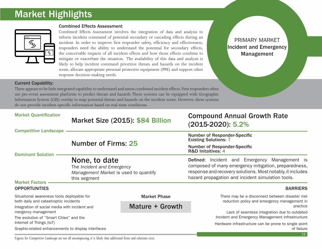
19
BARRIERS
PRIMARY MARKETIncident and Emergency
Management
Market Phase
Combined Effects AssessmentCombined Effects Assessment involves the integration of data and analysis to inform incident command of potential secondary or cascading effects during an incident In order to improve first responder safety efficiency and effectiveness responders need the ability to understand the potential for secondary effects the conceivable impacts of all incident effects and how those effects combine to mitigate or exacerbate the situation The availability of this data and analysis is likely to help incident command prioritize threats and hazards on the incident scene allocate appropriate personal protective equipment (PPE) and support other response decision-making needs
Market Quantification
Figures for Competitive Landscape are not all encompassing it is likely that additional firms and solutions exist
Compound Annual Growth Rate (2015-2020) 52
Competitive Landscape
Dominant Solution
Market Factors
Market Size (2015) $84 Billion
Number of Firms 25
None to date Defined Incident and Emergency Management is composed of many emergency mitigation preparedness response and recovery solutions Most notably it includes hazard propagation and incident simulation tools
The Incident and Emergency Management Market is used to quantify this segment
Current Capability
There may be a disconnect between disaster risk reduction policy and emergency management in
practice
Hardware infrastructure can be prone to single point of failure
Market Highlights
There appears to be little integrated capability to understand and assess combined incident effects First responders often use pre-event assessment platforms to predict threats and hazards These systems can be equipped with Geographic Information System (GIS) overlay to map potential threats and hazards on the incident scene However these systems do not provide incident-specific information based on real-time conditions
Lack of seamless integration due to outdated Incident and Emergency Management infrastructure
Number of Responder-SpecificRampD Initaitives 4
Number of Responder-SpecificExisting Solutions 7
Mature + Growth
OPPORTUNITIES
Situational awareness tools deployable for both daily and catastrophic incidents Integration of social media with incident and mergency managementThe evolution of ldquoSmart Citiesrdquo and theInternet of Things (IoT)
Graphic-related enhancements to display interfaces
20
Market Factors
Combined Effects Assessment
AutomatedRed-Force Tracking
Remote Monitoringof Threats and
Hazards
The ability to detect monitor and analyze passive and active threats and hazards at incident scenes in real time
Market Barriers
Market Opportunities
Legal and privacy concerns regarding facial recognition and other surveillance platformsDevice vulnerability and chances of systems being hacked
Integration with responder locationtracking systems and other situational awareness tools
Lack of synergy among security solutions
Solutions that address accuracy mobility speed and cost
The evolution of ldquoSmart Citiesrdquo and the Internet of Things (IoT)
x
x
x
Market Barriers
Market Opportunities
Dominance of large defense-related firms
Legal restrictions liability concerns and cost of unmanned systems
Development of free data and software platforms encouraged in the US and Europe
Potential widespread adoption of low cost drones and small satellite platforms
The evolution of ldquoSmart Citiesrdquo and the Internet of Things (IoT)
x
x
There may be a disconnect between disaster risk reduction policy and emergency management in practice
Lack of seamless integration due to outdated incident and emergency management infrastructure
Situational awareness tools deployable for both daily and catastrophic incidents
Integration of social media with incident and emergency management
The evolution of ldquoSmart Citiesrdquo and the Internet of Things (IoT)
x
x
Hardware infrastructure can be prone to single point of failure
x
Graphic-related enhancements to display interfaces
Market Barriers
Market Opportunities
21
Competitive LandscapeA total of 124 global firms were recognized as key players and innovators within the primary of Capability Gap 2 Specifically the breakdown of each market is as follows
The following seven firms were identified as key players and innovators in at least two of the three market segments regarding rapidly identification and detection of hazardous agents and contaminants
BAE Systems plc (United Kingdom)Boeing Company (US)General Dynamics Corporation (US)General Electric Corporation (US) Honeywell International Inc (US) andRaytheon Company (US)
These figures are not all encompassing it is likely that additional firms and solutions exist within each market
Detect Monitor and Analyze Threats and Hazards MarketKey Players and Innovators 2015
Multi-Sensor Integration and Analysis
Improved Standoff Detection and Identification of Hazards
Risk Assessment and Decision Support to Command
19
6
37
7
17
7
16
5 64
12
6
Commercial
First Responder-Specific
Existing Solutions Research and Development (RampD)
Technology Landscape SummaryThis analysis activity has identified a total of 71 existing solutions and 34 research and development (RampD) initiatives related to Capability Gap 2 - The Ability to Detect Monitor and Analyze Passive and Active Threats and Hazards at Incident Scenes in Real Time
Among the exisiting and developing solutions identified 20 solutions appear to be readily deployable for first responder use and 15 solutions appear to be in development for first responder use
0
10
20
30
40
90
50
40
30
20
10
0
19
80
25
Remote Monitoring of Threats and Hazards
Automated Red-Force Tracking
Combined Effects Assessment
80
70
60
Research and Development (RampD) by SectormdashIndustry Academia and Government
Remote Monitoring of Threats and Hazards
Automated Red-Force Tracking
Combined Effects Assessment
IndustryAcademiaGovernment
0 10 20 30 40 50 60 70 80 90 100
This analysis activity identified 34 RampD initiatives related to Capability Gap 2 - The Ability to Detect Monitor and Analyze Passive and Active Threats and Hazards at Incident Scenes in Real Time
Among the developing solutions identified 13 solutions (38 percent) appear to be initiated by industry firms 12 solutions (35 percent) appear to be initiated by academic institutions and 9 solutions (26 percent) appear to be initiated by government organizations
Based upon the data presented there is a comparatively low number of responder-specific solutions identified given the number of firms operating in each segment This presents an opportunity for those firms already developing solutions in the broader market as in some cases they may be able to make slight adaptations to existing solutions to meet first responder needs By engaging with responders particularly on a global level through the Forum firms can begin to assess how close they are to providing meaningful solutions for responders Furthermore they can engage responders throughout their process to ensure that their developments will meet responder needs
For questions or comments related to the information presented in this assessment please contact the Forum at infointernationalresponderforumorg
The majority (56 percent) of existing solutions identified by this analysis activity appear to be designed for various commercial industries while 28 percent of solutions appear to be designed for first responder use and 16 percent of solutions appear to be designed for defense-related initiatives
There may be an opportunity for firms with existing commercial solutions to compete in the first responder market by adapting existing solutions to meet the needs of first responders
56
16
28
First Responder-Specific
Commercial
Defense-Specific
Existing Solutions by SectormdashCommercial First Responder-Specific Defense-Specific
22
23
The following section presents some of the potential first responder-specific solutions by segment as identified by this assessment It is likely that there are additional potential solutions that exist or are in development and therefore this section should not be considered exhaustive A complete list of solutions identified by this assessment can be found in the Appendix at the end of this synopsis
The data presented in this section represents information that is publicly available from manufacturersrsquo Web sites This information is not further validated by this assessment
Automated Red-Force Tracking
Domo Tactical Communications (DTC) Ltd (United States) offers customized solutions for emerging surveillance and situational awareness challenges within border control internal security and critical infrastructure protection areas
DTC states its Orion trackers provide law enforcement military and intelligence agencies with a scalable technically advanced Radio Direction Finding (RDF) and Global Positioning System (GPS) solution to locate and track mission critical assets in challenging environments RDF systems offer covert tagging tracking and locating within a dedicated secure network without a reliance on commercial infrastructure such as GPS cellular or satellite foundations The range of Orion tracking options and tags include body worn solutions vehicle solutions airborne solutions fixed site solutions and city and country wide solutions
Information regarding price and specific deployment within the first responder community does not appear to be publicly available for this solution
Domo Tactical Communications (DTC) Ltd
Airbox Systems Limited (United Kingdom) is a computer software company that offers systems integration and consultancy to law enforcement emergency services military and search and rescue (SAR) organizations
Airbox Systems states its Mission Optimized Situational Awareness Information amp Collaboration (MOSAIC) application solution enables users to identify the location of team members key assets resources and infrastructure as well as access full profile and visual details relative to a mission or incident location including live video feeds
In addition MOSAIC appears to support various tracking capabilities including blue force red force and asset tracking
Information regarding price and specific deployment within the first responder community does not appear to be publicly available for this solution
Airbox Systems Limited
Airbox Systemsrsquo MOSAIC
First Responder-Specific Technologies
24
Honeywell International Inc (United States) is a Fortune 100 company that offers hardware and software solutions that address global energy safety security productivity and urbanization challenges
The Honeywell Radar Video Surveillance (RVS) solution is described as a wide area security system that provides advanced surveillance capabilities through the integration of ground or waterside radar Global Positioning System (GPS) Automatic Identification System (AIS) video and thermal sensor data RVS is often paired with Honeywellrsquos Digital Video Manager (DVM) to leverage existing security infrastructure
Honeywellrsquos RVS radar sensors automatically detect potential threats in user defined Alarm Zones Following detection an alarm alerts security personnel and connected pan-tilt-zoom (PTZ) cameras are directed to identify and track the potential threats Video recording is distributed over a Local Area Network to provide real-time situational awareness to security personnel
The components of the RVS are presented in the figure below
Information regarding price and deployment within the first responder community does not appear to be publicly available for this solution
Honeywell International Inc Radar Video Surveillance (RVS)
Honeywell International Inc
The Institute of Anthropometrics amp Robotics at the Karlsruhe Institute of Technology (Germany) explores the science of symbiosis between human and humanoid The Institute focuses on human-centered environments with an aim to research and develop people-friendly systems using informatics The Institute studies topics such as multimodal interaction of people with technical systems humanoid robots language understanding image perception learning recognizing and understanding situations generating knowledge through experience and processing biosignals
Computer scientists from the Institute of Anthropometrics amp Robotics developed a new type of facial-recognition system that uses nontraditional methods Infrared spectrum thermal signatures emitted by skin tissues can be captured through passive thermal sensors without using any active light source Thus images or faces can be identified in the dark
In the study a ldquodeep neural networkrdquo computer system analyzed numerous infrared images of individual faces and compared the images to a repository of photos taken in daylight According to study results the proposed approach improved the state-of-the-art by more than 10 percent However further accuracy is warranted When presented with multiple comparative images the system was accurate about 80 percent of the time while when presented with one comparative image the system was accurate about 55 percent of the time
The Institute of Anthropometrics amp Robotics at the Karlsruhe Institute of Technology
25
According to study results the proposed approach improved the state-of-the-art by more than 10 percent However further accuracy is warranted When presented with multiple comparative images the system was accurate about 80 percent of the time while when presented with one comparative image the system was accurate about 55 percent of the time
The study was partially funded by the German Federal Ministry of Education and Research (BMBF) Additional information regarding funding and Technology Readiness Level (TRL) does not appear to be publicly available for this project
Deep Perceptual Mapping (DPM) Densely computed features from the visible domain are mapping through the learned DPM network to the corresponding thermal domain
26
SRI International (United States) is an independent nonprofit research center that provide basic and applied research development deployment and commercialization services SRI collaborates across various technical and scientific disciplines including
Biosciences Health and Medical SystemsChemistry Materials and EnergyComputing and Information TechnologyDefense and SecurityEducation and LearningOcean and SpaceRobotics andCustom Solutions
Researchers from SRI the University of Leeds (United Kingdom) and the University of Maryland (United States) are developing a system to enhance remote threat surveillance These efforts appear to be funded by the Mindrsquos Eye Program initiated by the US Defense Advanced Research Projects Agency (DARPA) The Mindrsquos Eye Program promotes the development of smart cameras for real-time threat detection and analysis
The system under development known as Visual Intelligence Grounded in Learning (VIGIL) combines vision analysis automatic reasoning and machine learning to identify and report unusual interactions between people and objects SRI states VIGIL is being designed to use probabilistic reasoning statistical and relational learning as well as other artificial intelligence approaches to detect recognition and describe behavior and activities observed in video The goal of the program is to construct a compact field-portable system compatible for rapid cost-effective deployment on unmanned vehicles Additional information regarding funding and Technology Readiness Level (TRL) does not appear to be publicly available for this project
SRI International
27
Vidsys Inc (United States) offers Converged Security Information Management (CSIM) software for various industry sectors including government education energy transportation enterprise public safety and healthcare
Vidsys CSIM software is described as a browser-based platform that collects correlates and converts vast amounts of data into meaningful and action information based on a userrsquos risk policy standards and compliance requirements The software can be rapidly deployed to provide real-time situational awareness and information management capabilities to remote users and first responders
Vidsys states its CSIM software can provide the following advantages to public safety personnel
In 2014 Vidsys CSIM software was deployed in the City of Baltimore Maryland for the ldquoStar Spangled Spectacularrdquo This event was designated as a Level 2 Special Event by the US Department of Homeland Security (DHS) In Baltimore Vidsys CSIM software generated a common operating picture that connected nearly 50 local state and federal agencies in one command center Further the platform integrated approximately 1500 security cameras mapping technology weather alerts social media monitoring mass notification radar and other technologies to enhance public safety and ensure rapid response
Information regarding price does not appear to be publicly available for this solution
Vidsys Inc
Centralize security monitoring to enhance situational awareness among various agencies
Provide more accurate details to first responders en route and on the scene
Improve collaboration among state and local police emergency medical service (EMS) responders and other agencies
Improve response time by leveraging location based assets and
Archive situation management for the purpose of training and after action analysis
Vidsys Converged Security Management (CSIM) Software
28
Remote Monitoring of Threats and Hazards
The Environment and Sustainability Institute (ESI) DroneLab at the University of Exeter (United Kingdom) designs manufactures and tests lightweight fixed wing and multi-rotor aircraft and related systems
According to ESI DroneLab smartphones are equipped with a broad suite of sensors (eg cameras microphones light sensors accelerometer compass gyroscope and Global Positioning System [GPS]) and on-board microcomputers Therefore there may be an untapped opportunity in converting smartphones into all-inclusive or self-containing remote sensing devices
In 2016 scientists from the ESI DroneLab began development of an android-based smartphone application programed to automatically capture aerial photographs and spatial metadata The smartphone equipped with the application could then be fixed onto a lightweight portable platform such as a drone or a kite for grassroot mapping scenarios For example ESI DroneLab states in the aftermath of a humanitarian disaster the ability to rapidly and cheaply survey environmental damage and search for survivors is more readily achieved from a drone or a kite than from a piloted aircraft or satellite In addition the resolution of data from low-flying platforms such as drones and kites enables more useful and easily interpreted data
All coding for the intial app is available via GIThub In addition the app can be freely downloaded via the Google Store Initial funding to develop the app was provided by the European Social Fund The Natural Environment Research Council (NERC) supported further testing and development through its ldquoImpact Acceleratorrdquo fund Additional information regarding funding Technology Readiness Level (TRL) and deployment within the first responder community does not appear to be publicly available for this project
The Environment and Sustainability Institute (ESI) DroneLab at the University of Exeter
FLIRreg Systems Inc (United States) designs develops manufactures markets and distributes solutions for enhanced perception and situational awareness In 1978 FLIRreg offered infrared imaging systems to be used for energy audits FLIRreg systems and components have since evolved for use in security (eg airborne and ground-based surveillance) condition monitoring navigation drug interdiction transportation safety and efficiency border and maritime patrol environmental monitoring and chemical biological radiological nuclear and explosives (CBRNe) threat detection
Launched in 2016 the FLIRreg Aerial First Responder Kit includes a DJI Inspire 1 drone DJI Zenmuse XT thermal camera DJI Zenmuse X3 4k visible light camera and a variety of accessories to provide fire fighters and first responders with airborne thermal imaging capabilities
FLIRreg states the solution offers incident commanders the ability to see through smoke and keep track of personnel in large fire-related incident scenes In addition the system can be deployed for search and rescue (SAR) missions regardless of the time of day
FLIRreg Systems Inc
FLIRreg Aerial First Responder Kit
29
FLIRreg Aerial First Responder Kit package specifications are presented in the table below
ModelFLIRreg Aerial First
Responder Basic KitFLIR Aerial First
Responder Advanced Kit
Thermal CameraDJI Zenmuse XT Thermal Camera amp Stabilized Gimbal
DJI Zenmuse XT Thermal Camera amp Stabilized Gimbal
Thermal Camera Configuration
68 mm lens (45deg x 35deg) 336 x 256 resolution
13 mm lens (45deg x 37deg) 640 x 512 resolution
Aircraft Type DJI Inspire 1 (V 20) DJI Inspire 1 (V 20)
Controller(s) One Two
Batteries Included Three Three
Color Video CameraDJI Zenmuse X3 4k Video Camera amp Stabilized Gimbal
DJI Zenmuse X3 4k Video Camera amp Stabilized Gimbal
FLIRreg Tools+ Image Analysis Software
Yes Yes
Apple iPad Mini 4 (64GB WiFi)
One Two
Monitor Hood(s) One Two
Rugged Carrying Case Yes Yes
FLIRreg Landing Pad Yes Yes
FLIRreg Aerial First Responder Kits are available to purchase starting at approximately $10450 per kit Information regarding specific deployment within the first responder community does not appear to be publicly available
Lockheed Martin Corporation (United States) is a global security innovation and aerospace company with specialties in aeronautics missiles and fire control rotary and mission systems and space systems The majority of Lockheed Martinrsquos business is with the US Department of Defense (DoD) and US federal government agencies However Lockheed Martin also engages with international government and commercial users
The Lockheed Martin Procerus Technologies Indago quadrotor unmanned aerial system (UAS) provides military civil and commercial users with aerial reconnaissance capabilities The solution is adaptable to a variety of payloads for precision agriculture mapping surveying and inspection and reconnaissance Lockheed Martin states the solution is collapsible weighs less than five pounds and folds into a man-packable unit that requires no tools for assembly In addition the UAS solutions includes a weather-resistant wireless hand controller to provide an intuitive interface and untethered UAS operation
Lockheed Martin Corporation
Procerus Technologies Indago Quadrotor UAS Wireless Hand Controller
30
In regards to the first respond community the Indago quadrotor UAS can be equipped with location antenna and tracking system capabilities Project Lifesaver International a public safety nonprofit organization works with first responders to deploy the system to locate and track individuals with Alzheimerrsquos disases Autism and Down syndrome
Information regarding price does not appear to be publicly available for this solution
Procerus Technologies Indago Quadrotor UAS
Mouser Electronics Inc (United States) is an authorized global distributor of semiconductors and electronic components for design engineers In 2014 Mouser Electronics initiated its Empowering Innovation Togethertrade campaign The campaign was founded in partnership with Grant Imahara a celebrity engineer best known for his roles on Mythbusters and Battlebots To promote campaign initiatives Grant Imahara hosts a series of webisode videos that highlight innovative and creative engineers worldwide with new products and technical expertise One such series features Mouser Electronicsrsquo Project First Responders
The recently complete Project First Responders was an initiative to develop a fleet of connected drones for public safety applications Specifically Project First Responders showcased the proof of concept for an autonomous cloud-based drone platform for use in search and rescue or surveillance operations The developed network of drones were equipped with GlobalARC communication GlobalARC (United States) offers a full service unmanned aerial vehicle (UAV) deployment and management system with integrated airspace compliance and live video feed from drones The service enables autonomous robot communication (ARC) or peer-to-peer communication between autonomous vehicles via cellular networks
During testing the developed drone network was deployed in a wildfire scenario Mouser Electronics states the solution provided key data to first responders such as wind speed and direction fuel types around existing fire and the location of trapped civilians
Project First Responders is sponsored by Intel Corporation (United States) and TE Connectivity Ltd (Switzerland) However additional information regarding funding Technology Readiness Level (TRL) and deployment within the first responder community does not appear to be publicly available
Mouser Electronics Inc
31
Environmental Systems Research Institute (Esri) Inc (United States) is an information technology and services company specialized in geographic information system (GIS) and mapping software The companyrsquos premier solution that appears to dominate the GIS industry is ArcGIS ArcGIS provides contextual tools for mapping and spatial reasoning that enable users to explore data and share location-based insights Specifically ArcGIS capabilities include
Spatial Analytics
Mapping and Visualization
3D and Real-Time GIS
Imagery and Remote Sensing and
Data Collection and Management
ArcGIS for Emergency Management includes multiple applications to map and model potential plans determine their potential impacts visualize critical vulnerabilities and plan for special events
Notably ArcGIS for Emergency Management includes a CAMEO Tools application to import critical data for chemical emergencies The Computer-Aided Management of Emergency Operations (CAMEO) software suite is used to prepare for and response to chemical emergencies The solution was developed by the US Environmental Protection Agency (EPA) and the National Oceanic and Atmospheric Administration (NOAA) CAMEO Tools imports information from the CAMEO system into ArcGIS to support critical analysis and emergency management
ArcGIS is available to multiple users on a subscription basis ranging from $45000 to $500 per year Information regarding specific deployment within the first responder community does not appear to be publicly available for this solution
Environmental Systems Research Institute (Esri) Inc
PREDICT Overlay historical incidents with operational data to anticipate where future events are most likely to occur
MODEL Run sophisticated what-if scenarios to understand how a chemical spill or sudden flood will affect a community and environment
PREPARE Pre-position assets to the most vulnerable areas of a community to improve response when an incident occurs
ArcGIS Capabilities
ArcGIS Solutions
Combined Effects Assessment
32
SimTable LLC (United States) provides agent-based modeling distributed mobile computing and real-time Geographic Information System (GIS) platforms as described below
In the US Simtables are deployed in more than 85 city state and federal agencies and academic institutions In regards to pricing each client is quoted individually However packages can range from $35000 to $79000 per client
SimTable LLC
Agent-Based Modeling SimTable develops agent-based modeling frameworks to explore and visualize complex scenarios for both physical and social incidents Specifically SimTable designs customized agent-based models based on local community data for wildfire flood evacuation storms airborne particulates as well as biological and ecological behaviors Distributed Mobile Computing SimTable enables mobile phone and tablet communication across disparate networks for real-time data sharing
Real-Time Geographic Information System (GIS) SimTable enables the integration of GIS for use in simulation and planning applications SimTable Training Exercise for Fire Services
33
Appendix
Automated Red-Force Tracking
Existing SolutionsIndustry Academia and Government Solution
Airbox Systems IncMission Optimized Situational Awareness Information amp Collaboration (MOSAIC)
Domo Tactical Communications (DTC) Ltd DTC Orion
International Business Machines Corporation (IBM)
Intelligent Operation Center for Emergency Management
ResponderX Inc ResponderX
Vidsys IncConverged Security Information Management (CSIM)
Visual Semantics Real-Time Intelligence
Developing (RampD) SolutionsIndustry Academia and Government Solution
Analog DevicesSensor Fusion Approach to Precision Location and Tracking for First Responders
Commandwear Systems Inc CommandWear
Electronic Warfare Associates IncBiometric Optical Surveillance System (BOSS)
National Aeronautics and Space Administration (NASA) Jet Propulsion Lab (JPL)
Precision Outdoor and Indoor Navigation and Tracking for Emergency Responders (POINTER)
University of Michigan (MconneX) Weapons-Detecting Radars
The following section includes tables that list the potential first responder-specific solutions both existing and in development as identified by this assessment It is likely that there are additional potential solutions in the market and therefore this section should not be considered exhaustive
34
AppendixRemote Monitoring of Threats and Hazards
Existing SolutionsIndustry Academia and Government SolutionCovidence AS Video Surveillance
FLIRreg Systems Inc
Aerial First Responder Kits (UAS)
Aerial Thermal Imaging Kits
KF6 Thermal Imaging Solution
HAAS IncIntelligent Operation Center for Emergency Management
Lockheed Martin Corporation ResponderX
SeSys LtdConverged Security Information Management (CSIM)
Developing (RampD) SolutionsIndustry Academia and Government Solution
Aditya College of EngineeringAutomatic Fire Alarm System based on Wireless Sensor
Mouser Electronics Inc Project First Responders
RAE Systems IncWirelessly-Connected Monitoring Equipment
Research Center on Software Technologies and Multimedia Systems for Sustainability (CITSEM) at Universidad Politeacutecnica de Mardrid (UPM)
Forest Fire Detection Drones
The Environment and Sustainability Institute (ESI) DroneLab at the University of Exeter
Grassroots Remote Sensing Toolkit
35
AppendixCombined Effects Assessment
Existing SolutionsIndustry Academia Government Solution
Hexagon ABMobile Responder
Public Safety Analytics
International Business Machines Corporation (IBM)
Intelligent Operation Center for Emergency Management
Lawrence Livermore National Laboratory HotSpot
National Oceanic and Atmospheric Administration
Computer-Aided Management of Emergency Operations (CAMEO)
SimTable LLC SimTable
US Defense Threat Reduction Agency (DTRA)
Hazard Prediction and Assessment Capability (HPAC)
Developing (RampD) SolutionsIndustry Academia Government Solution
Hendrix CollegeDetection of Atmospheric Infrasound with a Ring Laser Interferometer
Idaho National Laboratory Robotics 3D Mapping
Oak Ridge National Laboratory (ORNL)Incident Management Preparedness and Coordination Toolkit (IMPACT)
TransVoyant LLC Continuous Decision Intelligencetrade (CDItrade)
36
Appendix
RTO Automated Red-Force Tracking Border Security System Marketmdashthe border security system market forecast period is 2016 to 2022 with a market figure available for 2022 The CAGR of 716 percent was used to estimate the revenue values for 2015 to 2020 The figure for 2015 was extrapolated outside of the forecast period of 2016 to 2022 Facial Recognition Marketmdashthe facial recognition market forecast period is 2016 to 2021 with market figures available for 2016 and 2021 The CAGR of 153 percent was used to estimate the revenue values for 2015 to 2020 The figure for 2015 was extrapolated outside of the forecast period of 2016 to 2021
Head-Mounted Display (HMD) Marketmdashthe HMD market forecast period is 2016 to 2020 with market figures available for 2015 and 2020 The CAGR of 489 percent (2015 to 2020) was used to estimate the revenue values for 2016 to 2019
Military Electro-OpticsInfrared Systems Marketmdashthe military electro-opticsinfrared systems market forecast period is 2016 to 2022 with market figures available for 2016 and 2022 The CAGR of 576 percent was used to estimate the revenue values for 2015 to 2020 The figure for 2015 was extrapolated outside of the forecast period of 2016 to 2022
Physical Security Information Management (PSIM) Marketmdashthe PSIM market forecast period is 2016 to 2024 with market figures available for 2015 and 2024 The CAGR of 186 percent (2015 to 2024) was used to estimate the revenue values for 2016 to 2023 Physical Security Marketmdashthe physical security market forecast period is 2016 to 2021 with market figures available for 2016 and 2021 The CAGR of 101 percent was used to estimate the revenue values for 2015 to 2020 The figure for 2015 was extrapolated outside of the forecast period 2016 to 2021
Video Analytics Marketmdashthe video analytics market forecast period is 2017 to 2022 with market figures available for 2017 and 2022 The CAGR of 337 percent was used to estimate the revenue values for 2015 to 2020 The figures for 2015 and 2016 were extrapolated outside of the forecast period 2017 to 2022
Video Surveillance Marketmdashthe video surveillance market forecast period is 2016 to 2022 with market figures available for 2016 and 2022 The CAGR of 164 percent was used to estimate the revenue values for 2015 to 2020 The figure for 2015 was extrapolated outside of the forecast period 2016 to 2022
RTO Combined Effects Assessment 3D Mapping amp 3D Modeling Marketmdashthe 3D mapping amp 3D modeling market forecast period is 2015 to 2020 with market figures available for 2015 and 2020 The CAGR of 550 percent was used to estimate the revenue values for 2016 to 2019
Computer-Aided Design (CAD) Marketmdashthe CAD market forecast period is 2017 to 2021 with market figures available for 2016 and 2021 The CAGR of 70 percent (2016 to 2021) was used to estimate the revenue values for 2015 and 2017 to 2020 The figure for 2015 was extrapolated outside of the forecast period of 2016 to 2021
Market Figure Disclaimers
37
Geospatial Analytics Marketmdashthe geospatial analytics market forecast period is 2016 to 2021 with market figures available for 2016 and 2021 The CAGR of 192 percent was used to estimate the revenue values for 2015 and 2017 to 2020 The figure for 2015 was extrapolated outside of the forecast period of 2016 to 2021
Geospatial Imagery Analytics Marketmdashthe geospatial imagery analytics market forecast period is 2016 to 2021 with market figures available for 2016 and 2021 The CAGR of 298 percent was used to estimate the revenue values for 2015 and 2017 to 2020 The figure for 2015 was extrapolated outside of the forecast period of 2016 to 2021
Governmental Geospatial Intelligence (GEOINT) Solutions Marketmdashthe GEOINT solutions market for defense and HLS market forecast period is 2015 to 2020 with market figures available for 2014 and 2016 The CAGR of 82 percent (2014 to 2026) was used to estimate the revenue values for 2015 and 2017 to 2020
RTO Remote Monitoring of Threats and Hazards Remote Sensing Technologies Marketmdashthe remote sensing technologies market forecast period is 2016 to 2021 with market figures available for 2015 2016 and 2021 The CAGR of 92 percent was used to estimate the revenue values for 2017 to 2020
Security Robots Marketmdashthe security robots market forecast period is 2016 to 2022 with market figures available for 2015 and 2022 The CAGR of 84 percent (2015 to 2022) was used to estimate the revenue values for 2016 to 2020
Unmanned Aerial Vehicle (UAV) Marketmdashthe UAV market was calculated as a percentage of the total security robots market based on a publicly available market report
Unmanned Ground Vehicle (UGV) Marketmdashthe UGV market was calculated as a percentage of the total security robots market based on a publicly available market report
Unmanned Underwater Vehicle (UAV) Marketmdashthe UUV market was calculated as a percentage of the total security robots market based on a publicly available market report
Video Analytics Marketmdashthe video analytics market forecast period is 2017 to 2022 with market figures available for 2017 and 2022 The CAGR of 337 percent was used to estimate the revenue values for 2015 to 2020 The figures for 2015 and 2016 were extrapolated outside of the forecast period 2017 to 2022
Video Surveillance Marketmdashthe video surveillance market forecast period is 2016 to 2022 with market figures available for 2016 and 2022 The CAGR of 164 percent was used to estimate the revenue values for 2015 to 2020 The figure for 2015 was extrapolated outside of the forecast period 2016 to 2022
38
GlossaryCompound Annual Growth Rate (CAGR)
First Responder
Project Responder 4 (PR4)
Response Technology Objective (RTO)
RTO Automated Red-Force Tracking
The average annual growth rate when compounding is taken into account its formula is as follows
CAGR = (FVPV)^(1n) - 1 where FV is the future or ending value PV is the present or starting value and n is the number of years between PV and FV
A person among those responsible for going immediately to the scene of an accident or emergency to provide assistance The first responder market is to include law enforcement fire services and emergency medical services
The fourth in a series of studies that commenced in 2003 to focus on identifying capability needs shortfalls and priorities for catastrophic incident response in the United States Findings including a set of enduring and emerging capability needs technology objectives and state of science and technology to meet capability needs are based on discussions with federal state and local first responders as well as technical subject matter experts (SMEs)
A term used within Project Responder 4 (PR4) to translate a capability statement into an actionable technology-centric objective
Automated Red-Force Tracking involves the automatic identification and surveillance of red forces In the emergency response community a red force may represent a specific threat or hazard such as a person (eg active shooter suspect) or an object (eg weapon explosive device) In order to improve first responder safety efficiency and effectiveness responders need the ability to know the location and movement of red forces and their proximity to other response personnel critical resources and infrastructure in real time The ability to automatically identify and track red forces is likely to improve response situational awareness and decision-making
39
RTO Combined Effects Assessment
RTO Remote Monitoring of Threats and Hazards
Combined Effects Assessment involves the integration of data and analysis to inform incident command of potential secondary or cascading effects during an incident According to PR4 advances in technology for this RTO are primarily focused on the graphic display of threats and hazards for improved situational awareness In order to improve first responder safety efficiency and effectiveness responders need the ability to ldquounderstand the potential for secondary effects the conceivable impacts of all incident effects and how those effects combine to mitigate or exacerbate the situationrdquo The availability of this data and analysis is likely to help incident command prioritize threats and hazards on the incident scene allocate appropriate personal protective equipment (PPE) and support other response decision-making needs
This RTO focuses on the development of multiple platforms to support remote ongoing surveillance and monitoring of threats and hazards on the incident scene and potentially affected areas In order to improve first responder safety efficiency and effectiveness responders need the ability to continuously evaluate existing emerging and potential threats and hazards in areas affected by an incident Remote monitoring of threats and hazards can provide incident command with pertinent information throughout an incident without exposing responders to additional risk
40
ReferencesldquoAbout ArcGISrdquo Esri nd Web 15 March 2017 lthttpwwwesricomarcgisabout-arcgis gtldquoAbout Esrirdquo Esri nd Web 15 March 2017 lthttpwwwesricomabout-esrigtldquoAboutrdquo GlobalARC nd Web 15 March 2017 lthttpswwwglobalarcusgt ldquoAbout Usrdquo Mouser Electronics Inc nd Web 15 March 2017 lthttpwwwmousercomaboutusgt ldquoAbout SimTablerdquo SimTable nd Web 15 March 2017 lthttpswwwsimtablecomaboutgtldquoAbout Usrdquo SRI International nd Web 15 March 2017 lthttpswwwsricomaboutgtldquoAbout Vidsysrdquo Vidsys Inc nd Web 15 March 2017 lthttpwwwvidsyscomaboutgtldquoAerial Thermal Imaging Unleashedrdquo FLIRreg Systems Inc nd Web 15 March 2017 lthttpwwwflircomsuas aerial-thermal-imaging-kitsgtldquoAirbox Systems History amp Awardsrdquo Airbox Systems nd Web 15 March 2017 lthttpairboxsystemscomhis tory-and-awardsgtldquoAirbox Systems MOSAICrdquo Airbox Systems nd Web 15 March 2017 lthttpairboxsystemscomwp-content uploads201608AirboxMOSAICpdfgtAnderson Dr Karen et al A Grassroots Remote Sensing Toolkit Using Live Coding Smartphones Kites and Light weight Drones The University of Exeter Environment and Sustainability Institute (ESI) DroneLab 4 May 2016 Web 15 March 2017 lthttpswwwncbinlmnihgovpmcarticlesPMC4856374gtldquoCAMEO Toolsrdquo Environmental Systems Research Institute Inc nd Web 15 March 2017 lthttpsolutionsarc giscomemergency-managementhelpcameo-toolsgtConverged Security Information Management (CSIM) Brochure Washington DC nd Web 15 March 2017 lthttpwww vidsyscomsectorspublic-safetygtDouglass Jason ldquoDARPA Kicks Off Mindrsquos Eye Programrdquo Infowars Free Speech Systems LLC 6 Jan 2011 Web 15 March 2017 lthttpswwwinfowarscomdarpa-kicks-off-minds-eye-programgtldquoESI DroneLabrdquo University of Exeter Environment and Sustainability Institute nd Web 15 March 2017 lthttp wwwexeteracukmediauniversityofexeteresipdfsESI_Concertina_12pp_version_6-FINALpdfgtldquoFirst Responders Buy Complete Drone Packages Through FLIRrdquo FLIRreg Systems Inc 19 April 2016 Web 15 March 2017 lthttpwwwflircomhomenewsdetailsID=75100gtldquoFLIR Systemsrdquo LinkedIn nd Web 15 March 2017 lthttpswwwlinkedincomcompany-beta163847path Wildcard=163847gtldquoHoneywellrsquos Innovative Technologies Are Making Our World Cleaner and More Sustainable More Secure Con nected Energy Efficient and Productiverdquo Honeywell International Inc nd Web 15 March 2017 lthttpswwwhoneywellcomwho-we-areoverviewour-companygtldquoIAR ndash Institute for Anthropomatics and Roboticsrdquo Karlsruhe Institute of Technology nd Web 15 March 2017 lthttpswwwinformatikkiteduenglish1323phpgtldquoIndago UASrdquo Lockheed Martin Corporation nd Web 15 March 2017 lthttpwwwlockheedmartincomus productsprocerusindago-uashtmlgtldquoIntegrated Surveillance Solutionsrdquo Domo Tactical Communications Ltd nd Web 15 March 2017 lthttp wwwdomotacticalcomproductsintegrated-surveillance-solutionsgtldquoMouser Electronics Announces New Partnership with Grant Imahara of Mythbusters Fame to lsquoEmpower Innova tion Togethertradersquordquo Mouser Electronics Inc 11 Nov 2014 Web 15 March 2017 lthttpwwwmouser compublicrelationsmouserempoweringinnovationfinal2014gtldquoProductsrdquo Domo Tactical Communications Ltd nd Web 15 March 2017 lthttpwwwdomotacticalcom productsgtldquoProject Lifesaver Case Studyrdquo Lockheed Martin Corporation nd Web 15 March 2017 lthttpwwwlock heedmartincomusproductsprocerusindago-uasproject-lifesaver-case-studyhtmlgt
41
ReferencesProject Responder 4 2014 National Technology Plan for Emergency Response to Catastrophic Incidents Washington DC Homeland Security Studies and Analysis Institute 2014 PDF 10 Jan 2017 lthttpswwwdhsgovsitesdefault filespublicationsProject20Responder204_1pdfgtPublic Safetyrdquo Vidsys Inc nd Web 15 March 2017 lthttpwwwvidsyscomsectorspublic-safetygtRadar Video Surveillance (RVS) Brochure Orlando Honeywell International Inc 2006 Web 15 March 2017 lthttpswwwhoneywellintegratedcomproductsintegrated-securityvideo97630htmlgtldquoRadar Video Surveillance (RVS) Systemrdquo Honeywell International Inc nd Web 15 March 2017 lthttpswww honeywellintegratedcomproductsintegrated-securityvideo97630htmlgtSarfraz Saquib M and Bainer Stiefelhagen Deep Perceptual Mapping for Thermal to Visible Face Recognition Karlsruhe Institute of Technology Institute of Anthropometrics amp Robotics 2015 Web 15 March 2017 lthttpsarxivorgpdf150702879v1pdfgtSchneider Steven ldquoNew Facial Recognition System Works in the Darkrdquo Tech Times 27 July 2015 Web 15 March 2017 lthttpwwwtechtimescomarticles7230220150727new-thermal-based-facial-recognition- system-works-in-the-darkhtmgtldquoTagging Tracking Locate amp Interceptrdquo Domo Tactical Communications Ltd nd Web 15 March 2017 lthttp wwwdomotacticalcomproductstagging-tracking-locate-interceptgtldquoVisual Intelligence Grounded in Learning (VIGIL)rdquo SRI International nd Web 15 March 2017 lthttpswww sricomworkprojectsvisual-intelligence-grounded-learning-vigilgtldquoWho We Arerdquo Lockheed Martin Corporation nd Web 15 March 2017 lthttpwwwlockheedmartincomus who-we-arehtmlgt
RTO Automated Red-Force TrackingldquoAugmented Reality Market by Component (Sensor Display amp Software) Display Type (Head Mounted Head-Up Handheld amp Spatial) Application (Aerospace amp Defense Consumer Commercial) and Geography - Global Forecast to 2020rdquo MarketsandMarkets Nov 2015 Web 10 Jan 2017 lthttpwwwmarketsandmarkets comMarket-Reportsaugmented-reality-market-82758548htmlgtldquoBorder Security System Market by Environment (Ground Aerial Naval) System (Laser Radar Camera Wide Band Wireless Communication Perimeter Intrusion Unmanned Vehicles C2C Biometric Systems) and Geography - Global Forecast to 2022rdquo MarketsandMarkets April 2016 Web 10 Jan 2017lthttpwww marketsandmarketscomMarket-Reportsborder-security-system-market-103309188htmlgtErguumlrel Deniz ldquoLower Costs Will Drive the Head Mounted Display Marketrdquo Haptical 14 Sept 2016 Web 10 Jan 2017 lthttpshapticalhead-mounted-display-report-technavio-2016-a5ee5fe36bafgtldquoFacial Recognition Market by Component Software Tools (2D 3D and Thermal) and Services (Training amp Con sulting Services and Cloud-Based Facial Recognition Services) Technology Use Case and Application Area - Global Forecast to 2021rdquo MarketsandMarkets Nov 2016 Web 10 Jan 2017 lthttpwwwmarketsand marketscomMarket-Reportsfacial-recognition-market-995htmlgtldquoPhysical Security Market by Type (System (Access Control Video Surveillance PSIM Perimeter Intrusion De tection amp Prevention Security Scanning Imaging amp Metal Detection Fire amp Life Safety) amp Service) Vertical and Region - Global Forecast to 2021rdquo MarketsandMarkets March 2017 Web 15 March 2017 lthttp wwwmarketsandmarketscomMarket-Reportsphysical-security-market-1014htmlgt
42
ReferencesldquoPhysical Security Information Management Market (Component - Software (Off-the-Shelf and Customized) and Service End User - Residential Retail BFSI Telecom and IT Transportation and Logistics Government and Defense Sector Hospitality Industrial Manufacturing Energy and Utility Healthcare Educational Insti tutions Religious Buildings and Stadiums) - Global Industry Analysis Size Share Growth Trends and Forecast 2016 ndash 2024rdquo Transparency Market Research 22 Nov 2016 Web 10 Jan 2017 lthttpwww transparencymarketresearchcomphysical-security-information-managementhtmlgtldquoGlobal Head-Mounted Display Market 2016-2020rdquo Technavio Aug 2016 Web 10 Jan 2017 lthttpswww technaviocomreportglobal-embedded-systems-global-head-mounted-display-market-2016-2020gtldquoMilitary Augmented Reality (MAR) Technologies Market Report 2016-2026rdquo visiongain 1 July 2016 Web 10 Jan 2017 lthttpswwwvisiongaincomReport1678Military-Augmented-Reality-(MAR)-Technolo gies-Market-Report-2016-2026gtldquoMilitary Electro-OpticsInfrared (EOIR) Systems Market by Platform System (Targeting Imaging) Technology (Uncooled Cooled) Sensor Technology (Staring Scanning) Imaging Technology (Hyperspectral Mul tispectral) and Region - Global Forecast to 2022rdquo MarketsandMarkets Dec 2016 Web 10 Jan 2017 lthttpwwwmarketsandmarketscomMarket-Reportselectro-optical-market-234736604htmlgtldquoVideo Analytics Market by Type (Software and Services) Application (Intrusion Management Incident Detection CrowdPeople Counting Traffic Monitoring ANPR Facial Recognition) Deployment Model Vertical and Region - Global Forecast to 2022rdquo MarketsandMarkets April 2017 Web 5 April 2017 lthttpwww marketsandmarketscomMarket-Reportsintelligent-video-analytics-market-778htmlgtldquoVideo Surveillance Market by System (Analog IP Biometrics) Hardware (Camera Monitors Servers Storage Devices) Software (Video Analytics VMS) and Service (VSaaS Installation amp Maintenance) Vertical and Region - Global Forecast to 2022rdquo MarketsandMarkets March 2017 Web 15 March 2017 lthttpwww marketsandmarketscomMarket-Reportsvideo-surveillance-market-645htmlgt
RTO Combined Effects Assessmentldquo3D Mapping and 3D Modeling Market by Application in 3D Mapping (3D Projection Mapping Mapping and Navigation and Others) by Vertical (Healthcare Building and Construction and Others) and by Geog raphy - Forecast to 2020rdquo MarketsandMarkets Oct 2015 Web 10 Jan 2017 lthttpwwwmarketsand marketscomMarket-Reports3d-mapping-market-819htmlgtldquoComputer-Aided Design Market ndash Drivers and Forecasts by Technaviordquo Business Wire Inc 27 Jan 2017 Web 15 March 2017 lthttpwwwbusinesswirecomnewshome20170127005528enComputer-aided-De sign-Market-ndash-Drivers-Forecasts-TechnaviogtldquoGlobal Computer-Aided Design Market 2017-2021rdquo Technavio Jan 2017 Web 15 March 2017 lthttps wwwtechnaviocomreportglobal-product-lifecycle-management-global-computer-aided-design-mar ket-2017-2021utm_source=T3amputm_campaign=Mediaamputm_medium=BWgtldquoGeospatial Analytics Market by Type (Surface Analytics Network Analytics amp Geovisualization) Technology (Re mote Sensing GPS amp GIS) Application (Surveying Medicine amp Public Safety and Others) Vertical and Re gion - Global Forecast to 2021rdquo MarketsandMarkets Jan 2017 Web 15 March 2017 lthttpwwwmar ketsandmarketscomMarket-Reportsgeospatial-analytics-market-198354497htmlgtldquoGeospatial Imagery Analytics Market by Type (Image and Video) Collection Medium (GIS Satellite UAV) Vertical (Defense amp Security Insurance Agriculture Healthcare amp Life Sciences) and Region - Global Forecast to 2021rdquo MarketsandMarkets Oct 2016 Web 10 Jan 2017 lthttpwwwmarketsandmarketscomMar ket-Reportsgeospatial-imagery-analytics-market-221633264htmlgt
43
ReferencesldquoGlobal Geographic Information System (GIS) Market (Size of $7613 million in 2014) to Witness 11 CAGR During 2015 ndash 2020rdquo PampS Market Research Feb 2016 Web 10 Jan 2017 lthttpswwwpsmarket researchcompress-releaseglobal-geographic-information-system-marketgtldquoGlobal Geographic Information System (GIS) Market Size Share Development Growth and Demand Forecast to 2020 - Industry Insights by Type (Hardware Software Services) by Industry Vertical (Aerospace amp De fense Oil amp Gas Exploration Water amp Wastewater Government Transportation amp Logistics Engineering amp Business Services Oil amp Gas Refining Telecommunications Healthcare Other) by Project Size (Small (lt$250K) Medium ($250K to1 Million) Large (gt$1 Million))rdquo PampS Market Research Feb 2016 Web 10 Jan 2017 lthttpswwwpsmarketresearchcommarket-analysisgeographic-information-sys tem-marketgtldquoGovernmental Geospatial Intelligence (GEOINT) Solutions Market 2014-2024rdquo visiongain 22 Oct 2014 Web 10 Jan 2017 lthttpswwwvisiongaincomReport1336Governmental-Geospatial-Intelli gence-(GEOINT)-Solutions-Market-2014-2024gtldquoGovernmental Geospatial Intelligence (GEOINT) Solutions Market Report 2016-2026rdquo visiongain 9 Dec 2015 Web 10 Jan 2017 lthttpswwwvisiongaincomReport1547Governmental-Geospatial-Intelli gence-(GEOINT)-Solutions-Market-Report-2016-2026gtldquoIncident and Emergency Management Market by System and Solution (Web-Based Emergency Management Mass Notification) Professional Service Simulation Communication Tool and Device Vertical and Region - Global Forecast to 2021rdquo MarketsandMarkets Oct 2016 Web 10 Jan 2017 lthttpwwwmarketsand marketscomMarket-Reportsincident-emergency-management-market-1280htmlgt
RTO Remote Monitoring of Threats and HazardsColumbus Louis ldquo2015 Roundup of 3D Printing Market Forecasts and Estimatesrdquo Forbes 31 March 2015 Web 10 Jan 2017 lthttpswwwforbescomsiteslouiscolumbus201503312015-round up-of-3d-printing-market-forecasts-and-estimates37a0b1041b30gtldquoGlobal 3D Printing Market (Technology Material Services Application and Geography) - Size Share Global Trends Company Profiles Demand Insights Analysis Research Report Opportunities Segmentation and Forecast 2013 ndash 2020rdquo Research and Markets Allied Analytics LLP July 2014 Web 10 Jan 2017 lthttp wwwresearchandmarketscomresearch9cv6shglobal_3dgtldquoGlobal Remote Sensing Technologies Market Analysis amp Trends - Industry Forecast to 2025rdquo Research and Markets Accuray Research LLP Sept 2016 Web 10 Jan 2017 lthttpwwwresearchandmarketscomre ports3861630global-remote-sensing-technologies-marketpos-1gtldquoPublic Safety Drones Market (2017-2022)rdquo Arcluster 4 Jan 2017 Web 15 March 2017 lthttpsarclustercom researchstudiespublic-safety-drones-marketgtRemote Sensing Technologies and Global Markets Boston BCC Research 2016 PDF 10 Jan 2017 lthttpswwwbccre searchcommarket-researchinstrumentation-and-sensorsremote-sensing-technologies-markets-re port-ias022ehtmlgtldquoSecurity Robots Market by Type (Unmanned Aerial Vehicles Unmanned Ground Vehicles Unmanned Underwater Vehicles) Component (Sensors Controller Systems Camera Systems Navigation Systems) Application and Geography - Forecast to 2022rdquo MarketsandMarkets June 2016 Web 10 Jan 2017 lthttpwwwmarket sandmarketscomMarket-Reportssecurity-robots-market-242305735htmlgt
44
ReferencesldquoUnmanned Aerial Vehicle (UAV) Market by Application Class (Mini Micro Nano Tactical MALE HALE UCAV) SubSystem (GCS Data Link Software) Energy Source Material Type Payload and Region - Global Forecast to 2022rdquo MarketsandMarkets Nov 2016 Web 10 Jan 2017 lthttpwwwmarketsandmarketscomMar ket-Reportsunmanned-aerial-vehicles-uav-market-662htmlgtldquoUnmanned Ground Vehicle (UGV) Market by Application (Defense (ISR EOD Crew Integration Physical Secu rity) Commercial (Field Agriculture Chemical Oil amp Gas)) Mobility Size Component Modes of Opera tion Payload amp Region - Global Forecast to 2021rdquo MarketsandMarkets Feb 2017 Web 15 March 2017 lthttpwwwmarketsandmarketscomMarket-Reportsunmanned-ground-vehicles-market-72041795 htmlgtldquoUnmanned Underwater Vehicles (UUV) Market by Type (Remotely Operated Vehicle amp Autonomous Underwater Vehicle) ROV amp AUV Market by Application by Product by Propulsion System by Payload amp by Geogra phy - Global Forecasts to 2020rdquo MarketsandMarkets March 2016 Web 10 Jan 2017 lthttpwwwmar ketsandmarketscomMarket-Reportsunmanned-underwater-vehicles-market-140710720htmlgtldquoVideo Analytics Market by Type (Software and Services) Application (Intrusion Management Incident Detection CrowdPeople Counting Traffic Monitoring ANPR Facial Recognition) Deployment Model Vertical and Region - Global Forecast to 2022rdquo MarketsandMarkets April 2017 Web 5 April 2017 lthttpwww marketsandmarketscomMarket-Reportsintelligent-video-analytics-market-778htmlgtldquoVideo Surveillance Market by System (Analog IP Biometrics) Hardware (Camera Monitors Servers Storage Devices) Software (Video Analytics VMS) and Service (VSaaS Installation amp Maintenance) Vertical and Region - Global Forecast to 2022rdquo MarketsandMarkets March 2017 Web 15 March 2017 lthttpwww marketsandmarketscomMarket-Reportsvideo-surveillance-market-645htmlgtldquoWorldwide Public Safety Drones Market [by Segments (Hardware Software Services) by Applications (Law En forcement Emergency Management Firefighting Search and Rescue Medical Others) by Regions] Mar ket Size and Forecasts (2017- 2022)rdquo PR Newswire Association LLC 12 Jan 2017 Web 15 March 2017 lthttpwwwprnewswirecomnews-releasesworldwide-public-safety-drones-market-by-seg ments-hardware-software-services-by-applications-law-enforcement-emergency-management-firefight ing-search-and-rescue-medical-others-by-regions-market-size-and-forecasts--300390497htmlgt

20
Market Factors
Combined Effects Assessment
AutomatedRed-Force Tracking
Remote Monitoringof Threats and
Hazards
The ability to detect monitor and analyze passive and active threats and hazards at incident scenes in real time
Market Barriers
Market Opportunities
Legal and privacy concerns regarding facial recognition and other surveillance platformsDevice vulnerability and chances of systems being hacked
Integration with responder locationtracking systems and other situational awareness tools
Lack of synergy among security solutions
Solutions that address accuracy mobility speed and cost
The evolution of ldquoSmart Citiesrdquo and the Internet of Things (IoT)
x
x
x
Market Barriers
Market Opportunities
Dominance of large defense-related firms
Legal restrictions liability concerns and cost of unmanned systems
Development of free data and software platforms encouraged in the US and Europe
Potential widespread adoption of low cost drones and small satellite platforms
The evolution of ldquoSmart Citiesrdquo and the Internet of Things (IoT)
x
x
There may be a disconnect between disaster risk reduction policy and emergency management in practice
Lack of seamless integration due to outdated incident and emergency management infrastructure
Situational awareness tools deployable for both daily and catastrophic incidents
Integration of social media with incident and emergency management
The evolution of ldquoSmart Citiesrdquo and the Internet of Things (IoT)
x
x
Hardware infrastructure can be prone to single point of failure
x
Graphic-related enhancements to display interfaces
Market Barriers
Market Opportunities
21
Competitive LandscapeA total of 124 global firms were recognized as key players and innovators within the primary of Capability Gap 2 Specifically the breakdown of each market is as follows
The following seven firms were identified as key players and innovators in at least two of the three market segments regarding rapidly identification and detection of hazardous agents and contaminants
BAE Systems plc (United Kingdom)Boeing Company (US)General Dynamics Corporation (US)General Electric Corporation (US) Honeywell International Inc (US) andRaytheon Company (US)
These figures are not all encompassing it is likely that additional firms and solutions exist within each market
Detect Monitor and Analyze Threats and Hazards MarketKey Players and Innovators 2015
Multi-Sensor Integration and Analysis
Improved Standoff Detection and Identification of Hazards
Risk Assessment and Decision Support to Command
19
6
37
7
17
7
16
5 64
12
6
Commercial
First Responder-Specific
Existing Solutions Research and Development (RampD)
Technology Landscape SummaryThis analysis activity has identified a total of 71 existing solutions and 34 research and development (RampD) initiatives related to Capability Gap 2 - The Ability to Detect Monitor and Analyze Passive and Active Threats and Hazards at Incident Scenes in Real Time
Among the exisiting and developing solutions identified 20 solutions appear to be readily deployable for first responder use and 15 solutions appear to be in development for first responder use
0
10
20
30
40
90
50
40
30
20
10
0
19
80
25
Remote Monitoring of Threats and Hazards
Automated Red-Force Tracking
Combined Effects Assessment
80
70
60
Research and Development (RampD) by SectormdashIndustry Academia and Government
Remote Monitoring of Threats and Hazards
Automated Red-Force Tracking
Combined Effects Assessment
IndustryAcademiaGovernment
0 10 20 30 40 50 60 70 80 90 100
This analysis activity identified 34 RampD initiatives related to Capability Gap 2 - The Ability to Detect Monitor and Analyze Passive and Active Threats and Hazards at Incident Scenes in Real Time
Among the developing solutions identified 13 solutions (38 percent) appear to be initiated by industry firms 12 solutions (35 percent) appear to be initiated by academic institutions and 9 solutions (26 percent) appear to be initiated by government organizations
Based upon the data presented there is a comparatively low number of responder-specific solutions identified given the number of firms operating in each segment This presents an opportunity for those firms already developing solutions in the broader market as in some cases they may be able to make slight adaptations to existing solutions to meet first responder needs By engaging with responders particularly on a global level through the Forum firms can begin to assess how close they are to providing meaningful solutions for responders Furthermore they can engage responders throughout their process to ensure that their developments will meet responder needs
For questions or comments related to the information presented in this assessment please contact the Forum at infointernationalresponderforumorg
The majority (56 percent) of existing solutions identified by this analysis activity appear to be designed for various commercial industries while 28 percent of solutions appear to be designed for first responder use and 16 percent of solutions appear to be designed for defense-related initiatives
There may be an opportunity for firms with existing commercial solutions to compete in the first responder market by adapting existing solutions to meet the needs of first responders
56
16
28
First Responder-Specific
Commercial
Defense-Specific
Existing Solutions by SectormdashCommercial First Responder-Specific Defense-Specific
22
23
The following section presents some of the potential first responder-specific solutions by segment as identified by this assessment It is likely that there are additional potential solutions that exist or are in development and therefore this section should not be considered exhaustive A complete list of solutions identified by this assessment can be found in the Appendix at the end of this synopsis
The data presented in this section represents information that is publicly available from manufacturersrsquo Web sites This information is not further validated by this assessment
Automated Red-Force Tracking
Domo Tactical Communications (DTC) Ltd (United States) offers customized solutions for emerging surveillance and situational awareness challenges within border control internal security and critical infrastructure protection areas
DTC states its Orion trackers provide law enforcement military and intelligence agencies with a scalable technically advanced Radio Direction Finding (RDF) and Global Positioning System (GPS) solution to locate and track mission critical assets in challenging environments RDF systems offer covert tagging tracking and locating within a dedicated secure network without a reliance on commercial infrastructure such as GPS cellular or satellite foundations The range of Orion tracking options and tags include body worn solutions vehicle solutions airborne solutions fixed site solutions and city and country wide solutions
Information regarding price and specific deployment within the first responder community does not appear to be publicly available for this solution
Domo Tactical Communications (DTC) Ltd
Airbox Systems Limited (United Kingdom) is a computer software company that offers systems integration and consultancy to law enforcement emergency services military and search and rescue (SAR) organizations
Airbox Systems states its Mission Optimized Situational Awareness Information amp Collaboration (MOSAIC) application solution enables users to identify the location of team members key assets resources and infrastructure as well as access full profile and visual details relative to a mission or incident location including live video feeds
In addition MOSAIC appears to support various tracking capabilities including blue force red force and asset tracking
Information regarding price and specific deployment within the first responder community does not appear to be publicly available for this solution
Airbox Systems Limited
Airbox Systemsrsquo MOSAIC
First Responder-Specific Technologies
24
Honeywell International Inc (United States) is a Fortune 100 company that offers hardware and software solutions that address global energy safety security productivity and urbanization challenges
The Honeywell Radar Video Surveillance (RVS) solution is described as a wide area security system that provides advanced surveillance capabilities through the integration of ground or waterside radar Global Positioning System (GPS) Automatic Identification System (AIS) video and thermal sensor data RVS is often paired with Honeywellrsquos Digital Video Manager (DVM) to leverage existing security infrastructure
Honeywellrsquos RVS radar sensors automatically detect potential threats in user defined Alarm Zones Following detection an alarm alerts security personnel and connected pan-tilt-zoom (PTZ) cameras are directed to identify and track the potential threats Video recording is distributed over a Local Area Network to provide real-time situational awareness to security personnel
The components of the RVS are presented in the figure below
Information regarding price and deployment within the first responder community does not appear to be publicly available for this solution
Honeywell International Inc Radar Video Surveillance (RVS)
Honeywell International Inc
The Institute of Anthropometrics amp Robotics at the Karlsruhe Institute of Technology (Germany) explores the science of symbiosis between human and humanoid The Institute focuses on human-centered environments with an aim to research and develop people-friendly systems using informatics The Institute studies topics such as multimodal interaction of people with technical systems humanoid robots language understanding image perception learning recognizing and understanding situations generating knowledge through experience and processing biosignals
Computer scientists from the Institute of Anthropometrics amp Robotics developed a new type of facial-recognition system that uses nontraditional methods Infrared spectrum thermal signatures emitted by skin tissues can be captured through passive thermal sensors without using any active light source Thus images or faces can be identified in the dark
In the study a ldquodeep neural networkrdquo computer system analyzed numerous infrared images of individual faces and compared the images to a repository of photos taken in daylight According to study results the proposed approach improved the state-of-the-art by more than 10 percent However further accuracy is warranted When presented with multiple comparative images the system was accurate about 80 percent of the time while when presented with one comparative image the system was accurate about 55 percent of the time
The Institute of Anthropometrics amp Robotics at the Karlsruhe Institute of Technology
25
According to study results the proposed approach improved the state-of-the-art by more than 10 percent However further accuracy is warranted When presented with multiple comparative images the system was accurate about 80 percent of the time while when presented with one comparative image the system was accurate about 55 percent of the time
The study was partially funded by the German Federal Ministry of Education and Research (BMBF) Additional information regarding funding and Technology Readiness Level (TRL) does not appear to be publicly available for this project
Deep Perceptual Mapping (DPM) Densely computed features from the visible domain are mapping through the learned DPM network to the corresponding thermal domain
26
SRI International (United States) is an independent nonprofit research center that provide basic and applied research development deployment and commercialization services SRI collaborates across various technical and scientific disciplines including
Biosciences Health and Medical SystemsChemistry Materials and EnergyComputing and Information TechnologyDefense and SecurityEducation and LearningOcean and SpaceRobotics andCustom Solutions
Researchers from SRI the University of Leeds (United Kingdom) and the University of Maryland (United States) are developing a system to enhance remote threat surveillance These efforts appear to be funded by the Mindrsquos Eye Program initiated by the US Defense Advanced Research Projects Agency (DARPA) The Mindrsquos Eye Program promotes the development of smart cameras for real-time threat detection and analysis
The system under development known as Visual Intelligence Grounded in Learning (VIGIL) combines vision analysis automatic reasoning and machine learning to identify and report unusual interactions between people and objects SRI states VIGIL is being designed to use probabilistic reasoning statistical and relational learning as well as other artificial intelligence approaches to detect recognition and describe behavior and activities observed in video The goal of the program is to construct a compact field-portable system compatible for rapid cost-effective deployment on unmanned vehicles Additional information regarding funding and Technology Readiness Level (TRL) does not appear to be publicly available for this project
SRI International
27
Vidsys Inc (United States) offers Converged Security Information Management (CSIM) software for various industry sectors including government education energy transportation enterprise public safety and healthcare
Vidsys CSIM software is described as a browser-based platform that collects correlates and converts vast amounts of data into meaningful and action information based on a userrsquos risk policy standards and compliance requirements The software can be rapidly deployed to provide real-time situational awareness and information management capabilities to remote users and first responders
Vidsys states its CSIM software can provide the following advantages to public safety personnel
In 2014 Vidsys CSIM software was deployed in the City of Baltimore Maryland for the ldquoStar Spangled Spectacularrdquo This event was designated as a Level 2 Special Event by the US Department of Homeland Security (DHS) In Baltimore Vidsys CSIM software generated a common operating picture that connected nearly 50 local state and federal agencies in one command center Further the platform integrated approximately 1500 security cameras mapping technology weather alerts social media monitoring mass notification radar and other technologies to enhance public safety and ensure rapid response
Information regarding price does not appear to be publicly available for this solution
Vidsys Inc
Centralize security monitoring to enhance situational awareness among various agencies
Provide more accurate details to first responders en route and on the scene
Improve collaboration among state and local police emergency medical service (EMS) responders and other agencies
Improve response time by leveraging location based assets and
Archive situation management for the purpose of training and after action analysis
Vidsys Converged Security Management (CSIM) Software
28
Remote Monitoring of Threats and Hazards
The Environment and Sustainability Institute (ESI) DroneLab at the University of Exeter (United Kingdom) designs manufactures and tests lightweight fixed wing and multi-rotor aircraft and related systems
According to ESI DroneLab smartphones are equipped with a broad suite of sensors (eg cameras microphones light sensors accelerometer compass gyroscope and Global Positioning System [GPS]) and on-board microcomputers Therefore there may be an untapped opportunity in converting smartphones into all-inclusive or self-containing remote sensing devices
In 2016 scientists from the ESI DroneLab began development of an android-based smartphone application programed to automatically capture aerial photographs and spatial metadata The smartphone equipped with the application could then be fixed onto a lightweight portable platform such as a drone or a kite for grassroot mapping scenarios For example ESI DroneLab states in the aftermath of a humanitarian disaster the ability to rapidly and cheaply survey environmental damage and search for survivors is more readily achieved from a drone or a kite than from a piloted aircraft or satellite In addition the resolution of data from low-flying platforms such as drones and kites enables more useful and easily interpreted data
All coding for the intial app is available via GIThub In addition the app can be freely downloaded via the Google Store Initial funding to develop the app was provided by the European Social Fund The Natural Environment Research Council (NERC) supported further testing and development through its ldquoImpact Acceleratorrdquo fund Additional information regarding funding Technology Readiness Level (TRL) and deployment within the first responder community does not appear to be publicly available for this project
The Environment and Sustainability Institute (ESI) DroneLab at the University of Exeter
FLIRreg Systems Inc (United States) designs develops manufactures markets and distributes solutions for enhanced perception and situational awareness In 1978 FLIRreg offered infrared imaging systems to be used for energy audits FLIRreg systems and components have since evolved for use in security (eg airborne and ground-based surveillance) condition monitoring navigation drug interdiction transportation safety and efficiency border and maritime patrol environmental monitoring and chemical biological radiological nuclear and explosives (CBRNe) threat detection
Launched in 2016 the FLIRreg Aerial First Responder Kit includes a DJI Inspire 1 drone DJI Zenmuse XT thermal camera DJI Zenmuse X3 4k visible light camera and a variety of accessories to provide fire fighters and first responders with airborne thermal imaging capabilities
FLIRreg states the solution offers incident commanders the ability to see through smoke and keep track of personnel in large fire-related incident scenes In addition the system can be deployed for search and rescue (SAR) missions regardless of the time of day
FLIRreg Systems Inc
FLIRreg Aerial First Responder Kit
29
FLIRreg Aerial First Responder Kit package specifications are presented in the table below
ModelFLIRreg Aerial First
Responder Basic KitFLIR Aerial First
Responder Advanced Kit
Thermal CameraDJI Zenmuse XT Thermal Camera amp Stabilized Gimbal
DJI Zenmuse XT Thermal Camera amp Stabilized Gimbal
Thermal Camera Configuration
68 mm lens (45deg x 35deg) 336 x 256 resolution
13 mm lens (45deg x 37deg) 640 x 512 resolution
Aircraft Type DJI Inspire 1 (V 20) DJI Inspire 1 (V 20)
Controller(s) One Two
Batteries Included Three Three
Color Video CameraDJI Zenmuse X3 4k Video Camera amp Stabilized Gimbal
DJI Zenmuse X3 4k Video Camera amp Stabilized Gimbal
FLIRreg Tools+ Image Analysis Software
Yes Yes
Apple iPad Mini 4 (64GB WiFi)
One Two
Monitor Hood(s) One Two
Rugged Carrying Case Yes Yes
FLIRreg Landing Pad Yes Yes
FLIRreg Aerial First Responder Kits are available to purchase starting at approximately $10450 per kit Information regarding specific deployment within the first responder community does not appear to be publicly available
Lockheed Martin Corporation (United States) is a global security innovation and aerospace company with specialties in aeronautics missiles and fire control rotary and mission systems and space systems The majority of Lockheed Martinrsquos business is with the US Department of Defense (DoD) and US federal government agencies However Lockheed Martin also engages with international government and commercial users
The Lockheed Martin Procerus Technologies Indago quadrotor unmanned aerial system (UAS) provides military civil and commercial users with aerial reconnaissance capabilities The solution is adaptable to a variety of payloads for precision agriculture mapping surveying and inspection and reconnaissance Lockheed Martin states the solution is collapsible weighs less than five pounds and folds into a man-packable unit that requires no tools for assembly In addition the UAS solutions includes a weather-resistant wireless hand controller to provide an intuitive interface and untethered UAS operation
Lockheed Martin Corporation
Procerus Technologies Indago Quadrotor UAS Wireless Hand Controller
30
In regards to the first respond community the Indago quadrotor UAS can be equipped with location antenna and tracking system capabilities Project Lifesaver International a public safety nonprofit organization works with first responders to deploy the system to locate and track individuals with Alzheimerrsquos disases Autism and Down syndrome
Information regarding price does not appear to be publicly available for this solution
Procerus Technologies Indago Quadrotor UAS
Mouser Electronics Inc (United States) is an authorized global distributor of semiconductors and electronic components for design engineers In 2014 Mouser Electronics initiated its Empowering Innovation Togethertrade campaign The campaign was founded in partnership with Grant Imahara a celebrity engineer best known for his roles on Mythbusters and Battlebots To promote campaign initiatives Grant Imahara hosts a series of webisode videos that highlight innovative and creative engineers worldwide with new products and technical expertise One such series features Mouser Electronicsrsquo Project First Responders
The recently complete Project First Responders was an initiative to develop a fleet of connected drones for public safety applications Specifically Project First Responders showcased the proof of concept for an autonomous cloud-based drone platform for use in search and rescue or surveillance operations The developed network of drones were equipped with GlobalARC communication GlobalARC (United States) offers a full service unmanned aerial vehicle (UAV) deployment and management system with integrated airspace compliance and live video feed from drones The service enables autonomous robot communication (ARC) or peer-to-peer communication between autonomous vehicles via cellular networks
During testing the developed drone network was deployed in a wildfire scenario Mouser Electronics states the solution provided key data to first responders such as wind speed and direction fuel types around existing fire and the location of trapped civilians
Project First Responders is sponsored by Intel Corporation (United States) and TE Connectivity Ltd (Switzerland) However additional information regarding funding Technology Readiness Level (TRL) and deployment within the first responder community does not appear to be publicly available
Mouser Electronics Inc
31
Environmental Systems Research Institute (Esri) Inc (United States) is an information technology and services company specialized in geographic information system (GIS) and mapping software The companyrsquos premier solution that appears to dominate the GIS industry is ArcGIS ArcGIS provides contextual tools for mapping and spatial reasoning that enable users to explore data and share location-based insights Specifically ArcGIS capabilities include
Spatial Analytics
Mapping and Visualization
3D and Real-Time GIS
Imagery and Remote Sensing and
Data Collection and Management
ArcGIS for Emergency Management includes multiple applications to map and model potential plans determine their potential impacts visualize critical vulnerabilities and plan for special events
Notably ArcGIS for Emergency Management includes a CAMEO Tools application to import critical data for chemical emergencies The Computer-Aided Management of Emergency Operations (CAMEO) software suite is used to prepare for and response to chemical emergencies The solution was developed by the US Environmental Protection Agency (EPA) and the National Oceanic and Atmospheric Administration (NOAA) CAMEO Tools imports information from the CAMEO system into ArcGIS to support critical analysis and emergency management
ArcGIS is available to multiple users on a subscription basis ranging from $45000 to $500 per year Information regarding specific deployment within the first responder community does not appear to be publicly available for this solution
Environmental Systems Research Institute (Esri) Inc
PREDICT Overlay historical incidents with operational data to anticipate where future events are most likely to occur
MODEL Run sophisticated what-if scenarios to understand how a chemical spill or sudden flood will affect a community and environment
PREPARE Pre-position assets to the most vulnerable areas of a community to improve response when an incident occurs
ArcGIS Capabilities
ArcGIS Solutions
Combined Effects Assessment
32
SimTable LLC (United States) provides agent-based modeling distributed mobile computing and real-time Geographic Information System (GIS) platforms as described below
In the US Simtables are deployed in more than 85 city state and federal agencies and academic institutions In regards to pricing each client is quoted individually However packages can range from $35000 to $79000 per client
SimTable LLC
Agent-Based Modeling SimTable develops agent-based modeling frameworks to explore and visualize complex scenarios for both physical and social incidents Specifically SimTable designs customized agent-based models based on local community data for wildfire flood evacuation storms airborne particulates as well as biological and ecological behaviors Distributed Mobile Computing SimTable enables mobile phone and tablet communication across disparate networks for real-time data sharing
Real-Time Geographic Information System (GIS) SimTable enables the integration of GIS for use in simulation and planning applications SimTable Training Exercise for Fire Services
33
Appendix
Automated Red-Force Tracking
Existing SolutionsIndustry Academia and Government Solution
Airbox Systems IncMission Optimized Situational Awareness Information amp Collaboration (MOSAIC)
Domo Tactical Communications (DTC) Ltd DTC Orion
International Business Machines Corporation (IBM)
Intelligent Operation Center for Emergency Management
ResponderX Inc ResponderX
Vidsys IncConverged Security Information Management (CSIM)
Visual Semantics Real-Time Intelligence
Developing (RampD) SolutionsIndustry Academia and Government Solution
Analog DevicesSensor Fusion Approach to Precision Location and Tracking for First Responders
Commandwear Systems Inc CommandWear
Electronic Warfare Associates IncBiometric Optical Surveillance System (BOSS)
National Aeronautics and Space Administration (NASA) Jet Propulsion Lab (JPL)
Precision Outdoor and Indoor Navigation and Tracking for Emergency Responders (POINTER)
University of Michigan (MconneX) Weapons-Detecting Radars
The following section includes tables that list the potential first responder-specific solutions both existing and in development as identified by this assessment It is likely that there are additional potential solutions in the market and therefore this section should not be considered exhaustive
34
AppendixRemote Monitoring of Threats and Hazards
Existing SolutionsIndustry Academia and Government SolutionCovidence AS Video Surveillance
FLIRreg Systems Inc
Aerial First Responder Kits (UAS)
Aerial Thermal Imaging Kits
KF6 Thermal Imaging Solution
HAAS IncIntelligent Operation Center for Emergency Management
Lockheed Martin Corporation ResponderX
SeSys LtdConverged Security Information Management (CSIM)
Developing (RampD) SolutionsIndustry Academia and Government Solution
Aditya College of EngineeringAutomatic Fire Alarm System based on Wireless Sensor
Mouser Electronics Inc Project First Responders
RAE Systems IncWirelessly-Connected Monitoring Equipment
Research Center on Software Technologies and Multimedia Systems for Sustainability (CITSEM) at Universidad Politeacutecnica de Mardrid (UPM)
Forest Fire Detection Drones
The Environment and Sustainability Institute (ESI) DroneLab at the University of Exeter
Grassroots Remote Sensing Toolkit
35
AppendixCombined Effects Assessment
Existing SolutionsIndustry Academia Government Solution
Hexagon ABMobile Responder
Public Safety Analytics
International Business Machines Corporation (IBM)
Intelligent Operation Center for Emergency Management
Lawrence Livermore National Laboratory HotSpot
National Oceanic and Atmospheric Administration
Computer-Aided Management of Emergency Operations (CAMEO)
SimTable LLC SimTable
US Defense Threat Reduction Agency (DTRA)
Hazard Prediction and Assessment Capability (HPAC)
Developing (RampD) SolutionsIndustry Academia Government Solution
Hendrix CollegeDetection of Atmospheric Infrasound with a Ring Laser Interferometer
Idaho National Laboratory Robotics 3D Mapping
Oak Ridge National Laboratory (ORNL)Incident Management Preparedness and Coordination Toolkit (IMPACT)
TransVoyant LLC Continuous Decision Intelligencetrade (CDItrade)
36
Appendix
RTO Automated Red-Force Tracking Border Security System Marketmdashthe border security system market forecast period is 2016 to 2022 with a market figure available for 2022 The CAGR of 716 percent was used to estimate the revenue values for 2015 to 2020 The figure for 2015 was extrapolated outside of the forecast period of 2016 to 2022 Facial Recognition Marketmdashthe facial recognition market forecast period is 2016 to 2021 with market figures available for 2016 and 2021 The CAGR of 153 percent was used to estimate the revenue values for 2015 to 2020 The figure for 2015 was extrapolated outside of the forecast period of 2016 to 2021
Head-Mounted Display (HMD) Marketmdashthe HMD market forecast period is 2016 to 2020 with market figures available for 2015 and 2020 The CAGR of 489 percent (2015 to 2020) was used to estimate the revenue values for 2016 to 2019
Military Electro-OpticsInfrared Systems Marketmdashthe military electro-opticsinfrared systems market forecast period is 2016 to 2022 with market figures available for 2016 and 2022 The CAGR of 576 percent was used to estimate the revenue values for 2015 to 2020 The figure for 2015 was extrapolated outside of the forecast period of 2016 to 2022
Physical Security Information Management (PSIM) Marketmdashthe PSIM market forecast period is 2016 to 2024 with market figures available for 2015 and 2024 The CAGR of 186 percent (2015 to 2024) was used to estimate the revenue values for 2016 to 2023 Physical Security Marketmdashthe physical security market forecast period is 2016 to 2021 with market figures available for 2016 and 2021 The CAGR of 101 percent was used to estimate the revenue values for 2015 to 2020 The figure for 2015 was extrapolated outside of the forecast period 2016 to 2021
Video Analytics Marketmdashthe video analytics market forecast period is 2017 to 2022 with market figures available for 2017 and 2022 The CAGR of 337 percent was used to estimate the revenue values for 2015 to 2020 The figures for 2015 and 2016 were extrapolated outside of the forecast period 2017 to 2022
Video Surveillance Marketmdashthe video surveillance market forecast period is 2016 to 2022 with market figures available for 2016 and 2022 The CAGR of 164 percent was used to estimate the revenue values for 2015 to 2020 The figure for 2015 was extrapolated outside of the forecast period 2016 to 2022
RTO Combined Effects Assessment 3D Mapping amp 3D Modeling Marketmdashthe 3D mapping amp 3D modeling market forecast period is 2015 to 2020 with market figures available for 2015 and 2020 The CAGR of 550 percent was used to estimate the revenue values for 2016 to 2019
Computer-Aided Design (CAD) Marketmdashthe CAD market forecast period is 2017 to 2021 with market figures available for 2016 and 2021 The CAGR of 70 percent (2016 to 2021) was used to estimate the revenue values for 2015 and 2017 to 2020 The figure for 2015 was extrapolated outside of the forecast period of 2016 to 2021
Market Figure Disclaimers
37
Geospatial Analytics Marketmdashthe geospatial analytics market forecast period is 2016 to 2021 with market figures available for 2016 and 2021 The CAGR of 192 percent was used to estimate the revenue values for 2015 and 2017 to 2020 The figure for 2015 was extrapolated outside of the forecast period of 2016 to 2021
Geospatial Imagery Analytics Marketmdashthe geospatial imagery analytics market forecast period is 2016 to 2021 with market figures available for 2016 and 2021 The CAGR of 298 percent was used to estimate the revenue values for 2015 and 2017 to 2020 The figure for 2015 was extrapolated outside of the forecast period of 2016 to 2021
Governmental Geospatial Intelligence (GEOINT) Solutions Marketmdashthe GEOINT solutions market for defense and HLS market forecast period is 2015 to 2020 with market figures available for 2014 and 2016 The CAGR of 82 percent (2014 to 2026) was used to estimate the revenue values for 2015 and 2017 to 2020
RTO Remote Monitoring of Threats and Hazards Remote Sensing Technologies Marketmdashthe remote sensing technologies market forecast period is 2016 to 2021 with market figures available for 2015 2016 and 2021 The CAGR of 92 percent was used to estimate the revenue values for 2017 to 2020
Security Robots Marketmdashthe security robots market forecast period is 2016 to 2022 with market figures available for 2015 and 2022 The CAGR of 84 percent (2015 to 2022) was used to estimate the revenue values for 2016 to 2020
Unmanned Aerial Vehicle (UAV) Marketmdashthe UAV market was calculated as a percentage of the total security robots market based on a publicly available market report
Unmanned Ground Vehicle (UGV) Marketmdashthe UGV market was calculated as a percentage of the total security robots market based on a publicly available market report
Unmanned Underwater Vehicle (UAV) Marketmdashthe UUV market was calculated as a percentage of the total security robots market based on a publicly available market report
Video Analytics Marketmdashthe video analytics market forecast period is 2017 to 2022 with market figures available for 2017 and 2022 The CAGR of 337 percent was used to estimate the revenue values for 2015 to 2020 The figures for 2015 and 2016 were extrapolated outside of the forecast period 2017 to 2022
Video Surveillance Marketmdashthe video surveillance market forecast period is 2016 to 2022 with market figures available for 2016 and 2022 The CAGR of 164 percent was used to estimate the revenue values for 2015 to 2020 The figure for 2015 was extrapolated outside of the forecast period 2016 to 2022
38
GlossaryCompound Annual Growth Rate (CAGR)
First Responder
Project Responder 4 (PR4)
Response Technology Objective (RTO)
RTO Automated Red-Force Tracking
The average annual growth rate when compounding is taken into account its formula is as follows
CAGR = (FVPV)^(1n) - 1 where FV is the future or ending value PV is the present or starting value and n is the number of years between PV and FV
A person among those responsible for going immediately to the scene of an accident or emergency to provide assistance The first responder market is to include law enforcement fire services and emergency medical services
The fourth in a series of studies that commenced in 2003 to focus on identifying capability needs shortfalls and priorities for catastrophic incident response in the United States Findings including a set of enduring and emerging capability needs technology objectives and state of science and technology to meet capability needs are based on discussions with federal state and local first responders as well as technical subject matter experts (SMEs)
A term used within Project Responder 4 (PR4) to translate a capability statement into an actionable technology-centric objective
Automated Red-Force Tracking involves the automatic identification and surveillance of red forces In the emergency response community a red force may represent a specific threat or hazard such as a person (eg active shooter suspect) or an object (eg weapon explosive device) In order to improve first responder safety efficiency and effectiveness responders need the ability to know the location and movement of red forces and their proximity to other response personnel critical resources and infrastructure in real time The ability to automatically identify and track red forces is likely to improve response situational awareness and decision-making
39
RTO Combined Effects Assessment
RTO Remote Monitoring of Threats and Hazards
Combined Effects Assessment involves the integration of data and analysis to inform incident command of potential secondary or cascading effects during an incident According to PR4 advances in technology for this RTO are primarily focused on the graphic display of threats and hazards for improved situational awareness In order to improve first responder safety efficiency and effectiveness responders need the ability to ldquounderstand the potential for secondary effects the conceivable impacts of all incident effects and how those effects combine to mitigate or exacerbate the situationrdquo The availability of this data and analysis is likely to help incident command prioritize threats and hazards on the incident scene allocate appropriate personal protective equipment (PPE) and support other response decision-making needs
This RTO focuses on the development of multiple platforms to support remote ongoing surveillance and monitoring of threats and hazards on the incident scene and potentially affected areas In order to improve first responder safety efficiency and effectiveness responders need the ability to continuously evaluate existing emerging and potential threats and hazards in areas affected by an incident Remote monitoring of threats and hazards can provide incident command with pertinent information throughout an incident without exposing responders to additional risk
40
ReferencesldquoAbout ArcGISrdquo Esri nd Web 15 March 2017 lthttpwwwesricomarcgisabout-arcgis gtldquoAbout Esrirdquo Esri nd Web 15 March 2017 lthttpwwwesricomabout-esrigtldquoAboutrdquo GlobalARC nd Web 15 March 2017 lthttpswwwglobalarcusgt ldquoAbout Usrdquo Mouser Electronics Inc nd Web 15 March 2017 lthttpwwwmousercomaboutusgt ldquoAbout SimTablerdquo SimTable nd Web 15 March 2017 lthttpswwwsimtablecomaboutgtldquoAbout Usrdquo SRI International nd Web 15 March 2017 lthttpswwwsricomaboutgtldquoAbout Vidsysrdquo Vidsys Inc nd Web 15 March 2017 lthttpwwwvidsyscomaboutgtldquoAerial Thermal Imaging Unleashedrdquo FLIRreg Systems Inc nd Web 15 March 2017 lthttpwwwflircomsuas aerial-thermal-imaging-kitsgtldquoAirbox Systems History amp Awardsrdquo Airbox Systems nd Web 15 March 2017 lthttpairboxsystemscomhis tory-and-awardsgtldquoAirbox Systems MOSAICrdquo Airbox Systems nd Web 15 March 2017 lthttpairboxsystemscomwp-content uploads201608AirboxMOSAICpdfgtAnderson Dr Karen et al A Grassroots Remote Sensing Toolkit Using Live Coding Smartphones Kites and Light weight Drones The University of Exeter Environment and Sustainability Institute (ESI) DroneLab 4 May 2016 Web 15 March 2017 lthttpswwwncbinlmnihgovpmcarticlesPMC4856374gtldquoCAMEO Toolsrdquo Environmental Systems Research Institute Inc nd Web 15 March 2017 lthttpsolutionsarc giscomemergency-managementhelpcameo-toolsgtConverged Security Information Management (CSIM) Brochure Washington DC nd Web 15 March 2017 lthttpwww vidsyscomsectorspublic-safetygtDouglass Jason ldquoDARPA Kicks Off Mindrsquos Eye Programrdquo Infowars Free Speech Systems LLC 6 Jan 2011 Web 15 March 2017 lthttpswwwinfowarscomdarpa-kicks-off-minds-eye-programgtldquoESI DroneLabrdquo University of Exeter Environment and Sustainability Institute nd Web 15 March 2017 lthttp wwwexeteracukmediauniversityofexeteresipdfsESI_Concertina_12pp_version_6-FINALpdfgtldquoFirst Responders Buy Complete Drone Packages Through FLIRrdquo FLIRreg Systems Inc 19 April 2016 Web 15 March 2017 lthttpwwwflircomhomenewsdetailsID=75100gtldquoFLIR Systemsrdquo LinkedIn nd Web 15 March 2017 lthttpswwwlinkedincomcompany-beta163847path Wildcard=163847gtldquoHoneywellrsquos Innovative Technologies Are Making Our World Cleaner and More Sustainable More Secure Con nected Energy Efficient and Productiverdquo Honeywell International Inc nd Web 15 March 2017 lthttpswwwhoneywellcomwho-we-areoverviewour-companygtldquoIAR ndash Institute for Anthropomatics and Roboticsrdquo Karlsruhe Institute of Technology nd Web 15 March 2017 lthttpswwwinformatikkiteduenglish1323phpgtldquoIndago UASrdquo Lockheed Martin Corporation nd Web 15 March 2017 lthttpwwwlockheedmartincomus productsprocerusindago-uashtmlgtldquoIntegrated Surveillance Solutionsrdquo Domo Tactical Communications Ltd nd Web 15 March 2017 lthttp wwwdomotacticalcomproductsintegrated-surveillance-solutionsgtldquoMouser Electronics Announces New Partnership with Grant Imahara of Mythbusters Fame to lsquoEmpower Innova tion Togethertradersquordquo Mouser Electronics Inc 11 Nov 2014 Web 15 March 2017 lthttpwwwmouser compublicrelationsmouserempoweringinnovationfinal2014gtldquoProductsrdquo Domo Tactical Communications Ltd nd Web 15 March 2017 lthttpwwwdomotacticalcom productsgtldquoProject Lifesaver Case Studyrdquo Lockheed Martin Corporation nd Web 15 March 2017 lthttpwwwlock heedmartincomusproductsprocerusindago-uasproject-lifesaver-case-studyhtmlgt
41
ReferencesProject Responder 4 2014 National Technology Plan for Emergency Response to Catastrophic Incidents Washington DC Homeland Security Studies and Analysis Institute 2014 PDF 10 Jan 2017 lthttpswwwdhsgovsitesdefault filespublicationsProject20Responder204_1pdfgtPublic Safetyrdquo Vidsys Inc nd Web 15 March 2017 lthttpwwwvidsyscomsectorspublic-safetygtRadar Video Surveillance (RVS) Brochure Orlando Honeywell International Inc 2006 Web 15 March 2017 lthttpswwwhoneywellintegratedcomproductsintegrated-securityvideo97630htmlgtldquoRadar Video Surveillance (RVS) Systemrdquo Honeywell International Inc nd Web 15 March 2017 lthttpswww honeywellintegratedcomproductsintegrated-securityvideo97630htmlgtSarfraz Saquib M and Bainer Stiefelhagen Deep Perceptual Mapping for Thermal to Visible Face Recognition Karlsruhe Institute of Technology Institute of Anthropometrics amp Robotics 2015 Web 15 March 2017 lthttpsarxivorgpdf150702879v1pdfgtSchneider Steven ldquoNew Facial Recognition System Works in the Darkrdquo Tech Times 27 July 2015 Web 15 March 2017 lthttpwwwtechtimescomarticles7230220150727new-thermal-based-facial-recognition- system-works-in-the-darkhtmgtldquoTagging Tracking Locate amp Interceptrdquo Domo Tactical Communications Ltd nd Web 15 March 2017 lthttp wwwdomotacticalcomproductstagging-tracking-locate-interceptgtldquoVisual Intelligence Grounded in Learning (VIGIL)rdquo SRI International nd Web 15 March 2017 lthttpswww sricomworkprojectsvisual-intelligence-grounded-learning-vigilgtldquoWho We Arerdquo Lockheed Martin Corporation nd Web 15 March 2017 lthttpwwwlockheedmartincomus who-we-arehtmlgt
RTO Automated Red-Force TrackingldquoAugmented Reality Market by Component (Sensor Display amp Software) Display Type (Head Mounted Head-Up Handheld amp Spatial) Application (Aerospace amp Defense Consumer Commercial) and Geography - Global Forecast to 2020rdquo MarketsandMarkets Nov 2015 Web 10 Jan 2017 lthttpwwwmarketsandmarkets comMarket-Reportsaugmented-reality-market-82758548htmlgtldquoBorder Security System Market by Environment (Ground Aerial Naval) System (Laser Radar Camera Wide Band Wireless Communication Perimeter Intrusion Unmanned Vehicles C2C Biometric Systems) and Geography - Global Forecast to 2022rdquo MarketsandMarkets April 2016 Web 10 Jan 2017lthttpwww marketsandmarketscomMarket-Reportsborder-security-system-market-103309188htmlgtErguumlrel Deniz ldquoLower Costs Will Drive the Head Mounted Display Marketrdquo Haptical 14 Sept 2016 Web 10 Jan 2017 lthttpshapticalhead-mounted-display-report-technavio-2016-a5ee5fe36bafgtldquoFacial Recognition Market by Component Software Tools (2D 3D and Thermal) and Services (Training amp Con sulting Services and Cloud-Based Facial Recognition Services) Technology Use Case and Application Area - Global Forecast to 2021rdquo MarketsandMarkets Nov 2016 Web 10 Jan 2017 lthttpwwwmarketsand marketscomMarket-Reportsfacial-recognition-market-995htmlgtldquoPhysical Security Market by Type (System (Access Control Video Surveillance PSIM Perimeter Intrusion De tection amp Prevention Security Scanning Imaging amp Metal Detection Fire amp Life Safety) amp Service) Vertical and Region - Global Forecast to 2021rdquo MarketsandMarkets March 2017 Web 15 March 2017 lthttp wwwmarketsandmarketscomMarket-Reportsphysical-security-market-1014htmlgt
42
ReferencesldquoPhysical Security Information Management Market (Component - Software (Off-the-Shelf and Customized) and Service End User - Residential Retail BFSI Telecom and IT Transportation and Logistics Government and Defense Sector Hospitality Industrial Manufacturing Energy and Utility Healthcare Educational Insti tutions Religious Buildings and Stadiums) - Global Industry Analysis Size Share Growth Trends and Forecast 2016 ndash 2024rdquo Transparency Market Research 22 Nov 2016 Web 10 Jan 2017 lthttpwww transparencymarketresearchcomphysical-security-information-managementhtmlgtldquoGlobal Head-Mounted Display Market 2016-2020rdquo Technavio Aug 2016 Web 10 Jan 2017 lthttpswww technaviocomreportglobal-embedded-systems-global-head-mounted-display-market-2016-2020gtldquoMilitary Augmented Reality (MAR) Technologies Market Report 2016-2026rdquo visiongain 1 July 2016 Web 10 Jan 2017 lthttpswwwvisiongaincomReport1678Military-Augmented-Reality-(MAR)-Technolo gies-Market-Report-2016-2026gtldquoMilitary Electro-OpticsInfrared (EOIR) Systems Market by Platform System (Targeting Imaging) Technology (Uncooled Cooled) Sensor Technology (Staring Scanning) Imaging Technology (Hyperspectral Mul tispectral) and Region - Global Forecast to 2022rdquo MarketsandMarkets Dec 2016 Web 10 Jan 2017 lthttpwwwmarketsandmarketscomMarket-Reportselectro-optical-market-234736604htmlgtldquoVideo Analytics Market by Type (Software and Services) Application (Intrusion Management Incident Detection CrowdPeople Counting Traffic Monitoring ANPR Facial Recognition) Deployment Model Vertical and Region - Global Forecast to 2022rdquo MarketsandMarkets April 2017 Web 5 April 2017 lthttpwww marketsandmarketscomMarket-Reportsintelligent-video-analytics-market-778htmlgtldquoVideo Surveillance Market by System (Analog IP Biometrics) Hardware (Camera Monitors Servers Storage Devices) Software (Video Analytics VMS) and Service (VSaaS Installation amp Maintenance) Vertical and Region - Global Forecast to 2022rdquo MarketsandMarkets March 2017 Web 15 March 2017 lthttpwww marketsandmarketscomMarket-Reportsvideo-surveillance-market-645htmlgt
RTO Combined Effects Assessmentldquo3D Mapping and 3D Modeling Market by Application in 3D Mapping (3D Projection Mapping Mapping and Navigation and Others) by Vertical (Healthcare Building and Construction and Others) and by Geog raphy - Forecast to 2020rdquo MarketsandMarkets Oct 2015 Web 10 Jan 2017 lthttpwwwmarketsand marketscomMarket-Reports3d-mapping-market-819htmlgtldquoComputer-Aided Design Market ndash Drivers and Forecasts by Technaviordquo Business Wire Inc 27 Jan 2017 Web 15 March 2017 lthttpwwwbusinesswirecomnewshome20170127005528enComputer-aided-De sign-Market-ndash-Drivers-Forecasts-TechnaviogtldquoGlobal Computer-Aided Design Market 2017-2021rdquo Technavio Jan 2017 Web 15 March 2017 lthttps wwwtechnaviocomreportglobal-product-lifecycle-management-global-computer-aided-design-mar ket-2017-2021utm_source=T3amputm_campaign=Mediaamputm_medium=BWgtldquoGeospatial Analytics Market by Type (Surface Analytics Network Analytics amp Geovisualization) Technology (Re mote Sensing GPS amp GIS) Application (Surveying Medicine amp Public Safety and Others) Vertical and Re gion - Global Forecast to 2021rdquo MarketsandMarkets Jan 2017 Web 15 March 2017 lthttpwwwmar ketsandmarketscomMarket-Reportsgeospatial-analytics-market-198354497htmlgtldquoGeospatial Imagery Analytics Market by Type (Image and Video) Collection Medium (GIS Satellite UAV) Vertical (Defense amp Security Insurance Agriculture Healthcare amp Life Sciences) and Region - Global Forecast to 2021rdquo MarketsandMarkets Oct 2016 Web 10 Jan 2017 lthttpwwwmarketsandmarketscomMar ket-Reportsgeospatial-imagery-analytics-market-221633264htmlgt
43
ReferencesldquoGlobal Geographic Information System (GIS) Market (Size of $7613 million in 2014) to Witness 11 CAGR During 2015 ndash 2020rdquo PampS Market Research Feb 2016 Web 10 Jan 2017 lthttpswwwpsmarket researchcompress-releaseglobal-geographic-information-system-marketgtldquoGlobal Geographic Information System (GIS) Market Size Share Development Growth and Demand Forecast to 2020 - Industry Insights by Type (Hardware Software Services) by Industry Vertical (Aerospace amp De fense Oil amp Gas Exploration Water amp Wastewater Government Transportation amp Logistics Engineering amp Business Services Oil amp Gas Refining Telecommunications Healthcare Other) by Project Size (Small (lt$250K) Medium ($250K to1 Million) Large (gt$1 Million))rdquo PampS Market Research Feb 2016 Web 10 Jan 2017 lthttpswwwpsmarketresearchcommarket-analysisgeographic-information-sys tem-marketgtldquoGovernmental Geospatial Intelligence (GEOINT) Solutions Market 2014-2024rdquo visiongain 22 Oct 2014 Web 10 Jan 2017 lthttpswwwvisiongaincomReport1336Governmental-Geospatial-Intelli gence-(GEOINT)-Solutions-Market-2014-2024gtldquoGovernmental Geospatial Intelligence (GEOINT) Solutions Market Report 2016-2026rdquo visiongain 9 Dec 2015 Web 10 Jan 2017 lthttpswwwvisiongaincomReport1547Governmental-Geospatial-Intelli gence-(GEOINT)-Solutions-Market-Report-2016-2026gtldquoIncident and Emergency Management Market by System and Solution (Web-Based Emergency Management Mass Notification) Professional Service Simulation Communication Tool and Device Vertical and Region - Global Forecast to 2021rdquo MarketsandMarkets Oct 2016 Web 10 Jan 2017 lthttpwwwmarketsand marketscomMarket-Reportsincident-emergency-management-market-1280htmlgt
RTO Remote Monitoring of Threats and HazardsColumbus Louis ldquo2015 Roundup of 3D Printing Market Forecasts and Estimatesrdquo Forbes 31 March 2015 Web 10 Jan 2017 lthttpswwwforbescomsiteslouiscolumbus201503312015-round up-of-3d-printing-market-forecasts-and-estimates37a0b1041b30gtldquoGlobal 3D Printing Market (Technology Material Services Application and Geography) - Size Share Global Trends Company Profiles Demand Insights Analysis Research Report Opportunities Segmentation and Forecast 2013 ndash 2020rdquo Research and Markets Allied Analytics LLP July 2014 Web 10 Jan 2017 lthttp wwwresearchandmarketscomresearch9cv6shglobal_3dgtldquoGlobal Remote Sensing Technologies Market Analysis amp Trends - Industry Forecast to 2025rdquo Research and Markets Accuray Research LLP Sept 2016 Web 10 Jan 2017 lthttpwwwresearchandmarketscomre ports3861630global-remote-sensing-technologies-marketpos-1gtldquoPublic Safety Drones Market (2017-2022)rdquo Arcluster 4 Jan 2017 Web 15 March 2017 lthttpsarclustercom researchstudiespublic-safety-drones-marketgtRemote Sensing Technologies and Global Markets Boston BCC Research 2016 PDF 10 Jan 2017 lthttpswwwbccre searchcommarket-researchinstrumentation-and-sensorsremote-sensing-technologies-markets-re port-ias022ehtmlgtldquoSecurity Robots Market by Type (Unmanned Aerial Vehicles Unmanned Ground Vehicles Unmanned Underwater Vehicles) Component (Sensors Controller Systems Camera Systems Navigation Systems) Application and Geography - Forecast to 2022rdquo MarketsandMarkets June 2016 Web 10 Jan 2017 lthttpwwwmarket sandmarketscomMarket-Reportssecurity-robots-market-242305735htmlgt
44
ReferencesldquoUnmanned Aerial Vehicle (UAV) Market by Application Class (Mini Micro Nano Tactical MALE HALE UCAV) SubSystem (GCS Data Link Software) Energy Source Material Type Payload and Region - Global Forecast to 2022rdquo MarketsandMarkets Nov 2016 Web 10 Jan 2017 lthttpwwwmarketsandmarketscomMar ket-Reportsunmanned-aerial-vehicles-uav-market-662htmlgtldquoUnmanned Ground Vehicle (UGV) Market by Application (Defense (ISR EOD Crew Integration Physical Secu rity) Commercial (Field Agriculture Chemical Oil amp Gas)) Mobility Size Component Modes of Opera tion Payload amp Region - Global Forecast to 2021rdquo MarketsandMarkets Feb 2017 Web 15 March 2017 lthttpwwwmarketsandmarketscomMarket-Reportsunmanned-ground-vehicles-market-72041795 htmlgtldquoUnmanned Underwater Vehicles (UUV) Market by Type (Remotely Operated Vehicle amp Autonomous Underwater Vehicle) ROV amp AUV Market by Application by Product by Propulsion System by Payload amp by Geogra phy - Global Forecasts to 2020rdquo MarketsandMarkets March 2016 Web 10 Jan 2017 lthttpwwwmar ketsandmarketscomMarket-Reportsunmanned-underwater-vehicles-market-140710720htmlgtldquoVideo Analytics Market by Type (Software and Services) Application (Intrusion Management Incident Detection CrowdPeople Counting Traffic Monitoring ANPR Facial Recognition) Deployment Model Vertical and Region - Global Forecast to 2022rdquo MarketsandMarkets April 2017 Web 5 April 2017 lthttpwww marketsandmarketscomMarket-Reportsintelligent-video-analytics-market-778htmlgtldquoVideo Surveillance Market by System (Analog IP Biometrics) Hardware (Camera Monitors Servers Storage Devices) Software (Video Analytics VMS) and Service (VSaaS Installation amp Maintenance) Vertical and Region - Global Forecast to 2022rdquo MarketsandMarkets March 2017 Web 15 March 2017 lthttpwww marketsandmarketscomMarket-Reportsvideo-surveillance-market-645htmlgtldquoWorldwide Public Safety Drones Market [by Segments (Hardware Software Services) by Applications (Law En forcement Emergency Management Firefighting Search and Rescue Medical Others) by Regions] Mar ket Size and Forecasts (2017- 2022)rdquo PR Newswire Association LLC 12 Jan 2017 Web 15 March 2017 lthttpwwwprnewswirecomnews-releasesworldwide-public-safety-drones-market-by-seg ments-hardware-software-services-by-applications-law-enforcement-emergency-management-firefight ing-search-and-rescue-medical-others-by-regions-market-size-and-forecasts--300390497htmlgt
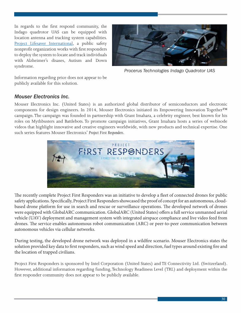


