the late cenozoic evolution of the columbia river … · the late cenozoic evolution of the...
TRANSCRIPT

1
The Late Cenozoic Evolution of the Columbia River System in the Columbia River Flood Basalt Province-A Field Trip Guide (Much of the text in this guide is derived from Reidel and Tolan (in press) and our 2009 GSA Filed Trip) Stephen P. Reidel, Washington State University, Tri-Cities, 2710 Crimson Way, Richland, WA 99352 Terry L. Tolan, GSI Water Solutions, 1020 North Center Parkway, Ste. F, Kennewick, WA 99336 ABSTRACT The Columbia River system is one of great river systems of North America draining much of the Pacific Northwest as well as parts of the western US and British Columbia. The river system has had a long and complex history, slowly evolving over the past 16 million years. The Columbia River and its tributaries have been shaped by flood-basalt volcanism, Cascade volcanism, regional tectonism, and finally the great Missoula floods of the Pleistocene. The most complex part of river development has been in the northern part, the Columbia Basin, where the Columbia River and its tributaries were controlled first by a subsiding Columbia Basin with subtle anticlinal ridges and synclinal valleys superimposed on a flood-basalt landscape. After negotiating this landscape, the course to the Pacific Ocean led through the Cascade Range via the Columbia trans-arc lowland, an ancient crustal weakness zone that separates Washington and Oregon. The peak of flood-basalt volcanism obliterated the river paths but as flood-basalt volcanism waned, the rivers were able to establish courses within the growing fold belt. As tectonism produced larger and larger folds, the major pathways of the rivers moved toward the center of the Columbia Basin where subsidence was greatest. The finishing touches to the river system, however, were added during the Pleistocene by the Missoula Floods, which caused local repositioning of river channels. INTRODUCTION
The rivers and streams of the Columbia River Flood Basalt Province (Fig. 1) constitute one of the largest river systems in the continental United States. The Columbia River is the major river of the province with all others eventually joining it prior to emptying into the Pacific Ocean. The Columbia River and its tributaries (Fig. 1) appear as if they have been occupying their channels since the eruption of the flood basalts. However, this initial look can be misleading. Research covering more than a century has shown that the Columbia River system has had a long and complex history; there has been a gradual evolution of the rivers into their present course since the beginning of the basalt eruptions to the present. In this paper we will demonstrate how the present Columbia River System evolved since the Miocene as a consequence of the flood-basalt volcanism, Cascade Arc volcanism, and tectonism of the Pacific Northwest.
REGIONAL SETTING
The Columbia River flood basalt province (CRFBP; Fig. 1) is defined as that area covered by the Columbia River Basalt Group (CRBG) in the Pacific Northwest United States (Reidel and Hooper, 1989). That definition now has been expanded to include that area underlain by the Steens Basalt in the Oregon

2
Plateau, as defined by Camp et al. (in press) bringing the total area of the CRFBP to ~210,000 km2 (Reidel et al., in press). The CRFBP lies within a complex structural setting in the Pacific Northwest; it is surrounded by rocks ranging in age from the Proterozoic to the Recent that contain structures that developed over the same time period. Most of the province lies between the Cascade Range and the Rocky Mountains in Washington, Oregon, and Idaho but a small portion extends west of the Cascades into western Washington and Oregon with some basalt reaching the Pacific Ocean. On the north the CRFBP is bounded by the Okanagan Highlands and the North American craton of northeast Washington and Idaho. East of the province lies the Rocky Mountains, Idaho Batholith, and Salmon River suture in Idaho; and the Basin and Range Province of northern Nevada marks the southern extent. The northern part of the CRFBP is a broad structural basin, the Columbia Basin (Fig. 1) covering over 150,000 km2. West of the Cascade Range and east of the Coast Range, the CRBG fills the northern Willamette Valley, and Portland Basin, which is connected to the Columbia Basin by the Columbia River Gorge and to the Pacific Ocean by the Columbia River where it cuts through the Coast Range. The Blue Mountains bound the Columbia Basin on the south and mark a transition to the Oregon Plateau, which forms the southern part of the province. The Oregon Plateau is broken in part by fault-bounded mountain ranges, extensional basins, and the High Lava Plains that lie between the northern Klamath Mountains and southern Cascade Mountains to the west, and the Western Snake River Plains and Owyhee Mountains to the east (Carlson and Hart, 1987; Camp et al. in press).
STRATIGRAPHY The complex history of the Columbia River system is recorded in the volcanic and sediment stratigraphy (Fig. 2). The main stratigraphic units consist of the CRBG and intercalated and overlying sediments and sedimentary rocks, although Cascade volcanic rocks have also played an important role. The sediments were directly deposited by the ancestral Columbia River system and record its depositional history but the CRBG and Cascade volcanic rocks also recorded the pathways and channels, and together with the tectonism, ultimately controlled the evolution of the ancestral Columbia River system. Columbia River Basalt Group. The CRBG consists of ~ 210,000 km3 of tholeiitic flood-basalt flows that cover ~210,000 km2 in Washington, Oregon, and Idaho (Reidel et al., in press[a]). Although the basalt was erupted between ~16.7 and 5.5 Ma, most (>96 volume %) of the flows were emplaced over a 1 million year period from 16.7 to 15.6 Ma (Swanson et al., 1979a; Tolan et al., 1989; Barry et al., in press; Reidel et al., in press[a]). From oldest to youngest, the main formations are: Steens Basalt, Imnaha Basalt, Grande Ronde Basalt, Picture Gorge Basalt, Prineville Basalt, Wanapum Basalt, and Saddle Mountains Basalt. CRBG flows were erupted from long (10 to as great as 100 km), generally north-trending linear fissure systems located in eastern Washington, eastern Oregon, and western Idaho. Individual eruptions have volumes as great as 10,000 km3 with the largest eruptions occurring during Grande Ronde Basalt time (Reidel and Tolan, in press [a]).
During this intense period of CRBG volcanism, most of the flows traveled many hundreds of kilometers from their linear vent systems, and covered many thousands of square kilometers (Tolan et al., 1989; Reidel et al., 1989b, in press [a]; Reidel and Tolan, in press). As lava flowed from the vent systems, they were directed westward by major tectonic features including the Palouse Slope of the Columbia Basin that resulted from continued subsidence, and the Columbia trans-arc lowland (Fig. 1; Beeson et al., 1989; Beeson and Tolan, 1990; Reidel et al. 1989; in press [b]). The Yakima folds in the western Columbia Basin provided additional control on the westward flowing lavas. The Columbia trans-arc lowland provided a pathway from the Columbia Basin across the Miocene Cascade Range into western Oregon and Washington and the Willamette Valley. This lowland was more than 60 km wide from the northern edge near the present-day Columbia River to the southern edge near the Clackamas River. Some CRBG units extend the breadth of this extent. A common misconception is that the CRBG flows traversed the Cascade Range in deep narrow gorges similar to the present Columbia Gorge (Williams, 1916; Barnes and Butler, 1930; Allen, 1932, 1979; Hodge, 1933, 1938; Warren, 1941; Lowry and
3
Baldwin, 1952; Waters, 1973; . However, only a few of the Wanapum Basalt and Saddle Mountains Basalt flows were confined to stream canyons (Anderson, 1980; Vogt, 1981, Tolan, 1982; Tolan and Beeson, 1984; Beeson at al., 1985; Beeson and Tolan 1990, 1996, 2002; Tolan et al., 2002).
Once in western Oregon and Washington, the paths of CRBG flows were strongly influenced by major northwest-striking, dextral strike-slip fault zones (Fig. 3) and the apparent continuation of the Columbia trans-arc lowland (Sherwood trough of Beeson et al., 1989; Evarts et al., 2009).
In the Oregon Plateau, the CRFBP is dominated by Steens Basalt, with a much smaller volume of overlying Imnaha and Grande Ronde Basalt exposed in the Malheur Gorge region and farther north (Camp et al., in press). Sedimentary interbeds are rare in the Steens succession, reflecting the very high eruption rate. The CRBG stratigraphy on the Oregon Plateau is partially overlain by tuffs, pyroclastic-flow deposits, a sequence of calc-alkaline to mildly alkaline lavas, pyroclastic rocks, and pyroclastic sediments (Streck et al., 1999; Cummings et al., 2000; Hooper et al., 2002; Camp et al., 2003; in press) and widespread basaltic rocks of high-alumina olivine tholeiite that erupted after ~10 Ma (Hart et al., 1984). The primary drainages in this region are the Snake River and its tributaries (e.g. Malheur River). CRBG Flows as indicators of the River Systems
Although most CRBG flows are huge sheet flows covering much of the CRFBP, internal features (intraflow structures) in the basalts provide clues to the history of the river system. The physical characteristics of CRBG flow bottoms are largely dependent on the environmental conditions the molten lava encountered as it was emplaced. For example, if the advancing lava encountered relatively dry ground conditions, the flow bottom typically consists of a narrow (<1 m-thick) zone of sparsely vesicular, glassy to very fine-grained basalt (see Fig. 12, Reidel et al., in press [a]). However, if advancing lava entered lakes, rivers, and/or areas of water-saturated, unconsolidated sediments, far more complex flow bottom structures formed (e.g. Mackin, 1961; Schmincke, 1967; Grolier and Bingham, 1978; Byerly and Swanson, 1978; Swanson et al., 1979a; Swanson and Wright, 1978, 1981; Camp, 1981; Beeson et al., 1979, 1989; Tolan and Beeson, 1984; Reidel et al., 1994; Beeson and Tolan, 1996). Where advancing lava encountered a lake, a pillow lava complex would be created as the lava flowed into water. A pillow complex consists of elongate to spherical lobes of basalt (pillows) set in a matrix of glassy basalt fragments (hyaloclastite). The pillows represent subaqueous pahoehoe flow lobes that advanced down the front of the pillow lava delta. CRBG pillow lava complexes and hyaloclastites are common feature and their occurrence and distribution reflects the paleodrainage pattern that existed at the time of their emplacement (Fecht et al., 1987; Tolan and Beeson, 1984; Beeson et al., 1989; Reidel et al., 1994; Beeson and Tolan, 1996).
Invasive flows are also common in the CRBG of the Columbia Basin as well as the coastal regions of northwest Oregon and southwest Washington. An invasive flow occurs where basalt sink through poorly consolidated wet sediment and continues to flow laterally with sediment both above and below the basalt (Byerly and Swanson, 1978; see Fig. 18, Reidel et al. in press [a]). Some of the most spectacular examples of invasive CRBG flows are found along the Oregon and Washington coast where the distal ends of CRBG flows burrowed many hundreds of feet into Miocene marine sediments producing dikes and sills (Beeson et al., 1979; Wells et al., 1989, 2009; Pfaff and Beeson, 1989; Beeson and Tolan, 2002).
Intracanyon CRBG flows (Fig. 3) are conclusive evidence for ancestral river canyons; they result when an advancing CRBG sheet flow encountering a river canyon (Swanson and Wright, 1976, 1979b, 1980). The development of major canyons by rivers within the ancestral Columbia River system during CRBG time was in large part governed by the length of time between large-volume CRBG flows. The emplacement of large-volume CRBG flows typically inundated existing low-lying areas, which also resulted in the obliteration of the medial to distal reaches of the ancestral Columbia River System. While this part of the drainage system was essentially destroyed, the upper reaches outside the CRFBP remained intact. This disarrangement of the ancestral Columbia River system commonly resulted in the formation of lakes along the margin of the newly emplaced flow, but inevitably (months to centuries;Reidel et al.,

4
1994; Tolan et al. 2002, 2009 ) the streams and rivers established new courses proximal to the margin of the CRBG flows. Creation of canyon(s) would begin by the relatively slow process of headward erosion. In many cases, it appears that long periods of time were required to create significant major canyons that extended for distances of >150 km. However during the peak period of CRBG eruptive activity (~16.7 to ~15.6 Ma), the duration of quiescent periods between emplacement of large-volume flows was relatively short (Reidel et al., 1989b; Reidel and Tolan, in press) and did not provide the time needed for the incision of major canyons. This changed during the waning phase of CRBG eruptive activity (~15.6 to ~6 Ma) when the length of quiescent periods between CRBG eruptions increased (commonly lasting 200,000 to >1 million years) accompanied by a general reduction in the size and volume of CRBG flows (Tolan et al., 1989; Reidel et al. in press). These factors created opportunities for the ancestral Columbia River system to incise significant major canyons (Tolan and Beeson, 1984; Fecht et al., 1987; Reidel et al., 1996). Late Cenozoic Sediments of the Columbia Basin The Neogene to Quaternary sediments are the direct deposits of the river system and provide important constraints on the location and source of the rivers and streams. These deposits are both intercalated with and, in some places, overly the CRBG. In the Columbia Basin, sedimentary rocks and sediments consist of the Ellensburg, Latah, Payette, McKay, Alkali Canyon, Chenoweth, Ringold, Idaho, Troutdale, Scappoose, and Astoria Formations. In addition to these epiclastic and volcanoclastic sediments are important deposits of the Cascade arc volcanic deposits belonging to the Rhododendron Formation, Simcoe Volcanics, and High Cascade Group (Fig. 2), which also played an important part in the evolution of the ancestral Columbia River system. Covering the basalt and sediment in many places are the Pleistocene sediments derived from the Cataclysmic Missoula Floods. All of these units provide valuable pieces of the puzzle to the drainage history of the Columbia River System.
The thick, Neogene sediment deposits of the CRFBP have been studied for almost a century (e.g., Bretz, 1917; Buwalda and Moore, 1927; Piper, 1932; Hodge, 1938, 1942; Warren, 1941; Lowry and Baldwin, 1952; Waters, 1955; Laval, 1956; Mackin, 1961; Trimble, 1963; Schmincke, 1964, 1967; Hodgenson, 1964; Newcomb, 1966; 1971; Bentley, 1977; Kent, 1978; Rigby et al., 1979; Swanson et al., 1979a,b, 1981; Bentley et al., 1980; Farooqui et al., 1981a,b; Tolan and Beeson, 1984; Dames and Moore, 1987; Hagood, 1986; Fecht et al., 1987; Smith, 1988; Smith et al., 1989; Lindsey, 1996; Reidel and Tolan, 2009). These studies have shown that the composition and mode of deposition of these sediments can be locally differentiated. For example, pyroclastic/volcaniclastic sediments derived from the adjacent Cascade volcanic arc are easily separated from nonvolcaniclastic, epiclastic fluvial and lacustrine strata. The Ellensburg Formation is one of the most important formations to unraveling the history of the ancestral Columbia River system in the Columbia Basin; it is composed of epiclastic and volcaniclastic sedimentary rocks intercalated with, and in some places overlying the CRBG (Waters, 1961; Swanson et al., 1979a; Smith, 1988; Smith et al., 1989). Most volcaniclastic material occurs in the western part of the Columbia Basin whereas nonvolcaniclastic sediments of the ancestral Salmon-Clearwater and Columbia Rivers are dominant in the central and eastern basin, (Fecht et al., 1987; Bond, 1963). Most studies (e.g., Bretz, 1917; Buwalda and Moore, 1927; Piper, 1932; Allen, 1932; Warren, 1941; Hodge, 1938, 1942; Lowery and Baldwin, 1952; Waters, 1955; Laval, 1956; Trimble, 1963; Schmincke, 1964) have found that Neogene sediments in the Columbia Basin contain conglomerates that have varying abundance of far-travelled extrabasinal clasts (previously referred to as “esoteric or exotic clasts”; Piper, 1932; Hodge, 1938; Newcomb et al., 1972;Waters, 1973; Allen, 1979; Beeon and Tolan, 1984; Fecht et al., 1987; Tolan et al., 2002). Particularly easy to recognize “exotic clast” are the bright-colored quartzite clasts that stand out out from other dark-colored clasts. The presence of quartzite clasts was interpreted as compelling evidence that the conglomerate was deposited by the ancestral Columbia River (Allen, 1932; Hodge, 1938; Warren, 1941; Lowery and Baldwin, 1952; Waters, 1955, 1973; Laval, 1956; Trimble, 1963; Schmincke, 1964). Also important are metavolcanic clasts derived from the Seven Devils Formation that are linked to the ancestral Salmon-Clearwater system. Despite the presence of such distinctive exotic clast types, conglomerates containing these clasts could not, by themselves, be used to

5
define broad-scale, mappable Neogene units. The primary problem was that these clasts (especially quartzite) appear throughout the entire late Neogene sedimentary record. This, coupled with complex lateral facies and lithologic changes within the deposits and difficulties in physically tracing horizons within the deposits, largely thwarted the development of a detailed, mappable, stratigraphy based on traditional sedimentologic criteria. Thus, the sediments alone could not be used for defining the history of the Columbia River System. The CRBG as a Key to Unraveling the History of the Ancestral Columbia River System
Despite the apparent complexity of the Neogene sedimentary deposits, there is a series of excellent marker horizons – the CRBG. This allowed for the division of the Neogene sediments overlying the CRBG (suprabasalt sediments) into a number of formations in different geographic areas. These formations are:
• Ellensburg Formation: Columbia Basin (Laval, 1956; Schmincke, 1964, 1967; Bentley, 1977; Grolier and Bingham, 1978; Rigby et al., 1979; Swanson et al., 1979; Bentley, 1989; Smith, 1988; Smith et al., 1989);
• Ringold Formation (Newcomb et al., 1972; Tallman et al., 1981; Lindsey, 1996): Pasco Basin and south-central Washington;
• Dalles Group (Newcomb, 1966, 1969, 1971; Farooqui et al., 1981a,b; Gannett, 1982; Dames and Moore, Inc., 1987; Smith, 1988; Lindsey et al., 1993; Lindsey and Tolan, 1996; Tolan et al., 1996) : Umatilla-Dalles basins.
• Troutdale Formation (Allen, 1932; Hodge, 1938; Lowry and Baldwin, 1952; Trimble, 1963; Tolan, 1982; Tolan and Beeson, 1984; Swanson et al., 1993; Tolan et al., 2002, Evarts et al., 2009): western Columbia River Gorge-northern Willamette Valley-southwestern Washington. As the CRBG stratigraphy was developed, identifiable and mappable CRBG flows interbedded
with the Ellensburg Formation were used to define sedimentary members (Fig. 2). CRBG flows are reliably identified using a combination of physical, lithologic, geochemical, and paleomagnetic criteria and this, coupled with the large areal extent of many of the flows (Swanson et al., 1979a; see Reidel et al., in press [a]), appeared to make them ideal marker horizons. Thus, subdivisions within the Ellensburg Formation (e.g., Vantage, Selah Members) could be extended over the Columbia Basin and eventually into western Oregon and Washington (Beeson et al., 1979; 1989).
While the present Ellensburg nomenclature is widely used and accepted, problems do occur when the defining CRBG flow(s) are not present. Beyond the terminus of the interbedded CRBG flows, the Ellensburg "members" can no longer be identified and the sedimentary section simply becomes part of another Ellensburg member or the suprabasalt sediment section (i.e., upper Ellensburg Formation). For example, in the Umatilla Basin, Ellensburg members beyond the bounding CRBG flow margins become part of the suprabasalt sediment Alkali Canyon Formation (formerly the Dalles Formation) of Farooqui et al. (1981a,b).
Another potentially confusing aspect of Ellensburg stratigraphy is that the time-interval represented by an Ellensburg member at one locality may not be the same as at a different locality. For example, the Selah Member (Fig. 2) is defined by the presence of the Pomona Member (12 Ma) and whatever CRBG unit immediately underlies it (Schmincke, 1964, Newcomb, 1971, Kent, 1978; Smith et al., 1989). The underlying CRBG flow could belong to the Umatilla Member (~13.5 Ma), the Priest Rapids Member (~14.5 Ma), or even the Frenchman Springs Member (~15.3 Ma). So the span of time represented by the “Selah Member” within this basin could range from 1.5 to over 3 million years.
A similar problem also occurs with the suprabasalt sediments. The suprabasalt sediment formations are simply defined as sediments that overlie the CRBG. However, the CRBG unit upon which these sediments lie is not always the same. This is clearly illustrated again in the Umatilla Basin by the Alkali Canyon Formation (Fig. 2). As one travels south from the Columbia River into Oregon, the Alkali Canyon Formation progressively lies atop older and older CRBG units. Thus, the age of the base of the

6
“Alkali Canyon Formation” can vary from ~10.5 Ma to ~15.3 Ma. In another example from the central Columbia Basin, the Ringold Formation is defined as those sediments overlying the CRBG. However, borehole studies (USDOE, 1988) have shown that the earliest Ringold Formation is equivalent to the Levey Interbed (Fig. 2) where the Ice Harbor Member (8.5 Ma) is present.
TECTONICS Like CRBG flows, the ancestral Columbia River system was also influenced by major tectonic
features (i.e., Palouse Slope, Columbia Basin, Yakima Fold Belt, Columbia trans-arc lowland). Fold growth along with continued regional subsidence produced westward, regional down-gradient pathways for the ancestral Columbia River (Tolan and Beeson, 1984; Fecht et al., 1987; Smith et al., 1989; Reidel et al. 1989a, 1994a,b; Tolan et al., 1989; Reidel et al., in press [b]). Both the Columbia Basin and Columbia trans-arc lowland have experienced considerable regional-scale subsidence, with the Columbia Basin experiencing >3,500 m of subsidence since the onset of CRBG volcanism approximately 16.7 million years ago (Reidel et al., 1982, 1989a, in press [b]). Subsidence kept pace with volcanism and fold growth, resulting in a broad basin with a series of low-relief anticlines and synclines. Once CRBG volcanism ended, the folds continued to grow reaching their current size. After the end of flood-basalt volcanism and into the Pliocene, the northern Oregon-southern Washington Cascade Range, and western Oregon/Washington underwent broad, regional-scale uplift (e.g., Hodge, 1938; Lowry and Baldwin, 1952; Waters, 1961; Tolan and Beeson, 1984; Fecht and others, 1987; USDOE, 1988; Beeson et al., 1989; Hammond, 1989; Beeson and Tolan, 1990). The amount of apparent vertical uplift increased towards the axis of the Cascade Range (excluding the central Hood River graben) from ~60 to >120 m at the White Bluffs in the central Columbia Basin near the confluence of the Snake and Columbia rivers, to more than 1200 m in the northern Oregon Cascades; west of the Cascade Range in the northern Willamette Valley, there was 30 to >60 m of uplift (Tolan and Beeson, 1984; Fecht et al., 1987; USDOE, 1988; Reidel et al., 1989, 1994a,b; Beeson and Tolan, 1990).
The onset of this regional-scale uplift began approximately 3 million years ago (Tolan and Beeson, 1984; Fecht an others, 1987; USDOE, 1988; Beeson and Tolan, 1990; Reidel et al., 1994a,b) and marked the end of wide-spread sediment deposition within this region (e.g., Troutdale, Ellensburg, and Ringold Formations). This regional uplift marked the beginning of stream and river entrenchment and the creation of the present Columbia River Gorge. This is also the time period when over 100 m of Ringold sediment was removed from the Pasco Basin (Reidel et al. 1994a,b) and the beginning of the entrenchment of the meanders of the major tributaries to the Columbia River system (e.g. the Yakima River between Yakima and Ellensburg; the lower Grande Ronde River in southeast Washington and northeast Oregon; the Umatilla, John Day, Deschutes, and Klickitat Rivers in the western Columbia Basin; the Sandy, Clackamas and Molalla River in the northern Willamette Valley).
PALEODRAINAGE HISTORY OF THE COLUMBIA RIVER SYSTEM
Numerous studies over of the years have provided much insight into the evolution of the Columbia River system (e.g., Bretz, 1917; Buwalda and Moore, 1927; Piper, 1932; Hodge, 1938; Warren, 1941; Lowery and Baldwin, 1952; Waters, 1955; Laval, 1956; Mackin, 1961; Bond, 1963; Trimble, 1963; Schmincke, 1964; Hodgenson, 1964; Newcomb, 1966; 1969, 1971; Newcomb et al., 1972; Griggs, 1976; Bentley, 1977; Kent, 1978; Grolier and Bingham, 1978; Rigby and Othberg, 1979; Swanson et al., 1979a,b, 1981; Bentley and others, 1980; Camp, 1981; Farooqui et al., 1981a,b; Webster et al., 1982; Tolan and Beeson, 1984; Tolan et al. 1984a,b; Hagood, 1986; Fecht et al., 1987; Anderson and Vogt, 1987; Smith, 1988; USDOE, 1988; Smith et al., 1989; Lindsey et al., 1993; Goodwin, 1993; Reidel et al., 1994; Lindsey, 1996; Beeson and Tolan, 1996; Lindsey and Tolan, 1996; Tolan and others, 1996; Beeson and Tolan, 2002; Tolan et al., 2002; Reidel and Tolan, 2009; Evarts et al., 2009). Previous summaries of late Neogene sediment stratigraphy and paleodrainage history of the ancestral Columbia River system have been published by Fecht et al. (1987), Baker et al. (1987), Smith et al. (1989), and Tolan et al., 2002. The following discussion builds upon these previous studies and incorporates new data collected since the publication of the most recent of those papers over 20 years ago.
7
In this field guide, Figures 4 through 15 are attached at the end to provide the sequence of changes in the drainage pattern through time. Because we cannot align the stops to follow the changes through time, discussions at stop will refer to these maps. Drainages Prior to the CRBG Eruptions.
Little is known about the ancestral Columbia River drainage system in the Pacific Northwest prior to the beginning of the CRBG eruptions. Bond (1963) suggested that the main river systems in the Clearwater Embayment drained west toward the Cascade Range but the exact route(s) through the Cascades Range were problematic. Prior to the onset of Cascade arc volcanism at the end of the Eocene and beginning of the Oligocene, there would have been few known north-south barriers to westward drainage. However, with the onset of Cascade arc volcanism, the Cascade Range ultimately became a major topographic barrier to rivers. Thus, we speculate that the Columbia trans-arc lowland of Beeson et al. (1989) was the principal path through the Cascade Range of Washington and Oregon for the Columbia River prior to the beginning of CRBG eruptions (Fig.1). The Columbia River was flowing from Canada as it does now, and probably joined with the ancestral Salmon-Clearwater River along with other tributaries near the central portion of the Columbia Basin where subsidence was centered and then continued west through the Columbia trans-arc lowland.
The present-day course of the Snake River was established long after the CRBG eruptions ceased. The major drainage for the region of the Columbia Basin north of the Blue Mountains was the ancestral Salmon-Clearwater River (Fecht et al. 1987; Baker et al., 1987). Up until late Pliocene time the Snake and Salmon-Clearwater Rivers had separate drainage basins; the Salmon-Clearwater River drained much of the Palouse Slope and Clearwater Embayment (Camp, 1981;Ross, 1989; Hooper and Swanson, 1990) and then joined the ancestral Columbia River in the Pasco Basin (Fecht et al., 1987) whereas ancestral Snake River drained the Oregon Plateau (Strowd, 1980) and joined the ancestral Columbia River near The Dalles, Oregon (Lindsey et al., 1993; Lindsey and Tolan, 1996; Tolan et al., 1996; Fig. 1). Wheeler and Cook (1954), Kimmel (1982), and Webster and others (1982) suggest that a tributary stream to the ancestral Salmon-Clearwater River captured the Snake River (Lake Idaho) around 2 million years ago, thus establishing the present Snake River.
Initiation of CRBG Volcanism to Vantage time
The initial CRBG eruptions began in the Oregon Plateau with the Steens Basalt (Camp et al., in press) and progressed northward into the Columbia Basin by Imnaha time. Imnaha eruptions were concentrated along the dike system near the Washington-Idaho border and the Imnaha Basalt shows that the central Blue Mountains were a formidable paleotopographic barrier to the Imnaha flows (Reidel et al. in press [a]). Imnaha Basalt flowed westward along the north flank of the Blue Mountains toward the central portion of the Columbia Basin and the Columbia trans-arc lowland.
The Imnaha Basalt erupted into a mountainous paleotopography and largely filled valleys carved into the accreted terrane rocks by the ancestral Salmon and Clearwater River system. The path shown in Figure 5 undoubtedly reflects the pre-CRBG Salmon-Clearwater River drainage which was controlled by the southwest tilted Palouse Slope (Reidel et al., in press [b]) and the north slope of the Blue Mountains. It is apparent from the Imnaha Basalt that the Columbia trans-arc lowland was major cross-Cascades feature prior to the CRBG and was the primary east-west drainage pathway across the Miocene Cascade Range into western Washington and Oregon.
8
ROAD LOG – DAY 1 RYE GRASS SUMMIT TO RICHLAND Stop 1. The Rye Grass Summit and the Columbia River during the Grande Ronde time. From Rye Grass Summit and Rest Area proceed east to Huntzinger Road and exit there to Vantage Vantage (Exit 136). As you proceed along I-90 you are following the contact between the Ginkgo flow, Frenchman Spring Member, Wanapum Basalt. At the Rest Area we will discuss the causes for the Columbia River switching from flowing south though the Ellensburg valley to its present location flowing past Vantage and through Sentinel Gap (See Figure 4). Grande Ronde Time Drainage Development
The Imnaha Basalt was followed by the voluminous eruptions of the Grande Ronde Basalt (Fig. 2). The Grande Ronde Basalt consists of over 110 flows (Reidel and Tolan, in press) that were emplaced in about 500,000 years (Barry et al. 2010). This massive eruption of flood basalts obliterated any drainage course in its path. Thus, the ancestral Columbia River flowing south from Canada had little chance to establish a stable path across the Columbia Basin during Grande Ronde time, as did the Salmon-Clearwater River flowing west from the Clearwater Embayment.
Extensive pillowed, hyaloclastite-dominated Grande Ronde Basalt flows exposed along the eastern slope of the Cascade Range indicate that the ancestral Columbia River was repeated pushed against the east slopes of the Cascade Range by these flood basalt flows (Fecht et al. 1987). Rare pillow complexes in Grande Ronde Basalt flows that are found within the central portion of the Columbia Basin, show that the ancestral Columbia River repeatedly tried to re-establish courses near the axis of the Columbia Basin, only to be forced westward against the Cascade Range by each new Grande Ronde Basalt eruption. This pattern continued until the end of Grande Ronde time.
This same pattern is seen also within the Columbia trans-arc lowland and the northern Willamette Valley. Grande Ronde flows exposed in the present-day Columbia River Gorge (northern margin of the Columbia trans-arc lowland) often exhibit relatively thick (1/3 to ½ total flow thickness), laterally extensive pillow complexes that are evidence that Grande Ronde flows repeatedly forced the ancestral Columbia River to the northern margin of this lowland. Conversely, pillow complexes are far less common along the southern margin of the Columbia trans-arc lowland. The distribution of pillow complexes within the Grande Ronde Basalt in the northern Willamette Valley also suggests that the ancestral Columbia River’s path during most of Grande Ronde time was localized in the northern portion of this area (Portland/Tualatin Basins).
At the end of the Grande Ronde time and during the Vantage hiatus in the Columbia Basin, there was an easterly shift in the course of the ancestral Columbia River from against the eastern flank of the Cascade Range to near its present course from Wenatchee to Priest Rapids Dam. This easterly channel shift, dated at the time of the Grande Ronde-Wanapum contact ~15.6 Ma, was caused by a barrier formed by the rise of north-south trending Naneum Ridge, a ridge that strikes south from the Cascades west of Wenatchee. Naneum Ridge forms the present north-south control of the Columbia River in this area. The time of this shift is well documented in the Saddle Mountains where Vantage sands occupy a narrow channel in Sentinel Gap, where the present water gap is located (Reidel, 1989). Here the channel through Sentinel Gap is
9
overlain by the Basalt of Ginkgo, the first Frenchman Springs flow in this area. The easterly course shift of the ancestral Columbia River also was “helped” by debris flows and lahars produced by dacitic and andesitic Cascade arc volcanism. The upper part of the Vantage Member is largely dominated by volcaniclastic sediments, debris flows, and lahars in the region from Ellensburg/Yakima, Washington, east to Naneum Ridge-Sentinel Gap. These Cascade arc-generated debris flows and lahars are responsible for carrying the wide variety of subalpine to subtropical trees now preserved in the Basalt of Ginkgo pillow complex (marks the end of Vantage time) and showcased at the Ginkgo Petrified Forest State Park (Tolan et al., 1991). The first three stops are designed to summarize the evidence for this change in course. Follow main road through Vantage Intersection with Ginkgo Avenue and the road to the Ginkgo Petrified Forest State Park Interpretive Center. Continue ahead on Huntzinger Road. Huntzinger Road becomes the Old Vantage Highway. The town of Vantage rests on the Museum flow which is the youngest unit in the Sentinel Bluffs Member, Grande Ronde Basalt. The Vantage Member (Ellensburg Formation) forms the bench along the river here; the Frenchman Springs and Roza flows lie above that level. Stop 2. Ginkgo Pillow Complex (Frenchman Springs Member Figure 2)
Exposed in road cuts along the right (north) side of the road is an excellent exposure of the Ginkgo pillow complex. The basalt of Ginkgo is the second oldest, and second largest, unit in the Frenchman Springs Member of the Wanapum Basalt (Beeson et al., 1985). Its type locality is along Schnebly Coulee at the Ginkgo Petrified Forest State Park along the west-side of the Columbia River at Vantage, Washington (Mackin, 1961). At this location, petrified logs occur in the basal pillow complex that overlies sediments of the Vantage Member.
At this location, the pillow complex is approximately 15 m-thick and constitutes one-third
of the total flow thickness. The basal pillow complex grades upward into the colonnade that makes up the bulk of the flow. The presence of an extensive basal pillow complex suggests that the Ginkgo lavas flowed into a lake. Note that the pillow complex consists of elongate to spherical lobes of basalt (pillows) set in a matrix of glassy basalt fragments (hyaloclastite). The pillows represent subaqueous pahoehoe flow lobes that advanced down the front of the pillow lava delta. Studies of the active formation of basaltic pillow lavas in Hawaii (e.g., Moore et al., 1973; Moore, 1975; Tribble, 1991) indicate that molten lava can smoothly flow into the ocean without thermal disruption (phreatic brecciation) as long as a thin film of highly insulating steam protects the lava. This process allows for the formation of subaqueous lava tubes (pahoehoe flow lobes that advance and grow in a manner similar to observed on land (Swanson, 1973; Moore, 1975; Hon et al., 1994)). Disruption of this insulating steam barrier (e.g., wave action, currents, and gas explosions within the lava lobe) allows water to come into direct contact with molten lava resulting in the production or glassy debris (hyaloclastite) by phreatic brecciation. Within the CRBG pillow lava complexes and hyaloclastites are not an uncommon feature, but their occurrence and distribution reflects the paleodrainage pattern that existed at the time of

10
their emplacement (Tolan and Beeson, 1984; Fecht et al., 1987; Beeson et al., 1989; Reidel et al., 1994b; Beeson and Tolan, 1996)
Turn around and proceed east on the Old Vantage Highway.
Turn left at first road and proceed for about 1000 ft.
Stop 3. Type location for the Vantage Member of the Ellensburg Formation (“Vantage Interbed” See Figure 2). Grande Ronde Basalt and Wanapum Basalt Contact)
The sediment interbed exposed in this road cut is the type location of the Vantage Member
of the Ellensburg Formation (Mackin, 1961). In this area the Vantage Member consists of volcaniclastic and epiclastic sediments. In the Vantage area the volcaniclastic sediments generally comprise the upper port of this interbed and consist of poorly bedded to massive, tuffaceous sandstone that contains rounded hornblende dacite pumice clasts. We interpret these volcaniclastic deposits to represent the distal end of a dacitie pumice lahars that originated to the west in the Cascade volcanic arc (Tolan et al., 1991). The epiclastic sediments consist of micaceous, arkosic sandstones, siltstones, and minor claystone that are interpreted as ancestral Columbia River deposits (Mackin, 1961; Fecht et al., 1987).
Immediately overlying the Vantage Member is the basalt of Ginkgo pillow lava. The
Ginkgo pillow lava was formed when the advancing Ginkgo flow encountered a lake. In the Vantage area this pillow lava complex ranges from 2 to >20 m thick. The extent of this pillow lava complex at the base of the Ginkgo flow is very wide-spread in this region, extending from the north side of the Saddle Mountains north into the Quincy Basin and west into the Kittitas and Yakima Valleys. We estimate that the Ginkgo pillow complex is present over an 800 km2 area.
One of the most unusual aspects of the Ginkgo pillow complex in this area is the
abundance of preserved fossil wood (logs) found within the pillow complex. The origin of unrooted logs entombed within (surround by pillow lava lobes) the Ginkgo pillow complex has been a subject of discussion for many years. Another unusual aspect of these fossil trees preserved in the Ginkgo pillow complex is that they represent more than 32 genera of trees from a number of diverse ecological habitats, ranging from subalpine to subtropical. Previously it has been suggested that that this collection of fossil logs originated as either log rafts along the ancestral Columbia River or sunken logs at the bottom of a lake. Our work in this area has led us to propose an alternative hypothesis (Tolan et al., 1991). The physical features, lithology, and geochemical composition of clasts from the volcaniclastic sediments that form the upper part of the Vantage Member indicate it represents the distal portion of a Cascadian dacitic lahar. We speculate that explosive Cascadian volcanism, and the lahar emplacement process, may have denuded large tracks of trees and thereby carried large accumulations of logs (from diverse ecological habitats) into the Vantage area. Shortly after this event, the eruption of the Ginkgo unit began, with the northern extension of its linear vent system located approximately 80 km east of the Vantage area. Evidence suggests that the advancing Ginkgo flow front dammed off the Columbia River immediately south of the Vantage area, which allowed a lake to form. The orientation and position of fossil logs within the Ginkgo pillow complex suggest that the

11
temporary lake waters must have floated the logs before they were entombed by the advancing Ginkgo flow.
Continue ahead and turn right at first street which will take you up the hill to the Ginkgo
Petrified Forest State Park Interpretive Center. This is a Washington Parks Fee Area.
Lunch Stop. Ginkgo Petrified Forest State Park Interpretive Center.
At this stop you will have an opportunity to visit the museum and see the extensive collection of cut and polished petrified wood and well as the fossil logs from the Ginkgo pillow complex on the grounds. At the Columbia River overlook you can see the CRBG flows ramping up to the north along the Frenchman Hills anticline. The freeway directly across the river is on the Vantage “bench” with the Sentinel Bluffs Member of the Grande Ronde Basalt directly below and the Wanapum Basalt above. Three flows of the Frenchman Springs Member lie above the Vantage Member. From the Vantage are the basalt of Ginkgo, the basalt of Sand Hollow, and the basalt of Sentinel Gap. The basalt of Sentinel Gap pinches out across the river. The Roza Member and the Priest Rapids Member (basalt of Rosalia) lie above the Frenchman Springs Member.
Exit interpretive center parking lot, proceed ahead on Ginkgo Ave., then turn left onto Huntzinger Road/Old Vantage Highway. Turn left at Old Vantage Highway and proceed to I-90 heading to Spokane.
Cross Columbia River and exit at first exit toward Richland; this is SR 26.
Turn right toward Richland on SR 243. Pass well-developed columns in the colonnade of the Roza Member which can be seen at two o’clock. Ice-age floodwater scouring removed much of the entablature here. This is a good place to search for phenocrysts in basalt. The Roza has several hundred 2 to 5-mm phenocrysts per square meter of surface area; this is a distinctive characteristic of this flow. (In contrast, most Frenchman Springs flows have fewer phenocrysts and Priest Rapids flows contain almost no phenocrysts.) SR 243 lies on Frenchman Springs flows for the next 0.6 miles. The Roza Member forms cliffs above the highway level. At nine o’clock, the flows are the Frenchman Springs (above), Roza, and Priest Rapids Members. At three o’clock across the river is the same sequence. Town of Beverly and Crab Creek Road at nine o’clock. Entering Schwana. You have a good view of the Crab Creek floodway to the east. Crab Creek acted as an overflow channel as Missoula floodwaters farther up the Columbia spilled out of the
12
channel and spread across the Columbia Basin. Some of this floodwater scoured out the Crab Creek drainage as it back flowed to the Columbia River here. To the southeast, the thrust fault (or a high-angle reverse fault) has formed a very steep cliff along the north flank of the Saddle Mountains. To the west, fault breccia from the Saddle Mountains thrust fault is barely visible across the river. Entering Sentinel Gap, a water gap through the Saddle Mountains Turnout with Mazama Ash exposed on roadcut on east side of highway. The road to the left leads to a quarry exposing an interbed of the Ellensburg Formation. The name ”Beverly member” was formerly applied to this interbed. The name is no longer used because this unit is a composite of several interbeds; the intervening Saddle Mountains Basalt flows are not present. This quarry is a good place to see this 55-meter-thick interbed. The lower part contains conglomerate deposited by the ancestral Columbia River, and the upper part is made up of poorly indurated siltstone, sandstone, and tuff. Stop 4 Sentinel Gap At this stop we will discuss the history of Sentinel Gap. The antecedent Columbia River maintained its course as the Saddle Mountains were uplifted, cutting down through this ridge at Sentinel Gap. Missoula Flood bar gravels cover it on this side of the river. This thrust places Priest Rapids and Roza basalt flows over the Priest Rapids flows. The Asotin Member (see Figs. 2, 7 and 8), which crops out at lower elevations of the Saddle Mountains anticline at ten o’clock, fills a former channel of the Columbia River through Sentinel Gap. Along the east side of Sentinel Gap, the Frenchman Springs, Roza, and Priest Rapids Members of the Wanapum Basalt form the upper cliffs. The bench below the upper cliffs is the result of erosion along a sedimentary interbed, the Vantage Member of the Ellensburg Formation. The lower cliffs here are flows of the Grande Ronde Basalt. At eleven o’clock, west of Sentinel Gap, the white patch high on the cliff face is the Vantage interbed. Frenchman Springs Member flows (Wanapum Basalt) lie above it and Grande Ronde Basalt lies below. Continue on SR 243 toward Priest Rapids Dam. Overview of Umtanum Ridge Anticline. Umtanum Ridge extends about 110 km from near the western margin of the Columbia Basin to the Palouse Slope (Fig. 1). The structural relief gradually decreases eastward where it becomes a series of en echelon anticlines developed along the dying ridge. In the Priest Rapids Dam area, the north limb is overturned and dips 40º to the south. An upper thrust fault (the Buck thrust fault) and a lower thrust fault (the Umtanum thrust fault) define the overturned portion of the fold (Price and Watkinson, 1989). The Buck thrust fault merges with the Umtanum thrust fault to the east as the overturned portion becomes steeply dipping to the north. Near surface drilling has constrained the fault to between 30º and 60º degrees to the south. To the west is a good view of the thrust faults of the Filey Road area. Many of the thrust

13
faults are partially concealed by landslides, fanglomerates, and loess, but at least one is visible. The thrust faults place the Priest Rapids Member (Wanapum Basalt) and older rocks onto flows of the Saddle Mountains and Wanapum basalts. Flood gravels near the river level mask the bedrock geology. Vernita Bridge over the Columbia River. This is the last free-flowing segment of the Columbia River in Washington, and part of the Hanford Reach National Monument. At three o’clock is a good view along the north limb of the Umtanum Ridge anticline. Here, flows of the Grande Ronde and Wanapum Basalts dip about 70 degrees to the north. Farther west, the Grande Ronde Basalt is overturned and dips steeply to the south. To the east is Gable Butte, an en echelon anticline along Umtanum Ridge. Ice-age floodwaters eroded the crest of the anticline producing the small valley visible in the distance. Junction with SR 24 (west) to Yakima and the ‘Yakima Barricade’ (east), entrance to the Hanford Site. Turn right (west) on SR 24 toward Yakima. Follow SR 24 for about 2 miles and look for the Cold Creek Road on the right. This is a gravel road. Follow it through the vineyards up Cold Creek valley. Our next stop is before the entrance to the US Army’s Yakima Training Area Stop 5. Intracanyon Asotin and Wilbur Creek Members (see Figs 2, 7 and 8). At this stop you will see the intracanyon Asotin and Wilbur Creek Members where the channel crosses the road between Umtanum Ridge and Yakima Ridge (Fig. 8). These flows followed the ancestral Columbia River and were controlled by the northern edge of the Umatilla Member (See Figs 2, 5 and 6). Reidel and Fecht (1987) discuss the Asotin and Wilbur Creek Members). Reidel (1998) discusses the Umatilla Member). Return to SR 24 and turn right toward Yakima. As you climb up onto Yakima Ridge the road follows the contact between the Pomona (see Figs. 2 and 10) and Elephant Mountain (SEE Figs. 2 and 11).Members which is marked by the Rattlesnake Ridge sedimentary interbed (Fig. 2). Top of Ridge. Turn right into parking lot for Silver Dollar Café. Stop 6. Discussion of river drainages from Umatilla through Elephant Mountain time. This discussion will focus on Figures 5-12. The paleodrainage pattern of the ancestral Columbia River system in early Saddle Mountains Basalt time becomes much clearer than in previous times. This is primarily due to smaller volume CRBG flows and the greater span of time between eruptions. Prior to the first lava flow of the Saddle Mountains Basalt time, the Umatilla Member, an extensive, thick (10 m) sedimentary interbed, the Mabton Member of the Ellensburg Formation (Fig. 2), was deposited over much of the central and western Columbia Basin.

14
The inferred course of the ancestral Columbia River system from the onset of Saddle Mountains time prior to the emplacement of the Wilbur Creek/Asotin Members is shown in Figures 5- 8. The source area for the early Saddle Mountains flows was the Lewiston Basin and Clearwater Embayment; these flows used the ancestral Salmon-Clearwater River and Lewiston Basin as a conduit to the west. The locations of the ancestral Columbia and Salmon-Clearwater Rivers are defined on the basis of both CRBG intracanyon flows and sediment (gravel clast) lithologies (Fecht and others, 1987). The Umatilla Member erupted from a linear vent system near Puffer Butte at the south end of the Lewiston Basin and flowed north into the Lewiston area and onto the Uniontown Plateau north of the basin (Reidel, 1998). However, the main drainage route out of the basin was to the south and west through the Troy Basin and then across the Blue Mountains near Tollgate into the Walla Walla Basin and eventually into the Umatilla Basin-Klickitat Valley (Fig. 5). The Umatilla flow followed and filled the channel until it reached the Walla Walla and Umatilla Basins where it spread as a sheet flow. From the Umatilla Basin, the lava advanced north into the Pasco Basin and then westward along the path of the ancestral Columbia River, which is in the Moxie syncline between Yakima Ridge and Umtanum Ridge, eventually reaching the Yakima Basin. The north edge of the Umatilla Member diverted the Columbia River at Priest Rapids Dam forcing it westward. This channel of the ancestral Columbia River was to persist for much of Saddle Mountains time. From the Pasco Basin, the ancestral Columbia River established a path across the western Plateau and the Columbia trans-arc lowland. The ancestral Columbia River had a period of approximately 1.0 to 1.5 million years from the end of Wanapum volcanism when it was able to incise a canyon through the Columbia trans-arc lowland (Fecht and others, 1987; Tolan and Beeson, 1984; Beeson and Tolan, 1990). The paleodrainage pattern of the ancestral Columbia River system from the end of Umatilla Time to the emplacement of the Esquatzel Member of the Saddle Mountains Basalt is shown in Figures 6-9. The overall drainage pattern is very similar to the previous time period, except for the ancestral Salmon-Clearwater River. The Salmon-Clearwater River was forced north of the Lewiston Basin due to the Umatilla Member blocking the Blue Mountains channel, forcing the river to establish a new channel to the north. The Wilbur Creek and Asotin members were erupted nearly contemporaneously (Reidel and Fecht, 1987; Reidel and others, this volume [a]) showing only slight changes in drainages for the Salmon-Clearwater River. Swanson et al. (1979b) showed that the river flowed northwest from the Lewiston Basin and west to the present town of Othello and southwest into the Pasco Basin. There is only a slight change in the channel from Wilbur Creek to Asotin where apparently the later Asotin Member followed a channel adjacent to and slight south of the one occupied by the Wilbur Creek Member. Both lava flows merged into one in the northern part of the Pasco Basin (Waluke syncline) and flowed westward along the margin of the Umatilla Member toward Yakima in the ancestral channel of the Columbia River. Beginning in Umatilla time and up to Pomona time, the confluence of the Salmon-Clearwater River and the Columbia River was near the present Priest Rapids Dam. The Wilbur

15
Creek/Asotin Member (~ 13 Ma) continued to flow westward down the canyon of the ancestral Columbia River (Bridal Veil Channel) and eventual reach the Pacific Ocean. The Wilbur Creek/Asotin Member was the first Saddle Mountains Basalt flow to reach western Oregon and Washington (Beeson and Tolan, 2002). In the Pasco Basin the Esquatzel flow transitioned from an intracanyon flow into a sheet flow which was largely confined to the southern part of the Pasco Basin. The southern margin of the Asotin Member and the Umtanum-Gable Mountain anticline appear to have hindered its northward advance. However, the primary exit from the Pasco Basin remained the channel along the southern margin of the Asotin Member as delineated by conglomerate deposits along the margin of the Asotin. Eventually the Esquatzel Member flow advanced to the vicinity of Yakima, Washington, but apparently did have the volume to continue west along the ancestral Columbia River channel. With the emplacement of the Esquatzel Member as sheet flows in the Pasco Basin, the basalt overtopped the confines of the ancestral Salmon-Clearwater River channel in the Pasco Basin destroying this canyon and forcing the ancestral Salmon-Clearwater River to establish a new channel to the south nearly parallel to the present Snake River (Reidel and Fecht, 1987; Fecht and others, 1987). The eruption of the ~ 12 Ma Pomona Members followed the emplacement of the Esquatzel Member and was one of the larger lava flows of the Saddle Mountains Basalt (Tolan et al., 1989). Its relatively wide areal extent allows us to use this flow to define the paths of the ancestral Salmon-Clearwater and Columbia rivers throughout the Columbia Basin, Columbia trans-arc lowland and western Oregon and Washington (Camp, 1981; Fecht et al., 1987; Anderson, 1987; Tolan and Beeson, 1984). Upon reaching the Pasco Basin, the Pomona Member spread as a sheet flow destroying the previous channel and forcing the ancestral Salmon-Clearwater River south into the Umatilla-Dalles basins establishing the final portion of the present Snake River (Fecht and others, 1987). This also caused the abandonment of the previous confluence with the Columbia River near Priest Rapids Dam. The ancestral Salmon-Clearwater, Snake, John Day, and Deschutes rivers then join near the present Deschutes River prior to flowing to the new confluence with the ancestral Columbia River just northeast of the present-day city of Hood River, Oregon. The Pomona Member was the second Saddle Mountains Basalt flow with enough volume to reach the Pacific Coast and provides excellent constraints on the channel (Tolan and Beeson, 1984). The Elephant Mountain Member entered the Pasco Basin and spread west as a sheet flow which caused the ancestral Salmon-Clearwater River to maintain a path south to the Umatilla Basin. To the north, the Elephant Mountain Member entered the Columbia River channel near Priest Rapids Dam and followed it as far west as the present-day Klickitat River (Anderson and Vogt, 1987). In the period following the emplacement of the Elephant Mountain Member (10.5 Ma) to about 8 Ma, the course of the ancestral Columbia River shifted southeast across the Yakima Valley-Klickitat Valley towards the Pasco Basin. Ancestral Columbia River channel, during this time, followed a path along the western part of the U.S. Department of Energy’s Hanford Site, thus abandoning the channel along the margin of the Umatilla Member to the north. This new path crossed the Rattlesnake Hills at the Sunnyside Wind Gap, now the route of SR 241, and

16
entered the Yakima Valley. We suggest that the main reason the channel shifted south is because of the continued southward growth (uplift) of Naneum Ridge. As the ridge grew from the north to the south, it forced the ancestral Columbia River to find a more accessible route to the south. The Sunnyside Gap is a natural structural and topographic low that allowed the Columbia River to cross the anticline. Continuing on from the Silver Dollar Café, we will follow SR 241 through another water gap cut into the Rattlesnake Hills. This water gap is shown in Figure 12. Follow SR 241 to Sunnyside and join Interstate Highway 82. Head east toward Prosser and Richland. Continue on through Prosser. You will exit at the Benton City exit (96). Follow SR 225 through Benton City toward the Yakima River water gap through Rattlesnake Mt-Red Mountain. We will stop just beyond that gap. Stop 7. Yakima River water gap.
Sediment deposits in the Yakima Valley of post-Elephant Mountain age have been mapped as the Snipes Mountain Conglomerate (Fig. 2). Correlative deposits in the Pasco Basin, mapped as the Ringold Formation, record later phases of this shift in river. Lowermost Ringold deposits are interpreted to have been deposited in the Pasco Basin ~ 8 Ma by an ancestral Columbia River that entered the Basin from the northwest and followed a southeast-trending course across the Pasco Basin until it encountered the constructional topography of the flow margin of the Basalt of Martindale, Ice Harbor Member (Figs. 2, 13 and 14). There the course of the ancestral Columbia River was deflected to the southwest and west along the Ice Harbor flow margin and into the lower Yakima Valley through a structural wind gap between Rattlesnake Mountain and Red Mountain. The river flowed southwest through the Yakima Valley crossing the Horse Heaven Hills near the Bickelton-Mabton area. (Fecht and others, 1987; Lindsey, 1996). In the Yakima Valley, the ancestral Columbia River was able to erode nearly 10 meters into the Elephant Mountain Member leaving about of meter of conglomerate and several meters of overbank deposits.
Proceed north on SR 225 to SR 240 at Horn Rapids. Turn right to Richland.
End of Day 1.
ROAD LOG – DAY 2 Richland to Washtucna
Junction of Interstate 182, U.S. 395, and U.S. 12. Proceed straight ahead (east) on U.S. 12 Cross the Snake River. Note the flood gravels along the north bank. About 3.2 kilometers to the south, the Snake River flows into the Columbia River. The Ice Harbor Member (Saddle

17
Mountains Basalt; Fig. 2) is exposed at river level about 3.2 kilometers up the Snake River to the northeast. Older CRBG flows crop out at progressively greater distances up the Snake River. Junction of U.S. 12 and State Route 124. Junction of U.S. 12 and U.S. 730. Bear right onto U.S. 730 west. At eleven o’clock, you can see the trace of the main fault at the front of the Horse Heaven Hills just above U.S. 12 to Walla Walla. The area on the south side of the road has been uplifted relative to the north side, juxtaposing Saddle Mountains Basalt to the north against the Frenchman Springs Member (Wanapum Basalt) to the south. Entrance to the Port of Walla Walla. Flows of the Umatilla through Ice Harbor Members (Saddle Mountains Basalt) are tilted to the north (30 degrees) in this area. At three o’clock (about 100 yards south of the Pasco–Walla Walla road sign) are excellent examples of vertical strike-slip faults. There are three, 4 to 8 cm-thick faults that have clay gouge zones and display excellent subhorizontal slickensides. These secondary faults are associated with the main frontal fault zone of the Horse Heaven Hills that parallels the road to the north. The main displacement on the Horse Heaven Hills fault is vertical (>1,000 m) so that the Ice Harbor, Elephant Mountain, Pomona, and Umatilla Members of the Saddle Mountains Basalt are thrust over by the flows of the Frenchman Springs Member, Wanapum Basalt. The strike-slip faults are minor features activated by north–south movement along the main fault. this flow entered water. At nine o’clock, the small valley across the Columbia River is the result of erosion along the trace of the Yellpit fault, one of the fault segments that make up the frontal fault zone of the Horse Heaven Hills. This fault places Ice Harbor, Elephant Mountain, and Pomona Members of the Saddle Mountains Basalt on the north against the older Frenchman Springs Member (Wanapum Basalt) on the south. The fault trace is overlain by undisturbed sediments that contain the 13,000-year-old Mount St. Helens set ‘S’ ash. This indicates that the fault has not been active in the Holocene. On the east (left) side of the highway are two basaltic buttes. This famous “Twin Sisters” landmark was described by Meriwether Lewis and William Clark. The Twin Sisters are erosional remnants of a Sand Hollow flow (Frenchman Springs Member). Note the well-developed columnar jointing of the colonnade and the overlying irregular or hackly jointing of the entablature. Mile marker 4.0. Road cut exposures of the basalt of Ginkgo (Frenchman Springs Member, Wanapum Basalt). Day 2, STOP 1. Wallula Gap View Point at Port Kelly
At this stop we are afforded an excellent view of the basalt cliffs across the Columbia River on the westside of Wallula Gap. The cliff face mainly consists of Frenchman Springs

18
Member flows (Wanapum Basalt) that are overlain by two Saddle Mountains Basalt flows (Umatilla and Ice Harbor Members) visible at the top of the cliff.
Sometime after 8 Ma, the ancestral Columbia River abandoned the Yakima Valley and began flowing through Wallula Gap (Fig. 1). This is probably the same time that the Yakima River abandoned Konnowock Pass and began flowing through Union Gap, a structural low in the Horse Heaven Hills. The reason for the abandonment of the westward course and adoption of Wallula Gap is the subject of some debate. We favor the continued growth of Naneum Ridge and the Horse Heaven Hills, along with continued subsidence of the Pasco Basin and eventual stream capture of the ancestral Columbia River by the ancestral Salmon-Clearwater River as the primary factors. The growth of Naneum Ridge would also explain why the Yakima River shifted 30 km west and began using Union Gap. Konnowock Pass is much closer to the axis of Naneum Ridge uplift and Union Gap now marks a low area between the Cascades to the west and Naneum Ridge to the east.
With the ancestral Columbia River abandoning the Yakima Valley, the Yakima River was forced to flow eastward through the valley to meet the Columbia River. However, rather than following the course that it presently follows through the Rattlesnake Mountain-Red Mountain water gap, it abandoned the Yakima Valley at Benton City and followed a path through Badger Coulee joining the Columbia at Kennewick-Pasco Washington (Fig. 13).
Turn around to return east on U.S. 730. Junction of U.S. 12 and U.S. 730. Bear left onto U.S. 12 west. Turn left onto U.S., 12 west toward Pasco. Intersection of U.S. Highway 12 and State Route (SR) 124 at traffic light. Intersection of Interstate 182/U.S. Highway 12 and the Pasco-Kahlotus Highway. Bear right for the Pasco-Kahlotus- Highway. Turn right onto the Pasco-Kahlotus Highway Intersection with Martindale Road. Continue on straight ahead. Intersection with Ice Harbor Dam junction. Continue straight ahead. Intersection with McClenny Road junction. Continue straight ahead. Intersection with Snake River Road. Continue straight ahead, past Star School, one of the only one room school houses remaining in Washington. Intersection with Burr Canyon Road. Turn right onto Burr Canyon Road, going towards Windust Park.
As one proceeds down this grade, the road transects numerous poor exposures of the Wanapum Basalt. Weathered crops of the Priest Rapids Member are exposed near the top of the grade. A prominent red colored basalt outcrop encountered soon after one starts down the grade

19
is the top of the Roza Member. At the bottom of the grade, the base of the Eckler Mountain Member (Basalt of Dodge) of the Wanapum Basalt is exposed in the road cuts.
Pass beneath the railroad trestle at the base of the grade. The Grande Ronde Basalt – Wanapum Basalt contact lies just below the road.
Intersection with Wallace Walker Road. Continue east on SR 263 to Windust Park for lunch and restrooms.
Turn left on SR 263 and proceed up Devils Canyon. Stop 2. Saddle Mountains Intracanyon Flows. Park in turnout leading to gate. From this vantage point, we can see an impressive natural cross-section through portions of three different Saddle Mountains Basalt flows (Fig. 3) that flowed down the canyon cut by the ancestral Salmon-Clearwater River between 14 and 10.5 Ma (Swanson and Wright, 1976, 1981; Swanson et al., 1980). The earliest flows (Esquatzel Member and Pomona Member) did not fill the canyon and this allowed the river to reoccupy it after these flows were emplaced. At about 10.5 Ma, the Elephant Mountain Member was emplaced (uppermost entablature/colonnade that unconformably lies upon the Esquatzel and Pomona flows) and was voluminous enough to fill and obliterate this canyon of the ancestral Salmon-Clearwater River (Swanson and Wright, 1976, 1981). The Elephant Mountain Member forced the ancestral Salmon-Clearwater River out of this path and caused it to relocate its channel south of its former position to about the present-day location of the Snake River. This locality is a good spot to ponder how long it might have taken to emplace these moderate-volume (by CRBG standards) intracanyon flows. For CRBG flows in general, it has been suggested that they could have been emplaced very rapidly over a period of a few weeks or months (Shaw and Swanson, 1970; Mangan et al., 1986; Wright et al., 1989; Reidel and Tolan, 1992) or conversely that it took many years to many decades to emplace these same flows (Long et al., 1991; Self et al., 1991; Hon et al., 1994; Finnemore et al., 1993). In examining intracanyon flows of the Esquatzel and Pomona members, one will note that neither flow displays any evidence that it encountered, or interacted with, the river that carved this canyon (i.e., extensive pillow lavas, hyaloclastic debris, bedded hyaloclastite). This is also true for the Pomona Member in the western portion of the province, where it entered the ancestral Columbia River canyon (Tolan and Beeson, 1984; Anderson and Vogt, 1987). Apparently, both the Esquatzel and the Pomona had sufficient volume to dam the ancestral Salmon-Clearwater River where they entered the canyon upstream from this point; the dam let them advance down a dry canyon. The Pomona was also able to dam the ancestral Columbia River in the northern Pasco Basin area which allowed it to advance through the Cascade Range into western Oregon and Washington down a dry Columbia River canyon. These field observations seem to be at odds with a long-term emplacement model. If the Pomona flow was indeed emplaced over a long period (years or decades), we should be able to find evidence that the ancestral Salmon-Clearwater and Columbia Rivers reestablished their presence within the canyons before the Pomona flow was completely emplaced. The lava dams created by the Pomona flow (on the order of 10 to 30 m high) would have probably been filled in a period of a few weeks to months and overtopped long before this model suggests that the

20
Pomona reached its most distal point (Pacific Ocean) and certainly long before it was inflated to its final thickness. Because these rivers reoccupied their canyons, we would expect the river waters to overtake the slowly advancing flow front where it would encounter fresh Pomona lava. The consequences of the river encountering an active Pomona flow front should be the creation of large quantities of hyaloclastic debris and the presence of intraflow structures indicative of lava/water interaction. Hyaloclastic debris should be continuously created as the Pomona flow slowly advanced; the hyaloclastic debris created by this process also would be transported and deposited downstream in advance of the lava flow like that postulated by Tolan and Beeson (1984). Studies of the Pomona intracanyon flow (Snavely et al., 1973; Anderson, 1980; Swanson and Wright, 1981; Tolan and Beeson, 1984; Anderson and Vogt, 1987) do not find extensive hyaloclastite deposits and intraflow structures that would be a consequence of a very long emplacement history. Because of an absence of these features, we conclude that the Pomona flow was rapidly emplaced. One characteristic of CRBG intracanyon flows is that they typically display an entablature/basal colonnade jointing style. Even CRBG flows that typically display a blocky or columnar jointing style throughout much of its extent (e.g., the basalt of Ginkgo; Beeson et al., 1985, 1989) changes to an entablature/colonnade jointing style when they become intracanyon flows. Another example is the flow of the Elephant Mountain Member exposed here. Throughout much of its extent it displays blocky to columnar jointing and only seems to develop a well formed entablature/colonnade only near its margins or where it has been channelized as an intracanyon flow (Anderson and Vogt, 1987; Reidel and Fecht, 1987). Long and Wood (1986) proposed a model for entablature formation in CRBG flows. Their petrographic examination of CRBG entablatures found that they contained a high percentage of glass within their groundmass (upward of 60%) and had quenched textures. They proposed that CRBG entablatures formed when the top of the cooling CRBG flow was inundated by water. The water (from deranged drainages and/or heavy rainfall) would infiltrate newly formed cooling joints and rapidly extract heat from the lava, thus producing an entablature. This model might explain why CRBG intracanyon flows typically have very thick entablatures; however, close examination of field evidence at this, and other, localities fails to lend support to Long and Wood's (1986) model.
The origin of entablature jointing in both the Esquatzel and Pomona Members might be attributed to water flowing over the top of the cooling flow. Field relationships exposed here indicate that neither flow filled this canyon thus allowing the ancestral Salmon-Clearwater River to reoccupy it after each flow had been emplaced. The Elephant Mountain Member, however overwhelmed this portion of the canyon and kept the river from reoccupying it. Outcrops indicate that from this area west, the Elephant Mountain actually overtopped this canyon and spread as a sheet flow (Swanson et al., 1979b, 1980). There is no evidence that water flowed across, or was ponded atop, this flow and yet entablature developed. This is not a unique situation, other CRBG intracanyon flows overtopped the canyons they were following in the western portion of this flood basalt province. The Ginkgo intracanyon flow in the northern Willamette Valley of Oregon is a prime example. The Ginkgo flow completely obliterated the ancestral Columbia River canyon that it was following and forced the Columbia River to establish a new course many tens of kilometers north of its previous position (Beeson et al., 1985, 1989). There is no field evidence to suggest water either flowed along, or ponded atop, the Ginkgo intracanyon flow, yet it has an entablature that is over 120 m thick. A similar situation and conditions also existed for the Rosalia
21
intracanyon flow (Priest Rapids Member), and it has an entablature that is over 120 m thick (Tolan and Beeson, 1984; Anderson and Vogt, 1987; Beeson et al., 1989). However, where the Ginkgo and Rosalia flows have overflowed their canyons, these flows revert to their more customary blocky or columnar jointing pattern that is typical of their non-intracanyon (sheet flow) appearance.
Many sheet flows also display an entablature/basal colonnade jointing style, such as the Palouse Falls flow. As seen at Optional Stop C, the flow top of the Palouse Falls flow is noneroded and shows no evidence of possible presence of once flowing, or standing, water. This is true for other entablature-dominated flows elsewhere on the Columbia Plateau. The question remains as to what caused entablatures to form? Perhaps a combination of intrinsic lava flow properties (e.g., composition, viscosity, absence of crystal nuclei, etc.) as well as external factors (e.g., flow stresses, environment of emplacement) play a primary role in determining the jointing style. Turn around and retrace steps to Lower Monumental Dam Stop 3. Lower Monumental Dam. At this stop we will discuss how the ancestral Salmon-Clearwater River channel moved from Stop 2 to the present channel here at Lower Monumental Dam. Also note in the outcrop across the road the entablature/colonnade flow that forms the cliffs to the left (north). This is a Palouse Falls flow (Frenchman Springs Member). Here the Palouse Falls flow directly overlies Grande Ronde Basalt (Sentinel Bluffs Member) because the Dodge flow as pinched-out. Retrace rout to Devils Canyon. Frenchman Springs Member exposed along road. Intersection with Pasco-Kahlotus Highway. Turn right and proceed through Kahlotus. Intersection with SR 260. Turn Right Follow SR 260 to SR 261 (road to Palouse Falls). At entrance to Palouse Falls, turn left and drive to park. Stop 4. Palouse Falls. At this stop we discuss how the Palouse River left its channel now followed by SR 260 and occupied this channel as a result of the Missoula floods. Return to SR 261. If time permits we will turn right and proceed toward Lyons Ferry and the Snake River If time has run out, turn right and return to SR 260. At SR 260, turn right and proceed to Washtucna. AT Washtucna, SR 260 intersects SR 26. Turn left (west) on SR 26 and follow it to Vantage and I-90.

22
Optional Stop 5. Intracanyon flows of the Snake River near Washtucna. Follow SR 261 to Lynos Ferry; stay on the road that crosses the river and continue to the Tucannon River. Follow the road to the Little Goose Dam turnoff on the left. Follow that road to the top of the hill. Here we will see an intracanyon Lower Monumental intracanyon flow.
SELECTED REFERENCES
Allen, J.E., 1932, Contributions to the structure, stratigraphy, and paleontology of the lower Columbia River Gorge: University of Oregon, Eugene, M.S. Thesis, 96 p.
Allen, J.E. 1979, The magnificent gateway: Timber Press, Forest Grove, Oregon, 144 p. Anderson, J.L., 1980, Pomona Member of the Columbia River Basalt Group – an intracanyon
flow in the Columbia River Gorge, Oregon: Oregon Geology, v. 42, no. 12, p. 195-199. Anderson, J.L., 1987, The structure and ages of deformation of a portion of the southwest
Columbia Plateau, Washington and Oregon: University of Southern California, Los Angeles, Ph.D. dissertation, 272 p.
Anderson, J.L., and Vogt, B.F., 1987, Intracanyon flows of the Columbia River Basalt group in the southwestern part of the Columbia Plateau and adjacent Cascade Range, Oregon and Washington, in, Schuster, J.E., ed., Selected papers on the geology of Washington: Washington Division of Geology and Earth Resources Bulletin 77, p. 249-267.
Baker, V.R, and Nummedal, D., eds, 1978, The Channeled Scablands – a guide to the geomorphology of the Columbia Basin, Washington: U.S. National Aeronautics and Space Administration, 186 p.
Baker, V.R., Greely, R., Komar, P.D., Swanson, D.A., and Waitt, R.B., Jr., 1987, Columbia and Snake River plains, in, Graf, W.L., ed., Geomorphic systems of North America: Geological Society of America, Boulder, Colorado, Centennial Special Volume 2, p. 403-468.
Baker, V.R., Bjornstad, B.N., Busacca, A.J., Fecht, K.R., Kiver, E.G., Moody, U.L., Rigby, J.G., Stradling, D.F., and Tallman, A.M., 1991, Quaternary geology of the Columbia Plateau, in, Morrison, R.B., ed., Quaternary geology of the conterminous United States: Geological Society of America, Geology of North America, v. K-2, p. 215-238.
Barnes, F.F., and Butler, W., 1930, The structure and stratigraphy of the Columbia River Gorge and Cascade Mountains in the vicinity of Mount Hood: University of Oregon, Eugene, M.S. Thesis, 73 p.
Barry T.L. Kelley, S.P., Reidel, S.P., Camp, V.E., Self, S., Jarboe, N., Renne, P., Duncan, R., This volume, A review of radiometric age constraints for the stratigraphy and eruptions of the Columbia River Basalt Group lavas
Barry, T.L., Self, S., Kelley, S.P., Reidel, S.P., Hooper, P., Widdowson, M., 2010, New 40Ar/39Ar dating of the Grande Ronde lavas, Columbia River Basalts, USA: Implications for duration of flood basalt eruption episodes: Lithos, doi:10.1016/j.lithos.2010.03.014.
23
Beeson, M.H. and Tolan, T.L., 1990, The Columbia River Basalt Group in the Cascade Range - a middle Miocene reference datum for structural analysis: American Geophysical Union Journal of Geophysical Research, v. 95, no. B12, p. 19,547-19,559.
Beeson, M.H. and Tolan, T.L., 1996, Field trip guide to Columbia River Basalt intracanyon flows in western Oregon and Washington - Ginkgo, Rosalia, and Pomona flows: Cordilleran Section Meeting of the Geological Society of America, Portland, Oregon, 35 p.
Beeson, M.H. and Tolan, T.L., 2002, Basalt of Huntzinger, Asotin Member of the Saddle Mountains Basalt, Columbia River Basalt Group (CRBG) identified in western Washington: Geological Society of America Abstracts with Programs, v. 34, no. 5, p. 33.
Beeson, M.H., Perttu, R., and Perttu, J., 1979, The origin of the Miocene basalt of coastal Oregon and Washington; an alternative hypothesis: Oregon Geology, v. 41, no. 10, p. 159-166.
Beeson, M.H., Fecht, K.R., Reidel, S.P., and Tolan, T.L., 1985, Regional correlations within the Frenchman Springs Member of the Columbia River Basalt Group - new insights into middle Miocene tectonics of northwestern Oregon: Oregon Geology, v. 47, no. 8, p. 87-96.
Beeson, M.H., Tolan, T.L., and Anderson, J.L., 1989, The Columbia River Basalt Group in western Oregon - geologic structures and others factors that controlled emplacement patterns, in, Reidel. S.P., and Hooper, P.R., eds., Volcanism and Tectonism in the Columbia River Flood-Basalt Province: Geological Society of America Special Paper 239, p. 223-246.
Bela, J.L., 1982, Geologic and neotectonic evaluation of north-central Oregon – The Dalles 10 x 20 quadrangle: Oregon Department of Geology and Mineral Industries GMS-27, 2 plates, scale 1:250,000.
Bentley, R.D., 1977, Stratigraphy of the Yakima basalts and structural evolution of the Yakima ridges in the western Columbia Plateau, in Brown, E.H. and Ellis, R.C., eds., Geological Excursions in the Pacific Northwest: Western Washington University, p. 339-390.
Bentley, R.D., 1989, Geology and stratigraphy of the Columbia Hills area (Wood Gulch Report), in, Pacific Groundwater Group, Hydrogeologic characterization Rabanco Regional Landfill, Klickitat County, Washington: Consultant Report prepared for The Rabanco Regional Landfill Company, Appendix F, 16 p.
Bentley, R.D., Anderson, J.L., Campbell, N.P., and Swanson, D.A., 1980, Stratigraphy and structure of the Yakima Indian Reservation, with emphasis on the Columbia River Basalt Group: U.S. Geological Survey Open-File Report 80-200, 86 p.
Bond, J.G., 1963, Geology of the Clearwater Embayment: Idaho Bureau of Mines and Geology Pamphlet 128, 83 p.
Bretz, J H., 1917, Satsop formation of Washington and Oregon: Journal of Geology, v. 25, p. 446-458.

24
Bretz, J H., Smith, H.T.U., and Neff, G.E., 1956, Channeled scablands of Washington – new data and Interpretations: Geological Society of America Bulletin, v. 67, no. 8, p. 957-1049.
Buwalda, J.P., and Moore, B.N., 1927, Age of the “Satsop” and Dalles formations of Oregon and Washington: Science, v. 66, p. 236.
Byerly, G., and Swanson, D.A., 1978, Invasive Columbia River basalt flows along the northwestern margin of the Columbia Plateau, north-central Washington: Geological Society of America Abstracts with Programs, v. 10, no. 3, p. 98.
Camp, V.E., 1981, Geologic studies of the Columbia Plateau; Part 2, Upper Miocene basalt distribution, reflecting source locations, tectonism, and drainage history in the Clearwater embayment, Idaho: Geological Society of America Bulletin, Part 1, v. 92, no. 9, p. 669-678.
Camp, V.E., Ross, M.E., and Hanson W.E., 2003, Genesis of flood basalts and Basin and Range volcanic rocks from Steens Mountain to the Malheur River Gorge, Oregon: Geological Society of America Bulletin, v. 115, p. 105-128.
Camp, V.E., Ross, M.E., Duncan, R.A., Jarboe, N.A., Coe, R.S., Hanan, B.B., and Johnson, J.A., this volume, The Steens Basalt: Earliest lavas of the Columbia River Basalt Group,.
Carlson, R.W., and Hart, W.K., 1987, Crustal genesis on the Oregon Plateau: Journal of Geophysical Research, v. 92, p. 6191-6206.
Cummings, M.L., Evans, J.G., Ferns, M.L., and Lees, K.R., 2000, Stratigraphic and structural evolution of the middle Miocene synvolcanic Oregon-Idaho graben: Geological Society of America Bulletin, v. 112, p. 668-682.
Dames and Moore, Inc., 1987, Geologic and hydrogeologic site characterization report, Chem-Security Systems, Inc., Arlington facility, Arlington, Oregon: Consultant report to Chem-Security Systems, Inc., Bellevue, Washington.
Farooqui, S.M., Bunker, R.C., Thoms, R.E., and Clayton, D.C., 1981a, Post-Columbia River Basalt Group stratigraphy and map compilation of the Columbia Plateau, Oregon: Oregon Department of Geology and Mineral Industries Open-File Report 0-81-10, 79 p. 6 plates.
Farooqui, S.M., Beaulieu, J.D., Bunker, R.C., Stensland, D.E., and Thoms, R.E., 1981b, Dalles Group – Neogene formations overlying the Columbia River Basalt Group in north-central Oregon: Oregon Geology, v. 43, no. 10, p. 131-140.
Evarts., R.C., O’Connor, J.E., wells, R.E., and Madin, I.P., 2009, The Portland Basin - a big river runs through it: GSA Today, v. 19, no. 10, p. 4-10
Fecht, K.R., Tallman, A.M., and Reidel, S.P., 1987, Paleodrainage history of the Columbia River system on the Columbia Plateau of Washington state - a summary, in, Schuster, J.E., ed., Selected papers on the geology of Washington: Washington Department of Natural Resources, Division of Geology and Earth Resources Bulletin 77, p. 219-248.
Gannett, M.W., 1982, A geochemical study of the Rhododendron and the Dalles Formations in the area of Mount Hood, Oregon: Portland State University, Portland, Oregon, M.S. Thesis, 70 p.

25
Goodwin, S.M., 1993, Petrography of the coarse-grained facies of the Miocene-Pliocene Ringold Formation, south-central Washington State: Western Washington University, Bellingham, M.S. Thesis, 96 p.
Gray, L.B., Sherrod, D.R., and Conrey, R.M., 1996, Potassium-Argon ages from the northern Oregon Cascade Range: Isochron/West, no. 63., p. 21-28.
Griggs, A.B., 1976, The Columbia River Basalt Group in the Spokane quadrangle, Washington, Idaho, and Montana: U.S. Geological Survey Bulletin 1413, 39 p.
Grolier, M.J., and Bingham, J.W., 1978, Geology of parts of Grant, Adams, and Franklin Counties, east-central Washington: Washington State Division of Geology and Earth Resources Bulletin 71, 91 p.
Hagood, M.C., 1986, Structure and evolution of the Horse Heaven Hills in south-central Washington, RHO-BW-SA-344 P, 190 p.
Hammond, P.E., 1989, Guide to the geology of the Cascade Range: 28th International Geological Congress field trip guidebook T306: American Geophysical Union, 215 p.
Hart, W.K., Aronson, J.L., and Mertzman, S.A., 1984, Areal distribution and age of low-K high alumina olivine tholeiite magmatism in the northwestern Great Basin, Geological Society of America Bulletin, v. 95, p. 185-195.
Hodge, E.T., 1933, Age of the Columbia River and lower canyon: Geological Society of America Bulletin, v. 44, p. 156.
Hodge, E.T., 1938, Geology of the lower Columbia River: Geological Society of America Bulletin, v. 49, no. 6, p. 831-930.
Hodge, E.T., 1942, Geology of north central Oregon: Corvallis, Oregon, Oregon State University Monographs, Studies in Geology, no. 3, 76 p.
Hodgenson, G., 1964, Geology and ground water of the Umatilla River basin, Oregon: U.S. Geological Survey Water-Supply Paper 1620, 162 p.
Hooper, P.R., and Swanson, D.A., 1990, The Columbia River Basalt Group and associated volcanic rocks of the Blue Mountain Province, in, Walker, G.W., ed., Geology of the Blue Mountains region of Oregon, Idaho, and Washington – Cenozoic geology of the Blue Mountains region: U.S. Geological Survey Professional Paper 1437, p. 63-99.
Hooper, P.R., Binger, G.B., and Lees, K.R., 2002, Ages of the Steens and Columbia River flood basalts and their relationship to extension-related calc-alkaline volcanism in eastern Oregon: Geological Society of America Bulletin, v. 114, p. 43-50.
Kent, M.H., 1978, Stratigraphy and petrography of the Selah Member of the Ellensburg Formation in south-central Washington and north-central Oregon: Portland State University, Portland, Oregon, M.S. Thesis, 118 p.
Kimmel, P.G., 1982, Stratigraphy, age, and tectonic setting of the Miocene-Pliocene lacustrine sediments of the western Snake River Plain, Oregon and Idaho, in, Bonnichsen, B. and Breckenridge, R.M., eds., Cenozoic geology of Idaho: Idaho Geological Survey Bulletin 26, p. 559-578.

26
Kiver, E.P., Rigby, J.G., Strandling, D.F., Breckenridge, R.M., MacDonald, E.V., and Busacca, A.J., 1989, The Channeled Scabland - Lake Missoula floods and sediments and loess stratigraphy, in Joseph, N.L., and others, eds., Geologic guidebook for Washington and adjacent areas: Washington Department of Natural Resources, Division of Geology and Earth Resources Information Circular 86, p. 305-346.
Laval, W.N., 1956, Stratigraphy and structural geology of portions of south-central Washington: University of Washington, Seattle, Ph.D. dissertation, 208 p.
Lindsey, K.A., 1996, The Miocene to Pliocene Ringold Formation and associated deposits of the ancestral Columbia River system, south-central Washington and north-central Oregon: Washington Department of Natural Resources, Division of Geology and Earth Resources Open-File Report 96-8.
Lindsey, K.A., and Tolan, T.L., 1996, Rediscovery of Late Neogene lacustrine deposits in the western Umatilla Basin - implications for basin evolution and paleodrainage history, north-central Oregon and south-central Washington: Geological Society of America Abstracts with Programs, v. 28, no. 5, p. 85.
Lindsey, K.A., Tolan, T.L., and Reidel, S.P., 1993, New insights into the origin of late Neogene sediments in the Umatilla Basin, north-central Oregon and south-central Washington: Geological Society of America Abstracts with Programs, v. 25, no. 5, p. 70.
Lowry, W.D., and Baldwin, E.M., 1952, Late Cenozoic geology of the lower Columbia River Valley, Oregon and Washington: Geological Society of America Bulletin, v. 63, no. 1, p. 1-24.
Mackin, J.H., 1961, A stratigraphic section in the Yakima Basalt and Ellensburg Formation in south-central Washington: Washington Division of Mines and Geology Reports of Investigations 19, 45 p.
Martin, B.S., 1989, The Roza Member, Chemical Stratigraphy and Flow Distribution: in, Reidel, S.P., and Hooper, P.R., eds., Volcanism and tectonism in the Columbia River flood-basalt province: Geological Society of America Special Paper 239, p. 85-111.
Moore, J.G., 1975, Mechanism of formation of pillow lava: American Scientist, v. 63, p. 269-277.
Moore, J.G., Phillips, R.L., Grigg, R.W., Peterson, D.W., and Swanson, D.A., 1973, Flow of lava into the sea, 1969-1971, Kilauea Volcano, Hawaii: Geological Society of America Bulletin, v. 84, no. 2, p. 537-546.
Newcomb, R.C., 1966, Lithology and eastward extension of the Dalles Formation, Oregon and Washington: U.S. Geological Survey Professional Paper 550-D, p. 59-63.
Newcomb, R.C., 1969, Effect of tectonic structure on the occurrence of ground water in the basalt of the Columbia River Group of The Dalles area, Oregon and Washington: U.S. Geological Survey Professional Paper 383-C, 33 p.
Newcomb, R.C., 1971, Relationship of the Ellensburg Formation to the extension of the Dalles Formation in the area of Arlington and Shutler Flat, north-central Oregon: Oregon Department of Geology and Mineral Industries, The Ore Bin, v. 33, no. 7,p. 133-142.

27
Newcomb, R.C., Strand, J.R., and Frank, F.J., 1972, Geology and groundwater characteristics of the Hanford Reservation of the U.S. Atomic Energy Commission, Washington: U.S. Geological Survey Professional Paper 717, 78 p.
Pfaff, V.J., and Beeson, M.H., 1989, Miocene basalt near Astoria, Oregon; geophysical evidence for Columbia Plateau origin, in, Reidel, S.P., and Hooper, P.R., eds., Volcanism and tectonism in the Columbia River flood-basalt province: Geological Society of America Special Paper 239, p. 143-156.
Piper, A.M., 1932, Geology and ground-water resources of the Dalles Region, Oregon: U.S. Geological Survey Water-Supply Paper 659-B, 189 p.
Pluhar, C.J., Bjornstad, B.N., Reidel, S.P., Coe, R. S., and Nelson, P.B., 2006, Magnetostratigraphic Evidence from the Cold Creek Bar for the Onset of Ice-Age Cataclysmic Flooding in Eastern Washington During the Early Pleistocene: Quaternary Research, v. 65, p. 123-135.
Reidel, S.P., 1982, Stratigraphy of the Grande Ronde Basalt, Columbia River Basalt Group, from the Lower Salmon River and Northern Hells Canyon Area, Idaho, Oregon and Washington, in, Bonnichen, B., and Breckenridge, R.M., eds., Cenozoic Geology of Idaho: Idaho Geological Survey Bulletin 26, p. 77-101.
Reidel, S.P., 1989, Geologic Map of the Saddle Mountains, southcentral, Washington: Division of Geology and Earth Resources Geologic Map GM-38.
Reidel, S.P., 1998, Emplacement of Columbia River flood basalt: American Geophysical Union Journal of Geophysical Research, v. 103, no. B11, p. 27,393-27,410.
Reidel, S.P., and Fecht, K.R., 1987, The Huntzinger flow – evidence of surface mixing of the Columbia River basalt and it petrogenetic implications: Geological Society of America Bulletin, v. 98, p. 664-677.
Reidel, S.P., and Hooper, P.R., eds., 1989, Volcanism and tectonism in the Columbia River lood-basalt province: Geological Society of America Special Paper 239, p. 247-264.
Reidel, S.P., and Tolan, T.L., in press, The Grande Ronde Basalt Reidel, S.P., Fecht, K.R., and Cross, R.W., 1982, Constraints on tectonic models for the
Columbia Plateau from age and growth rates of Yakima Folds: Proceedings, 33rd Alaska Scientific Conference, Arctic Division, America Association for the Advancement of Science, v. 12, p. 131.
Reidel, S.P., Fecht, K.R., Hagood, M.C., and Tolan, T.L., 1989a, The geologic evolution of the central Columbia Plateau, in, Reidel, S.P., and Hooper, P.R., eds., Volcanism and tectonism in the Columbia River flood-basalt province: Geological Society of America Special Paper 239, p. 247-264.
Reidel, S.P., Tolan, T.L., Hooper, P.R., Beeson, M.H., Fecht, K.R., Bentley, R.D., and Anderson, J.L., 1989b, The Grande Ronde Basalt, Columbia River Basalt Group - stratigraphic descriptions and correlations in Washington, Oregon, and Idaho, in, Reidel, S.P., and

28
Hooper, P.R., eds., Volcanism and tectonism in the Columbia River flood-basalt province: Geological Society of America Special Paper 239, p. 21-53.
Reidel, S.P. Tolan, T.L., and Beeson, M.H., 1994a, Factors that influenced the eruptive and
emplacement histories of flood-basalt flows: a field guide to selected vents and flows of the Columbia River Basalt Group, in Swanson, D.A., and Haugerud, R.A.: Geologic field trips in the Pacific Northwest, 1994 Annual Meeting Geological Society of America, v. 1, p. 1B-1-18.
Reidel, S.P., Campbell, N.P., Fecht, K.R., and Lindsey, K.A., 1994b, Late Cenozoic structure and stratigraphy of southcentral Washington, in Cheney, E. and Lasmanis, R., eds, Regional Geology of Washington State: Washington Division of Geology and Earth Resources Bulletin 80, p. 159-180.
Reidel, S.P., Tolan, T.L., Camp, V.E., and Martin, B.S., this volume [a], The Columbia River Flood-Basalt Province: Stratigraphy, Areal Extent, Volume, and Physical Volcanology
Reidel, S.P., Camp, V.E., Tolan, T.L., Kaufmann, J., and Garwood, D., this volume [b], The Tectonic Development of the Columbia River Flood Basalt Province.
Rigby, J.G., Othberg, K., Campbell, N.P., Hanson, L., Kiver, E., Stradling, D., and Webster, G., 1979, Reconnaissance surficial geologic mapping of the late Cenozoic sediments of the Columbia Basin, Washington: Washington Division of Geology and Earth Resources Open File Report 79-3, 94 p. 7 plates.
Ross, M.E., 1989, Stratigraphic relationships of subaerial, invasive, and intracanyon flows of Saddle Mountains Basalt in the Troy Basin, Oregon and Washington, in, Reidel, S.P., and Hooper, P.R., eds., Volcanism and tectonism in the Columbia River flood-basalt province: Geological Society of America Special Paper 239, p. 131-142.
Schmincke, H.-U., 1964, Petrology, paleocurrents, and stratigraphy of the Ellensburg Formation and interbedded Yakima Basalt flows, south-central Washington: John Hopkins University, Baltimore, Ph.D. dissertation, 407 p.
Schmincke, H.-U., 1967, Stratigraphy and petrography of four upper Yakima Basalt flows in south-central Washington: Geological Society of America Bulletin, v. 78, p. 319-330.
Smith, G.A., 1988, Neogene syntectonic and synvolcanic sedimentation in central Washington: Geological Society of America Bulletin, v.100, p. 1479-1492.
Smith, G.A., Bjornstad, B.N., and Fecht, K.R., 1989, Neogene terrestrial sedimentation on and adjacent to the Columbia Plateau, Washington, Oregon, and Idaho, in, Reidel, S.P., and Hooper, P.R., eds., Volcanism and tectonism in the Columbia River flood-basalt province: Geological Society of America Special Paper 239, p. 187-198.
Streck, M..J., Johnson, J.A., and Grunder, A.L., 1999, Field guide to the Rattlesnake tuff and High Lava Plains near Burns, Oregon: Oregon Geology, v. 61, no. 3, p. 64-76.
Strowd, W.B., 1980, A review of the Upper Cenozoic stratigraphy overlying the Columbia River Basalt Group in western Idaho: Richland, Washington, Rockwell Hanford Operations Report
RHO-BWI-C-87, 83 p.

29
Swanson, D.A., and Wright, T.L.,1976, Guide to Field Trip Between Pasco and Pullman Washington Emphasizing Stratigraphy, Vent Areas and Intracanyon Flows of Yakima Basalt, Field Trip Guide 1, Washington State University, Pullman, Washington GSA Pullman field guide`
Swanson, D.A., and Wright, T.L., 1978, Bedrock geology of the northern Columbia Plateau and adjacent areas, in, Baker, V.R., and Nummedal, D., eds., The Channeled Scablands - a guide to the geomorphology of the Columbia Basin, Washington: Washington, D.C., NASA Office of Space Science, Planetary Geology Program, p. 37-57.
Swanson, D.A., and Wright, T.L., 1981, The regional approach to studying the Columbia River Basalt Group, in, Subbarao, K.V., and Sukheswala, R.N., eds., Deccan Volcanism and related basalt provinces in other parts of the World: Geological Society of India Memoir No. 3, p. 58-80.
Swanson, D.A., Wright, T.L., Hooper, P.R., and Bentley, R.D., 1979a, Revision in the stratigraphic nomenclature of the Columbia River Basalt Group: U.S. Geological Survey Bulletin 1457-G, 59 p.
Swanson, D.A., Anderson, J.L., Bentley, R.D., Camp, V.E., Gardner, J.N., and Wright, T.L., 1979b, Reconnaissance geologic map of the Columbia River Basalt Group in Washington and adjacent Idaho: U.S. Geological Survey Open-File Report 79-1363, scale 1:250,000.
Swanson, D.A., Wright, T.L., Camp, V.E., Gardner, J.N., Helz, R.T., Price, S.M., Reidel, S.P., and Ross, M.E., 1980, Reconnaissance geologic map of the Columbia River Basalt Group, Pullman and Walla Walla quadrangles, southeast Washington and adjacent Idaho: U.S. Geological Survey Miscellaneous Investigations Series Map I-1139, scale 1:250,000.
Swanson, D.A., Anderson, J.L., Camp, V.E., Hooper, P.R., Taubeneck, W.H., and Wright, T.L., 1981, Reconnaissance geologic map of the Columbia River Basalt Group, northern Oregon and western Idaho: U.S. Geological Survey Open-File Report 81-797, scale 1:250,000.
Tallman, A.M., Lillie, J.T., and Fecht, K.R., 1981, Suprabasalt sediments of the Cold Creek syncline area, in, Myers, C.W., and Price, S.M., eds., Subsurface geology of the Cold Creek syncline: Richland, Washington, Rockwell Hanford Operations, RHO-BWI-ST-14, p. 2.1-2.28.
Timm, S., 1979, The structure and stratigraphy of the Columbia River basalt in the Hood River Valley, Oregon: Portland State University, Portland, Oregon, M.S. Thesis, 56 p.
Tolan, T.L., 1982, The stratigraphic relationships of the Columbia River Basalt Group in the lower Columbia River Gorge of Oregon and Washington: Portland State University, Portland, Oregon, M.S. Thesis, 151 p.
Tolan, T.L., and Beeson, M.H., 1984, Intracanyon flows of the Columbia River Basalt Group in the lower Columbia River Gorge and their relationship to the Troutdale Formation: Geological Society of America Bulletin, v. 95, no.4, p. 463-477.
30
Tolan, T.L., Beeson, M.H., and Lindsey, K.A., 2002, The effects of volcanism and tectonism on the evolution of the Columbia River system – a field guide to selected localities in the southwestern Columbia Plateau and Columbia River Gorge of Washington and Oregon: Northwest Geological Society, Seattle, Washington, Field Guide Series, 74 p.
Tolan, T.L., Beeson, M.H., and Vogt, B.F., 1984a, Exploring the Neogene history of the Columbia River: Discussion and geologic field trip guide to the Columbia River Gorge, Part I, Discussion: Oregon Department of Geology and Mineral Industries, Oregon Geology, v. 46, no. 8, p. 87-97.
Tolan, T.L., Beeson, M.H., and Vogt, B.F., 1984b, Exploring the Neogene history of the Columbia River: Discussion and geologic field trip guide to the Columbia River Gorge, Part II, Road log and comments: Oregon Department of Geology and Mineral Industries, Oregon Geology, v. 46, no. 9, p. 103-112.
Tolan, T.L., Lindsey, K.A., and Beeson, M.H., 1996, Neogene paleodrainage implications of exotic clast lithologies in the Chenoweth (Dalles) Formation, Oregon - rediscovery of old truths about the Dalles Formation: Geological Society of America Abstracts with Programs, v. 28, no. 5, p. 118.
Tolan, T.L., Martin, B.S., Reidel, S.P., Anderson, J.L., Lindsey, K.A., and Burt, W., 2009, An introduction to the stratigraphy, structural geology, and hydrogeology of the Columbia River flood-basalt province – a primer for the GSA Columbia River Basalt Group field trips, in O’Connor, J.E., Dorsey, R.J., and Madin, I.P., eds., Volcanoes to Vineyards – geologic field trips through the dynamic landscape of the Pacific Northwest: Geological Society of America Field Trip Guide 15, p. 599-643.
Tolan, T.L., Reidel, S.P., Beeson, M.H., Anderson, J.L., Fecht, K.R., and Swanson, D.A., 1989, Revisions to the estimates of the areal extent and volume of the Columbia River Basalt Group, in, Reidel, S.P., and Hooper, P.R., eds., Volcanism and tectonism in the Columbia River flood-basalt province: Geological Society of America Special Paper 239, p. 1-20.
Tolan, T.L., Reidel, S.P., and Fecht, K.R., 1991, The unusual occurrence of fossil logs within middle Miocene flood-basalt pillow lava complex - an examination of geologic events and processes that created the ”Vantage Forest” of central Washington State: EOS (Transactions of the American Geophysical Union), v. 72, no. 44, p. 602.
Tribble, G.W., 1991, Underwater observations of active lava flows from Kilauea volcano, Hawaii: Geology, v. 19, no. 6, p. 633-636.
Trimble, D.E., 1963, Geology of Portland, Oregon, and adjacent areas: U.S. Geological Survey Bulletin 1119, 119 p.
USDOE (U.S. Department of Energy), 1988, Site characterization plan, Reference Repository Location, Hanford Site, Washington - consultation draft: Washington, D.C., Office of Civilian Radioactive Waste Management, DOE/RW-0164, v. 1 - 9.
Vallier, Tracy,1998, Islands and Rapids, A Geologic Story of Hells Canyon, Confluence Press, Lewiston, Idaho, 151 p.

31
Vogt, B.F., 1981, The stratigraphy and structure of the Columbia River Basalt Group in the Bull Run Watershed, Oregon: Portland State University, Portland, Oregon, M.S. Thesis, 151 p.
Waitt, R.B., Jr., 1980, About fourty last-glacial Lake Missoula jokulhlaups through southern Washington: Journal of Geology, v. 88, no. 6, p. 653-679.
Waitt, R.B., Jr., O' Connor, J.E., and Benito, G., 1994, Scores of gigantic, successively smaller Lake Missoula floods through Channeled Scabland and Columbia valley, in, Swanson, D.A., and Haugerud, R.A., eds., Geologic field trips in the Pacific Northwest: Seattle, Washington, University of Washington Department of Geological Sciences, v. 1, p. 1k.1 - 1k.88.
Warren, C.R., 1941, Course of the Columbia River in south-central Washington: American Journal of Science, v. 239, p. 106-127.
Waters, A.C., 1955, Geomorphology of south-central Washington as illustrated by the Yakima East quadrangle: Geological Society of America Bulletin, v. 66, no. 6, p. 663-684.
Waters, A.C., 1961, Stratigraphic and lithologic variations in Columbia River Basalt: American Journal of Science, v. 259, p. 583-611.
Waters, A.C., 1973, The Columbia River Gorge – basalt stratigraphy, ancient lava dams, and landslide dams, in, Beaulieu, J.D., ed., Geologic field trips in northern Oregon and southern Washington: Oregon Department of Geology and Mineral Industries Bulletin 77, p. 133-162.
Webster, G.D., Kuhns, M.J.P., Waggoner, C.L., 1982, Late Cenozoic gravels in Hells Canyon and the Lewiston Basin, Washington and Idaho, in, Bonnichsen, B. and Breckenridge, R.M., eds., Cenozoic geology of Idaho: Idaho Geological Survey Bulletin 26, p. 669-683.
Wells, R.E., Simpson, R.W., Bentley, R.D., Beeson, M.H., Mangan, M.T., and Wright, T.L., 1989, Correlation of Miocene flows of the Columbia River Basalt Group from the central Columbia River Plateau to the coast of Oregon and Washington, in, Reidel, S.P., and Hooper, P.R., eds., Volcanism and tectonism in the Columbia River flood-basalt province: Geological Society of America Special Paper 239, p. 113-130.
Wells, R.E., Niem, A.R., Evarts, R.C., and Hagstrum, J.T., 2009, The Columbia River Basalt Group – from the Gorge to the sea, in, O’Connor, J.E., Dorsey, R.J., and Madin, I.P., eds., Volcanoes to Vineyards – geologic field trips through the dynamic landscape of the Pacific Northwest: Geological Society of America Field Trip Guide 15, p. 737-774.
Wheeler, H.E., and Cook, E.F., 1954, Structural and stratigraphic significance of the Snake River capture, Idaho-Oregon: Journal of Geology, v. 62, p. 525-536.
Williams, I.A., 1916, The Columbia River Gorge, its geologic history interpreted from the Columbia River Highway, Oregon: Oregon State Bureau of Mines and Geology, Mineral Resources of Oregon, v. 2, no. 3, 130 p.

32
Figure Captions
Figure 1. Location Map. Shown are major features discussed in text. CRG is Columbia River
Gorge; HR is Hood River; TD is The Dalles; WG is Wallula Gap; LMD is Lower
Monumental Dam; PB is Pasco Basin.
Figure 2. Startigraphic Nomenclature. Diagram shows the main geologic units discussed in text.
The Columbia River Basalt Group is generalized; see Reidel et al. (this volume [a]) for
complete nomenclature.
Figure 3. Intracanyon Esquatzel, Pomona and Elephant Mountain Members in the Ancestral
Salmon-Clearwater Canyon exposed at Devils Canyon. Devils Canyon is just north of
Lower Monumental Dam in Figure 1.
Figure 4. Grande Ronde and Vantage Time. Shown are the aerial extent of the Grande Ronde
Basalt (from Reidel et al., this volume [a]), and inferred drainage paths of the major
rivers of the Columbia River System. Paths for Grande Ronde Time and change to Late
Vantage Time.
Figure 5. Umatilla Time. Shown are the aerial extent of the Umatilla Member (from Reidel et al.,
this volume [a]), and inferred drainage paths of the major rivers of the Columbia River
System. Numbers refer to Snake River possible confluences of the Snake River and
Columbia River.
Figure 6. Detail of the Pasco Basin area for Post-Umatilla Time. See Figure 1 for location of
Pasco Basin.
Figure 7. Wilbur Creek, Asotin and Esquatzel Times. Shown are the aerial extent of the Wilbur
creek Member, Asotin Member, and Esquatzel Member (from Reidel et al., this volume
[a]), and ancestral Columbia River. The extent of each lava flow shows the drainage
path followed by the ancestral Salmon-Clearwater River followed from Wilbur Creek
time through Esquatzel time. LMD is Lower Monumental Dam.
Figure 8. Detail of the Pasco Basin area for Post-Asotin Time. See Figure 1 for location of Pasco
Basin.
Figure 9. Detail of the Pasco Basin area for Post-Esquatzel Time. See Figure 1 for location of
Pasco Basin.

33
Figure 10. Pomona Time. Shown are the aerial extent of the 12 Ma Pomona Member (from
Reidel et al., this volume [a]), and inferred drainage paths of the major rivers of the
Columbia River System.
Figure 11. Elephant Mountain Time. Shown are the aerial extent of the 10.5 Ma Elephant
Mountain Member (from Reidel et al., this volume [a]), and inferred drainage paths of
the major rivers of the Columbia River System.
Figure 12. Detail of the Pasco Basin area for Post-Elephant Mountain Time. See Figure 1 for
location of Pasco Basin.
Figure 13. Ice Harbor Time. Shown are the aerial extent of the 8.5 Ma Ice Harbor Member
(from Reidel et al., this volume [a]), and inferred drainage paths of the major rivers of
the Columbia River System. RM is Rattlesnake Mountain; WG is Wallula Gap.
Figure 14. Detail of the Pasco Basin area for Post-Ice Harbor Time. See Figure 1 for location of
Pasco Basin.

Figure 1.

Figure 2
Figure 3
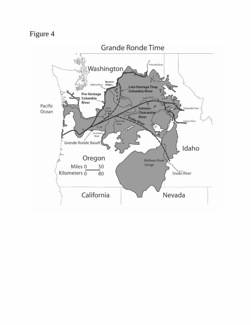
Figure 4

Figure 5

Figure 6
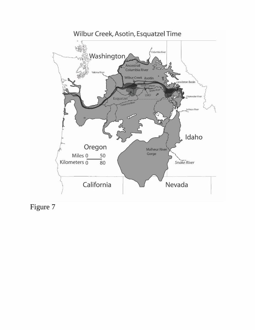
Figure 7

Figure 8
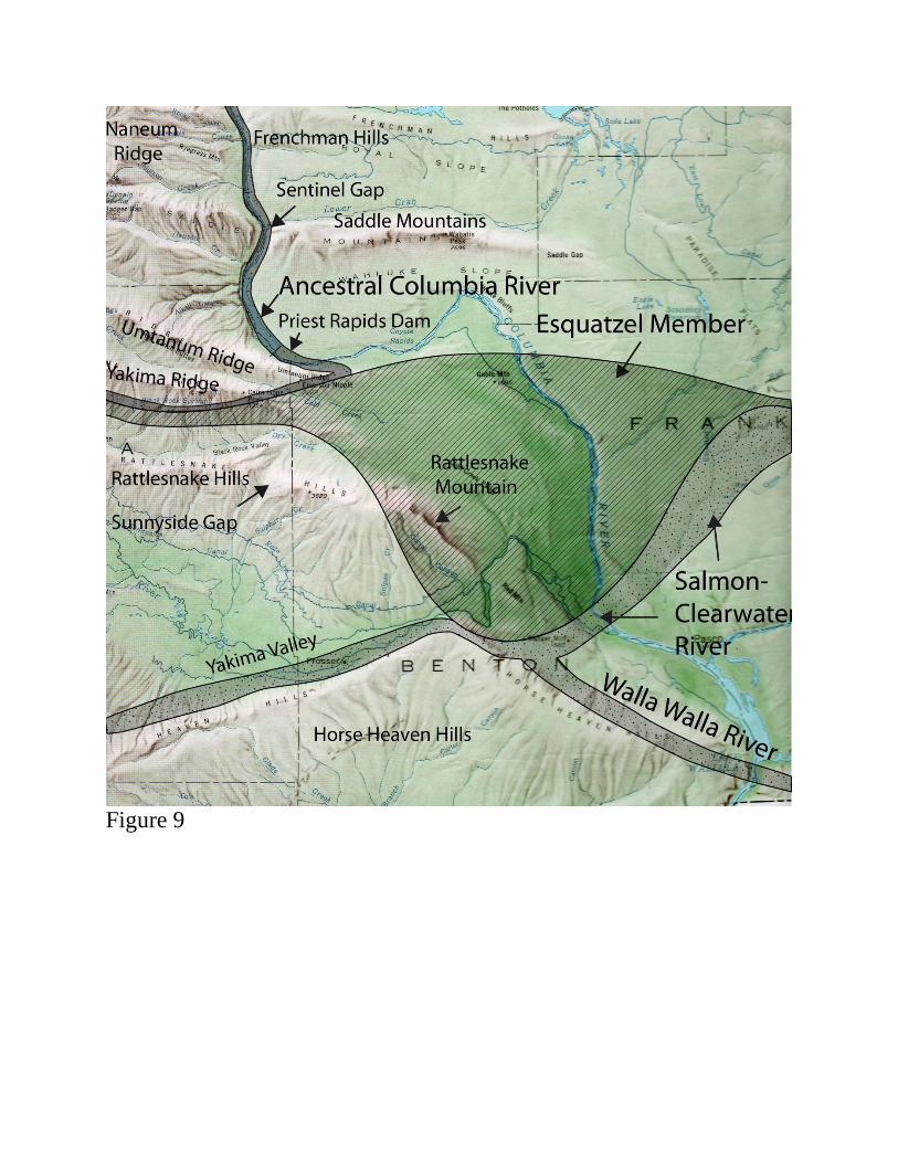
Figure 9

Figure 10

Figure 11
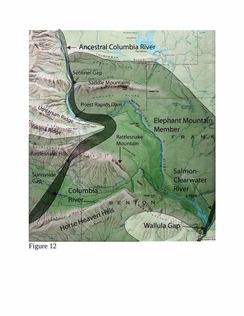
Figure 12
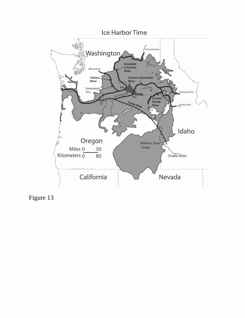
Figure 13
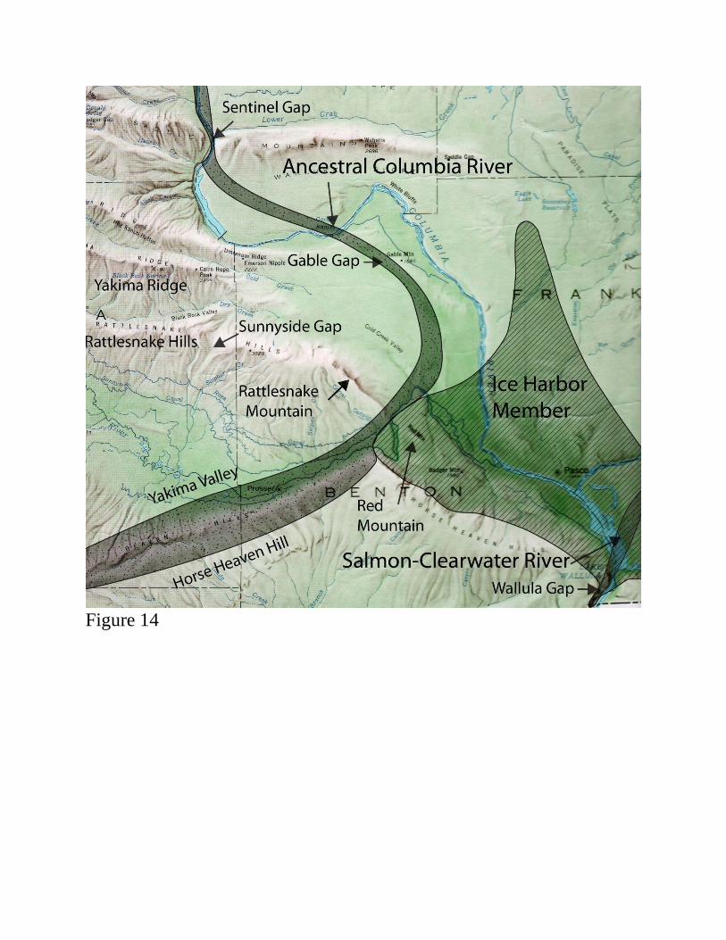
Figure 14

Figure 15