the law and economics of street layouts … 64/issue 3...1 ellickson 463 – 510 (do not delete)...
TRANSCRIPT
1 ELLICKSON 463 – 510 (DO NOT DELETE) 2/1/2013 12:23 PM
THE LAW AND ECONOMICS OF STREET LAYOUTS: HOW A GRID PATTERN BENEFITS A DOWNTOWN
Robert C. Ellickson∗
ABSTRACT
People congregate in cities to improve their prospects for social and economic interactions. As Jane Jacobs recognized, the layout of streets in a city’s central business district can significantly affect individuals’ ability to obtain the agglomeration benefits that they seek. The costs and benefits of alternative street designs are capitalized into the value of abutting lots. A planner of a street layout, as a rule of thumb, should seek to maximize the market value of the private lots within the layout. By this criterion, the street grid characteristic of the downtowns of most U.S. cities is largely successful. Although a grid layout has aesthetic shortcomings, it helps those who frequent a downtown to orient themselves and move about. A grid also is conducive to the creation of rectangular lots, which are ideal for siting structures and minimizing disputes between abutting landowners. Major changes in street layouts, such as those accomplished by Baron Haussmann in Paris and Robert Moses in New York City, are unusual and typically occur in bursts. Surprisingly, the aftermath of a disaster that has destroyed much of a city is not a propitious occasion for the revamping of street locations.
∗ Walter E. Meyer Professor of Property and Urban Law, Yale Law School. This lecture was
delivered at the University of Alabama School of Law on March 2, 2012 as part of the Meador Lecture Series on the topic of Boundaries. I owe thanks to Gary Libecap, John Travis Marshall, Katherine Mauter, Thomas Merrill, David Schleicher, Arnis Siksna, Reuben Teague, Chad Tindol, and Fredrick Vars for comments and other forms of help, and to Eric Parrie for research assistance.

1 ELLICKSON 463 – 510 (DO NOT DELETE) 2/1/2013 12:23 PM
464 Alabama Law Review [Vol. 64:3:463
ABSTRACT .................................................................................................. 463 INTRODUCTION .......................................................................................... 465 I. THE CREATION OF AN INITIAL LAYOUT OF DOWNTOWN STREETS ........ 466
A. The Spontaneous Creation of Streets from Below ...................... 467 B. The Planned Creation of Streets from Above ............................. 469
II. LAND VALUES AS A MEASURE OF THE MERITS OF A STREET
LAYOUT .......................................................................................... 474 III. GRID IS GOOD: HOW A RECTANGULAR LAYOUT TENDS TO
ENHANCE THE AGGREGATE VALUE OF DOWNTOWN LOTS ............ 479 A. Rectangular Blocks Reduce Construction and Demarcation
Costs ........................................................................................ 479 B. A Grid Fosters Circulation by Easing Travel and
Orientation .............................................................................. 480 C. The Aesthetic Shortcomings of a Street Grid ............................. 481 D. Empirical Studies of the Effects of a Lot’s Shape on Its
Value ........................................................................................ 483 IV. CHANGES IN STREET LAYOUTS ........................................................... 484
A. The Path Dependence of Streets ................................................. 484 B. Sources of Path Dependence ...................................................... 488 C. Punctuated Equilibria: Why Changes in Street Patterns
Tend to Occur in Bursts ........................................................... 490 D. Legal Innovations that Are Tending to Lock Street Layouts
into Place ................................................................................. 492 V. WHY THE AFTERMATH OF A DISASTER IS A POOR OCCASION FOR
MAJOR CHANGES IN THE LAYOUT OF DOWNTOWN STREETS ......... 493 A. Planners’ Priorities: Using a Disaster as an Opportunity for
City Transformation ................................................................ 494 B. Residents’ Principal Priority: The Rapid Rebuilding of the
Familiar ................................................................................... 497 1. The Negligible Effects of Historically Notable Disasters
on Street Layouts ............................................................... 497 2. Why Residents Resist Major Changes to Street Layouts
After a Disaster .................................................................. 501 C. The Doubtful Merits of Preparing a Transformative Street
Plan After a Disaster ............................................................... 503 1. The Benefits and Costs of Ambitious Post-Disaster
Planning ............................................................................. 503 2. How the Federalization of Post-Disaster Aid Has
Tended to Slow Recoveries ................................................ 505 VI. SUMMARY AND CONCLUSION: STREET LAYOUTS, ATTORNEYS,
AND TUSCALOOSA .......................................................................... 507

1 ELLICKSON 463 – 510 (DO NOT DELETE) 2/1/2013 12:23 PM
2013] The Law and Economics of Street Layouts 465
INTRODUCTION
I am honored to have been asked to participate in the University of Alabama Law School lecture series on boundaries. I have chosen to address the layout of the boundaries of a city’s streets, especially in its downtown area. The boundary of a street right-of-way demarcates where a private lot ends and the hurly-burly of the city’s open-access domain begins.1 Most residents of a city cross into or out of its street system, by foot or vehicle, at least several times a day.
Three events of the past year have sparked my interest in the design and law of downtown streets. The first was the two-hundredth anniversary of the issuance of the Commissioners’ Plan of 1811 that laid out, in a rectangular grid, most of the streets of Manhattan Island. The Museum of the City of New York organized an exhibition, “The Greatest Grid,” to celebrate this anniversary.2 The boastfulness of that title prompts some questions. Does the grid layout of Manhattan indeed even warrant the adjective great, not to mention greatest? How would one know? Was the eminent urbanologist Jane Jacobs correct in thinking that the design of a city’s street layout can significantly affect the quality of residents’ lives?3 Might not the effects of a city’s street pattern on its vitality be trivial, compared to the effects of other attributes such as its political structure, business climate, or stock of social capital?
The second event that prompted my interest was the publication in 2011 of an article by two economists, Gary Libecap and Dean Lueck.4 Libecap and Lueck employed an ingenious research design to investigate the effects of the shape of a farm parcel on the parcel’s value. Controlling for other characteristics, they found that regularly shaped farm parcels were twenty to thirty percent more valuable than irregularly shaped ones.5 This finding, I contend, provides indirect support for the greatness of the Manhattan grid.
1. For reasons of brevity, there is no discussion of the boundaries of urban public lands other than
streets, such as parks and school grounds. 2. The organizers of this exhibition have published a superb volume to complement it: MUSEUM
OF THE CITY OF NEW YORK, THE GREATEST GRID: THE MASTER PLAN OF MANHATTAN, 1811–2011 (Hillary Ballon ed., 2012) [hereinafter GREATEST GRID].
3. See JANE JACOBS, THE DEATH AND LIFE OF GREAT AMERICAN CITIES (1961). In this classic work, Jacobs makes repeated references to street designs and emphasizes the importance of land uses that provide “eyes on the street.” Id. at 34–35, 378–84.
4. Gary D. Libecap & Dean Lueck, The Demarcation of Land and the Role of Coordinating Property Institutions, 119 J. POL. ECON. 426 (2011).
5. Id. at 428.

1 ELLICKSON 463 – 510 (DO NOT DELETE) 2/1/2013 12:23 PM
466 Alabama Law Review [Vol. 64:3:463
The third event was the April 27, 2011 tornado that devastated large parts of Tuscaloosa, Alabama, the city where I present this lecture.6 A disaster, at first blush, might appear to offer a city’s leaders an unparalleled opportunity to update its street layout.7 In the last Part of my lecture, I will argue that history suggests otherwise. A review of the aftermaths of other disasters, such as the Great Chicago Fire of 1871, the bombing of Hiroshima, and Hurricane Katrina’s flooding of New Orleans, reveals that landowners and residents seldom regard a disaster as a springboard for revamping street locations.
My topic is relevant to attorneys. An attorney active in civic affairs should have some understanding of how a street layout can contribute to, or detract from, the greatness of a city. Although a city typically employs civil engineers, urban planners, or surveyors to map out new streets, it turns to attorneys to execute street transactions.8 When a city initiates a proceeding to open or close a street, lawyers invariably are involved. Moreover, opponents of a street change, when fighting their battles, commonly seek help from attorneys. One of my themes is that various statutory innovations during the past half-century have strengthened the defenders of the status quo and made it more difficult for a city’s leaders to relocate downtown streets.
I. THE CREATION OF AN INITIAL LAYOUT OF DOWNTOWN STREETS
Settlers of a previously uninhabited area might consider two polar-opposite approaches to the provision of streets.9 At one extreme, they could
6. This “EF-4 tornado cut a 5.9 mile long and half mile wide path of destruction” through the city,
killed fifty residents, and damaged 5,000 of the city’s 40,000 housing units. TUSCALOOSA FORWARD, A
STRATEGIC COMMUNITY PLAN TO REBUILD AND RENEW 58 (August 1, 2011), http://tuscaloosaforward.com/documents/Tuscaloosa%20Forward%20-%20August03.pdf.
7. Tuscaloosa’s downtown street grid was laid out during the 1820s. See AMALIA K. AMAKI &
KATHERINE R. MAUTER, TUSCALOOSA 7, 21 (2011). The tornado’s destruction fell in a northeasterly path through less historic areas of the city located more than a mile distant from downtown, either to the south or east. A proposal for the establishment of new rights-of-way in the tornado’s path is discussed infra text accompanying notes 254–257.
8. To obtain a sense of designers’ perspectives on street issues, see, for example, MATTHEW
CARMONA ET AL., PUBLIC PLACES, URBAN SPACES: THE DIMENSIONS OF URBAN DESIGN 182–83, 234–39 (2d ed. 2010).
9. In all nations, governments provide downtown streets. A private entrepreneur cannot practically provide an open-access street because there is, as yet, no technology that would enable the entrepreneur to collect tolls from the pedestrians, bicyclists, motorists, and others who briefly enter it. In the argot of economics, a downtown street is an impure public good. See Robert C. Ellickson, Property in Land, 102 YALE L.J. 1315, 1381–86 (1993). The public provision of streets dismays anarcho-capitalists, who aspire to privatize all land. See, e.g., MURRAY N. ROTHBARD, FOR A NEW
LIBERTY 202 (1973): Abolition of the public sector means, of course, that all pieces of land, all land areas, including streets and roads, would be owned privately, by individuals, corporations, cooperatives, or any other voluntary groupings of individuals and capital. . . . What we need

1 ELLICKSON 463 – 510 (DO NOT DELETE) 2/1/2013 12:23 PM
2013] The Law and Economics of Street Layouts 467
let streets bubble up from below by delegating the power to determine street locations to decentralized landowners and travelers. If they adopted this approach, city officials would invariably accept any gift of a public right-of-way that a private landowner might tender, and would also initiate legal actions to affirm that traditionally used paths across private parcels had become public ways.10 At the other extreme, the settlers could permit, or urge, their leaders to map out a comprehensive plan of streets and to wield governmental power to impose that layout from the top down. This distinction between bottom-up and top-down street creation is conceptually useful, even though, in practice, a city is likely to make some use of both approaches. In the twenty-first century, for example, a developer and a municipality typically decide by mutual agreement the layout of streets in a new subdivision.11 And, during the eighteenth century, a city similarly might have declined a landowner’s request to open a right-of-way, or, on its own initiative, mandated a piecemeal street opening, typically softened by some form of compensation.12
A. The Spontaneous Creation of Streets from Below
Of the most populous U.S. cities, the early histories of New York and Boston best exemplify the process of street creation from below.13 Over the course of the eighteenth century, residents of the tiny settlement at the southern tip of Manhattan Island began to move northward into areas beyond their main defensive wall. In these areas of expansion, owners of private tracts typically laid out their own interior streets and transferred those rights-of-way to the city.14 After the Revolutionary period, these
to do is to reorient our thinking to consider a world in which all land areas are privately owned (emphasis in original).
10. On these processes of express and implied dedication, see infra text accompanying notes 17–19.
11. See ROBERT C. ELLICKSON & VICKI L. BEEN, LAND USE CONTROLS 424–30 (3d ed. 2005). 12. See Molly Boyle, The Failure of America’s First City Plan: Why New Haven, the Colonies’
First Planned City, Would Have Been Better Left Unplanned 26, 35 (May 5, 2010) (unpublished student paper, Yale Law School) (on file with author); see also John F. Hart, Takings and Compensation in Early America: The Colonial Highway Acts in Social Context, 40 AM. J. LEGAL HIST. 253, 270–99 (1996) (describing procedures for the opening of “highways”).
13. Molly Boyle has defended bottom-up processes of street planning. She argues that they not only save the administrative costs of centralized design efforts, but also delegate the task of boundary making to land occupants, who commonly have the best local knowledge of land conditions. See Boyle, supra note 12. Boyle convincingly argues that, as New Haven grew during the eighteenth century, the excessive size of the blocks of the Nine Squares impeded downtown circulation. See infra note 39. Although Boyle recognizes that a street planner may be more attentive than a landowner to network externalities (see id. at 79–80), she may underestimate the potential benefits of a planned street grid. But cf. id. at 84 (praising the Commissioners’ Plan for Manhattan). See also Molly Boyle, A Study of Changes in the Land Demarcation System in Seventeenth and Eighteenth Century New Haven (Spring 2011) (unpublished student paper, Yale Law School) (on file with author).
14. See GREATEST GRID, supra note 2, at 17.
1 ELLICKSON 463 – 510 (DO NOT DELETE) 2/1/2013 12:23 PM
468 Alabama Law Review [Vol. 64:3:463
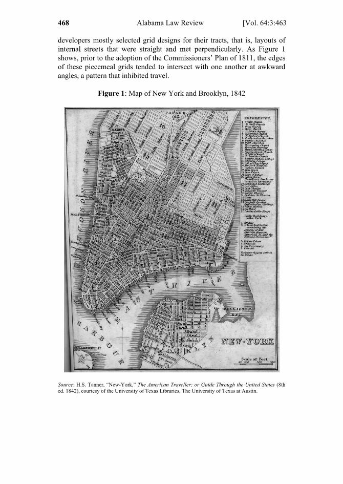
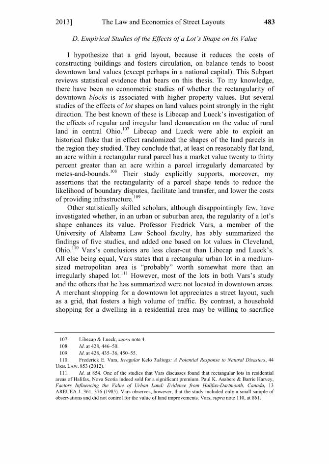
developers mostly selected grid designs for their tracts, that is, layouts of internal streets that were straight and met perpendicularly. As Figure 1 shows, prior to the adoption of the Commissioners’ Plan of 1811, the edges of these piecemeal grids tended to intersect with one another at awkward angles, a pattern that inhibited travel.
Figure 1: Map of New York and Brooklyn, 1842
Source: H.S. Tanner, “New-York,” The American Traveller; or Guide Through the United States (8th ed. 1842), courtesy of the University of Texas Libraries, The University of Texas at Austin.

1 ELLICKSON 463 – 510 (DO NOT DELETE) 2/1/2013 12:23 PM
2013] The Law and Economics of Street Layouts 469
Boston provides a more thoroughgoing example of bottom-up street design. Boston was founded on a narrow and hilly peninsula, the Trimountaine, which jutted into Boston Harbor. As the city matured, Bostonians continually filled portions of their harbor to enable the city to expand.15 Largely as a result of this topographical history, the downtown area of Boston became a hodgepodge of blocks far more irregular than the downtown blocks of any other major U.S. city, including those in the southern portion of Manhattan.16
When street creation is bottom-up, a city typically obtains formal title to a right-of-way by means of some variant of the process of dedication. By written document, a private landowner may expressly dedicate (give) to the city, and the city may then accept, the area in the street either in fee simple or as a public easement.17 In an instance where the public has long used a right-of-way that a private owner never formally dedicated, the city may be able to successfully invoke the doctrine of implied dedication.18 The rules of implied dedication are generally analogous to the rules governing creation of a prescriptive public easement.19
B. The Planned Creation of Streets from Above
Leaders who adopt a top-down street plan promulgate a map depicting the locations of the rights-of-way that they eventually intend to open. In some historical instances, such as the founding of New Haven and Philadelphia, a map of this sort is issued by either a newly-arrived proprietor, or group of proprietors, that owns all the affected territory.20 In other instances, such as the Commissioners’ Plan for Manhattan, an established government lays out a proposed network of streets for a largely undeveloped area of private farms and pastures. The owners of these scattered tracts may lobby in favor of the street plan, anticipating that it
15. Many other cities engaged in landfilling, but few on the scale of Boston. On the multiple
minor landfills in Boston prior to 1800, see JOHN W. REPS, THE MAKING OF URBAN AMERICA: A
HISTORY OF CITY PLANNING IN THE UNITED STATES 141–44 (1965). On later and more ambitious Boston landfills, see the remarkable animation by Jeffrey Howe, BOSTON: HISTORY OF LANDFILLS (Boston Coll. 1996), available at http://www.bc.edu/bc_org/avp/cas/fnart/fa267/sequence.html (1996).
16. See REPS, supra note 15, at 141 (offering this reason for Boston’s circuitous street layouts). 17. A classic mid-nineteenth-century legal work includes a discussion of these issues. JOSEPH K.
ANGELL & THOMAS DURFEE, A TREATISE ON THE LAW OF HIGHWAYS 104–08 (1st ed. 1857). 18. See, e.g., Denning v. Roome, 6 Wend. 651, 658 (N.Y. Sup. Ct. 1831) (holding public road
had been created by implied dedication). 19. See, e.g., Reed v. Inhabitants of Northfield, 30 Mass. (13 Pick.) 94 (1832) (Shaw, J.) (holding
public road had been established by prescription). On the interrelatedness of the doctrines of implied dedication and public prescriptive rights, see Gion v. City of Santa Cruz, 465 P.2d 50, 55–58 (Cal. 1970) and ANGELL & DURFEE, supra note 17, at 102–04, 112–42.
20. See infra sources cited in notes 25–26.

1 ELLICKSON 463 – 510 (DO NOT DELETE) 2/1/2013 12:23 PM
470 Alabama Law Review [Vol. 64:3:463
would raise the value of their holdings.21 Or, the primary impetus may come from the outside, as it did in 1791 when the U.S. government commissioned Pierre L’Enfant to map streets for a new capital city on the Potomac River.
A street plan imposed from on high need not entail a system of rectangular blocks. In the 1950s, French planners of La Défense, a dense cluster of commercial skyscrapers just west of Paris, mapped out many curvilinear roads, including a Boulevard Circulaire.22 L’Enfant’s plan for Washington, D.C. included numerous diagonal avenues that eventually created a host of triangular blocks.23 Despite the availability of these non-grid alternatives, the civic leaders in the U.S. who have laid out downtown streets in top-down fashion have overwhelming preferred straight streets and right-angled intersections. Of the ten most populous U.S. cities in 1860, only New York and Boston lacked a downtown largely laid out in a pattern of rectangular blocks.24 And neither of those two exceptional cities was consistently committed to the spontaneous creation of streets from below. As mentioned, in 1811, New Yorkers, who had had the opportunity of observing the strengths and weaknesses of a bottom-up system of street creation, switched to a top-down grid design for most of the area of Manhattan north of its southern tip.25 Boston’s leaders, after filling the waters of Back Bay during the second half of the nineteenth century, imposed a rectangular grid on that large new neighborhood.26
Rectangular street layouts date back at least to ancient Greece and Rome.27 The first planned grid in the territory that became the Thirteen Colonies appears to have been the Nine Squares of New Haven, Connecticut, laid out in 1639.28 A more salient role model for subsequent founders of North American cities was William Penn’s 1683 grid plan for
21. As Thomas Merrill has suggested to me, the adoption of the Commissioners’ Plan likely
demonstrates the political power of the real estate development lobby in New York at the time. On the role of interest groups in the production of new property rights, see, e.g., Terry L. Anderson & Peter J. Hill, Cowboys and Contracts, 31 J. LEGAL STUD. 489 (2002). A policy that benefits a particular interest group, of course, may also promote the general welfare.
22. See EDMUND N. BACON, THE DESIGN OF CITIES 188 (1967). 23. L’Enfant’s plan is reproduced in GREATEST GRID, supra note 2, at 55. 24. These ten cities are listed in Appendix A. 25. See GREATEST GRID, supra note 2, at 17; REPS, supra note 15, at 296–99 (discussing the
Commissioners’ Plan of 1811); Figure 1 on p. 468. 26. See REPS, supra note 15, at 146 (explaining that Boston was “extended in a great grid pattern
southwesterly . . . as the Back Bay was filled to provide more land for the now rapidly growing city.”). 27. See GREATEST GRID, supra note 2, at 27. Pizarro’s 1535 grid plan for Lima, Peru, predated
those in North America. See id. at 48–49. On the history of the grid and its popularity in the United States, see also MICHAEL SOUTHWORTH & ERAN BEN-JOSEPH, STREETS AND THE SHAPING OF TOWNS
AND CITIES 12–13, 25, 28 (1997). 28. On early New Haven, see REPS, supra note 15, at 128–130; Boyle, supra note 12 at 14–78.

1 ELLICKSON 463 – 510 (DO NOT DELETE) 2/1/2013 12:23 PM
2013] The Law and Economics of Street Layouts 471
Philadelphia.29 By the time of the Revolution, Philadelphia had leapfrogged Boston and New York, among others, to become the most populous city in the colonies.30 New York’s population had surpassed Philadelphia’s, however, by 1811, when the Commissioners’ Plan was adopted.31 By 1840, thanks in part to the Erie Canal, New York had over three times Philadelphia’s population.32 Chicago, the American city with the most extraordinary rate of growth during the nineteenth century, began to boom after James Thompson laid out its regular street grid in 1830.33 From this anecdotal evidence, a nineteenth-century observer might have inferred that a grid layout of a city’s commercial district was somehow conducive to population growth.
Although a grid layout by definition features rectangular blocks, other design details can vary.34 For starters, the widths of a grid’s streets are not preordained.35 The New York Commissioners mapped out wide avenues running uptown, but narrower cross streets.36 The Commissioners also opted for rectangular blocks, some with a length almost five times their width.37 Downtown Chicago’s blocks, by contrast, are virtually square, partly as a result of the influence of the checkerboard system devised in the Land Ordinance of 1785 for the surveying of townships and parcels in the Northwest Territories.38 The sizes of blocks are another design decision. At one extreme were New Haven’s initially huge Nine Squares, each of which
29. John Reps attributes the popularly of the grid in the U.S. to the prominence of Philadelphia in
colonial America. REPS, supra note 15, at 294; see also GREATEST GRID, supra note 2, at 49–50. 30. Largest Cities in the United States by Population by Decade, WIKIPEDIA,
http://en.wikipedia.org/wiki/Largest_cities_in_the_United_States_by_population_by_decade. 31. Id. 32. Id. 33. On the origins of this Chicago plat map, see REPS, supra note 15, at 299–303. 34. A pioneering study of the shapes and sizes of downtown blocks is Arnis Siksna, The Effects of
Block Size and Form in North American and Australian City Centres, 1 URB. MORPHOLOGY 19 (1997) [hereinafter Siksna, Block Size]. See also Arnis Siksna, City Centre Blocks and Their Evolution: A Comparative Study of Eight American and Australian CBDs, 3 J. URB. DESIGN 253 (1998) (providing additional factual details).
35. An urban street right-of-way typically includes space not only for a street pavement, but also, on both sides, a sidewalk and perhaps a planting strip.
36. See GREATEST GRID, supra note 2, at 33. 37. Id. 38. The Land Ordinance of 1785 first applied to federal lands that lay from Ohio westward. A
committee headed by Thomas Jefferson helped devise the Land Ordinance’s system of square townships and sections. See BILL HUBBARD JR., AMERICAN BOUNDARIES: THE NATION, THE STATES, AND THE RECTANGULAR SURVEY (2009); THOMAS W. MERRILL & HENRY E. SMITH, PROPERTY: PRINCIPLES AND POLICIES 121–23 (2007); see also REPS, supra note 15, at 216–17 (asserting, at 217, the “dullness and mediocrity” of this checkerboard survey system, but conceding that it may have speeded settlement). The Land Ordinance hardly invented the square block. For example, most blocks of the French Quarter of New Orleans, laid out c.1720, also have that shape.

1 ELLICKSON 463 – 510 (DO NOT DELETE) 2/1/2013 12:23 PM
472 Alabama Law Review [Vol. 64:3:463
had an area of about 16 acres.39 At the other was James Oglethorpe’s 1733 grid plan for Savannah, Georgia, which created rectangular blocks less than two acres in area.40
Thanks in part to the Land Ordinance of 1785, the downtown grids of Chicago and many other U.S. cities are oriented on a true north–south axis.41 The founders of New Haven, Philadelphia, Savannah, and other cities laid out prior to the Revolution, however, all oriented their grids away from true north-south so that the streets at the edges of their grid would mesh well with the banks of nearby rivers or creeks.42 In 1811, the New York Commissioners followed this tradition and canted their grid away from true north-south so that their new avenues would run roughly parallel with the East and Hudson Rivers that border Manhattan.43 Similarly, Tuscaloosa’s downtown street grid is oriented to parallel the banks of the Black Warrior River.44
A city also can vary the “rules of the road” that govern the use of particular streets in its grid. A decision to make most downtown streets one-way may speed up vehicular flows, but also make motorists’ routes more circuitous and pedestrians’ strolls on sidewalks less inviting. And a city can provide special lanes for bicycles or buses, or even bar vehicular traffic from certain streets. Street grids, in sum, appear in many varieties.
A city that plans its streets top-down typically employs attorneys to help it acquire the rights-of-way it has mapped across lands in private ownership.45 Partly because the opening of a new street usually enhances the value of abutting lands, some of these private owners may be willing to sell or give their lands to the city. If an owner is unwilling to voluntarily transfer a right-of-way, however, a city may exercise, or threaten to exercise, its power of eminent domain.46 In the U.S., a city exercising this power, as a constitutional matter, of course must provide a condemnee “just
39. These blocks proved to be too large to permit the ready circulation characteristic of a
successful commercial downtown. By 1820, the City of New Haven had converted most of them into four smaller blocks by inserting new streets that divided each large initial block roughly into quarters. See Boyle, supra note 12, at 44–78. This is a common fate of a large downtown block. See Siksna, Block Size, supra note 34, at 25.
40. I estimated this area from a map that appears in REPS, supra note 15, at 200; see also Boyle, supra note 12, at 9 (presenting a diagram comparing the areas of the standard blocks in the grid plans of New Haven, New York City, Philadelphia, and Savannah). On the Savannah layout, see REPS, supra note 15, at 185–92, 198–203.
41. REPS, supra note 15, at 216–217. 42. See id. at 129, 161, 186–89, 200–02. 43. See id. at 297–99; see also GREATEST GRID, supra note 2, at 39–42. 44. AMAKI & MAUTER, supra note 7, at 20. 45. In contemporary practice, a city’s street plan commonly is referred to as its “official map.”
See Joseph C. Kucirek & J. H. Beuscher, Wisconsin’s Official Map Law: Its Current Popularity and Implications for Conveyancing and Planning, 1957 WIS. L. REV. 176, 177 (1957).
46. See ANGELL & DURFEE, supra note 17, at 53–101.

1 ELLICKSON 463 – 510 (DO NOT DELETE) 2/1/2013 12:23 PM
2013] The Law and Economics of Street Layouts 473
compensation.”47 The doctrines governing the calculation of compensatory payments may authorize a city to set off, against a condemnee’s damage award, the market value of the benefits that the new street confers on the condemnee’s retained acreage.48
The implementation of the Commissioners’ Plan of 1811 illustrates how mapped streets became actual streets. The 1807 New York statute that governed the creation of the “greatest grid” authorized the City of New York to open a mapped street at a time of its choosing.49 A section of the statute provided that, when the city did open a right-of-way across private land, it owed the owners of those lands “reasonable compensation” for both land and buildings taken.50 But the same section included three additional provisions that shifted most of the financial costs of street openings to owners of abutting lands. First, the statute implicitly adopted the usual rule that the city could set off, against the compensation owed an owner of land taken for a right-of-way, the benefits that the new street would confer on that owner’s untaken lands.51 Second, in the not-uncommon event that the benefits conferred on an owner’s untaken lands would exceed the value of the owner’ damages, the New York statute authorized the city to impose special assessments on the owner to recoup some or all of the net benefit.52 And third, the statute stated that if, after the street map had been officially adopted, a landowner were to have erected a building within the area of a mapped street, the city, when it opened that street, would not owe compensation for the value of that building.53
47. U.S. CONST. amend. V. 48. This principle may be limited in various ways. Applicable doctrine might permit, for
example, the set off only of special benefits, as opposed to general benefits, and only against severance damages. See Hendler v. United States, 175 F.3d 1374, 1379 (Fed. Cir. 1999) (describing state law); JULIUS L. SACKMAN ET AL., 8A NICHOLS ON EMINENT DOMAIN §§ G16.01–05 (rev. 3d. ed. 1998); see also WILLIAM A. FISCHEL, REGULATORY TAKINGS 64–99 (1995).
49. REPS, supra note 15, at 29–32. 50. 1807 N.Y. Laws, ch. 115, § IX (reproduced in GREATEST GRID, supra note 2, at 30–31).
According to one tally, thirty-nine percent of the buildings standing in 1811 in the area affected by the Commissioners’ Plan were located either wholly or partially within a mapped right-of-way. GREATEST
GRID, supra note 2, at 39. 51. Cf. Livingston v. City of New York, 8 Wend. 85 (N.Y. 1831) (rebuffing state constitutional
challenge to city’s setting off, against compensation provided landowner, of benefits to the landowner’s retained lands).
52. Cf. In re City of New York, 11 Johns. 77 (N.Y. Sup. Ct. 1814) (upholding fairness of principle of financing street projects through assessments levied against benefited landowners). The City of New York commonly imposed assessments on owners of land within its grid seriatim: when the street was first opened, when its surface was smoothed and paved, and when sewers were installed. GREATEST GRID, supra note 2, at 76. In practice, the city probably did not attempt to obtain complete restitution of benefits conferred, a policy that would have sapped landowners’ support for the program.
53. Cf. In re Furman St., 17 Wend. 649 (N.Y. Sup. Ct. 1836) (rebuffing state constitutional challenge to prohibition against erection of buildings within a mapped street). Furman Street involved legal challenges to a New York statute, patterned after the 1807 statute for Manhattan, that had enabled the mapping of streets in the City of Brooklyn. Id. at 652.

1 ELLICKSON 463 – 510 (DO NOT DELETE) 2/1/2013 12:23 PM
474 Alabama Law Review [Vol. 64:3:463
These statutory rules incentivized the Commissioners to adopt a street plan whose benefits exceeded its costs.54 The Commissioners had reason, for example, not to map streets that were overly wide, because the city would owe compensation for the value of lands converted to rights-of-way. Because benefits to abutting lots could be set off, the Commissioners also had an incentive to lay out streets in a pattern that real estate investors would value, for example, a grid of rectangular blocks.55 In addition, the statutory rules incentivized landowners to help mitigate the city’s future costs of opening streets. Suppose that John Jacob Astor, one of leading dealers in Manhattan real estate during the first half of the nineteenth century, were to have owned a large tract of rural land across part of which the Commissioners had mapped the future Fifth Avenue. Because Astor would not have been entitled to receive compensation for the loss of any post-1811 structures within the confines of that planned right-of-way, he would have had an incentive to keep that strip of land unimproved.
II. LAND VALUES AS A MEASURE OF THE MERITS OF A STREET LAYOUT
Was the Commissioners’ 1811 map for Manhattan indeed a “great” plan? Frederick Law Olmsted, the preeminent U.S. landscape architect whose accomplishments included the co-design of Manhattan’s Central Park, thought not. In Olmsted’s eyes, an unalloyed grid plan provides too few sites for the erection of visually prominent monumental buildings, in contrast to, for example, the street layouts of Paris and Washington.56 Kevin Lynch, a planning professor who has stressed the desirability of legible cityscapes, similarly disdains the highly readable grid, referring to it as a “banal” layout.57 John Reps, the author of the leading historical study of the layouts of U.S. cities, agrees. Reps asserts that a rectangular pattern of streets lacks variety, fails to respect the natural terrain, creates too many traffic intersections, and—echoing Olmsted—provides no focal locations for landmark buildings.58 Reps’s evaluation of the Commissioners’ Plan of 1811 is scathing: “[t]he fact that it was this gridiron New York that served as a model for later cities was a disaster whose consequences have barely been mitigated by more modern city planners.”59
54. The large sums at stake also incentivized unscrupulous landowners and politicians to try to
manipulate the administration of assessments. See GREATEST GRID, supra note 2, at 76 (describing complaints about assessment practices).
55. See infra text accompanying notes 82–114. 56. See GREATEST GRID, supra note 2, at 87; see also infra note 106 and accompanying text. 57. KEVIN LYNCH, THE IMAGE OF THE CITY 22 (1960). 58. REPS, supra note 15, at 217, 290, 298–99. 59. Id. at 299; see also id. at 314 (asserting “the folly of using a gridiron street system on the hills
of San Francisco”).

1 ELLICKSON 463 – 510 (DO NOT DELETE) 2/1/2013 12:23 PM
2013] The Law and Economics of Street Layouts 475
The aesthetic shortcomings of a grid pattern, a common theme of these critics, are undeniable.60 But a street system is a lumpy good that affects the quality of life in a downtown along a host of dimensions in addition to aesthetics. Street designs influence, for both street users and occupiers of abutting lands, noise levels, safety, and access to light and air. Most important, a street layout affects ease of orientation, pedestrian circulation, and vehicular access. People cluster in cities primarily to obtain what urban economists call “agglomeration benefits.” These include positive spillovers from information flows, transport cost reductions, and enhanced specialization of labor and capital.61 Urbanites put up with the hassles of city life to enhance their opportunities to engage in face-to-face interactions, social and commercial. A street layout can promote interpersonal contact by making it easier for people to find one another and by lowering their travel times. By minimizing waste of scarce downtown land, an efficacious street layout also can increase population densities at the urban epicenter where agglomeration benefits are potentially greatest.
In sum, a street layout can affect the quality of city life, positively or negatively, along many dimensions. It would be useful to have an objective metric of how city dwellers trade off these differing effects. Although no measure is unflawed, I assert that land values provide the best available evidence. Both the positive and negative effects of a street layout can be expected to be capitalized into the values of abutting lots.62 A layout’s facilitation of circulation, for example, would increase the value of abutting lots, while a layout’s aesthetic deficiencies would lower them. There thus is a rough test for judging the overall merits of alternative street layouts: a planner laying out streets should seek to maximize the market value of the private parcels in the planned area.63
Paying attention to the effects of alternative street plans on the aggregate value of land has three significant merits. First, this guideline
60. See infra text accompanying notes 99–106; see also Edward Glaeser, Reflection, in GREATEST GRID, supra note 2, at 209 (admitting aesthetic shortcomings of the grid, but praising its legibility).
61. See Edward L. Glaeser & Joshua D. Gottlieb, The Wealth of Cities: Agglomeration Economies and Spatial Equilibrium in the United States, 47 J. ECON. LIT. 983, 999–1015 (2009); David Schleicher, The City as a Law and Economic Subject, 2010 U. ILL. L. REV. 1507, 1515–29.
62. On this process, see WILLIAM A. FISCHEL, THE HOMEVOTER HYPOTHESIS: HOW HOME
VALUES INFLUENCE LOCAL GOVERNMENT TAXATION, SCHOOL FINANCE, AND LAND-USE POLICIES 39–51 (2001). The capitalization of benefits provides the legal rationale for a city’s imposition, on abutting landowners, of special assessments for street improvements.
63. Others have used effects on land values as a yardstick for judging the merits of a land policy. See, e.g., Libecap & Lueck, supra note 4, at 434 (“The planner’s objective . . . is to choose the allocation and parcel demarcation that maximizes the net value of the entire tract.”); Frank Michelman, Toward a Practical Standard for Aesthetic Regulation, 15 PRAC. LAW. 36 (Feb. 1969) (suggesting that examination of effects on real estate values be used to help resolve debates over aesthetics); see also infra notes 107–114 and accompanying text. Anup Malani, Valuing Laws as Local Amenities, 121 HARV. L. REV. 1273 (2008), applies the idea exceptionally broadly.

1 ELLICKSON 463 – 510 (DO NOT DELETE) 2/1/2013 12:23 PM
476 Alabama Law Review [Vol. 64:3:463
decentralizes, from those in political power to the many participants in land markets (including tenants), appraisals of the tradeoffs among the many conflicting attributes of streets.64 If these market participants were to have varied tastes for street patterns, to maximize total land value a planner might devise different street layouts for different areas of a city. The Commissioners who devised Manhattan’s grid concluded that a rectangular design had inherent advantages and explicitly rejected including in their layout any “supposed improvements” such as “circles, ovals, and stars.”65 If the Commissioners had anticipated that some Manhattanites would share Olmsted’s taste for giving primacy to the aesthetic aspects of a street pattern, however, they might have provided these sorts of embellishments in at least a few neighborhoods.
A second advantage of directing a street planner to maximize the total value of lots is that this instruction deters the waste of land.66 For example, wide streets generally speed traffic flows and provide abutting landowners better natural light and air. But a street widening also reduces the acreage in private ownership. A planner who aspired to maximize total land value would take that opportunity cost into account. Similarly, a planner attuned to maximizing total lot values would recognize the disadvantages of street plans that would result in lots whose shapes would repel builders and occupants.
Third, the objective of maximizing land values promises to bring greater rigor to debates over street designs.67 Consider Jane Jacobs’s ultimately successful battle in the 1960s against Robert Moses’s plans to erect an elevated Lower Manhattan Expressway across the ungridded streets of southern Manhattan.68 Jacobs, by focusing on the value of the improved private lots that would be taken for the project and the project’s negative effects on the value of other lots nearby, would have added coherence to her critique of the project.
There are, to be sure, potential problems with the proposed test. Even observers willing to take an entirely utilitarian approach to street design might raise various objections to it. A planner who sought to maximize the aggregate market value of lots would be ignoring owners’ and occupants’
64. See generally Friedrich A. Hayek, The Use of Knowledge in Society, 35 AM. ECON. REV. 519
(1945). 65. See GREATEST GRID, supra note 2, at 40 (quoting the Commissioners’ report). 66. See SOUTHWORTH & BEN-JOSEPH, supra note 27, at 81–82. 67. I plainly assume that, in this context, cost–benefit analysis is a meritorious tool of policy
assessment. To sample the intense debate over the value of that technique, compare MATTHEW D. ADLER & ERIC A. POSNER, NEW FOUNDATIONS OF COST–BENEFIT ANALYSIS (2006), with Frank Ackerman & Lisa Heinzerling, Pricing the Priceless: Cost–Benefit Analysis of Environmental Protection, 150 U. PA. L. REV. 1553 (2002).
68. See ANTHONY FLINT: WRESTLING WITH MOSES: HOW JANE JACOBS TOOK ON NEW YORK’S
MASTER BUILDER AND TRANSFORMED THE AMERICAN CITY 137–39 (2009).
1 ELLICKSON 463 – 510 (DO NOT DELETE) 2/1/2013 12:23 PM
2013] The Law and Economics of Street Layouts 477
subjective valuations of land values, which likely would be higher. The proposed guideline also pays no attention to who would pay for the costs of a proposed street revamping. If far-removed taxpayers would bear these costs, land values in the affected area might rise only on account of these subsidies. From a utilitarian perspective, a planner laying out streets should assume that all the costs of street alterations would be entirely financed by means of charges assessed on benefited lot owners. But even with that modification, the test of maximizing aggregate lot values in the planned area remains crude because it ignores the effects of a project on land values in adjacent territories. Robert Moses, for example, might have argued that the proposed Lower Manhattan Expressway would have boosted land values in the neighborhoods of commuters who would have traveled on it. As a conceptual matter, a utilitarian analyst therefore would want to attend to positive and negative spillouts beyond the area of the street plan itself.
Finally, a totting up of costs and benefits gives no weight to non-utilitarian considerations. In 1811, egalitarian sentiments may have partly prompted the Commissioners to reject “circles, ovals, and stars”—embellishments that would have created elite intersections. Egalitarianism also may have contributed to their decision to make all blocks in the Manhattan grid 200 feet in width, a dimension that encouraged subdividers to create shallow lots that were relatively affordable.69
Despite these caveats, I assert that on balance a planner, when appraising the quality of a proposed street pattern, should focus on the plan’s effect on the aggregate value of improved lots. This test promises to help resolve, for example, controversies over the sizing of blocks.70 In the mid-twentieth century, many planners favored the selective closing of streets to create “superblocks.”71 Between 1940 and 1965, New York officials helped provide superblocks for the United Nations building, the Stuyvesant Town apartment complex, the cluster of theaters at Lincoln Center, and numerous public housing projects in East Harlem.72 Superblocks have since fallen from fashion.73 Jane Jacobs and others have observed that the interior of a superblock tends to be relatively lifeless.74 In addition, the creation of a superblock entails street closings that typically
69. See GREATEST GRID, supra note 2, at 33; see also Hilary Ballon, Introduction, in id., at 13
(asserting that in Manhattan’s grid “All blocks are equal and no sites are inherently privileged.”); REM
KOOLHAAS, DELIRIOUS NEW YORK: A RETROACTIVE MANIFESTO FOR MANHATTAN 15 (1978) (envisioning the smallness of Manhattan’s blocks as a bulwark against totalitarian rule).
70. See generally Siksna, Block Size, supra note 34. 71. GREATEST GRID, supra note 2, at 179. 72. See SAMUEL ZIPP, MANHATTAN PROJECTS: THE RISE AND FALL OF URBAN RENEWAL IN
COLD WAR NEW YORK (2010); GREATEST GRID, supra note 2, at 179, 183–86. 73. For the assertion that, in a downtown, small blocks generally are superior to large ones, see
Siksna, Block Size, supra note 34, at 25, 29. 74. See JACOBS, supra note 3, at 186; ZIPP, supra note 72 at 360–71.

1 ELLICKSON 463 – 510 (DO NOT DELETE) 2/1/2013 12:23 PM
478 Alabama Law Review [Vol. 64:3:463
disrupt neighborhood circulation. In the 1960s, a massive superblock was created for Manhattan’s World Trade Center. Recognizing the drawbacks of this layout, the planners of the redevelopment of Ground Zero have elected to reopen some of the local streets previously closed.75 I infer that they recognize that a superblock design typically reduces, not enhances, the aggregate value of lots.
But blocks also can be too small. The street grids of the downtowns of Chicago, Philadelphia, and numerous other cities once commonly included alleys that provided access to the rears of lots.76 By the twentieth century, the area of the half-block between an alley and a street commonly had become too small for the siting of a major hotel, department store, or office building.77 To create those valuable sites, cities have closed many of their downtown alleys, which had added little to the quality of the overall circulation network.78
John Reps, a leading critic of the Commissioners’ 1811 plan for Manhattan, certainly would dissent from the recommendation that a street planner focus on boosting aggregate land value. He asserts that the Commissioners harbored the wrong priorities: “[T]he commissioners . . . were motivated mainly by narrow considerations of economic gain. . . . As an aid to [real estate] speculation the commissioners’ plan was perhaps unequalled, but only on this ground can it be justifiably called a great achievement.”79 Reps misattributes the causes of high real estate prices. Purchasers of land consider all aspects of alternative prospective locations, not just their aesthetic aspects (the feature that Reps appears to prize most highly). In a relatively competitive real estate market such as New York’s after 1811, the high prices of lots were evidence less of artificial manipulations by land speculators, and more of robust consumer demand.80
75. See GREATEST GRID, supra note 2, at 191–92; Julie Satow, Sundered Greenwich Street Will
Be Rejoined, N.Y. TIMES, July 18, 2012, at B6. The designers of Battery Park City, a project begun in Lower Manhattan in the 1970s, had previously resurrected the ideal of a grid of small blocks. GREATEST GRID, supra note 2, at 192.
76. See generally REPS, supra note 15. 77. See, e.g., Blakely v. Gorin, 313 N.E.2d 903 (Mass. 1974) (enabling the developer of the Ritz
Carlton Hotel in Boston to proceed with an expansion that would span a pre-existing alley). 78. See infra text accompanying note 132. 79. REPS, supra note 15, at 299. 80. See GREATEST GRID, supra note 2, at 87 (stating, in response to Reps: “The fact is that real
estate improvements produced both private and public value and advanced the development of the city.”).

1 ELLICKSON 463 – 510 (DO NOT DELETE) 2/1/2013 12:23 PM
2013] The Law and Economics of Street Layouts 479
III. GRID IS GOOD:81 HOW A RECTANGULAR LAYOUT TENDS TO ENHANCE
THE AGGREGATE VALUE OF DOWNTOWN LOTS
In a downtown area, a grid pattern of streets rates highly when appraised by its effects on aggregate lot values.82 Over the course of the sixty-year boom that followed the adoption of the Commissioners’ Plan in 1811, all members of the changing cast of New York’s political leaders remained committed to the basic design of the Greatest Grid.83 Developers, lot purchasers, and prospective tenants all appreciated its net advantages.
A. Rectangular Blocks Reduce Construction and Demarcation Costs
Anyone who has puttered around a home workshop knows that it is simplest to design and build objects that have straight edges that intersect at right angles. Each of the rectangular blocks in a street grid can be entirely subdivided, without any leftovers, into rectangular lots. A rectangular lot in turn is a site conducive to the placement of a rectangular building, especially in a dense downtown, where side-yard setbacks are either small or nonexistent. The rectangularity of a building in turn facilitates the creation of rectangular rooms. And space in a rectangular room generally is more economical than space in an irregularly-shaped room because tables, beds, desks, bookcases, and other items of furniture are most cheaply designed and built in rectangular form. The Commissioners who chose a grid for Manhattan’s area of northern expansion explicitly identified this virtue. They favored the creation of rectangular blocks because, in their words, “a city is to be composed principally of the habitations of men and . . . strait-sided and right-angled houses are the most cheap to build and the most convenient to live in.”84 They might have added that, when a street is straight, a city can more cheaply install curbs and sidewalks.
A street layout conducive to the creation of rectangular lots also reduces the costs of land demarcations and land transactions. The tasks of a land surveyor are much simplified when the boundaries of a parcel are straight and meet at right angles. Partly as a result, legal disputes over boundary locations are rarer when lots are rectangular.85 In addition, the regularity of lot shapes tends to reduce buyers’ search costs. After 1811,
81. With a hat tip to Oliver Stone, writer and director of Wall Street, the 1987 film that includes
the controversial line that inspired my use of this phrase. WALL STREET (20th Century Fox 1987). 82. See infra note 114 and accompanying text. 83. See GREATEST GRID, supra note 2, at 73. The Manhattan plan did, however, undergo some
tweaking. See, e.g., id. at 103–17 (describing the insertion, over time, of a few small parks and squares); id. at 155–67 (on the evolution of Broadway, long portions of which cut diagonally across the grid).
84. GREATEST GRID, supra note 2, at 40 (quoting the Commissioners’ report). 85. See infra text accompanying note 109.
1 ELLICKSON 463 – 510 (DO NOT DELETE) 2/1/2013 12:23 PM
480 Alabama Law Review [Vol. 64:3:463
Manhattan subdividers developed norms that tended to standardize lots in the grid into rectangles 100-feet deep and either twenty or twenty-five feet wide.86 These regularities made it easier for buyers to compare the merits of lots offered for sale. Many of the lots within Manhattan’s grid were first sold at auction houses, which did a lively business.87 The standardization of lot sizes also simplifies a city’s tasks of making property-tax assessments and levying special assessments. On a block where lots are rectangular and of equal depth, a city can generally apportion assessments for street improvements according to a simple rule: the length of an abutting landowner’s frontage on the street.88
B. A Grid Fosters Circulation by Easing Travel and Orientation
Because people come to a downtown to interact, the layout of downtown streets should be designed to foster movement on foot and by vehicle. In terms of interconnectivity, a grid system warrants mixed marks.89 Its primary negative feature is the absence of time-saving diagonal routes. On the positive side, a grid of two-way streets typically provides numerous alternative routes for going from one specific location to another. The word gridlock therefore misleads. A rectangular grid of two-way streets typically poses fewer risks of bottlenecks than does a street plan that includes chokepoints such as “circles, ovals, and stars.”90
To promote circulation, a city’s streets must not only be easy to travel, but also lie in a pattern that emboldens downtown visitors to venture about. One of the significant intangible merits of a grid design is its legibility, especially to relative newcomers.91 Because individuals can relatively easily map a grid in their heads, a rectangular layout helps enable them to know where they are and to imagine getting to where they want to go.92 Orienting a downtown street grid to true north-south, as in Chicago, further promotes circulation. It enables a traveler aware of the time of day to more
86. GREATEST GRID, supra note 2, at 87. 87. Id. at 87–91 (describing the marketing of lots). 88. See Webster v. City of Fargo, 181 U.S. 394 (1901) (sustaining the constitutionality of
apportioning special assessments by frontage); see also Annotation, Assessments for Improvements by the Front-Foot Rule, 56 A.L.R. 941 (1928). The front-foot rule is hardly perfect, largely because it may result in the overassessment of corner lots. Nonetheless, homogeneity of lot shapes generally simplifies the politics and administration of special assessments.
89. On various measures of interconnectivity, see John W. Matthews & Geoffrey K. Turnbull, Neighborhood Street Layout and Property Value: The Interaction of Accessibility and Land Use Mix, 35 J. REAL EST. FIN. & ECON. 111, 114–16 (2007).
90. See GREATEST GRID, supra note 2, at 40 (quoting the Commissioners’ report); see id. at 199 (discussing the etymology of gridlock).
91. Kevin Lynch is noted for touting the advantages of a legible cityscape. See LYNCH, supra note 57, at 2–6.
92. See Glaeser, supra note 60, at 209.

1 ELLICKSON 463 – 510 (DO NOT DELETE) 2/1/2013 12:23 PM
2013] The Law and Economics of Street Layouts 481
confidently use the sun for orientation, and slightly simplifies the giving of directions.93
The naming of streets in a comprehensible pattern can also increase the legibility of a city. In London, partly because so many streets are short, most would-be licensed taxicab drivers have to spend at least two years cramming for an exam nicknamed “The Knowledge.”94 Manhattan is far easier to navigate. In 1811, the Commissioners opted, with minor exceptions, to use sequential numbers as the names of both Manhattan’s broad north–south avenues and also its narrower cross streets.95 Although these numbered designations lack flair, they have made Manhattan extraordinarily easy to explore, even by newcomers.96 In the early twentieth century, the City of Tuscaloosa chose to mimic the Manhattan system. During the nineteenth century, the streets in Tuscaloosa’s downtown grid all bore proper names such as Cotton, Union, and Washington.97 Around the turn of the twentieth century, city officials, presumably to facilitate travelers’ orientation, changed most of these proper names to numbers.98 Today, most of Tuscaloosa’s “avenues,” which run roughly north-south, are identified by sequential numbers, and are crossed by a set of sequentially numbered “streets.”
C. The Aesthetic Shortcomings of a Street Grid
Olmsted, Lynch and Reps cogently identified a grid’s aesthetic deficiencies.99 If laid out on uneven ground, a grid either fails to honor topographical undulations or eventually leads to their effacement—the outcome in much of Manhattan.100 Moreover, because a grid eases
93. In conversation, Gary Libecap has also suggested that the north–south orientation of a city’s
grid might provide a future subdivider a focal orientation for streets in a new subdivision. Compare Figure 1, supra p. 468 (depicting the diverse orientations of the various mini-grids in southern Manhattan prior to the adoption of the Commissioners’ Plan).
94. Transport for London, THE KNOWLEDGE, http://www.tfl.gov.uk/businessandpartners/ taxisandprivatehire/1412.aspx. This added cost of entry likely pushes up the cost of London taxicab fares.
95. GREATEST GRID, supra note 2, at 95. 96. Many Manhattanites resist attempts to meddle with this prosaic system of street names. In
1945, the New York City Council officially changed the name of Sixth Avenue to Avenue of the Americas, but most residents still use the former name. See Dan Barry, No Way to Name an Avenue, N.Y. TIMES, Sept. 21, 2005, at B1.
97. These names appear on an 1837 map of the City of Tuscaloosa reproduced in AMAKI &
MAUTER, supra note 7, at 20. 98. See Our Old Streets, TUSCALOOSA NEWS, Dec. 21, 1938, at 4 (stating that the city had
switched to numbers “not so many years ago . . . and it is strange that so many of our older citizens have forgotten” the former names of the streets).
99. See supra text accompanying notes 56–60. 100. See, e.g., GREATEST GRID, supra note 2, at 80–84 (describing how the Manhattan grid was
imposed upon uneven topography).

1 ELLICKSON 463 – 510 (DO NOT DELETE) 2/1/2013 12:23 PM
482 Alabama Law Review [Vol. 64:3:463
orientation, it fails to surprise or provide visual stimulation. Baron Haussmann, who, between 1852 and 1870, executed much of Napoleon III’s plan to cut new boulevards through old neighborhoods of Paris, sought not only to improve circulation and clear slums, but also to provide street-users vistas of strategically sited monuments and landmark buildings.101 In the United States, leaders of the City Beautiful Movement, which flowered with the Chicago Exposition of 1893, similarly favored enlivening a grid pattern with broad diagonal boulevards.102 The insightful Jane Jacobs recognizes that a grid layout has some virtues. But she also concludes that a grid that is overly regular fails to provide pedestrians and motorists enough “visual interruptions” as they gaze down street corridors.103 A city, however, can deliberately incorporate into a rectangular street system the visual end-points that Jacobs values. Among U.S. cities, Savannah’s grid best exemplifies this approach. Oglethorpe’s plan for downtown Savannah visually interrupts many street corridors, at regular intervals, with small rectangular parks.104
The primary rationale for including “circles, ovals, and stars” in a street plan is to provide visual variety.105 These focal locations are ideal sites for monumental buildings and memorials. The Capitol building in Washington, D.C. and the Arc de Triomphe in Paris are well-known examples. The designer of a national capital such as Washington or Paris commonly seeks to feature structures that symbolize national values. These can attract pilgrimages by tourists and thereby raise land values. In a national capitol, a street layout incorporating circles and stars thus may make more sense than it would in a commercial city.106
101. See PIERRE PINON, ATLAS DU PARIS HAUSSMANNIEN 66–68 (2002); see also id. at 68
(downplaying the importance to Haussmann of a street layout suitable for controlling mobs and demonstrators). In the heart of Paris, a centerpiece of Haussmann’s plan was the grande croisée, a nearly right-angled intersection between rue de Rivoli and boulevard de Sébastopol. See id. at 139. Most of Haussmann’s boulevards, however, did not intersect at right angles.
102. See generally WILLIAM H. WILSON, THE CITY BEAUTIFUL MOVEMENT (1994). 103. JACOBS, supra note 3, at 378–84; see also Andy Martin, Sartre and Camus in New York,
N.Y. TIMES, Opinionator Blog (July 14, 2012), http://opinionator.blogs.nytimes.com/category/the-stone/ (describing Jean-Paul Sartre’s complaint that New York’s street layout made it a city for the “far-sighted,” with “nothing to mark a beginning or end” (internal quotation marks omitted)). But see Ballon, supra note 69, at 14 (referring to “the thrill of open-ended space” that Manhattan’s grid can inspire).
104. Savannah’s parks may add visual variety, but they also interrupt traffic flows. A study of their net effect on the total value of the city’s lots would be enlightening.
105. GREATEST GRID, supra note 2, at 40 (quoting the Commissioners’ report); see JACOBS, supra note 3 at 378–84.
106. See GREATEST GRID, supra note 2, at 55 (observing that L’Enfant’s plan for Washington had created sites for conspicuous monuments). A street plan that helps beautify a capital city also might enhance national solidarity, a benefit that would spill out far beyond the city’s own boundaries.
1 ELLICKSON 463 – 510 (DO NOT DELETE) 2/1/2013 12:23 PM
2013] The Law and Economics of Street Layouts 483
D. Empirical Studies of the Effects of a Lot’s Shape on Its Value
I hypothesize that a grid layout, because it reduces the costs of constructing buildings and fosters circulation, on balance tends to boost downtown land values (except perhaps in a national capital). This Subpart reviews statistical evidence that bears on this thesis. To my knowledge, there have been no econometric studies of whether the rectangularity of downtown blocks is associated with higher property values. But several studies of the effects of lot shapes on land values point strongly in the right direction. The best known of these is Libecap and Lueck’s investigation of the effects of regular and irregular land demarcation on the value of rural land in central Ohio.107 Libecap and Lueck were able to exploit an historical fluke that in effect randomized the shapes of the land parcels in the region they studied. They conclude that, at least on reasonably flat land, an acre within a rectangular rural parcel has a market value twenty to thirty percent greater than an acre within a parcel irregularly demarcated by metes-and-bounds.108 Their study explicitly supports, moreover, my assertions that the rectangularity of a parcel shape tends to reduce the likelihood of boundary disputes, facilitate land transfer, and lower the costs of providing infrastructure.109
Other statistically skilled scholars, although disappointingly few, have investigated whether, in an urban or suburban area, the regularity of a lot’s shape enhances its value. Professor Fredrick Vars, a member of the University of Alabama Law School faculty, has ably summarized the findings of five studies, and added one based on lot values in Cleveland, Ohio.110 Vars’s conclusions are less clear-cut than Libecap and Lueck’s. All else being equal, Vars states that a rectangular urban lot in a medium-sized metropolitan area is “probably” worth somewhat more than an irregularly shaped lot.111 However, most of the lots in both Vars’s study and the others that he has summarized were not located in downtown areas. A merchant shopping for a downtown lot appreciates a street layout, such as a grid, that fosters a high volume of traffic. By contrast, a household shopping for a dwelling in a residential area may be willing to sacrifice
107. Libecap & Lueck, supra note 4. 108. Id. at 428, 446–50. 109. Id. at 428, 435–36, 450–55. 110. Frederick E. Vars, Irregular Kelo Takings: A Potential Response to Natural Disasters, 44
URB. LAW. 853 (2012). 111. Id. at 854. One of the studies that Vars discusses found that rectangular lots in residential
areas of Halifax, Nova Scotia indeed sold for a significant premium. Paul K. Asabere & Barrie Harvey, Factors Influencing the Value of Urban Land: Evidence from Halifax-Dartmouth, Canada, 13 AREUEA J. 361, 376 (1985). Vars observes, however, that the study included only a small sample of observations and did not control for the value of land improvements. Vars, supra note 110, at 861.
1 ELLICKSON 463 – 510 (DO NOT DELETE) 2/1/2013 12:23 PM
484 Alabama Law Review [Vol. 64:3:463
ease of circulation for beauty, quiet, security, and privacy.112 A street layout featuring cul-de-sacs and curves may promote those latter values better than a grid does.113 When the streets are designed in this “suburban” style, few lots are rectangular. It thus is hardly surprising that studies that have included many non-downtown lots have found that rectangular lots command only a small premium. Vars cites only one study that focused entirely on land values in a central business district. It found that an irregularly shaped lot in downtown Tokyo was about forty-two percent less valuable than a regularly shaped one.114 Downtown, at least, a grid indeed does appear to be good.
IV. CHANGES IN STREET LAYOUTS
A city typically is loath to alter the locations of existing downtown streets. In this Part, I explain why this is so, and also investigate why, when a city does move its streets, it tends to do so in bursts. In addition, I refer to legal innovations during the past half-century that have strengthened opponents of street change.
A. The Path Dependence of Streets
Once opened, a street may endure for millennia. The Appian Way still leaves southeastern Rome through the porta San Sebastiano, a structure that dates to the reign of Caesar Augustus.115 Oxford Street, the liveliest shopping street in London, follows the path of an ancient Roman road, the via Trinobantina.116 Between 1860 and 2010, the population of the City of Tuscaloosa increased from 4,000 to 90,000, and the horse-and-buggy
112. Libecap and Lueck’s findings imply that the priorities of buyers of rural land may differ
from those of suburban homebuyers. 113. Beginning in the 1930s, the Federal Housing Administration encouraged developers of
suburban subdivisions to favor layouts with cul-de-sacs. See SOUTHWORTH & BEN-JOSEPH, supra note 27, at 82–88; see also id. at 105–29 (discussing relative merits of grids and cul-de-sacs in residential neighborhoods). In a low-density residential neighborhood, houses on a cul-de-sac apparently sell for a premium. See, e.g., Paul K. Asabere, The Value of a Neighborhood Street with Reference to the Cul-de-Sac, 3 J. REAL EST. FIN. & ECON. 185 (1990); Yan Song & Gerrit-Jan Knaap, New Urbanism and Housing Values: A Disaggregate Assessment, 54 J. URB. ECON. 218, 231 (2003). But see C. F. Sirmans, Geoffrey K. Turnbull & Jonathan Dombrow, Residential Development, Risk, and Land Prices, 37 J. REGIONAL SCI. 613, 624 (1997) (finding no cul-de-sac premium).
114. Kazuhiko Fujiki, A Study of CBD Land Value Variations 85 (Masters of Science of Business Administration Thesis, Univ. of British Columbia, Aug. 1989), available at https://circle.ubc.ca/bitstream/handle/2429/27261/UBC_1989_A4_6%20F84.pdf?sequence=1. The strength of landowners’ sentiments to re-establish former streets after a disaster suggests that Fujiki’s finding may be at the high end of the distribution. See infra note 236 and accompanying text.
115. ROBERT A. KASTER, THE APPIAN WAY: GHOST ROAD, QUEEN OF ROADS 1–2 (2012). 116. Christopher L. Witmore, Symmetrical Archaeology: Excerpts of a Manifesto, 39 WORLD
ARCHAEOLOGY 546, 557 (2007).

1 ELLICKSON 463 – 510 (DO NOT DELETE) 2/1/2013 12:23 PM
2013] The Law and Economics of Street Layouts 485
yielded to the automobile.117 Yet almost all of the streets that existed in 1860 in downtown Tuscaloosa still persist.118 Street locations, in short, are highly “path dependent,” a phrase particularly apt in this context.119
A city’s officials nonetheless have reasons to consider tinkering with its physical form. The designers of a street layout primarily seek to accommodate the transportation technologies and demographic conditions of their own day. Because these conditions evolve, some features of any current street system are likely to appear to be old-fashioned.
Most alterations of street layouts are minor. A city might, for example, close short stretches of one or two local streets to create a superblock for a convention center or public housing project. Or, conversely, to dismember a superblock that the city has now decided was mistakenly created during the 1950s or 1960s, it might reopen those former streets.120 More dramatic would be the construction of a limited-access highway through a downtown. Comprehensive efforts to revamp city streets are rare. Famous instances include Pope Sixtus V’s street plan for Rome, mostly implemented after his death in 1590,121 Napoleon III and Haussmann’s bringing of boulevards to Paris,122 and Stalin’s 1935 plan for Moscow, which significantly widened several ring roads.123
To acquire the land needed to widen or open a street in an existing downtown, a city can use many of the same legal techniques it uses to acquire its initial street rights-of-way.124 Within constitutional and statutory constraints, a city may possess techniques for reducing its acquisition costs. State law may empower it both to prohibit a landowner from erecting a structure in a sliver of land mapped for a planned street-widening, and also to exact ownership of that sliver as a condition for its approving the
117. Tuscaloosa, Alabama, WIKIPEDIA, http://en.wikipedia.org/wiki/Tuscaloosa,_Alabama. 118. For purposes of illustration, compare TUSKALOOSA COAL, IRON & LAND CO., MAP OF CITY
AND SUBURBAN LAND BELONGING TO THE TUSKALOOSA COAL, IRON AND LAND CO. AT TUSKALOOSA, ALA. SHOWING ALSO NEWTOWN AND NORTHPORT (1887), available at http://alabamamaps.ua.edu/ historicalmaps/counties/tuscaloosa/tuscaloosa.html (follow hyperlink for map with this title), with UNIV. OF ALA., AERIAL PHOTOGRAPH OF TUSCALOOSA DOWNTOWN (2005), available at http://alabamamaps.ua.edu/aerials/Counties/Tuscaloosa/Tuscaloosa_Downtown_2005.html.
119. For an accessible introduction to various forms of path dependence, see Mark J. Roe, Chaos and Evolution in Law and Economics, 109 HARV. L. REV. 641, 643–62 (1996).
120. See supra text accompanying notes 71–75. 121. See BACON, supra note 22, at 131–35. 122. See supra note 101 and accompanying text. 123. See William Richardson, Hannes Meyer and the General Plan for the Reconstruction of
Moscow, 1931–5, 6 PLANNING PERSP. 109, 119–20 (1991). 124. These include consensual sales and also transfers stemming from the city’s possession of the
power of eminent domain. See supra text accompanying notes 17–19, 45–48. A case study of techniques used to obtain lands for the broadening of rights-of-way is Jason Gilliland, The Creative Destruction of Montreal: Street Widenings and Urban Development in the Nineteenth Century, 31 URB. HIST. REV. 37 (2002).

1 ELLICKSON 463 – 510 (DO NOT DELETE) 2/1/2013 12:23 PM
486 Alabama Law Review [Vol. 64:3:463
owner’s plans to subdivide or build.125 State law is also likely to provide special statutory procedures to govern a city’s decision to vacate (close) a street, an outcome likely to impair some lot owners’ means of access.126
To obtain evidence of the rate of change in the locations of downtown streets, I examined street maps of the ten most populous U.S. cities in 1860. As Appendix A explains more fully, for each city, I demarcated a square measuring 3,000 feet per side around the epicenter of the city’s nineteenth-century downtown. Both a mid-nineteenth century map and a Google Earth map dated 2011 were consulted to reveal the locations, then and now, of streets within that square. There are countless potential metrics of street change. For simplicity, I focused only on the extent of street closures, which, during this era, were far more common than openings. A stretch of street was counted as remaining open if the centerline it possessed on the mid-nineteenth century map also fell within a street right-of-way appearing on the 2011 map.127 Table 1 presents the basic findings. It lists the cities, in descending order, according to percentage of streets open in c.1850 that remained open in c.2011.
Table 1 indicates that, on average, despite dramatic changes in transportation technology, eighty-eight percent of the centerlines of streets laid out in the mid-nineteenth century remained open in 2011. From an aerial perspective, the layout of Chicago’s downtown streets has persisted virtually unaltered, despite the ravages of the Great Fire of 1871.128 Boston and New York, the only two of the ten cities lacking a grid in its traditional downtown, on average closed sixteen percent of their downtown streets, compared to eleven percent for the other eight cities. This is suggestive evidence—but no more than that—that a planned grid layout tends to endure longer than a street layout that emerges bottom-up.
125. See, e.g., In re Furman St., 17 Wend. 649, 650 (N.Y. Sup. Ct. 1836); Ridgefield Land Co. v.
City of Detroit, 217 N.W. 58, 59 (Mich. 1928). To avoid being deemed a taking of property in violation of the federal constitution, the burden of a city’s exaction must be roughly proportional to the impact that the landowner’s project would have on the city. Dolan v. City of Tigard, 512 U.S. 374, 391 (1994).
126. See, e.g., CAL. STS. & HIGH. CODE §§ 8300–8325 (West 2012); see also sources cited infra note 136.
127. The figures reported in Table 1 ignore alterations in the elevation of streets. Because the source maps provided only aerial views, these changes were hard to detect.
128. After the fire, the grades of many downtown Chicago streets were elevated seven to eight feet. CHRISTINE MEISNER ROSEN, THE LIMITS OF POWER: GREAT FIRES AND THE PROCESS OF CITY
GROWTH IN AMERICA 99 (1986).

1 ELLICKSON 463 – 510 (DO NOT DELETE) 2/1/2013 12:23 PM
2013] The Law and Economics of Street Layouts 487
Table 1
Ten Most Populous U.S. Cities in 1860, Ranked by Percentage of Stretches of Downtown Streets in c.1850 that Remained Open in c.2011
Chicago 99%
Buffalo 96%
New Orleans 95%
Philadelphia 92%
New York* 89%
St. Louis 88%
Baltimore 85%
Cincinnati 85%
Boston* 79%
Brooklyn 70%
Average 88%
* A city lacking a grid in its traditional downtown. Source: Statistics in Appendix A.
Anne Vernez Moudon’s remarkably detailed examination of the
physical evolution of a neighborhood in San Francisco strongly supports the notion that street locations are path dependent.129 She focuses on Alamo Square, a district situated one-and-a-half miles southwest of downtown. Moudon provides maps, for the years 1899, 1931 and 1976, that show all of the streets, lots, and building footprints in this fifty-two square-block neighborhood, whose streets are laid out in a strict rectangular grid.130 Moudon chose to entitle her book Built for Change. She included change in her title because she found that, over the course of her seventy-seven-year study period, owners of land in the neighborhood frequently altered building footprints and, with somewhat less frequency, lot lines.131 But Moudon’s maps also reveal that every stretch of the Alamo Square streets that existed in 1899 remained open in 1979.
129. ANNE VERNEZ MOUDON, BUILT FOR CHANGE: NEIGHBORHOOD ARCHITECTURE IN SAN
FRANCISCO (1986). 130. Id. at 14–15. 131. Id. at 249.

1 ELLICKSON 463 – 510 (DO NOT DELETE) 2/1/2013 12:23 PM
488 Alabama Law Review [Vol. 64:3:463
Both Moudon’s study and my own indicate that a city is far more likely to close an alley or other minor right-of-way than a named street. In 1899, ten of Alamo Square’s blocks had harbored an internal alley or other minor street, but, in 1976, only five-and-a-half blocks still did.132 To calculate the percentages shown in Table 1, I included only the rights-of-way that the nineteenth-century maps identified as a “street,” “avenue,” or the like, and ignored those that either bore no name or bore a lesser title, such as “alley,” or “court.” Appendix A includes additional notations indicating that, during the past century and a half, Baltimore, Chicago, Cincinnati, and Philadelphia have each closed, in their downtown, about one-half of the stretches of minor passageways such as alleys.
B. Sources of Path Dependence
Why is the location of a street far more stubbornly fixed than the location of an alley or lot line? Harold Demsetz’s classic article provides a starting point for the analysis of the dynamics in changes in property rights arrangements.133 According to Demsetz’s rosy view, the members of a society tend to alter property allocations when an exogenous shock, such as a change in demographic conditions or available technologies, has presented them with an opportunity to reshuffle entitlements to mutual advantage.134 A Demsetzian analyst therefore might infer that the streets of Alamo Square have persisted because San Franciscans have yet to regard the alteration of the layout to be cost-justified. Opening a new street in a built-up area entails major outlays, including the costs of transferring legal entitlements in the new right-of-way, razing buildings and other capital improvements located there, designing and building the new streetscape, and relocating utility lines.135 In many instances, these costs would greatly exceed the undoubted benefits that would flow from the modernization of a street layout designed for conditions prevailing in the nineteenth-century or earlier. A street closure is more common than a street opening partly because a closure typically requires less demolition. A closure, however, also may inflict serious losses, possibly compensable at law, on abutting landowners whose access is impaired.136 In short, from a Demsetzian
132. The blocks with alleys are all situated in the eastern portions of Moudon’s maps. 133. Harold Demsetz, Toward a Theory of Property Rights, 57 AM. ECON. REV. 347 (1967). 134. For the view, essentially Demsetzian, that a city with excessively large initial downtown
blocks eventually succeeds in cutting them up, see Siksna, Block Size, supra note 34, at 24–25. 135. Michael L. Stokes, Moving the Lines: The Common Law of Utility Relocation, 45 VAL. U. L.
REV. 457, 457 (2011) (citing examples of the high costs of moving utility lines). 136. See, e.g., People v. Ricciardi, 144 P.2d 799, 803 (Cal. 1943) (“The courts of this state, from
time immemorial and in cases too numerous to mention, have declared and enforced the abutting property owner’s right to a free and convenient use of and access to the highway on which his property abuts.”). See generally H. Dixon Montague, The Circuitous Route Taken to Deny Property Owners
1 ELLICKSON 463 – 510 (DO NOT DELETE) 2/1/2013 12:23 PM
2013] The Law and Economics of Street Layouts 489
viewpoint, the path dependence of an aged layout of streets is not necessarily evidence of its inefficiency.137
There are, however, two less rosy interpretations of the stickiness of downtown street patterns. First, a cost-justified street change may be politically unachievable. The redrawing of a street layout typically would affect, in different ways, a large number of owners, occupiers, shoppers, and commuters. These parties usually have diverse interests and different levels of information. As a result, elected officials, buffeted from many sides, may end up in a costly political stalemate.138 An alley tends to be less path dependent than a street in part because the closure of an alley affects fewer parties, and therefore is easier to accomplish politically.
A second downbeat theory would attribute some of the stickiness of street locations to psychological dispositions that may be ephemeral. Most city residents, for example, have a “sense of place.”139 Most of them also have a bias that favors maintenance of the status quo. They appraise the prospect of a loss from a given reference point to be more momentous than the prospect of an equivalent gain.140 When contemplating a proposed rejiggering of local streets, city officials, landowners and residents thus are all likely to exaggerate the costs of losing a street right-of-way, and to undervalue the benefits of gaining a new one.141 As a result, political pressures may block a street change that, in the long run, would prove to be popular after city inhabitants had become accustomed to it. Many New Yorkers, for instance, were initially skeptical of the merits of the Commissioners’ Plan of 1811, but warmed to that grid as it gradually came into being.142
Damages in Access Cases: Where Has All the Fairness Gone?, 32 URB. LAW. 523 (2000) (reviewing the case law).
137. For present purposes, I deem a decision to retain an outmoded street layout efficient if the decision would satisfy Kaldor-Hicks criteria, that is, if the gains of those gaining from retention of the layout would exceed the losses of those who would be advantaged by a proposed alteration of the layout. For Mark Roe, these conditions would constitute an instance of “semi-strong form path dependence.” See Roe, supra note 119, at 648–50.
138. See, e.g., GARY D. LIBECAP, CONTRACTING FOR PROPERTY RIGHTS 19–28 (1989); Roe, supra note 119, at 651–53 (referring to political blockage of an efficient change as an instance of “strong-form path dependence”).
139. See, e.g., EMILY CHAMLEE-WRIGHT, THE CULTURAL AND POLITICAL ECONOMY OF
RECOVERY: SOCIAL LEARNING IN A POST-DISASTER ENVIRONMENT 104–05, 109–14 (2010) (describing sense of place of residents of New Orleans’s Lower Ninth Ward); ROSEN, supra note 128, at 76–78 (citing Walter Firey’s assertion of Bostonians’ attachments to place); see also infra note 222.
140. See infra text accompanying note 221. 141. Cf. Christine Jolls & Cass R. Sunstein, Debiasing Through Law, 35 J. LEGAL STUD. 199
(2006) (on possibilities of affirmative debiasing by governments). 142. See GREATEST GRID, supra note 2, at 15.

1 ELLICKSON 463 – 510 (DO NOT DELETE) 2/1/2013 12:23 PM
490 Alabama Law Review [Vol. 64:3:463
C. Punctuated Equilibria: Why Changes in Street Patterns Tend to Occur in Bursts
Some evolutionary biologists assert that new species of flora and fauna seldom evolve gradually in geologic time, but instead in a rush. The phrase they use to describe this pattern—punctuated equilibria—well describes how the layouts of the streets of cities appear to evolve.143 Why might street change be punctuated? An unalloyed Demsetzian might chalk up the pattern to episodic lurches in cost–benefit conditions. Variations in political conditions, however, are likely to be as or more important.144
Especially in a democracy, proponents of comprehensive street change cannot succeed without putting together a political coalition massive enough to overcome the block-level political forces that typically support retaining the status quo.145 As Demsetz would predict, when current street patterns are obviously obsolete, leaders of street modernization movements find it easier to recruit allies. A modernizing public official, such as Robert Moses in New York City or Edward Logue in Boston, is wise to start with projects that most city residents see as long overdue. To complete these first projects, government agencies have to arrange for the hiring of, among others, civil engineers, attorneys, construction contractors, and workers in the construction trades. Members of these interest groups, once mobilized, are likely to provide fervent political support for more projects of a similar nature.146 If the coalition is sufficiently mighty, a burst of work ensues. Eventually, however, the proponents of street modernization find it harder to identify popular projects. As opponents of street change increasingly defeat proposed projects, the coalition weakens and the burst ends. Moses and Logue, like Baron Haussmann before them, ultimately lost power and indeed came to be widely reviled.147
Of the cities listed in Table 1 on page 487, Brooklyn and Boston rank first and second in terms of percentage of downtown street stretches closed. In Brooklyn, the key technological development leading to Demsetzian change was the invention of the suspension bridge. Figure 1 on page 468
143. See, e.g., Stephen Jay Gould & Niles Eldredge, Punctuated Equilibria: The Tempo and
Mode of Evolution Reconsidered, 3 PALEOBIOLOGY 115 (1977); Roe, supra note 119, at 663–65. 144. See also supra note 138 and accompanying text. 145. JOHN H. MOLLENKOPF, THE CONTESTED CITY (1983) (describing the formation of pro-
growth coalitions). 146. On Haussmann’s repeat hiring of certain concessionaires for boulevard projects in Paris, see
PINON, supra note 101, at 63. 147. See ROBERT A. CARO, THE POWER BROKER: ROBERT MOSES AND THE FALL OF NEW YORK
(1975); PINON, supra note 101, at 174–75 (describing Haussmann’s fall from power); David W. Dunlap, Edward Logue, Visionary City Planner, Is Remembered, N.Y. TIMES, Apr. 23, 2000, at 35 (quoting Jane Jacobs as having said, in 1970, “Logue tosses people and small businesses around ruthlessly”).

1 ELLICKSON 463 – 510 (DO NOT DELETE) 2/1/2013 12:23 PM
2013] The Law and Economics of Street Layouts 491
depicts the layout of downtown Brooklyn in 1842. Between 1880 and 1909, Brooklyn officials approved the closure of almost a quarter of the stretches of streets in the city’s downtown grid to enable the construction of ramps for the Brooklyn and Manhattan Bridges spanning the East River.148
Boston’s downtown streets, designed bottom-up during the colonial era, were mostly narrow and tended to intersect awkwardly.149 The advent of high-speed motor vehicles ultimately sparked change. Prior to the advent of the federal interstate-highway program in the late 1950s, Boston politicians supported, despite much neighborhood opposition, the construction of a state-financed elevated highway, the Central Artery, through the eastern portion of the city’s downtown.150 During the early 1960s, Bostonians’ perceptions of the shortcomings of their downtown helped redevelopment director Edward Logue amass political support for a multiblock Government Center, an urban-renewal project that required the remapping of a cluster of local streets.151
Brent Ryan, who has examined changes in the locations of streets in downtown Detroit over the course of the twentieth century, similarly identifies the automobile as the principal catalyst of change.152 The federal interstate-highway and urban-renewal programs were responsible for over half of Detroit’s many street closures, which were concentrated in 1950–1970.153 Detroit’s officials consistently supported the creation of superblocks, a mistake in policy that likely contributed, perhaps only in a minor way, to the city’s decline.154
An autocratic government can execute a major street revamping more easily than can a democratic government, which tends to be more responsive to grassroots opposition. Pope Sixtus V, Emperor Napoleon III, and Marshal Stalin, each the architect of an ambitious transformation of a major capital city, never had to fear rejection at the ballot box.155 A century ago, in some U.S. cities members of a business elite held disproportionate
148. See infra Appendix A, Table A-1. 149. See supra text accompanying notes 15–16. 150. See ALAN ALTSHULER & DAVID LUBEROFF, MEGA-PROJECTS: THE CHANGING POLITICS OF
URBAN PUBLIC INVESTMENT 79 (2003). About 1,000 structures were cleared to open the right-of-way. Id.
151. THOMAS H. O’CONNOR, BUILDING A NEW BOSTON: POLITICS AND URBAN RENEWAL, 1950–1970, at 197–203, 211–13 (1995).
152. See Brent D. Ryan, The Restructuring of Detroit: City Block Form Change in a Shrinking City, 1900–2000, 13 URB. DESIGN INT’L 156 (2008).
153. Id. at 160, 166. 154. See id. at 165; supra text accompanying notes 70–75. 155. On these leaders’ endeavors, see supra text accompanying notes 121–123.
1 ELLICKSON 463 – 510 (DO NOT DELETE) 2/1/2013 12:23 PM
492 Alabama Law Review [Vol. 64:3:463
political power.156 A city governed oligarchically is more likely than a city governed pluralistically to embark on major street reforms.157
D. Legal Innovations that Are Tending to Lock Street Layouts into Place
Even in the 1870s, opponents of urban change sometimes succeeded in using threats of litigation to thwart transformative plans.158 In the 1950s and 1960s, the excesses of the urban-renewal and interstate-highway programs prompted widespread citizen opposition to ambitious projects to alter downtown streets.159 Project opponents turned to lawyers to seek relief, or at least delay, from the courts.160 Even then, doctrines of administrative law and property law provided conceivable bases for grounding a legal complaint.161 By 1971, litigators’ harassment had played a part in the demise of, among other downtown projects, the Lower Manhattan Expressway,162 the I-40 project through downtown Memphis,163 and the Vieux Carré Riverfront Expressway through the French Quarter of New Orleans.164
Federal and state statutes enacted since the late 1960s have multiplied the legal grounds available to an attorney who seeks to slow or stop a street-change project. These enactments are indicative of what Alan Altshuler and David Luberoff call the “do no harm” sensibility that continues into the twenty-first century.165 An opponent’s lawsuit based on one of these statutes might assert a procedural error, such as inadequate community involvement in the planning process, or a failure to perform a
156. See ROSEN, supra note 128, at 255–60 (describing the key roles that members of Baltimore’s
business elite played in planning the rebuilding of that city’s downtown after the great fire of 1904). Rosen thinks that, during the late nineteenth century, political power in cities was more broadly distributed than most analysts have asserted. See id. at 334–35.
157. For various versions of the thesis that members of business elites dominate city politics, see FLOYD HUNTER, COMMUNITY POWER STRUCTURE: A STUDY OF DECISION MAKERS (1953); CLARENCE
N. STONE, REGIME POLITICS: GOVERNING ATLANTA, 1946–1988 (1989). But cf. ROBERT A. DAHL, WHO GOVERNS? DEMOCRACY AND POWER IN AN AMERICAN CITY (1961) (depicting political power in cities as widely dispersed).
158. In the aftermath of the Chicago fire, opponents of plans for a new union railroad depot included a lawsuit among their tactics for scuttling the project. See ROSEN, supra note 128, at 131. Fear of litigation by future condemnees similarly helped deter Boston officials from pursuing a radical remapping of the city’s streets after the fire of 1872. See id. at 190.
159. See ALTSHULER & LUBEROFF, supra note 150, at 2–3, 17–27. 160. See, e.g., Berman v. Parker, 348 U.S. 26 (1954). 161. See also ROSEN, supra note 128, at 330 (describing nineteenth-century litigation). 162. See, e.g., Porter Flushing Realty Co. v. N.Y.C. Planning Comm’n, 251 N.Y.S.2d 125 (App.
Div. 1964). 163. See Citizens to Preserve Overton Park v. Volpe, 401 U.S. 402 (1971), abrogated by Califano
v. Sanders, 430 U.S. 99, 104–05 (1977). 164. See RICHARD O. BAUMBACH, JR. & WILLIAM E. BORAH, THE SECOND BATTLE OF NEW
ORLEANS: A HISTORY OF THE VIEUX CARRÉ RIVERFRONT-EXPRESSWAY CONTROVERSY (1981). 165. ALTSHULER & LUBEROFF, supra note 150, at 8, 27–42.

1 ELLICKSON 463 – 510 (DO NOT DELETE) 2/1/2013 12:23 PM
2013] The Law and Economics of Street Layouts 493
proper environmental assessment of the project’s impacts.166 Alternatively, opponents might assert the violation of a substantive legal constraint, such as a statutory requirement that a municipality’s project be consistent with its comprehensive plan.167 In some states, post-Kelo constraints on the exercise of the power of eminent domain might provide a substantive basis for legal delay.168 A state, for example, may forbid municipal use of eminent domain powers for a project primarily designed to enhance tax revenues.169 If an attorney for opponents of a street change project were to file a complaint that asserted this tainted municipal motivation, the municipality might not be able to defeat an associated motion for a preliminary injunction against progress on the project.
After 1970, mayors, recognizing the height of these legal hurdles and the strength of “do no harm” political sentiments, became more hesitant to support a major program of street change.170 In what may have been a realistic response to the contemporary legal environment, the officials responsible for Boston’s Big Dig, the $15 billion project to place the Central Artery underground,171 deliberately designed the project so that it would not require the taking of a single structure.172 Today, the term gridlock may better describe the legal and political environment of a city than the flow of traffic on its downtown streets.173
V. WHY THE AFTERMATH OF A DISASTER IS A POOR OCCASION FOR
MAJOR CHANGES IN THE LAYOUT OF DOWNTOWN STREETS
At first blush, it might be thought that a disaster such as Tuscaloosa’s would present a prime opportunity for major changes in city form. When a
166. See ELLICKSON & BEEN, supra note 11, at 368–393; see also BERNARD J. FRIEDEN, THE
ENVIRONMENTAL PROTECTION HUSTLE (1981) (describing use of environmental protection litigation to thwart housing development). Many environmental protection statutes confer standing broadly, creating a large potential class of persons with at least temporary veto power. On the problems this can create, see Michael A. Heller, The Tragedy of the Anticommons: Property in the Transition from Marx to Markets, 111 HARV. L. REV. 621 (1998).
167. See ELLICKSON & BEEN, supra note 11, at 58–59, 336–41. 168. On these post-Kelo enactments, see John J. Costonis, New Orleans, Katrina, and Kelo:
American Cities in the Post-Kelo Era, 83 TUL. L. REV. 395 (2008); Ilya Somin, The Limits of Backlash: Assessing the Political Response to Kelo, 93 MINN. L. REV. 2100 (2009).
169. See, e.g., S.D. CODIFIED LAWS § 11-7-22.1(2) (2006). 170. The increase in federal subsidies for road projects, however, might heighten a mayor’s
interest in them. According to one estimate, the federal share of governments’ total capital outlays on highways rose from eleven percent in 1946 to forty-four percent in 1999. ALTSHULER & LUBEROFF, supra note 150, at 83.
171. Id. at 110. 172. Id. at 107. Some litigants nonetheless did challenge the Big Dig. See id. at 110. On the
history of the project, see id. at 90–122. 173. See MICHAEL HELLER, THE GRIDLOCK ECONOMY: HOW TOO MUCH OWNERSHIP WRECKS
MARKETS, STOPS INNOVATION, AND COSTS LIVES (2008); see also supra note 166.
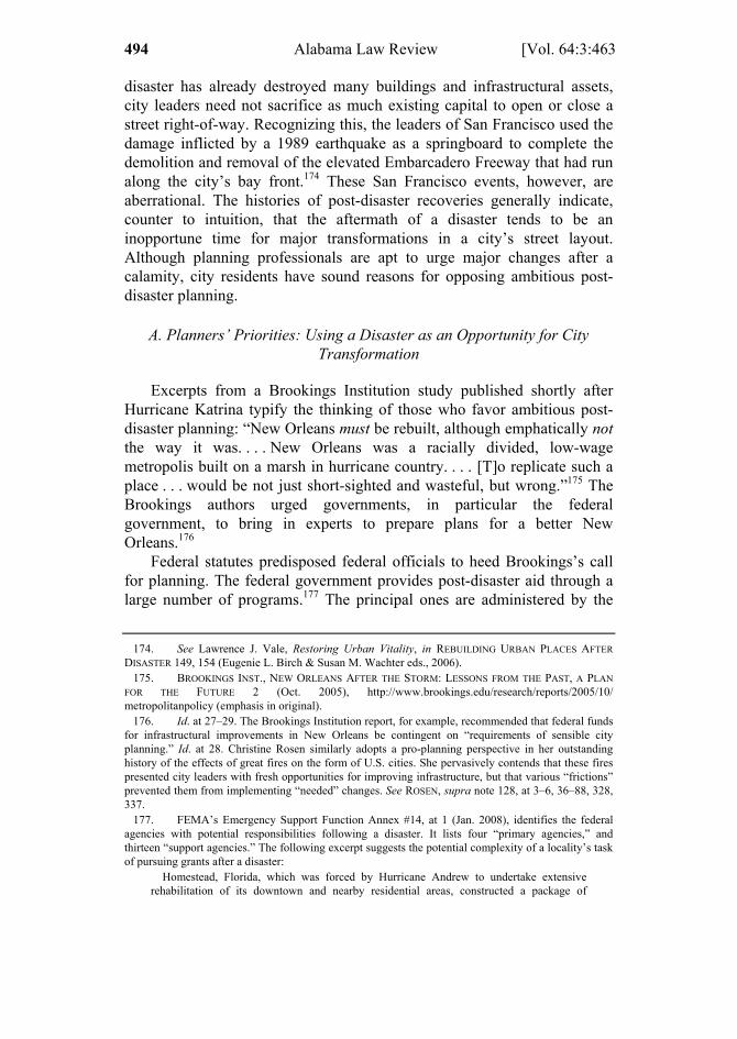
1 ELLICKSON 463 – 510 (DO NOT DELETE) 2/1/2013 12:23 PM
494 Alabama Law Review [Vol. 64:3:463
disaster has already destroyed many buildings and infrastructural assets, city leaders need not sacrifice as much existing capital to open or close a street right-of-way. Recognizing this, the leaders of San Francisco used the damage inflicted by a 1989 earthquake as a springboard to complete the demolition and removal of the elevated Embarcadero Freeway that had run along the city’s bay front.174 These San Francisco events, however, are aberrational. The histories of post-disaster recoveries generally indicate, counter to intuition, that the aftermath of a disaster tends to be an inopportune time for major transformations in a city’s street layout. Although planning professionals are apt to urge major changes after a calamity, city residents have sound reasons for opposing ambitious post-disaster planning.
A. Planners’ Priorities: Using a Disaster as an Opportunity for City Transformation
Excerpts from a Brookings Institution study published shortly after Hurricane Katrina typify the thinking of those who favor ambitious post-disaster planning: “New Orleans must be rebuilt, although emphatically not the way it was. . . . New Orleans was a racially divided, low-wage metropolis built on a marsh in hurricane country. . . . [T]o replicate such a place . . . would be not just short-sighted and wasteful, but wrong.”175 The Brookings authors urged governments, in particular the federal government, to bring in experts to prepare plans for a better New Orleans.176
Federal statutes predisposed federal officials to heed Brookings’s call for planning. The federal government provides post-disaster aid through a large number of programs.177 The principal ones are administered by the
174. See Lawrence J. Vale, Restoring Urban Vitality, in REBUILDING URBAN PLACES AFTER
DISASTER 149, 154 (Eugenie L. Birch & Susan M. Wachter eds., 2006). 175. BROOKINGS INST., NEW ORLEANS AFTER THE STORM: LESSONS FROM THE PAST, A PLAN
FOR THE FUTURE 2 (Oct. 2005), http://www.brookings.edu/research/reports/2005/10/ metropolitanpolicy (emphasis in original).
176. Id. at 27–29. The Brookings Institution report, for example, recommended that federal funds for infrastructural improvements in New Orleans be contingent on “requirements of sensible city planning.” Id. at 28. Christine Rosen similarly adopts a pro-planning perspective in her outstanding history of the effects of great fires on the form of U.S. cities. She pervasively contends that these fires presented city leaders with fresh opportunities for improving infrastructure, but that various “frictions” prevented them from implementing “needed” changes. See ROSEN, supra note 128, at 3–6, 36–88, 328, 337.
177. FEMA’s Emergency Support Function Annex #14, at 1 (Jan. 2008), identifies the federal agencies with potential responsibilities following a disaster. It lists four “primary agencies,” and thirteen “support agencies.” The following excerpt suggests the potential complexity of a locality’s task of pursuing grants after a disaster:
Homestead, Florida, which was forced by Hurricane Andrew to undertake extensive rehabilitation of its downtown and nearby residential areas, constructed a package of

1 ELLICKSON 463 – 510 (DO NOT DELETE) 2/1/2013 12:23 PM
2013] The Law and Economics of Street Layouts 495
Federal Emergency Management Agency (FEMA, an agency of the Department of Homeland Security) and the Department of Housing and Urban Development (HUD).178 Following statutory directives, federal officials are inclined to treat a natural disaster as a springboard for comprehensive planning, primarily, but not entirely, to make the community less vulnerable to a future disaster. Federal law requires a local government to prepare and approve a variety of “plans” to qualify for post-disaster federal financial aid.179 These local plans are then reviewed by state disaster-agency officials, who themselves are likely to have to prepare a state plan.180 Ultimately, federal officials typically must sign off on both state and local post-disaster plans.181 Federal statutes require localities to prepare these plans in part because both elected and appointed federal officials seek to avoid the waste of disaster-relief money and the
improvements under a newly created community redevelopment agency called Homestead Economic and Rebuilding Organization (HERO). Its five-year plan reveals heavy reliance on a combination of state and federal resources including various grant programs of the federal Economic Development Administration and grants for road improvements from the Florida Department of Transportation, in addition to the use of Community Development Block Grants (CDBG) and Housing Opportunities Made Equal (HOME) funds from the U.S. Department of Housing and Urban Development for residential redevelopment . . . .
AM. PLANNING ASS’N, PLANNING FOR POST-DISASTER RECOVERY AND RECONSTRUCTION—PLANNING
ADVISORY SERVICES REPORT 71 (2005), available at http://www.fema.gov/library/ viewRecord.do?id=1558.
178. FEMA’s activities are largely structured by the Robert T. Stafford Disaster Relief and Emergency Assistance Act, Pub. L. No. 93-288, as amended by the Disaster Mitigation Act of 2000, Pub. L. 106–390, codified at 42 U.S.C. §§ 5121–5207 (2006). HUD’s post-disaster aid primarily appears in the form of special Community Development Block Grants (CDBG). A locality typically has more discretion in spending a CDBG grant than a FEMA grant. See generally Phyllis Craig-Taylor, All That Glitters Is Not Gold: A Critique of Waivers and Congressional Mandates on Community Development Block Grants, 2 CHARLOTTE L. REV. 145 (2010) (describing CDBG program and criticizing it for not being sufficiently directed at low- and moderate-income households); John Jopling, Two Years After the Storm: The State of Katrina Housing Recovery on the Mississippi Gulf Coast, 77 MISS. L.J. 873, 877–82 (2008) (detailing eligibility for CDBG aid after Katrina).
179. A locality, and its disaster victims, are not eligible to receive FEMA hazard mitigation grants prior to the locality’s preparation of a “local mitigation plan.” See 44 C.F.R. §§ 201.6(a)(1), 206.434(b)(1) (2009). To receive funds under HUD’s CDBG programs, a locality must have both a “strategic plan” and an “action plan.” See 24 C.F.R. §§ 91.215, 91.220 91.515(a) (2012). See also ROBERT B. OLSHANSKY & LAURIE A. JOHNSON, CLEAR AS MUD: PLANNING FOR THE REBUILDING OF
NEW ORLEANS 49 (2010) (“The general consensus [in New Orleans immediately after Katrina] was that it was important to have a plan as soon as possible in order to make an argument for federal assistance.”).
180. See 44 C.F.R. § 201.3(c) (2009) (on state hazard mitigation plans); 44 C.F.R. § 201.6(d)(1) (on state review of local plans); see also OLSHANSKY & JOHNSON, supra note 179, at 108 (on the insistence of an agency of the State of Louisiana, post-Katrina, that each damaged locality prepare a comprehensive recovery plan “as a pre-requisite to certain funding,” implicitly federal).
181. This is the usual sequence for approval of, for example, a local hazard mitigation plan. See 44 C.F.R. § 201.6(d) (2009). But see id. at 201.6(d)(4) (allowing for possibility of exemption from federal review). After Katrina, Louisiana shaped the structure of one of its key agencies, the Louisiana Recovery Authority, in significant part to enable it to draw down federal post-disaster aid. See OLSHANSKY & JOHNSON, supra note 179, at 28.

1 ELLICKSON 463 – 510 (DO NOT DELETE) 2/1/2013 12:23 PM
496 Alabama Law Review [Vol. 64:3:463
embarrassment that that waste would cause.182 State and local officials, in turn, prepare post-disaster plans largely to qualify for federal aid, not necessarily because they themselves favor ambitious planning during the early stages of a recovery.183
After a disaster has struck, a local government commonly hires a planning firm to help it jump through the procedural and substantive hoops of federal law. Federal post-disaster grant funds can be used to pay for many of these planning services.184 FEMA’s website includes a link to the American Planning Association’s manual for post-disaster recovery, evidence of the close ties between the staff of the agency and members of the planning profession.185
Partly on account of self-selection, most planning professionals tend to be relatively supportive of physical changes in a city’s form and to have relative confidence in merits of top-down governmental control. As the Brookings Institution’s authors had hoped, there was a major outbreak of planning in New Orleans in the aftermath of Hurricane Katrina. Within five years, five major plans for the recovery of the City of New Orleans had been prepared, some ultimately at federal expense, others with financial support from foundations and other nonprofit entities.186 The rate of New Orleans’s recovery after Hurricane Katrina was, for a variety of reasons, unusually slow. The hurricane struck a city already in decline. Between 1960 and July 2005, just before Katrina landed, the City of New Orleans had lost thirty-one percent of its population.187 In addition, after Katrina, until the U.S. Army Corps of Engineers had completed the lengthy process of improving the city’s levees, some investors may have been inclined to
182. See, e.g., OLSHANSKY & JOHNSON, supra note 179, at 23–25, 59 (describing federal
concerns about reliability of Louisiana state government). 183. See id. at 108, 175, 209–15, 224, 238. 184. See id. at 30–32 (on federal funding of planning activities after Katrina). Up to seven percent
of a state’s hazard mitigation program grant from FEMA may be used to help pay for the preparation of state and local mitigation plans that satisfy federal planning criteria. 44 C.F.R. § 206.434(d)(1) (2009). The federal share of planning costs is normally capped at seventy-five percent, but a locality may be able to defray part of the remaining twenty-five percent out of federally provided Community Development Block Grant funds, a less restricted source.
185. AM. PLANNING ASS’N, supra note 177. 186. See OLSHANSKY & JOHNSON, supra note 179 (providing a history of these planning efforts).
The first post-Katrina plan to appear, Bring New Orleans Back (BNOB), was initiated by Mayor Ray Nagin, spearheaded by the Urban Land Institute (a nonprofit organization based in Washington, D.C.), and completed within a few months of the disaster. Id. at 42–68. The BNOB plan soon imploded, and was followed by the Lambert plans, id. at 79–81, 115–26; the Unified New Orleans Plan largely funded by the Rockefeller Foundation, id. at 81–113, 127–88, 196–215; the ACORN-University plan for the Lower Ninth Ward, id. at 175; and the target plans of Edward Blakely, appointed in 2006 to serve as the city’s Director of Recovery Management, id. at 193–95, 237. Copies of first three plans mentioned are available at http://www.nolaplans.com/.
187. R.W. Kates et al., Reconstruction of New Orleans after Hurricane Katrina: A Research Perspective, 103 PROC. NAT’L ACAD. SCI. 14,653, 14,658 (2006).
1 ELLICKSON 463 – 510 (DO NOT DELETE) 2/1/2013 12:23 PM
2013] The Law and Economics of Street Layouts 497
hold back.188 Nonetheless, the proliferation of comprehensive plans for New Orleans’s recovery, by prolonging uncertainties, contributed to the tardiness of the city’s recovery.189
B. Residents’ Principal Priority: The Rapid Rebuilding of the Familiar
Scholars who study disasters report that there tends to be, after each, a “rush to rebuild the familiar.”190 The armature of a city’s physical form is its street layout. The histories of the aftermaths of city disasters indicate that city leaders, under intense pressure from residents and landowners, typically decide to retain their basic pre-disaster street system. This Subpart recounts some of this history, and explains and defends residents’ preferences for reestablishing the status quo ante.
1. The Negligible Effects of Historically Notable Disasters on Street Layouts
Some selected vignettes, all but two from U.S. history, support the proposition that a city’s street locations are seldom reshuffled after a disaster.191 The first, in chronological order, is the aftermath of the Great Fire of London in 1666. For a large portion of the burned section that abutted the Thames, the famed architect Christopher Wren proposed that the former maze of streets be remapped into a grid pattern.192 Most London landowners desired to maintain their prior lot lines, however, and few streets ultimately were relocated.193
Historian Christine Rosen has examined the aftermaths of three fires that devastated the downtown of a U.S. city: Chicago in 1871, Boston in 1872, and Baltimore in 1904. In each instance, Rosen reports that proposals for major street reforms were introduced, but promptly rejected. Within a
188. In 2010, this $14.5 billion project was nearing completion. John Schwartz, New Orleans
Levees Nearly Ready, But Mistrusted, N.Y. TIMES, Aug. 23, 2010, at A1. Two years later, it was said to be “substantially complete.” John Schwartz, Vast Defenses Now Shielding New Orleans, N.Y. TIMES (June 14, 2012), http://www.nytimes.com/2012/06/15/us/vast-defenses-now-shielding-new-orleans. html?pagewanted=all.
189. CHAMLEE-WRIGHT, supra note 139, provides an especially insightful review of these events. 190. The phrase is drawn from R.W. Kates et al., supra note 187, at 14,656. 191. Residents also are eager to put pre-existing utility lines back in service. In 1992, Hurricane
Andrew felled, in the greater Miami area, poles for 3,000 miles of utility wires. Some observers saw this as an ideal opportunity to bury some of these lines. That option was quickly dismissed, however, because residents were anxious to have their electricity and telephone service restored. Betty Hearn Morrow & Walter Gillis Peacock, Disasters and Social Change, in HURRICANE ANDREW: ETHNICITY, GENDER, AND THE SOCIOLOGY OF DISASTERS 226, 239–40 (Walter Gillis Peacock, Betty Hearn Morrow & Hugh Gladwin, eds., 1997).
192. See GREATEST GRID, supra note 2, at 53–54. 193. Id.
1 ELLICKSON 463 – 510 (DO NOT DELETE) 2/1/2013 12:23 PM
498 Alabama Law Review [Vol. 64:3:463
few weeks of the Chicago fire, the Chicago Tribune suggested that the city’s grid street system be revamped to incorporate boulevards modeled after Haussmann’s in Paris, and two New York newspapers urged the opening of diagonal avenues to embellish the city’s “prosaic” street pattern.194 Critics of these proposals stressed the press of time and the scarcity of public funds.195 Chicago’s leaders quickly decided not to transfigure the city’s traditional grid.196 Eight months after the fire, the central business district of Chicago had been entirely rebuilt and sported buildings that generally were more spacious and fire-resistant than their predecessors had been.197
Within a few days of Boston’s massive fire, civil engineers proposed radical plans for the widening and straightening of many of the city’s atypically irregular downtown streets.198 Although these proposals garnered some political support, the Boston City Council rejected these radical changes at a meeting convened nine days after the fire had begun.199 The rebuilding of Boston proceeded rapidly. Within two years of the fire, the value of the buildings newly erected in the burned area exceeded by one-third the value of the area’s buildings prior to the fire.200
The aftermath of the Baltimore fire played out similarly. The Baltimore Sun suggested an ambitious set of street changes modeled after Haussmann’s Paris, but immediately backed off after the owners of lots in the burnt area protested.201 Baltimore’s business leaders promptly prepared a less ambitious plan that called for the widening of a number of downtown streets.202 The city implemented virtually all of these widenings over the next four years, without any federal financial aid.203 Two-and-a-half years after the fire, eighty-five percent of Baltimore’s burnt areas had been rebuilt.204
In 1906, much of San Francisco was leveled by a disastrous earthquake and ensuing fire. Just prior to this tragedy, a San Francisco civic group had
194. ROSEN, supra note 128, at 94, 124–25. 195. Id. at 124. 196. Id.; see also id. at 110–11 (providing maps indicating that the fire had no more than trivially
affected street locations). 197. See id. at 107, 114, 118; KAREN SAWISLAK, SMOLDERING CITY: CHICAGOANS AND THE
GREAT FIRE, 1871–1874, at 163 (1995). 198. ROSEN, supra note 128, at 187–90. 199. Id. at 191. Within a year of the fire, however, Boston had made some modest changes within
the burned district. The city widened portions of seventeen streets, and extended four others to eliminate dead ends. Id. at 218.
200. Id. at 244. 201. Id. at 264. 202. Id. at 250, 255–59. 203. Id. at 258–95. 204. Id. at 306.

1 ELLICKSON 463 – 510 (DO NOT DELETE) 2/1/2013 12:23 PM
2013] The Law and Economics of Street Layouts 499
commissioned Daniel Burnham, an icon of the City Beautiful movement, to propose a bold new layout for the city.205 Burnham’s plan, submitted a year prior to the earthquake, envisioned diagonal boulevards radiating from a new civic center.206 After the earthquake, however, San Francisco’s leaders ignored most of Burnham’s proposals and, deferring to popular sentiment, retained the great bulk of the city’s pre-existing street grid.207 Within three years of the earthquake, the city’s central business district had reemerged.208
The history of Hiroshima, Japan, also illustrates the potency of a familiar street layout. Figure 2 reproduces two aerial photographs, one taken shortly prior to the explosion of the atomic bomb that leveled the city in 1945, and the other in 2008. The photographs demonstrate that Hiroshima’s pre-disaster street pattern, a rectangular grid tilted slightly toward the northeast, was largely reestablished after the bombing. In the center of each photograph is the epicenter of the bomb blast, the northern tip of a long island in the Ōta River. Although the streets of this island have been adjusted to accommodate the creation of the Hiroshima Peace Memorial Park, most of the current bridges to this island are sited where a pre-1945 bridge had been.209
205. Brian J. Godfrey, Urban Development and Redevelopment in San Francisco, 87
GEOGRAPHICAL REV. 309, 313 (1997). 206. Id. 207. The city, however, did pursue Burnham’s idea of creating a civic center. On these events in
San Francisco, see Eugenie L. Birch, Learning from Past Disasters, in REBUILDING URBAN PLACES
AFTER DISASTER, supra note 174, at 132, 138; Godfrey, supra note 205, at 313. 208. Godfrey, supra note 205, at 313; see also Birch, supra note 207, at 138 (reporting that,
during the three years that followed the earthquake, 25,000 new buildings had been erected in San Francisco).
209. Within about twenty years of its devastation, Hiroshima reattained its relative rank in size among Japanese cities. Donald R. Davis & David E. Weinstein, Bones, Bombs, and Break Points: The Geography of Economic Activity, 92 AM. ECON. REV. 1269, 1282–83 (2002).

1 ELLICKSON 463 – 510 (DO NOT DELETE) 2/1/2013 12:23 PM
500 Alabama Law Review [Vol. 64:3:463
Figure 2: Street Layouts, Hiroshima, Japan, early 1945 and 2008
Source of 2008 aerial photograph: Google Earth.
The aftermath of Katrina in New Orleans provides a final illustration of
the inertial forces that tend to keep a pre-disaster street layout in place. One of the most devastated areas was the Lower Ninth Ward, an almost entirely African-American neighborhood in the eastern part of New Orleans. By 2010, the population of the Lower Ninth Ward had grown back to only twenty percent of the pre-Katrina population.210 The worst flood damage occurred in the quarter of the Lower Ninth that lies north of North Claiborne Avenue and west of Caffin Avenue.211 Before the flooding, this subarea included 110 blocks, all of them rectangular. It still does. Despite this neighborhood’s steep drop in population, New Orleans has taken no steps to close any of the streets that delineate these blocks.212
210. According to U.S. Census data, the population of the entire Lower Ninth Ward fell from
14,008 in 2000 to 2,842 in 2010. GREATER NEW ORLEANS COMMUNITY DATA CENTER, Lower Ninth Ward Statistical Area, http://www.gnocdc.org/NeighborhoodData/8/LowerNinthWard/index.html (last modified June 18, 2012).
211. See CHAMBLEE-WRIGHT, supra note 139, at 102, 163. 212. I reached this conclusion after comparing Google Earth maps of the area dated August 17,
2005 and November 30, 2011. The principal ambiguity was whether Law Street, now closed to traffic
Hiroshima, 2008
Hiroshima, 1945, prior to atomic bomb blast

1 ELLICKSON 463 – 510 (DO NOT DELETE) 2/1/2013 12:23 PM
2013] The Law and Economics of Street Layouts 501
2. Why Residents Resist Major Changes to Street Layouts After a Disaster
Roy Popkin, an expert on disasters who spent most of his career with the American Red Cross, has succinctly captured the lesson of these vignettes: “A basic error of the professional community is to assume that formal studies, plans and designs are requirements for reconstruction when there is already such a plan in the minds of the community inhabitants—the predisaster city.”213 Basic error is a strongly negative phrase, but Popkin is right to invoke it. The residents of a city ravaged by a disaster have at least two sound reasons for wanting to recreate the past.
The high costs of delay. Comprehensive planning after a disaster—the thrust of current federal policy—invariably causes delay and uncertainty.214 Time is of the essence after a calamity. Residents of the ravaged area, to mitigate the trauma they have suffered, are strongly disposed to immediately begin recovery efforts. Dislocated households and firms typically seek to move back as quickly as possible.215 After a calamity that has received widespread publicity, representatives of charities and construction workers may pour into the disaster zone. Within weeks, civic leaders typically assume cheerleading roles and forecast that life in the destroyed portions of the city will be, after recovery, even better than before.216 A city that fails to take advantage of this initial burst of enthusiasm jeopardizes the momentum of its recovery. Dislocated households and firms, for example, may put down roots elsewhere and never return.217
As economist Emily Chamlee-Wright has argued, after a disaster residents of a city benefit from being able to coordinate their expectations
for the one-block stretch between Caffin Avenue and Flood Street, was also closed prior to Katrina. The pre-Katrina Google Earth aerial shot suggests that it was. A “future land use map” that the City of New Orleans approved for the Lower Ninth Ward in 2010 also indicates that no street openings and closures are in the offing. CITY OF NEW ORLEANS, PLAN FOR THE 21ST CENTURY, Future Land Use Map, District 8 (August 2010), http://www.nolamasterplan.org/documentsandrresources.asp#C12. Many of the streets in this quarter, however, are abysmally maintained, in part because the city has been hoping to receive federal grants to help finance repairs.
213. Roy Popkin, Summary, in RECONSTRUCTION FOLLOWING DISASTER xxv, xxxiii (J. Eugene Haas, Robert W. Kates & Martyn J. Bowden eds., 1977).
214. Id.; see also CHAMLEE-WRIGHT, supra note 139; Robert W. Kates, Major Insights: A Summary and Recommendations, in RECONSTRUCTION FOLLOWING DISASTER, supra note 213, at 261, 267 (“ambitious planning is counterproductive”).
215. During the first three months that followed Katrina, the City of New Orleans denied former residents of portions of the Lower Ninth Ward access to their houses. On the dismay this caused, see CHAMLEE-WRIGHT, supra note 139, at 102.
216. See, e.g., R.W. Kates et al., supra note 187, at 14,657; Vale, supra note 174, at 155. 217. See, e.g., CHAMLEE-WRIGHT, supra note 139, at 167–69 (describing how the slow pace of
the recovery of the Lower Ninth Ward after Katrina prompted many households to permanently relocate from New Orleans to Houston).
1 ELLICKSON 463 – 510 (DO NOT DELETE) 2/1/2013 12:23 PM
502 Alabama Law Review [Vol. 64:3:463
about the course of recovery.218 In particular, the owner of a pre-disaster lot cannot be expected to start rebuilding, much less succeed in securing mortgage financing, until the owner knows the locations of the rights-of-way that will serve that lot. On the issue of street locations, there is one prominent Schelling focal point—the street layout that was in place prior to the disaster.219 Shifting around a street’s location invariably reshapes the boundaries of all lots that abut it. Moving a street typically enhances the value of some lots and detracts from the value of others. If city leaders were to suggest that street layouts were up for revamping in the aftermath of a disaster, competing factions of lot owners would likely end up fighting drawn-out political battles over rival plans.220 The pursuit of ambitious street changes after a disaster thus risks seriously prolonging lot owners’ uncertainties. The historical vignettes presented, from the Great Fire of London in 1666 onward, reveal that lot owners quickly grasp these truths. They lobby city leaders to adopt the only focal policy: keeping streets where they had been.
Psychological dispositions to recreate what has been lost. Residents’ desires to “rush to rebuild the familiar” likely arise not only from their aversions to delay, but also from intense, and perhaps fleeting, emotional dispositions. As already noted, cognitive psychologists such as Tversky and Kahneman have famously asserted that a person is apt to value the recovery of an object or condition perceived as “lost” more highly than the “gain,” from scratch, of the same object or condition.221 After a disaster, residents displaced from a neighborhood are likely to regard the restoration of their neighborhood’s street layout as the recovery of a loss. If loss-averse, they would likely value that recovery more highly than the gain of an alternative street layout that outside observers would regard to be just as meritorious as the old one. Some observers assert that residents of a working-class neighborhood have particularly strong tastes for restoring physical conditions that had previously provided them a “sense of place.”222
These sorts of psychological dispositions helped prevent the City of New Orleans from closing streets in the most lightly repopulated subareas
218. See id. at 133–37, 166, 171–72. 219. THOMAS C. SCHELLING, THE STRATEGY OF CONFLICT 57 (1960). On Schelling’s thoughts
on the coordination of expectations after a disaster, see CHAMLEE-WRIGHT, supra note 139, at 40. 220. A street-location battle is likely to prompt the involvement of political factions consisting of
owners and occupants of land who had never previously joined together to engage in political action. These factions’ lack of experience may further reduce the odds of their achieving a quick political settlement.
221. See, e.g., Amos Tversky & Daniel Kahneman, Loss Aversion in Riskless Choice: A Reference Dependent Model, 106 Q.J. ECON. 1039 (1991).
222. See, e.g. CHAMLEE-WRIGHT, supra note 139, at 104–05, 109–14 (describing residents’ fondness of the Lower Ninth Ward); ROSEN, supra note 128, at 166 (referring to workers’ “emotional and practical attachments” to neighborhoods in pre-fire Chicago).

1 ELLICKSON 463 – 510 (DO NOT DELETE) 2/1/2013 12:23 PM
2013] The Law and Economics of Street Layouts 503
of the Lower Ninth Ward. Immediately after Katrina, several outsiders recommended that the federal government consider not funding the reconstruction of the most devastated neighborhoods of the city.223 The city’s first post-Katrina plan, Bring New Orleans Back, was completed a few months after the disaster.224 It included maps showing green dots of new open space in many of the worst-flooded areas.225 Local politicians and activists construed these dots as evidence that planners intended to force the downsizing of neighborhoods such as the Lower Ninth Ward.226 There arose a chorus of opposition, including voices of displaced households eager to move back to their former neighborhoods.227 Mayor Ray Nagin backed away from the possibility of downsizing, and within four months of the storm, the idea was dead as a political matter.228 As noted, the most damaged quarter of the Lower Ninth Ward, which seems unlikely soon to recover even half its pre-Katrina population, retains all of its pre-Katrina streets.229
C. The Doubtful Merits of Preparing a Transformative Street Plan After a Disaster
1. The Benefits and Costs of Ambitious Post-Disaster Planning
For some aspects of a city’s physical recovery, centralized planning may be cost-justified.230 Prior to the disaster, the forces of path dependence may have perpetuated, for example, street layouts no longer suited to current conditions.231 A disaster destroys existing physical capital, thereby reducing the marginal capital costs of carrying out a major revamping. Recognition of this reality gives rise to the common intuition that a disaster
223. See, e.g., Edward L. Glaeser, Should the Government Rebuild New Orleans, Or Just Give Residents Checks? 4 ECONOMISTS’ VOICE (Sept. 2005); Robert W. Hahn, The Economics of Rebuilding Cities, 4 ECONOMISTS’ VOICE (Sept. 2005) (noting House Speaker Dennis Hastert’s mention of this option).
224. See supra note 186. 225. See OLSHANSKY & JOHNSON, supra note 179, at 57. 226. CHAMLEE-WRIGHT, supra note 139, at 134; OLSHANSKY & JOHNSON, supra note 179, at 52,
57–58. 227. CHAMLEE-WRIGHT, supra note 139, at 134–35. Local politicians, who are generally fearful
of losing familiar constituents, typically intensely support restoration of the status quo ante. 228. OLSHANSKY & JOHNSON, supra note 179, at 44–49. 229. See supra notes 210–212 and accompanying text. 230. On the trade-offs between speed of recovery and comprehensive planning, compare
CHAMLEE-WRIGHT, supra note 139, at 166, 171 (generally stressing the advantages of speed), with OLSHANSKY & JOHNSON, supra note 179, at 217–19, 237 (defending the pause to prepare the UNOP plan for New Orleans). See also Marla Nelson, Renia Ehrenfeucht & Shirley Laska, Planning, Plans, and People: Professional Expertise, Local Knowledge, and Governmental Action in Post-Hurricane Katrina New Orleans, 9 CITYSCAPE 23 (No. 3, 2007).
231. See supra text accompanying notes 115–172.
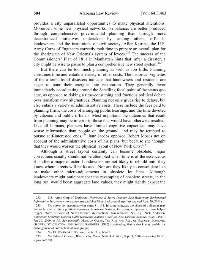
1 ELLICKSON 463 – 510 (DO NOT DELETE) 2/1/2013 12:23 PM
504 Alabama Law Review [Vol. 64:3:463
provides a city unparalleled opportunities to make physical alterations. Moreover, some new physical networks, on balance, are better produced through comprehensive governmental planning than through more decentralized initiatives undertaken by, among others, officials, landowners, and the institutions of civil society. After Katrina, the U.S. Army Corps of Engineers correctly took time to prepare an overall plan for the shoring up of New Orleans’s system of levees.232 The success of the Commissioners’ Plan of 1811 in Manhattan hints that, after a disaster, a city might be wise to pause to plan a comprehensive new street system.233
But there can be too much planning as well as too little. Planning consumes time and entails a variety of other costs. The historical vignettes of the aftermaths of disasters indicate that landowners and residents are eager to pour their energies into restoration. They generally favor immediately coordinating around the Schelling focal point of the status quo ante, as opposed to risking a time-consuming and fractious political debate over transformative alternatives. Planning not only gives rise to delays, but also entails a variety of administrative costs. These include the fees paid to planning firms, the costs of arranging public hearings, and the time devoted by citizens and public officials. Most important, the outcomes that result from planning may be inferior to those that would have otherwise resulted. Like all humans, planners have limited cognitive capacities, may have worse information than people on the ground, and may be tempted to pursue self-interested ends.234 Jane Jacobs opposed Robert Moses not on account of the administrative costs of his plans, but because she thought that they would worsen the physical layout of New York City.235
Although a street layout certainly can become obsolete, major corrections usually should not be attempted when time is of the essence, as it is after a major disaster. Landowners are not likely to rebuild until they know where streets will be located. Nor are they likely to consolidate lots or make other micro-adjustments in obsolete lot lines. Although landowners might anticipate that the revamping of obsolete streets, in the long run, would boost aggregate land values, they might rightly expect the
232. U.S. Army Corp of Engineers, Hurricane & Storm Damage Risk Reduction: Background
Information, http://www.mvn.usace.army.mil/hps2/hps_background.asp (last updated Aug. 29, 2011). 233. See supra text accompanying notes 81–114. In some contexts, the shock of a disaster may
favorably alter a city’s political dynamics. Hurricane Katrina, for example, appears to have helped trigger reform of some of New Orleans’s dysfunctional bureaucracies. See, e.g., Nick Anderson, Education Secretary Duncan Calls Hurricane Katrina Good for New Orleans Schools, WASH. POST, Jan 30, 2010, at A6. See generally MANCUR OLSEN, THE RISE AND FALL OF NATIONS: ECONOMIC
GROWTH, STAGFLATION, AND SOCIAL RIGIDITIES (1982) (contending that a shock may enable the dislodgement of entrenched interest groups).
234. See ELLICKSON & BEEN, supra note 11, at 65–71. 235. See Edward Glaeser, What a City Needs, NEW REPUBLIC, Sept. 9, 2009 (reviewing FLINT,
supra note 68).
1 ELLICKSON 463 – 510 (DO NOT DELETE) 2/1/2013 12:23 PM
2013] The Law and Economics of Street Layouts 505
size of that increment to be modest.236 It is plain that, historically, landowners have tended to lobby for reaffirmation of the basic pre-disaster street layout, and city politicians have tended to accede to their pleas.
2. How the Federalization of Post-Disaster Aid Has Tended to Slow Recoveries
A century or more ago, within a period of three years or less following a disastrous fire, Chicago, Boston, Baltimore and San Francisco each had largely rebuilt its downtown.237 In the twenty-first century, post-disaster recoveries, such as New Orleans’s after Katrina, or New York’s after 9/11, have been slower.238 Statutes enacted since the 1960s have contributed to this pattern. In this context, the environmental and planning statutes that honor the “do no harm” principal239 are seldom a major source of delay, in part because many of these statutes authorize government officials to exempt post-disaster decisions from the statute’s coverage.240
Instead, the delays stem, in significant part, from the national policy of funding much of post-disaster financial aid at the federal level. A century or more ago, after the Chicago, Boston, Baltimore, and San Francisco fires, funds for reconstruction were derived almost entirely from private capital, payouts on insurance policies, and subventions from the municipality’s own treasury.241 In these historical instances, state governments provided at most minor financial support for rebuilding. In the immediate aftermath of the worst of these calamities, such as San Francisco’s, the federal government did deliver emergency rations and tents, and provide troops to
236. Landowners in a post-disaster city would likely not expect an increment as high as forty-two
percent, the gain that Fujiki, supra note 114, implies might be achievable in parts of Tokyo. 237. See supra text accompanying notes 194–208. 238. See supra text accompanying notes 186–189. 239. See supra text accompanying notes 165–173. 240. See Julia C. Webb, Note, Responsible Response: Do the Emergency and Major Disaster
Exceptions to Federal Environmental Laws Make Sense from a Restoration and Mitigation Perspective? 31 WM. & MARY ENVT’L L. & POL’Y REV. 529, 532 (2007). On the controversy over whether an environmental lawsuit filed prior to Hurricane Katrina delayed the construction of an adequate levee system for New Orleans, see Douglas A. Kysar & Thomas O. McGarity, Did NEPA Drown New Orleans? The Levees, the Blame Game, and the Hazards of Hindsight, 56 DUKE L.J. 179 (2006).
241. See ROSEN, supra note 128, at 175 (reporting that, after the Great Fire, funds for the rebuilding of Chicago came mostly from private persons or organizations, or from the city itself, and were topped off by a bit of state aid); id. at 202–07, 244 (indicating that the rebuilding in Boston was financed almost entirely locally, with the federal government’s involvement restricted to the building of a new post office); id. at 258–64 (stating that the reconstruction in Baltimore was entirely city financed, and that the federal government affirmatively declined to contribute). On the paucity of federal aid for the rebuilding of San Francisco after 1906, see Rutherford H. Platt, Natural Hazards of the San Francisco Bay Mega-City: Trial by Earthquake, Wind, and Fire, in CRUCIBLES OF HAZARD: MEGA-CITIES AND DISASTERS IN TRANSITION 335, 343 (James K. Mitchell ed., 1999).

1 ELLICKSON 463 – 510 (DO NOT DELETE) 2/1/2013 12:23 PM
506 Alabama Law Review [Vol. 64:3:463
help keep order.242 But, during the rebuilding stage, federal aid seldom went beyond appropriations to replace federal buildings that had been destroyed.243
In the early twenty-first century, the federal government is the predominant provider of public post-disaster financial grants.244 Federal funding has some unarguable advantages. It spreads disaster risks from a narrower set of loss-bearers to all federal taxpayers. In addition, in some instances the federal government may have a comparative advantage in mobilizing expert help after a disaster, which, by definition, is an unusual event that might overwhelm the capabilities of municipal and state officials.
But the availability of federal aid also has significant disadvantages. It tends to crowd out other forms of aid, may dull local and state sensitivity to the magnitude of risks, and weaken political pressure against waste of post-disaster aid. In particular, the availability of federal money, too plentiful for local officials to resist, is likely to slow a post-disaster recovery.245 As noted, to qualify for federal aid, a locality must devote time and energy during the post-recovery period to the preparation of plans.246
Within weeks after the tornado struck on April 27, 2011, the City of Tuscaloosa had hired BNIM, a planning firm with a branch office in Kansas City, Missouri.247 BNIM submitted a draft plan, Tuscaloosa Forward, in mid-July.248 Both FEMA’s and HUD’s regulations require that the locality give members of the public opportunities to comment on the plan before it is officially approved.249 After the period of public comment, the Tuscaloosa City Council approved a revised version of the plan on September 6, 2011.250 Yet, more than a year after the tornado, the city was still seeking to satisfy federal procedural requirements for approval of its
242. See 1906 Earthquake: The U.S. Army’s Role, NAT’L PARK SERVICE, available at
www.nps.gov/goga/planyourvisit/upload/sb-1906-earthquake.pdf. 243. See supra note 241. 244. See supra notes 177–178 and accompanying text. 245. See, e.g., OLSHANSKY & JOHNSON, supra note 179, at 229–30 (asserting that federal red tape
slowed recovery of New Orleans). 246. See supra notes 179–185 and accompanying text. 247. See Jason Morton, Consultants Outline Vision for Rebuilding City, TUSCALOOSA NEWS,
June 15, 2011, at 1A. 248. Jason Morton, Residents Helped Guide Effort to Rebuild, TUSCALOOSA NEWS, Apr. 29,
2012, at 1A. Note 6, supra, provides a link to the August 1, 2011 version of this plan. 249. See 24 C.F.R. § 91.225(b)(1) (2012) (requiring locality applying for a CDBG grant to
provide for “citizen participation”); 44 C.F.R. § 201.6(b) (2012) (requiring locality preparing a local mitigation plan for FEMA to provide an “open public involvement process”).
250. Jason Morton, Tuscaloosa Forward Plan Passes Unanimously, TUSCALOOSA NEWS, Sept. 7, 2011, at 1A.
1 ELLICKSON 463 – 510 (DO NOT DELETE) 2/1/2013 12:23 PM
2013] The Law and Economics of Street Layouts 507
“Action Plan.”251 The inducements of federal aid virtually compelled Tuscaloosa to choose a planned, but delayed, recovery, over a less-planned, but speedier, one. Residents of Tuscaloosa would know better than I whether or not the federal government has done them a favor.252
The speed of Tuscaloosa’s planning certainly compares favorably to New Orleans’s after Katrina. There, Renee Lewis, a neighborhood activist, amusingly articulated her frustrations at a public hearing:
The plan we had was the framework for the plan that would be the plan to shape the plan that was going to allow us to plan for the plan that would be our instrument implementation plan and then we would plan on how to get the money in order to get the plan moved from plan to adoption to—and we haven’t laid one damn brick.253
Rushing to rebuild the familiar may indeed be preferable to pausing to engage in political battles over the nature of the ideal.
VI. SUMMARY AND CONCLUSION: STREET LAYOUTS, ATTORNEYS, AND TUSCALOOSA
My objective in this lecture has been to broaden lawyers’ perspectives on the layout of downtown streets. When a city chooses to open or close a street, attorneys execute the transaction. Lawyers employed by either municipalities or real estate developers can benefit from having an analytical framework for recognizing whether a street change is meritorious. I have contended that, as a first cut, a change in the layout of streets would be advantageous if it would raise the aggregate market value of the private lots embedded within the street system. By this criterion, the grid layout characteristic of most U.S. central cities—despite its aesthetic shortcomings—wins high marks. A grid pattern helps people know where they are and how they can get to their next destination. A grid of rectangular blocks also encourages subdividers to create rectangular lots, the shapes that generate the fewest boundary disputes and are easiest for building.
251. See CITY OF TUSCALOOSA, ALABAMA, CDBG–DISASTER RECOVERY ACTION PLAN, DRAFT
FOR PUBLIC REVIEW 5 (undated), available at http://www.tuscaloosa.com/Assets/stimulus-project-information/action%20plan.pdf (stating that, following a period to allow for public comment, the city intended to submit the action plan to HUD on or about July 13, 2012).
252. At a City Council meeting on August 23, 2011, many business owners in Tuscaloosa complained that the planning process had been delaying their efforts to reopen. Morton, supra note 248.
253. CHAMLEE-WRIGHT, supra note 139, at 136.
1 ELLICKSON 463 – 510 (DO NOT DELETE) 2/1/2013 12:23 PM
508 Alabama Law Review [Vol. 64:3:463
The process of street relocation rarely generates much business for attorneys because street locations tend to remain fixed. This path dependence has arisen historically from both the capital costs of moving streets and residents’ psychological dispositions to stick with the status quo. Statutes enacted since the 1960s, however, have given opponents of street change many new legal weapons. As a consequence, street locations have become more firmly implanted. In a U.S. city, it is hard to imagine the rise, at least within the next several decades, of a street-shaker comparable to Baron Haussmann in Paris or Robert Moses in New York City.
Because Tuscaloosa is in the process of recovering from a devastating tornado, I have included remarks on the effects of a disaster on prospects for a street revamping. As it happens, BNIM, the planning firm that Tuscaloosa hired after the disaster, proposed that the city open, within the path that the tornado had taken, a new five-mile-long greenway featuring a pavement for pedestrians and bicyclists.254 This proposal, later renamed CityWalk, illustrates the inclination of members of the planning profession to regard a disaster as an unrivalled opportunity for change. Officials of the City of Tuscaloosa have since endorsed the opening of this new right-of-way.255
I know far too little about Tuscaloosa to offer an opinion on the merits of the CityWalk project. Historically, the residents of a city struck by disaster have tended to be strongly inclined to retain their pre-disaster street layout.256 Some Tuscaloosans undoubtedly will oppose the greenway on the ground that the proposed project will both slow rebuilding and deny them recovery of their former sense of place. Officials of the City of Tuscaloosa who favor CityWalk should consider the desirability of declaring their unconditional commitment to completing it. Currently, the city’s commitment to the project may be perceived as contingent on the uncertain success of city applications for federal or state grants-in-aid. If so, owners of lots along the proposed CityWalk may put their rebuilding plans on hold until these funding uncertainties have been resolved. The armature of a city’s form is its street layout. A city helps itself when it informs its citizens where its streets will be.257
254. See TUSCALOOSA FORWARD, supra note 6, at 87 (proposing tentative location of a
“Conceptual Greenway Path”). 255. See CITY OF TUSCALOOSA, supra note 251, at 13–16, app. E (proposing to devote part of any
CDBG Disaster Recovery allocation to the costs of creating portions of CityWalk). 256. See supra text accompanying notes 191–229. 257. See CHAMLEE-WRIGHT, supra note 139, at 133–37 (on how “regime uncertainty” after
Hurricane Katrina caused many residents of New Orleans to play a waiting game, which slowed the recovery of the city); see also David T. Beito & Daniel J. Smith, Tornado Recovery: How Joplin Is Beating Tuscaloosa, WALL ST. J., Apr. 14–15, 2012, at A13 (contending that Tuscaloosa’s post-disaster recovery has been slowed by its overly top-down approach and pursuit of federal funding).

1 ELLICKSON 463 – 510 (DO NOT DELETE) 2/1/2013 12:23 PM
2013] The Law and Economics of Street Layouts 509
Appendix A: Streets Closings in Ten Large U.S. Cities Table A-1 provides figures on the extent of change, between c.1850
and c.2011, in the street systems in the downtowns of the ten most populous U.S. cities in 1860. For each city, a major street intersection, lying at least 1500 feet from any body of water, was selected as the epicenter of the downtown area. To circumscribe a study area, a square, oriented north-south and with 3000 feet on each side, was centered on this epicenter. For each city, this square was drawn on two maps: a baseline map dated as close as possible to 1850, and a contemporary map, accessed in early 2012 on Google Earth.
There are numerous potential methods of measuring change in a street system. Table A-1 takes no account of street openings, street widenings, and changes in the vertical alignments of streets. It instead measures only street closures, which, during the study period, were far more common than street openings. Each street in c.1850 was equated with the midline of its right-of-way at that time. A minor passageway identified on a city’s baseline map as an “alley” or “court” was not counted as a street, nor was any unnamed right-of-way. (As notations in the table indicate, Baltimore, Chicago, Cincinnati, and Philadelphia each closed half or more of the minor passageways during the period studied.) A stretch of street was deemed to have been closed during the study period if its midline in c.1850 did not fall within a street right-of-way appearing on the Google map accessed in 2012. To compute the percentages shown, the total length of a city’s street closures was divided by the total length of the midlines of its streets on the baseline map. Although care was taken, the figures are approximations.
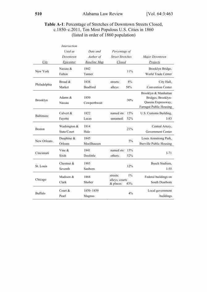
1 ELLICKSON 463 – 510 (DO NOT DELETE) 2/1/2013 12:23 PM
510 Alabama Law Review [Vol. 64:3:463
Table A-1: Percentage of Stretches of Downtown Streets Closed, c.1850–c.2011, Ten Most Populous U.S. Cities in 1860
(listed in order of 1860 population)
City
Intersection
Used as
Downtown
Epicenter
Date and
Author of
Baseline Map
Percentage of
Street Stretches
Closed
Major Downtown
Projects
New York
Nassau &
Fulton
1842
Tanner 11%
Brooklyn Bridge,
World Trade Center
Philadelphia
Broad &
Market
1838
Bradford
streets: 8%
alleys: 58%
City Hall,
Convention Center
Brooklyn Adams &
Nassau
1850
Cowperthwait 30%
Brooklyn & Manhattan Bridges, Brooklyn-
Queens Expressway, Farragut Public Housing
Baltimore
Calvert &
Fayette
1822
Lucas
named sts: 15%
unnamed: 52%
U.S. Customs Building,
I-83
Boston
Washington &
State/Court
1814
Hale 21%
Central Artery,
Government Center
New Orleans Dauphine &
Orleans
1845
Moellhausen 5%
Louis Armstrong Park,
Iberville Public Housing
Cincinnati
Vine &
Sixth
1841
Doolittle
named sts: 15%
others: 52% I-71
St. Louis
Chestnut &
Seventh
1903
Sanborn 12%
Busch Stadium,
I-55
Chicago Madison &
Clark
1868
Shober
streets: 1% alleys, courts & places: 43%
Federal buildings on
South Dearborn
Buffalo
Court &
Pearl
1850–1859
Magnus 4%
Local government
buildings