the mayors’ institute on city design - cmu.edu reports... · mayor of the city of huntington...
TRANSCRIPT
The National Endowment for the Arts
The United States Conference of Mayors
The American Architectural Foundation
Meeting Summary
Midwest SessionPittsburgh, PennsylvaniaFebruary 10-12, 2010
The Mayors’ Institute on City Design


MICD Midwest | February 10-12, 2010Meeting Summary
iii
The Mayors’ Institute on City Design is a program that conducts a series of intimate, closed-door two-day symposia intended to offer a small group of invited mayors a better understanding of the de-sign of American cities. Participation is limited to eighteen to twenty people: half are mayors and half are urban design experts and other resource people.
The mayors represent a wide variety of cities and bring a wide variety of design issues to the table. The resource team members range from architects and planners to public policy specialists, develop-ers, preservationists, sociologists, lawyers, and historians, and include practicing professionals and distinguished academics.
The institute format encourages a high degree of participation and exchange. Each mayor presents a design issue from his or her city, which is analyzed by the other mayors and the design professionals who, working together, discuss how an appropriate design process can help solve the problem. The exchange between mayors and the resource team sparks lively debate, opens new perspectives, and leads to creative proposals for solutions.
The resource team members also make presentations on general principles of urban design. These provide important background for the mayors on planning, urban design, landscape design, and the role of developers. The mayors and designers discuss both generic and specific problems facing cities today, and explore how the public and private sectors can work together to improve the conditions of our cities. Particular emphasis is placed on how the design process works, and on the importance of the mayor as city designer.
The Mayors’ Institute on City Design is a leadership initiative of the National Endowment for the Arts, in partnership with the United States Conference of Mayors, and the American Architectural Foundation.
This document is the meeting summary of the Midwest Session of the Mayors’ Institute on City Design, hosted by Donald K. Carter, Director of the Remaking Cities Institute, Carnegie Mellon University, Pittsburgh, Pennsylvania on February 10-12, 2010. This summary draws on the back-ground materials prepared for the session’s briefing book as well as on the actual presentations made during the session.
Mayors’ Institute on City Design

MICD Midwest | February 10-12, 2010 Meeting Summary
iv
MICD Midwest | February 10-12, 2010Meeting Summary
iii
Table of Contents
Mayors & Cities Page 1
Resource Team Page 2
MICD Staff & Sponsors Page 3
Host Team Page 4
Agenda Page 5
Photos of Events and Venues Page 8
Charleston, West Virginia Page 12The Honorable Danny Jones
Racine, Wisconsin Page 16The Honorable John T. Dickert
Huntington, West Virginia Page 20The Honorable Kim Wolfe
Springfield, Illinois Page 24 The Honorable Timothy J. Davlin
Kenosha, Wisconsin Page 28The Honorable Keith G. Bosman
Canton, Ohio Page 31The Honorable William J. Healy II
Elkhart, Indiana Page 34The Honorable Dick Moore
Midsize Cities, Big Ideas Page 38Donald K. Carter

MICD Midwest | February 10-12, 2010 Meeting Summary
iv

MICD Midwest | February 10-12, 2010Meeting Summary
1
Mayors & Cities
The Honorable Keith G. BosmanMayor of the City of Kenosha625 52nd Street, Room 300Kenosha, Wisconsin 53140Tel: (262) 653-4000 Fax: (262) 653-4010
The Honorable Timothy J. DavlinMayor of the City of SpringfieldMunicipal Center EastSpringfield, Illinois 62701Tel: (217) 789-2200Fax: (717) 789-2109
The Honorable John T. DickertMayor of the City of Racine 730 Washington Avenue Racine, Wisconsin 53403Tel: (262) 636-9111Fax: (262) 636-9570
The Honorable William J. Healy IIMayor of the City of CantonCanton City Hall218 Cleveland Avenue SWCanton, Ohio 44702Tel: (330) 438-4300Fax: (330) 489-3282
The Honorable Danny JonesMayor of the City of Charleston501 Virginia Street EastCharleston, West Virginia 25301Tel: (304) 348-8174 Fax: (304) 348-8034
The Honorable Dick MooreMayor of the City of ElkhartMunicipal Building229 S. Second StreetElkhart, Indiana 46516Tel: (574) 294-5471 Ext. 240Fax: (574) 293-7964
The Honorable Kim WolfeMayor of the City of HuntingtonHuntington City Hall800 5th AvenueHuntington, West Virginia 25717Tel: (304) 696-5540Fax: (304) 696-4493

MICD Midwest | February 10-12, 2010 Meeting Summary
2
Resource Team
Frederick R. Bonci, RLA, ASLAFounding PartnerLaQuatra Bonci Associates95 South Tenth StreetPittsburgh, Pennsylvania 15203Tel: (412) 488-8822Fax: (412) 488-8825Email: [email protected]
William A. Gilchrist, FAIASenior AssociateEDAW/AECOM817 West Peachtree Street, Suite 770Atlanta, Georgia 30308Tel: (404) 478-3743Fax: (404) 965-9605Email: [email protected]
The Honorable William H. Hudnut IIISenior Resident Fellow EmeritusUrban Land InstituteManaging Partner Bill Hudnut Consultants LLC 4206 Thornapple StreetChevy Chase, Maryland 20815Tel: (202) 834-8815Email: [email protected]
Paul Hardin Kapp, AIA, LEED APAssociate ProfessorHistory & PreservationThe University of Illinois at Urbana-ChampaignSchool of Architecture MC-624 408A608 Lorado Taft DriveChampaign, Illinois 61820Tel: (217) 244-3531 Fax: (217) 333-5240Email: [email protected]
Walter Kulash, P.E.Transportation Planner32 Blands Knob RoadP.O. Box 252Little Switzerland, North Carolina 28749Tel: (828) 843-6552Email: [email protected]
Dr. Deborah A. Lange, P.E., ASCEExecutive DirectorSteinbrenner Institute for Environmental Education and ResearchHamburg Hall 12094800 Forbes Avenue Carnegie Mellon UniversityPittsburgh, Pennsylvania 15213Tel: (412) 443-7121Fax: (412) 268-7813Email: [email protected]
Vivian Loftness, FAIAUniversity ProfessorSchool of Architecture and Center for Building Performance & DiagnosticsCarnegie Mellon UniversityPittsburgh, Pennsylvania 15213Tel: (412) 268-2350Fax: (412) 268-6129Email: [email protected]
Anne-Marie Lubenau, AIAPresident & CEOCommunity Design Center of Pittsburgh938 Penn AvenuePittsburgh, Pennsylvania 15222Tel: (412) 391-4144Fax: (412) 391-1282Email: [email protected]
MICD Midwest | February 10-12, 2010Meeting Summary
3
MICD Staff & Sponsors
Story K. BellowsDirectorMayors’ Institute on City Design1620 Eye Street NW, Third FloorWashington, District of Columbia 20006Tel: (202) 463-1390Fax: (202) 463-1392Email: [email protected]
Nicholas FosterDeputy DirectorMayors’ Institute on City Design1620 Eye Street NW, Third FloorWashington, District of Columbia 20006Tel: (202) 463-1391Fax: (202) 463-1392Email: [email protected]
Ronald BoglePresident & CEOAmerican Architectural Foundation1799 New York Avenue NWWashington, District of Columbia 20006Tel: (202) 626-7302Fax: (202) 626-7420Email: [email protected]
Tom CochranCEO & Executive DirectorUnited States Conference of Mayors 1620 Eye Street, Northwest Washington, District of Columbia 20006Tel: (202) 293-7330 Fax: (202) 293-2352 Email: [email protected]
Rocco LandesmanChairmanNational Endowment for the Arts1100 Pennsylvania Ave. NWWashington, District of Columbia 20506Tel: (202) 682-5414 Fax: (202) 682-5639 Email: [email protected]
Tom McClimonManaging DirectorUnited States Conference of Mayors1620 Eye Street NW, Fourth FloorWashington, District of Columbia 20006Tel: (202) 861-6729Fax: (202) 293-2352Email: [email protected]

MICD Midwest | February 10-12, 2010 Meeting Summary
4
Host Team
Donald K. Carter, FAIA, FAICP, LEED APDavid Lewis Director of Urban Design and Regional EngagementRemaking Cities InstituteCarnegie Mellon UniversityCollege of Fine Arts 201Pittsburgh, Pennsylvania 15213Tel: (412) 268-6255Mobile: (412) 996-1312Fax: (412) 268-7819Email: [email protected]
Session Host and Moderator
Christine Brill, AIAAdjunct Associate ProfessorSchool of ArchitectureCarnegie Mellon UniversityCollege of Fine Arts 201Pittsburgh, Pennsylvania 15213Tel: (412) 268-2354Fax: (412) 268-7819Email: [email protected]
Faculty Site Visitor: Elkhart, Indiana; Kenosha, Wisconsin; Racine, Wisconsin; and Springfield, Illinois
John Folan, AIA, LEEP APT. David Fitz-Gibbon Professor of Architecture School of ArchitectureCarnegie Mellon UniversityCollege of Fine Arts 201Pittsburgh, Pennsylvania 15213Tel: (412) 268-6260Fax: (412) 268-7819Email: [email protected]
Faculty Site Visitor: Canton, Ohio
Elise GattiResearch AssociateRemaking Cities InstituteCarnegie Mellon UniversityCollege of Fine Arts 201Pittsburgh, Pennsylvania 15213Tel: (412) 268-9553Fax: (412) 268-7819Email: [email protected]
Faculty Site Visitor: Charleston, West Virginia and Huntington, West Virginia

MICD Midwest | February 10-12, 2010Meeting Summary
5
Mayors’ Institute on City Design - Midwest SessionPittsburgh, PennsylvaniaFebruary 10 – 12, 2010
Final Agenda
Wednesday, February 10, 2010
From noon Check-in: Renaissance Hotel, 107 6th Street, Downtown Pittsburgh
3:00 pm – 5:00 pm Meet in hotel lobby for tour of Cultural District
5:00 pm Return to Renaissance Hotel
6:00 – 6:45 pm Cocktail reception at Renaissance Hotel (Rhapsody Ballroom Foyer, 3rd Floor)
6:45 – 7:45 pm Program at Renaissance Hotel (Rhapsody Ballroom, 3rd Floor)
Welcome Mark Kamlet, Provost, Carnegie Mellon University
Introduction of Mayor Luke Ravenstahl Donald K. Carter, Director, Remaking Cities Institute, Carnegie Mellon
Welcome to Pittsburgh The Honorable Luke Ravenstahl, Mayor, City of Pittsburgh
Panel Discussion: Design and the City Anne-Marie Lubenau, President & CEO, Community Design Center of Pittsburgh William Gilchrist, Senior Associate, EDAW/AECOM Rob Stephany, Executive Director, Urban Redevelopment Authority of Pittsburgh Saleem Ghubril, Executive Director, Pittsburgh Promise
7:45 pm Dinner at Renaissance Hotel (Ballroom, 3rd Floor)

MICD Midwest | February 10-12, 2010 Meeting Summary
6
Thursday, February 11, 2010
Before 8:00 am Breakfast on your own at Renaissance Hotel
8:00 Meet in hotel lobby for short walk to PNC Park for session
8:30 – 8:45 am Introductions and Overview Donald K. Carter, Director, Remaking Cities Institute, Carnegie Mellon
8:45 – 9:05 am Resource Presentation 1 Fred Bonci, Principal, LaQuatra Bonci Associates
9:05 – 10:25 am Mayor Case Study 1 Presentation and Discussion: Charleston, WV The Honorable Danny Jones, Mayor
10:25 – 10:40 am Break
10:40 – 11:00 am Resource Presentation 2 Deborah A. Lange, Executive Director, Steinbrenner Institute, Carnegie Mellon
11:00 – 12:20 pm Mayor Case Study 2 Presentation and Discussion: Racine, WI The Honorable John T. Dickert, Mayor
12:20 – 1:30 pm Ballpark lunch in Hall of Fame Club, tour of PNC Park, and group photo
1:30 – 1:50 pm Resource Presentation 3 Vivian Loftness, University Professor, School of Architecture, Carnegie Mellon
1:50 – 3:10 pm Mayor Case Study 3 Presentation and Discussion: Huntington, WV The Honorable Kim Wolfe, Mayor 3:10 – 3:25 pm Break
3:25 – 3:45 pm Resource Presentation 4 Walter Kulash, Transportation Planner
3:45 – 5:05 pm Mayor Case Study 4 Presentation and Discussion: Springfield, IL The Honorable Timothy J. Davlin, Mayor
5:05 pm Walk to hotel
7:00 pm Meet in hotel lobby to board shuttle for dinner at LeMont, 1114 Grandview Ave

MICD Midwest | February 10-12, 2010Meeting Summary
7
Friday, February 12, 2010 Before 8:00 am Breakfast on your own at Renaissance Hotel
8:00 am Meet in hotel lobby for short walk to PNC Park for session
8:30 – 8:50 am Resource Presentation 5 William Gilchrist, Senior Associate, EDAW/AECOM
8:50 – 10:10 am Mayor Case Study 5 Presentation and Discussion: Kenosha, WI The Honorable Keith G. Bosman, Mayor
10:10 – 10:20 am Break
10:20 – 10:40 am Resource Presentation 6 William H. Hudnut III, Senior Fellow Emeritus, Urban Land Institute
10:40 – 12:00 noon Mayor Case Study 6 Presentation and Discussion: Canton, OH The Honorable William J. Healy II, Mayor
12:00 – 12:40 pm Lunch in Hall of Fame Club, PNC Park
12:40 – 1:00 pm Resource Presentation 7 Paul Kapp, Associate Professor, University of Illinois
1:00 – 2:20 pm Mayor Case Study 7 Presentation and Discussion: Elkhart, IN The Honorable Dick Moore, Mayor 2:20 – 2:50 pm Break
2:50 – 3:10 pm Resource Presentation 8 Anne-Marie Lubenau, President & CEO, Community Design Center of Pittsburgh
3:10 – 3:30 pm Wrap up and Evaluation Story Bellows, Executive Director, Mayors’ Institute on City Design Donald K. Carter, Director, Remaking Cities Institute, Carnegie Mellon
3:30 pm Walk to hotel
7:15 pm Meet in hotel lobby and walk to dinner at Café Zao, 649 Penn Avenue
MICD Midwest | February 10-12, 2010 Meeting Summary
8
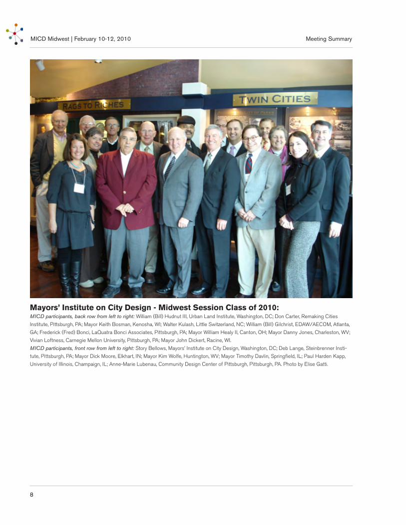
MICD Midwest - Class of 2010
Mayors’ Institute on City Design - Midwest Session Class of 2010:MICD participants, back row from left to right: William (Bill) Hudnut III, Urban Land Institute, Washington, DC; Don Carter, Remaking Cities
Institute, Pittsburgh, PA; Mayor Keith Bosman, Kenosha, WI; Walter Kulash, Little Switzerland, NC; William (Bill) Gilchrist, EDAW/AECOM, Atlanta,
GA; Frederick (Fred) Bonci, LaQuatra Bonci Associates, Pittsburgh, PA; Mayor William Healy II, Canton, OH; Mayor Danny Jones, Charleston, WV;
Vivian Loftness, Carnegie Mellon University, Pittsburgh, PA; Mayor John Dickert, Racine, WI.
MICD participants, front row from left to right: Story Bellows, Mayors’ Institute on City Design, Washington, DC; Deb Lange, Steinbrenner Insti-
tute, Pittsburgh, PA; Mayor Dick Moore, Elkhart, IN; Mayor Kim Wolfe, Huntington, WV; Mayor Timothy Davlin, Springfield, IL; Paul Harden Kapp,
University of Illinois, Champaign, IL; Anne-Marie Lubenau, Community Design Center of Pittsburgh, Pittsburgh, PA. Photo by Elise Gatti.
MICD Midwest | February 10-12, 2010Meeting Summary
9
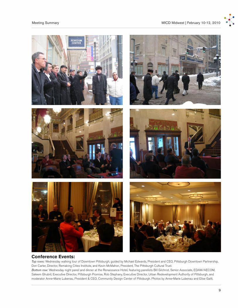
Conference Events:Top rows: Wednesday walking tour of Downtown Pittsburgh, guided by Michael Edwards, President and CEO, Pittsburgh Downtown Partnership, Don Carter, Director, Remaking Cities Institute, and Kevin McMahon, President, The Pittsburgh Cultural Trust. Bottom row: Wednesday night panel and dinner at the Renaissance Hotel, featuring panelists Bill Gilchrist, Senior Associate, EDAW/AECOM, Saleem Ghubril, Executive Director, Pittsburgh Promise, Rob Stephany, Executive Director, Urban Redevelopment Authority of Pittsburgh, and moderator Anne-Marie Lubenau, President & CEO, Community Design Center of Pittsburgh. Photos by Anne-Marie Lubenau and Elise Gatti.
MICD Midwest | February 10-12, 2010 Meeting Summary
10
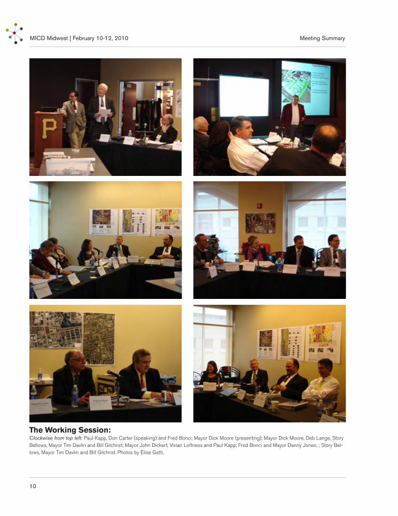
The Working Session:Clockwise from top left: Paul Kapp, Don Carter (speaking) and Fred Bonci; Mayor Dick Moore (presenting); Mayor Dick Moore, Deb Lange, Story Bellows, Mayor Tim Davlin and Bill Gilchrist; Mayor John Dickert, Vivian Loftness and Paul Kapp; Fred Bonci and Mayor Danny Jones; ; Story Bel-lows, Mayor Tim Davlin and Bill Gilchrist. Photos by Elise Gatti.

MICD Midwest | February 10-12, 2010Meeting Summary
11
The Venues:Clockwise from left: Map of Pittsburgh in 1902 by T.M. Fowler; obtained from http://www.mapsofpa.com/pitts/locfowler.jpg; View of Downtown Pittsburgh from Mount Washington. Photo by Marc O. Rieger; obtained from http://www.math.cmu.edu/~ana/Pictures/pic7.html; PNC Park with Downtown Pittsburgh as the backdrop. Photo by David Fulmer; obtained from http://en.wikipedia.org/wiki/File:PNC_Park,_Home_of_Pittsburgh_Pirates.jpg.; Renaissance Hotel, former Fulton Building. Photo by Robert Maihofer; obtained from http://pica-saweb.google.com/lh/photo/nCqSZPFg6GjSBJ5xnk2KMQ; Robert Clemente Bridge. Photo obtained from http://www.redfish.com/sta-dium/RobertoClementeBridge.jpg; View of Downtown Pittsburgh, the “Golden Triangle”, from inside LeMont Restaurant on Mount Washing-ton. Photo by Pam Panchak, Pittsburgh Post-Gazette; obtained from http://www.post-gazette.com/pg/09099/961536-46.stm.

MICD Midwest | February 10-12, 2010 Meeting Summary
12

MICD Midwest | February 10-12, 2010Meeting Summary
13
Case Study: Charleston, West Virginia
Case Study
Known as the “Home of Hospitality”, Charleston, Kanawha County is West Virginia’s capitol and its most populous city with an estimated 50,302 residents (estimated metropolitan population 303,944, 2008 Census Estimate). Charleston is located along the scenic Kanawha Valley at the confluence of the Elk and Kanawha Rivers. Originally the site of Fort Lee, built in 1788, Charleston’s early growth and prosper-ity was centered on salt production in the early 1800s. Drilling for salt wells led to the discovery natural gas, followed by coal. Rail lines were laid in the late 1800s, and by the turn of the century, Charleston had become both a river and rail transportation hub as well as a center for steel, chemical, glass and timber industries. Today, three interstate highways converge in Charleston, bringing Charleston within 500 miles of more than 50 percent of the country’s major mar-ket areas. The Kanawha region is at the center of the state’s finance, trade, government, retail and cultural sectors, and as a result, its economy is quite diversified.
Downtown Charleston is bordered to the north by the Elk River, the east and south by the Interstate 64/77 and to the west by the Kanawha River, and is flanked by hillsides filled with historic estate homes on the
south side and the Spring Hill Cemetery on the north side. Its Central Business District (CBD) is situated in the northern half of downtown, while the southern half is mostly occupied by a residential neighborhood and the State Capitol Complex. There are three access points to the I-77/64 from within downtown, and two bridges including the I-64 bridge. The downtown’s street pattern is strongly oriented in an east-west direction, with weak north-south linkages, and there is an extensive one-way street system. Its major one-way pair thoroughfares are Washington Street East (Route 60)/Lee Street and Quarrier Street East/Virginia Street East. Kanawha Boulevard East is also a major thoroughfare with four lanes of traffic (truck traf-fic is not permitted). The Kanawha Regional Transit Authority’s (KRTA) regional bus transit hub, called the Laidley Transit Mall, is adjacent to Slack Plaza, a large public square at the center of a mid-block pedes-trian mall (Brawley Walkway) that links the Town Center Mall to the Downtown Village District sur-rounding historic Capitol Street. An Amtrak station is located across the river beside the pedestrian-friendly South Side Bridge. There are currently no bike lanes in Charleston and there was opposition to a recent Sasaki Associates proposal, supported by the Mayor, to replace a lane of traffic along Kanawha Boulevard with a riverfront trail and bike route.
MICD Midwest | February 10-12, 2010 Meeting Summary
14
Case Study: Charleston, West Virginia
Charleston’s downtown daytime population is said to double during the work week, with most employ-ees commuting by car as evidenced by the numerous large, stacked parking garages and surface parking lots scattered throughout downtown. The city’s biggest downtown employers are the State Capitol Complex (over 12,000 employees), the Charleston Area Medical Center Healthy System (three locations and more than 5,000 employees), the Charleston Town Centre Mall and the Plaza East Shopping Center. The University of Charleston is located across the river from the State Capitol Complex. After a period of decline, the Charleston Town Center Mall has regained momen-tum. The mall has 930,923 square feet of retail floor area, 130 tenants and three anchors.
Downtown Charleston suffered disinvestment during the 1960s and 70s, and efforts to revitalize the area began with the creation of Charleston Renaissance Development Corporation. Charleston Renaissance prepared the Downtown/Old Charleston Urban Renewal Plan for the Charleston Urban Renewal Authority in 1985. The Plan, focused on the CBD area, had the primary goal of preserving, restoring and enhancing the downtown’s existing historic character and of prioritizing pedestrian linkages. Proposed pub-lic space redevelopment projects included the redesign of Capitol Street between Virginia and Lee Streets and Quarrier Street between Capitol and Dickinson Streets (short of the block containing the Holley Hotel site), the development of a riverfront park (now the Haddad Riverfront Park), and the expansion of a farmers market (now the Capitol Market) and the redevelopment of the former Holley Hotel site, all of which have been accomplished except for the Holley Hotel site, the focus of this case study.
The Holley Hotel used to sit mid-block on Quarrier Street, west of Leon Sullivan Way. The block itself covers 7.14 acres (311,177 square feet) and measures 466 feet along Dickenson Street, 649 feet along Lee Street, 464 feet along Leon Sullivan Way and 694 feet along Quarrier Street. The popular Capitol Street and Brawley Walkway leading to the Town Center Mall are two short blocks west. In contrast to Capitol Street’s late 19th century architectural style, the sec-
tion of Quarrier Street between Hale Street and Leon Sullivan Way features many examples of Art Deco style, including the now-closed Quarrier Diner, a once-bustling lunch spot and a beloved local icon. Around 14 buildings are currently scattered around the block, mostly along Quarrier and Leon Sullivan Way. The block is divided into 12 different parcels, each with different owners, including the Charleston Urban Redevelopment Authority (CURA). The Kanawha County Public Library is fundraising to build a new central library on the northeast portion of the site. It has an option on all of the property that it does not own. The current design features a large building and adjacent surface parking lot. The FBI has proposed using the former Holley Hotel site but would require a 30-foot setback which is not consis-tent with the traditional setback pattern. The admin-istration would like to see Quarrier Street returned to something resembling its former glory and is looking for a solution that will benefit the entire context area. The Charleston Urban Renewal Authority (CURA) owns the Holley Hotel site.
The 1997 C.E.N.T.R.A.L. (Commercial, Economic, Neighborhood, Transportation, Recreation and Living) Plan noted several urban design issues that still hold true: the lack of pedestrian and vehicular linkages between key attractions, the absence of a “gateway” to downtown, and a poor overall pedestrian and aes-thetic environment along Washington Street, a main corridor between the Town Center Mall, the new Clay Center for the Arts and Sciences, and the State Capitol Complex. An additional issue identified by the Mayor is that there are very few housing choices within the CBC, and as a result, the area’s amenities, which include shops, eateries and the Haddad Riverfront Park, are underused in the evenings and on weekends. A more upper-income residential area is concentrated east of Bradford Street, in the East End Historic District just north of the State Capitol Complex. A more modest-income residential section is located in the north-east corner of downtown, in a space bounded by the highway, the Elk River, Court Street and Washington Street East. Efforts by the City to lure a grocery store to downtown have yet to be success-ful, although the Capitol Market recently opened in a

MICD Midwest | February 10-12, 2010Meeting Summary
15
Case Study: Charleston, West Virginia
renovated railroad transfer dock near the downtown’s main gateway on Leon Sullivan Way.
Questions
1. How can the current site design for the library be improved from an urban design standpoint?
2. How can we support the pedestrian and historic character of nearby Capitol Street down Quarrier Street and to the Clay Center?
3. How can we better connect the Clay Center to Capitol Street by redeveloping the proposed Quarrier/Lee/Dickinson/Leon Sullivan Way block?
4. How do we reclaim the former prestige and vitality of the area that the Holley Hotel brought? How can we build off the rich historical resources?
5. How can residential use be integrated into the development? What kind of housing types and which demographics?
6. Property values in the downtown are superficially high and are a barrier to redevelopment, How can we overcome this reality?
Discussion
This is a classic situation where a site-specific issue ac-tually represents an opportunity to understand broader urban design issue for the downtown.
• Plan the ProcessionalsDowntown Charleston has good legible nodes and districts at either end and in between, with the Civic Center and Town Mall on one end, Capitol Street and the Clay Center a little farther to the middle, the East End residential neighborhood and the State Capitol Complex at the other end. Try to connect these nodes (“a processional”), so that both pedestrians and driv-ers will enjoy the scenery. Focus on urban design and pedestrian comfort, block by block. A few wise con-
nections and a few more public spaces may help create continuity for all modes of transportation. It might take years but revitalize this important corridor section by section. Use the Holley Hotel site/block as an op-portunity to strengthen connections visually and func-tionally between the Town Center Mall/Downtown Village District and the East End District residential area, as well as a chance to draw the Clay Center into the urban fray. The processional to the Clay Center is broken; there’s nowhere to walk from the Clay Cen-ter. Focus on all sides of the Holley Hotel site block, particularly Quarrier Street and Lee Street leading to the DVD, and Lee Sullivan Way, a major gateway to Downtown. Leon Sullivan Way should be slowed down and made two-way; interstate ramps can adapt to two-way connection [Birmingham had same issue].
• Market StudyCharleston has a good number of cultural, retail and entertainment destinations. Highlight the real destina-tions today, such as the Clay Center, the Post Office, the Town Mall, the Civic Center (convention center) and identify who, how many, and from where people are coming. Layer this information onto a market study for both housing and a hotel.
• Reconsider the New Library ProposalThe current library building appears perfect, at least from the outside, and it is already in the DVD. Con-sider another cultural/educational venue for the CURA site, with the parking lot behind it until future develop-ment can be envisioned including a hotel.
• Avoid Suburban Footprints and “Object Buildings”Charleston has enough “object buildings”, buildings that are set back and stand out on their own. It needs to rebuild its urban fabric where there are now vacant spaces, such as surface parking lots. If building a new library, which the Resource Team did not endorse, then place the library on Quarrier Street, not set back behind a lawn and parking as proposed. A library is a better downtown street use than a hotel because it generates more activity, acting as a storefront. This will additionally open a development site for a hotel behind it. The current proposal for the library will ruin the development potential of the rest of the block because

MICD Midwest | February 10-12, 2010 Meeting Summary
16
Case Study: Charleston, West Virginia
of its setback and difficult to build around gracefully. Frame the opportunity for the current library site to developers as “Here is a center site between two great bookends [Capitol Street and Clay Center], perfect for a mixed-use development”.
• Urban Design EnhancementsExplore using design standards to bridge the nearby Downtown Village District historic district with the Holley Hotel site and Clay Center; envision how you would like it to look and then set design standards that would encourage it. Remember that good urban design doesn’t happen over night. It’s the result of the right cumulative actions, from transit and street traffic pat-terns to public spaces, street trees and building facades. The average walk in a three anchor mall is 2,600 feet. This tells us that people will walk if the quality of the context is appealing, the scenery changes every 24 feet, and if there are distractions along the way. Use public art in the public right-of-way, as Chicago has, to create points of interest along streets that are waiting to be filled in with new property investments. Tell a histori-cal story, offer visual interests, such as the “Freedom Trail” in Boston.
• Two-Way Streets Are Usually PreferableConsider turning one-way streets into two-way streets wherever possible, including along Quarrier Street. One-way streets were created to help commuter traffic flow in and out of the city, not to support local busi-nesses. They are not conducive to a vibrant urban environment. If there’s room for two lanes in the same direction, then it’s possible to have two-way streets. Quarrier Street currently has three lanes, with the left lane turning left to the bridge. Conversion to two-way is a system-wide effort, but it can start with this project.
• Connecting Downtown NodesKanawha Boulevard needs to be narrowed back to a two lane boulevard, with a pedestrian/bike promenade. Consider linking the Town Mall and DVD to the State Capitol Complex with a trolly along Kanawha Boulevard, such as in Norfolk, VA, or a modern bus. Evansville, IN and Milwaukee, WI have created urban riverfront boulevards.

MICD Midwest | February 10-12, 2010Meeting Summary
17
Case Study: Racine, Wisconsin
Case Study Description
Racine was founded on the shore of Lake Michigan at the mouth of the Root River. It is 33 miles south of Milwaukee and 80 miles north of Chicago, in the southeast corner of Wisconsin. A factory town from its earliest days, 34% of the local economy is still based in manufacturing. Racine was “the city of inven-tion,” with businesses as diverse as Johnson and Wax, Horlick Malted Milk, Haben Snowmobiles, Dremel Corporation and InSinkErator. Locally based Rood Electric is currently expanding into green technology in the area of LED manufacturing.
Racine is well served by freight rail and there is also a possibility that commuter rail from Milwaukee will be extended to the city. The Root River provides another important mode of transportation infrastructure with its many drawbridges. Researchers in Racine have also developed pioneering methods in beach management, including a natural system for water treatment on the lakeshore, that are now being used in other cities and regions. Extensive walking, bicycling and water trails are accessible to the public along the Root River and Lake Michigan. Racine is also working to revitalize its downtown area through public events and activities, new loft housing, parks, marinas, museums and other forms of entertainment.
To further activate the lakefront, there is interest in redeveloping the formerly industrial Walker Property, located just north of downtown across the Root River. The city-owned 9.65 acre development site is located at the southern end of Hamilton Street, between the water utility and a boat marina. Several architecturally significant, former Coast Guard structures are also located at the eastern edge of the marina site. The surrounding context is a predominantly working class neighborhood. North Beach Park and the public zoo are located north of the site along Lake Michigan.
The Walter Property was recently studied for its potential as a residential development site with a den-sity of 13 dwelling units per acre, similar to the sur-rounding neighborhood. A “gated community” may not be developed on the site. An important element of the proposed development project is the provision of enhanced public access to the lakefront through an east-west pedestrian connection. Despite public support for the project, funding for the residential development project fell through during the recent economic crisis.
Once developed, the Walker Property could help to catalyze the transformation of a chain of brownfield redevelopment sites along the riverfront. The project could help to generate activity along the lakefront and
MICD Midwest | February 10-12, 2010 Meeting Summary
18
Case Study: Racine, Wisconsin
create a new city destination. The vacant site provides an opportunity to expand the range of local housing products. There is also substantial interest in devel-oping the Walker Property in combination with the adjacent marina site, improving the visibility of the site and allowing for an expanded mix of possible uses. For example, the former Coast Guard buildings on the marina site could be converted into a water research center where the public could learn about innovative water management and cleaning strategies. Such a use could be compatible with other residential, hospitality or retail offerings.
Many different parties will want to participate in discussions about the Walker Property’s redevelop-ment. Stakeholders will include the City of Racine, the Marina site owner, representatives from companies with an interest in the project, the local alderman, community groups, and individuals interested in the potential for jobs to be created as part of the redevel-opment effort.
Although there are many opportunities related to the site’s redevelopment, there are also challenges. If the marina becomes part of the Walker Property rede-velopment site, the parcel will need to be acquired and consolidated. Successfully providing public access through and along the two waterfront edges of the site will be challenging. It will also be important to enhance the site’s connectivity to downtown, across the Root River, so that the project can contribute to broader efforts at activating the City’s lakefront.
Racine residents are clamoring for exciting destina-tions along the Root River and Lake Michigan, and there was a lot of support for the city’s previous resi-dential development plan. The site would likely be redeveloped using a combination of tax increment financing (TIF) and other incentives, including grants to help pay for environmental remediation. The rede-velopment of the Walker Property is envisioned as part of an effort to reinvest in the local housing stock, improve quality of life, and help make Racine one of the most livable cities in America.
Questions
1. Should the Walker site be redeveloped in combina-tion with the adjacent marina and former Coast Guard buildings or independently?
2. What are the highest and best uses for the site?
3. What is the ideal height and massing of future buildings on the site?
4. What precedents exist for waterfront redevelop-ment sites involving the adaptive reuse of historically significant structures?
5. How can the Walker Property tie in to lakefront beach activity north of the site?
6. How can the project’s impact be expanded to North Main Street and connect to downtown Racine?
7. What type of financing is available to help fund site redevelopment costs?
Discussion
• Creating a Destination through a Mixed-Use ProgramThe stated goal of the project is to create an anchor destination on the edge of Racine’s waterfront. The Resource Team believes that in order to meet this goal, there must be more mixed-use near the harbor with a strong focus on public amenities. It is recom-mended that residential use be blended with com-mercial use, and that new offices be limited and kept closer to Downtown.
The Resource Team noted that the massing in the existing proposal is about right. It could be slightly taller but must be appropriate to existing neighbor-hoods. One idea proposed is to attract young IT incu-bators to set up their offices in the tall buildings at the back of the development to encourage a “live-work-play” scenario.

MICD Midwest | February 10-12, 2010Meeting Summary
19
Case Study: Racine, Wisconsin
It was suggested that restaurants be located along the river so that it is accessible to Main Street and to boaters. Another idea was to situate a public market along the waterfront with food stalls, accessible to the marina and bike trail.
Several traditional Northern harbor towns with strong boating amenities were recommended as precedents, including Baltimore, Maryland; Bristol, Rhode Island; and Camden, Maine. It was mentioned that Duluth, Minnesota, has a great marine museum surrounded by restaurants.
• Water, Water, Water!A new water research facility in the old Coast Guard buildings was thought to be an excellent idea. However in order to avoid creating a hermetic com-plex, consider adding a public use to the complex, such as a small museum, interactive education center or cafe. A recommended precedent for interactive children’s programming is the Creative Discovery Museum in Chattanooga, Tennessee.
In order to further develop the Racine/water connec-tion, it was suggested to add training opportunities for new careers that are water-related, such as waste water treatment, green roof installation and green infrastruc-ture/stormwater management. Pursue Racine’s niche as a water research and ecology center and access fed-eral funding with this vision.
• Linkages and TransportationIt was recommended that the city increase the “obvi-ous” paths (processions) from Downtown to the beach and harborfront. Extending Dodge Street, for example, will be critical to drawing people from Downtown.
A Resource Team member suggested looking at Racine’s entire waterfront and to envision a “green rib-bon” as a framework within which there are sequences and nodes/focal points. Where the natural sandy beach ends, create a “green beach” of green space and vegetation to soften up the edge. Consider link-ages between Downtown and destination points along the waterfront: Lighthouse at Schoop Park on Wind
Point; Lake View Park and the Racine Zoo/“Zoo Beach”; the beach, the Racine Yacht Club and jetty; Coast Guard buildings; Main Street and 6th Street restaurant row; Gaslight Point Marina; Racine Civic Center; Pershing Park. Think about creating a “lake history” themed bike trail.
It was strongly recommended that the city find a way to allow for pedestrian/bike flow across the mouth of the river, perhaps with the installation of a low-tech pontoon bridge with a pivot opening. This would allow a circuit from Downtown, along Main Street to Dodge Street, across the river again and back down Gaslight Drive or 4th Street. The bridge itself could be an attraction. A precedent pedestrian bridge is in Greenville, South Carolina. At the same time, consider adding bike taxis and keep the seasonal ferry idea alive.
The Resource Team noticed that the residential neigh-borhood west of the Walker site does not seem con-nected to the waterfront. The new development would be an opportunity to engage a population that is cur-rently somewhat marginalized in spite of its proximity to the beach, the harbor and Downtown.
Other linkage precedents are the Marginal Way coast-al walk, which includes a pedestrian bridge at Perkins Cove, in Ogunquit, Maine; Mallory Pier in Key West, Florida; the connection between the main street and harborfront in Annapolis, Maryland’; and Chicago’s new Gateway Fountain development, which has two- and three-story buildings with commercial at grade and greenspace (“green beach”) along the river.
• Keep the Waterfront PublicThe Resource Team felt very strongly that the water-front should remain public and be designed to be wel-coming. The public edge in the last proposal for the site was too understated. The waterfront and beach should be considered everyone’s amenity, and the more access points the better. Add more restaurants, even small ones embedded into other uses, such as the much cherished Cafe at Frick at the Frick Art and Historical Center in Pittsburgh.

MICD Midwest | February 10-12, 2010 Meeting Summary
20
Case Study: Racine, Wisconsin
• Development Goals and Design GuidelinesIt was recommended that before partnering with developers, the city should set clear urban design goals and establish guidelines for height, density, mobility, use mix, etc. Pick up cues of grain, color and height from Downtown and the Coast Guard buildings and extend these throughout the harborfront redevelop-ment. Five to six stories could work but should transi-tion down near the harbor to avoid creating a barrier. Allow some flexibility but have a set vision so that the goals are met.
Don’t forget to consider the views that any project will allow to the water. Racine’s harborfront could become a mecca, with a real profile -- a post card image.
Commission a market study parallel to the urban design guidelines study and figure out what kind of tools will be used to inject the initial investments into the area, such as TIFs, public infrastructure invest-ments, etc., prior to seeking a developer.

MICD Midwest | February 10-12, 2010Meeting Summary
21
Case Study: Huntington, West Virginia
Case Study Description
Located along the southern shore of the Ohio River, Huntington is West Virginia’s second largest city and the seat of Cabell County. Its population was estimat-ed at 49,185 in 2008, while the Huntington-Ashland, WV-KY-OH, Metropolitan Statistical Area’s popula-tion was 286,012 in 2005. Huntington was incorpo-rated in 1871 near historic Guyandotte, later annexed as a neighborhood, as the western terminus for the Chesapeake and Ohio Railway (C&O). Huntington’s position along the Ohio River, its comprehensive rail-road infrastructure, and regional coal and salt mines attracted glass, steel, chemical and locomotive parts industries. By mid-century, Huntington’s population had reached nearly 100,000 residents.
Huntington suffered a severe loss of industry in the latter half of the 20th century which lead in part to a population reduction of nearly 50 percent, and sub-sequent disinvestment in its downtown and many of its urban neighborhoods. A program of federal urban renewal cleared four blocks (9 acres) in downtown Huntington in the 1970s, creating what is referred to as the “Superblock”. However with the exception of the construction of the Huntington Civic Arena, the razed land remained bare as plan after plan failed to materialize. In 2004, construction began on Pullman
Square, a successful pedestrian-oriented retail and entertainment center (“lifestyle center”) with a historic downtown feel. In addition to this, two local private developers have begun renovating historic commercial buildings in the Central Business District, and several former hotels have been converted into upscale resi-dential buildings. Other revitalization projects include the Harris Riverfront Park and the planned streetscap-ing of 4th Avenue, called the Old Main Corridor, which connects Pullman Square to the Marshall University campus.
Today, Huntington is considered a regional medi-cal center and a college town, with several facilities located near the city’s core, including the Cabell-Huntington Hospital, Marshall University Medical Center, St. Mary’s Medical Center and Marshall University. While downtown Huntington has turned the corner, its east side residential neighborhoods are struggling with the issues that often accompany seri-ous poverty, namely the abandonment of property, crime and violence. The area just south of the railroad and east of Hal Greer Boulevard is particularly trou-bled, and is the focus of this case study.
In late 2008, Huntington obtained a 5-year, 1 mil-lion dollar Weed and Seed grant from the U.S. Department of Justice Weed and Seed Initiative.

MICD Midwest | February 10-12, 2010 Meeting Summary
22
Weed and Seed is a program that brings both law enforcement and community development resources to the problem of crime. Huntington’s overall Weed and Seed area, called the Fairfield Neighborhood Strategy Area, is 1.24 square miles, crossing six Council Districts, encompassing 20 percent of the city’s population (9,742) and much of downtown and the East End. The area’s median household income is $13,351 compared to the City’s $23,234. Half of the residents and 33 percent of families in this area are living below the poverty line in contrast to 25 percent of Huntington’s residents and 22 percent of its fami-lies. Fairfield Neighborhood’s median house value is $43,100 while the City’s is $65,400. Just under 9 per-cent of the area’s residents have obtained a bachelor’s degree, and sixty percent of all crimes, 39 percent of juvenile arrests for drugs and crimes, and 50 percent of juvenile arrests for robbery took place in the Fairfield area in 2008.
Huntington’s administration is committed to turning this neighborhood’s fortunes around and has already implemented a number of strategies to curtail violence and plant the seeds for community revitalization. The hiring of two building inspectors (there were previ-ously none) in conjunction with the start of a land-bank program modelled after the successful Michigan model has allowed the City to address the issue of blight and abandonment. In less than two years, it has demolished 29 structures, boarded up 60 buildings and developed 14 residential lots for sale. Its landbank has amassed over 100 properties, 30 of which are in the case study area. The City has also opened a Weed and Seed Office and Huntington Police Department Field Office with Canine Unit in a former day care center near a community center and athletic field on Hal Greer Boulevard, adjacent to the worst affected sec-tion (the case study area). The office will be used for after-school programs and will be the base for a police bike patrol (and perhaps a mounted police unit). The Huntington Community Gardens volunteer organiza-tion planted a garden in its yard last summer.
The case study area is at the center of the Weed and Seed area. It is bound to the north by the rail-road, to the east by 20th Street, to the south by the
Cabell-Huntington Hospital and to the west by the city’s main southern gateway, Hal Greer Boulevard. Huntington’s street grid is oriented in an east-west direction along the river, and the city is divided by rail infrastructure between 7th and 8th Avenues. The downtown’s main streets are between 3rd and 5th Avenues. Hal Greer Boulevard connects to one of Huntington’s four interchanges along Interstate 64 and is anchored to the south by the Cabell-Huntington Hospital which forms the city’s gateway entrance, and by Marshall University near the river to the north between College and 3rd Avenue. In between the hos-pital and the railroad tracks/8th Avenue, Hal Greer Boulevard is bordered by a plethora of automotive businesses and billboards, as well as several blocks of squat, 2-story tracts of public housing at either end. While downtown Huntington’s main avenues are unusually wide, Hal Greer Boulevard’s dimensions feel constrained given its important role within the city’s street hierarchy.
The most troubled area within the case study bound-ary is along 9th Avenue between 20th Street and Hal Greer. The City recently targeted blight along Artisan Avenue, demolishing several structures and enlisting the help of Habitat for Humanity in the construction of a half dozen homes. The City is now concerned with 9th Avenue, particularly around the gas station at the corner of 20th Street, which has become the epicenter of street prostitution and drug dealing. The City would like to stabilize this section of Huntington. It is interested in increasing home ownership, attract-ing middle-income residents, making linkages between the university and the hospital, workforce training and increasing the general livability of the neighborhood. Some of the challenges facing revitalization include the lack of public green spaces, a public school and basic neighborhood services, such as a grocery store. Some of the assets include a walkable, traditional grid street layout, handsome brick homes in the middle section of the study area, mature trees and nearby nodes of employment.
An important ally in Huntington’s efforts at revital-ization is the presence of a committed coalition of community, neighborhood and faith groups calling
Case Study: Huntington, West Virginia

MICD Midwest | February 10-12, 2010Meeting Summary
23
Case Study: Huntington, West Virginia
themselves Create Huntington. There is interest from the community and on the part of the administration to include community agriculture plots in the neigh-borhood, and the city is studying Philadelphia’s “Clean and Green” approach to vacant lots.
Questions
1. What other kinds of strategies for dealing with vacancy and blight would be appropriate for Huntington?
2. How can we attract residents with higher incomes to this area?
3. How can we reuse existing public housing struc-tures in a way that increases their livability and intro-duces a mix of incomes?
4. What kind of neighborhood amenities should we focus on attracting and where should they go?
5. Are there any strategic public investments that can be made and where should they be located?
6. How can we make Hal Greer Boulevard safer for pedestrians and children, and transform its character into something more fitting for the city’s main gate-way?
7. How can we further engage groups like Create Huntington in this process?
Discussion
• Create a Neighborhood Vision The main recommendation is that Huntington develop a planning vision and master plan before continuing with demolition of housing. Resource Team members argued that the risk with condemning houses without a vision is that it can eventually result in near-empty streets that are no longer a neighborhood. It was suggested that the city first map the problem houses, home-ownership and the houses that possess rehab
potential, then identify opportunities for solid sets of strong houses/strong blocks as well as opportunities for green spaces. Consider offering stable houses the op-tion to buy vacant side yards and involve Huntington Community Gardens in reusing vacant lots for local food production. A long-range plan will also help draw developers to the neighborhood.
Once a plan is in place, decide what the criteria for condemnation will be and then apply it conservatively. Consider adding a job training program around demo-lition and reuse of materials, as well as landscaping and tree tending. As an example, a Resource Team men-tioned Pittsburgh’s Construction Junction, a success-ful non-profit organization that collects construction materials to be re-sold to the public.
A precedent cited is Fall Creek Place, Indianapolis, Indiana, which was very similar to Fairfield in form, demographics and issues. New, contextual housing units were introduced, a park renovated, housing rehabbed and a program of streetscaping put in place. The Mayor of Indianapolis then used this successful project to demonstrate to residents how such a vision and planning strategy can work in other neighbor-hoods.
• Focus on the Strongest Streets AND the Weakest StreetsIt was suggested that good neighborhood streets be supported first and foremost. If possible, select a highly visible street with several solid properties and invest in those adjacent properties that have potential but are struggling. Restore all the best houses, help owners to restore them or engage Habitat for Humanity to help with rehabbing or adding contextually-appropriate housing. Focus on landscaping in the public right-of-way and training citizens to help with maintenance. Pittsburgh’s Tree Tenders and Friends of the Pitts-burgh Urban Forest is a successful model for non-prof-it/public sector partnership. Studies show that tended street trees and parks can increase housing property values and increase retail activity.
Find the weakest, most blighted street in the neigh-borhood that has a vacant area that could potentially become a viable park. Relocate the few families to

MICD Midwest | February 10-12, 2010 Meeting Summary
24
rehabbed homes in the neighborhood and create a new public green space or community gardens.
One caveat mentioned is that while encouraging home ownership is a good idea, Huntington might focus on restoring the best existing housing stock rather than building new Habitat for Humanity homes. If building new, see the Urban Design Associates (UDA) pattern book for Habitat for Humanity housing that offers models that are contextual for each city. Also consider clustering Habitat for Humanity rehabbed or new houses in the same area to create critical mass.
• Address the Weak EdgesThe case study area is surrounded by weak edges. A prominent edge (and barrier) is Hal Greer Boule-vard, an important gateway to Marshall University and Downtown from the Interstate. However it also runs through neighborhoods and currently has poor pedestrian quality, a lack of neighborhood-servicing amenities and too many car-oriented businesses and billboards. It was suggested that Hal Greer Boulevard is an ideal candidate for a “road diet”. Suggestions in-cluded converting it to a three-lane street with parking, improving streetscaping and adding bike lanes.
Since its buildings are mostly set back far from the street, Hal Greer can be redeveloped over time as a more urban boulevard, with wider sidewalks, bike lanes and buildings set closer to the street. In order to achieve this vision, consider form-based code for retail infill development over time, stormwater man-agement landscaping and a continuous tree canopy to hide vacant lots. Billboards cheapen the streetscape. Hal Greer Boulevard should be made a city-wide urban design priority given its importance as a gateway offer-ing a first impression of the city, and a major corridor between two important employment nodes, Downtown Huntington and Marshall University, and the Cabe-Huntington Hospital near the city’s entrance.
The public housing tracts along Hal Greer Boulevard and Artesan Avenue offer an urban edge but have altered the street network and are in need of updating. It was recommended that the city renovate and update them or replace them with new, mixed-income infill
development. The redevelopment of public housing should be folded into the overall vision and planning strategy for the neighborhood.
It was mentioned that Scott Canel and Associates, a developer from Chicago is rehabbing public housing in Charleston, West Virginia into mixed-income housing. A ratio to aim for in the redevelopment is one-third market-rate housing, one-third subsidized, and one-third public housing. Developers can still use HUD Section 8 funding and use neighborhood stabilization funds. A good precedent cited is Perkins Eastman’s Hope VI mixed-income redevelopment of public housing in Pittsburgh. Another examples is the John Hay Homes Project in Springfield, Illinois, which was redeveloped into Madison Park Place, also a success-ful Hope VI project. Re-establishing the street grid by reconnecting 11th Avenue to Hal Greer Boulevard is also recommended.
Another weak edge and a physical barrier are the railroad tracks below 8th Avenue at Hal Greer Boule-vard. It was mentioned that the underpass will soon be redesigned. It was strongly recommended that when investing in beautifying the underpass, a program of tree planting, continuous wide pedestrian sidewalks and modern and aesthetic night lighting should be considered.
As is the case with many urban neighborhoods, Fair-field lacks basic retail services, such as a grocery store. Twentieth Street is calmer and more residential than Hal Greer Boulevard; consider enforcing a residen-tial commercial corridor between Charleston Avenue and the troubled 9th Avenue intersection, with strong pedestrian amenities.
The interface between the Cabell-Huntington Hospi-tal and the residential neighborhood was also high-lighted. The hospital is self-contained and surrounded by parking lots and scattered development. A master plan for the hospital site that allows for some urban infill development along the hospital edges over time to contain it and create a better connection and pedes-trian environment is recommended.
Case Study: Huntington, West Virginia

MICD Midwest | February 10-12, 2010Meeting Summary
25
Case Study: Springfield, Illinois
Case Study Description
Springfield, the capitol of Illinois, is located centrally in the state, just south of the Sangamon River. In the 1800’s, the area had excellent agricultural land and wildlife, making it attractive to trappers and settlers alike. Springfield has historically been a busy trading center and it continues to be well served today by mul-tiple modes of transportation. The City has highway access, an airport, several major railroads, and Amtrak direct daily passenger routes to Chicago and St. Louis.
State and local government currently dominate the local economy, but healthcare is growing as a major local employer. Springfield’s coal-fired power plant also plays an important economic role, providing inex-pensive electricity for much of the region. Springfield is best known as the home of President Abraham Lincoln. Other historic attractions include the home of poet Vachel Lindsay, and the Dana-Thomas House, designed by Frank Lloyd Wright.
Like most American cities, Springfield experienced a migration of commercial activity from the center city to peripheral area in the second half of the 20th Century. In recent years, several projects have been undertaken to revitalize Springfield’s core, includ-
ing the rehabilitation of historic buildings, such as the State Capitol Building and Abraham Lincoln’s residence. The convention center was also relocated to central Springfield, and a new multi-modal transit terminal will be built at the eastern edge of downtown as part of a high-speed commuter rail enhancement project.
Springfield is also working to infill under-utilized sites within the City limits. Legacy Point, located at the City’s southwestern edge, recently became a viable development site because the MacArthur Boulevard extension will soon connect it directly to I-72. From the Interstate, MacArthur Boulevard runs north, approximately one mile west of the Capitol Building. It is anticipated that the new I-72 access point will bring a significant volume of traffic onto MacArthur Boulevard, a once-vibrant commercial corridor that is now in need of revitalization.
Several years ago, at the request of the City, the plan-ning firm Peckham Guyton Albers and Viets con-ducted an informal windshield study of MacArthur Boulevard. The firm recommended that a more-detailed study of the corridor be conducted due to its multi-jurisdictional issues, the Boulevard’s State Road status, and because of early signs of decay.

MICD Midwest | February 10-12, 2010 Meeting Summary
26
Case Study: Springfield, Illinois
The city of Springfield identified the former K-Mart and bowling alley sites, located at the northwest cor-ner of MacArthur Boulevard and Outer Park Drive, as an important redevelopment opportunity. The project area is located approximately 2 miles north of I-72. The K-Mart site is 115,526 SF in area, with an existing vacant one-story building (106,000 GSF) and 450+ parking spaces. In combination with the adjacent former bowling alley parcel, the redevelopment site would have excellent visibility from two busy roadways, and the depth of the site could accommodate a variety of uses with ample space for parking. Across from the K-Mart redevelopment site, on eastern MacArthur Boulevard, there are other commercial uses situated on significantly shallower lots that back up onto residential properties. Solid residential areas are located to the east and west of the proposed redevelopment site.
MacArthur Boulevard was historically a neighbor-hood commercial district with multiple supermarkets and other retail offerings, but it has recently begun to attract predatory cash advance and loan agency busi-nesses. MacArthur Boulevard is served by public trans-portation and is within walking distance from adja-cent residential neighborhoods. In recent years, the proposed redevelopment site has come to be viewed by local residents as an inner sore to the surrounding neighborhood.
Uses envisioned for the site include neighborhood-serving retail such as a smaller-scale grocery store or movie theater, or a mixed-use development. The redevelopment of these parcels could exemplify new development standards for Mac Arthur Boulevard, and help to catalyze additional reinvestment along the cor-ridor. The former K-Mart and bowling alley site could be part of a newly redeveloped corridor with distinctly different offerings from the big boxes at Legacy Point and the historic and cultural amenities of downtown Springfield. The City anticipates that site redevelop-ment would likely be financed through a combination of private dollars as well as funding made available through the Enterprise Zone.
Several challenges face the former K-Mart and bowl-ing alley sites. The infrastructure along this commer-
cial corridor is aging, there are many existing curb cuts, and commercial buildings have been developed in an ad hoc, disorganized fashion. There is also the chal-lenge that near-term investment will likely go toward the new Legacy Point development site. Entities that would be impacted by the sites’ redevelopment include the out-of-town property owner(s), the City of Springfield, and neighbors with concerns about trucks, trash and increasing traffic along MacArthur Boulevard. But on the other hand, local residents agree that the corridor, and the former K-Mart and bowling alley sites in particular, are in need of improvement.
The City of Springfield recently contracted with The Lakota Group, a Chicago-based planning firm, to study how MacArthur Boulevard can be successfully redeveloped. The former K-Mart and bowling alley site is a prime opportunity to help catalyze reinvest-ment along the commercial corridor and demonstrate new development approaches.
Questions
1. What would be the most appropriate use, or uses, for the former K-Mart and bowling alley sites?
2. What branding or district identity can be leveraged to make the MacArthur Boulevard corridor a place and a destination that is distinctive from the historic core and the new big box development sites?
3. What physical design issues should the City be aware of when attempting to transform a vehicle-ori-ented commercial corridor into a more visually-cohe-sive, pedestrian-friendly neighborhood destination?
4. Building on the existing bus service, what enhanced role can public and multi-modal transportation play in revitalizing the MacArthur Boulevard corridor? Are there available funding sources related to this type of planning and development?
5. How have other transitioning, historic cities success-fully attracted supermarkets, movie theaters and enter-tainment venues to existing urban commercial districts?

MICD Midwest | February 10-12, 2010Meeting Summary
27
6. Can green design play a role in redeveloping the MacArthur corridor and former K-Mart/bowling alley sites? Are there available financing opportunities that Springfield can utilize for this type of development?
Discussion
• Brand MacArthur BoulevardThe Resource Team immediately recommended creat-ing a physical vision for the commercial corridor so that regardless of program, it will look and behave a certain way. It was proposed that the former K-Mart site be used as a case study for a community visioning process that could be expanded to the entire cor-ridor. The Mayor mentioned that there is an active nearby residents group and business association. One Resource Team member recommended using before/after images as seen in some of the Resource Team presentations to help residents imagine a new look for the boulevard.
In order to guarantee the redevelopment outcome, have design guidelines and regulations in place that prescribe height, setback, parking, massing, materiality and landscaping. Avoid useless green space as is often seen in big box developments.
One Resource Team member mentioned that US cities generally have too much commercially-zoned land, collectively up to 40% of oversupply, which has led to the cannibalization of older business districts. It was recommended that the city consider creating sequences of alternating commerce and residential use along MacArthur Boulevard, focusing commercial at inter-sections, rather than spreading it out along the entire corridor.
Another recommendation was to produce a unified design for the public right-of-way (street trees, street furniture, signage, bus stops, etc.). It was noted that the lack of overhead infrastructure is helpful with this as-pect. Precedents for corridor plans include Annandale, Virginia; San Jose, California; and Shaker Heights, Cleveland, Ohio.
• Transform MacArthur Boulevard into a Neighborhood Commercial DistrictMacArthur Boulevard is surrounded by stable residen-tial neighborhoods. While the boulevard is a regional asset, it also has potential to be transformed into a finer-grain neighborhood retail strip that could even integrate a public use, such as a community center, branch library and grocery store. A neighborhood needs assessment might be useful in attracting new uses. In seeking to transform MacArthur Boulevard into a more pedestrian-friendly environment, institute a smaller street and block pattern into the redevelop-ment of large sites, such as the K-Mart site, and weav-ing them into surrounding street networks. These will support a wider range of potential uses.
It was noted that new development near the inter-change will likely replace MacArthur Boulevard as a roadway-oriented retail zone. This is further reason for gradually transforming the identity of the boulevard to neighborhood-serving commercial.
In order to address the adjoining neighborhood, the site should be redeveloped on all sides, with storefronts facing both the boulevard and the neighborhood. Continuous access through parking lots at the back of the shops should be encouraged for permeability, as should pedestrian linkages. New housing types should be considered, such as senior housing, townhouses or apartments. Moreland Avenue in Atlanta, Georgia, is a larger site with similar issues. A single curb-cut allows traffic to enter a mixed-use area with neighborhood services toward the back.
Another precedent cited was Austin, Texas. The city has a lot of arterials originally bordered with two- and three-story mixed-use buildings. These strips are now becoming densified and turning into neighborhood-serving commercial districts to which local residents walk and bike.
• Calm Traffic along MacArthur BoulevardA Resource Team member noted that when traffic counts are above 20,000, it becomes politically chal-lenging to transform 4 and 5 lanes to 3 lanes. However MacArthur Boulevard may receive less traffic once the
Case Study: Springfield, Illinois
MICD Midwest | February 10-12, 2010 Meeting Summary
28
Interchange is built. The city should fold as much of the right-of-way as possible into a pedestrian buffer zone of at least 5 feet for sidewalks, street trees, uni-fied street lighting, and possibly a protected bike lane. Work with property owners if possible. Even if it is piecemeal, it will gradually change the dynamic along the boulevard.
• Solutions to the Proliferation of Driveways and Street-front Parking LotsHigh demand parking uses can still be located along the boulevard but the parking should be placed behind buildings and interconnected for rear circulation. Challenges to form-based coding regarding parking tend not to stand up in court as long as the required parking is made available in some form, even if behind the stores. It was noted that owners are already engag-ing in informal cross-access. The Resource Team rec-ommends working with willing owners to organize and continue the effort. Businesses in strip malls and along arterial roads tend to have a high rate of turnover.
Cross-access easements will help consolidate driveways with any change of property use (sale, building permit, change of use, etc). Another way to increase traffic flow will be to upgrade alleys into access points from side streets and joint driveways. The city should consider applying to the state DOT for access management study funding.
Case Study: Springfield, Illinois

MICD Midwest | February 10-12, 2010Meeting Summary
29
Case Study: Kenosha, Wisconsin
Case Study Description
Kenosha is located on Lake Michigan in the southeast corner of Wisconsin, 32 miles south of Milwaukee and 67 miles north of Chicago. Both cities exert significant economic influence, with more than 40% of residents working outside of Kenosha County. Major industries include commercial fishing and more than 100 years of automobile manufacturing. Kenosha used to be known for its taverns and factories, but it has begun to draw residents from Chicago and Lake County, IL. Significant effort has gone into diversifying the local economy, emphasizing tourism, cultural amenities and lakefront recreation. Kenosha also hosts 10,000 college students, and has many architectural treasures such as the Daniel Burnham-designed public library.
There are two distinct Kenoshas: the eastern historic core along Lake Michigan, and newer development stretching seven miles west towards I-94. The City has worked to make downtown Kenosha a regional draw for two decades, beginning with a plan in the 1980’s to develop a lakeside marina adjacent to the Chrysler manufacturing facility. When Chrysler left its lakefront site in 1989, along with more than 6000 local jobs, the City recognized an opportunity to fur-ther transform downtown Kenosha and expand public access to Lake Michigan.
In 1996, the Urban Land Institute (ULI) worked with local residents and planners to study the potential for Kenosha’s lakefront redevelopment. The resulting plan envisioned a new neighborhood and museums front-ing onto a harbor park. The ULI plan, subsequently refined by a planning firm, has been successfully implemented. As part of the redevelopment effort, a year-round east-west trolley loop was introduced. The trolley links the museums, the commuter rail stop, government buildings, parking facilities and the lake-shore edge. There is some interest in adding a north to south trolley loop to connect more of the central downtown districts via public transportation.
Kenosha is poised to undertake another phase of downtown redevelopment. Because several downtown parcels are vacant or under-utilized, there is the poten-tial to concentrate related uses into districts and open up other properties for development. Due to the pre-vious redevelopment efforts, infrastructure is already in place, ready to support new infill projects. Kenosha is the county seat, and one project might involve relo-cating the existing municipal building nearer to county buildings in the Civic District. This move would cre-ate a marketable development site with views of Lake Michigan. Another potential project would involve building a 5,000-seat multi-purpose arena in down-town Kenosha. To support the growing tourism indus-

MICD Midwest | February 10-12, 2010 Meeting Summary
30
try, the existing lakefront hotel and convention center might also be renovated or rebuilt.
Kenosha’s past redevelopment efforts have been suc-cessful, largely due to the foresight of local leaders who saw opportunity in the face of economic transfor-mation. But there are some challenges that will need to be addressed by future development efforts. The Metra commuter train is an asset, but it physically separates the core of downtown from the western part of the city. The biggest redevelopment challenge fac-ing Kenosha is funding. Residents currently bear $1.7 million in annual taxes to support their local museums, and $5-6 million is spent every year on park mainte-nance. These quality-of-life amenities are important to local residents but there are limits to what can be sustained by tax dollars alone.
The City of Kenosha, Kenosha County, local busi-ness owners, residents and other property owners will continue to be involved in downtown Kenosha rede-velopment efforts. A revitalized downtown will help to grow the local tax base, create job opportunities, inspire entrepreneurship, attract residents and tour-ism, diversify cultural and entertainment options, and infill vacant and blighted properties. Despite the slug-gish national economy, there are signs of interest from prospective developers. Now is a good time to create a publicly supported strategy and vision for the contin-ued revitalization of downtown Kenosha.
Questions
1. How should the boundaries for the next phase of downtown planning be defined?
2. What additional programming and land uses should be considered for under-developed land in downtown Kenosha near Lake Michigan?
3. What zoning modifications should Kenosha con-sider to prepare for future redevelopment projects? For example, view corridors toward the iconic light-house have been discussed. How are these policies best enacted?
4. What is the ideal density and height for remain-ing development areas at and adjacent to the harbor? Is the current maximum building height of 100 feet appropriate?
5. How can downtown redevelopment be funded without burdening local taxpayers?
6. If a 5000-seat multi-purpose arena were built in downtown Kenosha, where would it best be located?
7. How can downtown Kenosha be better connected to adjacent residential neighborhoods, especially at barriers such as the Metra underpass?
8. The future may bring additional visitors to Kenosha from the water, via dinner cruises, water taxis, etc. What physical improvements to Kenosha’s lakefront would support this type of activity?
Discussion
• Create an Urban VillageThe Resource Team felt that the proposed develop-ment site, being situated at an important point along the harborfront, is too valuable for office use. It was recommended that the city expand the scope of the development area to encompass the area between 13th Avenue and the Kenosha Metra station, 56th Street, 50th Street and the waterfront. The proximity to the Metra line and downtown trolley make it possible to consider a Transit Oriented Development (TOD).
The Resource Team’s vision is of an “urban village”. The site itself would probably best accommodate tiered housing with views of the water and ground floor retail and restaurants. A possible target buyer would be retirees from Chicago. Surrounding uses could be commercial buildings of three to six stories with porticoes, large windows and ground floor retail to help with street life. It was agreed that Kenosha should avoid highrise buildings in this area.
Case Study: Kenosha, Wisconsin
MICD Midwest | February 10-12, 2010Meeting Summary
31
• Celebrate Access to the River and Amplify ActivityThe development site should be considered a front door to the harborfront. The site and area including 6th Avenue, 54th Street and the harbor, is an impor-tant “knuckle” but it seems too empty and the water feels too far away. It was recommended that the corner parking lot at 6th Avenue and 54th Street, in front of the marina housing, be replaced with a destination venue, such as a pavilion for farmers’ market or a civic building.
Tighter street sections along waterfront streets, such as 6th Avenue, would help create more intimacy at the water’s edge. Sixth Avenue is particularly underde-veloped and could accommodate a lot more develop-ment. Promote infilling, bring buildings and housing closer to the water. While waiting for development to be phased in, add street trees and on-street park-ing to make the street feel more urban. The entire harbor and waterfront from Carthage College down to Southport Park should be treated as a public park amenity with bike and pedestrian infrastructure linking to beach destinations.
• Market Study and Development ToolsA market study to determine opportunities for the site and surrounding context is recommended. The development site is very desirable and should be put onto the tax roll. The Resource Team suggests that the city consider asking the developer to build the new municipal building elsewhere. There may be federal tax credits for heritage conservation in the area sur-rounding the sight. Be sure to create stringent public works detailing and urban design guidelines in order to get the desired results from the developer.
• Proposed Arena/Convention CenterThere was doubt that an arena/convention center would be feasible for Kenosha because of a lack of hotels and the actual size of the site. It was posited that the site may be better used for residential-domi-nated mixed-use given its proximity to the Metra line.
The proposed arena site is prime property for increas-ing the population base and supporting an urban vil-lage atmosphere. If a decision is made to go with the
arena, consider expanding the program into an all-sea-son multipurpose building. Avoid blank walls and pos-sibly integrate storefront uses at grade. As a precedent, see PNC Park in Pittsburgh for its urban scale, use of materials and active street facades.
• Increase Linkages between the Residential Neighborhoods and the Downtown/Waterfront District
It was noted that nearby residential neighborhoods could be drawn to the harborfront by redesign-ing 52nd and 50th Streets into processional streets through the addition of street trees and by limiting heavy traffic. Perpendicular streets can focus on bike and pedestrian infrastructure with constricted car flow.
The raised Metra line acts as a barrier to Downtown and waterfront district. The creative redesign and lighting of the underside of the Metra line would ren-der it less of an obstruction for residential neighbor-hoods on the western side of the rail line. As a prec-edent, see the Mood Wall interactive light installation in a pedestrian tunnel in Amsterdam.
Case Study: Kenosha, Wisconsin

MICD Midwest | February 10-12, 2010 Meeting Summary
32

MICD Midwest | February 10-12, 2010Meeting Summary
33
Case Study: Canton, Ohio
Case Study Description
Canton, Ohio is located in the northeastern portion of the state, approximately 60 miles south of Cleveland. Founded in 1805 on the West and Middle Branches of the Nimishillen Creek, Canton developed as a major manufacturing center due to the confluence of numer-ous railroad lines. While the manufacturing sector of the city remains stable with industrial leaders such as the Timken Company, the Belden Brick Company, and Diebold Safe and Lock Company maintaining large production facilities in the city, Canton’s over-all manufacturing sector has witnessed decline in the past twenty years. In response to the decline of heavy manufacturing, the city’s industry has diversified into service economy sectors including retail, education, financial, and healthcare.
In support of that diversification, the City of Canton has been working with Cormony Development on the re-purposing of the former Hercules Motors Company Complex. The complex was home to the Hercules Motors Company from 1915 until 1999. During that time, over 2.5 million engines were built for trucks, jeeps, generators, pumps and other equip-ment. Hercules was, at one time, the world’s largest producer of internal combustion engines. During
World War II the company devoted 100 percent of its production to war needs, employing 5,800 men and women working a 24-hour a day, seven day a week production schedule.
The Hercules Motors Company Complex encom-passes 26 acres and 610,000 square feet of vacant industrial property within 29 interconnected ware-house buildings constructed between 1855 and 1945 in downtown Canton, Ohio. The redevelopment involves the environmental clean up of the brownfield site and its buildings, the adaptive re-use of historic structures consistent with Smart Growth policies, and the use of multiple tax credit programs.
Located at the southern edge of downtown Canton, Ohio, near the intersection of Route 30 and Interstate Highway 77, the project is favorably positioned near major regional transportation infrastructure that will enable it to form a gateway into the city. It will also fortify recent commercial investment in the Central Business District which has been stimulated by the privately funded adaptive re-use of historic commercial structures into market rate housing and a strengthen-ing cultural and arts district. These developments have all been reinforcing the northern portion of the cul-tural district.

MICD Midwest | February 10-12, 2010 Meeting Summary
34
The proposed program for the Hercules adaptive re-use is intended to act as a catalyst for redevelop-ment in the southern portion of the Central Business District. A variety of uses have been identified that can be utilized to leverage sustained development of sur-rounding parcels and improve upon assets that bring the city consistent national recognition and tourism revenue. These program elements include market rate housing, rental apartments, class A office space, retail space, restaurant space and a convention center. The convention center will serve as the new home for the Pro Football Hall of Fame’s enshrinement din-ner, gameday luncheon, and fashion show, all keynote events during induction weekend and significant rev-enue generators for local businesses.
While new uses will enable revitalization of this city sector, stakeholders recognize the necessity to maintain the heritage of Canton’s industrial past. Development guidelines have been established that will preserve the character of the existing structures and enable appropriate upgrading/modernization that will be vital to the success of the re-programmed space. The Hercules Motors Company complex has been placed on the National Register of Historic Places and has received Part II approval from the State Historic Preservation Office and the National Park Service, ensuring the preservation of heritage while making the property eligible for both State and Federal Historic Tax Credits which will assist in the realization of the project.
Pre-development work has already been initiated. In the first quarter of 2008, environmental remedia-tion and selective demolition were completed. The Remedial Action Plan (RAP) prepared for the Hercules site as a component of this work represents the cul-mination of an intensive Phase II Environmental Site Assessment conducted under the Ohio EPA’s Voluntary Action Program (VAP). At the conclusion of this pro-cess the US EPA and the Ohio EPA will both sign off on the environmental condition of the site and issue a Covenant-Not-To-Sue. This is the highest level of assurance provided at the State and Federal level that environmental issues have been properly identified and rectified to an appropriate level.
Case Study: Canton, Ohio
Consistent with successes in pre-development, the city and its partners expect to create a green project to the greatest extent possible within existing project and market constraints. The project aspires to be a model for urban, historically sensitive redevelopment, brownfield remediation, main street development and low-income community development. With a projected budget of 178 million dollars for full implementation, this project will be the largest development in Stark County in over three decades. Central to the success of the Hercules project will be consensus support from a broad range of constituents. Evidence of support has already been provided by a coalition of Ohio State, local and private entities whose efforts resulted in the establishment of a 36 million dollar tax credit for the project, an incentive for the first phases of development that will revitalize a dormant sector of the city and define a vital urban gateway to the Stark County seat.
Questions
1. What is the overall best mixture of uses for the former Hercules plant and the various surrounding parcels located within the Hercules development?
2. What should be the city’s strategy for the munici-pal parking deck and the use of surrounding land and buildings?
3. If the Hercules development is to include an adja-cent hotel, how should the phasing of this project be structured?
4. What type of design strategy would enhance the Hercules development as a visual gateway to the Downtown from Route 30 and I-77?
5. How do we create/improve connections between the Hercules district, Downtown Canton, and the Professional Football Hall of Fame?
6. How do we create a vibrant and active commercial and financial district that extends the already exist-ing pedestrian-friendly downtown streetscape to the Hercules development?

MICD Midwest | February 10-12, 2010Meeting Summary
35
Discussion
• Rebrand Canton as a Healthy Active CityThe big idea is to rebrand Canton as a Healthy, Active City, linking two of its assets: its renowned network of parks and open green spaces along its rivers, and its affiliation with the National Football League (NFL). There is an existing natural green corridor of under two miles along Canton’s Parks District from the Pro Football Hall of Fame to the Hercules Complex site that has potential to become a tree lined event space.
The task would be to decide what the “ride will be like” in the Disney sense: Not a conventional trolley ride but a themed Hall of Fame event ride, like the Freedom Trail. A multi-modal corridor featuring the Water Works Park, the McKinley Presidential Library and Museum, West Park, the Pro Football Hall of Fame, and reaching up to the Arboretum Park and Kent State University. It was suggested that a light rail connector might be incorporated into this corridor.
The NFL currently has an initiative to promote health and active living in cities. Canton, already affiliated with the NFL, could become a showcase for active living through its augmented parks network, light rail line, walkable districts and productive landscapes (urban farming).
• Hercules Site ProgramA mixed-use program was proposed for the Hercules Complex site. There was a discussion about moving the Pro Football Hall of Fame to the Hercules site but after discussion, it was agreed that it should not be moved but that certain events may in the future be held on a renovated Hercules site, such as the draft, once a transportation corridor was established. This would create a connection between the two points at the north and south ends of Canton. One idea was to promote the Hercules site, accessible directly from the highway, as a starting point for a visit to Canton. Visitors would find ample parking, hop on a trolley to Downtown or the LRT through the Parks District and to the city’s various destinations, including the Pro Football Hall of Fame.
It was also mentioned that there is a scenic rail line that runs between Akron, Cleveland and Canton, Ohio, and it dead ends near the Hercules site. It could be brought onto the Hercules site as a final terminus and destination point.
• Expand the Development Scope and PhasingThe Hercules site is currently disconnected from Downtown. It was recommended that the city consider the area from Market Avenue and 2nd Street down to the site as an development focus area for the south end of Canton. The mile between Downtown Canton and the Hercules site is vague and could be strengthened with the redevelopment of the Hercules site. A proces-sional along Court Street, currently an arts district, and Market Street would help draw pedestrian traf-fic to the site. The city could consider infill housing developments on vacant land between the Downtown and the Hercules Complex Site.
The Resource Team suggested phasing the redevelop-ment, using parking and park space as interim uses. Several precedent projects were cited: Germany has several good examples of old industrial buildings and infrastructure that have been set into a naturalistic landscape setting as a transitional use, particularly the Landschaftspark Duisburg-Nord, which offers bike tours, ecology study tours, and a night light tour of an illuminated blast furnace plant. The former El Toro Marine Corps base in Orange County is being con-verted into a mixed-use development. The first phase of the redevelopment is the Orange County Great Park, with an airport hangar -- Hangar 244 -- convert-ed into a year-round entertainment venue as a tem-porary use. Durham, North Carolina, reinvented the former American Tobacco Factory, located along the NC-147, as a mixed-use entertainment district, pre-serving historic buildings and materials. Hercules site could likewise become an example of adaptive reuse, green development and innovating landscaping.
It was noted that among the site’s assets is its extraor-dinary freeway access, with high capacity loop ramps leading almost directly into site. The site could have a freeway-oriented gateway “back door” for long reach visitors, and a city-oriented “front door” facing the Downtown for local driving and walking access.
Case Study: Canton, Ohio

MICD Midwest | February 10-12, 2010 Meeting Summary
36

MICD Midwest | February 10-12, 2010Meeting Summary
37
Case Study: Elkhart, Indiana
Case Study Description
Elkhart is located at the northern edge of Indiana, 110 miles east of Chicago, 15 miles east of South Bend and 150 miles north of Indianapolis. The city was estab-lished at the confluence of the St. Joseph and Elkhart Rivers in the early 1830s. Early industry in Elkhart included musical instrument factories and other mills that became important to the local economy by the early 20th century.
Elkhart is known to many as the Trailer and RV Capital of the World. Its recreational vehicle industry started before World War II and grew after the war to include a range of companies manufacturing recreation vehicles, trailers, manufactured housing, boats and specialty vans. Companies operating in Elkhart includ-ed Four Winds, Hy-Line, Skyline, Travel Supreme and others. The recreational vehicle industry, current-ly the largest employer in Elkhart, was hit hard dur-ing the recent economic downturn. 20% of Elkhart’s population is currently unemployed, and at least one RV manufacturer has closed its factory. But this has also led to opportunity and Elkhart wants to diversify its economy, looking toward solar and green technolo-gies. Think North America, a European electric car company, will open a factory in Elkhart later this year
in a former RV manufacturing facility, bringing several hundred jobs with it.
Elkhart has significant commercial and residential architecture and a relatively intact downtown central business district with much of its building stock dat-ing from the late 19th and early 20th centuries. In the 1990’s Elkhart developed a Riverwalk trail along the St. Joseph’s River, featuring an ice-skating/roller-blad-ing path depending on the time of year. Several other businesses and attractions have helped to activate the riverfront. Current redevelopment projects in the city core include the renovation of the Lerner Theater, block-by-block streetscape rehabilitation along Main Street, open space improvements and incentives for entrepreneurs interested to open businesses. The expanded Indiana University of South Bend campus has also increased activity in downtown.
Elkhart is located on the Indiana Toll Road (Interstates 80/90) 15 miles east of Notre Dame University. This proximity to a major university, along with the vol-ume of Interstate through traffic, has created a strong demand for hotel rooms. Dozens of hotels have located at exit 92 in Elkhart, catering to business travelers and Notre Dame fans alike. Elkhart has the largest hotel community on the entire Indiana Toll Road system. This district of hotels and service retail, know as the

MICD Midwest | February 10-12, 2010 Meeting Summary
38
Case Study: Elkhart, Indiana
North Point Plaza Gateway, is located approximately 3.5 miles north of downtown Elkhart’s historic center.
To capitalize on the presence of so many visitors at the northern edge of the city, Elkhart embarked on a plan-ning project to study improvements to this district, and to the larger Cassopolis Corridor (Route 19), con-necting it to the city’s historic urban core. Planning efforts have been driven by North Point property owners, the County Convention and Visitors Bureau, and the City of Elkhart Redevelopment Commission. An initial study done by Development Concepts Inc, Storrow Kinsella Associates and Wightman Petrie in 2007, initiated a public discussion about the area’s redevelopment. Early strategies recommended that the corridor be unified in a way that extends Elkhart’s identity from the historic downtown core all the way to the Indiana Toll Road and the North Point Plaza Gateway district.
One of the most challenging aspects of the project is the reorganization and redevelopment of the North Point district itself. North Point was annexed by Elkhart from the County in 1993 and the prior devel-opment does not meet the City’s design standards. The land use is a mix of commercial and residential, predominantly hotels but also a mix of other retail, restaurants and apartment buildings. Some build-ings are currently vacant. The primary access is along Northpointe Boulevard, an east-west street perpen-dicular to Route 19 with minimal landscaping and no sidewalks.
There are many challenges with redeveloping this site. The current development has a confusing street and parcel layout resulting in numerous buildings that lack clear street frontage. Building, parking lot and entry orientations vary from one building to the next and several streets flow into large parking fields resulting in extremely difficult wayfinding, particularly for out of town visitors. Existing signage fails to communi-cate the full range of business offerings and doesn’t clearly communicate that the district is the gateway to Elkhart. The existing site layout also results in poor visibility for many businesses from both the Toll Road and Route 19 corridors.
While there is interest in retaining most of the current businesses through the redevelopment process, there are individual cases where some buildings and uses are not complementary. A wide swath of right-of-way land parallel to Route 19 is undeveloped and its utiliza-tion could be negotiated with the County and/or state government. The goal of the Gateway project is to rationalize, reorganize and beautify the district while retaining existing buildings, businesses and infrastruc-ture to as large a degree as possible. The City also sees the project as an opportunity to create a gateway entry feature that will distinguish the North Point Plaza Gateway and communicate Elkhart’s unique identity to visitors exiting the Interstate.
Redeveloping the site creates an opportunity for a tie-in to enhancements along the larger Cassopolis cor-ridor, and eventually, with the historic city center as well. Improvements will enhance visitors’ perception of Elkhart and attract extended tourism and invest-ment as people discover its unique offerings.
Questions
1. How much of the North Point Plaza Gateway district physically needs to be modified to establish a sense of place and legibility? What role can signage improvements play?
2. What are strategies to pay for landscape and streetscape improvements and how can long-term maintenance requirements be funded? Could BID be a way to finance redevelopment improvements and maintenance?
3. How can Elkhart’s history and local culture be expressed through local development and streetscape elements?
4. How can the site be redeveloped so that it does not compete with downtown Elkhart’s efforts?
5. How can the district and corridor be beautified and visually unified given the wide range of different uses?

MICD Midwest | February 10-12, 2010Meeting Summary
39
Discussion
• North Point Plaza: Elkhart’s Front DoorOnly two miles to Downtown and two miles to Uni-versity of Notre Dame in South Bend, Indiana, the Route 19/Cassopolis Corridor is an important gateway to the City of Elkhart and stop for travellers visiting the region. The Resource Team reacted well to the idea of creating a hospitality area that can compete with other hotel districts along the Interstate. The slogan “Don’t spend the night in a parking lot -- spend the night in Elkhart!” resonated with the participants.Having a clear vision upfront will help Elkhart ac-complish a realistic feasibility study, which will in turn attract investors. In addition to creating a hotel and shopping district that will distinguish itself from other highway shopping areas, the vision includes creating a gateway that will draw visitors along the Cassopolis Corridor into Downtown Elkhart.
Some Resource Team members brought up the poten-tial risk with the proposed plan, which includes hotels, retail and a movieplex, of undermining Downtown Elkhart’s commercial viability. However it was also said that each area could focus on slightly different users and uses, with North Point Plaza catering to the high-way traveller and residents interested in retail chains, while Downtown Elkhart focuses on culture, arts and a downtown historic ambiance. It was suggested that each the city try to find complimentary uses for each area so that they act like two anchors at each end of the Cassopolis Corridor.
It was once again recommended that the scope of the proposal be expanded to encompass a larger area in order to create connections to adjacent neighborhoods. Vehicular and pedestrian linkages should be created between these neighborhoods and the Plaza, as well as regular public transit service between the Plaza and Downtown Elkhart. Residential uses could be inte-grated into the Plaza project and linked to adjacent residential streets.
In order to distinguish Elkhart’s interchange from the others along the Indiana Toll Road (I-90/I-80), Resource Team members suggested filling in grassy
triangle created by the Route 19 exit with striking landscape art and water gardens to control stormwater runoff from the highway. This would turn an otherwise unremarkable space into a memorable landscape ame-nity, beckoning travellers to Elkhart. It may be possible to find a sponsor to be stewards of the interchange triangle.
• Street LayoutThe Resource Team like the proposal to create a street framework consisting of blocks with buildings along the street edge behind which parking is hidden. It was suggested that another outlet onto Route 19 be added at Alt Drive.
The proposed roundabout was considered good as it will outperform a signal at the projected traffic vol-umes and will help redirect traffic smoothly at right angles. However roundabouts are not ideal for pe-destrians. In the proposed development, pedestrian flow may not actually need to follow the streets since destination points are aligned diagonally rather than along the street edges.
• Design Features and AmenitiesThe Resource Team commented that if a U or crescent interior road design is used, there is good potential for a central public space. This is a rare feature for a high-way interchange commercial development and could be combined with a sheltered public transit stop, bike parking and other public amenities. It was suggested that the development be flexible enough to include future mixed-use development opportunities. Surface parking could be an interim use, to be filled in later with stacked parking.
A tower or landmark structure within the site would signal to drivers along the highway that North Point Plaza is an interesting place to stop. The gateway en-trance into North Point Plaza as proposed in the plan was considered a good idea.
Southern Village Market Street in Chapel Hill, North Carolina, was named as a precedent. It has an oval shape with a “Village Green” on the middle and build-ings arranged around it. The sidewalks are landscaped,
Case Study: Elkhart, Indiana

MICD Midwest | February 10-12, 2010 Meeting Summary
40
restaurants have outdoor patios and there is a movie theatre.
• Route 19/Cassopolis CorridorIt was recommended that the North Point Plaza re-development be used as an opportunity to rethink the current design and character of the Cassopolis Corri-dor, the gateway to Downtown Elkhart along the lines of the recommendations for MacArthur Boulevard in Springfield, Illinois. One idea was for Elkhart’s RV history be told along Route 19 by way of an RV trolly from North Point Plaza to Downtown.
• FeasibilityIt may be difficult to attract investors without a feasi-bility study. However having a clear vision with design guidelines will assist with the successful redevelop-ment.
It was suggested that Elkhart consider installing a toll road access at a single point across from site entrance as a revenue source.
Case Study: Elkhart, Indiana

MICD Midwest | February 10-12, 2010Meeting Summary
41
Midsize cities, big ideas: The Top 10 take-home messages from the Mayors’ Institute on City Design
Adapted from an article written by Donald K. Carter, Director of the Remaking Cities Institute for the Pittsburgh Post-Gazette. Published Sunday, March 07, 2010. Obtained from: http://www.post-gazette.com/pg/10066/1040664-109.stm#ixzz0hi53BQbr.
In the thick of Pittsburgh’s first massive snowstorm last month, mayors from seven Midwest cities bravely made their way here Feb. 10 for the Mayors’ Institute on City Design, hosted by the Remaking Cities Institute of Carn-egie Mellon University. The mayors trekked through the Cultural District and then spent the next two days inside the Tour Theater of PNC Park working alongside eight design professionals from around the country.
Each mayor presented a case study on a project he was struggling with related to the redevelopment of vacant land, blighted properties or brownfields. The mayors received frank feedback and practical advice on their project from the design professionals and each other.
The case studies ranged from residential neighborhood blight to lakefront mixed-use projects to declining com-mercial corridors. Ten themes emerged from the sessions -- applicable not only for the visiting mayors, but also for anyone who cares about Pittsburgh:
1 There is hope.
Although the cities of the Midwest have lost jobs and population over the last 30 years as their manufacturing bases have declined, they also have great strengths in their historic cores, local institutions, cultural and recreational amenities, neighborhoods, waterfronts and, most of all, resilient and loyal citizens.
We are not “shrinking cities.” Rather we are “cities in transition.” We are not “Rust Belt” cities. Rather we are “Water Belt” cities blessed with walkable neighborhoods, diverse economies, verdant landscapes and abundant water -- in contrast to the “sand cities” of the “Sun-Drought” Belt.”
2 Design matters.
Projects are not single entities but are part of a block, a neighborhood, a city, a region. Design guidelines and zon-ing that respect historic context and pedestrian scale are essential to creating great buildings and enduring places.
The central city must set the standard for design excellence. One need only contrast the pedestrian-friendly urban environment of the SouthSide Works to the big-box suburban sprawl of The Waterfront in Homestead to witness how design matters.
Pittsburgh has many institutions -- Riverlife, Community Design Center, Pittsburgh History & Landmarks Foun-dation, Sustainable Pittsburgh and neighborhood-based groups -- that advocate for good urban design. Their roles are vital in balancing private and public interests.

MICD Midwest | February 10-12, 2010 Meeting Summary
42
3 Connectivity is key.
Since every project is part of the overall urban fabric, how projects connect to each other and to the city is a central tenet of urban design. Streets, public transit, bikeways and connected green space weave the city together. They are the basic frameworks for city design.
This year Pittsburgh is embarking on developing its first-ever comprehensive plan. The first two work elements are open space and transportation, the two most important connective frameworks.
The Port Authority of Allegheny County is investigating a rapid bus connection between Downtown and Oak-land, the second- and third-largest economic centers in Pennsylvania. Councilman Bill Peduto is pushing for a crosstown rail connection from the Pittsburgh Technology Center on the Monongahela River through Oakland to Lawrenceville on the Allegheny River.
4 The automobile does not rule.
Cities are about people, not cars. Cities are successfully dismantling obsolete freeways that separate neighbor-hoods, undoing one-way street patterns from the 1950s, encouraging bicycling with bike lanes and trails, and expanding public transit with streetcars and rubber wheeled trolleys.
The development of bike trails and bike lanes in the past 10 years in Pittsburgh has greatly increased bicycle commuting. Compared with other cities of its size, Pittsburgh has the highest percentage of daily transit use to its employment centers. Over 50 percent of workers and visitors arrive in Downtown and Oakland by public transit. The undoing of the ring roads in East Liberty and Allegheny Center is yet to be accomplished.
5 Public/Private partnerships work.
Most urban redevelopment projects require public investment: roads and sewers, parking, land write downs, tax abatements and tax increment financing. Private investment in challenging redevelopment projects follows when the pump is primed by the public.
Pittsburgh was one of the first cities in the United States to have an Urban Redevelopment Authority. Since 1946 the URA has partnered with the private sector to develop Gateway Center, Liberty Center, Crawford Square and the SouthSide Works, to name four of the most successful projects.
6 Wishing will not make it so.
Projects must have a sound financial basis to justify private and public investment. Market studies and cost/benefit studies help mayors identify which projects are feasible and will justify public investment.
The failure of the Lazarus and Lord & Taylor projects Downtown and the difficulty of financing a new hotel next to the convention center are evidence of the importance of the financial bottom line for public/private partnerships.

MICD Midwest | February 10-12, 2010Meeting Summary
43
7 You can’t do everything at once.
Mayors have many problems to deal with including pensions, public safety and budget concerns. Redevelop-ment must be undertaken strategically with clear priorities established so that projects are not done outside of the broader goals of the city. Make every project count.
A good example is Eastside, the URA-sponsored project in East Liberty with The Mosites Co. that started with a pioneering Whole Foods and has continued with a Borders and other retail. Adjacent properties and blocks that would have continued to deteriorate are now being redeveloped.
8 Sustainable development pays.
Best practices for storm water management, brownfield cleanup and LEED-certified buildings produce financial payback to cities. They favor conservation of green space, and preservation and adaptive reuse over demolition. Pittsburgh is a world leader in sustainable development. With projects like Summerset at Frick Park, The Cork Factory, PNC Service Center, Washington’s Landing, and the David L. Lawrence Convention Center, Pittsburgh is striving to become a leader in sustainable design.)
Yet to be solved is the combined sewer overflow problem in Allegheny County that will require innovative sustain-able practices in storm water management, such as on-site infiltration and rain gardens, to reduce the enormous cost of piping and retention installations that would otherwise be required using standard civil engineering practices.
9 Learn from others.
In addition to the seven case studies presented by the mayors, each mayor in the course of the discussions over the two days pointed to some of their redevelopment successes. It was invaluable for the mayors to hear from each other and from the design professionals how problems nearly identical to theirs had been solved in other cities.
Pittsburgh can learn from Chattanooga, Portland, Austin, Denver and -- yes -- even Cleveland and Philadelphia, where innovative redevelopment and sustainable projects are being undertaken, including creative use of vacant and abandoned properties for open space, storm water management, rapid bus transit and urban agriculture.
10 The city needs a vision.
Mayors must have an overall strategy for development. Mayor Richard M. Daley of Chicago (the “Green Mayor”) and Mayor Michael Bloomberg of New York City (“PlaNYC 2030”) are examples of mayors who have set a clear vision for their cities. Every public or private project is thus seen in the context of whether it enhances or detracts from that vision.
The seven Midwest mayors who visited Pittsburgh got that message.

MICD Midwest | February 10-12, 2010 Meeting Summary
44