the miniliths of exmoor project - le
TRANSCRIPT

The Miniliths of Exmoor Project
Report on the 2009 excavations
Mark Gillings, Jeremy Taylor (University of Leicester)
& Josh Pollard (University of Bristol)

1
The Miniliths of Exmoor Project - Excavations at Lanacombe 2009
1.0 Introduction The fieldwork described forms part of a broader research initiative that seeks to contextualise and understand a group of unique, yet to date largely un-investigated, prehistoric stone monuments that occur across the upland landscape of Exmoor, southwest England. Referred to as ‘stone settings’, a total of 59 of these structures have been identified on the moor, with new discoveries taking place regularly (Riley & Wilson-North 2001; Jamieson 2002; Riley 2007). Assumed to be of later Neolithic-early Bronze Age date, these monuments take a variety of geometric, semi-geometric and apparently random forms with no known parallels. They are remarkable not only for their unusual configuration, but also their diminutive size: component stones frequently standing to heights of 0.2m or less, leading Aubrey Burl to describe them rather aptly as ‘minilithic’ (Burl 1993: 88). The surviving settings are virtually invisible in the landscape and the smaller examples could conceivably have been erected by a single person in the space of an afternoon. This relative frailty and invisibility has also made them particularly susceptible to damage, and even the most cursory examination of on-going condition surveys reveals a number of recently toppled standing stones. Despite their frequency and unique character, the Exmoor settings have escaped any sustained archaeological research beyond basic mapping and condition survey; there have been no excavations on upland examples nor has their broader landscape context been explored. This is all the more surprising given the role such structures can potentially play in enriching our current understandings of the processes of, and motivations for, monument construction and use in British prehistory. This is a consequence of the way in which they simultaneously defy existing classifications whilst representing episodes of landscape ‘marking’ grossly divergent in scale and impact to those effected by conventional megaliths. Like monuments found in the pre-eminent megalithic landscapes, the settings gained physical form through the careful selection, movement and erection of standing stones. However, in marked contrast to the former, they are tiny, occur in a bewildering array of configurations, and lack evidence for any direct cosmological concerns through alignment/orientation. Current approaches to the study of monumentality in prehistory, stressing as they do factors such as group participation, bodily access, the choreographing and control of social encounters, and the manner in which the morphology of monuments visually referenced and echoed wider topographic configurations (for a recent summary see Cummings 2008), thus seem redundant when faced with constructions like this. Growing interest in the material, experiential and biographical qualities of substances such as stone and wood has also tended to focus upon the more dramatic constructions (large stone and timber circles, for example) – the proverbial palisades rather than the stakeholes. The potential therefore exists to use structures such as the Exmoor settings to confront and challenge current orthodoxies regarding the creation, maintenance and role of monuments in Neolithic and Bronze Age societies. 2. 0 The Miniliths of Exmoor Project In order to understand the Exmoor settings a contextual approach was deemed essential. Pilot studies were carried out between 2005-8, which sought to move beyond the immediate setting ‘envelopes’ to examine instead the surrounding landscape context. The

2
primary focus of this work has been the upper reaches of Badgworthy water, an area that had already been highlighted as ripe for study due to a dense concentration of stone settings and allied features such as cairns, and lack of any obvious disruption from later farming activity (Riley & Wilson-North 2001: 31; Riley 2007: 17). Geophysical and topographical surveys were carried out on a group of five settings (Figure 1): East Pinford, Tom’s Hill and a line of three adjacent settings located on the southeast slope of Lanacombe (sites Lanacombe I, II and III). The most sustained episode of work was carried out at Lanacombe, where geophysical survey in the environs of the settings was supplemented by small scale excavation at Lanacombe I and III occasioned by the recent toppling of component miniliths. The results of this work have been discussed in detail elsewhere and as a result only a concise summary will be offered here (see Gillings et al. in press).
Figure 1 – location of the study area
2.1 The Lanacombe Settings The settings lie on the south-facing crestslope of Lanacombe (5.9 – 9.5o), just inside the northern boundary of the former Royal Forest. To the southeast of the settings lies the backslope of the combe between Lanacombe and Trout Hill, whilst to the northwest the broad summit of Lanacombe rises by some 6 – 14m before once again sloping down to Hoccombe Water (Figure 1). Lanacombe I (SS78124276 – Somerset HER No. 33112) This setting comprises 13 small sub-angular slabs of local stone standing to a maximum height of 0.65m. In plan they form a rather irregular linear arrangement that runs on a northwest-southeast alignment for a distance of 43m directly across the contour (Figure 2).

3
Lanacombe II (SS78414288 – Somerset HER No. 33113) Located 330m to the northeast of Lanacombe I, this setting comprises four well-set stones (varying in dimension between 0.3–0.45m high, 0.2–0.53m wide and 0.1–0.15m thick) three of which were located in marked erosion hollows (Figure 2). The possible position of a fifth, now lost, stone is marked by an erosion hollow. A further, previously unrecorded component of the setting was recorded during the survey of 2008, a fallen and partly buried stone (at least 0.5m long, 0.23m wide and 0.11m thick) 8.8m to the northwest of stone A (Figure 3). As with Lanacombe I, the stones form a rather irregular linear arrangement that runs on a north-west/south-east alignment for a distance of 40.5m perpendicular to the contour.
Figure 2 – The Lanacombe stone settings
Lanacombe III (SS78614301 – Somerset HER No. 33114) A further 232m along the edge of Lanacombe is the third of the settings examined, taking the form of four stones and an associated cairn (Figure 2). The setting is much smaller than Lanacombe I and II, with the component stones extending for a distance of 20m perpendicular to the contour. A further 7m to the SE is a small cairn. Although five stones were originally recorded a further fallen stone was visible in the core area of the setting at

4
the time of survey. This appears to have been partly covered by turf and only recently exposed. A further three stones were recorded in 1993 to the immediate west (noted in the Somerset HER record for the site). Of these, only two could be located amongst the thick covering of rushes at the time of survey (Figure 3). At Lanacombe I the results of the soil resistance survey demonstrated a correlation between the standing stones of the setting and a band of high resistance, most likely corresponding to a rise in the level of the underlying bedrock. At the site of Lanacombe II a 120 x 40m survey grid was established to encompass the setting itself and a linear spread of cairned stones, tentatively interpreted as a fragment of prehistoric field system (Wilson North pers. comm.) and two low stone cairns located to the west of the standing stones. The results of the resistance survey confirmed the relationship between setting location and underlying geology observed at Lanacombe I, the line of stones marking the western edge of a clear high resistance band running down the slope. Less expected were a group of linear high resistance features to the west of the setting running along and perpendicular to the contour (Figure 3); some are continuous whilst others more interrupted. That these were not geological was indicated by the results of a fluxgate magnetometer survey, which served to highlight the dominant trending direction of the underlying geology which deviated markedly from that of the linear anomalies. The location of the small cairns visible on the surface directly adjacent to the clearest of these linears was also persuasive. Other features of note took the form of a group of ‘teardrop’ shaped anomalies running along the contour to the immediate east of the setting. Defined by extremely low resistance readings these are puzzling. They could be geological (though it is difficult to envisage a geological feature that would generate such a signature), or, conceivably, mark the locations of former hollows, scrapes or even stone quarries.
Figure 3 – the results of the earlier geophysical surveys
At Lanacombe III there was once again a strong relationship between background resistance trends and the location of the setting, with the main group of miniliths concentrated along the northeast edge of a band of higher resistance trending northwest-southeast (Figure 3). Of particular interest was the western group of stones recorded in 1993 which are situated

5
upon a much more coherent band of high resistance directly above a semi-circular high resistance feature. The latter was wholly unexpected – there is no earthwork or spread of stone visible at the surface – and its magnitude and circular shape argue against a geological origin. The external diameter of 10m certainly falls comfortably within the 4-12m diameter range recorded for hut circles on Exmoor and if the apparent break in the circuit corresponds to an entrance, its orientation accords with those recorded for hut circles at Great Hill and Porlock Allotment (Riley & Wilson-North 2001, 44-7). Another possibility was that we were looking at the remains of a ring cairn, a number of which have recently been identified on Exmoor (Quinnell 1997). Located on a distinctive band of shallower bedrock in close proximity to this structure, the status of the western group of stones identified in 1993 remained unclear. Were they a component of Lanacombe III or a separate setting? 3.0 The 2009 fieldwork season The geophysical surveys carried out on the Lanacombe sites had revealed a dense, and wholly unexpected, series of features in the immediate vicinity of the known stone settings - a ‘hidden’ landscape of related cairns, structures and boundaries. This raised the tantalising possibility that rather than isolated ritual/ceremonial structures, the settings may have originally been part of a relatively ‘busy’ landscape, suggesting in turn that this particular tradition of erecting standing stones was embedded in a complex set of ways of inhabiting and marking the land. It also revealed a strong correlation between the location of the settings and bands of high resistance corresponding to areas of shallower bedrock and surface clitter. Prior to the accumulation of the thin peat deposits on the moor, these raised stony areas would have had an enhanced visibility. At present the significance of this observed correlation between stone settings and bands of high resistance is unclear: does it reflect a deliberate preference on the part of those erecting the miniliths, or are we only seeing settings on these geological features because they have not been enveloped by peat soil and the thick growths of purple moor grass that develop over it? A further question is whether such locations would have maintained a characteristic pattern of vegetation in the past? As has been noted, the scale of the settings is tiny and successfully relocating them can be difficult, requiring familiarity and an intimate understanding of the surrounding topography. In practice, identifying the distinctive vegetation patterns that mark these high resistance bands today is the first stage in homing-in on the location of a given setting. The suggestion therefore is that stone settings may have been preferentially located in areas of the landscape that were distinctively textured in terms of vegetation cover in the past (Evans 2003, 45-72). However, as with all upland areas in western and northern Britain, the moor soils and the vegetation they support have undoubtedly undergone transformation since prehistory, through acidification, leaching and peat formation (O’Connor & Evans 2005, 35-6), and also variation in regimes of land-use. It may therefore be the distinctive geology upon which the settings were placed that really mattered in the past. To further explore the above a more sustained programme of excavation and geophysical survey was carried out in August 2009. Excavation was targeted upon the linear anomalies and possible structure adjacent to Lanacombe III, with the aim of characterising and, where possible, dating these features. All of the excavated trenches were located upon soils of the Pinkworthy Series, a half bog soil characterised by a brown fibrous peat over a thin layer of

6
silt loam, the latter lying above gleyed B and B/C horizons containing weathered fragments of sandstone and slate (Curtis 1971: 41). The geophysical investigation comprised a substantial block of resistance survey linking the existing Lanacombe II and III survey areas. This survey across the apparently featureless open moorland between the settings was designed to answer two questions. First, whether the observed bands of high resistance were unique or not, allowing us to argue more conclusively that the setting-outcrop correlation was an exclusive one. Second, to gauge the extent of the putative Lanacombe II field-system and determine the presence (or otherwise) of further structures in this inter-setting zone. 3.1 Exploring the linear anomaly and attendant cairns (trench 50) The original intention was to place a single trench linking the two small cairns (Features 1 and 5) visible at the surface and in so doing sample the continuous linear feature joining them and the junction with the more diffuse NW-SE aligned linear. Given the difficulties encountered in removing the moor grass and rush from the area the decision was taken to initially divide trench 50 into east (T50E) and west (T50W) sections with the aim of moving on to de-turf and excavate the baulk between as excavation concluded in T50E and T50W (Figure 4). As will become clear, the unexpected scale and structural complexity of the cairns meant that excavation of the baulk (and therefore investigation of the junction) was not possible in the time available.
Figure 4 – trench locations at Lanacombe II

7
3.1.1 Trench 50 east (T50E) The trench comprised a 6 x 7m block (with a small 2 x 1m extension to the northeast) with the long-axis aligned across the slope (the ground surface dropped 0.87m from the northeast to the southwest edges). Immediately beneath the turf and clumps of purple moor grass and soft rush was a uniform spread of loose sub-angular fragments of sandstone, a common feature of all of the trenches excavated. This was photographed (but not planned) and then removed to reveal the cairn and a dense linear spread of stone (Figure 5). As excavation progressed two further features became evident; the edge of a possible gulley and an irregular sub-rectangular hollow.
Figure 5 – base plan of Trench 50 east Cairn (Feature 1) Although appearing at the surface as a rather modest, irregular spread of sandstone chunks, rather than a haphazard accumulation of stone the cairn was substantial and displayed a degree of structural regularity in its form. The core of the cairn was defined by a rectangular layering of steeply sloping slabs of sandstone (max. dimension 0.6m) giving it an ‘onion-skin’ appearance. Although this resulted in the creation of a small void this was irregular and appears to have been a consequence of (rather than reason for) the vertical layering approach adopted. This technique of construction resulted in the creation of an approximately square cairn of large sub-angular sandstone slabs (typ. 0.3 – 0.6m in

8
maximum dimension). Further sub-angular chunks of sandstone (typ. 0.1 – 0.3m) were then piled against this core to the northeast and southwest to create a ‘boat-shaped’ structure (4.6 x 1.6m, height 0.45m) whose long-axis was aligned northeast-southwest [004] (Figure 6). There was no evidence of any period of stabilisation between construction of the core and the ‘prow’ and ‘stern’ of the structure implying either a single phase of construction or a relatively short period of time between creation of the core and its subsequent elaboration.
Figure 6 – primary phase of cairn (F.1)
To ascertain the presence of any pre-cairn activity a 1.0m wide slot was excavated against the northeast trench edge through the core of the cairn [004] (Figure 6 – dashed line). Sealed beneath and extending 1.25m to the southeast (in the downslope lee of the structure) was a deposit of dark yellow-brown sandy silt [011] containing common sub-angular chunks of sandstone (typ. 0.2m) (Figure 7). This appears to be the only surviving remnant of a buried soil predating construction of the cairn and preserved beneath it and the downslope spread of [003] (see below). Although extensively sampled, this deposit proved free of artefactual and environmental material beyond rare flecks of charcoal (Appendix 2). Gulley? (Feature 3) Located 2.6m to the southeast of the cairn and running parallel to its long axis was what appeared to be a linear gully truncated by the edge of the excavation trench [015]. The side

9
Figure 7 – trench 50 east sections

10
of the cut was steep, regular and straight (except where it encountered areas of outcropping rock) reaching a depth of 0.05m below the level of the natural before merging with a flat base (Figures 7 & 8). At the southwest end of the trench where the feature was cut through an area of outcropping rock the basal profile was ‘V’ shaped and deeper (0.15m). The primary fill was a deposit of loose greyish brown clay-sand [005] containing common sub-rounded lumps of sandstone (typ. 0.1m); the feature showed no evidence for any re-cutting. Hollow (Feature 2) Located between the line of the gulley and the projected long axis of the cairn was a sub-rectangular scoop [016] with shallowly sloping sides merging with an irregular base (depth varying between 0.02-0.1m). Rather than a deliberately cut feature, the form was suggestive of an area of natural irregularity in the natural, or that had suffered from erosion/weathering (Figure 8). The hollow was filled for the most part with a soft dark reddish brown sandy silt containing common sub-angular chunks of sandstone [006] the edge of which was initially mistaken for an arc of stones [007] (Figure 6). This appears to be a single deposit presumably to level the hollow (Figures 7 & 8). It is tempting to see the levelling and consolidation of this area as an immediate precursor to the creation of the linear spread [003] (see below).
Figure 8 – the ?gulley and hollow

11
The Stone Spread (Feature 6) At some point in time the southwest end of the cairn was covered by a relatively shallow, linear spread of angular to sub-angular pieces of sandstone (typ. 0.1 – 0.3m) at its maximum 3m wide and aligned on the long axis of the cairn, parallel to the gulley [003] (Figure 5). At the southwest edge of the trench (and truncated by it) a perpendicular extension of the spread sealed the area of the hollow. Less clear is whether this deposit extended across (and thus sealed) the gulley in this area (Figure 5). A definitive answer may well lie under the unexcavated baulk. Unlike the main body of the cairn [004] the sandstone here was generally smaller and more loosely arrayed and lacked the sense of structure encountered in the cairn. There was no evidence of any period of stabilisation prior to the deposition of [003] and the haphazard nature of the spread made it difficult to ascertain whether it was the result of a single, or progressive, dump of material. Whatever the mechanism, the spread of stone served to formalise the line linking the cairns that hitherto had only been suggested by the axis of the boat-shaped cairn. The spread is clearly not structural, more the product of the clearance of stone to a pre-existing linear feature. Nevertheless, a thin (0.05-0.1m) layer of firm, dark grey-brown silty clay [002], presumably hillwash, had accumulated against its upslope edge. 3.1.2 Trench 50 west (T50W) The second trench comprised a 7 x 4.2m block with the long-axis once again aligned across the slope (the ground surface dropping 0.87m from the northeast to the southwest edges). As a result of the scale and complexity of the cairn (Feature 5 - see below), and the commensurate need for repeated planning during its exploration, excavation of T50W was not completed. As a result the discussion below is very much that of a work in progress. Once again the rather modest spread of sandstone chunks apparent on the surface, proved upon removal of the turf to mark the location of a substantial and structurally complex cairn. The only other features visible in the trench were continuations of the possible linear gulley (F.3) and stone spread (F.6) recorded in T50E. Cairn 2 (Feature 5) A working section was established through the centre of the cairn (see Figure 11) and excavation took place to the northeast of this line. After each successive phase of ‘unpicking’ the structure was planned; a time-consuming practice but one deemed essential if the structural sequence was to be elucidated. One of the most striking features of the cairn was a cist (Feature 4) located in the approximate centre of the structure (Figure 9) and marked by substantial vertical slabs (typ. 0.4m long by 0.3m high and 0.06m thick) on three sides and a sloping stone to the northeast [010]. The fill of the cist was a soft dark reddish-brown sandy silt [009], becoming slightly more clayey with depth and containing rare pieces of sub-angular sandstone (typ. 0.01m). Rather than a single bulk sample, the fill was excavated in three approximately equal spits in order to mitigate against any possible contamination of the upper fraction; these samples were labelled upper, middle and lower. The fill contained no artefactual material, though small fragments of Oak charcoal were recovered from flotation of the middle spit (see Appendices 2 & 3). An AMS determination on the charcoal (Sample LAN2_09_1003 (SUERC-27930) – see Appendix 4) returned a

12
calibrated date of 3835 ± 30. At the 95.4% probability level this yields a range of 2460 – 2190 BC suggesting a later Neolithic date for the cist fill.
Figure 9 – the cist (for location plan see figure 11) In terms of the earliest phase of cairn construction it is clear in hindsight that we erred too heavily on the side of caution, our last ‘pause’ in excavation only just beginning to reveal the primary phase on the southeast side (indicated in bold on Figure 10). This was marked by a curving edge of carefully placed rectangular blocks of sandstone [018] (0.32 – 0.4m) and the strong suggestion (albeit provisional) is of an elongated cairn (2.4 x 4.2m, height 0.48m) aligned on the same axis as the cairn in T50E (Feature 1). Located in the approximate centre of the cairn it is presently unclear whether the cist is part of this primary phase or a later insertion and this can only be clarified by further excavation. The apparent similarity between the earliest phases of both of the cairns (boat-shaped) coupled with the fact that a rectangular void was integral to the earliest phase of T50E, may suggest that the cist is indeed a primary feature (though this would raise the question of whether it is a cist at all). The evidence for the cist being a later insertion, perhaps contemporary with the second phase of cairn activity (see below) is more persuasive. The orthostats marking the sides of the box are resting on a layer of sandstone rubble rather than a ground surface, and at its deepest the base of the cist sits 0.51m above the level of the natural exposed to the southeast. This is significantly high, even taking into account the fall in elevation observed across the trench. Given the late Neolithic date for the fill of the cist, this would argue that the cairn is earlier, placing it firmly in the Neolithic. At a subsequent point in time the spatial extent of the cairn (though not the height) was enlarged through the addition of loose piles of sandstone [012] ranging in size from small sub-angular to angular chunks (typ. 0.15m) to more rounded boulders and slabs (max. 0.4m). As with the T50E cairn there was no evidence of any stabilisation between [018] and the addition of [012]. The resultant structure is broadly circular in shape (diameter 4.0m), showing little evidence for any deliberate or coherent pattern to the added stone, with the possible exception of a group of three very large boulders that appear to form a rough kerb

13
along the southeast (downslope) edge and a tendency for large blocks to cluster towards the centre (Figure 11). At the northeast edge of the trench a trail of this material extends off the cairn, presumably to link up with [003] in T50E (see Figure 4).
Figure 10 – the primary phase of the cairn emerges
The rather haphazard character of [012] meant that it was not clear whether this ‘tail’ was an integral part of [012] or a scatter of stone spread across its surface (as in T50E). Against the upslope edge of the cairn was a deposit of firm, dark yellowish-brown silty clay [013] containing common sub-angular pieces of sandstone (typ. 0.1m). As with [002] encountered in T50E, this appears to be a thin deposit of hillwash that has accumulated against the body of the cairn.

14
Figure 11 – final phase of cairn construction
?Gulley (F.3) Located 2.0m to the southeast of the cairn and running parallel to the edge of the trench was a continuation of the possible linear gully encountered in T50E [017]. The feature was more pronounced in T50W deepest at the northeast edge (0.125m) and becoming shallower (0.09m) and wider to the southwest (Figure 10). As in T50E, the excavated side of the cut was steep and regular merging with a flat base and there was no evidence of any re-cutting. The fill was a deposit of loose greyish brown clay-sand [014] containing common sub-

15
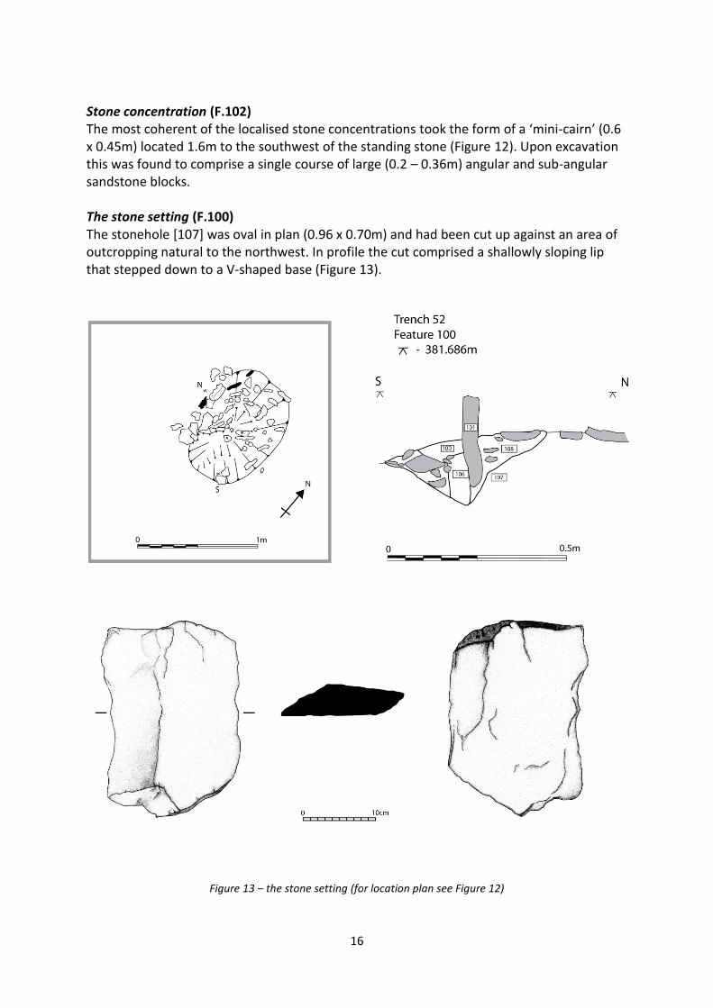
angular pieces of sandstone (typ. 0.1m). There was no stratigraphic relationship with the cairn with the exception of a large stone sitting on the top of [014] that could represent tumble from [012]. 3.2 Exploring the cairn-defined linear (trench 52) One of the more ephemeral features identified by the original geophysical survey was the series of intermittent high resistance linear anomalies to the west of the Lanacombe II settings. Provisionally interpreted as boundaries defined by discrete piles of clearance, a single 5 x 5m trench (T52) was excavated across the junction between two of these features in order to investigate further (Figure 4). Immediately beneath the turf and bound up in the root mat was a uniform spread of very loose sub-angular fragments of sandstone (typ. 0.05-0.1m). As with T50E and T50W, this loose material was photographed and removed. Immediately apparent was a small orthostat set perpendicular to the trending direction of the natural (Feature 100). The edge of a distinct cut could be seen around this small standing stone, analogous to the stoneholes previously excavated at Lanacombe I and III (Gillings et al. in press). Otherwise, with the exception of a number of small concentrations of large sub-angular sandstone blocks (in the southwest portion of the trench) set within an apparently random scattering of sub-angular fragments (typ. 0.08m) it was free of features (Figure 12).
Figure 12 – base plan of trench 52
16
Stone concentration (F.102) The most coherent of the localised stone concentrations took the form of a ‘mini-cairn’ (0.6 x 0.45m) located 1.6m to the southwest of the standing stone (Figure 12). Upon excavation this was found to comprise a single course of large (0.2 – 0.36m) angular and sub-angular sandstone blocks. The stone setting (F.100) The stonehole [107] was oval in plan (0.96 x 0.70m) and had been cut up against an area of outcropping natural to the northwest. In profile the cut comprised a shallowly sloping lip that stepped down to a V-shaped base (Figure 13).
Figure 13 – the stone setting (for location plan see Figure 12)

17
Into the hole a wooden post had been placed [106] against which the standing stone [101] had been inserted. The surviving post-pipe indicates a circular timber 0.1m in diameter, resting directly on the base of the hole. The stone was a thin (0.03m) rectangular slab of sandstone (0.19 x 0.27m) that projected 0.12m above the surface of the natural. The post and stone were then packed into place by a compact dark grey-brown sandy clay deposit [108] containing common small (< 0.02m) rounded fragments of sandstone. Contemporary with this episode of packing was the placement of a number of larger (0.1-0.15m) tabular pieces of stone against the upright stone and post, presumably as additional packing [103]. The presence of the post-pipe indicates that the post had been left to decay in situ, the resultant weathering cone filling with a deposit of compact grey-brown sandy clay [100]. 3.3 Exploring the circular feature (trench 53) To investigate the semi-circular anomaly to the west of the Lanacombe III setting a 4 x 7m trench was placed across the westernmost tip of the semi-circular feature (Figure 14). Once again, directly beneath the turf was a uniform spread of very loose sub-angular fragments of sandstone (typ. 0.05-0.1m) that was photographed and removed. After base-planning of the trench had been completed the decision was made to focus excavation on a smaller (2 x 4.4m) area along the southeast edge of the trench (discussed in more detail below). The shallow gulley (F.203) The earliest feature in T53 was a portion of shallow curving gulley [207] (0.05m deep and 0.6m wide) crossing the eastern corner of the trench (Figures 15 & 16). The sides were very shallow merging with a dished base and filling the feature was a compact, dark grey-brown silty clay [206] containing occasional small (0.02-0.1m) angular and sub-angular stones and frequent flecks and small fragments of Oak charcoal (see Appendix 2).
Figure 14 – trench 53

18
AMS determination on the Oak charcoal from the gulley (sample LAN3_09_1004 (SUERC-
27928)) returned a date of 3230 ± 30 BP. At the 95.4% probability this yields ranges of
1610 – 1570BC (7.2%) and 1560 – 1430BC (88.2%) with the weighting favouring the more
recent early-middle Bronze Age date.
Stakeholes (F.201 & F.202) Visible at the same level as the gulley were the truncated bases of two stakeholes. The first [203] was circular in plan (diam. 0.05m) tapering to a point 0.05m below the surface of the subsoil (Figure 15). The second [205] was once again circular in plan (diam. 0.05m) but shallower, its dished base only penetrating 0.02m below the surface. In each case the fill was a firm, dark-grey silty clay with no inclusions.
Figure 15 – the gulley and stakeholes (for plan location see figure 16)
Buried Soil [201] and Stone spread (F.200) Apparently sealing the gulley and stakeholes and running across the full width of the trench was a deposit of moderately compact dark grey-brown silty clay [201]. This contained variable quantities (5 – 20%) of small (< 0.05m) sub-angular stones and occasional flecks and small fragments of Oak charcoal and presumably corresponds to a buried soil. Although no clear cut was visible for either the gulley or stakeholes, it is quite possible that they had been originally been dug through this deposit, contexts [011] and [201] being distinguished largely on the basis of increased charcoal in the former. This uncertainty is indicated by the dashed line marking the notional upper boundary of context [206] in Figure 16. Sitting within [201] were four pieces of worked flint and a quartz crystal (see Appendix 1). An AMS determination on a fragment of charcoal (LAN3_09_1011 (SUERC-27929 )) returned a date of 3605 ± 30 BP. At the 95.4% probability this yields a range of 2040 – 1880 BC placing the deposit firmly in the early Bronze Age (SWARF Period 3). Although based on single determinations for each deposit, this would certainly support the suggestion that the gulley is a later feature, cut through the buried soil.

19
Figure 16 – section through the stone spread and gulley
Sitting atop this buried soil at the northeast edge of the trench was a thin (generally only one stone thick) band of small to medium sized (0.05 – 0.3m) sub-angular fragments of sandstone [200] corresponding to the high resistance anomaly seen in the geophysical survey (Figure 17). It was in order to provide a section through this feature that the smaller 2 x 4.4m excavation area was established.
Figure 17 – the stone spread
If the arc of stones accumulated, or were deliberately spread against the perimeter of an extant structure, the latter does not appear to have been constructed from stone or been deliberately terraced into the hill-slope. Instead, the suggestion is of a more ephemeral construction sitting atop the buried soil, perhaps of turf and/or timber. As the shallow gulley

20
(and possibly stakeholes), dating to around 1500 BC also appears to have been cut from this level it may suggest a date for this putative structure. 3.4 Extending the Geophysical Survey The excavations were highly successful in ground-truthing the anomalies detected by the soil resistance survey, and in so doing confirming the existence of previously unsuspected activity in the immediate environs of the stone settings. In particular they stressed the value of soil resistance survey on the moorland, showing that given an appropriately sensitive sampling interval and a sufficiently large area is surveyed, even the faint signatures left by ephemeral spreads and accumulations of stone can be detected. During the 2009 season a 200 x 60m survey transect was surveyed, linking the existing Lanacombe II and III survey blocks. In addition, a further three survey grids were completed along the top edge of the Lanacombe II block, taking the total area surveyed to 1.8 hectares. As in previous seasons, survey was carried out using a twin-probe array (RM15 and 0.5m separation) with sample and traverse intervals of 0.5 and 1.0m respectively (i.e. a total of 800 readings per 20m grid square). The survey results along with an interpretation plot are given in Figures 18 & 19.
Figure 18 – the results of the soil resistance survey
Perhaps the most striking result of the survey was confirmation that the open moorland between the settings was free from any of the high resistance banding, confirming the long

21
suspected correlation between these features. The area seems otherwise free of archaeological features, apart from a straggling line of cairns aligned northeast-southwest; there is certainly no trace of any linear anomalies comparable to those seen to the west of Lanacombe II or further structures in the vicinity of Lanacombe III. One anomaly of note was that left by the modern trackway which has a characteristic signature, low across open moor (where the ruts are muddy and wet) and high across shallower bedrock (where they erode the topsoil to reveal underlying natural). It is however a faint signature and different in character and kind from the anomalies noted. Noise on the plot (e.g. the anomalies marked ‘A’ on figure 18) is due to the difficulty encountered in taking readings through some of the thicker patches of moor grass. The extension to the Lanacombe II survey shows that the continuous linear anomaly running to the south of the two cairns extends further to the northeast whilst the clearance-defined linear anomalies to the southwest of Lanacombe II appear to show a degree of regularity in layout with the cross-cutting of lines hinting at the presence of a number of phases of activity.
Figure 19 – interpretation plot
Interestingly, the curious low resistance ‘tear-drops’ do not extend beyond the original survey area. They do however respect the projected line of the southernmost interrupted linear and may well mark the former position of a linear boundary.

22
4.0 Discussion The project set out to ground-truth a series of geophysical anomalies that had hinted at a complex of features in the immediate environs of the Lanacombe stone settings, features that had otherwise left little in the way of surface traces. In addressing this aim it was extremely successful, confirming the existence of a series of linear partitions to the west of Lanacombe II that incorporated a range of features – from complex multi-phase cairn structures (F.1 & F.5), very small, discrete piles of stone (F.102), more haphazard shallow spreads of stone (F.6) and wooden posts (F.100). The anomaly to the west of Lanacombe III is more enigmatic, a shallow spread of stone (F.200) sealing a buried soil containing lithic material, that in turn sealed a shallow gulley (F.203) and stakeholes (F.201 & F.202). The cairns were far more substantial and structurally complex than the rather ephemeral spreads of surface stone had suggested and clearly represent more than one phase of activity (Figure 20). Originally aligned on a shared long axis, the westernmost was subsequently enlarged and elaborated through the insertion of a cist before the axial line was formalised through the dumping of a layer of stone. The morphology of the cairns is intriguing. Although, following the English Heritage monument class description, they would technically be classified as ‘ovoid’ this does not do justice to the sharpness of the tapering ends and as a result ‘boat-shaped’ is preferred here for purely descriptive (rather than rigid classificatory) purposes1. Clear parallels have yet to be located, though the tapered linear clearance heap (4m x 2m) encountered at Shallowmead (Site B) is certainly suggestive2. The AMS determination on the fill of the cist suggests that this was deposited in the later Neolithic, which in turn implies that the initial phase of cairn construction was earlier. Assuming the initial phases of construction are broadly contemporaneous (as the morphology suggests) this makes them the earliest of the complex of features investigated at Lanacombe. As to whether this early date is typical or unusual is currently difficult to assess. Whilst there are a number of cairns recorded on Lanacombe, including a number of smaller cairns closely associated with stone settings (e.g. Lanacombe I, II and III all have small associated cairns) and some very large cairns (e.g. HER 35619 on the broad crest of Lanacombe - 13.7m diameter and surviving to a height of 1.1m ), none have been investigated by excavation and, given how deceptive the surface remains can be with respect to any underlying structural complexity, reliable comparisons are difficult to draw. To compound this, Exmoor has not witnessed any sustained attempt to survey, record and classify cairns comparable to that carried out on Bodmin (Johnson and Rose 1994: 34-45) though a series of site-by-site detailed descriptions were compiled by the RCHME (Wilson-North, pers comm). Despite their shared axial alignment and initial morphological similarities the subsequent histories of the two cairns were markedly different. At F.1 a loose, haphazard spread of stone was placed adjacent to, and partly lapping over, the cairn, respecting its original elongated shape. A mere 10m to the southwest F.5 a similar dump of stone was used to
1 The term ‘boat-shaped’ has previously been used by Webley to describe the very different pointed-prow,
flat-stern shaped cairns excavated at Twyn Bryn Glas (Webley 1962). 2 It is worth noting that in the original Shallowmead report the captions for plates 4 and 5 appear to have been
transposed (as is clear from the written description and Figure 11 plan (Quinnell 1997).

23
enlarge the F.5 cairn to create a circular structure. This was supplemented by deliberate boulder kerbing and the insertion of a possible cist.
Figure 20 – the primary phase of cairn activity
Figure 21 – the final phase of cairn activity

24
That the spread of stone linking the cairns lay upon a boundary is suggested by the thin (0.05-0.1m) layer of firm, dark grey-brown silty clay [002] and [013], presumably hillwash, that accumulated against its upslope edge and the main body of the cairns (Figure 21). Less clear is whether this spread of stone was responsible for the linear anomaly recorded by the geophysical surveys. Although this was suspected during the course of the excavation, careful overlay of the excavation plan and geophysical results show that the bulk of the anomaly is actually displaced to the south of the cairns and accords better with the location and alignment of the possible gulley (F.3). Given that we have only excavated the northernmost edge of this feature, it is entirely plausible that our notional ‘gulley’ is in fact merely the northernmost edge of a much wider and more substantial feature. Further excavation is clearly required. Although at first glance, the small scale of the post-hole in Trench 52 make it one of the least impressive of the features excavated, it is potentially one of the most important with regard to our understanding of stone settings and miniliths in the prehistoric landscape of Exmoor. We excavated the feature fully expecting to find little more than the stone-hole for the observed orthostat. Indeed, in terms of size, shape and overall character (i.e. placement against an edge of outcropping stone) it does closely resemble the stone-hole excavated at Lanacombe I (Gillings et al. in press). Where they differ is that in this case the standing stone was secondary, acting as a thrust plate for a wooden post. In light of this it is worth reflecting upon how frequently miniliths are described as having attendant stone ‘triggers’ (e.g. Riley 2007: 13), with the locations of lost standing stones postulated on the basis of surviving triggers alone (e.g. Chanter & Worth 1906 Plate VII). Further, it is worth considering how the small scale of many of the component miniliths found at the settings has made it difficult in practice to distinguish between standing-stone and triggers (Quinnell and Dunn 1992: 3). The discovery in T52 raises the distinct possibility that some of the miniliths recorded on Exmoor are in fact thrust plates or supports for wooden posts, and that the presence of triggers alone cannot be taken in an uncritical way to indicate the former presence of a standing stone as the self-same technology was being employed to erect uprights of stone and wood. The important word to emphasise here is ‘some’. In the case of the one relatively undisturbed standing stone that has been excavated (Lanacombe I) there was no evidence of either a post-pipe or stone trigger, nor were post-pipes encountered in the excavation of the lowland stone setting at Westermill Farm (Burrow and McDonnell1992). Although the sample is admittedly small, it does raise the tantalising possibility that the enigmatic minilithic settings may originally have comprised a blend of wooden posts and standing stones. This is turn raises the question of how ephemeral and ‘hidden’ these structures really were. Looking more broadly, the presence of a post at the expected junction of a pair of linear boundary features implies a degree of planning and organisation to the laying out of these features. Through an overlay of the trench plan with the geophysical survey results it is clear that the mini-cairn (and other noted clusters of larger stones) are responsible for the geophysical anomaly running upslope. The presence of a post at the point where a perpendicular boundary joins this line is highly significant, as it suggests that sighting posts were being employed in the structuring of the landscape at this point.

25
Taken as a whole the linear anomalies suggested a fragment of co-axial field-system, defined in large part by small, discontinuous piles of stone, with at least one junction marked by a wooden post. Assuming that the continuous anomaly flanked by the cairns marks the dominant axis, this is aligned northeast-southwest and follows the contour exactly. Excluding Lanacombe, only 10 co-axial field systems have been recorded on Exmoor (Riley & Wilson-North 2001: 40-54, Fig. 2.32; Riley 2009: 27) and the paucity of excavated examples makes it difficult to identify immediate parallels – indeed, with the exception of palaeoenvironmental sampling at Codsend the present fieldwork comprises the only geophysical survey and excavation to have been carried out on a co-axial prehistoric field system in the National Park (Riley 2009: 26). The closest fragment of coaxial field system so far identified is at East Pinford (HER 33140) some 1.5km to the east, though the Lanacombe features bear little resemblance to the 3.0m wide stone banks that delineate the axes of the former. The presence of cairn-defined boundaries at Lanacombe certainly echoes the Bronze Age field systems recorded at Codsend Moor site 4 (Patterson & Sainsbury 1989, 87) and the 30m interval between the boundaries accords well with the 30-35m recorded at Codsend site 3 (ibid., 85). The two areas also share a general northeast-southwest main alignment and are on areas of sloping ground with a southerly aspect. There are also dissimilarities; there is no evidence for the stone banks and lynchets evident at Codsend, nor does the main axis of the system lie diagonally across the contour. A closer parallel may lie some 1.25km further along the edge of Lanacombe to the southwest, where fragments of a possible prehistoric field system were recorded in 1994 (HER 35607) that were similarly defined by a combination of cairns and interrupted linear features (described in this case as either linear clearance or interrupted stony banks). These features showed indications of extending under the peat to the north and north east and, taken together with the evidence from the current project, may suggest that field systems may once have been extensive along the southern crestslopes of Lanacombe. As for what the small stone piles and amorphous spreads represent we are clearly not dealing with continuous structures such as field walls or the remains of revetted banks. In saying this, the features respected something and the suggestion is of material that has been cleared to a pre-existing yet ephemeral boundary feature, perhaps defined by a hedge, fence or merely a line of sight between two or more posts. Of particular interest are the lines of stone piles which appear to be on a different axial alignment (marked ‘? fragment of interrupted linear’ on figure 19) which may point to the existence of other phases of activity. Before moving on to discuss the circular feature at Lanacombe III, one final piece of evidence for field systems around the Lanacombe II stone setting is worthy of mention. To the immediate west of the excavation area is a length of what has been described as rubble bank, corresponding to a fragment of prehistoric field system (the westernmost cairn marked on Figures 3 & 19) (HER 35600). Whilst the feature showed clearly as a higher resistance anomaly in the geophysical survey, rather than a continuous linear feature (as we would expect of a stone bank) it appeared instead as a rather diffuse, elongated cairn, and may well be analogous to the excavated cairns described here albeit on the other axis of the suggested system. One of the most enigmatic of the geophysical results was the 10m diameter circular anomaly to the immediate west of the Lanacombe III setting, which lacked any matching surface signature (e.g. protruding stone, banking or terracing. Excavation across the

26
westernmost ‘terminal’ of this feature revealed a shallow and ephemeral spread of stone that is difficult to interpret as structural in any traditional sense of the word; there are no conspicuously large stones, no coursing or evidence of deliberate terracing or banking. As to what this represents, it is difficult to envisage this as a hut circle akin to those already recorded on Exmoor (for typical example see Riley 2009: 15-18). It certainly lacks the 3.0m wide stony bank and terracing that marks the hut circle associated with the coaxial field system at East Pinford (HER 33139). Perhaps the most convincing explanation is that it preserves (either through accumulation or a deliberate spread) the perimeter of a timber or turf structure - an example of what Ainsworth has termed a ‘circumstantial’ settlement site in the case of Gardom’s edge. In such cases there are no surviving physical traces of the structure itself at the surface (house or hut), instead its presence is indicated by factors such as sympathetic changes in the alignment of other features and arcs of stone that may have been stacked, or spread, against its perimeter (Ainsworth 2001: 25-7 & Fig 2). The worked flint, stakeholes, possible gulley and charcoal certainly attest to a degree of activity in the immediate area and it may be worth noting that with hindsight the location of the anomaly could be seen to coincide with a vegetation change (moor grass and rushes marking the perimeter, giving way to short grass in the interior). Another possibility is that the ephemeral spread of stone marks the location of a ring-cairn. It could be argued that the term ‘ring-cairn’ is of little use as a descriptor, referring as it does to a wide and diverse range of broadly circular stone structures - see for example recent classificatory work in Cumbria (Evans 2008). Further, in the absence of excavation, ring-cairns can be extremely difficult to distinguish from hut circles (for an Exmoor example of this difficulty see Ruckham Combe (HER 33022 & 35558)). Putting such caveats aside, it is difficult to find any immediate parallels for the feature with the only suggested ring-cairn so far recorded on Lanacombe (HER 35611) defined by a notable spread of surface stone. Even those described as being of ‘slight construction’ such as the excavated cairn at Rixdale (South Devon) (Quinnell 1997: 32) are positively monumental in comparison with Lanacombe3. As we only investigated the westernmost tip of the anomaly where it was at its most diffuse, it may well be that the stronger response given by the northernmost arc does indeed correspond to a more substantial deposit of stone, though the lack of any surface indication of such is telling. The single excavated example of a ring-cairn structure on Exmoor, Shallowmead, some 8km to the southwest does, however, provide some interesting parallels. Although at first glance the two features could not be less alike – Shallowmead comprising a substantial stone built structure with deliberate kerbing, revetment and platforming – there are some tantalising similarities. For example, there was also a break in the Shallowmead circle to the south – in this case a 2.5m wide gap where the otherwise kerbed structure of substantial stones had ‘petered out’ (Quinnell 19978: 21). This area was partly covered by a spread of flat stones and tentatively interpreted as an entrance. Just within this putative entrance gap was a roughly circular area of a buried soil rich in charcoal and associated with a group of stakeholes (Quinnell 1997: 20-22).
3 The published photographs show an arc defined by a substantial spread of large stones (Griffiths 1984).

27
This may, of course, be coincidental. At present, all we can say with confidence is that activity was taking place in the immediate vicinity of the Lanacombe III stone setting in the early – middle Bronze Age, with a circular spread of stone sealing a buried soil containing flint work through which stakeholes and a shallow gulley (the latter rich in charcoal) had been cut. As to whether this corresponds to a circular wooden structure, a ring-cairn or other form of structure yet to be recorded on Exmoor only further targeted excavation will tell. Needless to say, the results of the excavations have enormous implications for our interpretation of Lanacombe, and by extension, upland Exmoor, in prehistory. They have certainly confirmed the suspicion gained from earlier geophysical surveys that far from sitting in splendid isolation, the Lanacombe stone settings were embedded within complex landscapes of clearance and partition. They have also confirmed the correlation between setting location and bands of shallower bedrock, adding weight to the suggestion that they were originally constructed in areas that were distinctive, either as clearings or through the vegetation they supported. Given the proximity of field systems it may also be worth considering whether they would also have been distinctively textured in terms of the types of agriculture they would (and would not) have supported. The results have also raised questions regarding the status and significance of the apparently small and haphazard cairns recorded across the surface of Lanacombe and found in frequent association with stone settings. Two remarkably unimpressive examples were excavated with every expectation of finding shallow, haphazard accumulations of cleared stone. Instead complex, carefully constructed cairns were revealed showing evidence for successive phases of activity. If the Lanacombe III anomaly does mark the location of a timber hut or roundhouse then this raises questions regarding the known distribution of house structures across the moor. The same applies to field partitions and boundaries that are defined by ephemeral material spreads and concentrations that leave little or no surface trace. 4.1 Suggestions for further work It is in the very nature of excavation that as many questions are raised as have been answered and as a further excavation season is required to clarify some of the ambiguities discussed in detail above. Key priorities for any future excavation season in the Lanacombe landscape will be:
1. completion of the excavation of the T50W cairn (F.5) in order to resolve the detail of its constructional sequence (including the status of the cairn)
2. excavation of the baulk between T50E and T50W, extending to the south to yield a
full section across the ?gulley (F. 3) and shed light upon the intersection between the two linear features
3. further excavation on the arc (and interior) of the semi-circular stone spread at
Lanacombe III (F. 200) to fully characterise this feature

28
4. investigation of the low-resistance ‘teardrop’ features that seem to align on the axis of the linear features. Excavation of at least one of these features is a priority.
With regard to geophysical survey, one aim will be to map the full extent of the main axial line of the field-system. A second is to extend the survey block upslope towards the broad crest of Lanacombe where a number of small scoops and terraces were noted during the course of the excavation season; what is missing from this landscape at present is any suggestion of roundhouse structures which, on the basis of other areas of the moor (e.g. East Pinford), we would expect to be associated with the field-system (Riley & Wilson-North 2001: 44-46). With this contextual work completed, attention can then return to the minilithic settings themselves, where the goal will be to elucidate the relationship between the stone settings of Lanacombe and this emerging landscape of partitions and boundaries. Did the clusters of small standing stones pre or post-date these features or were the settings an integrated component? Indeed, need all of the component miniliths that make up the settings be free-standing stones or could some have been triggers for wooden posts? Only further excavation will tell.
29
Appendix 1 – Assessment of Finds
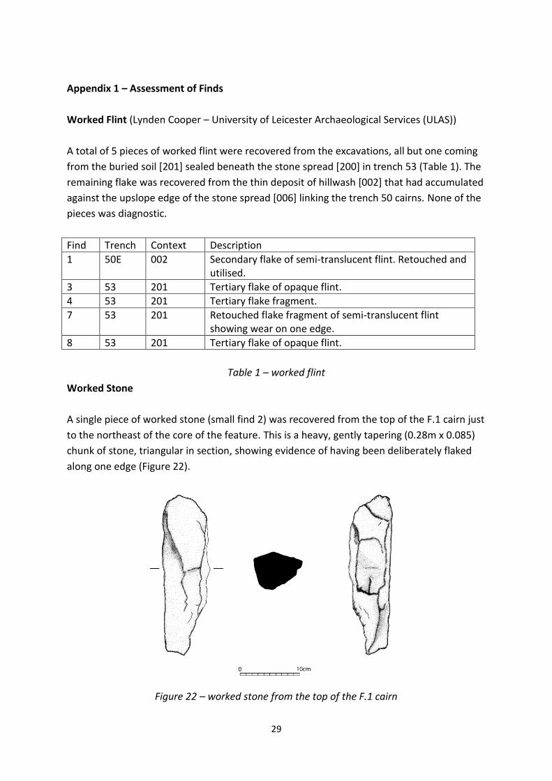
Worked Flint (Lynden Cooper – University of Leicester Archaeological Services (ULAS))
A total of 5 pieces of worked flint were recovered from the excavations, all but one coming
from the buried soil [201] sealed beneath the stone spread [200] in trench 53 (Table 1). The
remaining flake was recovered from the thin deposit of hillwash [002] that had accumulated
against the upslope edge of the stone spread [006] linking the trench 50 cairns. None of the
pieces was diagnostic.
Find Trench Context Description
1 50E 002 Secondary flake of semi-translucent flint. Retouched and utilised.
3 53 201 Tertiary flake of opaque flint.
4 53 201 Tertiary flake fragment.
7 53 201 Retouched flake fragment of semi-translucent flint showing wear on one edge.
8 53 201 Tertiary flake of opaque flint.
Table 1 – worked flint
Worked Stone
A single piece of worked stone (small find 2) was recovered from the top of the F.1 cairn just
to the northeast of the core of the feature. This is a heavy, gently tapering (0.28m x 0.085)
chunk of stone, triangular in section, showing evidence of having been deliberately flaked
along one edge (Figure 22).
Figure 22 – worked stone from the top of the F.1 cairn

30
The tapered end also appears to have been broken off in antiquity. The function of this
object presently remains unclear; it is weighty and fits comfortably in the hand, however
there were no signs of pecking or wear on the surface (though it should be noted that a
portion of the flaked edge had suffered post-depositional damage).
Quartz
During the course of excavation fragments of white quartz were ubiquitous, being
recovered from the majority of contexts investigated. As an exercise in unbridled
empiricism, a record was kept of the weights of quartz recovered by context (Table 2).
Trench Context Count Weight
53 001 101 8.05kg
52 001 108 3.5kg
50 001 100 1.6kg
50 002 208 3.66kg
50 004 43 0.35kg
50 005 9 0.175kg
50 011 8 0.15kg
50 013 94 0.50kg
53 201 17 1.2kg
Table 2 – Quartz by context
Whilst at one level this served the prosaic function of confirming the frequency of natural
quartz, it may have relevance for any attempted use of techniques such as OSL to date
excavated deposits in future. Of more immediate interest were the visually striking
examples of transparent, individual quartz crystals. A total of five were recovered (Table 3)
the largest (0.025 x 0.014m) recovered from in amongst the stones making up the northeast
end of the F.1 cairn. As to whether these comprise artefacts per se or are merely elements
of the general spread of quartz throughout the excavated contexts is at present unclear.
Find Trench Context Comment
5 50E 004 very large (0.025 x 0.014m) pointed crystal
6 53 201 small (0.01 x 0.005m) pointed crystal
9 50W 013 small (0.014 x 0.004m) pointed crystal
10 50W 013 very small (0.006 x 0.003m) pointed crystal
11 50E 014 small (0.009 x 0.007m) faceted crystal
Table 3 – Quartz crystals

31
Appendix 2 - An assessment of the soil samples
Alistair Hill - School of Archaeology & Ancient History, University of Leicester
Introduction
During August 2009, excavations were carried out around the stone settings at Lanacombe,
Exmoor by a team from the University of Leicester. Whilst carrying out the excavation work,
soil samples were taken to facilitate the recovery of archaeobotanical evidence. The
collection and analysis of plant remains from archaeological sites presents archaeologists
with a very distinctive range of data that can be used to interpret the social and economic
systems of past societies as ‘almost all plant species attested for archaeological sites have
economic implications, either of direct or of indirect nature’ (van Zeist 1991:109).
Methods
Using a judgemental sampling strategy, the archaeobotanical samples were taken from
contexts identified as having the potential for the preservation of plant remains. A total of
13 bulk samples were taken from a range of contexts/features.
The samples taken for the recovery of plant remains were processed using a 500micron
(0.5mm) mesh with the flotation fraction (flot) collected on a 300micron (0.3mm) mesh
sieve. The flotation residues were air dried and the fraction over 5.6mm sorted for all finds
then discarded. The flot was air dried and packed carefully in self-seal polythene bags that
were marked with details of the project code, context and sample numbers prior to
laboratory analysis. The course fraction (over 4mm) was separated on a riddle and sorted
for all remains. The analysis of all the flots was carried out by scanning and 100% sorting
each flot using a binocular microscope with magnification settings of between x7 and x45.
Results:
Lanacombe 2009
Sample No Trench Feature Context Description Lts Kg Flot mls Ch
1000 52 100 106 2 2.2 30 + flecks
1001 52 100 100 4 5.4 125 ++ flecks
1002 52 100 106 0.5 1.5 20 + flecks
1003 50(west) 4 9 Upper fill of cist 11 11.8 900 -
Middle fill of cist 6 10 400 +++ flecks
Lower fill of cist 1.2 2.4 40 + flecks
1004 53 200 206 Fill of hollow 10.5 15 100 +++ flecks
1005 53 200 206 Charcoal from area of hollow N/A N/A 7.5 + flecks
1006 53 201 202 Stakehole fill 0.05 - 50 + flecks
1007 53 202 204 Stakehole fill 0.014 - 14 -
1008 50(east) 11E Buried soil beneath cairn 11 12 600 -
1009 50(east) 11W Buried soil beneath cairn 5 7 50 -
1010 50(east) 11W Buried soil beneath cairn 14 17.5 100 + flecks

32
Table 4: Assessment of flots from Lanacombe 2009 Key to Table 4 Ch = charcoal, + = present, ++ = moderate, +++ = abundant As can be seen from the above table, 8 contexts (13 samples) were sieved, with a total sample volume of 62.3 litres (85.2 kg). However, the samples which were from relatively shallow contexts were predominately composed of stone fragments, peaty soil and modern root contamination. The only archaeobotanical evidence was the presence of charcoal flecks in 9 of the samples, with samples 1003 (middle fill of cist) and 1004 (hollow fill) containing flecks that may be large enough to use for wood identification or carbon dating. It should be noted that the evidence for Early Prehistoric plant remains is often sparse and they are not present on all sites. Recommendations No further study of the biological remains from these samples is justified, but the possibility that other deposits, with preserved charred plant remains, may be present at this site and should be considered in the event of further interventions.

33
Appendix 3 – An Assessment of the wood charcoal
Dr. Ruth Young - School of Archaeology & Ancient History, University of Leicester
Lanacombe wood charcoal Sample 1003 (Lanacombe II area - fill of cist [009]) 0.231g 1 fragment - ? not identifiable? Sample 1004 (Lanacombe III area - fill of hollow [206]) 0.210g 2 fragments - both Quercus spp. Sample 1011 (Lanacombe III area - buried soil [201]) 0.365g 3 fragments – all Quercus spp. Wood charcoal preparation and identification followed standard procedure, namely examining a range of pieces 2mm3 and larger, splitting them according to transverse, radial longitudinal and tangential longitudinal sections, and examined under magnification up to x100 (Thompson 1994, 20; Dimbleby 1978). Identification of wood charcoal was carried out using the keys of Ilic (1991) and Schweingruber (1978) alongside reference material. The presence of oak at this Bronze/Iron Age site is to be expected in an assemblage from a British site of this period (see e.g. Boyd 1988; Gale 1994), and suggests exploitation of local woodland for fuel and construction purposes.

34
Appendix 4 – Radiocarbon Dating
All of the charcoal samples discussed in Appendix 3 were submitted for AMS dating. The
samples were measured at the Scottish Universities Environmental Research Centre AMS Facility
(SUERC) with calibrated age ranges determined using the University of Oxford Radiocarbon
Accelerator Unit calibration program (OxCal3).
Sample LAN3_09_1004 (SUERC-27928 (GU-20933))
This corresponded to fragments of oak charcoal recovered by flotation from the fill of the shallow
gulley excavated at Lanacombe III.
Radiocarbon Age BP (1 sigma) 3230 ± 30
Calibration Plot
The calibrated date range at 95.4% probability places the sample in the early-middle Bronze Age,
with the probability range weighted towards the transition (following the chronology established by
the South West Archaeological Research framework (SWARF)).
Atmospheric data from Reimer et al (2004);OxCal v3.10 Bronk Ramsey (2005); cub r:5 sd:12 prob usp[chron]
1800CalBC 1600CalBC 1400CalBC 1200CalBC
Calibrated date
3000BP
3100BP
3200BP
3300BP
3400BP
3500BP
Rad
ioca
rbon d
eter
min
atio
n
SUERC-27928 : 3230±30BP
68.2% probability 1525BC (68.2%) 1450BC 95.4% probability 1610BC ( 7.2%) 1570BC 1560BC (88.2%) 1430BC

35
Sample LAN3_09_1011 (SUERC-27929)
This corresponds to fragments of oak charcoal recovered manually during excavation of the buried
soil [201] at Lanacombe III.
Radiocarbon Age BP (1 sigma) 3605 ± 30
Calibration Plot
The calibrated date range at 95.4% probability places the sample firmly within the early Bronze Age,
designated Period 3 within the South West Archaeological Research framework (SWARF).
Atmospheric data from Reimer et al (2004);OxCal v3.10 Bronk Ramsey (2005); cub r:5 sd:12 prob usp[chron]
2200CalBC 2000CalBC 1800CalBC 1600CalBC
Calibrated date
3300BP
3400BP
3500BP
3600BP
3700BP
3800BP
Rad
ioca
rbon d
eter
min
atio
n
SUERC-27929 : 3605±30BP
68.2% probability 2020BC (18.7%) 1990BC 1985BC (49.5%) 1920BC 95.4% probability 2040BC (95.4%) 1880BC

36
Sample LAN2_09_1003 (SUERC-27930)
This corresponds to fragments of charcoal recovered from flotation of the middle fill of the cist at
Lanacombe II [009].
Radiocarbon Age BP (1 sigma) 3835 ± 30
Calibration Plot
The calibrated date range at 95.4% probability gives the sample a date in the terminal Neolithic,
Periods 1 and 2 following the chronology established by the South West Archaeological Research
framework (SWARF).
Comparison of calibrated date ranges
Atmospheric data from Reimer et al (2004);OxCal v3.10 Bronk Ramsey (2005); cub r:5 sd:12 prob usp[chron]
2600CalBC 2400CalBC 2200CalBC 2000CalBC
Calibrated date
3600BP
3700BP
3800BP
3900BP
4000BP
4100BP
Rad
ioca
rbon d
eter
min
atio
n
SUERC-27930 : 3835±30BP
68.2% probability 2350BC (37.7%) 2270BC 2260BC (30.5%) 2200BC 95.4% probability 2460BC (95.4%) 2190BC
Atmospheric data from Reimer et al (2004);OxCal v3.10 Bronk Ramsey (2005); cub r:5 sd:12 prob usp[chron]
3000CalBC 2500CalBC 2000CalBC 1500CalBC
Calibrated date
SUERC-27928 3230±30BP
SUERC-27929 3605±30BP
SUERC-27930 3835±30BP

37
Acknowledgements
Thanks are given to the Maltwood Fund of the Somerset Archaeological and Natural history
Society and the Society of Antiquaries who kindly funded the 2009 excavations and the
Exmoor National Parks Authority who funded the C14 dates. Heartfelt thanks are also given
to Jessica Turner and Rob Wilson-North (Exmoor National Park) for all of the hard work they
put into making the fieldwork possible and to Mark de Winter Smith for kindly allowing us to
excavate and survey on Lanacombe, Paul Richards for help with regard to livestock and
fencing and the National Park rangers for helping us to get equipment to and from
Lanacombe.
The work was carried out in good spirit by one stalwart volunteer (Lisa Rotheram) and a
team of students from the Universities of Bristol (Jenney Giddins, Rebecca Pullen, Bruce
Redman, Andy Spencer, Mel Winterton); Leicester (Paul Andrews, Chloe Chandler, Christine
Dann, Jemma Mitchell, Ryan Morrison, Dickie Spurgin, Mary Wickenden) and Plymouth
(Emily Goodchild). The worked stone was illustrated by Emma Shaw. Special thanks are
extended to Rebecca Pullen for base planning trench 50 west.
Bibliography
Ainsworth, S. 2001. Prehistoric settlement remains on the Derbyshire Gritstone moors. Derbyshire Archaeological Journal 121: 19-69. Boyd, W.E. 1988. Methodological problems in the analysis of fossil non-artifactual wood assemblages from archaeological sites. Journal of Archaeological Science 15, 603-19. Burl, A. 1993. From Carnac to Callanish: the prehistoric stone rows and avenues of Britain, Ireland and Brittany. New Haven: YUP Burrow, I.C.G. & McDonnell, R.R.J. 1982. Westermill Stone Setting. Unpublished Interim Excavation Report (Somerset HER 33602) Chanter, J.F. and Worth, R. H. 1906. The rude stone monuments of Exmoor and its borders. Part II. Reports and Transactions of the Devonshire Association 38: 538-52 Cummings, V. 2008. The architecture of monuments. In J. Pollard (ed.). Prehistoric Britain: 135-59. Oxford: Blackwell Curtis, L.F. 1971. Soils of Exmoor Forest. Harpenden: The Soil Survey of England and Wales. Dimblebly, G. 1978. Plants and Archaeology. London: Paladin. Evans, H. 2008. After the axe: ways into the upland landscapes of Cumbria. In A. Chadwick (ed.). Recent Approaches to the Archaeology of Land Allotment: 122-142. BAR S1875. Oxford: Archaeopress.

38
Evans, J. 2003. Environmental archaeology and the social order. London: Routledge. Gale, R. 1994. Charcoal and wood. In: M.G. Fulford, J.R.L. Allen & S.J. Rippon ‘The settlement and drainage of the Wentlooge level, Gwent: excavations and survey at Rumney Great Wharf 1992’ Britannia XXV: 205-206. Gillings, M., Pollard, J. and Taylor, J. (in press). The Miniliths of Exmoor. The Proceedings of the Prehistoric Society. Ilic, J. 1991. CSIRO Atlas of Hardwoods. Bathurst, NSW: Crawford House Press. Jamieson, E. 2002. Archaeological Survey Work at Larkbarrow. Somerset Archaeological and Natural History Society 146: 17-26 Johnson, N. and Rose, P. 1994. Bodmin Moor: An archaeological survey. Volume 1: The Human Landscape To c.1800. Swindon: English Heritage. O’Connor, T. and Evans, J. 2005. Environmental Archaeology: principles and methods. Stroud: Sutton. Patterson, P. and Sainsbury, I.S. 1989. Prehistoric earthworks on Codsend and Hoar Moors, Somerset. In M. Bowden, D. Mackay and P. Topping (eds). From Cornwall to Caithness: some aspects of British Field Archaeology, 79-91. Oxford: BAR British Series 209 Quinnell, H. 1997. Excavations of an Exmoor barrow and Ring Cairn. Proceedings of the Devon Archaeological Society 55: 1-38 Quinnell, N.V. & Dunn, C.J. 1992. Lithic Monuments within the Exmoor National Park: a New Survey for Management Purposes. Unpld. RCHME Survey report Riley, H. 2007. Lithic Monuments on Exmoor: some new discoveries. The Warcombe Water Stone Row and a Stone Setting on Trout Hill. English Heritage: Research Department Report Series 44-2007. Riley, H. 2009. Hoar Moor & Codsend Moors, Exford & Cutcombe, Somerset, Exmoor National Park. English Heritage: Research Department Report Series 15-2009. Riley, H. & Wilson-North, R. 2001. The Field Archaeology of Exmoor. Swindon: English Heritage Schweingruber, F.H. 1978. Microscopic Wood Anatomy. Teufen, Switzerland: F.Fluck-Wirth. Webley, D.P. 1962. Twyn Bryn Glas: the excavation of a round-cairn at Cwm Cadlan, Breconshire. The Bulletin of the Board of Celtic Studies XIX: 56-71.

39
Zeist, van W. 1991. Economic aspects. In W. van Zeist, K Wasylikowa, and K-E. Behre (eds.)
Progress in Old World Paleoethnobotany. Rotterdam, A.A Balkema.