the national parks of haiti
TRANSCRIPT

Stewardship Plan
for
The National Parks of Haiti
by
Charles A Woods
and
Lawrence Harris
I
STEWARDSHIP PLAN
FOR
THE NATIONAL PARKS OF HAITI
by
Charles A. Woods, PhD
Department of Natural Sciences
Florida State Museum
University of Florida
and
Lawrence Harris,PhD
Department of Wildlife and Range Sciences
School of Forest Resources and Conservation
University of Florida
Gainesville, Florida
January 1986
Prepared for USAID/Haiti under contract number
521-0169-C-00-3083-00

Table of Contents
Executive Summary
Chapter I - The Concept of National Parks in Haiti
1. Introduction
2. Terminology
3. Conservation Strategy in Haiti
Page
1
37
37
39
43
4. Actions of the Government of Haiti in Conservation 46
5. National Priorities and Conservation Goals in Haiti 50
Chapter II - Organizational Plan
1. Objectives
2. Special Concerns
3. Pares Nationaux Naturels d'Haiti
A. Introduction
B. Organization of Pares Haiti
C. Responsibilities of Pares Haiti
1. Implementation and Development
2. Operations
3. Public Use
4. Environmental Stewardship
5. Monitoring and Evaluation
D. Budget for Pares Haiti
E. Pares Haiti and the concept of "Biospnere
Reserves"
54
54
54
55
55
58
63
64
66
67
68
79
71
84

F. Organization of Pares Haiti and other GOH units
within the biosphere reserve concept 85
G. Ten Ye^r Plan for Pares Haiti 87
Chapter III - Pare National La Visite
1. Location
2. Size and Natural Boundaries
3. Access
4. Major Features
A. Geology
B. Floristics
C. Butterflies
D. Land Mollusks
E. Herpetofauna
F. Birds
G. Mammmals
5. Critical Regions
A. Areas
B. Special Concerns
6. Zones and Areas of Pare La Visite
A. Recreation
B. Biological Preserve
C. Restoration
D. Maintenance and Service
E. Security and Information
F. Education
G. Research
7. Plan for Pare La Visite
94
94
94
99
102
103
106
113
114
114
116
119
123
123
125
127
128
130
131
133
133
134
136
138
\

A. Administration
B. Maintenance
C. Security
D. Recreation and Tourism
E. Education and Interpretation
F. Public Relations
G. Research
H. Conservation Goals
I. Ten Year Plan
Chapter IV - Pare National Pic Macaya
Location
Size ai.
Access
atural Boundaries
4. Major Features
A. Geology
B. Floristics
C. Butterflies
D. Land Mollusks
E. Herpetofauna
F. Birds
G. Mammals
5. Critical Regions and Topics of Special Concern
A. Areas
B. Special Concerns
: <iones and Areas of Pare Macaya
A. Recreation
B. Special Permit Area
138
139
140
142
143
144
145
146
147
149
149
149
154
159
159
163
170
171
172
175
181
186
186
188
190
190
192
V\

C. Biological Preserve
D. Restoration
E. Maintenance and Service
F. Security and Information
G. Education
H. Research
7 . Plan for Pare Macaya
A. Administration
B. Maintenance
C. Security
D. Recreation and Tourism
E. Education and Interpretation
F. Public Relations
G. Research
H. Conservation Goals
I. Ten Year Plan
194
196
198
199
200
201
203
203
204
205
207
209
210
211
212
213
Acknowledgments
Literature Cited
Tables
Figures
Maps
Photographs
217
219
221
249
256
262
EXECUTIVE SUMMARY
1. Background
The concept of protecting the natural areas of Haiti
goes back at least to the law of 17 August 1955. The
official creation of "Pares Nationaux Naturels" was a decree
published on 23 June 1983, which set aside "Morne La Visite
du Massif de la Selle" (2000 hectares) and "Morne Macaya du
Massif de La Hotte" (2000 hectares) in addition to eight
sites selected as "Pares Nationaux" and "Sites Naturels" in
the decret of 18 March 1968. These ten sites, but most
especially Pare National La Visite and Pare National Pic
Macaya represent the components of the national parks of
Haiti. Since 1983 the Florida State Museum has worked on a
contract with USAID to complete an inventory of Pare
National La Visite and Pare National Pic Macaya, and to
develop a management plan for each park, as well as for the
national parks program. Since 1983 the parks have been
under the joint administration of the Institut National
Haitien de la Culture et des Arts (INAHCA) and the Ministere
de 1'Agriculture, des Ressources Naturelles et du
Developpement Rural (MARNDR).
A. Location
The area now designated as Pare National La Visite is
located 22 ki.'.ometers south of Port-au-Prince in the Massif

de la Selle in the area of latitude 18 20'30" N and
longitude 72 20' W. The park is situated along the crest of
the Massif de la Selle between Morne d'Enfer (1900 meters)
and Morne Kadeneau (2155 meters). The highest spot in the
park is Morne Cabaio (2282 meters) on which there is a
benchmark. The boundaries of the park have not been
officially designated. The official (by decree) size of the
park is 2000 hectares. The natural boundaries of the
plateau area of the park and the steep cliffs north of the
La Selle Escarpment enclose an area of 4500 hectares. The
region of Morne d'Enfer is a natural extension of the park
that includes uninhabited areas to the west of Mornf 1 La
Visite and the existing boundary of the pe v k along the
mountain road from Furcy. This -are.=> '"icrl'H be included in
the park Lecau^e : ' ..;^rv c->-s as .-c^es and
habitats that : ' £ * '" ' -_ easier;;
areas of the .oar.. . . . ' finfe-. to
Morne Kadeneau i., an c^t* . -..- .....
Access to Pare Nationa.1 La Vi^iOo is via che mountain
highway from Port-au-Prince via Furcy and Ca Jacques. An
alternative access route departs Port-au-Prince and follows
the route to the south anc, the road to Jacmel. Beyond
Jacmel the route pdsses through Marigot before ascending the
southern slope of the Massif de la Selle to Marche Seguin
which is near the southern boundary of the park. The route
from Furcy passes through the park to join the route via

Jacmel at Marche Seguin. The route via Furcy is 55 km
between Port-au-Prince and Pare National La Visite and
normally takes four hours to drive while the route via
Jacmel is 150 km and over six hours driving time. Both
routes are rough and the unpaved mountain sections
frequently are damaged by heavy rains. The grade on the
route via Furcy is abnormally steep. Improvements will have
to be made to both of these routes before safe and regular
access to the parks by visitors will be possible.
The area now designated as Pare National Pic Macaya is
located 36 km NW of Les Cayes and 195 km W of Port-au-Prince
at latitude 18 21' N and 74 01' W. The park is situated
around the two dominant mountains of the region, Pic Formon
(2219 meters) and Pic Macaya (2347 meters) and includes the
large and deep ravine between these two mountains that
serves as the headwaters of the Riviere Ravine du Sud« The
plain south of Pic Formon (Plaine de Formon and Plaine de
Deron) are also included in the park as are the rocky
(karst) hills along the southern boundaries of these plains.
The two high peaks tower above the surrounding plains
(which are between 1000 and 1500 meters in elevation) and a
series of mountain ridges and receive moist air blowing
inland from the Golfe de la Gonave to the north (via the
northeast trade winds) or the Caribbean to the south (via
sea breezes). The result is an area of extremely high
rainfall (in excess of 3000 mm/year). Pare National Pic

Macaya is the source of four major rivers of southern Haiti
(Riviere de Port-au-Piment, Riviere des Roseaux, Riviere
Ravine du Sud and Riviere 1'Acul). Extreme deforestation in
the area the stability of these rivers, and the rich
agricultural lands below (Cohen, 1984; Lowenstein, 1984).
Pare National Pic Macaya serves the dual role of
conservation of the national patrimony in protecting
numerous endemic species of plants and animals and
protecting the watersheds of four of the most important
risers of Haiti that spread outwards from the park like the
spokes of a wheel.
Access to Pare National La Visite is difficult. The
journey is via the route to the south from Port-au-Prince
passing through Les Cayes 196 kms west. Beyond Les Cayes
the route is via a gravel road to Le Due and then a rough
dirt road to Le Pretre that crosses the Riviere 1'Acul.
Beyond Le Pretre the route ascends to the plateau of the
Plaine de Formon by a series of sharp switchbacks to the
town of Les Platons. The entire trip from Port-au-Prince is
129 kms, although the 33 kms from Les Cayes to Les Platons
are the most difficult. Beyond Les Platons it is necessary
to hike for 10 kms across the southern edge of the Plaine de
Formon to the location of the park headquarters at 1428
meters elevation. A road is presently under construction by
local residents from the Catholic church at Les Platons in
the direction of Marche Sous Bois. As of November 1985 the

road was passable on a jeep for a distance of 1.5 kms.
Because access to the park is so difficult and the location
is so distant from Port-au-Prince we recommend that an area
of the upper Plaine de Formon be leveled for a grass landing
strip Cor small airplanes after the park is underway.
B. Purpose
The purpose of the national parks has never been
clearly stated. The law of 17 August 1955 regulated
cutting, transporting and selling wood, and the Rural Code
of Francois Duvalier (28 May 1962) strickly controlled
forest resources and activities in forest resrves. The
decree of 23 June 1983 creating "Pares Nationaux Naturels"
lists eight park related responsabilities for MARNDR that
can be summarized as: 1) protecting ecological conditions;
2) undertaking an inventory of plants and animals; 3)
studying the characteristics of endemic species in relation
to geology, soils, climate, etc.; 4) identifying areas
having important ecological characters; 5) preserving
national parks from physical deterioration; 6) supervising
and working with the scientific community in studies in the
parks and natu* 1 sites; 7) diffusing information
concerning the parks and sites; 8) making the facilities of
the parks available to visitors.
We have synthesized these statements, as well as our
many conversations with personnel from the governmental and

private sectors into the following list which we believe
represents the purpose of the Pares Nationaux Naturels
program in Haiti.
1. The protection of natural ecological conditions and
processes. The two most important consequences of these
actions are : 1) the preservation of watersheds, thereby
improving the quality of life for all inhabitants of Haiti
in areas adjacent to or under the influence of national
parks; 2) the preservation of natural species diversity and
therefore the national natural patrimony.
2. The promotion of the national natural patrimony.
The two most important consequences of this activity are:
1) the education of the citizens of Haiti about the unique
features of their country that make Haiti special; 2) the
increased possibility that wise decisions of long range
importance can be made concerning the utilization and
development of the natural resources of Haiti.
3. The development of a recreation and tourism program
that will take advantage of the unique physical location and
beauty of the parks as well as the special features of the
flora, fauna or geology. We believe that it is possible for
the citizens of Haiti to benefit from the parks at both the
local and national levels without damaging the quality of
the parks if a careful management plan is developed and
implemented.
2. Resources
The geological and biological resources have been
surveyed and are discussed in detail in the reports
presented as companion volumes to the Stewardship Plan.
These reports are: 1) Geological setting; 2) Floristic
study; 3) Butterflies; 4) Malacology; 5) Herpetofauna;
6) Birds; 7) Recent and extinct mammals. In summary, these
reports indicate that the national parks are of great
importance because they have so many unique features. The
geology of both parks reveals details about the past of
Haiti when it was more than one island and when the tops of
the mountains were shallow marine environments. The great
ravine of the Riviere Ravine du Sud between Pic Formon and
Pic Macaya is part of an enormous fault that cuts across the
southern peninsula of Haiti from Tiburon to the Cul-de-Sac
plain. The floristic features indicate that Pare Macaya has
69 vascular plants that are endemic species and Pare La
Visite has 36 endemic vascular plants. The total vascular
plant flora of Macaya includes 130 species that are endemic
to Hispaniola, which is 28 percent of the flora of the park.
Among flowering plants the degree of endendsm of Pare Macaya
is even greater with 124 species endemic to Hispaniola (34
8
percent of total) and 68 endemic to the park itself, which
is 19 percent of the flowering plants of the park. In La
Visite among the flowering plants 85 species are endemic to
Hispaniola (34 percent of total) and 35 species are endemic
to the park itself which is 14 percent of the flowering
plants of the park. In terms of endemism Macaya is more
important than La Visite. The importance of Macaya is even
more dramatically pointed out when just orchids are analyzed
(orchids are not included in the previous lists). Of the
133 species of orchids known to occur in Pare Macaya, 38 are
endemic to the Massif de La Hotte itself. Only twelve
species of orchids were collected in Pare La Visite.
There are 67 species of birds recorded from Pare La
Visite. Seventeen of these are endemic to Haiti, so 81
percent of the endemic birds of the country are round in La
Visite. There are 65 species of birds recorded from Pare
Macaya. Four important endemic species are missing from
Macaya, so Pare Macaya is more limited in importance in
terms of the preservation of endemic species than is Pare La
Visite. Both parks have significant populations of the
Black-capped Petrel. The most endangered species in both
parks is the White-winged Warbler, Xenoligea montana..
There has been a great loss of mammals in Pare La
Visile. Of the 17 species of endemic terrestrial mammals
known to occur in the parks within the last 3000 years, 16
(94%) have become extinct. The bats have fared almost as
poorly. Eight bat species are known bo have occurred in
Pare La Visite, but only four still occur within the
boundaries of the park, a 50% loss. In Pare Macaya 17
species of endemic terrestrial mammals are known, but 15
have become extinct (88%). Nine bat species still occur in
the park. Five species of bats of the Macaya fauna are
vulnerable to extinction if caves are disturbed and habitat
is destroyed (Morgan and Woods, 1986) . The loss of endemic
mammals in both parks is dramatic, but is not unique. The
average loss of endemic species throughout the Caribbean
during the past 3000 years has been 88% (Woods, et al.,
1986). It is clear, however, that the loss in Pare La
Visite is greater than the loss in Pare Macaya, and that La
Visite is a very disturbed area. One species of mammal (a
non-described and now extinct genus and species) is
restricted to Pare Macaya. An intense effort to find
additional new species of mammals in the Macaya and La
Visite areas was unsuccessful, but it is likely that five
species became extinct in the last 30 years (Woods, et al.
1986), which is the period of greatest habitat loss in the
Macaya area (Cohen, 1984).
3. Management
We have presented a detailed outline of our
recommendations for the management of each park (a

10
"Stewardship Plan"). We prefer the term stewardship rather
than management since we believe the latter concept implies
an active state of manipulation and alteration. Stewardship
can be passive and allow the ecosystem to recover ond
maintain itself without extensive manipulation. Both parks
are highly disturbed areas, however, and in the initial
stages of creating the parks an active program will be
necessary.
A. Zones.
The zones of each park fall into two categories, each
of which is divided into three areas. One zone is
associated with specific activities, and requires constant
attention and an active role by national park personnel and
visitors alike. This zone is called the "Designated Use
Zone", and it is subdivided into the following areas. 1)
"Recreation Areas" are where visitors can camp, hike,
observe scenic vistas and enjoy special features of the
parks. These areas are designated for each park on the maps
and text of the "Stewardship Plan". 2) "Education Areas" are
where national parks personnel have created a special
enriched environment to educate visitors about the special
features of the parks. These areas include nature trails,
special signs at designated locations, the site exhibits and
the public areas of the Park Headquarters. 3) Maintenance
and Service Areas" are where national parks personnel work
11
and store equipment and supplies that are necessary to
improve the quality of the park. These areas include the
work areas near the Park Headquarters, the depots where
equipment is stored, the security areas where guards work,
the living quarters of the Park Headquarters, the stables
and facilities for horses, mules and donkeys used in the
functions of the park (tourism included), the garages and
shops associated with the vehicles and macnines.
The second zone of the parks is associated with
restricted activities, and is called the "Limited Visitation
Zone". The primary goal of activities in this zone is
conservation of the soil, water, flora and fauna. The
largest and most important region of this zone is the
"Biological Preserve Area". No exploitation of any kind
should be allowed in areas so designated. When areas are of
potential importance to the conservation of specific
organisms, soils or watersheds, but currently degraded, then
an active role is required to restore the habitat to a
condition where it can be regarded as a Biological Preserve
Area. These areas, each of which will be designated as a
"Restoration Area", are where active management is necessary
with the long range goal of improving their quality so that
future management will not be necessary. The last area of
the Limited Visitation Zone is where research is permitted
on a limited and carefully controlled basis. This area
12
should be distinct from Biological Preserve Areas, and is
designated as a "Research Area".
All of these zones and areas are discussed in the text
of the Stewardship Plan and identified on the maps of each
park.
B. Construction Controls
The construction of all structures, trails and signs
should be supervised by a central office of the national
parks program where a record is kept of all construction
activities. A central file in the Park Headquarters should
contain work plans, information on costs and photographs of
completed projects. A routine inspection of all projects in
the parks should be completed by the Director at least once
a year, and on a regular basis by each Park Supervisor.
Until a parks program is in place and trained personnel
are able to take on this role a single person should be
designated to assume this responsability. We recommend that
Paul Paryski serve in this capacity on an interim basis, and
continue to do so until MARNDR, INAHCA, and USAID agree that
a suitable program has been implemented.
C. Roads
The existing roads to the parks are discussed in
section 1A under access to the parks. Clearly, access to
the parks is an important feature, and these roads must be
maintained and improved before an active tourism program is

13
possible. In Macaya this will require continuing the
construction of the rough road from Les Platons to Portal
Formon via Sous Bois. Beyond Portal Formon the road can
continue on to the Park Headquarters at "Bwa Pipirite".
This road is designated on the map in the Stewardship Plan.
Great care must be taken in the construction of this road,
however, since it will open the region up and remove the
last barrier to the exploitation of the interior of the
Massif de La Hotte, its isolated location. We do not
recommend the completion of this road until an active
national parks program is in place with personnel committed
to the supervision of all activities in Pare National Pic
Macaya.
The existing road to and through Pare National La
Visite is adequate for the present (but should eventually be
improved). Additional roads are necessary to the camping
facility and Park Headquarters. This road can follow an
existing rough trail and old logging road. The old logging
road should be upgraded to allow vehicles to pass to Tete
Opaque. No roads should be constructed to Morne d"Enfer.
4. Administration
A. Suggested Annual Budget
The total budget for the national parks program over a
five year program includes: 1) set up costs for the Central
14
Office in Port-au-Prince; 2) set up costs for each park;
3) signs; 4) exhibits; 5) publications; 6) training
personnel; 7) research; 8) operating the Central Office in
Port-au-Prince; 9) operating parks; 10) operating
vehicles; 11) salaries in the Central Office; 12) salaries
in parks. The total for these items over a fiver year
period is $2,117,440. The annual budget for the first year
($519,350) is very high because of the expenses of
purchasing equipment. The annual budget for each year after
the first is approximately $400,000. The exact costs are
outlined in the summary (Fig.5). The justification for all
budget items are discussed in the Stewardship Plan. In
summary, the four largest items are: 1) operating the
Central Office (10% of total cost); 2) rating the parks
(14% of total); 3) salaries for Director and other Central
Office staff (27% of total); 4) salaries for Park
Supervisor and personnel in parks (24% of total). These
four items account for 75 percent of the total budget. The
cost of setting up the parks and Central Office is six
percent. The cost of training personnel is three percent.
We believe that research is a very important component of
the implementation of a national parks program. The cost of
the research package proposed is $250,000 or ten percent of
the total budget. We believe that personnel from the staff
of the national parks program should work closely will all
researchers, and that this should serve as an important part

15
of the training process for all national parks personnel
during the first five years. The staff should also
participate in the publication process of the results of the
research. The results of the initial inventory should be
published in 1986. The results of the five year research
program would be published in 1990.
B. Routine Maintenance Schedule
A regular schedule should be established to insure
communication between the parks and the central office in
Port-au-Prince. The Park Supervisors should spend three
weeks in the parks and one week in the central office.
Within the parks a regular schedule should be established
for the following components.
1. Access Roads - A work crew should be assigned to
improving the quality of the access road to each park.
After the roads are in suitable condition to allow safe and
routine access to the parks, they should be "maintained" on
a monthly basis to remove fallen rocks and insure proper
drainage.
2. Trails - The trails through the areas of each park
where vegetation is dense, and especially in Pare Macaya
where trails become overgrown with cutting bamboo
Arthrostylidium haitiense and sharp spined blackberrys Rubus
spp., should be cleared every six months. In steep areas
16
care should be taken to landscape the trails at the same
time to prevent erosion.
3. Park Headquarters - The Park Supervisor should
develop a checklist for regular maintenance of the toilet,
sinks, septic tank, cisterns, stove, refrigerator, propane
gas and public quarters.
4. Central Office - The Director should develop a
checklist for regular maintenance of all equipment, supplies
and the building. The Director should delegate this
authority to the Assistant Director for Administration.
5. Vehicles - The Director should develop a schedule
where all vehicles are maintained on a regular basis. Each
vehicle should receive a thorough inspection every three
months. The Director should delegate this authority to the
Assistant Director for Administration.
C. Infrastructure
The national parks "program" should be organized as a
discrete unit with the ability to make decisions on policy,
management and budget. All aspects of the park should be
under the direct control of the Director.
The location of the national parks program within the
structure of the GOH has never been clearly designated. We
believe the best solution is to name the program Pares Haiti
and make no reference to a department, service or institute.
Pares Haiti should be a free standing unit of the GOH under

17
the supervision of a board of trustees Josignated as the
National Park Authority. The organization of the program is
diagramed below.
National Parks Authority
Director of INAHCA or ISPAN
Director of Direction des Ressources Naturelles,
(MARNDR)
Director of Office of Tourism
Director Societe Audubon d'Haiti (SAHPE)
Prominent Private Citizen
International Representative
"Pares Haiti"
Central Office
Component Parks and Natural Sites
The National Parks Authority would be responsible for
meeting with the Director of Pares Haiti on a regular basis/
and assisting the Director to improve funding, develop long
range goals and resolve points of conflict.
The actual administration of all aspects of national
parks in Haiti should be the responsability of the Director
of Pares Haiti.
The organization of Pares Haiti can be accomplished in
any one of three ways. We recommend creating a new program

18
within Haiti. During the first year a Director and
Assistant Director for Administration should be hired as
well as a complete staff for each park (Park Supervisor,
seven park guards, 15 park workers) and a complete office
staff. The additional two positions (Assistant Director for
Education and Recreation; Assistant Director for
Conservation and Research) are important to the development
of the parks and parks program, and require some technical
abilities. If individuals with the interest and training
for these positions do not exist in Haiti, then
international personnel could be used to fill the positions
on an interim basis (two to five years). The University of
Florida, IUCN, Parks Canada, U.S. National Parks Service and
World Wildlife Fund should be consulted for advice as to
whom to hire. The University of Florida-Florida State
Museum would be willing to coordinate this process.
The second possibility is to contract out the complete
operation of Pares Haiti to an international organization
concerned with conservation and national parks. This
concept has the advantage of being able to draw upon the
experiences of the group in other countries and the high
level of expertise of the group. It has the disadvantage of
being new and inexperienced in Haiti (so there will be a
significant loss of momentum) and being temporary and
foreign. On the balance we feel that this is a good idea
and should be implemented if our primary recommendation is
19
not possible. This organization should be under the
supervision of the same National Parks Authority discussed
above. The IUCN is a logical choice for this group. The
University of Florida-Florida State Museum would also be
willing to serve in this capacity.
The third possibility is to continue the existing
program jointly supervised by MARNDR and INAHCA. If this
method of administering the parks is selected then it is
imperative that changes be made in the way the program is
currently organized. We recommend the following changes.
1. Designate a single administrative head to the
program.
2. Create a staff committed to the parks that is drawn
from both INAHCA and MARNDR. Two individuals from each
organization should be designated.
3. This group of five individuals would be responsible
for the parks. The Director and two assistants would
be assigned to the Central Office in Port-au-Prince.
The other two individuals would be assigned to the
parks (one in each park as a Park Supervisor).
4. This group of five would receive training in Haiti
on parks techniques and natural science (see discussion
below under "Training Programs").
5. This group should be given a new name. We recommend
Pares Haiti.

20
6. The single administrative head of Pares Haiti should
should be given complete control of the budget of the
parks.
7. The group should have a separate office that is not
a part of either MARNDR (at Damien) or INAHCA (at
MUPANAH) so that it will have an identity of its
own.
8. The group will still be supervised by the
Directors of INAHCA and Ressources Naturelles in
MARNDR. Since these two individuals are part of the
proposed National Parks Authority we recommend the
creation of this authority even if the third
possibility for creating a program is selected.
Our primary recommendation for the creation of a
national parks program in Haiti is the creation of a new
Pares Haiti authority, although we believe that eithar of
the alternative possibilities would be able to accomplish
the same goal of implementing a national parks program.
The decision on which program to follow should be made
by March I/ 1986. The decision should be made by a majority
vote of the seven individuals discussed as the National
Parks Authority which can meet or a one time basis to make
this decision or become a permanent group advising the
national parks program (Pares Haiti).
D. Personnel
21
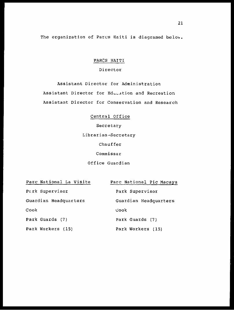
The organization of Pares Haiti is diagramed belov>.
PARCS HAITI
Director
Assistant Director for Administration
Assistant Director for Education and Recreation
Assistant Director for Conservation and Research
Central Office
Secretary
Librarian-Secretary
Chauffer
Commissar
Office Guardian
Pare National La Visite
Perk Supervisor
Guardian Headquarters
Cook
Park Guards (7)
Park Workers (15)
Pare National Pic Macaya
Park Supervisor
Guardian Headquarters
Cook
Park Guards (7)
Park Workers (15)

22
E. Logistics
The Central Office in Port-au-Prince would coordinate
all aspects of the program in national parks. All files,
plans, publications, correspondence and budget information
should be maintained there. The Director would interact
upward with the National Parks Authority, laterally with
other programs and supervise all activities of Pares Haiti.
The Assistant Directors will work with the Director and
regularly tour the parks and make reports. The Park
Supervisor-s will implement <-he directions from the Central
Office and supervise the personnel in each park. The Park
Supervisors should spend one week each month in
Port-au-Prince working with the Central Office staff and
planning. A radio communication network should exist
between the Central Office and each park, and there should
be regular discussions between the Park Supervisors and a
designated person in the Central Office.
The Director of Pares Hait. should meet with the
National Parks Authority at least twice a year.
5.Interpretation and Research
The programs in interpretation and research are two of
the most important elements of the national parks program.
Interpretation is the reponsability of the Assistant
Director for Education and Research. Research is the
23
responsability of the Assistant Director for Conservation
and Research.
A. Interpretation
We recommend the following as part of a program in
interpretation.
1. A series of temporary exhibits in Central Office
(year one).
2. Informative signs at entrance to each park (year
one) .
3. A brochure on the parks that promotes the most
important features, provides a species list of importanti*organisms, discusses the rules of the park and the purpose
and concepts of the parks (year one) .
4. Four exhibits in the Park Headquarters at Morne La
Visite (year two).
5. Two exhibits in the Park Headquarters at Macaya
(year two).
6. Two permanent exhibits in the Central Office Park
Headquarters (year two).
7. Nature trails with educational signs in each park as
designated on the maps in the Stewardship Plan (year two).
8. Information signs at designated locations off the
road beyond Furcy and along the road to Jacmel (year two).
9. Training the Park Supervisors to be interpretive
naturalists (continual).
24
10. Developing a slide-tape presentation (French,
Creole/ and English versions) for use in informing the
public of the national natural patrimony and the value of
the parks (year one).
11. Designating national species, and promoting a
better understanding of these species. We recommend the
following.
a. Plagiodontia aedium - National Mammal
b= Phaenicophilus poliocephalus
(Grey-crowned Palm Tanager) - National Bird
c. Didymopanax tremulum - National Tree
d. Fuchia pringsheimii - National Flower
e. Karst topography - National Geological Feature
These features can be promoted in postage stamps,
newspaper articles and posters. They can also be topics of
discussion in schools.
12. There should be a regular weekly newspaper feature
on the national parks written by the Director of Pares Haiti
or by special contributors. This feature should be in a
prominent place in at least one newspaper, and should also
be featured in the English language Haiti News.
13. Writing booklets on the special features of each
park based on scientific results from inventories and
ongoing research projects (year two and three).

25
B. Research
Research is one of the most important elements of the
development process for the national parks program. An
active research program will generate data on which
management decisions must be based. The research program
will also provide data on the national natural patrimony
(endemic species, many of which will be new). A third and
very important aspect of the research program is that by
actively involving the staff of Pares Haiti in the research
activities (field work, analysis, publications) one of the
most important and difficult: aspects of the training program
is completed (i.e. training in specific topics) at the same
time that data and publications are being generated.
Research personnel can also be required to lead training
sessions while they are in Haiti. The most important
research goals are outlined below. The costs of these
programs are listed in the budget sheet and in the
Stewardship Plan.
1. Publication of previous data from inventory (year one).
2. Research on the composition and requirements of the major
plant communities. (five year study)
3. Research on the basic biology of the endemic mammals
(endangered species). (five year study)
4. Biology of the Black-capped Petrel (three year study)
5. Regular inventories of avifauna (five year study)
26
6. Meteorological studies (five year study)
7. Invertebrate faunal studies (five year study)
8. Habitat requirements of herpetofauna (three year study)
9. Publication of the above data in 1990 (year five)
6. Park Headquarters and Stations
The facilities of the parks program are very important
because they not only provide a working environment for
Pares Haiti personnel and colleagues, but also signal the
existance of a viable parks program. This is especially
important within the boundaries of Pare National Pic Macaya
and Pare National La Visite where the Pare Headquarters
buildings, depots and outposts demonstrate that the parks
are official and that authority exists in the region. The
parks facilities should be constructed at the earliest
possible date (with existing funds, or in the first year of
the new five year budget).
A. Location
1) Central Office This structure should be distinct
from either MUPANAH or Damien. It can be located in
Port-au-Prince or Petionville. We feel it would be
desirable to build a facility for the parks at the
designated National Botanical Garden. The existing
plans for the Park Headquarters (see below) could be

27
modified as plans for the Central Office.
2) Park Headquarters at Pare National La Visite
This structure (see figure below) is to be located
near the cascade in the central part of the park
above the campground. This location is in
an attractive wooded area (Bois Cascade) and is central
to all activities in the park.
3) Depots and maintenance areas for Pare National La
Visite will be in the existing buildings at the
Scierie. '
4) An existing caye can be rented or purchased at Tete
Opaque as an outpost.
5) Park Headquarters at Pare National Pic Macaya
This structure is to be of the same plan as the La
Visite facility and is to be built in "Bois Pipirite"
at 1428 meters two kms north of Portal Formon (Madame
Robert's house) and two kms SE of Pic Formon (year
one) .
6. Depots and maintenance facilities should be
located near Portal Formon. The road will eventually
be constructed to this area, and since the area is flat
it is suitable for construction of a landing strip. An
existing caye can be rented or purchased, such as the
28
caye of M^ame Robert's that has been used by the
inventory team (year one).
7. An inexpensive caye should be constructed at 1000
meters elevation in the ravine of the Riviere Ravine du
Sud as an outpost. It should be modeled after Madame
Robert's caye that the inventory team used (year two).
8. An inexpensive caye should be located on the north
side of the park near 700 meters beside the Riviere
La Guinaudee. An existing caye can be rented or
purchased. This caye would serve as an outpost.
B. Type and construction
The plans for a Park Headquarters have been drawn and
are available (submitted to INAHCA, MARNDR, and USAID on 17
December 1985). The plans call for a basic stone or cement
block structure with a large front porch and central room
for public meetings. There are four rooms around the
central room to serve as office, laboratory, living and
depot space. In the rear of the building are rooms for
cooking, eating and a bathroom. The water supply for the
headquarters is via two 300 gallon cisters that gather
rainwater off of the rear roof of the building. This design
is very flexible, and the function of rooms can change as
the program grows. There is a loft for sleeping or storage.

29
The Park Headquarters would provide office space for
the Park Supervisor, a work room, a sleeping room for the
Park Supervisor, sleeping space for visiting scientists and
technicians, and a guest room for visitors from the Central
Office.
The building is to be constructed out of rock or
cement. Wood is used for the interior supports. The roof
is metal. All materials are available at the site or in
Port-au-Prince. A materials list is provided with the
plans.
7. Integration of the Parks with region
Pares Haiti should make a special effort to improve the
quality of life in the region around the parks in the Massif
de la Selle and Massif de la Hotte. If the parks are going
to be successful they must be viewed as being of local
importance as well as in the national interest.
A. Jobs
The Personnel from the parks should be hired from the
region. The available jobs associated with each park are
listed below. Regular jobs = R; Occassional jobs = I.
1. Park Guards
2. Park Workers
Number positions
7 (R)
15 (R)

30
3. Headquarters Cook
4. Headquarters Guardian
5. Other building guardians
6. Guides (estimate)
7. Special project workers
(estimate)
1 (R)
1 (R)
3 (R)
10 (I)
10 (I)
Twenty seven jobs will be generated in each region by
the permanent staff of the parks. Additional jobs will be
available as the Park Headquarters is being constructed, and
during phases of reforestation. Jobs will also be generated
as recreation and tourism increases. Some of the jobs will
be as guides, while others will be associated with renting
horses and donkeys to visitors and selling supplies. The
amount of money in the region will increase because of
regular salaries being paid to Pares Haiti personnel, and
more money means an increased need for supplies. This will
provide more jobs in the service sector of the region (store
owners, farmers).
B. Watershed Management
One of the main goals of the park is to improve the
quality of the environment and of the associated watersheds.
This will have some impact on residents on the plains and
along the rivers below the parks. More water will be
available for human consumption and 'irrigation. The quality

31
of the water will improve. The rate of soil erosion will
decrease. The danger of flooding to inhabitants living near
rivers will decrease. All of these will be possible because
major reforestation projects will be undertaken in each
region.
C. Model Programs
The following model programs are proposed for the
region of each park in association with Pares Haiti.
1. Communal Firewood Forest Project.
2. Reforestation and Fruit Tree Propagation Program
in cooperation with MARNDR and PVOS in region.
3. Technical Assistance Program coordinated by the Park
Supervisors.
4. Local artisan, handicraft and recreation program
coordinated by the Assistant Director for Education and
Recreation.
8. Recommended Training Programs
Since there has not been a tradition of natural
science, conservation or national parks in Haiti it is
necessary and important to implement an active training
program for all national parks personnel. After careful
reflection we believe that the most cost effective and

32
appropriate training program is for seminars and workshops
to be conducted in Haiti. Each workshop or training session
should last about two weeks and be conducted by a carefully
chosen international individual or group. There should be
four training sessions per year (every three months). These
training sessions should take place in the Central Office
and within the parks. There could be more frequent training
sessions during the first year of the program, and fewer as
the program develops. A possible training program is
outlined in Fig.6.
A. Individuals
Everybody associated with the parks should receive
training of some kind. The nature and duration of the
training are listed in the following table.
B. Location and Training
With the exception of the Director, who should be
encouraged to participate in the international parks
seminar, all training should be in Haiti. In this way
specific training is possible and all staff of the Pares
Haiti program can receive some benefit from the instructors
and training sessions. In addition, research biologists can
be involved in the training sessions. This is good economy
and encourages individuals to focus their training on the
Pares Haiti program rather than use the training as a
stepping stone to a higher position in Haiti or to leave

33
Haiti. It is important to create as much long term
stability in the Pares Haiti program as possible.
C. Specific Courses and Topics
The need for specific topics will be identified with
greater precision as the staff is hired and the background
of the Pares Haiti staff are known. At the initial stage we
can identify the following topics which are of major
concern.
National Parks Topics
1. History of National Parks and National Parks Policy
2. Biosphere Reserves
3. Administration of National Parks
4. Personnel Management and Decision Making
5. Financial Accounting and Data Management
6. Public Relations and Advertising
7. Museum Studies and Interpretation
8. Principles of Recreation and Tourism
Research and Conservation Topics
1. Biological and Geological History of Haiti

34
2. Collecting Techniques - Botanical
3. Collecting Techniques - Zoological
4. Ecological Methods
5. Cartography, Photo Interpretation and Remote Sensing
6. Major Features of Haiti - Botanical
7. Major Features of Haiti - Zoological
8. Major Features of Haiti - Geological, Hydrological,
Meteorological
9. Analysis of Data, Statistical Techniques and
Publication Techniques
Some of these 16 topics can be combined into one
training session, while others (such as "major features of
Haiti") represent more than one training session. The
training sessions can be organized as distinct one to two
week workshops and seminars. All research staff should be
required to present training sessions as part of their
research activities, and to include selected Pares Haiti
personnel in specific aspects of their research activities.
9. Concluding Comments on Pares Haiti and Biosphere
Preserves

35
The concept of a "Biosphere Reserve" has been approved
by UNESCO under the Man and the Biosphere Program (MAB).
Biosphere reserves are examples of the major landscapes of
the world complete with characteristic landforms, flora and
fauna as well as the various patterns of human use and
adaptation of the region. The concept of a biosphere
reserve is intended to promote a balanced relationship
between people and the natural environment. The emphasis in
biosphere reserves is demontrating the value and need for
conservation and the link between wise land use policies and
conservation and sustainable development. We believe that
the concept of a biosphere reserve is very well suited to
the nature of the national parks in Haiti, and we encourage
Pares Haiti to proceed with the implementation of a
biosphere reserve program.
Biosphere reserves consist of core areas, which are
lands already under some form of protection. In the case of
Pares Haiti, the core areas are Pare National Pic Macaya,
Pare National La Visite (and the various sites listed in the
decree of 23 June 1983). In biosphere reserves core areas
are surrounded by zones of cooperation, in which a variety
of resource uses may take place, such as forestry, ranching,
farming or tourism. In these zones solutions to
man-environment problems are sought by involving local
people. This is often done by including selected local
residents in the discussion process, often via a committee

36
made up of Parks personnel and local residents. The zone of
cooperation is analogous to the "Buffer Zone".
The concept of a national park surrounded by a buffer
zone, as discussed in the Stewardship Plan lends itself well
to the principles of a biosphere reserve, especially
considering the complicated land use practices in and around
the national parks and the need to resolve the problems of
land use and land tenure in the region. We also believe
that the habitats of Pare National La Visite and Pare
National Pic Macaya are unique and worthy of inclusion in
the biosphere reserve program of the world's major
landscapes. In 1985 there are 243 biosphere reserves in 65
countries. Pares Haiti should begin from its conception to
organize the national parks program and especially the two
great national parks of Haiti as biosphere reserves.

37
Chapter I
The Concept of National Parks
in Haiti
1. Introduction
Haiti is an island nation with a long history of human
occupation and alteration of the diverse ecosystems of the
western third of the island of Hispaniola. We knew enough of the
biological diversity of the country based on an analysis of
fossil vertebrates from cave and sinkhole deposits and of fossil
pollen in sediments to say with certainty that until the time
humans arrived on the island between 5000 and 7000 years ago
remarkably diverse floras and faunas were present in Haiti
(Woods, et al. 1986). Historical accounts indicate that
significant elements of that diverse flora and fauna were present
until after the time of Columbus, and that many regions of the
country were still forested and contained diverse natural
ecosystems into the early part of this century (Wetmore and
Swales, 1931; Wetmore and Lincoln, 1933; Wetmore, unpublished
field notes; Ekman, 1926, 1928, unpublished catalog; Cohen, 1984;
Lowenstein, 1984). Our objectives in this report are to present
a synthesis of the biological survey initiated by the Unites
Stated Agency for International Development (USAID) in
association with the Ministere de 1'Agriculture des Ressources
.

38
Naturelles et du Developpement Rural (MARNDR) and the Institut
National Haitien de la Culture et des Arts (INAHCA) and to
provide a series of recommendations on how to proceed with the
stablishment of a program of natural resource conservation,
preservation and management. The analyses and recommendations
are focused on two regions of Haiti, one in the Massif de la
Selle and the other in the Massif de la Hotte. These two
mountainous areas are among the most important sources of water
in the country, and contain the highes mountains of the
Republic. Many endemic plants and animals are restricted to
these regions of Haiti. In recognition of the importance of the
regions to the natural patrimony of Haiti, as well as to their
role in water conservation, a specific zone in each massif was
set aside as part of the special domain of Haiti and placed under
the protection of the government as soverign lands to be known as
national parks. Legislation passed in 1983 created Pare National
Pic Macaya in the Massif de La Hotte and Pare National La Visite
in the Massif de la Selle (Map 1). These are the first national
parks of significant size in Haiti, and therefore have special
importance in the history of the Republic. Our objective is to
provide data, analyses, historical comparisons, recommendations
and a plan of operation that will be of use to the government of
Haiti (GOH) in planning and implementing a national parks program
in the most effective and timely manner possible. The
recommendations in this report are based on our own personal
analyses and reflect our experiences in Haiti as well where we

39
recommended the formation of national parks in mountainous areas
of the Southern Peninsula nine years ago (Woods and Rosen, 1979),
as in national parks in other countries of the Antilles, Africa
and Costa Rica. Our park plan may not be the only viable
solution to the question of how to create a functional program in
national parks in Haiti. We are not sure what the best road to
take is because of the many financial, administrative, social,
historical and scientific questions that have weighed heavily on
our minds as we have tried to formulate a national park program
that is best suited for Haiti. With the assistance of the many
import-ant institutions and programs discussed in our document,
Haiti will be able to create a long lasting program in the
conservation of natural resources and the protection and
promotion of its natural patrimony.
2 Terminology
Many organizations, individuals and terms are used in the
course of this report. In order to provide a guide to the reader
we are providing a list of the major terms used. When a name for
an institution or organization is used for the first time in the
text it is spelled out completely, but thereafter only the
acronym is used.
Pares Nationaux Naturels d'Haiti (Pares Haiti)
Florida State Museum (FSM)
Government of Haiti (GOH)

40
Departement des Mines et des Ressources Energetiques (DMRE) Institut National Haitian de la Culture et des Arts (INAHCA) Institut de Sauvegarde du Patrimoine National (ISPAN) International Union for the Conservation of Nature and Natural Resources (IUCN)
Ministere de 1'Agriculture , des Ressources
Naturelles et du Developpement Rural (MARNDR) [alsoknown as DARNDR and sometimes as Damien].
Musee du Pantheon National d 1 Haiti (MUPANAH)
National Conservation Strategy (NCS)
National Parks Service of the United States (NPS)
Office National du Tourisme et des Relations Publiques
(ONTRP)
Parks Canada (PC)
Societe Audubon d"Haiti pour la Protection de 1'Environnement (SAHPE)
Unites States Agency for International Development (USAID) United Nations Environment Program (UNEP)
United Nations Educational, Scientific and Cultural Organizations (UNESCO)
World Conservation Strategy (WCS)
World Wildlife Fund (WWF)
The following words are used in the text of thia report without definition. We will provide a brief definition of each below.
Biotic diversity

41
The desired condition of having the greatest number of
compatable species associations in natural area. The goal of our
stewardship plan is the increase species diversity in the parks
and not just to increase the numbers of a few selected species.
Conservation
The practices and/or customs of man that permit the
perpetuation and sustained yield of renewable resources and the
prevention of waste of non-renewable resources.
Edaphic factor
A condition or characteristics of the soil, (physical,
chemical or biological) that influences organisms.
Endangered species
Species in danger of extinction and whose survival is
unlikely if the causal factors continue operating.
Endemic speciesi
A species confined to the island of Hispaniola or to a
region of Hispaniola when so designated.
Migratory species
Species that regularly move beyond their regularly occupied
geographic location, and in the sense of this study species that
seasonally depart Hispaniola.
Preservation

42
The practice of totally protecting a species or habitat from
any exploitation.
Rare Species
Species with small populations, usually localized within
restricted geographical areas or habitats, that are at risk.
Resident Species
Species that do not migrate.
Restoration
The act of putting the ecosystems or a specific unit of the
ecosystem (local habitat) back into prior (more natural)
condition. The activity is one element of a stewardship plan.
Site Exhibit
An exhibit located within the boundaries of the national
park or at a scenic location with a view of the park. The
exhibit is capable of withstanding the effects of weather with
only a shelter to protect it from direct rain.
Stewardship
The act of working with all aspects of a natural ecosystem
so as to promote and protect its natural intergrety. The word
has been chosen to contrast to term management, which we believe implies an active state of manipulation and "tinkering".
Stewardship in its ideal sense can be passive and allow the
ecosystem to recover and maintain itself without extensive

43
manipulation. Some restoration activities are part of the
process of stewardship.
Threatened Species
Species likely to become endangered in the near future it
the causal factors continue operating.
Names in Haitian Creole
Whenever possible the names for regions and conditions have
been designated in Haitian Creole. The standard spelling and
usage follows Valdman (1981). We have done our best to check the
designations and authenticity of all Creole names with local
authorities on a particular region or subject.
3. Conservation Strategy in Haiti
The national patrimony of Haiti consists of a blend of
natural and cultural history. This "history" consists of
physically tangible items such as endemic species and cultural
artifacts as well as intangibles such as unrecorded folk music,
culture and unique vistas and beautiful landscapes. No single
item of natural or cultural history is any more important than
another. All aspects of the national patrimony are to be
cherished and conserved to the degree that national pride and
identity dictate. The Conservation Strategy for Haiti should:
1) identify these items; 2) formally acknowledge their existence
and worth; 3) follow a standard decision making process to
44
determine their disposition. All cutural and natural history
items must or can be conserved, but the process of definition,
deliberation and decision making should not be compromised. The
Government of Haiti (GOH) should carefully design and designate
the responsibilities of its departments and institutes so that
all elements of the national patrimony are encompased by an
administrative unit with a clear mandate for the evaluation and
eventual disposition of a particular kind or class of patrimony.
Several departments and institutes of the GOH are responsible for
various aspects of national patrimony (see Figure 1). We stress,
however, that while overlapping responsability for conservation
may appear ideal on the surface, it is not ideal in practice.
Disputes regarding authority and perceived responsability often
can develop. We recommend that the GOH reduce the level of
overlap between departments and institutions where possible and
work each unit of the national organizational structure to
clearly define their areas of responsability. When it is not
clear which unit has responsability for all aspects a particular
class of national patrimony, such as in the case of the national
natural patrimony, then the GOH should consider establishing a
new administrative unit.
Many of the cultural and natural history items alluded to
above are not renewable and thus their conservation strategy
should be distinct from that of renewable natural resources. A
museum piece or scenic vista can be "used" in the sense that it
45
can be looked at, appreciated and studied, but actual physical
use may quickly destroy it. Similarly, a forested watershed may
be "used" to precipitate, obtain and moderate clean water
supplies, but actual physical use of the same watershed may
destroy it just as surely as the physical handling of a prized
national artifact would destroy the artifact. For this reason we
advise caution in adopting the philosophy that all natural
resources are renewable and thus can be "developed" for sustained
use. The definition of conservation presently proposed by the
IUCN is as follows:
The management of human use of the biosphere so that it
may yield the greatest sustainable benefit to present
generations while maintaining its potential to meet the
needs and aspirations of future generations.
Note that the emphasis is on management of the human use
rather than on the management of the resource itself. By this
definition conservation is positive and covers the spectrum of
specific approaches. These include PRESERVATION of resources
such as cultural artifacts and critically rare plants and
animals; MAINTENANCE of resources such as viable populations of
native plants and animals and unspoiled beaches and vistas;
SUSTAINABLE UTILIZATION of resources such as rich alluvial
plains, forests, and game birds; RESTORATION of resources such
as deforested mountain slopes;and ENHANCEMENT of resources such
as watersheds, forests and upland areas.

46
In Haiti the preservation of resources such as endemic
species and the enhancement of resources such as watersheds and
forests become a common concern. This is because in most regions
of the country so much habitat for endemic species has been
altered from its natural state that many species of plants and
animals have become extinct or been severely reduced in numbers.
The areas where habitats have been least disturbed are in remote
montane regions. These are the same regions where the watersheds
of some of the major river systems of Haiti are located. These
areas, such as specific regions of the Massif de la Salle and
Massif de la Hotte of southern Haiti are places where forest
cover remains and endemic species are still present. The
objective is to save important elements of the national natural
patrimony by saving habitats. The habitats that are preserved,
maintained , restored or enhanced improve the quality of the
ecosystem and promote water and soil conservation. Therefore, in
a country such as Haiti where land and resources are limited the
effort to save important elements of the national natural
patrimony is not a luxury that the country cannot afford, but
rather a critical link in the preservation of its natural
resources and especially its soil and water resources. Sites for
national parks and conservation areas must be carefully selected
with the aim of preservation of natural patrimony and
conservation of water and soil.
4. Actions of the Government of Haiti in Conservation

47
The Government of Haiti (GOH) has taken an active role in
the past to protect the environmental and natural patrimony of
the Republic by passing laws and decrees. The law of 17 August
1955 (Moniteur number 87, 26 September 1955) regulated cutting,
transporting and selling wood, protected the environment and
created "Zones sous protection" and "Zones reservees." Law
Number Eight (Des Forets) of the Rural Code of Francois Duvalier
(Moniteur number 51, 28 May 1962) passed even stricter
legislation concerning the protection of forest resources and
controled activities in forest reserves. The decree of 31 March
1971 (Moniteur number 26, 1 April 1971) regulated hunting and
protected nine categories of birds in accordance with the
recommendations of the "Convention pour la Protection de la
Nature et la Preservation de la Fauna Sauvage dans 1'hemisphere
occidentale," which Haiti ratified. In addition to the laws of
1955 and 1962 protecting the natural forests of the Republic and
the law of 1971 regulating hunting and protecting certain bird
species, the GOH has passed legislation concerning national
parks. The decree of 1968 (Moniteur number 23, 18 March 1968)
created "Pares Nationaux" and "Sites Naturels" under the joint
administration of MARNDR and the Office National du Tourisme.
The sites that were selected for protection were "Sources
Puantes", "Sources Chaudes," "Sources Cerisier et Plaisance,"
"Fort Mercredi," "Fort Jacques," "Fort Alexandre," "la
Citadelle," and "lac de Peligre." The concept was expanded to
include natural lands in the "Communique" of 5 May 1981 that

48
appeared in the Nouveau Monde which discussed establishing the
first "Pare Naturel" in Haiti in the area between Morne La Visite
and Morne Kadeneau in the Massif de la Selle.
The official creation of "Pares Nationaux Naturels" was by
decree published in Le Moniteur (number 41, 23 June 1983). The
decree listed as existing laws: four articles of the
Constitution; a 1921 law on public utilities; a 1926 law on
"Forets Nationales Reservees"; a 1940 law concerning "monuments
historiques"; a 1958 law organizing DARNDR; the de :ree of 1968
naming "Pares Nationaux" and "Sites Naturels"; the decree of 1979
creating ISPAN; a 1982 law on regionalism; a 1982 law on uniform
structures; and the decree of 1982 creating the Musee du Pantheon
National d'Haiti (MUPANAtn .
The decree of 23 June 1983 continued the protection of the
eight sites discussed above by declaring them to be "Pares
Nationaux Naturels." In addition, "Pares Nationaux Naturels"
were created at "Morne La Visite du Massif de la Selle" (2000
hectares) which hereafter we will designate as Pare National La
Visite and "Morne Macaya du Massif de la Hotte" (2000 hectares),
which we will designate as Pare National Pic Macaya.
Article 2 of the decree directs that "I 1 administration
generale, la protection et la mise en valeur des pares et sites
naturels terrestres et maritimes sont a la charge du

49
Departement." The "Departement" is not identified in Article 2
nor any place in Article 1.
The major responsibilities for the national parks program of
Haiti are listed in Article 6 of the 1983 decree under additional
responsibilities of MARNDR. Article 3 is quoted below:
Artcicle 3. En plus des attributions courantes definies
dans la Loi Organique du 7 avril 1958, le Departement
de I 1 Agriculture, des Ressources Naturelles exerce les
attributions suivantes ayant trait a la gestion des
pares et sites naturels;
a) proteger les conditions ecologiques des pares
et sites naturels.
b) entreprendre 1'inventaire des especes animales
et vegetales des pares et sites naturels.
c) etudier les caracteristiques des especes
endemiques de haute valeur scientifique ainsi
que celles des facteurs physiques: geologie,
sols, climats et autres des pares et sites
naturels.
d) identifier ler, aires naturelles terrestres
ou maritimes du territoire national presentant
des caracteristiques ecologiques uniques ou
speciales et qui meritent d'etre declarees pares
ou sites naturels.
e) preserver les pares et sites naturels de toute
50
deterioration physique.
£) autoriser et superviser dans les aires des
pares et sites naturels tous travaux de recherche
entrepris par la communaute scientifique.
g) diffuser toutes informations relatives aux
pares et sites naturels.
h) offrir les facilites d'acces et autres
commodites aux visiteurs.
5. National Priorities and Conservation Goals in tiaiti
Our interpretation of the primary conservation goals of the
GOH are: 1) watershed management; 2) soil stabilization and
conservation; 3) enhanced and sustained potable water supplies;
4) sustained yield forest products. We endorse a strong and
unwaivering commitment to these goals, which can greatly
facilitate the preservation of endemic species, the maintenance
of natural biotic diversity, the development of a parks-related
tourism industry, and the protection of natural ecological
processes.
Within the 23 June 1983 GOH National Parks decree we note
eight specific goals and responsabilities for the national parks
program:
a. Protection of natural ecological conditions and
processes.
b. Identification of sites possessing a significant

51
element of national patrimony.
c. Preservation of existing parks and potential park
sites.
d. Inventory and describe natural plant and animal
species.
e. Research and propose necessary management for
endemic species. '
f. Research and describe critical processes of the
natural ecosystems.
g. Develop an interpretation and education program to
inform the people of Haiti of their patrimony.
h. Develop a recreation and tourism program based on
sites of national patrimony.
Our estimate of the priority rank and relative importance of
each of these specific goals is as given above. The rationale
for our ranking is simple: protection of the natural ecological
processes and conditions goes furthrest to ensure achievement of
all that follow. On the other hand, the identification and
preservation of an endangered species or even an isolated
physical site removed from the natural context (ecosystem) is a
last ditch effort that is doomed to failure in most cases.
Identification, research and interpretation of endemic or even
presently unknown species species will be possible only if the
natural sites on which they occur are secured now. To wait is to
risk describing the past rather than the present.

52
We have synthesized these statements, as well as our many
conversations with personnel from the governmental and private
sectors into the following list which we believe represents the
purpose of the Pares Nationacx Naturels program in Haiti.
1. The protection of natural ecological conditions and
processes. The two most important consequences of these actions
are: 1) the preservation of watersheds, thereby improving the
quality of life for all inhabitants of Haiti in areas adjacent to
or under the influence of national parks; 2) the preservation of natural species diversity and therefore the national natural
patrimony.
2. The promotion of the national natural patrimony. The two
most important consequences of this activity are: 1) the
education of the citizens of Haiti about the unique features of
their country that make Haiti special; 2) the increased
possibility that wise decisions of long range importance can be
made concerning the utilization and development of the natural
resources of Haiti.
3. The development of a recreation and tourism program that
will take advantage of the unique physical location and beauty of the parks as well as special features of the flora, fauna or
geology. We believe that it is possible for the citizens of
Haiti to benefit from the parks at both the local and national

53
levels without damaging the quality of the parks if a careful
management plan is developed and implemented.
CHAPTER II
Organizational Plan
Pares Nationaux Naturels d 1 Haiti
Pares Haiti
1. Objectives
The objective of this chapter is to recommend a plan to
create a unified program to administrate all units of the
National Parks of Haiti, and to implement sound programs in
stewardship, conservation, education, recreation and public
awareness.
2. Special Concern
The major concerns about the existing program in
national parks in Haiti that have been expressed by various
individuals we have interviewed during the course of our
investigation are listed below.
1. There is a lack of a tradition of national parks in
Haiti, and therefore the philosophy of "preservation" of the
natural patrimony is a new concept that must be accepted.
2. There are few people in Haiti trained in ecology or
natural resource planning.
3. There are many other priorities in the country, anc7
human needs should take precedence over long range
preservation and conservation goals.
55
4. There is no organization in Haiti that is clearly
appropiate to manage the national parks. MARNDR is
responsible for developing a sound program to improve the
agricultural potential and "utilize" the natural resources
of the country. INAHCA is responsible for preservation of
the national patrimony with an emphasis on cultural and
historical events. The Office of Tourism is responsible for
promoting tourist activities are recreational facilities.
5. There was conflict between MARNDR and INAHCA in
working together during the initial stages of implementing a
program in national parks, and the program did not move
ahead as rapidly as expected by international organizations.
6. There are not enough funds available to support a
meaningful program on national parks.
3. Pares Nationaux Naturels d'Haiti
A. Introduction
We propose that the most effective way to establish a
viable program in national parks in Haiti is to create a new
GOH organization responsible for the preservation of the
national natural patrimony. This organization should be
called the "Pares Nationaux Naturels d'Haiti", and given the
acronym "Pares Haiti". We have chosen not to designate the
program as a department, service or institution in order to
56
emphasize the independent status of the new program. The
"Pares Nationaux Naturels" as currently defined by law
includes eight sites designated in the decree of 18 March
1968 and reiterated in the decree of 23 June 1983 as well as
Pare National Pic Macaya and Pare National La Visite as
described in Article 1 of the 1983 decree. The chief
administrative officer of Pares Haiti should be a "Director"
who would be in charge of the supervision of "all"
activities of the organization. The rationale for the
creation of Pares Haiti we believe lies in the wording of
Article 2 of the decree of 23 June 1983 which states that
"1'administration generale, la protection et la mise en
valeur des pares et sites naturels terrestres et maritimes
sont a la charge du Departement." Since the "Departement"
is not named or identified and since we recommend
concentrating all activities under the direction of a
"single" administrative unit we recommend interpreting the
intent of the law to be the creation of a program which
should be designated as Pares Nationaux Naturels d'Haiti.
In order to have a short attractive name for the program
that is easy to remember and identify with we recommend
using the name Pares Haiti whenever possible.
Areas of the natural patrimony that should also be
included in the domain of Pares Haiti include marine areas
of unique importance, recreational beaches, scenic areas,
caves and sinkholes with unique elements of the past or
57
present flora and fauna, zoological parks, botanical gardens
and natural biospheres of importance because of their unique
features and influence on surrounding areas. A list of
actual areas under the domain of Pares Haiti is presented
below. We have included all areas mentioned in the law of
1983.
Pares Nationaux Naturels (current Law)
Sources Puantes (10 ha)
Source Chaudes (20 ha)
Source Cerisier et Plaisance (10 ha)
Fort Mercredi (5 ha)
Forts Jacques et Alexandre (9 ha)
Lac de Peligre
Pare National la Citadelle (250 ha)
Pare National Pic Macaya (2000 ha)
Pare National La Visite (2000 ha)
Clearly, some aspects of the program in national parks
as created by the decree of 23 June 1983 fall into areas of
special concern to either ISPAN (which is currently part of
INAHCA) or MARNDR. For example, at the present time ISPAN
is responsible for national monuments, and Fort Mercredi,
Fort Jacques, Fort Alexandre, and la Citadelle Laferriere
even though they are part of "Pares Nationaux Naturels" as
legislated in the decree of 1983. In many aspects of both

58
Pare La Visite and Pare Macaya forestry, reforestation, soil
conservation and other areas of concern fall into activities
usually assigned to MARNDR.
The solution to these areas of overlap will require
negotiations between the various branches of the GOH within
the framework of the decree of 23 June 1983. We recommend
as a solution to these overlapping responsibilities that all
activities associated with the national natural patrimony be
the domain of Pares Haiti, that national historic sites and
national historic parks remain the responsibility of ISPAN
and that activities in the buffer zones surrounding the
parks be administered by MARNDR. Pares Haiti should work
very closely with ISPAN, INAHCA and MARNDR and their should
be many areas where the three programs will interact. These
interactions become a natural association if certain
regions, such as the area around Pare National La Visite and
Pare National Pic Macaya are designated "Biosphere Reserves"
(see discussion below). We recommend expanding the program
at La Citadelle Laferriere to also become a Biosphere
Reserve.
B. Organization of Pares Haiti
The new Departement des Pares Nationaux Naturels
d'Haiti (hereafter called Pares Haiti) should be an
autonomous unit with direct responsibility for managing the

59
national parks and protecting the national natural
patrimony. For a period of ten years Pares Haiti should
concentrate on establishing a sound program in the
conservation of natural resources and in developing Pare
National La Visite and Pare National Pic Macaya. Pares
Haiti can be created as an organization by one of three
methods (see below), and should immediately begin to assume
the responsibility for building a national parks program and
implementing the recommendations outlined here. Three
possible methods for creating Pares Haiti are listed below:
1. Our recommended procedure is to form a new GOH
organization called Pares Nationaux Naturals d'Haiti (Pares
Haiti) . This organization, as mentioned earlier, would not
be designated as <i department, service or institute and
would not be a part of any existing program. It should be
advised by a higher level authority made up of
representatives from the GOH, private citizens and
international organizations. This seven member board of
trustees should be called the National Parks Authority. The
recommended .members of this authority are: 1) Director of
INAHCA; 2) Director of the Direction des Ressources
Naturelles of MARNDR; 3) Director of the Office of Tourism;
4) President of the Societe Audubon d'Haiti pour la
protection de 1'Environnement (SAHPE); 5) a prominent
private citizen of Haiti interested in conservation; 6) a
representative of an international organization.

60
The National Parks Authority would meet with the
Director of Pares Haiti several times a year and provide
guidance.
The staff of Pares Haiti would be hired as soon as
possible following the guidelines on the following
organizational scheme (next page and Figure 2). The budget
for the salaries of Pares Haiti personnel as well as for all
equipment and operating costs for a five year period should
come from a contract with USAID to be renegotiated at the
end of the five year period. The Director of Pares Haiti
would be the responsible person in charge of the budget.
As many as possible of the six administrative personnel
should be hired from existing individuals within the
governmental or private sectors of Haiti. It is not
possible to fill all administrative positions with qualified
and interested Haitians, then it would be acceptable to
designate one or two of the Assistant Directors from
international organizations on a contract or subcontract
basis for a period of time ranging from two to five years.

61
Pares Nationaux Naturels d'Haiti
(Pares Haiti)
Central Office
Director
Assistant Director for Administration
Assistant Director for Education and Recreation
Assistant Director for Conservation and Research
Secretary
Secretary-Librarian
Chauffer
Commissar
Office Guardian
Pare La Visite
Park Supervisor
Headquarters Guardian
Cook
Park Guards (7)
Park Workers (15)
Pare Macaya
Park Supervisor
Headquarters Guardian
Cook
Park Guards (7)
Park Workers (15)
2. A second method of forming Pares Haiti would be by
contracting with an international organization such as IUCN,
Parks Canada or the University of Florida, and relying
heavily on consultants. This contract organization would

62
function for a period of five years with the option to renew
for another five years. Haitian staff would be hired where
possible and the program would slowly train Haitian
counterparts to assume full responsability at the end of the
contract period.
3. A third method of forming Pares Haiti would be by
utilizing existing personnel in Haiti by designating a
single Director and borrowing two staff members each from
MARNDR, INAHCA. This group of five individuals would be
totally responsible for the national parks program. The
Director and two assistants would be assigned to the Central
Office in Port-au-Prince. The other two individuals would
be assigned to the national parks where one would be Park
Supervisor for Pare National La Visite and the other Park
Supervisor for Pare National Pic Macaya. The third
Assistant Director should be an international person on a
contract basis. This group should be called Pares Haiti.
The Director should have complete control of the budget.
The Central Office should be apart from either Damien or
MUPANAH so that it can establish an independent identity and
work as a unit. The new program would still be part of
INAHCA or MARNDR.
We recommend that Pares Haiti be formed by 1 April
1986 by a method recommended by the National Parks
Authority. The selection of a permanent staff or
63
appropriate international organization should be completed
during the spring of 1986. Active discussions concerning
the budget for Pares Haiti should be initiated at the
earliest possible date so that the scope of the Pares Haiti
program can be carefully planned. During the next decade
Pares Haiti should continue to function as an autonomous
program with the support and advice of the National Parks
Authority.
C.Responsibilities of Pares Haiti
The reponsibilities of Pares Haiti are discussed below
in five major categories: 1) Implementation and development
of the "stewardship plan"; 2) operation of Pares Haiti; 3)
public use of the parks; 4) environmental stewardship of the
parks; 5) monitoring and evaluating the natural features of
the parks and developing an educational program for the
parks. The name of the administrator in charge of the
duties outlined in each category is presented in
parentheses. These suggestions are keyed to the
organizational scheme presented earlier in this chapter.
The final organization of Pares Haiti may differ somewhat
depending on how the staff is selected and which plan is
followed. For example, it is possible that the GOH will
choose to subcontract part or all of Pares Haiti out to an
international organization for the first five year period of

64
the development of the parks. If this is done then we
recommend that the duties of the Director, who should be a
Haitian national, remain as listed in section one of the
following discussion. The international organization could
assume responsibilities for the duties outlined in sections
two through five. If the GOH decides to further divide the
lines of responsibility, one international organization
could be selected to operate the parks (sections two through
four) under the direction of the Director, while another
institution could undertake the duties outlined in section
five to develop a method of monitoring the status of the
most vulnerable features of the parks, conduct research and
create an educational program. We have tried to write the
"Plan for Organization of Pares Haiti" in such a way that it
can be adapted for any of the several ways of creating Pares
Haiti discussed in this chapter.
1. Implementation and Development - (Director)
The Director of Pares Haiti will be responsible for the
overall program in national parks, the supervision of each
Assistant Director, the interactions with the other branches
of the GOH and the implementation of the program. The major
features of the duties of the Director in implementing and
developing a program in national parks are listed below.

65
a. Review the "Stewardship Plan" for Pares Haiti and
work with the staff and other branches of the GOH to
formulate a final plan.
b. Hire all staff of Pares Haiti, and supervise and
evaluate all personnel.
c. Coordinate all staff and projects into a unified
program with a clearly understood mission and well defined
goals.
d. Develop a schedule for the implementation of the
"Stewardship Plan", and coordinate all phases of the work so
that the schedule is maintained.
e. Develop a training program for the staff of Pares
Haiti.
f. Supervise all security forces of Pares Haiti.
g. Meet regularly with the National Parks Authority and
branches of the GOH, especially MARNDR and INAHCA to promote
cooperation, productive interactions and the planning and
implementation of specific projects.
h. Meet regularly with international organizations to
develop programs of assistance in technical areas and in
seeking additional funding for Pares Haiti.
i. Coordinate the duties of "Interns" and volunteers
from foreign institutions through the Assistant Director for
Administration.
j. Supervise and manage the budget.

66
k. Present speaches, write articles and in all other
ways promote the concept of Pares Haiti. As soon as
possible Pares Haiti should create a tape and slide
presentation of high quality to use in these presentations.
h. Carefully guide the growth of Pares Haiti by
evaluating all proposals fcr additional programs. The
Director will have the responsability of deciding which
features of the national natural patrimony are in need of
being included in Pares Haiti and coordinating the
feasibility studies. The Director will work with the staff
of Pares Haiti and outside consultants in reaching a
decision on any proposal based on the overall well being of
Pares Haiti, the natural feature under consideration and the
overall interests of the GOH.
2. Operations (Assistant Director for Administration)
The day to day administration of the overall program of
Pares Haiti should be conducted by an individual or office
that is responsible for administration and maintenance.
This individual would meet regularly with the Director. The
person would:
a. Assist the Director as requested.
b. Coordinate activities with Park Supervisors.
c. Coordinate activities with volunteer agencies.
d. Coordinate all activities of the staff of the
Central Office of Pares Haiti.
67
e. Supervise the use and maintenance of 'motor
vehicles.
f. Supervise the use and maintenance of all
equipment and supplies.
g. Maintain a Pares Haiti library and research
collection that would include a series of
photographs of specific habitats, maps,
reports, journal articles and books on
the natural patrimony of Haiti and the
national parks.
3* Public use (Assistant Director for Education and
Recreation)
All aspects of the use of the park by the public should
be supervised by an individual or office that is responsible
for education, recreation and tourism. This individual
would report to the Director on a regular basis. The person
would also work closely with the supervisors of each park
and could be responsible for:
a. Designing and posting all signs.
b. Designing access routes and trails.
c. Designing scenic areas.
d. Designing special recreational features.
e. Public relations.
f. Develop educational exhibits for the parks.

68
g. Working with hotels, airlines and tourist
organizations,
h. Writing a weekly column for newspaper and
writing scripts for release to interested
organizations.
4. Environmental Stewardship (Assistant Director for
Conservation and Research)
All aspects of the programs concerned with the
conservation of natural resources within Pares Haiti and the
stewardship of the resources within the parks themselves
should be supervised by an individual or office responsible
for conservation, preservation and stewardship. This person
would meet regularly with the Director and with each Park
Supervisor. They would be one of the major links between
the Central Office of Pares Haiti and the parks, and might
spend significant periods of time in the field. The person
would be responsible for:
a. Designating all Biological Reserve Zones.
b. Care for all special concern areas.
c. Representing Pares Haiti in discussions
concerning activities in the "Buffer Zone"
d. Implementing reforestation and reclamation
projects.
e. Working with local land owners near the parks
and organizations in Port-au-Prince to promote

69
land use practices that are appropiate for
the areas of the parks,
f. Coordinating activities with MARNDR to develop
a seedling nursery,
g. Fire control, and controlled burning of
certain habitats to prevent damaging wild
fires.
h. Representing Pares Haiti in the implementation
and coordination of the "Biosphere Reserves" in
the areas of the national parks.
5. Monitoring and Evaluation (Assistant Director for
Conservation and Research)
One of the most important aspects of the program in
national parks is monitoring and evaluating the status of
the ecosystems within the parks and the biosphere reserves.
This important function will allow the Pares Haiti to make
decisions on land use, recreation and resource management.
As special needs arise information on the status of the
environment of the parks will allow Pares Haiti to rapidly
adjust policies to accomodate environmental emergencies,
such as the continued decline of a particular endemic
species or the sudden increase in the numbers of a pest or
predator. The individual in charge of monitoring and
evaluating the environment would work closely with the
Director, other Assistant Directors, Park Supervisors and
international research teams. Ongoing research projects are
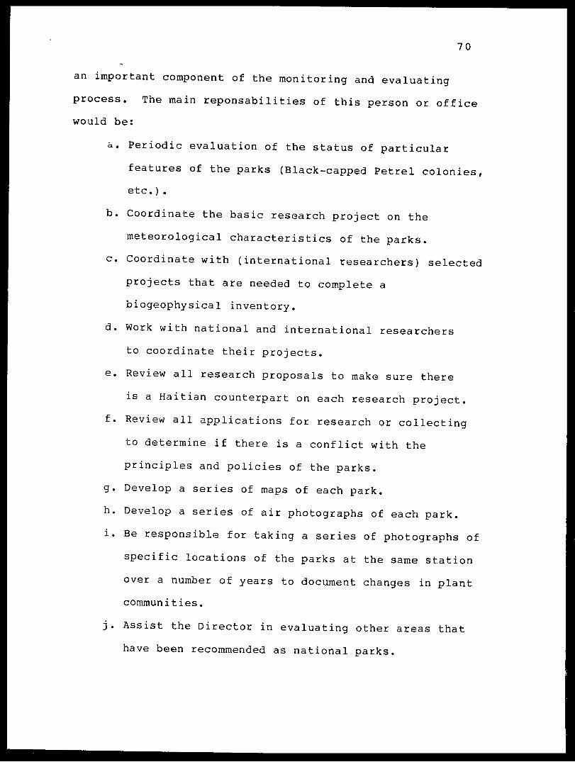
70
an important component of the monitoring and evaluating
process. The main reponsabilities of this person or office
would be:
a. Periodic evaluation of the status of particular
features of the parks (Black-capped Petrel colonies,
etc.) .
b. Coordinate the basic research project on the
meteorological characteristics of the parks,
c. Coordinate with (international researchers) selected
projects that are needed to complete a
biogeophysical inventory,
d. Work with national and international researchers
to coordinate their projects,
e. Review all research proposals to make sure there
is a Haitian counterpart on each research project,
f. Review all applications for research or collecting
to determine if there is a conflict with the
principles and policies of the parks,
g. Develop a series of maps of each park,
h. Develop a series of air photographs of each park,
i. Be responsible for taking a series of photographs of
specific locations of the parks at the same station
over a number of years to document changes in plant
communities.
j. Assist the Director in evaluating other areas that
have been recommended as national parks.

71
D. Budget for Pares Haiti
The budget for Pares haiti has been developed for a
five year period, and is presented in the table at the end
of this section as well as in an abbreviated table in theI
Executive Summary. The major budget categories are: 1) cost/
of setting up the Central Office and Park Headquarters/
programs; 2) cost of information, boundary and entrance /
signs; 3) cost of constructing exhibits; 4) cost of //
publications advertizing and promoting the parks and for the
publication of basic data (scientific results and new //
species descriptions); 5) cost of training programs tor
Pares Haiti personnel; 6) cost of research programs; 7)
operating expenses for Central Office; 8) operating
expenses for parks and biosphere reserves; 9) operating and
maintenance costs for vehicles; 10) salaries. The total
proposed budget for Pares Haiti (five years) is $2,117,440.
Budget justification
1. Set-up costs. The cost of setting up the Central
Office and parks is $125,900, or six percent of the total
budget. These costs include desks, chairs and basic office
equipment as well as four vehicles (two for the Central
Office, one for each park). A complete list of all
recommended items is presented in the table at the end of
this section.

72
2. Signs. It is important to place signs at the
entrances to the parks as soon as possible to signal the
official status of the parks and to welcome visitors. These
signs should come out of the existing budget. Boundary and
information signs should also be posted as well as signs for
nature trails. The signs must be weatherproof, sturdy and
attractive. The road signs, nature trail signs and
supplemental signs will cost $3000.
3. Exhibits. As part of the educational program
exhibits should be available at the Central Office and
within each park. These educational exhibits will make the
park experience more meaningful to visitors and educate park
personnel and visitors alike as to the importance of the
parks as component parts of the biosphere reserves. The
exhibits will be designed in Haiti and constructed in the US
as part of the Cooperative Agreement between INAHCA and the
Florida State Museum. The cost for eight large exhibit
signs is $8000, with information on both sides so that the
messages can change to introduce variety.
4. Publications. We propose publishing a general
purpose brochure on Pares Haiti and the national parks at
the earliest possible date (1986). This brochure will
explain the purpose of Pares Haiti, describe the major
features of Pare Macaya and Pare La Visite including lists
of major species, present maps of the parks and a message.
It will also present information on how to make
73
contributions and support Pares Haiti. The cost of the
initial publication is $5000. We recommend additional more
specific brochures and small booklets to be published the
second and third year of the budget period at $5000 each
year.
We believe that it is very important to make the
results of the parks inventory available as quickly as
possible. These "results" include descriptions of new
species , analyses of major plant and animal associations and
specific discussions of the major features of the parks. We
recommend that these results be published as a single volume
of the Bulletin of the Florida State Museum. Each page will
have a complete abstract in French. All new species and
important new data can then be made available to Haiti
within one year, and be readily available to students and
professionals in Haiti during the training sessions and
development stage of a national parks program. The
recommended budget for this publication is $20,000.
It is anticipated that a second scientific publication
will be appropriate at the end of the five year budget
period. This publication would include the results of
research over the five year period and include Haitian
counterparts as authors. We have budgeted $20,000 for this
second scientific publication.
5. Training programs. We believe that the most
economical way to run a training program is to make use of
74
seminars, workshops and training sessions in Haiti. Each
two week session would be conducted by an international
expert or team. We have budgeted $3000 for each session and
recommended four sessions per year ($12,000). During the
second year we recommend that the Director participate in
the national parks seminar and visit several mayor
institutions (such as the University of Florida) which have
international conservation programs.
The research programs (see following item) can also be
incorporated into the training programs.
6. Research. We believe that research is one of the
most important components of a developing program in
national parks. The data generated from selected research
projects will be used in making management related decisions
and in building the recreation and education programs.
Pares Haiti personnel should be included in all research
projects and therein receive valuable training that will be
specific to natural science in Haiti. We propose spending
ten percent of the budget, or $205,000 on research for a
five year period. The recommended research projects are
listed below with their duration and total cost in
parentheses.
1. Composition of major plant associations (5 years;
$30,000).

75
2. Growth and regeneration of endemic plants (5 years;
$30,000).
3. Habitat requirements of the endangered species of endemic
mammals (5 years; 60,000).
4. Biology of the Black-capped Petrel (3 year; $30,000).
5. Regular inventories of park avifaunas (5 years; $10,000).
6. Baseline Meteorological studies (5 years; $5,000).
7. Distribution and habitat requirements of Invertebrates (5
years; $25,000) .
8. Habitat requirements for endemic herpetofauna (3 years;
$15,000).
7. Operating Central Office. The specific estimated
costs of running the Central Office are listed at the end of
this section. We believe that it is very important to have
a well organized Central Office to tie together all aspects
of the parks program* Since the parks program will also
coordinate the activities of the biosphere reserves
associated with each park, the Central Office will become a
meeting place for many people and ideas. It will quickly
become the crossroads of all conservation activities in
Haiti and the clearinghouse for most information on the
natural ecosystems of the country. The total estimated cost

76
of the office is $41,000 per year or $205,500 over a five
year period (10% of total budget).
Our estimate is that it would cost $18,000 per year to
rent a reasonable building for a Central Office. It would
be cheaper in the long run to construct a new building. We
recommend constructing a new Central Office on the site of
the Botanical Garden following the plans for the Parks
Headquarters (Figure 3).
8. Operating Parks. The estimated costs for the
operation of the parks is $56,900 per year or $284,500 over
a five year period. This is 14 percent of the total
proposed budget for the parks (exclusive of salaries,
vehicle costs and equipment). When salaries, vehicle costs
and equipment are added the percent of the budget spent
directly on the parks jumps to 40 percent of the total
proposed budget. The individual items of operating the
parks are listed at the end of this section.
9. Operating Vehicles. We propose purchasing four
vehicles for use in the parks. Two vehicles are for use in
the Central Office. One of which will function in the
capital and the other will come and go to the parks. These
will be station wagons. The other two vehicles will be
pick-up trucks and will operate in the parks and transport
the Park Supervisors back and forth between the parks and
the Central Office. The estimated annual cost is $14,400
for a total cost of $72,000 or three percent of the total

77
estimated budget of Pares Haiti. Individual items are
listed below.
10. Salaries. The salaries of the four administrators
and five support staff of the Central Office are $100,200
per year or $553,665 for five years (27% of total budget).
The salaries for the two Park Supervisors, four support
staff, 14 guards and 30 workers for the two national parks
and biosphere reserves are 92,400 per year or $509,125 for
five years (24% of total budget). Therefore, 51 percent of
the proposed budget for Pares Haiti is for salaries. The
recommended annual salaries for all Pares Haiti personnel
are listed below.
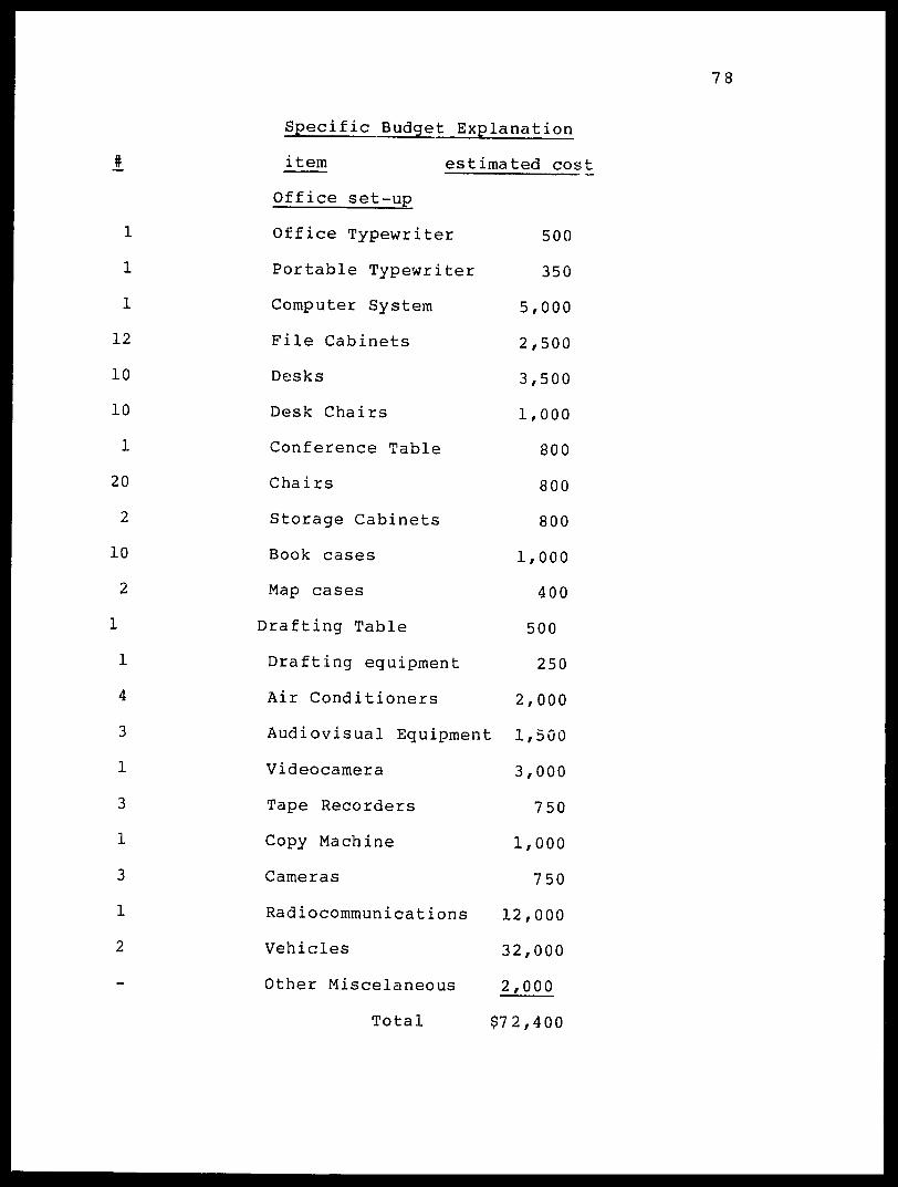
78
Specific Budget Explanation
#
1
1
1
12
10
10
1
20
2
10
2
1
1
4
3
1
3
1
3
1
2
item estimated cos
Office set-up
Office Typewriter
Portable Typewriter
Computer System
File Cabinets
Desks
Desk Chairs
Conference Table
Chairs
Storage Cabinets
Book cases
Map cases
Drafting Table
Drafting equipment
Air Conditioners
Audiovisual Equipment
Videocamera
Tape Recorders
Copy Machine
Cameras
Radiocommuni cat ions
Vehicles
Other Miscelaneous
Total
500
350
5,000
2,500
3,500
1,000
800
800
800
1,000
400
500
250
2,000
1,500
3,000
750
1,000
750
12,000
32,000
2,000
$72,400

79
Park Set-up (each)
J. Item Estimated cost
1 Woodstove 500
1 Storage Cabinet 400
i Chainsaw 350
1 Generator 2,500
4 Guns (shotguns) 500
4 Altimeters + pocket
transects 1,000 Field Furniture 500
Shovels, picks, etc. 1,000
1 Gas stove 500
1 Gas Refrigerator 500
1 Toilet 100
2 Sinks 200
Hardware 200
1 Vehicle (pick-up) 16,000
1 Motorcycle 1,500
Field Equipment j
Total $26,750

80
Signs
2 4'x8' Entrance sign
60 Information signs
2 4'x8' Roadside exhibits
50 nature trail signs
Total (from 86-90)
Exhibits
4 Double side exhibit panels
Publications
1 volume Scientific Results I
(Dec.1986 publication)
5000 Information Brochure (1986)
Park booklets (1987)
Park booklets (1988)
1 volume Information Brochure
(1990 publication)
Total
*we recommend that these be paid for
with 1985 funds as soon as possible
$2000 *
3000 *
2000
1000
$3000
8000
20,000
5,000
5,000
5,000
20,000
$55,000

81
Training programs
20 Two week training sessions (3,000 each) 60,000
(five year period)
1 Special parks seminar + visits for
Director 5 ,000
Total $65,000
Research
Research projects (see discussion in Budget Summary)
Operating Central Office
per year
Telephone 1,500
Lights + electricity 3,600
Office Rental* 18,000*
Supplies 4,000
incidentals 5,000
Per diem pool 6,000
International travel 3,000
pool
Total year
$41,100
$205,500
7,500
18,000
90,000*
20,000
25,000
30,000
15,000
5 year
$205,500
*Note: It would be more economical to build a new Central
Office building rather than rent a facility for over 3
years.

82
Operating each Park
year
Uniforms $ 350
Per diem (Park Supervisors) 3,600
Park Maintenance 24,000
Supplies 500
Total
$1,750
18,000
120,000
2,500
$28,450
(X 2 for Combined Parks) $56,900
Operating four Vehicles
Maintenance and tires
Gas
License and insurance
year
$4,000
10,000
400
$142,250
$284,500
Total
$20,000
50,000
2,000
Total $14,400 $72,000

83
1. Director
2. Assistant Director #1
3. Assistant Director #2
4. Assistant Director #4
5. Secretary
6. Secretary-Librarian
7. Chauffer
8. Commissar
9. Guardian
10. Park Supervisor #1
11. Park Supervisor #2
12. Headquarters Guardian
13. Headquarters Guardian
14. Park Guardians
1,800 each x 14
15. Park Workers
1/440 each x 30
Salaries
per year
Salary $20,000
expenses 4,000
Salary 15,000
expenses 3,000
same
same
6,000
5,500
6,000
3,000
1,500
Salary 10,000
expenses 1,000
same
#1 1,000
#2 1,000
25,200
43,200
Total
$146,400 $1,062,790
*Note: We have added a 5% salary increase each year.

84
E. Pares Haiti and the concept of "Biosphere Reserves"
Biosphere Reserves are a new concept in which a
balanced relationship between people and natural ecosystems
are encouraged in order to demonstrate the value and need
for conservation in supporting sustainable development.
Biosphere reserves are major landscapes complete with
characteristic landforms, floras, faunas and various
patterns of human use and adaptation. They consist of Core
Areas and surrounding Zones of Cooperation. Core areas are
lands under some form of protection, and zones of
cooperation are multiple use buffer zones where a variety of
uses of the available resources may take place. The
managers of the Pares Haiti program should do all they can
to promote and protect the core areas, which will be Pare
National Pic Macaya and Pare National La Visite. They
should also work with the GOH organizations responsible for
the management of the surrounding lands (MARNDR and ISPAN)
to insure a coordinated approach in the cooperative
research, restoration, supervision and monitoring. This
could be under the general plan of cooperating together via
the National Parks Authority as well as via specific
committees and meetings. Committees of concerned citizens
from the region of the national parks should be organized
and have an opportunity to be heard and be a part of the
decision making process.

85
The active biosphere reserve program will include the
core area (Pares Haiti), the zone of cooperation lands
(MARNDR), the historic monuments in the region (ISPAN) and
concerned citizens (a committee).
F. Organization of Pares Haiti and other GOH units in
biosphere rer^rve concept.
We propose that the parts of Pares Nationaux Naturels
are designated by the decree of 23 June 1983 be integrated
into the biosphere reserve concept in the following manner.
The chart lists all parts of the national patrimony that
should be associated with each GOH unit, and also lists new
items that might be added in the future (indicated with *).
Place
Pare National La
Visite (Core)
Buffer Zone La Visite
Pare National Pic
Macaya (Core)
Buffer Zone Pic Macaya
Citadelle Des Platons
*Parc National Naturel
La Citadelle
Size (ha.)
6,300
10,000
GOH unit
7 ,500
10,000
250
5,000
Pares Haiti
MARNDR
Pares Haiti
MARNDR
ISPAN
Pares Haiti

86
Project La Citadelle 250
Region Milot/Don Don
Fort Mercredi 5
Fort Jacques et Alexandre 9
Source Puantes 10
Source Chaudes 20
Source Cerisier et Plaisance 10
*Lac de Peligre National Park
*National Botanical Garden
Caves and Sinkholes
Scenic Areas
ISPAN
MARNDR
ISPAN
ISPAN
Pares Haiti
Pares Haiti
Pares Haiti
Pares Haiti
Pares Haiti
Pares Nationaux Maritimes - Pares Haiti
l.f.Les Arcaidine, Iroquois Islands Pares Haiti
Pares Haiti
Pares Haiti
In this list there are two actual biosphere reserves
(La Visite, Macaya) and one of great potential that we
recommend be designated as a biosphere reserve (La
Citadelle).

87
G. Ten Year Plan for Pares Haiti
The plan for the next ten years should first and
foremost include implementing the action plans for Pare
National La Visite and Pare National Pic Macaya. These
parks are discussed in detail _.n the following chapters and
for each a ten year plan of action has been prepared. The
following list is a series of recommendations in addition to
the individual action plans for each park.
1. Implement ten year action plans for each national
park.
2. Decide how Pares Haiti is to be organized and
staffed following the options outlined in this chapter.
3. Select a Director.
4. Select a staff for Pares Haiti Central Office and
national park sites.
5. Work with GOH, and international donor agencies and
private foundations or NGOs to establish an expanded budget
(see recommended budget).
6. Work with the Societe Audubon d'Haiti pour la
Protection de 1'environnement (SAHPE) to establish a
"friends of the parks" organization which can provide
assistance (financial, volunteer, public relations).
7. Establish an international organization with a
catchy name such as "International Fund for Conservation in
Haiti". This program could be modeled after a similar

88
project for the Citadelle, and could raise funds in the U.S.
and Europe for the national parks and publicize the program
abroad.
8. Develop an "identity" for the parks and for endemic
species of Haiti by a series of activities such as:
a. A set of postage stamps for the parks,
b. A set of postage stamps on special endemic,
species.
c. Designate by a decree that the following
endemic plants and animals be considered "National
Species".
Grey-crowned Palm Tanager -National Bird.
This species, known as the "Kat Je" or
"Quatre-Yeux" is the one bird found only
in Haiti.
Plagiodontia aedium -National Mammal.
This species, known as the "Zagouti" is widely
known in the countryside. It is one of only
two species of endemic mammals left in Haiti.
Didymopanax tremulum -National Tree.
This large and beautiful tree is found in
mountain areas of both Macaya and La Visite,
and is endemic to the island. It is one of the
ruost important forest trees in the parks, and

89
is known as "Bwa Tramble".
Fuchsia pringsheimii -National Flower.
This beautiful, large red flower is endemic
to the island and is found in both parks.
Karst topography - This special type of
limestone is associated with cave formations,
and some of the most important habitat
formations in Haiti.
d. Create a "slide show" package on the national
parks and the special areas of Haiti emphasizing
what is unique and beautiful, and what the
benefits of the park are to the present and future
of Haiti (water conservation, tourism, national
pride, etc.). The tape show should be
professional and there should be three language
versions (French, Creole, English) so that the
program could be used in a variety of situations.
The programed presentation (tape recorder with
dialogue, music and slides) should run 30-40
minutes. FSM could coordinate the production of
this program under the terms of our cooperative
agreement with INAHCA. The slide show package
should be created quickly since it is of value in
many areas of the ten year plan for Pares Haiti
90
in general as well as the plans for each park.
e. Create a series of post cards with attractive
photographs of scenes from the national parks as
well as some of the best features of the national
patrimony (birds, plants). The cards could be for
sale in areas in Port-au-Prince and elsewhere to
create an association between Haiti, natural
beauty and the natural patrimony.
9. Improve the information resource base of the parks
by promoting the following:
a. A series of maps of the parks.
b. A pamphlet on the parks describing the concept
most significant features, location, visiting
conditions, guidelines for tourists and future
goals (included in first year proposed budget).
10. Encourage the publication of the scientific results
of the inventory study so that all new data are available
(including new species descriptions) for planning, training,
and educational purposes.
11. Develop a research program to answer some of the
important questions that exist on how to rehabilitate,
restore, protect and safeguard natural ecological systems
and processes. This would include:
a.Biology of Black-capped Petrels.
b. Biology of endemic mammals and efficient

91
eradication principles for introduced species.
c. Evaluating the necessity of fire in maintaining
the natural environment.
d. Climatic profiles and local microclimatic
features of parks.
e. Methods of regeneration of rare plant species
cf the "Rak Bwa" habitats.
f. Factors governing successional rates and
patterns in disturbed communities.
g. Seed production, dispersal and germination
of native forest species.
12. Encourage and support allied departments (MARNDR)
to develop a nursery program for the parks specializing in
the propagation of endemic plant species to be used in
reforestation of "restoration areas" of the parks.
13. Work with the other agencies of the GOH, private
individuals and international organizations to develop an
acceptable combination of activities for the multiple use
buffer zones, and to establish a "Biosphere Reserve"
program.
14. Resolve all legal and public relations conflicts
that threaten the parks such as the relocation of private
citizens now living in the parks and claims of private
ownership within the main core areas of the parks. We
recommend that Pares Haiti and the GOH support a Haitian

92
judicial scholar to review and analyze legal, cultural and
moral land tenure questions in Haiti.
15. Work with international programs and agencies to
assist in training a complete staff for Pares Haiti that
could be ready to assume full responsability for all aspects
of the program at the end of ten years.
16. Keep the program small enough to be able to operate
within the bounds of a modest budget so that there is a
reasonable chance that Pares Haiti can survive over a long
term period within the financial capabilities of Haiti to
meet all of its budgetary responsabilities. Do not allow
more than 70% of the budget to be committed to personnel
l*st the personnel roster grow at the expense of operations
in the parks.
17. Expand the program (with the limitations of #16 in
view) to include additional areas of the national natural
patrimony that can be better protected by Pares Haiti than
any other agency in Haiti and which can improve the identity
of Pares Haiti. We recommend that the first expansion of
Pares Haiti be the creation of a 5000 ha. national park
around the core historical feature of the Citadelle
Laferriere (to become a biosphere reserve). The reasons to
do this are that the area is of biological and geological
importance and will attract significant national and
international attention because of the approaching
anniversary of the arrival of Columbus in the New World.

93
18. Work with INAHCA to assist them in creating a
series of exhibits at MUPAHAH that will educate the public
(nationals and tourists alike) on the unique value of the
natural patrimony of Haiti, and in so doing illustrate the
importance of the national parks.
19. Evaluate alternative economic eiiducements to insure
a private sector commitment to the long term stability of
the parks. The intent should be tc insure that there is
local interest and that there are local incentives for the
maintenance of the parks which are of national origin and
value.
94
CHAPTER III
Pare National La Visite
Section 1.- Location
The area now designated as Pare National La Visite is
located on the Massif de La Selle in the area of latitude 18
20'30" N and longitude 72 20' W. All areas of the park that
are located north of the La Selle Escarpment, the great
cliffs along the north side of the Massif, are in the
Departement de 1'Ouest, while the larger proportion of the
area of the park that lies south of the La Selle Escarpment
is in the Departement de Sud Est. Characteristic features
of the park are Morne La Visite, which is 2170 meters in
elevation and commands a view of much of Southern Haiti, and
Morne Cabaio (2282 meters), Morne Bellfontaine (2242 meters)
and the twin heads of Morne Tete Opaque (2269 and 2250
meters). Morne La Visite is located 22 kilometers from the
center of Port-au-Prince (the National Palace). We
recommend expanding the park westward to Morne d'Enfer (1900
meters) and eastward to Morne Kadeneau (2155 meters).
Section 2.- Size and Natural Boundaries
The original "Communique" in the Nouveau Monde (5 May
1981) indicated that the first "pare naturel" was to be
located between Morne La Visite and Morne Kadeneau on the
Massif de La Selle. Depending upon the elevation at which
95
the northern and southern boundaries are set this park could
vary in size from 500 to 1000 hectares. Subsequent
discussions have interpreted the boundaries of the park to
include the area along the ridge of the massif between where
the main access road from Port-au-Prince and Furcy crosses
the ridge (1880 meters elevation) and the eastern tete of
Tete Opaque (2250 meters elevation). The boundaries to the
north and south have never been officially established. The
decree of 23 June 1983 creating the national park in the
Massif de La Selle designated to size of the park to be 2000
hectares. The maps presented to the inventory team by
INAHCA and MARNDR indicate that the north and south
boundaries of the park have been set at 1600 meters
elevation, and therefore to inclose a region of
approximately 5000 hectares (see map 2). The boundaries
have been adjusted in various areas to include such
important features as the major cascade on the Riviere
Blanche at 1650 meters elevation and to exclude areas of
possible private property in the region of Morne Tete
Opaque. However, since no official survey of the boundaries
of the park has been initiated by MARNDR, it is not possible
to discuss the official size or boundaries of the national
park in the Morne La Visite area.
The natural boundaries of the park can be defined based
on the results of the inventory.
96
Inventories of the most important geological,
botanical, zoological and recreational features of the Morne
La Visite region indicate that the core area (areas of
complete protection inside the buffer zone) should include
all of the following features.
Feature
Morne La Visite
Morne Cabaio
Morne Tete Opaque
Areas north of La Selle Escarpment
2282 meters
Reason Location
-water conservation
-soil conservation
-scenic view
-nesting Black-capped Petrels
-water conservation
-scenic view
-nesting Black-capped Petrels
-water conservation
-scenic view
-nesting Black-capped Petrels (major colony)
-special botanical features
-water conservation
-mesic broad-leaved forest
-Nesting Black-capped Petrels
-Plagiodontia habitat
-special endemic birds
2170 meters
2250 meters
down to a minimum 1500 meters
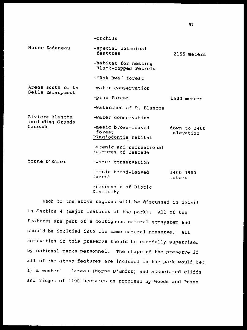
97
Morne Kadeneau
Areas south of La Selle Escarpment
Riviere Blanche including Grande Cascade
Morne D'Enfer
2155 meters
1600 meters
down to 1400 elevation
-orchids
-special botanical features
-habitat for nesting Black-capped Petrels
-"Rak Bwa" forest
-water conservation
-pine forest
-watershed of R. Blanche
-water conservation
-mesic broad-leavedforest
Plagiodontia habitat
-s ̂ enic and recreational features of Cascade
-water conservation
-mesic broad-leaved forest
-reservoir of Biotic Diversity
Each of the above regions will be discussed in detail
in Section 4 (major features of the park). All of the
features are part of a contiguous natural ecosystem and
should be included into the same natural preserve. All
activities in this preserve should be carefully supervised
by national parks personnel. The shape of the preserve if
all of the above features are included in the park would be:
1) a wester" ,lateau (Morne D'Enfer) and associated cliffs
and ridges of 1100 hectares as proposed by Woods and Rosen
1400-1900 meters

98
(1977); 2) a connecting corridor between Morne D'Enfer and
Morne La Visite that includes Morne Fe Noir and Morne Nacel
and occupies an area of 700 hectares; 3) a wide main area
of the park that includes tha ridge from near Ca Jacques
(where the Furcy road crosses) eastward to Morne Tete
Opaque, and beyond to one kilometer beyond Morne Kadeneau.
Northward of the La Selle Escarpment to the base of the
great cliffs of the Massif at 1500 meters, southward to the
natural margin of the pine forest and ravines that form the
upper watershed of the Riviere Blanche. This main unit
occupies a minimum of 4500 hectares. The total park area is
6300 hectares (see Map 2).
In the Morne D'Enfer region the park would extend down
to 1400 meters in the west and south and 1600 meters in the
north. The corridor connecting Morne D'Enfer with the main
body of the park would be limited by the 1600 meter contour
on the north and 1400 meters on the south. The main body of
the park would be limited by the 1500 meter contour to the
north and more or less by the 1600 meter contour to the
south. Along the southern margin of the park, however,
there are many houses and the well developed area at Seguin.
The southern boundary will have to be adjusted to take into
consideration these problems keeping in mind that, except
for the Ravine of the Riviere Blanche, this is the least
important biological zone of the park.

99
Section 3.- Access to Pare La Visite
The access to the park from Port-au-Prince is via
either of two highways (Map 2). The northern access is via
the route through Petionville, Kenskoff and on to near the
Teleco. The road to this point is either paved (to beyond
Kenskoff) or semi-paved (to near the crest of the ridge).
From the crest of the ridge at 1800 meters elevation a
spectacular view exists of the Massif de La Selle with
particularly fine vistas of Morne La Visite, Morne Cabaio
and the main steep cliffs of the massif that we have
designated as the place of the clouds, or "Nan Nway" in
Creole. Farther along the highway there are equally
splendid views of Morne D.1 Enfer and of Pic La Selle, the
highest peak in all Haiti. These locations make excellent
locations for rest stops and scenic areas. At two locations
along this highway (one near the first ridge so that it has
easy access from Port-au-Prince and a second at a
picturesque location ten kilometers by road from the first
and five kilometers (11 km by road) from Morne La Visite
where the most impr^ sive view of the park is available)
local site exhibits should be located that portray the
limits of the national park on an enlarged protograph of the
massif, and discuss a few of the major features of the park
that can be seen from the spot.
The highway from the ridge above Furcy to the crest of
the Massif de La Selle near Ca Jacques is 22 kilometers in

100
length and takes two hours to drive depending on local road
conditions. The road is very steep in locations and can be
dangerous (or even impossible) during the rainy season when
parts of it are washed away or closed by landslides, and
other areas are slippery because of mud and running water.
Over the crest of the massif near Ca Jacques the road
traverses the pine covered plateau and is very pleasant and
safe to drive on. Several side branches are possible, and
some areas are rough and in need of repair and maintenance,
especially as the road crosses tributaries of the Riviere
Blanche.
The road passes 1.5 kn SW of Morne La Visite in t'r.e
area of Ca Jacques, which is about z. half houv hike from the
iff- r. not well
••••• • ' t is a
where a
the
t oi the
road to the summit of Mcrne, La Vis"-' >
marked, but it" proper pia ' rv a ' *v'
pleasant and not L
splendid view is pcss;.
interior of the park where : t j.^ ^^ ; n.i.
abandoned sawmill (La Scierie) vherfe several old buildings
have been reconstructed. From this location ail areas of
the park can be reached by trs.il either on foot or
horseback. The road continues on tc Marche Seguin where it
joins the route from the south and another route from the
east that leads out onto the Plain of the massif in the
direction of Pic La Selle.
101
The route via the south departs Port-au-Prince and
follows the excellent highway across the mountains to the
city of Jacmel. This part of the highway passes through
picturesque countryside and is 100 kilometers long. There
are a few spots along the road where views of Morne D'Enfer
are possible, but the mountain is far away and often covered
with clouds. Even so, because the road between
Port-au-Prince and Jacmel is a major tourist route we
recommend that a site exhibit be established at the most
appropriate view of Morne D'Enfer that points out the
significance of the national parks for water conservation
and the preservation of the natural patrimony of Haiti.
The southerly access to the park leaves Jacmel as a"
non-paved route and passes along the coast through the towns
of Cayes Jacmel and Marigot. There are hotels in Jacmel and
at Civadier Beach eight km east of the city. The route,
after passing through the towns of Marigot and Ti Feuille 2
km beyond, crosses the Grande Riviere or Riviere des
Plantils (formed by the Riviere Blanche flowing from Pare
National La Visite) and ascends into the mountains. During
the rainy season the river crossing can be dangerous and
impossible in a passenger vehicle. The route from Marigot
to Marche Seguin is 20 km. long and is not nearly as steep
or dangerous as the road from Furcy to Ca Jacques.
The total driving time from Port-au-Prince to the park
headquarters on Pare National La Visite is six hours (150
102*
kilometers) depending on traffic in the Carrefour section and the condition of the road beyond Marigot. The Jacmel to the park headquarters section is three to four hours (49 kilometers). The northerly route from Port-au-Prince to the park via Furcy is four hours driving (55 kilometers) depending on the condition of the road after crossing the ridge near Furcy. From the scenic vista on this ridge to the park headquarters is a three hour drive (22 kilometers) under normal conditions.
Section 4.- Major Features of Pare La Visite
The ma-ior features of each park are discussed in elaborate detail in each of the eight supplemental reports that accompany this document. The reader should refer to each of these documents for complete species lists and discussions of how the species or features fit into the overall history of the region. The individual reports are: 1) Geological setting of Macaya and La Visite National Parks, Southern Peninsula of Haiti by Bruce MacFadden; 2) Floristic study of La Visite and Macaya National Parks/ Haiti by Walter Judd; 3) The Orchids of La Visite and Macaya National Parks, Haiti by Donald D. Dod (included as part of the previous report); 4) The Butterflies (Lepidoptera: Rhopalocera) of Morne La Visite and Pic Macaya/ Haiti by Frank Gali and Albert Schwartz; 5) The
103
Malacology of La Visite and Macaya National Parks, Haiti by
Fred Thompson; 6) The Herpetofauna of the ^Jaticnal Parks in
Southern Haiti by Richard Franz and Daniel Cordier; 7) The
Recent and Extinct Mammals of La Visite and Pic Macaya
National Parks, Haiti by Charles A. Woods; 8) The birds of
La Visite and Pic Macaya , National Parks/ Haiti by Charles
A. Woods and Jose A. Ottenwalder.
These reports provide a basis for understanding the
geological setting and ecosystem of each park and are the
basis of the analysis for the "stewardship plan". They are,
however, not a complete documentation of the natural
features in the region. Detailed analyses of climate,
hydrology, soils, and entomology other than Lepidoptera were
not completed by the inventory team nor was a socioeconomic
analysis done oil the region.
The major features of each report are summarized in the
following pages.
A.The Geology of Pare National La Visite
The geology of the region of La Visite reflects the
history of the island (MacFadden, 1986). The central
feature is a massive block of Eocene limestone that dips
southward. This limestone cap is exposed along the La Selle
Escarpment to the north at about 2100 meters and along the
southern boundary of the park at 1600 meters. This block
104
provides the park with most of its characteristics. Within
the limestone substrate extensive blocks of karst have been
exposed. These karst related geological features include
many dolines, sinkholes, ravines and verticle-walled pipes.
A complex system of underground caverns has been developed
by water working along cracks in the hard limestone. Some
of the exposures of hard limestone have weathered as jagged
blocks, standing like monuments on the surface. These areas
are called "casse dent" and have given rise to a region of
the park by that name. The superficial limestone outcrops
eventually weather to form small rounded residual rocks
where joints and cracks exist. Water from precipitation
goes directly into the ground and does not flow on the
surface. However, because much of the limestone forming the
surface of the park is unfractured, the headwaters and
tributaries of the Riviere Blanche contain significant
amounts of flowing surface water.
The limestone block of Pare National La Visite is
called the Neiba Foundation. It was formed 40-42 million
years ago as an area of shallow water and an exposed
external platform. Some areas are made up of tiny
foraminifera. Near the northern boundary of the formation
at about 2000 meters elevation a rich shelly marine fauna is
exposed that is composed of corals, pelecypods and
gastropods. The shells of these organisms can De found in
rocks near cliffs of La Visite and Cabaio, and in caves.

105
The northern boundary of the Massif de La Selle is a
steep cliff (La Selle Encarpment) that was formed by a major
fault, the La Selle fault. North of this fault the
limestone broke apart exposing the much softer rocks below
to rapid erosion, creating the great cliffs of the massif.
The rocks that are exposed on the surface of the cliff, and
which can be seen by hiking about in the basin between Morne
La Visite and Morne Cabaio, are very different than the
limestone encountered on the plateau and ravines. The rocks
one encounters are pillow lavas (basalts) that weather to a
rotten, iron-stained outcrop. These rocks date at 85
million years old. Other rocks in the zone are olivine
tholeiite basaltic rocks as well as deep water limestones
and some clastic (sedementary) deposits including
turbidites. This group of rocks is called the Demisseau
Formation, and was formed deep under the sea in the late
Cretaceous. This formation represents the late Cretaceous
sea floor which was subsequently uplifted.
This area of Hispaniola emerged in the early Eocene as
a series of low lying islands separate from the areas of
Hispaniola north of the Cul-dc-Sac. Some paleogeographic
reconstructions place the southern Peninsula, and therefore
the island forming what is know the almost flat surface of
Pare National La Visite, far to the west of its present
position and far removed from central highlands of
Hispaniola.

106
B. Floristic Features of La Visite
The floras of both parks are very diverse and extremely
rich in endemic species (Judd, 1986). Species of seed
plants endemic to Hispaniola that were collected in the
national parks are listed in Table 3. Note that several
species are undescribed. In fact, more endemic genera are
restricted to the Massif de la Hotte than any other region
of Hispaniola. From a study of published accounts of the
flora of the localities now contained in Pare National La
Visite and Pare national Pic Macaya, and of E. Ekman's
personal field notes, it appears that most plant species
present in the 1920's still occur within (or adjacent to)
the two national parks. Thus it is likely that the
establishment of the national parks in the Massif de La
Selle and Massif de la Hotte will lead to the preservation
of an important component of the flora of Haiti.
The plant formations of Pare National La Visite, in the
Massif de La Selle, form a complex mixture of pine and cloud
forests. Hardwoods occur along the steep,moist, more or
less north facing slopes from Morne Tete Opaque west to
Morne La Visite and continuing onto the plateau of Morne
D'Enfer. Pirelands occupy the central plateau of the La
Selle range. The vegetation of the larger ravines,
especially the Riviere Blanche, around sinkholes and caves
in the pine covered plateau is composed of elements of the

107
hardwood community. Localized areas of the park are very
disturbed due to cutting, burning, and agricultural
operations. With the destruction of the natural vegetation
of the montane areas of Hispaniola (and especially Haiti)
occurring at a rapid rate, the forested tracts preserved in
these parks are of increasing scientific value.
The species composition of the pine forest in the
Massif de La Selle is described by Holdridge (1947: 40-68)
and Judd (1986:11-12) who also described the composition of
the hardwood forest in great detail (Holdridge, 1947:68-85;
Judd, 1986:12-13). Both authors note how one forest
community grades into the other, and that while clear
examples of each exist it is more common to find forest
stands with characteristics of each. Holdridge classified
both "the hardwood forest" and "the pine forest" in his
"subtropical moist forest formation" when they occur below
the frost line. He noted that above 2100 meters elevation,
especially in poorly drained regions or in areas with little
evaporative water loss, that the forest takes on the
characteristics of a "tropical lower montane wet forest
formation". This type of forest is characteristic of a
region with an annual precipitation between 2000-4000 mm.
per year. In Holdridge's ecological map, constructed for
the Organization of American States (Sedwitz and Canet,
1972) he classified most of the plain of the Massif de La
Selle as "Foret tres humide de Montagne de basse altitude",
108
or tropical lower montane wet forest formation. The areas
above 2100 meters elevation he classified as "foret tres
humide de Montagne" or tropical mountain wet forest
formation. These designations are somewhat misleading
because they are not precise enough to differentiate between
the specific local regions in the park, many of which are
dramatically different from one another but fall into the
"tropical lower montane wet forest formation".
In order to be precise in our use of habitat
description in the park we have subdivided the forest types
in Pare National La Visite into the following habitat types.

109
1) Mature pine forest (Creole name "Bwapen")
Forest stands dominated by mature Pinus
occidentalis. The complete species composition of
this forest formation is described by Judd
(1986:10-12) .
2) Successional pine forest (Creole name "Bwapen Raje")
Forest stands of young Pinus occidentalis f often of
even age and rarely over six meters tall.
3) Mature hardwood forest (Creole name "Rak Bwa")
This forest type, sometimes called cloud forest on
limestone or mesic broad-leaved forest, is often
dominated by large Didymopanax tremulum trees and
a variety of shrubs including the wild avocado Persea
anomala, which is an important food source (fruits,
bark, twigs) for a variety of species of birds and
mammals. The species composition of this forest
formation is described by Judd (1986:12-13).
4) Fragmented hardwood forest (Creole name "Bwa Raje")
This forest type represents small patches of "Rak Bwa",
often growing around sinkholes or at the mouths of
caves, or extensive areas of Rak Bwa that have been
altered by cutting, burning or severe wind damage.
110
The species diversity is considerably reduced from
that of a typical "Rak Bwa" as described by Judd
(1986) or Holdridge (1947).
5) Abandoned gardens or areas in early succession (Creole
name "Raje")
Open areas dominated by grasses, braken ferns and
blackberries (Rubus spp.).
6) Garden (Creole name "Jadin")
Active garden plots or extensive agricultural areas
where corn is planted during the summer months.
The vascular flora of Pare National La Visite is
documented by collections representing 308 species
(including 249 flowering plants, 3 conifers, and 56 ferns
and fern allies). The largest families are Asteraceae (25
species), Poaceae (14), Urticaceae (13), Rubiaceae (13),
Melastomataceae (11), Dryopteridaceae (10), Solanaceae (10),
Polypodiaceae (9), Araliaceae s_. lat. (8), Piperaceae (8),
Aspleniaceae (7), and Lamiaceae (7). The total vascular
flora (excluding orchids) includes 90 species endemic to
Hispaniola (29% of the flora), and, of these, 36 are endemic
to the Massif de La Selle (about 11%). As in Pare National
Macaya, endemism is most pronounced among the flowering
plants, with 85 species found in the park being endemic to
Hispaniola (34% of the flora of the park). Of these, 35
Ill
species (about 14%) are endemic to the Massif de La Selle.
Families with many endemic species include Asteraceae (10),
Urticaceae (8), Melastomataceae (7), Rubiaceae (6),
Solanaceae (5), Ericaceae (4), Myrtaceae (4) , and Lamiaceae
(4). A total of 57 species of mosses and 16 species of
liverworts were collected in the region; very few of these
are endemic.
The species of special concern (endangered species)
would include all endamics with ranges restricted to the
Massif de La Selle (see Table 3). Species that are
especially susceptible to disturbance are listed below.
Juniperus ekmanii. This is the woody species most in
danger of extinction. It now occurs only in the Tete Opaque
region of the park. It does not sprout vegetatively after
fire or cutting.
Hypericum millefolium
Miconia rigidiss^ma
Gesneria hypoclada
Siphocampylus caudatus
Rondeletia domatiata (from Morne D'Enfer)
The Orchids of Pare National La Visite
The depth of the analysis of the orchids of La Visite
is considerably less than the investigation of the orchids
of Pare National Pic Macaya. Forty species are reported
from the region of Morne La Visite. However, not all of
112
these would be expected to occur in the park since most were
found in the 900-1500 meter elevation range. All of the
significant areas of broad-leaved forest in the park occur
above this elevation, and only a few areas of the park
extend down to 1400 meters. Except for the "Nan Nway"
habitat on the north face of the massif, which has been
severely altered by fires and deforestation in the past and
is once again being systematically destroyed, and the
pockets of broad-leaved forest in ravines and around
sinkholes and karst exposures, little mesic broad-leaved
forest remains in the park to support orchids. The region
of Morne D'Enfer is an exception, and is one of the reasons
this wet plateau with extensive areas of broad-le? d forest
must be included in the park, and connected to it via a
corridor of protected habitat.
Twelve species of orchids were collected in Pare
National La Visite. These species were in eight genera.
The most abundant orchids were in the genus Lepanthes. Four
species of this genus were collected. Most orchids were
collected on the north face of the massif between Morne La
Visite and Morne Cabaio. This habitat extends from the
ridge of the massif at an elevation above 2100 meters to
below 1500 meters. The forest below 1500 meters is very
disturbed by peasants burning and cutting to create gardens,
and by fires that often escape to burn upwards along
shoulders and drier rock faces of the steep cliffs. Only
113
the wet basins are protected from the effects of wild fires
escaping from below. These basins, especially, in the area
below the ridge connecting Morne La Visite with Morne
Cabaio, are the most important habitats for orchids in the
park. Special efforts must be made to prevent these mesic
basins from becoming converted to gardens. Many have, with
disastrous results to the orchid flora of the park.
The lack of a long list of orchid species for the park
is partially the result of too little collecting, and too
little habitat at low to intermediate elevations. However,
it is also clearly the result to overexploitation of the Rak
Bwa (mesic broad-leaved forest).
C. Pare National La Visite and its butterflies
Twenty species of butterflies are known from Pare La
Visite, which is almost twice as many as the eleven species
known to occur in Pare Macaya (Gali and Schwartz, 1986).
The two parks have six species in common. One species,
Calisto archebates, is restricted to the Massif de la Selle,
It is not apparent why so many more butterflies occur in
Pare La Visite than in Pare Macaya, of the butterflies
studied ten species are lowland forms and eleven species
clearly prefer upland areas. Of the eleven upland forms,
nine occure in Pare La Visite while only six occur in Pare
Macaya Of the ten lowland forms, eight occur in Pare La

114
Visite while only two occur in Pare Macaya. This is a
peculiar ratio since so much more of Pare La Visite is
upland, but still La Visite has many more lowland forms
occuring there than in Pare Macaya. We believe that this
might be the result of the highly disturbed nature of the
vegetation in Pare La Visite which is allowing lowland-like
successicnal vegetation to invade the park boundaries. The
species occuring in each park are listed in Table 4.
D. Pare National La Visite and its Land Mollusks
Fewer species of land snails are found in Pare La
Visite than in Pare Macaya (Thompson, 1986). Forty-five
species were collected in or near La Visite. Of these 27
were new species, but none were of new genera. At least
three new species are endemic to the Morne d'Enfer - Morne
Nacel area west of the main body of the park. The most
important habitat for land snails within the boundaries of
the park is associated with thick forest cover on limestone
(karst) domes« These areas are "Rak Bwa" or "Bwa Raje"
habitats. Table 5 lists all of the taxa of land snails
known to occur in Pare La Visite.
E. Pare National La Visite and its herpetofauna
Twelve species of amphibians and reptiles are reported
to occur within the proposed boundaries of Pare National La

115
Visite (Franz and Cordier, 1986). Four species
(Eleutherodactylus armstrongi, Eleutherodactylus furcyensis/
Eleutherodactylus leoncei , Wetmorena haetiana) are
restricted to the Massif de La Selle and adjoining ranges in
the south-central mountains of southern Haiti and adjacent
Dominican Republic. Five other species are more generally
distributed forms, including Anolis armouri which we also
found in Pare National Pic Macaya.
During the course of conducting field work in Pare La
Visite several frogs were found which appeared to be
undescribed. These species are currently under study. The
possible new frogs plus those taxa already established
suggest that the creation of Pare National La Visite is
warranted in order to conserve the quickly disappearing
montane herpetofauna associated with high elevations in the
Massif de La Selle. Most of these species occur in
specialized environments. It is essential that the native
Rak Bwa areas remain intact if these species are to continue
to survive in the La Visite area.
Expansion of the proposed boundaries to include Morne
D'Enfer and several isolated tracts southwest of Seguin is
recommended. This would add many of the taxa on the
Annotated List not presently included in the park. The
lower elevation sites southwest of Seguin are remnants of
wet forest on limestone (Rak Bwa) which is a forest type
that has nearly disappeared from the Massif de La Selle.
lib
Much of that which remains occurs on isolated limestone
ridges that extend south of the road between Seguin and
Marigot. Only limited agriculture is possible on these
rugged limestone outcrops. With their addition to the park
concept, the over-all species richness of the park would be
greatly enhanced. We recommend that an inventory of the
herpetofauna of these ridges be undertaken in order to
understand which of the areas is most important to preserve
in association with the areas already set aside as Pare
National La Visite. Table 6 lists the reptiles and
amphibians of Pare La Visite.
F. The Birds of La Visite
A complete list of all bird species of Pare National La
Visite is included with this report at Table 8. A basic
group of 41 resident species has been recorded from the park
(Woods and Ottenwalder, 1986). These birds occur within the
boundaries of the park throughout the year. An additional
21 bird species spend the winter months in the park. The
total list for birds at all seasons in the park is 67
species. Of this list of birds inhabiting Pare National La
Visite 17 are present that are part of the 21 species of
endemic birds found in Haiti. Therefore 81% of the endemic
birds of the country are found in Pare National La Visite,
which is one measure of the importance of the park.

117
The most important habitat in the park for species of
special concern is the steep north face of the massif
between Morne La Visite and Morne Kadeneau. This area
receives little direct sunlight and is frequently covered
with clouds rising from the lowlands below. Our designation
of the area is "Nan Nway" or place of the clouds in Creole.
Mesic broad-leaved forest covers the steep north slope of
the massif. This habitat is suitable for the threatened
Chat Tanager and the rare and endangered White-winged
Warbler. It is also the place where Black-capped Petrels
nest during the winter months (November-March) . This
habitat is being rapidly altered as peasants cut and burn
the natural vegetation on the mountainside to construct
gardens. The population of breeding Black-capped Petrel is
reduced from the last known survey in 1963 (Woods and
Ottenwalder, 1986). Dogs and cats are known to feed on
petrels. Dogs dig petrels from their burrows and disrupt
their breeding. Dogs and cats should be removed from all
sections of the park*
There has been a decrease in the numbers of ground
nesting birds in the last five years. The decrease may be
associated with predation from dogs and cats, but also could
be associated with predation by the mongoose, which is
becoming quite common in the park.
The second most important habitat is represented as
patches of mesic broad-leaved forest ("Bwa Raje") surrounded
118
by open pinelands ("Bwapen"). This combination of habitat
.supports the endemic Ground Warbler, Antillean Siskin, La
Selle Thrush, Rufous-throated Solitaire and Hispaniolan
Trogon. The habitat is most often associated with outcrops
of karst, ravines, the mouths of caves and the openings of
sinkholes. The forest in this habitat is very similar to
the "Rak Bwa" forest in the "Nan Nway" on the north face of
the massif except that it is much less heterogeneous.
The area surrounding Morne D'Enfer eight km west of
Morne La Visite is covered with a rich, diverse broad-leaved
forest (Rak Bwa). It has been much less altered than the
Nan Nway region between Morne La Visite and Morne Tete
Opaque and the "Bwa Raje" pockets of broad-leaved forest
found throughout the park. This habitat is especially rich
in endemic bird species, and should be allowed to serve as a
reservoir of species diversity that will allow the
populations of birds to withstand the temporary loss of
habitat in the main body of the park covered by the
deforestation of the pinelands in the 1970's and the recent
exploitation of the mesic broad-leaved forest.
The caves of the park are important nesting sites of
the Collared Swift, and should be protected from
exploitation.
The pinelands are important to the nesting and feeding
behavior of the very special White-winged Crossbill. This
species feeds on cones produced by mature pines. It is
119
found nowhere else in the Antilles, but also occurs in
northern regions of temperate North America,
The bird species that are known to occur in Pare
National La Visite but not in Pare National Pic Macaya are:
1) La Selle Thrush; 2) Palm Crow; 3) Hispaniolan Parakeet;
4) Ground Warbler; 5) Black-crowned F ""m Tar-ager. It was
previously believed that the White-winged Crossbill and the
Antillean Siskin were also confined to La Visite, but our
recent work confirms that these species also occur in Macaya
(Woods and Ottenwalder).
G. The Mammals of La Visite
There were once many endemic mammals living in the
region of what is now Pare National La Visite (Woods, 1986).
Our records indicate that several species survived in this
area and in the area of the Plain of Formon of Pare National
Pic Macaya into historic times even though they became
extinct in other regions of Haiti more than 1000 years ago
(Woods, et al., 1986). The list of original terrestrial
mammals of La Visite (Table 11) includes three species of
zagouti (rodents of the genus Plagiodontia) , two species of
hutia (another large rodent), one species of giant hutia,
one species of small hutia-like animal, one species of
monkey, four species of tenrec-like insectivores and at
least two and maybe as many as five species of large ground

120
sloths. Of these 17 land mammals, only one species is known
to still survive in the region of the park (and only two in
Haiti). The lone survivor is the "zagouti", Plagiodontia
a ed i um.
The "zagouti" was until the last three years more
common in the park than it was in any other known region of
Haiti. This is because there are many areas of its
preferred habitat in the "Nan Nway" region and in the ravine
of the Riviere Blanche. In 1982 we estimate that 50 zagouti
were found in the Nan Nway area between Morne La Visite and
Morne Cabaio (Woods, 1986). In 1985 that number had been
reduced to two. The specific reasons for the loss of so
many zagouties in the park in the last three years are: 1)
destruction of the Rak Bwa forest covering the limestone
blocks in the "Nan Nway" region; 2) predation by dogs which
now regularly hunt at night in gardens where zagouti found
refuge in Rak Bwa covered karst areas i.i 1982; 3) the
killing of animals by peasants in the early morning hours as
they work in their newly cleared gardens aru encounter
zagouties feeding on their crops.
The zagouti is now almost eliminated from the "Nan
Nway" region. It still survives in the upper ravine of the
Riviere Blanche. If the current trend continues almost all
zagouties will be gone from Pare National La Visite by 1990.
If the gardens are removed from the "Nan Nway" habitat and
the "Rak Bwa" allowed to regenerate, as it does readily by

121
sprouting from stumps in early stages of habitat
destruction, then we believe that the zagouti can increase
in numbers in the park again.
The reasons why 16 of the 17 species of land mammals
that are known to occur in Pare National La Visite became
extinct in the last few thousand years are not clear, but
surely relate to: 1) habitat destruction; 2) hunting;
predation; 3) competition; 4) disease. Plagiodontia
aedium is a survivor and has managed to persist in this
region of Haiti in spite of many of the same problems that
eliminated the other 94% of the land mammals known to occur
in the region (Woods et al., 1986). If the habitat can be
protected and if dogs and cats can be removed from the park,
we believe that Plagiodontia aedium has a good chance of
surviving within the boundaries of Pare National La Visite
as drawn to include all 6300 hectares.
The other kinds of mammals known to occur naturally in
Pare National La Visite are bats. Eighteen species of bats
are known to occur in Haiti. Eight of these are recorded in
caves and/or sinkhole deposits within the boundaries of Pare
National La Visite (Woods, 1986). Carbon 14 dates for these
samples indicate that they were present in the last 10,000
years. Work on the recent species of bats indicate that
only four species of bats are known to still occur in Pare
National La Visite (Table 12). Since bats are not easy to
see or capture, some of the 50% reduction in bat species

122
might be associated with sampling error. However, the
reduction in the number of species of bats below the number
that is known to have occurred there before the habitat was
altered is further evidence of the negative impact
deforestation has had on the mammalian component of the
ecosystem of Pare National La Visite. Ninety four percent
of the land mammals and 50% of the bats of the region have
become extinct. Something must be done to alter the rate of
habitat destruction or the loss of endemic mammals could be
complete.
The mammalian fauna of Pare National La Visite now
includes four introduced species (Table 13). These are the
Black rat, Norway rat, House mouse and Mongoose. In
addition dogs, cats, goats, sheep, cows, and live in or near
the park in a feral state. The current mammal fauna of Pare
National La Visite can therefore, be summarized as seven
species of land mammals (one endemic and six introduced) and
four species of bats. It is indeed a sad commentary on the
influence of human activities on the mammals of a region. A
complete list of the species of mammals known to survive in
La Visite is presented in Tables 11, 12, 13. The list of
the extinct species of land mammals is available in the
final report on mammals (Woods, 1986).
123
SECTION 5.- Critical Regions and Topics of Special Concern
Pare National La Visite
The previous discussion of the "Major Features" of Pare
National La Visite as well as a close review of all the
characteristics of the region indicates that several areas
are more important than others. The regions that are in
greatest need of protection are listed below.
Critical Areas
Region
1) The north face of the Massif
called by several authors the
"Nan Nway" because of the
frequent cloud cover.
2) The karst country SW of
Morne Tete Opaque.
Reason
Critical habitat for nest
ing Black-capped Petrels.
Also important habitat for
six species of endemic
birds, the endemic mammal
Plagiodontia aedium
and several endemic
orchids.
The area is where most
remaining Juniperus
ekmanii trees still
occur habitat is one of
the few regions on the
plateau capable of

124
3) The plateau on Morne
D 1 Enfer
4) The entire ravine of the
Riviere Blanche to below the
great cascade at the SW
boundary of the main region
of the park.
supporting a large area of
broad-leaved forest. It is
one of the more populated
regions of the park, and
is being rapidly degraded.
This is the only extensive
area of broad-leaved
forest left in the La
Visite region, and it is
essential to protect the
habitat from further
exploitation and to
connect it to the park
via a corridor that will
allow plants and animals
to recolonize the central
areas of the park.
This area is the only
location where
Plagiodontia aedium
continues to survive in
any numbers. It is also
favored habitat for plants
and animals that require
wet forest cover. The
125
cascade is one of the most
picturesque locations in
the park.
Special Concerns
1) Protecting the Black-capped Petrels along the north face
of the escarpment between Morne La Visite and Tete Opaque.
2) Protecting the few remaining "zagouti" (Plagiodontia
aedium) in the park by preventing all exploitation of the
north face of the escarpment and the ravine of the Riviere
Blanche.
3) Removing all dogs and cats from within the park
boundaries to protect the ground nesting birds and endemic
mammals.
4) Removing all domestic animals from within the park
boundaries, such as goats, sheep, cows and horses.
5) Preventing any further cutting of the patches of
broad-leaved forest ("Bwa Raje") that occur in isolated
patches around sinkholes, ravines, caves or karst exposures,
6) Establishing a program of guardians to patrol the park
and protect the flora and fauna.

126
7) Completing an official boundary survey of the park and to
clearly mark all of the perimeter of the park.
8) Producing a series of information signs that will:
a. Welcome visitors to the park at major byways,
b. Inform visitors of the rules of the park,
c. Warn visitors about vulnerable habitats or
activities that damage the ecosystem,
d. Educate visitors about the special features
of the park.
9) Establishing a park headquarters and associated parks
staff that is capable of keeping access to the park open and
undertaking projects in regions of special concern
(preventing erosion, destroying old gardens or ajupas,
planting trees, maintaining a seedling nursery of endemic
trees and shrubs, clearing trails, building camping or
recreational facilities, fighting fires, serving as
guardians, signaling the presence of government authority
with the park).
10) Determining a logo and appropriate uniform for all
personnel associated with the park.
11) Undertaking an educational program in the Capital that
will encourage understanding of an appreciation for the
park. Exhibits should be set up at MUPANAH to educate the
p ub1i c .

127
12) Creating a local "site museum" at the park headquarters
to demonstrate the major features of the park and mavce it
possible for visitors to appreciate what is unique and
valuable about the park.
Section 6.- Zones and Areas of Pare National La Visite
The areas of the national parks fall into several
categories as listed in Figure four. The park is
surrounded by a wide area of land that is privately owned
(Private sector, Free-use Zone). Inside this overall region
should be a Buffer Zone where various kinds of land use are
possible but in which Pares Haiti will work closely with
MARNDR and the private sector to establish guidelines for
the kinds of activities that will be allowed under the
concept of a biosphere reserve. Both of these zones fall
out of the area of direct jurisdiction of Pares Haiti. The
park itself is under the jurisdiction of Pares Haiti and is
composed of two main zones. In the "Designated Use Zone"
are areas where general activities are allowed under
designated conditions. This is the zone in which the areas
generally used by visitors are located. The other zone of
the park is the "Limited Visitation Zone". In this zone are
areas where visitors are not allowed and where conservation
and research are emphasized.

128
This arrangement is summarized in the list below. All
of the following units are part of the local biosphere
reserve (Map 3),
Outside the Park (Supervised by MARNDR, INAHCA and
local committees)
A. Free Use Zone
B. Buffer Zone
Inside the Park (Supervised by Pares Haiti)
C. Designated Use Zone
1. Recreation Areas
2. Education Areas
3. Maintenance and Service Areas
D. Limited Visitation Zone
1. Biological Preserve Areas
2. Restoration Areas
3. Research Areas
A. Recreation Area
Inside Pare La Visite are areas (within the Designated
Use Zone) where the features are suitable for general public
use and appreciation. The environment in these areas will
need to be enriched and modified in order to make it more
suitable for general use. The eight most important
modifications that relate to the ten year plan for the park
are listed below.

129
1) Park Headquarters should be constructed in Bois
Cascade near the waterfall and above the camping
meadow.
2; The camping meadow near the park headquarters should
be modified so that tents can be set-up. Some lean-to
shelters should be constructed, and the long range
(beyond five years) goal should include the
construction of some small cottages that could be
rented for weekends and brief periods.
3) A latrine should be constructed near the Park
Headquarters with a clean and easily maintained
bathroom and shower complex and sinks for washing.
4) A PVC pipe should be extended from the nearby
spring to the camping meadow to provide water for
washing dishes and to supply the latrine.
5) A trail to Morne La Visite across the upper cascade
and past the spring in the meadow below Morne La Visite
should be planned and built.
6) Morne La Visite scenic vista area should be planned
and built.
7) A trail to the lower cascade should be planned and
built.

130
8) The "basin" below the lower cascade should be
improved so that swimming and a scenic vista are
possible. The trail down the steep bank will need
to be improved/ and stairs will need to be constructed.
B. Biological Preserve Area
An important rationale for the establishment of a
national parks program in Haiti is conservation. By
conservation we lump together the goals of water and soil
conservation with the need to protect the ecosystem for the
protection of endemic species of plants and animals. Large
regions of the park should be set aside as areas where no
exploitation of any kind should be allowed. The guiding
principle in these conservation areas is wise stewardship to
increase the biotic diversity of the entire ecosystem. We
have chosen to designate these areas within the Limited
Visitation Zone of the park as "Biological Preserve Areas".
The most significant regions of Pare La Visite that are
large enough to support significant levels of biotic
diversity and are in need of immediate protection are listed
below.
1) The north face of the escarpment between Morne La Visite
and Morne Kadeneau.
2) All of Morne D'Enfer.

131
3) The area around Mcrne Tete Opaque where Juniperus ekmanii
grows. This region is called Bois Codine.
4) The entire ravine of the Riviere Blanche.
C. Restoration Area
There are a number of areas within Pare La Visite that
are of importance to specific organisms or are so badly
disturbed that active management is required as part of the
stewardship plan in order to restore their biological
potential. Active management implies enriching the
environment (placing nest boxes out to encourage cavity
nesting species or reforestation with trees and shrubs that
provide food and shelter) or manipulating the environment
(trapping mongoose or rats from areas where they threaten
birds, killing dogs and cats that prey upon endemic
vertebrates). Additional research is required before
activities can be recommended that might improve the chances
of survival of certain species (i.e. extermination of rats
and mongoose in areas where Black-capped Petrels nest) or
improve biotic diversity (management by fire). The four
areas of Pare La Visite that qualify for immediate
restoration under the goals of the ten year stewardship plan
are listed below.

132
1) Small regions in the Tete Opaque area where specific
Juniperus ekmanii need to be protected and some
reforestation will be necessary. There are many gardens and
houses that will need to be removed if Pares Haiti is to
assume control of the region.
2) The basin between Morne La Visite and Morne Cabaio on the
north face of the escarpment. This is critical habitat for
Plagiodontia aediurn , La Selle Thrushes and several ether
endemic species. In the last three years, massive
deforestation has occurred in the region. All dogs and cats
must be immediately removed. Persea anomala should be
replanted in various areas.
3) The Bellfontaine area has been severely deforested and is
wasteland. It should be reforested in Pinus occidentalis.
4) The Morne Cabaio area has been severely deforested. Dry
areas should be replanted with Pinus occidentalis, mesic
basins and areas of karst should be planted in Persea
anomala and Juniperus ekmanii.
Note; Given the difficulty of managing a nursery we
recommend initial reforestation by planting bare root
seedlings collected underneath parent trees, and
transplanting small specimen trees of specific species such
as Persea and Juniperus.

133
D. Maintenance and Service Areas
Some of the most important activities in the park
relate to providing services for personnel, equipment,
visitors and technical advisors associated with Pare La
Visite. The most important of these activities center
around the Park Headquarters and the access routes to the
park. These areas are in the Designated Use Zone. The ten
year plan calls for the designation of the following regions
in and around the park as "Maintenance and Service Areas".
1) The Park Headquarters.
2) The road from Ca Jacques to Seguin.
3) A supplemental Park Headquarters (outpost) in the Bois
Codine-Tete Opaque area where guardians can be stationed and
teams working in the interior of the park can find shelter.
4) A road (or rough trail) between the Park Headquarters and
Tete Opaque.
5) The entire road from Furcy to Pare National La Visite.
E. Security and Information Areas
The park is an imperfect place in the sense that
problems already exist and future patterns of anwise use or
inappropriate activities could further damage the fragile
ecosystem. Security guards are necessary to prevent the
active exploitation of Pare La Visite by people living in or
near the park. Security stations are necessary to provide

134
shelter and work stations for guards/ and to serve as
symbols of authority and a warning to potential exploiters.
Information signs are needed to inform visitors to the par ?-c
of the proper use of facilities of Pare La Visite and to
guide them to areas of special recreational potential and
away from areas of special conservation significance. Five
areas that fit the recommendations outlined in the ten year
plan are listed below.
1) Placement of a sign at the entrance to park near Ca
Jacques.
2) Placement of a sign at entrance to park near Seguin.
3) Construction of a guard station at Ca Jacques.
4) Incorporation of a guard station into the area of the
Service Depot near La Scierie.
5) Incorporation of a guard station into the supplemental
park Headquarters at Bois Codine.
F. Education Area
Pare National La Visite is ideally situated within
driving distance of Port-au-Prince and Jacmel (see our
description of access routes to La Visite), and should
attract a large number of visitors if the park is properly
developed and promoted. One of the highest goals of the ten

135
year plan for the park is to develop a viable program in
recreation and tourism. For visitors to make use of the
park there must be unique and attractive activities centered
in and around Pare La Visite. These features can have
multiple significance (tourism, education, scientific
development), and should be carefully designed in close
association with MUPANAH. The seven regions and activities
that related directly to the ten year plan are listed below.
1) Placement of a Site Museum (exhibits) in the central
public room at the Park Headquarters.
2) A 1x2 meter educational panel should be placed on the top
of Morne La Visite outlining the geological history of the
area and highlighting specific regions of importance and
where conservation activities are underway.
3) A scenic vista area with a 1x2 meter educational panel
with information about the park should be placed near the
crest of the road above Furcy. The educational panel should
also provide information on the significant features of the
La Selle Escarpment. We believe it could become a pleasant
outing for people to drive from Port-au-Prince to the scenic
vista, and so a small picnic area should be constructed
there.

136
4) A scenic vista site (of Morne D'Enfer) should be
constructed along the road between Port-au-Prince and Jacmel
and should be enriched with a sign explaining pertinent
facts about the park and region, and identifying features
that can be observed.
5) A nature trail should be constructed passing up the
ravine north and east of the camping meadow. Signs should
be placed along this trail that identify trees, rocks,
habitats and special phenomena.
6) Pares Haiti should work with the Office of Tourism and
private foundations and corporations (including hotels) to
consider the construction of an attractive lodging facility
on the outer boundary of the park or at a carefully
considered location within the park. This area would be
designated as part of the "Recreation Area" and carefully
supervised.
G. Research
A major component of the national parks program in
Haiti should be the conservation of the national patrimony
and the protection and promotion of the unique natural
features of the Republic for the benefit of all Haitians
(tourism and education). Active research in the park, which
is a form of exploitation, is not warranted except under
exceptional circumstances. These circumstances are: 1) when
137
the knowledge gained will aid in the wise stewardship of the
component parts of the ecosystem; 2) when the knowledge and
experiences associated with the research activity will help
train Haitian personnel; 3) the scientific value of the
proposed is of a unique character and can only be done
within the boundaries of the park. Research on eight topics
during the initial five year period is recommended because
we believe that the activities will provide important new
information and will be a component in the training of che
park personnel. These research topics are listed below.
1) An analysis1 of the composition (quantitative) of each
major plant association within the park.
2) An analysis of the microhabitat requirements of each
endemic plant species as well as the details of growth and
regeneration (carried out in park and adjacent to it).
3) A detailed analysis of the habitat requirements of
Plagiodontia aediurn and Solenodon paradoxus as well as a
search for the effects of dogs, cats, mongoose, Black Rats
and Norway Rats on the reproduction and life history of
these two rare and endangered endemic species (carried out
in park and at areas adjacent to park as well as in other
regions).
4) A detailed analysis of the habitat requirements of the
Black-capped Petrel, and the effects of dogs, cats,

138
mongoose, Black Rats and Norway Rats on breeding (carried
out in park and along the La Selle Escarpment).
5) The specific habitat associations of each species of bird
utilizing the park (carried out in park) .
6) The distribution and specific habitat requirements for
numerous species of invertebrates (including a search for
additional new species).
7) The distribution and specific habitat requirements for
each species of frog and reptile.
8) Baseline studies on the climate of each microhabitat in
the park.
Section 7.- Plan for Pare National La Visite
The stewardship plan for the park will be divided into
nine topics: 1) Administration and the park site; 2)
Maintenance; 3) Security; 4) Recreation and Tourism; 5)
Education and Interpretation; 6) Public Relations; 7)
Research; 8) Conservation; 9) Ten Year Plan.
A. Admin istrat ion;
There should be a full time "Park Supervisor" assigned
to Pare National La Visite who has lodging and an office at
the newly constructed Park headquarters. This supervisor

139
would be responsible for coordinating all activities within
the park. The person would supervise the guardians, the
maintenance workers and temporary help. The Park Supervisor
would also meet with visitors, run the education center and
be the general spokesperson for the park in the region. The
person would report to the Director of Pares Haiti and to
each Assistant Director by regular written reports and
monthly meetings. The Park Supervisor should spend three
weeks of each month in the park, and one week at the Central
Office in Port-au-Prince.
Volunteers or students from educational institutions in
Haiti or other countries who are associated with the park
should work under the direction of the Park Supervisor.
B. Maintenance
There should be a full time team of maintenance workers
who work on the road, clear trails, construct facilities,
etc. The crew would be under the supervision of the Park
Supervisor, but there should be a crew chief. They should
be workers recruited from the area of Pare National La
Visite. Whenever possible the workers should sleep in
quarters outside the boundaries of the park. We should not
construct a village inside the park to house, feed and
supply the large number of workers who will be associated
with Pare National La Visite.

140
The maintenance crew should be responsible for all
areas within the park, as well as maintaining the road
between Furcy and the park.
C. Security
There should be a team of full time guardians for Pare
La Visite under the direction of a "Chief of Guards".
Guards should not be stationed within the park so that there
is no chance of a problem developing where guards are
exposed to the possibility of maintaining their own gardens
or having domestic animals of any kind within the park
boundaries. Guards should regularly patrol the park via
horse back. The patrols could cover different regions of
the park on different days, but be regular enough to insure
the impression of a strong and visible presence of authority
within the park. All guards should wear uniforms, have a
means of security, and have a sense of pride and belief in
what they are doing. The latter comes from being carefully
selected, well supervised, properly trained and regularly
educated. The guards would be trained by the Park
Supervisor and be part of the training sessions that take
place in the park.
A security headquarters should be incorporated into the
modified old park headquarters at the Scierie so that it is
clear that the security force has authority within the park
but is under the administrative control of the Park

141
Supervisor. The security force can also make use of the
Agricultural station NW of Seguin. This site is 2 km by
road from the Park Headquarters, 4 km from Morne La Visite
and 3 km from Tete Opaque.
The number of guards should be large enough to insure
the safety of the guards under difficult circumstances and
to adequately staff the security post. We propose the
following arrangement.
A. Chief of Guards
B. Guard post on road to Furcy
C. Patrols on horseback in Park
D. Day duty at park Headquarters
E. Reserve guard for rotational
duty
2 guards
2 guards
1 guard
1 guard
7 guards
How the administration of the guards in the district
should be organized is an inter-institutional matter that
should be determined by the GOH. It should be noted that a
potential conflict could arise as to who has the
responsability for "security" in the region. There are a
number of VSN personnel in the area, and there is a post of
the FADH in Seguin. The security team of the park should be
able to draw from either of these security forces for
assistance, and could be formed entirely from one or the
142
other. It must be clearly understood, however, that they
must enforce the rules and regulations of the park and that
they must acknowledge the authority of the Park Supervisor
and the Director of Pares Haiti. The formation and
development of the administrative structure of the security
force should be completed as soon as possible by a formal
written agreement between Pares Haiti and GOH.
D. Recreation and Tourism
The first phase of the development of a program in
recreation and tourism is to develop all of the eight points
previously mentioned as being part of the "Recreation Area"
(Section 6-A). These recommendations when completed will
give visitors something to do in the park. The second phase
would be to integrate the recreation program with the
education program (Section 6-F). These two programs have
many areas of over lap, and coordinating activities between
the two would make the parks even more interesting places to
visit and spend time in.
When the above goals have been met, there will be: 1)
trails leading to interesting places in the park (Morne La
Visite and the Grande Cascade); 2)scenic vistas (Morne La
Visite as well as the sites along the road leading to the
park); 3) recreational sites (campground, swimming at the
Grande Cascade and the upper cascade, relaxation at the
"Sous La Visite" site along the trail to Morne La Visite;

143
4) educational facilities (the local site museum at the Park
Headquarters, the nature trail with instructional signs).
After a good facility is in place at La Visite, Pares
Haiti should work with private enterprise (hotels, travel
bureaus, airlines, tour guides, etc.) to create a tourist
package where visitors could be brought to the park on a
regular basis. A reasonable, rustic hotel or lodge could be
constructed near or in the park at that time. The facility
could be constructed with private money, and could include
an expanded museum facility. Since the park is so close to
Port-au-Prince, is so scenic, has such a pleasant climate
and great recreational potential, it is reasonable to
conclude that recreation and tourism could be a major
feature of the park. We believe that this would be possible
without compromising the quality of the park or destroying
the conservation features of Pare National La Visite.
We recommend that the local inhabitants of the region
be included into the tourism package. The effort should be
designed and coordinated by the Park Supervisor and the
Assistant Director for Education and Recreation. The
program should include local guides as well as a place to
rent horses. Food and soft drinks could be sold at local
stands.
E. Education and Interpretation
144
The major features of an educational program are listed in the section describing Educational Areas (Section 6-F). The six features and programs listed should be undertaken at an early stage in the development of the park. The exhibit panels can be designed in Haiti and constructed at the Florida State Museum under the auspices of the cooperative
accord. They should be all-weather panels of an adequate size (1x3 meters) and have a reasonable amount of
information in an attractive format. The panels should be incorporated into a public room at the Park Headquarters. There should be four panels at the beginning each with an exhibit on both sides. The eight exhibits should be: 1)
Geological features; 2) Climatic features; 3) Major forest communities; 4) Interesting flowers and shrubs; 5) Birds; 6) Mammals of the park; 7) Other animals of the park; 8) Water cycle and cave biology.
The nature trail should be constructed along the ravine NE of the Scierie. The trail should pass up the ravine and return via the upper cascade near the Park Headquarters. There should be signs on trees, and near flowers and rocks identifying the natural features of the park. The nature trail should be keyed to information on the exhibit panels in the Park Headquarters.
F. Public Relations

145
The park should be promoted in the media in
Port-au-Prince after adequate facilities exist in the park
site to insure that visitors will be impressed with the
park. The park should be featured in a series of
educational exhibits at MUPANAH. A regular weekly feature
on some special aspect of the park should be written for the
newspaper in Port-au-Prince.
The Park Supervisor should be well trained in
explaining the importance of conservation and the specific
goals and plans of the park to individuals living in the
park and in areas adjacent to the park. One of the most
important aspects of the job of the Supervisor of the park
should be to keep peace in the region and to promote an
understanding and appreciation for the parks at the local
level.
G. Research
There are a number of things that are not adequately
understood. Before long range conservation and management
plans can be made answers must be found to these questions.
We recommend that a five year program of research be
initiated. The research should be coordinated through a
foreign university or institution. For each research
project a co-investigator from Haiti should be assigned to
146
actively participate. This co-investigator should be a
co-author of all reports and publications.
The major research questions are listed in Section 6-G,
H. Conservation Goals
The major conservation goals for Pare La Visite for the
next ten years are listed below.
1) Preservation of Juniperus ekmanii and reforestation of
all appropriate areas of the park with this important
endemic plant.
2) Re-establishment of the rich and diverse mesic
broad-leaved forest in appropriate areas of the park.
3) Preservation of the breeding colonies of Black-capped
Petrels between Morne La Visite and Morne Kadeneau.
4) Preservation of the White-winged Warblers in the mesic
broad-leaved forest.
5) Re-introduction of breeding Hispaniolan Parrots into the
forest of La Visite. Nest boxes should be placed in
appropriate areas within the park.
6) Preservation of the Zagouti, Plagiodontia aedium on the
northern escarpment of the La Visite park and in the ravine
of the Riviere Blanche.

147
7) Re -introduction of Solenodon paradoxus into the park.
8) Conservation of the endemic birds closely associated with
the raesic broad-leaved forest (Hispaniolan Trogon, Ground
Warbler, Chat Tanager) .
I . Ten Year Plan for Pare La
All of the major features of the plan for Pare National
La Visite are discussed and outlined in sections A~H and
should be able to be accomplished in the next ten years.
In summary, these are:
1) Select a full time Park Supervisor and support staff for
the park (Highest Priority) .
2) Initiate an on site training program (High Priority).
3) Construct a Park Headquarters at Bois Cascade based on
the plans provided (High Priority).
4) Clearly established the boundaries of the park (High
Priority) .
5) Establish Biological Preserve areas to protect the
endemic flora and fauna (High Priority) .
6) Establish signs and information exhibits (High Priority) .
7) Reforest areas that are seriously degraded with
appropriate vegetation.
8) Eliminate all domestic animals from within the park
boundaries.
9) Resolve all issues of private holding in the park, and
remove all residents with houses or permanent structures.
148
10) Complete a series of research projects to provide basic
information on the natural resources of the park, and help
train Haitian biologists who can assume a major role in the
National Parks Program.
11) Establish a site museum at the park headquarters and
educational facilities including a nature trail.
12) Establish a recreational program with a clearly marked
series of trails and appropriate facilities.
13) Improve access to the park.
14) Eliminate all feral dogs and cats.
15) Establish an internship program to insure that in time
Haitian citizens will be in a position to assume all
positions with the park as well as the National Parks
Program.
16) Create a Recreation and Tourism package that will
encourage regular visitors to come to the park.
149
CHAPTER IV
Pare National Pic Macaya
Section 1.- Location
The area designated as Pare National Pic Macaya is
located on the Massif de la Hotte at the crest of the
mountains where several major rivers originate (Map 1). The
park lies at latitude 18 21' N and 74 Ol'W. The crest of the
mountains divides the Departement du Sud (Arrondissement des
Coteaux) in the south from the Departement de la Grande
Anse (Arrondissement de Jeremie) in the north. The most
characteristic feature of the p^rk is Pic Macaya with an
elevation of 2347 meters. Pic Macaya is located 36
kilometers northwest of the city of Les Cayes ana 195
kilometers west of Port-au-Prince.
Section 2.- Size and Natural Boundaries
The "communique" in the Nouveau Monde (5 May 1981)
mentioned the creation of "pares naturels" in the Massif de
la Selle and Massif de la Hotte but did not mention the
specific location or boundaries of the park in the La Hotte
region. The decret of 23 June 1983 creating the national
park in the Massif de la Hotte designated the size of the
park at Macaya to be 2000 hectares. The communique signed
by Dr. Roger Lafontant and Frantz Flambert on 15 January
1985 declared the Macaya area as a "zone protegee" but did

150
not set the specific boundaries of the preserve. The size
of the park was described as 2000 ha with a 10,000 ha buffer
zone in an internal document between MARNDR arid USAID
entitled "Fiche de Projet en Cours". Our original
recommendation for the size of a national park around Pic
Macaya was 3000 hectares (Woods and Rosen, 1977). In
correspondence between the Florida State Museum and USAID a
preliminary boundary for Pare National Pic Macaya was
recommended as comprising 5500 ha. This proposal was
accepted by INAHCA and MARNDR, and is being used by MARNDR
in conjuction with the recommendations of Florence Sergile,
Parks Coordinator in the Direction des Ressources Naturelles
(MARNDR), to determine the boundaries of the park by the
boundary survey team from MARNDR. We believe that the size
of the park should be expanded to 7500 ha. The specific
areas to be included and the justifications for doing so are
discussed below (Map 4).
The nr.ti'ral boundaries of Pare National Pic Macaya can
be defined based on the results of the various inventory
teams and the final reports of these investigations.
Analyses of the inventories of the most significant
geological, botanical, zoological and recreational features
of the Pic Macaya region indicate that all of the following
features should be included within the territorial limits of
the park.

151
Feature
Pic Macaya
Pic Formon and Pic Le Ciel
Reason
-water conservation
Location
-unique broad-leaved 2347 m and pine forest community
-nesting Black-capped Petrels
-soil conservation
-Recreation (wilderness setting)
-unique broad-leaved 2219 mand pine forest community 2170 m
-possible Black-capped Petrel nesting area
-water conservation
-soil conservation
"Bwa Formon" (karst hills between Morne Cavalier and Sous Bois)
-Endemic orchids 1570 nbelow Morne
-Plagiodontia habitat Cavalier andalong rim of
-Especially rich Plain of For- avifauna mon (karst
hills) to-Numerous endemic 1000 m
species
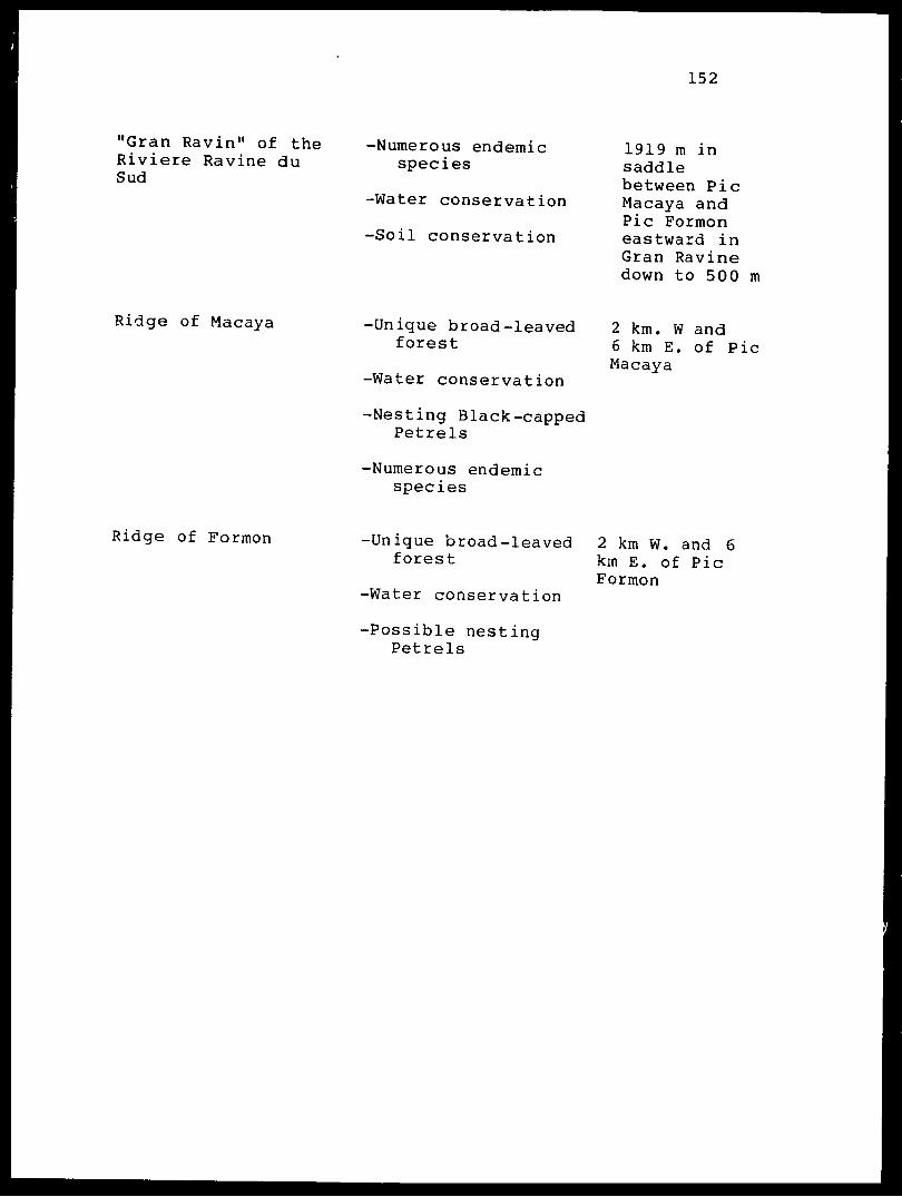
152
"Gran Ravin" of the Riviere Ravine du Sud
-Numerous endemic species
-Water conservation
-Soil conservation
1919 m in saddle between Pic Macaya and Pic Formon eastward in Gran Ravine down to 500 m
Ridge of Macaya -Unique broad-leaved forest
-Water conservation
-Nesting Black-capped Petrels
-Numerous endemic species
2 km. W and6 km E. of PicMacaya
Ridge of Formon -Unique broad-leaved 2 km W. and 6 forest km E. of Pic
Formon-Water conservation
-Possible nesting Petrels

153
Plain of Mare Cochon -Only habitat with 1200-1400 mSolenodon elevation NE of
Macaya-Rich broad—leaved
forest
-Exceptional number of endemic species
-Soil conservation
Each of the above features will be discussed in greater
detail in the section on the "major features" of the park,
and has been described in elaborate detail in each specific
report accompaning this document. All of the features are
part of a natural ecosystem that ranges in elevation from
900 to 2347 meters. If Pare Macaya were to include all of
these areas it would be a 5000 ha "block" of terrain that
would contain Pic Formon and Pic Macaya at their watersheds.
Pare Macaya would also include a 5OO ha. peninsula of land
that streaches southward from Pic Le Ciel and includes the
forested karst hills around the western and southwestern
boundaries of the plains of Formon and Deron that are rich
in important sinkholes and have several small ponds. The
park should also include 2000 hectares NE of the ridge of
Pic Macaya in the areas of Diquillon and Mare Cochon. All
of this park of 7500 hectares should be protected from
environmental degradation of all kinds including all
agriculture and deforestation. The flora and fauna of Pare

154
Macaya contain more endemic species than any other known
area of Hispaniola.
Section 3.- Access to Pare Macaya
Access to Pare National Pic Macaya is difficult. There
are several ways to enter the park, but only one is
practicable (Map 4). That route is via the city of Les
Cayes where there are several hotels that would be suitable
for tourist accomodations. Les Cayes is 196 kilometers by
road west of Port-au-Prince and the journey takes less than
four hours to drive on a paved all-weather highway. From
Les Cayes the route is a gravel road to the town of Le Due.
Beyond Le Due the road becomes rough and crosses the Riviere
1'Acul three times before passing through the town of Le
Pretre. Beyond Le Pretre the road is very rough and climbs
the escarpment by a series of switch backs from the valley
of the Riviere 1'Acul up to the southwestern margin of the
Plain of Formon at Les Platons. This is a picturesque area
where there is a fortification (Citadelle Des Platons) and
splendid views of the eastern Massif de la Hotte (ridges of
Pic Formon). The trip from Les Cayes to Les Platons in 33
kilometers and takes about two hours to drive. From Les
Platons the local residents are building a road towards Sous
Bois (the site of an important local market). The route is
not completed, however, and in November 1985 it was possible

155
to drive on it for only 1.5 km beyond the Catholic church at
Les Platons. Therefore, it is necessary to hike from Les
Platons (elevation 650 meters) northwest across the Plain of
Formon. The route passes through Marche Sous Bois, and then
the extensive karst hills that are still forest covered and
which are known locally as "Bwa Formon". The boundary
marker for the southern edge of the park is located beside
the trail in Bwa Formon 100 meters before the trail finally
passes out onto the flat, fertile Plain of Formon at "Portal
Formon", a collection of houses and large fields in a region
designated on the map (Edition 2-AMS, Sheet 5370-1,
1:50,000) as Nan Seille. Nobody in the region currently
recognizes the name Nan Seille, and all use the name Formon
or Portal Formon. The route from Les Platon takes three
hours to walk and is 10 kilometers long. At "Portal Formon"
the visitor looks northward to see Morne Cavalier and Pic Le
Ciel to the west of the ridge of Formon orientated in an
east-west direction. From "Portal Formon" two trails can be
used to pass through the park.
The first trail passes directly northward and ascends
the ridge of Formon via a series of gardens known as "Kay
Ogile" until it passes over the top of the massif at 1850
meters elevation. The trail then descends into the "Gran
Ravin" to a settlement of gardens known as "De Glace". The
area at "De Glace" is 1030 meters in elevation, and is
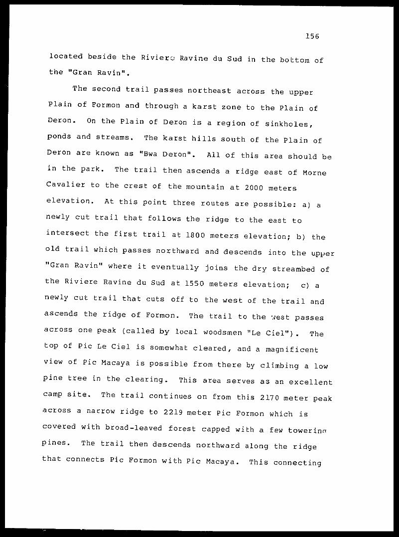
156
located beside the Riviera Ravine du Sud in the bottom of
the "Gran Ravin".
The second trail passes northeast across the upper
Plain of Formon and through a karst zone to the Plain of
Deron. On the Plain of Deron is a region of sinkholes,
ponds and streams. The karst hills south of the Plain of
Deron are known as "Bwa Deron". All of this area should be
in the park. The trail then ascends a ridge east of Morne Cavalier to the crest of the mountain at 2000 meters
elevation. At this point three routes are possible: a) a
newly cut trail that follows the ridge to the east to
intersect the first trail at 1800 meters elevation; b) the
old trail which passes northward and descends into the upper "Gran Ravin" where it eventually joins the dry streambed of
the Riviere Ravine du Sud at 1550 meters elevation; c) a
newly cut trail that cuts off to the west of the trail and
ascends the ridge of Formon. The trail to the west passes
across one peak (called by local woodsmen "Le Ciel"). The
top of Pic Le Ciel is somewhat cleared, and a magnificent
view of Pic Macaya is possible from there by climbing a low
pine tree in the clearing. This area serves as an excellent
camp site. The trail continues on from this 2170 meter peak across a narrow ridge to 2219 meter Pic Formon which is
covered with broad-leaved forest capped with a few towerinn
pines. The trail then descends northward along the ridge
that connects Pic Formon with Pic Macaya. This connecting

157
ridge is known locally as "Pa 1'en cont". After passing
over a small well forested peak at 1919 meters in the center
of the ridge which we designate as "Tete Ravine" the trail
steeply ascends the south ridge (shoulder) of Pic Macaya.
This trail passes near rocky ledges in places and is quite
dangerous and steep. The trail eventually levels off at the
shoulder (2200 meters) below the summit before steeply
climbing to the summit. A camp has been cleared near the
summit of Macaya at 2335 meters. The summit is 50 meters
west of the camp site at 2347 meters, and is marked by
chunks of cement (probably part of the old benchmark) wedged
into the stump of a fallen pine.
This is the only practical route to take into the park,
although it is possible to hike into the park from the east
via the towns of Duchity or Beaumont. However, the route
crosses steep ravines and the trail to the summit of Pic
Macaya has not been cleared. It is currently possible to
travel only as far as "Zapoti", a clearing at 1216 meters
two km north of Pic Macaya. The northern route, therefore,
is not suitable as the primary access to the national park
even though this is the historical route of access to
Macaya that was followed by Wetmore and Darlington. Now
that the trail has been cleared across Pic Formon from the
south, the route from Les Platens should be considered the
primary access to Pare National Pic Macaya. If the road
between Les Platens, Sous Bois and eventually Portal Formon

158
is completed this will provide access to Pare National Pic
Macaya that would be suitable for tourists. However the
route would require major supervision to prevent habitat
exploitation. The route from Les Platons provides many
picturesque vistas of Pare National as it traverses the
broad plain and crosses the karst hills.
159
Section 4.- Major features of Pare Macaya
The following section summarizes all of the reports of
the biogeophysical inventory. An attempt has been made to
review the most important features of Pare Macaya, and to
provide a synthesis of the information that is necessary for
planning as well as understanding the significance of Pare
Macaya. Each original report stands on its own and should
be consulted for detailed information concerning Pare
Macaya.
A. The Geology of Pare National Pic Macaya
The interpretation of the structural geology of Pare
Macaya is complicated by the extensive weathering of the
outcrops and the dense vegetation cover of most sections of
the park. There are numerous faults, some trending
east-west along the Grande Ravine du Sud and others
north-south in the Macaya Formation.
One of the most significant geological features of Pare
Macaya is the extensive karst topography that occurs along
the ?reas of low relief east and south of Morne Cavalier.
Karst is also exposed along the ridges between 1800-2000
meters east of Pic Formon and along the ridge between Pic
Formon and Pic Macaya. Most exposures of karst in the park
are associated with the "karst hills" that cover the edge of
160
the Plain of Formon/ which are really cones of karst. Low
areas are frequently doline collapses or sinkholes.
Steep-sided solution pipes and sinkholes are often
encountered on the Plain of Formon and Plain of Deron. Even
though the area receives abundant rainfall, most water
quickly enters the subsurface hydrologic cycle via the
extensive joint system and larger scale solution features
(flowing into caves).
The main body of the park is composed of two tall
peaks, Pic Formon and Pic Macaya. They are separated by an
active east-west trending fault system that forms the "Gran
Ravin" and the Riviere Ravine du Sud east of the ridge
connecting Pic Formon and Pic Macaya indicate active
vertical uplift in the region. The upper surfaces of both
mountains are covered with deep rich soils that support a
dense forest. These soils are highly oxidized, reddish
laterites. There is a thick layer of humus formed by
decomposing vegetation.
The long fault that originated in the Miocene passes
through much of the Southern Peninsula and crosses Pare
Macaya via the "Gran Ravin". The evidence of active
vertical tectonics in the region is found in the (steep
slopes of the ravine, the numerous talus deposits that flow
out onto the bottom of the ravine and flat areas on the
slopes above, and the frequent occurrence of massive
landslides.
161
The rocks of the park are from two formations. M<'Vt
rocks are limestones of the Macaya Formation. These massive
limestones are characterized by numerous veins of calcite.
Most rocks are fine-grained and light grey in color.
Occasional rocks that are greyish-brown or even darker in
color are encountered. This rock formation is very old,
probably originating in the late Cretaceous 70 to 80 million
years ago. During this time the western portion of what is
now the Southern Peninsula, and the Pare National Pic Macaya
was a back-arc basin that may have been detached from
northern Haiti and located hundreds of kilometers to the
west of its present position.
The second formation that is found in the park is the
"Demisseau Formation". This is the same formation that is
found in Pare National La Visite north of the La Selle
Escarpment. It is a deep-water deposit consisting of
basaltic volcanics (lava flowing under the ocean surface),
turbidites, limestones, cherts and siliceous sandstones.
Rocks derived from this formation are exposed at 1150 meters
in the stream basin of the Grande Ravine du Sud. Other
outcrops of basalt can be observed at 1400-1600 meters
elevation along the southern slope of the ridge of Formon.
Most workers believe that the Demisseau Formation underlies
the Macaya Formation, and is therefore older.
Both the Macaya and Demisseau formations were formed in
the deep ocean in the ancient Caribbean Sea. This seei
162
became shallow in the area of what is now the peninsula of
Haiti in the early Tertiary. During the middle Tertiary
(Miocene) a major tectonic left-lateral fault developed.
Since this time there have been continued lateral and
vertical tectonic events that have shaped the land as we see
it today. The late Tertiary and Quaternary (last 9 million
years) has been characterized by the formation of karst
landforms and lateriti' soils. If Hispaniola was separated
into two islands as some geologists believe, then the
Southern Peninsula would have joined the rest of Haiti about
9 million years ago.
The forces that shaped Haiti are still at work in Pare
National Pic Macaya. One of the best places in all
Hispaniola to stand and appreciate the forces of geological
events in action is in the upper Grande Ravine du Sud at
1600 meters elevation.
B. Floristic Features of Pic Macaya
The vegetation of Pare National Pic Macaya in the
Massif de la Hotte consists of an extremely diverse moist
broad-leaved forest growing on and around areas of exposed
limestone at the lower elevations of the park and extending
upward to about 1250 meters elevation (Table 3). Above 1250
meters a complex mosaic of habitats exist ranging from
moist, dense cloud forest to occassional open, savanna-like

163
pine forest (best developed above 1600 m). Human-caused
disturbance is extensive below 1600 meters.
Judd (1986:7-10) describes the vegetation in the Macaya
region into two major types. The first is an extremely
diverse wet forest on limestone. This is equivalent to
Holdridge's (Sedwitz and Canet, 1972) "foret tres humide de
Montagne de basse altitude" and ranges upward to about 1250
meters elevation. The second forest type described by Judd
is a complex mosaic of pine and cloud forest formations.
Local edaphic factors such as soil, exposure, local
precipitation amounts, wind patterns as well as part of the
history of the region (i.e. fire, cutting, hurricanes)
influence what type of forest will grow in a particular
locality. Because it is difficult to speak of the park in
specific terms within the general forest types mentioned
above, we have subdivided the forest types with several
subunits.
The lower "wet forest on limestone" is subdivided into
four types of habitat.
1) Mature broad-leaved forest (Creole name "Rak Bwa Woch").
This is a typical forest of the karst hills on the edge
of the Plain of Formon. The species composition is
described by Judd (1986:9-10).

164
2) Fragmented broad-leaved forest (Creole name "Bwa Raje
Woch).
This is a small patch of the preceeding forest type or
one that has been dramatically altered by selective cutting.
3) Abandoned gardens or areas of early succession (Creole
name "Raje").
Grassy areas on the Plain of Formon or in the foothills
below 1300 meters.
4) Gardens (Creole name "Jadin").
Garden planted in cleared areas within the "Rak Bwa
Woch" or on the Plain of Formon.
The complex of forest types above 1300 meters elevation
have been subdivided into the following units.
1) Pine forest (Creole name "Bwapen").
This forest type is described by Judd (1986:7). It is
similar to the pine forest in La Visite except it is much
moister and has many more broad-leaved plants in the
understory.
2) Successional pine forest (Creole name "Bwapen Raje").
Young stands of Pinus occidentalis with blackberries
(Rubus spp.) and braken ferns.
165
3) Mature hardwood forest or "cloud forest" (Creole name
"Rak Bwa").
This forest has few or no overstory pines, and usually
has large and conspicuous individual Didymopanax tremulum
trees (called "Bwa Tramble"). The understory is a diverse
array of small trees and shrubs such as Garrya fadyenii,
Myrsine coriacea , Brunellia comocladiifolia and the
important wild avocado Persea anomala. The climbing bamboo
Arthrostylidium haitiense ("liane a scie") grows up in sunny
spots and makes many areas of this habitat almost
impenetrable.
4) Fragmented hardwood forest (Creole name "Bwa Raje").
Small patches of "Rak Bwa", or hillsides where the
typical "Rak Bwa" has been modified by fire or wind damage
so that only a few species are present. In these disturbed
zones the climbing bamboo often grows up and over all of the
fallen vegetation.
5) Abandoned gardens or areas of early succession (Creole
name "Raje").
6) Gardens (Creole name "Jadin").
The above designations in conjuction with the
discussion and species lists available in Judd (1986) allow
us to understand the fine grain distribution of vegetation
types and associated flora found in various regions of the

166
park. A further indication of the importance of Pare Macaya
is demonstrated by examining the ecological map of Haiti
prepared by L.R. Holdridge for the Organization of America-
States (Sedwitz and Canet, 1972). The map shows five
vegetation formations occuring within the boundaries of the
park and associated buffer zone. These formations are
determined on the basis of elevation, precipitation,
evaporation, and climate. The five formations are described
below. The French name for the formation is given as
presented on the map by Holdridg.-> (Sedwitz and Canet, 1972) .
The English name is taken from Holdridge (1947:138) in the
work on the pine forests of Haiti in which he developed his
now famous system for classifying vegetation types. The
presence of five vegetation formations in one small region
is an indication of the ecological importance of Pare
National Pic Macaya. Some of these formations are
associated with abundant rainfall, further pointing out the
significance of the park in water conservation (see plate 6
in Atlas d'Haiti, Lasserre et al., 1985).
1) Foret tres humide de Montagne de basse altitude (Fth-M6)
Tropical lower montane wet forest formation.
-Precipitation 2000-4000 mm.
-Plain of Formon, foot hills of massif and karst hills.
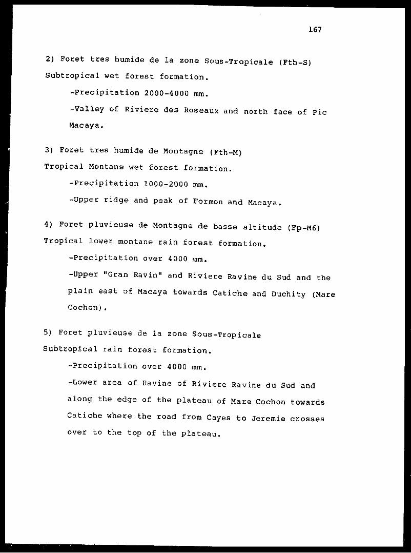
167
2) Foret tres humide de la zone Sous-Tropicale (Fth-S)
Subtropical wet forest formation.
-Precipitation 2000-4000 mm.
-Valley of Riviere des Roseaux and north face of Pic
Macaya.
3) Foret tres humide de Montagne (Fth-M)
Tropical Montane wet forest formation.
-Precipitation 1000-2000 mm.
-Upper ridge and peak of Formon and Macaya.
4) Foret pluvieuse de Montagne de basse altitude (Fp-M6)
Tropical lower montane rain forest formation.
-Precipitation over 4000 mm.
-Upper "Gran Ravin" and Riviere Ravine du Sud and the
plain east of Macaya towards Catiche and Duchity (Mare
Cochon).
5) Foret pluvieuse de la zone Sous-Tropicale
Subtropical rain forest formation.
-Precipitation over 4000 mm.
-Lower area of Ravine of Riviere Ravine du Sud and
along the edge of the plateau of Mare Cochon towards
Catiche where the road from Cayes to Jeremie crosses
over to the top of the plateau.

168
A total of 463 species of vascular plants (including
359 flowering plants, 1 conifer/ 102 ferns and fern allies)
were collected in Macaya National Park. These belong to 263
genera in 109 families. The largest families (excluding the
Orchidaceae) include the Melastomataceae (34 species),
Asteraceae (30), Polypodiaceae s_. str. (22), Piperaceae
(19) , Rubiaceae (19), Urticaceae £. lat. (19) ,
Dryopteridaceae (17), Poaceae (15), Solanaceae (13),
Bromeliaceae (12), and Myrtaceae (12). The total vascular
flora includes 130 species endemic to Hispaniola (28% of the
flora of the park). Of these, 69 are endemic to the Massif
de la Hotte (15% of park flora). The degree of endemism
among the flowering plants was slightly greater with 124
endemic species (34%). Of these, 68 (about 19%) are endemic
to the Massif de la Hotte. Only six percent of the fern and
fern allies of Macaya are endemic. Families with large
numbers of endemic species include Melastomataceae (26),
Urticaceae (12), Asteraceae (15), Solanaceae (7), and
Myrtaceae (6). A total of 99 species of mosses and over ,3
species of liverworts were collected in Pare Macaya. Very
few of these are endemic.
The species of special concern (endangered species) in
Pare National Pic Macaya as determined by Dr. Walter Judd of
the University of Florida include a number of endemics with
ranges restricted to the Massif de la Hotte (see Table 3).
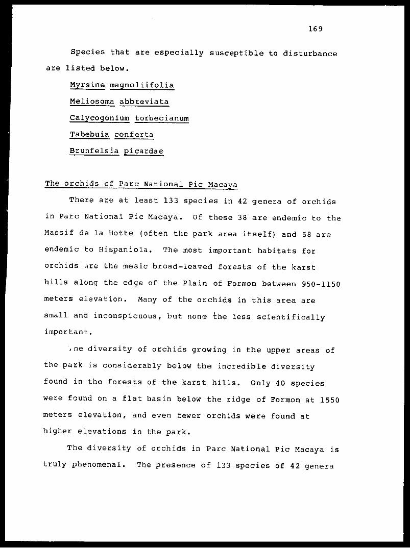
169
Species that are especially susceptible to disturbance
are listed below.
Myrsine magnoliifolia
Meliosoma abbreviata
Calycogonium torbecianum
Tabebuia conferta
Brunfelsia picardae
The orchids of Pare National Pic Macaya
There are at least 133 species in 42 genera of orchids
in Pare National Pic Macaya. Of these 38 are endemic to the
Massif de la Hotte (often the park area itself) and 58 are
endemic to Hispaniola. The most important habitats for
orchids ^re the mesic broad-leaved forests of the karst
hills along the edge of the Plain of Formon between 950-1150
meters elevation. Many of the orchids in this area are
small and inconspicuous, but none the less scientifically
important.
\ ne diversity of orchids growing in the upper areas of
the park is considerably below the incredible diversity
found in the forests of the karst hills. Only 40 species
were found on a flat basin below the ridge of Formon at 1550
meters elevation, and even fewer orchids were found at
higher elevations in the park.
The diversity of orchids in Pare National Pic Macaya is
truly phenomenal. The presence of 133 species of 42 genera

170
in ar: area of less than 10 square kilometers is
extraordinary, especially when it is realized that
Hispaniola has fewer than 350 orchids recorded for the
entire island. This means that almost 40% of all the
orchids of the island occur in Pare Macaya. Almost all of
these occur in the broad-leaved forests of the Plain of
Formon. The region of Pare Macaya, and especially the
region including the karst hills and Morne Cavalier (Bwa
Formon and Bwa Deron) is a piece of ecology so valuable that
it must be preserved.
C. Pare National Pic Macaya and itd butterflies
Eleven species of butterflies are known from Pare
Macaya, which is almost half the number of species known to
occur in Pare La Visite (20, and possibly 21). The two
parks have six species in common. One species, Calisto
loxias is known only from the Massif de la Hotte. The genus
Calisto is predominantly an upland group, often restricted
to one mountain massif. It is not surprising, therefore,
that a member of this genus is apparently endemic to the
Pare Macaya region while another is endemic to the Pare La
Visite.
The reason so many more butterflies occur in the Pare
La Visite region than in Pare Macaya is unresolved. Several
species missing from Pare Macaya are widespread in

171
Hispaniola and it is a surprise that they are not found in
the Macaya area. One explanation is clearly that Pare
Macaya is more isolated than Pare La Visite. This appears
to be one of the main explanations for why five endemic
birds that are common in La Visite do not occur in Macaya.
A second possible explanation may relate to the more
complete forest cover in the Pare Macaya region, which may
reduce the chance occurance of lowland forms. A list of the
species of butterflies found in each park is presented in
Table 4.
D. Pare National Pic Macaya and its Land Mollusks
Fifty seven species of land snails were reported from
Pare Macaya (Thompson, 1986) . Of these 23 are endemic
species that are known only from the immediate area of the
park. Twenty seven new species (two of which represent new
genera) were collected in Pare Macaya,
The large number of new endemic taxa is an indication
of the importance of the habitats included within the
boundaries of Pare Macaya. The most important habitat for
land snails in Pare Macaya is the "Bwa Formon" region along
the escarpment at the edge of the Plain of Formon. This
middle elevation region (1000 meters) is one of the few such
undisturbed habitats left in Haiti. The higher elevations
of the park are more depauperate in the number of species,

172
however nearly all species occuring in habitats above 1800 meters are locally endemic. Table 5 lists all of the land snails known to occur in Pare Macaya.
E. Pare National Pic Macaya and its herpetofauna
The Annotated List (Table 7) cites 26 amphibians and 33 reptiles in the Massif de la Hotte. This list and the analysis below do not take into consideration those taxa
whose distributions are confined to coastal and low
elevations sites (under 700 meters), and undescribed or
unidentified taxa found during recent explorations. At
least one of the new taxa is a unique frog from the ridge of Formon in the vicinity of Pic Le Ciel, Pic Formon and the north slope down to approximately 1650 meters. This species is now under study by Blair Hedges, Richard Thomas, and
Richard Franz and will be described in a separate
publication.
Collections from the study area include 18 frogs, 11 lizards, and 5 snakes. These represent approximately 58% of the taxa presented in the Annotated List. In general, Pare National Pic Macaya includes a mixture of both wide-ranging and highly restrictive species. The wide-ranging amphibians and reptiles are usually well represented in collections
from lower elevations while the restrictive ones are
confined to specific habitats and/or certain altitudes. The greatest species richness occurs at elevations under 1300

173
meters. As one ascends in elevation the number of species
decreases markedly until there are but three species on Pic
Macaya (elevation 2347 meters). Within the proposed park
area (between 1600 and 2347 meters) eight species were
found. Five were restricted to mid and high elevation
sites, while three where wide-ranging. Only
Eleutherodactylus ventrilineatus and the undescribed frog
appear to be endemic to the proposed park itself.
Expansion of the park boundaries would increase the
number of species present in the park. Inclusion of Morne
Cavalier and south slopes of Pic Formon and Pic Macaya add
an additional seven taxa (Eleutherodactylus nortoni,
Celestus costatus costatus, Anolis coelestinus coelestinus,
Chamaelinorops barbouri, Leiocephalus melanochlor^is
melanoc'hlorus / Antilliophis parvif rons parvif rons ,
Darlingtonia haetiana haetiana) . Inclusion of portions of
the upper Plain of Formon, the karst hills to Sous Bois, and
Grande Ravine du Sud add 15 more taxa (Eleutherodactylus
chlorophenax, Eleutherodactylus lamprotes, Eleutherodactylus
wetmorei wetmorei , Hyla heilprini, Hyla pulchrilineata, Hyla
vasta, Osteopilus dominicensis , Celestes stenurus stenurus,
Anolis cybotes cybotes, Anolis dolichocephalus sarmenticola,
Anolis monticola quadrisartus, Anolis ricordi leberi,
Epicrates gracilus hapalus, Epicrates striatus exagistus,
Uromacer catesbyi catesbyi). Inclusion of portions of the
north slope of Pic Macaya including areas near Castillon

174
(Mare Cochon) adds at least 16 more taxa (*flleutherodactylus
audanti audanti, *Eleutherodactylus abbotti ,
*Eleutherodactylus eunaster , *Eleutherodactylus
glaphycompus , *Eleutherodactylus heminota ,
*Eleutherodactylus hypostenor, *Eleutherodactylus inoptatus,
**Eleutherodactylus pictissimus pictissimus ,
*Eleutherodactylus sciagraphus , Bleutherodactylus
semipalmatus , Sphaeodactylus elasmorhynchus , *Anolis
darlingtoni , Anolis distichus suppar, Anolis dolichocephalus
dolichocephalus, Anolis monticola monticola , Anolis ricordi
viculus), and probably others (* = those taxa that may
eventually be found in one of the other proposed areas of
inclusion, ** = those taxa known to occur at lower
elevations just outside of the park boundaries).
Many of the amphibians and reptiles listed above occur
in very specific habitats. Those species occurring at
elevations above 1300 meters are found in mesic broad-leaved
and wet pine forest. Species found below 1300 meters are
associated with wet forests and limestone. Both of these
habitat types provide cool and humid environments for their
inhabitants. Data suggest that when conditions become more
arid through deforestation and agriculture many of the
species disappear from the surface with some taking refuge
in sinkholes and caves. Other species are probably
extirpated. It is also apparent that certain species
(Eleutherodactylus oyrhynchus,Osteopilus dominicensis,

175
Anolis coelestinus, Anolis distichus, Leiocephalus
melanochlorus , Celestus costatus , Celestus stenurus,
Darlingtonia haetiana) are apparently able to thrive under
those i.ew conditions and in some cases spread. This has
probably enabled certain "weed" species to follow trails
where the forest canopy has been removed into areas that
were previously uninhabited by them. Franz and Cordier
(1986) believe that Eleutherodactylus oxyrhynchus and Anolis
distichus used these corridors to gain access to high
altitude sites on Pic Formon, Pic Macaya and the ridge
connecting these two parks. The intrusion of exotic species
probably adversely impacts resident species.
The creation of a park within the Massif de la Hotte is
absolutely essential for the survival of the region's
herpetofauna. The region is an important center for
endemism in southern Hispaniola and contains over 30
restricted species and subspecies. In addition/ there are
at least 15 other taxa which are also found in the Massif de
la Selle area but are missing from intervening lowlands.
To preserve portions of the Massif de la Hotte means to
provide sanctuary for approximately 30% of amphibian and
reptile species known from Hispaniola (including 17 species
which are found nowhere else in the world).
F. The birds of Pic Macaya
176
A complete list of all bird species of Pare National
Pic Macaya is presented as Table 9. There are fewer
resident bird species in Macaya because of the absence of
five endemics that do not occur west of the Jacmel-Fauche
depression ("Bond's line"), such as the Black-crowned Palm
Tanager, Ground Warbler, Hispaniolan Parakeet, Palm Crow and
La Selle Thrush. The group of year round residents is an
assemblage of species that are found in a variety of
habitats, mostly associated with the mesic broad-leaved
forest (lower montane rain forest of Holdridge). This
habitat occurs throughout the higher elevations of the
Macaya region, while in the "Gran Ravin" subtropical rain
forest occurs (Holdridge map, 1972 in OAS report on Haiti).
This habitat does not occur in La Visite because less
rainfall falls in the Massif de La Selle than in the Macaya
region (OAS Holdridge map, Sedwitz and Canet, 19/2; Atlas
d'Haiti, Lasserre et al., 1985).
The pattern of isolation observed in Pare Macaya may be
the result of ecological conditions rather than the
geographical remoteness of the area. Indeed Macaya is not
very distant from the Massif de la Selle, since the mesic
broad-leaved forest of Morne D'Enfer is only 175 km distant
from a similar forest on the ridge of Pic Macaya. The test
of the ecological hypothesis would be if species from La
Visifce began to spread into Macaya as the habitat there is
altered by human activities. This has not occurred in the
177
case of species such as the Black-crowned Palm Tanager,
Ground Warbler or La Selle Thrush which are closely
associated with mesic broad-leaved forest, the habitat thit
is being destroyed in the Macaya region. However, the
White-winged Crossbill and Antillean Siskin showed up in the
Macaya region for the first time during the course of this
study. These birds are associated with open areas and
mature pines. The expansion of their range into Pare Macaya
may be the result of increased destruction of the mesic
forest in the Macaya region that has been documented by
Cohen (1984). The loss of the mesic forest is followed by
rapid regeneration of pine making the area more suitable for
species such as the crossbill and siskin. Large flocks of
crossbills were present from 1982 through the last survey in
November 1985. The transition is not complete, however,
since Hispaniolan Parakeets and Palm Crows, two other
species that do well in the open pine habitats of La Visite
have not yet spread to Macaya. Should these two species
spread into the Macaya region it would be a further
indication that Macaya has been isolated by its abundant
rainfall and rich, dense mesic forest. Therefore, the
appearance of crossbills and siskins in the Macaya area,
which at first thought seems to be a good sign since the
species are important Antillean endemics, may be instead a
reflection of the distribution of the rich mesic
broad-leaved forest that covered the region until the last

178
two decades (Cohen, 1984). More research is necessary to
clarify this question.
The list of resident birds is swelled by the addition
of migrant species that arrive in late September and stay
until April. This brings the total number of species found
in the Macaya region to 65; two less species than found in
Pare National La Visite. The difference in the number of
bird species, however, is largely the result of the fewer
number of endemics that occur in western Haiti. The
difference in the number of species would be even more
dramatic if it where not for the presence of the lower area
of Pare National Pic Macaya in the region of the Plain of
Formon at 1000 meters elevation. The broad-leaved forests
of the karst hills along the edge of the Plain of Formon
have a number of bird species that are characteristic of
lower elevations (Broad-billed Tody, Loggerhead Kingbird,
Mango Hummingbird) as well almost all of the species found
in high montane regions (except for the White-winged
Crossbill and Antillean Siskin) . This mid-montane forest is
the habitat that has been severely deforested in most parts
of Haiti. It is the most important and vulnerable of all
the habitats in Pare National Pic Macaya, as is readily
apparent when the number of species found in this small
subregion (500 ha) of the park is compared with the list of
species occurring in the rest of the park (7000 ha). On the
Plain of Formon and the adjacent karst hills 51 species

17 9
occur while in the montane zone of the park about 1300
meters elevation 47 species occur (Table 9).
The total number of individual birds is greater in Pare
National La Visite than in Pare National Pic Macaya. During
the winter census period on La Visite an average of 242
birds were seen per day, while in Macaya an average of only
151 birds were ooserved. A reason for this difference may
be that in the open ruinate ("Raje") areas of La Visite
during the winter months huge flocks of migrant warblers
feed in abandoned corn fields and gardens. Some of these
mixed flocks (mostly Yellow-rumped Warblers, Palm Warblers
and Cape May Wdrblers) number over 300 individual birds.
T>>ose flocks inflate the data on bird numbfcs, but are not a
true reflection of species richness. It is true that the
area of Pare National Pic Macaya above 15GO meters has fewer
species than Pare National La Visite (Table 9). This is in
part a reflection of the greater percentage of land area in
La Visite above 1500 meters, as well as the reduced number
of endemics in Macaya {see previous discussion). However,
the combination of the very important mid-montane habitats
of the Plain of Formon with the high montane forests of Pic
Formon and Pic Macaya create a combined ecosystem in Pare
Macaya that is richer in bird species than Us the case iny
Pare La Visite.
The presence of breeding Black-capped Petrels on the
south face of Pic Macaya is an important new observation.
180
The small colony of petrels on Macaya was discovered for the
first time in January 1984 and surveyed in detail in January
1985. An additional colony may exist on the northwest face
of Pic Formon. The presence of Black-capped latrels in Pare
Macaya adds special significance to the park since the
species has been eliminated from most islands in the
Antilles. The birds are nesting in burrows at about 2200
meters elevation at the transition zone between wet
broad-leaved forest and scrubby second growth occurring
where fires and erosion have disturbed the steep
mountainside. Many rock slides further disturb the habitat
below 2200 meters. The zone where the petrels nest is
especially vulnerable to damage from below by fire as it
sweeps up the mountain and kills the vegetation that
provides cover for the petrels and protects the steep
mountainside from further erosion. The open areas that
occur following fires also expose the petrels to predation
by dogs, cats and mongoose. Cats and mongoose now occur on
the peak of Macaya where the density of Black and Norway
rats is very high. All of these real and potential problems
mean that the colony of breeding Black-capped Petrels is
"threatened". Because the colony is small and the habitat
has been badly damaged by fires that have swept over the
area since 1978,- the status of the colony will be changed to
"endangered" if any more habitat is lost. The area below
the petrel colony should be totally protected.

181
No gardens, ajupas, fires or deforestation should be
allowed from the base of the mountain or on either side of
the connecting ridge between Pic Formon and Pic Macaya.
Since this is in the area of land claimed by the coffee
cooperative (UNICORS) and several private individuals, great
care must be taken to work with individuals and institutions
in the area to insure that the petrel colony is protected,
G. The Mammals of Macaya
There were originally eighteen species of land mammals
occuring on the Plain of Formon and the higher montane areas
of Pic Formon and Pic Macaya (Table 11). The remains of
these species were recorded in sinkholes on the upper Plain
of Deron near Morne Cavalier as well as from a sinkhole on
the ridge of Pic Macaya. These eighteen taxa were
distributed between two rodents similar to the zagouti, two
hutias of the kind kept by indians as a domestic species,
one giant hutia, one small zagouti-like form and one new
genus and species of 'rodent found no place else in
Hispaniola (for a total of six rodents). In addition there
were five insectivores, one monkey and as many as five
ground sloths, of these eighteen endemic land mammals, only
one survives in abundance within the boundaries of the park
today. This is Plagiodontia aedium, the "zagouti". It
surveys in the karst hills along the edge of the Plain of
182
Forrnon and Plain of Deron, but does not occur in higher
montane areas of the park where there are few areas of
exposed rocks or large trees with cavities where the zagouti
can find shelter.
The other surviving mammal, Solenodon paradoxus, is very
rare within the boundaries of the park. It is most abundant
in mid-elevation forested regions (500-1000 meters). It has
been eliminated from most areas of the Plain of Formon by
deforestation and because so many dogs are found in the
region. Dogs kill large numbers of Solenodon, and this
species, unlike the zagouti, has a difficult time surviving
in areas where dogs and people are abundant even when large
blocks of karst are available where the animals can take
refuge in rock crevaces. Plagiodontia can escape from dogs
and people by climbing into trees or running into rock
crevaces, but Solenodon is less wary and more frequently
killed. Solenodon continues to survive in the Pare Macaya
region only in the mesic forest east of Pic Macaya and west
of Catiche and Duchity (Mare Cochon area) . If dogs and
people are removed from the park, especially in the "Gran
Ravin" area which is adjacent to the area where Solenodon is
still found, then it is possible that the species will
become more abundant in the region of Pare National Pic
Macaya.
Plagiodontia and Solenodon are both abundant in the
remote area east of the main ridge of Pic Macaya (designated

183
Diquillon and Mare Cochon on 1:50,000 topographic maps).
This habitat is similar to the karst LI11s along the edge of
the Plains of Formon and Deron that have been included
within the boundaries of the park. Based on the results of
the mammal survey (as well as the survey of the
herpetofauna) we re ,-omuiend that the park boundaries be
expanded an additional 2000 ha to the northeast to include
Mare Cochon region which is the most important habitat for
mammals that remains in the vicinity of either natural park.
In addition, we recommend that a buffer zone be created
beyond this zone where coffee can be grown, but from which
dogs and cats are eliminated and where mesic broad-leaved
forest can return in a large block. An examination of the
ecological maps by Holdridge (Sedwitz and Canet, 1972) and
in the Atlas d'Haiti (Lasserre et al., 1985) reveals that
this broad rough plateau is at about 1200 meters elevation
in the area of Haiti with the most abundant precipitation.
Plagiodontia and Solenodon thrive in this zone of mesic
broad-leaved forest (much of which has been cut or burned) ,
karst exposures and abundant rainfall.
The nine species of bats recorded from Pare Macaya
represent more than twice the number of taxa collected in
Pare La Visite during the survey period (Table 12) . Four
bat species were collected in Pare La Visite. An
examination of cave and sinkhole deposits, however, indicate
that eight bat species are known to have occurred in the

184
Pare La Visite area during the past several thousand years.
The reason why 'fewer bats now occur in Pare La Visite than
occurred there in the recent past or occur in Pare Macaya
cannot be resolved with certainty. Some of the possible
reasons are: 1) the disturbance of bats in the La Visite
region by peasants burning the forest in ravines at the
mouth of caves in order to plant gardens in the rich, mesic
ravine habitats; 2) the general deforestation of the La
Visite area; 3) the greater proportion of land area in La
Visite that is above 1500 meters elevation which makes the
habitat less suitable for frugiv_rous bat species. It is
clear from the above data however that Pare Macaya is
currently much more important to the preservation of bat
species than is Pare La Visite. Pare Macaya is also more
important for terrestrial mammals. Indeed, in terms of the
conservation of all of the remaining endemic manuals of
Haiti, the araa of Pare National Pic Macaya including the
Plain of Formon and the Mare Cochon region to the east of
Pic Macaya is the most important region in all of Haiti. If
this region can be protected from further deforestation and
the "quality" of the habitat improved (regeneration of the
mesic broad-leaved forest, removal of domestic and feral
dogs and cats), then Solenodon paradoxus, Plagiodontia
aedium and a number of bat species have a good chance of
surviving in the country and being part of the natural
ecosystem for decades to come. Research on the status of

185
Plagiodontia and Solenodon including specific studies on
their habitat requirements and the impact of dogs, cats,
mongoose, Black Rats and Norway Rats is necessary to insure
proper data is available for use in wise management
decisions.
186
Section 5.-Critical Areas and Topics of Special Concerns
Pare National Pic Macaya
The most significant geological, botanical and
zoological features of Pare National Pic Macaya were
discussed in the previous section. Significant regions and
features of the park have been selected based on these data
and the synthesis of the individual inventory reports. The
areas in the Pare Macaya region that are in greatest need of
protection or are of greatest significance are listed below.
Critical Areas
Area Reason
1) Karst hills from Morne Most important habitat for
endemic orchids. Also habitat
with the greatest bird diver-
Cavallier southeast to
Sous Bois (region called
"Bwa Formon" and "Bwa Deron". sity. Only known habitat in
region where Parrots are
found. Only place
Plagiodontia aedium still
occurs in region unless Mare
Cochon is added to Park.
2) Small ponds on Plain of
Formon and Plain of Deron
at 1000-1200 meters.
Water conservation. Only
available aquatic habitat
near karst forest. Habitat
for Least Grebe.

187
3) Ridge of Formon from Pic The largest block of mesic
Formon east across 2170 meter broad-leaved forest left in
Pic Le Ciel and on east along Haiti. Water source for
the ridge of Formon to 1800 Riviere Ravine du Sud,
meter contour beyond Pic Riviere 1'Acul and Riviere
1728. de Port-a-Piment.
4) Western ridge of Pic Continuous with previous
Formon to 1600 meter contour. forest. Possible habitat
for Black-capped Petrels.
Suitable habitat for
Plagiodontia aedium
(re-introduction possible)
5) Pic Macaya Breeding Black-capped
Petrels.
Extensive pine forest with
White-winged Crossbills.
Numerous nesting endemic
birds. Water source for
Riviere Ravine du Sud and
Riviere des Roseaux.

188
6) Eastern extension of the
ridge of Pic Macaya to the
north into th^ Diquillon
region and eastward onto
Mare Cochon.
7) "Gran Ravin" down to
an elevation of 500 meters
where the two branches of
the Riviere Ravine du Sud
merge.
Largest number of endemic
herps. Only area where
Solenodon paradoxus
still occurs (and also
habitat for Plagiodontia
aedium). Orchid habitat.
Water source for Riviere
Ravine du Sud, Riviere des
Roseaux and Riviere Glace,
Mesic forest to low elevation
Abundant rainfall and water
conservation for Riviere
Ravine du Sud. Controlled
access to "Gran Ravin",
Special concerns
1. Protecting the Black-capped Petrels along the south face
of Pic Macaya by preventing all fires in areas below their
nesting colonies.
2. Protecting the few remaining "zagouti" (Plagiodontia
aedium) in the karst hills on the Plain of Formon,
3. Expanding the protected area (national park) to the north
and east of the main ridge of Pic Macaya to include 2000

18S
hectares of critical additional habitat (Mare Cochon) for
Plagiodontia aedi urn and providing the only suitable habitat
available for Solenodon paradoxus.
4. Removing the dogs and cats from the karst hills of the
Plain of Formon. This will be difficult because so many
people live in the area.
5. Removing sheep and goats from the "Gran Ravin", the Plain
of Formon and the Plain of Deron.
6. Establishing a program of guardians to patrol the park
and prevent deforestation and exploitation (now underway).
7. Completing an official boundary survey (nov; underway).
Note: This survey should resolve the conflict with COSAR in
the "Cadiene" area near Morne Cavalier and the area between
Pic Macaya and Pic Forrnon.
8. Establishing a Park Headquarters near a permanent source
of water. The best spot for a Park Headquarters is at Bwa
Pipirit on a prominent hillside at 1428 meters elevation.
9. Initiating a soil conservation program in the "Gran
Ravin" that will stabilize the steep slopes of the ravine.
Pines and hardwoods (such as Persea anomala , the wild
avocado) should be planted in suitable areas. Grass should
not be planted unless seeds of an appropriate native species
is available.
190
10. Replanting the areas around the small ponds on the Plain
of Formon and Plain of Deron to keep them from filling in
with surface soil. Rapid erosion from the newly cleared
land surrounding the ponds is threatening them.
11. Protecting all areas of the "Rak Bwa" growing in the
karst hills. This area is being rapidly de-forested.
12. Replanting trees* (pines and broad-leaved endemics) on
the Plain of Formon and Plain of Deron and in the foothills
to the north, especially in ravines and badly eroded areas.
Heavy rains carry away enormous quantities of soil and
nutrients in these areas. Planting can be in strips along
the ravines, in blocks around the ponds, and in patches in
especially suitable habitats. These patches in addition to
stabilizing the soil will create "edges" of habitat that
will increase the diversity of the otherwise ruinate open
areas of the Plain.
Section 6.- Zones and Areas of Pare National Pic Macaya
A. Recreation Area
Recreation and tourism are not likely to be as
important in Pare Macaya as in Pare La Visite because Macaya
is remote and the trails in most sections of the park are
steep and difficult to traverse, many tourists will not want
to undertake the exhausting hike necessary to get to Pic
191
Macaya or into the "Gran Ravin". Recreational facilities
should be available in the park, however, to accomodate
adventurous visitors and an effort should be made to develop
a program in wilderness tourism, r?he basic facilities and
recreational plan for Pare Macaya should include the
following.
1. £ Park Headquarters at :'Bwa Pipirit".
2. A camping area near Park Headquarters.
The camping area should have a latrine and a permanent
source of pure water.
3. A nature trail from the Park Headquarters up the
ridge of Formon and descending into the "Gran Ravin" at
1050 meters elevation where there is a picturesque
waterfall, pure water and a pleasant place to construct
a permanent campsight. There are several spectacular
views from this trail, visitors should be encouraged
to employ a guide
4. A trail from the Park Headquarters westward and up
the ridge of Formon, across Pic Le Ciel to Pic Formon.
A camping area (log lean-to) should be constructed on
Pic Le Ciel. The trail that crosses the ridge from Pic
Formon to Pic Macaya should be closed to the public.
The trail up Macaya is extremely steep and dangerous
in several places as it passes over exposed areas of
loose rock. The top of Pic Macaya is one of the most
dramatic and remote areas in all of Haiti (see

192
following section) . Visitors to Pic Le Ciel and Pic
Formon should be encouraged to employ a guide.
5. The Citadelle Des Platons near the town of Les
Platons should be included into the biosphere reserve
and Pares Haiti should work with ISPAN to develop the
site. There should be information about the
Citadelle available there, and also information about
the park (a three hour hike or a ten kilometer drive
if the road is completed). The view of the mountains
from Les Platons is very impressive.
6. Consideration should be given to constructing a
trail from the park headquarters to the cave where
the Riviere 1'Acul rushes from the mountain as a fully
formed stream. This area is outside of the park, but
in the buffer zone, and therefore part of the biosphere
reserve.
B. Special Permit Area
We recommend designating the top of Pic Macaya as a
combined "Recreation Area" and "Biological Preserve Area".
This designation acknowledges the exceptional mystique of
Pic Macaya. The birdlife is interesting because of the
large numbers of endemic species, the towering pine forest
is impressive, the vistas from the trail ascending the peak
are spectacular and there is an almost spiritual mystique
about being on Pic Macaya. These features mean that there
193
is a recreational dimension and tourist attraction about the
area that should be acknowledged and carefully cultivated.
The area is also very fragile. The trails are easily
damaged/ the deep pine litter make the zone susceptible to
forest fires. The colony of Black-capped Petrels on the
south side of the mountain are "threatened". Therefore, we
recommend that a shelter be built at the top of Pic Macaya
with a safe and secure place to build a fire. Everything
possible should be done to maintain the "wilderness" aspect
of this area. Trees should not be cut down for firewood and
fallen branches should not be burned because the burning of
excess wood is counter to maintaining the area in a
"wilderness" state. Firewood should be carried in, when
possible or more appropriately camp stoves should be used to
cook on. Visitors to the park should only be allow ad to
climb Pic Macaya (and camp there) with written permission (a
permit) obtained at the Central Office of Pares Haiti. We
recommend that a fee be charged for the permit. There
should be a place for the Park Supervisor of Pare Macaya to
also sign the permit to insure close supervision of all who
climb Pic Macaya. Two local guides (one to return for help
should a visitor fall and become injured) should accompany
all climbers. Since the trail to the peak is dangerous the
permit should include a signed waver to release Pares Haiti
from any legal liability in case of injury.

194
The top of Macaya is first and foremost an area of
great biological significance, and set aside as a Biological
Preserve Area. Therefore, what we have here is a small part
of the Biological Preserve Area being set apart in the
category of a "Designated Use Zone" even though it is in the
middle of a "Restricted Area".
C. Biological Preserve Area
There are so many endemic species of plants and animals
in Pare Macaya that one of the most important functions of
the park is conservation of these species, many of which are
threatened or endangered. Another important function of the
park is watershed conservation which is best accomplished by
increasing the percent of natural forest cover in the
region. Large sections of Pare Macaya should be set aside
as conservation zones. The term "Biological Preserve Area"
should be used ror all these conservation areas.
The most important areas to set aside as "Biological
Preserve Area" are listed below.
1. All of the karst hills along the margin of the Plain of
Formon from Sous Bois to Morne Cavalier (with the exception
of a well marked educational trail that will pass through
this zone) .
195
-This biological preserve is essential to protect the
zagouti (Plagiodontia aedium) , the Hispaniolan
Parrot and many species of endemic orchids which only
occur in the park in this region.
2. All of the eastern ridges of Pic Macaya as well as the
adjacent Diquillon and Mare Cochon areas.
-This is the most important wilderness area left in
Haiti.
3. The "Gran Ravin" from 500 meters elevation upward
(westward) to the ridge connecting Pic Formon with Pic
Macaya.
This area is severely degraded by overgrazing and
recurring landslides. It has great biological
significance, and is of importance in water
conservation for the Riviere Ravine du Sud.
4. The "Basin Dalest" is one of the few extensive flat areas
at moderate elevation (1500-1600 meters) in the park. It
still has extensive patches of mesic forest and some giant
pines. The basin is rich in bird life. The entire basin
and eastern extension of the ridge should be protected as a
"Biological Preserve Area".
5. The wet steep mountainside NE of the ridge connecting Pic
Le Ciel v _ri Pic Formon.

196
6. The entire area of Pic Macaya (which is also designated
as a "Recreation Area").
-This is designated as a Biological Preserve Area in
order to protect the breeding colony of Black-capped
Petrels and the unique "mesic" pine forest.
D. Restoration Area
The following areas are in need of management in order
to return to their biological potential or to correct severe
environmental problems that threaten their future and the
future of adjacent regions. Some of the areas are isolated
from other zones, while others are within a "Biological
Preserve Area", but have been severely degraded. The areas
of special concern are listed below.
1. The Plain of Formon has been severely degraded and must
receive immediate protection (see recommendations under
Section 5, Special Concerns, Number 12).
2. The ponds on the Plain of Formon and Plain of Deron need
special attention to prevent them from filling in with mud,
and to enrich the areas around them for wildlife. Endemic
shrubs and trees should be planted in a zone 20 meters wide
around the ponds. Beyond that for a distance of 100 meters
Pinus occidentalis should be planted to serve as a
transition zone and to provide shelter and protection.
197
3. The "Basin Delest" is designated as a "Biological
Preserve Area". The degradation and deforestation on the
bottom of this basin near a small house with a metal roof is
especially severe. New gardens have been planted in the
past year and many large pines have been cut. The house
should be removed. All gardens should be destroyed. Pinus
occidentalis should be planted in the gardens.
4. The steepest areas of the "Gran Ravin" on the south side
of Pic Macaya are eroding away very rapidly. Special
attention should be given to "securing" this area. The area
is naturally unstable and extremely difficult to get to.
Grass scattered onto the hillside would stabilize the slope.
One grass that could be planted to stabilize the hillside is
Rhychletrum repens a beautiful grass with a pinkish red
inflorescence that is a native of Africa. This grass is
very aggresive and has been planted in large sections of the
Dominican Republic and in the Massif de la Selle. Seed of
this grass in readily available. There are many problems
associated with planting this grass, however, and we do not
recommend using it. The grass is an aggresive non-native
species that will ^rowd out other important plants. The
presence of dried stems will also create a severe fire
hazard. Therefore we recommend planting pines on the
hillside where ever possible. Grass should only be planted
if seed of a native species can be obtained.
198
Special attention should be paid to removing goats and sheep
from the hillsides since they are overgrazing the vegetation
and starting erosion and landslides by walking in steep
areas. Pinus occidentalis should be planted along flatter
areas of the steep slopes and along the margin of badly
eroded areas. The pines area a natural feature in the
successional sequence of the region and would not only
increase the stability of the fragile slopes but also
increase the habitat available foj White-winged Crossbills.
E. Maintenance and Service Areas
The following areas should be set aside in the park as
part of activities assr ciate-u with maintenance and service.
1. Park Headquarters
2. The "tnad" i'-e <?s v>"-a+- -» ... l-v. quarters;.
3. A depot and >. . - '^ >ac!ame
Robert's house.
4. A supplemental headquartors at ''Des Glace" near water at
1040 meters in the "Gran Ravin".
5. A supplemental headquarters in the "Guinaudee" region of
the ravine o r '.UP Riviere de la Guinaudee (sometimes called
Riviere Tordeau). We recommend that this be at 700 meters
elevation in the ravine just outside of the Park boundaries.
Access to this area from Beaumont and Duchity is not

199
difficult. This would allow for access into the park to be
from both the north and south. The long range goal of
having a hiking trail that would pass from Les Platons to
Beaumont would create the need for a facility on the north
side of the park. There is also a need for a security
station in the area (see below) which could be part of the
supplemental headquarters.
F. Security and Information Areas
The following items are closely linked to preventing
further environmental degradation in the park, and to making
the park a safe and secure place to visit.
1. A sign describing the park should be placed at Les
Platons.
2. A sign about the Citadelle Des Platons should be placed
adjacent to the Citadelle along the access road to Pare
Macaya We recommend that the Citadelle become part of Pare
Macaya Biosphere Reserve program..
3. A sign about the park should be placed near the entrance
to the park beyond Sous Bois (near Portal Formon). This
sign should outline.
a. Park rules
b. Park features
c. Map of Park

200
5. A guard station should be established at the depot near the trail as it passes Portal Formon,
6. At some point within the next decade a guard station
should be constructed near the supplemental park
headquarters on the north side of the park in the valley of the Riviere Guinaudee along the acess route (to be
developed) from Beaumont and Duchity.
7. A guard station should be set up in association with the supplemental Park Headquarters in the "Gran Ravin" at or
near 1040 meters.
G. Education Area
The remoteness of Pare National Pic Macaya means that
it is not necessary to construct a site museum or to invest in many local site exhibits. The emphasis of the park
should be on soil and water conservation and the
preservation of endemic species of plants and animals.
Recreation of the "wilderness experience type" should also be encouraged. Should the park ever develop into a major
tourist facility, then the site museum can be constructed at or near the Citadelle Des Platons to take advantage of the historical importance of that facility and the remarkable
view of the mountains.
During the first 10 year phase of the park, the main
education zone will be an exhibit of two double sided

201
educational panels set up at the Park Headquarters. These
exhibits would provide a guide to the most significant
features of the park. The two panels would have four
exhibits.
1. Water Conservation
2. Geological and Physical Features
3. Major Forest and Plant Associations
4. Fauna of Parks
As part of the development of an access route to Pare
Macaya a nature trail should be constructed through part of
the karst hills of the Plain of Formon (3wa Formon)
H. Research Area
1. Three climatologies! research stations should be set up
in the park to record air temperature , soil temperature,
barometric pressure, rainfall, wind direction, and wind
speed.
These stations should be at:
1. Plain of Formon at "Depot" (1000 meters)
2. Summit of Pic Le Ciel (2170 meters)
3. "Gran Ravin" outpost (1040 meters)
No other research area is necessary. Since such large
sections of the park are classified as "Biological Preserve
Zones", care must be taken to preserve and protect the
ecosystems in the areas. Collecting for plants or animals
202
in any region of the park should be carefully regulated and
reviewed. As with Pare National La Visite, we recommend
that eight research projects be undertaken during the next
five years. These projects are:
1. A quantitative analysis of the composition of each major
plant association in the park.
2. An analysis of microhabitat requirements of each endemic
plant species as well as information on growth and
regeneration.
3. An in depth study of the ecology of the endemic mammals
in an effort to develop an effective management program.
4. A detailed analysis of the habitat requirements and
breeding biology of the Black-capped Petrel to develop an
effective management program.
5. A continuing analysis of the distribution and abundance
of birds in an effort to understand the habitat requirements
of the endemic species.
6. An in depth analysis of the habitat requirements of
numerous invertebrate species, and an effort to document
additional new species.
203
7. An in depth analysis of the specific habitat requirements
of each species of amphibian and reptile in an effort to
learn how to manage habitats to protect endemic species.
8. Baseline studies on the climate of each microhabitat in
the park.
Section 7.- Plan for Pare National Pic Macaya
As with Pare National La Visite, the plan for Pare
Macaya will be divided into nine topics. Each topic is
briefly discussed in this chapter as it relates to the local
situation in Pare Macaya.
A. Administration
As with Pare National La Visite, there should be a full
time "Park Supervisor" assigned to the park. The facilities
within the park at this stage in its development are not
suitable to house the quality person necessary to manage all
aspects of the park, so a Park Headquarters should be
constructed at "Bwa Pipirit" as soon as possible following
the architectural plans we have submitted.
Duties of "Park Supervisor"
1. Seek resolution of conflicts of land use with local
landholders, farmers, peasants.

204
2. Coordinate the improvements on the road and access
route to the p.vrk to improve access.
3. Serve as an active and effective spokesman for the
park, add the concept of conservation on the Cayes
region.
4. Coordinate and supervise all routine activities
in the park as designated by the Director and Assistant
Directors.
-maintenance
-security of the park
-implementation of park plan
B. Maintenance
There should be a full time team of maintenance workers
who carry out the instructions of the Park Supervisor via
the designated "crew chief". The size of the group of
workers will depend on the amount of work at any one season,
or at any one time in the implementation of the park plan.
However, there should be a nucleus of workers under
permanent contract (a "crew chief" and 14 full time workers
is the suggested size) . They should be hired from personnel
living in the region.
The maintenance crew is responsible for improving and
maintaining access to the parks, building basic park
facilities and assisting in reforestation.

205
C. Security
As with Pare La Visite there should be a team of full
time guardians for Pare Macaya. This group should be under
the direction of a "Chief of Guards" who answers directly to
the Park Supervisor.
It is important that guardians be trained and placed
within the park as soon as possible since there has been so
much recent exploitation of the park for lumber and gardens.
It is extremely important, however, that the presence of
guards not become a bigger problem than the problem they are
there to guard against. If the guards themselves are not
correctly supervised, then they may organize the peasants to
make gardens, harvest wood and graze animals. The guards
will also need to be fed and sheltered, and these compromise
the security of the habitat. Some guard posts in the
national parks of the Dominican Republic have been
associated with exploitation of the habitat, especially when
the posts are located in remote areas.
With the above special concerns in mind, guard posts
should be established in appropriate places (near water and
suitable services) of Pare Macaya. One guard post should be
near Portal Formon. This post would secure the trail to
Sous Bois (and the lowland areas to the south including
Port-a-Piment and Coteaux) as well as the main route back to
Les Platons (Chantal, Le Due, Torbeck and Cayes) . This
206
should be the main guard post for Pare Macaya and include
enough guards to secure the trail, as well as patrol the
south boundaries of the Park.
As noted in the discussion of security for Pare Lc1
Visite, we do not believe that guards should live inside the
park. Because of the remote nature of Pare Macaya, however,
this is a special problem in the region of the Plain of
Formon, and an even greater problem for the outpost on the
north side of the park. No easy solution is at hand because
of the difficulty of transportation in the region. If the
guards live in the nearby community they will in time tend
to watch out for the interests of that community and be
vulnerable to conflicts of interest. For that reason we
recommend incorporating a security post into the depot
facility of Pare Macaya at Portal Formon. This would be the
main security facility for the park.
A second guard post should protect the north and
northwest margins of the Park. This would secure the routes
to Chardonnieres and below Des Barrieres on the north side
of Macaya. There is water there, and easy access from both
Duchity and Beaumont. This guard post would be part of the
park headquarters outpost in that region. A third small
guard post can be set up in the "Gran Ravin" for occassional
use by the guardians from Portal Formon as they patrol the
"Gran Ravin". Special care should be taken to prevent this

207
area from being exploited since it is remote and already che
site of considerable agricultural activity.
D. Recreation and Tourism
As with the discussion of Pare La Visite, the major
features of a recreational program are outlined under the
discussion of the "Recreational Areas" in Section 6 of this
chapter. The development of these facilities [1) Park
Headquarters; 2) trail to "Gran Ravin"; 3) trail to Pic
Formon; 4) trail to source of Riviere de 1'Acul; 5)
campgrounds at Park Headquarters, Pic Le Ciel and "Gran
Ravin"; 6) special permit only campsite on Pic Macaya] will
provide tourists with something to do in Pare Macaya that is
unique and appropriate for the region. It will also allow
the park to be publicized/ and provide a public image for
the park that can be advertized in Port-au-Prince where
Macaya seems remote and poorly understood.
A nature trail through the karst hills of the Plain of
Formon will allow the public and important visitors to view
some of the best features of Pare Macaya without their
having to hike into the remote sections of the park. This
nature trail should have well placed and appropriately
designed signs to identify geological and botanical
features. The trail can be incorporated into the access
route to the park in some areas. If carefully planned the
nature trail will not conflict with the conservation goals
208
of the "Biological Preserve Areas" of the karst hills
region.
The Pic Macaya area has been set aside as a "Biological
Preserve Area" because the habitat is so sensitive to damage
by fire and disturbance by overuse. We have also
recommended that a "Recreation Area" also be included on Pic
Macaya. We have, therefore, designated the area of Pic
Macaya as both a recreation and preservation region.
Recreation should be allowed on Pic Macaya (because the area
has such significant recreational features), but only under
carefully controlled and well supervised conditions (see
Section 6-B). There should be an attractive and secure
campsite on the top of Pic Macaya, and a hiking trail along
the ridge.
Eventually (within the ten year plan) plans should be
made to develop a hiking trail that passes from Les Platons
across the Plain of Formon, up the ridge of Formon, across
Pic Formon, up the ridge of Macaya to Pic Macaya, down the
north ridge of Macaya across the "bump" at Zapoti to the
Riviere de La Guinaudee (or R. Tordeau as it is called in
the region), up to Desbarrieres and out to the town of
Beaumont. This hiking trail is difficult to traverse
because of its steep inclines. However, if properly
maintained it could be an attractive feature of the park
area. The climb to Macaya (from either Les Platons or
Beaumont) could be like climbing Mt. Kilimanjaro in Kenya

209
where certain hardy visitors are drawn by the mystique of
the place and name. Fees could be charged for this
"adventure" that would include campsite and guide fees (see
Section 6-B). This would generate some revenue for the
park, provide a focal feature for the park and yet "control"
the use of the zone so that a minimum of damage was done to
the flora and fauna.
E. Education and Interpretation
The main educational goals for Pare Macaya for the
first ten years are discussed in Section 6-G under the
description of the "Education Area". These activities
should be carefully coordinated with "Recreation and
Tourism" activities. The major education and interpretation
goals for the first ten years are listed below.
1. A sign at Les Platons about the Citadelle.
2. A sign at Les Platens about Pare Macaya.
3. A nature trail along the access route to the Park
Headquarters. This trail should be a unit in itself, but
should allow hikers from Les Platons the added feature of
hiking along the trail as they approach the Park
Headquarters. It should have a number of information signs
about the natural history of the area.
4. Two exhibits in the Park Headquarters (see Section 6-G).
210
5. Good maps should be completed of the park, along with
publications on the flora and fauna of the area. These
would be useful in recreation, education and management.
F. Public Relations
As with Pare La Visite, this park should be promoted in
the media in Port-au-Prince after adequate facilities exist.
The important features of Pare Macaya should be illustrated
in an entrance signs for the park that are prominently
displayed near the entrance near Portal Formon and at the
Park Headquarters. There should be exhibits on Pare Macaya
at MUPANAH.
The Park Supervisor of Pare Macaya should e the chief
spokesman for the park in the region. The pex.oon or a
representative of the Central Office should give speaches in
Les Cayes and other towns in the area, and should work with
organizations in the area such as the Union des Cooperatives
de la Region Sud d'Haiti (UNICORS). There are a number of
conflicts or potential conflicts in the area that could
damage the park. The park supervisor in association with
the Director and Assistant Directors should be responsible
for working at the local level to overcome these.
A tape/slide presentation should be available that can
be used by the Park Supervisor and administrative staff in
the Central Office to promote an understanding of the
reasons behind the park and the objectives of Pare Macaya.

211
G. Research
As much as possible Pare Macaya should be a "Biological
Preserve Zone". The area should be allowed to recover from
overexploitation. All research in the park should be
carefully regulated. No extensive collecting of plants or
animals should be allowed without a permit and permission of
the Director of Pares Haiti. However, information from
research is an important tool in developing sound programs
in management and conservation. Research should, therefore,
be allowed when a good case is made of its relationship to
the conservation goals of the park or to the development of
an educational program for the park. Pares Haiti should
also keep in mind that the Massif de La Hotte is one of the
most significant biological and geological regions of the
Antilles. There will be a number of requests for important
studies that have international significance. Where
possible these requests should be approved when assurances
are given that the results will be made available to PANAHA,
and when personnel from Haiti are included in the research
process.
All research in the park should be carefully
coordinated with Pares Haiti. Written requests must be
approved before research is allowed. Final reports must be
submitted. A Haitian counterpart should be assigned to each
proj.. ^t. Where possible the counterpart should work in the
field with the investigators, and become part of the
212
processes of documentation and analysis. Where appropriate
the counterpart should also be a part of the publication
process.
For Pare Macaya we have determined the most important
research goals for the next five years to be eight major
projects. These are listed in Section 6-G.
H. Conservation Goals
The major conservation goals for Pare Macaya for the
next ten years are listed below.
1. Preservation of the unique mesic broad-leaved forest
between Sous Bois and Morne Cavalier. The preservation of
this forest will by association preserve numerous endemic
plants and animals.
2. Preserve Plagiodontia aedium and Solenodon paradoxus in
Pare Macaya. The only way to be sure of doing this is to
include the Mare Cochon area in the park, and to carefully
manage the area. "Management" in the park for these endemic
mammals means that dogs and cats must be excluded (actively
hunted) from the park as well as protecting the area from
further deforestation. An active research program on the
habitat requirements of both species should be undertaken.

213
3. Preserve the colony of breeding Black-capped Petrels in
the park. Wise management will require additional
information based on an active research project.
4. Promote the preservation of Hispaniolan Parrots in th -:
park.
5. Conservation of the endemic plants and animals most
closely associated with mesic broad-leaved forest
(Hispaniolan Trogon, Chat Tanager and especially the
White-winged Warbler).
6. Undertake a major program in watershed management that
will increase the forest cover of Pare Macaya and stabilize
areas where soil erosion is a major problem (Plain of Formon
and "Gran Ravin"). These measures should increase the
quality and quantity of water in the Riviere de 1'Acul, R.
des Roseaux, R. Port-a-Piment, R. Ravine du Sud, R. Glace
and the numerous tributaries of these major rivers.
Research must be done on the propagation of endemic ipecies
and the best way to regenerate the diverse mesic
broad-leaved forest that once characterized the entire
region.
I. Ten Year Plan for Pare Macaya
The major features of the plan for Pare Macaya for the
next ten years are discussed and outlined in the previous
eight sections (A-H). All of these goals, and more are
214
possible to accomplish with a modest commitment of personnel
and funds, and with a clear plan of operation. These goals
are listed and summarized below.
1. Select a full time Park Supervisor and staff (Highest
priority).
2. Develop a Park Headquarters, at Bwa Pipirit (High
Priority).
3. Complete the boundary survey including the addition of
all areas recommended in this report (High Priority).
4. Establish "Biological Preserve Zones" to protect all
plants and animals in the zones (water resources and
geological features would also be protected).
5. Develop an associated historical site at Les Platons in
conjunction with ISPAN. Initiate an active training program
for all Pare Macaya staff and make sure Park Supervisor is
part of majo~ training program for park administrators.
6. Design/ manufacture and put in place signs for the park
(entrance, boundary, information).
7. Resolve issues of conflict between UNICORS and other
individuals and organizations in the region.

215
8. Improve the public image of the park in the area by
clearly demonstrating the advantages of the park via a
series of public meeting and workshops with local residents.
9. Complete a series of research projects that will ensure
the conservation of endemic species of plants and animals.
10. Create educational exhibits for the Park Headquarters or
Les Platons area. These exhibits should be carefully
coordinated with MUPANAH.
11. Initiate the biosphere reserve by developing a buffer
zone of 10,000-20,000 ha around the park and work with land
holders in this zone to create a mutually satisfactory land
use policy within the buffer zone (agriculture that does not
damage the watershed or lead to extinction of endemic
species).
12. Complete a recreational development program for the park
and buffer zone that encourages visitors to make use of the
scenic and aesthetic features of the park.
13. Improve access to the park via Les Platons.
14. Develop supplemental park headquarters (outpost) and
security stations on the north side of the park and in the
"Gran Ravin".
15. Design and construct nature trails.

216
16. Develop an international fundraising program to be
rssociated with the park.
17. Design an informational booklet or brochure on Pare
Macaya.
18. Complete a ten year climate study of the region.
19. Complete a series of maps of the park and buffer zones,

217
Acknowledgments
We would like to thank all of our co-workers who
participated in various aspects of this project. The
authors of the individual reports, Daniel Cordier, Donald
Dod/ Richard Franz, Frank Gali, Walter Judd, Bruce McFadden,
Jose Alberto Ottenwalder and Fred Thompson all spent long
periods of time in the field and wricing their manuscripts.
Albert Schwartz provided the benefits of his many years of
experience working in Hispaniola. Various students and
colleagues assisted in the fieldwork, and we thank Kurt
Auffenberg, Ada Fowler, Leslie Hay, John Hermanson, Larry
Hurst, Mara McDonald, William Oliver, Roger Portel, J.
Daniel Skean, Stott Woods, John Yarington and Scott Yocum.
Members of the University of Vermont Field Naturalist
program also participated in the project and we thank Nancy
Bazilchuk, Chris Fastie, Anne Hei.se, John Kasmer, Tamara
Nauman, Rose Paul, David Publicover, Carol Savonen, Sandy
Whidden and Koren Zimmerman. We also thank Gaston Georges,
Jr. of (DMRE) for providing his expertise and working with
us in the field. Paul Paryski of INAHCA and Florence
Sergile of MARNDR helped make many arrangements and worked
with us in the field for which we are extremely grateful.
They also read drafts of all of the reports and were
especially helpful in their comments concerning the
Stewardship Plan, as was James Talbot of USAID. We

218
acknowledge with appreciation the support of Raoul
Pierre-Louis and Edmond Magny of MARNDR and Gaston Hermantin
of INAHCA. We thank Patricia Ottenwalder for typing this
report with such skill and patience.
This Stewardship Plan is dedicated to Joseph Wainwright
of MARNDR (retired) who has been a long time associate and
advocate of conservation of natural resources in Haiti.
Thank you Mr. Wainwright.
219
Literature Cited
Cohen, W.B. 1984. Environmental Degradation in Haiti: an analysis of aerial photography. Unpublished report. U.S. Agency for International Development, Haiti, Port-au-Prince. 35 pp.
Ekman, E.L. 1926. Botanizing in Haiti. Bull. , 24(1) :483-497 .
U.S. Naval Med.
Ekman, E.L. 1928. A botanical excursion in la Hotte, Haiti. Svensk Botanisk Tidskrift? 22(1-2}:200-229.
Ekman, E.L. Unpublished field notes in his "Catalogue ofHispaniolan plants". On deposit in the Department of Phanerogamic Botany. Swedish Museum of Natural History.
Franz, R. and D. Cordier. 1986. The herpetofaunas of theproposed National Parks in southern Haiti. Unpublished Report, U.S. Agency for International Development, Haiti, Port-au-Prince. 73 pp.
Gali, F. and A. Schwartz. 1986. The Butterflies(LepidopterarRhopalocera) of Morne La Visite and Pic Macaya, Haiti. Unpublished Report. U.S. Agency for International Development, Haiti, Port-au-Prince. 16 pp.
Holdridge, L.R. 1947. The pine forest and adjacent mountain vegetation of Haiti considered from the standpoint of a new climatic classification of plant formations. PhD Dissertation. Univ. Michigan, Ann Arbor. 186 pp.
Judd, W.S. 1986. Floristic study of La Visite and MacayaNational Parks, Haiti. Unpublished Report U.S. Agency for International Development, Haiti, Port-au-Prince. 98 pp.
Lasserre, G,, P. Moral and P. Usselmann. 1985. Atlasd 1 Haiti. Centre d'Etudes Geographie Tropicale (CNRS).Bordeaux (France). No page numbers.
Lowenstein, F. 1984. Le deboisement du perimetre "Pic Macaya" et son impact sur la Plaine des Cayes. Unpublished report to Ministre d'Agriculture, des Ressources Naturelles et du Developpement Rural. Port-au-Prince, Haiti. 22 pp.
MacFadden, B.J. 1986. Geological setting of Macaya and La Visite National Parks, southern peninsula of Haiti.

220
Unpublished Report. U.S. Agency for International Development, Haiti, Port-au-Prince. 33 pp.
Sedwitz, W.J. and G.A. Canet. 1972. Haiti; Mission d'Assis- tance Technique Integree. Organisation des Etats Americains. Washington. 656 pp. + maps.
Thompson, F.G. 1986. Land Mollusks of the proposed National Parks of Haiti. Unpublished Report. U.S. Agency for International Development, Haiti, Port-au-Prince. 19 pp.
Valdman, A. 1981. Haitian Creole-English-French Dictionary. Creole Institute, Indiana University. Bloomington, vol.1, pp.1-582; vol.11, pp.1-222.
Wetmore, A. 1927 + 1931. Unpublished field notes, Haiti. On file U.S. National Museum. Washington, D.C.
Wetmore, A. and F.C. Lincoln. 1933. Additional notes on the birds of Haiti and the Dominican Republic. Proc. U.S. Nat.Mus. 82(25):l-68.
Wetmore, A. and B. Swales. 1931. The birds of Haiti and the Dominican Republic. Bull.U.S.Nat.Mus., 155:483 pp.
Woods, C.A. 1986. The mammals of the National Parks of Haiti. Unpublished Report. U.S. Agency for Inter national Development, Haiti, Port-au-Prince. 90 pp.
Woods, C.A., J.A. Ottenwalder and W. Oliver. 1986. LostMammals of the Antilles. Dodo (Jersey Wildlife Pres. Trust). 22:
Woods, C.A. and R.C. Rosen. 1977. Evaluation Biologique d'Haiti: Statut du Plagiodontia aedium et Solenodon paradoxus - Recommendations en ce qui concerne les preservations naturelles et les pares nationaux. Unpublished Report to Service de Conservation du Sol, des Forets et de la Protection de la Faune, DARNDR, Damien, Haiti. 32 pp. + 4 maps.
221
TABLES
1. Fungi collected in the National Parks of Haiti
2. Macrolichens collected in the National Parks of Haiti
3. Endemic seed plants of the National Parks of Haiti
4. Butterflies of the National Parks of Haiti
5. Land snails of the National Parks of Haiti
6. Amphibians and Reptiles of the National Parks of Haiti, Pare La Visite
7. Amphibians and Reptiles of the National Parks of Haiti, Pare Macaya
8. Birds of Pare National La Visite
9. Birds of Pare National Pic Macaya
10. Endemic Birds of Haiti
11. Mammals of the National Parks of Haiti - Endemic Land Mammals
12. Mammals of the National Parks of Haiti - Bats
13. Mammals of the National Parks of Haiti - Introduced Land Mammals
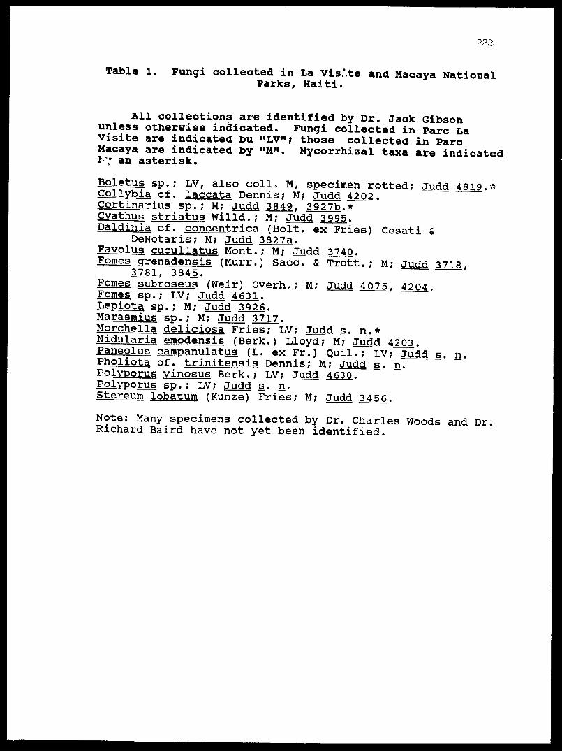
222
Table l. Fungi collected in La Vis.'.te and Macaya NationalParks, Haiti.
All collections are identified by Dr. Jack Gibson unless otherwise indicated. Fungi collected in Pare La Visite are indicated bu "LV"; those collected in Pare Macaya are indicated by "M". Mycorrhizal taxa are indicated I--7 an asterisk.
Boletus sp.; LV, also coll, M, specimen rotted; Judd 4819.*Collvbia cf. laccata Dennis; M; Judd 4202.Cortinarius sp.; M; Judd 3849. 3927b.*Cvathus striatus Willd.; M; Judd 3995.Daldinia cf. concentrica (Bolt, ex Fries) Cesati &
DeNotaris; M; Judd 3827a. Favolus cucullatus Mont.; M; Judd 3740. Fomes grenadensis (Murr.) Sacc. & Trott.; M; Judd 3718,
3781. 3845.Fomes subroseus (Weir) Overh.; M; Judd 4075, 4204. Fomes sp.; LV; Judd 4631. Lepiota sp.; M; Judd 3926. Marasmius sp.; M; Judd 3717. Morchella deliciosa Fries; LV; Judd s. n.* Nidularia emodensis (Berk.) Lloyd; M; Judd 4203. Paneolus campanulatus (L. ex Fr.) Quil.; LV; Judd s. n. Pholiota cf. trinitensis Dennis; M; Judd s_. n. Polyporus vinosus Berk.; LV; Judd 4630. Polvporus sp.; LV; Judd s. n. Stereum lobatum (Kunze) Fries; M; Judd 3456.
Note: Many specimens collected by Dr. Charles Woods and Dr. Richard Baird have not yet been identified.
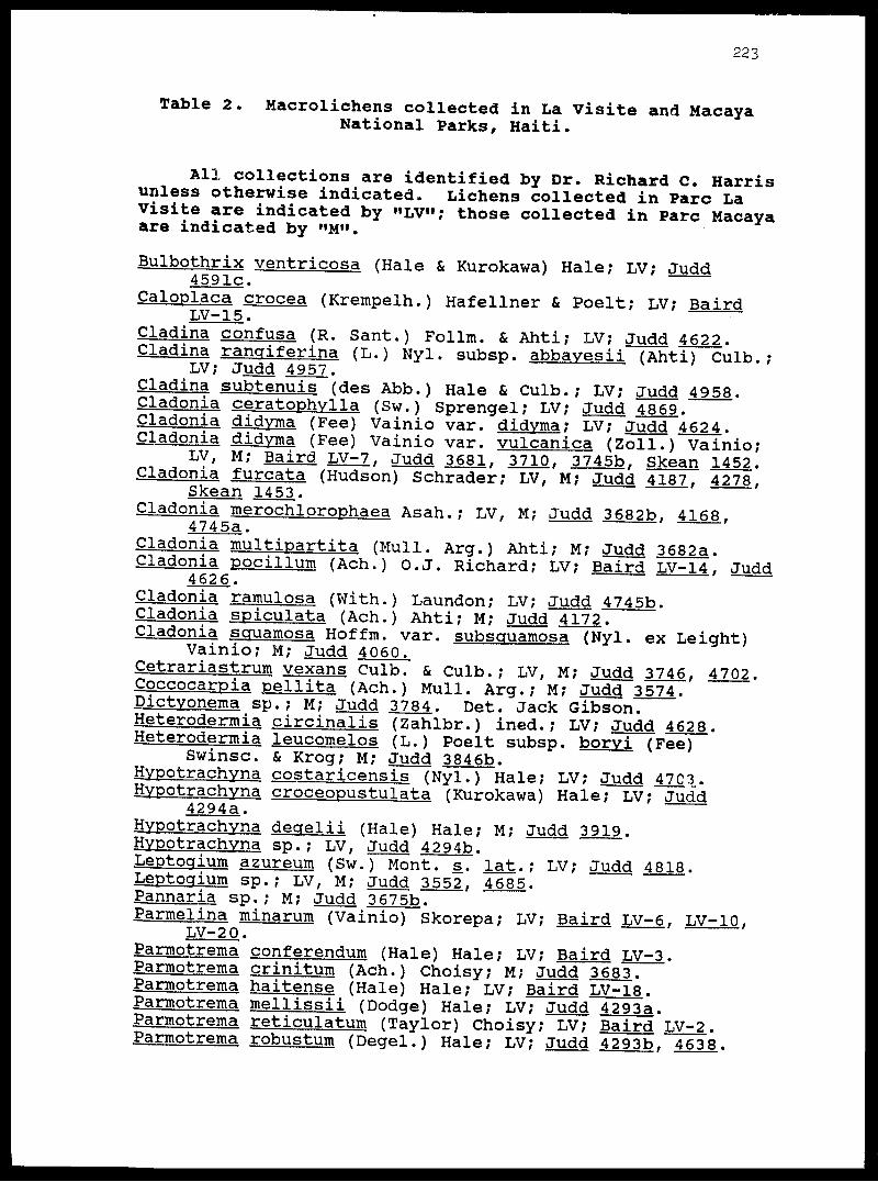
223
Table 2. Macrolichens collected in La Visite and MacayaNational Parks, Haiti.
All collections are identified by Dr. Richard C. Harris unless otherwise indicated. Lichens collected in Pare La Visite are indicated by "LV"; those collected in Pare Macaya are indicated by "M".
Bulbothrix ventricosa (Hale & Kurokawa) Hale; LV; Judd4591c.
Caloplaca crocea (Krempelh.) Hafellner & Poelt; LV; BairdLV-15.Cladina confusa (R. Sant.) Follm. & Ahti; LV; Judd 4622. Cladina ranqiferina (L.) Nyl. subsp. abbayesii (Ahti) Culb.;
LV; Judd 4957.Cladina subtenuis (des Abb.) Hale & Culb.; LV; Judd 4958. Cladonia ceratophylla (Sw.) Sprengel; LV; Judd 4869. Cladonia didyma (Fee) Vainio var. didyma; LV; Judd 4624. Cladonia didyma (Fee) Vainio var. vulcanica (Zoll.) Vainio;LV, M; Baird LV-7, Judd 3681. 3710. 3745b f Skean 1452. Cladonia furcata (Hudson) Schrader; LV, M; Judd 4187. 4278,Skean 1453. Cladonia merochlorophaea Asah.; LV, M; Judd 3682b, 4168,
4745a.Cladonia multipartita (Mull. Arg.) Ahti; M; Judd 3682a. Cladonia pocillum (Ach.) O.J. Richard; LV; Baird LV-14, Judd4626.Cladonia ramulosa (With.) Laundon; LV; Judd 4745b. Cladonia spiculata (Ach.) Ahti; M; Judd 4172. Cladonia squamosa Hoffm. var. subsquamosa (Nyl. ex Leight)
Vainio; M; Judd 4060.Cetrariastrum vexans Culb. & Culb.; LV, M; Judd 3746, 4702. Coccocarpia pellita (Ach.) Mull. Arg.; M; Judd 3574. Pictyonema sp.; M; Judd 3784. Det. Jack Gibson. Heterodermia circinalis (Zahlbr.) ined.; LV; Judd 4628. Heterodermia leucomelos (L.) Poelt subsp. boryi (Fee)
Swinsc. & Krog; M; Judd 3846b.Hvpotrachyna costaricensis (Nyl.) Hale; LV; Judd 47C3. Hypotrachvna croceopustulata (Kurokawa) Hale; LV; Jud'd
4294a.Hvpotrachyna degelii (Hale) Hale; M; Judd 3919. Hvpotrachyna sp.; LV, Judd 4294b.Leptogium azureum (Sw.) Mont. s. lat.; LV; Judd 4818. Leptogium sp.; LV, M; Judd 3552, 4685. Pannaria sp.; M; Judd 3675b. Parmelina minarum (Vainio) Skorepa; LV; Baird LV-6, LV-10,
LV-20.Parmotrema conferendum (Hale) Hale; LV; Baird LV-3. Parmotrema crinitum (Ach.) Choisy; M; Judd 36.83. Parmotrema haitense (Hale) Hale; LV; Baird LV-18. Parmotrema mellissii (Dodge) Hale; LV; Judd 4293a. Parmotrema reticulatum (Taylor) Choisy; LV; Baird LV-2. Parmotrema robustum (Degel.) Hale; LV; Judd 4293b f 4638.

22k
Parmotrema tinctorum (Nyl.) Hale; LV; Baird LV-5, LV-8.Parmotrema sp.; LV; Judd 4279.Pertusaria teyna Mull. Arg.; LV; Baird LV-9.Peltigera sp.; A; Judd 3750 (det. W. S. Judd), 4212, s. n.,Skean 1381. Pseudocyphellaria aurata (Ach.) Vainio; LV M; Judd 4817b,Skean 1544.Pseudoparmelia texana (Tuck.) Hale; LV; Baird LV-17. Ramalina sp.; LV; Judd 4385b. Sticta damaecornis (Sw.) Ach.; LV, M; Judd 3570 f 3586 (det.W. S. Judd), 4686, Skean 1286. Sticta laciniata Ach.; M; Judd 3694b. Sticta tomentosa (Sw.) Ach.; M; Judd 3704b. Sticta sp.; LV; Judd 4627. 4817a. Teloschistes flavicans (Sw.) Norm.; LV, M; Judd 3552b,
3846a. 4386. Usnea rubicunda Stirton; LV, M; Baird LV-4. LV-11, Judd3748. 4576b. Usnea spp.; LV, M; Baird LV-13. LV-14. Judd 3747. 3847b.
4167. 4274. 4385a. 4574. 4576a. 4746.

225
Table 3. Hispaniolian Endemic seed plants occuring in Pare Macaya and Pare La Visite, Haiti
Abbreviations and symbols: Occurring in Pare Macaya M; occurring in Pare La Visite LV; plant endemic to either Massif de la Hotte or Massif de la Selle *.
Agave antillarum M, LVAndropogon urbanianus LVArdisia picardae LV*Asketanthera picardae M*Banara splendens MBegonia platyptera LV*Begonia pycnantha MBuddleja domingensis LVBunchosa ekmanii LV*Calycogonium calycopteris MCalyptranthes densiflora LV* Calyptranthes hotteana M*Calyptranthes nummularia M,LVCarex ekmanii LV
Amyris apiculata M* Ardisia fuertesii M, LV Arthrostylidium haitiense M, Baccharis myrsinites M, LV Begonia domingensis LV Begonia plumieri M Brunfelsia picardae M Bumelia subintegra LV* Calycogonium apiculatum M* Calvcoqonium torbecianum M
LV
Castilleja haitiensis M* Oestrum brevifolium LV Oestrum filipes M* Oestrum mononeurum LV Oestrum violaceum LV* Coccoloba pauciflora M Coccothrinax montana M Danthonia domingensis LV Dendropanax selleanus M Dendropemon pycnophyllus LV Dendrophthora carnosa M* Didvmopanax tremulum M, LV Epilobium coloratum LV Erigeron domingensis M Eugenia formonica M* Eugenia picardae LV* Eupatorium cabaionum LV* Eupatorium illitum LV
Oestrum bicolor M* Oestrum coelophlebium M, LV Oestrum inclusum M, LV Oestrum picardae M Cleyera ternstroemioides M* Coccoloba picardae LV* Cyperus picardae LV Daphnopsis crassifolia M, LV Dendropemon bistratus LV Dendrophthora brachystacha M Dendrophthora versicolor M* Ekmaniocharis crassinervis M* Erigeron dissectus LV Eugenia christii M* Eugenia lineata LV Eugenia cf. tiburona M* Eupatorium flavidulum M* Eupatorium microchaetum M
Eupatorium porphyrocladium M*Eupatorium sp. nov. A. LV*Eupatorium stigmaticum M Exostemma picardae M Fuchsia triphylla LV Gesneria aspera M Gesneria hypoclada LV*
Gnaphalium eggersii LV Guzmania ekmanii M Henriettella elliptica M Hypericum fuertesii LV Hyptis schusteri M Ilex sp. nov. A. LV* Jacaranda poitei M Laplacea alpestris LV Lunania mauritii M Lvonia microcarpa LV*
Eupatorium urbanii M* Fuchsia pringsheimii M, LV Galium brevipes LV Gesneria fruticosa M Gesneria viridiflora ssp.
acrochordonanthe M* Gnaphalium selleanum LV* Haenianthus oblongatus M* Hyeronima domingensis M Hypericum millefolium LV* Ilex fuertesiana LV Illicium ekmanii M Juniperus ekmanii LV* Lobelia sp. nov. A. M*Lyonia buchii LV Lyonia truncata var.truncataLV*
Lyonia rubiginosa var. costata M, LV Malpighia macracantha LV* Mavtenus hotteana M*
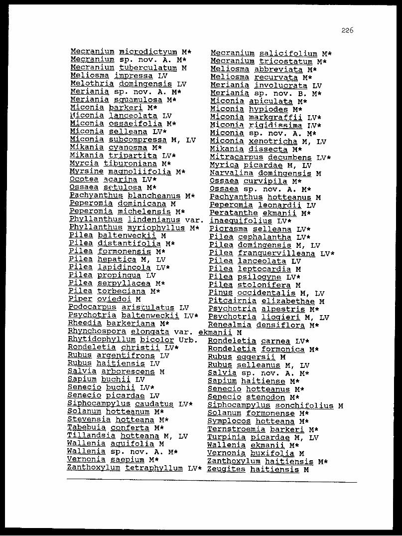
226
Mecranium microdictyum M* Mecranium sp. nov. A. M* Mecranium tuberculatum M Meliosma impressa LV Melothria domingensis LV Meriania sp. nov. A. M* Meriania squamulosa M* Miconia barker! M* Hiconia lanceolata LV Miconia ossaeifolia M* Miconia selleana LV* Miconia subcompressa M, LV Mikania cyanosma M* Mikania tripartita LV* Myrcia tiburoniana M* Myrsine magnoliifolia M* Ocotea acarina LV* Ossaea sctulosa M* Pachyanthus blancheanus M* Peperomia dominicana M Peperomia michelensis M* Phyllanthus lindenianus var Phyllanthus myriophyllus M* Pilea baltenweckii M Pilea distantifolia M* Pilea formonensis M* Pilea hepatica M, LV Pilea lapidincola LV* Pilea propincrua LV Pilea serpyllacea M* Pilea torbeciana M* Piper oviedoi M Podocarpus aris'culatus LV Psychotria baltenweckii LV* Rheedia barkeriana M* Rhynchospora elongata var. _ Rhytidophy11urn bicolor Urb. Rondeletia christii LV* Rubus argentifrons LV Rubus haitiensis LV Salvia arborescens M Sapium buchii LV Senecio buchii LV* Senecio picardae LV S iphocampylus caudatus LV* Solanum hotteanum M* Stevensia hotteana M* Tabebuia conferta M* Tillandsia hotteana M, LV Wallenia acruifolia M Wallenia sp. nov. A. M* Vernonia saepium M* Zanthoxvlum tetraphvllum LV*
Mecranium salicifolium M* Mecranium tricostatum M* Meliosma abbreviata M* Meliosma recurvata M* Meriania involucrata LV Meriania sp. nov. B. M* Miconia apiculata M* Miconia hypiodes M* Miconia markgraffii LV* Miconia rigid i ssima. LV* Miconia sp. nov. A. M* Miconia xenotricha M, LV Mikania dissecta M* Mitracarpus decumbens LV* Myrica picardae M, LV Narvalina domingensis M Ossaea curvipila M* Ossaea sp. nov. A. M* Pachyanthus hotteanus M Peperomia leonardii LV Peratanthe ekmanii M* inaecruifolius LV* Picrasma selleana LV* Pilea cephalantha LV* Pilea dominqensis M, LV Pilea franquervilleana LV* Pilea lanceolata LV Pilea leptocardia M Pilea psilogyne LV* Pilea stolonifera M Pinus occidentalis M, LV Pitcairnia elizabethae M Psychotria alpestris M* Psychotria liogieri M, LV Renealmia densiflora M*
ekmanii MRondeletia carnea LV* Rondeletia formonica M* Rubus eggersii M Rubus selleanus M, LV Salvia sp. nov. A. M* Sapium haitiense M* Senecio hotteanus M* Senecio stenodon M* Siphocampylus sonchifolius Solanum formonense M* Symplocos hotteana M* Ternstroemia barkeri M* Turpinia picardae M, LV Wallenia ekmanii M* Vernonia buxifolia M Zanthoxylum haitiensis M* Zeucrites haitiensis M
M
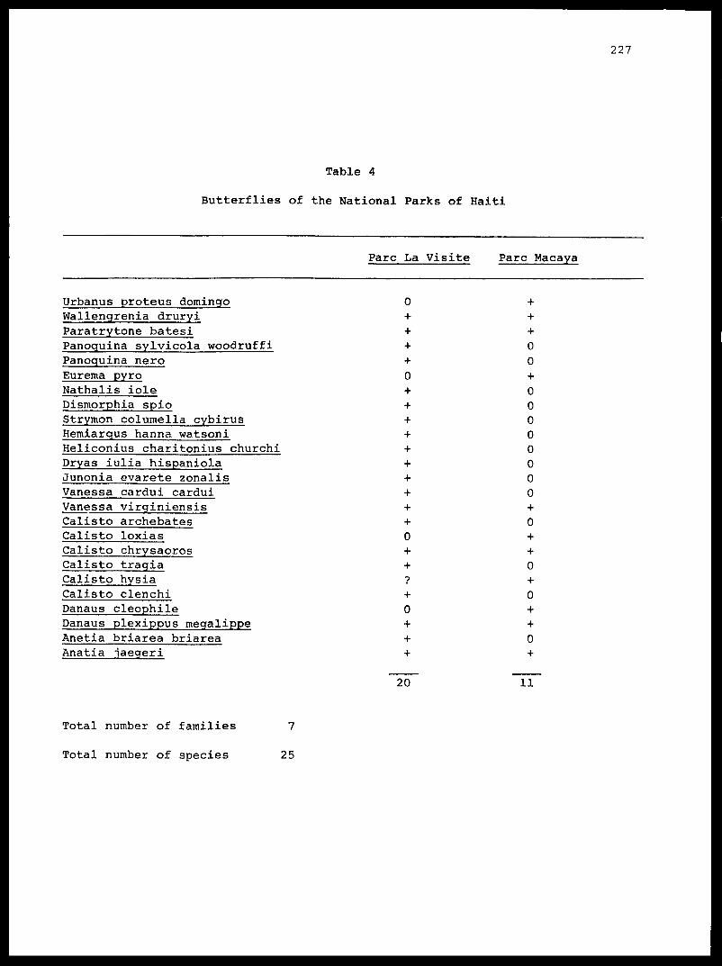
1227
Table 4
Butterflies of the National Parks of Haiti
Pare La Visite Pare Macaya
Urbanus proteus domingoWallengrenia druryiParatrytone batesiPanoquina sylvicola woodruffiPanoquina neroEurema pyroNathalis ioleDismorphia spioStrymon columella cybirusHemiarqus hanna watsoniHeliconius charitonius churchiDryas iulia hispaniolaJunonia evarete zonalisVanessa cardui carduiVanessa virginiensisCalisto archebatesCalisto loxiasCalisto chrysaorosCalisto tragiaCalisto hysiaCalisto clenchiDanaus cleophileDanaus plexippus megalippeAnetia briarea briareaAnatia jaegeri
0 0 + 0 0 0 0 0 0 0 0
0+ 0
20 11
Total number of families 7
Total number of species 25

228
Table 5
Land Mollusks of the National Parks of Haiti
Taxon
National Park
La Visite Macaya
CamaenidaePolydontes obliteratus (Ferussae) ]?. undulatus Ferussae) Coloniconcha n. sp, ?
Xanthonychidae Coryda sp. £. n. sp..£ cero saPlagioptycho n. sp. A P_. n. sp. B Cepolis cepa (Miller) Mcleania n. sp.
SagdidaeHojeda inaguensis (WeinlandH. micromphala (Pilsbry)Odontesanda n. sp. A£. n. sp. B£. n. sp. C£. n. sp. D£. n. sp. E£. n. sp. F£. n. sp. G£. n. sp. HSagdidae n. gen., n. sp.Suavitus taenioraphe (Pfeiffer)£. sp.Si. sp.Lacteoluna selenina
UrocoptidaeAutocoptis sp.A. juliae (Clench)Archegocoptis n. sp. AA. n. sp. BBrachypodella obesula (Pilsbry)15. n. sp. A13. n. sp. BJ5. n. sp. CJJ. sp.^. n. sp. DJ3. n. sp. EE. n. sp. F
0 0 + 0 + 0
0000
00
f
0 0 0 0 0 0 0 0
00
40
4-
0000
000
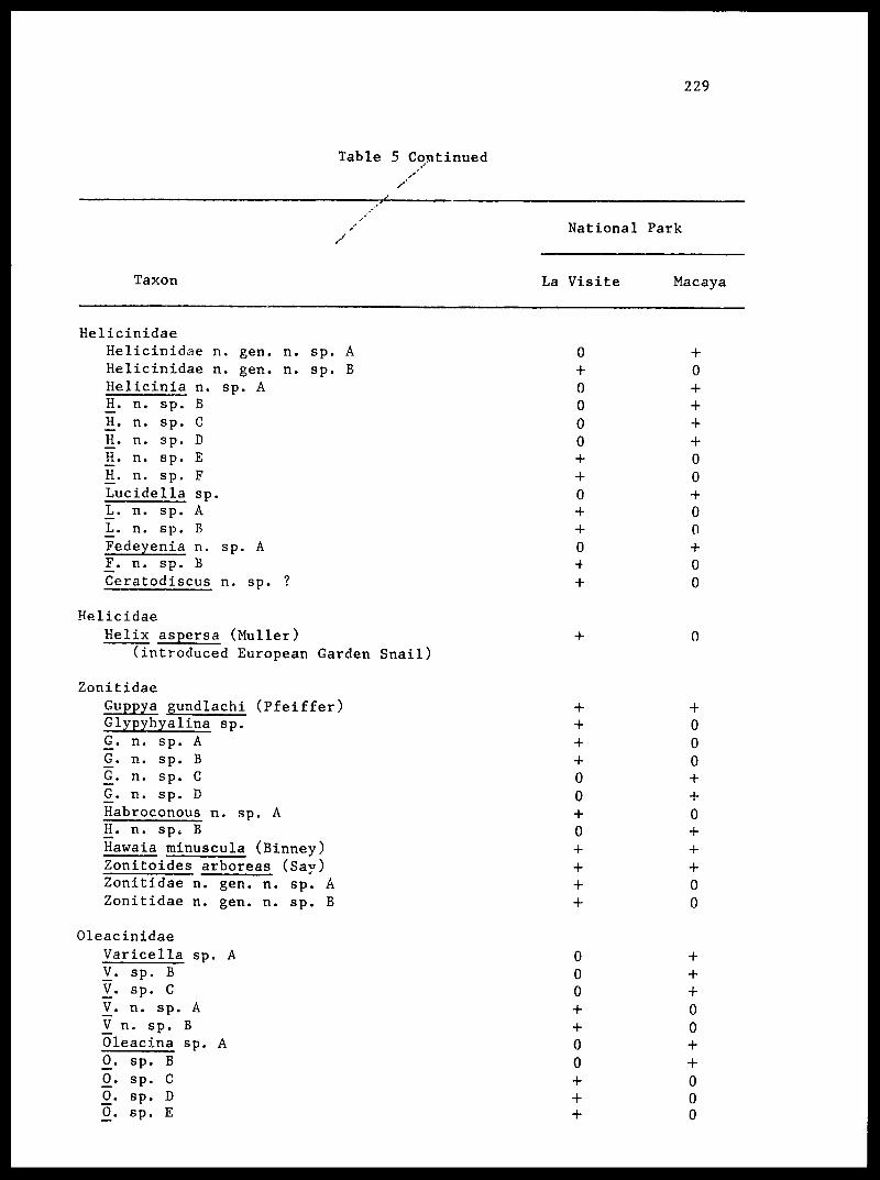
229
Table 5 Continued
Taxon
National Park
La Visite Macaya
HelicinidaeHelicinidae n. gen. n. sp. AHelicinidae n. gen. n. sp. BHelicinia n. sp. AH. n. sp. BII. n. sp. CH. n. sp. DH. n. sp. EH. n. sp. FLucidella sp.Ij. n. sp. AL. n. sp. BFedeyenia n. sp. A_F. n. sp. BCeratodiscus n. sp. ?
HelicidaeHelix aspersa (Muller)
(introduced European Garden Snail)
ZonitidaeGuppya gundlachi (Pfeiffer)Glypyhyalina sp.£. n. sp. A£. n. sp. B£. n. sp. C£. n. sp. DHabroconous n. sp. AH. n. sp. BHawaia minuscula (Binney)Zonitoides arboreas (Say)Zonitidae n. gen. n. sp. AZonitidae n. gen. n. sp. B
OleacinidaeVaricella sp. A V. sp. B V. sp. C V^. n. sp. A _V n. sp. B Oleacina sp. A £. sp. B £. sp. C £. sp. D £. sp. E
0000
04
00
000
00
00
00
00
000
4-
0
00
00
000

Table 5 Continued
230
Taxon
National Park
La Visite Macaya
Spiraxis n. sp. Sigmataxis sp. A £. sp. B S_. n. sp. AStreptostylops n. sp. A EL sp.
SubulinidaeLamellaxis gracilis (Hutton)Obeliscus n. sp.(). sp.£. dominicensis (Pilsbry)
Annular-idaeChondropoma manni (Clench and Aguayo) Orcuttipoma rollei (Weinland) Weinlandipoma sp. Colobostylus n. sp.
CyclophoridaeCrocidopoma sp.
ProserpinidaeProserpina n. sp.
PupillidaeGastrucopta pellucida (Pfeiffer)
SuccinidaeSuccinea sp.
ClausiliidaeNenisca n. sp.
HaplotrematidaeHaplotrematidae n. gen. n. sp.
BulimulidaeDrymaeus sallei (Pilsbry)
TotalsSpeciesSpecies unique to each parkNew Taxa
00
00
000
0
0
453827
575027
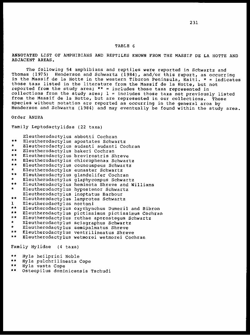
231
TABLE 6
ANNOTATED LIST OF AMPHIBIANS AND REPTILES KNOWN FROM THE MASSIF DE LA HOTTE AND ADJACENT AREAS.
The following 54 amphibians and reptiles were reported in Schwartz and Thomas (1975) Henderson and Schwartz (1984), and/or this report, as occurring in the Massif de la Hotte in the western Tiburon Peninsula, Haiti. * = indicates those taxa listed in the literature from the Massif de la Hotte, but not reported from the study area; ** = includes those taxa represented in collections from the study area; 1 = includes those taxa not previously listed from the Massif de la Hotte, but are represented in our collections. Those species without notation are reported as occurring in the general area by Henderson and Schwartz (1984) and may eventually be found within the study area.
Order ANURA
Family Leptodactylidae (22 taxa)
**
********
**
**
**
******
****
Eleutherodactylus Eleutherodactylus Eleutherodactylus Eleutherodactylus Eleutherodactylus Eleutherodactylus Eleutherodactylus Eleutherodactylus Eleutherodactylus Eleutherodactylus Eleutherodactylus Eleutherodactylus Eleutherodactylus Eleutherodactylus Eleutherodactylus Eleutherodactylus Eleutherodactylus Eleutherodactylus Eleutherodactylus Eleutherodactylus Eleutherodactylus Eleutherodactylus
abbotti Cochranapostates Schwartzaudanti audanti Cochranbakeri Cochranbrevirostris Shrevechlorophenax Schwartzcounouspeus Schwartzeunaster Schwartzglandulifer Cochranglaphycompus Schwartzheminota Shreve and Williamshypostenor Schwartzinoptatus Barbourlamprotes Schwartznortonioxyrhynchus Dumeril and Bibronpictissimus pictissimus Cochranruthae aporostegus Schwartzsciagraphus Schwartzsemipalmatus Shreveventrilineatus Shrevewetmorei wetmorei Cochran
Family Hylidae (4 taxa)
** Hyla heilprini Noble** Hyla pulchrilineata Cope** Hyla vasta Cope** Osteopilus dominicensis Tschudi

232
Order SQUAMATA
Suborder SAURIA
Family Gekkonidae (1 taxon)
* Sphaerodactylus elasmorhynchu , Thomas
Family Anguidae (3 taxa)
** Celestus costatus costatus Cope** Celestus stenurus stenurus Cope* Sauresia sepsoides Gray
Family Iguanidae (19 taxa)
armouri Cochran coelestinus coelestinus Cope cybotes Cope darlingtoni Cochran distichus aurifer Schwartz distichus suppar Schwartz distichus vinosus Schwartz dolichocephalus dolichocephalus Williams dolichocephalus sarmenticola Schwartz koopmani Randmonticola monticola Shrevemonticola quadrisartus Thomas and Schwartz ricordi leberi Williams ricordi viculus Schwartz rupinae Williams and Webster semilineatus Cope singularis Williams .inorops barbouri Schmidt jhalus melanochlorus melanochlorus Cope
Family Boidae (2 taxa)
** Epicrates gracilis hapalus Sheplan and Schwartz** Epicrates striatus exagistus Sheplan and Schwartz
Family Colubridae (3 taxa)
** Antillophis parvifrons parvifrons Cope** Darlingtonia haetiana haetiana Cochran** Uromacer catesbyi catesbyi Schlegel
1********************
*****
AnolisAnolisAnolisAnolisAnolisAnolisAnolisAnolisAnolisAnolisAnolisAnolisAnolisAnolisAnolisAnolisAnolisChamaer.<=i nrp
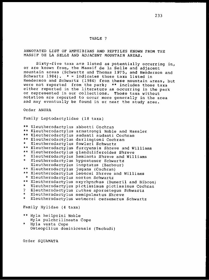
233
TABLE 7
ANNOTATED LIST OF AMPHIBIANS AND REPTILES KNOWN FROM THE MASSIF DE LA SELLE AND ADJACENT MOUNTAIN AREAS.
Sixty-five taxa are listed as potentially occurring in, or are known from, the Massif de la Selle and adjacent mountain areas (Schwartz and Thomas 1975, and Henderson and Schwartz 1984). * = indicates those taxa listed in Henderson and Schwartz (1984) from these mountain areas, but were not reported from the park; ** includes those taxa either reported in the literature as occurring in the park or represented in our collections. Those taxa without notation are reported to occur more generally in the area and may eventually be found in or near the study area.
Order ANURA
Family Leptodactylidae (18 taxa)
********
****
****
**
Eleutherodactylus Eleutherodactylus Eleutherodactylus Eleutherodactylus Eleutherodactylus Eleutherodactylus Eleutherodactylus Eleutherodactylus Eleutherodactylus Eleutherodactylus Eleutherodactylus Eleutherodactylus Eleutherodactylus Eleutherodactylus Eleutherodactylus Eleutherodactylus Eleutherodactylus Eleutherodactylus
abbotti Cochranarmstrongi Noble and Hassleraudanti audanti Cochrandarlingtoni Cochranfowleri Schwartzfurcyensis Shreve and Williamsglanduliferoides Shreveheminota Shreve and Williamshypostenor Schwartzinoptatus (Barbour)jugans (Cochran)leoncei Shreve and Williamsnorton Schwartzoxyrhynchus (Dumeril and Bibron)pictissimus pictissimus Cochranruthae aporostegus Schwartzsemipalmatus Shrevewetmorei ceraemerus Schwartz
Family Hylidae (4 taxa)
** Hyla heilprini NobleHyla pulchrilineata CopeHyla vasta CopeOsteopilius dominicensis (Tschudi)
Order SQUAMATA
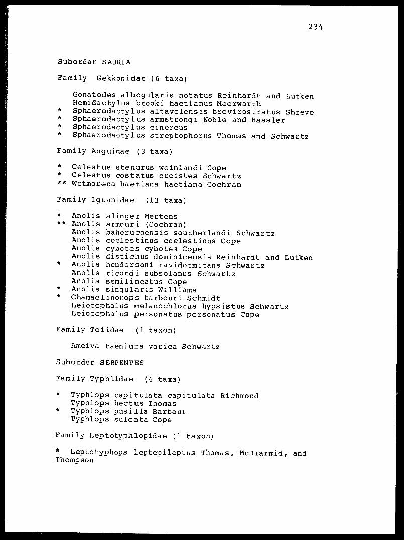
234
Suborder SAURIA
Family Gekkonidae (6 taxa)
Gonatodes albogularis notatus Reinhardt and Lutken Hemidactylus brooki haetianus Meerwarth
* Sphaerodactylus altavelensis brevirostratus Shreve* Sphaerodactylus armstrongi Noble and Hassler* Sphaerodactylus cinereus* Sphaerodactylus streptophorus Thomas and Schwartz
Family Anguidae (3 taxa)
* Celestus stenurus weinlandi Cope* Celestus costatus oreistes Schwartz** Wetmorena haetiana haetiana Cochran
Family Iguanidae (13 taxa)
alinger Mertensarmouri (Cochran)bahorucoensis southerlandi Schwartzcoelestinus coelestinus Copecybotes cybotes Copedistichus dominicensis Reinhardt and Lutkenhendersoni ravidormitans Schwartzricordi subsolanus Schwartzsemilineatus Copesingularis Williams
* Chamaelinorops barbouri SchmidtLeiocephalus melanochlorus hypsistus Schwartz Leiocephalus personatus personatus Cope
Family Teiidae (1 taxon)
Ameiva taeniura varica Schwartz
Suborder SERPENTES
Family Typhlidae (4 taxa)
* Typhlops capitulata capitulata Richmond Typhlops hectus Thomas
* Typhlops pusilla Harbour Typhlops sulcata Cope
Family Leptotyphlopidae (1 taxon)
* Leptotyphops leptepileptus Thomas, McDiarmid, and Thompson
***
*
*
AnolisAnolisAnolisAnolisAnolisAnolisAnolisAnolisAnolisAnolis
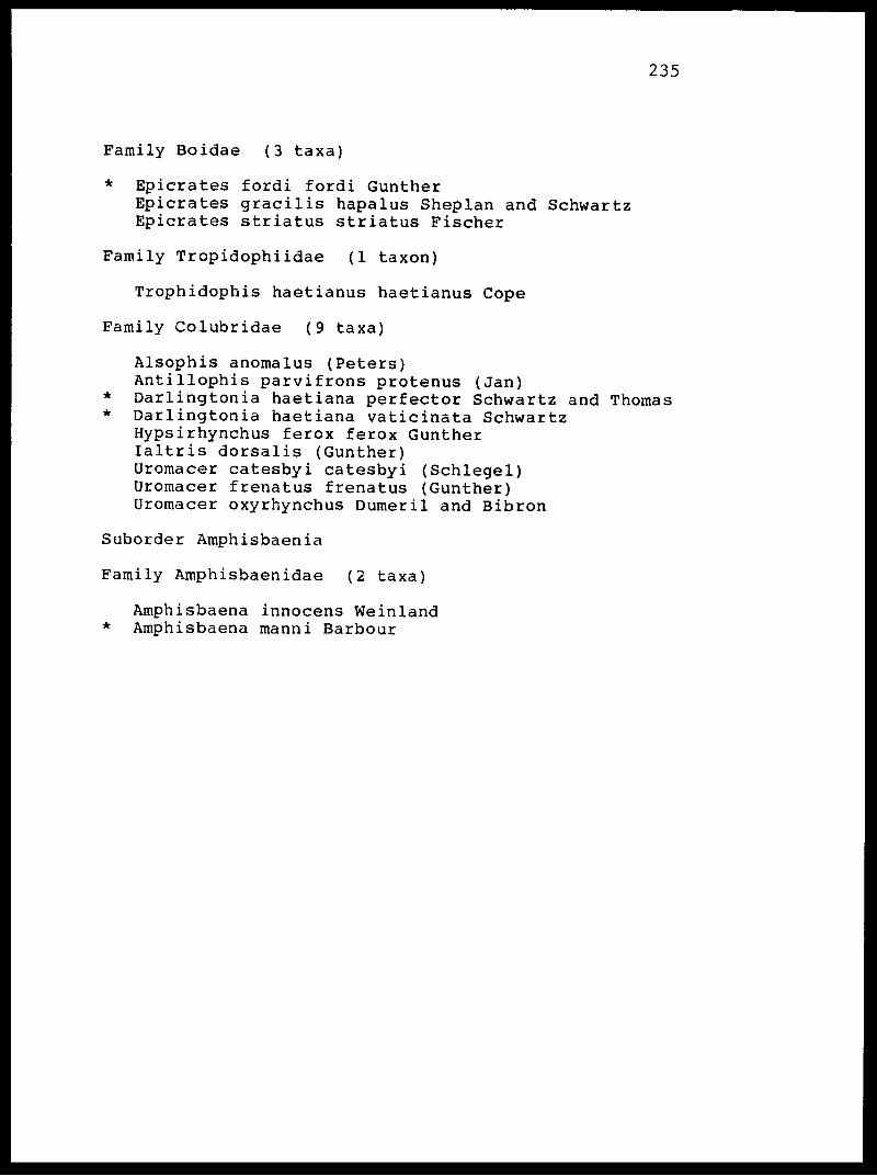
235
Family Boidae (3 taxa)
* Epicrates fordi fordi GuntherEpicrates gracilis hapalus Sheplan and Schwartz Epicrates striatus striatus Fischer
Family Tropidophiidae (1 taxon)
Trophidophis haetianus haetianus Cope
Family Colubridae (9 taxa)
Alsophis anomalus (Peters) Antillophis parvifrons protenus (Jan)
* Darlingtonia haetiana perfector Schwartz and Thomas* Darlingtonia haetiana vaticinata Schwartz
Hypsirhynchus ferox ferox Gunther laltris dorsalis (Gunther) Uromacer catesbyi catesbyi (Schlegel) Uromacer frenatus frenatus (Gunther) Uromacer oxyrhynchus Dumeril and Bibron
Suborder Amphisbaenia
Family Amphisbaenidae (2 taxa)
Amphisbaena innocens Weinland* Amphisbaena manni Barbour

236
TABLE 8. List of bird species of Pare National Pic Macaya indicating major habitat preferences for each species (% of observations within favored habitat in parentheses) and status within the park. All data are from December-February censuses.
SPECIES MOUNTAINS FORMON >1300 m PLAIN
Least Grebe
Black-capped Petrel +
Sharp-shinned Hawk +
Red-tailed Hawk +
American Kestrel
Peregrine Falcon +
Common Bobwhite
Common Guinea-fowl
Limpkin +
Killdeer
Spotted Sandpiper +
Red-necked Pigeon +
Mourning Dove
Hispaniolan Parrot
Hispaniolan Lizard Cuckoo
Smooth-billed Ani
Barn Owl +
Collard Swift +
Hispaniolan Emerald +
Antillean Mango +
Vervain Hummingbird +
UNTAINS
MC
RB(IOO)
RB(IOO)
RB(IOO)
RR
RB(84)
RB(IOO)
GR(IOO)
RB(50)
R(67)
BR(IOO)
PLAIN
ND(IOO)
RBW(IOO)
RBW(IOO)
J(100)
J(100)
J(100)
RBW(IOO)
J(100)
RBW(52)
RBW(IOO)
RBW(IOO)
RBW(54)
J(100)
RBW(IOO)
RBW(41)
BRW(IOO)
BRW(80)
STATUS
U/E
C/T
U/T
C
C
R/M
U/I
U/I
R/T
U
C/M
C
U
C/T
C
C
C
U
C
C
C
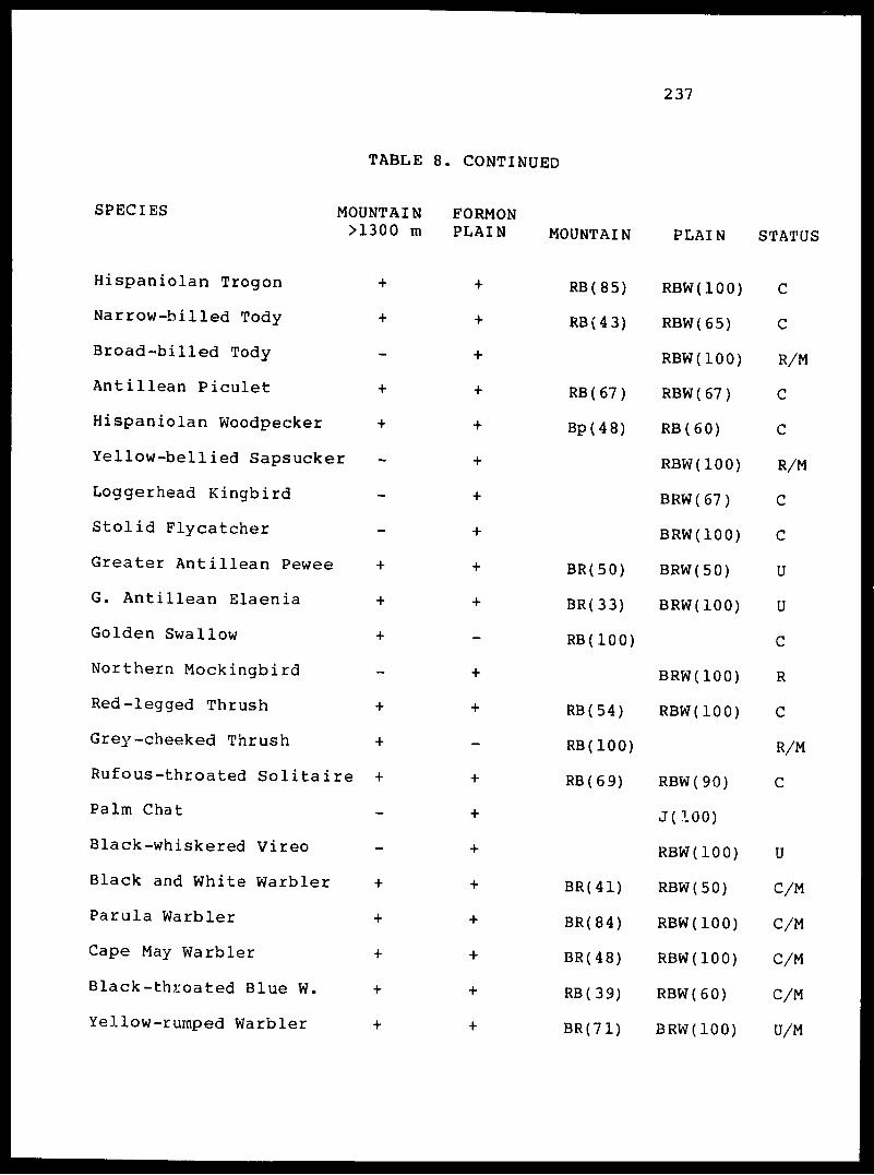
237
TABLE 8. CONTINUED
SPECIES
Hispaniolan Trogon
Narrow-billed Tody
Broad-billed Tody
Antillean Piculet
Hispaniolan Woodpecker
Yellow-bellied Sapsucker
Loggerhead Kingbird
Stolid Flycatcher
Greater Antillean Pewee
G. Antillean Elaenia
Golden Swallow
Northern Mockingbird
Red-legged Thrush
Grey-cheeked Thrush
Rufous-throated Solitaire +
Palm Chat
Black-whiskered Vireo
Black and White Warbler
Parula Warbler
Cape May Warbler
Black-throated Blue W.
Yellow-rumped Warbler
MOUNTAIN FORMON >1300 m PLAIN
+
+ +
+
+ +
+ +
>r +
+
+
k *4* "4~
+ ++
++ ++
.re + +
+
+
+
+ ++
+ +
MOUNTAIN
RB(85)
RB(43)
RB ( 67 )
Bp(48)
BR(50)
BR(33)
RB(IOO)
RB(54)
RB(IOO)
RB(69)
BR(41)
BR(84)
BR(48)
RB(39)
BR(71)
PLAIN i
RBW(IOO)
RBW(65)
RBW(IOO)
RBW ( 67 )
RB(60)
RBW(IOO)
BRW(67)
BRW(IOO)
BRW(50)
BRW(IOO)
BRW(IOO)
RBW (100)
RBW(90)
J(100)
RBW(IOO)
RBW(50)
RBW(IOO)
RBW(IOO)
RBW(60)
BRW(IOO)
3TATUJ
C
C
R/M
C
C
R/M
C
C
U
U
C
R
C
R/M
C
U
C/M
C/M
C/M
C/M
U/M

238
TABLE 8. CONTINUED
SPECIES
Black-throated Green W.
Yellow-throated Warbler
Prairie Warbler
Pine Warbler
Palm Warbler
Ovenbird
Louisiana Waterthrush
Common Yellowthroat
White-winged Warbler
American Redstart
Bananaquit
Blue-hooded Euphonia
Stripe-headed Tanager
Grey-crowled Palm T.
Chat Tanager
Greater Antillean Crackle
Antillean Siskin
White-winged Crossbill
G. Antillean Bullfinch
Black-faced Grassquit
Yellow-faced Grassquit
Lincoln's Sparrow
MOUNTAIN FORMON >1300 M PLAIN MOUNTAIN
+ - BR(IOO)
+ - R(50)
+ + Bp(lOO)
+ + Bp(80)
+ - BR(IOO)
+ - BR(45)
-
+ + RB(66)
+ - BR(80)
+ + BR(47)
+ + RB(68)
+ + RB(IOO)
+ + BR(54)
+ + RB ( 4 3 )
+ + RB(75)
:le - +
+ - BpR(lOO)
+ - Bp(93)
+ + BR(57)
+ + R(51)
+ + R(100)
+ - BR(IOO)
PLAIN ,<
RBW(IOO)
BRW(IOO)
BRW(IOO)
J(77)
RBW(58)
BRW(85)
RBW(IOO)
RBW(94)
BRW(75)
RBW (75)
RBW(IOO)
BRW (70)
J(100)
J(100)
3TATU,1
U/M
U/M
U/M
C
R/M
U/M
U/M
C/M
R/E
C/M
C
U
C
C
C/T
U
R
C
C
C
C
R/M

239
Number of species in ea ;h region
Total number of species for Park (January)
Total number of species for Park (May)
TABLE 8. CONTINUED
47 51
65
46
Habitat: (Bp) wr>/->h« /r:i^ df.Habitat: (Bp) Bwapen; (BpR) Bwapen Raje; (BR) Bwa Raje; (BRW) Bwa Raje Woch; (GR) Gran Ravine; (J) Jadin; (MC) Mountain Cliff; (ND) Nan Dlo; (RB) Rak Bwa; (RBW) Rak Bwa Woch; (RR) Riviere Ravine du Sud. Status: (C) Common; (E) Endangered; (I) Introduced; (M) Migrant; Rare; (T) Threatened; (U) Uncommon.
(R)
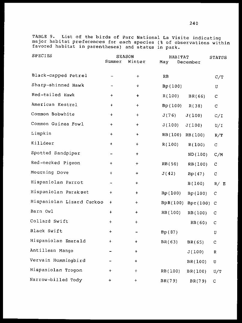
240
TABLE 9. List of the birds of Pare National La Visite indicating major habitat preferences for each species (% of observations within favored habitat in parentheses) and status in park.
SPECIES
Black-capped Petrel
Sharp-shinned Hawk
Red-tailed Hawk
American Kestrel
Common Bobwhite
Common Guinea Fowl
Limpkin
Killdeer
Spotted Sandpiper
Red-necked Pigeon
Mourning Dove
Hispaniolan Parrot
Hispaniolan Parakeet
Hispaniolan Lizard Cuckoo
Barn Owl
Collard Swift
Black Swift
Hispaniolan Emerald
Antillean Mango
Vervain Hummingbird
Hispaniolan Trogon
Narrow-billed Tody
SEASON Summer Winter
HABITAT May December
STATUS
RB
Bp(lOO)
R(100)
Bp(lOO)
J(76)
J(100)
RB(IOO)
R(100)
RB(50)
J(42)
Bp(lOO)
BpR(lOO)
RB(IOO)
Bp(87)
BR(63)
RB(IOO)
BR(79)
BR(66)
R(38)
J(100)
J(100)
RB(IOO)
R(100)
ND(IOO)
RB(IOO)
Bp(47)
B(100)
Bp(lOO)
Bpr(lOO)
RB(IOO)
RB ( 6 0 )
BR(65)
J(100)
BR(IOO)
BR(IOO)
BR(79)
C/T
U
C
C
C/I
U/I
R/T
C
C/M
C
C
R/ E
C
C
C
C
U
C
R
U
U/T
C
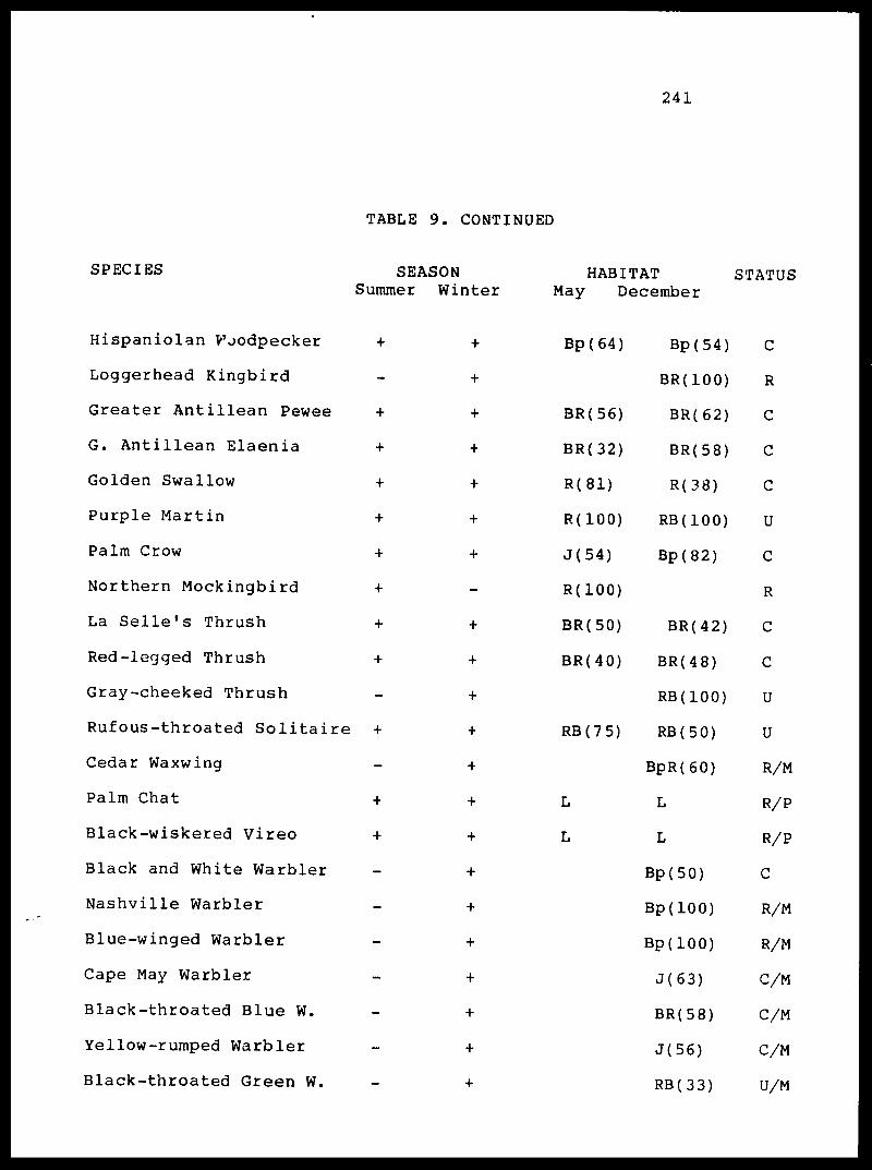
241
TABLE 9. CONTINUED
SPECIES
Hispaniolan V7oodpecker
Loggerhead Kingbird
Greater Antillean Pewee
G. Antillean Elaenia
Golden Swallow
Purple Martin
Palm Crow
Northern Mockingbird
La Selle's Thrush
Red-legged Thrush
Gray-cheeked Thrush
Rufous-throated Solitaire
Cedar Waxwing
Palm Chat
Black-wiskered Vireo
Black and White Warbler
Nashville Warbler
Blue-winged Warbler
Cape May Warbler
Black-throated Blue W.
Yellow-rumped Warbler
Black-throated Green W.
SEASON Summer Winter
HABITAT May December
STATUS
Bp(64)
BR(56)
BR(32)
R(81)
R(100)
J(54)
R(100)
BR(50)
BR(40)
RB(75)
L
L
Bp(54)
BR(IOO)
BR(62)
BR(58)
R(38)
RB(IOO)
Bp(82)
BR(42)
BR(48)
RB(IOO)
RB(50)
BpR(60)
L
L
Bp(50)
Bp(lOO)
Bp(lOO)
J(63)
BR(58)
J(56)
RB(33)
C
R
C
C
C
U
C
R
C
C
U
U
R/M
R/P
R/P
C
R/M
R/M
C/M
C/M
C/M
U/M
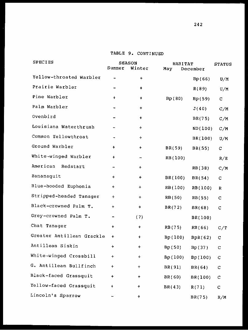
242
SPECIES
Yellow-throated Warbler
Prairie Warbler
Pine Warbler
Palm Warbler
Ovenbird
Louisiana Waterthrush
Common Yellowthroat
Ground Warbler
White-winged Warbler
American Redstart
Bananaquit
Blue-hooded Euphonia
Stripped-headed Tanager
Black-crowned Palm T.
Grey-crowned Palm T.
Chat Tanager
Greater Antillean Crackle
Antillean Siskin
White-winged Crossbill
G. Antillean Bullfinch
Black-faced Grassquit
Yellow-faced Grassquit
Lincoln's Sparrow
TABLE 9. CONTINUED
SEASON Summer Winter
HABITAT May December
STATUS
Bp(66) U/M
R(89) U/M
Bp(80) Bp(59) C
J(40) C/M
BR(75) C/M
ND(IOO) C/M
BR(IOO) U/M
BR(59) BR(55) C
RB(IOO) R/E
RB(38) C/M
BR(IOO) BR(54) C
RB(IOO) RB(IOO) R
RB(50) RB(55) C
BR(72) BR(68) C
BR(IOO)
RB(75) RB(66) C/T
Bp(lOO) BpR(62) C
Bp(50) Bp(37) C
Bp(lOO) Bp(lOO) C
BR(91) BR(64) C
BR(60) BR(IOO) C
BR(43) R(71) C
BR(75) R/M
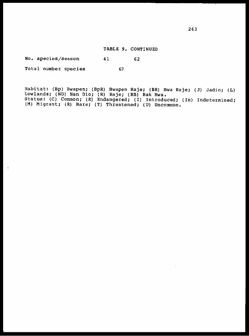
243
No. species/season
Total number species
TABLE 9. CONTINUED
41 62
67
Habitat: (Bp) Bwapen; (BpR) Bwapen Raje; (BR) Bwa Raje; (J) Jadin; (L) Lowlands; (ND) Nan Dlo; (R) Raje; (RB) Rak Bwa.Status: (C) Common; (E) Endangered; (I) Introduced; (In) Indetermined; (M) Migrant; (R) Rare; (T) Threatened; (U) Uncommon.

244
TABLE 10. Bird species that are endemic (E) or restricted (R) to Hispaniola. Species endemic only to Haiti (E*); once found in Puerto Rico (extirpated) but now confined to Hispaniola (R-PR); restricted to Hispaniola in the Antilles but also occurring in North America (R-NA) or South America (R-SA).
SPECIES STATUS
LAND BIRDS
CuculidaeSaurothera longirostris Hyetornis rufigularis
Caprimulg idaeSiphonorhis brewsteri
TrochilidaeChlorostilbon swansonii
PsittacidaeAmazona ventralis Aratinga chloroptera
TrogonidaePriotelus roseigaster
TodidaeTodus subulatus Todus angustirostris
PicidaeMelanerpes striatus Nesoctites micromegas
CorvidaeCorvus leucognaphalus
Muscicapidae (Turdinae) Turdus swalesi
DulidaeDulus dominicus
VireonidaeVireo nanus
E E
E
E
E E
E
E E
E E
R-PR
E
E

245
TABLE 10.- CONTINUED
SPECIES STATUS
Emberizidae (Parulinae) Dendroica pinus Microligea palustris Xenoligea montana
Emberizidae (Thraupinae)Phaenicophilus palmarum Phaenicophilus paliocephalus Calyptophilus frugivorus
FringillidaeCarduelis dominicensis Loxia leucoptera Zonotrichia capensis
R-NAEE
EE*E
ER-NAR-SA
NON-LAND BIRDS
AccipitridaeButeo ridgwayi E
Nomenclature follows the American Ornithologists Union Check-list (1983) .

246
TABLE 11
Mammals of the National Parks of Haiti (Ex = extinct; Pr = present; NP = never present)
Endemic Land Mammals
La Visite Pic Macaya
Order RodentiaFamily Capromyidae
Plagiodontia aediurn Plagiodontia velozi Plagiodontia araeum Isolobodon portoricensis Isolobodon montanus Hexolobodon phenax New genus + species
Family Echimyidae Brotomys voratus
Order Primates Family Cebidae
Saimiri bern nsis
Order InsectivoraFamily Solenodontidae
Solenodon paradoxus Solenodon marcanoi
Family Nesophontidae Nesophontes zamicrus Nesophontes hypomicrus Nesophontes paramicrus
Order XenarthraFamily Megalonychidae
Synocnus comes Parocnus New Taxon New Taxon New Taxon
Total number of taxa
Number of surviving taxa
Number of endemics not found in other park
Pr Ex Ex Ex Ex Ex NP
Ex
Ex
Ex Ex
ExEx Ex
Ex ExEx Ex Ex
17
PrEx NP Ex Ex Ex Ex
Ex
Ex
Pr Pr(?)
Ex Ex Ex
Ex Ex Ex Ex Ex
18

247
TABLE 12
Mammals of the National Parks
Bats
La Visits
Order Chiroptera Family Mormoopidae
Pteronotus quadridens fulg inosus *JP. parnelli pusillus
Family PhyllostomidaeMonophyllus redmani clinedaphus Artibeus jamaicensis jamaicensis
** Phyllops haitiensis** Phyllorcycteris poeyi obtusa * Erophylla sezekorni bombifrons Brachyphylla nana
Family VespertilionidaeEptesicus fuscus hispaniolae Lasiurus borealis minor
Family MolossidaeTadarida brasiliensis constanzae
00
0(ex) 0(ex) 0(ex)
+ 0(ex)
Macaya Plain Mt
00
0+ 0
00+ 0 0
+ 0
Total number of surviving species
Total number of species
** = Endemic in Hispaniola * = Endemic in Hispaniola
4
8
5 6
9

248
TABLE 13
Mammals of the National Parks of Haiti
Introduced Land Mammals
Species
Order Rodentia Family Muridae
Rattus rattus rattus (Black Rat)Brown morph
Rattus rattus rattusAll grey morph
Rattus rattus rattusGrey & white morph
Rattus norvegicus (Norway Rat) Mus musculus (House mouse)
Order Carnivora Family Viverridae
Herpestes auropunctatus (Mongoose)
La Visite Macaya
+
+
+
rare +
abundant(Pic Macaya)
Family CanidaeCenis familiaris (Dog)
Family F^l :.dae Felis catus (Cat)
Order Artiodactyla Family Bovidae
Capra hircus (Goat) Ovis aries (Sheep) Bos taurus (Cow)
Order Perissodactyla Family Equidae
Equus caballus (Horse) Equus asinus' (Donkey)
dom.& feral
feral
dom. & feral domestic domestic
dom.S feral
feral
dom. & feral domestic domestic
domestic (feral?) domestic domestic domestic

249
Figures
1. Types of Haitian Patrimony and the GOH Authority Responsible.
2. Organizational scheme for Pares Haiti.
3» Drawing of proposed building for Parks Headquarters for each National Park.
4. Diagramatic drawing of the units of a "Biosphere Reserve" and the zones and areas of a "National Park".
5. Suggested annual budget for National Parks of Haiti.
6. Training programs for National Parks of Haiti.

F IGURE 1
HAITIAN PATRIMONY
Type of Heritage: Cultural Geological Ag r i cu1tu ra1 Natural
E x a m p 1 e s : Indian Artifacts Colonial Artifacts Art
Marble Quaries Fisheries Mountain Caves Ekman's Forests View Wildlife Juniper Farms Seashores Mangroves La Selle
Thrush
Approach to Conserva t i on:
Museum Monuments
Regulation Soi 1Conservat ion Refo res ta t ion
Not Forest Developed Reserve
Nat i ona Park
Zoo logicalGardenBotanicalGardenNationalPark
G.O. H. Authority:
INAHCA DMRE MARNDR PARKS HAITI
Types of Haitian Patrimony and the G.O.H. Authority Responsible " indicates no designated authority * * indicates overlapping authority

F IGURE 2
NATIONAL PARKS AUHTORITY
Pares Natfonaux Naturels d'Haiti
(Pares Ha i t i)
Park Supervisor (La Visite)
Staff
Director Pares Haiti
Assistant Director for Administration
Assistant Director for Education and Recreation
Assistant Director for Conservation and Research
Staff
Park Supervisor (Macaya)
S t a i; f
International Volunteers
Educational and Scientific Specialists
Research Investigators
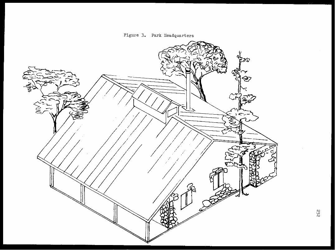
OJ LT\ OJ

Figure k. Units of Biosphere Researve and National Park
NATIONAL PARK
Limited Visit Zone
Designated Use Zone
*Biological Preserve
*Recreation
*Education
"Maintenance
^Restoration
*Research
BUFFER ZONEroVJluo
BIOSPHERE RESERVE

Item
Set up officeSet up Pare La VisiteSet up Pare MacayaSignsExhibitsPublicationsTraining PersonnelResearchOverheadOperating OfficeOperating parksOperating vehiclesSalaries OfficeSalaries Parks
Totals 519,350
Figure 5
National Parks of Haiti
Year
1(1986)
72,40026,75026,7502,000-
25,000 12,000 43,000 6,450
41,000 56,900 14,400
100,200 92,400
2 (1987)
____-
8,0005,000
17,000 63,000 9,450
41,000 56,900 14,400
105,210 97,020
3 (1988)
1,000
5,000 12,000 43,000 6,450
41,000 56,900 14,400
110,470 101,640
4 (1989)
12,000 28,000 4,200
41,000 56,900 14,400
115,993 106,491
5 (1990)
* "
"
~
20,000 12,000 28,000 4,200
41,000 56,900 14,400
121,793 111,573
Total
72,40026,75026,7503,0008,000
55,000 65,000
205,000 30,750
205,500 284,500 72,000
553,666 509,124
417,080 391,960 379,084 409,966 2,117,440
roUl

Figure 6
TRAINING PROGRAMS
Individuals Topic When Location Duration Instructors
1.
2.
3.
4.
5.
6.
7.
Director Pares Haiti Orientation Assistant Director Design Program Park Supervisors
Office Staff
Park Staff
Director, Asst. Directors, Park Supervisors
Director, Asst. Directors, Park Supervisors
Park Guards
Director
Orientation
Orientation
Training programs on Parks
Interpretation of park features, flora and fauna plus field tech niques
Park features
National Parks Seminar
Spring 1986 PAP One week
Spring 1986 PAP One day
Spring 1986 Parks Two days
Spring-Fall PAP Two weeks 1986-1990
Summer Winter PAP + Two weeks 1986-1990 Parks
Summer-Winter Parks Two days 1986-1990
Summer 1986 USA/ Two weeks CANADA
Raoul Pierre-Louis, Gaston Hermantin, Paul Paryski, Bob Wilson, Charles Woods
Director
Park Supervisor
International Parks Representative
UF/FSM Staff and Researchers
UF/FSM Staff and
Univ. of Michigan Canada, USNPS
Researchers
Parks
to171 Ul
256
Maps
1. Map of Haiti showing position of National Parks.
2. Map of Pare National La Visite showing boundaries.
3. Map of Pare national La Visite showing areas.
4. Map of Pare National Pic Macaya showing boundaries,
5. Map of Pare National Pic Macaya showing areas.
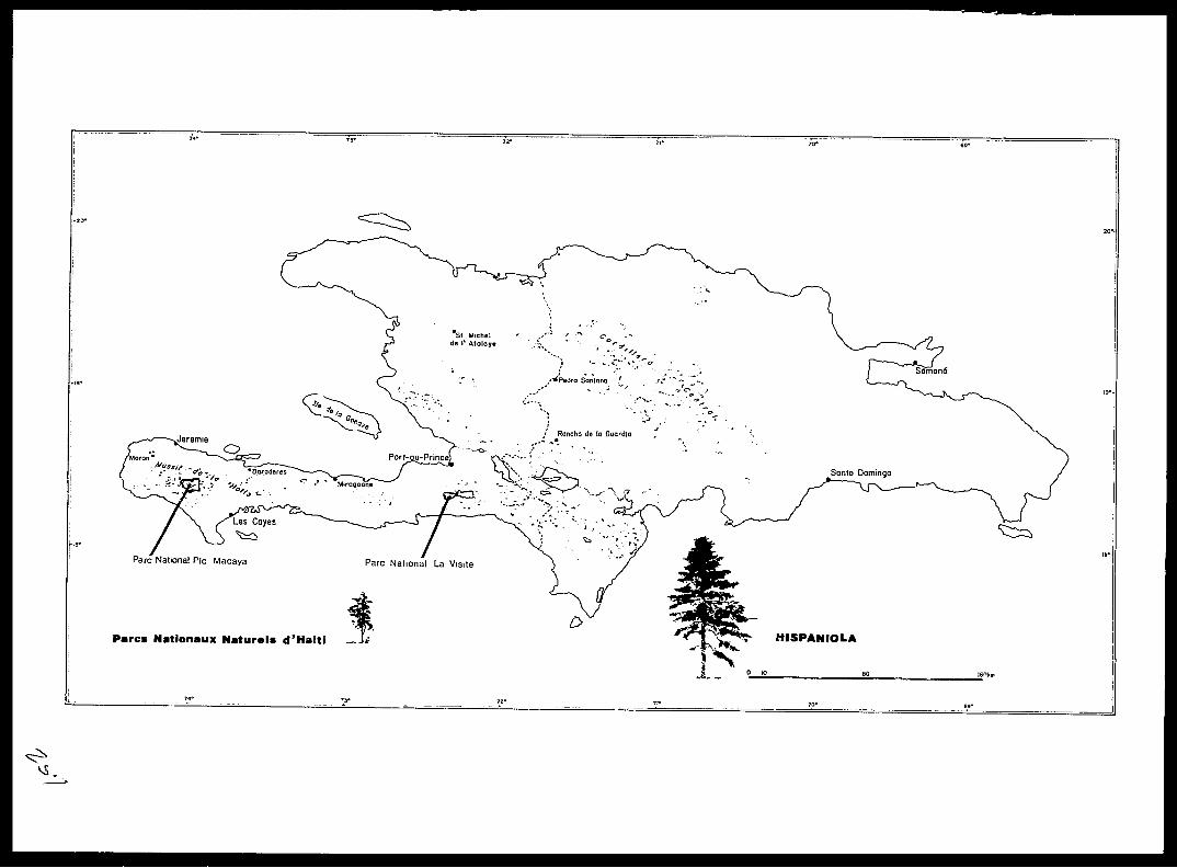
Pares Nationaux Naturels d'Haiti
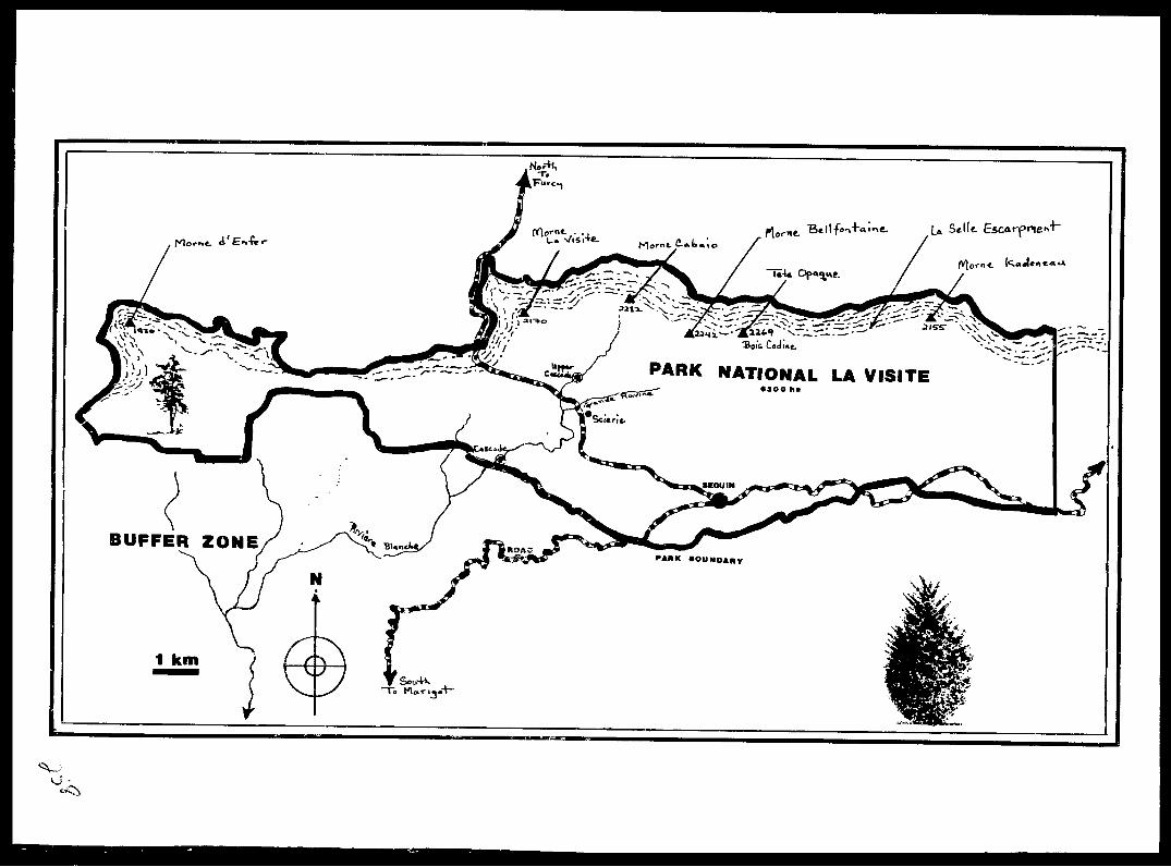
' ~ ^" ~ " '
PARK NATIONAL LA VlSITE
BUFFER ZONE

Pare National La VisiteSpecial Areas Map
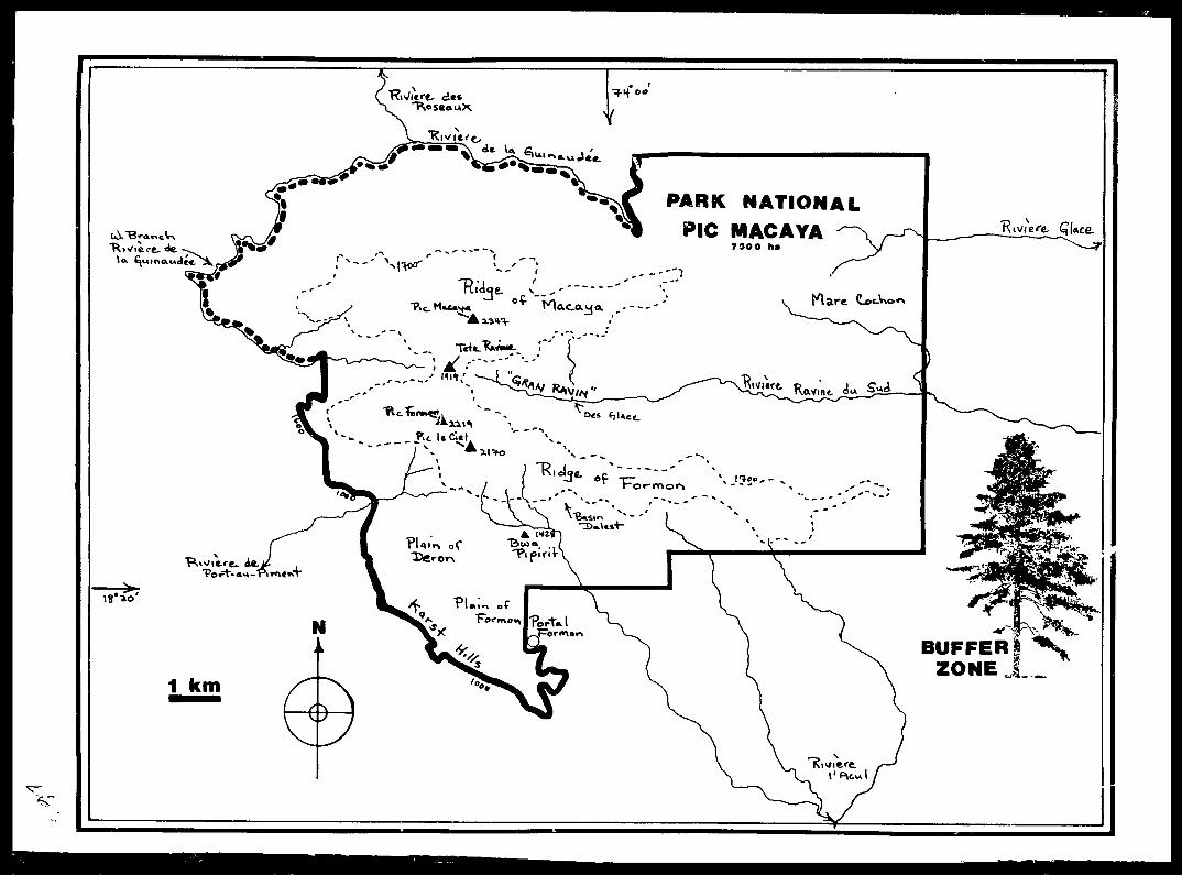
!/

&®i&?fe(£&2&
PIC LE CIEL CAMPGROUND
Pare National Pic MacayaSpecial Areas Map
BIOLOGICAL PRESERVE
AREA
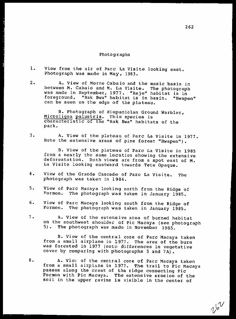
262
Photographs
1. View from the air of Pare La Visits looking east. Photograph was made in May, 1983.
2. A. View of Morne Cabaio and the mesic basin in between M. Cabaio and M. La Visite. The photograph was made in September, 1977. "Raje" habitat is in foreground. "Rak Bwa" habitat is in basin. "Bwapen" can be seen on the edge of the plateau.
B. Photograph of Hispaniolan Ground Warbler, Microligea palustris. This species is characteristic of the "Rak Bwa" habitats of the park.
3. A. View of the plateau of Pare La Visite in 1977. Note the extensive areas of pine forest "Bwapen").
B. View of the plateau of Pare La Visite in 1985 from a nearly the same location showing the extensive deforestation. Both views are from a spot east of M. La Visite looking eastward towards Tete Opaque.
4. View of the Grande Cascade of Pare La Visite. The photograph was taken in 1984.
5. View of Pare Macaya looking north from the Ridge of Formon. The photograph was taken in January 1985.
6. View of Pare Macaya looking south from the Ridge of Formon. The photograph was taken in January 1985.
7. A. View of the extensive area of burned habitaton the southwest shoulder of Pic Macaya (see photograph 5). The photograph was made in November 1985.
B. View of the central core of Pare Macaya taken from a small airplane in 1977. The area of the burn was forested in 1977 (note differences in vegetative cover by comparing with photographs 5 and 7A).
8. A. Viev: of the central core of Pare Macaya takenfrom a small airplane in 1977. The trail to Pic Macaya passes along the crest of the ridge connecting Pic Formon with Pic Macaya. The extensive erosion of the soil in the upper ravine is visible in the center of

263
the photograph.
B. Photograph of the White-winged Warbler, Xenoligea montana. This species still occurs in "Rak Bwa" habitats in Pare Macaya, but is the rarest species of bird in Haiti.
9. A. View of the "ridge of Formon" from a hill in "Bwa Formon" along the trail approaching "Portal Formon". Pic Le Ciel in the center with clouds rising out of the Grande Ravine beyond. The photograph was taken in 1984.
B. View of the same area from Portal Formon showing the extensive deforestation in this region of the park.

La
Escarpment
Cabalo
La Visite
1983
Pare La Visite
\o'\J

A
Cabaio
La Visite
B

1977
1985
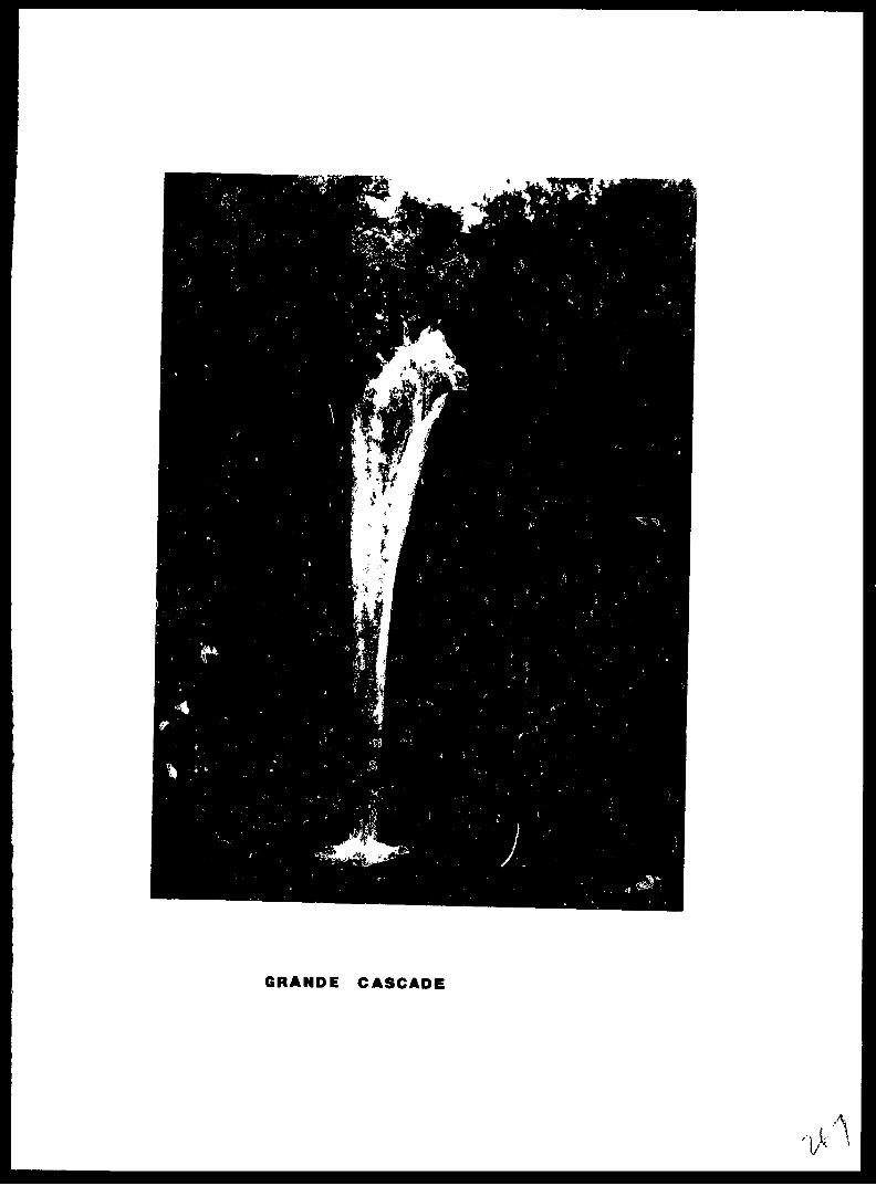
GRANDE CASCADE
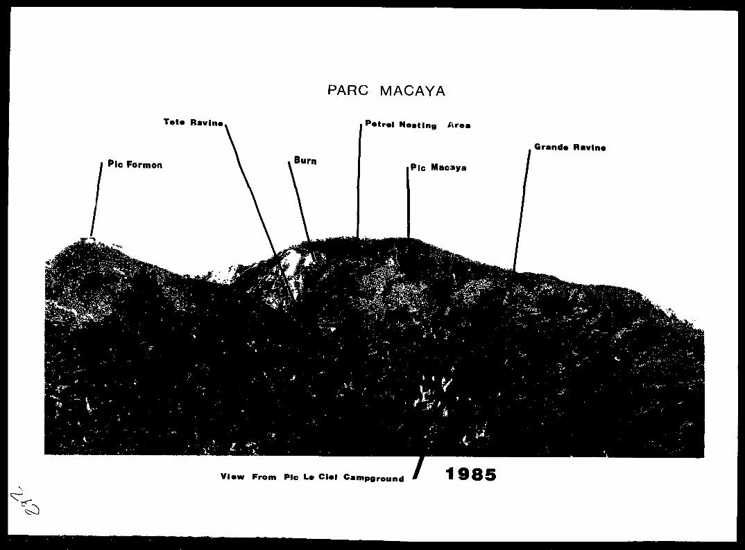
PARC MACAYA
Tete Ravine Petrel Nesting Area
Grande Ravin*
View From Pic L* Ciel Campground 1985

PARC MACAYA
Sous Bois ,
Bwa Formon Bwa Daron*
•'- >"jcf.'~ 'v- -.IT ' .. •>•-•.. '«<•*•'••>-. y,X ., >•-''••' ^-^^JCk.:.«:"-%^^
Plain Form on
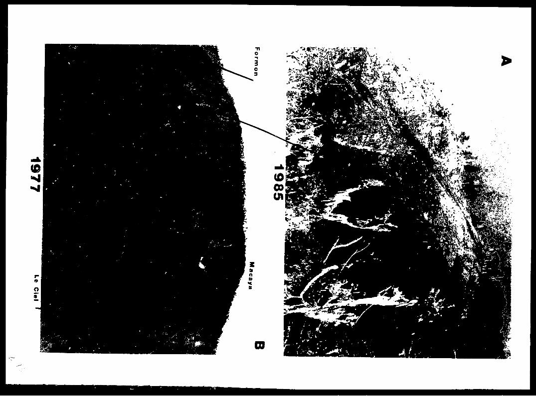
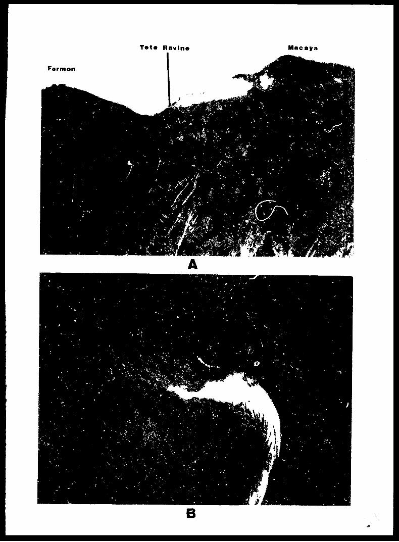
Tete Ravine Macaya
Formon
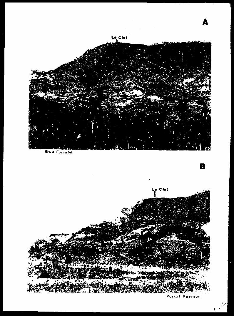
ALaCl»l
Bwa Formon
B
Le Ciej
Portal Formon