the nature of the banda arc–continent collision in the timor region
TRANSCRIPT

Chapter 7
The Nature of the Banda Arc–Continent Collisionin the Timor Region
R. Harris
7.1 Introduction
Arc continent collision is one of the most fundamen-
tal tectonic processes for the formation of new land,
and the preservation on land of fragments of oceanic
lithosphere (ophiolites). However, the tectonic evolu-
tion of arc continent collision is commonly over-sim-
plified in everything from introductory textbooks to
complex tectonic models. Major unresolved issues
include the response of the forearc during collision,
controlling factors of deep continental subduction,
possible slab delamination and the role of structural
inheritance. Many of these issues have been addressed
by detailed studies of arc continent collisions in a
variety of tectonic settings and stages of development.
These studies reveal many common features, such as
(1) arcuate orogens surrounding young, supra-subduction
zone ocean basins, (2) high pressure metamorphism, (3)
thrust sheets of forearc basement structurally overly-
ing melange in the hinterland of a continental fold and
thrust belt, (4) reversal of sedimentation into a flexural
trough, (5) contamination and modification of arc vol-
canism (6) arc accretion and suture zone development,
and (7) uplift and exhumation of the orogenic wedge.
These common features attest to similar syn-colli-
sional processes associated with plate kinematics that
controls the personality of arc continent collisions. I
refer to these features as the tectonic nurture of the
collision versus its tectonic nature, which is associated
with pre-collisional or inherited features. For example,
the arc continent collision of Taiwan displays only
some of the features listed above. Upper plate nappes
and high-pressure metamorphic terranes are notably
lacking in Taiwan. This contrast is mostly attributable
to the young nature of the Asian continental margin
versus the old and cold nature of most continental
margins colliding with arcs, such as the Tethyan con-
tinental margins and those involving the northern Aus-
tralian margin. Does the increased positive buoyancy
and reduced strength of warm continental margins
resist subduction more than cold continental margins?
Is a continental margin with high heat flow, as in
Taiwan, more likely to thrust over the forearc versus
under it to some extent as in most arc continent colli-
sions? Deciphering the relative contribution of these
inherited features versus plate kinematics in arc con-
tinent collisions is one of the most important aspects to
reconstructing how continental crust is formed and
shaped its nurture versus its nature.Active collisions are key to addressing these issues.
They provide both the tectonic nature and nurture of
the collision at a variety of temporal and spatial scales.
If the continental margin is oblique to the plate bound-
ary then it can be analyzed in the fourth dimension of
time where various phases of collision are manifest
along orogenic strike. Taiwan is the most intensely
studied example, but the Banda arc continent colli-
sion of the Timor region also provides a classic exam-
ple of an active, oblique arc continent collision that
differs in some very important aspects from Taiwan.
The plate kinematics or nurture of each is very similar,
but they are very different in nature.
The Timor region in many respects is more typical
of arc continent collisions in general (Searle and
Stevens 1984), yet it is not nearly as well constrained
by geological research as Taiwan and because of this
is used as a “one collision fits all” analog for almost
any tectonic scenario. Only recently has improved
R. Harris
Brigham Young University, Provo, UT, USA
e mail: [email protected]
D. Brown and P.D. Ryan (eds.), Arc Continent Collision, Frontiers in Earth Sciences,
DOI 10.1007/978 3 540 88558 0 7, # Springer Verlag Berlin Heidelberg 2011
163

political stability in the Timor region permitted sus-
tained geological research for the first time in over
30 years. The purpose of this paper is to present some
of the new discoveries resulting from these studies
and how they help us better understand the role of
structural heritage versus plate kinematics in shap-
ing active arc continent collisions and interpreting
ancient ones.
7.2 The Banda Orogen
The Banda arc continent collision or Banda Orogen
forms a tectonic buffer zone at the triple junction
between the huge Indo-Australian, Pacific and Asian
plates. It consists of a complex array of island arcs,
marginal basins, continental fragments and ophiolites
amalgamated by repeated plate boundary reorganiza-
tions over the past 200 million years (Hamilton 1979;
Pubellier et al. 2004; Harris 2003). Many of the
oceanic terranes in the mix were emplaced onto the
edges of partially subducted continental margins that
began arriving at the triple junction during the mid-
Tertiary. The last remains of a series of ocean basins
that once separated the Sunda Shelf of Asia from the
Sahul Shelf of Australia are closing and setting the
stage for a collision between these two continents
(Fig. 7.1).
The young deformation in the Banda Orogen is
used as a modern analog for the Jurassic amalgamation
of Alaska at the mega-triple junction between North
America, Kula and Asian Plates (i.e., Silver and Smith
1983; Harris et al. 1987; Audley-Charles and Harris
1990). It has also been used in several papers to sup-
port various models for the Jurassic and Cretaceous
amalgamation in the Mediterranean mega-triple junc-
tion between Africa, Europe and the Tethys (i.e.,
Searle and Stevens 1984). The 180� bend of the
Banda Orogen around the young Banda Sea ocean
basin is also similar to several Mediterranean orogenic
loops and others such as the Yukon-Koyukuk
(Alaska). However, in these orogens ophiolites are
nearly all that remains of what once was likely a
complex plate boundary system.
The initial closure stage presented by the Banda
Orogen offers a unique perspective into how the nature
of the colliding plates influences the transformation of
arcs and passive margins into continents. This transfor-
mation includes the poorly understood transitions from
subduction to collision, from an accretionary wedge to a
fold and thrust belt, from arc volcanism to arc accretion
and forearc destruction.
7.2.1 NNE-Directed Subduction Beneaththe SE Asian Continent–OceanTransition
The Banda Arc traces back to the “Great Indonesian
Arc” of Early Cretaceous to Oligocene time, which
stretched at least from India to the Sunda Shelf
(Lytwyn et al. 2001) and most likely eastward beyond
the Shelf into oceanic lithosphere all of the way to the
Philippines and Halmahera (Hall 2002). This arc col-
lapsed during a Tertiary regional extensional event
that opened up several new marginal basins through-
out SE Asia (Hall 2002).
The most recent expression of northward subduc-
tion of Indo-Australian oceanic lithosphere along the
SE Asian Plate is the Late Neogene Sunda arc. The
Sunda Arc replaced the Great Indonesian Arc and in
many places is mounted on top of its forearc subduc-
tion complex. As one of the premier active volcanic
arcs, the Sunda Arc stretches for nearly 6,000 km
from Myanmar, where it is terminated by continental
collision with India, to the Banda Arc where it is
transitional with the Banda arc continent collision.
The active accretionary wedge of the Sunda arc con-
sists mostly of Late Paleogene to Recent cover sedi-
ments and seamounts accreted from the subducting
Indian Ocean sea floor (Hamilton 1979). Where these
are thick the accretionary wedge rises above sea level
to form a series of arc-parallel islands, such as those
off of the coast of Sumatra in the NW and in the
Lesser Sunda Islands of the Timor region in the SE.
The uplift of the Lesser Sunda Islands is an
expression of how the nature of both the lower plate
of the Sunda subduction system changes from oce-
anic to continental. The upper plate also changes
from the continental Sunda Shelf to a series of com-
posite oceanic basins due to backarc extension. Where
the Australian continent enters the Sunda Trench
the subduction system is transformed into a collision
between the Banda intra-oceanic arc upper plate and
164 R. Harris

long-lived passive continental margin lower plate.
The collision actually involves the entire NW part of
the Australian continent including the western part
of New Guinea. However, the focus of this paper is
on the western part of the Banda Orogen, which is the
Timor region.
Banggai
SumbawaFlores
Sunda Trench
Sumba
Savu
Flores Thrust Wetar Thrust
Timor
Bali
Rote
Gulf ofBoneSunda
Shelf
Sulawesi
Seram
NorthBanda Basin
South
Banda Basin
Banda Ridge
s
Wetar Ridge
Weber B
asin
Sula
Savu Sea
Banda Sea
Pacific Plate
PhilippineSea Plate
Indo-Australian Plate
SE Asian Plate
BandaIsland
Lombok Ridge
Java
Timor Trou
gh
ScottPlateau
a
115°
115°b
120˚
120°
125˚
125°
130˚
130°
135˚
135°
−15°
−10°
−5°
4000
4000
4000
4000
4000
4000
2000
2000
2000
2000
2000
2000
2000
2000 2000
2000
−15°
−10°
−5°
Australian Plate
SumbaSavu
30°
0°
90° 120° 150°
30°
AUSTRALIA
ASIA
PACIFICOCEAN
NDIANOCEAN
2000
Banda Sea
T imo r
BaliFlores
Flores Thrust
Sunda Trench
Lombok
S. Sulawesi
Asian Plate
Wetar Thrust
Sumbawa
Rote
Scott Plateau
Australian Shelf
Sunda Shelf
Wetar
Alor
Sunda Arc
DSDP 262
RomangKisar
Tanimbar
WeberBasin
Leti Sermata
Manuk
Iya
B a n d a A r
c
Tim or Trough
Fig. 7.1 (a) DEM of the Banda Arc region showing active
faults (yellow, dashed is poorly defined) and active volcanoes
(red triangles). Inset is plate tectonic map of the SE Asian
region with plate vectors. Continental crust is grey and oceanic
crust white. Red box is area of larger maps. (b) Topographiclocation map of places referred to in text.
7 The Nature of the Banda Arc Continent Collision in the Timor Region 165

7.2.2 Seismic Tomography
Tomographic images to depths of 1,400 km across
the Banda arc continent collision show that the en-
tire region is underlain by subducted lithosphere
(Widiyantoro and van der Hilst 1997; Hafkenscheid
et al. 2001). Up to 5,400 km of convergence is esti-
mated along the Sunda Arc system from a high P-wave
velocity anomaly that stretches beneath the Banda Arc
region from Java to the southern Philippines. The
subducting Indian Ocean plate begins to lose its seis-
mic and tomographic expression below 600 km depth
where it merges with a more diffuse zone of high-
velocity mantle that underlies the entire region at
depths of 600 1,400 km. Tomographic images of the
Pacific side of the Banda Arc also connect westward
subducting slabs to a high P-wave velocity zone at
depth that is interpreted as a slab graveyard.
These results indicate that an entire ocean has
been consumed along the Sunda arc-trench system,
and that the Australian continent on the other side of
this large ocean basin has finally arrived at the sub-
duction zone. What happens when an ocean basins
pulls a continent embedded in it into a subduction
zone remains a topic of great debate, especially in
the Timor region (Audley-Charles 1981; Price and
Audley-Charles 1987; McCaffrey et al. 1985; Charlton
1991; Harris and Wu 1991; Sandiford 2008; Fichtner
et al. 2010). The debate is about whether the subduct-
ing slab stays intact and allows deep continental
subduction or the oceanic part breaks off preventing
deep subduction and causing isostatic rebound of
the continent. Much of the debate is driven by the
assumption that deep subduction of continental litho-
sphere is not possible. However, since the discovery
of micro-diamonds and other ultra-high pressure
minerals in several collision zones (i.e., Sobolev
and Shatsky 1990; Ernst and Liou 2000), there is
now direct evidence for deep subduction of continen-
tal crust (>350 km).
In the Banda Arc not only are high-pressure assem-
blages found (Kaneko et al. 2007), but also the
youngest arc volcanics are contaminated by deep
subduction of cratonic material (van Bergen et al.
1993; Elburg et al. 2004). These features attest to
subduction of the passive continental margin to at
least 120 km depth. Evidence for deeper subduction
without slab break off is provided by tomographic
studies that show a 200 km thick zone of high seismic
velocities (thickness of Australian continental litho-
sphere) extending to at least 400 km (Fichtner et al.
2010; Spakman and Hall 2010). The arc above this
zone is contaminated by continental crust indicating
that the high velocity zone is part of the Australian
continent (Fichtner et al. 2010). These results differ
significantly from tomograms of the Taiwan arc
continent collision (Wu et al. 2007), which show no
evidence of deep subduction. These differences are
consistent with the low heat flow (40 mWm 2)
reported for NW Australia (Cull 1982) versus high
heat flow (95 mWm 2) reported for the southern
China continental margin subducting beneath Taiwan
(Lee and Cheng 1986).
7.3 Collisional Setting
One of the most significant advantages of studying
the Banda arc continent collision is that the pre-
collisional characteristics of the arc and continent
are both preserved. Both can be progressively tracked
into the collision zone along orogenic strike and
inspected at various stages of collisional development.
Throughout this process it becomes increasingly appar-
ent just how much the nature of the lower plate matters
in the tectonic evolution of an arc continent collision.
The better we understand the structural and stra-
tigraphic heritage of the lower plate, the better we can
constrain how much structural inheritance influences
mountain building processes.
7.3.1 Lower Plate: NW Australian PassiveMargin and Scott Plateau
The Australian continental margin has a complex
structural heritage that causes many lateral dis-
continuities that are exploited by arc continent colli-
sion. The passive margin formed after Permian to
Jurassic intra-cratonic rifting of Gondwana. Middle-
Late Jurassic breakup evolved into Early Cretaceous
(Berriasian) sea-floor spreading in the adjacent Wharton
Basin (Falvey 1972; Larson 1975). The Wharton Basin
is one of the oldest remaining ocean basins on the
166 R. Harris

planet, which is a significant inherited feature that
adds to the negative buoyancy and strength of the
lower plate entering the Banda arc continent colli-
sion zone.
7.3.1.1 Structural Evolution
The early stages of Gondwana rifting produced intra-
cratonic basins of similar style and tectonic setting to
those found in the North Sea (Spencer et al. 2005).
These NW-SE striking basins filled with Permian to
Jurassic siliciclastics, carbonates and some volcanic
rocks known as the Gondwana Sequence (Fig. 7.2).
This early phase of intracratonic rifting is later over-
printed by breakup-related extension that produced a
nearly perpendicular set of ENE-WSW rift basins that
form the Australian continental margin (Fig. 7.3).
These rift basins are underlain by a Jurassic breakup
unconformity that separates the pre-breakup Gondwana
Sequence from the post-breakup Australian Contin-
ental Margin Sequence (Fig. 7.2).
During Gondwana breakup some of the earlier
NW-SE intra-cratonic rifts were exploited to form a
rifted margin with rectangular continental plateaus,
such as the NW protruding Scott Plateau (Longley
et al. 2002). The Scott Plateau is made up of thinned
continental crust 17 18 km thick (Symonds et al.
1998) and rises 2 3 km above the oceanic crust that
surrounds it on three sides (Fig. 7.4). Like the
Exmouth Plateau to the south it protrudes perhaps as
much as 500 km out beyond the ENE-WSW Austra-
lian continental shelf (Longely et al. 2002). Magnetic
lineations in oceanic crust surrounding the Scott
Plateau, and rift basins within the continental plateau,
are oriented ENE-WSW. These basins are truncated
by transform faults on the NE and SW sides of the
plateau.
The transform boundary on the NE side of the
Scott Plateau, not the NW facing rifted margin, is
colliding with the Sunda-Banda forearc (Fig. 7.4).
This collisional geometry brings the ENE-WSW ori-
ented rift basins of the Scott Plateau into the collision
zone sub-parallel to their axes. The islands of Sumba,
Savu and Rote emerge in the orogenic wedge adja-
cent to where some of these basins have entered into
trench end-on.
The protrusion of the Scott Plateau also causes
different parts of the continental margin to collide at
different times with the Java Trench. Generally, the
continental margin is oriented ENE-WSW from Timor
to Rote (Fig. 7.4). The continental margin moves NNE
at a rate of 68 km/Ma relative to the Asian Plate
(Nugroho et al. 2009). As it collides with the E-W
Sunda Trench the arc continent collision propagates
WSW at 110 km/Ma (Harris 1991). This plate kine-
matic solution predicts that the collision initiated in
central Timor by at least 6 Ma and has propagated
WSW to its current point of initiation south of Sumba
Island (Fig. 7.3). However, irregularities in the shape
of the continental margin to form the Scott Plateau
protrusion (Keep et al. 2002) cause it to collide with
the Sunda Trench at around 3.5 Ma (Fortuin et al.
1997), which is much earlier than the immediately
surrounding areas.
Structural inheritance in this instance exerts a
major control on where collision initiates and how it
propagates. For example, collision propagates along
the ENE-WSW part of the continental margin from
central Timor to Rote as predicted (Roosmawati and
Harris 2009). But the protrusion of the Scott Plateau
allowed it to arrive at the Sunda Trench much earlier
than adjacent parts of the Australian continental mar-
gin. The collision of the Scott Plateau propagates
southeastward along its NE edge from Sumba to Savu
to Rote. Evidence of these irregularities would be
difficult to detect in ancient arc continent collisions
where mostly orthogonal convergence, straight con-
tinental margins, and rifted versus transform bound-
aries are assumed.
7.3.1.2 Gondwana Sequence
The Permian to Jurassic Gondwana Sequence of the
Timor region represents the pre-breakup sedimen-
tary cover of the Australian continental margin. It
consists of two groups of rocks: the Kekneno Group
(Simons 1940; Audley-Charles 1968), which has a
proximal source, and the more distal facies Aileu and
Maubisse Formations (Fig. 7.2). Part of this group is
also inferred as the protolith of the Aileu metamorphic
Complex along the north coast of East Timor (Audley-
Charles 1968).
The Kekneno Group is exposed mostly in fensters
through structurally overlying nappes of the Banda
forearc (Banda Terrane). It consists of Permian to
Jurassic siliciclastics with minor interbedded limestone
7 The Nature of the Banda Arc Continent Collision in the Timor Region 167

QUATERNARY
PLIOCENE
U. CRETACEOUS
LR. CRETACEOUS
MIDDLE JURASSIC
TRIASSIC
PERMIAN
0
1
2
3
4
5
6
7
8
20–20
–10
0
100
km
TIMORDSDP
SITE 262 N. W. AUSTRALIAN SHELF
SLOPE
AND RISE
FACIES
Pelagic Mud
PLIOCENE
QUATERNARY
NEOGENE
PALAEOGENE
CRETACEOUS
MID. JURASSIC
TRIAS
PERMIAN
SHELF
FACIES
Fluvialdeltaic facies,
with some marineshelf facies.
SHELF LIMESTONE
CALCILUTITE
MARL
LIME MUD
RADIOLARITE
CHERT
SHALE
SILTSTONE
SANDSTONE
PILLOW BASALT
PRE-BREAKUP
INTRACRATONIC
BASIN FACIE
S
BREAK-UP U
NCONFORMITY
PLIOCENE
NEOGENE
PALAEOGENE
Banda TerraneForearc Nappe
Banda Orogen
PelagicChalk
AileuComplex
Kekneno S
eries
Imbricate StackGondwanaDuplex
Erosionsurface
CARBONIFEROUS
Maubisse F
ormation
R R R R R R RC CCCCCCCC
R R R
C CC
Shelf
Aileu-Maubisse Nappe
SynorogenicDeposits
Banda Melange
Australian PassiveMargin Sequence
Australian Shelf
Banda TerraneForearc Nappe
Gondwana Sequence
DSDP 262Timor Trough
DIABASE/GABBRO
Ban
da O
rog
en S
equ
ence
Go
nd
wan
a Seq
uen
ce
Au
s.Passive M
argin
Seq
uen
ce
Fig. 7.2 Stratigraphic correlation between in situ and accreted (Timor) lithologies of the Australian continental margin. Cross
section is modified from Harris (1991).
168 R. Harris

and volcanics (see review papers by Charlton et al.
2002, 2009). The volcanics are mafic in composition
with affinities to rift basin basalt (Berry and Jenner
1982). Similar rocks to the Kekneno Group are well
documented in drill cores of the Australian conti-
nental margin (Charlton 1989).
Petrologic studies of Kekneno Group sandstone in
Timor (Audley-Charles 1968; Bird and Cook 1991;
Zobell 2007; Haig et al. 2008), Savu (Harris et al.
2009) and Rote (Roosmawati and Harris 2009) indi-
cate it is texturally immature, consists of quartz to
lithic wackes with large subangular framework grains
of fresh twinned feldspar, mica, and lithic fragments.
These relations indicate a proximal source, which
according to discriminate diagrams was a recycled
orogen.
U/Pb age determinations of detrital zircon grains
collected from Timor, Savu and Kisar yield major
peaks at 301 Ma and 1882 Ma (Zobell 2007; Harris
2006). The youngest grain analyzed in Triassic sand-
stone is 234.6 � 4 Ma and the oldest grains are
Archean, with a maximum age of 2725.3 � 37.6 Ma.
The youngest grains in the Aileu Complex are
198 � 8 Ma (Major et al. 2009). The most likely
source region with matching age distributions is Argo-
land (Zobell 2007), which rifted from the Australian
continent during Jurassic breakup of Gondwana and
has since accreted to Asia (Stampfli and Borel 2002).
128°E124°E
120ºE
8ºS
10ºS
8ºS
250Km
Aust. Passive Margin Seq.
Gondwana Sequence
Aileu Complex
Banda Terrane (Forearc)
Lithotectonic Units
LondonderryHigh
AshmorePlatform
Vulca
n Su
b-ba
sin
Fold Axis
Flores Thrust Wetar Thrust
Timor Trou
gh
Sunda Trench
Fold Axes
N = 914 N = 54σ1
σ1σ1 N = 6212
circle 19%
Fold Axes
a b c
Sumba
Savu Rote
Timor
Fig. 7.3 Map showing extent of major lithotectonic units in the
Banda Orogen, fault plane solutions, active faults (thick yellow)and inherited structure (thin yellow). The Banda Terrane (darkgrey) is forearc crust that forms klippen overlying the Gond
wana Sequence in Timor. Black lines are hinge lines of anti
forms in Timor, which parallel the inherited structure of the
northwest Australian continental margin (from Petkovik et al.
2000). Stereographs show (a) contour of poles to bedding planesand (b) poles to axial planes in folded Gondwana Sequence
lithologies. Pi circle (red) approximates maximum compressive
stress (s1), Pi pole is approximation of fold hinge lines. (c)Mode one fracture measurements from synorogenic deposits
throughout Timor and Alor (Mikolas and Harris 1986). The
large pedal is parallel to s1, which is perpendicular to fold
axes and axial surfaces in pre orogenic rocks (above) and to
P Axes from shallow earthquakes (Das 2004). The secondary
direction is parallel to the plate motion vector measured by GPS
(Nugroho et al. 2009).
7 The Nature of the Banda Arc Continent Collision in the Timor Region 169

Sunda Trench
Scott Plateau
PRESENT
1000
2000
1000
5000
2000
3000
4000
1000
5000
30002000
3000
2000
1000
Timor - shortening, uplift and lateral expansion of island emergence.
Sumba - rapid uplift of coral terraces from collision with Scott Plateau prong (?)
Savu - rapid uplift from 2-3 km depth to surface
Rote - initiation of uplift
Banda volcanic arc - backarc thrust development - contamination front spreads east and west
6.0 Ma
2 Ma
4 Ma
Sumba
Rote
1000
SavuTimor
4000
1000
2000
300020001000
30002000
Timor - collision with Australian Shelf and rapid uplift (1-10 mm/a)- Closure of forearc
Sumba - rapid uplift in north (0.5 mm/a), extensional collapse in south
Savu - uplift on north coast (>0.3 mm/a) from north-directed Savu Thrust, subsidence in south
Rote - uplift with highest rates (1.5 mm/a) alongsouth coast near Timor Trough
Banda volcanic arc - accretion to lower plate, uplift and northward shift of volcanism
Timor - emergence to sea level from shortening ofaccreted Australian continental margin cover units- uplift and erosion of Banda Terrane- shallow exhumation of Aileu Complex
Sumba -3-4 km deep forearc basin
Savu and Rote - 3 km deep forearc ridge (Lombak Ridge Phase)
Banda volcanic arc - contamination by continental crust
3000
5000
40005000
5000
4000
3000
30002000
3000
5000
3000
1000
2000
1000
2000
Sunda Arc
Banda Arc
Sunda ArcBanda Arc
Sunda Trench
Scott Plateau
Timor - deep accretionary ridge underthrust by most distal parts of Australian basement. (Savu Phase).- metamorphism of Aileu Complex
Banda volcanic arc - subduction zone volcanismLombak Ridge
Lombak Ridge
Proto-Timor
SumbaSavu
68 mm/a
a
b
c
d
170 R. Harris

Aileu Complex
The Aileu Complex consists of late Carboniferous-
Jurassic psammite intruded by mafic plutons that
grades southward into limestone and basalt asso-
ciated with the Maubisse Formation (Audley-Charles
1968; Berry and Grady 1981; Prasetyadi and Harris
1996). On the north coast of central East Timor these
units are metamorphosed into pelitic schist, marble,
phyllite and amphibolite, and are intruded by gab-
broic and lherzolitic bodies of unknown age. In some
places there are so many intrusions that only screens
of metapsammite are found, which is interpreted as
a rift event, which may explain the sillimanite grade
rocks reported by Berry and Grady (1981). The
earliest phase of metamorphism is overprinted by
metamorphism associated with latest Miocene onset
of collision in central Timor (Berry and McDougall
1986; Harris et al. 2000). Minimum P-T estimates
for these rocks along retrograde paths are as high
as 9 � 1.2 kbars and 826 � 37�C in Timor (Major
et al. 2009) and 10 kbars and 600�C on Leti Island
to the east of Timor (Kadarusman et al. in press).
Maubisse Formation
The Maubisse Formation consists of volcanic rocks
interbedded with a distinctive red, sparitic crinoidal
limestone and micritic units interbedded with red
shale that were deposited during the Early Permian
through Triassic (de Roever 1940; Audley-Charles
1968; Charlton et al. 2002). The volcanic rocks repre-
sent a bimodal suite with mostly basalt including
common pillow lavas and volcaniclastics, with minor
occurrences of rhyolite and some syenitic intrusives
(Major et al. 2009). Geochemical studies indicate
within-plate and ocean-ridge basalt, which is inter-
preted as representing the onset of rifting (Berry and
Jenner 1982). Clastic sedimentary units found in the
Maubisse Formation fine toward the south (Carter
et al. 1976). Rocks similar to the Maubisse Formation
are documented on the Sahul Shoals of the unde-
formed Australian continental margin (Archbold
1988).
7.3.1.3 Australian Passive Margin Sequence
The formation of the present NW Australian passive
margin is marked in the stratigraphic record by a
Middle Jurassic breakup unconformity at the top of
the Gondwana Sequence (Fig. 7.2). Overlying the
unconformity is a condensed succession of Early
Cretaceous pelagic iron- and manganese-rich shale
and mudstone interlayered with radiolarian chert
and semi-consolidated foraminiferal and nanno-
chalk (von Rad and Exon 1983). Exposures of these
deposits are found throughout the Banda Orogen and
are known as the Nakfunu Formation (Rosidi et al.
1979). They indicate rapid subsidence and develop-
ment of slope and rise passive margin sedimentary
environments. Overlying the Nakfunu Formation is a
dense Cretaceous to Tertiary calcilutite interbedded
with mudstone and some turbidites in both the present
passive margin of Australia and in the Banda Orogen
(Charlton 1989). These deposits are known as the Ofu
Formation. Most of the accreted slope and rise facies
Australian passive margin deposits outcrop in the
southern parts of Timor and Rote as part of an imbri-
cate thrust stack (Figs. 7.2 and 7.3). On the present
passive margin these slope deposits grade into shelf
facies successions of sandstone and shale conformably
overlain by thick successions of Cenozoic carbonate
up to 3,000 4,000 m thick (Smith and Ross 1986;
Balke and Burt 1976). No shelf facies post-breakup
successions are recognized in the orogenic wedge.
However, upper Pliocene shelf facies limestone was
encountered at the bottom of DSDP 262, which drilled
into a 2,298 m deep section of the Timor trough
�
Fig. 7.4 Palinspastic map of the Banda arc continent collision
using a plate velocity (68 mm/a) and direction (015�) of convergence relative to the Asian Plate (Nugroho et al. 2009).
Shortening of the Australian continental margin is shown by
progressive narrowing. Green represents land near sea level,
brown mountains, yellow turbidite deposition and lightgrey zone of active volcanism. Bathymetry in “B” to “D” is
speculative except where constrained by analysis of foraminifera
(Roosmawati and Harris 2009). ENE WSW lines in “D” are
approximate axes of rift basins on Australian continental margin
(see Fig. 7 3). Collision of Australian passive margin initiates
in the Timor region and propagates westward toward Rote. Colli
sion of the Scott Plateau initiates south of Sumba and propagates
SE to Savu and Rote. Modified from Roosmawati and Harris
(2009).
7 The Nature of the Banda Arc Continent Collision in the Timor Region 171

near the deformation front (Fig. 7.2). The shelf facies
material documents rapid subsidence of the contin-
ental margin from sea level to >2,000 m depth in
<2.5 Ma (Hamilton 1979).
7.3.1.4 Mechanical Stratigraphy
The major mechanical boundary layers of the Austra-
lian continental margin cover are the ~1,000 m thick
succession of Late Triassic to Jurassic mudstone
known as the Wai Luli Formation and the pelagic
mud of the immediately overlying Nakfunu Formation
(Harris et al. 1998). Both of these units straddle the
breakup unconformity (Fig. 7.2). Most of the clay
minerals in the mudstone are smectite-rich, which
retain large amounts of water and produce high fluid
over-pressures. Wells that penetrate this stratigra-
phic interval both in the Timor fold and thrust belt
(Sani et al. 1995) and on the NW Australian margin
(Kingborough et al. 1991) commonly experience
borehole blowouts due to very high pore fluid pres-
sures. Triaxial tests of mudstone from the breakout
zones show extreme ductility at surface tempera-
tures and differential stress of only 40 70 MPa
(Kingborough et al. 1991). The mechanical weakness
of this inherited structure and others found near the
base of the Permian exert a major control on how the
Australian continental margin cover sequences are
accreted to the Banda Arc.
7.3.1.5 Shortening of the Australian
Continental Margin
As the Australian continental margin arrives at the
Sunda Trench its pre- and post-rift sequences are
incorporated into the Banda orogenic wedge by both
underplating-duplexing and frontal accretion pro-
cesses, respectively (Fig. 7.5). There are also com-
ponents of subduction channel flow and diapirism
associated with the development and remobilization
of thick melange occurrences. Seismic reflection pro-
files across the deformation front in the Timor Trough
show active decollement propagation into Jurassic
and Early Cretaceous mudstone near the breakup
unconformity (Breen et al. 1986; Karig et al. 1987;
Masson et al. 1991). Large mud diapirs are seen rising
from the decollement zone and forming mud ridges
(blow-outs) on the seafloor. Some of the diapirs rise
seaward of the thrust front and may influence the
eventual position of the next forward-stepping thrust
fault (Breen et al. 1986). Above the breakup uncon-
formity-level decollement, post-breakup Australian
Passive Margin Sequences are frontally accreted to
the orogenic wedge as a stack of imbricate thrust
sheets (Fig. 7.6) with no lithologies older than Jurassic
found in the thrust stack.
The imbricate thrust stack that forms at the front of
the orogenic wedge is best exposed in the Kolbano
Mountains region of southern west Timor (Fig. 7.5b).
The Oetuke River canyon cut through the Kolbano
Mountains and exposes at least 25 imbricate thrust
sheets in only 13 km of section (Fig. 7.6). The faults
repeat a <500 m thick succession of Cretaceous
to Pliocene Australian Passive Margin Sequence.
The thrust sheets take the shape of truncated fault-
propagation folds with mostly overturned forelimbs.
The deformed section restores into an originally
27 km long section that is shortened by a minimum
of 58%. Axial planar pressure solution cleavage is
well developed throughout most of the section and
represents a significant amount of volume loss during
deformation.
The pre-breakup Gondwana Sequence underthrusts
the imbricate stack to deeper levels of the subduc-
tion channel where it then stacks up into a thrust
duplex zone (Fig. 7.5). The roof of the duplex is near
the breakup unconformity-level decollement and the
floor is near the base of the Permian. These boundary
conditions produce fault-propagation folded thrust
sheets 1 3 km thick that repeat various parts of the
Permian to Jurassic Gondwana Sequence (Fig. 7.5).
The duplex zone first emerges on the Island of Savu
at the rear of the orogenic wedge (Harris et al. 2009).
Savu exposes at least four separate thrust sheets
of the Triassic to Jurassic Babulu and Wai Luli
Formation, which is the upper part of the Gondwana
Sequence (Fig. 7.7). Another duplex consisting of
lower Gondwana Sequence lithologies is inferred
below the one exposed on the surface. The Savu
Thrust carries the duplex stack and melange over the
Banda Terrane nappe along the north coast of the
island (Fig. 7.7). Seismic reflection profiles across
the Savu Thrust show that it consists of a series of
northward younging thrust faults that deform the
172 R. Harris

youngest beds on the seafloor. A well drilled on the
north coast of Savu penetrated through synorogenic
chalk deposits before hitting melange overlying the
top of the Banda Terrane nappe (Harris et al. 2009).
The lower Gondwana Sequence thrust duplex is
exposed in several structural windows through the
Banda Terrane nappe of Timor (Harris 1991). A struc-
tural transect by Zobell (2007) through one of these
structural windows in the Cribas region of East Timor
reveals several repetitions of mostly Permian to
Triassic thrust sheets (Fig. 7.8). The Banda Terrane
nappe rests in a synformal region between two
Australian Shelf
NW Banda Arc SE
West Timor
0
–20
GondwanaSequenceDuplex
Aust. Passive Margin Seq.Imbricate Stack
Banda TerraneForearc Nappe
~ Level of Erosion(West Timor)
a
Fig. 7.5 (continued)
7 The Nature of the Banda Arc Continent Collision in the Timor Region 173

structural culminations of the duplex. Between the
lower Gondwana Sequence duplex and the structurally
overlying Banda Terrane nappe is a zone of melange.
Line balanced reconstructions of the duplex estimate
at least 48% shortening of an initial 100 km long
undeformed section (Zobell 2007).
Gross area balanced cross sections across the oro-
genic wedge indicate that after only 3 4 m.y. the
space available in the wedge would fill with Austra-
lian continental margin lithologies (Vorkink 2004;
Zobell 2007). This calculation assumes that the
wedge extends to at least 30 km depth, which is the
depth of metamorphism of the highest-pressure parts
of the Aileu Complex. It also assumes 100% accre-
tion of a constant thickness Permian to Pliocene
continental margin cover. What the estimate does not
take into account are deeper duplexes of Pre-Permian
units that may have stacked beneath the lower Gond-
wana Sequence duplex or even stacks of metamorphic
basement or metamorphosed Gondwana Sequence as
found in the Aileu Complex. These estimates hint
that the hinterland region of the Banda orogen, which
is all that is exposed throughout the Banda Arc,
formed in less than 3 4 m.y. and is currently being
exhumed. Most of the shortening associated with
~70 km/Ma of plate convergence is taken up in other
locations such as the back arc region (Wetar and
Flores Thrust systems), the rear of the accretionary
wedge and at the deformation front in the Timor
Trough (Fig. 7.2).
Australian Passive Margin Seq.
v
Aileu Complex
West Timor
East Timor
v v vv v v
v v
v
N
50 km
KUPANG
Lolotoi
Mutis
DILI
SOE
MataBia
Ocussi
BAUCAU
AustralianAffinity
AsianAffinity
BebeSusu
b
Synorogenic Deposits
Banda Sea Volcanics
Banda Terrane (Forearc)
Banda Melange
Gondwana Sequence
Thrust Fault
Kolbano Mountains
Oetuke River Cross-Section
(Fig. 7.6)
Cribas FensterCross-section (Fig. 7.8)
Aileu Complex Cross-Section
(Fig. 7.14)
Anticline
Laclo Fault
Fig. 7.5 (a) Analog sandbox model testing how a strong upper
plate structural lid influences orogenic wedge geometry (mod
ified from Vorkink 2004). Materials are scaled to the rheology
and thickness of the Australian continental margin (red and
white) and Banda Terrane (black). In coming continental margin
cover successions are detached at two levels. The Australian
Passive Margin Sequence is frontally accreted to form an imbri
cate thrust stack (blue). Gondwana Sequence lithologies
(yellow) are subduct further before detaching and deform into
a fold dominant duplex system. The Banda Terrane is repre
sented by black plasticene that is driven back into an asymmet
ric retro antiform by under stacking of Gondwana Sequence
units. Compare to cross section through West Timor (modified
from Harris 1991). The line of section is shown on map. (b)Generalized geologic map of Timor taken mostly from Audley
Charles (1968), Rosidi et al. (1979) and Harris et al. (2000).
Asian affinity Banda Terrane massifs are interpreted as structur
ally overlying Australian affinity Gondwana Sequence litholo
gies. Banda Melange (green) is found surrounding and beneath
the Banda Terrane klippe. The NW SE rectangles are the loca
tions of two detailed structural transects and cross sections (see
Figs. 7.6 and 7.8).
174 R. Harris

7.3.1.6 Banda Melange
The Banda Melange occurs extensively throughout the
Banda Orogen and is exposed at the front of, and in
erosional windows through the Banda Terrane nappe,
and as diapirs (Fig. 7.5). It consists mostly of a per-
vasively deformed scaly clay-rich matrix with lit-
tle to no internal continuity that incases a highly
mixed assemblage of neighboring blocks of a variety
of sizes, rock types, ages and metamorphic grade.
KTb
To
To
To
To
To
To
Kn
KnKTb
KTbTo
(ot)
To
KTb
ToKTb
Kn
KTb
To
KnKTb
KTb
To
KTb
KTb
8900000
1km
670000
To-Ofu Formation
KTb-Borolalo Limestone
Kn-Nakfunu Formation
Jw-Wai Luli Formation
Tvg-Viqueque Group
Tvg
KTb
KTbToJw
To
KTb
To
Kn
Kn
KTb
KTb
KTb
To
To
To
Kn
Jw
Kn
KTb
Oetuke R
iver
Timor Sea
a
Fig. 7.6 (continued)
7 The Nature of the Banda Arc Continent Collision in the Timor Region 175

Biostratigraphic analysis of the scaly clay matrix
yields a less mixed assemblage of palynoflora, nanno-
flora, and microfauna mostly derived from Jurassic
and Cretaceous clay-rich units near the breakup uncon-
formity. However, the large range of taxa (Lower
Triassic to Pliocene) indicates a high level of mixing
that is not consistent with sedimentary processes.
The melange was mapped in Timor as the Bobonaro
scaly clay (Audley-Charles 1968), and like many mel-
anges was initially interpreted as an olistostrome, but
later recognized as primarily a tectonic feature (Barber
et al. 1986; Harris et al. 1998). It is referred to here as
the Banda Melange due to its ubiquitous occurrence
throughout the Banda Orogen and most common struc-
tural position at the base, and immediately in front of
Banda Terrane nappes (Fig. 7.2). Other occurrences are
also documented that may relate to secondary sedi-
mentary and diapiric processes (Audley-Charles 1968;
Barber et al. 1986; Masson et al. 1991).
Stratal disruption within the Banda melange
involves mostly viscous flow at low temperatures due
to the nature of the expandable clay that feeds into
the melange from the Wai Luli Formation. There are at
least two phases of deformation: a pervasive mostly
coaxial layer-parallel extension and more localized
non-coaxial shear. Layer-parallel extension is charac-
terized by boudinage with viscous flow of clay-rich
layers out from between competent layers. Calcite
fibers in bed normal fractures throughout melange
blocks indicate coaxial strain about an axis normal to
bedding during hydro-fracturing, which attests to fluid
pressures at least 95% of lithostatic. Non-coaxial shear
is localized throughout the melange, particularly in
broken formation of the Gondwana Sequence near
the base of the melange and along the base of the
Banda Terrane roof thrust near the top of the melange,
which is consistent with flow in a subduction channel
(Shreve and Cloos 1986).
0200400600
–200–400–600
met
ers
–1000–800 –800
–1200–1000
–1400–1600
??
Lo = 27.65kmLf = 11.7kmLf – Lo/Lo = –0.58 = –58% strain
Upper Gondwana
Sequence Duplex
0200400600
–200–400–600
8001000
met
ers
Ofu Formation(Late Cretaceous to Tertiary)
Boti MemberOeleu MemberBorolalo Member
Nakfunu Formation (Early Cretaceous)
Wai Luli Formation (Late Triassic to Middle Jurassic)
Babulu Formation (Middle to Late Triassic)
SSE NNWb
Wai Luli Formation
Nakfunu Formation
Ofu Formation
Babulu Formation
0
200400600
–200–400–600
met
ers
–1000
–800
SSE NNWc
Fig. 7.6 Oetuke River structural transect (see Fig. 7.5 for
location). (a) Structural map of the lower Oetuke River, which
cuts through an imbricate thrust stack of Australian Passive
Margin Sequence units. Thrust faults with triangle and normal
faults with line on hanging wall. (b) Cross section along the
Oetuke river with dip symbols and topographic profile (heavyblack line). (c) Pre extensional forward model of cross section
using Lithotect software. Imbricate thrust sheets continue off
shore where they are imaged by reflection seismic profiles.
176 R. Harris

Block types are highly mixed but vary in abun-
dance from top to bottom and north to south through-
out the melange. Serpentinized mantle and deep
crustal lithologies from the Banda Terrane (Fig. 7.9)
are more abundant near the top and to the north
while upper crustal oceanic material and Gondwana
Sequence lithologies are most abundant in the lower
and southern sections. The middle of the melange
is a chaotic mixture of both types, with ubiquitous
Gondwana Sequence lithologies such as the sand-
stone and siltstone from the Kekneno Group, and
pink crinoidal limestone and associated pillow basalt
of the Maubisse Formation.
Mantle material incorporated into the melange is
mixed with early-accreted lithologies sourced from
the upper most oceanic crust (pillow basalt, chert,
manganese nodules). Sandstone blocks and matrix is
also sourced from the upper part of the Gondwana
Sequence and the distal most Australian Passive
Margin Sequence. These lithologies dominate in mel-
ange exposed near the south coast along with predom-
inately crustal versus mantle material from the forearc
upper plate. Dense blocks supplied from the forearc
upper plate sink through the low-density mud and mix
with lower plate lithologies. Mud extrusion around
the edges of many of these blocks is still active and
observed in several places throughout Timor forming
fresh mud lumps on the surface.
7.3.1.7 Mud Diapirism
Diapirs of matrix-rich melange locally rise from over-
pressured horizons up through the Banda Orogenic
wedge. The most common sites are at the deformation
front in the Timor Trough, at the front of the Banda
NNW SSE
0.5
0.5
1.0
1.5
2.0
2.5
3.0
Sealevel
Forearc Basement
Melange
Coral Terraces
HighestCoral
Terrace
Tilted Coral Terrace
Pedaro SS
Lower Babulu F
m.
Pedaro SS
Wai
luli F
m.
Lower Babulu F
m.
Pedaro SS
Middle Triassic Decollement
Savu Thrust System
Lower Gondwana Seq. Duplex
Km
Wai luli F
m.
Wai
luli F
m.
Savu Island
horizontal = vertical
Wai luli F
m.
6.0
5.5
5.0
4.5
4.0
3.5
0.5
0.5
1.0
1.5
2.0
2.5
3.0
Sealevel
Km
6.0
5.5
5.0
4.5
4.0
3.5
Cretaceous Nakfunu Fm.
Savu No. 1 Well
Fig. 7.7 Composite cross section across Savu (modified from
Harris et al. 2009). Upper Gondwana Sequence duplex of Tri
assic Babulu Formation and Jurassic Wai Luli Formation as
seen at base of Oetuke River section (Fig. 7.6). Black lineswithin the Wai Luli Formation are pillow basalt layers. Grey
is latest Miocene to Pleistocene pelagic chalk (Batu Putih For
mation) synorogenic cover. Savu No. 1 well drilled through
synorogenic cover into top of Banda Terrane forearc basement.
Active Savu Thrust carries rear of orogenic wedge and melange
over forarc basin deposits. The structure of northern section
is according to seismic profiles off the north coast and from
drilling data. Folds and thrust faults are determined from field
mapping (Harris et al. 2009). Dip measurements are given by
black dots with line pointing in direction of dip. Black bodies inWai Luli Formation are basalt. Detachment depth is estimated
from the projected depth of the Sumba Ridge and stratigraphic
thickness of units incorporated into thrust sheets. Cretaceous
units are interpreted as a roof thrust for the Upper Triassic Jur
assic duplex. Assuming no subduction erosion, the southern
edge of the forearc was the initial position of the pre collisional
Sunda Trench. Southward tilted coral terraces are shown at both
coast lines and above the syncline.
7 The Nature of the Banda Arc Continent Collision in the Timor Region 177

Terrane nappe, along the retrowedge thrust front (Savu
Thrust) and faults cross-cutting the orogen (Barber
et al. 1986; Harris et al. 1998). Many active diapir
fields are imaged offshore (Breen et al. 1986; Masson
et al. 1991). Onshore diapirs are found intruding into
basal synorogenic chalk and turbidites and along fault
zones (Harris et al. 1998).
Seismic profiles and side-scan sonar images across
the deformation front show disturbed areas in the sub-
surface that connect with mud diapirs on the surface.
The disrupted horizons rise from near the breakup
unconformity where drilling on the NW Australian
continental margin has documented over-pressured
mudstone. The diapirs form a series of mud ridges
20 km long and up to 300 m high that parallel the thrust
front within the Timor Trough (Breen et al. 1986). The
mud ridges define the deformation front, which
deforms the bedded continental margin units by diapir-
ism before they are accreted to the thrust front.
Large diapirs are also imaged along the Savu
Thrust at the rear of the accretionary prism (Reed
et al. 1986). Some of these diapirs are exposed on the
island of Savu and consist of block in clay melange with
blocks derived from both the Gondwana Sequence and
Banda Terrane.
Another large occurrence of melange diapirs is
found at the 123� East discontinuity (Barber et al.
1986), which forms the western edge of Timor and
intersects the islands of Semau and Rote (Fig. 7.1).
A line of several diapir islands rise along this NNE-
SSW zone that is sub-parallel to the direction of plate
convergence. Each island consists of active mud vol-
cano fields extruding block in clay melange through
eroded lag deposits of a variety of block types. Sys-
tematic block counts on these islands and in exposures
of melange throughout the Timor region document
a high degree of mixing under conditions of hydro-
fracturing (Harris et al. 1998).
The characteristics associated with the Banda
melange are most consistent with subduction channel
versus sedimentary processes (Harris et al. 1998).
These characteristics include the extensive occur-
rence of the melange, its structural position at the
base of forearc nappes and at active thrust fronts,
Australian Continental C
rust
Aitutu Anticline
Undifferentiated Gondwana Sequence
10Km
10 Km 20 Km 30 Km 40 Km 50 km
0 Km
5 Km
10 Km
15 Km
Banda Terrane
Melange
Aileu/Maubisse
Triassic-JurassicWailuli FormationTriassic Aitutu Formation
Permian Clastics
Lithologies
NW SE
0 Km
5 Km
10 Km
15 Km
0 Km
Aust. Passive Margin Seq.
Bebe Susu Synform Soibada AntiformImbricated Aust Passive Margin Seq
60 km
1 2 3 4 5 6 7 8
8 9 10 11
Erosion Level
Fig. 7.8 Cribas fenster cross section (modified from Zobell
2007). See Fig. 7.5b for line of section. Duplex of mostly
Permian to Triassic lower Gondwana Sequence lithologies
beneath the Banda Terrane as seen at base of Savu cross section
(Fig. 7.7). Balanced reconstruction (below). Thrust sheets on
restored section are numbered in order of deformation (1 is
accreted first). Green zone is mixed block and clay melange
that represents the original subduction channel. Current ero
sional level is shown.
178 R. Harris

the high degree of block dispersal and mixing,
intense viscous strain, hydro-fracturing, mix of fossil
assemblages and perhaps most significant, its lack of
any synorogenic sedimentary features. A thick layer
of deep marine chalk (see Batu Putih Formation
below) overlies the Banda Melange in many places.
The chalk uniformly yields planktic foraminifera of
stage N18 (5.6 5.2 Ma) and indicates water depths
near the lysocline (>3 km) (Roosmawati and Harris
2009). These data indicate that the melange was being
covered with chalk near the trench and during the
earliest stages of arc continent collision. The common
occurrence of melange beneath the Banda Terrane also
extends it from near the surface at the trench into the
subduction channel where it can mix with mantle
material and blocks of much higher temperature and
pressure conditions moving up the channel (e.g.
Shreve and Cloos 1986). Even in the northern most
exposures of the melange, where it would have been in
deeper parts of the channel, the clay matrix is not
metamorphosed indicating a very flat trajectory into
the subduction zone.
The part of the Banda Melange that is overlain by
the Batu Putih Formation can be traced from expo-
sures onshore to the accretionary ridge offshore that
forms in front of the Banda Terrane upper plate (Harris
et al. 1998). Offshore seismic reflection profiles across
the ridge show chaotic reflectors immediately beneath
well-bedded sediments (Harris et al. 2009). Wells
drilled through this contact confirm that it consists of
pelagic chalk deposits overlying melange with a variety
of block types encountered in the wells (Audley-Charles
Pal
elo
Gro
upLo
loto
i/M
utis
Polymetamorphic
Pelitic Schist and Gneiss
Amphibolite
Metagabbro
Mica and Graphite Schist
Greenschist and Black Phyllite
Ocussi and ManamasVolcanics
Cablac (Bowie) Limestone
Mosu / BariqueVolcanics
DartolluLimestone
Haulasi Fm.
Noni Fm.
Peridotite
Ar / Ar age = 33-35 Ma (mica), 39 Ma (amphibole)Lu / Hf age (Garnet) = 45-46 MaU / Pb detrital zircon = 80 and 560 Ma peaksRb / Sr Age = 32-200 Ma
U / Pb age = 35 Ma
Met
an F
m.
Key to Lithologies
Felsic and Mafic Dikes
Chert
Carbonate
Sandstone
Conglomerate
Volcanic Rocks
Metamorphic Rocks
Ar / Ar Age ~ 3-5 Ma
Banda Terrane of Timor
Boulder U / Pb zircon age = 83 Ma
PLEIST.
E
M
L
E
L
E
M
L
E
L
E
L
Ear
lyLa
te
CR
ETA
CE
OU
SP
ALE
OE
OC
EN
EO
LIG
MIO
CE
NE
PLI
O
Asian affinityfauna
Banda Arc
Collapse of Great Indonesian Arc
normal fault
Fig. 7.9 Lithologies and ages of the Banda Terrane (Banda forearc). Modified from Harris (2006).
7 The Nature of the Banda Arc Continent Collision in the Timor Region 179

1968; Harris et al. 1998, 2009). The accretionary ridge
collapses to the south where it is underthrust by the
Australian continental margin south of Savu. Where
this occurs the surface slope of the ridge decreases
dramatically from 6� to 2� causing the deformation
front to bulge southward by more than 100 km (Harris
1991). The collapse opened several slope basins
(Fig. 7.7) in this part of the accretionary wedge,
which are well documented by marine geophysical
studies by van der Werff (1995).
Extensional collapse of the orogenic wedge early in
its collisional history explains the ubiquitous layer-
parallel extension in the melange, its close associa-
tion with diapirism and the overlying pelagic chalk
(Harris et al. 1998). The contact between the melange
and overlying chalk is ubiquitously irregular due to
diapirism and remobilization of the scaly clay. It is
difficult to interpret this contact as sedimentary in
origin. Also, massive submarine landslides, such as
olistostomes, are notably lacking in seismic reflec-
tion profiles or sonar images of the seafloor through-
out the Banda Arc (Breen et al. 1986; Masson et al.
1991). In some ways the collapse of the orogenic
wedge mimics a mega-landslide, but the fundamen-
tal processes are associated with weakening of the
decollement at the base of the accretionary wedge
by overpressured mudstones of the underthrust
Australian continental margin. The relationships are
much more consistent with highly overpressured mud
“blowing out” of the subduction channel as seen in
seismic reflection profiles across the deformation
front (Breen et al. 1986).
7.3.2 Upper Plate: Banda Arc–ForearcComplex
The Banda Arc formed due to subduction of Creta-
ceous to Jurassic age oceanic lithosphere attached to
an irregular-shaped continental margin. The combi-
nation of these factors resulted in a strongly arcuate
pattern of trench retreat that opened supra-subduction
zone ocean basins. In the case of the Banda Arc, and
many other subduction zones like it, if the upper
plate cannot move or keep pace with a retreating
trench, it must stretch by internal extension and mag-
matism (Elsasser 1971; Schellart et al. 2002). The
young north and south Banda Sea ocean basins in
the upper plate separate highly attenuated ridges of
continental and arc material pulled away from the
pre-existing continental arc (Harris 2006). The
ocean basins opened from NW to SE (Honthaas
et al. 1998; Hinschberger et al. 2001) as the Banda
Trench retreated into the large continental embay-
ment west of New Guinea (Fig. 7.10). The direction
of trench retreat is recorded by the SE migration of
active volcanism in individual volcanoes of the
Banda Arc producing linear hot-spot tracks with the
active volcanoes at the eastern edges of the tracks
(Fig. 7.1). Additional bending of the northern part of
the Banda Arc may have involved oroclinal bending
associated with left lateral shear with the Pacific Plate
(Silver et al. 1985). These variable directions of
trench retreat produced a spoon-shaped subducting
slab (Hamilton 1979).
SundaShelf Luzon
BTGIA
Borneo
IndianPlate
SumbaAustralian Plate
GIA at 46 Ma
SundaShelf
Borneo
GIA at 35 Ma
CelebesSea
Indo-Australian Plate
SundaShelf
GIA at 10 Ma
Indo-Australian PlateButon collision
Australia
T
Australia
BandaSea
Fig. 7.10 Reconstruction of the collapse of the Great
Indonesian Arc (GIA), opening of the Banda Sea, dispersal of
the Banda Terrane (BT green) and development of the Banda
Arc (from Harris 2006). Red lines active rifting, Red triangles
active volcanism, T Timor.
180 R. Harris

The orogenic loop of the Banda Arc and other
orogens is interpreted in various ways that empha-
size buoyancy forces (Dewey 1988), asthenospheric
escape (Flower et al. 2001) and plate kinematics
(Dilek and Harris 2004), such as the combination of
northward convergence of Australia and westward
convergence of the Pacific plate to produce the bend
in the eastern Banda Arc (e.g. Silver et al. 1985).
However, Schellart and Lister (2004) show that
although each of these geodynamic processes may
contribute, the dominant mechanism for the progres-
sive out-bowing of most arcs is slab rollback, which
is also most consistent with data from the Banda Arc.
Examples of other orogenic systems comparable
to the Banda Arc are the Yukon Koyukuk Arc of
northern Alaska (Harris et al. 1987), the Carpathian,
Betic Rif, Tyrrhenian, and Aegean arcs of the Medi-
terranean region (Harris 1992; Royden 1993; Milsom
et al. 2001), and the Scotia and Caribbean arcs of the
western Atlantic (Schellart and Lister 2004). Each of
these orogens has collapsed toward an unconstrained
margin associated with subduction zone rollback
(Malinverno and Ryan 1986; Doglioni et al. 1999a
and b). Space created in the wake of the collision
zone is filled with highly attenuated continental and
arc crustal fragments embedded in new oceanic litho-
sphere, which produces a composite marginal basin.
Several continental and arc fragments are scattered
throughout the Banda Sea, such as the NEC-Lucipara
Ridges, which form the northern boundary of the
South Banda Basin, and the Wetar Ridge, which
forms its southern boundary. Geochemical and geo-
chronological analysis of samples dredged from both
of these ridges on either side of the South Banda
Basin show strong affinities suggesting that they
once formed a single magmatic arc that was split by
the opening of the South Banda Basin (Honthaas et al.
1998). The southern part of the South Banda Basin is
now being overthrust by the Wetar Ridge along the
Wetar Thrust, which takes up some of the convergence
between the Australia and Asia plates (Silver et al.
1983; Genrich et al. 1996; Nugroho et al. 2009). Load-
ing associated with the Wetar Thrust may explain the
anomalous depth versus young age of the South Banda
Basin.
Fragments of the Wetar Ridge and southern Banda
Sea ocean floor that are incorporated into the Banda
Orogen are known as the Banda Terrane (Harris 1992).
The Banda Terrane is exposed in situ in Sumba and on
Timor as nappes thrust over partially subducted Aus-
tralian continental margin lithologies (Harris 1991).
The nappes are part of the Banda forearc that was
uplifted by duplexing of the Gondwana Sequence
beneath it. The uplift and exposure of sections of a
forearc due to continental underthrusting provides a
rare opportunity to observe the composition of forearc
basement still attached to an active arc, and reveal how
forearc nappes are emplaced onto continents or
destroyed in suture zones.
7.3.2.1 Banda Terrane
Oceanic lithosphere is commonly inferred to occupy
the forearc of intra-oceanic arc systems. However, the
Banda forearc includes large fragments of arc-derived
meta-sediment that were intruded by arc-related plu-
tons and metamorphosed during another life as part of
the Great Indonesian Arc. The lack of oceanic litho-
sphere in the forearc and occurrence of arc rocks at its
southern edge attests to a significant amount of sub-
duction erosion (e.g. Scholl et al. 2008). The forearc
fragments are known as the Banda Terrane (Audley-
Charles and Harris 1992). The Banda Terrane consists
mostly of a mix of pelitic and mafic metamorphic
rocks consisting of gneiss, schist and greenstone
(Lolotoi Complex of East Timor and Mutis Complex
of West Timor) that is structurally overlain by Creta-
ceous to Miocene sedimentary and volcanic cover
units (Fig. 7.9). The cover units are remnants of a
Cretaceous-Early Tertiary forearc succession (Palelo
Group and Metan Formation), which is depositionally
overlain by Oligocene-Miocene massive limestone
(Bowie Limestone).
Petrologic analysis of the Lolotoi/Mutis meta-
morphic complex indicates a mostly Cretaceous
sedimentary origin with deposition of inter-layered
volcanogenic and pelitic sedimentary successions
(shale-greywacke) and arc-related volcanic deposits
(basalt to basaltic andesite compositions). Provenance
interpretations obtained from various geochemical
discriminant diagrams from these rocks indicate
mixed MORB and volcanic arc affinities for the igne-
ous units and intermediate to mafic continental and
oceanic arc sources for the sedimentary successions
(Harris 2006; Standley and Harris 2009). The protolith
studies point to a proximal forearc basin setting on
the southern edge of the eastern Great Indonesian Arc
7 The Nature of the Banda Arc Continent Collision in the Timor Region 181

before it collapsed to form the Banda Sea floor and
current Banda Arc.
Protolith age estimates are obtained from Rb/Sr and
U/Pb age analyses. The Rb/Sr ages from 12 whole
rock samples of pelitic schist and gneiss found
throughout the Mutis Complex of West Timor (Earle
1981) yield a poorly defined isochron with maximum
and minimum ages of 200 to 32 Ma (Harris 2006).
Detrital zircons from para-amphibolite of the Lolotoi
Complex in East Timor yield U/Pb ages as young as
82 Ma, which provides a maximum deposition age
for the metamorphic protolith (Harris 2006). The age
distribution has spikes at 663, 120 and 87 Ma, which
is typical for the Great Indonesian Arc of Asia, but
very different from Australian affinity lithologies (see
above).
Metamorphism of the Mutis and Lolotoi Com-
plexes is attributed to subduction zone processes
occurring beneath the arcward part of the forearc
basin. Various mineral assemblages yield pressure-
temperature estimates of 5 10 kbar and 530 680�C,which resulted in upper greenschist and amphibo-
lite facies metamorphism (Brown and Earle 1983;
Sopaheluwakan et al. 1989; Standley and Harris
2009). The age of peak metamorphism is well con-
strained at 45 46 Ma by Lu Hf age analysis of garnet
(Standley and Harris 2009), which was followed by
rapid uplift based on 40Ar/39Ar cooling ages for horn-
blende of 39 Ma and biotite of 34 Ma (Harris 2006).
The sedimentary and volcanic units faulted down
against the Mutis and Lolotoi Complexes consist of a
distinctive basal unit of Aptian Turonian radiolarian
chert with interbedded tuffaceous clastics, volcanic
units and carbonate (Haile et al. 1979; Earle 1983).
This succession is unconformably overlain by a con-
glomerate with metamorphic and felsic igneous clasts,
quartzite and chert. One of the andesitic cobbles in
the conglomerate overlying the Lolotoi metamorphic
rocks yields an U/Pb age of 83 Ma with Jurassic
xenocrysts.
Late Cretaceous turbiditic successions and Paleo-
gene tuffs and lavas overlie the conglomerate. The
volcanic rocks consist of agglomerates with a tuffa-
ceous matrix, pyroxene basalt and andesite lavas, and
andesitic and dacitic tuffs (some associated with
ignimbritic eruptions). Geochemical analysis of these
volcanic rocks and those with volcanic protoliths in
the metamorphic complexes uniformly indicate sub-
duction-related affinities with overlap of the two
different groups on most discriminate diagrams
(Standley and Harris 2009). Samples of the same age
from Sumba (Lytwyn et al. 2001) along with dredge
samples collected from the Wetar Strait north of
Timor (Harris 1992) and the South Banda Basin (Hon-
thaas et al. 1998) also show overlap (Standley and
Harris 2009). An age determination from a dacitic
volcanic unit yields a mean U/Pb age of 35 Ma, with
one zircon core of 67.8 Ma (Harris 2006).
Closely related to the volcanic rocks is a distinctive
Eocene carbonate that includes calcirudites with vol-
canic clasts and a pure microfaunal assemblage with
characteristic large foraminifera. These fauna are only
found in low latitude, shallow marine environments of
Sundaland and some Pacific islands (Lunt 2003).
A major hiatus in deposition occurs throughout the
Oligocene (Carter et al. 1976), which is also found
in wells drilled throughout the Sunda Shelf region
(Curray 1989). The hiatus is also coincident with
exhumation of the Lolotoi and Mutis metamorphic
complexes. By Oligocene time the metamorphic rocks
had reached the surface and were unconformably
overlain by basal conglomerates and limestone of the
Oligocene to mid-Miocene Bowie Limestone.
The Bowie Limestone (formerly the Cablac Lime-
stone) of West Timor consists of hard, commonly
massive units of calcilutite, oolitic limestone, calcar-
enite, and intra-formational breccia, agglomerate and
tuffaceous units that are well exposed on or around
Banda Terrane klippen in West Timor. Identical units
are also found associated with the Mata Bia and
Cablac massifs of East Timor, (Fig. 7.5) which is
why the limestone was initially named the Cablac
Limestone by Audley-Charles (1968). However, rocks
of Triassic age also make up some of the Cablac
Massif (Haig and McCartain 2007), so the name of
the unit has been changed to the Bowie Limestone
(Haig et al. 2007). At the base of the Bowie Limestone
is a distinctive conglomerate, first reported by T’Hoen
and Van Es (1926) in West Timor and is also reported
from the Mata Bia massif in East Timor (Harris 2006),
which consists of clasts from older Banda Terrane
units, such as polymetamorphic pelitic schist and a
range of volcanic and some plutonic clasts, Eocene
nummulites fragments and large Oligocene foraminif-
era embedded in a carbonate matrix. Near the top of
the Bowie Limestone in West Timor are an increasing
abundance of ash layers interbedded with Middle
Miocene marl (Carter et al. 1976). These deposits
182 R. Harris
may document the birth of the subaerial Banda Arc
(see below), which yields Late Miocene ages from
nearby arc volcanics in Wetar and Alor (Abbott and
Chamalaun 1981; Elburg et al. 2005).
Exhumation of the metamorphic basement of the
Banda Terrane was assisted by normal faults that
juxtapose various Cretaceous to Eocene cover units
with the Eocene metamorphic rocks. This tectonic
scenario is consistent with apatite fission track model
ages that indicate cooling below 120�C during the
Oligocene, then renewed burial into the partial anneal-
ing zone until rapid Pliocene Pleistocene uplift
(Standley and Harris 2009).
Late Miocene to Pliocene opening of the Banda
Sea further fragmented the Great Indonesian Arc and
transported the Banda Terrane southward and east-
ward until it became captured in the forearc of the
Banda Arc. Collision from Early Pliocene to the pres-
ent has uplifted much of the Banda Terrane, which is
one of the few places on the planet where large sec-
tions of the forearc of an active arc are exposed. The
uplift of the metamorphic rocks from the partial
annealing zone of apatite was so recent that no new
fission-tracks are found.
Structural analyses and observations of contact
relationships (Standley and Harris 2009) show that
during tectonic emplacement, the Banda Terrane was
thrust over Gondwana Sequence units of the Austra-
lian continental margin as indicated by extensive
outcrops of melange and broken formation at the
structural base of the Banda Terrane (see melange
above). This phase of deformation is recorded in the
Banda Terrane by parallelism between the orientations
and transport directions of structurally underlying
Gondwana Sequence and the latest phases of deforma-
tion of the Banda Terrane (Standley and Harris 2009).
Duplex stacking of Gondwana Sequence units beneath
the Banda Terrane uplifted it from a forearc basement
position to higher than 2,500 m elevation in places.
Erosion has removed much of the likely continuous
metamorphic terrane leaving only isolated klippen
with similar orientations of structural features (Harris
2006).
Due to the obliquity between the Australian conti-
nental margin and the Banda Trench, allochthonous
thrust sheets of the Banda Terrane in Timor can be
traced laterally along orogenic strike to autochthonous
units in the present forearc of the westernmost Banda
Arc island of Sumba (Harris 1991). Forearc basement
exposed in Sumba is traceable eastward along the
submarine Sumba Ridge (Reed et al. 1986) to the
mostly flat-lying thrust sheets of Banda Terrane in
Timor (Fig. 7.5). Various structural expressions of
the Banda Terrane are found along orogenic strike
and provide a rare glimpse of progressive modes
of forearc nappe emplacement during an active arc
continent collision.
7.3.2.2 Ophiolite?
Mafic and ultramafic bodies associated with the Banda
Terrane are commonly reported as a dismembered
ophiolite, but no characteristic ophiolite sequence is
found, neither is an age or compositional relationship
demonstrated for the assortment of fragments that are
documented (Harris and Long 2000). It is not clear
which of the mafic and ultramafic bodies are part of
the upper plate Banda Terrane or the most distal
edge of the lower plate Australian continental margin.
Lherzolitic and gabbroic bodies identical in com-
position to those found intruding the Aileu Complex
(see above) are dredged from the distal Australian
continental margin (Nicholls et al. 1981). These bod-
ies were emplaced and exhumed during continental
breakup and in Timor are now thrust back over the
continental margin during Latest Miocene to Pliocene
arc continent collision.
The best candidate for a supra-subduction zone
ophiolite is the 3 5 Ma Ocussi volcanic pile on the
north coast of West Timor, which structurally overlies
the Gondwana Sequence (Harris 1992). However,
nothing more than pillow basalt and sheet flows over-
lain by Pliocene forearc sedimentary successions are
found. These steeply dipping volcanic units have40Ar/39Ar ages (3 5 Ma) and supra-subduction zone
(SSZ) geochemical characteristics similar to dredge
samples from other parts of the southern Banda Sea
Basin (Harris 1992). A similar body of pillow basalt
with SSZ characteristics also occurs near Baucau in
East Timor (Standley and Harris 2009). Ultramafic
blocks in melange at the base of both of these nappes
are geochemically depleted with an estimated 20 25%
partial melting (Harris and Long 2000). Based on
these relations, the Ocussi and Baucau volcanics are
interpreted as the emergent tip of part of the SSZ
ocean basin that formed within the eastern Sunda
Arc in a similar way to the southern Banda Basin.
7 The Nature of the Banda Arc Continent Collision in the Timor Region 183

Another possible subduction-related ultramafic
body is the fault-bounded Hili Manu lherzolite of
central East Timor. Nd and Sr isotopes, REE and
associated harzburgite of this ultramafic body show
similar patterns to other ultramafic bodies with known
supra-subduction zone crustal affinities (Falloon et al.
2006). Based on these new data it is possible that the
gabbro and lherzolitic bodies along the north coast of
Timor and even those found within the Banda Terrane
may be associated with rifting of south Banda Basin
immediately before or during collision initiation.
Several lines of evidence indicate that the most
recent phase of extension of the Banda Basins was
synchronous with the arrival of the Australian conti-
nental margin at the Java Trench and the onset of
arc continent collision. For example, the first part of
the Australian continental margin to accrete to the
edge of the southern Banda Basin, the Aileu Complex,
yields reliable 40Ar/39Ar metamorphic cooling ages
of around 5 Ma (Berry and McDougall 1986), which
overlap those of the South Banda Basin. These con-
cordant ages indicate that the distal part of the Austra-
lian continental margin had already accreted to the
edge of the Asian plate, and cooled from 600 to
350�C, around the same time as the Banda Basins
were opening and forming new oceanic lithosphere.
The synorogenic sedimentary record of Timor (see
below) also dates the initial emergence and erosion
of the Banda arc continent collision at around this
time (Audley-Charles 1986; Fortuin and de Smet
1991). These relations are consistent with those docu-
mented for other arc continent collisions like in Oman
where supra-subduction zone ophiolites have ages
that overlap those of its tectonic emplacement over
continental margins (Harris 1992).
Although the Banda Terrane was probably em-
placed over the continental margin of Australia in a
similar way to Oman-type ophiolite nappes its compo-
sition is more akin to a composite forearc terrane.
It inherits its metamorphism and early deformational
history from its previous life as part of a proximal
forearc basin of a continental arc. The composition
and age relations of the Banda Terrane do not fit the
conventional model for oceanic lithosphere constitut-
ing the basement of intra-oceanic forearcs. Age and
compositional relations are mixed. Most of the forearc
formed and was metamorphosed during an event dis-
tant in time and space from the Banda Orogen, while
the Ocussi Volcanics show a direct relationship with
the arc continent collision it is incorporated into.
Other places where similar relations to the Ocussi
body may occur is in the Weber Basin, which is a
forearc region along orogenic strike to the east that
consists of oceanic lithopshere>7,000 m deep (Bowin
et al. 1980). Parts of the Weber Basin are uplifted in
the hinterland of the Banda Orogen near Tanimbar
and represents a large ophiolite in the initial stages of
emplacement onto the Australian continental margin,
an ophiolite as large as any known (Harris 1992).
7.3.2.3 Banda Volcanic Arc
The Banda volcanic arc is an extension of the eastern
Sunda Arc, both of which are considered intra-oceanic
volcanic arcs mounted on mostly oceanic crust
(Fig. 7.1a). Both arcs formed by subduction of Indian
Ocean floor. However, the Banda volcanic arc is youn-
ger (0 8 Ma, Honthaas et al. 1998; Elburg et al. 2005),
due to its association with opening of the Banda Sea,
and is contaminated by subduction of continental
material. The contamination causes some of the most
extreme compositional variation known from island
arcs, including everything from tholeiitic through cal-
calkaline and shoshonitic to leucititic compositions.
It also manifests the widest range of K2O values and
lowest He3/He4 ratios known (Wheller et al. 1987).
These variations result from mixing of peridotitic
and contaminated mantle with continental material
in the source region. Both spatial and temporal geo-
chemical variations are observed that relate directly to
lateral variations in composition and structure or the
“nature” of the lower plate subducting beneath the arc
(Whitford et al. 1977, 1981; Whitford and Jezek 1979;
Hilton and Craig 1989; Hilton et al. 1992; Vroon et al.
1993; van Bergen et al. 1993).
The spatial transition from parts of the arc that are
not contaminated by continental crust and those that
are, happens around Iya Volcano in central Flores
(Fig. 7.1b). Although there are exceptions to this,
such as non-contaminated volcanoes to the east and
some that are contaminated to the west, central Flores
marks the current position of the main westward pro-
pagating continental contamination front.
A notable exception to this pattern is found in
Sumbawa (Fig. 7.1b) where recent shoshonitic to
high-K volcanoes yield higher Pb and He isotopic
values than the low-K volcanoes surrounding them or
184 R. Harris

lavas from earlier eruptions (Elburg et al. 2004). The
Sumbawa segment of the volcanic arc is adjacent to
the Sumba segment of the collision, which has evolved
in a different manner than the Timor region (see
Sumba below). Contamination of the Sumbawa volca-
noes is predicted by models for the evolution of the
Sumba segment of the Banda Orogen resulting from
subduction of the Scott Plateau continental prong
ahead of the arrival of continental crust into immedi-
ately adjacent parts of the arc (Harris 1991; Keep et al.
2003; Fleury et al. 2009).
Tracking continental contamination of the arc
through time is possible in the parts of the volcanic
arc that are deeply eroded due to shifts in the posi-
tion of active magmatism, such as in Wetar Island
(Fig. 7.1) north of central Timor and Ambon Island
near Seram. The earliest signs of contamination are
found in cordierite- and garnet-bearing rhyolite and
dacite lavas in Ambom (ambonites) and Wetar. These
volcanics yield reliable 40Ar/39Ar ages of around
5 Ma (Elburg et al. 2005). This age is consistent with
a 4.9 Ma 40Ar/39 age for volcanic rocks with clear
evidence of continental contamination reported by
Scotney et al. (2005). The most contaminated volca-
nics onWetar yield a 40Ar/39 age of 2.4 Ma (Herrington
et al. 2011) indicating increased contamination
through time.
These age and geochemical data indicate that con-
tinental contamination started at least by around 5 Ma
near Wetar and has swept westward to its present
position in central Flores. The contamination front
also spread eastward from Wetar (e.g. Whitford et al.
1977; Elburg et al. 2005) where volcanoes become
progressively less contaminated toward Banda Island
(Fig. 7.1b). In a similar pattern to that of continental
contamination, cessation of volcanism along the axis
of the Banda Arc started at Wetar (<2.4 Ma) then
progressed to Romang (<1.7 Ma) and Alor (<1.3 Ma)
to the east and west, respectively (Fig. 7.1b).
Since the cessation of volcanism in the Wetar seg-
ment of the arc new volcanic centers have risen out of
the Banda Sea north of Wetar, Alor and eastern Flores
(Fig. 7.1). Active volcanism in this region is enigmatic
because it happens above a deep part of the Benioff
zone. However, compositionally the samples collected
from these 0 0.4 Ma volcanoes are very similar to
slightly contaminated volcanic rocks of Wetar, with
the exception of high Mg values (Schwartz et al.
1984). The fact that continental contamination is
detected in these new volcanoes is difficult to explain
unless the continent is taking a very shallow tra-
jectory into the subduction zone and has shifted or
re-established the asthenospheric wedge 90 km to the
north of the Benioff zone (Harris 2003). The Wetar
volcanic ridge is shifted 45 km to the north of the
main axis of volcanism along strike slip faults imaged
on the sea floor off the west coast of Wetar (Breen
et al. 1989a, b).
The location of the abandoned segment of the arc
and its high levels of continental contamination is
consistent with many other lines of evidence that
demonstrate collision initiated in the Central Timor/
Wetar region and therefore more continental crust is
subducted there than any other part of the Banda
Orogen (Harris 1991). The youngest volcanic rocks
in Wetar present an end-member of extreme contin-
ental contamination among studied volcanic arcs
worldwide with 87Sr/86Sr ratios as high as 0.7223,206Pb/204Pb ratios as high as 19.6, 143Nd/144Nd ratios
as low as 0.5195 and He3/He4 ratios much lower than
normal (2.0 average). These anomalous compositions
require the incorporation of large amounts of sub-
ducted continental sediment into the magma source
regions of these volcanoes (Vroon et al. 1993; Elburg
et al. 2005; Scotney et al. 2005).
Much of the compositional variation in the volcanic
rocks can be traced directly to the composition of
sediment entering the subduction zone. Lead isotope
variations, and trace element abundances in the vol-
canic rocks parallel variations found in the sediment
dredged from the seafloor entering the trench (Vroon
et al. 2001). Incompatible trace-element ratios in these
volcanics, such as K/Rb and La/Th, are unique among
island arcs (Vroon et al. 2001). Common trace ele-
ments used to detect a subduction component, such as
the Nb and Ta anomalies, can be traced directly to
similar anomalies found in the sediment entering the
subduction zone (Vroon et al. 1993).
Bulk mixing calculations by Vroon et al. (1993)
indicate that the amount of the subducted continental
material increases along the Banda Arc from 0.1%
near the northward bend in the arc (Island of Manuk,
Fig. 7.1b) to as much as 5.0% toward the central
Timor/Wetar region. The composition, age and thick-
ness of sediment entering the subduction zone also
vary depending on the structure of the continental
margin. For example, greater amounts of contamina-
tion by Proterozoic and Paleozoic sedimentary rocks is
7 The Nature of the Banda Arc Continent Collision in the Timor Region 185
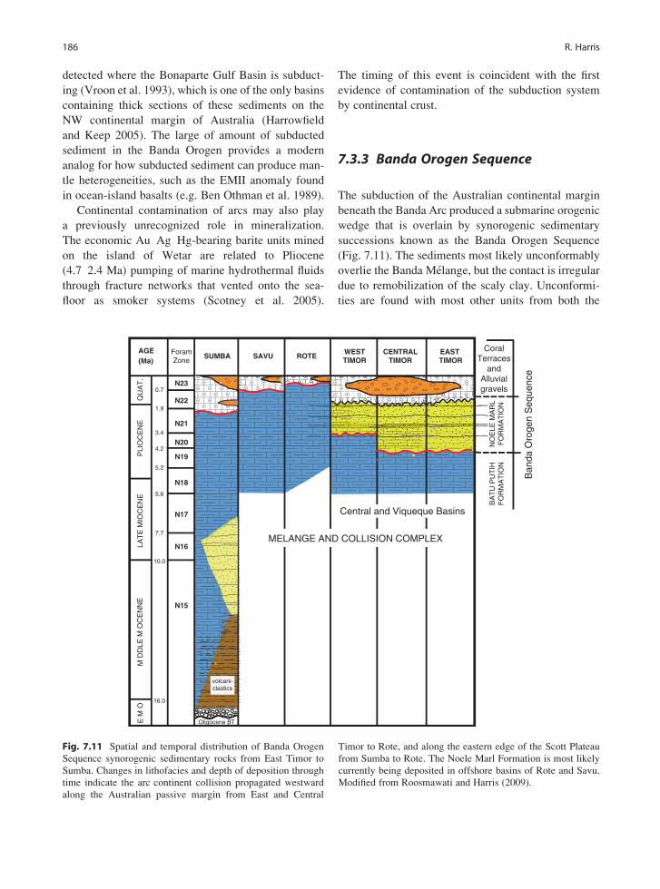
detected where the Bonaparte Gulf Basin is subduct-
ing (Vroon et al. 1993), which is one of the only basins
containing thick sections of these sediments on the
NW continental margin of Australia (Harrowfield
and Keep 2005). The large of amount of subducted
sediment in the Banda Orogen provides a modern
analog for how subducted sediment can produce man-
tle heterogeneities, such as the EMII anomaly found
in ocean-island basalts (e.g. Ben Othman et al. 1989).
Continental contamination of arcs may also play
a previously unrecognized role in mineralization.
The economic Au Ag Hg-bearing barite units mined
on the island of Wetar are related to Pliocene
(4.7 2.4 Ma) pumping of marine hydrothermal fluids
through fracture networks that vented onto the sea-
floor as smoker systems (Scotney et al. 2005).
The timing of this event is coincident with the first
evidence of contamination of the subduction system
by continental crust.
7.3.3 Banda Orogen Sequence
The subduction of the Australian continental margin
beneath the Banda Arc produced a submarine orogenic
wedge that is overlain by synorogenic sedimentary
successions known as the Banda Orogen Sequence
(Fig. 7.11). The sediments most likely unconformably
overlie the Banda Melange, but the contact is irregular
due to remobilization of the scaly clay. Unconformi-
ties are found with most other units from both the
AGE(Ma)
ForamZone
SUMBA SAVU ROTEWESTTIMOR
CENTRALTIMOR
EAST TIMOR
N23
N22
N21
N20
N19
N18
N17
N16
N15
0.7
1.9
3.4
4.2
5.2
5.6
7.7
10.0
16.0
EM
OM
DD
LE M
OC
EN
NE
LAT
E M
IOC
EN
EP
LIO
CE
NE
QU
AT
.
Ban
da O
roge
n S
eque
nce
NO
ELE
MA
RL
FO
RM
AT
ION
Oligocene BT
MELANGE AND COLLISION COMPLEX
volcani-clastics
CoralTerraces
andAlluvialgravels
BA
TU
PU
TIH
FO
RM
AT
ION
Central and Viqueque Basins
Fig. 7.11 Spatial and temporal distribution of Banda Orogen
Sequence synorogenic sedimentary rocks from East Timor to
Sumba. Changes in lithofacies and depth of deposition through
time indicate the arc continent collision propagated westward
along the Australian passive margin from East and Central
Timor to Rote, and along the eastern edge of the Scott Plateau
from Sumba to Rote. The Noele Marl Formation is most likely
currently being deposited in offshore basins of Rote and Savu.
Modified from Roosmawati and Harris (2009).
186 R. Harris

Australian continental margin and the Banda Arc,
which form the Banda orogenic wedge. The basal
unit of the Banda Orogen Sequence is a distinctive
pelagic chalk succession, which documents the birth
of the accretionary prism and much of its uplift his-
tory. These are overlain in places by turbidites shed
from the first land created by the rise of the orogenic
wedge above sea level. As the orogen emerged close to
sea level it was encrusted in coral reefs and locally
buried by fluvial gravels that form the uppermost units
of the sequence.
The basal unit of the Banda Orogen Sequence is
known as the Batu Putih Formation (Audley-Charles
1968), which consists of a few hundreds of meter thick
massive, foraminifera-rich calcareous pelagite and
chalk deposits with some calcilutite and vitric tuff
horizons. The depositional environment is consistent
with deep, low energy, open sea conditions of the
Banda forearc with no terrigenous input in the basal
section and some mica and metamorphic rocks frag-
ments in the upper section (Haig and McCartain
2007). The basal contact between the Batu Putih For-
mation and underlying accretionary wedge is poorly
defined. In the type location it is interpreted by Haig
and McCartain (2007) as unconfomable. However, it
is very irregular in places. In many places the contact
is highly disturbed by remobilization of melange.
Detailed biostratigraphic age analyses by Haig and
McCartain (2007) of the type location of the Viqueque
Group in East Timor yield ages of Neogene foraminif-
era zone N18 for the basal Batu Putih Formation. This
age corroborates those obtained by Kenyon (1974)
from the type locality of the Batu Putih Formation in
the Central Basin of West Timor. The earliest sign of
turbidite deposition within the Batu Putih Formation
is during N20 (4.2 3.35 Ma). The youngest age of
the Batu Putih Formation varies westward from N19
(5.2 4.2 Ma) in East Timor (Haig and McCartain
2007) to N20 (4.2 3.4 Ma) in western-most Timor
(Kenyon 1974) to N22-N23 (1.9 0.7 Ma) in Rote
and Savu (Roosmawati and Harris 2009), and is latest
Pliocene in Sumba (Fig. 7.11).
Overlying the Batu Putih Formation in Timor is
the Noele Marl Formation, which consists of calcilu-
tite and marl interbedded with turbiditic sandstone,
and tuffaceous material (Fig. 7.11). These deposits
become more clastic-rich up section, and the clasts
also coarsen upwards. The clasts are dominated by
metamorphic rock fragments. The oldest turbidites of
the Noele Marl Formation ranges in age from N21
(3.35 Ma) in East Timor (Haig and McCartain 2007),
to N22 (4.2 0.7 Ma) in West Timor. The absence of
the Noele Marl in Rote, Savu and Sumba (Fig. 7.11)
indicates that these islands are at different stages of
collisional evolution than Timor. During the time of
Noele Marl Formation deposition in Timor, Batu Putih
Formation pelagic deposits were deposited on the
accretionary ridge (Savu and Rote) and in the forearc
basin (Sumba) to the west. The lack of turbidite depo-
sition in the synorogenic rocks exposed on these
islands indicates that they are the first parts of the
orogenic wedge in these regions to emerge above sea
level and experience erosional exhumation, which
happened much earlier in Timor (Roosmawati and
Harris 2009).
The upper part of the Banda Orogen Sequence
consists of the Quaternary Baucau (coral limestone)
Formation and the Ainaro (gravel) Formation (Audley-
Charles 1968). These two units are commonly inter-
bedded along the coast and represent the emergence to
sea level of the Banda orogenic wedge (coral) and
uplift and erosion (gravels) of the islands mostly dur-
ing the Quaternary (Fig. 7.11). Both of these units are
uplifted and form marine and fluvial terraces through-
out Timor and other islands that are locally warped
by ongoing deformation (see Uplift History below).
7.3.3.1 Synorogenic Basins and Foredeep
The Banda Orogen Sequence accumulates to thick-
nesses of >3,000 m in slope basins that formed during
the collapse of the accretionary wedge shortly after
initial underthrusting of the Australian Continental
Margin (Figs. 7.12 and 7.13). Sonar mapping of the
seafloor and seismic reflection profiles show that most
of these basins are half-grabens with top-down-to-the-
south basin bounding faults (van der Werff 1995).
Some strike-slip faults are also found that may link
many of these basins to pull-apart structures (Mark
Quigley, Brendan Duffy and Myra Keep, personal
communication). Some of the basins also manifest
structures that suggest some tectonic inversion during
collision, but generally most basins show few contrac-
tional structures (Fig. 7.13). Much of the deformation
within the basins originally interpreted as shortening
(Kenyon 1974) is disturbed mostly by local diapiric
movement of the underlying Banda Melange.
7 The Nature of the Banda Arc Continent Collision in the Timor Region 187

The Banda Orogen Sequence progrades into the
3 km deep Timor Trough, which is a classic example
of an under-filled collisional foredeep. Drilling data
from DSDP 262, which was drilled 400 m into sedi-
ments in the Timor Trough, indicates a yield of mostly
pelagic ooze, containing nannofossils, foraminifers,
and radiolaria overlying Pleistocene age shallow
water shelf strata (Veevers et al. 1974). The pelagic
sediment documents the rapid subsidence of the Aus-
tralian Shelf as it flexes downward from near sea level
to enter into the Timor Trough. Modeling of the flex-
ure indicates an effective elastic thickness of 25 km
(Lorenzo et al. 1998) and only 200 m of forebulge
uplift. This contrasts with an effective elastic thickness
of 11 km for the China continental margin as it bends
beneath the Taiwan arc continent collision (Ma and
Song 2004). However, unlike Taiwan, a foreland
basin has not yet developed in the Banda Orogen.
The difference may be related to the greater rigidity
of the Australian continental margin, which is more
than 100 Ma older than the China margin, and the
lack of source sediment coming from the Australian
continent.
7.4 Initiation of Collision
When collision initiated in the Banda Orogen depends
upon how “collision” is defined. Most commonly the
time of collision initiation is interpreted as the age of:
(1) the youngest material accreted from the subducted
continental margin, (2) the oldest synorogenic depos-
its, (3) metamorphism of continental margin litholo-
gies, and (4) continental contamination and extinction
of the volcanic arc.
Slope
Continental Margin
Sumbawa Flores
Sunda
Trench
Sumba
Timor Trough
Rote
Savu
123 E Discontinuity
Asian Plate
Flores Thrust
Eastern Sunda Arc
Wetar Thrust
AustralianPlate
Shelf
Alor
Wetar
Timor Leste
West Timor
Oceanic Crust
50mm/yrGPS Velocity relative to Asia
Uplifted Coral Terraces(rates in mm/yr.)
Synorogenic Basins
Rise
Darwin(68 mm/yr)
Active Faults
Rote
-30°
0°
30°
NTUS
TOW2
YAR1
ALIC
CEDU
KARR
COCO
GUAM
PERT
YAR2
JAB1
PIMO
TWTTLHAZ
LAE1
KUNM
130°120°
0.5
1.5
0.3
1.5
1.3
Active Volcanoes
1.0
0.5
0.5
WedgeCollapse
Fig. 7.12 Neotectonic map of the Timor Region showing
active faults, active volcanism, surface uplift rates and GPS
velocities. Velocities are plotted relative to Asian reference
frame (see stations on inset map). Synorogenic basins open
during collapse of the accretionary wedge east of Sumba and
are uplifted due to subduction of the Australian continental
margin. Uplift rates vary throughout the region and correlate
best with proximity to active faults. Sea floor structure from van
der Werff (1995). Uplift rates from Cox et al. (2006). GPS
velocities from Nugroho et al. (2009).
188 R. Harris

7.4.1 Youngest Passive MarginLithologies
If collision is distinguished from subduction by under-
thrusting of continental versus oceanic lithosphere,
then where collision is initiating in the Banda Arc is
easy to pin point by where the distal most edge of
the Scott Plateau is entering the Java Trench south
of Sumba (Fig. 7.1). However, due to the obliquity
between the Australian continental margin and the
trench the age of collision, and the irregular shape of
the continental margin, collision initiation varies along
orogenic strike. In older parts of the Banda Orogen
evidence for collision initiation, according to this def-
inition, may be constrained by identifying the youn-
gest continental margin lithologies that were accreted
to the deformation front. However, identifying these
lithologies can be difficult because as the continental
margin approaches the accretionary wedge both are
overlain by the same sedimentary units. Ideally the
age of collision initiation could be bracketed across
Fig. 7.13 Idealized structural evolution of accretionary wedge
collapse south of Savu. (a) pre collisional geometry with slope
angle of 5 6�. Green is accretionary wedge and melange over
lain by Batu Putih formation pelagic chalk (yellow). (b) Underthrusting of continental margin with highly over pressured
Cretaceous and Jurassic mudstone (blue) weakens decollement
causing collapse of the accretionary wedge to the south, opening
of synorogenic slope basins, diapirism and collisional melange
development. Surface slope decreases to 2 3�. (c) Development
of Gondwana Sequence duplex (purple) uplifts the orogenic
wedge and may cause mild inversion of slope basins.
7 The Nature of the Banda Arc Continent Collision in the Timor Region 189

an angular unconformity where the youngest known
continental margin rocks of the accretionary wedge
are unconformably overlain by undeformed synoro-
genic deposits close to the same age. However, these
types of relations are difficult to constrain.
The youngest distinguishable continental margin
units incorporated into the Banda Arc accretionary
wedge form an imbricate stack that is partially exposed
along the south coast of Timor (Audley-Charles 1968;
Rosidi et al. 1979) and in Savu and Rote (Harris
et al. 2009; Roosmawati and Harris 2009). The best
exposures are in the Kolbano Mountains along the
cross-strike Oetuke River in West Timor (Fig. 7.6).
This drainage exposes a southward-verging imbricate
stack of at least 21 separate thrust sheets consisting
mostly of slope and rise facies pelagic lithologies
that range from Upper Jurassic Tithonian to Lower
Pliocene Zanclian stage (Sawyer et al. 1993). Uncon-
formably overlying the imbricate stack are successions
of Pliocene chalk and calcilutite of foraminifera stage
N18-19 (5.6 4.2 Ma). The youngest units of the
Australian Passive Margin Sequence found to date in
East Timor yield ages of 8 Ma (Keep and Haig 2010).
7.4.2 Oldest Synorogenic Deposits
The oldest synorogenic deposit is calcareous pela-
gite at the base of the Batu Putih Formation (Kenyon
1974; Audley-Charles 1986; Haig and McCartain
2007), which yields ages of (N18, 5.6 5.2 Ma).
Locally, Late Miocene calcilutite and tuffaceous
lithologies are found at the base of the chalk (Kenyon
1974; Haig and McCartain 2007) that may represent
the earliest pre-collisional synorogenic deposits. The
first turbidite in the Batu Putih Formation (N20,
4.2 3.35 Ma) and those that define the Noele Marl
Formation (N21, 3.35 1.9 Ma) document the emer-
gence of the Timor Island above sea level and the
initiation of erosional exhumation. As mentioned ear-
lier, the age of this transition decreases to the west
where in Rote and Savu there is no record of it at
all, but is likely happening offshore of these islands
(Roosmawati and Harris 2009). These ages document
the rise of the orogenic wedge from pelagic depths
of >3,000 m to the surface between 5.6 and 4.2 Ma
in East Timor and later to the west.
7.4.3 Metamorphic Cooling Ages
There are two distinct metamorphic complexes
exposed throughout the Banda Orogen: the Asian
affinity complexes of the Banda Terrane, which were
metamorphosed ~40 m.y. prior to the Banda Orogen
(see 7.3.2.1 above), and the Australian affinity Aileu
Complex. The age of metamorphic cooling of the Aileu
Complex was investigated initially by Berry and
Grady (1981) who report K/Ar ages for biotite and
white mica of 5.4 5.7 � 0.2 Ma and amphibole ages
of 7.7 16.5Ma. Nearly identical ages were produced by
Berry and McDougall (1986) using 40Ar/39Ar methods.
However, only one white mica age yields an acceptable
plateau age (5.36 � 0.05 Ma). Reanalysis of these data
using ISOPLOT yields unacceptable MSWD values
(>60) for inverse isochron plots for every age determi-
nation except the one white mica age (Major et al.
2009). Therefore, there is only one reliable age of
metamorphism for the Aileu Complex, which indicates
that it experienced metamorphic cooling to around
420�C (closure temperature of white mica, Kirshner
et al. 1996) at 5.4 Ma.
The age of exhumation of the Aileu Complex is
further constrained by fission-track analyses of apatite
grains (Harris et al. 2000). Nearly all of the fission-
tracks are highly to completely annealed, which indi-
cates a low-temperature exhumation age of <4 Ma.
These ages are also consistent with plate reconstruc-
tions (Hall 2002; Roosmawati and Harris 2009) of
when the NW Australian continental margin arrived
at the collision zone (Fig. 7.4).
7.4.4 Arc Contamination and Extinction
The age of arc extinction is commonly used as an
indicator of collision initiation, but in the Banda Arc
it is obvious that volcanism continued after collision
initiation and still may not have ceased completely.
The deeply eroded Wetar to Alor section of the arc
is not active currently and the youngest volcanic rocks
are 2.5 and 1.3 Ma, respectively (see Banda Arc
above). However, there are lavas on these islands
that show 238U-230Th disequilibrium that limits their
age to <350,000 years (Vroon et al. 1993). There is
190 R. Harris

also a line of active volcanoes north of the Wetar-
Alor segment that are similar in composition to the
Banda Arc (Schwartz et al. 1984). Dredge samples
from a submerged seamount in this region yield ages
of 0.4 Ma (Morris et al. 1984). There is abundant
evidence from multiple sources that arc continent
collision initiated in the Wetar to Alor segment of
the arc significantly earlier than volcanism ceased
(see above). It is also important to note that there are
well-documented inactive segments of the Sunda Arc
to the west that are not related to collision. For exam-
ple, there is a 200 km long extinct segment of Sunda
Arc in central Java. For these reasons it is advisable to
reconsider how arc volcanism is modified by collision
(Vroon et al. 1993).
The age of continental contamination of the Banda
Arc provides a minimum age of collision initiation
that would be at least 2 m.y. too young due to the
time it takes for the edge of the continent to reach the
depths of arc magma generation. Evidence for contam-
ination shows up in volcanic rocks of Wetar as early as
5 Ma (Scotney et al. 2005), which is consistent with
other minimum ages of collision initiation mentioned
earlier. The Wetar segment of the Banda volcanic arc
is also offset northward from the rest of the arc by
40 km. Instead of ramming into the accretionary
wedge as in Taiwan, the Banda volcanic arc is accret-
ing to the lower plate and moving mostly with it along
the Wetar Thrust to the north of the arc (see Fig. 7.12).
These geochemical and structural modifications to the
volcanic arc are adjacent to the oldest part of the
collision based on other indicators, such as the posi-
tion of the Aileu Complex, highest topographic relief
and oldest synorogenic sedimentary rocks.
Unlike Taiwan, volcanism is still active in most
parts of the collision zone in the Banda Orogen. The
West Timor to Sumba section of the collision, which
is at least 3 m.y. old, is adjacent to the active, but
contaminated volcanoes of Flores Island and those
between Flores and Alor. A similar situation is found
in the Wetar to Alor arc segment where continental
contamination of arc volcanics is found as early as
5 Ma, but arc volcanism persisted on Wetar until at
least 2.5 Ma (Scotney et al. 2005) and may be still
active. East of Romang the active volcanism is part of
the collision zone that stretches nearly all of the way
to Seram (Fig. 7.1).
7.4.5 Summary
The above indicators of collision initiation in Timor
converge at a Latest Miocene age (< 8 Ma). Taking
into account the lag times between collision initiation
and (1) emergence and erosion of the orogen at
4.2 Ma, (2) metamorphism and later metamorphic
cooling to 420�C at 5.3 Ma, and (3) continental margin
underthrusting (< 8 Ma) and eventual contamination
of the volcanic arc at Wetar by at least 5 Ma, the
collision initiated south of Wetar at around 8 Ma.
The age of collision initiation young’s to the west
towards Rote Island, but initiated earlier in Sumba
due to the Scott Plateau protrusion.
7.5 Tectonic Features of the BandaOrogen
Due to the Scott Plateau protrusion the Banda Orogen
is shaped by two arc continent collisions. The first is
the arrival of the NW Australian continental margin to
Banda Trench at around 8 Ma in the central Timor/
Wetar region. This collision propagated to the west in
a time-space equivalent manner to just beyond Rote
Island. Its propagation to the east is only constrained
by the eastern propagation of the contamination front.
The second collision is the arrival of the Scott Plateau
at the Sunda Trench at around 3 Ma to form the Sumba
Ridge. This collision propagated from Sumba to the
SE through Savu to Rote Island (Harris et al. 2009;
Roosmawati and Harris 2009). Both of the collisions
merge in the Rote region to form the western Banda
Orogen.
Serial sections through the collision reveal various
orogenic phases of collision propagation (Fig. 7.15).
These include, (1) the birth of Savu Island above the
Savu Thrust and collapse of the accretionary wedge
south of the Island, (2) deformation along a lateral
ramp in Rote, (3) development of the Gondwana
Sequence duplex beneath the Banda Terrane in West
Timor, (4) folding, uplift and detachment (?) of the
Banda Terrane tectonic lid, (5) forearc closure and ces-
sation of volcanism in central Timor, (6) forearc sinking,
arc accretion and northward translation adjacent to
7 The Nature of the Banda Arc Continent Collision in the Timor Region 191

Wetar, (7) strong coupling of the lower plate creating an
oblique-slip extensional system (East Timor), and exhu-
mation of metamorphic rocks (East Timor).
7.5.1 Sumba Ridge: Collision witha Continental Plateau
The most vivid expression of the initiation of collision
in the Banda Orogen is the abrupt uplift of the Sunda
forearc basin from 5 km below sea level to the surface
to form the island of Sumba. Sumba Island is the
emergent part of the Sumba Ridge (Fig. 7.4), which
stretches in a NW-SE direction from the distal conti-
nental margin of Australia under the Sunda trench and
forearc all of the way to the volcanic arc. The Sumba
Ridge uplifts the Sunda Trench and forearc by at least
the same amount as the 2 3 km difference in bathym-
etry between the Scott Plateau and the Jurassic oceanic
crust that surrounds it. The Sunda Trench becomes the
Timor Trough at this point. However, an additional
20 30 km of shortening in the region or a thicker crust
is needed to lift Sumba up from its forearc basin
origins to the surface and expose its basement rocks.
Gravity data from Sumba (Chamalaun et al. 1981)
indicate that whatever the uplift mechanism is, it
must involve continental-type crust, which underlies
the forearc basement exposed at the surface.
The Sumba Ridge also indents the Sunda Arc and
shifts it around 30 km northward near the island of
Sumbawa (Fig. 7.1). The indentation is accommodated
by slip along the Flores Thrust, which has propagated
over 300 km to the west near Lombak Island and nearly
the same distance to the east. The volcanoes in the
region of the indentation are contaminated with conti-
nental crust and include the explosive giant of Tambora.
The Sumba Ridge is likely the expression of the
subducted NE edge of the Scott Plateau (Harris 1991;
Keep et al. 2003), which arrived at the Sunda Trench
at around 3 Ma (Fig. 7.4). Subduction of the Scott
Plateau presents an end member of arc continent col-
lision of semi-buoyant thinned continental lithosphere
with only a thin veneer of cover sediment. The initial
stages of collision in the Sumba region are even char-
acterized as that of a seamount asperity forcing wedge
taper adjustments of shortening followed by extension
(Fleury et al. 2009).
The collision of the Scott Plateau is also manifest in
the volcanic arc and backarc region. Volcanoes above
where the Scott Plateau is subducted show evidence of
recent continental contamination (see Volcanic Arc
above) to the west of the main contamination front,
which is in central Flores. Adjacent to this region in
western Flores arc volcanism has ceased.
7.5.2 Transition from Subduction toCollision: Uplift and Shorteningof the Forearc
Where the Scott Plateau intersects the deformation
front the Sunda Trench becomes the Timor Trough
and manifests many structural features not seen in
the accretionary prism to the west. Differences in the
way incoming material is accreted is described by
Breen et al. (1986). In the Sunda Trench the thin
sedimentary cover blanketing the Indian Ocean sea-
floor is picked up by horizontal propagation of short
decollements into small, accreted slices that shorten
along closely spaced thrusts and conjugate strike-slip
faults. Seismic images of the accretion zone show
chaotic reflections interpreted as melange. Where the
Scott Plateau enters the Timor Trough (between
120�400 E and 121�, Fig. 7.1b) Breen et al. (1986)
report decollements propagating up to 15 km south
of the thrust front into significantly thicker sec-
tions of incoming layered successions allowing for
the accretion of long slabs of lower plate material
(Fig. 7.6). The length/thickness ratio of these thrust
sheets is more like what is found in fold-thrust zones.
The thrust front is well defined by a vertical separation
along faults and folds 2 4 km long that occur through-
out the lower slope. Mud diapirism is also seen for the
first time and produces ridges of mud volcanoes south
of the thrust front in the lower plate that are sourced
from the decollement. The decollement is traced as a
strong to moderate reflector into what is interpreted
as Cretaceous shale (Reed 1985; Karig et al. 1987).
Exposures of this unit in Timor show that it is actu-
ally a mudstone composed of expandable clays (see
Banda Melange above) that overlie pre-rift Gondwana
Sequence cover sediment of the Australian continental
margin.
192 R. Harris

Another difference in the deformation pattern
between subduction in the Sunda Trench and collision
in the Timor Trough is the partitioning of strain away
from the deformation front in the later. In the Sunda
Trench a sharp boundary is found between the lower
and upper slope of the accretionary wedge (Karig et al.
1987; Breen et al. 1986). Seismic reflection and sonar
data show that this boundary marks the northern limit
of the deformation front where recently accreted sedi-
ments are disturbed. In most places along the Sunda
Trench this boundary is 20 30 km from the deforma-
tion front, with no evidence of any deformation in
parts of the arc-trench system beyond this narrow
zone. This observation implies that in the Sunda
Trench most of the convergence between Indo-Aus-
tralia and SE Asian Plates occurs at very high strain
rates within only the lower slope region of the accre-
tionary wedge, which is consistent with the abundance
of melange generated in this zone. The only other site
of convergence in the zone of subduction is the Flores
Thrust to the north of the Sunda volcanic arc. How-
ever, it is most likely a product of subduction of the
Scott Plateau and its impingement on the Sunda vol-
canic arc.
Distribution of strain away from the deformation
front due to underthrusting of the Scott Plateau south
of Sumba involves: (1) initiation of northward-verging
thrust systems (Flores and Savu thrusts), (2) shift of
shallow seismicity away from the trench into the fore-
arc and backarc, (3) uplift of the forearc basin (Sumba)
and ridge (Savu), (4) abrupt widening of the accretion-
ary wedge by>100 km, (5) formation of top-down-to-
the-south half graben slope basins, and (6) extensive
mud diapirism. Features 1 3 may relate to increased
coupling due to positive buoyancy of the underthrust
continental plate. Features 4 7 are most likely caused
by adjustments of the accretionary wedge to basal
decollement weakening as over-pressured Australian
continental slope units enter the trench (Harris et al.
1998).
7.5.3 Savu: Initiation of the Retro-WedgeThrust System and Fore-WedgeCollapse
Savu Island emerged from the sea at around 0.8 Ma
where it was encrusted with coral terraces (Harris et al.
2009). The coral terraces are tilted to the south away
from active thrust fault near the north shore (Fig. 7.7).
Erosional windows through the coral terraces reveal
that Savu is composed mostly of Triassic to Jurassic
Gondwana Sequence with some Cretaceous Australian
Passive Margin Sequence that are stacked by thrust
faults (Harris et al. 2009). The thrust sheets are up to
2 km thick and verge to the south in the southern part
of the island and to the north near the north shore
(Fig. 7.7). Along the north coast and immediately
offshore are splays of the active Savu Thrust, which
offset uplifted coral terraces on shore and rupture all
of the way to the surface in several places offshore
(Harris et al. 2009). The island is part of the ENE-
WSW Savu-Rai Jua Ridge that corresponds to a rift
basin of the same orientation within the Scott Plateau
lower plate and the position of the Lombak forearc
accretionary ridge on the upper plate. Analysis of
foraminifera within synorogenic deposits reveal that
the accretionary ridge at Savu was uplifted from
depths of 2.5 km below sea level to the surface
between ~1.5 and 0.7 Ma, which is also when the NE
edge of the subducted Scott Plateau arrived beneath
Savu (Fig. 7.4).
The SSE dipping Savu Thrust forms where the rear
of the accretionary wedge ramps up over the uplifted
edge of the Banda forearc basement. Its orientation
and that of most other thrusts and fold axes on the
island parallels the ENE-WSW structural grain of NW
Australian continental margin rift basins (Fig. 7.3).
Even before the Australian continental margin arrives
at the Timor Trough some of its rift basins are inverted
to form anticlines with fold axes oriented parallel to
east-northeast west-southwest rift basins (Dore and
Stewart 2002). In many ways, the Savu Rai Jua ridge
can also be considered an inverted rift basin of the
Scott Plateau. Bedding attitude measurements
throughout Savu show a dominantly ENE-WSW
strike, which is also the orientation of fold hinge
lines and thrust faults (Fig. 7.3). These observations
show that the pattern of deformation in Savu during
the earliest phases of arc continent is more strongly
influenced by structural inheritance than NNE plate
convergence, which would produce fold axes and
thrust faults that strike WNW. This same pattern per-
sists into more advanced stages of collision. South of
Timor, the thrust front also rotates to parallelism with
the structural grain of the northwest Australian conti-
nental margin (Fig. 7.1).
7 The Nature of the Banda Arc Continent Collision in the Timor Region 193

One of the most unique features of the transition
from subduction to collision is the abrupt change in
surface slope angle of the accretionary wedge from 6�
to the west at the Lombak Ridge to around 2� south
of Savu. The collapse of the accretionary wedge to the
south is like a massive submarine slump that opens
rift basins in the upper slope and causes mud-cored
folds and thrusts at its toe (Figs. 7.12 and 7.13). The
mega-slump is most likely caused by decollement
weakening associated with underthrusting of highly
over-pressured Jurassic to Cretaceous mudstone (see
Banda Melange above). In many ways the structure
of the accretionary wedge south of Savu is similar to
the structure of the slumping sedimentary wedge of
the northern Gulf of Mexico.
7.5.4 West Timor: Anatomy of theCollision Revealed
Traveling from west to east on the only paved road
through the island of Timor is like climbing up
through an enormous plunging antiform. On the west
coast all that is exposed are coral terraces encrusting
the most recently uplifted part of the WSW pro-
pagating Banda Orogen. Below the coral veneer is a
thick section of synorogenic deposits of the Central
Basin (Fig. 7.5) that document rapid uplift of the
accretionary wedge from depths of >3 km to the
surface during the past 3 Ma (Kenyon 1974; De Smet
et al. 1990). Further to the east and deeper into the
antiform is a landscape that is a chaotic mix of two
very different worlds (Fig. 7.5). To the north are the
steep spires of deeply eroded Asian affinity rocks of
the Banda Terrane. To the south are piles of dismem-
bered thrust sheets of Gondwana Sequence. Between
the two is a block and scaly clay melange, which is a
chaotic mixture of the rocks on either side.
Erosional windows through the Banda Terrane
reveal that it structurally overlies the melange and
Gondwana Sequence. The melange formed as part of
the original subduction channel at the base of the
Banda Terrane that was eventually clogged by and
included parts of the Gondwana Sequence. The Gond-
wana Sequence is folded and thrust, but not enough
structural relief is available to make out the pattern of
deformation. However, the repetition of Permian to
Jurassic successions indicate that it is detaching
near the base of the Permian and is overlain by a
roof thrust above which the rest of the Cretaceous to
Tertiary section (Australian Passive Margin Sequence)
is found.
To find the Australian Passive Margin Sequence
requires braving the tortuous dirt roads to the Kolbano
Mountains along the south coast of West Timor. The
lower part of the Oetuke River exposes an astonishing
section of at least 24 imbricate thrust repetitions each
around 200 300 m thick of Early Cretaceous to Late
Tertiary slope and rise deposits (Figs. 7.6 and 7.7). The
thrust sheets are deformed mostly by fault-propagation
folding with the thrust faults truncating the overturned
forelimb. The structural relief increases upstream until
at its headwaters the river breaches the basal decol-
lement in the Wai Luli Formation. North of this
point mostly only Gondwana Sequence lithologies
are exposed in what is interpreted as a thrust duplex
(Harris 1991).
In the northern part of West Timor uplift and ero-
sion exposes several large massifs of the Banda Ter-
rane along strike of the submerged Sumba ridge to the
west that is exposed in Sumba. These nappes cover
much of the Gondwana Sequence duplex that varies in
structural relief beneath them making it difficult to
establish any lateral continuity of the underlying struc-
ture. The erosional level is such that the subduction
channel beneath the Banda Terrane nappes is well
exposed in several key places. It shows evidence of
high fluid pressures associated with hydrofracturing
of both lower and upper plate blocks along a basal
and roof decollement that may have been active simul-
taneously. Traction along the basal shear zone of the
channel pulls continental material deeper into the
channel while at the same time material is plucked
from the structurally overlying Banda Terrane roof
thrust, which may explain the strongly attenuated
nature of these nappes.
South of the Gondwana Sequence duplex zone the
Banda Terrane is tilted southward and even extends to
the south coast of the island in East Timor where it was
penetrated by wells (Audley-Charles 1968). North of
the duplex the Banda Terrane nappe is tilted steeply
northward and is likely detached from its roots and
carried by backthrusts over itself (Fig. 7.5). The best
example of northward back tilting is the steepening to
vertical dips of alternating pillow basalt and sheet flow
194 R. Harris

layers of the Occusi nappe on the north coast of West
Timor (Fig. 7.5).
7.5.5 East Timor: Fall of the Forearcand Rise of the Hinterland
The one paved road through Timor enters East Timor
(Timor Leste) along the north coast of the central part
of the island where two new features appear on the
eastern horizon. The closest is a large mountain range
(Aileu Range) of metamorphic rocks of the Australian
affinity Aileu Complex. The other feature is the deeply
eroded Banda volcanic arc island of Alor. Only 30 km
separates the coast of Alor from the western-most
north coast of East Timor. Between the two is the
nearly 3 km deep Wetar Strait. The Wetar Strait is
the site of the Wetar Suture proposed by Price and
Audley-Charles (1983) to explain the narrow gap
between the Banda volcanic arc and Australian con-
tinental margin material. They inferred a large fault
that ruptured through the entire Australian Plate and
moved it over the forearc. The location of the thrust at
the base of the north-facing slope of the accretionary
wedge (Fig. 7.14) is confirmed by seismic reflection
profiles across the Wetar Strait (Breen et al. 1989a, b;
Snyder et al. 1996). However, it is not known whether
the fault ruptures through the entire lithosphere or
connects with the basal decollement like a more
advanced stage of the Savu Thrust (Fig. 7.7).
Additional confirmation of the northward motion of
the orogenic wedge is provided by structural field
mapping of the Aileu Complex (Prasetyadi and Harris
1996). These studies locate several top-to-the north
thrust faults near the north coast of East Timor and a
switch to top-to-the-south motion near the crest of the
Aileu Range (Fig. 7.14).
The metamorphic fabric of the Aileu is character-
ized by an initial flattening (S0 ¼ S1), which is over-
printed by an axial planar foliation (S2) associated
with isoclinal and nearly recumbent folds with gener-
ally top-to-the-south vergence. Berry and McDougall
(1986) suggest that mica in the Aileu Complex records
the age of S2 (�6 Ma). Rf-f analysis of quartz grains
yield a nearly horizontal prolate ellipsoid with the
long (x) axis oriented N-S (Fig. 7.14). These features
are overprinted by low-angle generally top-to-the-
north thrust faults in the northern part of the range
and top-to-the-south thrust faults in the central and
southern parts of the range (Fig. 7.14). The last
phase of deformation is the development of high-
angle normal faults with an array of orientations, but
predominately top-down-to-the-north sense of shear
along the north coast.
The structure of the Aileu metamorphic complex
documents an initial layer-parallel extensional phase
most likely associated with compaction and perhaps
even a rift-related thermal event associated with pas-
sive margin development. A close association with
rifting is indicated by a series of enigmatic intrusions
of lherzolite and gabbro bodies (Fig. 7.14) into mica
schist mostly in the western part of the Aileu Complex
(Prasetyadi and Harris 1996). The later layer-parallel
shortening phase is most likely associated with
arc continent collision. Subsequent brittle deforma-
tional phases document uplift by retro-wedge motion
to the north and extensional exhumation.
2
0
-2
SouthNorthkm
Aileu Complex
4
am gs slateam
Fig. 7.14 Cross section across the Aileu Complex near the
border of West and East Timor (modified from Prasetyadi and
Harris 1996). See Fig. 7.5 for location. Stippled areas are mafic
and ultramafic intrusions. Abbreviations for metamorphic
grade: am amphibolite facies, gs green schist facies. Ellipses
are in the x z plane and show relative amounts of strain and
direction of stretching from Rf f analysis of quartz grains.
Normal faults are the youngest features and cross cut northward
verging faults near the intrusions and accommodate exhumation
on the southern part of the complex. The Laclo Fault is similar to
these top down to the south normal faults, but with some left
lateral strike slip motion.
7 The Nature of the Banda Arc Continent Collision in the Timor Region 195

7.5.5.1 Where is the Banda Forearc?
Retro-wedge motion along the Wetar Suture is used to
explain the progressive closure of the Banda forearc
north of Timor (Price and Audley-Charles 1983; Harris
1991). What happens to the forearc, and in many cases
the arc complex as well, during arc continent collision
is poorly understood. If the thrust in the Wetar Strait
completely over-rides the northern Banda forearc
basin then the forearc basement should be beneath
Timor. If this is the case then it would produce a
gradually decreasing gravity high from the north
coast toward the center of the island (Zobell 2007).
However, what is observed is perhaps the steepest
gravity gradient known that increases sharply from
the north coast but does not extend south beneath
Timor (Zobell 2007). Modeling this pattern from a
combination of detailed gravity measurements across
central Timor (Chamalaun et al. 1981) and regional
data (Kaye 1990) predicts a geometry very different
from those proposed by Price and Audley-Charles
(1983) and Harris (1991, 2003). The most viable way
to reasonably reconcile the predicted and observed
gravity values is to subduct the majority of the forearc
with the Australian lower plate. A similar solution to is
also presented by Richardson and Blundell (1996) for
gravity data collected east of Timor.
7.5.5.2 Structure of the Gondwana Duplex
At the same time as the forearc is sinking into the
subduction zone the adjacent hinterland of the oro-
genic wedge is rising. Enough uplift and erosion has
occurred in Central Timor to expose the lower Gond-
wana Sequence duplex that structurally underlies the
Banda Terrane roof thrust. Although structural studies
of this package of rocks are hampered by lack of good
biostratigraphic data, there are a few key marker units
for identifying various stratigraphic intervals, such as
the distinctive Triassic limestone of the Aitutu Forma-
tion. The Aitutu Formation is repeated several times
in N-S transects along drainages through the Ramelau
Range (Fig. 7.8). Most of the repetition is associated
with abrupt breaks in stratigraphy that both dip and
face upward to the NNW indicating thrust versus fold
repetition. Fault-propagation folds are observed at
wavelengths of up to 1 2 km (Fig. 7.8). The overall
pattern of deformation is one of ENE-WSW striking
folds and thrusts.
Space considerations require that there are likely
multiple levels of detachment within the Gondwana
Sequence that produce multiple duplex zones. For
example, in Savu a duplex of upper Gondwana
Sequence forms in front of the Banda Terrane nappe
while the lower section of the Gondwana Sequence
that is exposed in northern Timor is inferred to stack
up beneath it (Fig. 7.8).
7.5.5.3 Late-Stage Oblique-Slip Normal Faulting
The general pattern of ENE-WSW folds and thrusts is
disturbed by normal faults with significant amounts of
oblique slip that crosscut the Gondwana Sequence
duplex . These faults are only now being recognized
on shore in places where they down-drop thick sec-
tions of the Banda Orogen Sequence (synorogenic
deposits) and juxtapose them against much deeper
structural levels. Perhaps the largest of these structures
is the Laclo Fault, which was first recognized by Berry
and Grady (1981). This fault dips at a moderate angle
to the south and juxtaposes the upper parts of the
Gondwana Sequence duplex against amphibolite to
granulite facies sections of the Aileu Complex. More
recent studies of the fault recognize kinematic indica-
tors that vary from top-down-to-the-south to left-lat-
eral strike-slip motion along the fault. The Laclo River
separates the Laclo Fault zone and its thin hangingwall
of Gondwana Sequence to the north from the largest
Banda Terrane massif on the island (Fig. 7.5), which is
most likely preserved due to top-down-to-the-south
faulting on the Laclo Fault. The oblique-slip nature
of these faults may reflect the increased coupling
between the Banda Orogenic wedge and the Austra-
lian continental margin. A series of NE-SW left-lateral
wrench faults formed at around 3 Ma in parts of the
Australian continental margin near the Timor Trough
(Clough et al. 2000).
7.5.5.4 Eastern East Timor Plateau
East of the Aileu Complex the north coast of Timor
displays two very important features that help inter-
pret the evolution of arc continent collision. The
first is large section of ultramafic rocks associated
with melange that structurally overlies the Gondwana
Sequence duplex and exposes the subduction channel
that these rocks entered (Harris and Huang 2010). The
196 R. Harris

second feature is an unprecedented series of uplifted
coral terraces that rise to a high plateau over 600 m
above sea level. At least 25 individual terraces are
found in some places, and most of them are warped
into what may be ENE-WSW trending anticlines and
synclines that intersect the north coast of Timor at
oblique angles (Cox et al. 2006). The warping of the
terraces demonstrates active deformation in the region
over the past 0.1 Ma.
7.5.6 Uplift History
Investigating the pattern of uplift throughout the
Banda Orogen provides a way to test a fundamental
unresolved question about the geodynamics of colli-
sions generally. The question is about how much uplift
is due to crustal shortening versus lithospheric scale
processes, such as buoyancy of subducted continental
lithosphere, and delamination or tearing off of the
oceanic slab. Crustal shortening is documented
throughout the Banda Orogen, and enough material
has been brought into the orogenic wedge over the
past 8 Ma to fill all of the space needed to account
for its size and topography. However, much of the
incoming sediment may have subducted and not
accreted. One test of crustal shortening versus slab-
tear is the longevity of uplift. If most of the uplift is
from shortening during collision propagation then
there should also be a pattern of sustained uplift that
young’s in the direction of collision propagation to
the west and east, which is what is observed. In con-
trast, a pulse of rapid, simultaneous uplift throughout
variously shortened parts of the orogen followed by
no uplift would be more consistent with a whole
Wedge Collapse
NW SE
a
b
c
20-20
0
-20
0
-20
0
EAST TIMOR
CENTRAL TIMOR
WEST TIMOR
AUSTRALIAN CONTINENTAL MARGIN
20
20
Timor Trough0
-2020
d
e
Savu ThrustSAVUWest Flores
-20
0
20
AB
C
DE
Magmatic Arc
Timor Trough
Central Flores
Eastern Flores
Alor
Wetar Timor Trough
Gondwana Sequence
Australian PassiveMargin Sequence
Banda Terrane and Arc
Timor Trough
Aileu Complex
ROTE
Scott Plateau
?
Timor Trough
Fig. 7.15 Serial sections through the Banda arc continent col
lision from East Timor (a) to Savu (e). Initiation of retrowedge
thrust (Savu Thrust) and collapse of overcritical wedge south of
Savu. Shortening of subcritical wedge in Rote begins progres
sive northward translation of the Timor Trough as coupling
increases with the Australian lower plate. In Wetar the arc is
also translated northward as it couples with the lower plate.
Active volcanism (red lines) ceases in Alor and Wetar, but is
still active during collision in C E. In the Timor region the
southern edge of the forearc is folded and uplifted as a passive
roof thrust by accretion of Australian continental margin cover
units beneath it. North of Timor progressive closure of the
forearc requires it to sink into the subduction zone (downward
arrow). Maximum coupling with the lower plate in East Timor
results in mostly left lateral oblique extension.
7 The Nature of the Banda Arc Continent Collision in the Timor Region 197

lithosphere process. The rate of uplift through time is
also a key to distinguishing between these two
mechanisms or the relative contributions of each.
The emergence of several islands throughout the
Banda Orogen over the past few million years pro-
vides a rare glimpse of the temporal distribution of
vertical strain in an active arc continent collision over
time scales of 103 to 106 years. Multiple proxies for
measuring both surface and rock uplift rates are avail-
able including the rates of sediment discharge, ther-
mochronology of metamorphic rocks, depth versus
age relations from benthic and planktic foraminifers
in synorogenic deposits, rates of patterns of uplift from
flights of coral terraces and other geomorphic features
such as stream asymmetry.
7.5.6.1 Erosion Exhumation and Sediment
Discharge
The Banda Arc provides the rare opportunity to mea-
sure both rock and surface uplift rates throughout the
same orogen. This comparison provides a way to test
the significance of erosional or tectonic exhumation in
young mountain systems. It is commonly assumed that
erosional exhumation positively correlates with total
annual precipitation or rates of uplift, which is mani-
fest by high amounts of sediment discharge in streams.
However, measurements of sediment discharge in
Seram and Timor are markedly different even though
these islands of similar size and shape have nearly
identical uplift patterns, topography, geomorphology,
rock types, and basin catchment size (Cecil et al.
2003). The only other major factor controlling sedi-
ment discharge that may account for differences in
sediment discharge on these islands is climate.
The Banda Arc straddles two different climate
zones and provides a natural laboratory for testing
the extent that climate may control rates of erosional
exhumation (Harris et al. 2008). The southern part of
the Banda Arc (Timor) is seasonal and has a lengthy,
8-month dry season with around 1,300 mm/a of rain-
fall during its short rainy season. The northern Banda
Arc (Seram) is perhumid with little to no dry season.
During some months Seram receives up to 600 mm of
precipitation, with a total of 3,250 mm/a. However,
even though the total amount of rainfall in Seram is
nearly three times that of Timor, sediment discharge
in Timor during its short rainy season is more than
27 times that of the annual sediment discharge in
Seram. Timor annualized sediment concentration is
0.7 � 106 metric tons/km3 of water discharged. This
value is 60% of that of the Ganges/Bramaputra River
system (Cecil et al. 2003).
These data are consistent with other indicators
of sediment discharge rates found in Seram and
Timor. The rivers of Seram are characterized by mean-
dering, acidic blackwater with exceedingly low solute
and suspended-sediment concentrations, but with sig-
nificant amounts of terrestrial organic matter. They
also have limited fluvial bed loads, primarily as point
bars, which diminish downstream into estuaries with-
out sediment fill derived from fluvial systems. The
coastal regions where the rivers discharge are mud-
dominated, sediment-starved, host large stands of
mangrove and have few, if any coral reefs. In contrast,
the rivers of Timor are braided from the mountains to
the coast where sedimentation keeps pace with rising
sea level to produce deltas. Riverbed sediment is
dominated by cobbles and pebbles with lesser amounts
of sand-size material, which also characterizes the
beaches. The coastlines are mostly estuary and man-
grove free and have thick encrustations and large
build-ups of coral.
With most other factors nearly equal, it is evident
that seasonality of climate, not total amounts of pre-
cipitation is the major controlling factor of erosional
exhumation in the Banda Arc (Cecil et al. 2003). The
protracted dry season in the Timor region results in
less vegetative cover and higher rates of sediment run
off into streams. Higher rates of erosional exhumation
in Timor may explain why deeper structural levels are
exposed there compared to Seram.
7.5.6.2 Thermochronology
Rock uplift rates for the metamorphic core of the
Banda Orogen are inferred from a combination of
pressure and temperature estimates, 40Ar/39Ar cooling
ages, and apatite fission track analyses. Using the only
reliable 40Ar/39Ar age determination from white mica
in the Aileu Complex discussed above (5.3 Ma) along
with the pressure and temperature estimates for these
rocks (600 700�C and 8 10 kbars, Major et al. 2009)
yields a geothermal gradient of around 20 25�C/kmand long-term rock uplift rates of around 3 mm/yr over
the past 5 m.y. Fission track analyses of apatite grains
198 R. Harris

in the same rocks show uplift from the partial anneal-
ing zone (80 120�C) to the surface in <4 m.y. (Harris
et al. 2000). This requires a rock uplift rate of
1-2 mm/yr over the past 4 m.y. The exposure of
these metamorphic rocks in the part of the orogen
with the most shortening is consistent with uplift
caused by crustal shortening associated with exten-
sional and erosional exhumation versus regional litho-
spheric processes.
7.5.6.3 Foraminifers in Synorogenic Deposits
Synorogenic foraminifera-rich chalk and turbidites
provide depth and age constraints for tracking when
various parts of the Banda Orogen emerged from an
accretionary wedge at pelagic depths to where they are
exposed at the surface. Although there is some erosion
of these deposits after they reached the surface, the
majority of their ascent was in a submarine environ-
ment, with little to no erosion. Therefore, the record of
vertical movements is interpreted as mostly surfaceversus rock uplift.
The Batu Putih Formation chalk at the base of the
Banda Orogen Sequence has scarce benthonic forami-
nifera, but those that are found are characteristic of
very deep water (>3 km). Abundant planktonic for-
aminifer’s of biozone Neogene (N) 18 (5.6 5.2 Ma)
are partially dissolved indicating water depths near the
lysocline (~ 3 km). In early emerging parts of the
Banda Orogen the Batu Putih Formation is overlain
by turbidites of the Noele Marl Formation, which
varies in age along strike from N20 (4.2 3.4 Ma) in
East Timor and N21 (3.4 1.9 Ma) in West Timor
(Audley-Charles 1986) and Sumba (Fortuin et al.
1997). However, in between the large islands of
Timor and Sumba the deep water conditions of the
Batu Putih Formation continued until N21 as in Savu
(1.9 07 Ma) and N23 (<0.7 Ma) as in Rote (Fig. 7.11).
These data indicate that collision of the Australian
continental margin with the Banda Arc initiated much
earlier in Timor and Sumba than in Savu and Rote
where it has just begun. A rough pattern of westward
propagation of uplift exists between East Timor and
Rote, and eastward propagation of uplift from Sumba
to Savu. The pattern of westward propagation is con-
sistent with underthrusting and shortening of the NE-
SW trending part of the Australian continental margin
beneath the E-W Sunda Trench. Underthrusting of the
Scott Plateau beneath the western-most part of the
Banda Orogen explains SE propagation of uplift
from Sumba (2 3 Ma) to Savu (1.0 0.5 Ma) and then
to Rote (0.2 Ma). Average rates of surface uplift of the
Batu Putih Formation pelagic deposits during the past
2 m.y. in Rote and Savu are ~1.5 and 2.3 mm/a,
respectively (Roosmawati and Harris 2009).
7.5.6.4 Uplifted Coral Terraces
Uplifted coral terraces throughout the Banda orogen
reveal how strain is distributed over the past of 103 to
105 years. U-series age analysis of the lowest coral
terraces yields surface uplift rates that vary by almost
an order of magnitude from 0.2 to 1.5 mm/a
(Fig. 7.12). The pattern of uplift correlates best with
proximity to active faults. Merritts et al. (1998) calcu-
lated coral uplift rates on the south coast of Rote,
which is near the deformation front, of 1 1.5 mm/a.
Coral terraces on the north coast of Savu, which are
associated with the north-directed Savu thrust system,
yield uplift rates at least 0.3 mm/a (Harris et al. 2009).
A series of islands along the western edge of West
Timor yield uplift rates of 0.2 0.3 mm/a on Semau
Island and the adjacent coast of West Timor (Merritts
et al. 1998; Jouannic et al. 1988). Both of these sites
are part of a linear zone of uplift along the 123� Eaststructural discontinuity. Eastern Sumba has uplifted
coral terraces just on its north and east coast at rates
as high as 0.5 mm/a (Pirazzoli et al. 1991). A south
dipping thrust fault has been mapped offshore of this
region (van der Werff 1995). The previously men-
tioned uplifted coral terraces along the north coast of
East Timor may correlate with the retrowedge thrust
system imaged by seismic offshore to the north and
rates of uplift vary from 0.3 to 1.5 mm/a (Cox et al.
2006). Uplifted terraces on the north coasts of Alor
and Wetar (Fig. 7.12) may be associated with uplift
along the Wetar Thrust. On Atuaro Island, which is
much further from the Wetar Thrust, Chappell and
Veeh (1978) measured uplift rates of 0.5 mm/yr.
These uplifted terraces are used as evidence for slab
tear by Sandiford (2008).
However, most of these flights of coral terraces are
warped at short wavelengths. For example, coral ter-
races are tilted north in Sumba, SSE in Savu, NNW in
Rote and generally south along the north coast of
Timor. In all of these cases the tilt is away from
7 The Nature of the Banda Arc Continent Collision in the Timor Region 199

zones of active thrusting and folding. In Sumba the
forearc is ramping up and over the northern edge of the
Scott Plateau along what is most likely a north dipping
thrust (Fleury et al. 2009). In Savu the coral terraces
form on the back of the accretionary wedge, which is
ramping up over the forearc basin on the south dipping
Savu Thrust (Harris et al. 2009). In Rote coral terraces
form on the front of the accretionary wedge where it is
ramping up over the Australian continental margin
(Merritts et al. 1996; Roosmawati and Harris 2009).
The north coast of East Timor may be uplifted by
ramping of the rear of the accretionary wedge over the
base of the volcanic arc (Cox et al. 2006). Localized
uplift of circular islands surrounded by others with no
uplift is also common and may be associated with
diapirism (Major 2010). Generally, the pattern of uplift
is consistent with short wavelength deformational pro-
cesses with highly variable rates that correlate with
loading rates measured along active faults by GPS.
7.5.7 Active Faults
Active faults in the Banda Orogen are found near
where islands emerge and flights of coral terraces are
uplifted (Fig. 7.12). The Wetar and Flores Thrusts
along the backside of the volcanic arc are well defined
on the seafloor and by sonar, seismic reflection studies
and shallow seismicity. The amount of slip along the
Wetar Thrust is estimated at around 50 km from the
size of the fold and thrust belt it has produced (Silver
et al. 1986). The fold and thrust belt associate with the
Flores Thrust (Silver et al. 1983) decreases in size in
both directions away from Western Flores, which
implies that it has propagated away from where the
arc-trench system was first impacted by the Scott
Plateau.
The Savu Thrust within the forearc is recognized as
a site of active shortening from several lines of evi-
dence (Harris et al. 2009). Reflection seismic profiles
show several active splays of the thrust system break-
ing the surface of the sea floor. Some of the thrust
strands offset uplifted Pleistocene coral terraces along
the north coast of Savu. Also, GPS measurements
show up to 7 mm/a of strain accumulation across the
fault (Fig. 7.12).
Similar relations are found along the Timor Trough
where thrust splays cut the seafloor and GPS mea-
surements across the structure document a strain
accumulation rate of 21 mm/a. The lack of seismicity
at the deformation front has led some to interpret it
as inactive. However, thrust mechanism earthquakes
throughout the island of Timor document that the basal
decollement linked to the Timor Trough is still active
and the deformation front has seismic potential (Harris
et al. 1997).
The characteristics of the Timor Trough are similar
in many ways to the northern part of the Sunda arc-
trench system in the Sumatra region where subduction
is oblique and the trench is overstuffed with sediment,
which is typical of arc-trench systems that produce
mega-thrust earthquakes (Scholl et al. 2008). Histori-
cal accounts from Dutch outposts in the Banda Islands
document earthquakes of this magnitude with tsunami
run-ups of 20 m that trace back to the Timor Trough
(Major et al. 2008). The bad news is that it has been
nearly 200 years since the last recorded event.
Active thrust faults are also imaged breaking
through to the sea floor from reflection seismic profiles
across the southern edge of the Wetar Strait north of
East Timor (Breen et al. 1986; Snyder et al. 1996).
These faults extend east at least as far as Kisar Island.
Kisar rises up in the middle of the Wetar Strait and
exposes the Aileu Complex overlain by several flights
of coral terraces with uplift rates of 1.5 mm/a (Major
et al. 2010).
The 123� East discontinuity, which stretches from
the island of Rote along the western edge of West
Timor and into a linear volcanic field west of Alor,
has several shallow earthquakes with left-lateral
strike-slip fault plane solutions. The fault zone is also
imaged in seismic lines off the NW coast of West
Timor (Karig et al. 1987). This linear structure most
likely represents a transcurrent fault or lateral ramp
that separates two segments of the Banda Orogen with
differing amounts of shortening and coupling to the
Australian plate. Across the discontinuity the fore-
arc rises from around 1,000 m below sea level to
>2,000 m above sea level in the mountains of West
Timor. Differences in GPS velocities are also obser-
ved across the structure (Nugroho et al. 2009).
7.5.8 GPS Measurements
Another way to define where collision initiates and
how strain is partitioned in the Banda arc continent
collision is with geodetic measurements. Although
200 R. Harris

these measurements only record movement over a
very short temporal range (decade or less), they corre-
spond very closely with predictions over geological
time scales using plate kinematic models, such as
NUVEL-1.
The obliquity of collision allows documentation of
different strain regimes at various stages of collision
development. A series of campaign-style GPS mea-
surements throughout the Banda Orogen over the past
two decades (Fig. 7.12) reveal that large sections of
the SE Asian Plate are progressively accreting to the
edge of the Australian continent by distribution of
strain away from the deformation front to newly
forming forearc and backarc plate boundary segments
(Genrich et al. 1996; Nugroho et al. 2009). These
segments or crustal blocks have a nearly uniform
GPS velocity field, indicating little if any internal
deformation. Each crustal segment of the arc conti-
nent collision is 400 500 km in strike length and
moves parallel to the subducting Australian Plate, but
at different rates.
West of the collision in the Sunda continental arc
nearly all of the 68 mm/a of convergence between the
Australian oceanic plate and the Asian continental
margin (Tregoning et al. 1994) is taken up within
a narrow 30 km wide zone near the Sunda Trench
(Stockmal 1983; Sieh et al. 1999). No component of
the NNE subducting lower plate is detected on the
islands of Java or Bali, which indicates a decoupled
subduction system in this region (Nugroho et al. 2009).
East of Bali the consistent pattern of decoupled
subduction changes to one of increasing amounts of
coupling with the lower plate eastward (Fig. 7.12).
This is expressed as movement of arc and forearc
islands relative to the rest of the Asian Plate and in
the same direction as the lower plate. The first hint of
coupling with the lower plate is found on the island of
Lombok, which is across the famous “Wallace Line”
from Bali. The deep water between these islands that
limited faunal migration into the eastern Sunda Arc
marks the edge of the Sunda Shelf. At this boundary
the nature of the crust the Sunda Arc is mounted on
changes from continental to transitional or oceanic.
GPS measurements on Lombak and Sumbawa
Islands show slight amounts of movement relative to
Asia in nearly the same direction as the lower plate
and at around 20% of its velocity. Most, if not all, of
this movement is taken up along the Flores Thrust,
which is shoving the Sunda Arc over transitional
backarc crust. The Flores thrust has propagated into
this area from the collision with the Scott Plateau
500 km to the east. At face value, these GPS measure-
ments document that collision is initiating in the
Lombak region due to its partial movement with the
lower plate and the propagation of the Flores Thrust
into its backarc. Yet, the Sunda Arc is still a subduc-
tion zone in every other way.
The uniform velocity and direction of movement of
the Lombak-Sumbawa segment changes at the
Komodo Islands, between the Islands of Sumbawa
and Flores (Fig. 7.12). Across this 125 km distance
the direction and velocity of the upper plate changes so
that Komodo Island moves in the same direction as the
lower plate, like the rest of the crust to the east, but at a
velocity slightly higher than the 400 km long arc
segment to the west, but much less than the 400 km
long arc segment to the east. In the 30 km of distance
between the stations we measured on Komodo and
Flores Islands the percentage of movement with the
lower plate jumps from 25% to 40% (Nugroho et al.
2009). The fact that the upper plate is moving more
with the lower plate is not surprising since there is
other compelling evidence of collision in this region,
such as the uplift of the forearc basin and ridge to form
the island of Sumba. What is surprising, however, is
that the velocity is nearly constant over 400 km of
arc crust to the west and another 400 km of arc crust to
the east, but changes abruptly in this narrow straight.
There is no evidence of a major fault zone in the
region, although the data available is sparse.
The GPS measurements reveal two important pro-
cesses associated with the mechanical behavior of arc
accretion that is not very well understood. First, the
arc is not adhering to the lower plate in a progressive
manner, but rather in large jumps where a 400 km
long segment of the arc becomes partially attached
with uniform velocities throughout the segment, then
more attached uniformly. The second process is diffu-
sive versus localized shear as no fault zone is observed
across the boundary between the two crustal blocks
although there is seismicity.
The next accreting crustal segment of the arc to the
east of the Komodo Islands is the Flores-Savu-Sumba
block. It also shows nearly uniform directions and
velocities of movement among its stations, with some
notable exceptions. One of these is the 7 � 1 mm/a
difference in velocity between the Island of Savu and
western Flores, which crosses the Savu Thrust. This
7 The Nature of the Banda Arc Continent Collision in the Timor Region 201

result is consistent with other evidence that the Savu
Thrust is active (see Active Faults below).
The northern boundary of this arc segment is the
Flores Thrust, which is well imaged by sonar and
seismic reflection data (Silver et al. 1983) and accord-
ing to GPS measurements accumulates around 22 mm/
a of strain. Earthquakes along this thrust of magni-
tudes >7.5 are consistent with fault segments and
rupture lengths of similar size to the strike length of
crustal blocks based on our GPS measurements.
The eastern boundary of the Flores-Savu-Sumba
block lies near the 123�E structural discontinuity
(Fig. 7.1). The Timor Alor-Wetar crustal block to
the east of the discontinuity moves at 63% of the
motion of the Australian Plate, which is close to the
70% predicted from total shortening based on struc-
tural studies throughout Timor (Harris 1991).
Although the Timor Alor-Wetar segment is inter-
preted as accreted to the Australian continent
(Genrich et al. 1996), there remains around 21 mm/a
of Australian Plate motion unaccounted for between
Timor and Darwin, Australia (Nugroho et al. 2010).
This motion is most likely taken up along the basal
decollement of the Banda Orogen that surfaces at the
Timor Trough.
7.5.9 Seismic Gaps
The pattern of seismicity in the Banda Orogen mimics
in many ways the distribution of strain documented by
GPS measurements and along active faults. Shallow
earthquakes around Timor Island have mostly thrust
fault plane solutions and depths consistent with slip
along a basal decollement attached to the deformation
front in the Timor Trough (Fig. 7.3). Although many
researchers invoke major amounts of strike-slip
motion along lineaments cross-cutting the Banda Oro-
gen, there is little evidence of strike-slip geomorphic
features in the region and few strike-slip fault plane
solutions.
In terms of deeper earthquakes associated with
the Benioff zone beneath the Sunda and Banda Arcs
there is a nearly continuous zone of seismicity
from the shallow depths all of the way to around
600 km. However, a notable lack of seismicity is
observed at intermediate depths (71 300 km) in places
where arc volcanism has mostly ceased. Although lack
of seismicity at these depths is common in many
subduction zones it is distinct throughout the 500 km
strike-length of the Alor-Wetar segment of the Banda
Arc (Cardwell and Isacks 1978). Similar low levels of
seismic activity at this depth also occur along two
other abandoned volcanic arc segments in central
Java and western Flores.
A combination of factors in the Alor-Wetar arc
segment, such as the intermediate level seismic gap,
lack of volcanism, the high relief of the inactive arc
segment and the regionally extensive uplift of coast-
lines has led to a slab rupture hypothesis (McCaffrey
et al. 1985; McCaffrey 1989; Sandiford 2008). Several
characteristics of the earthquakes in the region are
used to support this hypothesis. However, tomo-
graphic images of the area do not support slab tear
(Spakman and Hall 2010; Fichtner et al. 2010). After
relocating more than 800 earthquakes in the Banda
Arc region, Das (2004) warned that existing models
often explain some observations but ignore others,
such as the fact that the only parts of the Indonesian
arc-trench systems with continuous seismicity from
the surface to below 600 km are those under the
highest stress in regions of greatest arc curvature. In
other words, adjacent slabs may be separated by
a structural discontinuity that allows for different
amounts of slab stress and produce a “seismic gap”
that does not relate to tearing at all.
Another consideration is the effect of distributed
heterogeneities within the slab, such as preexisting
faults (Silver et al. 1995; Kirby et al. 1996). The
intermediate depth seismic gap in the Alor-Wetar
region may be a function of the multi-deformed and
extremely heterogeneous nature of the subducting
plate in this region, which involves the irregular north-
ern rifted continental margin of Australia.
A gap in shallow seismicity also exits throughout
the eastern part of East Timor. However, in this
same region there are also many other indicators of
active deformation, such as the warped coral terraces
and seismic reflection images of thrust faults ruptur-
ing the seafloor. Due to the small temporal range of
the earthquake record it is possible that the shallow
seismic gap may be a locked fault segment, and
that uplift is co-seismic. Numerical models (Yang
et al. 2006) show that uplift of inactive segments of
the volcanic arc can be explained by increased cou-
pling with the lower plate and does not require a
slab tear.
202 R. Harris

7.5.10 Numerical Modeling
Quantifying horizontal and vertical strain through GPS
and surface uplift rate measurements, and shear stress
data from fault plane solutions, provides a way to
numerically model deformation patterns in the Banda
Arc. One of the key questions these models address is
whether the observed pattern of vertical and horizontal
movements (Fig. 7.12) can be replicated by simply a
progressive eastward increase in plate coupling or does
a
Timor Trough
b
Fig. 7.16 (continued)
7 The Nature of the Banda Arc Continent Collision in the Timor Region 203

it require other processes, such as slab tear or large
amounts of strike-slip movement?
This question was investigated by Yang et al.
(2006) using a 3-D power-law viscous flow model
(Fig. 7.16a). The model includes vertical variations
of rheology with major active fault zones simulated
as weak zones using a special fault element (Goodman
et al. 1968). The model includes only the crust
(30 km thick). The velocity boundary conditions are
constrained by GPS velocities that are applied to the
edges of the model domain. Topographic loading is
calculated from Etopo 5 data. Spring elements are
applied on the surface and bottom of the model to
simulate isostatic restoring forces. The evolution of
the finite strain is calculated using the finite element
method (Yang et al. 2003).
A series of forward models were used to explore
the effects of major factors on vertical and horizontal
strain partitioning, such as variation in coupling and
plate boundary reorganization. The model that fits the
GPS velocity field (Fig. 7.16b) also predicts a similar
surface uplift rate pattern to what is observed
(Fig. 7.12). What is especially telling are surface uplift
rates of >0.5 mm/a predicted by the model for the
Alor to Wetar segment of the Banda Arc, which is
close to rates measured from uplifted coral terraces in
the region. The model demonstrates that increased
coupling alone according to the pattern provided by
the GPS velocity field can account for uplift of the
abandoned arc segment without having to invoke an
additional slab tear component. The result is also
consistent with several other indicators that the colli-
sion is mostly progressive versus episodic.
Model C shows the shear stress field predicted
by model B, which is very similar to observed
shallow earthquake fault plane solutions for the region
(compare with Fig. 7.3). The model also shows the
importance of strain partitioning with most of the
c
Fig. 7.16 Three dimensional finite element model of the
Banda Arc (modified from Yang et al. 2006). (a) vertically
exaggerated reference model with vertical variation in rheology
and segmented crustal domains. For assumptions and model
conditions see Yang et al. (2003). (b) Best fit model to GPS
velocities (blue arrows). Viscosity along faults increases east
ward simulating increased plate coupling. Predicted uplift rates
are shown in color gradient. The model predicts uplift rates of
0.5 mm/a and greater for the inactive Alor to Wetar arc segment
without slab tear or any other lithospheric process. (c) Shearstress prediction using model B. Shear stress in MPa is shown as
color gradient. Fault plane solutions predict types and size of
earthquakes associated with stress field.
204 R. Harris

convergence distributed away from the deformation
front, but not all. This result is consistent with only
partial accretion of the volcanic arc and at least
21 mm/a of strain accumulation across the deforma-
tion front in the Timor Trough. Fitting the strain parti-
tioning also puts constraints on the crustal rheology
(effective viscosity) in the range of 1022 to 1023 Pa s.
7.6 Conclusion
The Australian Plate pulls into the Sunda and Banda
Trenches a passive margin with many inherited fea-
tures that strongly influence the way arc continent
collision is expressed in the Timor region. Some of
its characteristics provide modern analogs for other
arc continent collisions. However, in older orogens
where the collision process is complete it may be
difficult to detect these features. For example, in
most collisions lower plate heterogeneities that influ-
enced the collision are completely buried by a thick
fold and thrust belt or overprinted by metamorphism.
Perhaps even more critical is the loss to subduction of
the forearc and arc, which contain a crucial record of
pre- and syn-collisional events.
One of the most profound inherited controlling
factors of the Banda arc continent collision is the
thermo-mechanical influence of an old and cold
lower plate. This single attribute may account for
most of the tectonic differences the arc continent col-
lisions of Taiwan and Timor. Some of these features
unique to the Banda arc continent collision:
• Pre-collisional trench retreat, extensional collapse
and subduction erosion of the upper plate to form a
forearc consisting of highly attenuated arc crust
separated by young supra-subduction zone ocean
basins. The last phase of opening of the southern
Banda Basin happened during collision initiation.
• Collision of an irregularly shaped continental
margin.
• Initial collapse of the accretionary wedge as over-
pressured mudstones of the continental margin are
subducted and weaken the basal decollement.
• Massive mud diapirism by remobilization of over-
pressured mudstone.
• Melange development due to diapirism coupled
with subduction channel processes where material
from the upper part of the lower plate mixes with
blocks plucked from the lower part of the upper
plate.
• Extrusion of melange along the subduction channel
and out onto the sea floor at the deformation front.
• Opening followed by inversion of accretionary
wedge slope basins.
• Partitioning of strain away from the deformation
front into the forearc and backarc, and the develop-
ment of new plate boundary segments as plate
coupling increases.
• Emplacement of nappes of the upper plate onto the
shortened continental margin.
• Increased coupling of the arc to the continent one
~400 km long arc segment at a time.
• Uplift primarily from crustal shortening through
the development of multiple detachments and
duplex systems.
• Closure and eventual burial or sinking of the fore-
arc.
• Deep subduction of the continental lower plate to
depths where it experiences a high-pressure meta-
morphism and contaminates the volcanic arc. The
contamination front initiates at Wetar Island at
~5 Ma and spreads laterally in space and time.
• Continued subduction of the continent to depths of
at least 400 km with no slab break off.
• Active arc volcanism several millions of years after
collision initiation and even after initiation of arc
accretion.
• Movement of the arc partially with the lower plate
and development of a backarc fold and thrust belt
without subduction polarity reversal.
Acknowledgements I would like to thank the National Science
Foundation for support of much of my research in the Banda Arc
region. Major grants were also provided by Chevron/Texaco and
Union Texas Petroleum. Logistical support in Indonesia is
provided primarily by the GRDC and Universitas Pengbangu
nan Nasional (UPN) Yogyakarta. Field research relied heavily
on the invaluable assistance of several faculty and students from
UPN, especially the assistance of Carolus Prasetyadi. In East
Timor I appreciate the assistance of SERN directors and staff,
and several East Timorese field assistants who have accompanied
me over the past 20 years. I have also enjoyed rich collabora
tions with colleagues in the field including Mike Audley
Charles, Carolus Prasetyadi, Sahat Tobing, Rob Sawyer, Dor
othy Merritts, Nova Roosmawati, Hendro Nugroho and many
others including several graduate students whose names appear
as authors and co authors in this manuscript. The manuscript
benefited from reviews by Mike Sandiford, Sebastien Meffre,
Carl Hoiland and Tim Charlton.
7 The Nature of the Banda Arc Continent Collision in the Timor Region 205
References
Abbott MJ, Chamalaun FH (1981) Geochronology of some
Banda Arc volcanics. In: Barber AJ, Wiryosujono S (eds)
The geology and tectonics of Eastern Indonesia, vol 2. Geo
logical Research and Development Centre, Special Publica
tions, Bandung, Indonesia, pp 253 268
Archbold NW (1988) Permian brachiopoda and bivalvia from
Sahul Shoals No. 1, Ashmore Block, northwestern Australia.
Proc R Soc Victoria 100:33 38
Audley Charles MG (1968) The geology of Portuguese Timor.
Geological Society of London Memoir, vol 4. 76 pp
Audley Charles MG (1986) Rates of Neogene and Quaternary
tectonic movements in the southern Banda Arc based on
micropaleontology. Geol Soc London 143:161 175
Audley Charles MG (1983) Reconstruction of western Gond
wanaland. Nature 306(5938):48 50
Audley Charles MG (1981) Geometrical problems and im
plications of large scale over thrusting in the Banda
Arc Australian margin collision zone, vol 9. Geological
Society of London, Special Publication, London, pp
407 416
Audley Charles MG, Harris RA (1990) Allochthonous terranes
of the Southwest Pacific and Indonesia. Phil Trans R Soc
London 331:571 587
Balke B, Burt D (1976) Arafura Sea area, Economic geology of
Australia and Papua New Guinea 3. Australas Inst Min
Metall Monogr 7:209 214
Barber AJ, Audley Charles MG (1976) The significance of
the metamorphic rocks of Timor in the development
of the Banda Arc, eastern Indonesia. Tectonophysics 30:
119 128
Barber AJ, Tjokrosapoetro S, Charlton TR (1986) Mud volca
noes, shale diapirs, wrench faults and melanges in accre
tionary complexes, Eastern Indonesia. AAPG Bulletin
70:1729 1741
Ben Othman D, White WM, Patchett J (1989) The geochemistry
of marine sediments, island arc magma genesis, and crust
mantle recycling. Earth Planet Sci Lett 94:1 21
Berry RF, Grady AE (1981) Deformation and metamorphism of
the Aileu Formation, north coast, East Timor and its tectonic
significance. J Struct Geol 3(2):143 167
Berry RF, Jenner GA (1982) Basalt geochemistry as a test of the
tectonic models of Timor. J Geol Soc London 139:593 604
Berry RF, McDougall I (1986) Interpretation of (super 40) Ar/
(super 39) Ar and K/Ar dating evidence from the Aileu
Formation, East Timor, Indonesia. Chem Geol Isot Geosci
59(1):43 58
Bird PR, Cook SE (1991) Permo Triassic successions of the
Kekneno area. West Timor: Implications for paleogeography
and basin evolution. J Southeast Asian Earth Sci 6:359 371.
doi:10.1016/0743 9547(91)90081 8
Bowin C, Purdy GM, Johnston C, Shor G, Lawver L, Hartono
HMS, Jezek P (1980) Arc continent collision in Banda Sea
region. Bull AAPG 64:868 915
Breen NA, Silver EA, Roof S (1989a) The Wetar backthrust
belt, eastern Indonesia: the effects of accretion against an
irregularly shaped arc. Tectonics 8:85 98
Breen NA, Silver EA, Hussong DM (1986) Structural styles
of an accretionary wedge south of the island of Sumba.
Indonesia, revealed by Sea Marc II side scan sonar. Geol
Soc Am Bull 97:1250 1261. doi:10.1130/0016 7606
Breen NA, Silver EA, Roof S (1989b) The Wetar backthrust
belt, eastern Indonesia: the effects of accretion against an
irregularly shaped arc. Tectonics 8:85 98
Brown M, Earle MM (1983) Cordierite bearing schists and
gneisses from Timor, eastern Indonesia. P T implications
of metamorphism and tectonic implications. J Metamorph
Geol 1:183 203
Cardwell RK, Isacks BL (1978) Geometry of subducted litho
sphere beneath the Banda Sea in eastern Indonesia from
seismicity and fault plane solutions. J Geophys Res
83:2825 2838
Carter DJ, Audley Charles MG, Barber AJ (1976) Stratigraphi
cal analysis of island arc continental margin collision in
eastern Indonesia. Geol Soc London 132:179 198
Cecil CB, Dulong FT, Harris RA, Cobb JC, Gluskoter HG,
Nuroho H, (2003) Observations on climate and sediment
discharge in selected tropical rivers, Indonesia. In: Cecil
CB, Edgar T (eds) Climate Controls on Stratigraphy,
vol 77. Soc. Sedimentary Geology Special Publication,
pp 29 50
Chamalaun FH, Grady AE, von der Borch CC, Hartono HMS
(1981) The tectonic significance of Sumba. Bull Geol Res
Develop Centre Bandung 5:1 20
Chappell J, Veeh HH (1978) Late Quaternary tectonic move
ments and sea level changes at Timor and Atauro Island.
Geol Soc Am Bull 89:356 368
Charlton TR (1989) Stratigraphic correlation across an arc con
tinent collision zone: Timor and the Australian Northwest
Shelf. Aust J Earth Sci 36:263 274
Charlton TR (1991) Post collisional extension in arc continent
collision zones, eastern Indonesia. Geology 19:28 31
Charlton TR, Barber AJ, Harris RA, Barkham ST, Bird PR,
Archbold NW, Morris NJ, Nicoll RS, Owen HG, Owen
RM, Sorauf JE, Taylor PD, Webster GD, Whittaker JE
(2002) the Permian of Timor; stratigraphy, palaeontology
and palaeogeography. J Asian Earth Sci 20(6):719 774
Charlton TR, Barber AJ, McGowan AJ, Nicoll RS, Roniewicz
E, Cook SE, Barkham ST, Bird PR (2009) The Triassic of
Timor; lithostratigraphy, chronostratigraphy and palaeogeo
graphy. J Asian Earth Sci 36(4 5):341 363
Clough M, Keep M, Longley I (2000) Neogene structural mod
ifications of petroleum systems of the Timor Sea. AAPG
Bull 84(9):1412 1413
Cox NL, Harris RA, Merritts D (2006) Quaternary uplift of
coral terraces from active folding and thrusting along the
northern coast of Timor Leste. Eos Trans AGU 87(52):
T51D 1564
Cull JP (1982) An appraisal of Australian heat flow data. BMR J
Aust Geol Geophys 7(1):11 21
Curray JR (1989) The Sunda Arc: a model for oblique plate
convergence. Neth J Sea Res 24:131 140
Das S (2004) Seismicity gaps and the shape of the seismic zone
in the Banda Sea Region from relocated hypocenters. J
geophys Res 109. doi:10.1029/2004JB003192
de Roever WP (1940) Geological investigation in the South
western Moetis region (Netherlands Timor), Ph.D. Thesis,
University of Amsterdam, 244 pp.
De Smet MEM, Fortuin AR, Troelstra SR, Van Marle LJ,
Karmini M, Tjokrosapoetro S, Hadiwasastra S (1990)
206 R. Harris

Detection of collision related vertical movements in the
Outer Banda Arc (Timor, Indonesia), using micropaleontol
ogy data. J Southeast Asian Earth Sci 4(4):337 356
Dewey JF (1988) Extensional collapse of orogens. Tectonics
7:1123 1139
Dilek Y, Harris RA (2004) Continental margins of the Pacific
Rim: Tectonophysics Special Issue, V. 392, 348 p
Doglioni C, Guegen E, Harabaglia P, Mongelli F (1999a) On the
origin of west directed subduction zones and applications to
the western Mediterranean, vol 156. Geological Society of
London, Special Publication. pp 541 561
Doglioni C, Harabaglia P, Merlini S, Mongelli F, Peccerillo A,
Piromallo C (1999b) Orogens and slabs vs. their direction of
subduction. Earth Sci Resour 45:167 208
Dore AG, Stewart IC (2002) Similarities and differences in the
tectonics of two passive margins; the Northeast Atlantic
margin and the Australian North West Shelf. In: Keep M,
Moss SJ (eds) Sedimentary basins of Western Australia.
Petroleum Exploration Society of Australia Symposium Pro
ceedings, vol 3. pp 89 117
Ernst WG, Liou JG (2000) Ultra high pressure metamorphism
and geodynamics in collision type orogenic belts. In: Ultra
high pressure metamorphism and geodynamics in collision
type orogenic belts, vol 4, International Book Series. Bell
wether, Geological Society of America, Columbia, MD,
293 p
Earle MM (1981) The metamorphic rocks of Boi, Timor, eastern
Indonesia. In: Barber AJ, Wiryosujono S (eds) The geology
and tectonics of Eastern Indonesia, vol 2. Geological
Research and Development Centre, Special Publications,
Bandung, Indonesia, pp 239 251
Earle MM (1983) Continental margin origin for cretaceous
radiolarian chert in western Timor. Nature 305:129 130
Elburg MA, Foden JD, van Bergen MJ, Zulkarnain I
(2005) Australia and Indonesia in collision: geochemical
sources of magmatism. J Volcanol Geotherm Res 140:
25 47
Elburg MA, van Bergen MJ, Foden JD (2004) Subducted upper
and lower continental crust contributes to magmatism in the
collision sector of the Sunda Banda arc, Indonesia. Geology
32:41 44
Elsasser WM (1971) Sea floor spreading as thermal convection.
J Geophys Res 76:1101 1112
Falloon TJ, Berry RF, Robinson P, Stolz AJ (2006) Whole rock
geochemistry of the Hili Manu peridotite, East Timor; impli
cations for the origin of Timor ophiolites. Aust J Earth Sci
53(4):637 649
Falvey DA (1972) Sea floor spreading in the Wharton Basin
(north east Indian Ocean) and the break up of eastern Gond
wanaland. Aust Petrol Explor Assoc J 12:86 88
Fichtner A, De Wit M, van Bergen M (2010) Subduction of
continental lithosphere in the Banda Sea region: combining
evidence from full waveform tomography and isotope ratios.
Earth Planet Sci Lett 297(3 4):405 412
Fleury JM, Pubellier M, de Urreiztieta M (2009) Structural
expression of fore arc crust uplift due to subducting asperity.
Lithos 113(1 2):318 330
Flower MFJ, Russo RM, Tamaki K, Hoang N (2001) Mantle
contamination and the Izu Bonin Mariana (IBM) ‘high tide
mark’: evidence for mantle extrusion caused by Tethyan
closure. Tectonophysics 333:9 34
Fortuin AR, De Smet MEM (1991) Rates and magnitudes of late
Cenozoic vertical movements in the Indonesian Banda Arc
and the distinction of eustatic effects, vol 12. International
Association of Sedimentologist, Special Publication, pp
79 89
Fortuin AR, van der Werff W,Wensink H (1997) Neogene basin
history and paleomagnetism of a rifted and inverted forearc
region, on and offshore Sumba, eastern Indonesia. J Asian
Earth Sci 15:61 88
Genrich JF, Bock Y, McCaffrey R, Calais E, Stevens CW,
Subarya C (1996) Accretion of the southern Banda arc
to the Australian plate margin determined by Global Posi
tioning System measurements. Tectonics 15:288 295.
doi:10.1029/95TC03850
Goodman RE, Taylor RL, Brekke TL (1968) A model for the
mechanics of jointed rock. American Society of Civil Engi
neers, New York, pp 637 659
Grady AE, Berry RF (1977) Some Paleozoic Mesozoic strati
graphic structural relationships in Timor Leste and their
significance to the tectonics of Timor. J Geol Soc Aust
24:203 214
Guilou H, Arnaud N, Honthaas C, Rehault J, Maury RC, Bellon
H, Hemond C, Malod J, Cornee J, Villeneuve M, Cotten J,
Burhanuddin S, Guillou H, Arnaud N (1998) Neogene
back arc origin for the Banda Sea basins: geochemical and
geochronological constraints from the Banda ridges (East
Indonesia). Tectonophysics 298:297 317
Hafkenscheid SH, Buiter MR, Wortel W, Spakman HB (2001)
Modeling the seismic velocity structure beneath Indonesia: a
comparison with tomography. Tectonophysics 333:35 46
Haig DW, McCartain E (2007) Carbonate pelagites in the post
Gondwana succession (Cretaceous Neogene) of East Timor.
Aust J Earth Sci 54(6):875 889
Haig DW, McCartain E, Barber L, Backhouse J (2007) Triassi
c Lower Jurassic foraminiferal indices for Bahaman type
carbonate bank limestones, Cablac Mountain, East Timor.
J Foraminiferal Res 37:248 264
Haig DW, McCartain EW, Keep M, Barber L (2008) Re evalu
ation of the Cablac Limestone at its type area, East Timor;
revision of the Miocene stratigraphy of Timor. J Asian Earth
Sci 33(5 6):366 378
Haile NS, Barber AJ, Carter DJ (1979) Mesozoic cherts on
crystalline schists in Sulawesi and Timor. Geol Soc London
136:65 70
Hall R (2002) Cenozoic geological and plate tectonic evolu
tion of SE Asia and the SW Pacific: computer based recon
structions, model and animations. J Asian Earth Sci 20:
353 431
Hamilton W (1979) Tectonics of the Indonesian region. U.S.
Geology Survey Professional Paper 1078, pp 1 345
Harris RA (1991) Temporal distribution of strain in the active
Banda Orogen. A reconciliation of rival hypotheses. J South
east Asian Earth Sci 6:373 386
Harris RA (1992) Peri collisional extension and the formation
of Oman type ophiolites in the Banda Arc and Brooks
Range. In: Parson LM, Murton BJ, Browning P (eds) Ophio
lites and their modern oceanic analogues, vol 60. Geologi
cal Society of London, Special Publication, London,
pp 301 325
Harris RA (2003) Geodynamic patterns of ophiolites and mar
ginal basins of the Indonesian and New Guinea regions.
7 The Nature of the Banda Arc Continent Collision in the Timor Region 207

In: Dilek Y, Robinson PT (eds) Ophiolite in Earth history,
vol 218. Geological Society of London, Special Publication,
London, pp 481 505
Harris R (2006) Rise and fall of the eastern Great Indonesian
Arc recorded by the assembly, dispersion and accretion of
the Banda Terrane, Timor. Gondwana Res 10:207 231
Harris RA, Audley Charles MG (1987) Taiwan and Timor Neo
tectonics: a comparative review. Memoir Geological Society
of China, vol 9. pp 45 61
Harris RA, Wu S (1991) Postcollisional extension in arc
continent collision zones, eastern Indonesia. Geology
20(1):92 93
Harris RA, Long T (2000) The Timor ophiolite, Indonesia.
Model or myth? In: Dilek Y, Moores EM, Elthon D, Nicolas
A (eds) Ophiolites and oceanic crust. New insights from field
studies and the Ocean Drilling Program. Geologic Society of
America Special Paper vol 349, pp 321 330
Harris RA, Huang CY (2010) Linking melange types and occur
rences with active melange forming processes in Timor and
Taiwan. Geological Society of America, Tectonic Cross
roads Mtg., abstract 49 1, pp 84 85
Harris RA, Stone DB, Turner DL (1987) Tectonic implications
of paleomagnetic and geochronologic data from the Yukon
Koyukuk basin, Alaska. Geol Soc Am Bull 99:362 375
Harris RA, Donaldson K, Prasetyadi C (1997) Geophysical
disaster mitigation in Indonesia using GIS, vol 5. Buletin
Teknologi Mineral pp 2 10
Harris RA, Sawyer RK, Audley Charles MG (1998) Collisional
melange development: geologic associations of active mel
ange forming processes with exhumed melange facies in the
western Banda orogen: Indonesia. Tectonics 17:458 480
Harris RA, Kaiser J, Hurford A, Carter A (2000) Thermal
history of Australian passive margin cover sequences
accreted to Timor during Late Neogene arc continent colli
sion, Indonesia. J Asian Earth Sci 18:47 69
Harris RA, Cecil CB, Dulong FT, Nugroho H (2008) Is sediment
discharge controlled more by climate or tectonics? Studies of
suspended and dissolved loads from rivers in active orogens
of Indonesia. Himalayan Geol 29(3):32 33
Harris RA, Vorkink MW, Prasetyadi C, Zobell E, Roosmawati
N (2009) Transition from subduction to arc continent colli
sion: geological and neotectonic evolution of Savu, Indone
sia. Geosphere 5:1 20. doi:10.1130/GES00209.1
Harrowfield M, Keep M (2005) Tectonic modification of the
Australian North West Shelf: episodic rejuvenation of long
lived basin divisions. Basin Res 17(2):225 239
Herrington RJ, Philip A, Scotneybe M, Roberts S, Adrian B,
Boyce C, Harrison D (2011) Temporal association of
arrested subduction, progressive magma contamination in
arc volcanism and formation of gold rich massive sulphide
deposits on Wetar Island (Banda arc). Gondwana Res
Hilton DR, Craig H (1989) A helium isotope transect along the
Indonesian archipelago. Nature 342(6252):906 908
Hilton DR, Hoogewerff JA, van Bergen MJ, Hammerschmidt K
(1992) Mapping magma sources in the East Sunda Banda
arcs, Indonesia; constraints from helium isotopes. Geochi
mica et Cosmochimica Acta 56(2):851 859
Hinschberger F, Malod J A, Dyment J, Honthaas C, Rehault J,
Burhanuddin S (2001) Magnetic lineations constraints for
the back arc opening of the Late Neogene south Banda Basin
(eastern Indonesia). Tectonophysics 333:47 59
Hinschberger F, Malod JA, Rehault JP, VilleneuveM, Royer JY,
Burhanuddin S (2005) Late Cenozoic geodynamic evolution
of eastern Indonesia. Tectonophysics 404(1 2):91 118
Honthaas C, Rehault J, Maury R, Bellon H, Hemond C, Malod
JA, Cornee JJ, Villeneuve M, Cotten J, Burhanuddin S,
Guillou H, Arnaud N (1998) A Neogene back arc origin
for the Banda Sea basins: geochemical and geochronological
constraints from the Banda ridges (East Indonesia). Tecto
nophysics 298:297 317
Jouannic C, Hoang CT, Hantoro WS, Delinom RM (1988)
Uplift rate of coral reef terraces in the areas of Kupang,
West Timor: preliminary results. Palaeogeogr Palaeoclima
tol Palaeoecol 68:259 272
Kadarusman A, Maruyama S, Kaneko Y, Ohta T, Ishikawa A,
Sopaheluwakan J, Omori S in press. World’s youngest blues
chist belt from Leti Island in the non volcanic Banda outer
arc of eastern Indonesia. Gondwana Res 18(1):189 204
Kaneko Y, Maruyama S, Kadarusman A, Ota T, Ishikawa M,
Tsujimori T, Ishikawa A, Okamoto K (2007) On going
orogeny in the outer arc of the Timor Tanimbar region,
eastern Indonesia. Gondwana Research 11:218 233
Karig DE, Barber AJ, Charlton TR, Klemperer S, Hussong DM
(1987) Nature and distribution of deformation across the
Banda Arc Australian collision zone at Timor. Geol Soc
Am Bull 98:18 32
Kaye SJ (1990) The structure of Eastern Indonesia: an approach
via gravity and other geophysical methods. Unpublished Ph.
D. thesis, University of London, 290 pp
Keep M, Haig DW (2010) Deformation and exhumation in
Timor: Distinct stages of a young orogeny. Tectonophysics
[Tectonophysics]. Vol. 483, no. 1 2, pp. 93 111
Keep M, Longley I, Jones R (2003) Sumba and its effect on
Australia’s northwestern margin. In: Hills RR, Mueller RD
(eds) Special Paper Geological Society of America, vol 372.
pp 309 318
Keep M, CloughM, Langhi L, Moss SJ (2002) Neogene tectonic
and structural evolution of the Timor Sea region, NW Aus
tralia. In: Keep M, Moss SJ (eds) Sedimentary Basins of
Western Australia. Proceedings of the Petroleum Explora
tion Society of Australia Symposium, vol 3, pp 341 353
Kenyon CS (1974) Stratigraphy and sedimentology of the Late
Miocene to Quaternary deposits in Timor. Ph.D. Disserta
tion, University of London
Kirby SH, Engdahl ER, Denlinger R, Roger P (1996) Interme
diate depth intra slab earthquakes and arc volcanism as
physical expressions of crustal and uppermost mantle meta
morphism in subducting slabs. Geophys Monogr 96:
195 214
Kirschner DL, Cosca MA, Masson H, Hunziker JC (1996)
Staircase 40Ar/39Ar spectra of fine grained white mica:
timing and duration of deformation and empirical constraints
on argon diffusion. Geology 24:747 750
Kingborough RH, Williams AF, Hillis RR (1991) Borehole
stability on the Northwest Shelf of Australia. SPE 23015,
Soc. Petrol. Engin., Perth, Australia, pp 653 662
Larson RL (1975) Late Jurassic sea 11oar spreading in the
eastern Indian Ocean. Geology 3:69 71
Lee C R, Cheng W T (1986) Preliminary heat flow mea
surements in Taiwan. In: Proceedings of the Fourth Cir
cum Pacific Energy and Mineral Resources Conference,
Singapore
208 R. Harris

Longley IM, Buessenschuett C, Clydsdale L (2002) The North
West Shelf of Australia A Woodside perspective. In: Keep
M, Moss S (eds) Sedimentary basins of Western Australia.
Petroleum Exploration Society of Australia Symposium pro
ceedings, vol 3. pp 27 88
Lorenzo JM, O’Brien GW, Stewart J, Tandon K (1998) Inelastic
yielding and forebulge shape across a modern foreland
basin; northwest shelf of Australia, Timor Sea. Geophys
Res Lett 25(9):1455 1458
Lunt P (2003) Biogeography of some Eocene larger foraminif
era, and their application in distinguishing geological plates.
Palaeontologia Electronica 6:1 22
Lytwyn J, Rutherford E, Burke K, Xia C (2001) The geochem
istry of volcanic, plutonic, and turbiditic rocks from Sumba,
Indonesia. J Asian Earth Sci 19:481 500
Ma K F, Song Teh Ru Alex (2004) Thermo mechanical struc
ture beneath the young orogenic belt of Taiwan. Tectono
physics 388(1 4):21 31
Major J (2010) The tectonic significance and origin of Kisar,
Indonesia, AAPG Bulletin, vol. 94, no. 1, pp.132
Major JR (2010) Metamorphism, thermochronology and uplift
of the Aileu Complex on Kisar Island, Banda arc continent
collision, unpublished MSc. Thesis, Brigham Young Univer
sity, 150 p
Major JR, Harris RA, Robinson JS (2008) Earthquake and
tsunami history and hazards of eastern Indonesia. Eos
Trans AGU 89(53), Fall Meet. Suppl., Abstract T53E 2009
Major JR, Harris RA, Chiang H, Prasetyadi C, Shen C (2009)
Variation in deformational mechanisms in the Banda Arc:
uplift and tectonic implications of Kisar, Indonesia. Eos
Trans AGU 90(52), Fall Meet. Suppl., Abstract T33B T1915
Malinverno A, Ryan WBF (1986) Extension in the Tyrrhenian
Sea and shortening in the Apennines as result of arc migra
tion driven by sinking of the lithosphere. Tectonics
5:227 245
Masson DG, Milsan J, Barber AJ, Simumbang N, Dwiyanto B
(1991) Recent tectonics around the island of Timor, eastern
Indonesia. Mar Pet Geol 8:35 49
McCaffrey R, Molnar P, Roecker SW, Joyodirwiryo YS (1985)
Microearthquake seismicity and fault plane solutions related
to arc continent collision in the eastern Sunda Arc, Indone
sia. J geophys Res 90:4511 4545
McCaffrey R (1989) Seismological constraints and speculations
on Banda Arc tectonics. Neth J Sea Res 24:141 152
Merritts, Dorothy, Eby, Rebecca, Harris, Ron, Edwards, R.
Lawrence, and Cheng, Hai (1998) Variable Rates of Late
Quaternary Surface Uplift Along the Banda Arc Australian
Plate Collision Zone, Eastern Indonesia, In: Stewart IS, Vita
Finzi C (eds) Coastal Tectonics, Geological Society of Lon
don Special Publications No. 146, p. 213 224
Mikolas M, Harris RA (1986) Variations of stress in time and
space of an oblique arc continent collision; analysis of frac
tures in synorogenic deposits of Timor, Abstracts with Pro
grams. Geol Soc Am 28(5) p 91
Milsom J, Sardjono R, Susilo A (2001) Short wavelength,
high amplitude gravity anomalies around the Banda Sea,
and the collapse of the Sulawesi orogen. Tectonophysics
333:61 74
Morris JD, Gill JB, Schwartz D, Silver EA (1984) Late Miocene
to recent Banda Sea volcanism, III, Isotopic compositions.
EOS Trans AGU 65:1135, V22A 04
Myra K, David HW (2010) Deformation and exhumation in
Timor: distinct stages of a young orogeny. Tectonophysics
483(1 2):93 111
Nicholls LA, Ferguson J, Jones H, Marks GP, Mutter JC (1981)
Ultramafic blocks from the ocean floor southwest of Austra
lia. Earth Planet Sci Lett 56:362 374
Nugroho H, Harris RA, Amin WL, Bilal M (2009) Active plate
boundary reorganization in the Banda arc continent colli
sion: insights from new GPS measurements. Tectonophysics
479:52 65. doi:10.1016/j.tecto.2009.01.026
Peter Petkovic, Clive DN Collins, Doug M Finlayson (2000)
Crustal structure across the Vulcan Sub basin from seismic
refraction and gravity data, Exploration Geophysics
31:287 294
Pirazzoli PA, Radtke U, Hantoro WS, Jouannic C, Hoang DT,
Causse C, Borel Best M (1991) Quaternary raised coral reef
terraces on Sumba Island, Indonesia. Science 252:
1834 1836
Prasetyadi C, Harris RA (1996) Hinterland structure of the
active Banda arc continent collision, Indonesia: constraints
from the Aileu Complex of East Timor. In: Proceedings of
the 25th Convention of the Indonesian Association of Geol
ogy pp 144 173
Price NJ, Audley Charles MG (1983) Plate rupture by hydraulic
fracture resulting in overthrusting. Nature (London) 306
(5943):572 575
Price NJ, Audley Charles MG (1987) Tectonic collision pro
cesses after plate rupture. Tectonophysics 140
(2 4):121 129
Pubellier M, Monnier C, Maury RC, Tamayo R (2004) Plate
kinematics, origin and tectonic emplacement of supra sub
duction ophiolites in SE Asia. Tectonophysics 392(1 4):
9 36
Reed DL, Silver EA, Prasetyo H, Meyer AW (1986) Deforma
tion and sedimentation along a developing terrane suture:
Sunda forearc, Indonesia. Geology 14:1000 1003. doi:
10.1130/0091 7613
Reed DL (1985) Structure and stratigraphy of eastern Sunda
forearc, Indonesia: geologic consequences of arc continent
collision. Unpublished Ph.D. thesis, Scripps Institute of
Oceanography, La Jolla, California
Richardson AN, Blundell DJ (1996) Continental collision in the
Banda Arc. In: Hall R, Blundell D (eds) Tectonic evolution
of Southeast Asia, vol 106. Geological Society of London,
Special Publication, London, pp 47 60
Roosmawati N, Harris RA (2009) Surface uplift history of the
incipient Banda arc continent collision: geology and synoro
genic foraminifera of Rote and Savu Islands, Indonesia. Tec
tonophysics 479:95 110. doi:10.1016/j.tecto.2009.04.009
Rosidi HMO, Suwitopiroyo K, Tjokrosapoetro S (1979) Geo
logical map Kupang Atambua Quadrangle, Timor 1:250,
000. Geological Research Centre, Bandung, Indonesia
Royden LH (1993) The tectonic expression of slab pull at con
tinental convergent boundaries. Tectonics 12:303 325
Sani K, Jacobson ML, Sigit R (1995) The thin skinned thrust
structures of Timor. In: Indonesian Petroleum Association
24th Annual Convention, Jakarta, pp 277 293
Sandiford M (2008) Seismic moment release during slab rupture
beneath the Banda Sea. Geophys J Int 174(2):659 671
Sawyer, RK, Sani K, Brown S (1993) The stratigraphy and
sedimentology of west Timor, Indonesia. Paper presented
7 The Nature of the Banda Arc Continent Collision in the Timor Region 209

at 22nd Convention of the Indonesian Petroleum Associa
tion, Jakarta, pp 1 20
Schellart WP, Lister GS (2004) Tectonic models for the forma
tion of arc shaped convergent zones and back arc basins.
Geol Soc Am Spec Pap 283:237 258
Schellart WP, Lister GS, Jessell MW (2002) Analogue modeling
of back arc extension. J Virtual Explor 7:25 42 (on line)
Scholl DW, Keranen K, Kirby SH, Blakely RJ, Wells RE, Ryan
HF, von Huene R, Fisher MA (2008) Abstracts with Pro
grams. Geol Soc Am 40(6) pp 160
Schwartz O, Gill JB, Duncan RA (1984) Late Miocene to recent
Banda Sea Volcanism: II petrology. EOS Trans AGU 65(45)
p 1135, abstract V22A 03
Scotney PM, Roberts S, Herrington RJ, Boyce AJ, Burgess R
(2005) The development of volcanic hosted massive sulfide
and Barite Gold ore bodies on Wetar Island, Indonesia.
Mineralium Deposita 40:76 99
Searle MP, Stevens RK (1984) Obduction processes in ancient,
modern and future ophiolites. In: Gass LG, Lippard SL,
Shelton AW (eds) Ophiolites and oceanic lithosphere, vol
13. Geological Society of London, Special Publication, Lon
don, pp 303 320
Shreve RL, Cloos M (1986) Dynamics of sediment subduction,
melange formation, and prism accretion. J Geophys Res 91
(B10):10229 10245
Sieh K,Ward SN, Natawidjaja D, Suwargadi BW (1999) Crustal
deformation at the Sumatran subduction zone revealed by
coral rings. Geophys Res Lett 26:3141 3144
Silver PG, Beck SL, Wallace TC, Meade C, Myers SC, James
DE, Kuehnel R (1995) Rupture characteristics of the deep
Bolivian earthquake of 9 June 1994 and the mechanism of
deep focus earthquakes. Science 268:69 73
Silver EA, Smith RB (1983) Comparison of terrane accretion in
modern Southeast Asia and the Mesozoic North American
Cordillera. Geology 11(4):198 202
Silver EA, Reed R, McCaffrey R, Joyodiwiryo Y (1983)
Back arc thrusting in the eastern Sunda arc, Indonesia: a
consequence of arc continent collision. J Geophys Res
88:7429 7448. doi:10.1029/JB088iB09p07429
Silver EA, Gill JB, Schwartz D, Prasetyo H, Duncan RA (1985)
Evidence of submerged and displaced borderland, north
Banda Sea, Indonesia. Geology 13:687 691
Silver EA, Breen NA, Prasetyo H, Hussong DM (1986) Multi
beam study of the Flores backarc thrust belt, Indonesia. J
Geophys Res 91:3489 3500. doi:10.1029/ JB091iB03p03489
Simons AL (1940) Geological investigations in northeast Neth
erlands Timor. Geol Exped Lesser Sunda Islands 1:107 213
Smith MR, Ross JG (1986) Petroleum potential of northern
Australian continental shelf. Am Assoc Petrol Geol Bull
20:1700 1712
Snyder DB, Prasetyo H, Blundell DJ, Pigram CJ, Barber AJ,
RichardsonA, Tjokrosapoetro S (1996) A dual doubly vergent
orogen in the Banda arc continent collision zone as observed
on deep seismic reflection profiles. Tectonics 15:34 53
Sobolev NV, Shatsky VS (1990) Diamond inclusions in garnets
from metamorphic rocks; a new environment for diamond
formation. Nature 343(6260):742 746
Sopaheluwakan I, Helmers H, Tjokrosapetro S, Surya Nila E
(1989) Medium pressure metamorphism with inverted gra
dient. Associated with ophiolite nappe emplacement in
Timor, Netherlands. J Sea Res 24:333 343
Spakman W, Hall R (2010) Surface deformation and slab
mantle interaction during Banda arc subduction rollback.
Nat Geosci 3:562 566. doi:10.1038/ngeo917
Spencer A, Chew K, Leckie G (2005) The discovery patterns of
the resources of the rift and gas provinces of the North Sea
compared with some analogous provinces worldwide. In:
Dore AG, Vining BA (eds) Petroleum geology; north west
Europe and global perspectives. proceedings of the 6th
petroleum geology conference, vol 6. Pp 25 33
Stampfli GM, Borel GD (2002) A plate tectonic model for the
Paleozoic and Mesozoic constrained by dynamic plate
boundaries and restored synthetic oceanic isochrones. Earth
Planet Sci Lett 196(1 2):17 33
Standley C, Harris RA (2009) Banda forearc basement accreted
to the NW Australian continental margin: a geochemical,
age and structural analysis of the Lolotoi metamorphic com
plex of East Timor. Tectonophysics 479:66 94. doi:10.1016/
j.tecto.2009.01.034
Stockmal GS (1983) Modeling of large scale accretionary
wedge deformation. J Geophys Res 88:8271 8287
Symonds PA, Planke S, Frey O, Skogseid J (1998) Volcanic
evolution of the western Australian continental margin
and its implications for basin development. Petroleum
Exploration Society of Australia Proceedings, vol 2.
pp 33 54
T’Hoen CWAP, Van Es LJC (1926) The exploration for
minerals in the island of Timor. Jaarb Mijn Ned Indie
2:1 80
Tregoning P, Brunner FK, Bock Y, Puntodewo SSO, McCaffrey
R, Genrich JF, Calais E, Rais J, Subarya C (1994) First
geodetic measurement of convergence across the Java
Trench. Geophys Res Lett 21:2135 2138
Van Bergen MJ, Vroon PZ, Hoogewerff JA (1993) Geochemical
and tectonic relationships in the East Indonesian arc conti
nent collision region: Implications for the subduction of the
Australian passive margin. Tectonophysics 223:97 116
van der Werff W (1995) Cenozoic evolution of the Savu Basin,
Indonesia: forearc basin response to arc continent collision.
Mar Petrol Geol 12:247 262
Veevers JJ, Falvey DA, Hawkins LV, Ludwig WJ (1974)
Seismic Reflection Measurements of Northwest Australian
Margin and Adjacent Deeps. AAPG Bull 58(9):1731 1750
von Rad U, Exon NF (1983) Mesozoic Cenozoic sedimen
tary and volcanic evolution of the starved passive conti
nental margin off NW Australia. In: Watkins JS, Drake CL
(eds) Studies in continental margin geology. American
Association of Petroleum Geologists Memoir, vol 34.
pp 253 281
Vorkink (2004) Incipient tectonic development of the active
Banda arc continent collision : geologic and kinematic evo
lution of Savu Island, Indonesia. MSc. Thesis, Brigham
Young University, 87 p
Vroon PZ, Van Bergen MJ, White WM, Varekamp JC (1993)
Sr Nd Pb Isotope systematics of the Banda Arc, Indonesia:
Combined subduction and assimilation of continental mate
rial. J Geophys Res 98:22349 22366
Vroon PZ, Lowry D, van Bergen MJ, Boyce AJ, Mattey DP
(2001) Oxygen isotope systematics of the Banda Arc: Low
d18O despite involvement of subducted continental material
in magma genesis. Geochimica et Cosmochimica Acta
65:589 609
210 R. Harris

Wang Z, Zhao D, Wang J, Kao H (2006) Tomographic evidence
for the Eurasian lithosphere subducting beneath south Tai
wan. Geophys Res Lett 33(18):L1830
Wheller GE, Varne R, Foden JD, Abbott MJ (1987) Geochem
istry of Quaternary volcanism in the Sunda Banda are, Indo
nesia, and three component genesis of island arc basaltic
magmas. J Geotherm Volcanol Res 32:137 160
Whitford DJ, Jezek PA (1979) Origin of late Cenozoic lavas
from the Banda arc, Indonesia; Trace element and Sr Isotope
evidence: Contributions to Mineralogy and Petrology. Pages
68:141 150
Whitford DJ, Compston W, Nicholls IA, Abbott MJ (1977) Geo
chemistry of late Cenezoic lavas from eastern Indonesia: Role
of subducted sediments in petrogenesis. Geology 5:571 575
Whitford DJ, White WM, Jezek PA (1981) Neodymium isotopic
composition of Quaternary island arc lavas from Indonesia.
Geochimica et Cosmochimica Acta 45:989 995
Widiyantoro S, van der Hilst R (1997) Mantle structure beneath
Indonesia inferred from high resolution tomographic imag
ing. Geophys J Int 130:167 182
Wortel MJR, Spakman W (2000) Subduction and slab detach
ment in the Mediterranean Carpathian region. Science
290:1910 1917
Yang Y, Liu M, Stein S (2003) A 3 D geodynamic model
of lateral crustal flow during Andean mountain building.
Geophys Res Lett 30(21):2093. doi:10.1029/2003GL018308
Yang Y, Liu M, Harris RA (2006) From subduction to arc
continent collision: geodynamic modeling of strain partition
ing and mountain building in the Indonesia Archipelago. Eos
Trans AGU 87(52) T41C 1589
Yih Min Wu, Chien Hsin Chang, Li Zhao, J Bruce H Shyu,
Yue Gau Chen, Kerry Sieh, and Jean Philippe Avouac
(2007) Seismic tomography of Taiwan: Improved con
straints from a dense network of strong motion stations,
Journal of Geophysical research, vol. 112, B08312,
doi:10.1029/2007JB004983
Zobell E (2007) Origin and tectonic evolution of Gondwana
sequence units accreted to the Banda Arc: a structural tran
sect through central East Timor. M.S. thesis, Provo, Utah,
Brigham Young University, 75 p
7 The Nature of the Banda Arc Continent Collision in the Timor Region 211
