the navigable waters protection rule: definition of
TRANSCRIPT

217217217
200200200
255255255
000
163163163
131132122
2396553
110135120
1129256
62102130
1025648
130120111
237237237
8011927
252174.59
“The views, opinions and findings contained in this report are those of the authors(s) and should not be construed as an official Department of the Army position, policy or decision, unless so designated by other official documentation.”
Prepared by USACE Norfolk District For
2 APR 2020
THE NAVIGABLE WATERS PROTECTION RULE: DEFINITION OF “WATERS OF THE UNITED STATES”
1
NWPR IMPLEMENTATION AND TRAINING
• This webinar will provide a general overview of the Navigable WatersProtection Rule. Additional webinars in this series will provide greaterdetail regarding the main concepts being presented here.
• Training materials will be posted on the web, and links to the materials willbe provided to the field.
• Instructions for submittal of written questions will be provided at the end ofeach webinar. Headquarters is requesting that the field submit questions,in writing, following the completion of each webinar in the webinar series.
• Headquarters is developing Question and Answer (Q&A) training materialsto address common questions regarding the Navigable Waters ProtectionRule.
• Headquarters is working to develop region-specific training to supportimplementation of the Rule, which will focus on issues of interest toparticular regions.
2
TOPICS TO BE COVERED IN THIS WEBINAR
• Background on the “Waters of the United States” (WOTUS)rulemakings
• Overview of the Navigable Waters Protection Rule: Definition of“Waters of the United States”
• Key changes from the 2019 (“Step 1”) Rule (i.e. the1986Regulations and SWANCC/Rapanos Guidance)
• Implementation of the Rule
• Next steps
3

EPA’S NWPR WEBSITE
• The pre-publication version of the final rule and preamble, fact sheets, andthe supporting analyses for the final rule can be found on EPA’s NWPRwebsite at: https://www.epa.gov/nwpr.
• The preamble in particular provides an extensive discussion of the rationalefor the final rule and includes important information on how the agencies willimplement it.
4
“WATERS OF THE UNITED STATES” AND THE CLEAN WATER ACT
• “Waters of the United States” (WOTUS) is a key term in the CleanWater Act and establishes the scope of federal jurisdiction under theAct.
• Clean Water Act regulatory programs address “navigable waters,”defined in the statute as “the waters of the United States, including theterritorial seas.”
• The Clean Water Act does not define WOTUS; Congress left furtherclarification to the agencies.
• The EPA and the Department of the Army (Army) have definedWOTUS by regulation since the 1970s.
5

BACKGROUND: EXECUTIVE ORDER 13778
• On February 28, 2017, the President signed Executive Order (E.O.) 13778:Restoring the Rule of Law, Federalism, and Economic Growth by Reviewingthe ‘Waters of the United States’ Rule.
• The E.O. directs the EPA and the Army to review the final 2015 Waters of theUnited States Rule (2015 Rule) and “publish for notice and comment aproposed rule rescinding or revising the rule….”
• The EPA and the Army implemented a two-step rulemaking to providecertainty to the regulated community and the public while the agenciesdeveloped the revised definition of “Waters of the United States."
6

BACKGROUND: RULEMAKING PROCESS • The 2019 Rule (Step 1): Repealed the 2015 Rule and re-codified the pre-2015
regulations. • Final rule published October 22, 2019• Effective date was December 23, 2019• Repealed the 2015 WOTUS Rule, and reinstated the 1986 WOTUS
definition
• The Navigable Waters Protection Rule (Step 2): Revises the definition ofWOTUS, replaces the 2019 Rule
• Proposed rule was published in the Federal Register on February 14,2019.
• The 60-day public comment period closed on April 15, 2019.• The agencies received over 620,000 comments.• The final rule was signed on January 23, 2020.• The final rule will become effective 60 days after publication in the
Federal Register.• Because the Rule has not yet been published, the specific Rule
language may change slightly from what is presented in thiswebinar. Make sure to obtain and use the final Rule versionfollowing its publication.
7
GOALS OF THE NAVIGABLE WATERS PROTECTION RULE
• Operate within the scope of the federal government’s authority to regulate“navigable waters” under the Clean Water Act and the U.S. Constitution
• Restore and maintain the integrity of the nation’s waters while preserving thetraditional sovereignty of states and tribes over their land and water resources
• Increase predictability and consistency through a clearer definition of “Watersof the United States”
8
NWPR: FOUR CATEGORIES OF WOTUS
• Territorial seas and traditional navigable waters - (a)(1)
• Tributaries - (a)(2)
• Lakes and ponds, and impoundments of jurisdictional waters - (a)(3)
• Adjacent wetlands - (a)(4)
9
KEY CHANGES
– Key changes from the 2019 Rule (i.e., pre-2015 Rule/ 1986Regulation in light of SWANCC/Rapanos Guidance):• Four categories of jurisdictional waters and twelve categories of
excluded waters/features
• Combines the categories of traditional navigable waters and territorialseas into one category
• No stand-alone interstate waters category
• No case-specific significant nexus analysis
• New category of lakes and ponds, and impoundments of jurisdictionalwaters
10
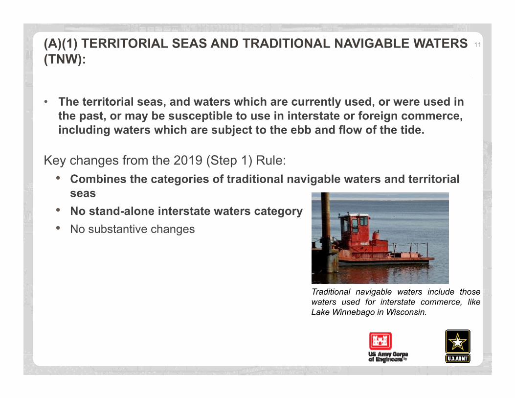
(A)(1) TERRITORIAL SEAS AND TRADITIONAL NAVIGABLE WATERS (TNW):
• The territorial seas, and waters which are currently used, or were used inthe past, or may be susceptible to use in interstate or foreign commerce,including waters which are subject to the ebb and flow of the tide.
Key changes from the 2019 (Step 1) Rule:• Combines the categories of traditional navigable waters and territorial
seas• No stand-alone interstate waters category• No substantive changes
11
Traditional navigable waters include thosewaters used for interstate commerce, likeLake Winnebago in Wisconsin.

(A)(2) TRIBUTARIES:
• “Tributary” means a naturally occurring surface water channel thatcontributes surface water flow to a paragraph (a)(1) water in a typical yeareither directly or through one or more paragraph (a)(2)-(4) waters. A tributarymust be perennial or intermittent in a typical year.
• A tributary does not lose its jurisdictional status if it contributes surface waterflow to a downstream TNW or territorial sea in a typical year through achannelized non-jurisdictional surface water feature, through a subterraneanriver, through a culvert, dam, tunnel, or similar artificial feature, or through adebris pile, boulder field, or similar natural feature.
• The alteration or relocation of a tributary does not modify its jurisdictionalstatus as long as it continues to satisfy the flow conditions of the definition.
• The term tributary includes a ditch that either relocates a tributary, isconstructed in a tributary, or is constructed in an adjacent wetland as long asthe ditch satisfies the flow conditions of this definition.
12
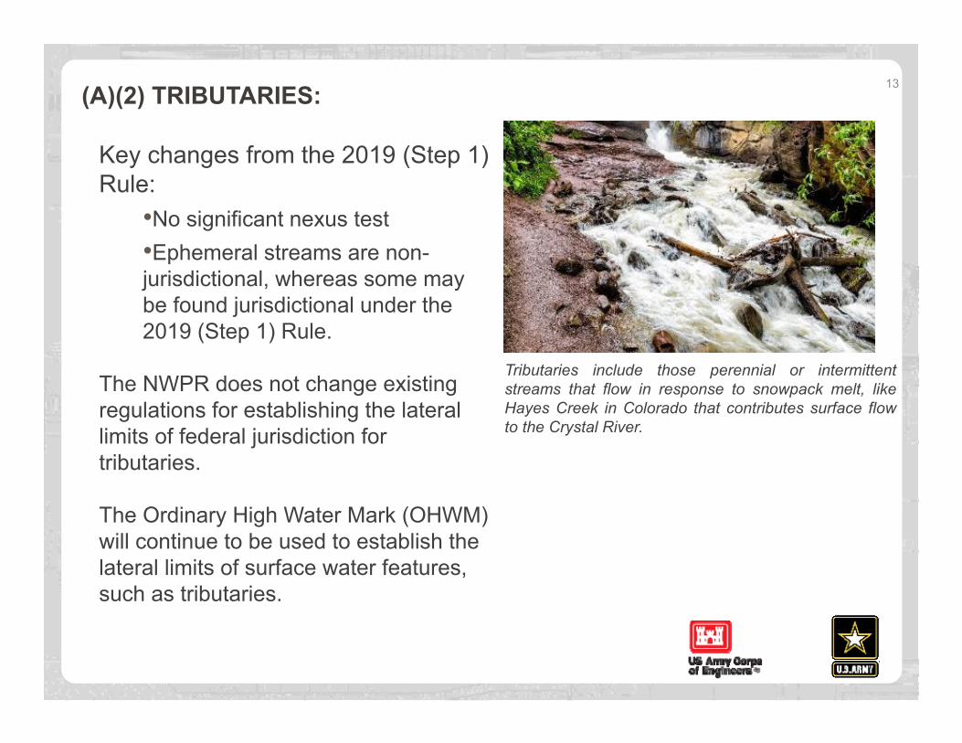
(A)(2) TRIBUTARIES: 13
Key changes from the 2019 (Step 1) Rule:
•No significant nexus test•Ephemeral streams are non-jurisdictional, whereas some maybe found jurisdictional under the2019 (Step 1) Rule.
The NWPR does not change existing regulations for establishing the lateral limits of federal jurisdiction for tributaries.
The Ordinary High Water Mark (OHWM) will continue to be used to establish the lateral limits of surface water features, such as tributaries.
Tributaries include those perennial or intermittentstreams that flow in response to snowpack melt, likeHayes Creek in Colorado that contributes surface flowto the Crystal River.

NWPR - KEY DEFINITIONS
Perennial:• The term perennial means surface water flowing continuously year-round.
Intermittent:• The term intermittent means surface water flowing continuously during certain
times of the year and more than in direct response to precipitation (e.g.,seasonally when the groundwater table is elevated or when snowpack melts).
Ephemeral:• The term ephemeral means surface water flowing or pooling only in direct
response to precipitation (e.g., rain or snow fall).
Snowpack:• The term snowpack means layers of snow that accumulate over extended
periods of time in certain geographic regions or at high elevation (e.g., innorthern climes or mountainous regions).
14
(A)(3) LAKES AND PONDS, AND IMPOUNDMENTS OF JURISDICTIONAL WATERS:
• Lakes and ponds, and impoundments of jurisdictional waters meansstanding bodies of open water that contribute surface water flow to aparagraph (a)(1) water in a typical year.
• A lake, pond, or impoundment does not lose its jurisdictional status if itcontributes surface water flow to a downstream jurisdictional water in a typicalyear through a channelized non-jurisdictional surface water feature (e.g., anephemeral stream, non-jurisdictional ditch), through a culvert, dam, tunnel, orsimilar artificial feature, or through a debris pile, boulder field, or similarnatural feature.
• A lake, pond, or impoundment is also jurisdictional if it is inundated byflooding from a paragraph (a)(1)-(3) water in a typical year.
15

(A)(3) LAKES AND PONDS, AND IMPOUNDMENTS OF JURISDICTIONAL WATERS:Key changes from the 2019 (Step 1) Rule:
• Similar to the 2019 Rule, the NWPRregulates lakes and ponds as part ofthe tributary network, but clarifiesthat other kinds of surfacehydrologic connections (e.g.,inundation by flooding from an(a)(1)-(3) water) in a typical year)can also render lakes, pond, andimpoundments jurisdictional.
• Impoundments of jurisdictionalwaters are jurisdictional only if theycontribute surface water flow to adownstream TNW or territorial seain a typical year or are inundated byflooding from an (a)(1)-(a)(3) waterin a typical year.
16
Lakes and ponds, and impoundments ofjurisdictional waters include open bodies ofsurface water that contribute surface flow to atraditional navigable water, like Christian Pond inWyoming.
(A)(4) ADJACENT WETLANDS:
The term “adjacent” means wetlands that:
• abut, meaning to touch at least at one point or side of, a paragraph (a)(1)-(3)water;
• are inundated by flooding from a paragraph (a)(1)-(3) water in a typical year;
• are physically separated from a paragraph (a)(1)-(3) water only by a naturalberm, bank, dune, or similar natural feature; or
• are physically separated from a paragraph (a)(1)-(3) water only by an artificialdike, barrier, or similar artificial structure so long as that structure allows for adirect hydrologic surface connection in a typical year through a culvert, floodor tide gate, pump, or similar artificial feature.
An adjacent wetland is jurisdictional in its entirety when a road or similar artificial structure divides the wetland, as long as the structure allows for a direct hydrologic surface connection through or over that structure in a typical year.
17
(A)(4) ADJACENT WETLANDS:
The rule does not change the long-standing definition of “wetlands.”
Key changes from the 2019 (Step 1) Rule:
• Revises long-standing definition of“adjacent.”
• No wetlands are evaluated by asignificant nexus test.
• Wetlands physically separatedfrom an (a)(1) - (a)(3) water by anartificial berm, dike, or similarartificial feature must have a directhydrologic surface connection tothe jurisdictional water in a typicalyear to be considered adjacent.
18
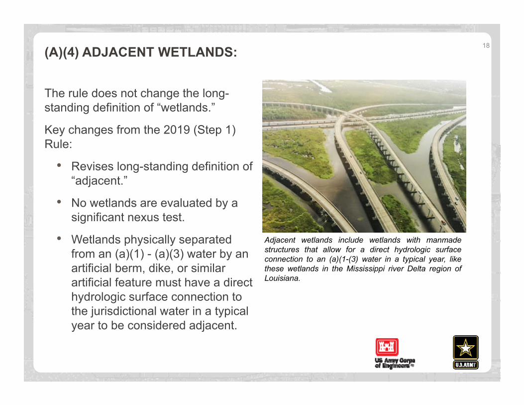
Adjacent wetlands include wetlands with manmadestructures that allow for a direct hydrologic surfaceconnection to an (a)(1-(3) water in a typical year, likethese wetlands in the Mississippi river Delta region ofLouisiana.

DITCHESThe term ditch means a constructed or excavated channel used to convey water. Ditches are not an independent category of WOTUS; ditches are jurisdictional only where they are:
• TNWs, including those subject to the ebb and flow of the tide (i.e., are(a)(1) waters);
• Either constructed in or relocate a tributary, or are constructed in anadjacent wetland, and satisfy the flow conditions of the tributary definition(i.e., are (a)(2) waters); or
• Constructed in an adjacent wetland and develop wetland characteristics(i.e., are (a)(4) waters).
Key Changes from the 2019 (Step 1) Rule:• The NWPR codifies that ditches constructed in upland (other than TNWs
and rerouted tributaries), certain ditches constructed in wetlands, andditches with ephemeral flow are not jurisdictional.
19

DEFINITION OF “TYPICAL YEAR”
• The term typical year means: “when precipitation and other climatic variablesare within the normal periodic range (e.g., seasonally, annually) for thegeographic area of the applicable aquatic resource based on a rolling thirty-yearperiod.”
• “Typical year” is a key concept for establishing jurisdiction based on surfacewater flow between a relatively permanent body of water (i.e., a perennial orintermittent surface water channel, a standing body of open water) andTNWs/territorial seas, and between wetlands and other jurisdictional waters.
• Application of the typical year concept ensures that the hydrologic flows andsurface water connections necessary to establish jurisdiction are characterizedbased on normal climatic conditions (i.e., neither too wet or too dry).
• When determining whether climatic conditions are typical, the period of timeexamined may be a year, or a shorter or longer time period, depending onfactors relevant to the water resource of interest.
20

PARAGRAPH B EXCLUSIONS: AQUATIC FEATURES EXCLUDED FROM NWPR WOTUS DEFINITION
• (b)(1) - Waters not listed as WOTUS
• (b)(2) - Groundwater
• (b)(3) - Ephemeral features
• (b)(4) - Diffuse stormwater run-off
• (b)(5) - Ditches not identified as WOTUS
• (b)(6) - Prior converted cropland (PCC)
• (b)(7) - Artificially irrigated areas
• (b)(8) - Artificial lakes and ponds
• (b)(9) - Water-filled depressions incidental to mining or construction activity
• (b)(10) - Stormwater control features
• (b)(11) - Groundwater recharge, water reuse, and wastewater recyclingstructures
• (b)(12) - Waste treatment systems
21
KEY ELEMENTS OF EXCLUSIONSUpland:
• The term upland means any land area that under normal circumstances does notsatisfy all three wetland factors (i.e., hydrology, hydrophytic vegetation, hydric soils)identified in paragraph (c)(16) and does not lie below the ordinary high water mark orthe high tide line of a jurisdictional water.
• Features constructed or excavated in upland or in non-jurisdictional waters must beconstructed/excavated wholly in upland or non-jurisdictional waters to meet applicableexclusions.
• The mere interface between the excluded feature constructed or excavated wholly in uplandand a jurisdictional water does not make that feature jurisdictional.
Exclusions as surface water connections:• Certain excluded features may convey surface water flow to a downstream jurisdictional
water in a typical year, thereby serving as a connection for upstream and downstreamjurisdictional tributaries, lakes, ponds, and impoundments. This does not includegroundwater or diffuse stormwater runoff/overland sheet flow.
• Excluded features that convey surface water flow between jurisdictional waters in atypical year do not become WOTUS themselves.
22
WATERS/FEATURES EXCLUDED FROM FINAL WOTUS DEFINITION
(b)(1) Waters not listed as WOTUS:• Categorically excludes all waters not listed as WOTUS in paragraph (a) of the
regulation.• Clarifies that a feature is not jurisdictional just because it is not explicitly
excluded in paragraph (b).• Intended to avoid confusion caused by features being called different names
across the country.• No change in practice, effectively how the 2019 Rule is implemented.
(b)(2) Groundwater:• Excludes groundwater, including groundwater drained through subsurface
drainage features.• The agencies have never interpreted WOTUS to include groundwater, and
the approach is unchanged from the 2019 Rule.
23
WATERS/FEATURES EXCLUDED FROM FINAL WOTUS DEFINITION(b)(3) Ephemeral features, including ephemeral streams, swales, gullies, rills, and pools:
• Ephemeral streams and other ephemeral features are not WOTUS under the NavigableWaters Protection Rule.
• Ephemeral features are categorically-excluded under the Navigable Waters ProtectionRule. There is no significant nexus test.
• Though not jurisdictional, these features may serve as connections between upstreamrelatively permanent waters and downstream jurisdictional waters that maintainjurisdiction of upstream waters, so long as the connection occurs in a typical year.
(b)(4) Diffuse stormwater run-off and directional sheet flow over upland:• Diffuse run-off and directional sheet flow over upland are excluded.• These features can not serve as a connection that can maintain jurisdiction of upstream
waters.• No specific exclusion for diffuse run-off or sheet flow in the 2019 Rule
24
WATERS/FEATURES EXCLUDED FROM FINAL WOTUS DEFINITION
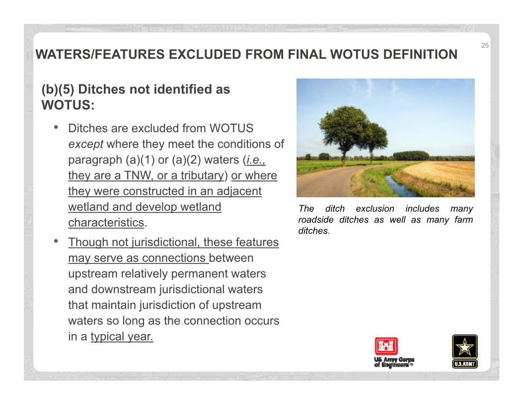
(b)(5) Ditches not identified as WOTUS:
• Ditches are excluded from WOTUSexcept where they meet the conditions ofparagraph (a)(1) or (a)(2) waters (i.e.,they are a TNW, or a tributary) or wherethey were constructed in an adjacentwetland and develop wetlandcharacteristics.
• Though not jurisdictional, these featuresmay serve as connections betweenupstream relatively permanent watersand downstream jurisdictional watersthat maintain jurisdiction of upstreamwaters so long as the connection occursin a typical year.
25
The ditch exclusion includes manyroadside ditches as well as many farmditches.
WATERS/FEATURES EXCLUDED FROM FINAL WOTUS DEFINITION
(b)(6) Prior converted cropland (PCC):• The term prior converted cropland means any area that, prior to December 23,
1985, was drained or otherwise manipulated for the purpose, or having theeffect of making production of an agricultural product possible.
• Under the NWPR, an area is no longer considered prior converted cropland forpurposes of the Clean Water Act when the area is abandoned and hasreverted to wetland. Abandonment occurs when prior converted cropland is notused for, or in support of, agricultural purposes at least once in the immediatelypreceding five years.
• Agricultural purposes includes, but is not limited to: grazing; haying; idling land for conservationpurposes (e.g., habitat; pollinator and wildlife management; and water storage, water supply, andflood management); irrigation tailwater storage; crawfish farming; cranberry bogs; nutrient retention;and idling land for soil recovery following natural disasters like hurricanes and drought.
Key change from previous practice: The NWPR only uses the abandonment principle, and no longer considers “change in use” which was implemented under the 2019 Rule.
26

WATERS/FEATURES EXCLUDED FROM FINAL WOTUS DEFINITION
(b)(7) Artificially irrigated areas:
• Excludes artificially irrigated areas, including fields flooded for agriculturalproduction, that would revert to upland should application of irrigation water tothat area cease.
(b)(8) Artificial lakes and ponds:
• Excludes artificial lakes and ponds, including water storage reservoirs andfarm, irrigation, stock watering, and log cleaning ponds, constructed orexcavated in upland or in non-jurisdictional waters, so long as those artificiallakes and ponds are not impoundments of jurisdictional waters.
(b)(9) Water-filled depressions incidental to mining or construction activity:
• Excludes water-filled depressions constructed or excavated in upland or innon-jurisdictional waters incidental to mining or construction activity, and pitsexcavated in upland or in non-jurisdictional waters for the purpose of obtainingfill, sand, or gravel.
27

WATERS/FEATURES EXCLUDED FROM FINAL WOTUS DEFINITION
(b)(10) Stormwater control features:• Excludes stormwater control features constructed or excavated in upland or
non-jurisdictional waters to convey, treat, infiltrate, or store stormwater run-off.• Exclusion helps to avoid disincentives to environmentally beneficial practices
such as green infrastructure for controlling stormwater.• In-line features that utilize rivers, streams, or other jurisdictional channels that meet the tributary
definition do not meet the exclusion
(b)(11) Groundwater recharge, water reuse, and wastewater recycling structures:
• Excludes groundwater recharge, water reuse, and wastewater recyclingstructures, including detention, retention, and infiltration basins and ponds,constructed or excavated in upland or in non-jurisdictional waters.
• Exclusion helps to avoid discouraging, or creating barriers to, water reuse andrecycling projects.
28
WATERS/FEATURES EXCLUDED FROM FINAL WOTUS DEFINITION
(b)(12) Waste treatment systems:• The term waste treatment system includes all components, including lagoons
and treatment ponds (such as settling or cooling ponds), designed to eitherconvey or retain, concentrate, settle, reduce, or remove pollutants, eitheractively or passively, from wastewater prior to discharge (or eliminating anysuch discharge).
• Waste treatment systems have been excluded from the definition of WOTUSsince 1979. The final rule defines waste treatment systems and thecomponents of the exclusion in the regulation for the first time.
29
METHODS FOR IMPLEMENTATION
Determining contribution of flow to downstream:
• The preamble to the rule provides information on the various tools, methods,datasets, and resources that may be used to inform jurisdictionaldeterminations.
• The list of sources of information mentioned in the preamble is notexhaustive, and the Corps will typically consider all relevant sources ofinformation when evaluating jurisdiction.
• Tools that may be used, for example, include USGS maps, state and localmaps, aerial photography, or other remote sensing information or models thathave been verified to be reliable to assess a feature’s flow path.
• A trace analysis in a Geographic Information System (GIS), can be used totrace the flow path from a user selected point on a map, downstream alongthe stream network until the network ends. The USGS StreamStatsapplication incorporates such a tool called the “Flow (Raindrop) Path,”available at: https://streamstats.usgs.gov/ss/.
30

METHODS FOR IMPLEMENTATION
Determining perennial or intermittent flow:
• May use a combination of the best available mapping sources, including theNHD* or local maps, as well as other remote tools and datasets such as aerialphotographs, NRCS hydrologic tools and soil maps, NOAA snow maps,desktop tools that estimate the discharge sufficient to generate intermittent orperennial flow, or modeling tools.
• * Keep in mind that NHD at High Resolution does not distinguish intermittent from ephemeralfeatures in most parts of the country and may not accurately identify on-the-ground flowconditions.
• Site visits may be needed to perform on-site observations of hydrology orcollect indicators of perennial or intermittent flow.
• Where available, streamflow duration assessment methods (SDAMs) that usephysical and biological indicators to determine the flow duration class of aparticular stream in a single site visit may be used.
• Additional information on the agencies’ efforts to develop regionally-specific SDAMs will beavailable on EPA’s website in the near future.
31
METHODS FOR IMPLEMENTATION
Sources of information used to evaluate surface flows and surface water connections should be interpreted within the context of the “typical year” concept (i.e., based on normal climatic conditions that are neither too wet nor too dry). Determining surface flow and surface water connections that occur in a typical year:
• The Corps has developed an Antecedent Precipitation Tool (APT) that collectsNOAA precipitation from nearby weather stations and compares precipitationfrom the time period of interest with precipitation data from the past 30 years,that may be used to determine whether precipitation conditions fall within thenormal range.
• Other data sources and tools that may be used to inform whether hydrologicflows or surface water connections occur under normal climatic conditionsinclude: drought indices, water-budget models, snow telemetry data,continuous flow monitor data, physical and biological indicators of typical flowconditions, or remote sensing data and hydrologic models.
32

ANTECEDENT PRECIPITATION TOOL (APT)• The APT is an automation tool that
evaluates three climatologicalparameters to assist in the making anddocumenting of various determinationsrequired by policy for the execution ofUSACE's Regulatory Program.
• Can be used to rapidly and accuratelydetermine whether any of the followingcircumstances exist for a givenlocation on a given date:
• Dry or Wet Season• Drought or Above-Normal
Precipitation Conditions• Lower than normal antecedent
precipitation• Greater than normal antecedent
precipitation• Automatically document the
basis of these decisions for theadministrative record.
33
METHODS FOR IMPLEMENTATION
Determining adjacency:
• The Corps will continue to use existing resources, methods, and practices toverify the presence of wetlands and to delineate wetland boundaries (e.g., theCorps’ 1987 Wetland Delineation Manual).
• A variety of remote tools and resources may be used to inform a wetlandjurisdictional determination, including, federal, state and local maps, aerialphotography and satellite imagery.
• Natural berms, banks, dunes, or similar natural features that physicallyseparate wetlands from jurisdictional waters may in certain instances beidentified through on-site observations or remotely using aerial photographyand satellite imagery, or other remote sensing information.
• Artificial structures that allow for a direct hydrologic surface connection (e.g.,through a culvert, tide gate, pump, or similar artificial feature) may in certaininstances be identified through on-site observations or remotely usingconstruction design plans, permitting data, state and local information, or leveeor drainage district information.
34

METHODS FOR IMPLEMENTATION
Determining inundation by flooding:• May use a combination of remote tools and datasets such as USGS stream
gage records, recurrence intervals of peak flows, wetland surface water levelrecords, flood records, aerial photography and satellite imagery, or inundationmodeling techniques and tools.
• The Corps’ Hydrologic Engineering Center’s River Analysis System (HEC-RAS) software allows users to perform inundation mapping and createinundation depth datasets. The HEC-RAS software is available for downloadat: https://www.hec.usace.army.mil/software/hec-ras/.
• Site visits may be needed to perform on-site observations of hydrology or field-based indicators of recent inundation (e.g., the presence of water marks,sediment and drift deposits, water-stained leaves, or algal mats).
35

NEXT STEPS
• Upon publication in the Federal Register, additional supporting documents suchas the agencies’ Response to Comments document will be available in thepublic docket on the Federal eRulemaking Portal (Docket ID No. EPA-HQ-OW-2018-0149, https://www.regulations.gov). These documents will also be postedon the Corps internal Jurisdiction SharePoint site.
• The Antecedent Precipitation Tool (APT) will be shared with all Corps regulatorsfor use. EPA will host a public-facing version of the APT for use by the public.
• Regionally-specific streamflow duration assessment methods (SDAMs) will bereleased over time. Additional tools may be developed in the future.
• New guidance may be developed, or existing guidance may be updated, if andas necessary, to facilitate implementation of the final rule.
36

FOR FURTHER INFORMATION
Visit https://www.epa.gov/nwpr for more information about the final rule, including the pre-publication copy, supporting analyses, and fact sheets.
Additional questions may be directed to Corps Headquarters at [email protected].
37
QUESTIONS FROM THE FIELD38
• Headquarters is developing Q&A training materials to answer commonquestions from the field.
• Written Questions should be submitted [email protected] by June 30, 2020. Please include“NWPR Q&A” in the Subject Line
• Topics for questions include, but are not limited to, the following:
• Ditches
• Tributaries
• Flow Regimes
• Downstream flowcontribution
• Adjacency
• Lakes and ponds, andImpoundments
•Inundation by flooding
•Typical year
•Exclusions
•Compliance/enforcement
•Compensatory mitigation
•Uplands