the new real estate mantra - american public ... new real estate mantra location near public...
TRANSCRIPT

THE NEW REAL ESTATE MANTRA LOCATION NEAR PUBLIC TRANSPORTATION | MARCH, 2013 1
The New Real Estate MantraLocation Near Public Transportation
The New Real Estate Mantra Location Near Public Transportation
COMMISSIONED BY
AMERICAN PUBLIC TRANSPORTATION ASSOCIATION
IN PARTNERSHIP WITH
NATIONAL ASSOCIATION OF REALTORS
PREPARED BY
THE CENTER FOR NEIGHBORHOOD TECHNOLOGY
MARCH 2013
COVER: MOCKINGBIRD STATION, DALLAS, TX Photo by DART

CONTENTS
1 Executive Summary
3 Previous Research
6 Findings
8 Phoenix
12 Chicago
17 Boston
23 Minneapolis-St. Paul
27 San Francisco
32 Conclusion
33 Methodology
THE NEW REAL ESTATE MANTRA LOCATION NEAR PUBLIC TRANSPORTATION | MARCH, 2013

ACKNOWLEDGEMENTS
Authors: Center for Neighborhood TechnologyLead Author: Sofia BeckerScott Bernstein, Linda Young
Analysis: Center for Neighborhood TechnologySofia Becker, Al Benedict, and Cindy Copp
Report Contributors and Reviewers: Center for Neighborhood Technology: Peter Haas, Stephanie MorseAmerican Public Transportation Association: Darnell GrisbyNational Association of Realtors: Darren W. Smith
Report Layout: Center for Neighborhood TechnologyKathrine Nichols
THE NEW REAL ESTATE MANTRA LOCATION NEAR PUBLIC TRANSPORTATION | MARCH, 2013

THE NEW REAL ESTATE MANTRA LOCATION NEAR PUBLIC TRANSPORTATION | MARCH, 2013 1
Executive Summary
Fueled by demographic change and concerns over quality of life, there has been a
growing interest in communities with active transportation modes. The recession
added another dimension to these discussions by emphasizing the economic impli-
cations of transportation choices. Housing and transportation, the two economic
sectors mostly closely tied to the built environment, were both severely impacted
by the economic downturn. There has been a growing effort among planners, real
estate professionals, and economists to identify not only the economic benefits
of alternative transportation modes in and of themselves, but also the impact
that they have on housing prices and value retention. The real estate mantra of
“location, location, location” is more important than ever. Moving beyond the
traditional arguments that good schools and neighborhood amenities impact hous-
ing prices, emerging research has indicated that urban form and transportation
options have played a key role in the ability of residential properties to maintain
their value since the onset of the recession.
Studies have shown that consumers are willing to pay more for housing located
in areas that exemplify new urbanist principles or are “traditional neighborhood
developments.” These neighborhoods are walkable, higher density, and have a mix
of uses as well as access to jobs and amenities such as transit.
This analysis investigates how well residential properties located in proximity to
fixed-guideway transit have maintained their value as compared to residential
properties without transit access between 2006 and 2011 in five regions: Boston,
Chicago, Minneapolis-St. Paul, Phoenix, and San Francisco. The selection of
these places for the study regions provides not only a geographic distribution, but
also an illustrative sample of the types of fixed-guideway transit systems in the US.
Minneapolis-St. Paul and Phoenix have newer light rail systems, while Boston,
Chicago, and San Francisco are mature systems dominated by heavy and com-
muter rail. Additionally, Boston is also home to one of the earlier BRT lines.
Here’s what we found:
Across the study regions, the transit shed outperformed the region as a
whole by 41.6 percent. In all of the regions the drop in average residential sales
prices within the transit shed was smaller than in the region as a whole or the
non-transit area. Boston station areas outperformed the region the most (129%),
followed by Minneapolis-St. Paul (48%), San Francisco and Phoenix (37%), and
Chicago (30%).

THE NEW REAL ESTATE MANTRA LOCATION NEAR PUBLIC TRANSPORTATION | MARCH, 2013 2
Transit type had an effect on the resilience of property values, which
benefited more from transit that was well connected and had a higher
frequency of service. Stations with higher levels of transit access saw the most
price resilience within and across regions.
No consistent trends have emerged with regards to residential property
type. For most property types, the transit shed outperformed the region, and in
Boston and Chicago this holds true for all property types.
In addition to more resilient residential property values, households living
in transit sheds had better access to jobs and lower average transportation
costs than the region as a whole.
The relative stability of property values in areas with transit access has a number
of policy implications. It helps to provide consumers and planners with better
information, and encourages greater investment in transit and more sustainable
development patterns.
FIGURE SUMMARY 1
Percent change in average residential sales prices relative to the region, 2006-11
THE NEW REAL ESTATE MANTRA LOCATION NEAR PUBLIC TRANSPORTATION | MARCH, 2013 3
Studies have shown that consumers are willing to pay more for housing located
in areas that exemplify new urbanist principles or are “traditional neighborhood
developments.” These neighborhoods are walkable, higher density, and have a
mix of uses as well as access to jobs and amenities such as transit. Tu and Eppli
used a hedonic regression model to compare the price differential between what
consumers will pay for a single-family home in a new urbanist development relative
to comparable housing in conventional suburban developments. They found that
buyers paid 4.1 to 14.9 percent more for housing in new urbanist developments
after controlling for other housing characteristics. In another study, several
measures of urban form were developed and then used to characterize neighbor-
hoods in the suburbs of Portland, Oregon. The authors found that households
were willing to pay more for homes in neighborhoods with a more connective street
network, smaller blocks, pedestrian accessibility to commercial uses, a mix of land
uses, and proximity light rail stations.
Proximity to high-capacity transit stops has been shown to increase property
values, a phenomenon known as the “transit premium.” The Center for Transit
Oriented Development (CTOD) examined a range of studies to determine the
impact of transit investments on real estate values and found that transit premiums
ranged from a few percent to over a 150 percent increase. The increases in
property values near transit were most dramatic for office and retail spaces. For
residential properties, single family dwellings had a property value premium range
of 2 percent to 32 percent; condominiums from 2 to 18 percent; and apartments
from 0-4 percent to 45 percent.
A study of select stations in San Francisco, New York, and Portland using a
hedonic regression also found that single family homes derive a premium from
transit access. Within one mile of the Pleasant Hill BART station (in the San
Francisco region) the average value of a single family home was 9 percent greater
than comparable homes outside the station area. In Queens, New York there was a
13 percent increase in value within the three station areas in the neighborhoods of
Forest Hills and Rego Park. The findings were not replicated in Portland, where
Previous Research
1. Tu, Charles C. and Mark J. Eppli. 2001. “An Empirical Examination of Traditional Neighborhood Developments,” Real Estate Economics. 29(3):
485-501.
2. Song, Yan and Gerrit-Jan Knaap. 2003. “New Urbanism and Housing Values: A Disaggregate Assessment.” National Center for Smart Growth
Research and Education, University of Maryland.
3. Center for Transit Oriented Development. 2008. “Capturing the Value of Transit.” Federal Transportation Authority.
4. Within 200 ft of at San Diego Trolley station. VNI Rainbow Appraisal Service. 1992. “Analysis of the Impact of Light Rail Transit on Real Estate
Values.” San Diego Metropolitan Transit Development Board.
5. Within 100 ft of the St. Louis LRT. Garrett, Thomas. 2004. “Light Rail Transit in America: Policy Issues and Prospects for Economic Development.”
Federal Reserve Bank of St. Louis.
6. Within 2,640 ft of a San Diego Trolley station. Cervero, Robert et al. 2002. “Land Value Impacts of Rail Transit Services in San Diego County.”
Urban Land Institute.
7. Within 2,640 ft of a San Diego Trolley station. Cervero, Robert et al. 2002. “Land Value Impacts of Rail Transit Services in San Diego County.”
Urban Land Institute.
8. Within 1,320 ft of a Santa Clara Valley LRT. Cervero, Robert. 2002. “Benefits of Proximity to Rail on Housing Markets: Experiences in Santa Clara
County.” Journal of Public Transportation. 5(1): 1-18.

THE NEW REAL ESTATE MANTRA LOCATION NEAR PUBLIC TRANSPORTATION | MARCH, 2013 4
three stations along the East Burnside corridor were studied, and the authors
postulate that this is a result of proximity to heavy traffic since Portland’s light
rail runs down a major arterial. However, there was a slight increase in property
values when homes were within the one mile radius but more than 2,000 ft from
the roadway and transit line. Additionally, they speculate that the near absence of
a transit premium could be due to differences in the service characteristics of light
rail as compared to the heavy rail studied in San Francisco and New York. Ranges
in premiums are impacted by numerous factors, including the local regulatory
environment, transit service characteristics and connections, and national and
regional economies.
Research on other active transportation modes, namely walking, has shown that
walkable neighborhoods also result in higher property values. Using WalkscoreTM
data as a measure of walkability, a positive correlation between walkability and
housing prices was found in 13 out of 15 metropolitan areas (with Las Vegas and
Bakersfield being the exceptions). Walkscore is measured on a scale of 1 to 100 and
the study found that one additional point of improvement in the average Walkscore
adds between $700 and $3,000 to the value of a typical home, all other mitigating
factors being constant. A study of neighborhoods in the Washington D.C. region
also found that there was a premium associated with walkability in the form of
an increase in office, residential and retail rents, retail revenues, and for-sale
residential values. The recession increased the premium for retail and office space
in walkable urban neighborhoods; pre-recession (defined as 2000-07) there was
a 23 percent premium per square foot valuation, during the recession (2008-10) it
jumped to 44.3 percent.
Additional evidence that properties in location efficient areas have performed bet-
ter during the recession comes from a study on mortgage default. Using a sample
of over 40,000 mortgages in Chicago, Jacksonville, and San Francisco, researchers
modeled the probability of mortgage default based on differences in location
efficiency. Two proxy variables were used to measure location efficiency, vehicles
per household scaled by income and Walkscore. In all three cities, the probability
of mortgage default increased as the auto ownership rates rose. In high income
areas the likelihood of default decreased with increases in Walkscore (associated
with higher walkability); the results did not hold true in low income areas however.
This paper investigates how well residential properties located in proximity to
9. Lewis-Workman, Steven and Daniel Brod. 1997. “Measuring the Neighborhood Benefits of Rail Transit Accessibility.” Transportation Research
Record. 1576(1): 147-153.
10. Cortright, Joe. 2009. “Walking the Walk.” CEOs for Cities.
11. Leinberger, Christopher B. and Mariela Alfonzo. 2012. “Walk this Way: The Economic Promise of Walkable Places in Metropolitan Washington,
D.C.” Brookings Institute.
12. Rauterkus, Stephanie Y., Grant I. Thrall, and Eric Hangen. 2010. “Location Efficiency and Mortgage Default.” Journal of Sustainable Real
Estate.2(1).
THE NEW REAL ESTATE MANTRA LOCATION NEAR PUBLIC TRANSPORTATION | MARCH, 2013 5
fixed-guideway transit have maintained their value as compared to residential
properties without transit access in five regions: Boston, Chicago, Minneapolis-St.
Paul, Phoenix, and San Francisco. The relative stability of property values in areas
with transit access has a number of policy implications. It helps to provide consum-
ers and planners with better information, and encourages greater investment in
transit and more sustainable development patterns.

THE NEW REAL ESTATE MANTRA LOCATION NEAR PUBLIC TRANSPORTATION | MARCH, 2013 6
Overall there was a substantial decline in average residential sales prices in the
study regions between 2006 and 2011. However, in all of the regions, the decline
in average residential sales prices within the transit shed was lower than in the
region as a whole or the non-transit area. Across the study regions, the transit
shed outperformed the region as a whole by 41.6 percent. Figure 1 shows the
percent change in average residential sales prices in the transit shed and non-
transit area relative to the regional percent change in price.
Within a given region, heavy rail, light rail, and BRT transit sheds held their value
best. In addition to having higher frequency service and better transit connectiv-
ity, these types of fixed-guideway transit stations also tend to be located in areas
that are more walkable, have higher residential density, and better access to jobs.
Commuter rail sheds also saw a smaller decline in average residential sales prices
than the region as a whole.
FIGURE 1
Percent change in average residential sales prices relative to the region, 2006-11
Findings

THE NEW REAL ESTATE MANTRA LOCATION NEAR PUBLIC TRANSPORTATION | MARCH, 2013 7
No consistent trends have emerged with regards to residential property type. For
most property types, the transit shed outperformed the region, and in Boston and
Chicago this holds true for all property types. Data was not available to perform a
breakout by property type in the Minneapolis-St. Paul region.
13. Boston’s rapid transit stations which consist of both heavy and light rail transit are included in the heavy rail category here.
FIGURE 2
Percent change in average residential sales prices relative to the region of single family homes,
2006-11
THE NEW REAL ESTATE MANTRA LOCATION NEAR PUBLIC TRANSPORTATION | MARCH, 2013 8
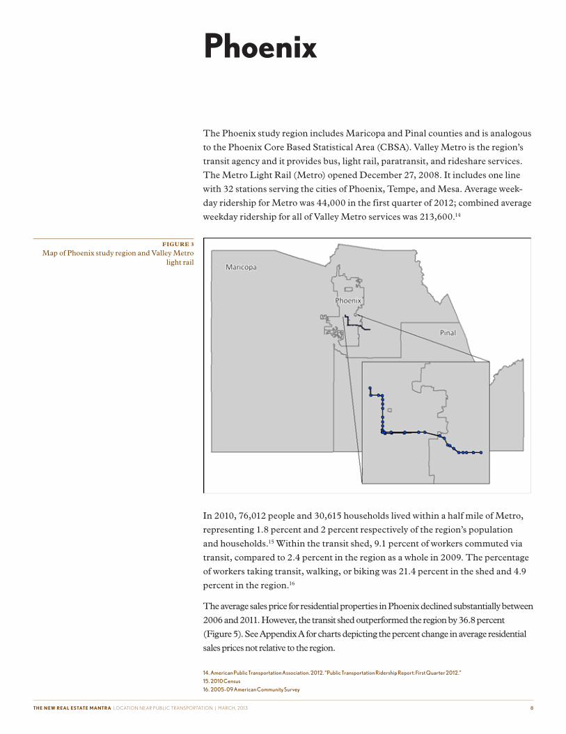
The Phoenix study region includes Maricopa and Pinal counties and is analogous
to the Phoenix Core Based Statistical Area (CBSA). Valley Metro is the region’s
transit agency and it provides bus, light rail, paratransit, and rideshare services.
The Metro Light Rail (Metro) opened December 27, 2008. It includes one line
with 32 stations serving the cities of Phoenix, Tempe, and Mesa. Average week-
day ridership for Metro was 44,000 in the first quarter of 2012; combined average
weekday ridership for all of Valley Metro services was 213,600.14
In 2010, 76,012 people and 30,615 households lived within a half mile of Metro,
representing 1.8 percent and 2 percent respectively of the region’s population
and households.15 Within the transit shed, 9.1 percent of workers commuted via
transit, compared to 2.4 percent in the region as a whole in 2009. The percentage
of workers taking transit, walking, or biking was 21.4 percent in the shed and 4.9
percent in the region.16
The average sales price for residential properties in Phoenix declined substantially between
2006 and 2011. However, the transit shed outperformed the region by 36.8 percent
(Figure 5). See Appendix A for charts depicting the percent change in average residential
sales prices not relative to the region.
Phoenix
14. American Public Transportation Association. 2012. “Public Transportation Ridership Report: First Quarter 2012.”
15. 2010 Census
16. 2005-09 American Community Survey
FIGURE 3
Map of Phoenix study region and Valley Metro light rail

THE NEW REAL ESTATE MANTRA LOCATION NEAR PUBLIC TRANSPORTATION | MARCH, 2013 9
Among individual transit zones, the Smith-Martin/Apache station had the high-
est percent change in average sales price relative to the regional percent change
(528.9%). Appendix B includes a complete list of the change in average sales price
for all transit zones.
FIGURE 4
Percent change in average residential sales prices relative to the region in Phoenix, 2006-11
FIGURE 5
Percent change in average residential sales prices relative to the region by transit zone in Phoenix,
2006-11

THE NEW REAL ESTATE MANTRA LOCATION NEAR PUBLIC TRANSPORTATION | MARCH, 2013 1 0
Examining the change in average sales price by property type shows that all
property types did not benefit equally from access to transit. Apartment buildings
within the transit shed experienced the smallest decline in average sales price (see
Appendix A), and per Figure 7, differed the most from the region.17 Average sales
prices for condominiums and 2-4 plexes also experienced smaller declines in the
transit shed than in the region or non-transit area. Single family homes, however,
performed better outside of the transit shed.
Residential properties in the transit shed not only have access to fixed-guideway
transit, overall they have substantially better transit connectivity and higher levels
of service than the region as a whole. CNT developed two measures of transit
access, the Transit Connectivity Index (TCI) and Transit Access Shed. TCI is
based on the number of bus stops and train stations that are accessible in a given
neighborhood; it is scaled by frequency and weighted by distance from the transit
stop. Within the transit shed the average TCI is 23,096 rides per week, more than
five times greater than the regional average of 4,438. The Transit Access Shed
is the area accessible from any neighborhood within 30 minutes by public trans-
portation (allowing for one transfer), scaled by frequency of service. In the transit
shed, the average area accessible by transit within a half an hour is 318.5 km2; in
the region as a whole the average transit access shed is 96.0 km2.
FIGURE 6
Percent change in average residential sales price relative to the region by property type in Phoenix,
2006-11
17. Apartment buildings defined as five or more units
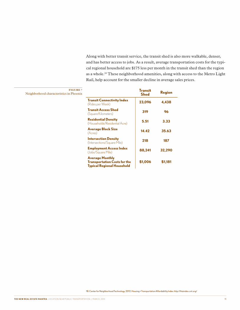
THE NEW REAL ESTATE MANTRA LOCATION NEAR PUBLIC TRANSPORTATION | MARCH, 2013 1 1
Along with better transit service, the transit shed is also more walkable, denser,
and has better access to jobs. As a result, average transportation costs for the typi-
cal regional household are $175 less per month in the transit shed than the region
as a whole.18 These neighborhood amenities, along with access to the Metro Light
Rail, help account for the smaller decline in average sales prices.
18. Center for Neighborhood Technology. 2012. Housing + Transportation Affordability Index. http://htaindex.cnt.org/
Transit Shed Region
Transit Connectivity Index(Rides per Week) 23,096 4,438
Transit Access Shed(Square Kilometers) 319 96
Residential Density (Households/Residential Acre) 5.51 3.33
Average Block Size (Acres) 14.42 35.63
Intersection Density (Intersections/Square Mile) 218 187
Employment Access Index(Jobs/Square Mile) 88,241 32,290
Average Monthly Transportation Costs for the Typical Regional Household
$1,006 $1,181
FIGURE 7
Neighborhood characteristics in Phoenix

THE NEW REAL ESTATE MANTRA LOCATION NEAR PUBLIC TRANSPORTATION | MARCH, 2013 1 2
The Chicago study region includes Cook, DuPage, Kane, Kendall, Lake,
McHenry, and Will counties in Illinois and is not directly comparable to the
Chicago CBSA. Three transit agencies serve the Chicago study region: Metra,
the Chicago Transit Authority (CTA), and PACE, with Metra and the CTA
providing fixed-guideway transit service. Metra is a commuter rail system with
240 stations on 11 lines. In addition to bus service, the CTA has eight heavy rail
lines with a total of 144 stations. Average weekday ridership for Metra in the first
quarter of 2012 was 304,300. For the CTA subway, ridership was 709,700 and the
combined bus and rail total for the CTA was 1,711,900.19
Chicago
19. APTA, 2012.
FIGURE 8
Map of Chicago study region, CTA rail, and Metra rail

THE NEW REAL ESTATE MANTRA LOCATION NEAR PUBLIC TRANSPORTATION | MARCH, 2013 1 3
In 2010, 1,944,836 people and 801,900 households lived within a half a mile of a
CTA or Metra station, representing 23.1 percent and 26 percent, respectively, of
the study region’s population and households. Both population and households
were fairly evenly distributed between the CTA and Metra sheds.20, 21 Within
the CTA transit shed 31.7 percent of workers commuted via transit in 2009,
compared to 18.5 percent in the Metra transit shed, and 12.6 percent in the region
as a whole. In the same year, the percentage of workers taking transit, walking,
or biking was 41.8 percent in the CTA shed, 25.3 percent in the Metra shed, and
16.3 percent in the region.22
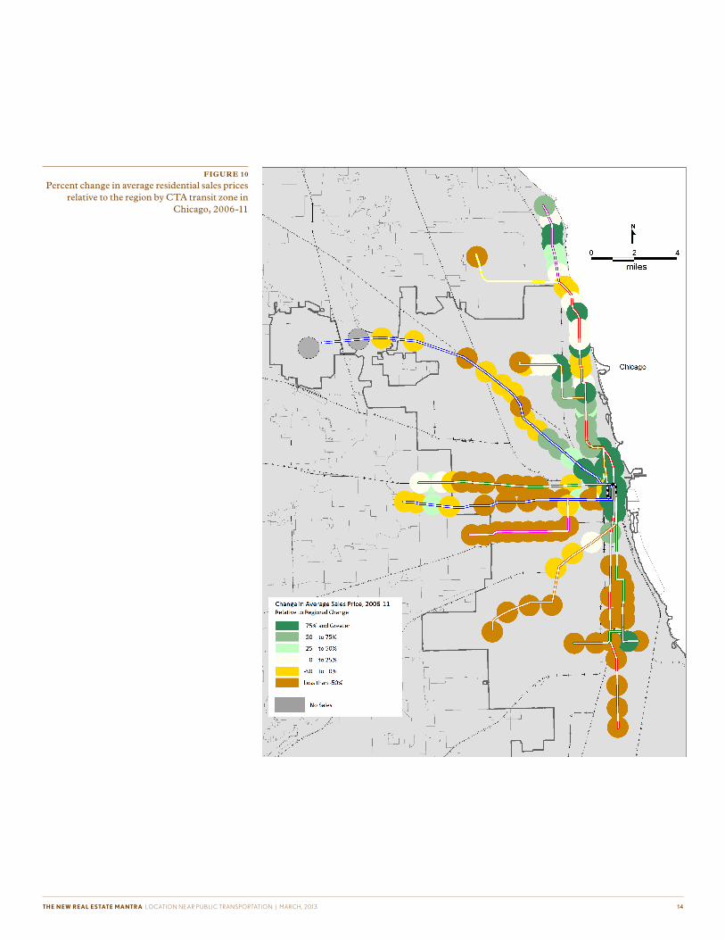
The average sales price for residential properties in the Chicago region declined
by nearly a third between 2006 and 2011 (see Appendix A). Prices in the transit
shed outperformed the region by 29.7 percent (Figure 10). The CTA shed was
the most resilient and did 47.3 percent better than the region; the Metra shed was
22.7 percent better.
Figure 11 shows the percent change in average sales prices relative to the region
within individual CTA transit zones; the Noyes Purple Line station has the
largest change at 549.5 percent. Appendix B includes a complete list of the change
in average sales price for all transit zones.
FIGURE 9
Percent change in average residential sales prices relative to the region in Chicago, 2006-11
20. 1,070,837 people and 471,365 households lived in the CTA shed; for Metra the numbers were 1,043,796 and 412,337.
21. 2010 Census
22. 2005-09 American Community Survey
THE NEW REAL ESTATE MANTRA LOCATION NEAR PUBLIC TRANSPORTATION | MARCH, 2013 1 4
FIGURE 10
Percent change in average residential sales prices relative to the region by CTA transit zone in
Chicago, 2006-11

THE NEW REAL ESTATE MANTRA LOCATION NEAR PUBLIC TRANSPORTATION | MARCH, 2013 1 5
For Metra transit zones, the change in average sales prices relative to the region
was the greatest at the 103rd St (Rosemoor) station on the Metra Electric Line in
Chicago (461.4%).
FIGURE 11
Percent change in average residential sales prices relative to the region by Metra transit zone in
Chicago, 2006-11

THE NEW REAL ESTATE MANTRA LOCATION NEAR PUBLIC TRANSPORTATION | MARCH, 2013 1 6
The CTA and Metra transit shed performed better than the region and the non-
transit area for all property types. Townhomes in the transit shed experienced the
smallest decline in average sales price (see Appendix A). Additionally, the transit
shed for townhomes outperformed the region more than any of the other property
types, by 63 percent (Figure 13).
In addition to having more stable average residential sales prices, the CTA transit
shed also has lower household transportation costs. As a result of better access
to jobs and transit, higher residential density, and more walkable streets, the
typical regional household spends significantly less on transportation –nearly
$300 a month– within the CTA transit shed as compared to the regional average.
The Metra transit shed is also more location efficient than the region, but not as
efficient as the CTA shed.
FIGURE 12
Percent change in average residential sales price relative to the region by property type in
Chicago, 2006-11
FIGURE 13
Neighborhood characteristics in Chicago
CTA Transit Shed
Metra Transit Shed Region
Transit Connectivity Index (Rides per Week) 95,712 46,876 29,997
Transit Access Shed (Square Kilometers) 714 468 258
Residential Density (Households/Residential Acre) 16.65 6.41 4.51
Average Block Size (Acres) 5.04 6.91 14.91
Intersection Density (Intersections/Square Mile) 586 391 303
Employment Access Index (Jobs/Square Mile) 139,908 77,513 56,300
Average Monthly Transportation Costs for the Typical Regional Household $775 $990 $1,074
23. CNT, 2012.

THE NEW REAL ESTATE MANTRA LOCATION NEAR PUBLIC TRANSPORTATION | MARCH, 2013 17
Boston’s study region covers Essex, Middlesex, Norfolk, Plymouth, and Suffolk
counties and does not correspond to the CBSA. One transit agency serves the
Boston region, the Massachusetts Bay Transportation Authority (MBTA). In
addition to bus service, MBTA provides five types of fixed-guideway transit ser-
vice: commuter rail, heavy rail, light rail, bus rapid transit, and ferry boat. For this
analysis the heavy rail and light rail are grouped together under “rapid transit” and
the ferry boats are excluded. There are other ferry providers in the Boston region
that are also not examined here. There are 12 commuter rail lines with a total of
134 stations (123 of which fall within the area of analysis), four rapid transit lines
with 121 stations, and one BRT line with 35 stations. Average weekday ridership
for MBTA in the first quarter of 2012 was 1,317,800.24 For commuter rail, average
weekday ridership was 130,700 and for rapid transit it was 758,900.
Boston
FIGURE 14
Map of Boston study region and MBTA fixed-guideway transit
24. APTA, 2012.

THE NEW REAL ESTATE MANTRA LOCATION NEAR PUBLIC TRANSPORTATION | MARCH, 2013 1 8
In 2010, 934,403 people in 382,911 households lived within a half mile of the
MBTA stations included in this analysis, representing 22.9 percent of the study
region’s population and 24.3 percent of the households.25 Within the transit shed
33.8 percent of workers commuted via transit, compared to 13.1 percent in the
region in 2009. Over half (52.9%) of workers in the shed used transit, walked, or
biked; in the region the figure was 19.1 percent.26
Between 2006 and 2011 the transit shed outperformed the region by 128.7 per-
cent (Figure 16).The rapid transit shed did 226.7 percent better than the region as
whole (Figure 16) and was primarily responsible for the increase in prices in the
overall transit shed (see Appendix A). Although prices declined in the commuter
rail shed slightly more than the regional average, the shed still fared better than
the non-transit area.
FIGURE 15
Percent change in average residential sales prices relative to the region in Boston, 2006-11
25. 2010 Census
26. 2005-09 American Community Survey
27. Prices fell in the non-transit areas for rapid transit (-12.5%), commuter rail (-8.4%), and BRT (-9.3%) as well.

THE NEW REAL ESTATE MANTRA LOCATION NEAR PUBLIC TRANSPORTATION | MARCH, 2013 1 9
Within individual rapid transit zones, the station area with the highest percent
change in average sales prices relative to the region was the Mattapan station on
the Red Line (Mattapan High-Speed Line portion) at 3,437 percent. Appendix B
includes a complete list of the change in average sales price for all transit zones.
FIGURE 16
Percent change in average residential sales prices relative to the region by rapid transit zone in
Boston, 2006-11

THE NEW REAL ESTATE MANTRA LOCATION NEAR PUBLIC TRANSPORTATION | MARCH, 2013 2 0
The Bradford commuter rail transit zone on the Haverhill Line performed 1,090.8
percent better than the region.
FIGURE 17
Percent change in average residential sales prices relative to the region by commuter rail transit
zone in Boston, 2006-11

THE NEW REAL ESTATE MANTRA LOCATION NEAR PUBLIC TRANSPORTATION | MARCH, 2013 2 1
For BRT transit zones, the largest percent change in average residential sales
prices relative to the region was at the Washington St at E Berkeley St station
(316.6%).
Large apartment buildings (with nine or more units) showed the most dramatic
increase in value across geographies. Condos were the only other property type
that saw an increase in average price in the transit shed and region (see Appendix
A). However, the other property types –single family, townhouse, and 4-8 unit
apartments- still held their value better in the transit shed than the region or
non-transit area (Figure 20).
FIGURE 18
Percent change in average residential sales prices relative to the region by BRT transit zone in
Boston, 2006-11

THE NEW REAL ESTATE MANTRA LOCATION NEAR PUBLIC TRANSPORTATION | MARCH, 2013 2 2
Transportation costs for the typical regional household are significantly lower
within the BRT transit shed than the region overall. Households located in the
BRT shed have the best access to transit and jobs, and live in the most walkable
neighborhoods. The rapid transit shed is also very location efficient. Although
the commuter rail shed had higher household transportation costs than the other
sheds, it is still more efficient and affordable in terms of household transportation
costs than the region overall.
FIGURE 19
Percent change in average residential sales price relative to the region by property type in Boston,
2006-11
FIGURE 20
Neighborhood characteristics in Boston28
Commuter Rail
Transit Shed
Rapid Transit Shed
BRT Transit Shed Region
Transit Connectivity Index(Rides per Week) 130,776 258,652 444,556 64,582
Transit Access Shed(Square Kilometers) 843 1,336 2,160 389
Residential Density (Households/Residential Acre) 6.64 13.93 29.01 4.14
Average Block Size (Acres) 8.34 5.13 3.61 24.62
Intersection Density (Intersections/Square Mile) 478 634 859 293
Employment Access Index(Jobs/Square Mile) 101,880 170,334 305,279 57,363
Average Monthly Transportation Costs for the Typical Regional Household
$955 $746 $636 $1,097
28. CNT, 2012.

THE NEW REAL ESTATE MANTRA LOCATION NEAR PUBLIC TRANSPORTATION | MARCH, 2013 2 3
Anoka, Carver, Dakota, Hennepin, Ramsey, Scott, and Washington are the
counties in Minnesota covered by this analysis; the study region is smaller than
the Minneapolis-St. Paul-Bloomington MN-WI CBSA. The primary transit
provider for the Minneapolis region is Metro Transit, which has two types of
fixed-guideway service, the Hiawatha light rail line and the Northstar commuter
rail line. The Hiawatha Line opened in June of 2004 and has 19 stations; the
Northstar commuter rail opened November 16, 2009 and has 6 stations (4 of
which are included in this analysis). In the first quarter of 2012, average weekday
ridership on the Hiawatha line was 27,100 and was 2,100 on the Northstar line.
Metro Transit’s total average weekday ridership was 260,500.29
Minneapolis-St. Paul
FIGURE 21
Map of Minneapolis-St. Paul study region, Hiawatha LRT, and Northstar commuter rail
29. APTA, 2012.
THE NEW REAL ESTATE MANTRA LOCATION NEAR PUBLIC TRANSPORTATION | MARCH, 2013 24
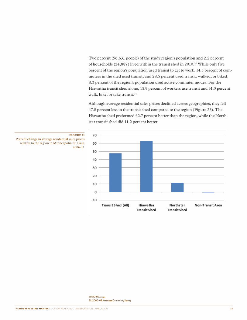
Two percent (56,631 people) of the study region’s population and 2.2 percent
of households (24,887) lived within the transit shed in 2010.30 While only five
percent of the region’s population used transit to get to work, 14.5 percent of com-
muters in the shed used transit, and 28.5 percent used transit, walked, or biked;
8.3 percent of the region’s population used active commuter modes. For the
Hiawatha transit shed alone, 15.9 percent of workers use transit and 31.3 percent
walk, bike, or take transit.31
Although average residential sales prices declined across geographies, they fell
47.8 percent less in the transit shed compared to the region (Figure 23). The
Hiawatha shed preformed 62.7 percent better than the region, while the North-
star transit shed did 11.2 percent better.
FIGURE 22
Percent change in average residential sales prices relative to the region in Minneapolis-St. Paul,
2006-11
30. 2010 Census
31. 2005-09 American Community Survey

THE NEW REAL ESTATE MANTRA LOCATION NEAR PUBLIC TRANSPORTATION | MARCH, 2013 2 5
On the Hiawath Line, the Government Plaza station transit zone (76.1%) had the
highest percent change in average residential sales prices relative to the region,
while on the Northstar Line it was the Target Field station (30.7%).
FIGURE 23
Percent change in average residential sales prices relative to the region by transit zone in
Minneapolis-St. Paul, 2006-11

THE NEW REAL ESTATE MANTRA LOCATION NEAR PUBLIC TRANSPORTATION | MARCH, 2013 26
Data was not available to do a breakout by property type in the Minneapolis-St.
Paul region.
Transit accessible neighborhoods in Minneapolis-St. Paul are more location
efficient than the region as a whole. Neighborhoods with access to light rail were
more efficient than those with access to commuter rail, but both types of fixed-
guideway transit service helped to provide residents with substantially better transit
connectivity and access.
FIGURE 24
Neighborhood characteristics in Minneapolis-St. Paul32
Hiawatha Transit Shed
Northstar Transit Shed Region
Transit Connectivity Index(Rides per Week) 128,011 97,204 20,101
Transit Access Shed(Square Kilometers) 1,314 1,104 253
Residential Density (Households/Residential Acre) 9.31 5.03 3.13
Average Block Size (Acres) 6.20 9.49 34.74
Intersection Density (Intersections/Square Mile) 268 211 151
Employment Access Index(Jobs/Square Mile) 132,132 108,354 37,484
Average Monthly Transportation Costs for the Typical Regional Household
$840 $977 $1,164
32. CNT, 2012.

THE NEW REAL ESTATE MANTRA LOCATION NEAR PUBLIC TRANSPORTATION | MARCH, 2013 27
The San Francisco study region covers Alameda, Contra Costa, Marin, San
Francisco, and San Mateo counties, the same counties included in the San
Francisco-Oakland-Fremont, CA CBSA. There are a number of transit providers
in the region and the ones included in the study are: Altamont Commuter Express
(ACE), Bay Area Rapid Transit (BART), Caltrain, Capital Corridor, and San
Francisco Municipal Transportation Agency (SFMTA). As with the Boston
analysis, ferry services are excluded. ACE, Caltrain, and Capital Corridor transit
agencies all provide commuter rail service on a single line; respectively, they have
10 stations (4 of which are included in the analysis), 32 stations (16 within the
study region), and 17 stations (8 stations included). BART has 44 stations on five
heavy rail lines. SFMTA has 7 light rail lines, 3 cable car lines, and a streetcar
line with a total of 255 stations. In the first quarter of 2010, ACE had an average
weekday ridership of 3,100; Caltrain 42,400; Capital Corridor 5,700; and BART
383,700. SFMTA’s total average weekday ridership was 690,100, on the cable cars
it was 18,800, and on the light rail lines it was 164,900.33
San Francisco
FIGURE 25
Map of San Francisco study region and fixed-guideway transit systems
33. APTA, 2012.
THE NEW REAL ESTATE MANTRA LOCATION NEAR PUBLIC TRANSPORTATION | MARCH, 2013 28
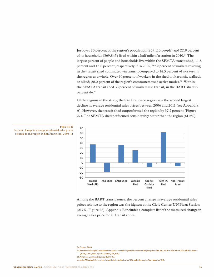
Just over 20 percent of the region’s population (869,110 people) and 22.8 percent
of its households (369,845) lived within a half mile of a station in 2010.34 The
largest percent of people and households live within the SFMTA transit shed, 11.8
percent and 13.8 percent, respectively.35 In 2009, 27.9 percent of workers residing
in the transit shed commuted via transit, compared to 14.5 percent of workers in
the region as a whole. Over 40 percent of workers in the shed took transit, walked,
or biked; 20.2 percent of the region’s commuters used active modes.36 Within
the SFMTA transit shed 33 percent of workers use transit, in the BART shed 29
percent do.37
Of the regions in the study, the San Francisco region saw the second largest
decline in average residential sales prices between 2006 and 2011 (see Appendix
A). However, the transit shed outperformed the region by 37.2 percent (Figure
27). The SFMTA shed performed considerably better than the region (61.6%).
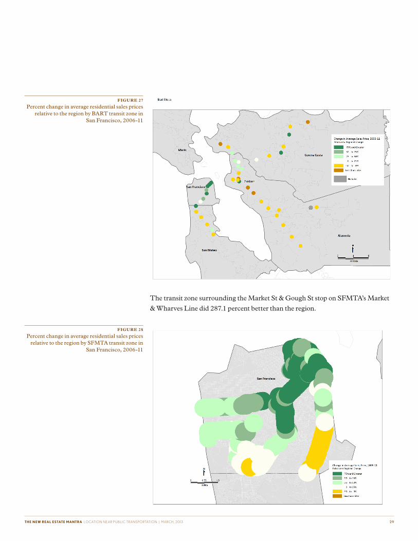
Among the BART transit zones, the percent change in average residential sales
prices relative to the region was the highest at the Civic Center/UN Plaza Station
(217%, Figure 28). Appendix B includes a complete list of the measured change in
average sales price for all transit zones.
FIGURE 26
Percent change in average residential sales prices relative to the region in San Francisco, 2006-11
34. Census, 2010.
35. Percent of the region’s population and households residing in each of the transit agency sheds: ACE (0.4%, 0.4%), BART (8.6%, 9.8%), Caltrain
(2.5%, 2.8%), and Capital Corridor (1.1%, 1.1%).
36. American Community Survey, 2005-09.
37. In the ACE shed 5% of workers is transit, in the Caltrain shed 16%, and in the Capital Corridor shed 18%.
THE NEW REAL ESTATE MANTRA LOCATION NEAR PUBLIC TRANSPORTATION | MARCH, 2013 2 9
The transit zone surrounding the Market St & Gough St stop on SFMTA’s Market
& Wharves Line did 287.1 percent better than the region.
FIGURE 27
Percent change in average residential sales prices relative to the region by BART transit zone in
San Francisco, 2006-11
FIGURE 28
Percent change in average residential sales prices relative to the region by SFMTA transit zone in
San Francisco, 2006-11

THE NEW REAL ESTATE MANTRA LOCATION NEAR PUBLIC TRANSPORTATION | MARCH, 2013 3 0
Of the commuter transit zones (ACE, Caltrain, and Capital Corridor), the Jack
London Station on the Capital Corridor Line saw the largest increase in average
residential sales prices relative to the region at 156 percent.
Not all property types in the San Francisco region performed better in the transit
shed. Multi-family residences with five or more units saw a very slight decline in
average residential sales prices in the transit shed, but increased in the non-transit
area (see Appendix A). Sales prices for single family homes, condos, and smaller
multi-family dwellings fell less in the transit shed than in the region; Figure 31
shows the percent change by property type in the transit shed and non-transit area
relative to the regional percent change for each property type.
FIGURE 29
Percent change in average residential sales prices relative to the region by commuter rail transit
zone in San Francisco, 2006-11

THE NEW REAL ESTATE MANTRA LOCATION NEAR PUBLIC TRANSPORTATION | MARCH, 2013 3 1
The SFMTA and BART transit sheds are more location efficient than the com-
muter rail transit sheds, which likely contributed to the smaller declines in average
residential sales prices in these sheds.
FIGURE 30
Percent change in average residential sales price relative to the region by property type in San
Francisco, 2006-11
FIGURE 31
Neighborhood characteristics in San Francisco
ACE BART Caltrain Capital Corridor SFMTA Region
Transit Connectivity Index(Rides per Week) 4,447 145,989 39,488 24,270 242,233 52,012
Transit Access Shed(Square Kilometers) 112 587 148 363 603 202
Residential Density (Households/Residential Acre) 5.25 11.54 8.25 8.27 18.09 5.36
Average Block Size (Acres) 12.47 5.94 6.64 7.14 4.40 20.42
Intersection Density (Intersections/Square Mile) 312 491 291 341 568 300
Employment Access Index(Jobs/Square Mile) 25,762 128,140 75,714 51,153 172,581 56,933
Average Monthly Transportation Costs for the Typical Regional Household
$1,207 $898 $1,084 $1,087 $746 $1,112
THE NEW REAL ESTATE MANTRA LOCATION NEAR PUBLIC TRANSPORTATION | MARCH, 2013 3 2
Data from all the regions studied shows that average sales prices for residences in
close proximity to fixed-guideway transit were more stable during the recession,
supporting the assertion that transit access helped mitigate the effects of the reces-
sion on property values. Compact neighborhoods in transit zones with walkable
streets, access jobs, and a wide variety of services have high location efficiency,
which also contributes positively to property value and reduces household trans-
portation expenses.
Transit type also had an effect on the resilience of property values, which benefited
more from transit that was well connected and had a higher frequency of service.
Although most commuter rail transit sheds still saw a smaller decline in average
residential sales prices than the region as a whole, heavy rail, BRT, and light
rail transit sheds outperformed commuter rail transit sheds within and across
regions. Heavy rail transit sheds had significantly higher levels of transit access,
as measured by the Transit Connectivity Index and the Transit Access Shed, than
the commuter rail sheds. Average monthly household transportation costs were
also substantially lower in the heavy rail than the commuter rail sheds, indicating
that the heavy rail sheds had not only higher levels of transit service, but were more
location efficient overall. For most property types, the transit shed outperformed
the region; however, unlike with transit type, there were no consistent trends
across regions.
In addition to providing consumers and planners with information, the findings
support investment in transit and encourage development in location efficient
areas. The presence of fixed-guideway transit not only benefits individual property
owners, it also supports a more resilient tax base.
Conclusion

THE NEW REAL ESTATE MANTRA LOCATION NEAR PUBLIC TRANSPORTATION | MARCH, 2013 3 3
Methodology
The study utilized recorder of deeds sales prices from 2006 and 2011 for resi-
dential properties in the Boston, Chicago, Minneapolis-St. Paul, Phoenix, and
San Francisco regions. Data included sales of single family homes, apartments,
condominiums, and townhomes. In Minneapolis-St. Paul, the data only included
information on owner-occupied properties. Recorder of deeds data was used in the
analysis because it shows actual sales prices, not a self-reported value. The loca-
tions of fixed-guideway transit stations, as well as station area characteristics, were
pulled from the Center for Transit Oriented Development’s (CTOD) National
TOD Database.
Data was analyzed at four different geographies: the region, the transit zone, the
transit shed, and the non-transit area. Some regions are limited by data availabil-
ity, but where possible the regions matched the Census-defined Core Based Sta-
tistical Area (CBSA). A half mile buffer was created around each fixed-guideway
transit station in the five study regions to create the transit zones. Transit sheds, an
aggregation of transit zones that eliminates double counting, were constructed for
all existing transit stations in the region, by agency, and by type of fixed-guideway
transit. The non-transit area consists of the regional geography minus the land
area covered by the existing transit half mile shed.
Recorder of deeds sales price data was geocoded for both years. For 2006 and
2011 data the average sales price of properties located within each of the four
geographies was calculated. Averages were then determined for all the residential
properties together and by property type. The property type classifications
differed slightly between regions. Data from 2006 was converted into 2011 dollars
to adjust for inflation. The percent change in sales prices from 2006 to 2011 was
then evaluated for all the different geographies and property type. Averages across
regions and agencies are weighted by the number of stations. Graphs in the body
of the report show the percent change relative to the regional percent change as
opposed the actual percent change in average residential sales prices; this informa-
tion is available in Appendix A.
Some supplementary data is drawn from the Center for Neighborhood Technol-
ogy’s (CNT) Housing + Transportation Affordability Index (H+T® Index),
including transportation costs modeled for the “typical regional household.” The
typical regional household is a household earning the area median income, with
the average household size for the region, and the average number of commuters
per household.
There are a number of areas for further research, including a study of commercial
and mixed-use properties to see if transit has comparable effects on sales prices.
The current study looked at average sales prices within a given geography, but did

THE NEW REAL ESTATE MANTRA LOCATION NEAR PUBLIC TRANSPORTATION | MARCH, 2013 3 4
not track repeat-sales to determine how individual properties performed. A study
of repeat sales would control for some of the property characteristics that impact
sales price. Rental properties were included in this study, but the impact of transit
on rent in addition to sales prices could be investigated for both residential and
commercial properties.
Data Sources
Boston: Recorder of deeds sales, point level data from The Warren Group
Chicago: Recorder of deeds sales, point level data from Record Information
Services
Minneapolis-St. Paul: Recorder of deeds sales, block group level (owner-
occupied properties only), from Metropolitan Council
Phoenix: Recorder of deeds sales, point level data from The Information Market
San Francisco: Recorder of deeds sales, point level data from DataQuick

THE NEW REAL ESTATE MANTRA LOCATION NEAR PUBLIC TRANSPORTATION | MARCH, 2013 3 5
For more information, contact the American Public Transportation Association
(202) 496-4887 | [email protected]