the nile: evolution, quaternary river environments and ...homepages.wmich.edu/~kehew/geos...
TRANSCRIPT

13
The Nile: Evolution, Quaternary River Environments and Material Fluxes
Jamie C. Woodward1, Mark G. Macklin2, Michael D. Krom3 and Martin A.J. Williams4
1School of Environment and Development, The University of Manchester, Manchester M13 9PL, UK2Institute of Geography and Earth Sciences, University of Wales, Aberystwyth, Aberystwyth SY23 3DB, UK
3School of Earth Sciences, University of Leeds, Leeds LS2 9JT, UK4Geographical and Environmental Studies, University of Adelaide, Adelaide, South Australia 5005, Australia
Large Rivers: Geomorphology and Management, Edited by A. Gupta© 2007 John Wiley & Sons, Ltd
13.1 INTRODUCTION
The Nile Basin contains the longest river channel system in the world (>6500 km) that drains about one tenth of the African continent. The evolution of the modern drainage network and its fl uvial geomorphology refl ect both long-term tectonic and volcanic processes and associated changes in erosion and sedimentation, in addition to sea level changes (Said, 1981) and major shifts in climate and vegetation during the Quaternary Period (Williams and Faure, 1980). More recently, human impacts in the form of land use change over the last few millennia and large dam construction over the last hundred years or so, have had major impacts on the hydrology and sediment budget of the Nile Basin. The river basin straddles 35° of latitude (4° S to 31° N) encompassing a wide variety of climates, river regimes, biomes and terrains – from the Equatorial lakes plateau of the White Nile headwaters to the delta complex in the Eastern Mediterranean Sea (Figure 13.1). It is unique among the large exotic rivers of the world in that today it fl ows for almost 2700 km through the Sahara Desert without any signifi cant peren-nial tributary inputs. Of all the world’s rivers with catch-ments greater than 1 million km2, the Nile has the lowest specifi c discharge, 0.98 litres s−1 km−2 at Aswan (Shahin, 1985) – although base fl ows and the summer fl ood were signifi cantly higher in the early Holocene (Adamson
et al., 1980; Williams et al., 2000; Woodward et al., 2001; Krom et al., 2002) as well as during previous interglacial and interstadial periods (Williams et al., 2003). The true desert Nile begins in central Sudan at Khartoum (15° 37′ N 32° 33′ E) on the Gezira Plain where the Blue Nile and the White Nile converge (Figure 13.1). These two systems, and the tributary of the Atbara to the north, are all large rivers in their own right with distinctive fl uvial landscapes and process regimes. The Nile has a total catchment area of around 3 million km2 (Figure 13.1 and Table 13.1).
The Nile Basin supports a vast range of ecosystems (Rzoska, 1976) and has played a central role in the devel-opment of a rich diversity of cultures (Wendorf et al., 1976; Welsby, 1998, 2001; Shaw, 2003). It has been an important corridor for the movement of people and animals throughout the Quaternary and the lower Nile and delta saw the rise of the Kingdoms of Egypt (Davies and Fried-man, 1999) and their great irrigation-based civilization (Hassan, 1988). Today over 180 million people live within the basin and about half this number are almost totally dependent on Nile fl ows for economic and domestic needs. While much of the basin is sparsely populated, rapidly growing urban centres, most notably Cairo (popu-lation >16.5 million) and greater Khartoum (population >6 million) – and extensive tracts of agricultural land on the valley fl oor and delta – are heavily or totally reliant

262 Large Rivers
1
ABCDEF
AswanJebel AuliaKhashm el GirbaSennarRoseiresOwen Falls
Dams
CataractsMarshes
1
2
3
45
6
Cairo
Khar toum
Dongola
Malakal
Wadi Halfa
Juba
Kampala
Med i t e r r aneanSea
R e dS e a
EGYPT
SUDAN
ERITREA
ETHIOPIA
KENYA
CONGO
CHAD
LIBYA
CENTRALAFRICANREPUBLIC
UGANDA
TANZANIA
RWANDA
F
E
D
CB
A
0
N
500 km
Nile
Nile
Atbara
Sobat
BahrJebel
elW
hiteNile
Wadi Howar
Wad
i el M
elk
BlueNile
LakeAlbert
LakeEdward
LakeTurkana
LakeTana
LakeNasser
Lake Nubia
LakeVictoria
Figure 13.1 Map of the Nile Basin showing the drainage network, basin states, and major dams

The Nile 263
on Nile fl ows for irrigation and power generation. The population of Egypt (>65 million in 2001) is expected to double by 2050 and it already uses the largest share of the annual water budget. The spatial pattern of rainfall inputs across the Nile Basin is highly variable and because Sudan and Egypt abstract the greatest volumes for irrigation – and have the highest water resource dependency ratios (Table 13.1) – the allocation and use of Nile waters con-tinues to be a highly charged political issue within the 10 basin states (Howell and Allan, 1994).
The dominant water resource management and fl ood control strategy of the twentieth century saw the develop-ment of major river impoundments in the basin (Figure 13.1). Over the same period, as the population of Egypt and its irrigation schemes grew apace, the allocation and use of Nile waters emerged as a source of major interna-tional political tension (Collins, 1990; Howell and Allan 1994) and Nile Waters Treaties were signed in 1929 and 1959. The fi rst phase of construction of the Aswan High Dam was completed in 1964 (the fi nal phase ended in 1971) and other major twentieth century dams include the Jebel Aulia (1937) on the White Nile and the Roseires Dam (1966) on the Blue Nile (Figure 13.1). Since the long-term fl ow records for the Nile exhibit considerable annual variability (Hassan, 1981; Sutcliffe and Lazenby, 1994), the major water storage schemes hold considerable strategic importance for water resource management, power generation and fl ood control. These schemes are partly a response to the fact that most of the fl ows are generated in headwater areas that cover only about 20 %
of the basin. Local water resources are minimal in the arid and semi-arid regions of Egypt and Sudan (Table 13.1) and evaporation and seepage losses are high in this part of the basin (UNEP, 2000). The Merowe Dam near the fourth cataract in northern Sudan is expected to be com-pleted in 2008 and it will treble the nation’s hydropower capacity. Hydroelectric output from the Aswan High Dam never lived up to expectations owing to seepage losses and serious underestimates of evaporation losses. The Merowe project will create the fi rst dam on the main Nile in Sudan and will involve the resettlement of 50 000 people as well as the loss of many archaeological sites (Askouri, 2004).
This chapter reviews the evolution of the river and its present day hydrology and fl uvial geomorphology. It also summarises the response of the Nile Basin to Late Pleis-tocene and Holocene climatic changes as this provides important context for the contemporary fl uvial environ-ments of the basin. The suspended sediment budget of the basin and offshore regions is also discussed and the impacts of the major water resource management develop-ments on water and sediment fl uxes are assessed.
13.2 NILE BASIN RIVER ENVIRONMENTS
According to Said (1981) the Nile Basin encompasses fi ve major regions that differ from one another in structure and geological history (Figures 13.1 and 13.2). These are listed below and the characteristic fl uvial environments of each region are briefl y described:
Table 13.1 Geographical, hydrological, and water resource data for each of the 10 countries of the Nile Basin (based on sources in UNEP, 2000)
Country Area of country Average rainfall Internal Actual The dependency Population in the within the Nile across the basin in renewable renewable ratio = the Nile Basin in 1990 basin (km2) and its each country for water water percentage (millions) with the percentage of the minimum and resources resources difference percentage of the total basin area (in maximum years (IRWR) (ARWR) between the country’s population parentheses) (mm) (km3 year−1) (km3 year−1) ARWR and the in the basin (in IRWR parentheses)
Burundi 13 260 (0.4) 895 to 1570 3.6 3.6 0 3 204 (58)DR Congo 22 143 (0.7) 875 to 1915 935 1019 8.2 1 838 (4)Egypt 326 751 (10.5) 0 to 120 1.7 58.3 96.9 47 599 (85)Eritrea 24 921 (0.8) 240 to 665 2.8 8.8 68.2 0.918 (30)Ethiopia 365 117 (11.7) 205 to 2010 110 110 0 19 454 (35)Kenya 46 229 (1.5) 505 to 1790 20.2 30.2 33.1 9 129 (32)Rwanda 19 876 (0.7) 840 to 1935 6.3 6.3 0 5 731 (72)Sudan 1 978 506 (63.6) 0 to 1610 35 88.5 77.3 20 893 (74)Tanzania 84 200 (2.7) 625 to 1630 80 89 10.1 4 878 (16)Uganda 231 366 (7.4) 395 to 2060 39.2 66 40.9 15 999 (75)Total 3 112 369 (100) 129 643

264 Large Rivers
Fig
ure
13.2
L
ong
profi
le
of t
he N
ile
from
the
Whi
te N
ile
head
wat
ers
to t
he M
edit
erra
nean
Sea
(af
ter
Sai
d, 1
994)
. N
ote
that
the
Blu
e N
ile
is n
ot s
how
n

The Nile 265
(1) The Equatorial lake plateau in the White Nile head-waters with densely forested, tropical catchments with perennial fl ow regimes.
(2) The Sudd region and central Sudan with low gradient fl oodplains, extensive swamplands and broad channel belts and low suspended sediment concentrations.
(3) The Ethiopian Highlands forming the headwaters of the Blue Nile and the Atbara with deep ravines, un -stable slopes, entrenched steep gradient gravel bed streams with highly seasonal fl ows and high sediment loads.
(4) The great bends and cataracts of the desert Nile with ephemeral tributary wadi systems and alluvial fans in the arid lands of Sudan and Egypt and the cataracts and vast alluvial reaches of the main Nile with a strongly modifi ed fl ow and sediment regime down-stream of the Aswan High Dam.
(5) The Egyptian region including the low gradient delta complex with its large distributaries, promontories and lagoons, heavily modifi ed drainage and dense network of irrigation canals.
Marked contrasts are evident in the hydrology and fl uvial geomorphology of each of the fi ve regions. Distinctive large river valley-fl oor environments are present in each region and these refl ect the strong regional variations in topography, tectonic setting, climate, hydrology, vegeta-tion, sediment supply and other factors. The legacy of Quaternary sediments and landforms on the valley fl oor is also apparent in many parts of the basin and these may exert an important infl uence on contemporary fl uvial pro-cesses and on the chemical and physical properties of alluvial soils, especially soil permeability and soil salinity (Williams et al., 2000). These contrasts in river basin dynamics pose a wide range of catchment management issues and the nature and extent of the human impact and use of river-related resources varies markedly across the Nile basin.
13.3 EARLY ORIGINS AND THE LATE MIOCENE AND PLIOCENE NILE
Several detailed reviews of the evolution of the Nile drain-age basin have been published in recent decades (Adamson and Williams, 1980; Williams and Williams, 1980; Said, 1981, 1993; Adamson et al., 1993). These document the development of the modern drainage confi guration fol-lowing the infl uence of major tectonic phenomena – including the rifting of East Africa – climatic changes and other factors. Adamson and Williams (1980) and Adamson et al., (1993) have examined the structure and tectonic
history of the Nile Basin and neighbouring regions and have related these geological phenomena to the organiza-tion of the drainage network, to the location of major sedimentary basins, and to major changes in the former extent of the catchment. They argue that tectonic events of great antiquity – probably dating to the Pan-African orogenic event (∼550 Ma) or earlier – have been infl uential in shaping the Nile Basin and the courses of the large river channel systems that form the modern catchment. The watershed of the present Nile and its relationship to the major rift zones and other large river systems to the east and west of the upper and middle Nile is shown in Figure 13.3. The courses of large rivers including the Bahr el Jebel, the Blue Nile, the Atbara, the main Nile and many tributaries are infl uenced by dominant linear structures including dykes, joints, faults and major geo-logical contacts (Adamson and Williams, 1980; Adamson et al., 1993).
13.3.1 The Late Miocene Nile Canyon in Egypt
The severing of the connection between the North Atlantic Ocean and the Mediterranean Sea at the end of the Miocene (around 6.5 million years BP) led to the onset of the Mes-sinian Salinity Crisis – arguably one of the most dramatic series of environmental changes recorded in recent Earth history (Hsu et al., 1973). The evaporation of the Mediter-ranean Sea and the shift to saline desert conditions across its former marine basins had profound impacts on the large river systems of the region including the Nile. The fall in base level in the Eastern Mediterranean led to large-scale fl uvial incision and, according to Hsu et al. (1973), the Nile carved a deep bedrock canyon to ca. 570 m below present sea level at Cairo and to −170 m at Aswan – some 1000 km upstream from the present coastline. This fall in elevation of about 400 m between Aswan and Cairo for the Late Miocene Nile Valley compares with a fall of around 70 m for the modern Nile over the same distance. Figure 13.4 shows a block diagram of the Eonile Canyon from the area of present-day Cairo to the dried out basin of the Late Miocene Mediterranean. Said (1981) has called this Late Miocene river The Eonile. Recently, Le Pichon et al. (2005) have estimated that the canyon was about 1100 km long and 1900 m deep. Further downstream the Late Miocene Nile created a series of fans in the region of the North Delta Embayment (more than 4000 m below modern sea level) where evaporites accumulated in the distal areas of these fan complexes under arid climatic conditions (Figure 13.4). Said (1981: 99) has argued that the course of this river was determined by the tectonic framework of the region at the time and he observes that this was

266 Large Rivers
Figure 13.3 The drainage network of central and northeastern Africa showing the Congo, Chad, Niger and Nile river basins and the present and former extent of the Nile watershed. The major zones of Tertiary rifting are also shown (after Adamson and Williams, 1980)
‘the fi rst time in the history of the drainage of the elevated lands of Egypt that the river followed a defi ned and deep gorge which distinguishes it from the alluviating and shallow rivers of the pre-late Miocene drainage systems which preceded the Nile system.’
It is interesting to note that the Late Miocene Nile Canyon was longer and deeper that the Grand Canyon of the Colo-
rado River (see Chapter 10; Table 13.2) and this phase of fl uvial erosion generated an estimated 70 000 km3 of sedi-ment in less than 3 million years (Said, 1981). This repre-sents about 20 % of the total mass of sediment in the Nile Cone (Said, 1981). Estimates vary, with McDougall et al. (1975) suggesting a maximum volume for the Nile cone of ∼200 000 km3. Other large river systems draining to the Mediterranean Sea including the Po and Rhone also cut deep canyons at this time (Ryan and Cita, 1978).

The Nile 267
Higher sea levels during the Pliocene resulted in the creation of a long narrow marine gulf in the Nile Valley that reached as far south as Aswan. The marine sediments of the Early Pliocene fi lled about one third of the depth of the Eonile canyon (Said, 1981). The Late Pliocene Nile saw a shift from marine to brackish conditions with a load of fi ne-grained sediments derived from local wadi systems – the Egyptian Red Sea Hills were an important source of sediment at this time. This period saw the complete infi ll-ing of the Eonile canyon (Said, 1981) as the freshwater
zone moved northwards towards the modern Mediterra-nean coastline.
13.3.2 The Integrated Nile
Much debate has surrounded the antiquity of the inte-grated Nile Basin that exists today and the nature and timing of the connections between the Egyptian Nile and the major headwater basins of the White Nile and Blue Nile (Figure 13.3). Adamson (1982) has reviewed the development of ideas on this topic during the 1960s and 1970s. Williams and Williams (1980) point out that while there is some evidence for a Late Cretaceous drainage link between Sudan and Egypt, the earliest fi rm evidence of Nile fl ow from the Ethiopian Highlands to the Mediterra-nean Sea (via Sudan and Egypt) dates to the Early Pleis-tocene. Tertiary tectonic events associated with the rifting of Africa and the separation of Arabia created the high elevation sub-basins of the Nile and determined its north-ward course to the Mediterranean Sea (Adamson, 1982; Adamson et al., 1993). Williams and Williams (1980) and Adamson (1982) have argued that the Nile has been trans-porting water and sediment from the Ethiopian Highlands to the Mediterranean since ‘well back into the Tertiary’ and they point to the microfossil and mineralogical evi-dence in the sediments of the Nile Cone – as well as the huge volume of those sediments – as evidence for a very early integration of sub-Saharan drainage with the Egyptian Nile. Part of their argument was based on the rough equivalence in the volume of rock eroded from the Ethiopian headwaters of the Nile (McDougall et al., 1975) and that of the Nile Cone. Adamson and Williams (1980: 251) have argued that, while climatic and tectonic events may have periodically interrupted the connection, the inte-grated Nile Basin is as old as the Tertiary rifting of Africa. Butzer and Hansen (1968: 6), however, contend that the Nile hydrographic system as we know it today is of com-paratively recent age – they have argued that the White Nile and the Blue Nile catchments did not connect with the Saharan Nile before the Early Pleistocene. It is diffi -cult to reconcile this latter view with the presence of sap-ropels in the pre-Quaternary marine record of the Eastern Mediterranean Sea as most workers agree that elevated fl ood fl ows from the Blue Nile Basin are a key ingredient for their formation (Rossignol-Strick et al., 1982).
More recent work has shown that the lower White Nile is relatively young, and fl ows across the fl oor of a very large lake that occupied its valley around 400 000 years BP (Williams et al., 2003). The age of the Blue Nile is harder to estimate. Some 2 km of uplift in the past 8 Ma initiated or accelerated the incision that gave rise to the Blue Nile Gorge, which dissects horizontal Trap Series
Table 13.2 A comparison of the modern Grand Canyon in Arizona with estimates for the size of the Late Miocene Nile Canyon. Reprinted from the Geological Evolution of the River Nile, Said R., pp 151. Copyright (1981). With kind permission of Springer Science and Business Media
Grand Canyon, Eonile Canyon, Arizona, USA, Egypt (Late Colorado River Miocene)
Width (km) 10–20 10–20Length (km) 320 1300Depth (m) 2080 2500Gradient 1 : 625 1 : 400Age Early Miocene Late Miocene to presentFormation time (years) ca. 20 million ca. 3 million
Figure 13.4 Schematic reconstruction of the Nile Canyon showing the main channel and tributary gorges cut by the Egyp-tian Nile drainage during the Late Miocene (Messinian) salinity crisis. See Table 13.2 and text for estimates of the main canyon’s dimensions. Reprinted from The Geological Evolution of the River Nile, Said, R., page 151, Copyright (1981). With kind per-mission of Springer Science and Business Media

268 Large Rivers
basalts of Upper Oligocene age (McDougall et al., 1975). It is clear from a wide range of sources that the Nile Basin watershed has expanded and contracted throughout its history (Figures 13.3 and 13.4). However, while the exis-tence of several large, separated river basins at some stage in its early development is now widely accepted, reliable geochronological and stratigraphical data on their age and extent are not yet available for periods before the Late Pleistocene, apart for the lower White Nile (Williams et al., 2003).
13.4 THE LATE PLEISTOCENE AND HOLOCENE NILE
Fluctuations in the climate and hydrology of tropical Africa during the Quaternary exerted an important infl u-ence on the behaviour of the Nile sediment system. During the cold stages of the Pleistocene low lake levels refl ect a decrease in precipitation as the expanded ice sheets cooled the global oceans and monsoon intensity fell (Hulme, 1994). These changes were driven by Milankov-itch forcing of global climate and the precession signal was an especially important infl uence on tropical rainfall dynamics. The infl uences of eustatic changes in Quater-nary sea level driven by changes in ice volume were not propagated upstream of the lower Nile in Egypt.
The Nile Basin contains a wide range of sedimentary archives that preserve information about Pleistocene and Holocene environments. Lacustrine sequences from lake basins of various sizes form the most detailed and well dated of these records (e.g. Gasse et al., 1980; Stager et al., 1997). The alluvial sedimentary record is also important, but most of the work in the Nile Basin has been conducted in Sudan and Egypt and, in general, the depo-sitional records tend to be much more fragmented and less well dated than the lake sediment records (Butzer, 1980; Said, 1981). An exception is the lower White Nile, where an alluvial record extending back at least 240 ka is reason-ably well preserved due to very gentle gradients and minimal erosion (Williams et al., 2003). In some areas the Late Pleistocene and Early Holocene fl uvial geomorphol-ogy is well preserved and large-scale valley fl oor land-forms point to the existence of very different fl uvial environments at these times. Figure 13.5 shows the chang-ing fl uvial geomorphology of the lower White Nile valley during the global Last Glacial Maximum (LGM) (ca. 18–20 000 14C years BP), the Early Holocene (ca. 7000 14C years BP) and the present day. In a series of papers, Adamson et al. (1980), Williams and Adamson (1980) and Williams et al. (2000) have reviewed the Late Qua-ternary history of the Nile and its main tributaries and their fi ndings, along with the outcomes of recent work on the
Holocene records in the Nile Delta (Krom et al., 2002) and in northern Sudan (Woodward et al., 2001) are briefl y summarized below. Note that all ages in the following section are uncalibrated radiocarbon ages unless otherwise stated.
13.4.1 20 000 to 12 500 14C Years BP
The early part of this period coincides with the global LGM of Marine Isotope Stage 2. This was a dry period across much of the Nile Basin with colder conditions than present and rapid erosion in the Ethiopian Highlands where the tree line was probably about 1000 m lower than at present during the coldest phases of the Pleistocene. In very general terms, during the global LGM the main chan-nels of the Blue Nile and desert Nile were characterized by net aggradation and sediments were deposited on the valley fl oor in a braided river environment dominated by sandy bar complexes with some fi ne gravel. Adamson et al. (1980) have argued that discharges at this time were much reduced – perhaps amounting to only about 10–20 % of the modern Nile fl ows. The increased sediment supply to the fl uvial system at this time resulted from a decrease in vegetation cover in the Ethiopian Highlands leading to slope instability and gully and sheet erosion. The hillslope environments and fl uvial geomorphology of the Blue Nile Basin during the global LGM are shown in Figure 13.6. Small glaciers were present on the highest mountains in Ethiopia and periglacial activity was widespread in these uplands. It is likely that the LGM fl ow regime in the Blue Nile Basin was even more seasonal than at present (Wil-liams and Adamson, 1980).
During this period the regime of the White Nile was also highly seasonal and with very low fl ows and even periods of complete drying out for all or part of the year (Williams et al., 2000). This is a key contrast with the modern White Nile system. This fl ow regime was the product of lower Equatorial rainfall during the Late Pleis-tocene and the absence of a connection with Lake Victo-ria. Thus, the White Nile in Sudan became isolated from its Equatorial headwaters in Uganda, and, as noted above, it is the White Nile that is presently responsible for main-taining the perennial fl ow of the main Nile, especially during drought years. With greater aridity at this time the valley fl oor of the White Nile was characterized by exten-sive active aeolian dune systems derived from the sandy fl uvial bed load and these were large enough to block the channel zone in some reaches (Figures 13.5 and 13.7). The dunes are typically aligned north to south and it is likely that some of the discharge may have continued to fl ow north through the dune complexes (Williams and Adamson, 1980). The Late Pleistocene White Nile in central Sudan

The Nile 269
Figure 13.5 The geomorphology of the middle and lower reaches of the White Nile during the global Last Glacial Maximum, the Early Holocene and present day. Note that the dates are in radiocarbon years before present. The geomorphology of the reaches demarcated by the boxes on the present Nile is shown in more detail in Figure 13.7. Reprinted from Global and Planetary Change, 26, M.A.J. Williams et al., Late Quaternary . . . White Nile, pages 305–316, Copyright (2000), with permission from Elsevier

270 Large Rivers
Figure 13.6 Geomorphological processes in the Blue Nile Basin during (a) the global Last Glacial Maximum and (b) the Early Holocene (after Williams and Adamson, 1980)
saw a range of large scale fl uvio-aeolian interactions with each process regime providing sediment for aeolian or fl uvial transport and there is a good deal of evidence for aeolian modifi cation of fl uvial landforms and vice versa. These process interactions would have been in evidence on a seasonal basis and in the longer term. Williams et al. (2000: 310) have argued that fl ood discharges were highly variable in the White Nile valley during this period, and seasonal ponding of runoff behind dunes and mobile sand bars would have created a fl uvial landscape similar to that of the central Niger valley today. It is also important to appreciate that for much of the Late Pleistocene, fl ood
waters and suspended sediments from the Blue Nile were conveyed via a series of distributaries across the Gezira fan (upstream of the confl uence at Khartoum) and into the reaches of the lower White Nile (Figure 13.5). This has produced complex alluvial sedimentary records in this large confl uence zone.
13.4.2 12 500 to 5000 14C Years BP
Shortly after about 12 500 14C years BP enhanced rainfall in the tropics led to the overfl ow of Lake Victoria and Lake Albert (Figure 13.1 and Table 13.4) leading to ‘dra-

The Nile 271
Figure 13.7 Geomorphological maps of the lower White Nile fl oodplain showing large-scale fl uvial landforms relating to higher discharges in the Early Holocene and aeolian dunes representing more arid periods and much lower fl ows. (a) Reaches near Esh Shawal. (b) Reaches near El Geteina. See Figure 13.5 for locations. Reprinted from Global and Planetary Change, 26, M.A.J. Williams et al., ‘Late Quaternary . . . White Nile’, pages 305–316, Copyright (2000), with permission from Elsevier.
and led to the deposition of fi ne-grained sediments over an extensive area of the lower White Nile valley (Williams et al., 2000). The reaches near Esh Shawel record a sequence of extensive Late Pleistocene linear sand dunes that were partly reworked by fl uvial processes and partly buried beneath the fl uvio-lacustrine sediments that were laid down across much of the valley fl oor when these reaches were inundated by the extensive terminal Pleisto-cene White Nile lake (Figure 13.7a) (Williams et al., 2000). Further north on the western margins of the Gezira Plain near El Geteina, well-preserved and highly sinuous palaeochannels of terminal Pleistocene and Early Holo-cene age are evident (Figure 13.7b).
After ca. 12 000 14C years BP, the climate became much wetter in the Ethiopian Highlands as the summer monsoon
matic and enduring changes in the lower White Nile valley’ (Williams et al., 2000: 310). The onset of the modern discharge regime in the Nile Basin can be traced back to the beginning of this Late-glacial and early Holo-cene wet phase around 12 000 14C years BP (Talbot et al., 2000). An increase in regional humidity and a shift to a perennial fl ow regime led to stabilization of the dune systems on the White Nile valley fl oor by vegetation. In some areas the dunes were buried beneath low energy fi ne-grained fl uvio-lacustrine clays (Figures 13.5 and 13.7). By about 11 500 to 11 000 14C years BP, the White and Blue Niles conveyed very large fl ood discharges and this produced a very extensive inundated area in the lower White Nile valley (Figure 13.5). This inundated area was about 4 to 5 m higher and 20 to 40 km wider than present

272 Large Rivers
increased in intensity and water fl uxes from the Blue Nile headwaters increased. This resulted in an increase in ve -getation cover and widespread slope stability and soil for-mation and a net decrease in sediment fl ux from the Blue Nile Basin. The geomorphology of the early Holocene Blue Nile is summarized in Figure 13.6. In the lower reaches of the Blue Nile the main channel incised into the valley fl oor leaving a series of perched palaeochannels on the surface of the Gezira fan complex (Figure 13.5). On the main Nile in northern Sudan, over 15 km to the east of the modern channel, large palaeochannel belts have been dated by OSL to the Early Holocene with the oldest ages >7000 calendar years BP (Woodward et al., 2001). Some of these palaeochannels are associated with Neolithic sites in the Northern Dongola Reach (Welsby, 2001) and rep-resent high discharges at this time. During the early Holo-cene humid phase, the northern front of monsoonal rainfall extended about 700 km further north than present produc-ing lake basins in the Sahara (Ritchie et al., 1985), recharg-ing groundwaters and feeding seasonal fl ows in local wadi systems in northern Sudan. More extensive river systems also supplied water and sediment to the Nile in the Early and Middle Holocene including the Wadi Howar Basin that drained a large catchment in western Sudan (Figure 13.1) until it dried out around 4500 14C years BP (Pachur and Kropelin, 1987).
This general model is supported by work in the Nile Delta by Foucault and Stanley (1989). They showed that the contrasts in lithology between the White Nile and Blue Nile headwaters produces suspended sediment loads in these rivers with distinctive heavy mineral assemblages. Analysis of sediments from delta cores spanning the last 40 000 years or so have shown that the heavy mineral suite refl ects changes in the relative contributions of sediment from the Blue Nile and the White Nile and provides a more or less continuous record of sediment source varia-tions in the major Nile tributaries.
13.4.3 5000 14C Years BP to Present
Over the last fi ve millennia or so the climate in much of the Nile Basin has become increasingly dry with the devel-opment of conditions that are comparable with the present. Detailed records of environmental change from this period in the arid zone of northern Sudan have been recovered from former lake basins in the Sahara Desert (e.g. Ritchie et al., 1985). This period saw the establishment of the exotic Nile that fl ows through the arid lands of northern Sudan and Egypt without any signifi cant tributary inputs downstream of the Atbara.
Recent work in the Dongola Reach of northern Sudan (Figure 13.8) has revealed dramatic changes in valley
fl oor geomorphology and human use of the river environ-ment during the Neolithic, Kerma (ca. 2500 to 1500 cal-endar years BC), and later periods (Woodward et al., 2001; Welsby et al., 2002). Extensive systematic survey of the valley fl oor has recorded over 450 new archaeological sites and many of these are closely associated with former channels of the Nile up to 18 km to the east of the modern Nile. Geomorphological research and OSL dating of the Holocene alluvial record has shown that these palaeochan-nel belts were active during the Neolithic and Kerma periods (Macklin and Woodward, 1998, 2001). Decreas-ing Nile fl ows after ca. 2500 calendar years BC resulted in major changes in the settlement pattern on the valley fl oor with all archaeological sites located close to the palaeo-channel systems. However, by the middle of the fi rst millennium BC, all permanent settlements had become concentrated in the west along the banks of the course of the modern river (Welsby, 2001; Welsby et al., 2002).
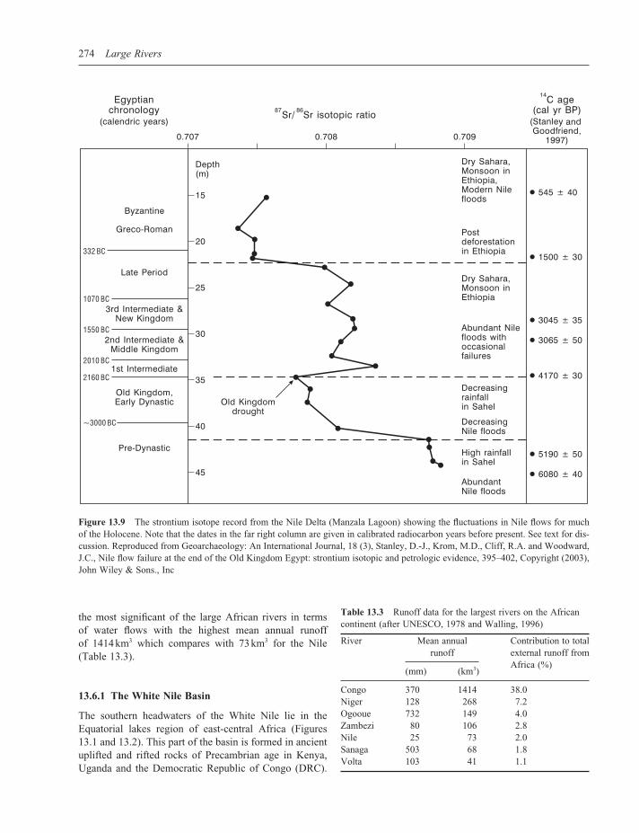
Krom et al. (2002) have shown that the sedimentary record in the delta can provide a more or less continuous record of changing catchment behaviour for much of the Holocene. Figure 13.9 is a strontium isotope record from a sediment core taken from Manzala Lagoon in the Nile Delta. Sediments from the Blue Nile Basin derived from young volcanics and other rocks contain low strontium isotope ratios. The ancient shield terrains of the White Nile headwaters yield sediments with higher strontium isotope ratios and this contrast provides a valuable basis for establishing a long-term record of the changing prov-enance of fl uvial sediment deposited in the delta. The form of the strontium isotope curve refl ects changing environ-ments in the Nile headwaters and, in general terms, pro-vides a proxy for Nile fl ows and sediment fl ux for the last 7000 years or so (Krom et al., 2002). The lower part of the record shows high fl ows in the Early Holocene Nile that correlate with some of the large palaeochannel forms in the White Nile Valley (Figure 13.7). This part of the record refl ects a signifi cant fl ux of sediment from the White Nile Basin. The steep fall in the curve down to ca. 4200 calendar years BP refl ects a progressive increase in sediment fl ux from the Ethiopian Highlands as Nile fl ows declined following a decrease in monsoon intensity and a reduction in vegetation cover in the Blue Nile headwaters. Krom et al. (2002) and Stanley et al. (2003) have argued that these strontium isotope minima provide the fi rst geo-logical data showing a catastrophic decline in Nile fl ows that may have led to the demise of the Old Kingdom (Bell, 1971). The central part of the record (after 4200 calendar years BP) shows fl uctuating Nile fl ows up to around 1500 calendar years BP when the record may be partly infl u-enced by enhanced sediment yields from Ethiopia follow-ing deforestation. In general terms the record shows a long

The Nile 273
Figure 13.8 Geomorphology of the Nile channel complex in the Dongola Reach in northern Sudan at low fl ow. (a) A large sand bar and thick channel margin fl ood deposits. (b) A fl ood channel to the east of the main Nile. View looking downstream in each case. Photographs taken by Jamie Woodward in February 1997
term drying trend during the course of the Holocene and one with the tantalizing prospect of linking it to the long historical fl ood records.
13.5 RECORDS OF NILE RIVER BEHAVIOUR IN THE EASTERN MEDITERRANEAN SEA
The marine sedimentary record in the Eastern Mediter-ranean provides a valuable record of the long-term behaviour of the River Nile (Rossignol-Strick et al., 1982) because long-term changes in the fl ux of water and sediment from the Blue and White Nile Basins have exerted an important infl uence on oceanographic and sedimentation dynamics. The sedimentary record in the Eastern Mediterranean is punctuated by the occurrence of dark, organic rich layers known as sapropels (Stanley, 1978; Rohling, 1994; Thomson et al., 1999). These dis-tinctive sediments range in thickness from a few milli-metres to tens of centimetres and represent episodes of stratifi cation and deep-water stagnation (when organic material was not broken down) and a net increase in bio-logical productivity – which increases the fl ux of organic matter to the sea fl oor. Periods of enhanced discharge from the Nile have been shown to correspond with periods of sapropel deposition as the fl oodwaters created
a freshwater layer across the surface of the Eastern Medi-terranean. Indeed, Rossignol-Strick et al. (1982: 3) have argued that if the discharge of the Late-glacial Nile was 2.5 times greater than today (similar to the present Zambezi), it could have produced a 25 m deep freshwater layer across the surface of the Levantine and Ionian basins in only 15 years. Recent work by Williams et al. (2003) has shown that times of very high fl ow in the White Nile over the past 240 ka that have been dated by OSL show a good correlation with the dated sapropel record in the Mediterranean.
13.6 THE MODERN NILE: HYDROLOGY AND GEOMORPHOLOGY
The climate and hydrology of the modern Nile Basin ranges from Equatorial in the White Nile headwaters to hyperarid in the desert region of northern Sudan and Egypt. Thus, for much of its course, the Nile is an exotic river. Despite its large area, on average, runoff from the Nile Basin accounts for only around 2 % of the total runoff from the African continent (UNESCO, 1978). In fact it ranks fi fth behind the Congo, Niger, Ogooue and Zambezi Rivers for mean annual runoff (Table 13.3). Data pre-sented in UNESCO (1978) show that the Congo River is
274 Large Rivers
Figure 13.9 The strontium isotope record from the Nile Delta (Manzala Lagoon) showing the fl uctuations in Nile fl ows for much of the Holocene. Note that the dates in the far right column are given in calibrated radiocarbon years before present. See text for dis-cussion. Reproduced from Geoarchaeology: An International Journal, 18 (3), Stanley, D.-J., Krom, M.D., Cliff, R.A. and Woodward, J.C., Nile fl ow failure at the end of the Old Kingdom Egypt: strontium isotopic and petrologic evidence, 395–402, Copyright (2003), John Wiley & Sons., Inc
the most signifi cant of the large African rivers in terms of water fl ows with the highest mean annual runoff of 1414 km3 which compares with 73 km3 for the Nile (Table 13.3).
13.6.1 The White Nile Basin
The southern headwaters of the White Nile lie in the Equatorial lakes region of east-central Africa (Figures 13.1 and 13.2). This part of the basin is formed in ancient uplifted and rifted rocks of Precambrian age in Kenya, Uganda and the Democratic Republic of Congo (DRC).
Table 13.3 Runoff data for the largest rivers on the African continent (after UNESCO, 1978 and Walling, 1996)
River Mean annual Contribution to total runoff external runoff from
(mm) (km3) Africa (%)
Congo 370 1414 38.0Niger 128 268 7.2Ogooue 732 149 4.0Zambezi 80 106 2.8Nile 25 73 2.0Sanaga 503 68 1.8Volta 103 41 1.1

The Nile 275
The uplifted terrains of the western rift form the watershed with the eastern headwaters of the Congo River (Figure 13.3). The highest point in the Nile basin is Mount Stanley (5109 m) in the Ruwenzori Mountain range between Lake Edward and Lake Albert on the border between the DRC and Uganda. The geological evolution of this area is complex and it was subjected to tectonic movements related to the African Rift system during Tertiary and Quaternary times (Said, 1981). The drainage of the Lakes Plateau region into the Nile Basin followed regional uplift and the formation of Lake Victoria. Prior to this the region’s drainage appears have formed part of the eastern headwaters of the Congo River (Said, 1981) (Figure 13.3). Figure 13.2 shows the long profi le of the White Nile with its steep gradient reaches in the Lake Plateau region with large waterfalls and rapids between Ripon Falls (1135 m) and Juba (455 m) – a distance of some 874 km. Down-stream of Juba the White Nile is a very low gradient system with an average slope of 1 : 13 900 in the Sudd Region and 1 : 101 000 between Malakal and Khartoum in its middle and lower reaches where it fl ows across the aggraded fl oor of the ∼400 ka mega-lake (Williams et al., 2003) (Figures 13.2 and 13.5). The Sudd overlies a vast alluvial fan, hence its relatively steep gradient. The exten-sive low-lying alluvial plain of the Sudd region extends for over 220 km on either side of the modern river channel complex (Said, 1981).
Rainfall in the White Nile Basin varies markedly between the Lake Victoria catchment (with annual rainfall of <2000 mm) and the arid and semi-arid environments in central Sudan with values of about 175 mm year−1 at Khar-
toum and 800 mm year−1 near Malakal. The western moun-tains of the Lake Plateau are extremely wet with around 360 rain days and over 5000 mm of precipitation each year (Said, 1993). The hydrology of the White Nile headwaters is strongly infl uenced by the presence of large lakes and swamps and the main lakes and swamps in the Nile basin are listed in Table 13.4. These water bodies cover an area approaching 130 000 km2. Lake Victoria, which is the second largest freshwater lake in the world, is by far the largest (ca. 67 000 km2) and exerts an important control on White Nile discharge (Tate et al., 2001). Annual fl ows into Lake Victoria of about 20 km3 year−1 are typical. This infl ow is made up from 7.5 km3 year−1 from the Kagera River (which forms the border between Rwanda and Tan-zania), 8.4 km3 year−1 from north-east Kenya, 3.2 km3 from the Serengeti of Tanzania and 1–2 km3 year−1 from the swamplands of north-west Uganda (Howell et al., 1988; FAO, 1997). The Ripon Falls in Uganda form the only outlet from Lake Victoria. The volume of the outfl ows (ca. 40 km3 year−1, Table 13.4) – which feed the Victoria Nile – is very sensitive to precipitation inputs to the Lake Victoria Basin as evaporation rates do not vary greatly from year to year. The Victoria Nile fl ows into Lake Albert via Lake Kioga (Figure 13.1).
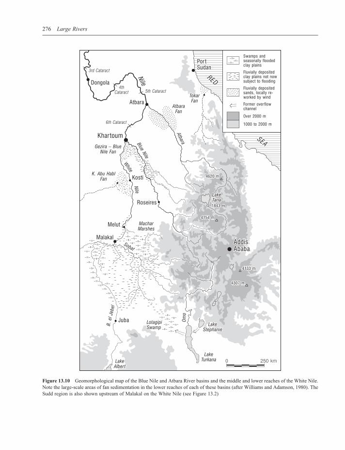
A dominant characteristic of the White Nile fl ow regime is that the seasonal variability of fl ows is highly damped by storage in lakes and swamps. The Sudd Region down-stream of Juba contains a huge area of swamplands (Figure 13.10) and evaporation from these water bodies is a very signifi cant component of the water balance. Typical evapo-ration losses from this part of the White Nile Basin are
Table 13.4 Long-term water balance data for lakes and swamps in the Nile Basin for various periods of the twentieth century (after Sene et al., 2001). The monitoring periods are approximations in some cases
Water body Area (km2) Monitoring Active Nile Local runoff Outfl ow Direct rainfall Evaporation period storage infl ow (km3 year−1) (km3 (km3 year−1) (km3 year−1) (km3) (km3 year−1) year−1)
Kagera swamps 3 000 1940–1973 3.8 0.0 8.1 6.3 3.0 4.8Lake Victoria 67 000 1925–1990 208.4 0.0 25.9 40.0 121.3 107.2Lake Kioga 6 270 1970–1973 23.8 40.0 3.0 42.1 9.1 10.0Lakes George and 2 500 0.8 0.0 3.6 2.6 3.5 4.5 EdwardLake Albert 5 400 1970–1973 28.1 42.1 6.2 45.1 5.4 8.6Albert-Sudd reach 380 swampsSudd swamps 22 400 1961–1980 60.5 50.3 0.0 21.4 19.3 48.2Machar marshes 3 200 1950–1955 0.0 1.4 0.1 6.0 7.3Bahr el Ghazal <16 600 1942–1986 0.0 11.3 0.3 9.5 20.5 swampsLake Tana 3 000 1928–1937 0.0 3.9 4.0 3.8 3.7Totals <129 750 63.4 180.9 214.8
276 Large Rivers
Figure 13.10 Geomorphological map of the Blue Nile and Atbara River basins and the middle and lower reaches of the White Nile. Note the large-scale areas of fan sedimentation in the lower reaches of each of these basins (after Williams and Adamson, 1980). The Sudd region is also shown upstream of Malakal on the White Nile (see Figure 13.2)

The Nile 277
shown in Table 13.5. According to Howell et al. (1988), between 1905 and 1980 the mean annual water loss to evaporation and evapotranspiration in the Sudd region was 16.9 km3 and this represents about 51.2 % of the fl uvial input to the area as recorded on the White Nile at Mongalla. The Sudd region has an extremely low gradient and contains a series of natural channels that fl ow through permanently waterlogged swamps fl anked by seasonally fl ooded grasslands. The Sudd stretches over 900 km from Juba to Malakal (Figures 13.2 and 13.10) and hydrological assessments have shown that the evaporation losses are greatest in those years when infl ows are highest and the inundated areas expand to cover a much greater area (Howell et al., 1988). High levels of rainfall in the lakes region of the White Nile headwaters in the 1960s and 1970s led to a signifi cant increase in the perennial swamp area in the Sudd from 2700 km2 in 1952 to 16 200 km2 in 1980. Downstream of the Sudd Region, between Malakal and Khartoum, the Nile falls only 8 m over a distance of about 809 km with a mean average gradient of less than 1 cm km−1. The climate becomes drier to the north and these reaches do not contain swamps and permanent water bodies. Downstream of the Sobat River junction there are no major tributary inputs south of Khartoum (Figure 13.1). The White Nile below Malakal is gently incised forming a broad and shallow alluvial channel that commonly bifur-cates around the mid-channel bars and islands that are common in these reaches (Williams et al., 1982). The channel planform of the White Nile upstream of the ∼400 ka mega-lake bed differs from that of the river where it fl ows along the former lake fl oor but has yet to be studied in detail.
13.6.2 The Blue Nile and Atbara Basins
The headwaters of the Blue Nile and the Atbara River lie in the highlands of Ethiopia and these upland fl uvial systems contain steep river channels with coarse boulder beds that fl ow within deep gorges. Figure 13.10 shows
those parts of the Ethiopian Highlands lying above 2000 m and the deeply dissected drainage network that feeds the main tributaries of the Blue Nile and Atbara rivers. Inci-sion of these uplands was initiated by regional uplift during the Late Oligocene to Miocene, the Late Pliocene and the Late Pleistocene (McDougall et al., 1975). This created a superimposed drainage network from a cover of Oligocene to Miocene age basalts into Mesozoic lime-stone and sandstone and granite and metamorphic rocks of Precambrian age (Williams and Williams, 1980). Note that several tributaries of the Sobat River drain the south-ern part of this region before traversing low gradient swamplands in central Sudan and eventually joining the White Nile upstream of Malakal (Figure 13.10).
Downstream of Khartoum the fl ood hydrology of the main Nile is dominated by runoff from the Blue Nile and the Atbara (Table 13.6) and the climate and hydrology of their catchments are dominated by the infl uence of the summer monsoon. Rainfall and runoff in the Upper Blue Nile catchment (176 000 km2) are strongly seasonal and many tributary channels do not convey fl ows in the dry season from November to May (Conway, 2000). The Upper Blue Nile has a mean annual discharge of 48.5 km3 (1912–1997) and inter-annual variability in fl ows is con-trolled by the intensity of the monsoon and by ENSO, with low fl ow during years of strongly negative Southern Oscillation Index, at least in the past hundred years, and conversely (Whetton et al., 1990). Precipitation dynamics in the Blue Nile and Atbara headwaters are infl uenced by three main mechanisms (Conway, 2000):
(1) the summer monsoon;(2) tropical upper easterlies;(3) local convergence in the Red Sea coastal region.
About 70 % of the annual rainfall in the Blue Nile head-waters of Ethiopia falls between June and September declining from 2000 mm in the southwest to less than 1000 mm in the northeast (Conway, 2000). The lower
Table 13.5 Water balance of the Sudd region for various periods of the twentieth century (after Howell et al., 1988 and FAO, 1997)
Period Annual Annual Annual % discharge outfl ow from losses at Mongalla swamps (km3) (km3) (km3)
1905–1960 26.8 14.2 12.6 47.01961–1980 50.3 21.4 28.9 57.51905–1980 33.0 16.1 16.9 51.2
Table 13.6 Mean annual discharges for the major basins of the Nile as reported by Williams et al. (1982)
River basin Discharge Peak fl ow Low fl ow (km3) (%) (%)
White Nile 27.5 10 83Blue Nile 51.0 68 17Atbara 12.5 22 0Main Nile 91EthiopianHighlands 63.5 90 17

278 Large Rivers
Blue Nile has a catchment area of about 324 530 km2 (Shahin, 1985) and its fl ow regime is also characterized by highly seasonal fl ows and marked inter-annual vari-ability. On average about 85 % of annual fl ow of the Blue Nile is concentrated into one third of the year between July and October. The 1900 to 1982 gauging station records for the Blue Nile at Khartoum show a mean monthly range in discharge from 9 to 8834 m3 s−1 with a mean of 1513 m3 s−1. The fl ow regime of the Atbara exhib-its even greater seasonality and the river is commonly dry from December to May with very low fl ows in November and June. Between 1912 and 1982 the mean discharge in the Atbara at the Kilo 3 station (69 000 km2) for the month of August ranged from 533 to 4928 m3 s−1 with an average fi gure of 2002 m3 s−1.
The Ethiopian Highlands are strongly dissected and the Blue Nile fl ows in a narrow, steep-sided valley for much of its course. Between its source at Lake Tana (1829 m) and the Sudan border – a distance of about 850 m (Figure 13.10) – the Blue Nile falls 1350 m at a mean gradient of 0.0016. From the border to Khartoum (374 m), a distance of some 900 km, the gradient is much more subdued (0.00013) (Williams et al., 1982). This change in channel gradient indicates that much of the coarser bed load mate-rials derived from the granites, basalts and sandstones of the Ethiopian Highlands now probably lie below the fi ne-grained sediments of the Gezira Fan Formation (Figure
13.10) – a body of sediment forming the large low-angle inland alluvial fan of radius ∼300 km that lies upstream of Khartoum between the lower reaches of the Blue and White Niles (Williams et al., 1982). Extensive areas of fan deposits in the lower gradient reaches of the Atbara and Blue Nile Basins are shown in Figure 13.10 and these represent signifi cant long-term sediment sinks. In its lower reaches the Blue Nile is a narrow and deep, single channel system incised into the Holocene and Pleistocene alluvial sediments of its former fl oodplain.
13.6.3 The Confl uence Zone and the Desert Nile from Khartoum to the Mediterranean
A key function of the major water bodies in the Upper White Nile Basin is the maintenance of the perennial base fl ow of the desert Nile from November to June when the Blue Nile and Atbara are not in fl ood (Figure 13.11a). The ratio of peak monthly fl ow to minimum monthly fl ow is typically 40 : 1 in the Blue Nile and 5 : 2 in the White Nile. The Blue Nile fl ood reaches its peak in late August to early September with a rise in stage of about 10 m above its low season fl ow at Khartoum. The White Nile fl ood peak arrives later and is much lower (ca. +2 m) – but lasts from late September until January (Williams et al., 2000) (Figure 13.11a). Before the construction of large dams this contrast in fl ood stage at the confl uence resulted in the
Figure 13.11 (a) Typical annual fl ow regime of the pre-impoundment Nile at Aswan showing the contributions from the three major tributary basins. Reproduced from The Nile: a General Account of the River and the Utilization of Its Waters, H.E. Hurst, Discharge of the Nile at Aswan, 1952, Constable and Company, London. (b) The discharge and suspended sediment budget of the Nile. Reprinted by permission from Macmillan Publishers Ltd: Nature, 339, 6219, Alain Foucault, Daniel Jean Stanley, Late Quaternary palaeoclimatic oscillations in East Africa recorded by heavy minerals in the Nile delta, pages, 44–46, Copyright (1989)

The Nile 279
formation of a seasonal lake that extended for more than 300 km upstream of Khartoum along the White Nile fl ood-plain (Williams et al., 2000). The width of this lake ranged from 1 to 7 km.
The six cataracts of the main desert Nile lie in the reaches between Khartoum (378 m) and Aswan (91 m) over a distance of 1847 km where the channel falls over 280 m (Figure 13.2). The great bends of the Nile are per-haps the most distinctive feature of the channel between the sixth and second cataracts (Figure 13.1). Adamson and Williams (1980) have suggested that the great bend that incorporates the sixth, fi fth and fourth cataracts is a product of updoming and volcanic activity in the Bayuda area where evidence for volcanic fl ows and volcanic cones is extensive. These authors also point out that the promi-nent dykes and lineaments that are oriented ENE and SSE correspond with the course of the Nile as it bends around the Bayuda dome (Figure 13.3). The bedrock reaches account for about 30 % (565 km) of the channel length between Khartoum and Aswan, where the steeper gradient cataract reaches are formed in resistant crystalline rocks (Said, 1981). Between the cataracts lie low gradient basins where softer Nubian sandstones have been eroded to provide accommodation space for expanses of Pleisto-cene and Holocene alluvial sediments (Figure 13.8). One example is the Dongola Reach of northern Sudan where the eastern side of the valley fl oor is fl anked by a low relief Holocene fl oodplain complex with well preserved palaeo-channel belts up to 18 km from the modern channel of the Nile (Macklin and Woodward, 2001; Woodward et al., 2001). Extensive aeolian dune systems are present in this reach and there is evidence in some reaches of large scale wind erosion of the Holocene alluvial record (Welsby et al., 2002).
Many of the large African rivers have fl ow records that extend back into the nineteenth century because gauging stations were established during the colonial era. Uniquely, the Nile has a long-term historical fl ood series that extends back to 622 AD at the Roda Island gauge at Cairo and these data have been analysed by many scholars (Brooks, 1927; Fraedrich et al., 1997). Modern discharge measurements on the Nile began in 1869 at Khartoum and in 1870 at Aswan. The fl ow records for the twentieth century show signifi cant variability – the maximum water yield of 120 km3 was recorded in 1916 while 1984 registered a minimum value of 42 km3. Between 1870 and 1984 the Nile at Aswan had a mean monthly discharge of 2700–2800 m3 s−1 (Figure 13.11b). El-Manadely et al. (2002) report that the average yearly discharge of the Nile at Aswan is 84 km3. It has been estimated that about half of the annual discharge released from the Aswan High Dam reaches the delta and this represents about 34–35 km3 in
an average year (Sharaf El Din, 1977; Stanley, 1996). Approximately one third of the fl ow reaching the delta is lost via evapotranspiration and infi ltration to groundwater while another third drains slowly through irrigation chan-nels and canals. Thus, as Stanley (1996) has pointed out, only about one third of the discharge that passes Cairo actually reaches the Mediterranean Sea. The last ‘normal’ fl ood discharge in the Nile was in 1964 and the fl ux of water to the Mediterranean between 1961 and 1973 is shown in Figure 13.12a. Note the marked decline in the annual peak of the controlled releases from Aswan and the shift in the timing of peak from summer (natural) to winter (controlled).
Before the completion of the Aswan High Dam in 1964 the annual Nile fl ood exerted an important infl uence on the hydrographic conditions and the pattern of circulation in the Eastern Mediterranean Sea up to about 80 km from the coast and to a maximum depth of ca. 150 m (Sharaf El Din, 1977). During the fl ood season (August to October) the salinity of the Mediterranean Sea fell from about 39 to <30 ppm at the near shore surface (Sharaf El Din, 1977). The huge particulate and solute loads associated with the fl oodwaters formed a vital role in the biology of the marine environment.
13.7 THE SUSPENDED SEDIMENT BUDGET
This section examines the contemporary suspended sedi-ment budget of the basin upstream of the delta complex. Suspended sediment concentrations and loads have been measured at several stations on the Egyptian Nile – espe-cially in the decades leading up to the planning and con-struction of the Aswan High Dam – but continuous long-term records are not presently available in the scien-tifi c literature. A good deal of the early work is docu-mented in Volume IX of The Nile Basin (Hurst et al., 1959). The suspended sediment load of the Nile is rather modest in comparison with its basin area. Milliman and Syvitski (1992) quote a value of 120 million tonnes year−1 for the average annual pre-Aswan High Dam load and a mean annual sediment yield of 40 t km−2 year−1 (Table 13.7). The sediment loads of many of the large rivers of Africa that drain the ancient shield terrains of the tropical interior are also low by world standards (Table 13.7).
It is important to appreciate that sediment production and sediment delivery vary markedly in the major tribu-tary basins and marked spatial and temporal (annual and seasonal) variability in suspended sediment fl ux is a key feature of the fl uvial geomorphology of the basin. Sus-pended sediment concentrations and loads are subject to considerable annual variation. According to Abu El-Ata (1978) the annual sediment load of the Nile at Aswan has

280 Large Rivers
Figure 13.12 (a) The pre- and post-impoundment fl ow regime at Aswan between 1961 and 1973. Reprinted from Limnology and Oceanography, 22, 2, Sharaf El Din. Copyright (1977) by the American Society of Limnology and Oceanography, Inc. (b) Discharge and suspended sediment concentration series for summer fl oods on the main Nile at Wadi Halfa (1931) and Gaafra (1955). Reprinted from Hydrology of the Nile Basin, Developments in Water Science 21, Mamdouh Shahin, page 460, Copyright (1985), with permis-sion from Elsevier
Table 13.7 The suspended sediment loads and yields of some large African rivers (from Milliman and Syvitski, 1992). The pre-impoundment loads are given in parentheses and these values have been used for the yield estimates
River Basin area Sediment load Sediment yield (×106 km2) (×106 t year−1) (t km−2 year−1)
Nile 3.00 0 (120) 40Congo 3.80 43 11Orange 0.89 17 (89) 100Niger 1.20 40 33Zambezi 1.40 20 (48) 35Limpopo 0.41 33 80
varied between 50 and 228 million tonnes. Due to the erodible upland terrains, high sediment supply and high runoff, much of the suspended sediment load measured at Aswan derives from the highlands of Ethiopia. In fact, together the Blue Nile and Atbara contribute on average about 97 % of the Nile’s annual suspended sediment load (with about 72 % from the Blue Nile and 25 % from the Atbara) and the White Nile the remaining 3.0 % (Figure 13.11b) (Foucault and Stanley, 1989). Suspended sedi-ment fl ux is dominated by the summer fl ood in the Blue Nile and Atbara catchments. For example, with a peak fl ow to low fl ow ratio of 40 : 1, and typical mean August and June sediment concentrations of 4000 and 100 mg l−1 respectively, the Blue Nile can transport up to 1600 times
The Nile 281
more sediment during the summer fl oods than at the end of the dry season (Williams et al., 1982: 119).
The White Nile drains the resistant rocks of the Equato-rial plateau and these terrains have much lower erodibility and a more effective cover of protective vegetation in contrast to the deeply dissected Blue Nile headwaters. Consequently, suspended sediment concentrations are much lower in the fl oodwaters of the White Nile and the lower gradient White Nile is a much less effi cient sus-pended sediment delivery system (Figure 13.11b). A sig-nifi cant proportion of its suspended sediment load is also trapped in the swamps and marshes of the Sudd region in the middle White Nile reaches. The Sudd swamps also act as an effi cient biochemical fi lter, since the solute concen-tration of the river on leaving the Sudd is equal to that on entering it, despite the loss of half the original fl ow volume through evapotranspiration and seepage (Williams and Adamson, 1973). In the main Nile at Aswan the sediment wave tends to peak in August before the main fl ood peak and several weeks may separate these two events. The suspended sediment concentrations for the summer fl ood of 1955 at Gaafra (near Aswan) peak at over 5500 mg l−1 in mid-August and then decline steadily to <500 mg l−1 by the end of October (Figure 13.12b). Many of the sus-pended sediment sampling programmes have tended to focus on the fl ood season and the major fi ndings of this work on the main Nile in Egypt have been reported by Shahin (1985) and may be summarized as follows:
• The mean annual pre-impoundment fl ux of suspended sediment at Aswan was about 125 million tonnes.
• Approximately 98 % of the annual suspended sediment load is transported during the fl ood season from August to November and suspended sediment concentrations may range from about 100 to >5800 mg l−1 during this period (Figure 13.12b).
• The relationship between suspended sediment concen-tration and water discharge shows a clear tendency for clockwise hysteresis with sediment concentration rising rapidly and peaking before the main fl ood peak (Figure 13.12b).
• Typical particle size distributions for samples of the suspended load at Aswan contained 30 % clay, 45 % silt and 25 % sand – and the proportion of sand tended to increase as the fl ood season progressed. Samples of suspended sediment collected from the delta region of Lake Nasser displayed a mean particle size distribution with 30 % fi ne sand, 40 % silt and 30 % clay (El-Manadely et al., 2002).
Data on bed load fl ux in the Nile Basin are extremely scarce but Shahin (1985) reports that studies in the pre-
Aswan High Dam period showed that bed load sediment transport accounted for only about 1–2 % of the total load. Thus it became customary to consider the suspended sedi-ment load as the total load. One would expect a signifi cant fl ux of coarse bed load material in the steep and fl ashy headwater streams of the Blue Nile and Atbara basins. Indeed, as mentioned above, Williams et al. (1982: 117) speculate that much of the coarser bed load materials eroded from the granites, sandstones and basalts of Ethio-pia now probably form the base of the Gezira Formation to the south of Khartoum (Figure 13.10), a surmise con-sistent with drilling records.
13.7.1 Reservoir Sedimentation
While there are still key gaps in our understanding of basin-wide sediment dynamics in the Nile, some of the most useful information on recent suspended sediment fl uxes derives from repeat bathymetric surveys of the large artifi cial reservoirs. Furthermore, because they form very effective sediment traps, these reservoirs form an impor-tant component of the suspended sediment budget of the Nile Basin. As the Ethiopian Highlands are the main source of suspended sediment in the basin, the river systems draining this region have witnessed some of the most severe sediment management problems since the construction of large dams.
The Roseires Dam (1966) on the Blue Nile and the Khashm el Girba Dam (1964) on the Atbara River (Figure 13.1) both encountered major problems with sedimenta-tion within a decade of their construction (Elsheikh et al., 1991). The Roseires Dam was built close to the Ethiopian border to store Blue Nile water for irrigation use in central Sudan. According to these authors, the storage capacity of the Roseires reservoir (3.02 × 10⁹ m3) had fallen by 18 % after 10 years and 21 % after 15 years – while the capacity of the Khasm el Girba reservoir fell by 25.4 % after 7 years of operation and by 42.3 % after 12 years. Bathymetric survey showed that 540 million m3 of sediment had been deposited in the Roseires reservoir between 1966 and the 1975/1976 hydrological year – giving a mean annual value for sediment deposition of about 54 million m3 for this period. The total volume of deposited sediment had increased to 640 million m3 by 1980/81 (Elsheikh et al., 1991).
In the Ethiopian headwaters of the Blue Nile and Atbara Rivers, mean annual rates of soil loss today amount to about 40 t ha−1 (2 mm year−1) on mountain slopes, but attain rates of over 300 t ha−1 (15 mm year−1) during cultivation years, or some 5–10 times more than in non-mountainous areas (Hurni, 1999). In many areas the increasing demand for land has meant a reduction in fallow to virtually zero

282 Large Rivers
and an expansion of the area under cultivation. In one region in Gojjam Province the area cultivated rose from 40 % in 1957 to 77 % in 1995, while natural forest land decreased from 27 % to 0.3 % (Hurni, 1999). These rates of accelerated soil erosion can be compared with long-term denudation rates for the catchment. The mean rate of geo-logical erosion over the past 23.5 Ma was 0.01 mm year−1 in the Ethiopian headwaters of the Blue Nile (Williams and Williams, 1980). The rate of erosion in the Blue Nile headwaters during the 70 years before completion of the Aswan High Dam was 0.12–0.24 mm year−1. In contrast, in the 1970s annual soil loss from parts of the Ethiopian Plateau was roughly 0.4–1.0 mm year−1. This represents a two orders of magnitude increase in the rate of soil loss – a rate that is much faster than corresponding rates of soil formation.
Removal of forest in the seasonally wet tropical uplands of Ethiopia has changed the local hydrological balance, resulting in reduced infi ltration, increased runoff and increased soil loss. The downstream effects are equally signifi cant and in this instance are not confi ned to Ethio-pia. By 1996, the capacity of the Roseires reservoir had been reduced by almost 60 % by the infl ux of sediment from the Ethiopian uplands and that at Khashm el Girba on the Atbara, by 40 % (Swain, 1997). It thus appears that deforestation in the headwaters of the Blue Nile and Atbara Rivers during the past 40 years has triggered a wave of accelerated soil loss from cultivated land and has led to siltation of reservoirs many hundreds of kilometres downstream.
Lake Nasser and Lake Nubia (the latter is the Sudanese sector of the reservoir behind the Aswan High Dam) (Figure 13.1) have a maximum surface area of 600 km2 and this equates to a maximum storage capacity of 162 km3. El-Manadely et al. (2002) have described the nature of the three storage zones in the reservoir:
(1) the dead storage zone – used for sediment accumula-tion up to 147 m asl – with a maximum capacity of 31 km3;
(2) the live storage zone – 147 to 175 m asl – with a maximum capacity of 90 km3;
(3) the fl ood-buffer storage zone – 175 to 182 m asl – with a capacity of 41 km3.
Stanley (1996: 191) has described the sediment deposition in Lake Nasser as ‘the New Nile delta’ and by the mid-1990s this rapidly growing feature was about 200 km long, 12 km wide and about 40 m thick – extending northwards to Abu Simbel. When the annual fl ood reaches Lake Nubia, the fl ow velocity falls from >1.0 m s−1 to about
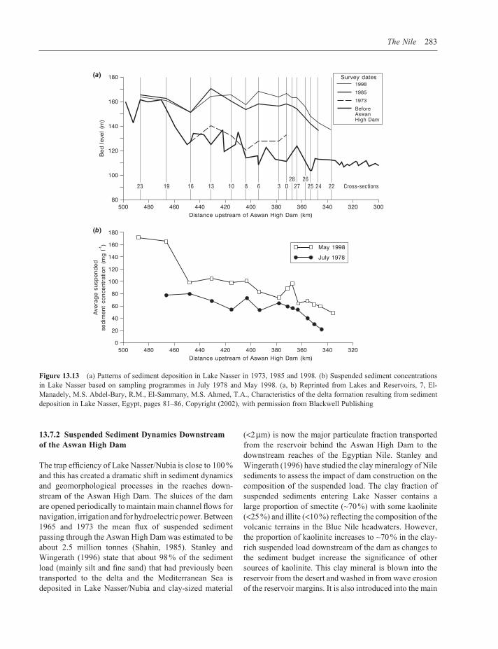
0.02 m s−1 (Shahin, 1985). Thus, the trap effi ciency in the Aswan High Dam is close to 100 % and under normal conditions only the fi nest fractions of the suspended load are transported to the downstream portion of the reservoir. The total volume of deposited sediment between 1964 and 1998 has been estimated to be 3.5 km3 and 90 % of this sediment is within the Sudanese side of the reservoir (El-Manadely et al., 2002). This estimate is based on a series of re-surveys of the original Nile river channel bed levels and valley fl oor cross-sections that were conducted before the construction of the dam. The last major sedimentation survey was carried out in 1998 when 15 cross-sections were surveyed in the reservoir’s delta between 487 and 337.5 km upstream of the dam and the results are shown in Figure 13.13a. Comparison of the pre-reservoir bed levels and the 1998 survey shows that net sediment depo-sition ranges from ca. 2.4 m (at cross-section 23) to a maximum of 60.2 m at cross-section 6 (Figure 13.13a) (El-Manadely et al., 2002). It is important to appreciate that the width of the cross-sections (CS) increases from 300 m at CS 23 to 4100 m at CS 26 to 9300 m at CS 22 (Figure 13a) and this widening leads to a decrease in fl ow competence.
Suspended sediment concentrations in this part of Lake Nasser/Nubia based on samples collected in July 1978 and May 1998 are shown in Figure 13.13b and refl ect this decrease in fl ow velocity moving northwards along the delta complex. The 1998 samples contain maximum mean suspended sediment concentrations of 172 mg l−1 (487 m upstream of the dam) and this value declines steadily to less than 50 mg l−1 around 150 km further down reservoir (El-Manadely et al., 2002). A general fi ning of the suspended sediment load accompanies the decline in sediment concentration. Mean clay content increases from around 30 % at the entrance to Lake Nasser to >70 % over the same distance. The survey work by El-Manadely et al. (2002), based on the calcu-lated volume of sediment deposited between 1964 and 1998 in the Lake Nasser delta, gives an estimate of 310 years for the lifetime of the dead storage zone allocated for sediment accumulation (31 km3) in Lake Nasser. These researchers also point out that signifi cant volumes of sediment may be transported down reservoir towards the dam when large fl ood events follow a sus-tained period of low fl ows because this results in net erosion of some parts of the Lake Nasser delta complex. A further modifi cation to the sediment budget of this vast reservoir will follow the completion of the new dam at Merowe on the fourth cataract as this will result in a marked reduction in suspended sediment fl ux to Lake Nasser/Nubia.
The Nile 283
13.7.2 Suspended Sediment Dynamics Downstream of the Aswan High Dam
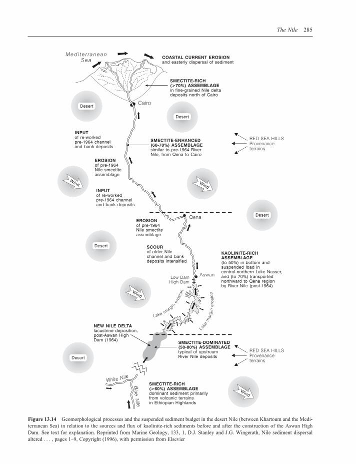
The trap effi ciency of Lake Nasser/Nubia is close to 100 % and this has created a dramatic shift in sediment dynamics and geomorphological processes in the reaches down-stream of the Aswan High Dam. The sluices of the dam are opened periodically to maintain main channel fl ows for navigation, irrigation and for hydroelectric power. Between 1965 and 1973 the mean fl ux of suspended sediment passing through the Aswan High Dam was estimated to be about 2.5 million tonnes (Shahin, 1985). Stanley and Wingerath (1996) state that about 98 % of the sediment load (mainly silt and fi ne sand) that had previously been transported to the delta and the Mediterranean Sea is deposited in Lake Nasser/Nubia and clay-sized material
(<2 µm) is now the major particulate fraction transported from the reservoir behind the Aswan High Dam to the downstream reaches of the Egyptian Nile. Stanley and Wingerath (1996) have studied the clay mineralogy of Nile sediments to assess the impact of dam construction on the composition of the suspended load. The clay fraction of suspended sediments entering Lake Nasser contains a large proportion of smectite (∼70 %) with some kaolinite (<25 %) and illite (<10 %) refl ecting the composition of the volcanic terrains in the Blue Nile headwaters. However, the proportion of kaolinite increases to ∼70 % in the clay-rich suspended load downstream of the dam as changes to the sediment budget increase the signifi cance of other sources of kaolinite. This clay mineral is blown into the reservoir from the desert and washed in from wave erosion of the reservoir margins. It is also introduced into the main
Figure 13.13 (a) Patterns of sediment deposition in Lake Nasser in 1973, 1985 and 1998. (b) Suspended sediment concentrations in Lake Nasser based on sampling programmes in July 1978 and May 1998. (a, b) Reprinted from Lakes and Reservoirs, 7, El-Manadely, M.S. Abdel-Bary, R.M., El-Sammany, M.S. Ahmed, T.A., Characteristics of the delta formation resulting from sediment deposition in Lake Nasser, Egypt, pages 81–86, Copyright (2002), with permission from Blackwell Publishing

284 Large Rivers
channel by clear water erosion of valley fl oor sediments and rocks downstream of the dam. Stanley and Wingerath (1996) argue that the kaolinite trace can be used to monitor the impoundment-related alterations to river fl ows and sediment composition. These impoundment-induced changes to the regional sediment budget from Lake Nasser to the delta are summarized in Figure 13.14.
13.8 THE NILE DELTA AND THE EASTERN MEDITERRANEAN
13.8.1 The Delta and Coastal Zone
The modern Nile Delta began forming in the early Holocene about 7500 14C years BP and is the largest dep-ocentre in the Mediterranean region (Stanley and Warne, 1993). For much of this time the delta complex was built up by a series of large distributaries that conveyed water and sediment across the delta and to the coast. Nine major channel systems have been identifi ed in the Holocene deposits of the northern delta and between two and fi ve of these were active at any one time (Sestini, 1992; Stanley and Warne, 1993; Stanley, 1996). Today, downstream of Cairo, the Nile divides into two main distributaries – the Rosetta and Damietta channels and these fl ow to the north-west and north-east, respectively, where they have formed marked promontories at the coast (Figure 13.15a). These two distributaries have been the main conduits for water and sediment fl ux to the coast since the end of the nine-teenth century. The delta covers an area of around 22 000 km2 and the distance from Cairo to the coast is about 160 km. The rate of alluvial sedimentation on the delta and the fl oodplain of the lower Nile before 1964 has been estimated to be 60 to 150 mm century−1 with a mean rate of 0.8 mm year−1 (Shahin, 1985).
Since the closure of the Aswan High Dam in 1964, the main sources of suspended sediment downstream of Aswan have been fl uvial erosion of the river channel margins and direct inputs of aeolian dust. In fact, sus-pended sediment concentrations greater than 850 mg l−1 have been recorded in Nile fl ows at Cairo since the closure of the dam (Stanley, 1996). However, only a very small proportion of this material actually reaches the coast because the delta’s large barrages and the very high density of drainage canals and irrigation channels form a vast and very effi cient network for trapping sediment. Figure 13.15b provides a graphic illustration of the human impact on the drainage network on the delta. Many of the larger artifi cial channels drain into the deltas wetlands and lagoons so that sediment delivery to the coast is further reduced (Stanley, 1996).
The coastal zone of the delta extends from east of Alex-andria to Port Said – a distance of about 240 km. The main
features of the coastline are the Rosetta and Damietta promontories and the broad Burullus headland between them that was created by sediment delivered from the former Sebennitic branch of the Nile about 6500 14C years BP (Orlova and Zenkovitch, 1974; Frihy et al., 2003) (Figure 13.15a). Since the completion of the Aswan High Dam, coastal erosion and sediment redistribution have been major concerns and, in very general terms, the actively prograding delta has been replaced by an eroding coastal plain (Stanley and Warne, 1993; Frihy et al., 2003). The eroding promontories are the principal sources of sediment for the coastal zone. Rates of shoreline change have been estimated from beach surveys and Frihy and Komar (1993) reported maximum rates of retreat along the Rosetta promontory of 106 m year−1 with rates of 10 m year−1 and 7 m year−1 at the Damietta and Burullus promontories, respectively. Zones of sediment accretion were identifi ed within the embayments between the prom-ontories with a maximum shoreline advance averaging about 13 m year−1. Research by Frihy and co-workers over the last two decades has shown that the sediment budget at the coast can be viewed as a series of regional littoral sedimentation cells that extend from Alexandria to Akko on the northern margin of Haifa Bay, Israel. Each cell contains a coherent system of sediment sources, fl uxes and sinks (Frihy et al., 2003).
13.8.2 Sediment Supply to the Eastern Mediterranean Sea
The Nile has been the major supplier of suspended sedi-ment to the Eastern Mediterranean Sea since Late Miocene times until the construction of the Aswan High Dam. In the Late Quaternary and Holocene marine sedimentary record across the region, sands of Nile provenance have been identifi ed in the Nile Cone and along the margins of Israel, while fi ner grained sediments (clays) have been traced as far north as Turkey (Stanley and Wingerath, 1996). While the Nile was the dominant supplier of fi ne-grained particulate material to the Levantine basin up to 1964, aeolian dust from the Sahara has long formed a very signifi cant component of the Eastern Mediterranean marine sediment budget. Krom et al. (1999) have used strontium isotopes (87Sr/86Sr) to map the dispersal of Nile-derived suspended sediments across the Levantine basin to establish those parts of the marine environment that will be most affected by the trapping of sediment in the Aswan High Dam. Their results are shown in Figure 13.16. It is clear that Nile-derived sediment is dispersed widely across the Levantine basin with the highest values (>80 %) to the east of the Nile Cone and towards the coast of Israel fol-lowing transport by easterly-directed surface currents
The Nile 285
Figure 13.14 Geomorphological processes and the suspended sediment budget in the desert Nile (between Khartoum and the Medi-terranean Sea) in relation to the sources and fl ux of kaolinite-rich sediments before and after the construction of the Aswan High Dam. See text for explanation. Reprinted from Marine Geology, 133, 1, D.J. Stanley and J.G. Wingerath, Nile sediment dispersal altered . . . , pages 1–9, Copyright (1996), with permission from Elsevier

Figure 13.15 (a) The major geomorphological features and canals and pumping stations of the Nile delta and coastline. The arrows show the direction of major coastal currents and associated sediment fl ux. The main barrages on the delta are also shown. (b) Map of the delta showing more than 10 000 km of irrigation canals and drains. This map is based on charts produced by the Defence Mapping Agency (1970–1993). This area represents the most intensively modifi ed portion of the Nile drainage basin. (a, b) Reprinted from Marine Geology, 129, 3–4, Daniel Jean Stanley, Nile delta extreme case of . . . , pages 189–195, Copyright (1996), with permis-sion from Elsevier
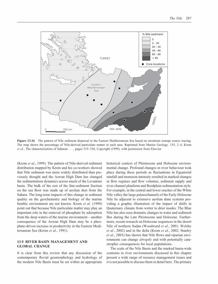
The Nile 287
(Krom et al., 1999). The pattern of Nile-derived sediment distribution mapped by Krom and his co-workers showed that Nile sediment was more widely distributed than pre-viously thought and the Aswan High Dam has changed the sedimentation dynamics across much of the Levantine basin. The bulk of the rest of the fi ne-sediment fraction on the sea fl oor was made up of aeolian dust from the Sahara. The long-term impacts of this change in sediment quality on the geochemistry and biology of the marine benthic environment are not known. Krom et al. (1999) point out that because Nile particulate matter may play an important role in the removal of phosphate by adsorption from the deep waters of the marine environment – another consequence of the Aswan High Dam may be a phos-phate-driven increase in productivity in the Eastern Medi-terranean Sea (Krom et al., 1991).
13.9 RIVER BASIN MANAGEMENT AND GLOBAL CHANGE
It is clear from this review that any discussion of the contemporary fl uvial geomorphology and hydrology of the modern Nile Basin must be set within an appropriate
historical context of Pleistocene and Holocene environ-mental change. Profound changes in river behaviour took place during these periods as fl uctuations in Equatorial rainfall and monsoon intensity resulted in marked changes in fl ow regimes and fl ow volumes, sediment supply and river channel planform and fl oodplain sedimentation style. For example, in the central and lower reaches of the White Nile valley the large palaeochannels of the Early Holocene Nile lie adjacent to extensive aeolian dune systems pro-viding a graphic illustration of the impact of shifts in Quaternary climate from wetter to drier modes. The Blue Nile has also seen dramatic changes in water and sediment fl ux during the Late Pleistocene and Holocene. Further-more, recent research on Holocene sequences in the desert Nile of northern Sudan (Woodward et al., 2001; Welsby et al., 2002) and in the delta (Krom et al., 2002; Stanley et al., 2003) has shown that Nile fl ows and riparian envi-ronments can change abruptly and with potentially cata-strophic consequences for local populations.
The scale of the Nile Basin and the marked basin-wide contrasts in river environments discussed in this chapter present a wide range of resource management issues and it is not possible to discuss them in detail here. The primary
Figure 13.16 The pattern of Nile sediment dispersal in the Eastern Mediterranean Sea based on strontium isotope source tracing. The map shows the percentage of Nile-derived particulate matter in each area. Reprinted from Marine Geology. 155, 2–4, Krom et al., The characterization of Saharan . . . , pages 319–330, Copyright (1999), with permission from Elsevier

288 Large Rivers
concerns of the ten riparian states are water storage and allocation for irrigation and hydropower generation. The essence of the political confl ict surrounds the confl ict between the desires of the ‘upstream’ basin states to fully exploit the potential offered by Nile fl ows in their own territories, with the needs of the downstream users – par-ticularly Egypt. The Nile Waters Treaty of 1959 allows the Sudan to abstract up to 18.5 km3 year−1 – this is about 22 % of the estimated mean Nile fl ow of 84 km3 year−1 that formed the basis of the agreement. The rest of the fl ow is accounted for by the allocation to Egypt and losses to seepage and evaporation (Sene et al., 2001). Egypt has the lowest concentration of arable land per head of population of any African state and this has led to more intensive farming methods and to the expansion of the cultivated area through year-round irrigation both on the delta and in the Nile Valley. Political tensions over water allocations for the basin states resurfaced in early 2004 with a meeting of the Nile Basin Initiative in Uganda. The riparian states upstream of Egypt and Sudan aim to develop their hydro-electric potential and the drought-prone lands of Ethiopia and Eritrea have plans for large-scale irrigation schemes of their own. The Nile Basin Treaty of 1929 states:
‘Without the consent of the Egyptian government, no irrigation or hydroelectric works can be established on the tributaries of the Nile or their lakes, if such works can cause a drop in water level harmful to Egypt.’
Sutcliffe and Lazenby (1994) have reviewed the hydrologi-cal data requirements for planning the management of water resources in the Nile Basin. They emphasize the importance of accurate and consistent long-term hydro-logical records for the development of an effective basin-wide resource management plan. They also highlight the need for more effi cient use of irrigation waters in Egypt and Sudan. Over the last century or so the dominant basin-wide strategy for the management of water resources in the Nile Basin has been the construction of large dams and reservoirs. The major water resource development projects are shown in Figure 13.17. The major reservoirs provide essential storage to serve the ever-growing and year-round irrigation demands in Egypt and Sudan. Storage losses to sedimentation are a signifi cant management issue in the Atbara and Blue Nile Basins and a basin-wide sediment monitoring and management strategy is needed (Sutcliffe and Lazenby, 1994). The Jonglei Canal project in the Sudd (Figure 13.17) remains unfi nished due to ongoing confl icts and political problems in Sudan (Howell et al., 1988). This scheme was intended to reduce evaporation losses in the swamplands and to increase the net water yield of the White Nile Basin. However, caution is needed when drain-
Figure 13.17 Major water resource development projects in the Nile Basin (after Newson, 1992). The Merowe Dam project on the main Nile in Sudan is under construction (Askouri, 2004). Reprinted from Dams, People and Development, Hussein M. Fahim, Copyright (1981) and Land, Water and Development, M.D. Newson, Copyright (1992). London, Routledge
ing major wetlands. For example, Williams and Adamson (1973) have argued that some of the potential consequences of draining part of the Sudd include exposure of saline soils, an increase in channel bank erosion downstream, and a change in water chemistry.
Sutcliffe and Lazenby (1994) have pointed out that the issue of climate change and its effect on water discharge is especially important in the Nile Basin because the low
The Nile 289
runoff coeffi cients associated with the rainfall regime suggest that even a modest change in precipitation will have a disproportionate effect on runoff. They cite the average long-term runoff value of just 55 mm at the Dongola gauging station in northern Sudan (19° N) to illustrate this point. The Nile comprises highly contrasting tributary basins but runoff from each is sensitive to changes in rainfall and this is why marked fl uctuations in river fl ows on the main Nile have been recorded in the past (Sutcliffe and Lazenby, 1994).
The long historical discharge records for the Nile (Hassan, 1981) and the richness of the archaeological and Quaternary sedimentary records mean that this basin pro-vides a unique context for the study of global climate change and its impact upon the hydrology and sediment dynamics of a large river and its population. Recent work in the Nile Basin has suggested that the river system can change rapidly and fl ow volumes from both the Blue Nile and the White Nile can decrease abruptly (Krom et al., 2002). The long fl ood records have been interrogated to explore the relationship between changes in the global climate system (e.g. monsoon intensity and ENSO) and Nile fl ood magnitude. Over the last decade or so research-ers have attempted to predict the impact of various global climate change scenarios on Nile fl ows and fl ood regime (Sene et al., 2001), but the complexity and scale of the basin have proved to be problematic in many modelling studies (Hulme, 1994; Tate et al., 2001). Understanding the dynamics of the Nile Basin is a major challenge for hydrologists, geomorphologists and river basin planners. The uncertainty surrounding the nature and impact of global change and its potential impact on Nile fl ows is a major concern – especially in Egypt (Conway and Hulme, 1996) – and casts a large shadow over the politics of water sharing agreements in the basin. If we are to improve our understanding of how the Nile might respond to future changes in global climate, we also need to consider fl uc-tuations in water and sediment fl uxes (and the forcing factors responsible) over a range of Holocene and Pleis-tocene timescales and across the entire catchment (Krom et al., 2002). It is also important to investigate long-term interactions between climate change and the human use of river-based resources. This can only be achieved by care-fully integrating information from both cultural and geo-logical archives (Woodward et al., 2001). The broader signifi cance of these research agendas for other large river systems is now clear. As Adamson (1982: 233) observed in a discussion of Late Quaternary environmental change in the Nile Basin written over two decades ago:
‘. . . climate in the future will undoubtedly oscillate between the extreme limits which the whole Nile
basin has so recently experienced. An understanding of the past behaviour of such a river system as the Nile, and of its depositional legacy in the Sudan and Egypt, is therefore of both local and world-wide interest.’
ACKNOWLEDGEMENTS
We would like to thank Nick Scarle (School of Environ-ment and Development, The University of Manchester) for expertly drawing the maps and diagrams. We also thank Avi Gupta and the two referees for their helpful reviews.
REFERENCES
Abu El-Ata, A. (1978) Egypt and the Nile after the High Aswan Dam. Ministry of Irrigation and Land Reclamation, Egypt.
Adamson, D.A. (1982) The integrated Nile. In: A Land Between Two Niles: Quaternary Geology and Biology in Central Sudan (M.A.J. Williams and D.A. Adamson, Eds.). A.A. Balkema, Rotterdam, 221–234.
Adamson, D.A. and Williams, F. (1980) Structural geology, tec-tonics and the control of drainage in the Nile basin. In: The Sahara and The Nile: Quaternary Environments and Prehis-toric Occupation in Northern Africa (M.A.J. Williams and H. Faure, Eds.). A.A. Balkema, Rotterdam, 225–252.
Adamson, D.A., Gasse, F., Street, F.A. and Williams, M.A.J. (1980) Late Quaternary history of the Nile. Nature, 288, 50–55.
Adamson, D., McEvedy, R. and Williams, M.A.J. (1993) Tec-tonic inheritance in the Nile basin and adjacent areas. Israel Journal of Earth Sciences, 41, 75–85.
Askouri, A. (2004) A Culture Drowned. World Rivers Review, 19(2), 8–9.
Bell, B. (1971) The Dark Ages in Ancient History. I. The First Dark Age in Egypt. American Journal of Archaeology, 75(1), 1–26.
Brooks, C.E.P. (1927) Periodicities in the Nile fl oods. Memoirs of the Royal Meteorological Society, 2, 9–26.
Butzer, K.W. (1980) Pleistocene history of the Nile Valley in Egypt and Lower Nubia. In: The Sahara and The Nile: Qua-ternary Environments and Prehistoric Occupation in Northern Africa (M.A.J. Williams and H. Faure, Eds.). A.A. Balkema, Rotterdam, 253–280.
Butzer, K.W. and Hansen, C.L. (1968) Desert and River in Nubia: Geomorphology and Prehistoric Environments at the Aswan Reservoir. Madison, University of Wisconsin Press.
Collins, R.O. (1990) The Waters of the Nile, Hydropolitics and the Jonglei Canal 1900–1988. Clarendon Press, Oxford.
Conway, D. (2000) The climate and hydrology of the Upper Blue Nile River. The Geographical Journal, 166(1), 49–62.
Conway, D. and Hulme, M. (1996) The impacts of climate variability and future climate change in the Nile Basin on water resources in Egypt. Water Resources Development, 12(3), 277–296.

290 Large Rivers
Davies, W.V. and Friedman, R. (1999) Egypt. The British Museum, London, 224 pp.
El-Manadely, M.S., Abdel-Bary, R.M., El-Sammany, M.S. and Ahmed, T.A. (2002) Characteristics of the delta formation resulting from sediment deposition in Lake Nasser, Egypt: approach to tracing lake delta formation. Lakes and Reser-voirs: Research and Management, 7, 81–86.
Elsheikh, S., Kaikai, A. and Andah, K. (1991) Intensive sediment transport from the Upper Nile Basin and water resources man-agement in Sudan. In: Hydrology for the Water Management of Large Rivers (F.H.M. van de Ven, D. Gutknecht, D.P. Loucks and K.A. Salewicz, Eds.). IAHS Publication No. 201, 291–300.
FAO (1997) Irrigation Potential in Africa: A Basin Approach. FAO Land and Water Bulletin 4. Food and Agriculture Organi-sation, Rome.
Foucault, A. and Stanley, D.J. (1989) Late Quaternary paleocli-matic oscillations in east Africa recorded by heavy minerals in the Nile Delta. Nature, 339, 44–46.
Fraedrich, K., Jiang, J., Gerstengarbe, F. and Werner, P. (1997) Multiscale detection of abrupt climate changes: application to River Nile fl ood levels. International Journal of Climate Change, 17, 1301–1315.
Frihy, O.E. and Komar, P.D. (1993) Long-term shoreline changes and the concentration of heavy minerals in beach sands of the Nile delta, Egypt. Marine Geology, 115, 253–261.
Frihy, O.E., Debes, E.A. and El Sayed, W.R. (2003) Processes reshaping the Nile delta promontories of Egypt: pre- and post protection. Geomorphology, 53, 263–279.
Gasse, F., Rognon, P. and Street, F.A. (1980) Quaternary history of the Afar and Ethiopian Rift Lakes. In: The Sahara and The Nile (M.A.J. Williams and H. Faure, Eds.). A.A. Balkema, Rotterdam, 361–400.
Hassan, F.A. (1981) Historical Nile fl oods and their implications for climate change. Science, 212, 1142–1145.
Hassan, F.A. (1988) Climatic change, Nile fl oods and civiliza-tion. Nature and Resources, 34(2), 34–40.
Howell, P.P. and Allan, J.A. (Eds.) (1994) The Nile: Sharing a Scarce Resource. Cambridge University Press, Cambridge.
Howell, P., Lock, M. and Cobb, S. (Eds.) (1988) The Jonglei Canal: Impact and Opportunity. Cambridge University Press. Cambridge.
Hsu, K.J., Ryan, W.B.F. and Cita, M.B. (1973) Late Miocene desiccation of the Mediterranean. Nature, 242, 239–243.
Hulme, M.A. (1994) Global climate change and the Nile basin. In: The Nile: Sharing a Scarce Resource (P.P. Howell and J.A. Allan, Eds.). Cambridge University Press, Cambridge, 139–162.
Hurni, H. (1999) Sustainable management of natural resources in African and Asian mountains. Ambio, 28(5): 382–389.
Hurst, H.E. (1952) The Nile. Constable, London.Hurst, H.E., Black, R.P. and Simaika, Y.M. (1959) The Nile
Basin, Volume IX: The hydrology of the Blue Nile and Atbara and the Main Nile to Aswan with some reference to projects. Nile Control Department Paper No. 12, Government Printing Offi ces, Cairo Egypt.
Krom, M.D., Brenner, S., Kress, N., Gordon, L.I. (1991) Phos-phorous limitation of primary productivity in the Eastern Mediterranean Sea. Limnology and Oceanography, 36(3), 424–432.
Krom, M.D., Cliff, R.A., Eijsink, L.M., Herut, B. and Chester, R. (1999) The characterization of Saharan dusts and Nile par-ticulate matter in surface sediments from the Levantine basin using Sr isotopes. Marine Geology, 155, 319–330.
Krom, M.D., Stanley, J.D., Cliff, R.A and Woodward, J.C. (2002) River Nile sediment fl uctuations over the past 7000 years and their key role in sapropel development. Geology, 30(1), 71–74.
Le Pichon, X., Clauzon, G. and Bellier, O. (2005). Ouverture de la Méditerranée Occidentale et épisode messinien: implications pour la tectonique du sud de la France. Abstracts, College de France Conférences publiques, CEREGE, Aix-en-Provence.
Macklin, M.G. and Woodward, J.C. (1998) Alluvial architecture and OSL dating of Holocene palaeochannels in the Northern Dongola Reach of the Nile, Sudan. Sudan and Nubia, 2. The British Museum (SARS), London, 22–26.
Macklin, M.G. and Woodward, J.C. (2001) Holocene alluvial history and the palaeochannels of the River Nile in the Northern Dongola Reach. In: Life on the Desert Edge: Seven Thousand Years of Settlement in the Northern Dongola Reach, Sudan (D.A. Welsby, Eds.) (Volume 1). The Sudan Archaeological Research Society Publication No. 7, London, 7–13.
McDougall, I., Morton, W.H. and Williams, M.A.J. (1975) Age and rates of denudation of Trap Series basalts at Blue Nile gorge, Ethiopia. Nature, 254, 207–209.
Milliman, J.D. and Syvitski, J.P.M. (1992) Geomorphic/Tectonic control of sediment discharge to the ocean: the importance of small mountainous rivers. The Journal of Geology, 100, 525–544.
Newson, M.D. (1992) Land, Water and Development. London, Routledge.
Orlova, G. and Zenkovitch, V. (1974) Erosion of the shores of the Nile delta. Geoforum, 18, 68–72.
Pachur, H.J. and Kropelin, S. (1987) Wadi Howar: paleoclimatic evidence from an extinct river system in the southeastern Sahara. Science, 237, 298–300.
Ritchie, J.C., Eyles, C.H. and Haynes, C.V. (1985) Sediment and pollen evidence for an early to mid Holocene humid period in the eastern Sahara. Nature, 314, 352–355.
Rohling, E.J. (1994) Review and new aspects concerning the formation of Mediterranean sapropels. Marine Geology, 122, 1–28.
Rossignol-Strick, M., Nesteroff, V., Olive, P. and Vergnaud-Grazzini, C. (1982) After the deluge: Mediterranean stagnation and sapropel formation. Nature, 295, 105–110.
Ryan, W.B.F. and Cita, M.B. (1978) The nature and distribution of Messinian erosional surfaces – indicators of a several kilo-meter deep Mediterranean in the Miocene. Marine Geology, 27, 193–230.
Rzoska, J. (Ed.) (1976) The Nile: Biology of an Ancient River. W. Junk Publishers, The Hague, 417 pp.

The Nile 291
Said, R. (1981) The Geological Evolution of the River Nile. Springer-Verlag, New York, 151 pp.
Said, R. (1993) The River Nile: Geology, Hydrology and Utiliza-tion. Pergamon Press, Oxford. 320 pp.
Said, R. (1994) Origin and evolution of the Nile. In: The Nile: Sharing a Scarce Resource (P.P. Howell, and J.A. Allan, Eds.). Cambridge University Press, Cambridge, 17–26.
Sene, K.J., Tate, E.L. and Farquharson, F.A.K. (2001) Sensitivity studies of the impacts of climate change on White Nile Flows. Climatic Change, 50, 177–208.
Sestini, G. (1992) Implications of climate change for the Nile delta. In: Climatic Change and the Mediterranean (L. Jeftic, J.D. Milliman and G. Sestini, Eds.). Edward Arnold, New York, 535–601.
Shahin, M. (1985) Hydrology of the Nile Basin. Elsevier, Amster-dam, 575 pp.
Sharaf El Din, S.H. (1977) Effect of the Aswan High Dam on the Nile fl ood and on the estuarine and coastal circulation pattern along the Mediterranean Egyptian coast. Limonology and Oceanography, 22, 194–207.
Shaw, I. (Ed.) (2003) The Oxford History of Ancient Egypt. Oxford University Press, Oxford, 540 pp.
Stager, J.C., Cumming, B. and Meeker, L. (1997) A high resolu-tion 11 400-year diatom record from Lake Victoria, East Africa. Quaternary Research, 47, 81–89.
Stanley, D.J. (1978) Ionian Sea sapropel distribution and late Quaternary palaeoceanography in the eastern Mediterranean. Nature, 274, 149–152.
Stanley, D.-J. (1996) Nile delta: extreme case of sediment entrap-ment on a delta plain and consequent coastal land loss. Marine Geology, 129, 189–195.
Stanley, D.J. and Warne, A.G. (1993) Nile delta: recent geologi-cal evolution and human impact. Science, 260, 628–634.
Stanley, D.J. and Wingerath, J.G. (1996) Nile sediment dispersal altered by the Aswan High Dam: the kaolinite trace. Marine Geology, 133, 1–9.
Stanley, D.J. and Goodfriend, G.A. (1997) Recent subsidence of the northern Suez Canal. Nature, 388, 335–336.
Stanley, D.J., Krom, M.D., Cliff, R.A. and Woodward, J.C. (2003) Nile fl ow failure at the end of the Old Kingdom Egypt: stron-tium isotopic and petrologic evidence. Geoarchaeology: an International Journal, 18 (3), 395–402.
Sutcliffe, J. and Lazenby, J. (1994) Hydrological data require-ments for planning Nile management. In: The Nile: Sharing a Scarce Resource (P.P. Howell and J.A. Allen, Eds.). Cambridge, Cambridge University Press, 163–192.
Swain, A. (1997) Ethiopia, the Sudan and Egypt: The Nile River dispute. Journal of Modern African Studies, 35, 674–694.
Talbot, M.R., Williams, M.A.J. and Adamson, D.A. (2000) Strontium isotope evidence for Late Pleistocene re-establish-ment of an integrated Nile drainage system. Geology, 28, 343–346.
Tate, E.L., Sene, K.J. and Sutcliffe, J.V. (2001) A water balance study of the upper White Nile basin fl ows in the late nineteenth century. Hydrological Sciences Journal, 46(2), 301–318.
Thomson, J., Mercone, D., de Lange, G.J. and van Santvoort, P.J.M. (1999) Review of recent advances in the interpretation of eastern Mediterranean sapropel S1 from geochemical evi-dence. Marine Geology, 153, 77–89.
UNEP (2000) Water Sharing in the Nile River Valley. Project GNV011: Using Remote Sensing for the Sustainable Use of Natural Resources. UNEP, Geneva, 85 pp.
UNESCO (1978) World Water Balance and Water Resources of the Earth. UNESCO Studies and Reports in Hydrology No. 25, Paris.
Walling, D.E. (1996) Hydrology and Rivers. In: The Physical Geography of Africa (W.M. Adams, A.S. Goudie and A.R. Orme, Eds.). Oxford, Oxford University Press, 103–121.
Welsby, D.A. (1998) The Kingdom of Kush: The Napatan and Meroitic Empires. Markus Weiner Publishers, Princeton.
Welsby, D.A. (2001) Life on the Desert Edge: Seven Thousand Years of Settlement in the Northern Dongola Reach, Sudan. The Sudan Archaeological Research Society Publication No. 7, London (two volumes).
Welsby, D.A., Macklin, M.G. and Woodward, J.C. (2002) Human responses to Holocene environmental changes in the Northern Dongola Reach of the Nile, Sudan. In: Egypt and Nubia: Gifts of the Desert (Renée Friedman, Ed.). The British Museum Press, London, 28–38.
Wendorf, F., Schild, R. and Issawi, B. (1976) Prehistory of the Nile Valley. New York, Academic Press.
Whetton, P., Adamson, D.A. and Williams, M.A.J. (1990) Rain-fall and river fl ow variability in Africa, Australia and East Asia linked to El Niño – Southern Oscillation events. In: Lessons for Human Survival: Nature’s record from the Quaternary. Geological Society of Australia Symposium Proceedings (P. Bishop, Ed.), l 1, 71–82.
Williams, M.A.J. and Adamson, D.A. (1973) The physio-graphy of the central Sudan. Geographical Journal, 139, 498–508.
Williams, M.A.J. and Adamson, D.A. (1980) Late Quaternary depositional history of the Blue and White Nile rivers in central Sudan. In: The Sahara and The Nile: Quaternary Environments and Prehistoric Occupation in Northern Africa (M.A.J. Williams and H. Faure, Eds.). A.A. Balkema, Rotterdam, 281–304.
Williams, M.A.J. and Faure, H. (Eds.) (1980) The Sahara and The Nile: Quaternary Environments and Prehistoric Occupation in Northern Africa. A.A. Balkema, Rotterdam, 607 pp.
Williams, M.A.J. and Williams, F.M. (1980) Evolution of the Nile Basin. In: The Sahara and The Nile: Quaternary Environments and Prehistoric Occupation in Northern Africa (M.A.J. Williams and H. Faure, Eds.). A.A. Balkema, Rotterdam, 207–224.
Williams, M.A.J., Adamson, D.A. and Abdulla, H.H. (1982) Landforms and soils of the Gerzira: A Quaternary legacy of the Blue and White Nile rivers. In: A Land Between Two Niles: Quaternary Geology and Biology of the Central Sudan (M.A.J. Williams and D.A. Adamson, Eds.). A.A. Balkema, Rotterdam, 111–142.

292 Large Rivers
Williams, M.A.J., Adamson, D., Cock, B. and McEvedy, R. (2000) Late Quaternary environments in the White Nile region, Sudan. Global and Planetary Change, 26, 305–316.
Williams, M.A.J., Adamson, D., Prescott, J.R. and Williams, F.M. (2003) New light on the age of the White Nile. Geology, 31, 1001–1004.
Woodward, J.C., Macklin, M.G. and Welsby, D.A. (2001) The Holocene fl uvial sedimentary record and alluvial geoarchaeol-ogy in the Nile Valley of Northern Sudan. In: River Basin Sediment Systems: Archives of Environmental Change (D.R. Maddy, M.G. Macklin and J.C. Woodward, Eds.). A.A. Balkema, Rotterdam, 327–356.