the nomos of the earth - aa school homepage 14_the nomos of … · the nomos of the earth. ... the...
TRANSCRIPT
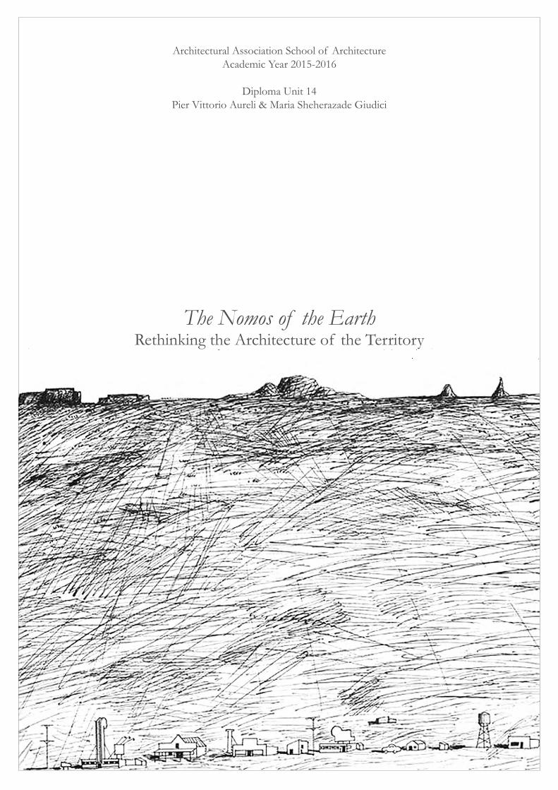
Architectural Association School of ArchitectureAcademic Year 2015-2016
Diploma Unit 14Pier Vittorio Aureli & Maria Sheherazade Giudici
The Nomos of the EarthRethinking the Architecture of the Territory
Introduction
In his book The Nomos of the Earth, the German jurist Carl Schmitt postulated the
concept of nomos as the relationship between the concreteness of the ‘ground’ and
the construction of a political order. This relationship, he wrote, is made manifest in
the primary event of land appropriation, an action that precedes the formation of any
geo-political institution such as the community, the city or the state. The nomos is
therefore the basis for all the categories that define the life of a community such as
sovereignty, justice and distribution of resources.
To settle is one of the primary forms of land appropriation and the primary form for
architecture. In the settlement architecture reveals its most fundamental capacities,
such as to orient, to limit and to define distances and proximities. While the act of
settling expresses a desire for stability and sense of orientation, settlements always
confront situations of crisis, disorder and failure. Here the politicisation of
architecture is no longer ‘discursive’ but instead embedded in the very material
constitution of its elements: walls, passages, rooms and streets. Especially in times of
danger, crisis, warfare and colonisation, ‘to settle’ becomes a mechanism for social
mobilisation. It helps us to define and reproduce specific forms of life. In this sense,
the settlement is the architecture of the territory. Limits, boundaries, thresholds,
topography, topology, logistics and infrastructure become direct indexes of the way
political forces directly inform human subjectivity.
This year Diploma 14 calls for a rethinking of the architecture of territory as a site for
architectural invention. The unit will focus on projects that simultaneously act at the
territorial and at the architectural scale and in doing so question the spatial order
on which the politics of a territory are grounded. We will ask e ach student to select
an exemplary case study of a territorial condition. We will then propose
comprehensive projects that rethink the way in which division of labour and the
consequent social inequality have shaped the present condition of each case study.
These proposals will establish an anatomy of the landscape by giving a form to both
the built, but also the unbuilt space. To envision new forms of housing, new modes of
Diploma 14: The Nomos of the Earth
2
production, new logistics and land redistribution should be considered the goal of
such a project.
Ultimately, we aim to go beyond the dichotomy of form/ content, which has paralysed
recent architectural discourse, by reintroducing urban form as nomos, as a
framework for the project of the city. The following notes introduce the students of
Diploma 14 to the background at stake in the project. While we intentionally have left
succinct the information regarding the students’ assignment, we think it is important
to be very precise about the conceptual background of this year studio.
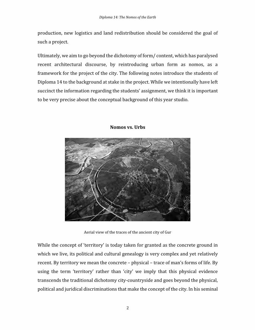
Nomos vs. Urbs
Aerial view of the traces of the ancient city of Gur
While the concept of ‘territory’ is today taken for granted as the concrete ground in
which we live, its political and cultural genealogy is very complex and yet relatively
recent. By territory we mean the concrete – physical – trace of man’s forms of life. By
using the term ‘territory’ rather than ‘city’ we imply that this physical evidence
transcends the traditional dichotomy city-countryside and goes beyond the physical,
political and juridical discriminations that make the concept of the city. In his seminal

Diploma 14: The Nomos of the Earth
3
Teoria General de la Urbanizacion, Ildefonso Cerdà proposed the term Urbanization
as a way to go beyond the term Ciudad (city) which he considered too limiting vis-à-
vis the reality of human settlement. By referring to the Latin word Urbs, which
addresses the material condition of a human agglomeration, Cerdà used urbanization
in order to address the vast expanded nature of the anthropic territory. For Cerdà
urbanization was a veritable ‘scientific knowledge’ and as such it addressed not just
the morphology of the city but its very physiology. Crucial in Cerdà’s idea of the urban
territory is the role of circulation whose managerial force cannot be contained by any
form or limit. For Cerdà the streets of the potentially endless urbe would provide
unimpeded circulation; resources would be evenly distributed, and ultimately social
conflicts would disappear in the smooth surface of urbanization. Twisting Le
Corbusier’s conundrum, we could say that the late capitalist society is actually called
to choose between “Urbanization or Revolution”. It is possible to argue that Cerdà’s
theory fulfilled, less than a hundred years before, Carl Schmitt’s analysis of the decline
of the nomos (and thus of politics) within western civilization. For Schmitt 19th
century techno-scientific progress undermined the possibility of the political as
confrontation and thus recognition of the enemy. In a world that has become a ‘global
village’ where everything is connected and animated by the power of technology and
science, there cannot be any external ‘enemies’ – that is to say enemies we can face in
an agonistic relationship as entities that are different from us, and yet worthy of
respect. Indeed for Cerdà the advent of urbanization meant the approximation of
‘universal peace’ since the whole world would be governed by the rational criteria of
science and technology. And yet as Schmitt noted it is precisely in a world that is
expected to become the smooth surface of global trade that the most insidious and
ungovernable conflicts are produced. This happens because within a ‘globalized’
world where everything is meant to be governed by a comprehensive ‘world order’
the very idea of agonistic external enemy is meaningless and any enemy becomes a
‘total enemy’ i.e. a terrorist or someone to be not just defeated but eliminated. In this
condition, political conflict is considered a threat to society and as such replaced by
economic administration. If we assume Schmitt’s vantage point, we can argue that in
the ‘urban age’ any political or ethical concept must adequate itself to economic
Diploma 14: The Nomos of the Earth
4
imperatives whose command on human life is uncontested. Almost one and a half
century after Cerdà’s theory of urbanization, we can say that the theory has been
fulfilled by reality; however, this has not resulted in universal peace but rather in a
world dominated by bureaucracy and permanent war.
The question we would like to propose is whether there is chance to re-imagine the
idea of the territory beyond the a-political lens of urbanization. This does not mean
that we can undo urbanization since the latter is not just a neologism but a concrete
condition. To address the territory beyond urbanization means to think of the
territory not just as a machinic apparatus whose form eludes our own mental and
physical ‘grasp’, but as an artifact whose form can be experienced and defined. After
all, even the most elusive ‘urban’ condition whose functioning is completely
concealed from our own direct experience (such as internet or the pervasive world of
logistics) leave a concrete trace in the physical world that is difficult to efface. By
‘architecture of the territory’ we mean precisely the material experience of the
territory, an experience that can be intended as a way to grasp its elusive nature and
imagine it as a body that possesses a specific anatomy. Our initial goal will be
therefore to find forms of representation that can help us identify the architecture of
territorial conditions.
A first step towards the definition of ‘The architecture of the Territory’ is to think
urbanization no longer as the ‘natural’ fate of society but as a historical process whose
traces can be defined in the way in which the modern city has come into being. In
ancient times a territory was a vast open-ended realm within which the first cities
were isolated human settlements. Yet already at this stage the territory is interpreted
as a canvas in which topographic features such as mountains, rivers, plateaus, islands
are not just ‘places’ to inhabit or to use as resources, but points of reference that
orient the settlers. These points of reference become a theological geography and as
such they define limits through which the community organizes itself. Here, the
concept of sacred space plays a fundamental role in defining what is free to use and
what is restricted and later what is public and what is private.
Diploma 14: The Nomos of the Earth
5
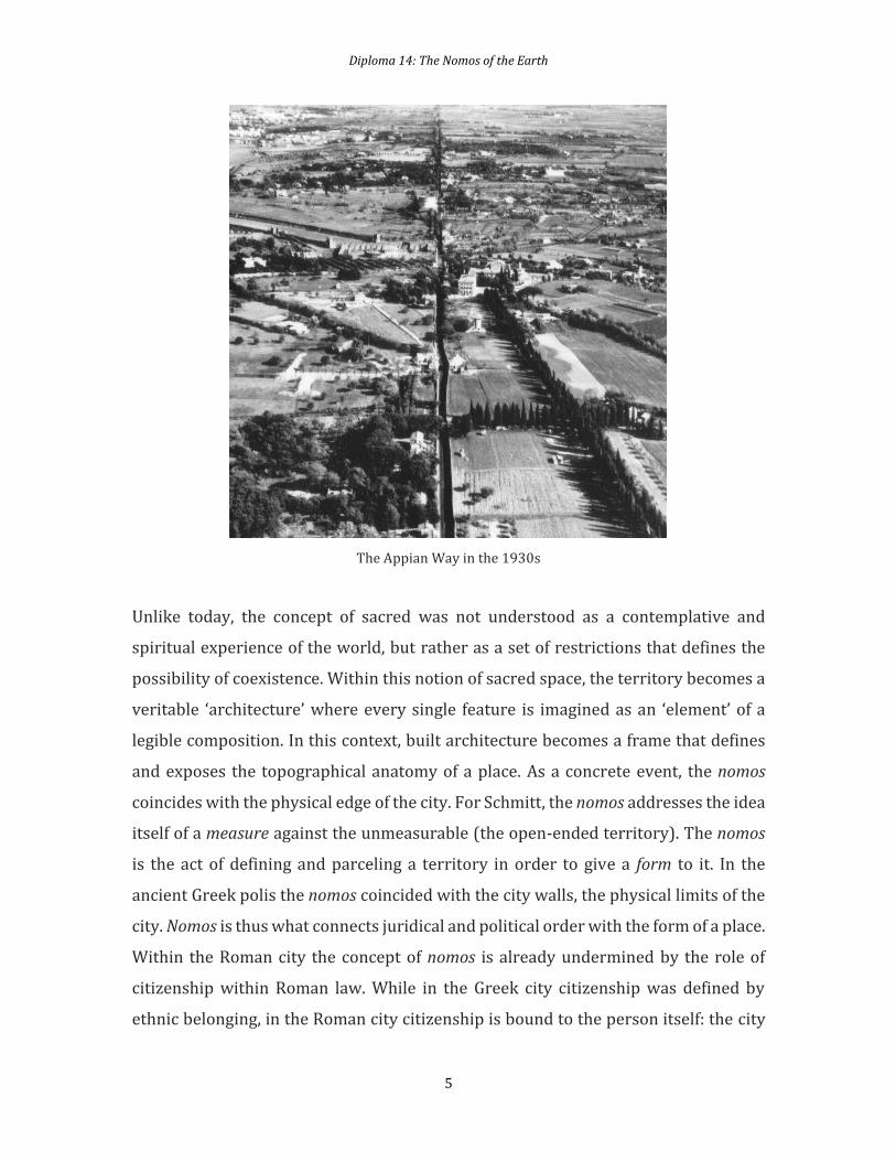
The Appian Way in the 1930s
Unlike today, the concept of sacred was not understood as a contemplative and
spiritual experience of the world, but rather as a set of restrictions that defines the
possibility of coexistence. Within this notion of sacred space, the territory becomes a
veritable ‘architecture’ where every single feature is imagined as an ‘element’ of a
legible composition. In this context, built architecture becomes a frame that defines
and exposes the topographical anatomy of a place. As a concrete event, the nomos
coincides with the physical edge of the city. For Schmitt, the nomos addresses the idea
itself of a measure against the unmeasurable (the open-ended territory). The nomos
is the act of defining and parceling a territory in order to give a form to it. In the
ancient Greek polis the nomos coincided with the city walls, the physical limits of the
city. Nomos is thus what connects juridical and political order with the form of a place.
Within the Roman city the concept of nomos is already undermined by the role of
citizenship within Roman law. While in the Greek city citizenship was defined by
ethnic belonging, in the Roman city citizenship is bound to the person itself: the city
Diploma 14: The Nomos of the Earth
6
as civitas is made of the cives, the person who settles. Another factor that within the
Roman city counters the limit of the nomos is the fundamental role played by
circulation and urban expansion. While the ancient Greeks ignored the potential of
technology, the latter played a fundamental role in the Roman city. The Roman urbs
is thus not a city defined by limits and boundaries, but by movement and circulation.
Roads not only connect different cities but they also expand the power of the city over
the territory. In this sense the Roman centuriatio, the regular layout of roads traced
across a vast territory, can be understood as territorial expansion of the city itself. Yet
within the Roman cities, roads are not only about circulation and military control, but
also of means of processional movement. Roman civilization is based on ritual and
thus the territory is structured in order to perform the religious and civic rituals that
choreograph the multiethnic populus as one coherent civic body. This means that
even though Roman civilization is based on the circulatory movement of its
infrastructures, the ritualistic movement at the basis of Roman life cannot be reduced
to the logistic power of infrastructure.
We can argue that the Roman city is a condition in which nomos and the expansive
logic of the urbs are in reciprocal tension. Neither the nomos nor the urbs can overtake
the other. The most visible expression of this tension are the ‘civic’ architectural
works that make the Roman city and that range from the Basilica to the Aqueduct.
What is interesting is that all these elements – whether monuments or infrastructure
– are built like architectures. The territory becomes a landscape of civic artifacts such
as roads, dams, agricultural fields and temples which seem to have all the same
importance in constructing the human habitat. When in the 18th century Giovanni
Battista Piranesi represented Ancient Rome in his Antichità Romane, he did not only
depict the main monuments of the city, but also anonymous infrastructures such as
walls, foundations and aqueducts. The Roman Empire is perhaps the only civilization
that made of every feature of its territory whether a temple or a simple wall a specific
architectural form. The administrative apparatus that governed the Roman people
can be described as ‘biopolitical’ i.e. as life-conditioning. Yet the architectural
explicitness through which such apparatus was made legible through built form
Diploma 14: The Nomos of the Earth
7
countered the stealth tactics through which biopolitics would be performed in the
modern age.
With the fall of the Roman Empire, also the balance between nomos and urbanization
fell apart. Since the 12th century, with the flourishing of merchant and artisan
economy, urban growth, increasing population and economic wealth become the
tangible ‘effects of good government’. Starting from the medieval city, economy
becomes increasingly more powerful than politics and the latter is made into an
ideological lubricant for the success of the former. Of course the medieval city has
walls, but its dominion extends to the countryside, making the latter a subordinated
territory to the city itself. Yet the triumph of cities over the countryside was not a
politically smooth passage. Between the fall of the Roman Empire and the early
centuries of the first millennium, the western territory was a place in which the power
balance between the rural territory and cities was not yet resolved in favor of the
latter. As Karl Marx, noted in this period the countryside is ‘the place of history’ and
this happens through two phenomena: feudalism and the development of
monasticism.
Feudal power does not find its organizational core in cities, but rather in a
constellation of castles that control vast rural territories and important roads.
Monasticism spreads all over the western world through organized movements of
monks who live according a specific rule of which the monastery becomes the
physical embodiment. But monasteries – such as those belonging to the Benedictine
order – are also centers of political power and economic wealth. Both castles and
monasteries form a territorial network that for some centuries replaces the city.
Among these two powerful institutions there are also a multitude of small rural
centers, often located in remote areas, whose life is self-organized by the local
inhabitants. This condition is disrupted by the political and juridical struggles that
define modern sovereignty at the beginning of the 15th century.
Diploma 14: The Nomos of the Earth
8
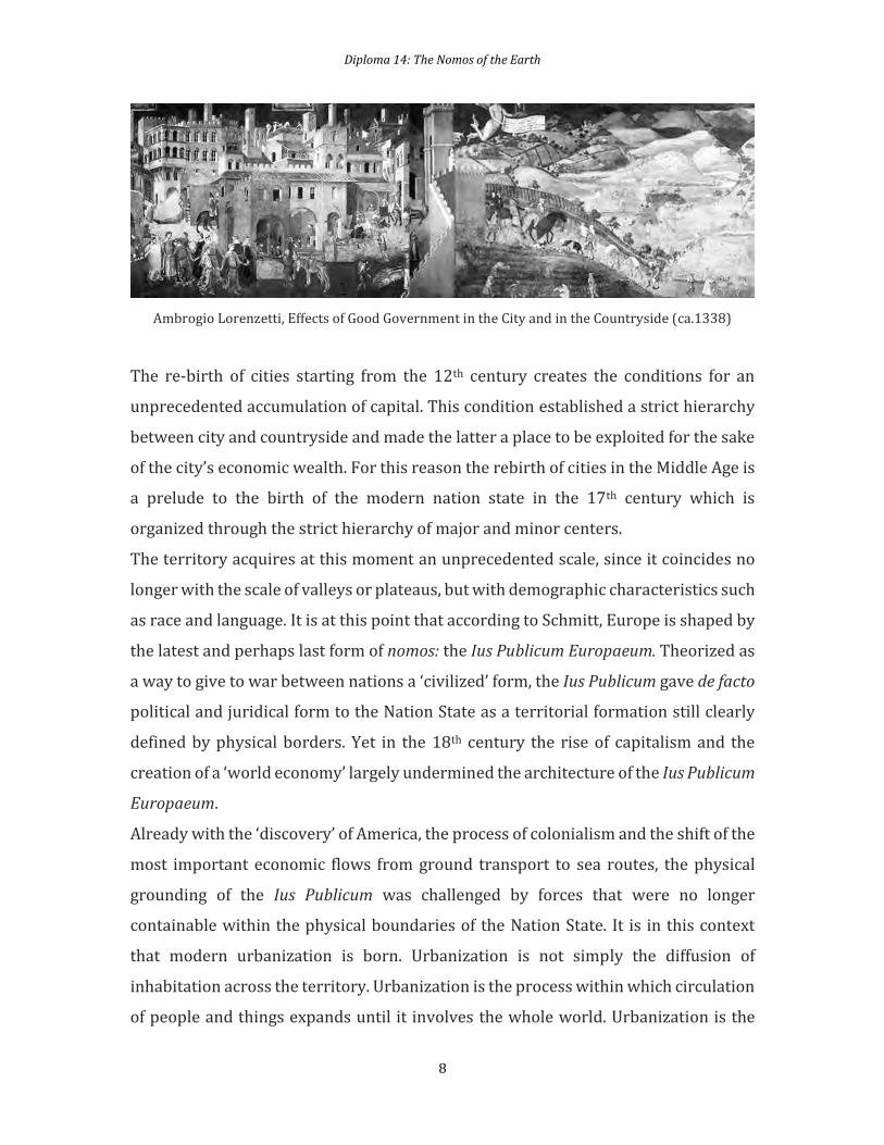
Ambrogio Lorenzetti, Effects of Good Government in the City and in the Countryside (ca.1338)
The re-birth of cities starting from the 12th century creates the conditions for an
unprecedented accumulation of capital. This condition established a strict hierarchy
between city and countryside and made the latter a place to be exploited for the sake
of the city’s economic wealth. For this reason the rebirth of cities in the Middle Age is
a prelude to the birth of the modern nation state in the 17th century which is
organized through the strict hierarchy of major and minor centers.
The territory acquires at this moment an unprecedented scale, since it coincides no
longer with the scale of valleys or plateaus, but with demographic characteristics such
as race and language. It is at this point that according to Schmitt, Europe is shaped by
the latest and perhaps last form of nomos: the Ius Publicum Europaeum. Theorized as
a way to give to war between nations a ‘civilized’ form, the Ius Publicum gave de facto
political and juridical form to the Nation State as a territorial formation still clearly
defined by physical borders. Yet in the 18th century the rise of capitalism and the
creation of a ‘world economy’ largely undermined the architecture of the Ius Publicum
Europaeum.
Already with the ‘discovery’ of America, the process of colonialism and the shift of the
most important economic flows from ground transport to sea routes, the physical
grounding of the Ius Publicum was challenged by forces that were no longer
containable within the physical boundaries of the Nation State. It is in this context
that modern urbanization is born. Urbanization is not simply the diffusion of
inhabitation across the territory. Urbanization is the process within which circulation
of people and things expands until it involves the whole world. Urbanization is the

Diploma 14: The Nomos of the Earth
9
filling of the whole Earth with tangible and intangible infrastructure. The idea of
territory loses its legibility as artifact and becomes an endless machine-like network
whose goal is not to ‘represent’ but to ‘govern’.
The loss of legibility of the territory is also the outcome of the rise of architecture as
a specific discipline. Since architecture is ennobled as intellectual profession it
focuses mainly on prestigious commissions such as churches, palaces and public
buildings. All infrastructural works such as roads, walls, dams, land reclamation are
left to the anonymous domain of engineering. The territory is thus constructed
following a mere managerial logic that leaves no room for physical representation.
Only in the 18th century architectural culture realized it had lost its intellectual
sovereignty on infrastructure, and tried to catch up in a clumsy way making
architecture look like infrastructure. Since the 20th century infrastructure and
logistics have become trendy topics among architects, but often their contribution to
this realm has not ventured beyond heroic representation. From the 1960s
megastructures to the current ‘big box’ craze, architecture translates the idea of
territory into expressionistic objects.
Against this trend, we propose to reconsider the territory itself as architecture: a
gigantic manmade artifact whose anatomy is latent within its functioning. We
propose a project in which reading and designing becomes one and the same. Rather
than considering the territory as a disembodied realm, we propose to make visible its
possible architecture. By doing this the goal is to imagine new forms of production
and reproduction that would challenge the present economic and political asymmetry
that characterize the reality of many urban territories. For us legibility does not
consist simply in making things visible, but also making them accessible. The project
will consist in proposing scenarios in which accessibility to resources can trigger a
possible new nomos where the form of the territory and its political order can
coincide.
Diploma 14: The Nomos of the Earth
10
Index
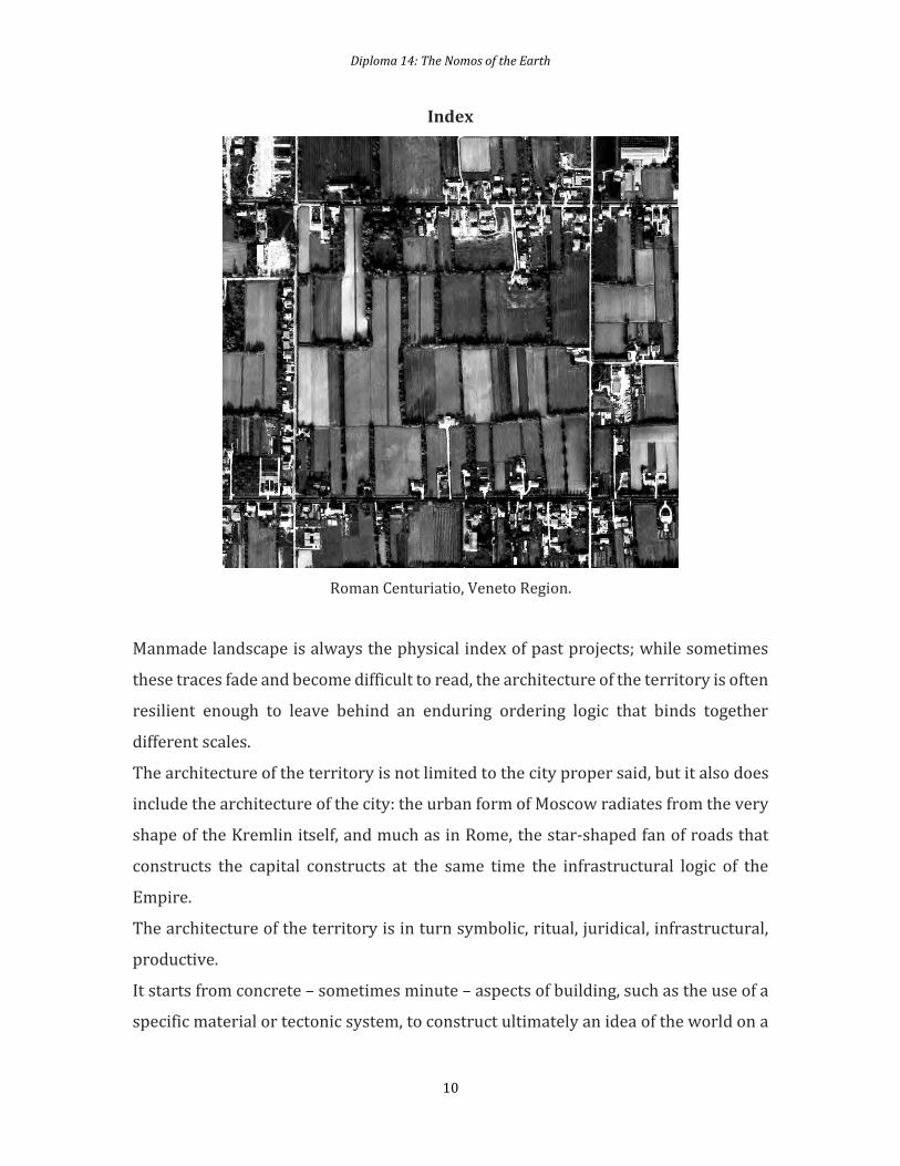
Roman Centuriatio, Veneto Region.
Manmade landscape is always the physical index of past projects; while sometimes
these traces fade and become difficult to read, the architecture of the territory is often
resilient enough to leave behind an enduring ordering logic that binds together
different scales.
The architecture of the territory is not limited to the city proper said, but it also does
include the architecture of the city: the urban form of Moscow radiates from the very
shape of the Kremlin itself, and much as in Rome, the star-shaped fan of roads that
constructs the capital constructs at the same time the infrastructural logic of the
Empire.
The architecture of the territory is in turn symbolic, ritual, juridical, infrastructural,
productive.
It starts from concrete – sometimes minute – aspects of building, such as the use of a
specific material or tectonic system, to construct ultimately an idea of the world on a
Diploma 14: The Nomos of the Earth
11
large scale. The red bricks that distinguish the Sienese settlements from the grey
stone Florentine ones are a symptom of an economic condition but also an aesthetic
choice that embodies deep seated regional conflicts.
Often, the architecture of the territory is historically layered, one power inheriting
the project of its predecessor and twisting it or reusing it for its own aims, or one
civilization searching for legitimacy in models that are long gone but whose territorial
traces still mark the landscape.
The Roman Empire had tried to impose its centuriatio grid across north Italy, in the
vast flatland of the Po river valley. Along with the grid system came new crops to
substitute the original forest and marshlands, and already a thousand years ago the
area bore almost no resemblance to its original ‘natural’ configuration but was
actually a large scale architectural piece made of canals, streets, trees, and
plantations.
In the western part of the region, the grid largely waned due to the medieval project
of exploitation of spring water and irrigation which substituted the checkerboard
with a different field pattern, higher yielding cultures, an entirely different
production and ownership system, and therefore different forms of life. However,
traces of the grid remain in the cross-shaped arrangement of the main streets of
towns and villages which is the undisputed urban archetype in the area; the cross
shape survives until today, even if it had to undergo a millennia-long resemantization
in which local churches occupied the centre of the crossroad turning what had been
largely functional into a symbolic device, and what had once been an isotropic grid
into a constellation system rich in reference points marked by belltowers.
In the east of the Po valley, however, and especially in the region now called Veneto,
the primacy of centuriatio continued, setting the blueprint for the scale of the
territory, its juridical form, its ownership subdivision. The pattern proved an
enduring way to organize the territory which is still visible today: at the same time,
the index of a past ideology, and the very instrument through which that ideology was
created and sustained.
Diploma 14: The Nomos of the Earth
12
Language
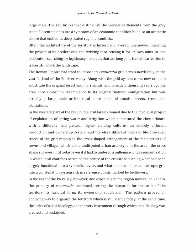
Andrea Palladio, Plan and Elevation of Villa Emo at Fanzolo (from the Four Books, 1570).
In the 1500s it was precisely to this territory that the ailing Venetian Republic turned
as source of wealth. As trade with the Americas and the discovery of new sea routes
to the East, coupled with the rise of the Ottoman Empire, threatened Venice’s
maritime supremacy, the city’s elite started to see to the mainland as a more stable
source of wealth. Architect Andrea Palladio was hired by several members of the
landowning Venetian elite to design their country estates which would be at the same
time agricultural enterprises and pleasure palaces of a cultured upper class. These
villas form an anti-urban constellation of control centres which contradicts the
concentration of wealth and power that had made independent most north-eastern
Italian towns in the late Middle Age. If one can argue that this system is a harbinger
of the contemporary diffused, ‘weak’ city, it is also true that, contrary to random
sprawl, the virtue of such a project lies in its explicitness and capacity to put forward
a specific settlement form – with its good and bad ideological aspects – with utmost
clarity and a specific architectural definition.
Diploma 14: The Nomos of the Earth
13
The villas are at the core of architecture of the territory that acts at different scales –
at the geopolitical scale by shifting Venice’s focus from sea to land, at the regional
scale by redistributing power out of the cities and constructing a constellation
arrangement, at the scale of the agriculture by controlling the fields, at the scale of the
architecture where they introduce a new typology that hybridizes farm and palace,
and finally, at the scale of the detail by proposing the classical language as unifying
koine able to represent the landowner class.
Palladio’s work at large, both in the countryside and in his interventions in Venice
itself, as part of a larger project to turn the Venetian state from its old, republican,
sea-oriented version into a different political entity altogether. At the time classicism
was slowly being introduced in Venice more than a century after it had become the
standard in the rest of Italy and what strikes in Palladio’s work is the fact that the
simple choice of an architectural language can impact large scale dynamics and be
part and parcel of the architecture of the territory. The classical language, with its link
to an idea of order and shared grammar, clearly contradicted the stylistic tradition of
the medieval golden age of Venice. This tradition implied first of all a clear reference
to Byzantine and near-eastern models which echoed Venice’s pride in belonging to
the sea, rather than to the land. Choosing a ‘Roman’ language meant to turn one’s back
to the very idea of Venice as epicenter of the Mediterranean. Moreover, the formal
freedom implicit in a style that allowed the use of idiosyncratic materials,
proportions, and eclectic visual references seemed to mirror the freedom of the early
Venetian republic; on the contrary, the consistency of the system of classical orders
was symptomatic of a more formalized and constructed cultural hierarchy which in
actual fact did mirror quite accurately the fact that Venice was by then ruled by an
oligarchic class rather than a democratic system.
A few centuries later, Thomas Jefferson would also employ the classical language in a
similar way as ordering device deployed on a potentially territorial scale. In
Charlottesville, Virginia, he designed several buildings between which the local
university campus and his own residence at Monticello; these buildings are key
examples of an attempt to establish a readability of the single architectural piece as
recognizable and yet harmonious part of a whole.
Diploma 14: The Nomos of the Earth
14
Settlement
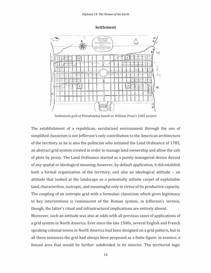
Settlement grid of Philadelphia based on William Penn’s 1682 project
The establishment of a republican, secularized environment through the use of
simplified classicism is not Jefferson’s only contribution to the American architecture
of the territory as he is also the politician who initiated the Land Ordinance of 1785,
an abstract grid system created in order to manage land ownership and allow the sale
of plots by proxy. The Land Ordinance started as a purely managerial device devoid
of any spatial or ideological meaning; however, by default application, it did establish
both a formal organization of the territory, and also an ideological attitude – an
attitude that looked at the landscape as a potentially infinite carpet of exploitable
land, characterless, isotropic, and meaningful only in virtue of its productive capacity.
The coupling of an isotropic grid with a formulaic classicism which gives legitimacy
to key interventions is reminiscent of the Roman system; in Jefferson’s version,
though, the latter’s ritual and infrastructural implications are entirely absent.
Moreover, such an attitude was also at odds with all previous cases of applications of
a grid system in North America. Ever since the late 1500s, several English and French
speaking colonial towns in North America had been designed on a grid pattern, but in
all these instances the grid had always been proposed as a finite figure: in essence, a
fenced area that would be further subdivided in its interior. The territorial logic
Diploma 14: The Nomos of the Earth
15
behind the establishment of a homogenous, expandable grid – such as the Roman
centuriatio, Cerda’s Barcelona, or Jefferson’s Ordinance – is completely different from
the decision to fence off a special, specific plot of land which becomes an inside
separated from the wild outside. The subdivision of the initial square also had a
profoundly symbolic meaning: in many cases the square was divided in a nine-
square-grid referencing what was widely believed at the time to be the configuration
of the Temple of Solomon following a series of reconstructions crystallized perhaps
in their most famous version in Juan Bautista Villalpando’s book Ezechielem
Explanationes but equally well known through popular sources in protestant
environments. From the Escorial palace in Madrid to the core plan of the town of New
Haven, this archetypal form became the settlement principle of countless territorial
interventions. These grids were finite and highly symbolic; unfortunately, they would
not withstand the speculative pressure that on the contrary was smoothly managed
by the Jeffersonian grid. It is today quite difficult to recognize these analogues of
Jerusalem although in certain cases the original plan still informs the contemporary
city: in New Haven, for instance, the central sector of the nine-square-grid is still the
town green, empty and at the same time central, symptomatic of what had once been
a social and religious utopia which could only happen on virgin land.
These North American grids were often the expression of individual obsession or of
the deep seated beliefs of a small and tightly knit sect such as in the cases of the
quaker William Penn, founder of Philadelphia, or the puritan John Davenport in New
Haven. In Latin America, however, Spanish colonization followed a more organized,
hierarchical logic, and it imposed an architecture of the territory which adopted the
grid system not as idiosyncratic act of faith, but as a planned device that would at the
same time cater to both pragmatic and symbolic purposes. Interestingly, the use of
the grid as territorial system was theorized by a series of crucial legal documents that
go collectively under the title of Laws of the Indies, a set of rules periodically reviewed
and updated by Spanish monarchs throughout the late 1500s and 1600s. The Laws of
the Indies clearly stated that the new towns would have a grid pattern not only in
order to handle growth in a rational way, but also as a pedagogical device to teach the
heathens how to lead a civilized (ie European) life.
Diploma 14: The Nomos of the Earth
16
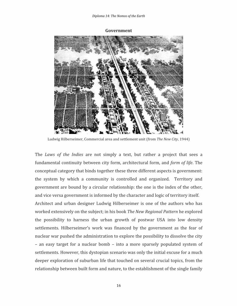
Government
Ludwig Hilberseimer, Commercial area and settlement unit (from The New City, 1944)
The Laws of the Indies are not simply a text, but rather a project that sees a
fundamental continuity between city form, architectural form, and form of life. The
conceptual category that binds together these three different aspects is government:
the system by which a community is controlled and organized. Territory and
government are bound by a circular relationship: the one is the index of the other,
and vice versa government is informed by the character and logic of territory itself.
Architect and urban designer Ludwig Hilberseimer is one of the authors who has
worked extensively on the subject; in his book The New Regional Pattern he explored
the possibility to harness the urban growth of postwar USA into low density
settlements. Hilberseimer’s work was financed by the government as the fear of
nuclear war pushed the administration to explore the possibility to dissolve the city
– an easy target for a nuclear bomb – into a more sparsely populated system of
settlements. However, this dystopian scenario was only the initial excuse for a much
deeper exploration of suburban life that touched on several crucial topics, from the
relationship between built form and nature, to the establishment of the single family
Diploma 14: The Nomos of the Earth
17
house as nuclear blueprint of society. Hilberseimer in fact did not only work on the
regional scale of the pattern, but also on the urban morphology and building types
that would respond to the form of life implied by this low density territory. Rather
than relying on the freestanding villa model, Hilberseimer imagined a fabric-like
system of patio houses that would substitute the front lawn with an internal
courtyard. His suburban settlement would therefore host a life that is radically
different from what we see in contemporary sprawl while catering essentially to the
same middle class subject and maintaining a very low density. Moreover, the patio
pattern would allow for a secondary system of green pedestrian alleys, interlocked
with the street pattern. The presence of carefully scripted voids is perhaps one of the
most peculiar characteristic of Hilberseimer’s work: his architecture of the territory
starts from an idea of settlement which frames and confronts the emptiness of nature
and circulation space.
This attitude is particularly evident in Lafayette Park, a project developed by
Hilberseimer together with Mies van der Rohe in Detroit, where a composition of tall
slabs and low residential strips frames a large park that establishes, much as in
Hilberseimer’s regional schemes, a double circulation system where the pedestrian
integrates the car-based, and the greenery complements the infrastructure. These
experiments are ultimately an attempt to formulate an architecture that not only
accommodates a new subject, but also somehow gives it a readable form.
Hilberseimer’s is perhaps a realist position which accepts the fundamental alliance
between government and architecture, but it is also a position which offered him a
vantage point to actually make explicit a dynamic that is often hidden. The Laws of the
Indies were undoubtedly an instrument of aggression if not genocide; in their name,
the pyramids of Tenochtitlan were destroyed to build the quadrangular podium of
the Zocalo. However, they also put forward a world view that in its uncompromising
clarity also offered itself to criticism and resistance. Hilberseimer’s projects for
postwar USA perhaps share with the Laws the same ambition to shape the very way
citizens conceive their own being-in-a-society as well as the deep conviction that the
form we give to the landscape – and by extension to the city – ultimately are nothing
but the very form of the social relationships that bind us together.
Diploma 14: The Nomos of the Earth
18
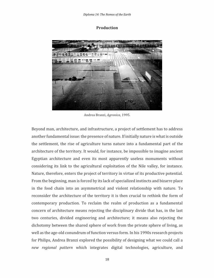
Production
Andrea Branzi, Agronica, 1995.
Beyond man, architecture, and infrastructure, a project of settlement has to address
another fundamental issue: the presence of nature. If initially nature is what is outside
the settlement, the rise of agriculture turns nature into a fundamental part of the
architecture of the territory. It would, for instance, be impossible to imagine ancient
Egyptian architecture and even its most apparently useless monuments without
considering its link to the agricultural exploitation of the Nile valley, for instance.
Nature, therefore, enters the project of territory in virtue of its productive potential.
From the beginning, man is forced by its lack of specialized instincts and bizarre place
in the food chain into an asymmetrical and violent relationship with nature. To
reconsider the architecture of the territory it is then crucial to rethink the form of
contemporary production. To reclaim the realm of production as a fundamental
concern of architecture means rejecting the disciplinary divide that has, in the last
two centuries, divided engineering and architecture; it means also rejecting the
dichotomy between the shared sphere of work from the private sphere of living, as
well as the age-old conundrum of function versus form. In his 1990s research projects
for Philips, Andrea Branzi explored the possibility of designing what we could call a
new regional pattern which integrates digital technologies, agriculture, and
Diploma 14: The Nomos of the Earth
19
knowledge production. In proposals such as Agronica the traditional division
between life and work, production of goods and ideas, typology and urban
morphology are challenged and reimagined. Landscape is revealed as a manmade
construct, and therefore becomes an integral part of the project of which the architect
must take responsibility. Branzi’s work sheds light on the fact that it is impossible to
reimagine an architecture of the territory unless we are willing to question the way
man produces but also reproduces himself. As our relationship to landscape is
inescapably exploitative, the issue is not only how to make this exploitation more
sustainable from the point of view of resources, but also from the social point of view.
Some sixty years earlier, Le Corbusier himself had in fact tried his hand at designing
a model for the territory: his Village Radieux was, true to form, not an idyllic or rustic
place, but on the contrary the ideal laboratory where Le Corbusier tested concepts
that would become crucial to his urban models of later years. The Village’s
composition of an urbanized territory through a constellation of sculptural objects is
directly inspired from the Acropolis and will find in the 1940s its best expression in
the plan of St. Die. Even more radically than Le Corbusier, however, Branzi starts from
an actual analysis of the productive conditions not only to accommodate them, but
also to manipulate them, and ultimately open up the possibility to subvert them.

Diploma 14: The Nomos of the Earth
20
The project
At the beginning of first term each student will chose a territory. In order to make the
different case studies comparable each student will frame her/his analysis within a
100x100 km square. This square will be the project site.
By means of accurate mapping each student will produce a cartographic account of
the territory by emphasizing both tangible and intangible conditions. After the first
round of mapping, the mapping will slowly evolve towards an analogical
representation of the territory as anarchitecture. Such interpretation will trigger the
formulation of a scenario and thus the composition of a specific architectural brief.
The set of maps will be commented by a concise text of no more than 2.000 words.
Although the architectural brief will change from case to case, all projects should
tackle the question of creating a settlement, which responds to contemporary
conditions. Generally speaking, a settlement is a built form which allows the
development of human activities of production (work) and reproduction (living). In
order to do so, in principle the settlement should include infrastructure, housing, and
workspace. However, the relationship between the three has changed in the last
decades, to the point that it is impossible to distinguish between them. A new form of
settlement should therefore take into account this shift, reimagining new spatial
relationships between domestic space, immaterial and material production, cultural
and institutional space, and transport infrastructure.
We ultimately expect that, within the larger territorial project, all students should
arrive to the definition of at least one key architectural element at the scale of the
building. We believe that both typological investigation, and tectonic experimentation
are not divorced from the larger scale, but on the contrary contribute to it in a crucial
way.
A fundamental issue that will be debated in the studio will be representation.
Historically the concept of the territory has evolved through the fabrication of maps.
Within the modern age is not the reality of territory that has produced cartographic
Diploma 14: The Nomos of the Earth
21
knowledge, but it has been cartographic knowledge that has produced the concept of
territory. Issues such as scale or even cartographic conventions are not innocent
means of representation. By modifying our reading of maps, these issues construct a
political understanding of the territory which is often taken for granted. We’ll invite
students to explore unconventional means of cartographic representation by mixing
scales or inserting figures as it used to be before the introduction of ‘scientific’
cartography. The goal of the project is to evolve out a specific territorial condition
new forms of settlements that challenge the way in which human habitat has been
defined by urbanization. From logistics to domestic space, the goal will be to mobilize
every territorial feature towards the possibility of a legible ‘architecture of the
territory’.
During the year there will be a series of lectures by the Diploma tutors and invited
guests on the topic of the territory that will accompany the development of the
project. As usual in Diploma 14, drawing, text and well constructed argumentation
will play a fundamental role in the development of the project.
Diploma 14: The Nomos of the Earth
22
Concise Bibliography
Carl Schmitt, The Nomos of the Earth in the International Law of Jus Publicum
Europaeum (London: Telos Press Publishing, 2006).
Carl Schmitt, The Concept of the Political, expanded edition (Chicago: University of
Chicago Press, 2007).
Stuart Elden, The Birth of Territory (Chicago: University of Chicago Press, 2013).
Michel Foucault, Security, Territory, Population: Lectures at the Collège de France
1977—1978 (London: Picador, 2009).
Sandro Mezzadra, Brett Neilson, Borders as Method or the Multiplication of Labor
(Durham: Duke University, 2013).
Neil Brenner, State/Space, A Reader (London: Wiley Blackwell, 2003).
Neil Smith, Uneven Development: Nature, Capital and the Production of Space (Atlanta:
University of Georgia Press, 2008).
François de Polignac, Cults, Territory, and the Origins of the Greek City-State (Chicago:
University of Chicago Press, 1995).
Gian Pietro Brogiolo, Towns and Their Territories between Late Antiquity and the Early
Middle Ages (Transformation of the Roman World) (London: Brill Academic Publisher,
2000).