the north-south 400 kv interconnection development overview of
TRANSCRIPT

3/6/2016
1
The North-South 400 kV
Interconnection Development
Des Cox, Senior Planning Consultant, EirGrid
Overview of the North-South 400 kV
Interconnection Development

3/6/2016
2
Overview of the Transmission System
Transmission Customers
Substation
Substation Distribution Network
Generators
Homes, Businesses, Factories, etc.
Transmission Network
Transmission Network

3/6/2016
3
The
European
Grid
Network
(ENTSO-E)

3/6/2016
4
Equivalent Capacity
10 x 110kV Single Circuit
2 x 275kV Single Circuit
1 x 400kV Single Circuit
= =
3 x 220kV Single Circuit
= =
1 x 275kV Double Circuit
Proposed Interconnector
Existing Grid in NI
Technical Performance
Community & Environment
Balance
Costs & Efficiency
The Balance of Grid Development
Safe
Secure
Reliable
Economical
Efficient
Due regard for the Environment

3/6/2016
5
The Nature and Extent of the
Development – the Overhead Line
• New single-circuit 400 kV overhead line of
approximately 100.5 km in the counties of
Monaghan, Cavan and Meath
• Extending from the border with NI in Co.
Monaghan to the existing 400 kV Woodland
substation, Co. Meath
(Fig. 2.1 Vol. 3B)
400 kV Overhead Line Design
(Fig. 6.25, Vol. 3B) (Fig. 5.19, Vol. 3B)

3/6/2016
6
400 kV Overhead Line Design
(Fig. 6.25, Vol. 3B) (Fig. 5.19, Vol. 3B)
The Nature and Extent of the
Development – the Overhead Line
• New single-circuit 400 kV overhead line of
approximately 100.5 km in the counties of
Monaghan, Cavan and Meath
• Extending from the border with NI in Co.
Monaghan to the existing 400 kV Woodland
substation, Co. Meath
• Approximately 2.85 kM strung on unused
northern side of existing Oldstreet-Woodland
400 kV double-circuit
(Fig. 2.1 Vol. 3B)

3/6/2016
7
Existing 400 kV Overhead Line
(Fig. 6.30 Vol. 3B)
• Double-circuit 400 kV overhead line on
approach to Woodland Substation
• Conductors on each circuit are in a
vertical rather than horizontal
configuration hence the need for taller
structures
The Nature and Extent of the
Development – the Overhead Line
• New single-circuit 400 kV overhead line of
approximately 100.5 km in the counties of
Monaghan, Cavan and Meath
• Extending from the border with NI in Co.
Monaghan to the existing 400 kV Woodland
substation, Co. Meath
• Approximately 2.85 kM strung on unused
northern side of existing Oldstreet-Woodland
400 kV double-circuit
• Concurrent proposal by SONI for the portion
of the overall interconnector in NI, extending
from the NI border to a planned 400 kV
substation at Turleenan, Co. Tyrone
(Fig. 2.1 Vol. 3B)

3/6/2016
8
• Associated modifications to existing 110 kV
lines at intersection with proposed lines
• Associated western extension of existing
Woodland 400 kV Substation
• Associated construction materials storage
yard
• All associated and ancillary development
(Fig. 5.18
Vol. 3B)
The Nature and Extent of the
Development – Associated & Ancillary
Receiving Environment
(Fig. 5.7 Vol. 3B)

3/6/2016
9
Receiving Environment
• SEA for the Grid25 Implementation
Programme 2011-16 identifies national
Overall Development Potential Rating.
• More environmentally constrained areas
are indicated in red.
• The area of the north-east of Ireland is
identified as generally of low, or localised
constraint.
(Grid25 Implementation Plan 2011-2016 - SEA
in Reference Material, Vol. 3B)
The Alignment of the Proposed
North-South 400 kV Interconnection
Development

3/6/2016
10
Lemgare to Lisdrumgormly Towers 102 to 109
Lisdrumgormly to Cashel Towers 109 to 118

3/6/2016
11
Cashel to Cornamucklagh North Towers 118 to 126
Cornamucklagh North to Cornanure (Monaghan Barony)
Towers 126 to 136

3/6/2016
12
Cornanure ( Monaghan Barony) to Drumguillew Lower
Towers 136 to 149
Drumguillew Lower to Cooltrimegish Towers 149 to 161

3/6/2016
13
Cooltrimegish to Tullyglass Towers 161 to 176
Tullyglass to Ardragh Towers 176 to 188

3/6/2016
14
Ardragh to Doagh Towers 188 to 203
Doagh to Corlea (Clankee Barony)
Towers 203 to 217

3/6/2016
15
Corlea (Clankee Barony) to Cordoagh (ED
Enniskeen) Towers 217 to 224
Cordoagh to Clonturkan Towers 224 to 237

3/6/2016
16
Clonturkan to Shancor Towers 237 to 252
Shancor to Rahood Towers 252 to 271

3/6/2016
17
Rahood to Dowdstown (ED Castletown)
Towers 271 to 290
Dowdstown (ED Castletown) to Diméin
Bhaile Ghib (Gibstown Demesne)
Towers 290 to 307

3/6/2016
18
Diméin Bhaile Ghib (Gibstown Demesne) to
Durhamstown Towers 307 to 324
Durhamstown to Philpotstown (ED Bective)
Towers 324 to 342

3/6/2016
19
Philpotstown (ED Bective) to Trubley
Towers 342 to 359
Trubley to Branganstown Towers 359 to 375

3/6/2016
20
Branganstown to Culmullin
Towers 375 to 392
Culmullin to Bogganstown (ED Culmullin)
Towers 392 to 402
(Existing Oldstreet to Woodland OHL Route)

3/6/2016
21
Bogganstown (ED Culmullin) to Woodland
Towers 402 to 410
(Existing Oldstreet to Woodland OHL Route)
Construction and Temporary Access

3/6/2016
22
(Fig. 7.2 Vol. 3B)
(Source: Landowner Information Brochure (July 2013) for illustrative purposes only)
Tower 135: Identified Alternative
Temporary Construction Access Route
Townland of Cargaghramer, Co. Monaghan.
---------- access route identified in EIS ---------- Potential alternative access route identified

3/6/2016
23
The North-South 400 kV
Interconnection Development

Overview of the North-South 400 kV Interconnection Development
Appendix

Alternative Temporary Access Routes Reference “Response to the Issues Raised in Submissions / Observations”, Section 6.2.1.3, Potential Access Route Changes, p 97: “6.2.1.3 Potential Access Route Changes 17 Some landowner submissions raise issues in respect of the access route proposed over their
lands and in one case suggested an alternative route.
Applicant’s Response: 18 It is always EirGrid’s objective to facilitate landowner requests where practicable and where it
does not create additional impact. However, it was not feasible, within the timeframe available to complete this response report, to carry out a full evaluation of potential changes to approximately 11 no. access routes requested either by a landowner or under consideration due to issues landowners have raised.”
Alternative Access Routes, March 2016 Tower 123 – LCT051 [SI(2015)-0049] Figure 1.1

Table 1.1
Environmental Review
Topic
Tower 123 Access Route Comment
Ecology The alternative access route uses an existing gap in the hedgerow in the
southeast of the field, crossing improved agricultural grassland to the tower.
The alternative route is slightly preferable as it utilises an existing gap in the
hedgerow. Having considered the potential impact of this alternative route,
there is no change to the overall ecological impact evaluation submitted.
Cultural Heritage The proposed alternative is a minor adjustment to the access route in an
area where there are no previously recorded archaeological or architectural
heritage features. Having considered the potential impact of this alternative
route from a cultural heritage perspective, there is no preference.
Traffic No change off the public road network.
Soils/Geology No significant issues with either access track option. Type 2 tracks already
recommended. No preference.
Agronomy The impact from either option is imperceptible. The alternative route option is
closer to the field boundary and uses an existing farm track and will therefore
cause less damage to land and is preferable.

Tower 135 – LCT070 [SI(2015)-0655] Figure 1.2
Table 1.2
Environmental Review
Topic
Tower 135 Access Route Comment
Ecology The alternative route follows an existing farm track, is shorter and utilises an
existing gate to access improved grassland at the tower site. This alternative
route is slightly preferable. Having considered the potential impact of this
alternative route, there is no change to the overall ecological impact evaluation
submitted.
Cultural Heritage Alternative route avoids the location of a farmstead depicted on 1st Edition OS
Maps but which is no longer extant by the time of the 2nd Edition survey.
Alternative route would be slightly preferred.
Traffic No change off the public road network.
Water/Soils/Geology No significant issues with either access track option. No preference.
Agronomy The impact from either option is imperceptible. The alternative option, which
crosses over green field for a shorter distance, will cause less damage to land
and is preferable.

Tower 137 – LCT073 [SI(2015)-0184] Figure 1.3
Table 1.3
Environmental Review
Topic
Tower 137 Access Route Comment
Ecology The alternative access route uses an existing gap in the hedgerow in the
southeast of the field, crossing improved agricultural grassland to the
tower. Having considered the potential impact of this alternative route, it is
slightly preferable, with however no change to the overall ecological impact
evaluation submitted.
Cultural Heritage Both existing and alternative access routes skirt the location of a house
depicted on the 1st edition OS Map. From a cultural heritage perspective
there is no preference.
Traffic No change off the public road network.
Water/Soils/Geology No preference. Moderately steep slope (1:4) on either access route option.
No significant issues with either access track option.
Agronomy The impact from the original access route is lower, because it crosses over
green field for a shorter distance. However, the difference is very small and
there is no preference for either.
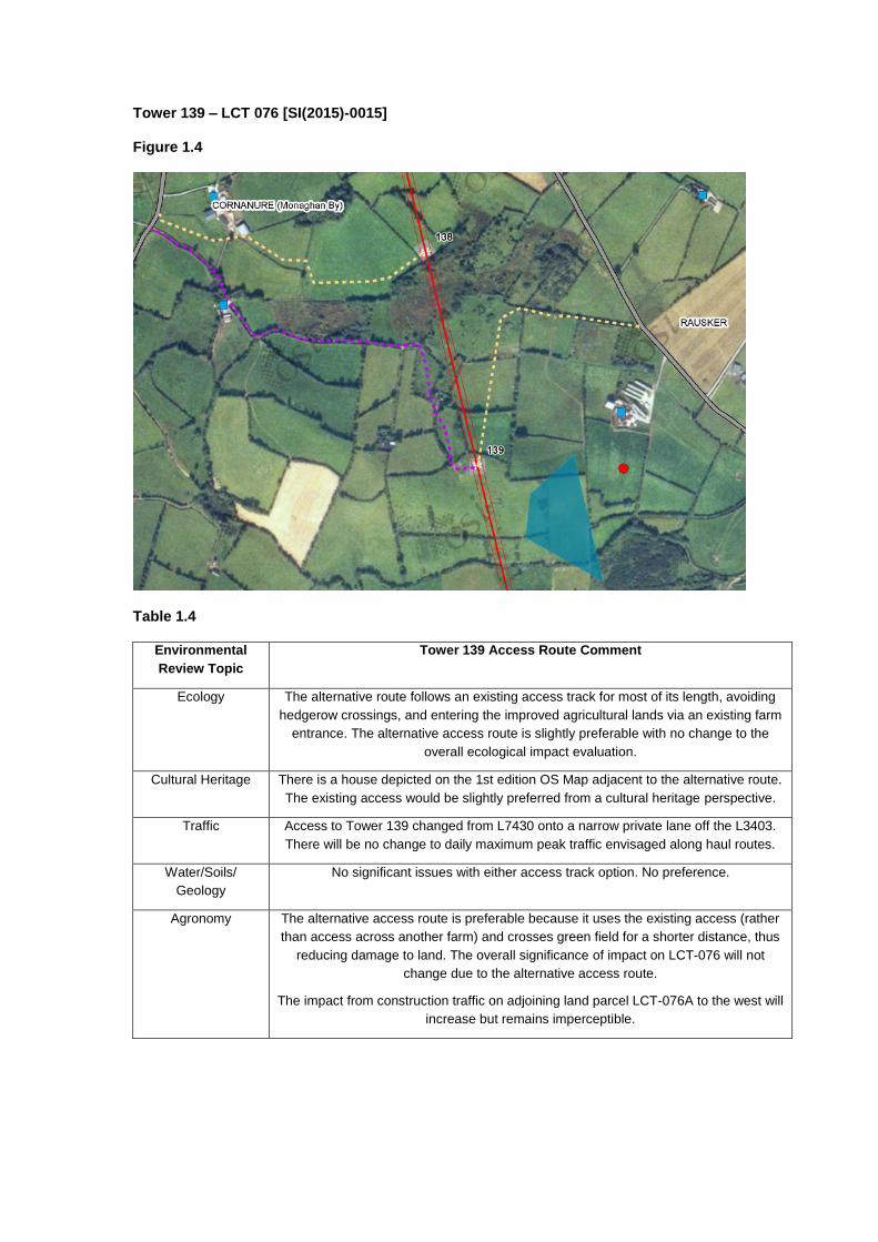
Tower 139 – LCT 076 [SI(2015)-0015] Figure 1.4
Table 1.4
Environmental
Review Topic
Tower 139 Access Route Comment
Ecology The alternative route follows an existing access track for most of its length, avoiding
hedgerow crossings, and entering the improved agricultural lands via an existing farm
entrance. The alternative access route is slightly preferable with no change to the
overall ecological impact evaluation.
Cultural Heritage There is a house depicted on the 1st edition OS Map adjacent to the alternative route.
The existing access would be slightly preferred from a cultural heritage perspective.
Traffic Access to Tower 139 changed from L7430 onto a narrow private lane off the L3403.
There will be no change to daily maximum peak traffic envisaged along haul routes.
Water/Soils/
Geology
No significant issues with either access track option. No preference.
Agronomy The alternative access route is preferable because it uses the existing access (rather
than access across another farm) and crosses green field for a shorter distance, thus
reducing damage to land. The overall significance of impact on LCT-076 will not
change due to the alternative access route.
The impact from construction traffic on adjoining land parcel LCT-076A to the west will
increase but remains imperceptible.

Tower 159 – LCT 108 [SI(2015)-0076] Figure 1.5
Table 1.5
Environmental Review
Topic
Tower 159 Access Route Comment
Ecology The alternative access route follows an existing farm track throughout its
length, avoiding hedgerow crossings. Having considered the potential impact
of this alternative route, it is slightly preferable, with no change to the overall
ecological impact evaluation submitted.
Cultural Heritage There are a number of farmsteads and houses depicted along the alternative
route on 1st edition OS mapping. The existing access is shorter and there is a
single house depicted on the OS mapping. Therefore the existing route would
be slightly preferred from a cultural heritage perspective.
Traffic No change off the public road network.
Water/Soils/Geology No significant issues with either access track option. No preference.
Agronomy The alternative route is preferable because although it uses the existing farm
yard access and a longer access route via the existing farm road, it will
reduce land damage. The residual impact due to either of the access route
options is imperceptible.

Tower 191 – LCT165 [SI(2015)-0064] Figure 1.6
Table 1.6 Environmental Review
Topic
Tower 191 Access Route Comment
Ecology The alternative access route follows an existing track and enters the improved
agricultural grassland at the tower site via an existing farm gate. Having
considered the potential impact of this alternative route, it is slightly preferable,
with no change to the overall ecological impact evaluation submitted.
Cultural Heritage Alternative route passes in the vicinity of a farmstead/house marked on the 1st
edition OS Map. The existing access would therefore be slightly preferred from a
cultural heritage perspective.
Traffic No change off the public road network.
Water/Soils/Geology No significant issues with either access track option. No preference.
Agronomy The impact from either option is imperceptible. The alternative option is
preferable because it uses an existing farm track and will cause less damage to
land.