the pond-and-plug treatment for stream and meadow ...€¦ · design considerations this paper is...
TRANSCRIPT

THE POND-AND-PLUG TREATMENT FOR STREAM AND MEADOW RESTORATION:
RESOURCE EFFECTS AND DESIGN CONSIDERATIONS
A Briefing Paper for Plumas National Forest Resource Specialists and Managers
The Red Clover – McReynolds Project, the first spring after construction (2008) (Photo: Jim Wilcox)
Version 1.0 May 2010
Table of Contents
Executive Summary ......................................................................................................... i
Introduction ..................................................................................................................... 1
Description of the Pond-and-Plug Treatment .................................................................. 2
A Brief Aside: The Project Planning Process .................................................................. 4
Treatment Benefits and Impacts, both Theoretical and Demonstrated ........................... 5
Reduced streambank erosion ...................................................................................... 5
Improved forage and riparian vegetation ..................................................................... 7
Timing of stream flow ................................................................................................... 8
Flood Attenuation....................................................................................................... 13
Temperature Effects .................................................................................................. 14
Heritage Resource Effects ......................................................................................... 15
Wildlife Effects ........................................................................................................... 16
Botanical Effects: Invasive Plant Species .................................................................. 20
Carbon Sequestration ................................................................................................ 20
Hydrologic Risks and Design Considerations ................................................................ 22
Grade Control Structure ............................................................................................. 23
Flow over the Plugs ................................................................................................... 25
References .................................................................................................................... 30
Contributors / Reviewers ............................................................................................... 33
Appendix A: List of Pond-and-Plug Projects Implemented in Upper Feather Watershed ...................................................................................................................................... 34

Plumas NF Pond-and-Plug Briefing Paper: Executive Summary i
Executive Summary This paper is intended to provide a description of the pond-and-plug treatment, briefly present general treatment effects, and discuss basic design considerations relative to potential risks of the treatment. This paper’s audience is intended to be Plumas National Forest (PNF) resource specialists and managers who may or may not be familiar with the technique. A primary goal of this paper is to document the Forest’s current understanding, across several resource areas, of effects associated with the treatment as well as to point out gaps in our understanding that should be addressed by future monitoring or research. Nowhere has this technique been employed to a greater extent than in the meadows of the Upper Feather River watershed. Implementation of pond-and-plug projects has intensified in recent years, with more than twice as many projects constructed since 2002 than were constructed in the 7 years prior. Several factors have contributed substantially to these phenomena. The pond-and-plug technique results in both reconnection of a stream channel with a functioning floodplain and restoration of a degraded meadow’s water table up to its historic level. The restored floodplain facilitates much less flood-flow stress along the restored channel so that stream banks are stabilized with less risk of future maintenance or reconstruction. Restoration of the meadow water table results in re-watering of meadow soils and vegetation, with significant effects throughout the restored floodplain for meadow hydrology, wildlife, and forage. Restored floodplain connectivity spreads flood flows so that a meadow’s natural ability to settle the coarse or fine sediment delivered from steeper stream reaches is restored, a function that is especially critical where anthropogenic changes to the upper watershed have altered hydrology and increased sediment loads. These effects are substantially realized within the first year after construction. Upper Feather River meadows have suffered severe degradation due to human-caused activities over the past 150 years, converting the meadows to dry lands with channel banks in a highly erodible state and local vegetation and wildlife communities that are far removed from historic condition. Due to efficiencies associated with construction, the technique allows restoration practitioners to economically treat larger lengths of these degraded systems than had been possible with past restoration techniques, with a wider array of potential benefits.
The technique is relatively new. Dramatic improvements have been observed at projects completed to date and reliable project design techniques have continually developed over the past 15 years. However, there is still much to be learned about several aspects of long-term ecological effects and project design elements will continue to evolve, particularly for steeper stream and meadow systems.
Treatment Description The stream and meadow restoration technique commonly known as “pond-and-plug” was first implemented on the PNF in 1995. The vast majority of pond-and-plug projects in the Upper Feather River watershed have been designed and implemented by the Feather River Coordinated Resource Management group (CRM). Briefly described, this restoration technique obliterates an existing, incised (“gullied”) stream channel, typically 3-10 feet deep, and redirects flow to a stable channel that is connected with a

Plumas NF Pond-and-Plug Briefing Paper: Executive Summary ii
broad floodplain during annual peak flow events. The post-project channel is more stable because, when subjected to floods, flow accesses the channel’s floodplain and spreads out over a broad area. As a result, flood flows are much shallower and less erosive and conditions for streamside vegetation establishment and maintenance are improved. The pre-project incised channel is obliterated by constructing a series of earth plugs. Import of enough material to completely fill in the gully is extremely costly. Instead, the gully is widened both upstream and downstream of each plug to provide the borrow material. When the stream is re-located to the meadow surface, the water table rises and the widened gully areas fill with ground water, resulting in a series of ponds that are as deep as the original gully. General “dos and don’ts” associated with stream restoration projects apply also to projects in which pond-and-plug is an alternative. For any stream restoration project, it is important to develop an understanding of the current condition and the factors, both natural and anthropogenic, that have shaped that condition. Prior to initiating a restoration project, it should be clear why the project meadow has degraded more quickly than what would occur naturally. Also, it is imperative that the specific project objectives be clearly communicated and that an inter-disciplinary review team be fully engaged in the development and analysis of those objectives. Finally, planning for any stream or meadow restoration project should include an appropriate monitoring program to assess whether the specific objectives stated for the project were achieved.
A Brief Summary of the Effects Discussions
• A multitude of benefits are associated with restoring floodplain connection and returning the meadow water table to historic condition, including reduced stream bank erosion and improved riparian vegetation and forage. Stream temperature is improved due to deeper base flows, improved shading, and increased ground water interaction. Base flow through shallow ponds may cause detrimental stream temperature effects.
• Fencing is typically necessary to exclude grazing from completed projects, at least in the short term.
• When floodplain function is restored, a portion of winter and spring runoff is stored in meadow soils rather than racing down the pre-project gully during the runoff season. Data indicates that release of this stored runoff results in increased stream flow in late spring. Conversion of dryland vegetation to riparian species more similar to historic condition results in increased evapotranspiration, which may result in lower base flow within the project reach in late summer and early fall. Flow timing effects will vary substantially from meadow to meadow and more data is necessary to better predict effects.
• The pond-and-plug treatment spreads large flows across the floodplain, delaying delivery of the flow to the downstream end of the meadow, and generally resulting in a reduction of peak flood flows. However, this is a highly simplified description of the primary peak flood effect. The overall effect is significantly influenced by several complex factors and will vary for different project sites.
• The pond-and-plug treatment is typically beneficial to native fish, bird, and terrestrial wildlife populations due to improved water quality, soil moisture and riparian vegetation.
• The introduction of ponds into meadows potentially represents both positive and/or negative effects. A foremost concern is proliferation of non-native aquatic species such as bullfrogs that could present a severe adverse effect to sensitive frog species such as the Mountain Yellow-Legged Frog. Proliferation of bullfrog populations has been observed at a few pond-and-plug projects.

Plumas NF Pond-and-Plug Briefing Paper: Executive Summary iii
• Typical measures to protect sensitive plants and prevent introduction of invasive plants are critical for pond-and-plug projects.
• Pond-and-plug projects have resulted in increased identification of historical heritage sites. Reduced stream bank erosion has protected some archaeological sites.
Design Considerations
This paper is not intended to be a technical guide for how to design pond-and-plug projects. Design considerations are presented in this paper in very basic terms, with the intention that readers who are resource professionals but not hydrologists or engineers can gain a better understanding of how the treatment works. Recent hydrologic concerns regarding viability of the treatment have focused on project grade control structures, risks associated with flow over the plugs, risks associated with steeper meadow systems, and viability of projects during large floods like a 100-year event.
• Grade control structures are rock and soil structures with riparian vegetation transplants that are typically necessary to stabilize the downstream terminus of pond-and-plug projects. Recent designs have improved substantially from earlier projects constructed in the mid-1990s. Grade control structures must be placed at locations in which the landscape naturally funnels all flows, including large floods, over the structure. The largest floods to test these structures occurred in 2006 (estimated flood return intervals of 5 to 15 years) with good results.
• Pond-and-plug designs generally assume that base flow could, and likely will, at some time leave the designed low flow channel and flow somewhere else on the floodplain, potentially over plugs. Vegetation established on plugs is key to keeping the plug surface stable and capable of resisting shear stresses associated with flood flows. Beaver may also help to maintain the surface of plugs and the base level of pond-and-plug projects.
• A significant test of plugs located within the floodplain occurred on the Big Meadows project on the Sequoia NF, which in October 2009 was subjected to a flood with an estimated 50- to 100-year return interval. Post-flood observations indicated that all project plugs sustained some overland flow, some to depths of 2 feet. However, no significant erosion was observed on any of the plug surfaces
• Steeper meadows present more challenging sites for implementation of pond-and-plug due to the potential for increased flow stresses on plugs and larger sediment sizes and loads generally associated with steeper stream systems.
Assessment of the hydrologic success of any restoration project, including pond-and-plug projects, should include a definition of what “failure” and “success” mean. Flow that cuts across a plug is not likely a failure if the new path is stable or if the flow can be easily diverted back to a location that is stable in the long-term. A project which loses a number of plugs in a flood and is left in an unstable condition that cannot be repaired without essentially re-doing the treatment is likely a failure. Implementing no treatment and leaving a system to continually degrade, widen, and erode vast amounts of meadow could also be considered a “failure.”

Plumas NF Pond-and-Plug Briefing Paper Page 1
Introduction This paper is intended to provide a description of the pond-and-plug treatment, briefly present general treatment effects, and discuss basic design considerations relative to potential risks of the treatment. This paper’s audience is intended to be Plumas National Forest (PNF) resource specialists and managers who may or may not be familiar with the technique. A primary goal is to document the Forest’s current understanding, across PNF ID-team resource areas, of effects associated with the treatment as well as to point out gaps in our understanding that should be addressed by future monitoring or research. Existing studies and research associated with the treatment are catalogued in this paper’s References section. As this body of knowledge grows and our experience with the treatment progresses, this paper should be updated. While other restoration techniques are occasionally mentioned here for comparison purposes, the goal of this paper is not to provide deciding officials with a comprehensive overview of the advantages and disadvantages of different stream restoration techniques. Rather, the intent is to provide information on only the pond-and-plug treatment, in hopes of aiding resource managers who are unfamiliar with the treatment or would like more information on the treatment. This paper is not intended to be a technical guide for how to design pond-and-plug projects. Design considerations are presented in basic terms, with the intention that readers who are resource professionals but not hydrologists or engineers can gain a better understanding of how the treatment works. Nowhere has this technique been employed to a greater extent than in the meadows of the Upper Feather River watershed. Implementation of pond-and-plug projects has intensified in recent years, with more than twice as many projects constructed since 2002 than was constructed in the 7 years prior (Appendix A). Several factors have contributed substantially to these phenomena. First, the pond-and-plug technique results in both reconnection of a stream channel with a functioning floodplain and restoration of a degraded meadow’s water table up to its historic level. The restored floodplain facilitates much less flood-flow stress along the restored stream channel than for traditional bank stabilization efforts performed within incised, “gullied” channels, so that stream banks are stabilized with less risk of future maintenance or reconstruction. Restoration of the meadow water table results in re-watering of meadow soils and vegetation, with significant effects throughout the restored floodplain for meadow hydrology, wildlife, and forage. Second, the pond-and-plug technique restores a meadow’s natural ability to spread flood flows and induce settling and deposition of high sediment loads delivered from the upper watershed. This is a critical natural function associated with points on the landscape where stream systems covert from steeper, sediment transport reaches to broad floodplain, sediment deposition reaches. This function is especially important for buffering human-induced changes to upper watershed hydrology and sediment supply. Other stream stabilization treatments that are located within the incision of degraded channels typically result in less connection to a working floodplain and do not restore this buffering function or restore it to a much lesser degree than pond-and-plug. These effects are substantially realized within the first year after construction. Also, since much smaller amounts of large rock and other materials are imported to pond-and-plug projects than for many common bank stabilization methods (such as riprap or boulder vanes), the technique allows restoration practitioners to produce near-immediate effects on

Plumas NF Pond-and-Plug Briefing Paper Page 2
much larger reaches of stream and meadow than could be treated in the past. Finally, Upper Feather River meadows, particularly on the drier east side of the watershed, have suffered severe degradation due to human-caused activities over the past 150 years, with several stream systems gullied to depths of 6-12 feet or more, converting the meadows to dry lands with channel banks in a highly erodible state and local vegetation and wildlife communities that are far removed from historic condition. Such severely degraded conditions have encouraged restoration practitioners to treat larger lengths of stream and, at times, to “push the envelope” in applying the pond-and-plug technique to more challenging sites. Successfully designed and implemented, pond-and-plug restores much of the critical hydrologic function of a meadow system, resulting in numerous ecological benefits. The technique is relatively new. Dramatic improvements have been observed at projects completed to date and reliable project design techniques have continually developed over the past 15 years. However, there is still much to be learned about several aspects of long-term ecological effects and project design elements will continue to evolve, particularly for steeper stream and meadow systems. It is readily apparent that no two pond-and-plug projects are completely alike and each project site has its own nuances and challenges. Each PNF resource specialist involved in planning of these projects can start with the brief, common understanding of the treatment presented here and apply her or his own skills to a site-specific analysis of effects.
Description of the Pond-and-Plug Treatment The stream and meadow restoration technique commonly known as “pond-and-plug” was first implemented on the PNF at Big Flat, Cottonwood Creek in 1995. Since then, nearly 30 pond-and-plug projects have been implemented in the Upper Feather River watershed, with roughly half of those involving PNF lands (Appendix A). The vast majority of these projects were designed and implemented by the Feather River Coordinated Resource Management group (CRM). While PNF staff have been involved in review and analysis for all of the projects on PNF land, design and implementation has been led by PNF staff for only a few projects. Additionally, roughly a dozen pond-and-plug projects have been implemented throughout the Sierra, outside of the Upper Feather River watershed. Briefly described, this restoration technique obliterates an existing, incised (“gullied”) stream channel, typically 3-10 feet deep, and redirects flow to a stable channel that is connected with a broad floodplain during annual peak flow events. The pre-project channel is typically unstable and eroding excessively, with near vertical banks and little or no established streamside vegetation. With flood flows confined to the gully, these incised channels are continually widening in an effort to re-gain an appropriate, functional floodplain. Such channels do not generally recover or stabilize within desirable timeframes because a reasonable floodplain width will not be achieved until much of the gully walls and meadow soils are eroded away. The post-project channel is more stable because, when large flows reach a channel-filling flood depth (known as the bankfull stage), flow accesses the channel’s floodplain and spreads out over a broad area. As a result, flood flows are much shallower and less erosive, stream power and shear stress are significantly reduced, and conditions for streamside vegetation establishment and maintenance are improved. Pre-project incised channels generally formed due to post-industrial anthropogenic activities such as livestock grazing, channel straightening or relocation, timber harvest, road building, beaver or willow eradication, or other land manipulation activities. To access the historic

Plumas NF Pond-and-Plug Briefing Paper Page 3
floodplain, the post-project channel is re-located to the meadow surface elevation. The pre-project incised channel is obliterated by constructing a series of earth plugs. Import of enough material to completely fill in the gully is extremely costly. Instead, the pond-and-plug treatment uses on-site material to obliterate the channel. The gully is widened both upstream and downstream of each plug to provide the borrow material. The first upstream plug raises and diverts stream flow into the new channel, which is most often a historic channel that is a remnant of the days when the stream and meadow were connected. When the base level of the stream is raised, the meadow water table rises and the widened gully areas fill with ground water, resulting in a series of ponds that are as deep as the original gully (Figure 1).
The term “pond-and-plug,” though catchy, is a poor moniker for the treatment because the treatment’s primary restorative element is not the series of ponds and plugs but the re-connection of the stream channel with its floodplain. Pond and plug features, though potentially significant to project performance and ecological resources, are simply the method employed for economically filling the existing incised stream channel. This technique was pioneered and demonstrated to PNF and the CRM in the early 1990s by Dave Rosgen, an innovative stream restoration expert who is well-known to federal land management agencies. Rosgen describes this technique of re-establishing the channel on the historic floodplain as “Priority 1,” his primary technique to be pursued and evaluated for improvement of incised stream channels because, successfully completed, it would result in hydrologic conditions that more closely resemble historic function than treating within the gully. (Rosgen 1997). Pond-and-plug or Priority 1 projects can be constructed without any ponds or plugs if the existing channel entrenchment is not large and a large enough borrow site is available nearby to economically fill the old channel completely and allow for re-connection of the stream and floodplain. This method was used on the Humbug-Charles project. However, excavation and haul of dirt is very expensive and, depending upon the size of the gully, import of material from a borrow source that is even just one mile away from the project can increase project costs by several times. One interesting alternative has been utilized on the Stanislaus National Forest whereby the original, vast meadow surface is scraped and used as material to fill the gully. This method would result in a restored floodplain that is lower
Figure 1: Post-project aerial photo of Last Chance Creek (2005). The series of ponds and plugs mark the location of the pre-project gully. The widths of constructed plugs indicate pre-project gully width. Historic remnant channels are used for the base flow channel of the restored system. (Photo: Jim Wilcox)

Plumas NF Pond-and-Plug Briefing Paper Page 4
than the historic floodplain. Also, since the entire restored floodplain will have been excavated and disturbed, quick establishment of floodplain vegetation would be critical.
A Brief Aside: The Project Planning Process This paper is focused on technical aspects of the pond-and-plug treatment and not the process by which the treatment would become a proposed action. However, several reviewers raised a few important planning considerations associated with pond-and-plug and those considerations are discussed briefly here. General “dos and don’ts” associated with stream restoration projects apply also to projects in which pond-and-plug is an alternative. For any stream restoration project, it is important to develop an understanding of the current condition and the factors, both natural and anthropogenic, that have shaped that condition. Natural stream channels, even those considered to be “stable” or “in equilibrium,” are dynamic and evolving, constantly depositing and eroding sediment in response to forces such as climate, basin geology, and upland condition and activities - at degrees that vary widely from watershed to watershed. In many cases, a reasonable cause and effect relationship exists between an incised, eroding stream channel and past or present land management actions. However, downcutting and rebuilding of meadows is a natural process in the Sierras and, prior to initiating a restoration project, it should be clear why the project meadow has degraded more quickly than what would occur naturally. Further, the pond-and-plug technique is not a template treatment that should be automatically considered as the preferred alternative for all broad, alluvial valley situations. Rosgen identifies the pond-and-plug type of treatment (re-connection with historic floodplain) as being the first priority for improvement of incised stream channels due to the reduced risk and multitude of benefits associated with the treatment. But Rosgen, and all qualified stream restoration practitioners, advocate that sufficient fluvial geomorphology, hydrologic and sediment analysis be performed for each unique project site to determine the viability of applying a pond-and-plug treatment. Stream restoration actions need to be determined to be appropriate for each situation. For example, treatments which Rosgen has implemented successfully in the Rocky Mountains may respond very differently in Sierra basins that experience rain-on-snow runoff events and are more geomorphically active. Physical (e.g., roads, homes) or biological constraints (e.g. amphibian life history needs) may exist which influence how or if a pond-and-plug project could be applied. Ideally, restoration projects should be part of a strategy to improve the watershed beyond the project site. Fencing to exclude livestock from stream channels has also been effective in restoring hydrologic function for meadows which are not extremely incised. Ecological benefits due to stream and meadow restoration are difficult to achieve beyond the scale of the project area. However, a strategic combination of several cost-effective restoration projects such as pond-and-plug, livestock exclosure fencing, and management changes could result in extension of benefits to the landscape or watershed scale. Stream and meadow systems are critically important landscape features for a multitude of ecological resources. For any restoration project, it is imperative that the specific project objectives be clearly communicated and that an inter-disciplinary review team be fully engaged in the development and analysis of those objectives. The term “meadow
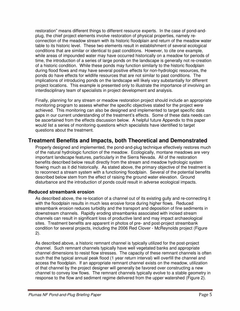
Plumas NF Pond-and-Plug Briefing Paper Page 5
restoration” means different things to different resource experts. In the case of pond-and-plug, the chief project elements involve restoration of physical properties, namely re-connection of the meadow stream with its historic floodplain and return of the meadow water table to its historic level. These two elements result in establishment of several ecological conditions that are similar or identical to past conditions. However, to cite one example, while areas of impounded water may have occurred historically on a meadow for periods of time, the introduction of a series of large ponds on the landscape is generally not re-creation of a historic condition. While these ponds may function similarly to the historic floodplain during flood flows and may have several positive effects for non-hydrologic resources, the ponds do have effects for wildlife resources that are not similar to past conditions. The implications of introducing ponds on the landscape will likely vary substantially for different project locations. This example is presented only to illustrate the importance of involving an interdisciplinary team of specialists in project development and analysis. Finally, planning for any stream or meadow restoration project should include an appropriate monitoring program to assess whether the specific objectives stated for the project were achieved. This monitoring can also be designed and implemented to target specific data gaps in our current understanding of the treatment’s effects. Some of these data needs can be ascertained from the effects discussion below. A helpful future Appendix to this paper would list a series of monitoring questions which specialists have identified to target questions about the treatment.
Treatment Benefits and Impacts, both Theoretical and Demonstrated Properly designed and implemented, the pond-and-plug technique effectively restores much of the natural hydrologic function of the meadow. Ecologically, montane meadows are very important landscape features, particularly in the Sierra Nevada. All of the restoration benefits described below result directly from the stream and meadow hydrologic system flowing much as it did historically. As stated above, the primary objective of the treatment is to reconnect a stream system with a functioning floodplain. Several of the potential benefits described below stem from the effect of raising the ground water elevation. Ground disturbance and the introduction of ponds could result in adverse ecological impacts.
Reduced streambank erosion
As described above, the re-location of a channel out of its existing gully and re-connecting it with the floodplain results in much less erosive force during higher flows. Reduced streambank erosion reduces turbidity and the transport and deposition of fine sediments in downstream channels. Rapidly eroding streambanks associated with incised stream channels can result in significant loss of productive land and may impact archaeological sites. Treatment benefits are apparent in photos of pre- and post-project streambank condition for several projects, including the 2006 Red Clover - McReynolds project (Figure 2). As described above, a historic remnant channel is typically utilized for the post-project channel. Such remnant channels typically have well vegetated banks and appropriate channel dimensions to resist flow stresses. The capacity of these remnant channels is often such that the typical annual peak flood (1 year return interval) will overfill the channel and access the floodplain. If an appropriate remnant channel exists on the meadow, utilization of that channel by the project designer will generally be favored over constructing a new channel to convey low flows. The remnant channels typically evolve to a stable geometry in response to the flow and sediment regime delivered from the upper watershed (Figure 2).
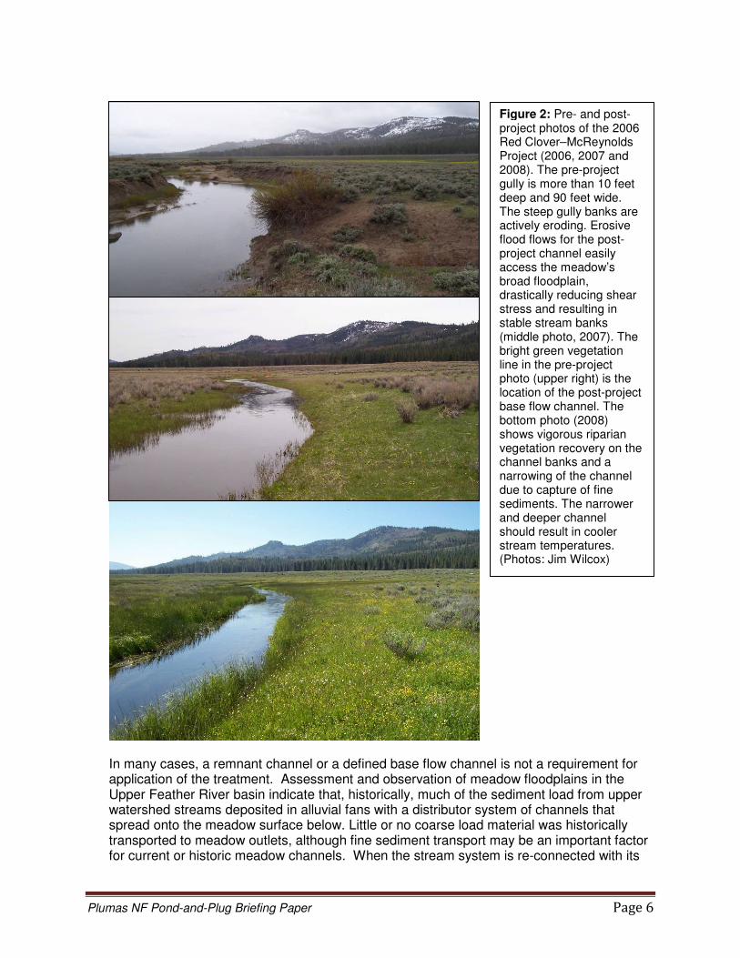
Plumas NF Pond-and-Plug Briefing Paper Page 6
In many cases, a remnant channel or a defined base flow channel is not a requirement for application of the treatment. Assessment and observation of meadow floodplains in the Upper Feather River basin indicate that, historically, much of the sediment load from upper watershed streams deposited in alluvial fans with a distributor system of channels that spread onto the meadow surface below. Little or no coarse load material was historically transported to meadow outlets, although fine sediment transport may be an important factor for current or historic meadow channels. When the stream system is re-connected with its
Figure 2: Pre- and post- project photos of the 2006 Red Clover–McReynolds Project (2006, 2007 and 2008). The pre-project gully is more than 10 feet deep and 90 feet wide. The steep gully banks are actively eroding. Erosive flood flows for the post-project channel easily access the meadow’s broad floodplain, drastically reducing shear stress and resulting in stable stream banks (middle photo, 2007). The bright green vegetation line in the pre-project photo (upper right) is the location of the post-project base flow channel. The bottom photo (2008) shows vigorous riparian vegetation recovery on the channel banks and a narrowing of the channel due to capture of fine sediments. The narrower and deeper channel should result in cooler stream temperatures. (Photos: Jim Wilcox)

Plumas NF Pond-and-Plug Briefing Paper Page 7
historic floodplain, a channel will form (or not) in response to the flow and sediment load that is delivered. At times, where a usable remnant channel does not exist, it is desirable to pioneer a new channel (e.g. if fishery improvement within the meadow is a project objective). Such channels are designed to have geomorphic characteristics (such as sinuosity, bedload competency and capacity, width / depth ratio, riffle and pool depth, pool spacing) that mimic those of natural channels typical in comparable landscapes. It is important to utilize native vegetation transplants, such as willow stakes and meadow sod mats, to protect the new channel and facilitate the establishment of riparian vegetation.
Improved forage and riparian vegetation
By raising the stream base level to the historic floodplain elevation, the ground water table is restored. This re-watering of the meadow results in the re-establishment of riparian herbs and woody vegetation. Comparisons of pre- and post-project photos for pond-and-plug projects demonstrate the conversion of acres of meadow vegetation from dry land species, like sagebrush, to riparian species (Figure 3).
This conversion has resulted in improved aquatic and terrestrial wildlife habitat and vastly improved forage for livestock grazing. For projects implemented on PNF grazing allotments, typical practice to date has been to provide fencing that excludes grazing for 2-3 years along the restored channel and the obliterated gully. For more sensitive sites, longer-term or permanent fencing may be necessary. For example, if a primary project objective is overhanging banks for fish habitat, then permanent fencing may be required. Fencing protects the restored stream channel and the project plugs while riparian vegetation is re-established. Restored stream channels which utilize historic remnant channels typically see a return of vigorous riparian vegetation within 1-2 years (Figure 2), but the banks of these channels remain sensitive to the types of excessive hoof traffic that may have initiated or widened the meadow gully. Since plugs are newly constructed features with no initial
Figure 3: The improved riparian grass community and improved livestock forage are evident in this series of photos from the Clarks Creek project. When the meadow is re-watered, the sagebrush quickly dies off.

Plumas NF Pond-and-Plug Briefing Paper Page 8
vegetation apart from project transplants, those features usually need more time to establish dense vegetation than remnant channels, particularly plugs with a finished grade that is one foot or more above the water table. Rather than relying on a general rule for how long livestock should be excluded (e.g. 2 or 3 years), site specific analysis of vegetation along a stream channel’s “greenline” (most often, at or slightly below bankfull stage) would likely give a better indication of whether vegetation is adequate to hold stream banks together (Winward 2000). Winward has developed “stability classes” for riparian plants (a rating from 1 to 10 with 10 being as stable as a stream bank composed of anchored rock) and a method for surveying a channel’s greenline and calculating its stability rating based on the greenline’s composition of species. Raising the water table could affect some Forest Service-designated “sensitive” plants that have thrived under the drier pre-project condition. Historically, many meadows on the eastside of the Plumas likely had a mix of wet meadow areas and higher dry sites (mounds) that could have supported species such as Ivesia sericoleuca and Pyrrocoma lucida. These species can be found in drier sites, but most often are associated with habitats that have seasonally wet and dry conditions such as likely occurred historically throughout eastside meadows and flats. Any restoration project that affects the water table and results in long-term saturation of areas that were drier under the pre-project condition could restrict habitat for one or more sensitive plant species, regardless of whether those plants were present historically or not. Site-specific project analysis would determine whether those habitat effects would result in significant impacts to sensitive plant species.
Timing of stream flow
By raising the stream base level to floodplain elevation, the meadow’s historic function of acting as a “sponge” and reservoir for runoff is restored. For the pre-project entrenchment, response to large flows is unfavorable because most floods greater than bankfull are not spread over a floodplain and do not soak into meadow soils. When floodplain function is restored, a portion of winter and spring runoff is stored in meadow soils where it is available for release later in the spring and summer. This restored meadow function results in some level of improvement of flow timing, including augmentation of some seasonal flows, potentially resulting in benefits for aquatic species and downstream irrigators. The primary flow augmentation effect would typically occur in late spring as stored groundwater from winter and spring runoff flows out of meadow soils to the stream channel. The channel flow augmentation effect often extends into summer months but this effect is variable from site to site. Increased post-project evapotranspiration could result in reduced base flow within the project reach during late summer. The potential stream flow timing benefit is indicated by CRM monitoring results for completed projects. Stream flow was measured in 2006 above and below the Big Flat project on Cottonwood Creek (completed in 1995) (Figure 4). The flow gages are located less than half a mile apart and no significant tributary channels exist between the gages. The data indicates reduced flow peaks below the pond and plug reach. A more detailed look at flood flow recession in May - June 2006 demonstrates that flow downstream of the project, which was lower during flood peaks, is higher than flow upstream of the project as seasonal flow approaches base flow. A similar flow data comparison for the pre-project, degraded meadow is not available. Researchers in the Lake Tahoe Basin used a similar, two-gage approach to study flow timing effects (Tague 2008). The Trout Creek project was constructed in 2001, with one objective being to reestablish hydrologic connectivity between

Plumas NF Pond-and-Plug Briefing Paper Page 9
the degraded stream channel and its former floodplain. Comparisons of USGS gages located just upstream and downstream of the project indicated statistically significant increases in flow during snowmelt recession months and a 24% increase for the month of July. For the Trout Creek study, this effect of groundwater storage supporting base flow diminished through the late summer and early fall months but still appeared to be enough to cancel increased evapotranspiration from riparian vegetation along the channel and on the floodplain.
Figure 4: Stream flow measurements taken simultaneously above and below the Big Flat project demonstrate reduced flood flow peaks. The lower chart is a closer look at the spring runoff recession and demonstrates that flow downstream of the project is higher through the early part of baseflow season.

Plumas NF Pond-and-Plug Briefing Paper Page 10
For the Clarks Creek project, water table elevations recorded from a ground water monitoring well located within the restored meadow demonstrate that runoff is stored in the meadow. The pre-project water table elevation maximized within 1 foot of the meadow surface but drained to the gully quickly, dropping to less than 2 feet below meadow surface within about 2 months (Figure 5). Post-project data for three different runoff seasons demonstrate that the ground water table elevation remains within 4 inches of the surface for over 5 months each year, even during years that had less than 80% of average precipitation. Further, the drop in water table elevation through the summer months (like Cottonwood Creek, Clarks Creek is not a perennial stream within the project reach) indicates that this stored water is being released downstream during months when, pre-project, it had been unavailable for irrigators and aquatic species.
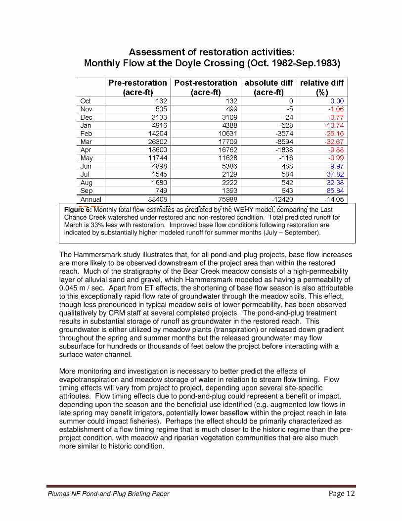
Sacramento State researchers estimated that, for the 116-acre Clarks Creek meadow, groundwater storage decreased by approximately 65% through summer 2007 (from 218 acre-ft to 76 acre-ft), primarily due to groundwater flowing to the incised, unrestored channel at the downstream end of the meadow (Cornwell, 2008a). The Forest Service Regional Office has secured a grant with National Fish and Wildlife Foundation to estimate improvements in groundwater storage that could be achieved through a region-wide meadow restoration initiative for National Forests in the Sierra Nevada. Those estimates will be completed by 2012. Using the Last Chance Creek project area as his model site, a UC-Davis professor developed the Watershed Environmental Hydrology (WEHY) model to account for the various hydrologic processes associated with natural landscapes (Kavvas 2004). This model was applied to Last Chance Creek above Doyle Crossing by inputting precipitation data for October 1982 – September 1983 (Figure 6) (Kavvas 2005). The scale of this modeling effort (a watershed area of roughly 100 sq. mi.) is much larger than the scale of
Figure 5: Water table levels at Clarks Creek project. Stated percentages represent the amount of precipitation received that year in relation to the annual average.

Plumas NF Pond-and-Plug Briefing Paper Page 11
the other project-level monitoring or modeling presented in this section. Total predicted runoff for March 1983 for a modeled landscape that was completely restored above Doyle Crossing was 33% less than for the existing, un-restored landscape. The model results presented in Figure 6 represent changes in groundwater storage and flow volumes for the first year after restoration. In modeling flows for a dry month, total predicted flow for September 1983 for the restored stream systems was 86% greater than for the existing, un-restored landscape. These model results include evapotranspiration effects and indicate significant flow timing benefits for pond-and-plug restoration projects in the form of attenuated spring runoff and improved summer base flows.
In assessing potential benefits for stream flow timing, it is important to consider and analyze evaporation and transpiration effects. Restoration of meadow function should result in increased transpiration of groundwater since the landscape is converted from dry land species like sagebrush to historic riparian species. Potential for evaporation of ground water is increased by the installation of ponded water in the restored meadow. Stanford University professors developed an evapotranspiration (ET) mapping algorithm and showed that daily ET for two reaches of restored Last Chance Creek was approximately twice the daily ET for similar degraded reaches that had not been restored (Loheide 2005). CRM flow monitoring data for the 2006 Red Clover / McReynolds Project indicates marked reductions in late season flow at the immediate downstream terminus of the project when compared with flow measured upstream of the project (Feather River CRM, 2010). Pre-project monitoring measured flows of 1.1 and 1.6 cfs at the downstream end of the project reach in August and September 2005, reduced from 1.4 and 1.8 cfs (respectively) measured above the reach. Monitoring for August and September 2008 and 2009 indicated similar flow at the upstream location (a mean of 1.4 cfs) but practically zero flow at the downstream project terminus. The 2009 project monitoring report states that the project’s effect on late season base flow cannot yet be fully evaluated because 2007-2009 were droughty years and the meadow’s groundwater storage capacity is still filling. However, the report also identifies that at least part of the late season flow reduction within the project reach is due to increased evapotranspiration. As more years of post-project streamflow data is collected, this effect will be better characterized. Researchers at UC-Davis applied a hydrologic model to a pond-and-plug project in northern California and predicted that summer baseflow duration was actually reduced following the project, with roughly half of that decrease due to an increase in evapotranspiration (Hammersmark 2008). The Bear Creek project was constructed in 1999 on a 2.2-mile-long tributary of the Fall River, approximately 60 miles northeast of Redding, CA. Model simulations demonstrated that the pond-and-plug project decidedly met the project goal of restoring connectivity between Bear Creek and its floodplain. Floodwater storage on the floodplain acted to attenuate peak flood flows (see section D below). However, anticipated improvements in aquatic habitat due to increases in baseflow were not predicted by the model. Model results indicated a decrease in the total amount of runoff of 1-2% and a shortening of the baseflow season (Bear Creek is not a perennial stream) by 13 days. In addition to ET effects, the baseflow decrease was attributed to an increased loss of stored runoff as groundwater that would have drained to the incised channel pre-project stayed as groundwater in the post-project condition and flowed out of the meadow downstream as either shallow groundwater or overland flow.
Plumas NF Pond-and-Plug Briefing Paper Page 12
The Hammersmark study illustrates that, for all pond-and-plug projects, base flow increases are more likely to be observed downstream of the project area than within the restored reach. Much of the stratigraphy of the Bear Creek meadow consists of a high-permeability layer of alluvial sand and gravel, which Hammersmark modeled as having a permeability of 0.045 m / sec. Apart from ET effects, the shortening of base flow season is also attributable to this exceptionally rapid flow rate of groundwater through the meadow soils. This effect, though less pronounced in typical meadow soils of lower permeability, has been observed qualitatively by CRM staff at several completed projects. The pond-and-plug treatment results in substantial storage of runoff as groundwater in the restored reach. This groundwater is either utilized by meadow plants (transpiration) or released down gradient throughout the spring and summer months but the released groundwater may flow subsurface for hundreds or thousands of feet below the project before interacting with a surface water channel. More monitoring and investigation is necessary to better predict the effects of evapotranspiration and meadow storage of water in relation to stream flow timing. Flow timing effects will vary from project to project, depending upon several site-specific attributes. Flow timing effects due to pond-and-plug could represent a benefit or impact, depending upon the season and the beneficial use identified (e.g. augmented low flows in late spring may benefit irrigators, potentially lower baseflow within the project reach in late summer could impact fisheries). Perhaps the effect should be primarily characterized as establishment of a flow timing regime that is much closer to the historic regime than the pre-project condition, with meadow and riparian vegetation communities that are also much more similar to historic condition.
Figure 6: Monthly total flow estimates as predicted by the WEHY model, comparing the Last Chance Creek watershed under restored and non-restored condition. Total predicted runoff for March is 33% less with restoration. Improved base flow conditions following restoration are indicated by substantially higher modeled runoff for summer months (July – September).
Plumas NF Pond-and-Plug Briefing Paper Page 13
Flood Attenuation
At first glance, potential benefits to the timing of stream flow, as described above, would seem to logically lead to the premise that the pond-and-plug treatment could reduce peak flood flows via the same natural “sponge” function of meadows, since post-project flood flows could soak into meadow soils and would not be left to race down the pre-project gully. In fact, flood flow at a pond-and-plug project is affected more by the spreading of flow across the floodplain than by the soaking of water into pore spaces of meadow soils. By re-connecting the floodplain, runoff would certainly be attenuated if meadow soil pore spaces were dry. However, large peak flows would most likely occur at a time when the floodplain landscape would have been saturated under both the pre- and post-project conditions. In such cases, since water is not stored within the meadow, the post-project peak flow and the pre-project peak flow would theoretically be identical because the flow into the system must equal the flow out of the system (the “continuity” equation). Post-project flow would be more shallow and slow (due to the roughness of the floodplain) but would occupy more cross-sectional area across the broad floodplain than the fast flow confined to a gully in the pre-project condition. However, flow rate out of the project area would be identical to pre-project flood flow only after the water that is spread across the floodplain fully regains its downstream momentum. As a result of the pond-and-plug project, flow is spread in a direction away from the more direct, down-valley vector of the pre-project entrenchment, delaying delivery of the flow to the downstream end of the meadow, and resulting in a flood attenuation benefit. For severely incised pre-project channels, the deep gully would not be present post-project to laterally drain meadow soils, which may also reduce flood peaks downstream. Realize that these are highly simplified descriptions of the primary peak flood effects associated with the pond-and-plug treatment. Effects are significantly influenced by several other complex, site-specific factors for projects on the ground. The flood spreading effect is reflected in the reduced 2006 flood peaks at Big Flat, as presented in Figure 4. The Bear Creek project researchers (see section C above) also modeled a significant flood attenuation effect at the base of the restored meadow (Hammersmark 2008). For the largest flood events simulated (between 2- and 5-year return interval flood flows), peak flow values were reduced by up to 25% due to floodwater storage on the floodplain. Such delays in flood timing, if put into effect over a large scale by several projects such as pond and plug and exclosure fencing that would restore floodplain connectivity, could result in a measurable flood control benefit. Flood-peak reductions for very large, infrequent floods are likely to be less dramatic than for higher-frequency, lower-magnitude flood flows (Hammersmark 2008). Sacramento State researchers described the flood attenuation properties of the Clarks Creek meadow but did not quantitatively predict effects (Cornwell 2008b). Flood flow effects for a project are dependent upon several site-specific characteristics. For instance, several severely incised channels in the Upper Feather watershed still maintain floodplain connectivity at extremely high flows. For such a channel, extreme flows would be spread across the floodplain in both the pre- and post-project condition so the flood attenuation effect, while still beneficial for smaller floods, may not be as pronounced for extreme flows. Further, once a flow leaves its channel, flood timing and peak are certainly influenced by valley form such as how much the valley outlet constricts flows on the floodplain for both the pre- and post-project conditions.
Plumas NF Pond-and-Plug Briefing Paper Page 14
The pond-and-plug treatment will affect the peaks of most flood flows at the project level, which could cumulatively result in a flood control benefit for downstream landowners and municipalities. However, given inherent variations in precipitation and flow timing characteristics that exist over large watersheds, general predictions of the degree at which flood timing and peak magnitude are affected at this larger scale are difficult to make. Re-connection of a stream channel with a broad floodplain would, however, result in flood response that is much closer to the historic condition.
Temperature Effects
Most pre-project stream channels are classified under the Rosgen system as “F” channels (Rosgen 1994). These channels have evolved in an incision that has finished down-cutting (often in response to anthropogenic activities) to a stream that is now widening into soft meadow soils to re-gain the valley width necessary to hold a stable channel. Essentially, flow processes are pushing these channels to build a functioning floodplain within the gully floor at an elevation that is 3-10 feet below the historic meadow elevation. Livestock grazing and watering along such channels can further accelerate bank erosion and channel widening.
Such widening “F” channels have high width / depth ratios. During the low flows that typically exist most of the year, such channels are overly wide and shallow, possessing relatively large flow surface area that subjects the stream to more solar radiation and higher stream temperatures (particularly, of course, during summer months when coldwater aquatic species are most stressed). The lack of shade from streamside vegetation on eroding banks further exacerbates stream temperature impacts. Post-project stream channels, whether historic remnant channels or constructed pioneer channels, are designed to have width / depth ratios that are consistent with the natural geomorphology of the landscape. Channels are narrower and deeper, contributing to cooler
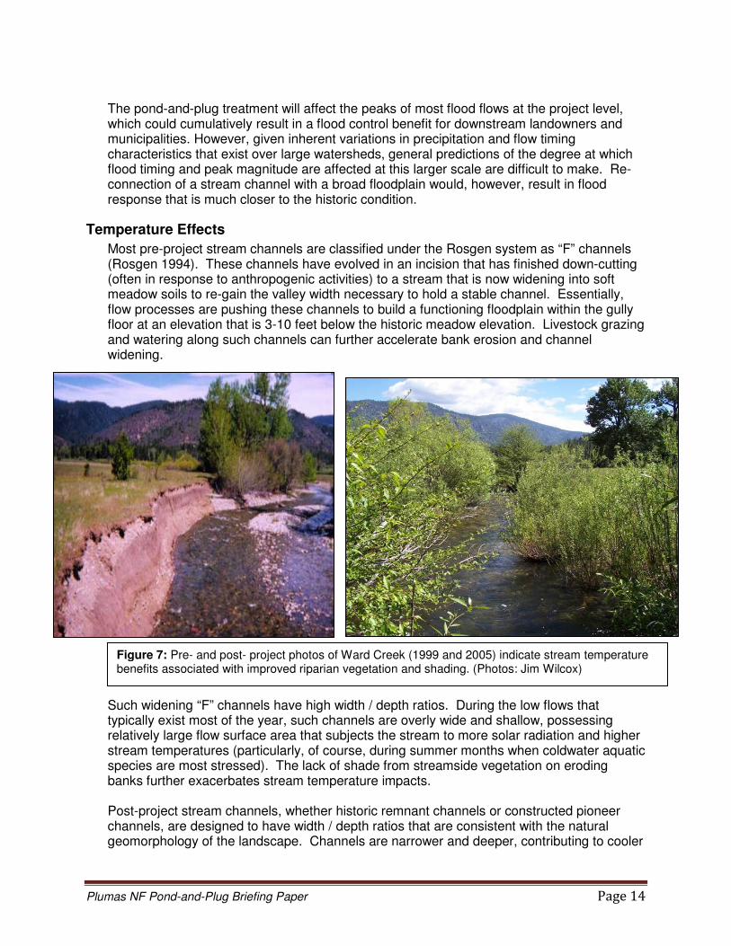
Figure 7: Pre- and post- project photos of Ward Creek (1999 and 2005) indicate stream temperature benefits associated with improved riparian vegetation and shading. (Photos: Jim Wilcox)

Plumas NF Pond-and-Plug Briefing Paper Page 15
stream temperatures (Figure 2). Re-established and stable streamside vegetation provides shading to further lower stream temperatures (Figure 7). Temperatures for water near the surface of post-project ponds are usually elevated due to solar exposure but deeper water in ponds can provide quality trout habitat year-round. Apart from solar radiation effects, the raised water table that results from the pond-and-plug treatment may provide benefits to stream temperature by enhancing surface and ground water interaction. During warm periods, groundwater input to streams lowers stream temperature and buffers diurnal stream temperature variations. During the coldest winter months, groundwater input would mollify extremely cold surface water temperatures. The change in magnitude of groundwater flow to a surface stream resulting from a pond-and-plug treatment would vary both seasonally, as stored runoff is either released to the stream or to the air via evapotranspiration, as well as spatially from reach to reach. Stanford University professors used high-resolution infrared imagery and instream temperature measurements to quantify detailed spatial patterns of groundwater recharge to the restored reach at Big Flat (Loheide 2006). Their investigations led to an estimate that maximum stream temperatures could be reduced by more than 3 degrees C through pond-and-plug restoration. Quantifying stream temperature effects for pond-and-plug projects via empirical data is difficult due to the array of variables that affect stream temperature and the spatial, annual, and seasonal variations of these elements. Most prominent of these confounding variables are flow rate and ambient air temperature, both of which vary profoundly from year-to-year while air temperature can vary substantially from day-to-day. Recent results from CRM monitoring and informal citizen monitoring on the Smith Creek project, constructed in 2007, indicate that shallow ponds connected to the base flow channel can result in increased stream temperatures. While the ponded areas used to obliterate the gully typically are connected to surface water flow only during flood events, pond-and-plug designs oftentimes use the ponds as a stable and convenient location to cross the low flow channel from one side of the valley to the other, thus following the natural flow path of the valley. At Smith Creek, monitoring data indicates water temperature increases several degrees F as it flows through a single, shallow pond. This effect may also stem in part from less deep groundwater interaction at this project site than at other projects. CRM designers are currently adapting design methods to consider a cold-flow channel from the inlet to the outlet for ponds that are less than roughly 3 feet deep.
Heritage Resource Effects
The majority of the pond and plug projects constructed to date are in areas that are considered prehistorically and historically significant. Consequently, since 2001, over 80 heritage sites have been recorded for the first time as a result of these projects. Additionally, at least 41 heritage sites have been re-recorded or re-visited. A Programmatic Agreement exists between the Forest Service, Region 5, the California State Historic Preservation Officer, and the Advisory Council on Historic Preservation. When Forest activities are implemented in accordance with the stipulations of this agreement, the Forest’s responsibilities for compliance with Section 106 of the National Historic Preservation Act are satisfied. Section 106 requirements have generally been met on pond-and-plug projects by using the “flag-and-avoid” technique to protect identified heritage resources.

Plumas NF Pond-and-Plug Briefing Paper Page 16
All archaeological sites within the Area of Potential Effect (APE) must be taken into account. If a no effect determination cannot be reached, Section 106 evaluations are required for heritage sites located within the APE for the pond-and-plug project. The APE includes areas of restored groundwater levels, even if no physical impact will occur. To date, the CRM projects have resulted in the evaluations of portions of two large railroad systems which are located on both public and private lands: the Clover Valley Lumber Company Railroad and the California Fruit Exchange Railroad, both of which were recommended as eligible to the National Register of Historic Places. In addition, 12 prehistoric sites have been evaluated in the Last Chance Creek meadow system, Red Clover Valley, and Humbug Valley. Site excavations have contributed geochemical data and, at times, Carbon-14 dating data, which further contribute to our archaeological understanding by providing relative dates to the occupation of the site. A unique archaeological benefit of the meadow projects is restoration of much of the natural environment of the heritage sites. This provides archaeologists with a clearer picture of the site’s natural setting during prehistoric times, and aids our understanding of the site’s function and interpretation. Before restoration, the sites appear to be located in exposed, sagebrush zones. Following restoration, the sites are more functionally situated in or near a lush meadow system with access to waterfowl, fish, and cultural material. In several cases, restoration has halted artifact loss and site erosion of prehistoric sites located along degraded stream channels. The CRM has consistently designated Supplemental Survey Areas (non-APE) in high sensitivity areas (Last Chance Creek, Red Clover Valley, and Humbug Valley) in order to gather a greater understanding of the resource. This is in keeping with its stated mission statement of Coordinated Resource Management. The use of Supplemental Survey Areas has resulted in the recording of heritage sites which otherwise would have been unrecorded. The pond-and-plug projects have the written support of Native American groups and Tribes, who have been active participants in consultation, review, and in some cases, survey. Restoring the natural environment is a stated tribal priority. Most of the CRM archaeology has taken place on private land, in locations where heritage sites would otherwise have remained unrecorded and therefore potentially unprotected. These projects have been requested by the private landowners due to their concern about meadow degradation. The landowners have actively expressed support for the archaeological component and some have taken steps to protect identified resources on a long-term basis.
Wildlife Effects
Restoration of the hydrologic function of a montane meadow system should result in significant benefits to aquatic and terrestrial wildlife. Riparian areas are known to be highly productive habitats and ecotones for both aquatic and terrestrial wildlife (Thomas, et al 1978). More than 225 species of birds, mammals, reptiles, and amphibians depend on California’s riparian habitats (RHJV 2004). Specifically, healthy meadows are biodiversity hotspots in the Sierra Nevada, providing forage and critical habitat for a wide range of plant and animal species, including many listed species such as the willow flycatcher, great gray owl, and the Yosemite toad (NFWF 2010). As described earlier, degraded meadow streams have wide, shallow channels that capture higher amounts of solar radiation, and therefore have higher temperatures than streams that
Plumas NF Pond-and-Plug Briefing Paper Page 17
are narrower and deeper. Additionally, degraded streams typically lack stream vegetation and shade, so temperatures are further increased. Pond-and-plug designs result in stream channels where vegetation and shade are at or near historic conditions, and this, in combination with channel morphology improvement and increased interaction with ground water, results in lower stream temperatures. While the restored water table will result in higher evapo-transpiration rates that may reduce stream flows within the project reach late in the season, this change represents restoration of meadow and riparian vegetation communities that are similar to historic conditions and a more natural flow regime to which native species are adapted. Restoration of flow and temperature regimes most likely improves habitat connectivity for native species at times for which they are adapted to move. Meadow restoration likely benefits a wide variety of wildlife species. Meadows are biodiversity hotspots for the animal species of California, particularly birds and amphibians, of which approximately two-thirds depend upon Sierra Nevada habitats (NFWF 2010). Eighty-two terrestrial vertebrate species are considered dependent on riparian and meadow habitat, 24% of which are at risk (Graber 1996). Mountain meadows are key habitats for many animal species because they provide water and shade availability during the three to six month dry season, promote lower summer stream temperatures, higher plant productivity, increased insect prey availability, and special vegetation structures such as willow thickets (Ibid). Examples of species that occur in wet meadows include mule deer, elk, mallard ducks and other waterfowl, yellow-headed and red-winged blackbirds, striped racer, and various frog species (Mayer and Laudenslayer 1988). Montane meadow habitat is extremely important for birds in the Sierra Nevada; numerous bird species, such as willow flycatcher, depend on montane meadows for breeding habitat and other species, such as great gray owl and red-breasted sapsucker, use meadows as important foraging habitat (Siegel and DeSante 1999). Additionally, montane meadows provide critical molting and pre-migration staging areas for juveniles and adults of a broad array of Sierra landbird species, such as orange-crowned and Nashville warblers, many of which also do not actually use meadow habitat for breeding (Ibid). Meadow restoration likely benefits native fish populations. The changes to hydrology, channel morphology and water quality described earlier all reflect positive changes to fish habitat. Typically, channels in degraded meadow systems are relatively wider and shallower than non-degraded streams. Additionally, these streams typically lack deep pool and riffle habitat, or stable, undercut banks that are important habitat attributes. Pond-and-plug designs typically restore these features to the channel components of the meadow. The restoration of stable banks to these streams also eliminates a major source of sediment. Fine sediment delivered to streams can impact spawning and incubation (typically early spring for rainbow trout) and increase mortality of eggs and fry. Reduction of sediment from these sources should increase survival. Fisheries monitoring conducted by the CRM at Big Flat in May 2000 found 60 rainbow trout in a 100-foot reach of Cottonwood Creek; that reach was typically dry and devoid of fish at that time of year (May) in the pre-project condition (Wilcox 2005). The Little Schneider project resulted in restoration of year-long flow during non-drought years so that trout were not stranded in dried-up reaches during those years. Macroinvertebrate monitoring at a 2001 floodplain re-connection project in the Carson River watershed (using a technique similar to pond-and-plug) demonstrated statistically significant improvements in the macroinvertebrate community during the first two years after construction (Herbst 2009). The macroinvertebrate community shifted from being dominated by pollution- (i.e., sediment)

Plumas NF Pond-and-Plug Briefing Paper Page 18
and disturbance-tolerant taxa to one comprising more sensitive taxa and more closely resembling the composition found at two nearby, healthy reference streams. Recent, not yet published studies on Trout Creek in the Lake Tahoe Basin indicated improved macroinvertebrate communities in the initial period after restoration but also that the response was not sustained after a period of 5 years (Herbst 2010). This study also points to a need to monitor ecological response to stream restoration over the long term. Meadows and riparian areas are the single most important habitat for birds in the west; meadow restoration and management should be among the highest priorities for avian managers in the Sierra Nevada (PRBO and USDA). Recent restoration efforts, primarily in the form of removing grazing, have resulted in increases in numerous meadow bird species. Dense patches of willow or alder are a critical habitat feature for meadow dependent birds and tall, lush herbaceous meadow vegetation is important for concealing nests and supporting invertebrates that birds prey upon. Preliminary results of avian monitoring conducted by the CA Department of Water Resources (DWR) at Red Clover – McReynolds (constructed in 2006) indicated 16 additional bird species observed post-project, a 20% increase over the pre-project survey. These additional species include riparian and wetland species such as marsh wren, pied-billed grebe, and Wilson’s phalarope (CA DWR 2007). The DWR surveys also indicated a 64% increase in waterfowl young produced between 2004 and 2007. Many of the species which occurred only post-project are State or federal special status species, including but not limited to bald eagle, black-crowned night heron, and double-crested cormorant. Statistically significant increases in total avian density and species richness were found for a DWR study at the Clarks Creek project (CA DWR 2005). Human eradication of beaver from PNF meadows is believed to be a key element in the loss of available meadow ecosystems. Beavers naturally perform the same type of work and results that are desired of the pond-and-plug treatment. That is, beavers spread flood flows and can re-water dried meadow systems. The CRM’s pond-and-plug projects are usually designed with the assumption that beaver will occupy and thrive within the restored project reach. During the project planning phase, designers need to assess whether project objectives can be achieved without extensive intervention and construction by encouraging the proliferation or introduction of area beaver populations. Installation of some small raises at channel riffles using rock or large wood may be enough to encourage substantial meadow improvement via beaver. The presence of ponds in meadows as a result of the pond-and-plug treatment represents both benefits and potential negative effects. Ponds may provide improved habitat for adult trout during seasons of extremely cool or warm temperature and, if located within the floodplain, would be accessible to the rest of the stream system. However, ponds may serve as habitat for non-native species, and, in some cases, may result in temperature increases. The creation of ponds may introduce or increase populations of non-native bullfrogs and bass in these meadows, negatively affecting amphibians. Increased trout populations, though potentially desirable for recreationists or fisheries specialists, are also known to impact amphibian populations. Amphibians of specific concern are the Mountain Yellow Legged Frog (MYLF), which the US Fish and Wildlife Service (USFWS) is expected to imminently list as a Threatened species, the Foothill Yellow-Legged Frog (designated as a Forest Service “sensitive” species), Northwestern Pond Turtle (sensitive), California Red-Legged Frog (Threatened), and Pacific Tree Frog (Management Indicator Species). Therefore, the potential for increases in bass and bullfrog should be assessed and the presence of amphibian species of concern should be considered during project design, balancing the benefits and potential negative effects, including defining mitigation measures.

Plumas NF Pond-and-Plug Briefing Paper Page 19
Ponds created by pond-and-plug efforts typically provide high-quality potential breeding habitat for bass or bullfrogs. Dramatic increases in bullfrog populations have been observed post-project at the Little Schneider Creek, Clarks Creek (PNF) and Carman Creek (Tahoe NF) projects. Bullfrogs existed at Carman Creek pre-project, although no pre-project survey data for bullfrogs are available. Bullfrogs were not known to exist pre-project within the Little Schneider and Clarks project areas, although a population did exist upstream of the Clarks project in a roadside watering pond. A large population of bass currently exists in the ponds at Little Schneider; bass were not known to occupy that area pre-project. These are the only known cases of aquatic invasive introduction or proliferation from pond-and-plug projects in the Upper Feather River watershed. However, little formal monitoring and documentation for invasive aquatic species has been performed to date on pond-and-plug projects. Pre- and post-project monitoring of bass and bullfrogs should occur. Substantial increases in bullfrog or bass populations would likely present a severe adverse effect to sensitive frog species like the MYLF. Bullfrogs are native to the eastern United States but introduced in the west; both natural and man-made habitats pose a risk for bullfrog invasions. Established populations of bullfrogs are extremely difficult to eradicate, as are fish species such as bass. Bullfrogs are extremely prolific; a single bullfrog may lay in a single clutch, thousands of eggs (Schwalbe in Roach, D. 2004). Adult bullfrogs are voracious, opportunistic predators (Schwalbe and Rosen 1988) that will readily attack any live animal smaller than themselves, including conspecifics and other frogs (Bury and Whelan 1984). Introduced bullfrogs have been implicated in the decline or displacement of many amphibians including foothill yellow-legged frogs (Rana boylii; California, Kupferberg 1997) and northern red-legged frogs (Rana aurora; Oregon, Kiesecker and Blaustein 1997, 1998). Fisher and Shaffer (1996) found a negative correlation between the presence of introduced exotics (bullfrogs and fishes) and native amphibians in California. However, they did not discriminate between fishes and bullfrogs in their analyses. Because bullfrogs are likely to co-occur with mountain yellow-legged frogs only at lower elevations, the potential for impact is restricted to these portions of the mountain yellow-legged frog's range. In addition to predation, bullfrogs could potentially affect desirable aquatic wildlife species by hosting and supporting proliferation of disease in the aquatic environment, such as the chytrid fungus. MYLF concerns are usually minimal for pond-and-plug projects proposed at the drier, flatter stream systems typically found on the east side of PNF. However, invasive species are still a policy issue that needs to be addressed, regardless of MYLF presence. For areas that are suitable for MYLF, more pre-project monitoring and investigation is needed to assess the potential for bullfrogs to migrate to or proliferate within a completed pond-and-plug project. Early conferencing with USFWS is necessary for proposed projects in areas suitable for MYLF. Human introduction to the constructed ponds of bullfrog and bass species is more likely for some project sites than others. A recent conference with USFWS regarding proposed restoration for Boulder Creek (Mt Hough RD) indicated that the USFWS felt the potential human introduction of invasives was an unacceptable risk because Boulder Creek has a known population of MYLF. USFWS informally supported the hypothetical notion of implementing a project in an unoccupied drainage parallel to Boulder Creek. Theoretically, restoration of the historic hydrologic function of a meadow should result in benefits to wildlife populations that naturally reside in that ecosystem. In the case of the MYLF, more investigation is needed to determine which physical features can be incorporated in the pond-and-plug design to improve habitat. Instream habitat for MYLF

Plumas NF Pond-and-Plug Briefing Paper Page 20
could potentially be improved but the introduction of ponds would likely not benefit MYLF and may result in indirect impacts. It should also be considered that restoring hydrologic function may increase populations of potentially undesirable non-native fish species, such as largemouth bass or brown trout. Further studies should be completed on how these pond/plug projects affect native fisheries, including water quality (temperature and potential disease), downstream sediment budgets, aquatic connectivity, development of invasive species breeding and rearing habitat, and general habitat requirements. In general, stream restoration projects on PNF lands need to protect and encourage native species while not introducing or causing proliferation of invasive species, as directed in current Forest planning documents (USDA 2004).
Botanical Effects: Invasive Plant Species
The pond-and-plug restoration technique typically involves significant ground disturbance, particularly in the excavation of pond areas and repeated traffic in hauling material from the pond area to the plug area (hauling is typically performed with a front-end loader). Large quarry rock needed for construction of the project grade control structure (described in section IV below) is usually imported and hauled to the structure site in dump trucks. These activities can result in the introduction of non-native plant and noxious weed species, which can severely impact the area ecology. The disturbed areas provide habitat where invasive plant species can thrive and out-compete native species. Further, any existing infestations of invasive plant species on the project site can be dispersed and exacerbated by construction activities. Particular noxious weed species of concern for riparian restoration projects are Canada Thistle (Cirsium arvense) and Tall Whitetop (Lepidium latifolium) because these species thrive in wet areas. If introduced, these species are difficult to eradicate because mechanical treatments may prevent seed set but typically do not kill all of a plant’s rhizomes. In most cases, eradication would require chemical treatment (i.e. herbicides). Typical PNF measures to prevent the introduction of invasive plant species must be implemented on all pond-and-plug projects. These measures include thorough washing of construction equipment prior to bringing equipment on site; the use of native seed mixes for revegetation; and when imported materials, such as quarry rock, mulch and hay/straw, are needed, using only materials that are certified weed-free. Control areas are typically established for areas with known noxious weed occurrences. Traffic and disturbance is excluded from these areas. To establish vegetation on disturbed sites (particularly constructed plugs) CRM projects typically utilize native grass seed that is gathered the previous season from within the project site. Results for these seeded areas have been positive. The native grasses sown in the Upper Last Chance project yielded high rates of germination. No noxious weeds were found in the seeded areas during visits to the site one year after project implementation.
Carbon Sequestration
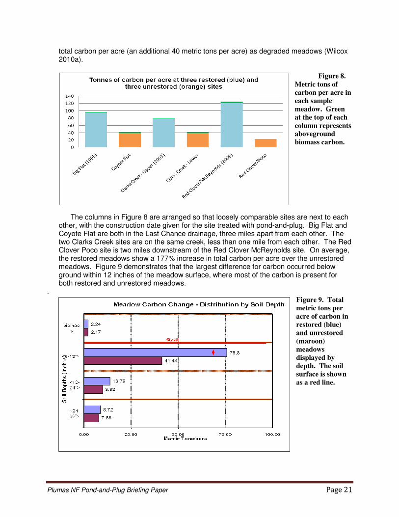
Qualitatively, restored meadows appeared to significantly increase organic carbon stocks through the much increased root mass and surface growth associated with conversion of dryland vegetation species to meadow herbs. In 2008, the CRM undertook a project to: 1) establish an acceptable scientific protocol to quantify carbon sequestration in restored versus un-restored meadows; 2) quantify carbon stocks in three restored meadows; and 3) quantify carbon stocks in three un-restored meadows to provide baseline data for future restoration. Initial data analysis indicates that restored meadows contain twice as much
Plumas NF Pond-and-Plug Briefing Paper Page 21
total carbon per acre (an additional 40 metric tons per acre) as degraded meadows (Wilcox 2010a).
Figure 8.
Metric tons of
carbon per acre in
each sample
meadow. Green
at the top of each
column represents
aboveground
biomass carbon.
The columns in Figure 8 are arranged so that loosely comparable sites are next to each other, with the construction date given for the site treated with pond-and-plug. Big Flat and Coyote Flat are both in the Last Chance drainage, three miles apart from each other. The two Clarks Creek sites are on the same creek, less than one mile from each other. The Red Clover Poco site is two miles downstream of the Red Clover McReynolds site. On average, the restored meadows show a 177% increase in total carbon per acre over the unrestored meadows. Figure 9 demonstrates that the largest difference for carbon occurred below ground within 12 inches of the meadow surface, where most of the carbon is present for both restored and unrestored meadows.
. Figure 9. Total
metric tons per
acre of carbon in
restored (blue)
and unrestored
(maroon)
meadows
displayed by
depth. The soil
surface is shown
as a red line.

Plumas NF Pond-and-Plug Briefing Paper Page 22
Hydrologic Risks and Design Considerations Ever since the first pond-and-plug project was proposed on PNF lands, and continually since then, concerns have been raised by PNF specialists and CRM signatories from all disciplines regarding the long-term viability of these projects and the risk of hydrologic “failure.” Certainly, such concerns are well-founded for any stream restoration technique because of the challenging expectations that the restored system will remain stable and provide improved habitat under the full range of flow and sediment loading conditions. For example, a design for Red Clover Creek - McReynolds would need to be stable throughout roughly 80% of the calendar year when flows are less than 1 cubic foot per second and also at the instances when the creek is experiencing a 100-year flood of approximately 6000 cfs. As stated above, pond-and-plug is a relatively new technique within the relatively new field of bio-engineered stream restoration. The CRM and PNF have been among the leaders nationally in pioneering this treatment and we have learned a great deal from the implementation of more than two dozen different pond-and-plug projects. Excessive erosion and gullying of the pioneered, new channel for the 1995 Big Flat project demonstrated the need to “under-design” rather than “over-design” the new channel so that higher flows will readily access the floodplain and not be confined to the channel to the point where downcutting occurs and is deeper than rooting depths. The Big Flat project also reinforced the approach that new channels should be cut into the meadow only when absolutely necessary and that working with existing meadow features such as remnant channels, or leaving flow to sheet over the meadow where a channel does not exist and is not needed, is preferable to constructing a new channel. Failure of the Willow Creek project demonstrated the importance of constructing an anchoring, grade control structure at a location that is assured of having large flood flows funneled over the structure. Extenuating circumstances limited the CRM to locating the grade control for that project, toward the middle of the meadow reach where flood flows could circumvent the structure. Additionally, the structure for Willow Creek was a version of a step-pool design that is no longer used. Constructed in 1996 less than three months prior to the 1997 flood of record, the step-pool structure failed and re-initiated headcutting. CRM designers have consistently applied adaptive management to pond-and-plug projects, improving design and construction techniques and resulting in recent projects that are much more stable than the two projects discussed in this paragraph, which were constructed nearly 15 years ago. Most recently, hydrologic concerns voiced have emphasized the viability of grade control structures, risks associated with flow over the plugs, risks associated with steeper meadow systems, and viability of projects during large floods like a 100-year event. These concerns, and design considerations to address such concerns, are briefly described below. As stated in the introduction, design considerations are presented here in very basic terms, with the intention that readers who are resource professionals but not hydrologists or engineers can gain a better understanding of how the treatment works. This paper is not intended to be a technical guide for how to design pond-and-plug projects. Detailed case studies of the design for one or two specific pond-and-plug projects would provide stream restoration practitioners with better, more comprehensive insight to the design details of this treatment. Within the stream restoration field, different design philosophies and approaches currently exist so a brief characterization of the approach used to date for pond-and-plug projects

Plumas NF Pond-and-Plug Briefing Paper Page 23
may be helpful. In fluvial geomorphology parlance, use of existing remnant channels on the meadow surface would likely be considered an “analog” approach to channel restoration. The designer starts with the assumption that the remnant channel was once stable and will be stable with respect to erosion and sedimentation in the future. Other restoration practitioners may take a more “analytical” approach to design in which hydraulic and sediment transport modeling are used to determine the dimensions of a stable channel system rather than ascertaining those dimensions from a presumed stable, reference channel on or near the project area. Intensive analytical designs can take more time and money to develop, primarily due to extensive sampling and surveying necessary to perform sediment transport modeling or advanced hydraulic modeling. Most stream restoration designs combine these two approaches. A “combination” design approach might include the assumption that the remnant channel will be stable, but that assumption would be verified with hydraulic and sediment transport modeling and field investigations. To date, the CRM’s “combination” design method could be characterized as closer to an analog approach, with the stability of remnant channels identified within the project area being verified by analytical assessment using basic, industry-standard hydraulic models and qualitative field investigations of sediment transport competence and capacity. These remnant channels are expected to adjust over time to the sediment size and load delivered. More intensive quantitative sediment modeling and advanced hydraulic modeling may be helpful for improving designs and predicting performance, particularly on steeper pond-and-plug projects, as discussed briefly below.
Grade Control Structure
As described above, by restoring streams to regain connectivity to a broad floodplain, the likelihood of project success is far greater than a restoration treatment that is undertaken within the incised gully of the existing stream system. This position is plainly supported by comparing calculated shear stresses for large flood flows that are spread out over a floodplain versus the much higher stresses developed when those flows are confined to a gully. When the base level of the stream system is raised to meadow elevation at the first upstream plug, it is common for the stream level to be lowered back to the incised, gullied elevation at the downstream end of the project reach. At that terminus, flows typically need to be dropped 3-10 vertical feet over a structure constructed of rock and soil. This is the point at which the pond-and-plug treatment is most vulnerable. The typical mechanism for potential failure is called an “end run” of the structure, in which a portion of a flood flow finds a soft location off of the armored structure. Once a small nick is formed at this soft location, flow can be concentrated there, eroding the nick deeper. Given enough flow power and duration, the nick can deepen, widen, and lengthen, developing into a gully that diverts the majority of flow around the hardened structure. To avoid an end-run of the grade control structure, it must be placed at a location in which the landscape naturally funnels all flows, including large floods, over the structure and into the downstream gully. This is the chief design consideration for these structures. Also, the grade control structure needs to be keyed into the gully or funnel walls so that the seam between the hardened structure and the softer wall material does not become a nick point where an end run can start.
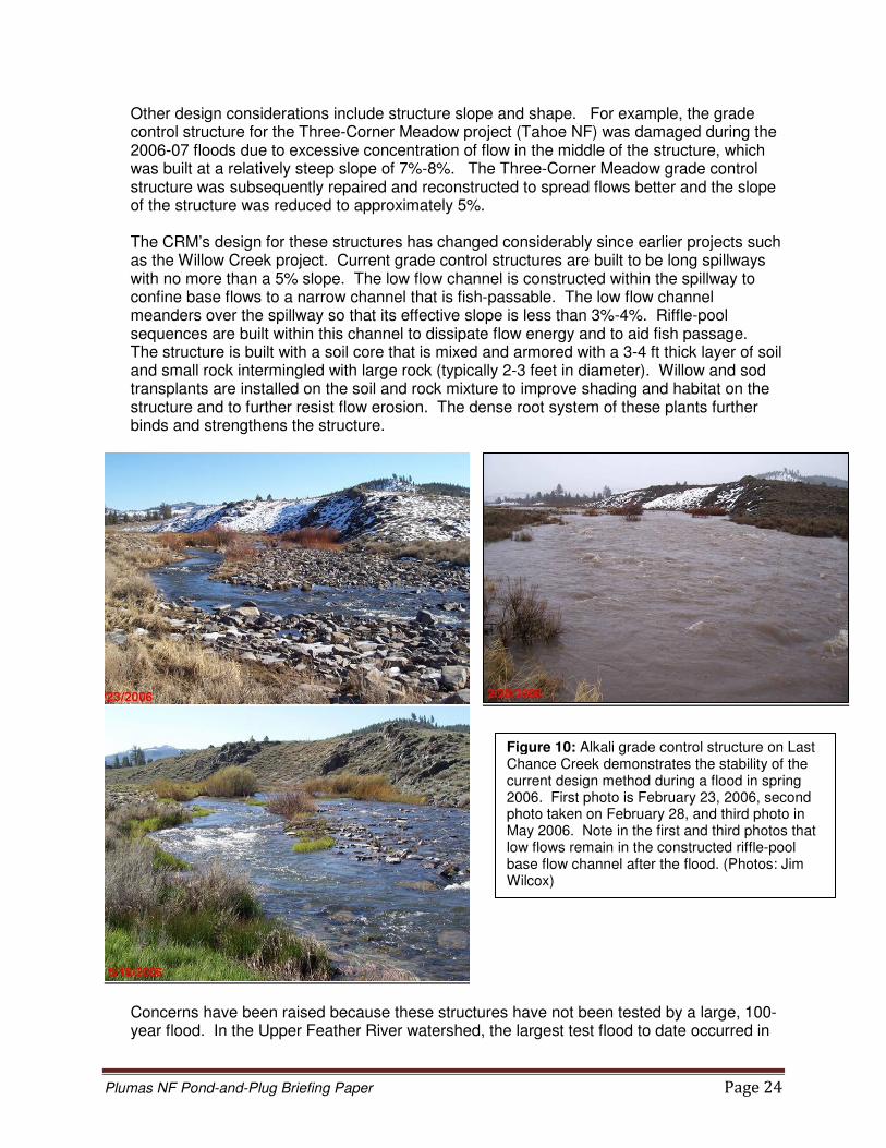
Plumas NF Pond-and-Plug Briefing Paper Page 24
Other design considerations include structure slope and shape. For example, the grade control structure for the Three-Corner Meadow project (Tahoe NF) was damaged during the 2006-07 floods due to excessive concentration of flow in the middle of the structure, which was built at a relatively steep slope of 7%-8%. The Three-Corner Meadow grade control structure was subsequently repaired and reconstructed to spread flows better and the slope of the structure was reduced to approximately 5%. The CRM’s design for these structures has changed considerably since earlier projects such as the Willow Creek project. Current grade control structures are built to be long spillways with no more than a 5% slope. The low flow channel is constructed within the spillway to confine base flows to a narrow channel that is fish-passable. The low flow channel meanders over the spillway so that its effective slope is less than 3%-4%. Riffle-pool sequences are built within this channel to dissipate flow energy and to aid fish passage. The structure is built with a soil core that is mixed and armored with a 3-4 ft thick layer of soil and small rock intermingled with large rock (typically 2-3 feet in diameter). Willow and sod transplants are installed on the soil and rock mixture to improve shading and habitat on the structure and to further resist flow erosion. The dense root system of these plants further binds and strengthens the structure.
Concerns have been raised because these structures have not been tested by a large, 100-year flood. In the Upper Feather River watershed, the largest test flood to date occurred in
Figure 10: Alkali grade control structure on Last Chance Creek demonstrates the stability of the current design method during a flood in spring 2006. First photo is February 23, 2006, second photo taken on February 28, and third photo in May 2006. Note in the first and third photos that low flows remain in the constructed riffle-pool base flow channel after the flood. (Photos: Jim Wilcox)
Plumas NF Pond-and-Plug Briefing Paper Page 25
2005 – 2006. The floods of that runoff season peaked at calculated return intervals that range from less than 5 years to as much as 15 years, depending upon location in the watershed, and several flood events greater than bankfull occurred that season in the Last Chance Creek watershed. Apart from the Three-Corner Meadow structure, none of the dozen or more pond-and-plug grade control structures that existed at that time received significant flood damage (see Figure 10). During design phase, conventional engineering charts and models for shear stress and channel rip rap sizing can be used to specify large rock of sufficient size to maintain the structure (USACE 1991 and USDoT 1989). Piping of flow, in which the structure erodes from within due to material being pushed through the face of the grade control structure by pressure from the water surface upstream of the structure, is not a practical concern because the length of these structures, relative to the length of earthen dams, is much greater. Conventional engineering flow net calculations can be used to verify that the length of the spillway is sufficient to prevent piping.
Flow over the Plugs
A common concern for the long-term stability and integrity of a pond-and-plug project is whether or not the earthen plugs that obliterate the gully are stable. For a typical application of the treatment, the earthen plugs are not considered to be dams because the “head,” i.e. the static water pressure exerted on the plug as measured by the difference in water elevations of the pond immediately upstream and downstream of the plug, is small, ideally less than 0.5 ft to 1.0 ft. Unlike a grade control structure, the downstream face of a plug may not be long and shallow-sloped but is typically abruptly sloped at approximately 30%- 70%. However, piping is usually not a concern for these plugs because the head (water pressure) is not large enough to force material through the plug and because most plugs are relatively longer than typical earth dams. Piping could be an issue for plugs on steeper projects (see below). The integrity of a plug can also be threatened by excessive flows over the plug. As described above, the remnant channel typically conveys low flows over the meadow at a location that is separate from the obliterated gully. However, during flood stages, flow is spread across the entire meadow, including over plugs designed to be part of the floodplain. If a headcut develops on a plug, flow could be concentrated for a long enough duration to divert more flow over the plug and eventually cut through the entire length of the plug (Figure 11). If flow over a plug were to cause a nick point, that nick would usually occur at the downstream edge of the plug because the flow elevation drops abruptly at this edge, from the elevation of the pond upstream of the plug to the elevation of the downstream pond, potentially resulting in turbulent, erosive force at this edge of the plug during a large flood. The downstream edge of a plug with a small change in flow elevation (less than 0.5 ft to 1.0 ft) will be subjected to less erosive force than a plug with a larger change in base elevation and will thus be less likely to form a headcut. If a plug were to have concentrated flow that eventually cut through the entire plug, the plug immediately upstream would now have its head essentially doubled, placing further stress on that plug. An abrupt drop at the downstream edge of plugs is susceptible to cutting during flood flows and can be ameliorated by sloping the surface of the plug. Again, this mitigation would be more difficult to achieve on plugs subjected to a larger difference in elevation of adjacent ponds because the slope of the plug surface would be steeper and shear stress due to flow

Plumas NF Pond-and-Plug Briefing Paper Page 26
on that steeper slope could be too high. Willow or sedge mat transplants can be added to armor the downstream edge or slope of plugs that are identified to be at risk of cutting due to flood flows.
A significant test of the integrity of plugs located within the floodplain during large flows occurred on the Big Meadows project on the Sequoia NF (Wilcox 2010b). Several of the design elements discussed above to reduce risks associated with flood flows on plugs were incorporated in the Big Meadows project (constructed in 2007, Figure 12). In October 2009, the project area was subjected to a high volume, high intensity precipitation event with over 8 inches of rain falling in less than 20 hours. Post-event field observations and stream gage records from the Kings River watershed indicated that flow through the project peaked at approximately 1200 cfs, estimated to be the flood with a 50- to 100-year return interval (i.e. a 1% - 2% chance of occurring in any given year). Post-flood observations indicated that all project plugs sustained some overland flow. Despite flood depths on the plugs of up to 2 feet and estimated flow velocities of up to 3.5 feet per second, no headcut was observed on any plug and very little mobilization of surface soil particles was observed. Nearly all pond-and-plug designs assume that, due to natural processes, the channel that carries base flow could, and likely will, leave the designed low flow channel and flow somewhere else on the floodplain, potentially over plugs that have been designed to be part of the floodplain. Only in the case where plug surfaces are substantially higher than the restored floodplain is this assumption not made. For example, flow could occur over a plug throughout the year, not only during larger floods, because a beaver dam on the designed base flow channel could divert the base flow. Since base flow location is likely to shift in response to natural processes, stable, well vegetated plug surfaces, particularly at the downstream edge of the plug, are critical for the success of pond-and-plug projects.
Figure 11: Excessive flow
over this plug on Last Chance Creek at Jordan Flat during the 2006 floods caused the base flow to be diverted over the plug. Excessive flow was due to unforeseen dynamics between Last Chance Creek and a tributary stream. A berm was constructed and the problem corrected in 2007. Excessive flow over plugs could headcut through the entire plug, lowering the upstream pond elevation to the elevation of the downstream pond and essentially doubling the head on the next upstream plug. (Photo: Joe Hoffman)
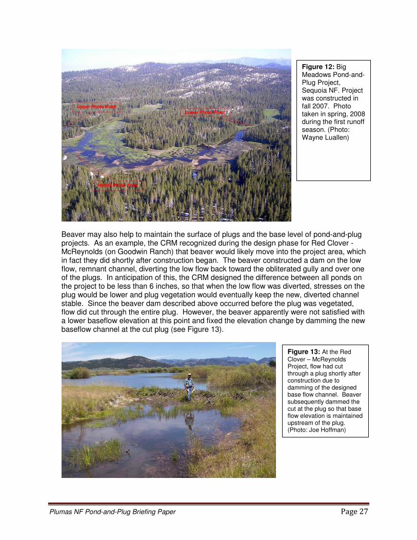
Plumas NF Pond-and-Plug Briefing Paper Page 27
Beaver may also help to maintain the surface of plugs and the base level of pond-and-plug projects. As an example, the CRM recognized during the design phase for Red Clover - McReynolds (on Goodwin Ranch) that beaver would likely move into the project area, which in fact they did shortly after construction began. The beaver constructed a dam on the low flow, remnant channel, diverting the low flow back toward the obliterated gully and over one of the plugs. In anticipation of this, the CRM designed the difference between all ponds on the project to be less than 6 inches, so that when the low flow was diverted, stresses on the plug would be lower and plug vegetation would eventually keep the new, diverted channel stable. Since the beaver dam described above occurred before the plug was vegetated, flow did cut through the entire plug. However, the beaver apparently were not satisfied with a lower baseflow elevation at this point and fixed the elevation change by damming the new baseflow channel at the cut plug (see Figure 13).
Figure 13: At the Red
Clover – McReynolds Project, flow had cut through a plug shortly after construction due to damming of the designed base flow channel. Beaver subsequently dammed the cut at the plug so that base flow elevation is maintained upstream of the plug. (Photo: Joe Hoffman)
Figure 12: Big Meadows Pond-and-Plug Project, Sequoia NF. Project was constructed in fall 2007. Photo taken in spring, 2008 during the first runoff season. (Photo: Wayne Luallen)

Plumas NF Pond-and-Plug Briefing Paper Page 28
Vegetation established on plugs is key to keeping the plug surface stable and capable of resisting shear stresses associated with flood flows. To facilitate quicker establishment of vegetation on the newly constructed earthen plugs, mats of native sedges and topsoil excavated from the pond borrow sites have been stockpiled and spread over the surface of the completed plug. CRM monitoring from the past 10 years indicates that seeding of plugs is integral to establishment of vegetation on the plug. In most cases a matted grass surface on a plug would not develop within the first two to three years, and could take up to 5 years to provide coverage that is dense enough to fully resist shear stresses associated with larger flood flows. Transplant or import of sod mats during project implementation can provide a highly-resistant, matted vegetative surface on the plug within the first year after construction.
The size and volume of sediment transported throughout the range of a watershed’s flood events, not merely the volume of water transported, is critical to any stream or meadow restoration design. Lane’s classic diagram demonstrates that the size and volume of sediment transported is proportional to the flow rate and channel slope (Figure 14). Steeper stream systems are often associated with bedload that is coarser (gravels and even cobbles) than the bedload typically associated with meadow streams. Plugging of the designed, post-project base flow channel with this coarse bedload, initiated by sediment deposition in the channel or a tree falling across the channel, can result in a diversion of the base flow channel much like that accomplished by beaver. Flatter meadow systems may need to transport sediment and that sediment would likely be finer than for steeper systems. However, the volume of sediment transported to the project reach may be large and could result in sediment deposition in the meadow reach, causing a rise in the channel bed elevation that may divert flow out of the designed base flow channel. Some meadow stream systems may not need to be designed to transport sediment. Analysis of the designed channel’s ability to transport the predicted size and volume of sediment delivered to the channel is critical to the long-term success of any stream restoration project. Project design
Figure 14: Lane’s classic diagram illustrates that the size and volume of sediment transported in a stream channel is proportional to the channel slope and the stream discharge.
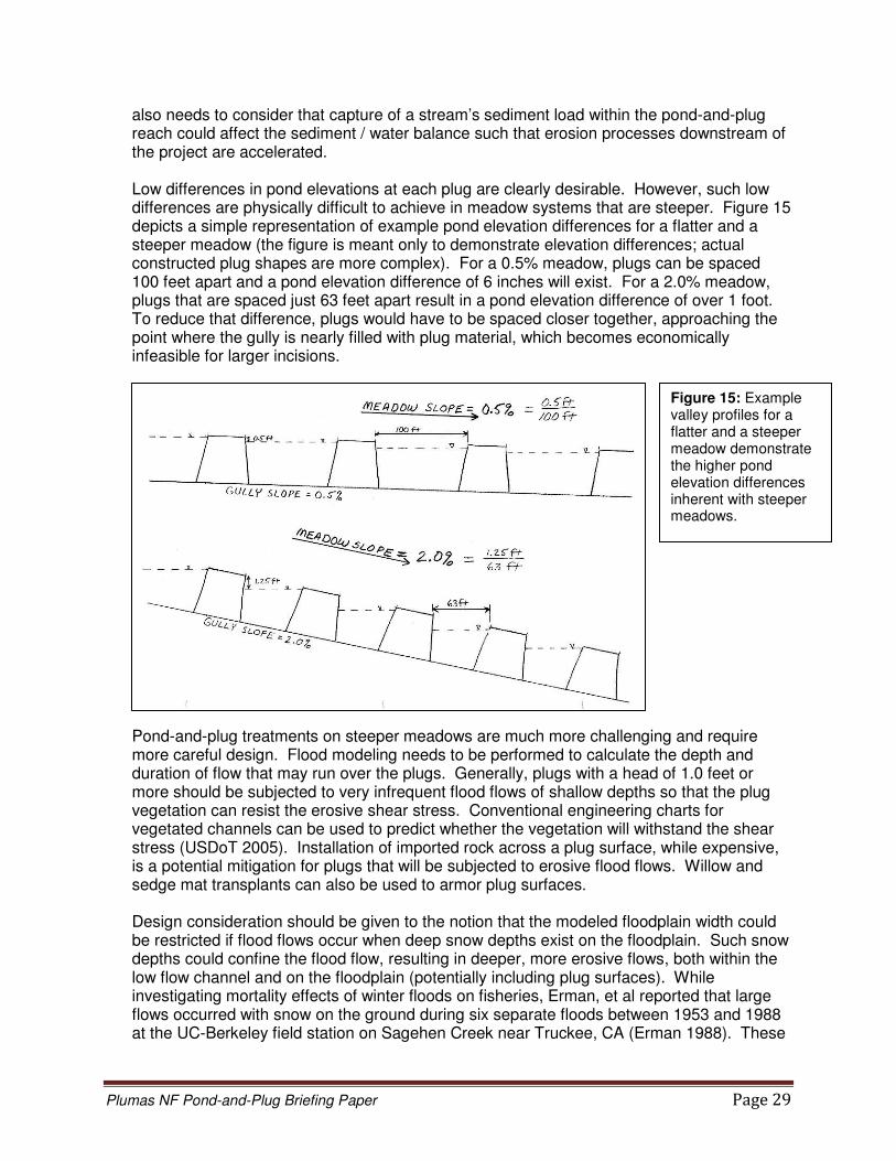
Plumas NF Pond-and-Plug Briefing Paper Page 29
also needs to consider that capture of a stream’s sediment load within the pond-and-plug reach could affect the sediment / water balance such that erosion processes downstream of the project are accelerated. Low differences in pond elevations at each plug are clearly desirable. However, such low differences are physically difficult to achieve in meadow systems that are steeper. Figure 15 depicts a simple representation of example pond elevation differences for a flatter and a steeper meadow (the figure is meant only to demonstrate elevation differences; actual constructed plug shapes are more complex). For a 0.5% meadow, plugs can be spaced 100 feet apart and a pond elevation difference of 6 inches will exist. For a 2.0% meadow, plugs that are spaced just 63 feet apart result in a pond elevation difference of over 1 foot. To reduce that difference, plugs would have to be spaced closer together, approaching the point where the gully is nearly filled with plug material, which becomes economically infeasible for larger incisions.
Pond-and-plug treatments on steeper meadows are much more challenging and require more careful design. Flood modeling needs to be performed to calculate the depth and duration of flow that may run over the plugs. Generally, plugs with a head of 1.0 feet or more should be subjected to very infrequent flood flows of shallow depths so that the plug vegetation can resist the erosive shear stress. Conventional engineering charts for vegetated channels can be used to predict whether the vegetation will withstand the shear stress (USDoT 2005). Installation of imported rock across a plug surface, while expensive, is a potential mitigation for plugs that will be subjected to erosive flood flows. Willow and sedge mat transplants can also be used to armor plug surfaces. Design consideration should be given to the notion that the modeled floodplain width could be restricted if flood flows occur when deep snow depths exist on the floodplain. Such snow depths could confine the flood flow, resulting in deeper, more erosive flows, both within the low flow channel and on the floodplain (potentially including plug surfaces). While investigating mortality effects of winter floods on fisheries, Erman, et al reported that large flows occurred with snow on the ground during six separate floods between 1953 and 1988 at the UC-Berkeley field station on Sagehen Creek near Truckee, CA (Erman 1988). These
Figure 15: Example valley profiles for a flatter and a steeper meadow demonstrate the higher pond elevation differences inherent with steeper meadows.
Plumas NF Pond-and-Plug Briefing Paper Page 30
researchers surmise that increased shear stress due to snow confining flow to the channel would increase the sediment transport rate by approximately an order of magnitude for the winter flood measured in 1982, when dead Paiute sculpin were collected during bedload sampling. Much of the study reach is located in a forested riparian area and these researchers assert that the effect of snow confining flood flows would be more prevalent in meadow systems. The Sagehen Creek station is located at an elevation of 6300 feet in a basin that averages 37 inches of precipitation per year. The frequency of snow-confining flows, and the depths of snow experienced, would likely be reduced for lower elevation sites and for drier sites. For steeper reaches approaching 3% - 4%, the difference between pond elevations at plugs can reach 3 – 6 feet. Clearly, flood flow over these plugs should not be considered a stable design unless the plugs are constructed more like grade control structures with hardened surfaces and spillways. Additionally, for plugs that approach this head, engineering design elements for conventional earthen dams should be evaluated or employed to prevent piping through the plug. Such elements may include controlled compaction of suitable, low permeability plug material and / or installation of a plug core consisting of clay or similar material of very low permeability. If a plug looks like a dam and acts like a dam, it should be designed, constructed and monitored as a dam. Finally, assessment of the hydrologic success of any restoration project, including pond-and-plug projects, should include a definition of what “failure” and “success” mean. Flow that cuts across a plug is not likely a failure if the new path is stable or if the flow can be easily diverted back to a location that is stable in the long-term. A minor amount of repair to a grade control structure as a result of a large flood is not likely a failure if the integrity of the project upstream and the meadow base level were maintained. A project which loses a number of plugs in a flood and is left in an unstable condition that can not be repaired without essentially re-doing the treatment is likely a failure. Consideration should also be given to the consequences of not doing any treatment. Leaving the system to continually degrade, widen, and erode vast amounts of meadow could also be considered a “failure.”
References California Department of Water Resources. September 2007. “Red Clover / McReynolds Creek Restoration: Bird and Small Mammal Population Summary.” Powerpoint presentation. California Department of Water Resources. March 2005. “Clarks Creek Stream / Meadow Restoration Project Fish and Wildlife Monitoring Report” Cornwell, K and Brown, K, 2008a. Physical and Hydrological Characterization of Clark’s Meadow. Department of Geology, California State University, Sacramento. Cornwell, K and Brown, K, 2008a. Flood Attenuation Conditions at Clark’s Meadow in the Last Chance Watershed. Report to Natural Heritage Institute Mountain Meadows IRWMP. Department of Geology, California State University, Sacramento.

Plumas NF Pond-and-Plug Briefing Paper Page 31
Erman, Don C, Edmund D Andrews, and Michael Yoder-Williams. 1988. “Effects of Winter Floods on Fishes in the Sierra Nevada.” Canadian Journal of Fisheries and Aquatic Sciences, Vol. 45, 2195-2200. Feather River CRM, Plumas Corporation. 2010. “Red Clover / McReynolds Creek Restoration Project Monitoring Report 2009.” Feather River CRM website. Graber, D.M. 1996. Status of Terrestrial Vertebrates. Sierra Nevada Ecosystem Project: Final report to Congress, Vol.II., Assessments and scientific basis for management options. Chapter 25. Davis: University of California, Centers for Water and Wildland Resources,1996. http://ceres.ca.gov/snep/pubs/web/PDF/VII_C25.PDF Hammersmark, Trevor H, Mark C Rains, and Jeffrey F Mount. 2008. “Quantifying the Hydrological Effects of Stream Restoration in a Montane Meadow, Northern California, USA. River Research and Applications, Vol. 24, 735-753. Herbst, D.B. 2010. “Trout Creek restoration case history – relations among hydrologic, geomorphic and ecological patterns of recovery” (abstract only). Sierra Nevada Aquatic Research Laboratory, University of California. Herbst, D.B. and Kane, J.M. 2009. “Responses of Aquatic Macroinvertebrates to Stream Channel Reconstruction in a Degraded Rangeland Creek in the Sierra Nevada.” Ecological Restoration, Vol. 27:1, March 2009. Kavvas, ML et al. 2004. “Watershed Environmental Hydrology (WEHY) Model Based on Upscaled Conservation Equations: Hydrologic Module.” Journal of Hydrologic Engineering. Vol. 9 No. 6 450-464. Nov-Dec 2004. Kavvas, M.L., Chen, Z.Q., Anderson, M., Liang, L., Ohara, N., Wilcox, J., Mink, L., and Benoit, T., 2005. Assessment of the Restoration Activities on Water Balance and Water Quality at Last Chance Creek Watershed Using Watershed Environmental Hydrology (WEHY) Model. Powerpoint presentation. Hydrologic Research Laboratory, Civil and Environmental Engineering, UC Davis
Loheide II, Steven P and Steven M Gorelick. 2005. “A local-scale, high-resolution evapotranspiration mapping algorithm (ETMA) with hydroecological applications at riparian meadow restoration sites.” Remote Sensing of Environment 98 (2005) 182-200. Loheide II, Steven P and Steven M Gorelick. 2006. “Quantifying Stream-Aquifer Interactions through the Analysis of Remotely Sensed Thermographic Profiles and In Situ Temperature Histories.” Environmental Science and Technology (2006) Vol. 40 No. 10 3336 – 3341. Mayer, K.E., and W.F. Laudenslayer, Jr., editors. A Guide to Wildlife Habitats of California. 1988. Jr. State of California, Resources Agency, Department of Fish and Game Sacramento, CA. 166 pp. http://www.dfg.ca.gov/biogeodata/cwhr/wildlife_habitats.asp NFWF (National Fish and Wildlife Foundation). 2010. Sierra Nevada Meadow Restoration Business Plan, March 5, 2010. http://www.nfwf.org/Content/ContentFolders/NationalFishandWildlifeFoundation/GrantPrograms/Keystones/WildlifeandHabitat/Sierra_Meadow_Restoration_business_plan.pdf
Plumas NF Pond-and-Plug Briefing Paper Page 32
Point Reyes Bird Observatory (PRBO) and USDA Forest Service. Website handout. “Managing Meadow Habitat for Birds in the Sierra Nevada.” www.prbo.org RHJV (Riparian Habitat Joint Venture). 2004. The riparian bird conservation plan: a strategy for reversing the decline of riparian associated birds in California. California Partners in Flight. http://www.prbo.org/calpif/pdfs/riparian_v-2.pdf. Rosgen, David L 1994. “A Classification of Natural Rivers.” Catena Vol. 22, 169-199. Rosgen, David L 1997. “A Geomorphological Approach to Restoration of Incised Rivers.” 1997 Proceedings of the Conference on Management of Landscapes Disturbed by Channel Incision. Siegel, R. B. and D. F. DeSante. 1999. Version 1.0. The draft avian conservation plan for the Sierra Nevada Bioregion: conservation priorities and strategies for safeguarding Sierra bird populations. Institute for Bird Populations report to California Partners in Flight. http://www.prbo.org/calpif/htmldocs/sierra.html Tague, C., Valentine, S., and Kotchen, M. 2008. “Effect of geomorphic channel restoration on streamflow and groundwater in a snowmelt-dominated watershed.” Water Resources Research, Vol. 44. Thomas, J. Editor. 1979. Wildlife Habitats in Managed Forests in the Blue Mountains of Oregon and Washington. USDA Forest Service, Agriculture Handbook 553. US Army Corps of Engineers 1991. Engineering Manual EM 1110-2-1601, Hydraulic Design of Flood Control Channels. USDA Forest Service. 2004. Sierra Nevada Forest Plan Amendment, Final Supplemental Environmental Impact Statement, Record of Decision. R5-MB-046. Pacific Southwest Region, Vallejo, California. US Department of Transportation, Federal Highways Administration 1989. Hydraulic Engineering Circular No. 11, Design of Riprap Revetment. US Department of Transportation, Federal Highways Administration 2005. Hydraulic Engineering Circular No. 15, Design of Roadside Channels with Flexible Linings.
Wilcox, Jim G 2005. “Water Management Implications of Restoring Meso-scale Watershed Features.” Feather River CRM website. Wilcox, Jim 2010. “Technical Report: Quantification of Carbon Sequestration Benefits of Restoring Degraded Montane Meadows.” Feather River CRM website.
Wilcox, Jim 2010. “Technical Report: Big Meadows Restoration Project, October 14, 2009 Flood Event.” Feather River CRM website.
Winward, Alma H 2000 “Monitoring the Vegetation Resources in Riparian Areas.” USDA, Forest Service, Rocky Mountain Research Station, General Technical Report RMRS-GTR-47.

Plumas NF Pond-and-Plug Briefing Paper Page 33
Contributors / Reviewers
Name Agency / Discipline Date Joe Hoffman Plumas National Forest, Hydrology May 2010 Jim Wilcox Feather River CRM, Hydrology May 2010 Terry Benoit Feather River CRM, Hydrology May 2010 Randy Westmoreland Tahoe National Forest, Soil Science March 2009 Kurt Sable Lassen National Forest, Hydrology April 2010 Barbara Drake Humboldt-Toiyabe National Forest, Hydrology March 2010 Barry Hill Regional Office, Hydrology Dec 2009 Antonio Duenas Plumas National Forest, Hydrology May 2010 Brendan Waterman Plumas National Forest, Hydrology May 2010 Kelby Gardiner Plumas National Forest, Hydrology April 2010 Tina Hopkins Plumas National Forest, Aquatic Wildlife April 2010 George Garcia Plumas National Forest, Wildlife April 2010 Ken Roby Lassen National Forest, Fish Biologist (retd.) May 2010 Richard Vacirca USFS LTBMU, Aquatic Wildlife Jan 2010 Diana Craig Regional Office, Wildlife April 2010 Leslie Mink Feather River CRM, Fisheries May 2010 Mike Friend Plumas National Forest, Botany March 2010 Jim Belsher-Howe Plumas National Forest, Botany Oct 2009 Scott Lusk Plumas National Forest, Range Management March 2009 Mary Kliejunas Plumas National Forest, Heritage March 2010 Ryan Nupen Plumas National Forest, Engineering May 2010 Jonathan Berry Plumas National Forest, Engineering March 2010 Angie Dillingham PNF, former Beckwourth District Ranger July 2009 Dan Martynn NRCS, Soil Science April 2010

Plumas NF Pond-and-Plug Briefing Paper Page 34
Appendix A: List of Pond-and-Plug Projects Implemented in Upper Feather Watershed
Project Name HUC-5 Watershed Date Private Land
USFS Land
Big Flat (Cottonwood Cr) Last Chance Creek 1995 Plumas
Willow Creek Upper Indian Creek 1996 Plumas
Bagley Creek II Red Clover Creek 1996 Plumas
Ward Creek Lower Indian Creek 1999 X
Little Schneider Creek Spanish Creek 1999 Plumas
Clarks Creek Last Chance Creek 2001 Plumas
Stone Dairy Last Chance Creek 2001 Plumas
Carman Creek (Knuthson Mdw) Sierra Valley 2001 Tahoe
Hosselkus Creek Lower Indian Creek 2002 X Plumas
Last Chance Phase I - Pvt Last Chance Creek 2002 X
Carman Creek (3-Corner Mdw) Sierra Valley 2002 Tahoe
Greenhorn Cr (New Eng Ranch) Spanish Creek 2002 X
Last Chance Phase I - USFS Last Chance Creek 2003 Plumas
Poplar Creek Lake Davis – Long Valley 2003 X Plumas
Humbug - Charles Lake Davis – Long Valley 2004 X
Last Chance - Charles Last Chance Creek 2004 X
Ross Meadow Lake Davis – Long Valley 2004 Plumas
Dooley Creek – Downing Mdw Last Chance Creek 2005 X Plumas
Jordan Flat Last Chance Creek 2005 Plumas
Humbug – Charles II Lake Davis – Long Valley 2006 X
Hosselkus Creek II Lower Indian Creek 2006 X
Red Clover – McReynolds Creeks Red Clover Creek 2006 X Plumas
Sulphur Creek KV Lake Davis – Long Valley 2007 Plumas
Rapp – Guidici (Sulphur Cr trib) Lake Davis – Long Valley 2007 X
Dixie Creek Red Clover Creek 2007 X
Last Chance – Ferris Fields Last Chance Creek 2007 Plumas
Smith Creek Lake Davis – Long Valley 2008 X
Boulder Creek (Sulphur Cr trib) Lake Davis – Long Valley 2008 X
Long Valley Creek Lake Davis – Long Valley 2008 X