the purpose ofthese limitations is to - fs.fed.us · principal investigators and approved by the...
TRANSCRIPT
2.
The Research Natural Area described in this supplement is administered by the National Park Service, U .S.Department ofthe Interior. Research Natural Areas in National Parks or National Monuments are administered by the Superinten-dent of the park or monument. A scientist wishing to use one of the tracts should contact the Superintendent responsible and outline the pro-posed research.
Because oflonginvolvement with scientific and educational use of National Parks and Monuments, the National Park Service has developed standard procedures for applications to use areas for research. A study proposal must be prepared by the principal investigators and approved by the Superintendent. National Park Service research biologists will assistin preparing proposals. Permits for collecting are necessary. There may be limitations on research activities.
Stetattle Creek Research Natural Area is part of a Federal system of such tracts established for research and educational purposes. Each Research Natural Area constitutes a site where natural features are preserved for scientific purposes, and natural processes are allowed to dominate. Their main purposes are to provide: 1. Baseline areas against which effects ofh uman
activities can be measured; 2. Sites for study of natural processes in
undisturbed ecosystems; and 3. Gene pool preserves for all types of organisms,
especially rare and endangered types.
1 Supplement No. 25 to "Federal Research Natural Areas in Oregon and Washington: A Guidebook for Scientists and Educators," by Jerry F. Franklin, Frederick C. Hall, C.T. Dyrness, and Chris Maser (Portland, OR: U.S. Department of Agriculture, Forest Service, Pacific Northwest Forest and Range Experiment Station; 1972. 498 p.). 2 James K. Agee is research biologist and professor, National Park Service Cooperative Park Studies Unit, College ofForest Resources, University of Washington, Seattle. C. Robert Wasem is park biologist, North Cascades National Park, Sedro Woolley, Washington.
1987
The Federal system is outlined in "A Directory of the Research Natural Areas on Federal Lands of the United States of America." 3
Ofthe 100 Federal Research Natural Areas es-tablished in Oregon and Washington, 45 are de-scribed in "Federal Research Natural Areas in Oregon and Washington: A Guidebook for Scien-tists and Educators" (see footnote 1). Supplements to the guidebook describe additions to the system.
The guiding principle in management of Re-search N aturalAreas is to prevent unnatural en-croachments or activities that directly or indirectly modify ecological processes. Logging and uncontrolled grazing are not allowed, for example, nor is public use that might impair scientific or educational values. Management practices nec-essary to maintain ecosystems may be allowed.
Federal Research Natural Areas provide a unique system of publicly owned and protected examples of undisturbed ecosystems where sci-entists can conduct research with minimal inter-ference and reasonable assurance that investments in long-term studies will not be lost to logging, land development, or similar activities. In return, a scientist wishing to use a Research Natural Area is obligated to: 1. Obtain permission from the appropriate ad-
ministering agency before using the area;4 1. Abide by the administering agency's regulations
governing use, including specific limitations on the type of research, sampling methods, and other procedures; and
1. Inform the administering agency on progress of the research, published results, and disposition of collected materials.
3 Federal Committee on Ecological Reserves. 1977. A directory of the Research Natural Areas on Federal lands of the United States of America. Washington, DC: U.S. Department of Agriculture, Forest Service. 4 Six agencies cooperate in this program in the Pacific North-west: U.S. Department of Agriculture--Forest Service; U.S. Department of the Interior-Bureau of Land Management, Fish and Wildlife Service, and National Park Service; U.S. Department of Energy; and U.S. Department of Defense.
1

The purpose ofthese limitations is to: 1. Ensure that the scientific and educational
values of the tract are not impaired; 2. Accumulate a documented body of knowledge
about the tract; and 3. Avoid conflict between studies.
Research must be essentially nondestructive; destructive analysis of vegetation is generally not allowed, nor are studies requiring extensive modification of the forest floor or extensive excavation of soil. Collection of plant and animal specimens should be restricted to the minimum necessary to provide voucher specimens and other research needs. Under no circumstances may collecting significantly reduce populations of species. Collecting must also be carried out in accordance with applicable State and Federal agency regulations. Within these broad guidelines, appropriate uses of Research Natural Areas are determined by the administering agency.

3.
Stetattle Creek Research Natural Area (RNA) was established by the National Park Service in 1973 and expanded in 1980 to represent a large watershed with significant forest types, glacial features, lakes, and streams. The 5,605-ha area is in North Cascades National Park, Whatcom County, Washington. It is between 48° 42' and 48°48' N.latitude and 121° 9' and121 °16'W.longitude. It is bounded on the south by the demarcation between North Cascades National Park and Ross Lake National Recreation Area. The watershed crest is the boundary on all other sides.
The scientific data base in all disciplines is weak for the Stetattle Creek RNA. More botanical studies are available than are studies in other disciplines; most are reconnaissance studies, and only two are published in the refereed literature. More comprehensive research is encouraged in every discipline.
Access and Accommodations
Stetattle Creek RNA is reached via Washington State Highway 20. Trailheads to the RNA begin at Diablo, which is about 30 km east of Marblemount or 100 km west of Winthrop (fig. 1). Two trails lead to the watershed. One begins in Diablo near where the road crosses Stetattle Creek and leads up the valley bottom. It proceeds up the valley for about 7 km where it gradually narrows and disappears. The second trail goes through a series of switchbacks up the ridge and is in the watershed but not the RNA for the first 3.5 km.1t crosses into the Sourdough Creek drainage and leads to Sourdough Lookout. From the lookout, cross-country access is relatively easy to Sourdough Ridge, the eastern boundary of the RNA. A traverse from Sourdough Ridge to Elephant Butte is described by Tabor and Crowder (1968).
Accommodations are available at the Diablo Lake Resort, about 1 km north of the trailhead. A National Park Service campground, Colonial Creek, is on Highway 20 about 7 km southeast of Diablo; two other National Park Service camp-grounds are in Newhalem, about 13 km west on Highway 20.
Environment
StetattIe Creek RNA ranges from 350 m in elevation near the mouth of the creek to over 2400 m at McMillan Spire above Azure Lake. 'Ibpography is rugged, especially in the western portion of the watershed. Climatically, the area represents a transition between the moist coastal zone and drier interior zone (Wagstaffand Taylor 1980). No climatic stations are within the watershed; the nearest weather records are from Diablo, representing low-elevation areas, and
3

Mount Baker (Douglas and Ballard 1971), representing high-elevation areas (table 1). A wet, cool maritime climate prevails. Maximum precipitation occurs in December and January, primarily as snow. Lowest precipitation occurs in July and August. Summers are generally cool, but the southwest-facing slopes of the watershed can become very warm and dry.
Geology ofthe RNAhas been mapped at a scale of 1: 500,000 as Pre-Upper Jurassic Gneiss (Washington 1961). The Skagit Gneiss is a blend of biotite, quartz diorite, trondhjemite, and hornblende gneisses, with small granitic inclusions. Large and very clean outcrops of the biotite gneiss rise as cliffs and glacier-smoothed humps on the slopes above Azure Lake (Tabor and Crowder 1968). Some ultramafic inclusions (for example, serpentine) are associated with these rock types (Misch 1966).
Soils in the study area have not been mapped; Douglas and Ballard (1971) identified soils in their study area near the eastern crest of the watershed as Lithic Cryorthods. Typic Ferrods probably occur at lower elevations; they are found on similar parent material to the west (Snyder and Wade 1970).
Glaciers are a prominent and impressive feature of the RNA. Eight glaciers cover a combined area of only about 1.3 km 2_a fraction ofthe area covered by the
Boston Glacier 25 km to the south. The small glaciers nevertheless
add physical diversity to the site and are responsible for some of
the floristic diversity of the watershed. The glaciers are on east- to
north-facing slopes, primarily at the head ofthe drainage around
Azure Lake, around the head of Jay Creek, and around Davis Peak.
The Davis Peak glacier is one ofthe glaciers oflowest elevation in
the Cascade Range.
There are 43.2 km of streams, including 8 km ofStetattle Creek, within the RNA. Basic water-quality data are available for Bucket, Camp, Dayo, and Sourdough Creeks. Water quality in Stetattle Creek has been monitored frequently since early 1978 and intermittently before then by the North Cascades National Park biological staff; these data are available in park files at Sedro Woolley. The U.S. Geological Survey has operated a water-stage recorder in the creek continuously since 1933. The maximum recorded discharge is 243 m3/sec on 26 November 1949;
the minimum recorded discharge is 0.255 m3/sec on 9-11 November 1936. Mean stream dis-charge over the period of record is 5.268 m3/sec.
The Stetattle Creek RNA contains three standing Clentic) bodies of water. All are subalpine, and all were formed by glacial scouring action. An unnamed pond (MP-8) lies at the head of Torrent Creek at 1566 m in elevation on the southeast slopes of Elephant Butte. Neither the creek nor the pond has been studied.
Jeanita Lake is a small, shallow, mud-bottomed pond lying in a small, glacial cirque basin at 1946 m in elevation on the west side of Sourdough Mountain. Data from 22 soundings show that it has a maximum depth of2.5 m and a mean depth of 1.48 m. The Secchi-disk can be seen as it rests on the bottom in all areas of the lake. In the initial survey in August 1973 by the park staff, the lake was homothermous (not thermally stratified). Near-neutral pH, low alkalinity, hardness, conductivity values, and low turbidities all indicate that Jeanita Lake is oligotrophic (table 2), which is typical of many other lakes and ponds of the northern Cascade Range. Variations in pH, alkalinity, hardness, and conductjvity readings at different times of year are caused by snowmelt in the basin and ice melting from the lake surface.
Azure Lake is a large subalpine lake at 1237 m in elevation. It occupies an exceptionally deep glacial cirque basin at the southeastern corner of the Picket Range (fig. 2). It has a maximum depth of105 km, and is the second deepest natural lake known within North Cascades National Park. Several small glaciers still cling to steep cirque walls and add a slightly milky quality to the lake water during extremely warm periods in mid to late summer. Thermal stratification was not present during an August 1980 survey by park staff. At that time, the surface water temperature was 11 °C and gradually went down to 3.8 °C at the 30-m depth. In an August 1983 survey, a shallow thermocline was present at a depth between 0.5 and 1.5 m, with little thermal stratification in the rest ofthe water column. Melting ice on the lake surface even in late August each year probably ensures a homothermous water column. The water of Azure Lake is extremely oligotrophic with low values of pH, alkalinity, hardness, calcium, and electrical conductivity (table 2).

tion information. This cover-type map was pro-duced for an area of 850,000 ha including and surrounding the park. The Stetattle Creek RNA contains representatives of all but one (ponderosa pine [Pinus ponderosa]) ofthe major vegetation types of the park, illustratingthe transitional nature of vegetation in the RNA. Major cover types are Douglas-fir (which includes lodgepole pine), subalpine fir, whitebark pine/subalpine larch (Pinus albicaulis / Larix lyallii ), mountain hemlock, Pacific silver fir, western hemlock, hardwood forest, lowland herbaceous, high shrub, subalpine herbaceous, and heather meadow.
Kuchler's (1964) map of potential natural vege-tation shows the RNA as being totally in type 15, western spruce-fir forest (Picea-Abies ). In fact, several other types are dominant, including
Biota Kuchler's type 2, cedar-hemlock-Douglas-fir for- est (l'huja- Tsuga-Pseudotsuga ); type 3, silver fir-
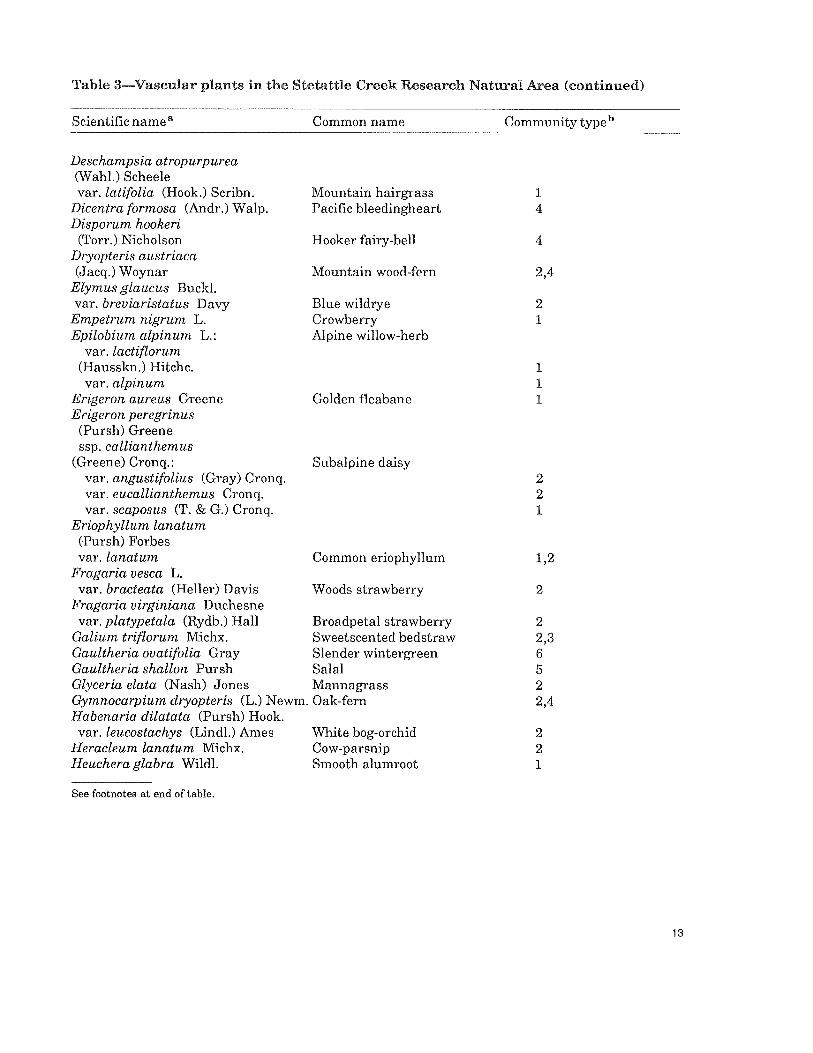
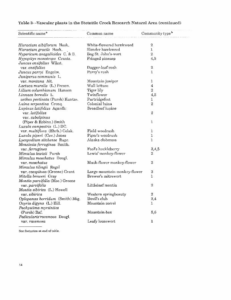
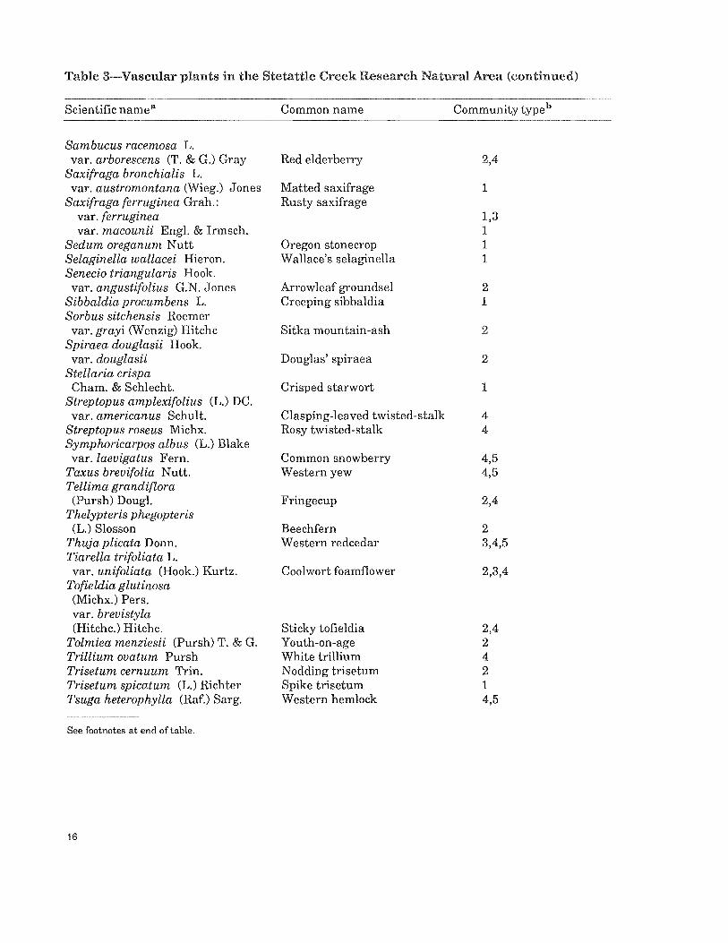
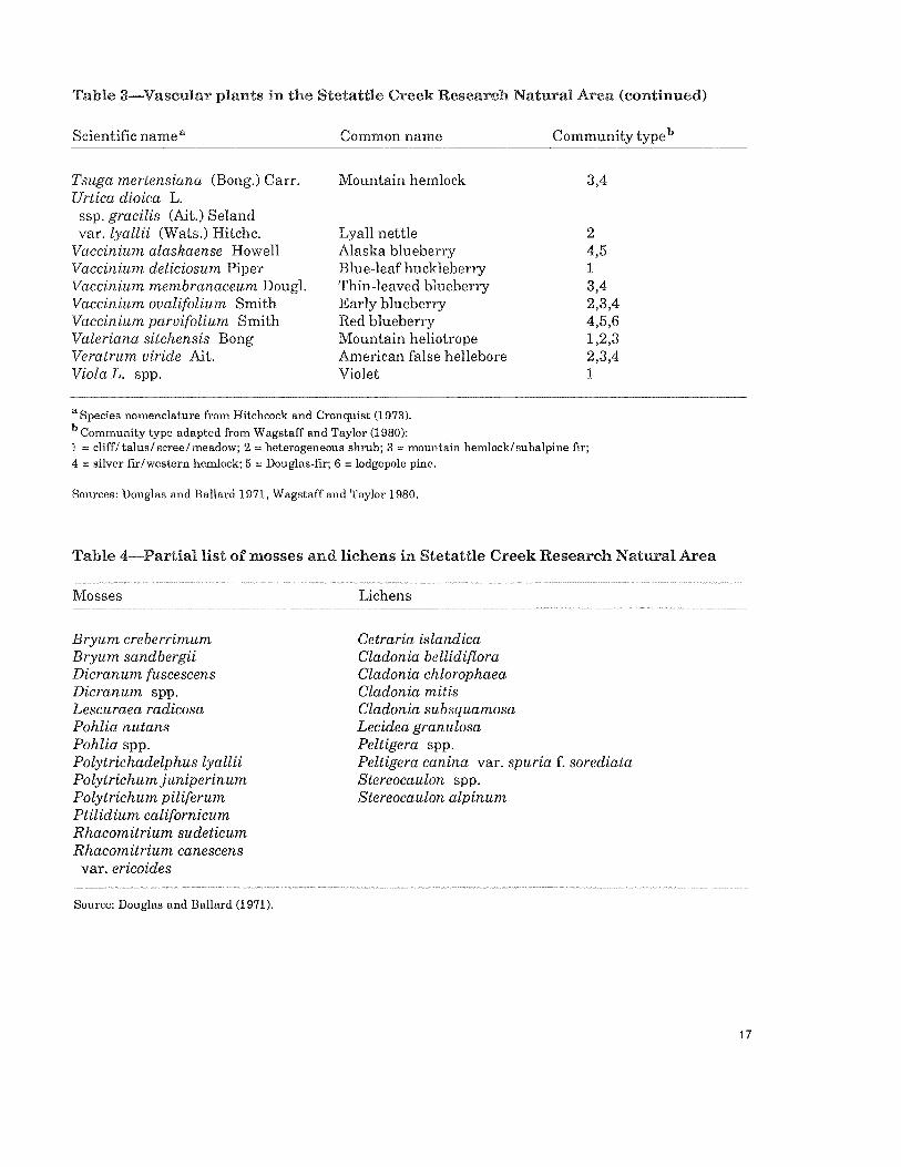
Stetattle Creek is in a transitional geographic Douglas-fir forest (Abies-Pseudotsuga); and type location and has a mix of coastal and interior 52, alpine meadows and barrens (Agrostis, Carex, vegetation types. Partial floras of the watershed Festuca, Poa). The following Society of American are given by Wagstaff and Taylor (1980), who Foresters cover types (Eyre 1980) occur in the surveyed the lowland and montane portions, and RNA: mountain hemlock (205), red alder (221), by Douglas and Ballard (1971), who intensively western hemlock (224), coastal true fir-hemlock studied a localized subalpine/alpine community. (226), and Douglas-fir-western hemlock (230). Plant lists based on these studies are included Although no habitat-type classification has been here (tables 3 and 4). completed specifically for the RNA, 28 forested Three maps of vegetation type have been pre- plant associations listed for the park complex by pared for the area. Wagstaff and Taylor (1980) Agee and others (1985) are likely present in the identified six general community types based on area (table 5). dominants: (1) cliff-talus-scree, (2) vine maple- Community descriptions are incomplete for the Sitka alder-willow (Acer circinatum-Alnus sinu- watershed. Because ofthe various definitions of ata-Salix spp.), (3) subalpine fir/mountain hem- community types, community descriptions of lock (Abies lasiocarpa / Tsuga mertensiana), different types from various studies probably (4) Pacific silver fir/western hemlock (Abiesama- overlap. Some general descriptions of bilis / Tsuga heterophylla), (5) Douglas-fir (Pseu- communities (fig. 3) can be made from the dotsuga menziesii ), and (6) lodgepole pine (Pinus classification of Agee and others (1985). The contorta). The National Park Service, Denver Douglas-fir cover type encompasses a broad Service Center, Remote Sensing Section (now midslope band across the eastern portion of the known as the Geographic Information Systems watershed, and Douglas-fir is the likely potential Field Unit, or GISFU), adapted this classifica- vegetation. Gaultheria shallon is the dominant tion for a photoin terpreted and more specific vege- understory species; associated species are Spiraea tation map (Waggoner n.d.). The types were es- betulifolia, Pachistima myrsinites, Pteridium senti ally the same, except that cliff-talus-scree aquilinum, andChimaphila umbellata (Douglas was divided into several categories: cliff-tal us- 1971, Larson 1972). Density of Douglas-fir may scree, alpine, and subalpine, which included be over 1000 stems per ha on these sites (Greene scattered tree clump forests. A third vegetation and Klopsch, n.d.). On recently burned and map (Agee and others 1985) was based on LAND- perhaps drier sites, lodgepole pine assumes SAT data combined with terrain and precipita- importance in the overstory. Dense stands of

4.
lodgepole pine occur (fig. 4) with Holodiscus discolor, Gaultheria shallon, Vaccinium spp., and Pteridium aqui-linum in the understory. Density oflodgepole pine may exceed 3000 stems per ha in such stands (Greene and Klopsch, n.d.).
The western hemlock cover type is on lower slopes in the southern portion ofthe watershed. This cover type is dominated by Douglas-fir in the overstory, with western hemlock and western redcedar (Thuja plicata) assuming dominance in older stands (fig. 5). The latter two species can comprise more than 75 percent of tree density (Greene and Klopsch, n.d.). Basal area averages about 50 m2/ha, with over half in Douglas-fir. Understory dominants in the bottomland portion ofthis cover type areAcer circinatum, Oplopanax horridum, Polystichum munitum, andVaccinium spp. (Agee and others 1985, Douglas 1971). In the drier upland portion of this cover type, overstory dominants are the same but understory dominants are Gaultheria shallon, Berberis neruosa, and Vaccinium spp. (Agee and others 1985, Douglas 1971).
The Pacific silver fir cover type is found along midslopes in the upper watershed and along valley bottoms. Some forests are estimated to be 650-750 years old where this type grades into the western hemlock cover type. Douglas-fir dominants of that age are beginning to die and be replaced by Pacific silver fir. Up to 85 percent of the regeneration is also Pacific silver fir (Greene and Klopsch, n.d.). Understory species
include Vaccinium spp., Clintonia uniflora, Linnaea borealis, Goodyera oblongifolia, and Comus canadensis (Agee and others 1985, Wagstaff and Taylor 1980).
Subalpine forests in the Stetattle Creek RNA appear to be quite diverse; in some areas, the subalpine fir cover type occurs, but in others the mountain hemlock cover type is dominant. At the highest elevations, scattered whitebark pine coexist with subalpine fir. This community is part ofthe whitebark pinel subalpine larch cover type. Because of the rocky slopes and disturbance from avalanche and fire, these forests generally have very open canopies with shrubs and herbs dom-inatingthe openings (fig. 6). Douglas and Ballard (1971) described a krummholz treeline community with subalpine fir and mountain hemlock as the dominant tree species; Alaska cedar

(Chamaecyparis nootkatensis) and whitebark pine were less important tree species. Major shrub dominants were Vaccinium deliciosum and Phyllodoce empetriformis.
Hardwood forest is not well represented in the RNA; limited amounts dominated by Alnus rubra occur in the bottoms of creeks.
The high-shrub cover type is well developed in the western portion of the watershed, particularly below snowfields where avalanches have occurred repeatedly. The avalanche chutes remain moist much of the year and usually have slopes exceeding 30 percent. A tree layer is usually absent. The shrub-layer dominants (with relative constancy from the high-shrub cover type of Agee and others [1985]) are Alnus sinuata (51), Rubus parviflorus (51), Acer circinatum (40), Pachistima myrsinites (40), Amelanchier alnifolia (26), Sorbus sitchensis (26), Comus stolonifera (21), Rubus spectabilis (13), Salix spp. (13), and Vaccinium membranaceum (7). Herb-layer dominants and constancies arePteridium aquilinum (37), Epilobium angustifolium (23), Athyrium filix-femina (16), Veratrum spp. (15), and Smilacina spp. (13).
The lowland herb community is intermixed at low elevation with the high-shrub cover type. It
contains many ofthe same herb-layer dominants as the high-shrub type plus some drier habitat herbs: Achillea lanulosa, Anaphalis margaritacea, and Fragaria virginiana.
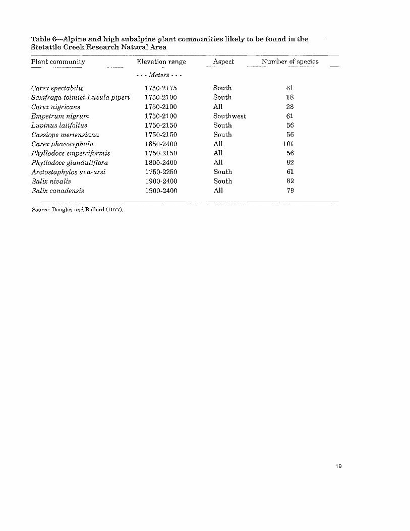
The subalpine-herb cover type is common on the south-facing slopes of Jay Creek, below Elephant Butte, and along Sourdough Ridge. Common species in the wetter portions of these communities include Sedum oreganum, Phlox diffusa, andSelaginella wallacei. The drier portions include Penstemon serrulatus, Saxifraga ferruginea, and Epilobium angustifolium (Wagstaff and Taylor 1980). Heather meadows are found near the ridgetops and include Vaccinium deliciosum, Phyllodoce empetriformis, Cassiope mertensiana, Carex rossii, andAntennaria lanata (Douglas and Ballard 1971). Subalpine and al-pine plant communities identified in the area (Douglas and Bliss 1977) are listed in table 6.
Three special-interest species exist in the RNA (Wagstaff and Taylor 1980). Luina serpentina occurs in a rocky area along Stetattle Creek, probably reflectingthe presence of serpentine soil. Carex macrochaeta was previously unknown from Washington, although it occurs in British Columbia and Oregon. Hemitomes congestum, found in moist Pacific silver fir communities, is a nongreen ericad considered rare in Washington.
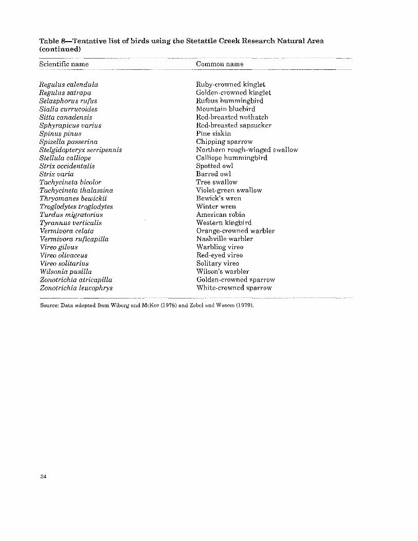
No mammal or bird surveys are known for the Stetattle Creek RNA. Tentative lists of such species for the nearby Boston Glacier RNA (Wiberg

and McKee 1978) and Pyramid Lake RNA (Zobel and Wasem 1979) may help anticipate species likely to be found in the Stetattle Creek RNA (tables 7 and 8).
Although the grizzly bear (fJrsus horribilis) and wolf (Canis lupis ) are not on the mammal list, infrequent sightings made in the North Cascades area suggest the possibility of their presence in the Stetattle Creek RNA. Many wildlife observations are on file at park headquarters.
Fish populations are not known from Sour-dough, Camp Dayo, and Bucket Creeks or in the unnamed pond. The main channel of Stetattle Creek contains introduced populations of rain-bow trout 6almo gairdneri Richardson), inter-montane cutthroat trout (Salmo clarki Richardson), and their hybrids. The cutthroat and hybrids are confined to the lower third of Stetattle Creek. Trout were first introduced to upper Stetattle Creek above the falls barrier as early as 1920. Native fishes, such as the Dolly Varden char (Salvelinus malma Walbaum), probably also inhabit lower Stetattle Creek.
Jeanita Lake had a small population of adult golden trout (Salmo aguabonita Jordan) at the time of the initial National Park Service survey in 1973. These fish were survivors of a planting in September 1968. Trout are presently absent from J eanita Lake, and the only other vertebrate in the lake is an undetermined species of sala-mander. Rainbow trout were introduced as early as 1938 into Azure Lake, a naturally fishless lake. Golden trout were introduced in 1961. Recent studies suggest trout are now absent from the lake, probably because of a lack of spawning habitat, which precludes natural recruitment.
Disturbance
Natural disturbances have played a major role in the distribution of plant communities in the Stetattle Creek RNA. Snow avalanches and wild-fires are the most widespread agents; wind is probably important on a smaller scale. Snow avalanches are apparently common below the glaciers and snowfields and along the steeper tributary creeks (fig. 7). Shrubfields along Jay Creek and along much of Stetattle Creek are
runout zones for the avalanches. Fires have occurred in the past in Stetattle
Creek RNA. The oldest forest stands in the wa-tershed appear to date from a fire 650-700 years ago. Douglas (1971) notes a fire that occurred about 1855 in the lower portions of the water-shed. Larson (1972) studied lodgepole pine stands that were established after fires occurred around 1889,1916, and 1931; this is based on the ages of the oldest trees on his sample plots. The 1889 fire may be the area represented in one of Darius Kinsey's historic photographs, taken about 1900 (Bohn and Petschek 1978). The photograph shows recently burned terrain (10-15 years old?) and was labeled "Sourdough Wilderness, Skagit River." The caption notes that "the trail crossed over Sourdough Ridge at middle skyline" (Bohn and Petschek 1978), which places the location in or near the eastern boundary of the RNA. This area is also shown as burned and not restocked on an 1898 forest inventory map (Ayres 1898). Douglas and Ballard (1971) studied a subalpine/ alpine fire that occurred about 1940. Fires of natural origin have continued to occur and are now allowed to burn under prescribed conditions. No recent fires of human origin are recorded. In 1984, the 5-ha Bucket Creek Fire burned under observation from August 5 to August 25 when rain extinguished it (Allen 1985).
Research
Most research use ofthe Stetattle Creek RNA has been associated with the plant communities. Larson (1972) studied the dynamics of a lodge-pole pine community over a broad area including parts of lower Stetattle Creek. Douglas and Ballard (1971) studied the effects offire in a sub-alpine/alpine area in the northeastern portion of the watershed. Douglas and Bliss (1977) included Stetattle Creek in their detailed study of alpine communities of the North Cascades. Wagstaff and Taylor (1980) surveyed the flora of the watershed. No intensive studies are known ofthegeology, soils, climate, glaciology, mammals, birds, amphibians, or reptiles. The park biological staff is currently monitoring the area for peregrine falcons (Falco peregrinus ).

The Stetattle Creek RNA provides an excellent example of a transitional mix oftypical eastside and west-side vegetation. From its diverse floristics and variety of disturbance factors, the Stetattle Creek RNA has good potential for in-teresting research. The major drawback is ac-cessibility, if places other then the lower valley bottom or Sourdough Ridge are to be visited.
Maps and Aerial Photographs
Topographic maps applicable to the area in-clude 7.5-minute Diablo Dam (1963) and Mount Prophet (1969), Washington, quadrangles, scale 1:24,000; 15-minute Marblemount and Mount Challenger, Washington, quadrangles, scale 1:62,500, both issued in 1953; and the North Cascades National Park map (1974), scale 1:100,000. All are issued by the U.S. Geological
Survey. A geologic map is available at a scale of 1:500,000 (Washington 1961). Vegetation maps by Waggoner (n.d., but prepared in 1980) at 1:24,000, Wagstaff and Taylor (1980) at about 1 :50,000, and Agee and others (1985) at about 1:105,000 are available.


References
Agee, J.K.; Pickford, S.G.; Kertis, J. [and others]. 1985. Vegetation and fuel mapping of North Cas-cades National Park Service complex. Seattle: National Park Service Cooperative Park Studies Unit, College of Forest Resources, University of Washington; final report, NPS contract CS-9000-3-E029. 111 p.
Allen, D. 1985. Prescribed natural fire report, 1984. Sedro Woolley, WA: North Cascades National Park Service Complex. Office report available from: North Cascades National Park Service Complex, Sedro Wooley, WA. 6 p.
Ayres, H. B.1898. Washington forest reserve. In: 19th annual report of the U.S. Geological Survey. Part 5: Forest reserves. Washington, DC: Government Printing Office: 283-313.
Bohn, D.; Petschek, R. 1978. Kinsey photographer. San Francisco: Prism Editions. 320 p.
Douglas, a.W.1971. An ecological survey of potential natural areas in the North Cascades National Park complex. Seattle: University of Washington, Inter-campus Educational and Scientific Preserves Committee. 137 p.
Douglas, G. W.; Ballard, T. 1971. Effects of fire on alpine plant communities in the North Cascades, Washington. Ecology. 52: 1058-1064.
Douglas, G. W.; Bliss, L. C. 1977. Alpine and high subalpine plant communities of the North Cascade Range, Washington and British Columbia. Ecologi-cal Monographs. 47: 113-150.
Eyre, F. ed.1980. Forest cover types of the United States and Canada. Washington, DC: Society of American Foresters. 148 p.
Greene, S.; Klopsch, M. [n.d.]. Unpublished data. Corvallis, OR: Forestry Sciences Laboratory, 3200 Jefferson Way.
Hitchcock, C.Leo.; Cronquist, Arthur. 1973. Flora of the Pacific Northwest: an illustrated manual. Seattle: University of Washington Press. 730 p.
Kiichler,A.W .1964. Manual to accompany the map of potential natural vegetation of the conterminous United States. Spec. Publ. 36. New York: American Geographical Society. [Unpaged].
Larson, J. W .1972. Ecological role oflodgepole pine in the upper Skagit River Valley, Washington. Seattle: University of Washington. 77 p. M.S. thesis.
Misch, P. 1966. Tectonic evolution of the northern Cascades of Washington State. In: Gunning, H.C., ed. A symposium on the tectonic history and min-eral deposits of the western cordillera. Spec. Vol. 8. Montreal, PQ: Canadian Institute of Mining and Metallurgy: 101-148.
Snyder, R.R.; Wade,J.M.1970. Mt. Baker National Forest soil resource inventory. Portland, OR: U.S. Department of Agriculture, Forest Service, PacificNorthwest Region. 267 p.
Tabor, R.W.; Crowder, D.F.1968. Hiker's map ofthe North Cascades: routes and rocks of the Mount Challenger quadrangle. Seattle: The Mountaineers. 47 p.
Waggoner, a.s. [n.d.]. Vegetation map of Stetattle Creek watershed. Denver, CO: National Park Serv-ice, Denver Service Center, Remote Sensing Sec-tion. 1 p. plus map.
Wagstaff, S.; Taylor, R.J.1980. Botanical reconnais-sance in the Stetattle Creek Research Natural Area, North Cascades National Park, Washington. Bell-ingham, WA: Department of Biology, Western Washington University. 21 p.
Wasem, Robert. 1973-83. Unpublished data. Sedro Wooley, WA: North Cascades National Park.
Washington [Geologic]. 1961. Olympia, WA: De-partment of Natural Resources, Division of Mines and Geology. 1 :500,000.
Wiberg, Curt; McKee, Arthur. 1978. Boston Glacier Research Natural Area. Suppl. 6. Portland, OR: U.S. Department of Agriculture, Forest Service, Pacific Northwest Forest and Range Experiment Station. 14 p. Supplement to: Federal Research Natural Areas in Oregon and Washington: a guide-book for scientists and educators.
Zobel, D. B.; Wasem, C. R.1979. Pyramid Lake Re-search Natural Area. Suppl. 8. Portland, OR: U.S. Department of Agriculture, Forest Service, Pacific Northwest Forest and Range Experiment Station. 17 p. Supplement to: Federal Research Natural Areas in Oregon and Washington: a guidebook for scientists and educators.

The Forest Service of the U.S. Department of Agriculture is dedicated to the principle of multiple use management of the Nation's forest resources for sustained yields of wood, water, forage, wildlife, and recreation. Through forestry research, cooperation with the States and private forest owners, and management of the National Forests and National Grasslands, it strives - as directed by Congress to provide increasingly greater service to a growing Nation.
The U.S. Department of Agriculture is an Equal Opportunity Employer. Applicants for all Department programs will be given equal consideration without regard to age, race, color, sex, religion, or national origin.
Pacific Northwest Research Station 319 S.w. Pine St. P.O. Box 3890 Portland, Oregon 97208