the richmond central stormwater …nz.mwhglobal.com/wp-content/uploads/the-richmond-central...the...
TRANSCRIPT

2016 Stormwater Conference
THE RICHMOND CENTRAL STORMWATER INFRASTRUCTURE UPGRADE
A Halder (MWH Global), I E McComb (Tasman District Council)
ABSTRACT (300 words maximum)
Richmond, the largest town in the Tasman District, has a central area that lies at the confluence of two stormwater catchments. While there are detention dams upstream
designed to protect the town centre, the stormwater systems do not meet the current desired levels of service and the town centre experiences periodic flooding.
In April 2013 a severe (1 in 500 year) rainfall event caused widespread flooding in the town centre which re-focused the community and the Council on the stormwater deficiencies and reinforced the priority to upgrade the stormwater infrastructure.
The proposed $13.9 million solution, is a major staged infrastructure project to improve the flood protection while also taking the opportunity to improve the accessibility, safety
and functionality of the main street. As part of the initial stage, as well as upgrading the existing stormwater pipes, the crown of the road will be lowered to prevent floodwaters flowing towards business entrances, as happened in 2013. The surface of the street will
be reinstated and the community invited to contribute ideas towards the design.
The second stage involves a new 1600mm dia. pipeline to divert stormwater flows away
from the Richmond central area out to the estuary via a new widened open channel drain. The new pipeline will collect flows from one of the upstream detention dams and other upstream diverted stormwater pipes.
Subsequent stages in the 10 year programme include further upstream diversions and improved management of overland flow paths.
This paper presents the flooding issues, options considered, the selection of the preferred solution and highlights some the challenges encountered during the design of the first two stages.
KEYWORDS
Stormwater strategy, resilience, pipe condition, levels of service
PRESENTER PROFILE
Avik Halder is the Technical Development Leader (Water and Waste) for MWH New
Zealand Ltd. Avik has been active in various projects for Tasman District Council as well as several other New Zealand local government clients since moving to New Zealand in 2006. Previously, he has worked in the United Kingdom and Ireland on a variety of
utilities infrastructure projects.
2016 Stormwater Conference
1 INTRODUCTION
Richmond, the main town in Tasman District, has a population of about 14,000. The town
centre is one of the largest commercial and retail hubs in the Nelson/Tasman Region and its role in the region is expected to grow as development around Tasman, and especially Richmond progresses.
Unfortunately, in recent times the town centre including Queen Street (the main street) has been subjected to several severe floods. The most severe was a 1 in 500 year short
duration event in April 2013 that caused widespread flooding affecting many businesses.
The Tasman District Council is working towards a major upgrade project to minimise future flooding, and since the main street will be significantly impacted by pipeline
upgrades, they are also taking the opportunity to upgrade the Queen Street carriageway, footpath and streetscape environments. This paper presents the flooding issues, options
considered, the selection of the preferred solution and highlights some of the challenges encountered during the design of the first two stages of the 10-year upgrade process.
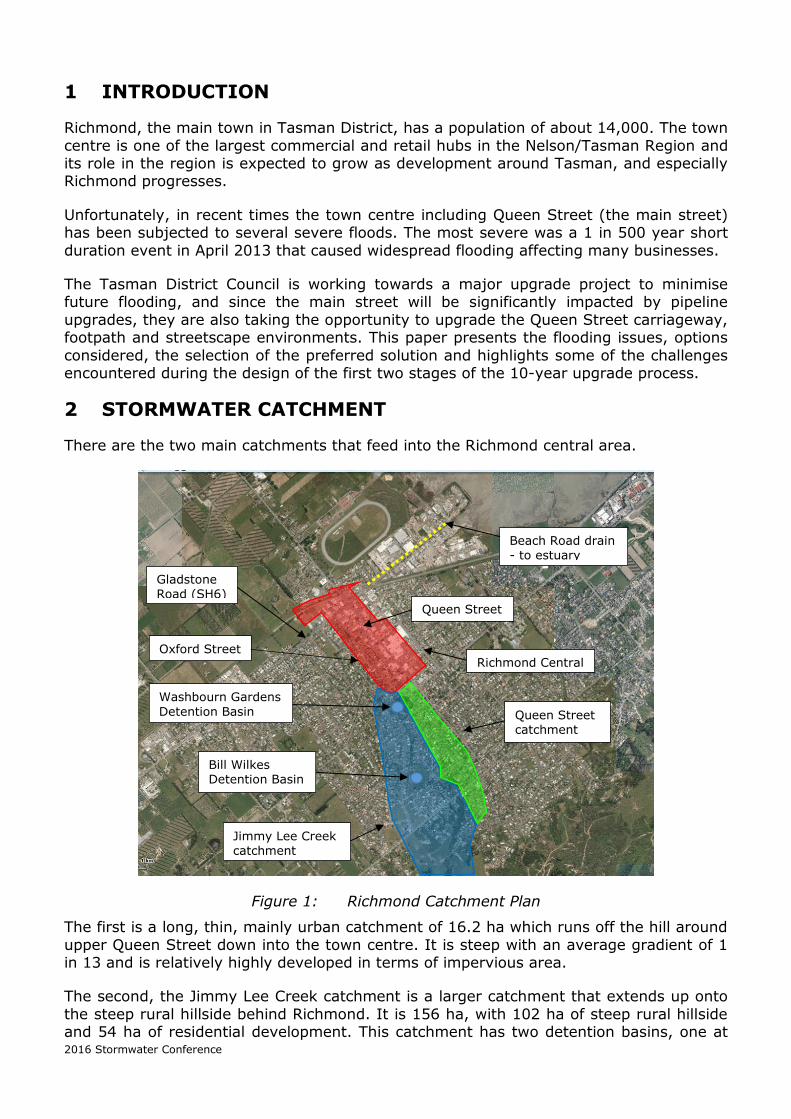
2 STORMWATER CATCHMENT
There are the two main catchments that feed into the Richmond central area.
Figure 1: Richmond Catchment Plan
The first is a long, thin, mainly urban catchment of 16.2 ha which runs off the hill around
upper Queen Street down into the town centre. It is steep with an average gradient of 1 in 13 and is relatively highly developed in terms of impervious area.
The second, the Jimmy Lee Creek catchment is a larger catchment that extends up onto
the steep rural hillside behind Richmond. It is 156 ha, with 102 ha of steep rural hillside and 54 ha of residential development. This catchment has two detention basins, one at
Gladstone
Road (SH6)
Oxford Street
Queen Street
Beach Road drain - to estuary
Washbourn Gardens
Detention Basin
Bill Wilkes Detention Basin
Richmond Central
Jimmy Lee Creek catchment
Queen Street catchment

2016 Stormwater Conference
the Bill Wilkes Reserve and one downstream and closer to town at Washbourn Gardens
(refer to Figure 1).
Photographs 1 & 2: Bill Wilkes Detention Basin Outlet (left) Basin full and overflowing at weir (right)
Downstream of Washbourn Gardens detention basin, Jimmy Lee Creek discharges into a
piped stormwater system at the top of Oxford Street. Oxford Street forms the southern side of the ring road around the town centre. Historically Jimmy Lee Creek was a natural
creek that ran between Oxford Street and Queen Street. The lower end of Queen Street was only piped in the 1950s. The pipe system carries Jimmy Lee Creek down Oxford Street to Gladstone Road.
Photographs 3 & 4: Jimmy Lee Creek through Washbourn Gardens
The town centre itself is 36.1 ha and is highly impervious with a large mall and several
car parking areas. Queen Street has a stormwater main running its length, 600 mm
diameter at the top end and 900mm diameter at the bottom end towards Gladstone
Road.
The lower ends of Oxford and Queen Streets are very flat and they run into Gladstone
Road which is also very flat. The stormwater mains in Gladstone Road pick up the flows
from Oxford and Queen Streets, turn them 90 degrees and carry them to the Beach
Road Drain.
The Beach Road Drain is a timber-lined drain that runs to the Waimea Inlet. It is
typically 6m wide and 1.5 m deep and tidally influenced in its lower reaches. It has
multiple property access crossings of variable size and construction.

2016 Stormwater Conference
Photographs 5 & 6: Beach Road Drain during a high tide (left) one of the constricted
bridges (right)
3 APRIL 2013 FLOOD EVENT
On 21 April 2013, 191mm of rainfall was recorded in Richmond (Tasman District Council office gauge) over a period of 24 hours. This event followed 18 months after another
large storm of 192mm, although the earlier storm had a significantly lower peak intensity. The 2013 storm had an average hourly intensity of just over 80mm/hr.
between 5pm and 6pm and a peak intensity approaching 120mm/hr. The event peak characteristics were estimated by the Tasman District Council to have a probability of occurring in any year of around 0.2% (1 in 500 years).
Photographs 7 & 8: Overland flows in the town centre (left) Richmond Mall car park off Queen Street (right)
In Queen Street during extreme events, the primary drainage system capacity is quickly
exceeded and flood water is carried on the streets into the town centre. Because the
streets have a reasonable gradient (1 in 50 at the top of the town centre), the
floodwater can be travelling at a high velocity.
Currently the road crown is high relative to the kerb and channel and shop floor levels
so it does not take long before the surface flows flood into shops. It also overflows into
the Richmond Mall car park, inundating the car park drainage systems and ponding at
the Mall entrance which has not been designed to cope with such flood flows.

2016 Stormwater Conference
The overland flows converge at the bottom of Queen Street and Oxford Street where
they join Gladstone Road (which is a state highway). At this point the topography is
relatively flat and when the primary drainage system capacity is exceeded, the flood
water ponds. The crown of Gladstone Road is higher than the floor levels of the
surrounding buildings so it does not take long for the ponding to flood the buildings.
Photographs 9 & 10: Ponding at the bottom of Queen Street and on Gladstone Road
4 LEVEL OF SERVICE
The target levels of service (LOS) for the retrofit project defined by the Tasman District
Council were:
Primary drainage system to contain the 1 in 20 year flows in the town centre
Primary drainage system to contain the 1 in 10 year flows in urban areas outside
the town centre
Stormwater system able to convey the 1 in 100 year flows in the town centre and urban areas without flooding buildings or dwellings
These LOS contrast significantly with the 1 in 5 year capacity that most of the existing
piped assets provide. As the Council cannot afford to significantly advance the
reticulation renewal dates, provision of secondary flow paths has been given a higher
priority. The Council has also identified that it will not protect land lower than the RL
4.0m contour from tidal effects and the effects of sea level rise.
5 HYDRAULIC MODEL
The Richmond piped stormwater network was modelled in 2007 using the InfoWorks
platform. As the LOS desired by the Council requires an understanding of the surface
drainage systems once the primary drainage networks are exceeded, it was agreed that
a 2-D surface model needed to be developed and integrated with the pipe network
model. To do this the model was converted to an Infoworks ICM model. The Council’s
LiDAR was used to generate the 2-D digital terrain model (DTM) to simulate the
overland flowpaths.

2016 Stormwater Conference
Initial simulations were undertaken to identify key overland flow paths and this
information was then used to refine the detail of the 2-D surface model. Building
outlines were digitised and given high roughness so as to be largely impervious to
overland flow. Street kerb and channels were digitised and modelled using higher
resolution 2-D grids to ensure kerb and channel flow was being adequately represented.
Adjustments and some isolated 2-D edits were required to mimic detailed surface
features not captured in the LiDAR survey that affected significant flow paths. These
edits were confirmed by flood photographs, local flood knowledge and by walkover.
6 RESILENT SOLUTIONS
The resilience of a catchment to stormwater flooding covers a range of concepts across a
reasonably broad spectrum of subjects, such as:
Resilient Infrastructure and Management (understanding and managing
existing infrastructure, understanding how and when it will fail (hydraulic, structural, operational, maintenance etc.), managing and mitigating the impact of when it does fail).
Community Preparedness (e.g. understanding the limits of infrastructure and planning for exceedance events, flood prediction, flood warning, contingency and
response planning, communication and reporting).
Responsibilities (e.g. individual and community responsibilities are defined, understood and communicated).
Adaption (e.g. awareness of and managing changing conditions over time).
Interdependencies between stakeholders (regulators, policy-makers, planning
authorities, owners, operators and the public) and the identification and management of risk.
Financial – the capability to fund and manage the infrastructure throughout its
life and considering the ongoing change.
For the purposes of this study, the aspects or areas of ‘resilience’ that were considered focused on ‘resilient stormwater infrastructure’ looking at the source, the pathway and the receptors.
6.1 SOURCE, PATHWAY, RECEPTOR APPROACH
The ‘Source, Pathway, Receptor, Consequence’, is a commonly adopted approach to understanding the link between hazard and risk, and consists of the following elements:
Source – the origin of the potential hazard, such as tide, storm surge, heavy
rainfall and hinterland runoff. Pathway – open channels, stormwater network (primary drainage network),
overland flow paths, (secondary drainage network), flood plains. Receptor – ponding flood areas, property, people, and environment. Consequence – loss of life, damage, cost, environmental impact.
This approach allows a hierarchy against which to consider the flooding issues and develop solutions. For example, if the source can be successfully controlled, then the pathway and receptor are protected. If the pathway can be controlled or managed, then
the receptor is protected.

2016 Stormwater Conference
Some examples of source, pathway and receptor controls are shown in the following sections.
6.1.1 SOURCE CONTROL
Figure 2: Source control – Catchwater diversion channels
6.1.2 PATHWAY CONTROL
Figure 3: Pathway control – Flow path channels in road berms
6.1.3 RECEPTOR CONTROL
Figure 4: Receptor control – Dismountable flood boards and glazed flood barrier

2016 Stormwater Conference
7 UPGRADE SCENARIOS AND OPTIONS
The project team went through a two stage shortlisting process to identify the preferred
strategy. The first stage was a workshop where the existing performance was reviewed
and scenarios brainstormed in terms of source, pathway and receptor.
The impractical or unfeasible options were discounted and eight main scenarios were
identified for further investigation. At two subsequent workshops scenarios were either
progressed, refined or discarded.
The final scenarios could essentially be grouped into three options, the main difference
being how the stormwater would be discharged to sea.
Option 1 - Upgrade the existing Beach Road drain outlet
Option 2 - Construction of a new outlet beside the racecourse grounds
Option 3 - New pipeline diverting flows into the Poutama drain outlet
7.1 OPTION 1 - UPGRADE THE EXISTING BEACH ROAD DRAIN OUTLET
Figure 5: Option 1- Upgrade the existing Beach Road drain outlet
The existing Beach Road drain can be used but its capacity would need to be enlarged
by removing sediment and vegetation as well as the current bridge crossing which
constricts the drain. The existing drain is timber lined and in poor condition. There is a
risk that any improvement work will further damage the timber.
For this option, upgrading the Beach Road drain alone is not enough, it will need
additional capacity between the drain and Queen Street, in order of an additional
1,500mm diameter pipeline.
Enlarge Beach Road drain
Additional 1500 dia. pipe

2016 Stormwater Conference
7.2 OPTION 2 - CONSTRUCTION OF A NEW OUTLET BESIDE THE
RACECOURSE GROUNDS
Figure 6: Option 2 - Construction of a new outlet beside the racecourse grounds
Instead of increasing the capacity of the Beach Road drain, a new drain bedside the
racecourse could be constructed, however this would need large pipes and an open
drain to the coast. Due to the topography, gravity discharge of catchment flow from the
Gladstone Road/Queen Street intersection would be marginal.
To improve this, a lift pump station at the racecourse ground could be constructed but
this would add significant additional cost because of extra pipework to the pump station.
This option is the most complicated hydraulically.
7.3 OPTION 3 - NEW PIPELINE DIVERTING FLOWS INTO THE POUTAMA
DRAIN OUTLET
Figure 7: Option 3- New pipeline diverting flows into the Poutama drain outlet
Construct new outlet drain
Potential lift pump station
New diversion pipe from Queen Street
Racecourse grounds
New pipeline from Washbourn Gardens detention basin
Existing Poutama drain
– to be widened

2016 Stormwater Conference
Installing a new pipeline from the Washbourn Gardens detention basin to Poutama Drain
effectively cuts off the Jimmy Lee catchment that feeds into the top of Oxford Street.
As a result, the existing infrastructure in Oxford Street is sufficient to cope with the
remaining stormwater in the town centre.
The pipeline to Poutama Drain would need to be a least 1,600mm in diameter and would
be partly pressurised, partly gravity. It will need to be carefully designed to ensure that
air can be appropriately managed in the system when the pipeline fills. The Poutama
Drain would also need to be enlarged to handle increased flows.
7.4 OPTIONS ASSESSMENT
A multi-criteria analysis (MCA) was used to compare the scenarios and options. The main
criteria assessed were: Economic 30%
Environmental 20% Social 20%
Solution Resilience 30% (hydraulic robustness, flood resilience, implementation risk and future resilience)
For the purposes of this paper, a simple table indicating some of the positives and negatives of the three outlet options is presented below.
Option 1 - Upgrade the existing Beach Road drain outlet
Positives Beach Road drain is the existing outlet to the sea for stormwater discharge in flood events
Negatives Limited additional capacity available
Beach Road drain is subject to tidal impact which is predicted to
increase with climate change
A major upgrade would be required to increase flow capacity
Option 2 - Construction of a new outlet beside the racecourse ground
Positives Would provide new drainage and outlet to the sea
Required capacity can be constructed to take Q100 flows
Possible future additional outlet
Negatives Requires land purchase and associated costs and time
Option 3 - New pipeline diverting flows into the Poutama drain outlet
Positives Provides a new collection system
Delivers flows to an enlarged Poutama Drain
Removes the need for additional pipe work in Oxford Street
Removes the need for a major upgrade to Beach Road Drain
Allows a pickup of flow from local upstream areas

2016 Stormwater Conference
Negatives Significant disruption to residents’/road users during construction
Design challenges with construction due to large pipe size
Table 1: Assessment of the three outlet options
8 PREFERRED SOLUTION
Option 3 was identified as the preferred solution and comprises the upgrade scenario
shown below.
Figure 8: Preferred upgrade scenario and stages
The approach adopted is focused on diverting water away from the town centre and hence is modifying the pathway to protect the receptor.
Divert Upper Queen Street flows (Stage 2)
Upgrade Queen Street including inverted road
crown (Stage 1)
Remove 2 constrictions (under bridges) on Beach Road Drain (Stage 4)
Enlarge existing Poutama drain (Stage 2)
Divert
Gladstone Road flows (Stage 2)
Local upgrades (Stage 3)
Overland flow path improvements - Richmond Central (Stage 4)
New pipeline from Washbourn Gardens detention basin (Stage 2)

2016 Stormwater Conference
Figure 9: 100-year flood model of current system (left) after preferred solution (right)
The flood maps demonstrate that the preferred solution achieves the target level of
service of the stormwater system being able to convey the 1 in 100 year flows in the town centre and urban areas without flooding buildings or dwellings.
The proposed solution was also checked against the 2013 event and the modelling indicated that a future 1 in 500 year event (after the works were completed) would
flood the area less than a current 1 in 100 year event.
The stormwater component of the overall scheme cost is estimated to be $13.9 million.
It should be noted that the Council identified that it will not protect land lower than the RL 4.0m contour from tidal effects and the effects of sea level rise. This is reflected in the flood map for the preferred solution.
9 STAGING OF WORK
Construction of the proposed stages is shown in the table below and in Figure 5.
Stage Description Year
Stage 1 Upgrade Queen Street including inverted road crown 2016-17
Stage 2 Upper Queen Street diversion. Gladstone Road diversion. New
pipeline from Washbourn Gardens to enlarged Poutama drain.
2017-19
Stage 3 Upgrade Blair Terrace and Washbourn Drive area 2019-22
Stage 4 Remove throttled bridge openings in Beach Road drain and
overland flow management across Richmond Central.
2022-25
Table 2: Staging and timing of the upgrade

2016 Stormwater Conference
This staged approach has been proposed to best achieve the upgrade taking into
consideration:
the need to provide improved performance in Queen Street as a priority the desire to avoid dis-advantaging (or increase flood risk) to any particular area
as the strategy is implemented over the stages to bundle projects in appropriate and sensible packages
to avoid duplication of work interruption in specific areas The overall design capacity will only be fully realised when the total complement of
upgrades is implemented. Until that time, it is acknowledged that in the short term, a lower level of service will be provided in localised areas.
10 DESIGN
Tasman District Council have approved the start of detailed design for both Stage 1 and Stage 2 of the upgrade. Stage 1 is programmed for construction in late 2016 and Stage 2
early 2017. The following section presents some of the challenges the design team will face for both
stages.
10.1 STAGE 1 - UPGRADE QUEEN STREET INCLUDING INVERTED ROAD
CROWN
An important part of this stage involves lowering the level of the road carriageway to create a better secondary flow path for stormwater. The crown of Queen Street will be
lowered to create a central swale that will direct the flow of water away from buildings.
The Council is also taking the opportunity to replace and future-proof aging water and
sewer reticulation in order to avoid construction works for other utilities in the near future.
To deliver these outcomes, extensive excavation work is required down the length of Queen Street and the major issue is the disruption to the public and local businesses. The works are proposed to be completed in segments with temporary road surface
reinstatement to minimise traffic restrictions
Complete reinstatement of the street will be necessary from shop front to shop front. The
re-profiling of the road surface provides the opportunity to improve the accessibility, safety and functionality of the street. The Council is currently engaged in community consultation on the design.

2016 Stormwater Conference
After re-profiling
Existing profile
Photograph 11: Queen Street road crown Figure 10: Sketch of road re-profiling
10.2 STAGE 2 - NEW PIPELINE FROM WASHBOURN GARDENS DETENTION BASIN TO ENLARGED POUTAMA DRAIN
10.2.1 PHYSICAL CONSTRUCTION OF A LARGE PIPELINE
The proposed new pipeline from Washbourn Gardens detention basin to the enlarged Poutama drain is expected to be 1600mm dia. This will require a major excavation both
in terms of width and depth.
A key challenge will be the inevitable clash with a multitude of existing services. An initial
thought is to undertake service diversions ahead of the installation of the stormwater pipeline in order to provide a clear working corridor.
10.2.2 JUBILEE PARK, STATE HIGHWAY 6 AND POUTAMA DRAIN
The new 1600mm pipeline as well as a diversion of the existing twin 1200mm pipe will
have to cross state highway and run along Jubilee Park, the main sports ground for Richmond and the largest sports and recreation reserve in the District.
The pipelines will then discharge to the existing Poutama drain and out to sea. There will
be both vertical and horizontal constraints that will need to be overcome, particularly to tie into the Poutama drain and also provide minimum pipe depth cover across the state
highway.
Initial consultation with both Council Parks and Reserves and NZTA staff has indicated a strong preference for a single crossing across Jubilee Park and State Highway 6.
Preliminary design indicates this to be achievable but would require a major diversion of approximately 150m of the existing Richmond 750mm trunk sewer.

2016 Stormwater Conference
Photographs 12 & 13: Jubilee Park and State Highway crossing
10.2.3 WASHBOURN GARDENS
Washbourn Gardens contains the detention basin from which the new pipeline will receive flow. The gardens are the flagship reserve in the district with frequent community events
and plantings of a number of native flora and fauna.
One of the key design challenges will be the intake structure to receive flows for the 1600mm pipeline. This will have complexities from both an operations and maintenance
perspective as well as a health and safety perspective not only for maintenance staff but also for the public.
Council Parks and Reserves staff have also indicated that the intake structure will need to incorporate aesthetic features to ensure that it blends in with the gardens. Additionally, there are likely to be restrictions on when construction can occur and stringent
reinstatement conditions.
Photographs 14 & 15: Washbourn Gardens (detention basin spillway – shown right)

2016 Stormwater Conference
11 CONCLUSIONS
The strategy of the Richmond central stormwater infrastructure upgrade is focused
on diverting water away from the town centre and hence modifying the pathway to
protect the receptor.
It will comprise significant multi-staged improvement works to achieve the high level
of service that the Tasman District Council wants to meet. To upgrade the primary
drainage system to the 1 in 20 year capacity involves substantial expenditure. The
objective of making the town centre resilient in the face of stormwater flooding
also further increases costs.
The primary system upgrades to meet the 1 in 20 year standard can very nearly
deal with the 1 in 100 year rainfall event. The amount of surface flooding that
results is within levels of service. Is this therefore a resilient system? A resilient
system can cater for and recover quickly from greater than design events or
obstruction/interruption of the primary drainage solution.
Options to improve the performance of the overland flows paths will be considered as
part of the final stage of the upgrade however they w i l l b e difficult and expensive
to ‘engineer’ in an already developed town centre environment.
Design is currently underway for the first two stages of the upgrades with Stage 1,
the Queen Street upgrade planned to start later this year.
ACKNOWLEDGEMENTS
Figures 2 and 3 images courtesy of Allan Leahy, MWH NZ Ltd.
Figure 4 images courtesy of Floodcontrol International
Figure 10 sketch courtesy of Tasman District Council’s website
REFERENCES
R.T. Lester, I.E. McComb, D.R. Wilson, A.M. Osborne (March 2015) Protecting Richmond Town Centre
MWH NZ Ltd (September 2015) Richmond Central Flood Options Assessment Report. Prepared for Tasman District Council