the role of the object modelling system (oms) for integrated assessment of conservation on...
TRANSCRIPT

The Role of the Object Modelling System The Role of the Object Modelling System (OMS) for Integrated Assessment of (OMS) for Integrated Assessment of Conservation on Agricultural Land in the Conservation on Agricultural Land in the United StatesUnited States
J. Carlson, O. David, J. Ascough II, F. Geter, and L. AhujaUSDA - ARS - Agricultural Systems Research UnitUSDA – NRCS - Information Technology CenterColorado State University – Civil Engineering and Computer Science
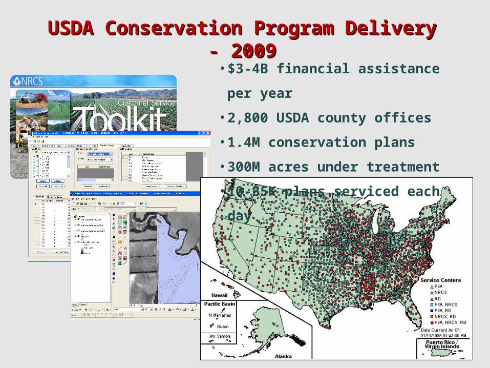
USDA Conservation Program Delivery - 2009USDA Conservation Program Delivery - 2009
• $3-4B financial assistance per year
• 2,800 USDA county offices
• 1.4M conservation plans
• 300M acres under treatment
• 10-35K plans serviced each day

Sample Conservation PlanSample Conservation Plan
Management System Wheat/Corn/Fallow, Reduced Tillage, MLRA 69A
Land Units: 201, 202, 205 (480 acres total)
Resource Concerns Erosion, Nutrient Runoff, Pesticide Runoff
Conservation Practices Planned Job Sheet DesignCost-Share Applied
Conservation Cropping System X X X
Residue Management X X X
Nutrient Management X X X
Pesticide Management X X X
Terrace X X X X
Grassed Waterway X X X

Conservation Treatment Coverage - 2009Conservation Treatment Coverage - 2009
What is the impact of this program activity?

Conservation Effects Assessment Project Conservation Effects Assessment Project (CEAP)(CEAP)
• Authorized by the 2002 Farm Bill
• Government-wide emphasis on Outcomes
• National Assessment plus Watershed Assessments
• “Scientifically quantify effects of Conservation Practices"

Initial CEAP National Assessment ProcessInitial CEAP National Assessment Process
• Focus on Cropland
• Obtain representative crop data from National Resources Inventory (NRI) and farmer surveys
• Estimate impacts of conservation practices on water quality, water quantity, and soil quality using the SWAT model.
Next Generation ProcessNext Generation Process• Consider Cropland, Rangeland, Wetlands, Wildlife
• Leverage NRI and mine the conservation plan database
• Address multiple resource concerns
• Add pre-program delivery watershed assessments
• Build New CEAP model base containing components from SWAT, J2000(S), WEPP, RHEM, and new research
• Apply the USDA Object Modeling System (OMS) framework

7
History of the Object Modeling System (OMS)History of the Object Modeling System (OMS)
Charge: Build a contemporary modeling framework for USDA
based on modular modeling experiences
2001/02 2003/04 2005/06 2007/08/09+
Netbeans Platform
Major Refactoring
Central Version Control
Standardize Component API
PRMS
Modeling Projects
USDA CoLab Use
Project Plan/Process
PRMS, CEAP, iFarm
Initial Prototype
Swing based
PRMS, RZWQM
Geospatial Integration
Calibration Tools
Sensitivity Analysis
Uncertainty Analysis
Knowledge Base
Data Provisioning
Deployment Platform
Agency Governance
Webservices
Cloud Computing
CEAP, J2000(S), PRMS, WWEM, Model Bases
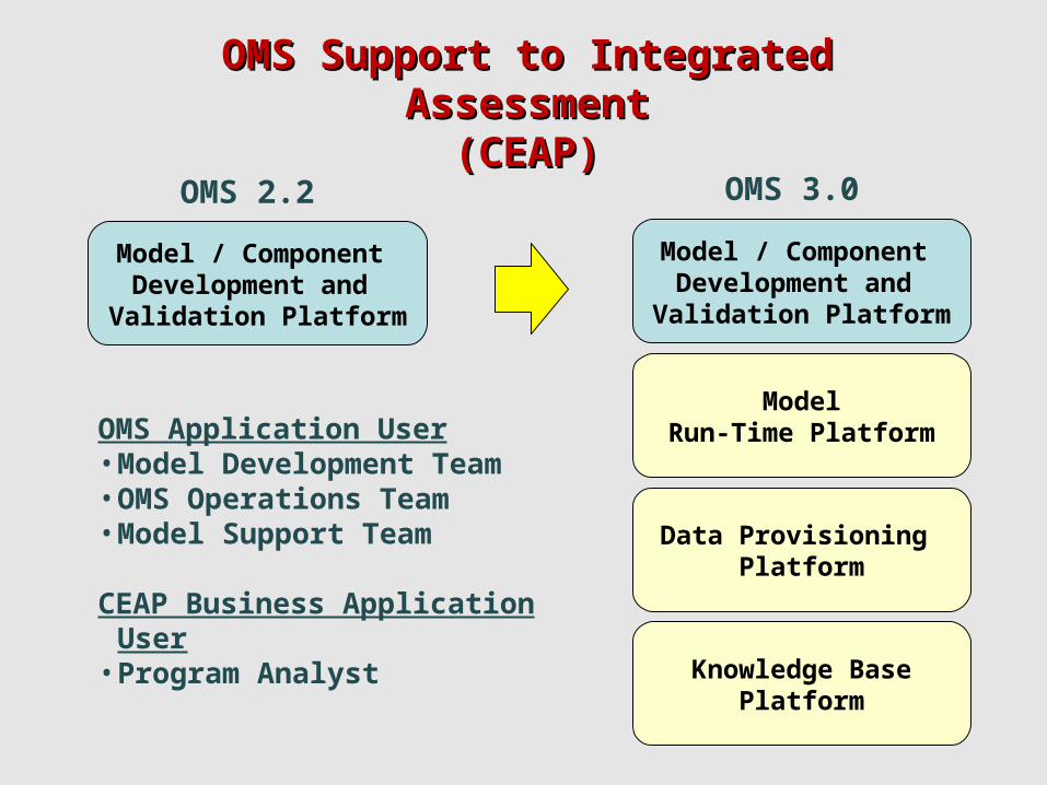
OMS Support to Integrated AssessmentOMS Support to Integrated Assessment(CEAP)(CEAP)
Model / Component Development and Validation Platform
Model / Component Development and Validation Platform
ModelRun-Time Platform
Data Provisioning Platform
Knowledge BasePlatform
OMS 2.2 OMS 3.0
OMS Application User• Model Development Team• OMS Operations Team• Model Support Team
CEAP Business Application User
• Program Analyst
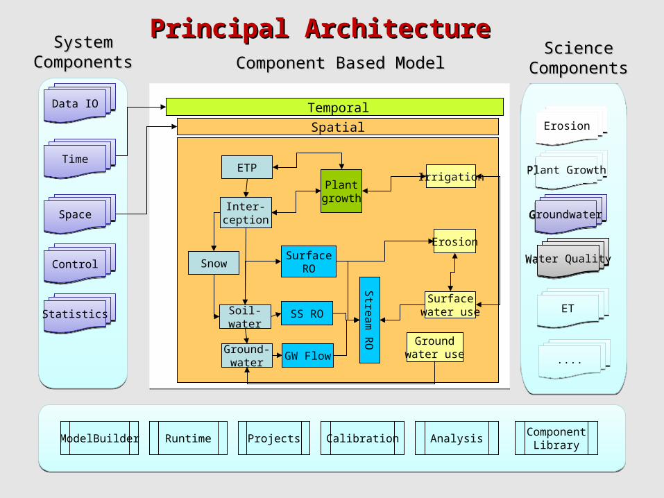
ModelBuilder
Temporal
Spatial
ETP
Inter-ception
Snow
Soil-water
Ground-water
SS RO
GW Flow
SurfaceRO
Irrigation
Erosion
Surfacewater use
Groundwater use
Plantgrowth
Stre
am
RO
System System ComponentsComponents
CalibrationProjects
Science Science ComponentsComponents
ErosionErosion
Plant GrowthPlant Growth
GroundwaterGroundwater
Water QualityWater Quality
ETET
Runtime AnalysisComponent
Library
Component Based ModelComponent Based Model
ControlControl
StatisticsStatistics
TimeTime
SpaceSpace
Data IOData IO
Principal ArchitecturePrincipal Architecture
........

OMS 3.0 Model Development and Validation OMS 3.0 Model Development and Validation PlatformPlatform
Component
input(s) output(s)processing
OMS Component = POJO + Meta data
OpenMIAdaptation
(optional, with CSDMS)
• Minimize framework API dependency in model component code (OMS 3.0 is non-invasive)
• Calibration – Luca (Shuffled Complex Evolution), Dynamically Dimensional Search (DDS), NSGA, …
• Sensitivity Analysis – Morris Screening, Extended FAST, Sobol
• Uncertainty Analysis – GLUE, Bayesian Monte Carlo
• OMS Component Library QA/QC (currently ~200 components)
• Geospatial Tools – GeoWind integration

OMS 3.0 Run-Time PlatformOMS 3.0 Run-Time Platform
• Models organized into model bases around business needs
• Models deployed as web services in an elastic computing cloud
• Model services are multi-threaded to scale to user demand
• Technology – Amazon EC2, Glassfish Enterprise Server, Terracotta
CEAP Integrated Assessment Model Base
Web ServiceRegistry
ModelA
Model B1
Model C1
ModelD
Model E
Model F
Model B2
Model C2
Enterprise Service Bus (OpenESB)
Business Application Business Application Business Application
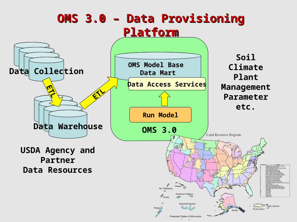
OMS 3.0
OMS Model Base Data Mart
Data Warehouse
Data Collection
Data Access Services
Run Model
ETL
ETL
USDA Agency and Partner
Data Resources
SoilClimate
PlantManagement
Parameteretc.
OMS 3.0 – Data Provisioning PlatformOMS 3.0 – Data Provisioning Platform

OMS 3.0 – Knowledge Base PlatformOMS 3.0 – Knowledge Base Platform
USDA Core Entities
•Land Unit (~10 million)
•Management System (~40,000)
•Conservation Practice (~150)
•Resource Concern (~80)
•Response Unit
•Soil Mapunit (thousands)
•Ecological Site (thousands)
•Climate Station (thousands)
•Common Resource Area (~1000)
•Plant/Crop (~40,000/~2000)
•NRI Sample Unit (~800K)
•Science Components
(hundreds)
USDA Knowledge Base
•Knowledge currently managed
in data dictionaries, E-R models,
and in hard/soft copy documents
•To be converted and managed
in OWL
•BPMS x knowledge base
interaction?
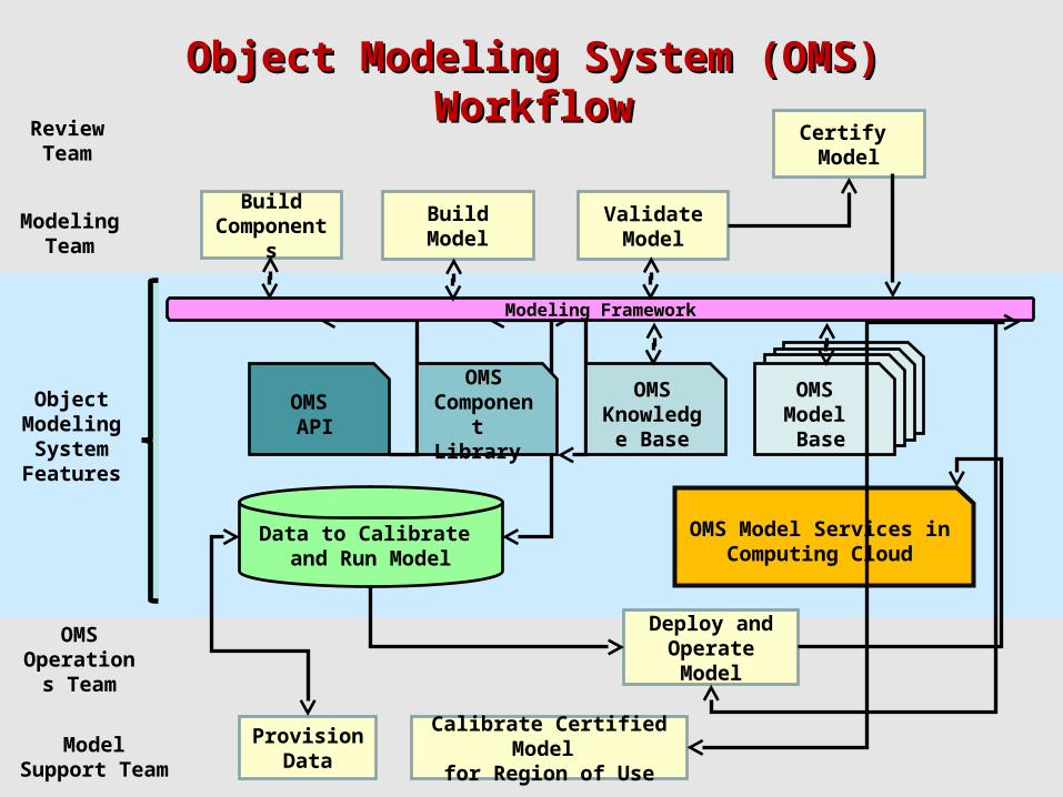
Object Modeling System (OMS) WorkflowObject Modeling System (OMS) Workflow
OMS Knowledge Base
Data to Calibrate and Run Model
OMS API
OMS Model Services in Computing Cloud
OMSCompone
nt Library
OMS Knowledge Base
OMS Model Base
OMS Model Base
OMS Model Base
OMS Model Base
Modeling Framework
Review Team
ModelingTeam
Object Modeling System
Features
OMS Operations
Team
Model Support Team
BuildCompone
nts
BuildModel
ValidateModel
Certify Model
ProvisionData
Calibrate Certified Model
for Region of Use
Deploy and Operate Model

15
Business Use Cases Requiring OMS Model ServicesBusiness Use Cases Requiring OMS Model Services
• Develop watershed assessments to assist allocation of Develop watershed assessments to assist allocation of
USDA program resourcesUSDA program resources
• Develop and evaluate management alternatives with the
producer or land manager
• Develop detailed practice designs
• Develop forecasts to assist within-season tactical decision
making
• Calculate credit for ecosystem services
• Determine USDA program eligibility
• Determine USDA program compliance
• Assess USDA program effects, benefits, and outcomesAssess USDA program effects, benefits, and outcomes
• Support USDA risk management programs
• Support USFS forest management plans
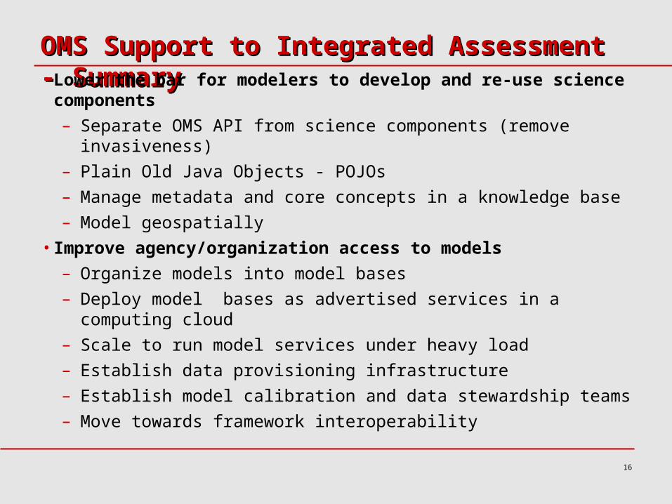
OMS Support to Integrated Assessment - SummaryOMS Support to Integrated Assessment - Summary• Lower the bar for modelers to develop and re-use science
components
– Separate OMS API from science components (remove invasiveness)
– Plain Old Java Objects - POJOs
– Manage metadata and core concepts in a knowledge base
– Model geospatially
• Improve agency/organization access to models
– Organize models into model bases
– Deploy model bases as advertised services in a computing cloud
– Scale to run model services under heavy load
– Establish data provisioning infrastructure
– Establish model calibration and data stewardship teams
– Move towards framework interoperability
16

OMS Briefing 17
oms.javaforge.comoms.javaforge.com

OMS Briefing 18