the rural municipality of beaver river no 622 basic ... · policy is required to accommodate farm...
TRANSCRIPT

THE RURAL MUNICIPALITY OF BEAVER RIVER NO 622 BASIC PLANNING STATEMENT
(with amendments)
This is a consolidation of the Basic Planning Statement Bylaw and amendments. In the case of an error the original document shall prevail.
Being Schedule “A” to Bylaw No. 58
of the Rural Municipality of Beaver River No. 622.
Original BPS Adopted by Council on March 9, 1995
______________(Reeve)____________ REEVE Seal ______________(Administrator)_____ ADMINISTRATOR

CONTENTS PART I BACKGROUND
1.1 Introduction 1.2 Municipal Planning Program 1.3 Development Issues and Concerns 1.4 General Goals
PART II AGRICULTURAL LAND USE 2.1 Agricultural Objectives 2.2 Agricultural Development Policy 2.3 Agricultural Subdivision Policy 2.4 Farm Based Business
PART III RESIDENTIAL LAND USE 3.1 Residential Objectives 3.2 Hamlet Policy 3.3 Single Parcel Country Residential Policy 3.4 Intensive Country Residential Policy 3.5 Home Based Businesses
PART IV LAKESHORE DEVELOPMENT 4.1 Lakeshore Development Objectives 4.2 Lakeshore Development Policy 4.3 Home Based Businesses
PART V COMMERCIAL AND INDUSTRIAL LAND USE 5.1 Commercial and Industrial Objectives 5.2 Commercial and Industrial Policy 5.3 Highway Commercial Development Policy
PART VI MUNICIPAL SERVICES 6.1 Municipal Servicing Objectives 6.2 Transportation Policy 6.3 Municipal Servicing Policy 6.4 Waste Disposal Policy
PART VII ENVIRONMENT AND RESOURCE CONSERVATION 7.1 Environment and Resource Conservation Objectives 7.2 Environment and Resource Conservation Policy
PART VIII LAND USE CONCEPT 8.1 Agriculture Development Policy Area 8.2 Hamlet Policy Area 8.3 Lakeshore Development Policy Area 8.4 Highway Commercial Development Policy Area 8.5 Forest Policy Area
8.6 Intensive Country Residential
PART IX IMPLEMENTATION 9.1 Cooperation and Interjurisdictional Consideration 9.2 Programs 9.3 Provincial Land Use Policies 9.4 Binding 9.5 Zoning Bylaw 9.6 Definitions
PART X DEVELOPMENT REVIEW CRITERIA

PART I BACKGROUND 1.1 Introduction
Sections 39 and 45 of The Planning and Development Act, 1983 empower Council to prepare and adopt a Basic Planning Statement and Zoning Bylaw. The Basic Planning Statement is a growth management tool which provides the basis for regulations and decisions made under the Zoning Bylaw. Its primary purpose is to provide a framework within which future land subdivision and development in the municipality is to be encouraged and directed. The policies within this statement are intended to: - Guide all growth in a logical and orderly manner in order to benefit all residents
of the municipality; - To enhance the cultural, visual and ecological qualities of the rural environment; - To ensure that adequate services are available for the health, safety and
convenience of the residents; and - To encourage the development or an environment which is pleasant, efficient and
economical for all concerned.
1.2 Municipal Planning Program
The Rural Municipality of Beaver River No. 622 authorizes the preparation of an updated Zoning Bylaw in 1992. The first step in this process was the preparation of the Background Planning Report dated 1992. This report presents information respecting land use and the social, cultural and physical resources of the municipality. It presents planning issues and key findings and recommends general goals and objectives to serve as a focus for the development of land use policy contained in the Basic Planning Statement. This document has been prepared for Council by the firm Hilderman Witty Crosby Hanna and Associates with the assistance of the Department of Municipal Government.
1.3 Development Issues and Concerns
a. Resources
Policy is required to protect any known area of gravel, or areas believed to exhibit a high potential for being a source of gravel, from development that would effectively preclude gravel extraction when needed/desired. Land use policy is required to promote and protect heritage properties and historical sites in the municipality. Land use policy is required to guide the development of resource extraction and forest industries in the municipality due to their potential impact on municipal infrastructure (i.e. heavy hauling on municipal roads) and potential impact on the municipal economy.
b. Agriculture
Agriculture is important to the municipality, but there is also a need to recognize opportunities to diversify land uses including single country residential subdivisions which will increase the municipal tax base and potentially lead to smaller scale agricultural and horticultural uses. Maintaining adequate site sizes for agricultural holdings is important which must be balanced by providing flexibility for intensive agricultural, country residential and small scale farms.

Policy is required to accommodate farm land subdivision to reflect realities of farm debt settlement, farmland consolidation, estate settlement, retirement planning and sale or lease of Crown land for farming purposes; Policy will be required to protect agricultural land use, including intensive agricultural operations from negative impacts of non-agricultural land use and development. Policy will be required to provide development standards for intensive agriculture uses so that they do not jeopardise existing developments and environmental concerns. Policy will be required to provide development standards for home and farm based business.
c. Residential
An assessment of current residential options is needed and adequate controls developed. More specifically: - Land use policy is required to prevent conflicts between the rural and urban
municipalities’ land uses. Land use policy for the areas in the municipality that area adjacent to the Villages of Pierceland and Goodsoil, the RM of Loon Lake No. 561, and Meadow Lake Provincial Park, should be considerate of their land use policy;
- Policy for the hamlets is required to reflect their diverse needs and provide direction to avoid future land use conflicts and to achieve future servicing efficiencies. Some growth is anticipated for the hamlets in the future, however, growth is dependant on several factors, such as growth of the oil industry and the economic outlook;
- Under the current Zoning Bylaw, the Hamlet of Golden Ridge is zoned AR – Agricultural Residential and lots in this area are too small to accommodate many agricultural land uses in conformity with site regulations. New policy should address the issue of whether this hamlet should continue in existence;
- Policies respecting lakeshore development should be established;
- Land use policy is required to minimize the economic costs of country
residential and lakeshore development to the municipality and to ensure that it is undertaken in a planned manner.
d. Industrial/Commercial
Opportunities exist for further development of the forest and oil related industries. Policy should provide for the growth and development of these industries and to minimize the negative impacts of commercial and industrial development on the environment, residential and agricultural land uses. Commercial activity is found in the hamlets and is dispersed in other areas throughout the municipality. Land use policy is required to give direction to the expansion and development of existing and potential commercial and industrial areas (to prevent land use conflicts and unnecessary environmental damage). Policy should be developed to address potential opportunities for on-farm business diversification (e.g. vacation farms, bed and breakfast operations, outfitting);

Consideration of policy to accommodate cottage industries, home industries and off farm employment is needed. Land use policy should recognize the directions being taken by the Freshwater R.D.C. and provide a context to help its development initiatives.
e. Tourism and Recreation
Location and development guidelines are required in policy for a wide range of existing and potential recreational opportunities in the municipality, such as hunting outfitters, bed and breakfast operations, and passive recreational opportunities. Site-specific planning policies are needed for the areas south of Meadow Lake Provincial Park. This area has some potential for further recreational development. Policy should reflect the need for infill of existing sites and planned development of new sites. Policy must address the effects of more resort traffic on municipal roads (i.e. effects on physical road condition and life-span). Land use policy is required to recognize the potential for tourism and recreation development around a number of lakes throughout the municipality.
f. General
Enhanced communications with adjoining municipalities, both rural and urban, as well as with different levels of government, should be actively pursued. In this respect, land use policy should be cognizant of the land use policy of adjoining municipalities and the development plans of Meadow Lake Provincial Park. Policy should promote intermunicipal agreements where there is joint use of facilities, land use, or infrastructure to help the municipalities in cost reductions and in limiting land use conflicts. Land use policy should provide guidelines and development controls for the future development of landfill sites. Policy is needed to identify all infrastructure development and servicing responsibilities for new subdivisions and development.
1.4 General Goals
The following general land use and development goals provide direction for establishing specific land use policies in the municipality. a) To recognize the importance of agriculture in the municipality in balance with
other land uses vital to maintaining the sustainability of the municipality. b) To promote orderly development of the municipality while minimizing any
detrimental social, economic, and environmental impacts. c) To maintain the long term economic and environmental sustainability of the
municipality by promoting appropriate development that exhibits a high degree of fit with the land resource base in both the short and long terms.
PART II AGRICULTURAL LAND USE 2.1 Agricultural Objectives
a) To generally maintain the agricultural character of the municipality and the rural way of life in concert with other land used.
b) To accommodate intensive agricultural uses in the municipality if it conforms to
development standards and do not override environmental concerns. c) To support agricultural land use and development that enhances soil conservation
and environmental sustainability. d) To support agricultural development that can improve the economic viability of
the rural municipality. e) To accommodate farm residential needs. f) To permit single residential acreage development considered compatible with
agricultural land uses. 2.2 Agricultural Development Policy
The primary agricultural uses include grain farming, mixed grain/livestock operations, farmsteads and farm residences, intensive agricultural uses, agricultural related commercial and industrial developments, and on-farm or home occupations. a) Intensive Agriculture Uses
i) Intensive Livestock Operations
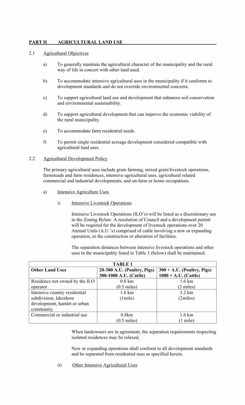
Intensive Livestock Operations (ILO’s) will be listed as a discretionary use in the Zoning Bylaw. A resolution of Council and a development permit will be required for the development of livestock operations over 20 Animal Units (A.U.’s) comprised of cattle involving a new or expanding operation, or the construction or alteration of facilities. The separation distances between intensive livestock operations and other uses in the municipality listed in Table 1 (below) shall be maintained.
TABLE 1 Other Land Uses 20-300 A.U. (Poultry, Pigs)
300-1000 A.U. (Cattle) 300 + A.U. (Poultry, Pigs) 1000 + A.U. (Cattle)
Residence not owned by the ILO operator
0.8 km (0.5 miles)
1.6 km (2 miles)
Intensive country residential subdivision, lakeshore development, hamlet or urban community
1.6 km (1mile)
3.2 km (2miles)
Commercial or industrial use 0.8km (0.5 miles)
1.6 km (1 mile)
When landowners are in agreement, the separation requirements respecting isolated residences may be relaxed, New or expanding operations shall conform to all development standards and be separated from residential uses as specified herein.
ii) Other Intensive Agricultural Uses

Council shall require the proponent of intensive agricultural uses such as nurseries, market gardens, etc. to demonstrate their feasibility as a basis for approval.
b) Agricultural Related Commercial and Industrial Uses Approval for such commercial or industrial developments may be granted if their function is directly related to agriculture and only after a review by Council, to ensure that: i) Incompatibility with other land uses will be avoided, including
consideration of proximity to urban centres, hamlets and Provincial Parks and Recreation Sites;
ii) Policies for environmental quality control will not be jeopardized
including water and waste disposal servicing; iii) repealed iv) The design and development of the use will conform to high standards of
safety, visual quality and convenience; v) The development will be situated along an all-weather road; and vi) All relevant approvals are obtained from government agencies for uses
such as anhydrous ammonia fertilizer facilities. c) Farm Dwellings
One farm dwelling will be permitted for agricultural operations. Additional dwelling units may be permitted, by a resolution of Council, if accessory to a legitimate agricultural operation and if it is intended to accommodate farm workers. The granting of a dwelling development permit by Council for such additional dwelling(s) shall not be construed, in any way, as consent or approval for future subdivision.
2.3 Agricultural Subdivision Policy a) Agricultural Land
Larger agricultural land holdings area generally important in maintaining the viability of certain agriculture operations. However, subdivision of land into parcels smaller than a quarter section for legitimate agricultural purposes will be permitted where: i) the severity of a financial crisis for a particular agricultural operation is
demonstrated, in Council’s opinion, to warrant the subdivision of a smaller site to assist debt restructuring or settlement; or
ii) it is fragmented from the balance of the quarter section by wither natural
(river, creek, coulee, etc.) or man made (roadway, railway etc.) barriers; or iii) it is intended to be consolidated under one title with adjacent land, in
accordance with The Land Titles Act, to create a more viable agricultural unit; or
iv) It is intended to accommodate estate planning and settlement; or v) it will accommodate the purchase or lease of Crown land. The Zoning Bylaw will restrict the use of such sites for agriculture purposes only.

b) Farmstead
It is important that the land use policies respecting farm housing be flexible to maintain and support agricultural production. The Zoning Bylaw shall make provisions for a farmstead subdivision to accommodate an existing or proposed base for a farm operation. This will also accommodate subdivision of a yard site for retirement purposes.
2.4 Farm Based Businesses It is recognized that farm based businesses can provide a valuable contribution to the diversified economic base of the rural municipality. Approvals will be based on the valuation of individual operations relative to specific Zoning Bylaw criteria to ensure that agricultural productivity, resource values and land value are not diminished.
PART III RESIDENTIAL LAND USE 3.1 Residential Objectives
a) To accommodate country residential development compatible with agricultural
land uses and activities. b) To permit country residential development to provide a growth stimulus to the
community and choice of lifestyles for residents. c) To minimize the economic costs of country residential development to the
municipality d) To direct intensive country residential uses away from areas of high quality
agricultural land. e) To minimize negative impacts of country residential development on the
environment and on agricultural land uses. f) To ensure that intensive and single parcel country residential subdivision and
development is undertaken in a planned maker and to provide for development of existing country residential sites and abandoned farm yard sites.
g) To promote the orderly development of residential and commercial uses within
the hamlets of Beacon Hill and Peerless.
3.2 Hamlet Policy
Limited residential and commercial growth as infilling of existing vacant land shall be allowed in the hamlets of Beacon Hill and Peerless. The provision of additional lots adjacent to the existing communities adjacent to the existing communities of Beacon Hill or Peerless will be supported by Council only where compatibility is demonstrated with existing development. Council will not approve development other than as prescribed in the Zoning Bylaw for the Agricultural District for the area presently known as the Hamlet of Golden Ridge. Council will also encourage and support the consolidation of existing undeveloped lots at Golden Ridge.
3.3 Single Parcel Country Residential Policy
a) Locational Guidelines
i) A maximum of four country residential subdivisions per quarter section will be allowed at the discretion of Council. Subdivision and subsequent development will be allowed, subject to the following setback conditions:
- 2 km (1.25 miles), or such greater distance as determined by
Council, from a National, Provincial, or Municipal Park or

Provincial Recreation site, a wildlife management area, a bird sanctuary, an existing or proposed industrial development or an airport, subject to demonstration of a potential land use or resource management conflict.
- 2 km (1.25 miles) from the corporate limits of a town, village,
hamlet, organized hamlet, or the edge of a designated country residential district when it is demonstrated that a conflict will result with the future long term development of that urban development.
- 201 m. (660 ft.) from an existing or proposed mineral or petroleum
extraction industry or gravel pit operation. - separation requirements from Intensive Livestock Operations as set
out in this bylaw.
ii) Single lot country residential subdivision and development will be permitted only where the site has direct access from a highway, existing primary grid or other existing all weather road.
3.4 Intensive Country Residential Policy
a) Locational Guidelines
Intensive country residential subdivisions should be located: i) Near a school with sufficient capacity to handle the increase in enrolment
or on an existing school bus route; ii) Near power and telephone lines of sufficient capacity to handle such
development; iii) So that adequate police and fire protection can be conveniently provided; iv) On poor quality agricultural land, Class 4, 5, or 6 (according to The
Canada Land Inventory for Agriculture). Developments will be permitted on Class 1, 2, and 3 where these classes are a relatively small portion (eg. Less than 10 percent) of the total site; and
v) To protect or enhance existing treed areas and/or critical wildlife habitat.
b) Locational Requirements
Intensive country residential subdivisions shall not be located: i) Where direct all-weather municipal road access has not been developed,
except where arrangements have been made, to the satisfaction of council, for the development of such access.
ii) On land subject to flooding, or land where there is a high water table or
potential for soil dumping; iii) Closer than 1.61 kilometres (1 mile) from an area that may be used for
industrial purposes; iv) Closer than 1.61 kilometres (1 mile) from an existing gravel extraction
operation or from a site where it has been documented that in situ aggregate resources are of sufficient quality and quantity to support possible future gravel extraction operations;
v) Closer than specified, in this bylaw, to an intensive livestock operation.

vi) Closer than 1.61 kilometres (1 mile) from an existing intensive country residential development to avoid an over-concentration of lots in any one area of the municipality;
vii) In a linear fashion stretched along municipal roads; viii) Closer than 1.61 kilometres (1 mile) from a solid or liquid waste disposal
facility; ix) Closer than 2 kilometres (1.25 miles) to a hamlet, organized hamlet,
village, or city limits; x) Closer than 2 kilometres (1.25 miles), or such greater distance as
determined by Council, from a National, Provincial, or Municipal Park, a wildlife management area, a bird sanctuary, an existing or proposed industrial development area or an airport, subject to demonstration of a potential land use or resource management conflict; and
xii) On sites where water quality and/or quantity is marginal or minimal.
c) Development and Design
i) Phasing A maximum of three intensive country residential subdivisions in developmental stages will be allowed at any point in time. Intensive country residential subdivisions with less than 75% of building lots with completed residential construction will be considered to be in a developmental stage.
ii) Scale & Density Each development area shall be limited to a maximum
area of 64.8 hectares (160 acres). No one proposed subdivision or combination of proposed subdivisions and existing single parcel country residential sites shall result in a cluster of more than 16 sites in any quarter section. The Zoning Bylaw shall provide site area requirements to safeguard the provisions of on site sewage and water services.
iii) Concept Plan Council will require, in the interests of ensuring a
comprehensive and planned approach to development, the preparation of a concept plan for the entire development area and submission of supporting documentation, where appropriate, as follows:
- Engineering reports to address concerns such as slope stability,
availability of ground water supply, surface water drainage, and suitability for on-site sewage treatment.
- The initial concept plan shall provide an integrated layout for the
total development area showing road layout and access to external municipal road, phasing of development, and dedicated lands. Once the initial concept plan is approved and development commences, no further expansion of the development area will be approved.
iv) Services Based on the recommendations of engineering reports as per
Section iii), each site shall have its own independent water and sewer system. Provisions for solid waste disposal shall be made in compliance with The Department of Health and The Department of Environment and Resource Management.
d) Servicing Agreement
Before approving any country residential subdivision development, Council will enter into a servicing agreement with the developer/proponent, pursuant to The Planning and Development Act, 1983. The servicing agreement will outline
responsibility for the provision of services, on the basis that they will not place any undue burden on the municipality.
3.5 Home Based Businesses
It is recognized that home based businesses can provide a valuable contribution to the diversified economic base of the rural municipality. Approvals will be based on the valuation of individual operations relative to specific Zoning Bylaw criteria to ensure that the residential character or land value is not diminished.
PART IV LAKESHORE DEVELOPMENT 4.1 Lakeshore Development Objectives
a) To ensure that lakeshore development occurs in a planned, orderly manner, and at locations that are compatible with each other.
b) To minimize land use and access conflicts and incompatibility with shore land
conditions. c) To maintain, protect, and enhance lake water quality, water levels and the health
of fishery resources d) To protect the amenities and environmental quality of the municipality’s
lakeshore lands. e) To encourage cooperative planning between Council, other jurisdictions and the
public.
4.2 Lakeshore Development Policy
Although the shorelines of most recreational lakes in the area lie within either Meadow Lake Provincial Park or the Joseph Bighead Indian Reserve, other lakes within the municipality may have potential for future lakeshore development. Further, some shoreline along Lac des Isles is within the Municipality. Therefore, although Council will not, at this time, identify specific lakeshore development areas in the Basic Planning Statement or delineate Lakeshore Development Districts in its Zoning Bylaw (excepting those areas in close proximity to Lac des Isles), it recognizes that such developments would be appropriate where site conditions are suitable, where land owners are supportive and when demand warrants. a) Interim Use
Until lakeshore development is deemed appropriate around lakes within the municipality, such areas will be used only for agriculture-related, forestry-related and/or resource conservation purposed, as appropriate.
b) Lakeshore Development Areas
If deemed appropriate for a lakeshore development, areas so designated shall be used for seasonal residences and related recreational uses. Commercial uses serving the vacationing public may be permitted at Council’s discretion and subject to development standards that will be specifies in the Zoning Bylaw.
c) Development and Design
i) Phasing That the number of undeveloped lakeshore development subdivisions allowed for at any one point in time be at the discretion of council.

ii) Concept Plan Council will require, in the interests of ensuring a comprehensive and planned approach to development, the preparation of a concept plan for the entire development area and submission of supporting documentation, where appropriate, as follows: - Engineering reports to address concerns such as slope stability,
availability of ground water supply, surface water drainage, and suitability for on-site sewage treatment.
- An indication, to the satisfaction of Council, that the proposed
subdivision will not result in unacceptable crowding of public beaches in the immediate vicinity, in unacceptable boating densities on the lake and/or unacceptable declines in the health of the sport fishery of the lake.
- An indication, to the satisfaction of Council, that public open space
is provided along the shoreline in sufficient depth to include erosion, wave impact and high water impacts and to provide for public use. This open space will be interconnected to other public open space areas to form a continuous open space system. Access points for backshore lot development to the water should not generally be more than 150 metres apart.
- The initial concept plan shall provide an integrated layout for the
total development area showing road layout and access to external municipal roads, phasing of development, and dedicated lands. Once the initial concept plan is approved and development commences, no further expansion of the development area will be approved.
iii) Services Based on the recommendations of engineering reports as per
Section ii), each site shall have its own independent water and sewer system. Provisions for solid waste disposal shall be made in compliance with The Department of Health and The Department of Environment and Resource Management.
b) Development Standards
Development Standards will be set out in the Zoning Bylaw to allow for a range of lakeshore development types and densities.
c) Servicing Agreement
Before approving any lakeshore subdivision development, Council will enter into a servicing agreement with the developer/proponent, pursuant to The Planning and Development Act, 1983. The servicing agreement will outline responsibility for the provision of services, on the basis that they will not place any undue burden on the municipality.
4.3 Home Bases Businesses It is recognized that home based businesses can provide a valuable contribution to the diversified economic base of the rural municipality. Approvals will be based on the valuation of individual operations relative to specific Zoning Bylaw criteria to ensure that the residential character or land value is not diminished.
PART V COMMERCIAL AND INDUSTRIAL LAND USE 5.1 Commercial and Industrial Objectives
a) To ensure that commercial and industrial development occurs in a manner which:

i) minimizes the economic costs of such development to the municipality; ii) fits with existing infrastructure, and municipal services (e.g. highways,
roads, rail lines); and iii) minimizes negative impacts on the environment and conflicts with other
land uses. b) To ensure that commercial and industrial land uses do not jeopardize agricultural
activities or resources. c) To direct commercial and industrial land uses away from areas of high quality
agricultural land. d) To encourage and promote commercial and industrial development that is
beneficial and well suited to the municipality.
5.2 Commercial and Industrial Policy
a) Commercial and industrial development will be directed to lands designated for such uses in the Zoning Bylaw rather than being allowed to be scattered throughout the municipality. The following exceptions may be permitted:
i) home farm occupations or business enterprises that sustain the viability of
a farming operation or are required to be located on farms or near farm markets;
ii) agricultural related commercial uses; iii) natural resource extraction industries that require a location near raw
materials; iv) industries with unique siting requirements that require large tracts of land,
transportation considerations, or which, by their nature, should be located away from populated areas or other industries, due to the emissions and other negative effects; and
v) tourism enterprises related to site-specific natural and/or cultural heritage
resource attractions. vi) natural resource developments including mineral and forest products
processing and related development facilities.
b) The rezoning of land for the development of commercial and industrial uses should be evaluated relative to the need for additional services.
c) Before considering a commercial or industrial development or subdivision
proposal, Council may require that an area structure plan be prepared which should contain:
i) the types of industry or commercial use to be contained on the site; ii) the size and number of parcels proposed; iii) the installation and construction of roads, services, and utilities; iv) the potential impacts on adjacent land uses, and proposed measures to
reduce any negative impacts; v) the environmental suitability of the site and other potentially affected lands
with particular consideration to the soils topography, drainage and availability of services, proximity to wildlife management areas and hazard land;

vi) the access, egress, and the potential impacts of the proposed development
on the highway system and traffic safety; vii) development standards or design criteria that include such aspects as
parking for large trucks, landscaping, screening storage, signage and building design and finish; and
viii) any other matters that Council considers necessary.
d) Commercial or industrial development will not be permitted where such
development could preclude the subsequent extraction of gravel or other aggregate resources.
e) Uses involving hazardous materials or chemicals will be permitted at the
discretion of council subject to approval by any government regulatory agency. f) Servicing Agreement
Before approving any commercial or industrial subdivision development, Council will enter into a servicing agreement with the developer/proponent, pursuant to The Planning and Development Act, 1983. This servicing agreement will outline responsibility for the provision of services, on the basis that they will not place any undue burden on the municipality.
5.3 Highway Commercial Development Policy
a) The rezoning of land for the development of highway commercial uses should be evaluated relative to the need for additional services.
b) Highway commercial uses should maintain the functional integrity of the
highway, through the use of service road systems, or controlled highway access points, which are approved by the Department of Highways and Transportation.
c) Before considering a highway commercial development or subdivision proposal,
the council may require a structure plan be prepared. Where an area structure plan is considered necessary, the plan should indicate: i) the location of proposed uses in relationship to adjacent or surrounding
commercial uses; ii) the servicing requirements of the proposed subdivision or development
(water quality and quantity, sewage disposal, fire fighting capability, utilities);
iii) the types of commercial development proposed; iv) the access, egress, and the potential impact of the proposed development
on the highway system and traffic safety; v) the agricultural soil capability; vi) the existing and future uses in the surrounding area; vii) development standards or design criteria that include such aspects as
parking for large trucks, landscaping, screening, storage, signage, and building design and finish, and
viii) any other matters that Council considers necessary.
PART VI MUNICIPAL SERVICES

6.1 Municipal Servicing Objectives
a) To minimize the financial burden on the residents of the municipality resulting from developments in the municipality.
b) To ensure that services are provided economically and efficiently. c) To provide and maintain a system of municipal roads that meet demands for safe
travel and access. d) To minimize land use conflicts between utility systems and adjacent or
surrounding land uses. e) To promote coordinated planning of transportation and public utility facilities and
rights-of-way with provincial agencies. f) To ensure that a reasonable balance is struck with respect to the servicing needs of
Organized Hamlets and the equitable sharing of tax revenues with the Hamlet Boards.
6.2 Transportation Policy
a) The municipality will cooperate with The Department of Municipal Government, The Department of Highways and Transportation, and adjacent municipalities and other adjacent jurisdictions in long-term planning that addresses its transportation needs.
b) Where resource access roads are required to meet the operational needs of forestry
or other resource extraction industries, Council will require that a road maintenance agreement be in place between the resource operator and the municipality before it will approve such road development. These road maintenance agreements will address the following:
i) responsibilities for paying for and/or undertaking ongoing maintenance of
new resource roads; ii) use/travel restrictions on the new resource roads; iii) provisions for closure, or for maintenance responsibilities, after resource
operations no longer require the resource road; and iv) compensation to the municipality to cover increased maintenance costs
related to increased resource traffic use of existing municipal roads.
6.3 Municipal Servicing Policy
a) All developments shall provide for individual on-site water supply and make provision for liquid and solid waste disposal to the satisfaction of Council.
b) When reviewing development proposals, Council may request utility companies
to indicate their existing and future services in and around the area of the development proposal.
6.4 Waste Disposal Policy
a) Solid and liquid waste disposal facilities will be allowed at the discretion of Council subject to locational and development standards as specified in the Zoning Bylaw.
PART VII ENVIRONMENT AND RESOURCE CONSERVATION
Development has the potential to generate excessive and undesirable environmental disruption and pollution. While the Saskatchewan Water Corporation, Saskatchewan Environment and Public Safety and Saskatchewan Health each work to achieve environmental quality and water management, Council is aware of and accepts its environmental planning responsibilities within the framework of The Planning and Development Act, 1983, and other statutes. 7.1 Environment and Resource Conservation Objectives
a) To promote and encourage resource use practices and the subdivision and
development of land in the municipality that will enhance soil conservation and environmental sustainability.
b) To encourage natural resource development that will improve the economic
viability of the rural municipality. c) To encourage land use and development that will not jeopardize responsible
exploitation of minerals, oils, gas and forest resources in the future. d) To protect natural features, resources, communities and ecosystems in the
municipality. e) To protect historical, archaeological and other features, resources and sites of
cultural heritage significance from incompatible development. f) To restrict development in area that could prove hazardous to development for
reasons of flooding of slope instability.
7.2 Environment and Resource Conservation Policy
a) Development shall not deplete or pollute groundwater resources within the municipality
b) Council shall require new development to have adequate surface water drainage
through the municipality to avoid flooding, erosion, or pollution. c) Development shall not needlessly destroy existing trees, vegetation, unique flora or
critical wildlife habitat. The Zoning Bylaw shall prescribe standards and restrictions for the removal or alteration of natural vegetation in the municipality.
d) Development shall not damage or destroy any building or site deemed to be of
cultural heritage significance. e) Council may require a geotechnical or hydrological inspection in considering
approval of development on hazard land. f) Council recognizes that Saskatchewan Agriculture and Food is coordinating an
Integrated Resource Management Planning exercise in the municipality. Council anticipates both:
- involvement of the municipality and its residents in this exercise; and - possible amendments to policies in this Basic Planning Statement, based on
the results of the Integrated Resource Management Planning exercise.
PART VIII LAND USE CONCEPT The Land Use Concept proposed for the municipality reflects the present land use patterns as well as identified opportunities for, and constraints on, future land use and development within the municipality and existing and proposed land use and development in adjacent jurisdictions. The concept identifies six “Policy Areas,” as follows: - Agriculture Development Policy Area

- Hamlet Policy Area - Lakeshore Development Policy Area - Highway Commercial Development Policy Area - Forest Policy Area - Intensive Country Residential The purpose of the Policy Areas shall be to help in applying the general goals, objectives and policies of the Basic Planning Statement, as well as objectives and policies relating more specifically to the spatial distribution of land use and development opportunities and constraints. The designation of Policy Areas in the Basic Planning Statement is shown on the map entitled “Land Use Concept,” which forms part of the policies set out in the Basic Planning Statement. 8.1 Agriculture Development Policy Area
a) Intent
The intent of the Agriculture Development Policy Area is to encourage, predominantly, agricultural and agriculturally supportive developments and control the development of single parcel residential properties.
b) Separate Residential Sites
Within the Agriculture Development Policy Area, both farmstead and country residential development may occur in a limited fashion on separate sites, subject to the general and development policies in the Basic Planning Statement and to development standards set out in the Zoning Bylaw. Limitations to such development will take the form of: - a maximum number of separate sites which may be developed on each
quarter-section of land; and - a maximum size for lots to be separated from agricultural holdings through
subdivision; The intent of these limitations is to control the quantity of productive farmland taken out of production to accommodate residential development.
c) Implementation Agriculture Development Policy Area development requirements, limitations and standards shall be further specified in the Zoning Bylaw. Generally, land within the Agriculture Development Policy Area shall be zoned “Agricultural” District. Where applications for intensive country residential development subdivisions are made in the Agriculture Development Policy Area, Council will consider such applications favourably and make required amendments to its and Zoning Bylaw to accommodate such developments where it is demonstrated that: - site conditions are suitable for intensive country residential development; - negative environment impacts of such development are avoided or suitably
mitigated; and - the development conforms to all other relevant provisions of the Basic
Planning Statement and Zoning Bylaw.

Objectives and policies contained in the Basic Planning Statement may also be implemented through such instruments as subdivision control procedures and the issuance of development and building permits.
8.2 Hamlet Policy Area
a) Intent
The intent of the Hamlet Policy Area is to enhance the roles of the Hamlets of Beacon Hill and Peerless as community and service centres for the surrounding agricultural area.
b) Implementation
Hamlet Policy Area development requirements, limitations and standards shall be further specified in the Zoning Bylaw. Land within the Hamlet Policy Area shall be zoned “Hamlet” District.
8.3 Lakeshore Development Policy Area
a) Intent
The intent of the Lakeshore Development Policy Area is to encourage and accommodate appropriate subdivision and development of suitable lakeshore and nearby areas for seasonal residences and related recreational uses. Commercial uses serving the vacationing public may be accommodated at Council’s discretion and subject to development standards that will be specified in the Zoning Bylaw.
b) Implementation
Existing lakeshore developments will generally be zoned one or more “Lakeshore Development” Districts in the Zoning Bylaw. The existence of more than one “Lakeshore Development” District, with differing development standards, reflects the range in character of the existing developed areas and the potential for varying development densities in lakeshore development areas. Permitted recreation residential development densities will range from high to low. The highest permitted densities (i.e. the smallest permitted lot sizes) will be permitted only where a road does not intervene between proposed lots and the lakeshore. Moderate development densities area intended to enhance the attractiveness and marketability of backshore lots (i.e. lots separated from the lakeshore by a road) but are also permitted for lakefront lots. For unsubdivided phases of “The Shores” development lying to the north of Lac des Isles Road in NW-7-63-22-W3M, land will be zones Lakeshore Development 1’ (High Density) District where the holding symbol “H” is used to specify the use(s) to which land and buildings may be put at any time that the holding symbol is removed by amendment to the Zoning Bylaw. When Lakeshore development subdivision and development are approved within this area, and when such proposals are in accordance with the policies in the Basic Planning Statement, Council may amend the Zoning Bylaw as stipulated in Section 84 of The Planning and Development Act, 1983. For other potions of the Lakeshore Development Policy Area, until and unless applications for lakeshore development subdivisions are approved, land within this Policy Area will generally be zoned “Agricultural” District. When lakeshore development subdivision and development are proposed within the area, and when such proposals are in accordance with the policies in the Basic Planning Statement, the land may be rezoned as appropriate (generally to a “Lakeshore development” District(s)).

Council also recognizes that there may be areas outside the Lakeshore Development Policy Area, as delineated on the Land Use Concept, which may be suitable and appropriate for lakeshore development. Where applications for lakeshore development subdivisions are made in such locations, Council will consider such applications favourably and make required amendments to this bylaw to accommodate such developments where it is demonstrated that: - site conditions are suitable for lakeshore development; - negative environmental impacts of such development are avoided or
suitably mitigated; and - the development conforms to all other relevant provisions of the Basic
Planning Statement and Zoning Bylaw. Objectives and policies contained in the Basic Planning Statement may also be implemented through such instruments as subdivision control procedures and the issuance of development and building permits.
c) Development Review
Where an application is made for development in the Lakeshore Development Policy Area, Council may apply specific development standards related to general standards established by the zoning bylaw. The general development standards will relate to minimizing land use conflict, supporting public safety, and protecting the natural environment in and along the lake. Where the applies development standards relate to protecting fish habitat and providing safe public swim areas, Council will have regard to: i) Section 3 of The Fish Habitat Protection Guidelines = Recreation
Developments dated March 1995, Canada Fisheries and Oceans, and Saskatchewan Environment and Resource Management attached hereto as Schedule 1; and
ii) Saskatchewan Environment and Resource Management Beach/Swimming
Area Standards, dated May 1995 hereto as Schedule 2
8.4 Highway Commercial Development Policy Area a) Intent
The intent of the Highway Commercial Development Policy Area is to accommodate appropriate commercial development serving the travelling public along primary travel routes.
b) Implementation
Until and unless applications for highway commercial subdivision are approved, land within the Highway Commercial Development Policy Area will be zoned restrictively (generally “Agricultural” or “Provincial Forest” District). When highway commercial subdivision and development are proposed within the area, and when such proposals are in accordance with the policies in the Basic Planning Statement, the land may be rezoned to “Commercial” District. Objectives and policies contained in the Basic Planning Statement may also be implemented through such instruments as subdivision control procedures and the issuance of development and building permits.
8.5 Forest Policy Area
a) Intent

The intent of the Forest Policy Area is to provide a relatively natural forest setting for the purposes of outdoor recreation, maintenance and enhancement of wildlife habitat and sustainable forestry operations.
b) Recreation Residential and Commercial Parcels
Within the Forest Policy Area, recreation residential and commercial development may occur in a limited fashion on leased parcels of land, subject to the general and development policies in the Basic Planning Statement and to development standards set out in the Zoning Bylaw. Council will cooperate with Saskatchewan Environment and Resource Management in the identification of development opportunity areas within the Northern Provincial Forest. The approval of additional development on leased parcels will be considered provided that full attention is paid to the provision of all services, including roads and liquid and solid waste management. The impact on existing services shall be considered as well. Any approvals for development on leased parcels will be dependent upon a minimal level of services and municipal responsibility. The limited provision of services must be understood at the outset by lessees applying for development.
c) Implementation
Forest Policy Area development requirements, limitations and standards shall be further specified in the Zoning Bylaw. Generally, land within the Forest Policy area shall be zoned “Provincial Forest” District.
8.6 Intensive Country Residential Development Policy Area
a) Intent
The intent of the Intensive Country Residential Development Policy Area is to encourage higher density residential development than may be allowed in the agricultural areas, and lower density than allowed in the Lakeshore Development Policy Areas.
b) Implementation
The Municipality wishes to encourage clustered, multi-parcel country residential development to achieve a more efficient and higher density of residential growth. The developer may be asked to prepare a concept plan in order to achieve economical and orderly settlement patterns that integrate quality subdivision design principles. This will encourage sustainable development, diverse land use patterns, effective and economical infrastructure and utility systems, and take best advantage of on-site development opportunities. Overall, Council has determined the costs of development should be borne by development. Appropriate servicing agreement or levies will be required from developers to pay the capital costs resulting from their projects.
Intensive country residential development will only be considered subject to the following criteria:
(1) each parcel will gain access from a developed highway, primary grid, or other all weather road;
(2) the availability and adequacy of a potable water supply and sewage disposal systems necessary to support the proposed residential development and the management of storm water proposed;

(3) Council will consider the impact the proposed residential development will have on adjacent lands and land uses, the natural environment, the local road system, biophysical and heritage resources and its compatibility with the surrounding area and the rural character of the Municipality;
(4) where possible, intensive country residential development shall access internal roads constructed as part of the development. Direct access from individual sites onto primary or grid roads should be minimized.
(5) the proponent signs a servicing agreement to provide for the capital cost of all required services and the capital costs of required expansion of off-site services at the cost and responsibility of the proponent. The cost of both direct and indirect services shall be considered.
If more than 16 residential sites are proposed in a country residential development, Council may require the project to be developed in phases to ensure the proposal is not premature and as such Council may limit the area to be rezoned. Council may use a Holding Zone for staged development, and in doing so, may set criteria for entering the next phase of development based on completion of specific capital works or servicing requirements related to the development.
Intensive Country Residential Development Policy Area development requirements, limitations and standards shall be further specified in the Zoning Bylaw. Generally, land within the Intensive Country Residential Development Policy Area shall be zoned “CR-Country Residential District”.
Objectives and policies contained in the Basic Planning Statement may also be implemented through such instruments as subdivision control procedures and the issuance of development and building permits.
c) Development Review
Where an application is made for development in the Intensive Country Residential Development Policy Area, Council may apply specific development standards related to general standards established in the zoning bylaw. The general development standards will relate to minimizing land use conflict and supporting public safety.
PART IX IMPLEMENTATION The Basic Planning Statement goals, objectives, and policies shall be implemented in the following manner: 9.1 Cooperation and Interjurisdictional Consideration
a) Council shall cooperate with senior governments, other municipalities and public and private agencies to implement the Basic Planning Statement.
b) Any application for development within 2km (1.25 miles) of an urban or adjacent
rural municipality’s corporate limits shall be referred to the Council of that municipality for comments about the impact of the development on the current and future land uses of that municipality.
c) Any application for development within 2km (1.25 miles) of the boundary of
Meadow Lake Provincial Park, or such greater distance as determined by Council that is consistent with an ecosystems approach to resource management, shall be referred to Saskatchewan Environment and Resource Management for comments about the impact of the development on the current and future land uses in and resource management programs of the Park.

d) Council shall establish a formal communication mechanism with Saskatchewan Environment and Resource Management and with Saskatchewan Agriculture and Food to ensure that municipal concerns are conveyed to and understood by these agencies when Crown land dispositions are being considered within the limits of the municipality.
e) Council will consider possible proposals from urban municipalities with respect to
municipal amalgamation and will view such proposals positively if it can be demonstrated that such amalgamation is in the long term interest of the rural municipality and its taxpayers.
9.2 Programs
Council shall participate in senior government economic development, public utility, resource enhancement, housing, social and environmental protection programs and projects, where such will help in achieving its goal and objectives.
9.3 Provincial Land Use Policies
This bylaw shall be administered and implemented in conformity with applicable provincial land use policies, statutes and regulations and in cooperation with provincial agencies.
9.4 Binding
The Basic Planning Statement shall be binding on the rural municipality, the Crown, and all other persons, associations, and other organizations, and no development shall be carried out that is contrary to this Basic Planning Statement.
9.5 Zoning Bylaw
Council shall prepare and adopt, together with this Basic Planning Statement, a Zoning Bylaw for the rural municipality.
9.6 Definitions
The Zoning Bylaw definitions shall apply to this Basic Planning Statement.
PART X DEVELOPMENT REVIEW CRITERIA 10.1 When considering applications to rezone, subdivide, and develop land, council shall have
regard to the following concerns: a) Conformity with the Basic Planning Statement goals objectives, and policies, and
the development standards of the Zoning Bylaw. b) The viability and necessity of the proposed use. c) The phasing of development (e.g. time, location, servicing, cost, municipal
capabilities, the degree of prematurity, etc.) d) The effective use of land (e.g. the availability of alternative sites and buildings.) e) Cost and benefits of the development (e.g. impacts on municipal infrastructure
and the need for servicing agreements). f) The compatibility and suitability of the proposed use with nearby land uses,
existing and preferred public utilities, the character of the area, and the environmental protection goals, objectives, and policies.
g) The effect of the proposed development on other municipal interests such as
municipal reserve and recreational areas.

h) Any additional reports, studies, development issues, resident concerns, provincial
comments, and public hearing submissions.
10.2 A decision to rezone land for subdivision and development shall not be approved where the proposal:
a) Is detrimental to the health, safety, convenience, or general welfare of the persons
residing or working in the area. b) Is injurious to, or incompatible with, existing or proposed developments or public
utilities in the vicinity. c) Involves, in council’s opinion, prohibitively expensive public utility construction
or maintenance costs. d) Involves the refusal of a developer to enter into a servicing or development
agreement. e) Is not located, appropriately arranged or services on an environmentally protected
site or in an environmentally suitable manner.

BYLAW NO. 58 A bylaw for the Rural Municipality of Beaver River No.622 to adopt a Basic Planning Statement. The Council of the Rural Municipality of Beaver River No.622 in the province of Saskatchewan, in open meeting assembled enacts as follows: 1 Pursuant to Section 44 of The Planning and Development Act, 1983 the Council of the Rural Municipality of Beaver River No.622 hereby adopts the Rural Municipality of Beaver River No.622 Basic Planning Statement identified as Schedule “A” to this bylaw. 2 The Reeve and Rural Municipal Administrator are hereby authorized to sign and seal Schedule “A” which is attached to and forms part of this bylaw. 3 This Bylaw shall come into force on the date of final approval by the Minister of Municipal Government. Read first time this _____ day of _(month)_, _(year)_ Read a second time this _____ day of _(month)_, _(year)_ Read a third time this _____ day of _(month)_, _(year)_ _________________________
Reeve SEAL _________________________
Rural Municipal Administrator Certified a true copy of Bylaw #58 adopted by resolution of council on the ____ day of _(month)_ , _(year)_. _________________________
Administrator