the smart watershed benchmarking tool
TRANSCRIPT

THE SMART
WATERSHEDBENCHMARKING
TOOL
Center for Watershed ProtectionJANUARY 2006


The Smart Watershed Benchmarking Tool
Prepared by:Pam Rowe and Tom Schueler
The Center for Watershed Protection 8390 Main Street, 2nd Floor
Ellicott City, MD 21043www.cwp.org
Produced for: Office of Wetlands, Oceans and Watersheds
U.S. Environmental Protection Agency1301 Constitution Ave. NW
Washington, DC 20004
January 2006
Copyright ©2006 by the Center for Watershed Protection.Material may be quoted provided credit is given.
Printed in the United States of America on recycled paper.

iii
There is a continuing need to address the ongo-ing impacts of stormwater runoff in urban water-sheds to improve water quality and designated uses in urban rivers and streams. Increasingly, state and federal regulatory programs are focus-ing on how to restore the quality of the nation’s degraded urban waters. For example, more than 1,000 communities are currently permitted under Phase I MS4 NPDES stormwater permits and an additional 5,000 communities will be captured by Phase II MS4 stormwater permits (U.S. EPA, 1999 and 2000).
This document distills the lessons learned from around the country into a self-assessment tool to help local communities integrate and align their urban watershed programs to meet their water re-source goals. What exactly is meant by integrate and align? Program integration is the extent to which municipalities coordinate individual plan-ning, restoration and education programs to fo-cus them on clear watershed restoration goals. Program alignment refers to the geographic tar-geting of restoration programs to priority sub-watersheds. The tool is designed to help local program managers and watershed groups make better decisions on watershed restoration priori-ties to maximize the performance of staff and fi-nancial resources.
Many individuals contributed significantly to the development of the Smart Watershed bench-marking tool. We are grateful to the many com-munities that assisted us with this project.
Survey respondents that helped lay the ground-work for Smart Watershed project include the following:
Andre Bruckin, El Paso County, COAndy Haub, City of Olympia, WABarry Fitz-James, Stafford County, VABetsy Pearce, Town of Cary, NCBill Hicks, City of Alexandria, VABill Schwer, City of Creve Coeur, MOBill Stack, City of Baltimore, MDBob Ragland, Forsyth County, NCBrant Keller, City of Giffin, GACameron Wiegand, Montgomery County, MDChris Haese, Neenah, WIChuck Gottfied, Springfield, ORDan Painter, City of Manassas Park, VADarren Greenwood, City of Livermore, CADavid Hirschman, Albemarle County, VADonald DiMartino, Town of Bellingham, MADonna Meyers, City of Santa Cruz, CADrew Kleis, City of San Diego, CAEric Evenson, Minnehaha Creek Watershed
District, MNEric Hielema, City of Lacey, WAErica Shingara, City of Gaithersburg, MDFrank Annunziata, Town of New Castle, NYGene Medley, City of Lakeland, FLGreg Fries, City of Madison, WIJanis Bobrin, Washtenaw County, MIJeff Bliemel, Poquoson, VAJeff Polenske, City of Milwaukee, WIJim Dedrick, Douglas County, COJon Spangler, City of Redmond, WA
FOREWORD
The Smart Watershed Benchmarking Tool
iv
Joseph Skupien, Somerset County, NJKate O’Laughlin, King County, WAKathy Shay, City of Austin, TXKeith Dersham, City of Adrian, MIKim Coy, City of Akron, OHLeslie Kane, Town of Guilford, CTLydia Scott, Village of Lincolnshire, ILMary Dillingham, Auburn, MEMikel Renner, Southwest FL Water Manage-
ment DistrictNeal Shapiro, City of Santa Monica, CAOndrea Hummel, City of Albuquerque, NMPatricia Werner, Lake County, ILPhil Cohen, Island County, WARick Watson, City of Bellevue, WAShahram Missaghi, City of Plymouth, MNSharam Kharaghan, City of Los Angeles, CASteve Roy, City of Burlington, VTSteve Wallander, New York City, NYTimothy Smith, Greene County, MOTodd Williams, Maricopa Flood Control
District, FL
The following individuals helped review an ear-lier draft of the benchmarking tool:
Bethany Georgoulias, NC Division of Water Quality
Lisa Nisenson, U.S. EPA Office of Smart GrowthBill Stack, City of Baltimore, MD Neal Shapiro, City of Santa Monica, CABradley Bennett, NC Division of Water QualityPaula Estornell, U.S. EPA Region IIICameron Wiegand, Montgomery County, MD Tim Icke, U.S. EPA OWOW
Dawn Hottenroth, City of Portland, OR Tom Davenport, U.S. EPA, Region V
Special thanks are extended to the following communities and individuals that provided de-tailed information and access to their programs to test the Benchmarking Tool:
City of Austin, TX: Kathy Shay, Watershed Protection and Develop-
ment Review Department
City of Santa Monica, CA: Neal Shapiro, Department of Environmental &
Public Works Management
Baltimore County, MD: Steve Stewart, Department of Environmental
Protection and Resource Management
Town of Cary, NC: Betsy Pearce, Department of Public Works
City of Philadelphia, PA: Tiffany LeDesma-Groll, Office of Watersheds
The Center staff that contributed to this report included Ted Brown, Hye Yeong Kwon, Lau-ren Lasher, Pamela Rowe, Tom Schueler, Chris Swann, and Jennifer Tomlinson. This project was funded by the United States Environmental Pro-tection Agency Office of Water under coopera-tive agreement X7-83153601-1. Special thanks to Tim Icke, EPA project officer, for his patience and insightful review.
v
TABLE OF CONTENTS
Foreword . . . . . . . . . . . . . . . . . . . . . . . . . . . . . . . . . . . . . . . . . . . . . . . . . . . . . . . . . . . . . . . . . . . . . . . . . iii
Table of Contents . . . . . . . . . . . . . . . . . . . . . . . . . . . . . . . . . . . . . . . . . . . . . . . . . . . . . . . . . . . . . . . . . . v
List of Acronyms . . . . . . . . . . . . . . . . . . . . . . . . . . . . . . . . . . . . . . . . . . . . . . . . . . . . . . . . . . . . . . . . . . vi
Introduction . . . . . . . . . . . . . . . . . . . . . . . . . . . . . . . . . . . . . . . . . . . . . . . . . . . . . . . . . . . . . . . . . . . . . . .11.1 The History of the Smart Watershed Program . . . . . . . . . . . . . . . . . . . . . . . . . . . . . . . . . . . . . . . . .3
Chapter 1 Introduction to Smart Watersheds . . . . . . . . . . . . . . . . . . . . . . . . . . . . . . . . . . . . . . . . . .31.2 The Benefits of Implementing Smart Watershed Programs . . . . . . . . . . . . . . . . . . . . . . . . . . . . . . .51.3 Suggested Uses of the Benchmarking Tool . . . . . . . . . . . . . . . . . . . . . . . . . . . . . . . . . . . . . . . . . . . .6
Chapter 2 The 14 Smart Watershed Programs . . . . . . . . . . . . . . . . . . . . . . . . . . . . . . . . . . . . . . . . .9 Program 1 Subwatershed Restoration Planning . . . . . . . . . . . . . . . . . . . . . . . . . . . . . . . . . . . . . . .11 Program 2 Stream and Subwatershed Field Assessment . . . . . . . . . . . . . . . . . . . . . . . . . . . . . . . . .13 Program 3 Subwatershed Monitoring and Reporting . . . . . . . . . . . . . . . . . . . . . . . . . . . . . . . . . .15 Program 4 Financing Watershed Restoration . . . . . . . . . . . . . . . . . . . . . . . . . . . . . . . . . . . . . . . .17 Program 5 Management of Natural Area Remnants . . . . . . . . . . . . . . . . . . . . . . . . . . . . . . . . . . .19 Program 6 Stormwater Retrofitting . . . . . . . . . . . . . . . . . . . . . . . . . . . . . . . . . . . . . . . . . . . . . . . .21 Program 7 Urban Stream Repair and Restoration . . . . . . . . . . . . . . . . . . . . . . . . . . . . . . . . . . . . .23 Program 8 Illicit Discharge Detection and Elimination . . . . . . . . . . . . . . . . . . . . . . . . . . . . . . . .25 Program 9 Maintenance, Inspection and Enforcement . . . . . . . . . . . . . . . . . . . . . . . . . . . . . . . . .27 Program 10 Smart Site Practices During Redevelopment . . . . . . . . . . . . . . . . . . . . . . . . . . . . . . .29 Program 11 Watershed Education and Personal Stewardship . . . . . . . . . . . . . . . . . . . . . . . . . . . .31 Program 12 Public Involvement and Neighborhood Consultation . . . . . . . . . . . . . . . . . . . . . . . .33 Program 13 Pollution Prevention at Stormwater Hotspots . . . . . . . . . . . . . . . . . . . . . . . . . . . . . .35 Program 14 Pollution Prevention at Municipal Operations . . . . . . . . . . . . . . . . . . . . . . . . . . . . . .37
Chapter 3 Using the Smart Watershed Benchmarking Tool . . . . . . . . . . . . . . . . . . . . . . . . . . . . .393.1 Steps to Complete the Benchmarking Tool . . . . . . . . . . . . . . . . . . . . . . . . . . . . . . . . . . . . . . . . . . .423.2 Alternative Scoring System for Small Communities . . . . . . . . . . . . . . . . . . . . . . . . . . . . . . . . . . . .453.3 Alternative Scoring for Communities that Lack Perennial Streams . . . . . . . . . . . . . . . . . . . . . . .463.4 Awarding Extra Credit Points . . . . . . . . . . . . . . . . . . . . . . . . . . . . . . . . . . . . . . . . . . . . . . . . . . . . . .473.5 The Smart Watershed Benchmarking Tool . . . . . . . . . . . . . . . . . . . . . . . . . . . . . . . . . . . . . . . . . . .49
References . . . . . . . . . . . . . . . . . . . . . . . . . . . . . . . . . . . . . . . . . . . . . . . . . . . . . . . . . . . . . . . . . . . . . . R-1
The Smart Watershed Benchmarking Tool
vi
LIST OF TABLES
Table 1: Summary of Smart Watershed Programs . . . . . . . . . . . . . . . . . . . . . . . . . . . . . . . . . . . . . . .3Table 2: Characteristics of Test Communities . . . . . . . . . . . . . . . . . . . . . . . . . . . . . . . . . . . . . . . . . . .4Table 3: Regulatory and Funding Drivers for Smart Watershed Programs . . . . . . . . . . . . . . . . . . . .6Table 4: Overview of the Smart Watershed Benchmarking Tool . . . . . . . . . . . . . . . . . . . . . . . . . . .39Table 5: Standard Smart Watershed Benchmarking Tool Scorecard . . . . . . . . . . . . . . . . . . . . . . . .40Table 6: Smart Watershed Benchmarking Grades For Large Communities . . . . . . . . . . . . . . . . . .44Table 8: Smart Watershed Benchmarking Grades For Small Communities . . . . . . . . . . . . . . . . . . .45Table 9: Benchmarks That May Not Apply to Small Communities . . . . . . . . . . . . . . . . . . . . . . . . .46Table 10: Summary of Revised Scoring Benchmarks for Communities that Lack Perennial Streams . 47Table 11: Measuring Extra Credit Within Each Program Area . . . . . . . . . . . . . . . . . . . . . . . . . . . . .48
LIST OF ACRONYMS
CERCLA Comprehensive Environmental Response, Compensation, and Liability Act (Superfund Program)
CSO Combined Sewer OverflowEPA Environmental Protection AgencyFEMA Federal Emergency Management AgencyGIS Geographic Information SystemMS4 Municipal Separate Storm Sewer SystemNGOs Non-Governmental OrganizationsNPDES National Pollutant Discharge Elimination SystemP2 pollution preventionRTE rare, threatened and endangered speciesTMDL Total Maximum Daily Load
Glossary . . . . . . . . . . . . . . . . . . . . . . . . . . . . . . . . . . . . . . . . . . . . . . . . . . . . . . . . . . . . . . . . . . . . . . . . G-1
Appendix A Smart Watershed Program Budget Worksheet . . . . . . . . . . . . . . . . . . . . . . . . . . A-1
Appendix B Excerpts from the Consensus Document of the National Redevelopment Roundtable . . . . . . . . . . . . . . . . . . . . . . . . . . . . . . . . . . . . . . . . . . . . . . . . . . . . . . . . . . . . . . . . . . B-1
The Smart Site Practices . . . . . . . . . . . . . . . . . . . . . . . . . . . . . . . . . . . . . . . . . . . . . . . . . . . . . . . . . . .2 Consensus Statement . . . . . . . . . . . . . . . . . . . . . . . . . . . . . . . . . . . . . . . . . . . . . . . . . . . . . . . . . . . . . .4 Members of the Redevelopment and Infill Roundtable . . . . . . . . . . . . . . . . . . . . . . . . . . . . . . . . . . .4
Appendix C Alternative Scoring Guidance for Small Communities . . . . . . . . . . . . . . . . . . . .C-1
Appendix D Revised Smart Watershed Scorecard for Communities that Lack a Perennial Stream Network . . . . . . . . . . . . . . . . . . . . . . . . . . . . . . . . . . . . . . . . . . . . . . . . .D-1
1
This report presents a tool to help stormwater and watershed managers align their municipal restoration programs to meet local watershed goals and regulatory drivers. The term Smart Watershed refers to 14 different program areas that can be integrated together to restore urban watersheds.
According to the 2000 Census, 69% of the U.S. population lives in urbanized areas that occupy only 2% of the nation’s land area. It is also pro-jected that future population growth will produce additional infill and redevelopment pressure into these urbanized areas. One of the key tenets of Smart Growth is that redevelopment and infill should be directed to existing urbanized areas that already possess infrastructure. Development that occurs within an already developed watershed is preferred to development that happens in a rural watershed. Redevelopment can help absorb some of the demand for new housing and reduce pres-sure on rural watersheds. Redevelopment tends to concentrate density and impervious cover in existing urban watersheds, and can help to pre-vent sprawl from encroaching on more distant and less developed, higher quality watersheds.
While redevelopment and infill are desirable on a regional basis, they can contribute to already seri-ous water quality problems in highly urban water-sheds. Quite simply, highly urban watersheds are often degraded, do not meet water quality stan-dards, and as a consequence are subject to many regulatory “drivers” that are complex, costly and confusing to implement.
This tool lays out a framework for pursuing a watershed-based approach to align municipal
INTRODUCTION
restoration programs. The framework can help communities make better decisions on watershed restoration priorities and make the most out of limited funding and staffing resources.
Organization of the Report
The report is organized in three chapters. The first chapter presents an overview of Smart Wa-tershed programs, outlines why they were de-veloped, and reviews some of the benefits and applications of the benchmarking tool for local communities. Chapter 2 presents a series of de-tailed profile sheets that describe each of the 14 Smart Watershed programs. Each profile sheet contains the following elements:
Program Description and GoalBenchmarks for the ProgramNational Average of Program ActivityA Case Study Illustrating an Outstanding Mu-nicipal ProgramTips on Program ImplementationResources on the Program Area, including links to additional examples and technical resources
Chapter 3 presents the Smart Watershed bench-marking tool and contains step-by-step guidance on how to complete the tool and interpret com-munity scores. The report also contains four ap-pendices that provide further details on restora-tion budgeting and adapting the benchmarking tool for special community conditions.
••••
••

The Smart Watershed Benchmarking Tool
2

3
TABLE 1: SUMMARY OF SMART WATERSHED PROGRAMS
1 Subwatershed Restoration Planning
2 Stream and Subwatershed Field Assessment
3 Subwatershed Monitoring and Reporting
4 Watershed Restoration Financing
5 Management of Natural Area Remnants
6 Stormwater Retrofitting
7 Urban Stream Repair/Restoration
8 Illicit Discharge Detection and Elimination
9 Maintenance, Inspection and Enforcement
10 Smart Site Practices During Redevelopment
11 Watershed Education and Personal Stewardship
12 Public Involvement and Neighborhood Consultation
13 Pollution Prevention at Stormwater Hotspots
14 Pollution Prevention at Municipal Operations
The term Smart Watershed refers to the integra-tion and alignment of 14 municipal programs to treat stormwater runoff, restore stream corridors and reduce pollution discharges in urban water-sheds (see Table 1). Taken together, the programs create a unified framework to integrate diverse programs and regulatory drivers into a coherent strategy to restore urban watersheds that measur-ably improves water quality.
Each community differs in area, population, reg-ulatory status and watershed goals. In the context of this document, three kinds of communities are defined, as follows:
Small communities, with a population less than 50,000Medium communities have populations be-tween 50,000 to 250,000 and are normally regulated under NPDES MS4 Phase I or II stormwater permitsLarge communities have populations greater than 250,000, and with a few exceptions, are regulated under NPDES MS4 Phase I storm-water permits
1.1 The History of the Smart Watershed Program
A basic tenet of the Center watershed manage-ment approach is that new growth should be di-rected to subwatersheds that are already impacted from existing development and away from more sensitive subwatersheds. Although redevelop-ment and infill are desirable on a regional basis, they have the potential to contribute to already serious water quality problems in highly urban watershed. These pervasive urban water quality problems, in turn, trigger increased regulation and compliance costs for many communities. At the same time, redevelopment can present oppor-tunities to address existing water quality impair-ments – if a community has integrated watershed restoration programs in place.
•
•
•
CHAPTER1INTRODUCTION TO SMART WATERSHEDS
The Smart Watershed Benchmarking Tool
4
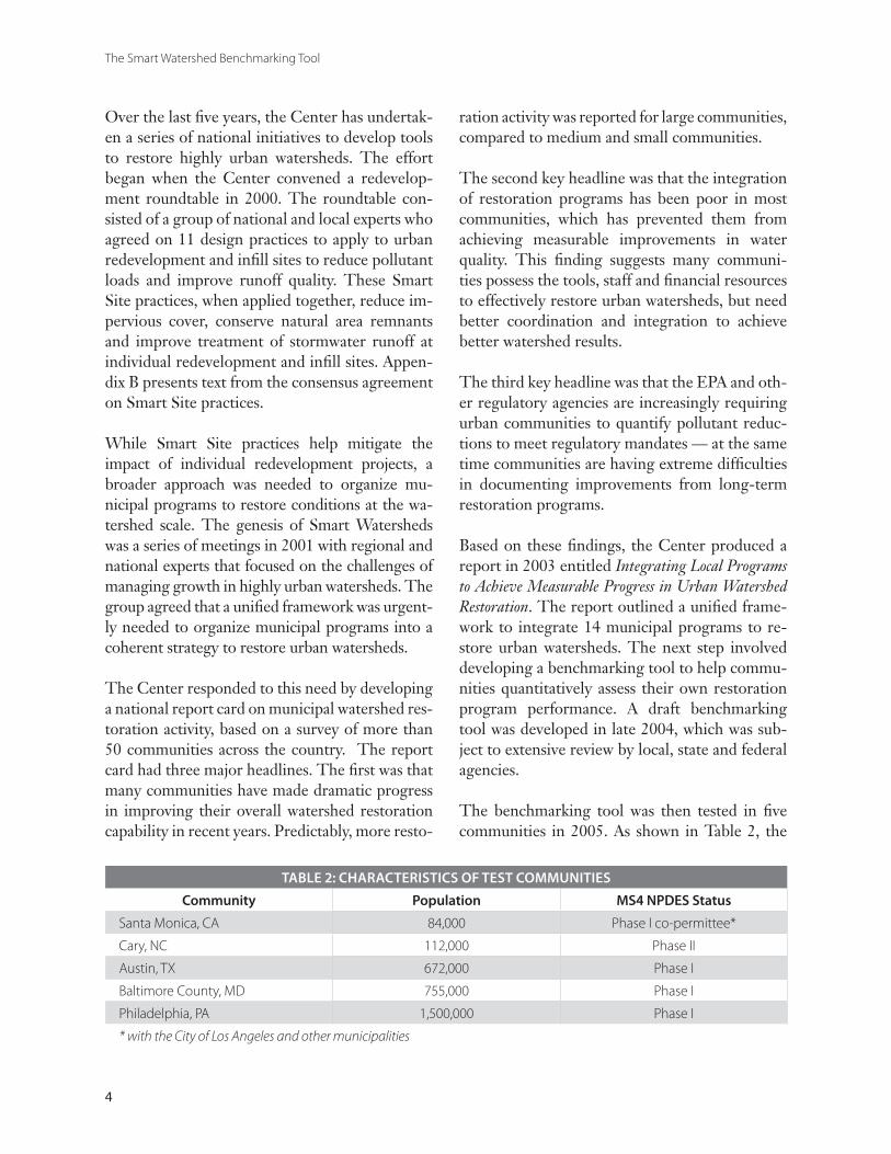
TABLE 2: CHARACTERISTICS OF TEST COMMUNITIES
Community Population MS4 NPDES Status
Santa Monica, CA 84,000 Phase I co-permittee*
Cary, NC 112,000 Phase II
Austin, TX 672,000 Phase I
Baltimore County, MD 755,000 Phase I
Philadelphia, PA 1,500,000 Phase I
* with the City of Los Angeles and other municipalities
Over the last five years, the Center has undertak-en a series of national initiatives to develop tools to restore highly urban watersheds. The effort began when the Center convened a redevelop-ment roundtable in 2000. The roundtable con-sisted of a group of national and local experts who agreed on 11 design practices to apply to urban redevelopment and infill sites to reduce pollutant loads and improve runoff quality. These Smart Site practices, when applied together, reduce im-pervious cover, conserve natural area remnants and improve treatment of stormwater runoff at individual redevelopment and infill sites. Appen-dix B presents text from the consensus agreement on Smart Site practices.
While Smart Site practices help mitigate the impact of individual redevelopment projects, a broader approach was needed to organize mu-nicipal programs to restore conditions at the wa-tershed scale. The genesis of Smart Watersheds was a series of meetings in 2001 with regional and national experts that focused on the challenges of managing growth in highly urban watersheds. The group agreed that a unified framework was urgent-ly needed to organize municipal programs into a coherent strategy to restore urban watersheds.
The Center responded to this need by developing a national report card on municipal watershed res-toration activity, based on a survey of more than 50 communities across the country. The report card had three major headlines. The first was that many communities have made dramatic progress in improving their overall watershed restoration capability in recent years. Predictably, more resto-
ration activity was reported for large communities, compared to medium and small communities.
The second key headline was that the integration of restoration programs has been poor in most communities, which has prevented them from achieving measurable improvements in water quality. This finding suggests many communi-ties possess the tools, staff and financial resources to effectively restore urban watersheds, but need better coordination and integration to achieve better watershed results.
The third key headline was that the EPA and oth-er regulatory agencies are increasingly requiring urban communities to quantify pollutant reduc-tions to meet regulatory mandates — at the same time communities are having extreme difficulties in documenting improvements from long-term restoration programs.
Based on these findings, the Center produced a report in 2003 entitled Integrating Local Programs to Achieve Measurable Progress in Urban Watershed Restoration. The report outlined a unified frame-work to integrate 14 municipal programs to re-store urban watersheds. The next step involved developing a benchmarking tool to help commu-nities quantitatively assess their own restoration program performance. A draft benchmarking tool was developed in late 2004, which was sub-ject to extensive review by local, state and federal agencies.
The benchmarking tool was then tested in five communities in 2005. As shown in Table 2, the

Chapter 1: Introduction to Smart Watersheds
5
test communities were diverse with respect to population, geographic area, and stormwater per-mit status. The test communities were also cho-sen since they had progressive watershed restora-tion and/or stormwater management programs. Center staff conducted on-site testing in coop-eration with municipal staff over several weeks in each community. The purpose of the testing was to assess the applicability of benchmark ques-tions, evaluate ways to make it easier to complete the tool, and calibrate the overall scoring for the tool.
Several major refinements were made to the benchmarking tool based on the testing phase.
For example, the tool was changed to provide:
Alternative scoring system for small communitiesAlternative scoring system for communities that lack perennial streams (e.g., ultra-urban watersheds and arid regions) More guidance on deriving Smart Watershed budget dataMore guidance on a step-by-step process to complete the benchmarking toolReduced scoring for extra credit points
Staff from the test communities indicated that it generally took about 40 hours to complete the tool and provide supporting documentation. In general, test communities found the results to be useful in assessing the strengths and weaknesses of their management programs. The test communities generally indicated that further improvement in their programs was possible, but they needed to overcome staffing, financing, coordination and technical challenges. The test communities consistently scored between the mid 70s and low 90s when extra credit points are accounted for. Several consistent areas of program weakness were reported, most notably in subwatershed-based prioritization, assessment of upland restoration potential, and management of natural area remnants.
••
•
•
•
This report releases the final benchmarking tool for general use for communities across the na-tion. It will be periodically updated in response to user comments and feedback.
1.2 The Benefits of Implementing Smart Watershed Programs
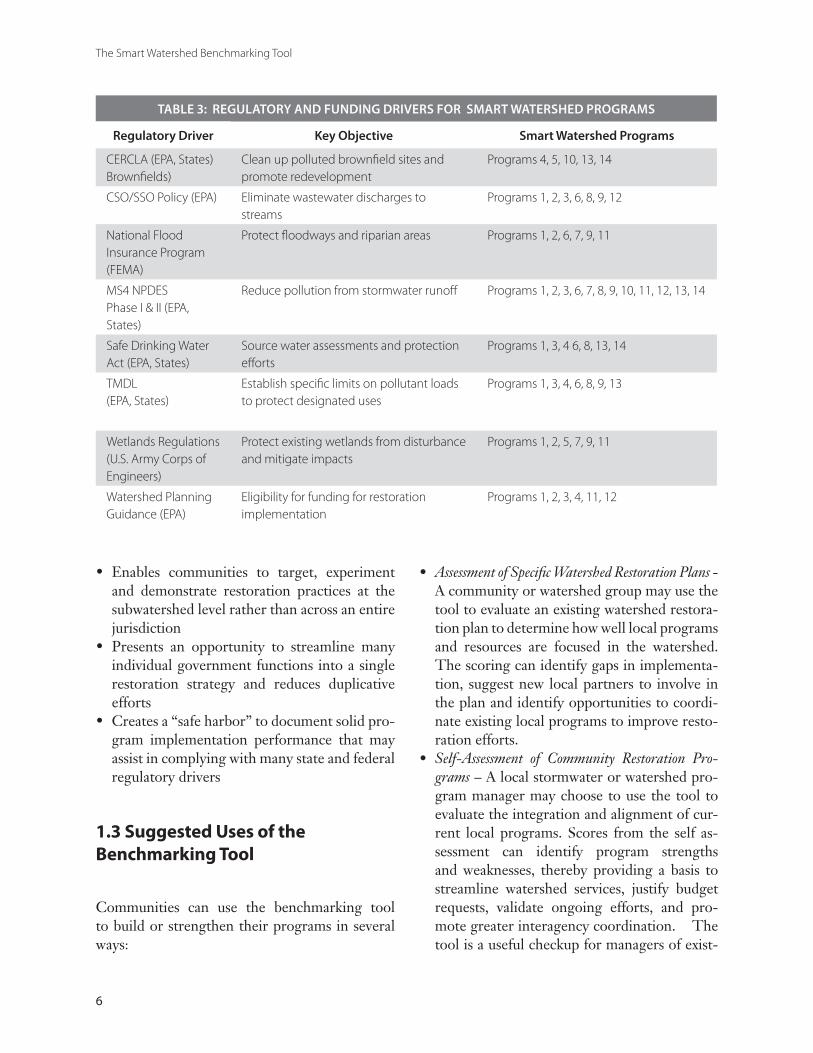
Communities may realize several benefits if they pursue a Smart Watershed approach. The prima-ry benefit is that it creates a unified framework to address many different programs, regulatory mandates and permit requirements that confront municipalities. These regulatory drivers are of-ten complex, costly and confusing to implement. Some of the major regulatory and funding driv-ers are profiled in Table 3. Most urban communi-ties are subject to many different regulatory driv-ers, and as can be seen, multiple smart watershed programs are needed to comply with them. In addition, many communities are also driven by regional watershed planning initiatives that pro-mote implementation of urban watershed resto-ration practices. The value of the Smart Water-shed approach is that it presents a single unified approach to watershed restoration that can simul-taneously address many different regulatory and funding drivers.
Some additional community benefits of the Smart Watershed approach are that it:
Directly links Smart Growth initiatives to ur-ban watershed restoration practices Provides a legitimate basis to grant flexibility and incentives for individual redevelopment and infill sites, in the form of relaxed or modi-fied stormwater requirements if overall subwa-tershed goals can be achievedMaintains or enhances water quality and habitat conditions within urban watersheds, and provides a yardstick to measure future improvements
•
•
•
The Smart Watershed Benchmarking Tool
6
TABLE 3: REGULATORY AND FUNDING DRIVERS FOR SMART WATERSHED PROGRAMS
Regulatory Driver Key Objective Smart Watershed Programs
CERCLA (EPA, States) Brownfields)
Clean up polluted brownfield sites and promote redevelopment
Programs 4, 5, 10, 13, 14
CSO/SSO Policy (EPA) Eliminate wastewater discharges to streams
Programs 1, 2, 3, 6, 8, 9, 12
National Flood Insurance Program (FEMA)
Protect floodways and riparian areas Programs 1, 2, 6, 7, 9, 11
MS4 NPDES Phase I & II (EPA, States)
Reduce pollution from stormwater runoff Programs 1, 2, 3, 6, 7, 8, 9, 10, 11, 12, 13, 14
Safe Drinking Water Act (EPA, States)
Source water assessments and protection efforts
Programs 1, 3, 4 6, 8, 13, 14
TMDL (EPA, States)
Establish specific limits on pollutant loads to protect designated uses
Programs 1, 3, 4, 6, 8, 9, 13
Wetlands Regulations (U.S. Army Corps of Engineers)
Protect existing wetlands from disturbance and mitigate impacts
Programs 1, 2, 5, 7, 9, 11
Watershed Planning Guidance (EPA)
Eligibility for funding for restoration implementation
Programs 1, 2, 3, 4, 11, 12
Enables communities to target, experiment and demonstrate restoration practices at the subwatershed level rather than across an entire jurisdictionPresents an opportunity to streamline many individual government functions into a single restoration strategy and reduces duplicative effortsCreates a “safe harbor” to document solid pro-gram implementation performance that may assist in complying with many state and federal regulatory drivers
1.3 Suggested Uses of the Benchmarking Tool
Communities can use the benchmarking tool to build or strengthen their programs in several ways:
•
•
•
Assessment of Specific Watershed Restoration Plans - A community or watershed group may use the tool to evaluate an existing watershed restora-tion plan to determine how well local programs and resources are focused in the watershed. The scoring can identify gaps in implementa-tion, suggest new local partners to involve in the plan and identify opportunities to coordi-nate existing local programs to improve resto-ration efforts.Self-Assessment of Community Restoration Pro-grams – A local stormwater or watershed pro-gram manager may choose to use the tool to evaluate the integration and alignment of cur-rent local programs. Scores from the self as-sessment can identify program strengths and weaknesses, thereby providing a basis to streamline watershed services, justify budget requests, validate ongoing efforts, and pro-mote greater interagency coordination. The tool is a useful checkup for managers of exist-
•
•
Chapter 1: Introduction to Smart Watersheds
7
ing programs, and also provides a yardstick to help managers build new programs where they do not exist. Overall Assessment of MS4 NPDES Stormwa-ter Permit Compliance - In this application, the tool is used as a streamlined way to review overall compliance with existing MS4 NP-DES stormwater permits. State or federal per-mitting agencies could use individual quanti-tative benchmarks or the overall community score to assess program implementation. The tool is currently calibrated for Phase I MS4 NPDES communities, but could easily be adapted for Phase II communities. The cur-rent NPDES stormwater permitting program lacks quantitative indicators of program per-formance, and the Smart Watershed bench-marking tool presents a comprehensive way to evaluate compliance. The tool could also provide a safe harbor, whereby communities that exceed a defined minimum score would be deemed to be in full compliance with per-mitting requirements. Certification of Excellence in Local Watershed Res-toration - Until now, there has been no mecha-nism to recognize and reward local programs that go beyond the minimum to achieve bet-
•
•
ter watershed restoration. The benchmarking tool has been designed to certify excellent pro-grams according to objective and consistent benchmarks that have been tested nationally. Ideally, an independent third party could use the tool to define:
Minimum acceptable program elementsCompliance with national norms for individual program achievement; and Overall excellence in local watershed programs.
The application is patterned after other certifi-cation tools, such as the Leadership in Environ-mental and Energy Efficient Design (LEED) certification program administered by the Green Building Council to set verifiable stan-dards for green building. The level of detail and supporting documentation in the benchmark-ing tool enables it to meet certification objec-tives, if an independent third party can review and verify the scoring. If funding support ma-terializes, the Center may take on the certifi-cation role to promote more widespread and consistent implementation of Smart Watershed programs.
o
o
o

The Smart Watershed Benchmarking Tool
8
9
Program 1 Subwatershed Restoration Planning .......................................................11Program 2 Stream and Subwatershed Field Assessment ..........................................13Program 3 Subwatershed Monitoring and Reporting ..............................................15Program 4 Financing Watershed Restoration ..........................................................17Program 5 Management of Natural Area Remnants ................................................19Program 6 Stormwater Retrofitting ..........................................................................21Program 7 Urban Stream Repair and Restoration ...................................................23Program 8 Illicit Discharge Detection and Elimination ..........................................25Program 9 Maintenance, Inspection and Enforcement ..........................................27Program 10 Smart Site Practices During Redevelopment .........................................29Program 11 Watershed Education and Personal Stewardship ...................................31Program 12 Public Involvement and Neighborhood Consultation ...........................33Program 13 Pollution Prevention at Stormwater Hotspots .......................................35Program 14 Pollution Prevention at Municipal Operations ......................................37
The chapter presents individual profile sheets that describe each of the 14 Smart Watershed programs that are organized as follows:
Description of the Program Smart Watershed Objectives FulfilledList of Specific Program Benchmarks National Average of Communities Report-ing in the Program Area (based on the 2003 survey)
••••
Local Case Study of Effective ProgramsTips on Effective Program Implementation Resources to Build or Strengthen Local Programs
Each profile sheet describes how to evaluate and strengthen the effectiveness of current programs. It is advisable to review the profile sheets to gain a better understanding of Smart Watershed before attempting to complete the benchmarking tool.
•••
CHAPTER2THE 14 SMART WATERSHED PROGRAMS

The Smart Watershed Benchmarking Tool
10
11
Chapter 2: The 14 Smart Watershed Programs
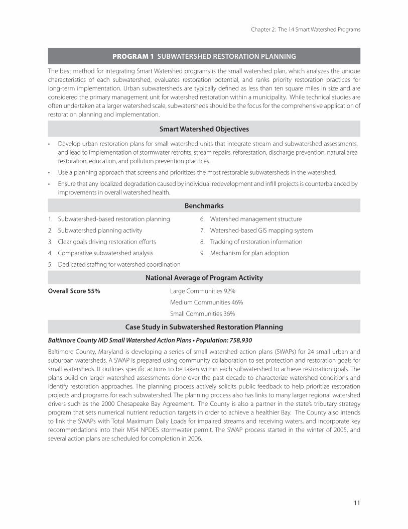
PROGRAM 1 SUBWATERSHED RESTORATION PLANNING
The best method for integrating Smart Watershed programs is the small watershed plan, which analyzes the unique characteristics of each subwatershed, evaluates restoration potential, and ranks priority restoration practices for long-term implementation. Urban subwatersheds are typically defined as less than ten square miles in size and are considered the primary management unit for watershed restoration within a municipality. While technical studies are often undertaken at a larger watershed scale, subwatersheds should be the focus for the comprehensive application of restoration planning and implementation.
Smart Watershed Objectives
Develop urban restoration plans for small watershed units that integrate stream and subwatershed assessments, and lead to implementation of stormwater retrofits, stream repairs, reforestation, discharge prevention, natural area restoration, education, and pollution prevention practices.
Use a planning approach that screens and prioritizes the most restorable subwatersheds in the watershed.
Ensure that any localized degradation caused by individual redevelopment and infill projects is counterbalanced by improvements in overall watershed health.
•
•
•
Benchmarks
1. Subwatershed-based restoration planning 6. Watershed management structure
2. Subwatershed planning activity 7. Watershed-based GIS mapping system
3. Clear goals driving restoration efforts 8. Tracking of restoration information
4. Comparative subwatershed analysis 9. Mechanism for plan adoption
5. Dedicated staffing for watershed coordination
National Average of Program Activity
Overall Score 55% Large Communities 92%
Medium Communities 46%
Small Communities 36%
Case Study in Subwatershed Restoration Planning
Baltimore County MD Small Watershed Action Plans • Population: 758,930
Baltimore County, Maryland is developing a series of small watershed action plans (SWAPs) for 24 small urban and suburban watersheds. A SWAP is prepared using community collaboration to set protection and restoration goals for small watersheds. It outlines specific actions to be taken within each subwatershed to achieve restoration goals. The plans build on larger watershed assessments done over the past decade to characterize watershed conditions and identify restoration approaches. The planning process actively solicits public feedback to help prioritize restoration projects and programs for each subwatershed. The planning process also has links to many larger regional watershed drivers such as the 2000 Chesapeake Bay Agreement. The County is also a partner in the state’s tributary strategy program that sets numerical nutrient reduction targets in order to achieve a healthier Bay. The County also intends to link the SWAPs with Total Maximum Daily Loads for impaired streams and receiving waters, and incorporate key recommendations into their MS4 NPDES stormwater permit. The SWAP process started in the winter of 2005, and several action plans are scheduled for completion in 2006.
12
The Smart Watersheds Benchmarking Tool
PROGRAM 1 SUBWATERSHED RESTORATION PLANNING
Building a Better Subwatershed Restoration Planning Program
Tips for Getting Started
Start out by conducting a Needs and Capabilities Assessment (NCA, Schueler and Kitchell, 2005). This simple checklist helps planners define key community concerns and regulatory drivers that shape watershed restoration goals. The NCA also evaluates local restoration capacity and can help the core team find out what restoration activities are being done and by whom.
Communities may want to consult the chapters on Getting Started and Scoping and Budgeting in Urban Subwatershed Restoration Manual No. 2 (Schueler and Kitchell, 2005).
The core team should provide early opportunities to allow stakeholders to give input on restoration goals and determine how they want to be involved in the planning process.
Think strategically on how local restoration programs can be linked to regional water quality management efforts and regulatory compliance.
Define the approach for managing stakeholder involvement early in the planning process that is consistent with community preferences and resources.
Be cautious about expending a lot of money on watershed modeling and monitoring unless more information is needed to characterize watershed conditions.
Promote watershed planning as a way to connect residents to their neighborhood streams and protect key aquatic resources people care about.
•
•
•
•
•
•
Tips for Fine-Tuning Existing Programs
Study program scores from the benchmarking tool to identify weak restoration program areas that could be strengthened.
Periodically revisit restoration goals to check if progress is being made in achieving them.
Recognize restoration partners through annual recognition programs and watershed forums.
Avoid watershed studies that are not focused on project implementation and evaluation.
Track implementation efforts annually and evaluate the effectiveness of restoration projects.
Commit to adopting an annual restoration workplan that translates planning outcomes into actual project implementation.
•
•
•
•
•
•
Resources for Subwatershed Restoration PlanningBowie, MD Watershed Restoration Action Strategies http://www.cityofbowie.org/green/partners/wras.htm
EPA Section 319 Success Stories – state by state project highlights from the Section 319 Program http://www.epa.gov/owow/nps/Section319/index.htm
Fairfax County, VA, Watershed Planning Project http://www.fairfaxcounty-watersheds.net/
Miami River Commission http://miamirivercommission.org/river.htm
Urban Subwatershed Restoration Manual 1: An Integrated Framework to Restore Small Urban Watersheds (Schueler, 2004)
Urban Subwatershed Restoration Manual 2: Methods to Develop Restoration Plans for Small Watersheds (Schueler and Kitchell, 2005)

13
Chapter 2: The 14 Smart Watershed Programs
PROGRAM 2 STREAM AND SUBWATERSHED FIELD ASSESSMENT
Rapid assessments of the stream corridor and upland areas are an important ingredient for successful watershed restoration. Rapid assessments provide the restoration team with critical information on current impacts and potential restoration opportunities within the entire subwatershed. Stream corridor assessments also provide opportunities to engage watershed organizations and volunteers in the subwatershed restoration process.
Smart Watershed Objectives
Conduct rapid stream corridor assessments on a subwatershed basis with the goal of covering all stream channel miles within a fixed time-period.
Utilize assessment data to identify and prioritize degraded stream reaches that merit immediate attention.
Identify any remaining high-quality streams in need of special protection.
Incorporate assessment data as a primary source of information to develop a comprehensive subwatershed restoration plan.
•
•
•
•
Benchmarks
10. Rapid stream corridor assessments 12. Field evaluations of upland restoration potential
11. Field evaluation of restoration potential in the stream corridor
National Average of Program Activity
Overall Score 49% Large Communities 69%
Medium Communities 38%
Small Communities 50%
Case Study in Stream and Subwatershed Field Assessment
Paxton Creek Stream and Subwatershed Assessments
Paxton Creek is a tributary to the Susquehanna River in the vicinity of Harrisburg, Pennsylvania. Over 63 miles of stream flow through forest, residential, commercial and industrial land uses. According to the State 303(d) list, the watershed contains 16.5 miles of streams impaired by urban runoff, construction and storm sewers. Stream and subwatershed assessments were conducted in a 7.4 square mile subwatershed of Paxton Creek using the Unified Stream Assessment (USA) and the Unified Subwatershed and Site Reconnaissance (USSR). The USA
is a comprehensive stream walk protocol that evaluates stream, riparian and floodplain conditions in the urban stream corridor (Kitchell and Schueler, 2004). The USSR is a field survey to evaluate potential subwatershed pollution sources and restoration opportunities outside of the stream corridor (Wright, et al, 2004). The core team included the Paxton Creek Watershed and Education Association, the Canaan Valley Institute, and the Center. The rapid surveys helped the team identify and prioritize hundreds of potential source control, retrofit, reforestation, stream repair and discharge prevention practices. The intensive surveys, which were performed in a week, also found other problems such as sewer overflows, trash dumping and damaged outfalls throughout the subwatershed. The field survey results created a strong technical foundation to develop a detailed and action-oriented restoration plan for the Paxton Creek subwatershed.
14
The Smart Watersheds Benchmarking Tool
PROGRAM 2 STREAM AND SUBWATERSHED FIELD ASSESSMENT
Building a Better Stream and Subwatershed Field Assessment Program
Tips for Getting Started
Use rapid assessment methods such as the Unified Stream Assessment (USA) and the Unified Subwatershed and Site Reconnaissance (USSR) to acquire information on watershed restoration opportunities in a test subwatershed.
Remember to train municipal staff and volunteers on the assessment methods before going out in the field.
Mapping and other simple desktop analysis conducted in the office can save a lot of time in the field.
Make sure to incorporate digital photos of key impacts and problems in your watershed education materials.
Combine stream corridor and upland assessments together within the same subwatershed.
Check with local colleges and state agencies to see if they have any historic maps or monitoring data to compare with current field data.
•
•
•
•
•
•
Tips for Fine-Tuning Existing Programs
Involve local enforcement staff in stream and subwatershed field work to take advantage of their knowledge of field conditions and rapid enforcement capability. Local inspectors may also know of chronic problem areas.
Carefully consider how data from field assessments will be managed and checked for quality control, and who will perform this important function.
Field assessments can generate hundreds of field forms so make sure to compile them into a well-organized database linked to the watershed-based GIS.
Consider involving trained volunteers or watershed groups in field assessments to expand manpower and create a unique education experience.
•
•
•
•
Resources for Stream and Subwatershed Field Assessment
Urban Subwatershed Restoration Manual 10: The Unified Stream Assessment (USA): A Users Manual (Kitchell and Schueler, 2004)
Urban Subwatershed Restoration Manual 11: The Unified Subwatershed and Site Reconnaissance (USSR): A Users Manual. (Wright, et al., 2004).
Urban Subwatershed Restoration Manual 2: Methods to Develop Restoration Plans for Small Watersheds (Schueler and Kitchell, 2005)
15
Chapter 2: The 14 Smart Watershed Programs
15
PROGRAM 3 SUBWATERSHED MONITORING AND REPORTING
Subwatershed monitoring is important to determine major water quality, habitat and biological impacts, and to track progress made over time in improving stream conditions. Monitoring data is used to support many key decisions throughout the restoration planning process, and must be organized and clearly communicated to the appropriate audience.
Smart Watershed Objectives
Develop a comprehensive approach to monitoring that can help the team understand subwatershed baseline conditions, track restoration progress and prioritize water quality problems.
Benchmarks
13. Subwatershed monitoring program 15. Public notification of water quality problems
14. Aquatic indicators linked to watershed goals 16. Data management and reporting
National Average of Program Activity
Overall Score 57% Large Communities 92%
Medium Communities 46%
Small Communities 43%
Case Study in Subwatershed Monitoring and Reporting
Austin, Texas Environmental Integrity Index
The City of Austin monitors their local creeks to track trends in ecological integrity and water quality impairment. The Watershed Protection Department developed an Environmental Integrity Index (EII) to track long-term trends in aquatic indicators. The index consists of six groups of water quality indicators that relate to the designated water uses of Austin creeks. The six designated uses include: contact recreation (swimming and wading), non-contact recreation, water quality, sediment quality, stability of stream channels, and aquatic life support. A subwatershed integrity index score is then calculated after a range of chemical, physical, and biological aquatic indicators are measured. The city felt that the index was needed because prior studies had shown that water quality data alone did not adequately describe the health of water resources. The index is used to rank the severity of problems based on the difference between a stream’s water quality goal and its current measured condition. In order to track long-term trends, the city also maintains sentinel monitoring stations in Barton and Edwards Springs, and conducts runoff sampling for 18 stormwater pollutants in East Austin’s Town Creek. Findings from the monitoring program are quickly posted on the city website: (http://www.ci.austin.tx.us/watershed/learn_ws.htm). The website also provides maps of watersheds and monitoring sites, land use information, index scores, photographs, and other watershed facts. Press releases regarding spills are posted on another website (http://www.ci.austin.tx.us/water/). The city devotes more than a million dollars annually to support the subwatershed monitoring program. For example, 20 creek and lake monitoring stations were sampled in 2004, along with 12 intensive water quality studies.
1616
The Smart Watershed Benchmarking Tool
PROGRAM 3 SUBWATERSHED MONITORING AND REPORTING
Building a Better Stream and Subwatershed Monitoring and Reporting Program
Tips for Building a Program
Build your monitoring program around existing or historic monitoring stations to maximize coverage.
Select a few good water quality indicators that are easy to measure. Guidance on choosing reliable but inexpensive indicators can be found in Urban Subwatershed Restoration Manual No. 2 (Schueler and Kitchell, 2005).
Look for opportunities to involve citizens and watershed groups in subwatershed monitoring efforts to enhance public involvement and education.
Link your subwatershed monitoring efforts to the local NPDES MS4 stormwater permit to help comply with minimum management measures for citizen involvement and stormwater education.
Invite sediment control inspectors and other local staff on a stream monitoring trip to expose them to the aquatic resources they work to protect daily.
•
•
•
•
•
Tips for Fine-Tuning Existing Programs
Check the existing aquatic indicators that are monitored to make sure they are directly linked to watershed goals and can be used to measure progress toward them.
Investigate ways to disseminate condensed summaries of monitoring data to stakeholders and the general public.
Consider expanding the monitoring program to measure the long-term effectiveness of installed restoration projects to identify factors that lead to future project success or failure.
Train local watershed groups and volunteers on monitoring protocols to expand municipal data gathering capabilities.
Consider out-sourcing monitoring work to watershed groups to help them become more sustainable.
•
•
•
•
•
Resources for Subwatershed Monitoring and Reporting
Montgomery County, MD County-wide Stream Protection Strategy http://www.montgomerycountymd.gov/deptmpl.asp?url=/content/dep/csps/index.asp
Burlington Vermont Beach monitoring http://www.uvm.edu/%7Eempact/water/data.php3
Urban Subwatershed Restoration Manual 2: Methods to Develop Restoration Plans for Small Watersheds (Schueler and Kitchell, 2005)
Stormwater Effects Handbook: A Toolbox for Watershed Managers, Scientists and Engineers (Burton and Pitt, 2001)
17
Chapter 2: The 14 Smart Watershed Programs
17
PROGRAM 4 FINANCING WATERSHED RESTORATION
Smart Watershed programs require significant financial resources from a diverse array of local, state, federal and private sources. Communities need to evaluate how they currently finance overall watershed restoration efforts, and look for alternative revenue streams to ensure that future programs are adequately funded.
Smart Watershed Objectives
Utilize a diverse blend of funding to support watershed restoration, including capital and operating budgets, stormwater utilities, stormwater fee-in-lieu projects, state and federal grants and revolving loans, and watershed partnership projects.
Ensure that staff and resources are adequate to meet overall Smart Watershed program implementation goals.
•
•
Benchmarks
17. Total watershed program expenditures 19. Local funding for Smart Watershed programs
18. Long-term funding for plan implementation
National Average of Program Activity
Overall Score 63% Large Communities 85%
Medium Communities 58%
Small Communities 50%
Case Study in Financing Watershed Restoration
Montgomery County, MD Watershed Management Program Budget
Montgomery County’s watershed management budget provides an example of how to leverage multiple funding sources and educate local elected officials to garner greater program support. The mission outlined in the budget is to protect citizens and improve the quality of the environment by monitoring and restoring county streams and waterways. Specific line-items in the budget include watershed restoration planning, restoration project design and construction, and ongoing stream monitoring. Funds also support urban forestry, illicit discharge control, public outreach, citizen stewardship, and maintenance of stormwater practices. The capital budget for stormwater retrofit and stream restoration projects is leveraged to match state and federal grant funds. The main revenue that supports the local budget is a stormwater utility fee attached to residential property taxes. The annual budget is unique in that it contains specific performance measures related to many Smart Watershed program areas that are reported to the elected officials in a condensed graphic format. Examples of performance measures include the following:
Percent of subwatersheds monitored in fiscal year with an improved (or declining) rating
Miles of priority streams needing restoration
Miles of restored stream showing improved stream condition
Acres of stormwater practices added to developed areas
Developed acres subject to uncontrolled runoff
Percent of watersheds meeting urban/suburban tree canopy cover goals
Number of environmental complaints received
Percent of watersheds with monitoring data accessible via the internet
The County estimates that full stream restoration within priority subwatersheds will require about 19 years at current funding and implementation rates. The most recent budget document can be viewed at http://www.montgomerycountymd.gov/content/omb/fy05/psprec/65-1.pdf
•
•
•
•
•
•
•
•

1818
The Smart Watershed Benchmarking Tool
PROGRAM 4 FINANCING WATERSHED RESTORATION
Building a Better Watershed Restoration Financing Program
Tips for Building a Program
Take time to project total financial resources needed to support effective restoration programs.
Make sure to link restoration expenditures to measurable environmental outputs and benefits. Federal and state agencies, elected officials and the general public increasingly want to know the tangible benefits they will get from the restoration dollars they invest.
Develop local partnerships to leverage funding in the form of cash or in-kind services.
Become familiar with the different types of match that can be leveraged to attract state and federal funding grants and/or revolving funds.
Understand the timing of the local budget cycle and learn exactly where and when each Smart Watershed program fits into the process.
Create line items for both operating and capital budgets.
Assign a project code for capital projects in each individual watershed to track progress toward implementation.
Identify several early action projects that can demonstrate project or program success.
•
•
•
•
•
•
•
•
Tips for Fine-Tuning Existing Programs
Focus on developing local revenue streams such as a stormwater utility that can be a stable and reliable funding source.
Train municipal staff in grant-writing and management skills - many funders, colleges and professional organizations offer free or low-cost training.
Seed the development of a local nonprofit watershed organization that can function as a strong partner and obtain funding on their own to augment municipal efforts.
Develop specific performance measures to track the impact of local restoration spending that can help educate elected officials about restoration during the annual budget process.
Remember the golden rule – each dollar of local revenue can be leveraged into ten dollars of bonds to finance capital projects.
•
•
•
•
•
Resources for Financing Watershed Restoration
http://www.stormwatercenter.net/ (Under Program Resources)
Environmental Finance Center web sites:
Great Lakes http://urban.csuohio.edu/glefc/index.htm
New England http://efc.muskie.usm.maine.edu/
New Mexico http://efc.unm.edu/
New York Region 2 http://www.maxwell.syr.edu/efc/
Southeast Regional http://cepm.louisville.edu/organization/SEEFC/seefc.htm
Maryland http://www.efc.umd.edu/
U.S. EPA Environmental Finance Center http://www.epa.gov/efinpage/
U.S. EPA Office of Water Funding/Grants http://www.epa.gov/water/funding.html
Plan2Fund: Watershed Planning and Budgeting Tool http://sspa.boisestate.edu/efc/Tools_Services/Plan2Fund/plan2fund.htm
19
Chapter 2: The 14 Smart Watershed Programs
19
PROGRAM 5 MANAGEMENT OF NATURAL AREA REMNANTS
Remaining natural areas in an urban subwatershed are important pockets that provide habitat, green space and some stormwater treatment. At the same time, they are often fragmented, compacted, and stressed by stormwater runoff, poor soils, invasive plant species, and human disturbance. Municipalities often own or manage natural areas and many of these parcels are prime candidates for reforestation, wetland restoration and land reclamation. This program seeks to expand watershed benefits by systematically restoring and increasing natural areas at the subwatershed level. This program may also involve working with the community to convert vacant land to beneficial uses, such as community gardens.
Smart Watershed Objectives
Comprehensively manage the remaining natural areas in a subwatershed, including urban forests, wetlands, stream corridors, open space and vacant lands.
Directly link urban forestry to subwatershed restoration plans, with the goal of increasing healthy forest cover or canopy.
Focus on creating urban forests on municipal lands such as public rights of way, vacant lands, parks, schools, riparian areas, transportation corridors and other areas of the urban landscape.
Actively manage and restore priority natural area remnant areas.
•
•
•
•
Benchmarks
20. Inventory of natural area remnants 22. Dedicated funding for natural area restoration/reforestation
21. Natural area planning and management 23. Subwatershed restoration/reforestation activity
National Average of Program Activity
Overall Score 56% Large Communities 77%
Medium Communities 49%
Small Communities 43%
Case Study in Management of Natural Area Remnants
Portland, Oregon Watershed Revegetation Program • Population: 538,180 • Budget $1,100,000
The City of Portland, Oregon is working to restore native vegetation through their Watershed Revegetation Program. The program is a voluntary partnership between the city and private landowners to restore degraded habitats through upland and riparian plantings, streambank repair, and wetland construction. Landowners pay 50 to 100% of project costs while the city provides native plants, contract labor, materials, and technical assistance. The restoration projects are designed to improve water quality, control erosion and reduce stormwater pollution –with the ultimate goal of recovering salmon populations. The program is funded by grants, the state revolving loan fund, sewer system charges and landowner cost share. Since 1996, 1,867 acres of native vegetation have been planted and an additional 2,217 acres are actively managed to control invasive plants. The program seeks to begin re-vegetation on 100 new acres each year which adds to the total management portfolio. Projects typically take 5 to 10 years to complete — from initial design, installation, invasive weed control, maintenance and site monitoring. Program details can be viewed at http://www.portlandonline.com/bes/index.cfm?c=dffci

2020
The Smart Watershed Benchmarking Tool
PROGRAM 5 MANAGEMENT OF NATURAL AREA REMNANTS
Building Better Management of Natural Area Remnants
Tips for Getting Started
Consolidate management efforts by multiple agencies and landowners into a single watershed plan to protect or restore all remaining natural area remnants.
•
Utilize property maps or a watershed GIS to find out who owns or manages natural area remnants, including large institutional and commercial sites.
Look at maps and aerial photos to explore opportunities to link fragmented natural areas in a subwatershed by creating hubs and corridors.
Target municipal lands for innovative demonstration projects involving native landscaping and reforestation.
Provide public access and interpretative signs to natural area remnants, when feasible.
Work up-front with public safety officials to develop design approaches that address concerns about vandalism, vagrancy, and community policing issues.
Think about cost sharing long-term management of natural areas to encourage greater participation by private landowners.
•
•
•
•
•
•
Tips for Fine-Tuning Existing Programs
Keep existing inventories of forest, wetland and natural cover up to date, as they tend to change rapidly in urban watersheds.
Establish numerical targets to guide the management of natural area remnants, such as:
Acres of public open space by type
Acres and ownership of vacant lands
Percent of open space that is permeable
❍
❍
❍
Percent forest canopy coverage by subwatershed
Tree planting targets by subwatershed
Percent of turf or open space that can be reforested or re-vegetated with regionally appropriate plants
❍
❍
❍
Establish partnerships with businesses and large institutional land owners to manage their natural area remnants. A good example is the Wildlife Habitat Certification program. This program, managed by the Wildlife Habitat Council, recognizes commendable habitat management and environmental education programs at individual sites. Certification by an independent third-party ensures an objective evaluation of habitat restoration projects.
•
•
•
Resources for Management of Natural Area RemnantsDenver Urban Gardens http://dug.org/gardens.html
Wildlife Habitat Council http://www.wildlifehc.org/registry_certifiedsites/index.cfm
Revitalizing Baltimore – Parks and People Foundation http://www.parksandpeople.org/programs.html
Philadelphia Green Program http://www.pennsylvaniahorticulturalsociety.org/phlgreen/
Forever Wild: Nature in New York City http://nycgovparks.org/sub_about/parks_divisions/nrg/forever_wild/foreverwild_home.html
Center for Urban Restoration Ecology http://www.i-cure.org/
Seattle P-Patch Community Gardens http://www.seattle.gov/neighborhoods/ppatch/
Urban Watershed Forestry Manual Part 1: Methods for Increasing Forest Cover in a Watershed (Cappiella et al., 2005a). http://www.cwp.org
Urban Watershed Forestry Manual Part 2: Conserving and Planting Trees at Development Sites. (Cappiella et al 2005b) http://www.cwp.org
Urban Watershed Forestry Manual Part 3: Urban Tree Planting Guide. (Cappiella et al 2006) http://www.cwp.org
21
Chapter 2: The 14 Smart Watershed Programs
21
PROGRAM 6 STORMWATER RETROFITTING
Retrofits are installed in urban watersheds to treat and manage runoff from areas that were developed prior to any stormwater management requirements, or with older technologies that can be improved upon to achieve better treatment. Ponds, wetlands and bioretention are re-engineered back into the urban landscape to help remove pollutants and protect stream channels, and are often located on public lands.
Smart Watershed Objectives
Systematically evaluate the potential for stormwater retrofit opportunities within all subwatersheds.
Utilize the inventory data to screen, design and construct priority stormwater retrofit projects to meet subwatershed goals.
•
•
Benchmarks
24. Subwatershed retrofit inventory 26. Demonstration of innovative technology
25. Level of stormwater retrofit implementation
National Average of Program Activity
Overall Score 53% Large Communities 69%
Medium Communities 42%
Small Communities 57%
Case Study in Stormwater Retrofitting
Seattle Natural Drainage System Program • Population 572,600 • Budget: $4,000,000
The City of Seattle has implemented a retrofit program that utilizes alternatives to traditional street drainage design to help address impacts from urban runoff. The program works to redesign residential street right-of-ways to incorporate vegetated swales, stormwater cascades, and small wetland ponds to mimic predevelopment hydrology. The objective of street retrofits is to infiltrate stormwater, decrease impervious cover, filter pollutants, promote porous paving, increase vegetation, and improve pedestrian amenities. The watershed goals are to maintain natural stream hydrology, reduce habitat degradation, provide channel protection, and reduce pollutant loads to local creeks. The program is funded by a drainage fee paid by Seattle property owners based on impervious surface coverage. In order to fund a project, the city must show that street retrofits are more cost-effective than traditional street design with curb and gutter. Project
sites are selected based on a set of criteria including proximity to creeks needing restoration, the slope, length, and existing infrastructure of the street and community interest. A staff of seven in the stormwater planning group initially assesses the feasibility of potential street retrofit projects, with actual implementation handled by many different agencies. The city has many street retrofit projects in the pipeline, with a typical project timeline of about three years from design to completion. The city estimates that capital costs and life-cycle maintenance costs for street retrofits are less expensive than traditional drainage systems. Street retrofits are engineered to treat runoff for storms up to the two-year design storm that make up the majority of rainfall events in Seattle. Monitoring has confirmed that street retrofits improve both the quality and quantity of stormwater runoff, which has prompted the city to utilize street retrofits as its primary stormwater management approach in all areas that drain directly to creeks. Designers are currently working on expanding street retrofits in four parts of the city, including an ultra-urban redevelopment area. http://www.seattle.gov/util/About_SPU/Drainage_&_Sewer_System/Natural_Drainage_Systems/Natural_Drainage_Overview/index.asp

2222
The Smart Watershed Benchmarking Tool
PROGRAM 6 STORMWATER RETROFITTING
Building a Better Stormwater Retrofitting Program
Tips for Getting Started
Systematically focus retrofitting efforts in a few priority subwatersheds to maximize the degree of stormwater treatment.
Precisely define the stormwater treatment objectives that retrofits will accomplish in restoring a particular subwatershed (e.g., pollutant removal, channel protection, recharge, etc.).
Combine retrofits with stream repairs and other restoration practices to maximize stream benefits.
Start with an accurate base-map of existing stormwater management practices to identify older structures with good retrofit potential (e.g., older dry ponds that may have chronic maintenance problems).
Train staff in rapid field methods such as the Retrofit Reconnaissance Inventory to quickly identify potential retrofit locations in a single subwatershed.
Demonstrate diversity of innovative retrofit projects on municipal parks and schools, particularly if retrofits are new to the community.
Public works maintenance yards are excellent retrofit locations that can address multiple NPDES MS4 stormwater permit requirements.
Consult with local planning staff to verify that vacant parcels don’t have development plans in the pipeline that will render them infeasible.
•
•
•
•
•
•
•
•
Tips for Fine-Tuning Existing Programs
Devote more effort to landscaping and community amenities during the design phase to improve public acceptance of stormwater retrofits.
Re-examine old retrofit inventories in light of new approaches and technologies. Retrofit sites that were discarded in the past may be suitable for new or emerging stormwater practices.
Consider combining stormwater maintenance and retrofit programs into a single program to maximize efficiency.
Local willingness to assume maintenance for older practices makes retrofitting much more attractive to private landowners.
Be creative in working around existing utilities; in some cases, existing sewer lines and other utilities can be worked around or relocated.
•
•
•
•
•
Resources for Stormwater Retrofitting
Anacostia Watershed Network (Restoration and Retrofitting) http://www.anacostia.net/progress.htm
“The Art of Opportunity” Slideshow at Stormwater Manager’s Resource Center web site http://www.stormwatercenter.net/Slideshows/retrofits.htm
“Article 143: Stormwater Retrofits: Tools for Watershed Enhancement,” Practice of Watershed Protection (Schueler and Holland, 2000)
Proceedings from National Conference on Retrofit Opportunities for Water Resource Protection in Urban Environments by the U.S. EPA Office of Research and Development http://www.epa.gov/ORD/NRMRL/pubs/625r99002/625r99002.htm
“Stormwater Retrofitting primer” at the Wisconsin Department of Natural Resources web site http://www.dnr.state.wi.us/permitprimer/stormwater/retro.html
23
Chapter 2: The 14 Smart Watershed Programs
23
PROGRAM 7 URBAN STREAM REPAIR AND RESTORATION
Stream repair practices enhance the appearance, structure and function of the urban stream network to address a series of subwatershed restoration objectives. Stream repair includes activities undertaken to address damage to stream channels stemming from uncontrolled runoff and other stream channel alterations caused by past development. Communities may choose more than one stream repair objective to guide their subwatershed restoration efforts as long as they are realistic and achievable. In most cases, the ability to achieve stream repair objectives is fundamentally constrained by subwatershed impervious cover and limited stormwater retrofit potential.
Smart Watershed Objectives
Comprehensively analyze stream conditions to identify the best stream repair practices to address restoration objectives within a given subwatershed.
Utilize the data to screen, design and construct innovative stream repair projects to meet subwatershed goals.
•
•
Benchmarks
27. Systematic subwatershed approach 29. Sophistication of stream repair practices
28. Level of stream repair implementation 30. Post-construction project evaluation/monitoring
National Average of Program Activity
Overall Score 51% Large Communities 77%
Medium Communities 42%
Small Communities 43%
Case Study in Urban Stream Repair and Restoration
King County Small Habitat Restoration Program • Population: 1,761,411 • Budget: $426,000
King County (Washington State) developed a Small Habitat Restoration Program to build low-cost projects to restore streams and wetlands in urban and rural watersheds. Projects are selected based on the restoration benefits provided and the cost-effectiveness of installation. Typical projects include streamside and wetland planting, livestock fencing, in-stream habitat improvements, removal of fish barriers and control of invasive plants. The program also provides technical assistance to property owners and other agencies interested in pursuing their own habitat restoration projects. The annual budget for the habitat program is less than a half million dollars and covers 2,134 square miles of unincorporated King County. The program is funded by a county surface water management fee, which is a property tax formula based on the areas of impervious cover. Administration accounts for about 10% of the program budget, and the project cost ratio is 60:40 for labor and construction. As of 2005, 71 habitat restoration projects were in some phase of scoping, design, permitting, construction or management. Individual projects take three to five years to complete, depending on the complexity of permitting and post-installation monitoring. Funds are also allocated for technical assistance which covers up to two days of assistance from program staff for private property owners. The staff generally advises on ways to address property management issues such as streambank erosion, invasive plant control, and wetland restoration. http://dnr.metrokc.gov/wlr/cposa/shrp/index.htm
2424
The Smart Watershed Benchmarking Tool
PROGRAM 7 URBAN STREAM REPAIR AND RESTORATION
Building a Better Urban Stream Repair and Restoration Program
Tips for Getting Started
Streamwalks are an excellent means to gain momentum for stream restoration and educate residents on the relationship between stream conditions and aquatic life.
Choose realistic and achievable restoration objectives for each urban stream segment, given that each segment is influenced differently by upstream and downstream factors. For a good systematic approach for assessing subwatershed stream repair potential, consult Urban Subwatershed Restoration Manual No. 4.
Although most communities have traditionally engaged in stream repair to protect threatened infrastructure and property, consider expanding objectives to include fishery habitat and channel stability.
Develop a process for evaluating and ranking local stream repair projects based on watershed benefits – otherwise projects will be prioritized to respond to the loudest complaints – not necessarily the most important problems.
•
•
•
•
Tips for Fine-Tuning Existing Programs
Invite local volunteer groups to assist in post-construction monitoring of restoration projects, and to keep sites free of invasive plants.
Stream repair projects should be treated like any other infrastructure investment – they require inspection and maintenance over time to remain viable.
Package stream repair projects in the context of subwatershed plans to be eligible for additional state and federal assistance.
•
•
•
Resources for Urban Stream Repair and RestorationMontgomery County, MD - Sligo Creek Watershed Restoration http://www.montgomerycountymd.gov/deptmpl.asp?url=/content/dep/csps/watersheds/csps/html/sligo.asp
Montgomery County Anacostia Restoration Program http://www.montgomerycountymd.gov/content/dep/Publications/pdf/anacostia_restoration.pdf
Griffin, GA - Streambank Restoration Program http://www.forester.net/sw_0107_griffin.html (as covered in Stormwater Magazine)
Berkeley, CA - Cordornices Creek Stream Daylighting http://www.coastalconservancy.ca.gov/sccbb/0503bb/0503Board08_Cordornices_Creek.pdf
Seattle Urban Creeks Legacy Project http://www.ci.seattle.wa.us/util/About_SPU/Drainage_&_Sewer_System/Projects/Creek_Restoration/index.asp
Urban Subwatershed Restoration Manual 4: Urban Stream Repair Practices (Schueler and Brown, 2004)
Urban Subwatershed Restoration Manual 10: The Unified Stream Assessment (USA): A Users Manual. (Kitchell and Schueler, 2004)
Stream Corridor Restoration: Principles, Processes, and Practices. Federal Interagency Stream Restoration Working Group at http://www.nrcs.usda.gov/technical/stream_restoration/

25
Chapter 2: The 14 Smart Watershed Programs
25
PROGRAM 8 ILLICIT DISCHARGE DETECTION AND ELIMINATION
The storm and sanitary sewer networks in many older watersheds can be a major source of pollutants through combined sewer overflows, sanitary sewer overflows, and illicit pollutant discharges. This Smart Watershed program concerns itself with targeted efforts to find, fix and eliminate discharges of sewage and other pollutants in portions of the watershed with the most severe problems.
Smart Watershed Objectives
Implement an ongoing program to detect and eliminate any discharges of untreated wastewater and non-stormwater flows into the watershed, including sanitary sewer overflows (SSOs), combined sewer overflows, and illicit discharges.
•
Benchmarks
31. Possess discharge control authority 34. Pollution hotline and response
32. Discharge mapping and screening 35. Activity in eliminating discharges
33. Outfall reconnaissance inventory
National Average of Program Activity
Overall Score 63% Large Communities 62%
Medium Communities 58%
Small Communities 71%
Case Study in Illicit Discharge Detection and Elimination
Fort Worth, Texas Dry Weather Monitoring • Population: 534,694
Fort Worth has been recognized nationally for its efforts to detect and eliminate illicit discharges to its municipal storm drain system. More than 150 dry weather field screens are performed across the city each year to help detect potential illicit discharges or improper connections using various tests. One innovative test uses luminescent bacteria as an indicator of potential toxicity at larger stormwater outfalls. The city actively performs detective work to locate and eliminate the sources of dry weather flows, and sponsors programs to prevent illicit discharges from occurring in the first place. Examples include pollutant fingerprinting, pollutant trace-backs, industrial inspections and public education. For example, the city installs more than 250 storm drain markers each year, with the location selected based on traffic volume, past dumping history, illicit discharge reports and citizen complaints. City staff routinely inspects industrial facilities considered to have a high illicit discharge potential, such as hazardous waste treatment, disposal or recovery facilities. The city also operates a permit program for mobile commercial power-washing vendors designed to limit detergents and other pollutants discharged into the storm drain system. Fort Worth also maintains a telephone hotline for reporting environmental complaints, such as illegal dumping and illicit discharges. Residents can also use an on-line complaint form to report spills or intentional violations. The city maintains a spill response team to handle spills less than 500 gallons. The team is on-call 24 hours a day, 7 days a week ready to contain and clean up chemical spills from car, truck, and train wrecks, industrial accidents, and other discharges that could impact the storm drain system. http://www.fortworthgov.org/DEM/aboutWQ.htm
2626
The Smart Watershed Benchmarking Tool
PROGRAM 8 ILLICIT DISCHARGE DETECTION AND ELIMINATION
Building a Better Illicit Discharge Detection and Elimination Program
Tips for Getting Started
Most communities initially have a poor understanding of the scope and nature of their illicit discharge problem. Therefore, an adaptive approach to manage illicit discharges as outlined in Brown et al (2004) may be warranted.
Once more is known about the extent of local illicit discharge problems, a community can shift resources to the most cost-effective screening, prevention and enforcement tools to solve the problem.
The extent of local illicit discharge problems is best understood by performing rapid field assessments, reviewing past complaint files, and interviewing key inspection and utility maintenance staff.
Continuous education is important since preventing pollution at its source is the most cost-effective method to control illicit discharges. Consider including illicit discharges as part of the overall stormwater education program in the community.
Combine stormwater outfall screening with other rapid stream corridor assessments so streams only need be surveyed once -- and consider out-sourcing both functions to a local watershed group.
•
•
•
•
•
Tips for Fine-Tuning Existing Programs
Look for patterns in outfall screening data to identify problem subwatersheds where limited resources can be effectively targeted.
Many communities find citizen hotlines are a very cost-effective tool to detect transitory illicit discharge events.
Work cooperatively with permit writers to ensure that IDDE program requirements are customized to deal with actual illicit discharge problems found in the community.
Up-front desktop and field screening can characterize the severity of illicit discharge problems in different subwatersheds so that the most severe problems are addressed in each MS4 NPDES permit cycle.
Mobile sources of illicit discharges such as industrial cleaning companies, septic pumpers, and recreational vehicles are often overlooked in many communities. Work with each sector to develop effective educational programs.
•
•
•
•
•
Resources for IDDE Programs
Cary, NC – Stormwater Inventory http://www.townofcary.org/depts/dsdept/engineering/engproj/stormwaterinventoryoverview.htm
Rouge River, MI – Illicit Discharge Detection and Elimination http://www.rougeriver.com/proddata/catalog.cfm?category=illicit
Washington, D.C. - Combined Sewer Overflow Abatement in Anacostia and Potomac Rivers, and Rock Creek http://www.dcwasa.com/education/css/combined_sewer.cfm
Greenwood, SC - Sanitary Sewer Overflow Control http://www.epa.gov/npdes/sso/greenwood/index.htm
Illicit Discharge Detection and Elimination: A guidance manual for program development and technical assessments. (Brown et al., 2004) http://www.cwp.org
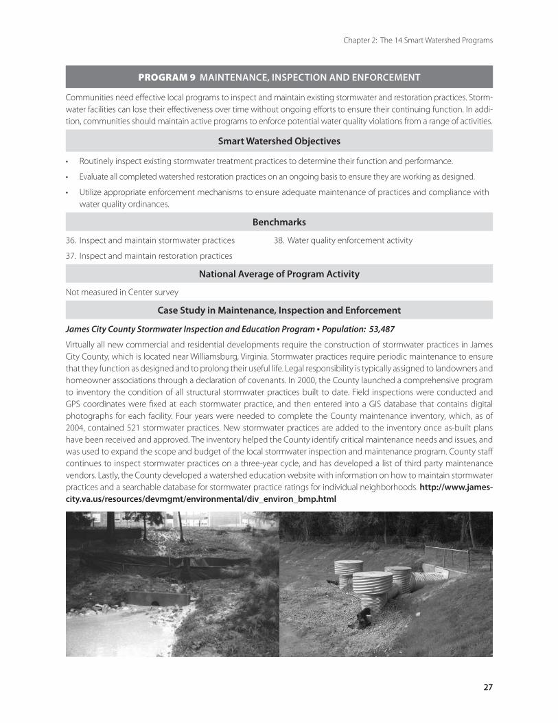
27
Chapter 2: The 14 Smart Watershed Programs
27
PROGRAM 9 MAINTENANCE, INSPECTION AND ENFORCEMENT
Communities need effective local programs to inspect and maintain existing stormwater and restoration practices. Storm-water facilities can lose their effectiveness over time without ongoing efforts to ensure their continuing function. In addi-tion, communities should maintain active programs to enforce potential water quality violations from a range of activities.
Smart Watershed Objectives
Routinely inspect existing stormwater treatment practices to determine their function and performance.
Evaluate all completed watershed restoration practices on an ongoing basis to ensure they are working as designed.
Utilize appropriate enforcement mechanisms to ensure adequate maintenance of practices and compliance with water quality ordinances.
•
•
•
Benchmarks
36. Inspect and maintain stormwater practices 38. Water quality enforcement activity
37. Inspect and maintain restoration practices
National Average of Program Activity
Not measured in Center survey
Case Study in Maintenance, Inspection and Enforcement
James City County Stormwater Inspection and Education Program • Population: 53,487
Virtually all new commercial and residential developments require the construction of stormwater practices in James City County, which is located near Williamsburg, Virginia. Stormwater practices require periodic maintenance to ensure that they function as designed and to prolong their useful life. Legal responsibility is typically assigned to landowners and homeowner associations through a declaration of covenants. In 2000, the County launched a comprehensive program to inventory the condition of all structural stormwater practices built to date. Field inspections were conducted and GPS coordinates were fixed at each stormwater practice, and then entered into a GIS database that contains digital photographs for each facility. Four years were needed to complete the County maintenance inventory, which, as of 2004, contained 521 stormwater practices. New stormwater practices are added to the inventory once as-built plans have been received and approved. The inventory helped the County identify critical maintenance needs and issues, and was used to expand the scope and budget of the local stormwater inspection and maintenance program. County staff continues to inspect stormwater practices on a three-year cycle, and has developed a list of third party maintenance vendors. Lastly, the County developed a watershed education website with information on how to maintain stormwater practices and a searchable database for stormwater practice ratings for individual neighborhoods. http://www.james-city.va.us/resources/devmgmt/environmental/div_environ_bmp.html
2828
The Smart Watershed Benchmarking Tool
PROGRAM 9 MAINTENANCE, INSPECTION AND ENFORCEMENT
Building a Better Maintenance, Inspection and Enforcement Program
Tips for Getting Started
Work with permit writers to ensure that performance standards for maintenance, inspection and enforcement activity are explicitly included as MS4 NPDES stormwater permit conditions.
Create a data management system to track the condition and maintenance status of stormwater and restoration infrastructure. Routine maintenance, inspection and enforcement data should be stored on a GIS so information can be quickly accessed.
Use new technology such as GPS, digital cameras and mobile data loggers to rapidly upload field inspection data into the tracking system.
Review local codes to ensure that they clearly define the authority and responsibilities for all maintenance, inspection and enforcement activities.
Create an emergency contact list and distribute to inspectors and field crews so they can quickly report water quality problems, erosion control violations and emergency stormwater maintenance needs.
Maintain a vendor list of qualified contractors that can handle emergency clean-ups and perform stormwater maintenance tasks.
•
•
•
•
•
•
Tips for Fine-Tuning Existing Programs
Review homeowner association covenants with the local attorney office to ensure they contain adequate language on stormwater maintenance responsibilities, including right of access, charge-backs for emergency repairs and penalties for non-compliance.
Cross-train field personnel to recognize signs of pollution problems and to know who to report them to.
Develop an emergency response handbook for all responders that contains practical tips on how to respond to different types of pollution events.
Consider launching an Adopt-a Pond program to educate homeowner associations about common maintenance needs for stormwater practices.
•
•
•
•
Resources for Maintaining, Inspecting and Enforcing Watershed PracticesBellevue, WA Private Drainage Inspection Program http://www.cityofbellevue.org/page.asp?view=1318
Stormwater Pond and Wetland Maintenance Tool (Brown and Hoyt, 2004) at http://www.stormwatercenter.net
Maui County Erosion and Sediment Control Program http://www.epa.gov/owow/nps/Section319III/innov_hi.htm
Montgomery County, MD Stormwater Facility Maintenance Program http://www.montgomerycountymd.gov/deptmpl.asp?url=/content/dep/SFMP/home.asp
San Ramon, CA BMP Maintenance and Operation Verification Program – annual compliance verification. http://www.ci.san-ramon.ca.us/engr/images/C.3appdix_K.pdf
29
Chapter 2: The 14 Smart Watershed Programs
29
PROGRAM 10 SMART SITE PRACTICES DURING REDEVELOPMENT
Smart Site practices involve eleven urban site design techniques to reduce the impacts of stormwater runoff when redeveloping existing urban areas. The purpose of Smart Site practices is to promote redevelopment as an attractive and affordable land use option while maximizing stormwater runoff controls where none were provided initially. Municipalities and their contractors are often major developers of public parking lots, roads, schools, offices, and public spaces, and can promote or require greater use of Smart Site practices during infill and redevelopment to meet restoration goals.
Smart Watershed Objectives
Lead by example by implementing Smart Site practices on municipal construction projects such as parking lots, roads and buildings.
Establish policies and incentives that promote Smart Site practices on private infill and redevelopment projects, and remove any barriers in existing codes and regulations.
•
•
Benchmarks
39. Conduct audit of redevelopment codes and ordinances 41. Demonstrate in municipal construction projects
40. Adopt Smart Site practices for redevelopment 42. Financial incentives for the private sector
National Average of Program Activity
Overall Score 37% Large Communities 46%
Medium Communities 29%
Small Communities 43%
Case Study in Smart Site Practices during Redevelopment
Santa Monica, California Green Building Program • Population: 84,000 • Budget: $1,000,000
Santa Monica developed a green building program in order to improve water quality and address other environmental impacts without forcing excessive cost burdens on developers, owners or occupants. Green building guidelines apply to institutional and commercial offices, light industrial buildings, commercial retail buildings, multi-family residences, and hotels/motels in the city. The guidelines contain recommended practices to reduce stormwater runoff and conserve water featuring innovative infiltration, water reuse, and landscaping practices. An urban runoff mitigation plan is required for all new development and redevelopment projects. The purpose of the mitigation plans is to ensure each development project maximizes permeable surface area and minimizes the amount of runoff directed to impermeable areas. Compliance is measured by documenting a 20% reduction in stormwater runoff volume after the site is developed. The city code also requires the use of pollution prevention practices and spill controls. The city also provides financial incentives to promote green building projects, and adopted a streamlined plan review process that expedites the plan approval process. http://greenbuildings.santa-monica.org
3030
The Smart Watershed Benchmarking Tool
PROGRAM 10 SMART SITE PRACTICES DURING REDEVELOPMENT
Building Better Programs for Smart Site Practices During Redevelopment
Tips for Building a Program
Identify several municipal building projects to demonstrate Smart Site practices.
Make sure that Smart Site practices are incorporated into green building certification programs such as the Leadership in Environmental and Energy Efficient Design (LEED) standards.
Analyze local codes to remove barriers to redevelopment and infill.
Offer technical information on Smart Site practices in a central location such as a kiosk or website.
Offer financial incentives to encourage Smart Site practices, such as energy efficiency grants, cost-sharing, tax credits, and waiver or reduction of certain fees.
Develop a local recognition program to call attention to innovative projects and developers that show leadership in Smart Site practices.
•
•
•
•
•
•
Tips for Fine-Tuning an Existing Programs
Keep track of redevelopment projects where Smart Site practices have been successfully demonstrated to educate the local design community.
Expedite the green building approval process so that it is faster than the standard development approval process.
Hardwire Smart Site requirements into standard municipal building design and construction contracts.
•
•
•
Resources for Smart Site Practices during RedevelopmentMDE Montgomery Park: Green Building and Smart Growth http://www.montgomerypark.com/green.html http://www.mde.state.md.us/AboutMDE/mp_special.ASP
Miami River Urban Infill Plan http://miamirivercommission.org/PDF/UIP-Final.pdf This is a very large download. Before clicking, you may want to visit the main page to read more about the plan: http://miamirivercommission.org
Natural Resources Defense Council Office in Santa Monica http://www.nrdc.org/cities/building/smoffice/walkwater05.asp#smtop
Redevelopment Roundtable Consensus Agreement: Smart Site Practices for Redevelopment and Infill Projects (Center for Watershed Protection, 2001) at http://www.cwp.org
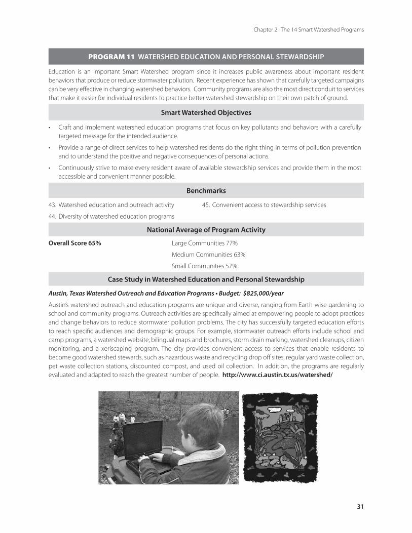
31
Chapter 2: The 14 Smart Watershed Programs
31
PROGRAM 11 WATERSHED EDUCATION AND PERSONAL STEWARDSHIP
Education is an important Smart Watershed program since it increases public awareness about important resident behaviors that produce or reduce stormwater pollution. Recent experience has shown that carefully targeted campaigns can be very effective in changing watershed behaviors. Community programs are also the most direct conduit to services that make it easier for individual residents to practice better watershed stewardship on their own patch of ground.
Smart Watershed Objectives
Craft and implement watershed education programs that focus on key pollutants and behaviors with a carefully targeted message for the intended audience.
Provide a range of direct services to help watershed residents do the right thing in terms of pollution prevention and to understand the positive and negative consequences of personal actions.
Continuously strive to make every resident aware of available stewardship services and provide them in the most accessible and convenient manner possible.
•
•
•
Benchmarks
43. Watershed education and outreach activity 45. Convenient access to stewardship services
44. Diversity of watershed education programs
National Average of Program Activity
Overall Score 65% Large Communities 77%
Medium Communities 63%
Small Communities 57%
Case Study in Watershed Education and Personal Stewardship
Austin, Texas Watershed Outreach and Education Programs • Budget: $825,000/year
Austin’s watershed outreach and education programs are unique and diverse, ranging from Earth-wise gardening to school and community programs. Outreach activities are specifically aimed at empowering people to adopt practices and change behaviors to reduce stormwater pollution problems. The city has successfully targeted education efforts to reach specific audiences and demographic groups. For example, stormwater outreach efforts include school and camp programs, a watershed website, bilingual maps and brochures, storm drain marking, watershed cleanups, citizen monitoring, and a xeriscaping program. The city provides convenient access to services that enable residents to become good watershed stewards, such as hazardous waste and recycling drop off sites, regular yard waste collection, pet waste collection stations, discounted compost, and used oil collection. In addition, the programs are regularly evaluated and adapted to reach the greatest number of people. http://www.ci.austin.tx.us/watershed/
3232
The Smart Watershed Benchmarking Tool
PROGRAM 11 WATERSHED EDUCATION AND PERSONAL STEWARDSHIP
Building a Better Watershed Education and Personal Stewardship Program
Tips for Building a Program
Target educational messages to specific audience needs.
Determine the watershed issues that residents find most compelling, and then craft action-oriented educational tools to address them.
Provide easy access to services that help residents become better watershed stewards.
Develop education approaches for local elected officials – a watershed brief book can be used to compile important watershed-related information and news on a regular basis.
Partner with the school system to build stormwater education into the curriculum.
•
•
•
•
•
Tips for Fine-Tuning an Existing Programs
Survey residents before and after education efforts to document change and measure effectiveness of outreach techniques.
Continue targeting education efforts to focus on a few new audiences each year such as real estate developers, local building industry associations, and homeowner associations.
Understand the changing demographics of urban watersheds and adapt educational materials to address change and resident turnover.
•
•
•
Resources for Watershed Education and Personal StewardshipAWRA 2000 Proceedings: http://www.awra.org/proceedings/Alaska2000/ak04/
Chesapeake Club Media Campaign http://www.chesapeakeclub.org/media.htm
EPA Section 319 Success Stories http://www.epa.gov/owow/nps/Section319III/inform.htm
King County, WA Water Quality Consortium Ad Campaign http://www.psat.wa.gov/Programs/Pie_Ed/Water_Ed_Materials.htm
Northern Virginia Stormwater Education Radio Campaign http://www.novaregion.org/pdf/NVRCProgramHL6_05.pdf
Portland OR – Downspout Disconnection Program http://www.portlandonline.com/bes/index.cfm?c=31246
Austin Hazardous Waste Facility and Reuse Store http://www.ci.austin.tx.us/sws/hhw.htm
Getting in Step: A Guide for Conducting Watershed Outreach Campaigns (McPherson and Tonning, 2003a) and Getting in Step: Engaging and Involving Stakeholders in Your Watershed (MacPherson and Tonning, 2003b) at http://www.epa.gov/owow/watershed/outreach/documents/
Westbrook Elementary School Stream Studies web site http://www.mcps.k12.md.us/schools/westbrookes/streamstudies.html

33
Chapter 2: The 14 Smart Watershed Programs
33
PROGRAM 12 PUBLIC INVOLVEMENT AND NEIGHBORHOOD CONSULTATION
Public involvement is critical to enlist long-term support for local watershed restoration efforts. Early public involvement in the planning process can provide important feedback on restoration goals and priorities. Communities that establish a positive relationship with residents during each step of the restoration planning process can gain support for project and program funding. This Smart Watershed program evaluates the degree to which a community enables the public to become involved and fully participate in the watershed restoration planning process.
Smart Watershed Objectives
Provide meaningful opportunities for public involvement and participation in each step of a subwatershed restoration plan.
Ensure that neighborhoods are fully consulted about local restoration projects.
•
•
Benchmarks
46. Stakeholder involvement in restoration planning 48. Public access to restoration information
47. Neighborhood consultation about restoration projects
National Average of Program Activity
Overall Score 71% Large Communities 85%
Medium Communities 75%
Small Communities 50%
Case Study in Public Involvement and Neighborhood Consultation
Rockville, Maryland Watts Branch Watershed Community Charrettes • Population: 59,000
Who could possibly be against watershed restoration? Quite a few people, actually, if they haven’t been involved in the design and location of restoration projects. The construction of restoration projects can have a dramatic effect on the character of neighborhoods, open space and parkland. Trees can be cleared, park uses changed, and possible water hazards created. When the City of Rockville, Maryland began an ambitious program to restore Watts Branch, they were mindful of past controversies about stormwater retrofit projects. Consequently, the city committed itself to actively involve the public in decision-making throughout the entire process. The city held more than twenty meetings (roughly four per every square mile in the watershed), posted project information on its website and community list serve and installed a watershed information kiosk in City Hall.
The city went well beyond public notification and education by forming the Watts Branch Partnership to include residents in the design and location of retrofit and stream restoration projects. The public was invited to participate in field meetings, retrofit inventories, stream assessments, and even site visits with permitting agencies. Numerous site tours were held with neighborhood and civic associations. Design charrettes were held to jointly develop a ranking system to prioritize retrofits, and raise concerns about tree clearing, loss of screening, and change in park uses. Several projects were redesigned, relocated or dropped from further consideration as a direct result of community involvement. The investment in neighborhood consultation was pivotal in getting the partnership to strongly endorse the final restoration plan. Based on the strong community support, the City Council authorized nearly $3,000,000 for final design and implementation of restoration projects.
3434
The Smart Watershed Benchmarking Tool
PROGRAM 12 PUBLIC INVOLVEMENT AND NEIGHBORHOOD CONSULTATION
Building a Better Public Involvement and Neighborhood Consultation Program
Tips for Building a New Program
Treat the public as a partner in restoration and not as a potential foe.
Make public involvement transparent, credible and responsive.
Go beyond mere notification and give residents meaningful opportunities to participate in restoration planning.
Remember that activities such as stream walks and site tours are effective ways to educate residents first hand about watershed problems that need to be addressed.
Provide suggestions at public meetings about simple stewardship actions residents can take and how they can report water quality problems.
Clearly indicate how public input will be used in watershed planning decisions and project implementation.
Be prepared to defray public discontent about unrelated community issues. A few cranky citizens can derail the process, so know what hot issues are important in the neighborhood and be ready to provide contacts that can help resolve problems.
Contact homeowners associations and civic groups to get on their agenda to describe restoration projects.
•
•
•
•
•
•
•
•
Tips for Fine-Tuning Existing Programs
Get to know your local media and public access cable channel. Local media can help get the word out about projects and highlight the restoration program, but keep in mind that media need a lot of lead time, so plan a season ahead.
Give restoration partners face time and speaking opportunities at public meetings.
Manage controversial restoration projects by hiring a facilitator, utilizing a neutral spokesperson, or training key staff on facilitation skills.
Formulate a detailed plan for the different types of public meeting formats and rehearse them in advance.
Provide a feedback form for stakeholders to comment on projects, and provide food and fun for all stakeholders.
•
•
•
•
•
Resources for Public Involvement and Neighborhood Consultation
Baltimore County State of our Watersheds Conference http://www.co.ba.md.us/Agencies/environment/watersheds/ep_watershedconference.htmlhttp://www.co.ba.md.us/News/2003/october/1027_watersheds.html
Urban Subwatershed Restoration Manual 2: Methods to Develop Restoration Plans for Small Watersheds (Schueler and Kitchell, 2005)
Getting in Step: Engaging and Involving Stakeholders in Your Watershed (MacPherson and Tonning, 2003b) at http://www.epa.gov/owow/watershed/outreach/documents/
Pennsylvania Senior Environmental Corps http://www.dep.state.pa.us/hosting/pasec/
35
Chapter 2: The 14 Smart Watershed Programs
35
PROGRAM 13 POLLUTION PREVENTION AT STORMWATER HOTSPOTS
A hotspot is defined as an urban land use or operation that generates higher concentrations of pollutants than are typically found in stormwater runoff. Simple pollution prevention practices employed at stormwater hotspots can sharply reduce pollutant loading and the frequency of spills, leaks and illicit discharges.
Smart Watershed Objectives
Target major hotspot operations within subwatersheds with a range of carrots and sticks to promote greater pollution prevention activity.
Provide clear and compelling pollution prevention education materials, compliance and enforcement information, and business recognition programs.
•
•
Benchmarks
49. Identify and map stormwater hotspots 51. Business recognition and partnerships
50. Target businesses for education and outreach
National Average of Program Activity
Overall Score 35% Large Communities 39%
Medium Communities 42%
Small Communities 21%
Case Study in Pollution Prevention at Stormwater Hotspots
Seattle Pollution Control Inspection Program • Population: 572,600
The City of Seattle works with local businesses to improve the stormwater quality delivered to local creeks, lakes and the Puget Sound. Business inspections are a key element of the city’s stormwater pollution prevention program required under its NPDES MS4 stormwater permit. The city inspects businesses that connect to its stormwater system that engage in activities and operations known to generate pollutant discharges, known as stormwater hotspots. Existing hotspot businesses must prepare spill prevention plans and implement operational controls to prevent runoff pollution. New hotspot businesses may also be required to install source controls or treat them with structural stormwater practices. Each business receives a notification letter sent a month before the planned inspection date. During the inspection, a water quality inspector identifies potential sources of pollutants to the storm drain system and observes whether pollution prevention practices are being maintained. If any corrective actions are needed, they are described in a letter sent to the property owner within two weeks of the inspection. The letter briefly describes the nature of the problem, recommends techniques to prevent pollutant discharge, and sets a date when the property will be re-inspected. If corrective actions are not taken, a violation notice is issued that could result in a fine of up to $500 for each day the violation continues. The city also provides financial support through the Greater Seattle Chamber of Commerce to offer local businesses free products and services that promote solid waste prevention, recycling, water conservation, stormwater pollution prevention and sustainable building. http://www.seattle.gov/util/Services/Drainage_&_Sewer/Stormwater_Related_Inspections/Pollution_Control_Inspections/index.asp
3636
The Smart Watershed Benchmarking Tool
PROGRAM 13 POLLUTION PREVENTION AT STORMWATER HOTSPOTS
Building Better Local Pollution Prevention Programs
Tips for Getting Started
Target training and inspections to specific hotspot business types based on local pollutants of concern and problems found during local illicit discharge detection screening (see Program 8).
Coordinate pollution prevention training for inspectors with adjacent communities to reduce costs.
Create a database of hotspots for each subwatershed and make this information available to inspectors and citizen volunteer monitors.
•
•
•
Tips for Fine-Tuning Existing Programs
Ensure that local inspection staff and other employees promote pollution prevention during other routine site visits and inspections.
Develop a business recognition program for companies that do the right thing.
Use municipal facilities to demonstrate effective pollution prevention practices.
Conduct voluntary site audits and offer technical assistance before taking enforcement action – it is more cost-effective and can avoid litigation costs.
•
•
•
•
Resources for Pollution Prevention at Stormwater Hotspots
EPA Stormwater Management for Industrial Activities: Developing Pollution Prevention Plans http://www.epa.gov/npdes/pubs/contents_indguide.pdf
EPA Compliance Assistance Centers http://www.epa.gov/compliance/assistance/centers/index.html
King County, WA Stormwater Pollution Control Manual http://dnr.metrokc.gov/wlr/dss/SPPM.htm
Montgomery County Clean Water Partners – resource link to handbooks http://www.montgomerycountymd.gov/deptmpl.asp?url=/content/dep/Epartners/home.asp
Urban Subwatershed Restoration Manual 8: Pollution Source Control Practices (Schueler et al., 2004)
Urban Subwatershed Restoration Manual 11: The Unified Subwatershed and Site Reconnaissance (USSR): A Users Manual. (Wright et al., 2004).
37
Chapter 2: The 14 Smart Watershed Programs
37
PROGRAM 14 POLLUTION PREVENTION AT MUNICIPAL OPERATIONS
The daily actions of public employees and municipal contractors can exert a strong influence on the quality of stormwater runoff in any watershed. In addition, public employees are also the front-line for public outreach and education and are instrumental in setting a good example. Changes in municipal operations such as street sweeping, yard waste collection, recycling of used oil and household hazardous waste, and general trash control can all help reduce stormwater, air and groundwater pollution. In addition, routine cleaning of streets and storm drains can help reduce pollutant loads delivered to local waters.
Smart Watershed Objectives
Integrate pollution prevention in the daily operations of public employees and municipal contractors.
Commit to continuous training of employees and municipal contractors, and employ innovative pollution reduction techniques throughout all municipal operations.
Design a pollution prevention strategy for each municipal operational area and designate a lead local agency or operations manager to implement the pollution prevention training.
•
•
•
Benchmarks
52. Municipal pollution prevention operations 55. Emergency spill and discharge response
53. Municipal road and storm drain maintenance 56. Environmental management system
54. Ongoing training of municipal employees
National Average of Program Activity
Overall Score 59% Large Communities 85%
Medium Communities 54%
Small Communities 43%
Case Study in Pollution Prevention at Municipal Operations
Los Angeles Municipal Training Program
To ensure compliance with its MS4 NPDES stormwater permit, Los Angeles initiated a training program to educate all 41,000 City employees on the actions they can take to reduce the amount of pollutants entering the municipal storm drain system. This training program includes a video entitled Stormwater Pollution — What You Can Do and a supplemental handbook distributed to all city divisions. The 20-minute video demonstrates good housekeeping practices, and the handbook describes actions employees can take to reduce stormwater pollution on the job and at home. Each division within the City of Los Angeles is responsible to ensure that all employees watch the video and read a copy of the handbook. The second phase of the training program provides specialized training for employees whose job duties directly impact the quality of urban runoff. In addition, all city facilities are required to develop stormwater pollution prevention plans. City employees that work in the field also receive extensive training to recognize stormwater pollution or illicit discharge problems and promptly report them to the appropriate authority.

3838
The Smart Watershed Benchmarking Tool
PROGRAM 14 POLLUTION PREVENTION AT MUNICIPAL OPERATIONS
Building Better Municipal Pollution Prevention Programs
Tips for Getting Started
Foster an institutional mindset of going beyond compliance.
Provide training opportunities and employee recognition programs that reward innovation and problem-solving.
All field staff should carry emergency pollution response contact information with them at all times.
Approach a local private industry with a good operations reputation to help train staff in doing on-site pollution prevention audits.
Include basic pollution prevention operating procedures into municipal contract language for any contracted services that have the potential to generate pollutants.
•
•
•
•
•
Tips for Fine-Tuning Existing Programs
Designate a pollution prevention coordinator to provide oversight of pollution prevention education, training, and implementation programs across all municipal operations.
Cross-train employees, particularly field staff, in recognizing problems and how to respond appropriately as a first responder and in getting assistance on-site.
Link municipal pollution prevention training to new employee orientation programs and performance reviews.
•
•
•
Resources for Pollution Prevention at Municipal Operations
National Pollution Prevention Roundtable http://www.p2.org/
EPA Performance Track http://www.epa.gov/performancetrack/index.htm
San Francisco CA – Integrated Pest Management http://www.pesp.org/1998/birc98.htm
Seattle Pesticide Use Reduction Program http://www.cityofseattle.net/environment/Pesticides.htm
Pollution Prevention/Good Housekeeping for Municipal Operations http://cfpub.epa.gov/npdes/stormwater/menuofbmps/poll.cfm
Stormwater Phase II Final Rule - Permitting and Reporting: The Process and Requirements http://www.epa.gov/npdes/pubs/fact2-9.pdf
Storm Water Phase II Compliance Assistance Guide http://www.epa.gov/npdes/pubs/comguide.pdf
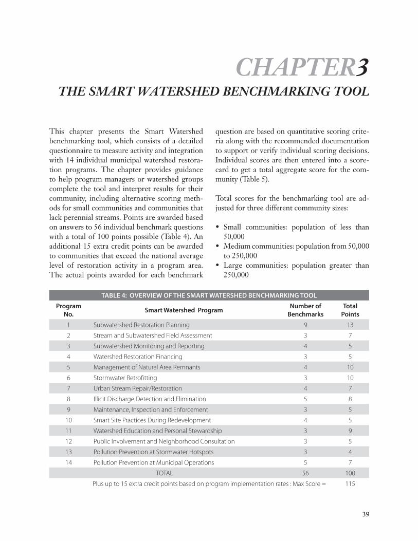
39
TABLE 4: OVERVIEW OF THE SMART WATERSHED BENCHMARKING TOOL
Program No.
Smart Watershed Program Number of
BenchmarksTotal
Points
1 Subwatershed Restoration Planning 9 13
2 Stream and Subwatershed Field Assessment 3 7
3 Subwatershed Monitoring and Reporting 4 5
4 Watershed Restoration Financing 3 5
5 Management of Natural Area Remnants 4 10
6 Stormwater Retrofitting 3 10
7 Urban Stream Repair/Restoration 4 7
8 Illicit Discharge Detection and Elimination 5 8
9 Maintenance, Inspection and Enforcement 3 5
10 Smart Site Practices During Redevelopment 4 5
11 Watershed Education and Personal Stewardship 3 9
12 Public Involvement and Neighborhood Consultation 3 5
13 Pollution Prevention at Stormwater Hotspots 3 4
14 Pollution Prevention at Municipal Operations 5 7
TOTAL 56 100
Plus up to 15 extra credit points based on program implementation rates : Max Score = 115
This chapter presents the Smart Watershed benchmarking tool, which consists of a detailed questionnaire to measure activity and integration with 14 individual municipal watershed restora-tion programs. The chapter provides guidance to help program managers or watershed groups complete the tool and interpret results for their community, including alternative scoring meth-ods for small communities and communities that lack perennial streams. Points are awarded based on answers to 56 individual benchmark questions with a total of 100 points possible (Table 4). An additional 15 extra credit points can be awarded to communities that exceed the national average level of restoration activity in a program area. The actual points awarded for each benchmark
question are based on quantitative scoring crite-ria along with the recommended documentation to support or verify individual scoring decisions. Individual scores are then entered into a score-card to get a total aggregate score for the com-munity (Table 5).
Total scores for the benchmarking tool are ad-justed for three different community sizes:
Small communities: population of less than 50,000 Medium communities: population from 50,000 to 250,000 Large communities: population greater than 250,000
•
•
•
CHAPTER3THE SMART WATERSHED BENCHMARKING TOOL
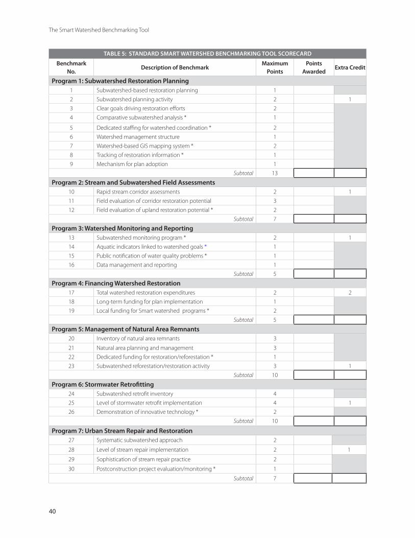
40
The Smart Watershed Benchmarking Tool
TABLE 5: STANDARD SMART WATERSHED BENCHMARKING TOOL SCORECARD
Benchmark No.
Description of Benchmark Maximum
PointsPoints
AwardedExtra Credit
Program 1: Subwatershed Restoration Planning 1 Subwatershed-based restoration planning 1
2 Subwatershed planning activity 2 1
3 Clear goals driving restoration efforts 2
4 Comparative subwatershed analysis * 1
5 Dedicated staffing for watershed coordination * 2
6 Watershed management structure 1
7 Watershed-based GIS mapping system * 2
8 Tracking of restoration information * 1
9 Mechanism for plan adoption 1
Subtotal 13
Program 2: Stream and Subwatershed Field Assessments 10 Rapid stream corridor assessments 2 1
11 Field evaluation of corridor restoration potential 3
12 Field evaluation of upland restoration potential * 2
Subtotal 7
Program 3: Watershed Monitoring and Reporting 13 Subwatershed monitoring program * 2 1
14 Aquatic indicators linked to watershed goals * 1
15 Public notification of water quality problems * 1
16 Data management and reporting 1
Subtotal 5
Program 4: Financing Watershed Restoration 17 Total watershed restoration expenditures 2 2
18 Long-term funding for plan implementation 1
19 Local funding for Smart watershed programs * 2
Subtotal 5
Program 5: Management of Natural Area Remnants20 Inventory of natural area remnants 3
21 Natural area planning and management 3
22 Dedicated funding for restoration/reforestation * 1
23 Subwatershed reforestation/restoration activity 3 1
Subtotal 10
Program 6: Stormwater Retrofitting 24 Subwatershed retrofit inventory 4
25 Level of stormwater retrofit implementation 4 1
26 Demonstration of innovative technology * 2
Subtotal 10
Program 7: Urban Stream Repair and Restoration27 Systematic subwatershed approach 2
28 Level of stream repair implementation 2 1
29 Sophistication of stream repair practice 2
30 Postconstruction project evaluation/monitoring * 1
Subtotal 7

41
Chapter 3: The Smart Watershed Benchmarking Tool
TABLE 5: STANDARD SMART WATERSHED BENCHMARKING TOOL SCORECARD
Benchmark No.
Description of Benchmark Maximum
PointsPoints
AwardedExtra Credit
Program 8: Illicit Discharge Detection and Elimination31 Possess discharge control authority * 1
32 Discharge mapping and screening * 2
33 Outfall reconnaissance inventory 2
34 Pollution hotline and response * 1
35 Activity in eliminating discharges 2 1
Subtotal 8
Program 9: Watershed Maintenance, Inspection and Enforcement 36 Inspect and maintain stormwater practices * 2
37 Inspect and maintain restoration practices 2
38 Water quality enforcement activity 1 1
Subtotal 5
Program 10: Promote Smart Site Practices during Redevelopment 39 Conduct audit of redevelopment codes 1
40 Adopt Smart Site Practices for redevelopment * 1
41 Demonstrate in municipal construction projects 2 1
42 Financial incentives for private sector * 1
Subtotal 5
Program 11: Watershed Education and Personal Stewardship43 Watershed education and outreach activity 3 1
44 Diversity of watershed education programs 4
45 Convenient access to stewardship services * 2
Subtotal 9
Program 12: Public Involvement and Neighborhood Consultation 46 Stakeholder involvement in restoration planning 2 1
47 Neighborhood consultation in restoration 2
48 Public access to restoration information * 1
Subtotal 5
Program 13: Pollution Prevention at Stormwater Hotspots49 Identify and map stormwater hotspots 1
50 Targeted businesses for education and outreach 2 1
51 Business recognition and partnerships * 1
Subtotal 4
Program 14: Pollution Prevention at Municipal Operations 52 Municipal pollution prevention operations 2
53 Municipal road and storm drain maintenance 2 1
54 Ongoing employee training * 1
55 Emergency spill and discharge response * 1
56 Environmental management system * 1
Subtotal 7
TOTAL 100
* benchmark may not fully apply to small communities –see Table 9 for scoring guidance for these communities
42
The Smart Watershed Benchmarking Tool
3.1 Steps to Complete the Benchmarking Tool
This section describes the seven steps needed to complete the benchmarking tool. The tool has been designed to take less than 40 hours of staff time in most communities, although it is prudent to schedule the time over a month to complete the entire process. In general, the tool is retro-spective, and unless otherwise stated, asks for a characterization of restoration activity in the pre-ceding one to three years.
Step 1: Decide Whether to Apply the Tool at the Com-munity or Watershed Scale
The first key decision is whether to apply the tool across all municipal programs in a community or only apply it to a specific watershed. In the first case, the tool is used to examine how well res-toration programs are integrated across an entire community. The second case evaluates individual watershed restoration plans from the standpoint of how implementation is integrated among mu-nicipal agencies. Most municipalities will apply the tool at the community scale, unless they have specifically focused limited restoration resources within a targeted watershed.
Step 2: Determine if Alternative Scoring is Needed Based on Local Conditions
While the benchmarking tool is applicable to a wide range of community sizes and geographic conditions, there are two specific situations where communities may choose an alternative scoring system to present a fair and more balanced assess-ment of their local restoration programs. This occurs when a community:
Is small (population less than 50,000) Lacks many perennial streams (common in ul-tra-urban communities with greater than 75% impervious cover, and/or arid regions of the West with a very low perennial stream density)
••
Sections 3.2 and 3.3 provide guidance to help us-ers choose whether it makes more sense to use an alternative scoring system in these situations.
Step 3: Find the Appropriate Local Staff to Fill Out the Benchmarking Tool
The next step is to find out who can most quickly put their hands on the right data to fill out the benchmarking tool. Ideally, local staff filling out the benchmarking tool will have the following skills:
Understand how the community is meeting lo-cal and state water quality and stormwater man-agement requirementsAre broadly familiar with local restoration activityUnderstand local budget documentsKnow key restoration players and watershed education groups in the community Don’t mind making some cold calls to get data Can quickly scan restoration documents to ex-tract summary information Have contacts with external organizations and agencies that may be providing watershed ser-vices in the community
In some cases, it may be desirable to assemble an interagency team to work together to fill out the benchmarking tool. It may also be useful to conduct a Needs and Capabilities Assessment (Schueler and Kitchell, 2005) at the same time to help discover the right contacts, inside and outside of government, that are knowledgeable about local watershed restoration efforts.
Step 4: Review Information of Local Restoration Pro-gram Information
The real detective work involves analyzing reports, budget justifications and watershed plans to find the information to score each benchmark. For larger communities, it is always a good idea to review:
NPDES MS4 Phase I or II stormwater permits and annual reports
•
•
••
••
•
•
43
Chapter 3: The Smart Watershed Benchmarking Tool
Water quality monitoring reports Stream and subwatershed field assessmentsWatershed and/or subwatershed restoration plansAction plans/work programs of local water-shed groupsAvailable GIS mapping resources Watershed education and outreach materials Agency operating and capital budget docu-mentsMunicipal facility maintenance and pollution prevention plans Codes and ordinances related to redevelopmentPark management plans and/or comprehensive plans that have a natural areas component
Step 5: Compile Program Budget Information
The most difficult and tedious step is to com-pile Smart Watershed budget information across many local departments, agencies and organiza-tions. A worksheet has been provided in Appendix A to simplify the job. Both annual operating and capital budgets need to be carefully scrutinized for line-item expenditures to determine total staffing and contracting dollars for each program area. In many cases, multiple agency or departmental bud-gets need to be examined, but start first with pub-lic works and the agency that administers the lo-cal stormwater permit. Hard decisions need to be made on how to assign actual staff effort to indi-vidual smart watershed program budget categories. Once the budget information is compiled on the worksheet, it is often surprising to see how much existing funding is available to support restoration.
Step 6: Document Scoring Decisions and Assemble Supporting Documentation in Master Binder
By now, the team has enough information to make the scoring decisions for each benchmark ques-tion and assemble the documentation to support them. It is highly recommended that the team compile supporting documentation in a three-ring master binder. The benchmarking tool pro-vides a box after each question to justify the scor-
•••
•
•••
•
••
ing rationale and reference the corresponding tab in the master binder where supporting documen-tation can be found.
Scoring is always subject to some interpretation and possible bias. Therefore, it is important to clearly document the scoring rationale, and have a second person review each scoring decision. In cases where answers to a benchmark question are unclear or difficult to ascertain, it may be helpful to review the program profile sheet and consult the resources section to see how other communities are addressing the program. Once individual scores for each benchmark are reviewed and verified, they can then be entered into the standard scorecard provided in Table 5 to determine the aggregate Smart Watershed score for the community.
Step 7: Analyze Program Strengths and Weaknesses
The final task is to total up the aggregate score for the community (or watershed), making sure to add in any extra credit points. Based on com-munity size, the total score is converted into an overall grade based on a sliding scale. Thus, a large community must receive 90 or more points to qualify for the highest Smart Watershed grade; whereas medium and small communities must only exceed 80 and 70 points, respectively, to qualify for the same grade. Tables 6 to 8 outline the overall Smart Watershed grades that can be assigned to different-sized communities.
Communities should also analyze individual pro-gram score totals to look for their strengths and weaknesses. It is advisable to establish an inter-agency workgroup to study the scores and find areas to add new programs of fine-tune existing ones. In many cases, the team may want to re-cruit new agencies or partners to the restora-tion effort, and target specific program areas for greater local restoration investment, staff train-ing or capacity building. Useful program build-ing resources are included in the Program Profile Sheets to help build or improve Smart Water-shed programs.
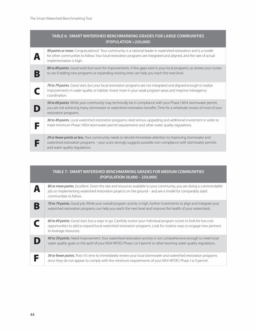
44
The Smart Watershed Benchmarking Tool
TABLE 6: SMART WATERSHED BENCHMARKING GRADES FOR LARGE COMMUNITIES (POPULATION >250,000)
A90 points or more. Congratulations! Your community is a national leader in watershed restoration and is a model for other communities to follow. Your local restoration programs are integrated and aligned, and the rate of actual implementation is high.
B80 to 89 points. Good work but room for improvements. A few gaps exist in your local programs, so review your scores to see if adding new programs or expanding existing ones can help you reach the next level.
C70 to 79 points. Good start, but your local restoration programs are not integrated and aligned enough to realize improvements in water quality or habitat. Invest more in your weak program areas and improve interagency coordination.
D50 to 69 points. While your community may technically be in compliance with your Phase I MS4 stormwater permit, you are not achieving many stormwater or watershed restoration benefits. Time for a wholesale review of most of your restoration programs.
F30 to 49 points. Local watershed restoration programs need serious upgrading and additional investment in order to meet minimum Phase I MS4 stormwater permit requirements and other water quality regulations.
F29 or fewer points or less. Your community needs to devote immediate attention to improving stormwater and watershed restoration programs – your score strongly suggests possible non-compliance with stormwater permits and water quality regulations.
TABLE 7: SMART WATERSHED BENCHMARKING GRADES FOR MEDIUM COMMUNITIES (POPULATION 50,000 – 250,000)
A 80 or more points. Excellent. Given the size and resources available to your community, you are doing a commendable job on implementing watershed restoration projects on the ground – and are a model for comparably sized communities to follow.
B 70 to 79 points. Good job. While your overall program activity is high, further investments to align and integrate your watershed restoration programs can help you reach the next level and improve the health of your watersheds.
C 60 to 69 points. Good start, but a ways to go. Carefully review your individual program scores to look for low cost opportunities to add or expand local watershed restoration programs. Look for creative ways to engage new partners to leverage resources.
D 40 to 59 points. Need improvement. Your watershed restoration activity is not comprehensive enough to meet local water quality goals or the spirit of your MS4 NPDES Phase I or II permit or other looming water quality regulations.
F 39 or fewer points. Poor. It’s time to immediately review your local stormwater and watershed restoration programs since they do not appear to comply with the minimum requirements of your MS4 NPDES Phase I or II permit.
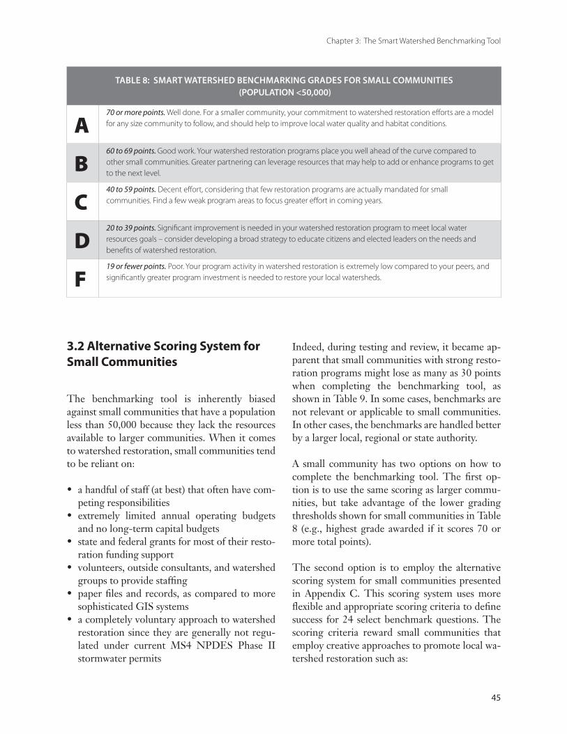
45
Chapter 3: The Smart Watershed Benchmarking Tool
TABLE 8: SMART WATERSHED BENCHMARKING GRADES FOR SMALL COMMUNITIES (POPULATION <50,000)
A70 or more points. Well done. For a smaller community, your commitment to watershed restoration efforts are a model for any size community to follow, and should help to improve local water quality and habitat conditions.
B60 to 69 points. Good work. Your watershed restoration programs place you well ahead of the curve compared to other small communities. Greater partnering can leverage resources that may help to add or enhance programs to get to the next level.
C40 to 59 points. Decent effort, considering that few restoration programs are actually mandated for small communities. Find a few weak program areas to focus greater effort in coming years.
D20 to 39 points. Significant improvement is needed in your watershed restoration program to meet local water resources goals – consider developing a broad strategy to educate citizens and elected leaders on the needs and benefits of watershed restoration.
F19 or fewer points. Poor. Your program activity in watershed restoration is extremely low compared to your peers, and significantly greater program investment is needed to restore your local watersheds.
3.2 Alternative Scoring System for Small Communities
The benchmarking tool is inherently biased against small communities that have a population less than 50,000 because they lack the resources available to larger communities. When it comes to watershed restoration, small communities tend to be reliant on:
a handful of staff (at best) that often have com-peting responsibilitiesextremely limited annual operating budgets and no long-term capital budgets state and federal grants for most of their resto-ration funding support volunteers, outside consultants, and watershed groups to provide staffing paper files and records, as compared to more sophisticated GIS systemsa completely voluntary approach to watershed restoration since they are generally not regu-lated under current MS4 NPDES Phase II stormwater permits
•
•
•
•
•
•
Indeed, during testing and review, it became ap-parent that small communities with strong resto-ration programs might lose as many as 30 points when completing the benchmarking tool, as shown in Table 9. In some cases, benchmarks are not relevant or applicable to small communities. In other cases, the benchmarks are handled better by a larger local, regional or state authority.
A small community has two options on how to complete the benchmarking tool. The first op-tion is to use the same scoring as larger commu-nities, but take advantage of the lower grading thresholds shown for small communities in Table 8 (e.g., highest grade awarded if it scores 70 or more total points).
The second option is to employ the alternative scoring system for small communities presented in Appendix C. This scoring system uses more flexible and appropriate scoring criteria to define success for 24 select benchmark questions. The scoring criteria reward small communities that employ creative approaches to promote local wa-tershed restoration such as:
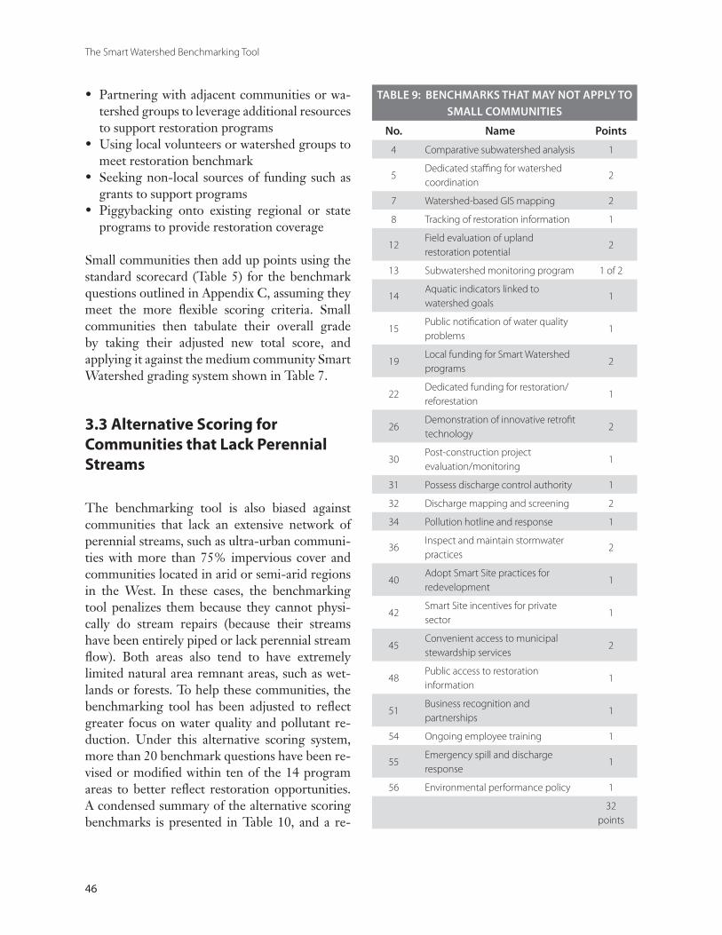
46
The Smart Watershed Benchmarking Tool
TABLE 9: BENCHMARKS THAT MAY NOT APPLY TO SMALL COMMUNITIES
No. Name Points
4 Comparative subwatershed analysis 1
5Dedicated staffing for watershed coordination
2
7 Watershed-based GIS mapping 2
8 Tracking of restoration information 1
12Field evaluation of upland restoration potential
2
13 Subwatershed monitoring program 1 of 2
14Aquatic indicators linked to watershed goals
1
15Public notification of water quality problems
1
19Local funding for Smart Watershed programs
2
22 Dedicated funding for restoration/reforestation
1
26Demonstration of innovative retrofit technology
2
30Post-construction project evaluation/monitoring
1
31 Possess discharge control authority 1
32 Discharge mapping and screening 2
34 Pollution hotline and response 1
36Inspect and maintain stormwater practices
2
40Adopt Smart Site practices for redevelopment
1
42Smart Site incentives for private sector
1
45Convenient access to municipal stewardship services
2
48Public access to restoration information
1
51Business recognition and partnerships
1
54 Ongoing employee training 1
55Emergency spill and discharge response
1
56 Environmental performance policy 1
32 points
Partnering with adjacent communities or wa-tershed groups to leverage additional resources to support restoration programs Using local volunteers or watershed groups to meet restoration benchmark Seeking non-local sources of funding such as grants to support programs Piggybacking onto existing regional or state programs to provide restoration coverage
Small communities then add up points using the standard scorecard (Table 5) for the benchmark questions outlined in Appendix C, assuming they meet the more flexible scoring criteria. Small communities then tabulate their overall grade by taking their adjusted new total score, and applying it against the medium community Smart Watershed grading system shown in Table 7.
3.3 Alternative Scoring for Communities that Lack Perennial Streams
The benchmarking tool is also biased against communities that lack an extensive network of perennial streams, such as ultra-urban communi-ties with more than 75% impervious cover and communities located in arid or semi-arid regions in the West. In these cases, the benchmarking tool penalizes them because they cannot physi-cally do stream repairs (because their streams have been entirely piped or lack perennial stream flow). Both areas also tend to have extremely limited natural area remnant areas, such as wet-lands or forests. To help these communities, the benchmarking tool has been adjusted to reflect greater focus on water quality and pollutant re-duction. Under this alternative scoring system, more than 20 benchmark questions have been re-vised or modified within ten of the 14 program areas to better reflect restoration opportunities. A condensed summary of the alternative scoring benchmarks is presented in Table 10, and a re-
•
•
•
•

47
Chapter 3: The Smart Watershed Benchmarking Tool
TABLE 10: SUMMARY OF REVISED SCORING BENCHMARKS FOR COMMUNITIES THAT LACK PERENNIAL STREAMS
Program 2: Upland assessments such as outfall surveys, storm drain mapping and stream daylighting investigations are substituted for stream assessment methods
Program 3: Water quality monitoring at stormwater outfalls replaces instream monitoring
Program 5: Management of Natural Area Remnants is changed to Management of Vacant Lands and Open Space to reflect greater emphasis on land reclamation, brownfields and urban forestry, and reduced emphasis on forest and wetland conservation
Program 6: More emphasis on implementation of on-site stormwater retrofits compared to storage retrofits
Program 7: Stream Repair is changed to Stormwater Pollution Source Assessment, with points awarded for source area modeling, pollutant load analysis, behavior surveys and water quality simulation modeling
Program 8: More points are awarded to illicit discharge screening and pollution hotlines
Program 9: More points are awarded to water quality enforcement activity, fewer points awarded for maintenance of stormwater practices
Program 13: More points awarded for pollution prevention at stormwater hotspots
Program 14: More points awarded for pollution prevention at municipal operations
•
•
•
•
•
•
•
•
•
Note: Consult Appendix D to see revised scorecard for communities that lack perennial streams.
vised scorecard for communities that lacks peren-nial streams can be found in Appendix D.
3.4 Awarding Extra Credit Points
It is possible for a community to earn extra credit points within each program area if the level of program activity goes beyond the national norm, based on a measurable rate of implementation. Collectively, a maximum of 15 extra credit points can be earned, although it is doubtful any community can qualify for them all. In order to qualify for extra credit, a community must demonstrate that it exceeds a given level of program implementation based on a defined metric. For example, the metric used to define
stream corridor assessments is based on the number of stream miles assessed. In this case, the metric also indicates different thresholds for implementation calibrated for small, medium and large communities based on the common unit of implementation.
The metrics and thresholds for implementation were based on reported levels of program activity in the 2003 survey. Only one extra credit point can be earned within each program area (with the exception of watershed financing, where up to two points can be awarded). Space has been pro-vided in the Smart Watershed scorecard to add the extra credit points to arrive at the total com-munity score (Table 5).
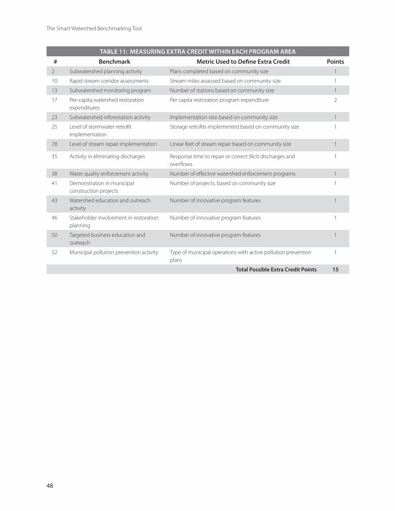
48
The Smart Watershed Benchmarking Tool
TABLE 11: MEASURING EXTRA CREDIT WITHIN EACH PROGRAM AREA
# Benchmark Metric Used to Define Extra Credit Points
2 Subwatershed planning activity Plans completed based on community size 1
10 Rapid stream corridor assessments Stream miles assessed based on community size 1
13 Subwatershed monitoring program Number of stations based on community size 1
17 Per-capita watershed restoration expenditures
Per capita restoration program expenditure 2
23 Subwatershed reforestation activity Implementation rate based on community size 1
25 Level of stormwater retrofit implementation
Storage retrofits implemented based on community size 1
28 Level of stream repair implementation Linear feet of stream repair based on community size 1
35 Activity in eliminating discharges Response time to repair or correct illicit discharges and overflows
1
38 Water quality enforcement activity Number of effective watershed enforcement programs 1
41 Demonstration in municipal construction projects
Number of projects, based on community size 1
43 Watershed education and outreach activity
Number of innovative program features 1
46 Stakeholder involvement in restoration planning
Number of innovative program features 1
50 Targeted business education and outreach
Number of innovative program features 1
52 Municipal pollution prevention activity Type of municipal operations with active pollution prevention plans
1
Total Possible Extra Credit Points 15
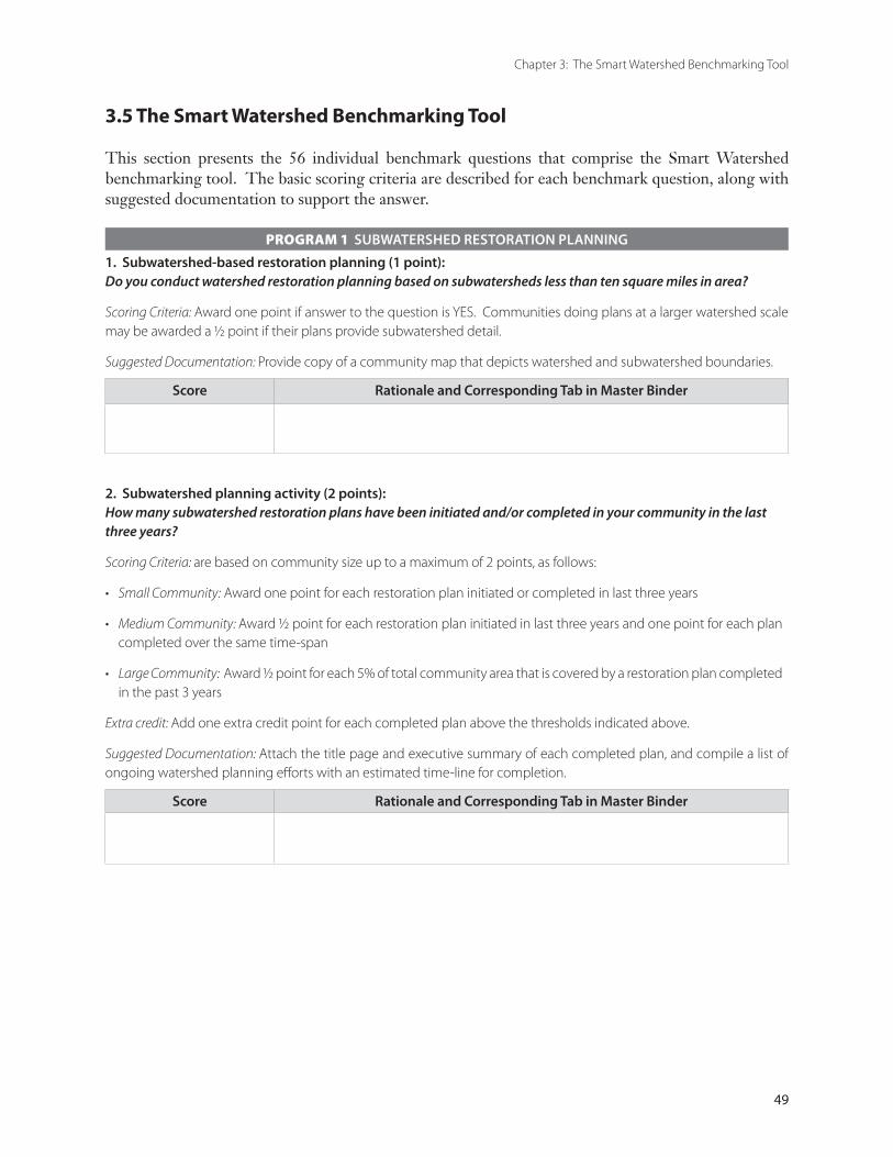
49
Chapter 3: The Smart Watershed Benchmarking Tool
PROGRAM 1 SUBWATERSHED RESTORATION PLANNING
1. Subwatershed-based restoration planning (1 point): Do you conduct watershed restoration planning based on subwatersheds less than ten square miles in area?
Scoring Criteria: Award one point if answer to the question is YES. Communities doing plans at a larger watershed scale may be awarded a ½ point if their plans provide subwatershed detail.
Suggested Documentation: Provide copy of a community map that depicts watershed and subwatershed boundaries.
Score Rationale and Corresponding Tab in Master Binder
2. Subwatershed planning activity (2 points): How many subwatershed restoration plans have been initiated and/or completed in your community in the last three years?
Scoring Criteria: are based on community size up to a maximum of 2 points, as follows:
Small Community: Award one point for each restoration plan initiated or completed in last three years
Medium Community: Award ½ point for each restoration plan initiated in last three years and one point for each plan completed over the same time-span
Large Community: Award ½ point for each 5% of total community area that is covered by a restoration plan completed in the past 3 years
Extra credit: Add one extra credit point for each completed plan above the thresholds indicated above.
Suggested Documentation: Attach the title page and executive summary of each completed plan, and compile a list of ongoing watershed planning efforts with an estimated time-line for completion.
Score Rationale and Corresponding Tab in Master Binder
•
•
•
3.5 The Smart Watershed Benchmarking Tool
This section presents the 56 individual benchmark questions that comprise the Smart Watershed benchmarking tool. The basic scoring criteria are described for each benchmark question, along with suggested documentation to support the answer.
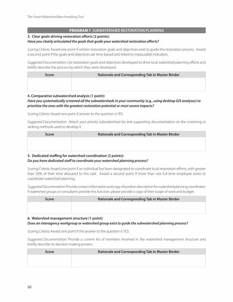
50
The Smart Watershed Benchmarking Tool
PROGRAM 1 SUBWATERSHED RESTORATION PLANNING
3. Clear goals driving restoration efforts (2 points): Have you clearly articulated the goals that guide your watershed restoration efforts?
Scoring Criteria: Award one point if written restoration goals and objectives exist to guide the restoration process. Award a second point if the goals and objectives are time-based and linked to measurable indicators.
Suggested Documentation: List restoration goals and objectives developed to drive local watershed planning efforts and briefly describe the process by which they were developed.
Score Rationale and Corresponding Tab in Master Binder
4. Comparative subwatershed analysis (1 point): Have you systematically screened all the subwatersheds in your community (e.g., using desktop GIS analyses) to prioritize the ones with the greatest restoration potential or most severe impacts?
Scoring Criteria: Award one point if answer to the question is YES.
Suggested Documentation: Attach your priority subwatershed list and supporting documentation on the screening or ranking methods used to develop it.
Score Rationale and Corresponding Tab in Master Binder
5. Dedicated staffing for watershed coordination (2 points): Do you have dedicated staff to coordinate your watershed planning process?
Scoring Criteria: Award one point if an individual has been designated to coordinate local restoration efforts, with greater than 50% of their time allocated to this task. Award a second point if more than one full-time employee exists to coordinate watershed planning.
Suggested Documentation: Provide contact information and copy of position description for watershed planning coordinator. If watershed groups or consultants provide this function, please provide a copy of their scope of work and budget.
Score Rationale and Corresponding Tab in Master Binder
6. Watershed management structure (1 point): Does an interagency workgroup or watershed group exist to guide the subwatershed planning process?
Scoring Criteria: Award one point if the answer to the question is YES.
Suggested Documentation: Provide a current list of members involved in the watershed management structure and briefly describe its decision-making powers.
Score Rationale and Corresponding Tab in Master Binder
51
Chapter 3: The Smart Watershed Benchmarking Tool
PROGRAM 1 SUBWATERSHED RESTORATION PLANNING
7. Watershed-based GIS mapping system (2 points): Do you utilize a watershed-based GIS mapping system that integrates all the data layers needed to support watershed restoration planning efforts?
Scoring Criteria: Award one point if a watershed-based GIS has been created to support planning efforts. Award a second point if the system is currently operational and accessible by the core restoration team.
Suggested Documentation: List the major data layers included in the GIS system and attach the most recent copy of watershed and subwatershed delineations.
Score Rationale and Corresponding Tab in Master Binder
8. Tracking of restoration information (1 point): Is a watershed-based geographic information system used to track cumulative restoration project implementation?
Scoring Criteria: Award one point if the answer to the question is YES.
Suggested documentation: Provide maps or spreadsheets that track project implementation and show cumulative effects of restoration efforts.
Score Rationale and Corresponding Tab in Master Binder
9. Mechanism for plan adoption (1 point): Have you defined the process by which subwatershed plans will be adopted, budgeted and implemented in your community?
Scoring Criteria: Award one point if the answer to the question is YES.
Suggested Documentation: Briefly describe the anticipated political process in your community to formally adopt, finance and implement subwatershed plans.
Score Rationale and Corresponding Tab in Master Binder
TOTAL SCORE FOR PROGRAM 1: __________________________________________________________________

52
The Smart Watershed Benchmarking Tool
PROGRAM 2 STREAM AND SUBWATERSHED FIELD ASSESSMENTS
10. Rapid stream corridor assessments (2 points): Have you conducted stream corridor assessments within priority subwatersheds in the last three years?
Scoring Criteria: Maximum of two points based on community size and implementation rate, as follows
Small Communities: Award one point for each subwatershed in which a stream corridor assessment has been completed
Medium Communities: Award one point for each 25 miles of stream corridor assessed
Large Communities: Award one point for each 50 miles of stream corridor assessed
Extra credit: Add one extra credit point if your community exceeds these stream corridor assessment thresholds.
Suggested Documentation: Provide a map describing the location and approximate mileage of all stream corridor assessments conducted in the past three years.
Score Rationale and Corresponding Tab in Master Binder
•
•
•
11. Field evaluation of restoration potential in the stream corridor (3 points): Does your rapid assessment methodology employ parameters that assess stream impacts and restoration potential?
Scoring Criteria: Award ½ point for each parameter that you routinely measure during your stream corridor assessments as shown in the list below. Maximum score: 3 points.
❑ Wetland assessment ❑ Stream corridor restoration needs
❑ Channel stability ❑ Riparian buffer quality
❑ Aquatic insect diversity ❑ Stormwater outfall screening
❑ Stream habitat ❑ Flow regime
❑ Water quality ❑ Other Indicator (please specify) ____________________________
Suggested Documentation: Provide a sample copy of the field forms used in your most recent stream corridor assessment.
Score Rationale and Corresponding Tab in Master Binder
53
Chapter 3: The Smart Watershed Benchmarking Tool
PROGRAM 2 STREAM AND SUBWATERSHED FIELD ASSESSMENTS
12. Field evaluations of upland restoration potential (2 points): Do you conduct any field assessments in upland areas of subwatersheds to evaluate restoration potential?
Scoring Criteria: Award ½ point for each type of field assessment routinely conducted in upland subwatershed areas. Maximum score: 2 points.
❑ Neighborhood source assessment ❑ Stormwater hotspot survey
❑ Upland reforestation surveys ❑ Stormwater retrofit inventory
❑ Streets and storm drain survey ❑ Other assessment (please specify)
❑ Assessment of natural area remnants
Suggested Documentation: Provide sample copy of field forms used to assess upland restoration potential at the subwatershed level.
Score Rationale and Corresponding Tab in Master Binder
TOTAL SCORE FOR PROGRAM 2: __________________________________________________________________
PROGRAM 3 SUBWATERSHED MONITORING AND REPORTING
13. Subwatershed monitoring program (2 points): Do you have a monitoring program that measures key aquatic indicators at the subwatershed level?
Scoring Criteria: Award two points if your community conducts monitoring at subwatershed level. If monitoring is conducted at a broader scale, award only one point.
Extra credit: Award one extra credit point if your community operates long-term sentinel monitoring stations to track trends in specific subwatershed indicators.
Suggested Documentation: Provide map that shows locations of monitoring stations and indicate the frequency that monitoring data is collected.
Score Rationale and Corresponding Tab in Master Binder
54
The Smart Watershed Benchmarking Tool
PROGRAM 3 SUBWATERSHED MONITORING AND REPORTING
14. Aquatic indicators linked to watershed goals (1 point): Does your monitoring program employ aquatic indicators that reflect the goals and objectives of your watershed restoration effort so that progress can be quantified?
Scoring Criteria: Award one point if your monitoring program measures indicators directly linked to watershed goals.
Suggested Documentation: List the primary aquatic indicators you currently sample and then cross-reference them to the goals outlined earlier in Benchmark 3.
Score Rationale and Corresponding Tab in Master Binder
15. Public notification of water quality problems (1 point): Does your program provide timely notification to the public about spills, sewage discharges and other water quality problems that make it unsafe for the public to swim, recreate or consume fish from local waters?
Scoring Criteria: Award ½ point if a notification system exists to warn the public about water quality problems. Award another ½ point if the system has been tested and/or used in last three years.
Suggested Documentation: Briefly describe the warning system and provide examples of signs, press releases or media announcements used to notify the public.
Score Rationale and Corresponding Tab in Master Binder
16. Data Management and Reporting (1 point): Has your community analyzed monitoring data and reported results to the public and other stakeholders in the last three years?
Scoring Criteria: Award one point if the answer to the question is YES.
Suggested Documentation: Attach a copy of your most recent monitoring report.
Score Rationale and Corresponding Tab in Master Binder
TOTAL SCORE FOR PROGRAM 3: _________________________________________________________________

55
Chapter 3: The Smart Watershed Benchmarking Tool
PROGRAM 4 FINANCING WATERSHED RESTORATION
17. Total watershed program expenditures (2 points): How much does your community spend on a per capita basis for watershed restoration programs in comparison to other municipal programs?
Scoring Criteria: Award one point if total annual restoration program expenditures covering the 14 Smart Watershed programs are at least $10 per capita. Award second point if restoration expenditures exceed $15 per capita.
Extra credit: Add one extra credit point for each additional $3 per capita spent on local watershed restoration above $18, for a maximum of two points.
Suggested Documentation: Estimate your total annual operating and capital expenditures directly related to watershed restoration program efforts for most recent fiscal year using the budget worksheet provided in Appendix A, and then divide by total population.
Score Rationale and Corresponding Tab in Master Binder
18. Long-term funding for plan implementation (1 point): Does your community have a long-term capital budget that extends beyond the current budget year to provide dedicated funding for design and construction of watershed restoration projects?
Scoring Criteria: Award one point if the answer to the question is YES.
Suggested Documentation: Attach a summary of approved capital budget line items for watershed restoration projects (or dedicated funding allocation from a local stormwater utility, if applicable).
Score Rationale and Corresponding Tab in Master Binder
56
The Smart Watershed Benchmarking Tool
PROGRAM 4 FINANCING WATERSHED RESTORATION
19. Local funding for Smart Watershed programs (2 points): Does your local budget include operating and/or capital funding to support Smart Watershed programs?
Scoring Criteria: Mark the following boxes where operating or capital funds are dedicated for the current budget year. Award one point if at least seven boxes are checked. Award a second point if more than ten boxes are checked.
❑ Program 1 Subwatershed Restoration Planning
❑ Program 2 Stream and Subwatershed Field Assessment
❑ Program 3 Subwatershed Monitoring and Reporting
❑ Program 4 Financing Watershed Restoration
❑ Program 5 Management of Natural Area Remnants
❑ Program 6 Stormwater Retrofitting
❑ Program 7 Urban Stream Repair/Restoration
❑ Program 8 Illicit Discharge Detection and Elimination
❑ Program 9 Maintenance, Inspection and Enforcement
❑ Program 10 Smart Site Practices During Redevelopment
❑ Program 11 Watershed Education and Stewardship
❑ Program 12 Public Involvement and Neighborhood Consultation
❑ Program 13 Pollution Prevention at Stormwater Hotspots
❑ Program 14 Pollution Prevention at Municipal Operations
Suggested Documentation: Estimate your total annual operating and capital expenditures directly related to each of the 14 Smart watershed programs for most recent fiscal year using the budget worksheet provided in Appendix A.
Score Rationale and Corresponding Tab in Master Binder
TOTAL SCORE FOR PROGRAM 4: __________________________________________________________________
57
Chapter 3: The Smart Watershed Benchmarking Tool
PROGRAM 5 MANAGEMENT OF NATURAL AREA REMNANTS
20. Inventories of natural area remnants (3 points): Does your community have a current inventory or map of natural area remnants available at the watershed level to prioritize their management?
Scoring Criteria: Award one point for each of the following natural areas that have been mapped or inventoried within the last three years (maximum score: 3 points).
❑ Steep Slopes ❑ Open Space
❑ Wetlands ❑ Vacant Lands
❑ Forest Cover or Canopy ❑ Other RTE Habitat (please specify)
❑ Vegetative Cover in Stream Corridor (Buffers)
Suggested Documentation: Provide an example map showing distribution of natural area remnants.
Score Rationale and Corresponding Tab in Master Binder
21. Natural area planning and management (3 points): Does your subwatershed planning approach address conservation, restoration and reforestation of natural areas?
Scoring Criteria: Award one point for each of the following natural area planning and management activities that apply in your community (maximum score: 3 points).
❑ Watershed or community forest cover/canopy goals are established
❑ Upland public lands are reforested
❑ Existing natural remnants are actively restored or managed
❑ High quality natural remnants are conserved
❑ Stream corridors are reforested
❑ Vacant lands/brownfields are reclaimed
❑ Invasive species are removed from natural areas
❑ Other (please specify) _________________________________________________________________________ Suggested Documentation: Provide excerpts from subwatershed plans that demonstrate actual implementation of each of the boxes checked above.
Score Rationale and Corresponding Tab in Master Binder

58
The Smart Watershed Benchmarking Tool
PROGRAM 5 MANAGEMENT OF NATURAL AREA REMNANTS
22. Dedicated funding for natural area restoration and reforestation (1 point): Do you have an annual budget of at least one dollar per capita for on the ground implementation of natural area restoration and reforestation projects?
Scoring Criteria: Award one point if the answer to the question is YES.
Suggested Documentation: Derive from restoration budget worksheet provided in Appendix A.
Score Rationale and Corresponding Tab in Master Binder
23. Subwatershed restoration and reforestation activity (3 points): How many acres has your community restored/reforested to improve subwatershed conditions in the last three years?
Scoring Criteria: A maximum of 3 points can be awarded based on community size and level of restoration activity, as follows: Award one point for each restoration activity that exceeds minimum area thresholds provided in the table below:
RESTORATION ACTIVITY COMMUNITY SIZE
Small Medium Large
Natural Area Restoration 5 acres 15 acres 30 acres
Stream Corridor Reforestation
5 acres 15 acres 30 acres
Upland Reforestation 5 acres 15 acres 30 acres Extra credit: Add an extra credit point if your community can report some activity in all three restoration areas shown in the table above.
Suggested Documentation: Provide project descriptions and photo documentation, if available.
Score Rationale and Corresponding Tab in Master Binder
TOTAL SCORE FOR PROGRAM 5: __________________________________________________________________
59
Chapter 3: The Smart Watershed Benchmarking Tool
PROGRAM 6 STORMWATER RETROFITTING
24. Subwatershed retrofit inventory (4 points): Has your community conducted stormwater retrofit inventories within priority subwatersheds within the last three years?
Scoring Criteria: Up to four points, based on the scope of retrofit inventories undertaken, as follows:
Award one point if a retrofit inventory has been conducted on municipal properties and at existing stormwater practices
Award second point if inventory has been conducted in at least one priority subwatershed
Award third point if full inventory has been completed in two priority subwatersheds
Award fourth point if more than 25% of developed area in your community has been systematically evaluated for retrofit opportunities
Suggested Documentation: Provide map showing subwatersheds in your community where retrofit inventories have been undertaken, and provide a sample retrofit inventory field sheet.
Score Rationale and Corresponding Tab in Master Binder
•
•
•
•
25. Level of stormwater retrofit implementation (4 points): What is the level of activity in retrofit design and/or construction in the last three years?
Scoring Criteria: Up to four points, based on the number of retrofit projects installed, as follows:
Award one point if at least one retrofit project is currently under design or construction
Award second point if at least three retrofit projects are currently under design or construction
Award third point if five or more retrofit projects have been completed or if completed retrofit projects have a combined drainage area of more than 250 acres
Award fourth point if more than ten retrofit projects have been completed or if completed retrofit projects have a combined drainage area of more than 500 acres
Extra credit: Add one extra credit point if more than 15 retrofit projects have been completed in last three years.
Suggested Documentation: Provide list and brief description of retrofit projects designed and/or constructed. Note: credit is given for storage retrofit projects only.
Score Rationale and Corresponding Tab in Master Binder
•
•
•
•

60
The Smart Watershed Benchmarking Tool
PROGRAM 6 STORMWATER RETROFITTING
26. Demonstration of innovative retrofit technology (2 points): Do your retrofit projects incorporate innovative stormwater technologies?
Scoring Criteria: Award one point if storage retrofit designs employ more advanced or sophisticated practices than the “average” stormwater design submitted for new development in your community. Award a second point if innovative on-site retrofits are employed in your retrofit program such as green rooftops, rain gardens, and bioretention areas.
Suggested Documentation: Provide photos of innovative retrofit designs or practices.
Score Rationale and Corresponding Tab in Master Binder
TOTAL SCORE FOR PROGRAM 6: _________________________________________________________________
PROGRAM 7 URBAN STREAM REPAIR AND RESTORATION
27. Systematic subwatershed approach (2 points): Are stream repair practices explicitly designed to address restoration objectives at the subwatershed level?
Scoring Criteria: Award one point if the answer to the question is YES. Award second point if stream repair projects are integrated with other subwatershed restoration practices such as storage retrofits and riparian reforestation.
Suggested Documentation: Briefly describe the methods used to assess stream restoration priorities at subwatershed scale and the primary objectives driving stream restoration in your community.
Score Rationale and Corresponding Tab in Master Binder
61
Chapter 3: The Smart Watershed Benchmarking Tool
PROGRAM 7 URBAN STREAM REPAIR AND RESTORATION
28. Level of stream repair implementation (2 points): How many stream miles have been covered by urban stream cleanup and stream repair practices in the last three years?
Scoring Criteria: Are based on community size and type of stream repair implemented, as follows:
Award one point if the length of stream cleanup projects undertaken in the last three years exceeds the thresholds in the following table. Award second point if the length of stream repair projects implemented exceeds the minimum length thresholds shown below.
PROJECT ACTIVITY COMMUNITY SIZE
SMALL MEDIUM LARGEStream cleanup/adoption 1000 feet 1 mile 5 miles
Stream repair projects 500 feet 2500 feet 10,000 feet
Extra credit: Add one extra credit point if your community has exceeded the stream repair length thresholds by a factor of two or more.
Suggested Documentation: Briefly list the type and length of stream cleanup and repair projects conducted in the last three years.
Score Rationale and Corresponding Tab in Master Binder
29. Sophistication of stream repair practices (2 points): Do you apply a variety of stream repair practices to improve stream habitat, structure and aquatic diversity?
Scoring Criteria: Award ½ point for each of the following practices that have been installed in the last three years. Maximum score: 2 points.
❑ Instream habitat enhancement ❑ Reintroduction of native fish
❑ Fish barrier removal ❑ Baseflow channel creation
❑ De-channelization ❑ Comprehensive stream restoration projects
❑ Natural channel design ❑ Other (please specify) ____________________________________ Suggested Documentation: Provide before and after photos of innovative stream repair projects.
Score Rationale and Corresponding Tab in Master Binder
62
The Smart Watershed Benchmarking Tool
PROGRAM 7 URBAN STREAM REPAIR AND RESTORATION
30. Post-construction project evaluation and monitoring (1 point): Have you conducted any post-construction monitoring to evaluate the effectiveness of the stream repair installations?
Scoring Criteria: Award one point if the answer to the question is YES.
Suggested Documentation: Provide copy of post-construction monitoring evaluation reports.
Score Rationale and Corresponding Tab in Master Binder
TOTAL SCORE FOR PROGRAM 7: __________________________________________________________________
PROGRAM 8 ILLICIT DISCHARGE DETECTION AND ELIMINATION
31. Possess discharge control authority (1 point): Does your community possess adequate legal authority to prohibit non-stormwater discharges to the storm drain system, including access to private property to investigate and enforce compliance?
Scoring Criteria: Award one point if your community has adopted a local ordinance that explicitly defines and regulates illicit discharges into the storm drain and stream system.
Suggested Documentation: Provide copy of illicit discharge ordinance and briefly describe how the public is made aware of its provisions.
Score Rationale and Corresponding Tab in Master Binder
32. Discharge mapping and screening (2 points): Have you conducted desktop analysis to screen the potential risks of illicit and/or sewage discharges at the subwatershed level?
Scoring Criteria: Award one point if your community has an up-to-date map of stormwater and sanitary sewer systems. Award second point if a desktop analysis has been conducted to identify priority areas to investigate potential discharges in the field.
Suggested Documentation: Provide map showing priority areas for field investigations.
Score Rationale and Corresponding Tab in Master Binder
63
Chapter 3: The Smart Watershed Benchmarking Tool
PROGRAM 8 ILLICIT DISCHARGE DETECTION AND ELIMINATION
33. Outfall reconnaissance inventory (2 points): Have you performed a field inventory of stormwater outfalls to look for potential or suspected illicit discharges?
Scoring Criteria: Award one point if at least 50% of stormwater outfalls in your community have been field screened in the last three years. Award a second point if all stormwater outfalls in your community have been screened in the field.
Suggested Documentation: Provide sample copy of outfall screening field forms.
Score Rationale and Corresponding Tab in Master Binder
34. Pollution hotline and response (1 point): Have you established and advertised a hotline to report spills, discharges and water quality problems?
Scoring Criteria: Award one point if answer to above question is YES.
Suggested Documentation: Provide the hotline number and describe how it is advertised to the public.
Score Rationale and Corresponding Tab in Master Binder
35. Activity in eliminating discharges (2 points): How quickly are illicit discharges and sewer overflows eliminated after they are discovered?
Scoring Criteria: Award one point if typical discharges are repaired within 60 days of discovery, including any needed repairs or enforcement actions. Award two points if discharges are enforced and corrected within 30 days of discovery.
Extra credit: Add extra credit point if discharges are corrected within 10 days of discovery.
Suggested Documentation: Provide excerpt from annual NPDES MS4 report or other documentation on progress made in detecting and eliminating illicit discharges.
Score Rationale and Corresponding Tab in Master Binder
TOTAL SCORE FOR PROGRAM 8: __________________________________________________________________

64
The Smart Watershed Benchmarking Tool
PROGRAM 9 MAINTENANCE, INSPECTION AND ENFORCEMENT
36. Inspect and maintain stormwater practices (2 points): Does your community regularly inspect stormwater treatment practices to assess ongoing maintenance needs?
Scoring Criteria: Award one point if your community has inspected more than half of all existing stormwater practices within the last three years. Award a second point if your community has a maintenance budget to perform critical maintenance tasks or has otherwise exercised authority to compel maintenance on privately owned practices.
Suggested Documentation: Briefly describe the inspection and maintenance components of your local stormwater program, with an emphasis on maintenance performed at privately-owned stormwater practices.
Score Rationale and Corresponding Tab in Master Binder
37. Inspect and maintain watershed restoration practices (2 points): Do you regularly inspect the condition of all restoration projects after they are installed to ensure they meet project objectives?
Scoring Criteria: Award one point if a tracking system is in place to inspect, maintain and evaluate restoration projects constructed to date. Award a second point if your community has actually inspected and taken corrective action at existing restoration projects.
Suggested Documentation: Provide sample inspection and maintenance reports for a typical restoration practice.
Score Rationale and Corresponding Tab in Master Binder
65
Chapter 3: The Smart Watershed Benchmarking Tool
PROGRAM 9 MAINTENANCE, INSPECTION AND ENFORCEMENT
38. Water quality enforcement activity (1 point): Do you actively enforce local ordinances that help protect local water quality?
Scoring Criteria: are based on the extent of local enforcement activity. Check the boxes for which you have actually undertaken enforcement action in the last year. Award one point if at least three boxes are checked.
❑ Erosion and sediment control violations ❑ Swimming pool discharges
❑ Illegal dumping ❑ Pet waste
❑ Illegal storm drain discharges ❑ Littering
❑ Clearing of stream buffers ❑ Other (please specify) ____________________________________ Extra credit: Add an extra credit point if more than three boxes are checked.
Suggested Documentation: Briefly describe the nature and extent of enforcement actions for each checked box.
Score Rationale and Corresponding Tab in Master Binder
TOTAL SCORE FOR PROGRAM 9: __________________________________________________________________
PROGRAM 10 PROMOTE SMART SITE PRACTICES DURING REDEVELOPMENT
39. Conduct audit of redevelopment codes and ordinances (1 point): Has your community assessed its codes and ordinances to identify barriers to implementation of Smart Site practices during redevelopment?
Scoring Criteria: Award one point if answer to question is YES.
Suggested Documentation: Briefly describe the process you used to evaluate local codes and ordinances to promote Smart Site practices.
Score Rationale and Corresponding Tab in Master Binder
66
The Smart Watershed Benchmarking Tool
PROGRAM 10 PROMOTE SMART SITE PRACTICES DURING REDEVELOPMENT
40. Adopt Smart Site practices to redevelopment projects (1 point): Has your community actually revised or modified existing codes to promote Smart Site practices for infill and redevelopment projects in highly urban watersheds?
Scoring Criteria: Award one point if the answer to the question is YES.
Suggested Documentation: Indicate the specific changes made to redevelopment and infill codes to promote Smart Site Practices.
Score Rationale and Corresponding Tab in Master Binder
41. Demonstrate in municipal construction projects (2 points): Have Smart Site practices been incorporated in any municipal construction projects in your community in the last three years?
Scoring Criteria: projects may include innovative site design and stormwater practices applied to schools, community centers, libraries, road construction and other construction projects. Award up to two points based on the following community size thresholds:
Small Communities: Award one point for each municipal construction project built that demonstrates innovative stormwater treatment and site design techniques
Medium Communities: Award ½ point for each municipal construction project incorporating Smart Site practices built in the last three years
Large Communities: Award ½ point for each municipal construction project incorporating Smart Site practices built in the past three years
Extra credit: Add one extra credit point if the number of municipal demonstration projects exceeds the indicated thresholds.
Suggested Documentation: Provide a summary list of municipal construction projects that have incorporated Smart Site practices, and provide photos if possible.
Score Rationale and Corresponding Tab in Master Binder
•
•
•
67
Chapter 3: The Smart Watershed Benchmarking Tool
PROGRAM 10 PROMOTE SMART SITE PRACTICES DURING REDEVELOPMENT
42. Financial incentives for the private sector (1 point): Does your community provide financial incentives to the private sector to encourage Smart Site Practices during redevelopment? (e.g., financial and technical assistance, streamlined plan review, tax credits)
Scoring Criteria: Award one point if the answer to the question is YES.
Suggested Documentation: Briefly describe the nature and effectiveness of the private sector incentives offered.
Score Rationale and Corresponding Tab in Master Binder
TOTAL SCORE FOR PROGRAM 10: _________________________________________________________________
PROGRAM 11 WATERSHED EDUCATION AND PERSONAL STEWARDSHIP
43. Watershed education and outreach activity (3 points): Does your community have a watershed outreach and education program?
Scoring Criteria: are based on scope and sophistication of local programs, based on the following: Check each of the following boxes that apply to your watershed education and outreach program.
❑ Has a full-time watershed outreach coordinator
❑ Focuses on pollutants of concern (as defined in local restoration goals)
❑ Presents clear and simple education messages
❑ Advertises message through newspapers, radio or television
❑ Has annual budget of more than $50,000 for outreach materials
❑ Conducts surveys to determine key watershed behaviors
❑ Targets specific pollution sources and outreach populations
❑ Produces local stormwater and watershed education materials
❑ Other (please specify) _________________________________________________________________________ Award ½ point for each box checked, up to a maximum of three points.
Extra credit: Add extra credit point if more than six boxes are checked.
Suggested Documentation: Provide typical examples of education and outreach materials produced and distributed by your program.
Score Rationale and Corresponding Tab in Master Binder
68
The Smart Watershed Benchmarking Tool
PROGRAM 11 WATERSHED EDUCATION AND PERSONAL STEWARDSHIP
44. Diversity of watershed education programs (4 points): Do your watershed education efforts include diverse opportunities for involvement among many sectors of the public?
Scoring Criteria: Award ½ point for any of the following that apply to your education and outreach program, up to a maximum of 4 points.
❑ Kids and schools (e.g., art contests, schoolyard habitat projects) ❑ Storm drain marking
❑ Adopt a stream programs ❑ Watershed fair/cleanup activity day
❑ Watershed website ❑ Community tree-planting projects
❑ Community directory of watershed services ❑ Downspout disconnection kits
❑ Distribution of brochures and fact sheets ❑ Citizen monitoring
❑ Watershed maps or posters ❑ Other (please specify) _________________ Suggested Documentation: Provide examples of each watershed education program checked.
Score Rationale and Corresponding Tab in Master Binder
45. Convenient access to municipal stewardship services (2 points): Does your community provide convenient access to direct services that enable residents to become good watershed stewards?
Scoring Criteria: Award ½ point for each municipal stewardship service offered by your community, up to maximum of two points.
❑ Household hazardous waste collection ❑ Technical assistance for stormwater pond maintenance
❑ Yard waste collection ❑ Homeowner retrofits such as rain gardens and rooftop disconnection
❑ Lawn soil testing ❑ Free/discounted compost, seedlings, rain barrels, or compost bins
❑ Natural lawn care consultation ❑ Used oil collection
❑ Septic system inspections ❑ Other (please specify) ____________________________________
❑ Pet waste collection stations
Suggested Documentation: Briefly summarize how each checked municipal service is advertised to the public.
Score Rationale and Corresponding Tab in Master Binder
TOTAL SCORE FOR PROGRAM 11: _________________________________________________________________
69
Chapter 3: The Smart Watershed Benchmarking Tool
PROGRAM 12 PUBLIC INVOLVEMENT AND NEIGHBORHOOD CONSULTATION
46. Stakeholder involvement in restoration planning (2 points): Does your small watershed restoration program involve stakeholders in restoration plan development and implementation?
Scoring Criteria: Award ½ point for each of the following boxes checked, up to a maximum of two points:
❑ At least three outreach methods are used to recruit stakeholders
❑ Stakeholders participate in restoration goal setting process
❑ Stakeholders are drawn from diverse constituencies
❑ At least two stakeholder meetings are conducted during each plan
❑ A current stakeholder management database is maintained
❑ Stakeholders receive at least two communications per year
❑ Several opportunities are provided for stakeholders to comment on restoration plans
Extra Credit: Award an additional point if more than four stakeholder management elements are checked above.
Suggested Documentation: Provide list of the names and affiliations of stakeholders involved in your most recent restoration plan.
Score Rationale and Corresponding Tab in Master Binder
47. Neighborhood consultation about restoration projects (2 points): Are adjacent residents and landowners routinely consulted about major restoration projects to solicit their feedback?
Scoring Criteria: Award one point for each of the following boxes that apply, up to a maximum of 2 points.
❑ Adjacent residents are consulted in advance about major restoration projects
❑ At least two outreach methods are used to notify them about projects
❑ Meetings are scheduled at convenient times for residents to attend
❑ Agency is willing to modify or drop projects based on resident concerns
Suggested documentation: Provide a typical agenda for a neighborhood consultation meeting.
Score Rationale and Corresponding Tab in Master Binder
70
The Smart Watershed Benchmarking Tool
PROGRAM 12 PUBLIC INVOLVEMENT AND NEIGHBORHOOD CONSULTATION
48. Public access to restoration information (1 point): Does your community make watershed plans and mapping products available to the public through web-based tools?
Scoring Criteria: Award ½ point if basic restoration documents/maps are made available upon request to the public free of charge. Award additional ½ point if restoration information and maps are provided on interactive websites.
Suggested Documentation: Provide sample copies of restoration documents and indicate website address.
Score Rationale and Corresponding Tab in Master Binder
TOTAL SCORE FOR PROGRAM 12: _________________________________________________________________
PROGRAM 13 POLLUTION PREVENTION AT STORMWATER HOTSPOTS
49. Identify and map stormwater hotspots (1 point): Have you developed a list or map of potential hotspot operations to aid in tracking and inspecting these sites?
Scoring Criteria: Award one point if the answer to the question is YES.
Suggested Documentation: Provide a map or list of hotspot operations in your community.
Score Rationale and Corresponding Tab in Master Binder
50. Target businesses for education and outreach (2 points): Does your community target specific local businesses to educate them on stormwater impacts and basic pollution prevention practices?
Scoring Criteria: Award one point for each of the following boxes that apply in your community (maximum two points):
❑ Specific hotspot operations are targeted that produce water quality problems
❑ Educational materials are distributed to business target groups
❑ Training classes are provided for businesses on pollution prevention practices
❑ On-site audits or other technical assistance are provided to business owners
Extra Credit: Award an extra credit point if more than two boxes are checked above.
Suggested Documentation: Provide list of hotspot operations that are targeted in your community and attach examples of outreach and educational materials distributed to them.
Score Rationale and Corresponding Tab in Master Binder
71
Chapter 3: The Smart Watershed Benchmarking Tool
PROGRAM 13 POLLUTION PREVENTION AT STORMWATER HOTSPOTS
51. Business recognition and partnerships (1 point): Does your community recognize businesses that employ good pollution prevention and stewardship practices?
Scoring Criteria: Award one point if the answer to the question is YES.
Suggested Documentation: Describe the nature of your business recognition program and the type of business partners that are recognized.
Score Rationale and Corresponding Tab in Master Binder
TOTAL SCORE FOR PROGRAM 13: _________________________________________________________________
PROGRAM 14 POLLUTION PREVENTION AT MUNICIPAL OPERATIONS
52. Municipal pollution prevention operations (2 points): Does your community have current pollution prevention plans for its own municipal facilities and operations?
Scoring Criteria: Check all municipal operations in your community that have current stormwater pollution prevention plans:
❑ Public works yard ❑ Public golf courses
❑ Landfills ❑ Road maintenance yard
❑ Wastewater treatment plants ❑ Marinas or ports
❑ Recycling/solid waste transfer stations ❑ Airports
❑ Maintenance depots ❑ Other operations (please specify)
❑ School bus and fleet storage areas
Award one point if at least three operations are checked. Award a second point if six or more municipal operations are checked.
Suggested Documentation: Provide a sample pollution prevention plan for at least two municipal operations checked above. Certify that an on-site inspection has occurred in the last year to verify plans are being implemented.
Score Rationale and Corresponding Tab in Master Binder
72
The Smart Watershed Benchmarking Tool
PROGRAM 14 POLLUTION PREVENTION AT MUNICIPAL OPERATIONS
53. Municipal road and storm drainage system maintenance (2 points): Does your community maximize pollutant reduction and/or prevention during its routine road and storm drain maintenance operations?
Scoring Criteria: Check any of the following maintenance operations that are performed to improve water quality in your community:
❑ Street sweeping
❑ Catch basin cleanouts
❑ Reduced road salting/sanding and de-icing chemicals
❑ Integrated pest management in road right-of-way
❑ Pollution prevention during routine road maintenance operations
❑ Other (please specify)
Award ½ point for each box checked above for a maximum of two points.
Extra Credit: Award additional point if more than four boxes are checked above.
Suggested Documentation: Briefly justify how each checked maintenance operation has been modified to improve water quality.
Score Rationale and Corresponding Tab in Master Binder
54. Ongoing employee training (1 point): Does your community offer routine pollution prevention training to all appropriate municipal staff?
Scoring Criteria: Award one point if your answer to the question is YES.
Suggested Documentation: Generally describe the nature of employee training programs and estimate the number of employees receiving training in the past year.
Score Rationale and Corresponding Tab in Master Binder
73
Chapter 3: The Smart Watershed Benchmarking Tool
PROGRAM 14 POLLUTION PREVENTION AT MUNICIPAL OPERATIONS
55. Emergency spill and discharge response (1 point): Does your community have the capability to rapidly respond to contain spills that occur during transport and industrial accidents?
Scoring Criteria. Award one point if emergency responders in your community have tested or employed spill response and containment procedures for highway or other spills into the storm drain system.
Suggested Documentation: Indicate which agencies or emergency responders are responsible for emergency spill response planning and when the last time the plan was tested or used.
Score Rationale and Corresponding Tab in Master Binder
56. Environmental Management System (1 point): Does your community have an Environmental Management System (EMS) or other institutional policy governing environmental performance of municipal operations and practices?
Scoring Criteria: Award one point if answer to the question is YES.
Suggested Documentation: Provide a copy of your community’s environmental performance policy.
Score Rationale and Corresponding Tab in Master Binder
TOTAL SCORE FOR PROGRAM 14: ________________________________________________________________
CONGRATULATIONS!
You have reached the end of the Smart Watershed benchmarking tool.
Enter your scores on the scorecard provided in Table 5 to assess your progress.

The Smart Watershed Benchmarking Tool
74
R-1
REFERENCES
Brown, E. and S. Hoyt. 2004. Stormwater Pond and Wetland Maintenance Guidebook. Center for Water-shed Protection. Ellicott City, MD.
Brown, E., D. Caraco and R. Pitt. 2004. Illicit Discharge Detection and Elimination: A Guidance Manual for Program Development and Technical Assessments. U.S. Environmental Protection Agency. Office of Wastewater Management. Center for Watershed Protection. Ellicott City, MD.
Burton, A and R. Pitt. 2001. Stormwater Effects Handbook: A Toolbox for Watershed Managers, Scientists and Engineers. Lewis Publishers. Boca Raton, FL.
Cappiella, K., T. Schueler and T. Wright. 2005a. Urban Watershed Forestry Manual Part 1: Methods for Increasing Forest Cover in a Watershed. USDA Forest Service, Newtown Square, PA.
Cappiella, K., T. Schueler and T. Wright. 2005b. Urban Watershed Forestry Manual Part 2: Conserving and Planting Trees at Development Sites. USDA Forest Service, Newtown Square, PA.
Cappiella, K., T. Schueler, J. Tomlinson and T. Wright. 2006. Urban Watershed Forestry Manual Part 3: Urban Tree Planting Guide. USDA Forest Service, Newtown Square, PA.
Center for Watershed Protection. 1998. Rapid Watershed Planning Handbook: A Comprehensive Guide for Managing Urbanizing Watersheds. U.S. Environmental Protection Agency. Center for Watershed Protection. Ellicott City, MD.
Center for Watershed Protection. 2001. Redevelopment Roundtable Consensus Agreement: Smart Site Practices for Redevelopment and Infill Projects. Center for Watershed Protection. Ellicott City, MD.
Center for Watershed Protection. 2003. Integrating Local Programs to Achieve Measurable Progress in Urban Watershed Restoration. Center for Watershed Protection. Ellicott City, MD.
Federal Interagency Stream Restoration Working Group (FISRWG). 1998. Stream Corridor Restora-tion: Principles, Processes, and Practices. Federal Interagency Stream Restoration Working Group. GPO Item No. 0120-A. Washington, D.C.
Kitchell, A. and T. Schueler. 2004. Unified Stream Assessment: A User’s Manual. Manual 10 in the Urban Subwatershed Restoration Manual Series. Center for Watershed Protection. Ellicott City, MD.
MacPherson, C. and B. Tonning. 2003a. Getting in step: a guide for conducting watershed outreach cam-paigns. Tetra Tech, Inc. EPA 841-B-03-002. U.S. EPA Office of Wetlands, Oceans and Watersheds. Washington, D.C.

The Smart Watershed Benchmarking Tool
R-2
MacPherson, C. and B. Tonning. 2003b. Getting in step: engaging and involving stakeholders in your wa-tershed. Tetra Tech, Inc. EPA 841-B-04-003. U.S. EPA Office of Wetlands, Oceans and Watersheds. Washington, D.C.
Schueler, T. 2004. An Integrated Framework to Restore Small Urban Watersheds. Manual 1 in the Urban Subwatershed Restoration Manual Series. Center for Watershed Protection. Ellicott City, MD.
Schueler, T. and H. Holland, eds. 2000. The Practice of Watershed Protection. Center for Watershed Pro-tection. Ellicott City, MD.
Schueler, T., C. Swann, T. Wright, and S. Sprinkle. 2004. Pollution Source Control Practices. Manual 8 in the Urban Subwatershed Restoration Manual Series. Center for Watershed Protection. Ellicott City, MD.
Schueler, T. and K. Brown. 2004. Urban Stream Repair Practices. Manual 4 in the Urban Subwatershed Restoration Manual Series. Center for Watershed Protection. Ellicott City, MD.
Schueler, T. and A. Kitchell. 2005. Methods to Develop Restoration Plans for Small Watersheds. Manual 2 in the Urban Subwatershed Restoration Manual Series. Center for Watershed Protection. Ellicott City, MD.
U.S. Environmental Protection Agency. 1998. Proceedings from National Conference on Retrofit Opportu-nities for Water Resource Protection in Urban Environments. EPA/625/R-99/002. U.S. EPA Office of Re-search and Development. Washington, DC.
U.S. Environmental Protection Agency/Natural Resource Conservation Service. 1998. Stream Corri-dor Restoration Manual- Principles, Processes, and Practices. The Federal Interagency Stream Restoration Working Group.
U.S. Environmental Protection Agency. 1999. Report to Congress on the Phase II Storm Water Regulations. EPA/833/R-99/001. U.S. EPA Office of Water. Available online at: http://www.epa.gov/npdes/pubs/ReptoCong_PhII_SWR.pdf
U.S. Environmental Protection Agency. 2000. Report to Congress on the Phase I Storm Water Regulations. EPA/833/R-00/001. U.S. EPA Office of Water. Available online at: http://cfpub.epa.gov/npdes/pkey-word.cfm?keywords=Phase+l+Stormwater&program_id=0
U.S. Environmental Protection Agency. 2004. “Fact Sheet - Effluent Guidelines for Construction and Development.” U.S. EPA Office of Water. Available online at http://www.epa.gov/waterscience/guide/construction/final-action-fs.htm
Wright, T., C. Swann, K. Cappiella, and T. Schueler. 2004. Unified Subwatershed and Site Reconnaissance: A User’s Manual. Manual 11 in the Urban Subwatershed Restoration Series. Center for Watershed Protection. Ellicott City, MD.
G-1
Aquatic indicators: Biological, chemical, physical, and community indicators used to measure biotic or abiotic attributes that can provide quantitative information on ecological condition, structure and function.
Discharge control authority: legal authority of a community to prohibit non-stormwater discharges to the storm drain system, including authority to investigate and enforce compliance (under MS4 stormwater permitting).
Environmental Management System: An EMS is a set of management processes and procedures that allows an organization to analyze and reduce the environmental impact of its activities. First adopted by private industry, the EMS approach is increasingly common in the public sector. For example, it can be used to help design, operate and maintain municipal wastewater treatment facilities.
Illicit discharge: Any discharge to a municipal separate storm sewer system that is not composed entirely of storm water, except for discharges allowed under an NPDES permit or waters used for certain emergency situations. Includes dry weather flows.
MS4: A municipal separate storm sewer system consisting of a conveyance or system of conveyances designed or used for collecting or conveying stormwater (roads with drainage systems, municipal streets, catch basins, curbs, gutters, ditches, man-made channels, storm drains). Stormwater discharges associated with MS4s are regulated through the use of National Pollutant Discharge Elimination System (NPDES) permits.
Municipal stewardship services: Community provided direct services that can improve stewardship by residents and businesses. Examples include: household hazardous waste collection, yard waste collection, lawn soil testing, natural lawn care consultation, septic system inspections, pet waste collection stations, technical assistance for stormwater pond maintenance, free/discounted compost, seedlings, rain barrels, or compost bins, and used oil collection.
Natural area remnants: Small parcels or fragments of forest, wetland, parks, stream corridors and open space in a subwatershed that could be expanded, restored or linked to other remnants to improve ecological structure and function of remaining natural areas, improve groundwater infiltration and restore habitat to a subwatershed.
Needs and Capabilities Assessment (NCA): a checklist of 47 questions that helps a restoration team understand its strengths and weaknesses, and identifies programs and resources to build an effective watershed restoration program.
NPDES: As authorized by the Clean Water Act, the National Pollutant Discharge Elimination System permit program was established to improve the quality of the nation’s streams, rivers, lakes, and estuaries by regulating point sources that discharge pollutants into waters of the United States and includes managing stormwater runoff from urban and suburban areas, construction projects, and industrial sites. Point sources are discrete conveyances such as pipes or man-made ditches and include municipal separate storm sewer systems (MS4s). NPDES Phase I, promulgated by EPA in 1990, covered medium and large municipalities (i.e., populations over 100,000), construction sites over 5 acres in size, and 10 categories of industrial activity. The Phase II program became law in 1999 and covers smaller municipalities, urban areas adjacent to some municipalities, and construction sites over 1 acre.
GLOSSARY
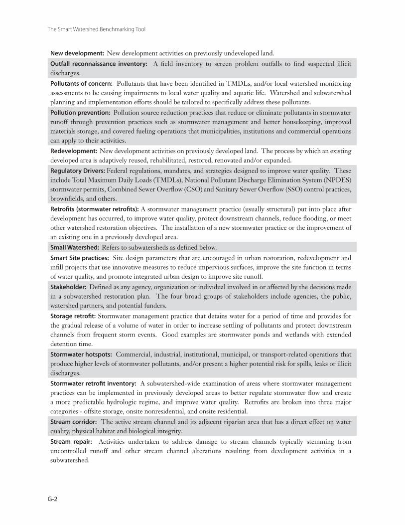
The Smart Watershed Benchmarking Tool
G-2
New development: New development activities on previously undeveloped land.
Outfall reconnaissance inventory: A field inventory to screen problem outfalls to find suspected illicit discharges.
Pollutants of concern: Pollutants that have been identified in TMDLs, and/or local watershed monitoring assessments to be causing impairments to local water quality and aquatic life. Watershed and subwatershed planning and implementation efforts should be tailored to specifically address these pollutants.
Pollution prevention: Pollution source reduction practices that reduce or eliminate pollutants in stormwater runoff through prevention practices such as stormwater management and better housekeeping, improved materials storage, and covered fueling operations that municipalities, institutions and commercial operations can apply to their activities.
Redevelopment: New development activities on previously developed land. The process by which an existing developed area is adaptively reused, rehabilitated, restored, renovated and/or expanded.
Regulatory Drivers: Federal regulations, mandates, and strategies designed to improve water quality. These include Total Maximum Daily Loads (TMDLs), National Pollutant Discharge Elimination System (NPDES) stormwater permits, Combined Sewer Overflow (CSO) and Sanitary Sewer Overflow (SSO) control practices, brownfields, and others.
Retrofits (stormwater retrofits): A stormwater management practice (usually structural) put into place after development has occurred, to improve water quality, protect downstream channels, reduce flooding, or meet other watershed restoration objectives. The installation of a new stormwater practice or the improvement of an existing one in a previously developed area.
Small Watershed: Refers to subwatersheds as defined below.
Smart Site practices: Site design parameters that are encouraged in urban restoration, redevelopment and infill projects that use innovative measures to reduce impervious surfaces, improve the site function in terms of water quality, and promote integrated urban design to improve site runoff.
Stakeholder: Defined as any agency, organization or individual involved in or affected by the decisions made in a subwatershed restoration plan. The four broad groups of stakeholders include agencies, the public, watershed partners, and potential funders.
Storage retrofit: Stormwater management practice that detains water for a period of time and provides for the gradual release of a volume of water in order to increase settling of pollutants and protect downstream channels from frequent storm events. Good examples are stormwater ponds and wetlands with extended detention time.
Stormwater hotspots: Commercial, industrial, institutional, municipal, or transport-related operations that produce higher levels of stormwater pollutants, and/or present a higher potential risk for spills, leaks or illicit discharges.
Stormwater retrofit inventory: A subwatershed-wide examination of areas where stormwater management practices can be implemented in previously developed areas to better regulate stormwater flow and create a more predictable hydrologic regime, and improve water quality. Retrofits are broken into three major categories - offsite storage, onsite nonresidential, and onsite residential.
Stream corridor: The active stream channel and its adjacent riparian area that has a direct effect on water quality, physical habitat and biological integrity.
Stream repair: Activities undertaken to address damage to stream channels typically stemming from uncontrolled runoff and other stream channel alterations resulting from development activities in a subwatershed.
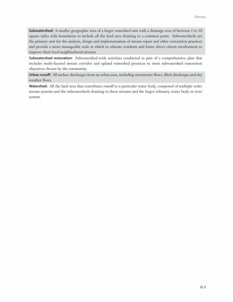
Glossary
G-3
Subwatershed: A smaller geographic area of a larger watershed unit with a drainage area of between 2 to 10 square miles with boundaries to include all the land area draining to a common point. Subwatersheds are the primary unit for the analysis, design and implementation of stream repair and other restoration practices and provide a more manageable scale at which to educate residents and foster direct citizen involvement to improve their local neighborhood streams.
Subwatershed restoration: Subwatershed-wide activities conducted as part of a comprehensive plan that includes multi-faceted stream corridor and upland watershed practices to meet subwatershed restoration objectives chosen by the community.
Urban runoff: All surface discharges from an urban area, including stormwater flows, illicit discharges and dry weather flows.
Watershed: All the land area that contributes runoff to a particular water body, composed of multiple order stream systems and the subwatersheds draining to these streams and the larger tributary, water body or river system.

The Smart Watershed Benchmarking Tool
G-4

A-1
APPENDIXASMART WATERSHED PROGRAM BUDGET WORKSHEET
Smart Watershed
Program
Operating Budget For Most Recent
Fiscal Year
Capital Improvement Program (CIP) Budget
For Most Recent Fiscal Year
Other Funding Sources
(Grants, Donated Services, Etc.)
Annual Program Totals
Program 1
Subwatershed Restoration Planning $ $ $
Program 1 Total:
$# staff (FTE) and Funding Source:
Funding Source: Funding Source: Percent of 14 Program Total:
Budget items include funding for watershed planning studies, staff costs for a watershed coor-dinator and/or planners, proportion of overall GIS budget allocated to watershed programs.
Program 2
Stream and Subwatershed Field Assessment
$ $ $
Program 2 Total:
$# staff (FTE) and Funding Source:
Funding Source: Funding Source: Percent of 14 Program Total:
Budget items include funding for field staff, consultant studies for watershed assessments, field equipment.
Providing adequate financing for the 14 Smart Watershed programs is perhaps the area where most communities face their greatest challenge. The budget worksheet provides a tool for com-puting individual program and overall commu-
nity budgets for Smart Watersheds. In general, the worksheet should be filled out for the most recent fiscal year. Alternatively, you can pro-vide the average for the three most recent fiscal years.
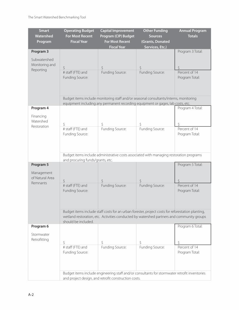
The Smart Watershed Benchmarking Tool
A-2
Smart Watershed
Program
Operating Budget For Most Recent
Fiscal Year
Capital Improvement Program (CIP) Budget
For Most Recent Fiscal Year
Other Funding Sources
(Grants, Donated Services, Etc.)
Annual Program Totals
Program 3
Subwatershed Monitoring and Reporting $ $ $
Program 3 Total:
$# staff (FTE) and Funding Source:
Funding Source: Funding Source: Percent of 14 Program Total:
Budget items include monitoring staff and/or seasonal consultants/interns, monitoring equipment including any permanent recording equipment or gages, lab costs, etc.
Program 4
Financing Watershed Restoration $ $ $
Program 4 Total:
$# staff (FTE) and Funding Source:
Funding Source: Funding Source: Percent of 14 Program Total:
Budget items include administrative costs associated with managing restoration programs and procuring funds/grants, etc.
Program 5
Management of Natural Area Remnants $ $ $
Program 5 Total:
$# staff (FTE) and Funding Source:
Funding Source: Funding Source: Percent of 14 Program Total:
Budget items include staff costs for an urban forester, project costs for reforestation planting, wetland restoration, etc. Activities conducted by watershed partners and community groups should be included.
Program 6
Stormwater Retrofitting
$ $ $
Program 6 Total:
$# staff (FTE) and Funding Source:
Funding Source: Funding Source: Percent of 14 Program Total:
Budget items include engineering staff and/or consultants for stormwater retrofit inventories and project design, and retrofit construction costs.
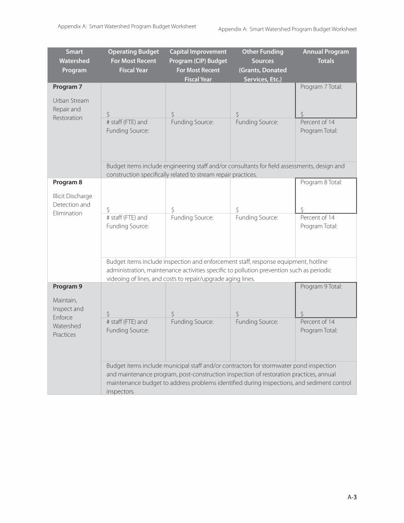
3A-3
Appendix A: Smart Watershed Program Budget WorksheetAppendix A: Smart Watershed Program Budget Worksheet
Smart Watershed
Program
Operating Budget For Most Recent
Fiscal Year
Capital Improvement Program (CIP) Budget
For Most Recent Fiscal Year
Other Funding Sources
(Grants, Donated Services, Etc.)
Annual Program Totals
Program 7
Urban Stream Repair and Restoration $ $ $
Program 7 Total:
$# staff (FTE) and Funding Source:
Funding Source: Funding Source: Percent of 14 Program Total:
Budget items include engineering staff and/or consultants for field assessments, design and construction specifically related to stream repair practices.
Program 8
Illicit Discharge Detection and Elimination $ $ $
Program 8 Total:
$# staff (FTE) and Funding Source:
Funding Source: Funding Source: Percent of 14 Program Total:
Budget items include inspection and enforcement staff, response equipment, hotline administration, maintenance activities specific to pollution prevention such as periodic videoing of lines, and costs to repair/upgrade aging lines.
Program 9
Maintain, Inspect and Enforce Watershed Practices
$ $ $
Program 9 Total:
$# staff (FTE) and Funding Source:
Funding Source: Funding Source: Percent of 14 Program Total:
Budget items include municipal staff and/or contractors for stormwater pond inspection and maintenance program, post-construction inspection of restoration practices, annual maintenance budget to address problems identified during inspections, and sediment control inspectors.
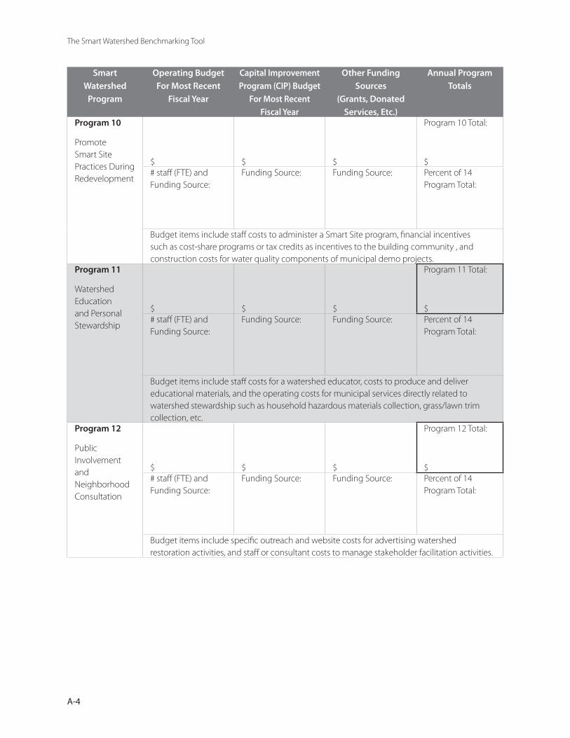
The Smart Watershed Benchmarking Tool
A-4
Smart Watershed
Program
Operating Budget For Most Recent
Fiscal Year
Capital Improvement Program (CIP) Budget
For Most Recent Fiscal Year
Other Funding Sources
(Grants, Donated Services, Etc.)
Annual Program Totals
Program 10
Promote Smart Site Practices During Redevelopment
$ $ $
Program 10 Total:
$# staff (FTE) and Funding Source:
Funding Source: Funding Source: Percent of 14 Program Total:
Budget items include staff costs to administer a Smart Site program, financial incentives such as cost-share programs or tax credits as incentives to the building community , and construction costs for water quality components of municipal demo projects.
Program 11
Watershed Education and Personal Stewardship
$ $ $
Program 11 Total:
$# staff (FTE) and Funding Source:
Funding Source: Funding Source: Percent of 14 Program Total:
Budget items include staff costs for a watershed educator, costs to produce and deliver educational materials, and the operating costs for municipal services directly related to watershed stewardship such as household hazardous materials collection, grass/lawn trim collection, etc.
Program 12
Public Involvement and Neighborhood Consultation
$ $ $
Program 12 Total:
$# staff (FTE) and Funding Source:
Funding Source: Funding Source: Percent of 14 Program Total:
Budget items include specific outreach and website costs for advertising watershed restoration activities, and staff or consultant costs to manage stakeholder facilitation activities.

5A-5
Appendix A: Smart Watershed Program Budget Worksheet
Smart Watershed
Program
Operating Budget For Most Recent
Fiscal Year
Capital Improvement Program (CIP) Budget
For Most Recent Fiscal Year
Other Funding Sources
(Grants, Donated Services, Etc.)
Annual Program Totals
Program 13
Pollution Prevention at Stormwater Hotspots
$ $ $
Program 13 Total:
$# staff (FTE) and Funding Source:
Funding Source: Funding Source: Percent of 14 Program Total:
Budget items include costs for education materials targeted to pollution hotspots such as automotive service stations, dry-cleaners, and costs for business recognition and incentive programs.
Program 14
Pollution Prevention at Municipal Operations
$ $ $
Program Total:
$# staff (FTE) and Funding Source:
Funding Source: Funding Source: Percent of 14 Program Total:
Budget items include staff costs for a pollution prevention coordinator, development and administration of P2 plans for municipal operations, spill response training and response kits, street-sweeping operations, storm drain clean-out, and construction costs for municipal operation upgrades specifically targeted to water quality improvements.
Budget Category Totals
Operating:
$
CIP:
$
Other:
$
Total Annual Budget
$Current Population: Per Capita Budget:
$Notes:
Personnel costs should be reported based on full time equivalent (FTE) units for a forty–hour week (e.g. if a staff person spends one-third of their time on watershed coordination, then show .3 FTE times a salary). If one staff person is responsible for a number of program elements, then estimate the proportion of time to be applied to the various program areas.

The Smart Watershed Benchmarking Tool
A-6
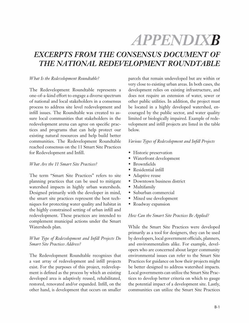
B-1
APPENDIXBEXCERPTS FROM THE CONSENSUS DOCUMENT OF
THE NATIONAL REDEVELOPMENT ROUNDTABLE
What Is the Redevelopment Roundtable?
The Redevelopment Roundtable represents a one-of-a-kind effort to engage a diverse spectrum of national and local stakeholders in a consensus process to address site level redevelopment and infill issues. The Roundtable was created to as-sure local communities that stakeholders in the redevelopment arena can agree on specific prac-tices and programs that can help protect our existing natural resources and help build better communities. The Redevelopment Roundtable reached consensus on the 11 Smart Site Practices for Redevelopment and Infill.
What Are the 11 Smart Site Practices?
The term “Smart Site Practices” refers to site planning practices that can be used to mitigate watershed impacts in highly urban watersheds. Designed primarily with the developer in mind, the smart site practices represent the best tech-niques for protecting water quality and habitat in the highly constrained setting of urban infill and redevelopment. These practices are intended to complement municipal actions under the Smart Watersheds plan.
What Type of Redevelopment and Infill Projects Do Smart Site Practices Address?
The Redevelopment Roundtable recognizes that a vast array of redevelopment and infill projects exist. For the purposes of this project, redevelop-ment is defined as the process by which an existing developed area is adaptively reused, rehabilitated, restored, renovated and/or expanded. Infill, on the other hand, is development that occurs on smaller
parcels that remain undeveloped but are within or very close to existing urban areas. In both cases, the development relies on existing infrastructure, and does not require an extension of water, sewer or other public utilities. In addition, the project must be located in a highly developed watershed, en-couraged by the public sector, and water quality limited or biologically impaired. Example of rede-velopment and infill projects are listed in the table below.
Various Types of Redevelopment and Infill Projects
Historic preservationWaterfront developmentBrownfieldsResidential infillAdaptive reuseDowntown business districtMultifamilySuburban commercialMixed use developmentRoadway expansion
How Can the Smart Site Practices Be Applied?
While the Smart Site Practices were developed primarily as a tool for designers, they can be used by developers, local government officials, planners, and environmentalists alike. For example, devel-opers who are concerned about larger community environmental issues can refer to the Smart Site Practices for guidance on how their projects might be better designed to address watershed impacts. Local governments can utilize the Smart Site Prac-tices to develop better criteria on which to gauge the potential impact of a development site. Lastly, communities can utilize the Smart Site Practices
••••••••••
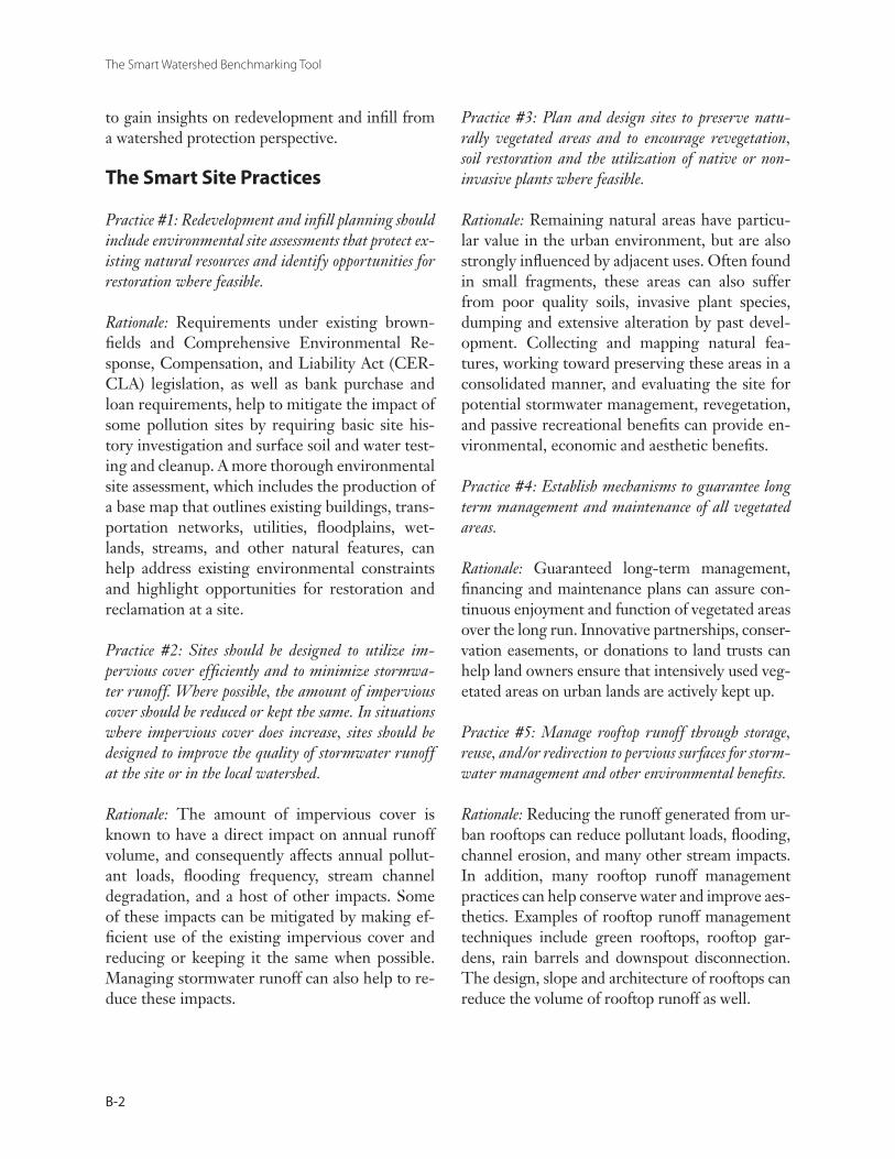
The Smart Watershed Benchmarking Tool
B-2
to gain insights on redevelopment and infill from a watershed protection perspective.
The Smart Site Practices
Practice #1: Redevelopment and infill planning should include environmental site assessments that protect ex-isting natural resources and identify opportunities for restoration where feasible.
Rationale: Requirements under existing brown-fields and Comprehensive Environmental Re-sponse, Compensation, and Liability Act (CER-CLA) legislation, as well as bank purchase and loan requirements, help to mitigate the impact of some pollution sites by requiring basic site his-tory investigation and surface soil and water test-ing and cleanup. A more thorough environmental site assessment, which includes the production of a base map that outlines existing buildings, trans-portation networks, utilities, floodplains, wet-lands, streams, and other natural features, can help address existing environmental constraints and highlight opportunities for restoration and reclamation at a site.
Practice #2: Sites should be designed to utilize im-pervious cover efficiently and to minimize stormwa-ter runoff. Where possible, the amount of impervious cover should be reduced or kept the same. In situations where impervious cover does increase, sites should be designed to improve the quality of stormwater runoff at the site or in the local watershed.
Rationale: The amount of impervious cover is known to have a direct impact on annual runoff volume, and consequently affects annual pollut-ant loads, flooding frequency, stream channel degradation, and a host of other impacts. Some of these impacts can be mitigated by making ef-ficient use of the existing impervious cover and reducing or keeping it the same when possible. Managing stormwater runoff can also help to re-duce these impacts.
Practice #3: Plan and design sites to preserve natu-rally vegetated areas and to encourage revegetation, soil restoration and the utilization of native or non-invasive plants where feasible.
Rationale: Remaining natural areas have particu-lar value in the urban environment, but are also strongly influenced by adjacent uses. Often found in small fragments, these areas can also suffer from poor quality soils, invasive plant species, dumping and extensive alteration by past devel-opment. Collecting and mapping natural fea-tures, working toward preserving these areas in a consolidated manner, and evaluating the site for potential stormwater management, revegetation, and passive recreational benefits can provide en-vironmental, economic and aesthetic benefits.
Practice #4: Establish mechanisms to guarantee long term management and maintenance of all vegetated areas.
Rationale: Guaranteed long-term management, financing and maintenance plans can assure con-tinuous enjoyment and function of vegetated areas over the long run. Innovative partnerships, conser-vation easements, or donations to land trusts can help land owners ensure that intensively used veg-etated areas on urban lands are actively kept up.
Practice #5: Manage rooftop runoff through storage, reuse, and/or redirection to pervious surfaces for storm-water management and other environmental benefits.
Rationale: Reducing the runoff generated from ur-ban rooftops can reduce pollutant loads, flooding, channel erosion, and many other stream impacts. In addition, many rooftop runoff management practices can help conserve water and improve aes-thetics. Examples of rooftop runoff management techniques include green rooftops, rooftop gar-dens, rain barrels and downspout disconnection. The design, slope and architecture of rooftops can reduce the volume of rooftop runoff as well.
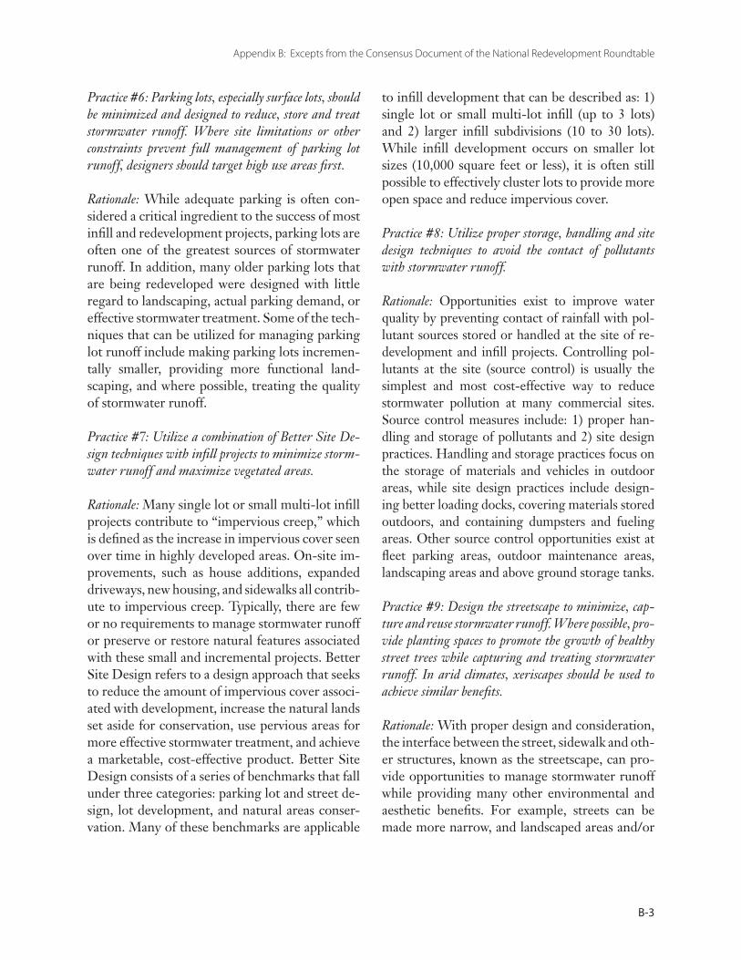
Appendix B: Excepts from the Consensus Document of the National Redevelopment Roundtable
B-3
Practice #6: Parking lots, especially surface lots, should be minimized and designed to reduce, store and treat stormwater runoff. Where site limitations or other constraints prevent full management of parking lot runoff, designers should target high use areas first.
Rationale: While adequate parking is often con-sidered a critical ingredient to the success of most infill and redevelopment projects, parking lots are often one of the greatest sources of stormwater runoff. In addition, many older parking lots that are being redeveloped were designed with little regard to landscaping, actual parking demand, or effective stormwater treatment. Some of the tech-niques that can be utilized for managing parking lot runoff include making parking lots incremen-tally smaller, providing more functional land-scaping, and where possible, treating the quality of stormwater runoff.
Practice #7: Utilize a combination of Better Site De-sign techniques with infill projects to minimize storm-water runoff and maximize vegetated areas.
Rationale: Many single lot or small multi-lot infill projects contribute to “impervious creep,” which is defined as the increase in impervious cover seen over time in highly developed areas. On-site im-provements, such as house additions, expanded driveways, new housing, and sidewalks all contrib-ute to impervious creep. Typically, there are few or no requirements to manage stormwater runoff or preserve or restore natural features associated with these small and incremental projects. Better Site Design refers to a design approach that seeks to reduce the amount of impervious cover associ-ated with development, increase the natural lands set aside for conservation, use pervious areas for more effective stormwater treatment, and achieve a marketable, cost-effective product. Better Site Design consists of a series of benchmarks that fall under three categories: parking lot and street de-sign, lot development, and natural areas conser-vation. Many of these benchmarks are applicable
to infill development that can be described as: 1) single lot or small multi-lot infill (up to 3 lots) and 2) larger infill subdivisions (10 to 30 lots). While infill development occurs on smaller lot sizes (10,000 square feet or less), it is often still possible to effectively cluster lots to provide more open space and reduce impervious cover.
Practice #8: Utilize proper storage, handling and site design techniques to avoid the contact of pollutants with stormwater runoff.
Rationale: Opportunities exist to improve water quality by preventing contact of rainfall with pol-lutant sources stored or handled at the site of re-development and infill projects. Controlling pol-lutants at the site (source control) is usually the simplest and most cost-effective way to reduce stormwater pollution at many commercial sites. Source control measures include: 1) proper han-dling and storage of pollutants and 2) site design practices. Handling and storage practices focus on the storage of materials and vehicles in outdoor areas, while site design practices include design-ing better loading docks, covering materials stored outdoors, and containing dumpsters and fueling areas. Other source control opportunities exist at fleet parking areas, outdoor maintenance areas, landscaping areas and above ground storage tanks.
Practice #9: Design the streetscape to minimize, cap-ture and reuse stormwater runoff. Where possible, pro-vide planting spaces to promote the growth of healthy street trees while capturing and treating stormwater runoff. In arid climates, xeriscapes should be used to achieve similar benefits.
Rationale: With proper design and consideration, the interface between the street, sidewalk and oth-er structures, known as the streetscape, can pro-vide opportunities to manage stormwater runoff while providing many other environmental and aesthetic benefits. For example, streets can be made more narrow, and landscaped areas and/or
The Smart Watershed Benchmarking Tool
B-4
trees can be incorporated into the street front and created so that they function to treat stormwater runoff. In addition, when tree pits are provided along with adequate soil and rooting space, street trees can provide additional stormwater capture and other numerous environmental benefits. Al-ternatively, xeriscaping (the practice of landscap-ing to conserve water) can be an important tool in more arid climates.
Practice #10: Design courtyards, plazas, and amenity open space to store, filter or treat rainfall.
Rationale: Much of the open space found in re-development and infill projects consists of hard surfaces that are impervious to rainfall. Using creative site plans, these courtyards, plazas, and other hard open spaces can be designed to store, filter and treat rainfall. Examples include the use of alternative pavers, bioretention areas, and planting boxes.
Practice #11: Design sites to maximize transportation choices in order to reduce pollution and improve air and water quality.
Rationale: Designing redevelopment and infill sites to increase connections to adjacent land uses, parks and public spaces through non-auto-motive related transportation choices (bike paths, pedestrian walkways, etc.) can improve environ-mental quality. Sites should also seek to provide links to mass transit when available, and provide commuter amenities such as bus shelters or bike racks. In addition, site designers may also wish to explore alternate pathway options for pedestrian movement, rather than the traditional sidewalk on both sides of the street.
Consensus Statement
As members of the Redevelopment Roundtable, we acknowledge the Smart Site Practices as sound and practical redevelopment and infill techniques that can help maintain natural areas, reduce the effects of stormwater runoff, and protect local
streams, lakes, wetlands and estuaries. We believe that the technical and case study information provided in these Smart Site Practices are based on sound research and encourage developers, environmental organizations, government agencies and the general public to utilize and promote the dissemination of the practices. The recommendations of the Redevelopment Roundtable reflect our professional and personal experience with redevelopment and infill and do not necessarily carry the endorsement of the organizations and agencies represented by their members.
Members of the Redevelopment and Infill Roundtable
Adrienne Bell Struever Brothers, Eccles & Rouse
Kathy Blaha Trust for Public Land
David Bulova Northern Virginia Regional Commission
Cheryl Cort Chesapeake Bay Foundation
Glenn Coyne, AICP American Planning Association
Bruce Douglas Office of Comprehensive Planning, County of Fairfax
Larry Gavan Virginia Department of Conservation and Recreation
Ed Gilliland International Economic Development Council
Ben Hamm U.S. EPA Brownfields Program
Wink Hastings National Park Service
George Holback Cho, Benn & Holback
Ed Jackson, Jr., Arch. D. The American Institute of Architects
Sven-Erik Kaiser U.S. EPA Brownfields Program
Appendix B: Excepts from the Consensus Document of the National Redevelopment Roundtable
B-5
Cheryl Kollin American Forests
Karen Lewand AIA Baltimore
Menchu Martinez Chesapeake Bay Program
Sari McLeod Wallace H. Campbell & Co., Inc
Bob McNamara National Association of Home Builders
George Middendorf Howard University
Nadejda Mishkovsky International City/County Management Association
Lisa Nisenson EPA, Office of Policy, Economics and Innovation
David O’Neill Urban Land Institute
Marolyn Parson National Association of Home Builders
Roger Platt The Real Estate Roundtable
Lynn Richards EPA, Office of Policy, Economics and Innovation
Neil Ridgely Alliance for the Chesapeake Bay
Brad Rogers 1000 Friends of Maryland
Andrea Ryon Metropolitan Washington Council of Governments
Bill Stack Baltimore Dept. of Public Works
Nancy Stoner Natural Resources Defense Council
Susan Van Buren Maryland Department of Planning
Javier Velez EPA, Office of Policy, Economics & Innovation
Susan Williams City of Baltimore Department of Planning

The Smart Watershed Benchmarking Tool
C-6
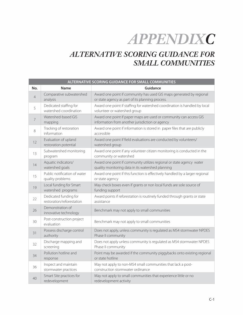
C-1
APPENDIXCALTERNATIVE SCORING GUIDANCE FOR
SMALL COMMUNITIES
ALTERNATIVE SCORING GUIDANCE FOR SMALL COMMUNITIES
No. Name Guidance
4 Comparative subwatershed analysis
Award one point if community has used GIS maps generated by regional or state agency as part of its planning process.
5Dedicated staffing for watershed coordination
Award one point if staffing for watershed coordination is handled by local volunteer or watershed group
7Watershed-based GIS mapping
Award one point if paper maps are used or community can access GIS information from another jurisdiction or agency
8Tracking of restoration information
Award one point if information is stored in paper files that are publicly accessible
12Evaluation of upland restoration potential
Award one point if field evaluations are conducted by volunteers/watershed group
13 Subwatershed monitoring program
Award one point if any volunteer citizen monitoring is conducted in the community or watershed
14Aquatic indicators/ watershed goals
Award one point if community utilizes regional or state agency water quality monitoring data in its watershed planning
15Public notification of water quality problems
Award one point if this function is effectively handled by a larger regional or state agency
19Local funding for Smart watershed programs
May check boxes even if grants or non local funds are sole source of funding support
22 Dedicated funding for restoration/reforestation
Award points if reforestation is routinely funded through grants or state assistance
26Demonstration of innovative technology
Benchmark may not apply to small communities
30Post-construction project evaluation
Benchmark may not apply to small communities
31Possess discharge control authority
Does not apply, unless community is regulated as MS4 stormwater NPDES Phase II community
32Discharge mapping and screening
Does not apply unless community is regulated as MS4 stormwater NPDES Phase II community
34Pollution hotline and response
Point may be awarded if the community piggybacks onto existing regional or state hotline
36Inspect and maintain stormwater practices
May not apply to non-MS4 small communities that lack a post-construction stormwater ordinance
40Smart Site practices for redevelopment
May not apply to small communities that experience little or no redevelopment activity
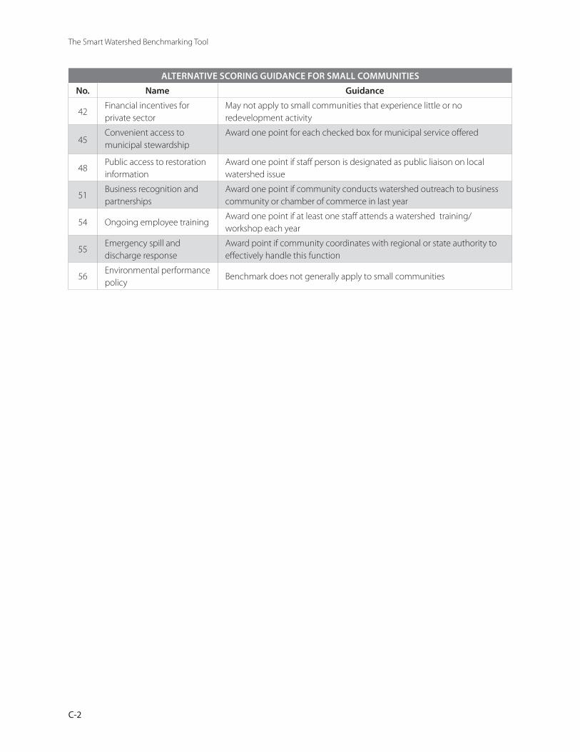
The Smart Watershed Benchmarking Tool
C-2
ALTERNATIVE SCORING GUIDANCE FOR SMALL COMMUNITIES
No. Name Guidance
42Financial incentives for private sector
May not apply to small communities that experience little or no redevelopment activity
45Convenient access to municipal stewardship
Award one point for each checked box for municipal service offered
48Public access to restoration information
Award one point if staff person is designated as public liaison on local watershed issue
51Business recognition and partnerships
Award one point if community conducts watershed outreach to business community or chamber of commerce in last year
54 Ongoing employee trainingAward one point if at least one staff attends a watershed training/workshop each year
55Emergency spill and discharge response
Award point if community coordinates with regional or state authority to effectively handle this function
56Environmental performance policy
Benchmark does not generally apply to small communities
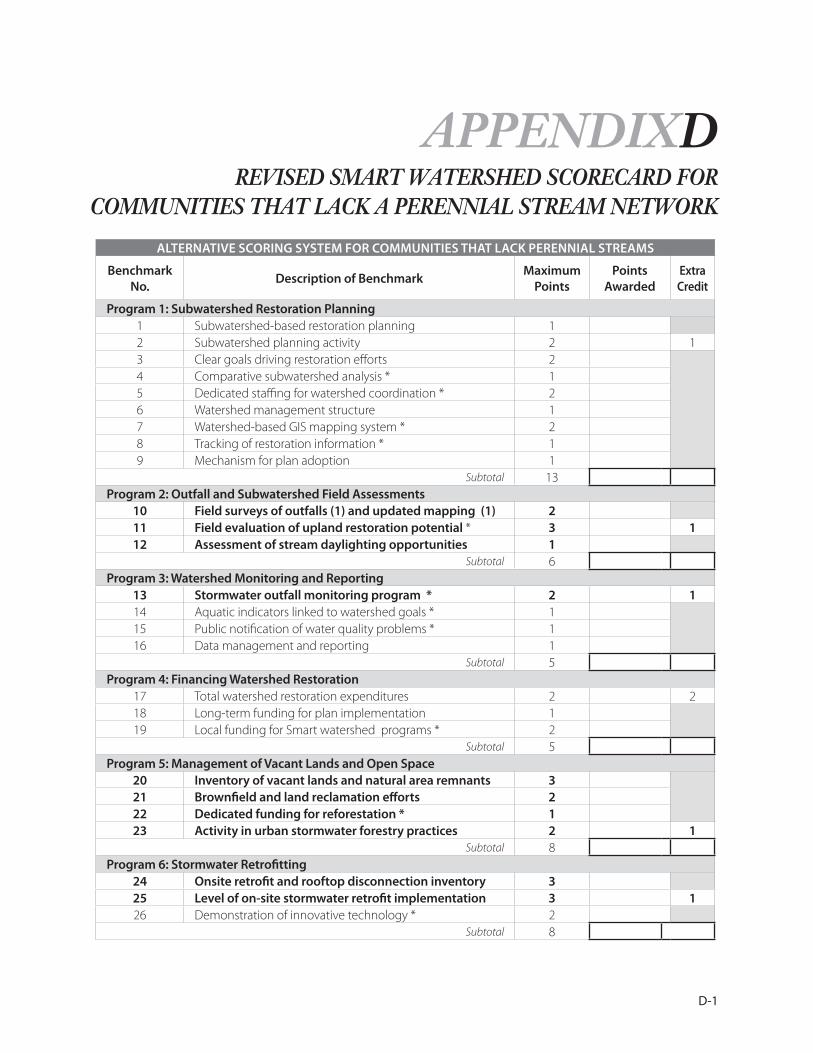
D-1
APPENDIXD
ALTERNATIVE SCORING SYSTEM FOR COMMUNITIES THAT LACK PERENNIAL STREAMS
Benchmark No.
Description of Benchmark Maximum
PointsPoints
AwardedExtra Credit
Program 1: Subwatershed Restoration Planning 1 Subwatershed-based restoration planning 12 Subwatershed planning activity 2 13 Clear goals driving restoration efforts 24 Comparative subwatershed analysis * 15 Dedicated staffing for watershed coordination * 26 Watershed management structure 17 Watershed-based GIS mapping system * 28 Tracking of restoration information * 19 Mechanism for plan adoption 1
Subtotal 13Program 2: Outfall and Subwatershed Field Assessments
10 Field surveys of outfalls (1) and updated mapping (1) 211 Field evaluation of upland restoration potential * 3 112 Assessment of stream daylighting opportunities 1
Subtotal 6Program 3: Watershed Monitoring and Reporting
13 Stormwater outfall monitoring program * 2 114 Aquatic indicators linked to watershed goals * 115 Public notification of water quality problems * 116 Data management and reporting 1
Subtotal 5Program 4: Financing Watershed Restoration
17 Total watershed restoration expenditures 2 218 Long-term funding for plan implementation 119 Local funding for Smart watershed programs * 2
Subtotal 5Program 5: Management of Vacant Lands and Open Space
20 Inventory of vacant lands and natural area remnants 321 Brownfield and land reclamation efforts 222 Dedicated funding for reforestation * 123 Activity in urban stormwater forestry practices 2 1
Subtotal 8Program 6: Stormwater Retrofitting
24 Onsite retrofit and rooftop disconnection inventory 325 Level of on-site stormwater retrofit implementation 3 126 Demonstration of innovative technology * 2
Subtotal 8
REVISED SMART WATERSHED SCORECARD FOR COMMUNITIES THAT LACK A PERENNIAL STREAM NETWORK
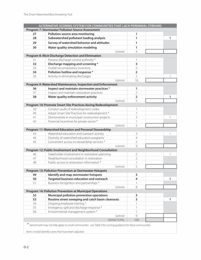
The Smart Watershed Benchmarking Tool
D-2
ALTERNATIVE SCORING SYSTEM FOR COMMUNITIES THAT LACK PERENNIAL STREAMSProgram 7: Stormwater Pollution Source Assessment
27 Pollution source area monitoring 128 Subwatershed pollutant loading analysis 1 1
29 Survey of watershed behavior and attitudes 1
30 Water quality simulation modeling 1Subtotal 4
Program 8: Illicit Discharge Detection and Elimination31 Possess discharge control authority * 132 Discharge mapping and screening * 333 Outfall reconnaissance inventory 234 Pollution hotline and response * 235 Activity in eliminating discharges 2 1
Subtotal 10Program 9: Watershed Maintenance, Inspection and Enforcement
36 Inspect and maintain stormwater practices * 137 Inspect and maintain restoration practices 238 Water quality enforcement activity 2 1
Subtotal 5 Program 10: Promote Smart Site Practices during Redevelopment
39 Conduct audit of redevelopment codes 140 Adopt Smart Site Practices for redevelopment * 141 Demonstrate in municipal construction projects 2 142 Financial incentives for private sector * 1
Subtotal 5Program 11: Watershed Education and Personal Stewardship
43 Watershed education and outreach activity 3 144 Diversity of watershed education programs 445 Convenient access to stewardship services * 2
Subtotal 9Program 12: Public Involvement and Neighborhood Consultation
46 Stakeholder involvement in restoration planning 2 147 Neighborhood consultation in restoration 248 Public access to restoration information * 1
Subtotal 5Program 13: Pollution Prevention at Stormwater Hotspots
49 Identify and map stormwater hotspots 350 Targeted business education and outreach 4 151 Business recognition and partnerships * 1
Subtotal 8Program 14: Pollution Prevention at Municipal Operations
52 Municipal pollution prevention operations 353 Routine street sweeping and catch basin cleanouts 3 154 Ongoing employee training * 155 Emergency spill and discharge response * 156 Environmental management system * 1
Subtotal 9 GRAND TOTAL 100
* benchmark may not fully apply to small communities –see Table 9 for scoring guidance for these communities
Items in bold identify scores that have been adjusted.