the space between: urban places, public spaces & tall ... space between: urban places ......
TRANSCRIPT

CTB
UH
Technical Guides Th
e Space B
etween
: Urb
an Places, Pu
blic Sp
aces & Tall B
uild
ing
s
It is becoming increasingly accepted that greater urban density is required to achieve more sustainable patterns of life, in order to reduce energy consumption and thus combat climate change. The concentration of people in denser cities – sharing space, infrastructure, and facilities – off ers much greater energy effi ciency than the expanded horizontal city, which requires more land usage as well as higher energy expenditure to facilitate infrastructure and mobility. However, the full implications of this push to greater density, especially vertical density, are not fully understood, and cities around the world – including both emerging and established skyscraper cities– are grappling with the question of how to move towards greater height and density while still maintaining a high quality of life.
As the world population continues to densify, the need for urban amenities becomes amplifi ed; cities must increasingly buff er or compensate for an expanding urban population. The development of open spaces of various scales will help off set the eff ects of neighborhoods increasingly fi lled with tall buildings. This CTBUH Technical Guide analyzes how to approach urban habitat adjoining tall buildings, highlighting case studies of open spaces at varying scales to help readers understand the ingredients that make them successful – or the lack of ingredients that holds them back from their full potential. In addition, public spaces across cities are analyzed holistically to determine how cities as an organic whole approach the concept of urban habitat.
This Technical Guide is the product of years of research by the CTBUH Urban Habitat / Urban Design Committee, which was formed to study the role of tall buildings within a city and how those tall buildings aff ect the quality of life for those that live or work within them. It is part of a series of Technical Guides that provides practical state-of-the-art technical details on specifi c areas of skyscraper research, off ering a wealth of knowledge essential for industry professionals, academic researchers, and all others interested in the relationship between skyscrapers and urban habitat.
CTBUH Technical Guides
An output of the CTBUH Urban Habitat / Urban Design Committee
The Space Between: Urban Places, Public Spaces & Tall Buildings
James Parakh, Jason Gabel & Daniel Safarik

Bibliographic Reference:Parakh, J., Gabel, J. & Safarik, D. (2017) The Space Between: Urban Places, Public Spaces & Tall Buildings: An output of the CTBUH Urban Habitat / Urban Design Committee. Chicago: Council on Tall Buildings and Urban Habitat.
Principal Authors: James Parakh, Jason Gabel & Daniel Safarik Coordinating Editor: Daniel SafarikEditorial and Directional Input: Antony WoodLayout: Liwen Kang, Kristen Dobbins & Annan Shehadi
The information contained in this guide is for educational purposes and obtained by CTBUH from sources believed to be reliable. However, neither CTBUH or its authors guarantee the accuracy or completeness of any information published herein, and neither CTBUH or its authors shall be responsible for any errors, omissions, or damages arising out of the use of this information. This work is published with the understanding that CTBUH and its authors are supplying information but are not attempting to render engineering or other professional services. The recommendations should not be used to circumvent building codes or other municipal or governmental building requirements. The recommendations are general in nature and may or may not be applicable to any particular building or any specific circumstances.
Front Cover Image: The Park at Lakeshore East, Chicago. © The Office of James BurnettOpening Chapter Image: Regent's Place Plaza, London. © British Land
© 2017 Council on Tall Buildings and Urban Habitat
Printed in the USA
The right of the Council on Tall Buildings and Urban Habitat to be identified as author of this work has been asserted by them in accordance with sections 77 and 78 of the Copyright, Designs and Patents Act 1988.
All rights reserved. No part of this book may be reprinted or reproduced or utilized in any form or by any electronic, mechanical, or other means, now known or hereafter invented, including photocopying and recording, or in any information storage or retrieval system, without permission in writing from the publishers.
Trademark notice: Product or corporate names may be trademarks or registered trademarks, and are used only for identification and explanation without intent to infringe.
Library of Congress Cataloging-in-Publication DataA catalog record has been requested for this book
ISBN 978-0-939493-57-9
CTBUH HeadquartersThe Monroe Building104 South Michigan Avenue, Suite 620 Chicago, IL 60603, USAPhone: +1 (312) 283-5599Email: [email protected] www.skyscrapercenter.com
CTBUH Asia HeadquartersCollege of Architecture and Urban Planning (CAUP)Tongji University1239 Si Ping Road, Yangpu DistrictShanghai 200092, China Phone: +86 21 65982972Email: [email protected]
CTBUH Research OfficeIuav University of Venice Dorsoduro 200630123 Venice, ItalyPhone: +39 041 257 1276 Email: [email protected]
CTBUH Academic OfficeS. R. Crown HallIllinois Institute of Technology 3360 South State StreetChicago, IL 60616Phone: +1 (312) 567 3487Email: [email protected]

Principal AuthorsJames Parakh, Chair, CTBUH Urban Habitat / Urban Design Committee
& Urban Design Manager, City of Toronto Planning DepartmentJason Gabel, Communications Manager, Council on Tall Buildings and Urban Habitat
Daniel Safarik, Senior Editor, Council on Tall Buildings and Urban Habitat
Contributors & Urban Habitat / Urban Design CommitteeDominic Bettison, Director, WilkinsonEyre
Lina Cantin, Commercial Real Estate Attorney, Colliers InternationalJosh Chaiken, Principal, Kohn Pedersen Fox Associates
Vinda Dravid, Design Engineer, Sterling EngineeringAndrew David Fassam, Senior Director, URA Singapore
Mark Lavery, Associate Director - Tall Buildings, BuroHappold EngineeringKarl Fender, Director, Fender Katsalidis Architects
Tom Ford, Infill NowRafael Gomes de Oliveira, Consultant, BR2 Experts
Helen Lochhead, Dean, Faculty of Built Environment, University of New South WalesPhilip Oldfield, Senior Lecturer, University of New South Wales
Swinal Samant, Senior Lecturer, National University of SingaporeSeverin Soder, Principal, Architectus
Holly Sovdi, Principal Planner, City of VancouverCaroline Stalker, Director, Archipelago Architects
Randolph Wang, Senior Urban Designer, City of OttawaRichard Wilson, City Design Director, Adrian Smith + Gordon Gill Architecture
Richard Witt, Design Principal, Quadrangle ArchitectsCaptain Zhu, Project Architect, Gensler
Contributing CompaniesCase studies in this Technical Guide were also made possible by the kind
contributions of the following companies: Aedas, British Land, CORE Architects, COX Architecture, HOK, Handel Architects, Hongkong Land, Kohn Pedersen
Fox Associates, Magellan Development Group, Mori Building, Robert A.M. Stern Architects, Jerde Partnership, The Office of James Burnett, Urban Strategies,
WilkinsonEyre, and architectsAlliance.
About CTBUH Committees
CTBUH Committees contribute to the Council in many ways, including generating / peer reviewing research outputs, judging awards, contributing data and images to our
Skyscraper Center database, and ruling on height criteria. Where a CTBUH Working Group forms for a period of time focused on a particular output (usually a publication),
a CTBUH Committee is a continual presence, focused on an essential aspect of the Council's mission – though individual committee members may change over time.
See more on other CTBUH Committees at committees.ctbuh.org
Tour Carpe Diem, Courbevoie
Regent’s Place Plaza, London
Namba Parks, Osaka
Xintiandi Hotels Plaza, Shanghai
Dubai Marina Waterfront Promenade, Dubai
Winter Spaces
The Park at Lakeshore East, Chicago
4
26
Preface
1.0 Introduction
2.0 Case Studies
Small Spaces
Tour Carpe Diem, Courbevoie, France
ÏCE Condominiums at York Centre, Toronto, Canada
The Forum, Hong Kong, China
Medium Spaces
Xintiandi Hotels Plaza, Shanghai, China
Regent’s Place Plaza, London, United Kingdom
Toranomon Hills, Tokyo, Japan
Chatswood Transport Interchange, Chatswood, Australia
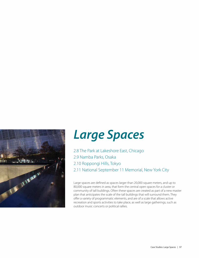
Large Spaces
The Park at Lakeshore East, Chicago, United States
Namba Parks, Osaka, Japan
Roppongi Hills, Tokyo, Japan
National September 11 Memorial, New York City, United States
Extra Large Spaces
Dubai Marina Waterfront Promenade, Dubai, United Arab Emirates
PATH System, Toronto, Canada
Marina Bay Promenade, Singapore
3.0 Walking Tours
Winter Spaces Walking Tour – January 2015
Warm Weather Spaces Walking Tour – September 2015
Twilight Spaces Walking Tour – August 2016
4.0 Conclusions and Recommendations
5.0 References
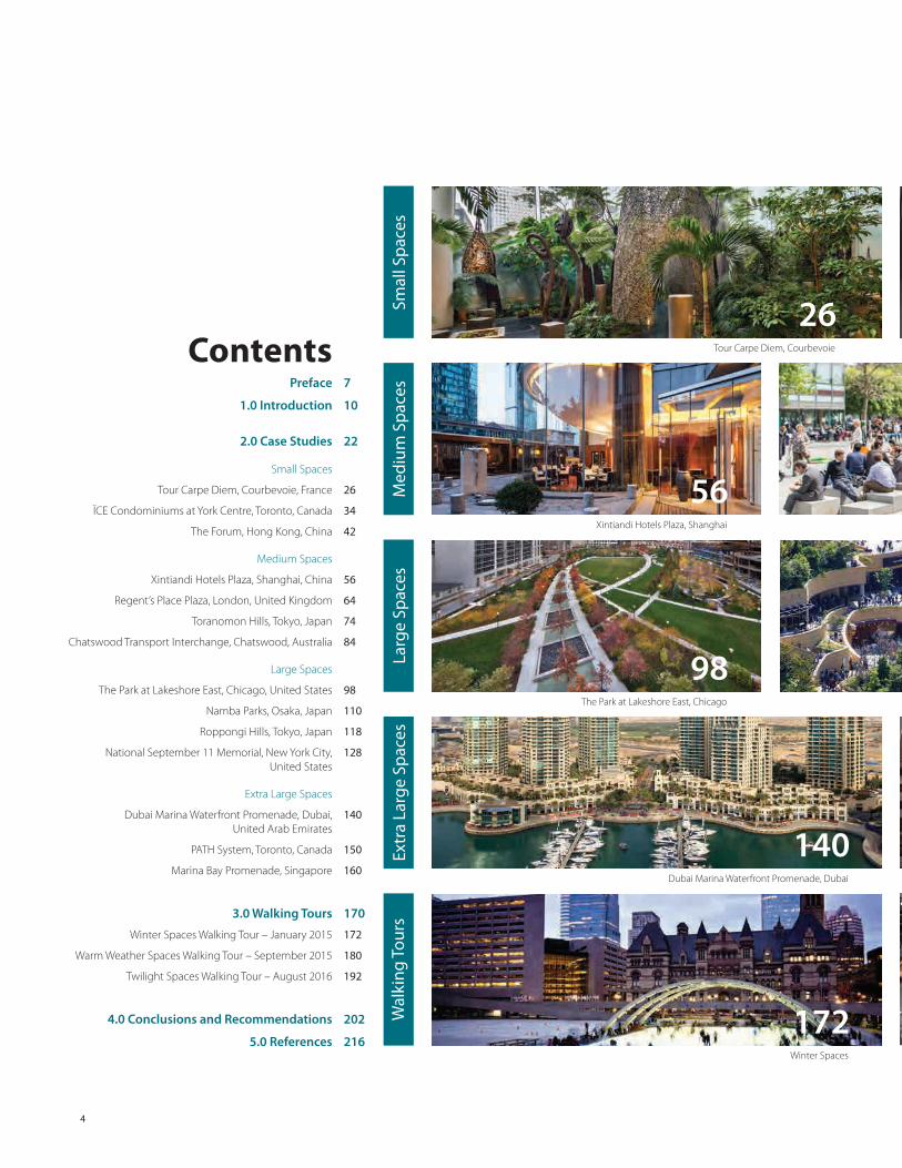
Contents
56
140
172
7
10
22
26
34
42
56
64
74
84
98
110
118
128
140
150
160
170
172
180
192
202
216
Smal
l Sp
aces
Med
ium
Sp
aces
Larg
e Sp
aces
Extr
a La
rge
Spac
esW
alki
ng T
ours
98

The Forum, Hong Kong
Toranomon Hills, Tokyo Chatswood Transport Interchange, ChatswoodRegent’s Place Plaza, London
Roppongi Hills, Tokyo National September 11 Memorial, New York CityNamba Parks, Osaka
PATH System, Toronto Marina Bay Promenade, Singapore
Warm Weather Spaces Twilight Spaces
ÏCE Condominiums at York Centre, Toronto
5
64 74 84
118 128110
150 160
180 192
4234

Preface | 7
In 2012 the CTBUH Sustainability Working Group launched Natural Ventilation in High-Rise Office Buildings, the first in a series of new CTBUH Technical Guides for those designing and building the next generation of sustainable skyscrapers. This was followed by Natural Ventilation in High-Rise Office Buildings (2012), Outrigger Design for High-Rise Buildings (2012), Wind Tunnel Testing of High-Rise Buildings (2013), Green Walls in High-Rise Buildings (2014), Outrigger Design for High-Rise Buildings – 2nd Edition (2017), etc. As that initial guide was launched, United Nations statistics portrayed a rapidly urbanizing world that was seeing an extra 200,000 people becoming urban residents every day, a pace that is projected to take us from a global population of 7 billion at 51% urbanized in 2010, to 9 billion at 70% urbanized by 2050. The need to build a new or expanded city of one million inhabitants every week seemed stark.
In the five years since the Natural Ventilation guide was launched, the pressure on our cities at every level has increased – including through the escalating manifestations of climate change itself. It has also become clear that significant urban growth is not unique to the developing world alone. In the United States, population demographics show a 0.9% population growth nationally per year over the next decade. When this is considered across 320 million people, together with the fact that this urban growth/migration is not equitable across all cities (people are migrating generally into “sun belt” from “rust belt” cities), then urban centers such as Dallas will need to cope with a 50,000-person increase year on year. So, the same question that faces many cities in developing countries such as China and India also faces many Western cities – how are these new urban inhabitants to be accommodated?
It is becoming increasingly accepted that greater urban density is required to achieve more sustainable patterns of life to reduce energy consumption and thus combat climate change. The concentration of people in denser cities – sharing space, infrastructure, and facilities – offers much greater energy efficiency than the sprawling horizontal city, which requires more land usage
Preface

8 | Preface
as well as higher energy expenditure in infrastructure and mobility. However, the full implications of this push to greater density, especially vertical density, is not fully understood, and cities around the world – including established skyscraper cities such as New York, Chicago, Shanghai, Hong Kong, and Toronto – are grappling with the question of how to move towards greater height and density while still maintaining a high quality of life for those that live within them.
As the world population continues to densify, the need for urban amenities becomes amplified; we must increasingly buffer or compensate for our expanding urban population. The development of open spaces of various scales will help offset the effects of neighborhoods increasingly filled with tall buildings. This Technical Guide highlights case studies of open spaces at varying scales, to help readers understand the ingredients that make them successful – or the lack of ingredients that holds them back from their full potential.
Our high-rise cities are primarily still made up of rectilinear, air-conditioned, glass-covered concrete and steel towers. How these towers in the sky ground themselves and animate the street, is one of the most important factors in creating a well-defined public realm, which plays a strong role in the success of our buildings and wider communities. Expanding this public realm in strategic locations with open spaces, and demonstrating how these spaces should be designed–is where this guide steps in. We have set out to show the best practices currently implemented in projects around the world, and to ask the questions and raise the issues that have come to light through this study.
We hope you enjoy reading the guide, and reflect on your own position with respect to the main factors influencing high-quality public urban spaces. The CTBUH Urban Habitat / Urban Design Committee firmly believes that this is an important part of the arsenal in moving cities towards a more fundamental “Sustainable Vertical Urbanism.”
As the world population continues to densify, the need for urban space and amenities becomes amplified; we must increasingly buffer or compensate for our expanding urban population.

12 | Introduction
Since the turn of the 19th into the 20th century, tall buildings have served as our cities’ landmarks, overreaching church spires as the dominant features on the skyline. At the same time, tall buildings became the epitome of corporate aspirations, with the Woolworth, Chrysler, Metropolitan Life and Seagram buildings in New York becoming early examples of companies using their corporate headquarters as symbols and landmarks. The Seagram was noted for its public plaza (see Figure 1.1). More recently, Petronas, Ping An, Lotte, and many other companies have used the tall building as a way of giving themselves iconic status in the world’s cities.
Today, tall buildings have become places in which not only to work, but also to live, shop, and play; the quality of life for those who occupy tall buildings and the spaces they anchor or enclose has become increasingly important. In today's sophisticated urban areas, the citizenry is putting a greater emphasis on quality of life. To achieve this, the tall building must refocus itself into something more than an icon on the skyline. The tall building must also succeed as a form of urban habitat. The concept of “urban habitat,” as applied to tall buildings, deals with the relationship of the tall building to the human scale and an assessment of the quality of life offered within, around, and between tall buildings. An inquiry into the quality of urban habitat asks these questions, among others:
How far apart do tall buildings need to be in order to maintain adequate access to light, views, and still maintain privacy? Does this distance vary from city to city? Does this vary based on the buildings’ internal uses such as office or residential? And, as is the focus of this Technical Guide, how
do tall buildings meet the street and contribute to the public realm? What are the essential ingredients needed to improve the quality of life for those who live and work in tall buildings within urban areas? What are the social and economic factors that affect these ingredients? What is the role of the tall building as a place-maker?
Although the role of the tower on the skyline may be the most obvious, the focus here is on how tall buildings contribute to the public realm by framing, creating and relating to open spaces at their base. These open/urban spaces can range from “pocket parks,” like Paley Park in New York (see Figure 1.2), to grandiose spaces such as Dubai's Burj Khalifa Lake. They are rendered at varying scales that serve a multitude of functions, and are most successful when they are executed at a scale and in the context appropriate to their cities.
Format of This Guide
The way in which tall buildings meet the ground, and the open spaces they define, are important considerations in the overall design of high-rise developments and the surrounding neighborhoods. Through this guide, the CTBUH Urban Habitat / Urban Design Committee hopes to raise awareness of these issues. The format for the guide is intended to demonstrate important place-making principles by way of case studies. These case studies demonstrate best practices from around the world and are organized by scale (“small,” “medium,” “large,” and “extra-large”). The case studies were selected because they contain successful ingredients that could be replicated in other cities, to help improve the quality of the urban habitat. The individual examples are reviewed using the following common criteria, to better understand how each of these can be helpful in fostering successful public space.
Introduction
5Figure 1.1: Seagram Building Plaza, New York. © Teri Tynes (cc-by-sa)

Introduction | 13
The criteria are expressed in two major ways. First, they appear as short bullet points on the far left and far right columns of each page spread at the beginning of a case study. These include general information, geographic data, and contextual information about the surrounding urban amenities, which should enhance understanding of the space being reviewed, through the use of a common set of data points. Second, they are explored in more detail in the body of the text.
Space Types These criteria must include, firstly, an understanding of the spatial characteristics and classifications. Is the space typology a Park, Plaza, Space Network, or Indoor / Outdoor Space?
Parks are defined in this guide as urban spaces whose predominant characteristics are: 1) having a surface area comprised of at least 50% vegetation and 2) purpose-designed for recreation. Parks provide much-needed green space in the urban context and help improve the physical environment. Parks also offer a variety of amenities that help improve the quality of life for those that live and work near them. Playgrounds, dog off-leash areas, and large fields for sports activities are all essential ingredients that are often found in suburban parks, and which new urban developments have had to adopt in order to attract families to the area. In this guide, The Park at Lakeshore East, Chicago (see Case Study 2.8, p. 98), is studied in detail; it is illustrative of an amenity shared by a neighborhood consisting largely of residential tall buildings. Unlike its more famous neighbor Millennium Park, a few blocks away, the Park at Lakeshore East has been designed as a neighborhood-scale asset, whereas the former has become internationally famous as a citywide amenity. These scalar distinctions
are explained in the Classification subsection (see p. 16).
Plazas are typically predominantly hard-surfaced/hardscaped spaces (50% or more), which can be formal or informal, but have more of an urbanized atmosphere than a park. Outdoor seating is an essential ingredient in their success, and those spaces with animated edges tend to be the most successful. Public art may also help play a role in these spaces by creating a focal
point to which people are drawn (see Figure 1.3). Toronto’s ÏCE Condos (see Case Study 2.2, p. 34) and Regent’s Place Plaza in London (see Case Study 2.5, p. 64) are examples of plazas that contribute to their urban context.
Space Networks are predominantly linear spaces that primarily function to connect various other spaces, streets, or buildings. Dubai Marina Waterfront Promenade (see Case Study 2.12, p. 140) and Singapore’s Marina Bay
5Figure 1.2: Paley Park, New York. © Aleksandr Zykov (cc-by-sa)

24 | Case Studies: Small Spaces

Case Studies: Small Spaces | 25
Small Spaces2.1 Tour Carpe Diem, Courbevoie 2.2 ÏCE Condominiums at York Centre, Toronto2.3 The Forum, Hong Kong
Small spaces are spaces of approximately 5,000 square meters or less in area, which serve the public in a variety of ways. This scale of space tends to have only one program element, such as places to sit, a public art installation, or a contemplative space with greenery and landscape. These intimate but important spaces take on various forms, from pedestrian connections to destinations in and of themselves.

26
General Information
Name � Tour Carpe Diem
Location � Courbevoie, France
Space Types � Plaza � Indoor/Outdoor Space
Year of Completion � 2013
Surface Area � Site area: 5,508 m2
� Public open area: 3,988 m2
� Percentage of open space: 72% � Total hardscape: 3,487 m2 (87%) � Total softscape: 501 m2 (13%)
Ownership Status � Interior (winter garden) – POPS � Exterior (plaza) – Public
Urban Design Strategies � Provide improved pedestrian access
to and from the La Défense Esplanade � Create multiple, inviting entry points
to the tower � Establish a publicly accessible interior
green spaceAssociated Tall Buildings
� Tour Carpe Diem (166 m) � Tour Europe (110 m)

Case Study: Tour Carpe Diem, Courbevoie | 27
Background/Overview
Tour Carpe Diem is a 166-meter office building designed by Robert A.M. Stern Architects, completed in 2013 (see Figure 2.1.1). It rises in La Défense, Paris’ master-planned business district located on the western outskirts of the city, primarily in the city of Courbevoie. The business district was begun in 1958, with major additions added in waves throughout the years. It is most well known for the raised esplanade, often referred to as "the Dalle," that runs through its center, an extension of the district to the larger Axe Historique, the central axis of Paris.
Built in 1978, the raised esplanade was intended to serve as a
pedestrian-friendly area, relegating services and infrastructure, such as transit, mechanics, and waste management to underground spaces. However, time has shown that the isolation of La Défense from its surroundings, exacerbated by the discontinuity of the raised esplanade, has compromised its success as an urban environment.
Tour Carpe Diem seeks to address that discontinuity by reconnecting the Dalle to the surrounding streetscape. This is primarily achieved through the addition of a grand staircase that runs along the eastern edge of the site (see Figure 2.1.2). A second interior staircase runs parallel to the outdoor set, behind a multi-story glass curtain wall, with
Case Study 2.1
Tour Carpe DiemCourbevoie, France
Geographic/Climatic Data:
Geographic Position � Latitude 48.9°N � Longitude 2.2°E
Elevation � 35 m
Climate Classification � Köppen Cfb; Oceanic Climate – Mild
and moderately wetAverage Daytime Temperature during the Hottest Months (June, July, August)
� 19.8°CAverage Daytime Temperature during the Coldest Months (December, January, February)
� 5.4°CAnnual Average Relative Humidity
� 78%Average Monthly Precipitation
� 54.1 mmPrevailing Wind Direction
� EastAverage Wind Speed
� 4.5 m/sAnnual Average Daily Sunshine
� 4.6 hours
Other Urban Features, with Walking Distances:
Nearby Urban Amenities � Esplanade de la Défense (200 m) � Parc Diderot (300 m) � Place Charras, Parc Freudenstadt (450 m)
Nearby Major Transport Systems � Paris Metro Line 1, Esplanade de la
Défense (600 m) � Gare de La Défense Station: RER, Paris
Metro Line 1, Tramway 2, Transilien (multiple lines) (800 m)
3Figure 2.1.1: Southwest façade of Tour Carpe Diem from the raised esplanade. © Peter Aaron/Otto 5Figure 2.1.2: The central design element of Tour Carpe Diem's public realm is the large indoor/outdoor stair that connects the upper and lower levels of La Défense. © Peter Aaron/Otto

54 | Case Studies: Medium Spaces

Case Studies: Medium Spaces | 55
Medium Spaces2.4 Xintiandi Hotels Plaza, Shanghai2.5 Regent's Place Plaza, London2.6 Toranomon Hills, Tokyo 2.7 Chatswood Transport Interchange, Chatswood
Medium spaces are defined as open spaces larger than 5,000 square meters but less than 20,000 square meters. In this type of space, multiple program elements can easily coexist. These spaces often form common open spaces for two or more tall buildings, and provide amenities such as recreation equipment/fields, a variety of hard surfaces, sculpted landscaping, outdoor seating, or children's play spaces.

56
General Information
Name � Xintiandi Hotels Plaza
Location � Shanghai, China
Space Type � Plaza
Year of Completion � 2011
Surface Area � Site area: 14,646 m2
� Public open area: 7,600 m2
� Percentage of open space: 52% � Total hardscape: 6,300 m2 (83%) � Total softscape: 1,300 m2 (17%)
Ownership Status � Privately owned public space
Urban Design Strategies � Continue the scale and fabric of
the low-rise shikumen buildings of Xintiandi, through a gateway condition of tall buildings, to a major shopping and traffic thoroughfare
Associated Tall Buildings � Andaz Shanghai (98 m) � Langham Xintiandi (98 m)

Case Study: Xintiandi Hotels Plaza, Shanghai | 57
Geographic/Climatic Data:
Geographic Position � Latitude 31.2°N � Longitude 121.5°E
Elevation � 4 m
Climate Classification � Köppen Cfa; Humid subtropical
climate (Hot summer)Average Daytime Temperature during the Hottest Months (Jul – Sep)
� 29°CAverage Daytime Temperature during the Coldest Months (Dec – Feb)
� 6°CAnnual Average Relative Humidity
� 42%Average Monthly Precipitation
� 97 mmPrevailing Wind Direction
� SoutheastAverage Wind Speed
� 2.9 m/sAnnual Average Daily Sunshine
� 4.8 hours
Other Urban Features, with Walking Distances:
Nearby Urban Amenities � Taipingqiao Park (150 m) � K11 Mall & Art Gallery (150 m) � Huaihai Park (200 m) � Shanghai Museum (700 m) � Shanghai Grand Theater (820 m)
Nearby Major Transport Systems � Shanghai Subway, South Huangpi
Road Station: Line 1 (100 m) � Huaihai Road (100 m) � Nanbei Elevated Highway (100 m) � Yan’an Elevated Highway (200 m) � Shanghai Subway, Xintiandi Station:
Line 10, Line 13 (300 m)
Case Study 2.4
Xintiandi Hotels PlazaShanghai, China
Background/Overview
The two Xintiandi hotels are a part of the Taipingqiao Master Plan in Shanghai’s French Concession District, which was originally developed in 1997 by Shui On Land, to a master plan by Skidmore, Owings & Merrill. The overall development, with its mixed-use program, has been a notable success. The first phase saw the implementation of two key neighborhood amenities: a central park with man-made lake, and an adjacent open-air retail/restaurant/entertainment development known as Xintiandi, designed by Studio Shanghai / Ben Wood. The vibrancy of these two sections has made this neighborhood one of the more desirable addresses in Shanghai.
The Xintiandi development celebrates the traditional stone-arched building type known as the shikumen. Many heritage structures were faithfully rebuilt and set side-by-side with new structures that complement the old
– creating a rich fusion of traditional and contemporary styles. The architectural expression of the two Xintiandi hotels, the Langham Xintiandi and Andaz Shanghai, extend and reinterpret this melding (see Figure 2.4.1). The patterned stone facades of the hotel towers resemble Chinese screens and reflect the masonry character of the historic neighborhood, while also presenting a contemporary and distinctive impression (see Figure 2.4.2).
The tower façades meet the ground in locations where their modular expression works effectively at the pedestrian scale. The patterned walls also define the skyline identities of both towers, wrapping the simple curved hotel forms on all sides. Podium elements for each hotel establish an intermediate scale, creating street walls along the north side of the site that relate to buildings across the street. Meanwhile, along the south edge of the site, two-story pavilions were developed in response to the scale of Xintiandi across Taicang Road,
3Figure 2.4.1: Xintiandi Hotels Plaza. © H.G. Esch/KPF5Figure 2.4.2: Xintiandi fuses elements of traditional and contemporary architecture. © H.G. Esch/KPF

96 | Case Studies: Large Spaces
Case Studies: Large Spaces | 97
Large Spaces2.8 The Park at Lakeshore East, Chicago2.9 Namba Parks, Osaka2.10 Roppongi Hills, Tokyo2.11 National September 11 Memorial, New York City
Large spaces are defined as spaces larger than 20,000 square meters, and up to 80,000 square meters in area, that form the central open spaces for a cluster or community of tall buildings. Often these spaces are created as part of a new master plan that anticipates the scale of the tall buildings that will surround them. They offer a variety of programmatic elements, and are of a scale that allows active recreation and sports activities to take place, as well as large gatherings, such as outdoor music concerts or political rallies.

98
General Information
Name � The Park at Lakeshore East
Location � Chicago, United States
Space Type � Park
Year of Completion � 2005
Surface Area � Site area: 24,300 m2
� Public open area: 24,300 m2 � Percentage of open space: 100% � Total hardscape: 7,360 m2 (30%) � Total softscape: 16,940 m2 (70%)
Ownership Status � Publicly owned privately managed
spaceUrban Design Strategies
� Establish recreational space for the 11-hectare Lakeshore East development
� Provide axial connections for pedestrians traversing the development footprint
� Resolve a 7.5-meter grade transition from the south side of the site to the north
� Maximize range of uses by offering variance in openness, surface treatments, vegetation, and public features
Associated Tall Buildings � Aqua (262 m) � GEMS World Academy (47 m) � The Lancaster (99 m) � The Shoreham (137 m) � The Tides (152 m)
Case Study: The Park at Lakeshore East, Chicago | 99
Case Study 2.8
The Park at Lakeshore East Chicago, United States
Background / Overview
Lakeshore East Park is a 24,300 square-meter park centrally located in the master-planned Lakeshore East development in downtown Chicago (see Figure 2.8.1). Surrounded by numerous high-rise buildings, the majority of which are recent constructions, the space provides important benefits to one of the city's densest residential areas.
Lakeshore East was proposed by Magellan Development Group in the early 2000s, with the goal of dramatically enhancing the livability of the downtown area. Prior to construction, the site was home to a nine-hole golf course, but has since become an epicenter for high-end condominium and apartment towers. In the first phase of construction for the development in 2005, the park was completed prior to any of the nearby towers, establishing a verdant focal point whose purpose was to serve the needs of residents, visitors, and tourists alike.
The park is rectangular in plan and bound by a one-way local street that loops around the perimeter. Several curvilinear cement pathways bisect the site, providing scenic connections between nearby pedestrian access points. An assortment of trees, plants, and ground cover establishes distinct “outdoor rooms” that encourage exploration and allow moments of privacy and solitude, despite the bustling urban activity that defines the surrounding district. Three luxury residential towers have primary entrances facing inward toward the park: The Tides (152 meters tall), The
Shoreham (137 meters tall), and The Lancaster (99 meters tall). In this respect, the park functions much like a village courtyard, one that reflects the scale of the high-rises that define its boundaries. In addition to being the “front yard” of these towers, the permanence of the green space ensures the preservation of views, sunlight, and fresh air for the entire neighborhood. Units facing the space have the added benefit of an interesting visual terminus, with views looking down to the landscape below.
The podium of the neighboring Aqua building (262 meters) also includes a series of town homes facing the park along the western side of the open space. The series of porches from these homes, in addition to those of Benton Place Park homes to the southeast, give the area a feeling of being on a neighborhood street, rather than in a dense commercial core (see Figure 2.8.2).
Ownership, Operation & Maintenance
The park is subject to a unique ownership structure. Despite technically being owned by the Chicago Park District, it also receives substantial operating income from the neighboring Lakeshore East condominium buildings. These funds allow the park to achieve and maintain a high level of services and landscaping, which would have otherwise been impossible through public funds alone. The theory is that by supporting the green space, property values are enhanced for nearby towers, thereby justifying the added maintenance costs. This type of public/
Geographic/Climatic Data:
Geographic Position � Latitude 41.9°N
Longitude 87.6°WElevation
� 181 mClimate Classification
� Köppen Dfa; Hot summer humid continental climate
Average Daytime Temperature during the Hottest Months (June, July, August)
� 22°CAverage Daytime Temperature during the Coldest Months (December, January, February)
� -3.6°CAnnual Average Relative Humidity
� 69.6%Average Monthly Precipitation
� 71 mmPrevailing Wind Direction
� SouthwestAverage Wind Speed
� 4.5 m/sAnnual Average Daily Sunshine
� 7 hoursNearby Natural Features
� Lake Michigan � Chicago River
Other Urban Features, with Walking Distances:
Nearby Urban Amenities � Chicago Riverwalk (160 m) � Chicago Riverfront Trail (250 m) � Maggie Daley Park (300 m) � Millennium Park (500 m) � Pritzker Pavilion (500 m) � Grant Park (800 m)
Nearby Major Transport Systems � CTA Bus, Randolph/Columbus: 4, 60
(300 m) � Lake Shore Drive (300 m) � Metra Regional Railway, Millennium
Station: ME, SSL Lines (600 m) � CTA Subway, Washington/Wabash
Station: Brown, Green, Orange, Pink, Purple Lines (800 m)
3Figure 2.8.1: Overall view of Lakeshore East Park from northwest. © The Office of James Burnett

138 | Case Studies: Extra Large Spaces

Case Studies: Extra Large Spaces | 139
Extra Large Spaces2.12 Dubai Marina Waterfront Promenade, Dubai 2.13 PATH System, Toronto2.14 Marina Bay Promenade, Singapore
Extra large spaces are defined as those having a citywide significance, which form the central focal points of an entire region. They often are places where civic celebrations occur. Generally, they are greater than 80,000 square meters in area.

140
General Information
Name � Dubai Marina Waterfront Promenade
Location � Dubai, UAE
Space Type � Space Network
Year of Completion � Opened 2008, work ongoing
Area � Site area: 1,049,565 m2
� Public open area: 95,000 m2
� Percent of open space: 9% � Total hardscape: 90,250 m2 (95%) � Total softscape: 4,750 m2 (5%)
Ownership Status � Privately owned public space
Urban Design Strategies � Create a landscaped water feature
with a continuous promenade surrounding it
� Provide residential construction at varying scales, with shops, restaurants and entertainment facilities to enliven the public areas
Associated Tall BuildingsMore than 80 tall buildings are located near the Dubai Marina Waterfront Promenade, including:
� Al Fattan Tower (245 m) � Al Marsa Tower / Dubai Marriott Hotel and Suites (254 m)
� Al Seef Tower (215 m) � Azure Le Reve (210 m) � Blakely Tower (115 m) � Cayan Tower (306 m) � Dubai Marina Towers (116 m) � Emirates Crown (296 m) � Horizon Tower (190 m) � Marina Crown (207 m) � Marina Heights (208 m) � Marina Terrace (183 m) � Sanibel Tower (115 m) � The Torch (352 m)

Case Study: Dubai Marina Waterfront Promenade, Dubai | 141
Background/Overview
The Dubai Marina is one of the more successful urban spaces in the Emirate. It features a 3.5-km-long man-made canal at its heart, surrounded by more than 100 buildings over 100 meters tall, in various states of completion. When the entire development is complete, it will accommodate more than 120,000 people in residential towers and villas. It is located on Interchange 5 of the Sheikh Zayed Road, between Jebel Ali Port and Dubai Internet City.
In order to create the man-made marina, the developer Emaar Properties brought the waters of the Persian Gulf into the site, creating a new waterfront. More than 12% of the total land area of the development site has been devoted to a central public space lining the canal. Although much of this area is occupied by the Marina’s water surface, it also includes almost 8 kilometers of landscaped public walkways.
Upon completion, it is claimed that Dubai Marina will be the world's largest man-made marina. The current largest man-made marina in the world is Marina del Rey in Los Angeles.
The Dubai Marina Waterfront Promenade pathways are popular with pedestrians and runners throughout the day, and connect residential towers, hotels, shopping malls, restaurants, plazas and outdoor markets. The canal is home to several marinas and offers spectacular skyline views.
The first phase of Dubai Marina, which cost more than AED 1.2 billion (US$330 million) covers 10.1 hectares, which includes Dubai Marina Towers, consisting of six freehold apartment buildings.
Three of the towers are named after precious stones: Al Mass, Fairooz, and Murjan. The other three are named after Arabic scents: Mesk, Anbar, and Al Yass. The smaller-scaled villas front the water’s edge and encircle the site, providing a human scale to the development at the ground level (see Figure 2.12.1). The water-themed plan incorporates bike paths, pedestrian pathways, water taxis and marina areas for large-vessel yachting close to the residential units.
Phase II of Dubai Marina will consist of high-rise buildings clustered into a what has become known as the "Tallest Block in the World," with the majority of the buildings ranging between 250 meters and 300 meters in height. There are also several towers that rise even higher: Cayan Tower and Ocean Heights, are taller than 300 meters; Princess Tower, Marina 101, and Marina 106, all exceed 400 meters, with the Pentominium topping out at 516 meters. Thus it is important that human-scaled habitat is firmly established before the second phase completes.
Waterfront promenades add value to their respective areas and become popular destinations. Waterfront settings provide a modicum of cooling, which is important in Dubai’s nearly-year-round extreme heat. That being said, the south side of the Promende receives more shade from the towers than the north side. Throughout much of the year, the promenade is best experienced from some of the many indoor air-conditioned cafes that line the canal. During cooler months and evening hours, the Promenade is a delightful walking experience, used by many, which adds to the quality of life of Marina inhabitants and visitors (see Figure 2.12.2).
Case Study 2.12
Dubai Marina Waterfront PromenadeDubai, United Arab Emirates
Geographic/Climatic Data:
Geographic Position � Latitude 25.1°N � Longitude 55.1°E
Elevation � 2 m
Climate Classification � Köppen Bwh; Hot desert climate
Average Daytime Temperature during the Hottest Months (June, July, August)
� 34.6°CAverage Daytime Temperature during the Coldest Months (December, January, February)
� 24°CAnnual Average Relative Humidity
� 59.8%Average Monthly Precipitation
� 7.8 mmPrevailing Wind Direction
� NorthwestAverage Wind Speed
� 3.8 m/sAnnual Average Daily Sunshine
� 9.6 hoursNearby Natural Features
� Arabian Gulf
Other Urban Features & Walking Distances:
Nearby Urban Amenities � Dubai Marina Mall (on site) � Dubai Marina Yacht Club (on site) � Pier 7 Entertainment Complex (on site) � Marina Beach (500 m)
Nearby Major Transport Systems � Dubai Tram: Marina Tower Station
(70 m) � Sheikh Zayed Road (300 m) � Dubai Metro, Damac Properties
Station (350 m)
3Figure 2.12.1: Dubai Marina Towers, with Marina Walk and Marina in the foreground. © HOK Canada – Tom Arban

Despite all the information technology we have today, from Google Earth to virtual reality, there is still no better way to apprehend the urban condition than by directly experiencing the public spaces in our cities. Each year, CTBUH’s Urban Habitat / Urban Design Committee organizes a walking tour that takes place roughly simultaneously in cities around the world. The past three tours have occurred at different times of year and times of day, across numerous climatic zones. Even when the premise is the same, the experience in each city and daylight condition was different. Yet, where the relationship between tall buildings and their cities is concerned, it is possible to draw some common themes and develop a sketch understanding about what is and isn’t successful in the contemporary urban landscape. In this chapter, we provide an overview of the walking tours and draw out key lessons, relating these wherever possible to the broader themes in the guide. (See also the Twitter hashtag #CTBUHWalks and more information at www.ctbuh.org)

Winter Spaces Walking Tour | 173
before entering an interior space, providing a comfortable distance for tour participants to traverse, braving the elements before warming up. One common conclusion: Well-designed interior public spaces are vital ingredients for maintaining vitality in cold-weather cities.
Americas
In Chicago, where winters are legendarily fierce, most, but not all the outdoor spaces were enlivened only by people sprinting across them to get indoors. The concrete Federal Plaza (see Figure 3.1.1) between the 1960s Dirksen Courthouse, Kluczynski Federal Building and U.S. Post Office, and the sunken Chase Center Plaza are both problematic. The Federal Plaza was buffeted by downdrafts and squalls ricocheting off the sharp corners of the High Modernist buildings. At Chase Plaza, even though the large space is positioned on the south side of the massive 259-meter Chase Tower that anchors the block, the winter sun angle is too low to overcome the surrounding
tall buildings and warm the space. Further, concerns about liability seem to be actively preventing exploration – on the day of the visit, yellow tape roped off the entrance to the staircases that descend from the street, lest anyone slip on the ice.
By comparison, Daley Plaza, which has similar characteristics to Federal Plaza, including somber black steel buildings and a Picasso sculpture, is considerably livelier. It has a burbling fountain that, while turned off in winter, still provides edges and definition to the space, breaking up its expanse. It is the location of a winter market and the city’s official Christmas tree, and is available by permit for any number of live performances, demonstrations and events. In one of the few cases in which post-9/11 security concerns improved a public space, the anti-vehicle bollards placed in Daley Plaza now provide places to sit and take in the action.
More than 40 blocks of downtown Chicago are connected by the Pedway system of pedestrian tunnels, one level below the street, via the basements of numerous public, retail and office buildings. Though convenient for those who can decipher it, the Pedway lacks a common design theme, wayfinding is not particularly straightforward, and unpleasant “dead ends” can occur when one building shuts its portion for the night before its neighbor does. Similarly, the multilevel roadways of the Illinois Center east of Michigan Avenue provide sheltered access to those willing to negotiate labyrinthine level changes, and adjacency to underground motor and rail traffic – but the public spaces within the center suffer from this complexity.
Meanwhile, the world-famous Millennium Park just to the south provides fantastic amenities year-round, with one of the world’s best skyline
The CTBUH 7 Cities Winter Spaces Walking tour observed how interconnected spaces can be thought of as a network connecting the interior and exteriors of buildings in the city core. Chicago's Pedway, Toronto's PATH system or New York's World Trade Center / Fulton Center concourses form part of a larger pedestrian network that allows people to move between buildings in a climate-controlled environment. At the single-building level, Shanghai's Plaza 66, Ottawa's World Financial Center, Toronto's Brookfield Place Galleria and London's Canary Wharf winter gardens offer block-long interior connections that link streets and serve as amenities for their adjacent tall buildings.
In cold-weather cities where winter temperatures can routinely drop well below 0 degrees Celsius (32 degrees Fahrenheit) the addition of interior public spaces, gallerias and winter gardens forms an important part of the public realm. Most tour routes were designed to not exceed 400 meters of travel distance outside
Walking Tour 3.1
Winter Spaces Walking TourJan. 29, 2015
3Figure 3.1.1: Bank of America Winter Village at Bryant Park, New York. © Angelito Jusay 5Figure 3.1.2: Federal Plaza, Chicago. © CTBUH

204 | Conclusions and Recommendations
Perhaps the greatest critique of skyscrapers, both new and old, is that the majority fail to adequately accommodate human needs at the ground plane. Creating a vibrant urban habitat in any condition is therefore an exercise in anticipating and responding to collective human activity, such that public spaces become more than transitory – they become places in and of themselves. It follows that each of the 14 case studies in this Technical Guide sought to answer similar questions: “what would people do in the spaces?”, and perhaps more importantly, “what would people want to do?” Despite the similar inquiries, the answers were highly varied, both in size and solution (see Figure 4.1). The range of space types, sizes, and characteristics that we’ve explored throughout this guide are featured in Table 4.1 “Case Study Analysis.”
The ingredients for successful public spaces are well documented in
Conclusions and Recommendations
research literature. One needn’t look much further than the likes of Jane Jacobs and William H. Whyte to find both qualitative and quantitative justifications for considering what have now become common-sense design/programmatic elements in dense cities. Yet it’s remarkable how often this advice goes unheeded, whether through a lack of forethought, or through a lack of prioritization of the improvement of the urban habitat. The challenges are magnified somewhat when we consider the urban habitat specific to tall buildings, which represent some of the largest and most resource-intensive human endeavors ever to grace the earth. How then, in the shadows of such structures, can we cater to an intimate human scale? That is the challenge that this Technical Guide seeks to address, having analyzed a number of successful cases where skyscrapers and humans achieved harmony.
Unquestionably, the urban skyline is an advertisement for, and symbiosis of, the excitement and dynamism that major cities promise. But the premise of this Technical Guide is that, in short, this is not enough to sustain the kind of cities people actually want to live in. Experiencing a variety of spaces with differing scales, characteristics, and personalities creates a rich pedestrian experience and enhances the quality of life for citizens.
There can never be a “one-size-fits-all” paradigm for walkable urbanism and useful public space at the feet of tall buildings around the world. Indeed, to propose such a standard would be to impose, from above, the same kinds of miseries now attributed to the western world's urban-renewal schemes of the 1950s and 1960s, when the certainties of “International Style” were visited upon neighborhoods of unique character and enterprise, often with devastating effect. But from these highly variegated
5Figure 4.1: The case studies in this guide represent a range of scales from small (The Forum, Hong Kong, left) to extra-large, (Marina Bay Promenade, Singapore, right). Source: Hongkong Land (left); © chensiyuan (cc-by-sa) (right)
Conclusions and Recommendations | 205
but shared global experiences of observing cities around the world, we can draw some preliminary conclusions.
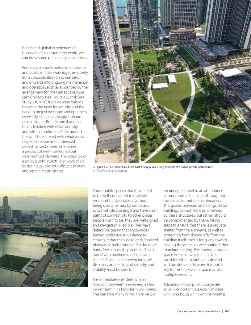
Public space works better when private and public entities work together closely from conceptualization to realization, and onwards into ongoing maintenance and operation, such as evidenced by the arrangement for The Park at Lakeshore East, Chicago. (see Figure 4.2, and Case Study 2.8, p. 98) It is a delicate balance between the need for security and the need to project welcome and openness, especially in an increasingly insecure urban climate. But it is one that must be undertaken with vision and vigor, and with commitment. Cities around the world are littered with windswept, neglected plazas and underused pedestrianized streets, oftentimes a product of well-intentioned but short-sighted planning. The presence of a single public sculpture or work of art by itself is usually not sufficient to draw and sustain return visitors.
Those public spaces that thrive tend to be well-connected to multiple modes of transportation (without being overwhelmed by ramps and active vehicle crossings) and have clear paths of connectivity to other places people want to be. They are well-signed and navigation is legible. They have defensible terrain that encourages benign, collective surveillance by citizens, rather than “dead ends,” isolated plateaus or dark corridors. On the other hand, few successful places are “blank slates” with nowhere to rest or take shelter. A balance between intrigue/discovery and feelings of security and visibility must be struck.
It is immediately evident when a “space in between” is receiving a clear investment in its long-term well-being. This can take many forms, from visible
security personnel to an abundance of programmed activities throughout the space, to routine maintenance. The spaces between and alongside tall buildings cannot feel overwhelmed by these structures, but rather, should be complimented by them. Taking steps to ensure that there is adequate shelter from the elements, as well as protection from downdrafts from the building itself, goes a long way toward making these spaces welcoming rather than intimidating. Positioning outdoor space in such a way that it collects sunshine when solar heat is desired and provides shade when it is not, is key to the success of a space across multiple seasons.
Adjoining indoor public spaces are equally important, especially in cities with long bouts of inclement weather.
5Figure 4.2: The Park at Lakeshore East, Chicago, is a strong example of a public-private partnership. © The Office of James Burnett

CTB
UH
Technical Guides Th
e Space B
etween
: Urb
an Places, Pu
blic Sp
aces & Tall B
uild
ing
s
It is becoming increasingly accepted that greater urban density is required to achieve more sustainable patterns of life, in order to reduce energy consumption and thus combat climate change. The concentration of people in denser cities – sharing space, infrastructure, and facilities – off ers much greater energy effi ciency than the expanded horizontal city, which requires more land usage as well as higher energy expenditure to facilitate infrastructure and mobility. However, the full implications of this push to greater density, especially vertical density, are not fully understood, and cities around the world – including both emerging and established skyscraper cities– are grappling with the question of how to move towards greater height and density while still maintaining a high quality of life.
As the world population continues to densify, the need for urban amenities becomes amplifi ed; cities must increasingly buff er or compensate for an expanding urban population. The development of open spaces of various scales will help off set the eff ects of neighborhoods increasingly fi lled with tall buildings. This CTBUH Technical Guide analyzes how to approach urban habitat adjoining tall buildings, highlighting case studies of open spaces at varying scales to help readers understand the ingredients that make them successful – or the lack of ingredients that holds them back from their full potential. In addition, public spaces across cities are analyzed holistically to determine how cities as an organic whole approach the concept of urban habitat.
This Technical Guide is the product of years of research by the CTBUH Urban Habitat / Urban Design Committee, which was formed to study the role of tall buildings within a city and how those tall buildings aff ect the quality of life for those that live or work within them. It is part of a series of Technical Guides that provides practical state-of-the-art technical details on specifi c areas of skyscraper research, off ering a wealth of knowledge essential for industry professionals, academic researchers, and all others interested in the relationship between skyscrapers and urban habitat.
CTBUH Technical Guides
An output of the CTBUH Urban Habitat / Urban Design Committee
The Space Between: Urban Places, Public Spaces & Tall Buildings
James Parakh, Jason Gabel & Daniel Safarik