the tea horse road guide · caravan on a cliff-cut trail the tea horse road, marked in red, began...
TRANSCRIPT

LIJIANG TO MEILI SNOW MOUNTAIN
THE TEA HORSE ROAD GUIDEPART 2

WRITTEN BY MICHAEL FREEMAN COURTESY OF LUX*

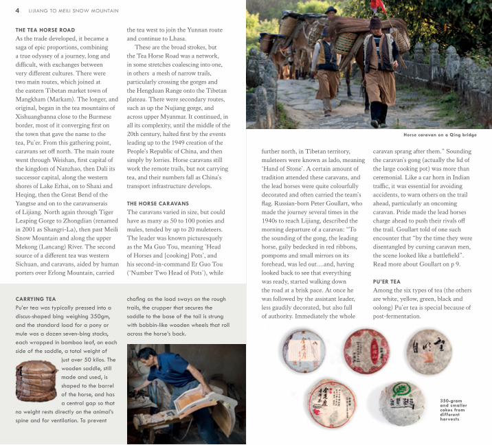
Caravan on a cliff-cut trail
The Tea Horse Road, marked in red, began in the tea mountains of Xishuangbanna and worked its way north through Yunnan to the Tibetan
Plateau, later joined by a second route from Sichuan
Lead horse in a tea caravan
2 3LIJIANG TO MEILI SNOW MOUNTAIN INTRODUCTION
INTRODUCTION
Between the 7th century and the middle of the 20th, one of the longest trade routes in the Ancient World, more than 3,000 kilometres, carried tea from its homeland in the deep south of Yunnan to Tibet. It was added to by a route from a second source, the tea mountains of Sichuan, and the combined network of stone roads and mountain trails became known as the Tea Horse Road, Cha Ma Dao. This was much more than a simple
trade route, because in return for tea, which Tibetans came quickly to crave, the Tang dynasty wanted horses for the Imperial Army. The route came under strict control, as the trading of tea for war horses became an arm of Tang foreign policy in its dealing with a neighbour that had risen from a loose collection of tribal societies to a military power on the empire’s northwestern border.
4 LIJIANG TO MEILI SNOW MOUNTAIN
CARRYING TEA
Pu’er tea was typically pressed into a discus-shaped bing weighing 350gm, and the standard load for a pony or mule was a dozen seven-bing stacks, each wrapped in bamboo leaf, on each side of the saddle, a total weight of
just over 50 kilos. The wooden saddle, still made and used, is shaped to the barrel of the horse, and has a central gap so that
no weight rests directly on the animal’s spine and for ventilation. To prevent
chafing as the load sways on the rough trails, the crupper that secures the saddle to the base of the tail is strung with bobbin-like wooden wheels that roll across the horse’s back.
THE TEA HORSE ROAD
As the trade developed, it became a saga of epic proportions, combining a true odyssey of a journey, long and difficult, with exchanges between very different cultures. There were two main routes, which joined at the eastern Tibetan market town of Mangkham (Markam). The longer, and original, began in the tea mountains of Xishuangbanna close to the Burmese border, most of it converging first on the town that gave the name to the tea, Pu’er. From this gathering point, caravans set off north. The main route went through Weishan, first capital of the kingdom of Nanzhao, then Dali its successor capital, along the western shores of Lake Erhai, on to Shaxi and Heqing, then the Great Bend of the Yangtse and on to the caravanserais of Lijiang. North again through Tiger Leaping Gorge to Zhongdian (renamed in 2001 as Shangri-La), then past Meili Snow Mountain and along the upper Mekong (Lancang) River. The second source of a different tea was western Sichuan, and caravans, aided by human porters over Erlong Mountain, carried
the tea west to join the Yunnan route and continue to Lhasa.
These are the broad strokes, but the Tea Horse Road was a network, in some stretches coalescing into one, in others a mesh of narrow trails, particularly crossing the gorges and the Hengduan Range onto the Tibetan plateau. There were secondary routes, such as up the Nujiang gorge, and across upper Myanmar. It continued, in all its complexity, until the middle of the 20th century, halted first by the events leading up to the 1949 creation of the People’s Republic of China, and then simply by lorries. Horse caravans still work the remote trails, but not carrying tea, and their numbers fall as China’s transport infrastructure develops.
THE HORSE CARAVANS
The caravans varied in size, but could have as many as 50 to 100 ponies and mules, tended by up to 20 muleteers. The leader was known picturesquely as the Ma Guo Tou, meaning ’Head of Horses and [cooking] Pots’, and his second-in-command Er Guo Tou (‘Number Two Head of Pots’), while
further north, in Tibetan territory, muleteers were known as lado, meaning ‘Hand of Stone’. A certain amount of tradition attended these caravans, and the lead horses were quite colourfully decorated and often carried the team’s flag. Russian-born Peter Goullart, who made the journey several times in the 1940s to reach Lijiang, described the morning departure of a caravan: “To the sounding of the gong, the leading horse, gaily bedecked in red ribbons, pompoms and small mirrors on its forehead, was led out….and, having looked back to see that everything was ready, started walking down the road at a brisk pace. At once he was followed by the assistant leader, less gaudily decorated, but also full of authority. Immediately the whole
caravan sprang after them.” Sounding the caravan’s gong (actually the lid of the large cooking pot) was more than ceremonial. Like a car horn in Indian traffic, it was essential for avoiding accidents, to warn others on the trail ahead, particularly an oncoming caravan. Pride made the lead horses charge ahead to push their rivals off the trail. Goullart told of one such encounter that “by the time they were disentangled by cursing caravan men, the scene looked like a battlefield”. Read more about Goullart on p 9.
PU’ER TEA
Among the six types of tea (the others are white, yellow, green, black and oolong) Pu’er tea is special because of post-fermentation.
Horse caravan on a Qing bridge
350-gram and smaller cakes from different harvests
Pressing cakes with stones
Akha Bulang Dai Hui
Bai NaxiYi Tibetan
6 LIJIANG TO MEILI SNOW MOUNTAIN 7INTRODUCTION
Other teas can also age, but for Pu’er it is an essential part of the process. Using the broad-leaved assamica variety of tea leaf (all the others in China use the smaller sinensis leaves), it comes only from the south of Yunnan. While its processing starts
in the same way as most green teas, with withering and wok firing, it continues to age slowly over the years and develops a complex flavour profile, woody and floral with notes varying from dried apricots or figs to camphor. After firing, the leaves are rolled to break the cell walls to remove moisture and to shape them, and are then spread outdoors in sunlight to dry. As loose leaves, Pu’er called is mao cha or ‘rough tea,’ and is next pressed for storage into cakes of various shapes, including the distinctive discus-shaped bing. The market for naturally aged Pu’er, known as sheng cha, is so strong that prices for cakes aged over 20 years have become astronomical — a 100-year-old 350gm bing would set you back over a million Rmb!
Because of these insane prices, and
also to reduce the astringency of young Pu’er, a process of forced fermentation (wo dui in Chinese) was developed in the 1970s. Loose mao cha is piled up in a warm humid environment and covered with bamboo mats or cloth to keep it moist and allow micro-organisms to speed up fermentation. This can be for up to a few weeks before pressing in to cakes of what is then called shu cha (‘cooked’ tea). This is dark brown, has an earthy taste when brewed that mimics aged sheng cha, and is much more affordable.
Pu’er sparked the Tibetan demand for tea, remarkable in its intensity. On average, Tibetans consume 11 kg of tea leaf annually according to a 1995 study, and they drink it in a very particular, even peculiar, manner. Across history and nations, tea has been drunk in many ways, but possibly none so extreme as bod ja, Tibetan Butter Tea. The tea is first boiled for at least an hour until thoroughly stewed, and then poured into a cylindrical churn where it is mixed by a plunger with salt, and butter from the bri (female of the yak), not uncommonly rancid. Drunk in large quantities and an essential offering of hospitality to guests, bod ja is finished off by mixing in powdered roasted barley, tsampa. For Tibetans, tea and its additions are essential nourishment in a harsh, high-altitude environment that creates high oxidative stress. This is what ultimately made tea so important to them.
There are different versions of how the Tibetans were introduced to tea. In one, Princess Wencheng, a member of the Tang dynasty court, took it with her as part of her dowry when she married the Tibetan King Songtsän Gampo in the 7th century. Another
version is that Tibet came into contact with the tea plant during its war with the southwest borderlands — what is now Yunnan — when Songtsän Gampo for the first time united Tibet into an effective kingdom, and began expansion.
A CHAIN OF CULTURES
Yunnan has long been the southwestern borderlands for China, and although the Han Dynasty made early attempts to control the region, first in 122 BC and later in 69 AD, they eventually gave up, and it wasn’t until the Ming and Qing Dynasties that it came properly under Chinese control. The southern outliers of the Himalayas, bordering Burma, Thailand and Laos, make this a difficult landscape in which to move
about, and the result has been 25 ethnic minorities within Yunnan, half of China’s total. Because the Tea Horse Road follows the grain of the land south to north, it passes through most of these. On the southern border with Burma are several hill groups, including the Akha (called Hani and Aini in Chinese), Bulang and Lahu, but the main lowland group is the Dai, around Jinghong and Simao. North from here, centred on Dali, are the Bai, and north again around Lijiang are the Naxi. In the hills particularly in the Lijiang area are Yi, in small communities although they are the largest ethnic minority in Yunnan as a whole. North again, as you’ll see when you drive up toward Shangri-La and Benzilan, are Tibetans, mainly the Khampa branch.

LIJIANG
LIJIANG IS BOTH A PREFECTURE
AND CITY, and while for most visitors it means the old quarter at its heart, it’s a sizeable town with a population of over a million. Historically, however, it began as three small settlements: first Baisha founded in 658 in the Tang Dynasty, next Shuhe shortly after, and finally Dayan, now the largest of the three. Lijiang is the centre of the Naxi people, who are believed to have migrated south from the Tibetan plateau more than a thousand years ago. Their exact origins and that of their language are still uncertain, but Naxi sacred literature, written in pictographs, refer to Mount Kailash and Lake Manasarovar, in the west of Tibet.
A LITTLE HISTORY
The Naxi first arrived in the fertile and sheltered Lijiang plain in 24 AD, and their numbers swelled until they set up their first capital in what is now Baisha in the 7th century. The first major disruption was the Mongol invasion of 1253, when Kublai Khan and his army swept south. The Naxi cooperated, helped the army cross the Yangtse River using goatskins, and were rewarded by Kublai Khan leaving their leader, Azong Aliang, in charge after the army continued south to capture Dali. A century later, the Mongol Empire lost power to the Ming Dynasty, and the Naxi again cooperated with the new rulers, gradually gaining a reputation as tough and reliable soldiers. The Ming governor gave the Naxi chieftains the name of Mu, and they became the hereditary rulers. Their palace remains at the foot of Lion Hill. Under the Ming and Qing, Naxi troops were stationed up and down central and northern
Yunnan, several times successfully fighting invading Tibetan armies, and suppressing bandits, a common threat in the rugged landscape that made it easy for them to hide.
A TRADING TOWN
Lijiang’s history is one of trade, as it’s on both the Southwest Silk Road and the Tea Horse Road. There were never any city walls, and the free flow of people and goods have made it a place and a culture that accepted outside influences, which you can see in the architecture, religious art, food and music. The narrow lanes, paved with shoes polished by constant traffic, were lined with shops and merchants, and the caravans passed straight through, even in the 1940s, as described by Peter Goullart (see below right): “Tibetan and Minkia [Bai] caravans, going and coming from the busy market town of Hoking [Heqing}, thirty miles to the south, had to pass through….and
were a terror both to pedestrians and shopkeepers. Swinging loads scraped the shelves in front of the shops, sweeping the wares into the road, and scattering the baskets and pottery ware on sale by the roadside. The polished surface of the street was like ice, and the animals, with legs spreading, would
The world’s only living hieroglyph
Dongba Shaman Female assistant
Dayan rooftops
Baisha houses
sometimes crash to the ground, causing injury to some unlucky passer-by.”
DONGBA: RELIGION,
HIEROGLYPHS AND PAPER
The Naxi religion is called Dongba (literally ‘wise man’), believed to have been strongly influenced by Tibetan Bön (which pre-dated Buddhism), and is based on the relationship between nature and man. Traditionally there were no places of worship, and depended on rituals and teachings conducted by Dongba shamans, who
alone could read and write the Dongba scriptures. The birthplace of Dongba was Bai Shui Tai (see p 22). The word is also used for the pictographic script, the world’s only living hieroglyph, called locally
Senjiulujiu. Dongba paper-making uses a local plant, ‘Adanda’ (Thymelaeaceae canescent wikstroemia) to create a mothproof and wear-resistant thick paper (see our recommended shop on p 17 for the revival of this ancient tradition).
LIJIANG
ARCHITECTURE
While their original buildings began with local stone and timber, the Naxi absorbed influences from Tibetans in the north, Bai in the south around Dali, and from Han Chinese in the east, especially from Zhejiang and Jiangsu. Most of what you see in the old town is in quadrangle courtyard style, known locally as zhi, traditionally with elaborate wooden carvings. Three houses and a front wall surrounding a central courtyard make the basic unit, wealthier families adding more courtyards
WESTERNERS IN LIJIANG
Two men, Joseph Rock and Peter Goullart, brought Naxi culture to the attention of the Western world in the 1920s, ‘30s and ‘40s.
8 9LIJIANG TO MEILI SNOW MOUNTAIN LIJIANG

Rock, an American, who arrived in 1922 and made his home in Yuhu village (see p 21) became a self-appointed Naxi scholar, writing and photographing for National Geographic in the US. Russian-born Goullart founded business co-operatives around Lijiang in the 1940s, immersed himself in Naxi life, and wrote his account in Forgotten Kingdom in 1955.
NAXI LIFESTYLE
Partly because of Lijiang’s long history as a trading town, the Naxi have for
long interacted easily and comfortably with other ethnic groups, while at the same time managing to preserve their
Naxi Falconers near Zhongyi market
NAXI CUISINE
The distinctive Naxi staples are pork, potatoes, starch jelly, mushrooms in season, and river fish. Salted and air-dried ham is a traditional specialty, either cut in strips or used in dishes such as Pipa Pork (Zhubiaorou 猪膘肉) and Three River Ham (三江火腿). Try mashed and spiced Laonai yangyu (老奶洋芋) (Granny’s Potato) or Yangyu Baba (洋芋粑粑), which are spiced and deep-fried white potato pancakes. Liangfen (literally ‘cold powder’) is the general Chinese name for starch jelly, and the most typical Naxi speciality is the greenish-grey Jidou Liangfen,
(鸡豆凉粉) made from chickpeas. June to November is mushroom season, and the most prized (and most expensive) are matsutake. Our LUX* Lijiang signature dish is Naxi Hotpot (纳西火锅), lighter and less oily than the Sichuan variety, made with local chicken, mushrooms and ham, with all the veg trimmings.
Cablecar
Impression Lijiang
Black Dragon Pool
Yuhu
Yulong (Jade Dragon) Mountain
Great Bend of the Yangtse
Jinsha (Yangtse) River
Lashi Lake
Tea Horse Road
Tea Horse Road
Tiger
Leaping G
orge
Baisha
Shuhe
Dayan
Lijiang
Shigu
own cultural identity. Tibetans from the north, Bai from the south, smaller groups like Yi in the surrounding mountains and Han traders from the east have intermingled freely. At the same time, Naxi customs have remained strong, as you can see in the evening communal dancing in Sifang (encouraged by municipal authorities for tourism but nevertheless authentic) and in such particular Naxi interests as hawking. There are an estimated thousand Naxi falconers in the town, and on any given morning, especially in the hawking season, groups of them gather to buy, sell, admire each other’s birds and talk about the craft and skills of hunting — near the market entrance in Dayan, or by the bridge called Dashiqiao, traditionally known as the ‘Hawk Market Bridge’. Several species are favoured, including the falcon and sparrow hawk, but the bird of choice here is the goshawk. Balancing an industrious life with time for leisure is an important priority, and there’s a Naxi saying, “Working as an ant while living as a butterfly.”
10 11LIJIANG TO MEILI SNOW MOUNTAIN LIJIANG

DAYAN OLD TOWN
Dayan is the name for the original old settlement of Lijiang, one of three clusters that date back over 800 years to the Southern Song Dynasty (the others are Shuhe and Baisha, to the NW respectively 6 km and 16 km). This is rightly considered one of China’s most celebrated ancient towns, the centre of Naxi culture and one of the most important trading posts along the Tea Horse Road. We’re at 2,400m here on the high Lijiang plain, with Yulong (Jade Dragon) mountain looming 25 km to the northwest, and for centuries the three settlements that make up Lijiang have been a thriving hub for trade, notably the horse caravans making their way from the tea mountains over 500 km to the south with packs of tea bound for Lhasa, while Tibetan medicines, herbs and furs came down through here from the north. Merchants from the east of China, in particular Nanjing, set up businesses and homes here,
and Lijiang’s architecture is a fusion of styles that include Han, Bai from Dali to the south, and Tibetan.
A devastating earthquake on the evening of February 3rd, 1996 destroyed a third of a million buildings, killing 300 people, but at the same time brought Dayan into the spotlight and paved the way for a reconstruction of the old town in pure Naxi style (strict building codes forbid any building other than traditional). The result is uniquely a living, vibrant town within the fabric of old winding cobbled lanes, two-storey timber-framed
Lion Hill and Wangu Tower
Lane on Lion Street
dwellings and a complex water system of streams and canals all fed by the nearby Heilong (Black Dragon) Pool. The massive local bluestones that pave the lanes, polished by use and not as slippery as they look, give a very special character to the town.
LOCATE YOURSELF
Use the map on the following page to get oriented. We’re in the south of Dayan, close to Zhongyi market. The freeform layout of winding cobbled lanes makes casual strolling a delight, and while it might seem easy to get lost, Dayan is on a walker’s scale and even if you decide to put the map away and let the pathways surprise you, before long you’ll find yourself in a known spot, such as the town square (Si Fang Street), the giant waterwheel in the north, the market in the south, or Qiyi Street that snakes NW-SE next to the Central River (go NW and it takes you to Si Fang). Keep an eye on Lion Hill, which rises on the NW side of the town, topped by the pagoda-like tower of Wangu Lou.
WE LIKE
As happens in China, there are manufactured tourist experiences vying for attention with authentic ones. These are authentic. Here’s our selection of Dayan highlights within walking distance of the hotel. See the entries further down for details.LION HILL overlook. Great view and no need to pay for itZHONGHE (CENTRAL RIVER) canal walk. The quiet side of Dayan, with willows and exquisite stone bridgesDIANA HE’S TEA HOUSE Generations of expert tea merchantsZHONGYI MARKET A real market, from fish and livestock to local copper pans
WE LIKE A LITTLE LESS
These are undeniably picturesque and significant, but marred by the usual attempts to over-organise and corral the tourists.MU RESIDENCE (木府)
For architecture enthusiasts,
the hereditary Lijiang rulers’ palace
BLACK DRAGON POOL
(黑龙潭黑龙潭) Maybe too pretty, but a
Lijiang if not a national icon, so worth
a visit. Picture postcard perfect, with all
that implies
WANGU TOWER (万古楼) On top of Lion Hill. Expensive for a view (we prefer our no-charge spot that locals use)
OUR FAVOURITE SHOPS,
FOOD AND TEA
There are indeed (and unfortunately) some pretty tacky offerings masquerading as souvenirs, but Naxi cultural integrity is also alive and well. Overleaf are our hand-picked suggestions, and at several of these we’ve also negotiated discounts for you. Retail therapy, Naxi-style. See both sides of the fold-out map.
Zhongyi Market
12 13LIJIANG TO MEILI SNOW MOUNTAIN DAYAN OLD TOWN

DAYAN’S TOP SIGHTS
LION HILL (Shizishan 狮子山)You can’t miss it, and if you’ve just arrived from a lower altitude it’s a bit of a slog, but it’s still a delightful way to rise above the tiled roofs of the ancient town and get an overview to put you in the picture, before you descend and stroll around the warren of stone-paved lanes and intricate waterway system. There are cafés and little restaurants with views, and our own favourite little overlook plaza, used by locals and student painters (see the map).
WATERWAYS AND BRIDGES
Dayan is actually a traditional hydraulic town (there are others in China, though none quite as well-organised as here), with water distributed to every dwelling through complex ancient engineering. Water flowing
SE from Jade Dragon Mountain is gathered at Black Dragon Pool (see below) a kilometre north of the town and then distributed by three small
rivers, the Central, West and East Streams, into Dayan. Side channels feed the settlement from these. In the old days, and even up to the 1950s, the hydraulics were so well thought-out that they were used to clean the old town’s streets overnight. Peter Goullart wrote, “Early in the morning the sluices of the canal which flanked the hill and was, therefore, slightly higher than the other streams flowing through the city, were opened and about a foot of water was allowed to rush through the place for an hour or so. All rubbish was swept away….” adding that “It was probably the only market-place in the whole of China which was thoroughly washed every day.”
Such an intricate water supply system demands not only civic discipline (the Naxi inhabitants maintain strict codes of behaviour to avoid sullying their precious clean waterways), but also bridges, and there are 350 of these, exquisite and varied in design, the majority of them Ming and Qing from Lijiang’s building heyday. Look out for the famous Naxi ‘three-eyed’ wells fed by this water system (see our map): arranged in tiers of three pools, the uppermost is for drinking water, the middle for washing vegetables, and the lowest for washing clothes and utensils.
DAYAN’S OLDEST TEA HOUSE
AND MERCHANTS
The family of our friend Diana He (pronounced ‘her’) have been tea merchants for generations, and are now the oldest in Dayan, and real experts. Every Spring, Diana drives the three-day journey down to Xishuangbanna in the far south of Yunnan to source the new harvest with her connoisseur’s eye and palate, and there’s no-one better
1 Taiwan Food Shop
2 Chan Yuan Ge tea shop
3 Na Zhen Restaurant
4 Na Zhen Flower Cakes
5 Jie Jie local clothing
6 Silversmiths
7 Hong Gu Handbags
8 Yak Meat Shop
9 Bunong Bell-makers
10 Dongba Paper Workshop
11 Diana He’s Tea House
12 He Haizhi Coppersmith
Bridge over Central Stream
14 LIJIANG TO MEILI SNOW MOUNTAIN
1
2
3
4
5
6
7 8
9
10
11
12
Hong Gu Handbags Yak Meat Shop
Bunong Bell-Makers
Dongba Paper Workshop
Diana He’s Tea House
He Haizhi Coppersmith
Outlook
Sifang
Yican well
3-eyed well
Hotel
Silversmiths
Jie Jie Local Clothing
Na Zhen Flower Cakes
Na Zhen Restaurant
Chan Yuan Ge Tea Shop
Taiwan Food Shop
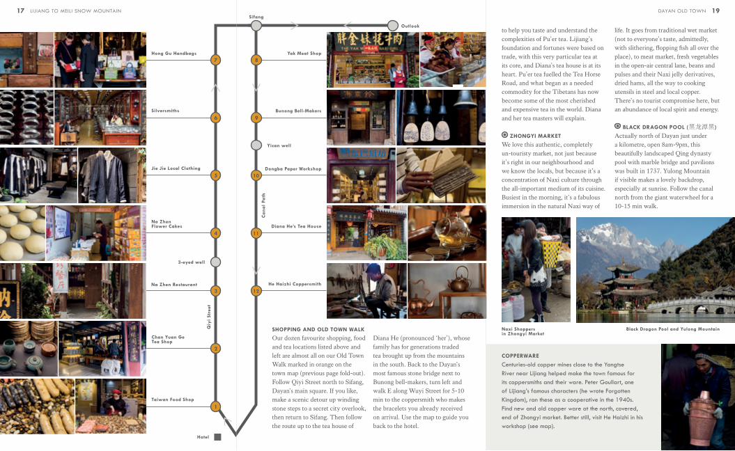
SHOPPING AND OLD TOWN WALK
Our dozen favourite shopping, food and tea locations listed above and left are almost all on our Old Town Walk marked in orange on the town map (previous page fold-out). Follow Qiyi Street north to Sifang, Dayan’s main square. If you like, make a scenic detour up winding stone steps to a secret city overlook, then return to Sifang. Then follow the route up to the tea house of
to help you taste and understand the complexities of Pu’er tea. Lijiang’s foundation and fortunes were based on trade, with this very particular tea at its core, and Diana’s tea house is at its heart. Pu’er tea fuelled the Tea Horse Road, and what began as a needed commodity for the Tibetans has now become some of the most cherished and expensive tea in the world. Diana and her tea masters will explain.
ZHONGYI MARKET
We love this authentic, completely un-touristy market, not just because it’s right in our neighbourhood and we know the locals, but because it’s a concentration of Naxi culture through the all-important medium of its cuisine. Busiest in the morning, it’s a fabulous immersion in the natural Naxi way of
life. It goes from traditional wet market (not to everyone’s taste, admittedly, with slithering, flopping fish all over the place), to meat market, fresh vegetables in the open-air central lane, beans and pulses and their Naxi jelly derivatives, dried hams, all the way to cooking utensils in steel and local copper. There’s no tourist compromise here, but an abundance of local spirit and energy.
BLACK DRAGON POOL (黑龙潭黑)
Actually north of Dayan just under a kilometre, open 8am-9pm, this beautifully landscaped Qing dynasty pool with marble bridge and pavilions was built in 1737. Yulong Mountain if visible makes a lovely backdrop, especially at sunrise. Follow the canal north from the giant waterwheel for a 10-15 min walk.
COPPERWARE
Centuries-old copper mines close to the Yangtse River near Lijiang helped make the town famous for its coppersmiths and their ware. Peter Goullart, one of Lijiang’s famous characters (he wrote Forgotten Kingdom), ran these as a cooperative in the 1940s. Find new and old copper ware at the north, covered, end of Zhongyi market. Better still, visit He Haizhi in his workshop (see map).
Naxi Shoppers in Zhongyi Market
Black Dragon Pool and Yulong Mountain
Diana He (pronounced ‘her’), whose family has for generations traded tea brought up from the mountains in the south. Back to the Dayan’s most famous stone bridge next to Bunong bell-makers, turn left and walk E along Wuyi Street for 5-10 min to the coppersmith who makes the bracelets you already received on arrival. Use the map to guide you back to the hotel.
1917 LIJIANG TO MEILI SNOW MOUNTAIN DAYAN OLD TOWN
Qiy
i St
reet
Can
al P
ath

LIJIANG SURROUNDINGS
YULONG (JADE DRAGON)
MOUNTAIN (玉龙雪山)A cluster of peaks with Shanzidou the highest at 5,596m dominate this section of the N-S Hengduan Range. Visible from Lijiang on a clear day, and about 45 min drive to the lower slopes from Dayan. There’s a cablecar ride to a viewing platform by the glacier at 4506m, and a walkway going a little higher (not always open). Depending very much on the weather, there are some good views of peaks and the glacier, but it’s expensive and you’ll be herded with the 10,000 other visitors who do this daily. The oxygen cans are a bit of a scam; oxygen’s not necessary for normally healthy people at this altitude. The lower slopes have a wide range of montane habitat with a quarter of China’s plant species. There are hiking trails in different sections, including Yak Meadow (Maoniuping), Spruce (Yunshan) Plateau and Dry Season Meadow (Ganhaizi).
IMPRESSION LIJIANG
Near the cablecar station at the foot of the mountain is an open-air theatre where China’s most famous movie
director, Zhang Yimou (Raise the Red Lantern, Hero, House of Flying Daggers, and more) has created Impression Lijiang, an epic show with a hundred horses and a cast of 500 in an open-air theatre with Jade Dragon Mountain as a backdrop. After lunch close by, enjoy VIP seats at the early afternoon hour-long performance. If you’re a photographer, it’s like having a major production exquisitely framed for your camera.
BAISHA (白沙)One of the three old communities that, together with Dayan and nearby Shuhe make up the original Naxi settlement of Lijiang, and in fact older than Dayan. Drive N from Dayan 16 km or N from Shuhe 5 km. Start at Dabaoji (Great Treasure) Palace, a temple built in 1582, to see the Baisha Murals. The surviving frescoes are unusually a fusion of Naxi, Daoist, Chinese Buddhist and Tibetan Buddhist deities and styles. Walk through the back of the temple complex to Baisha village which, apart from the main street with its cafés and shops, is very quiet. The Baisha Naxi Embroidery Institute teaches traditional silk embroidery and welcomes visitors.
SHUHE (束河)NW of Dayan (approx 10 km drive), this small town is basically a smaller, older version of Dayan, with cobbled lanes and waterways. Dating from the Tang Dynasty, it was famous for leather-working. The centre is now heavily developed with bars and
restaurants, but the 400-year-old stone Qinglong Bridge and the Jiudinglong (Dragon) Pool (九鼎潭九鼎龙潭) with its nearby Sansheng (Three Saints) Temple (束河三圣宫) and Beiquan (North Spring) Temple (北泉寺) are worth visiting.
YUHU (玉湖)Just N of Baisha is Yuhu village, distinctive for its stone building construction using what the Naxi call ‘monkey-head’ stones. Joseph Rock lived here in the ‘20s and ‘30s, preferring it to Lijiang, but there’s little to see at his small old courtyard house, now a museum.
GREAT BEND OF THE YANGTSE
25 km W of Lijiang (as the crow flies), the hard rock strata of the Hailuo Cliff force the S-flowing Yangtse to make a 140º turn to the NE. The view from the opposite hillside is impressive. The shallow waters of the river as it slows down for the wide bend made it a crossing point for Kublai Khan’s army in the 13th century, and in 1936 for the Red Army on the Long March. The small town here is Shigu (石鼓
镇); its name comes from the Stone Drum, in fact a 16th century plaque commemorating a Naxi victory over invading Tibetans. Climb up the hillside for a better view than from the village itself.
TIGER LEAPING GORGE (虎跳峡 HUTIAOXIA)About 40 km N of Lijiang (60 km driving), the Yangtse River, called here the Jinsha (Golden Sand), passes between Yulong Mountain and Haba Mountain and has cut a 15 km-long gorge that at its deepest point, river to mountain peak, is 3,790m, making it one of the world’s deepest river canyons. The rapids can be spectacular, especially during the rainy season. The Tea Horse Road used the gorge, with trails cut directly into the cliffs, still visible from the road. There are two trails, high and low, and while the entire High Trail takes two days, you can walk shorter sections.
Zhang Yimou’s Impression Lijiang
The Great Bend from Shigu
An alley in Shuhe
20 LIJIANG TO MEILI SNOW MOUNTAIN

The full High Trail hike covers 17 km on the first day, from Qiatou to Halfway Guesthouse, and 13 km on the second, from Halfway Guesthouse to Daju on the lower gorge. Day trips from Lijiang will drop you at one end of a shorter section and pick you up at the end. The Jun-Sep rainy season can be dangerous because of rockfalls.
BAI SHUI TAI (白水台)These white travertine terraces (the name means ‘white water’) were deposited by mineral-rich water flowing from a geothermal spring on the slope of Haba Mountain, and are similar to those at Mammoth Hot Springs, Yellowstone National Park, in the US. They’re considered the cradle of the Naxi’s Dongba Religion and culture, and at the spring itself a short walk up there are one or two practising Dongba priests. 3-4 hrs drive from either Lijiang or Shangri-La makes this a long day trip.
The White Terrace is the cradle of the renowned Dongba Religion of
theNaxi ethnic minority. It is situated in Baidi Village of Sanba Township (Shangri-la County), about 101 kilometers away from Shangri-la county seat. The elevation there is 2,380 meters above the sea level. A festival named “Chao Bai Shui” (pilgrimage to the white terrace) is annually held on lunar February 8th when the local Tibetans, Naxis, Bais, Lisus and so on will gather here for sacrificial ceremonies.
YAK
Massively built, up to 2m at the shoulder and with a shaggy pelt that hangs down like a black skirt, yaks are as Tibetan as butter tea, and a fixture of the landscape (as are the huge wooden racks for drying hay out of their reach). They look more like American bison that cattle, and despite their impressive size, weighing up to a metric ton, are not at all aggressive. For Tibetans, they provide milk, hair, meat and are beasts of burden. In fact, further up on the Tibetan plateau than here, at around 4,000m, they take over haulage work from horses. An old Tibetan song goes “yak’s head, eyes, intestines, down, hoof, heart become in turn sun, moon, stars, rivers, lakes, forests and mountain.” Be aware that the word comes from the Tibetan for the male, so you may get corrected with a laugh if you say ‘yak butter tea’, which would be a bit like saying ‘bull’s milk’. The female is called bri. But in fact, what you’ll see a lot more of around here is a cross-breed between yak and cattle, called dzo in Tibetan, smaller and slimmer (but that won’t stop guides calling them yak).
LIJIANG TO SHANGRI-LA
ONE OF THE MOST IMPORTANT
STAGES OF THE TEA HORSE ROAD
WAS FROM LIJIANG NORTH TO
SHANGRI-LA (ZHONGDIAN AS IT
THEN WAS). Driving route 214 takes around 3½ hrs, but in the past, the caravans took about a week, covering on average 30 km a day. The journey follows the expressway south, bound for Dali, and after skirting Lashi Lake, turns off to cross the low hills to the west and drop down to the Yangtse valley. The river is here flowing NE, a result of the Hailuo Cliff behind you that was responsible for the Great Bend of the Yangtse, and it continues in this direction for another 120 km. Up to your right is the back of Yulong Mountain, and the Tea Horse Road in fact crossed those slopes, heading north through Yi settlements on its way to Tiger Leaping Gorge. Soon
you’ll see the entrance to this 3,000 metre-deep canyon, and at the point where the river makes a sharp turn to the right to enter it (and the Tea Horse Road went), our road veers left to climb the steep winding valley of the much smaller Chongjiang River. After 40 km you reach the highest point at 3,500m where there’s a halt and a good panoramic view (weather depending), back towards 5,396m Haba Mountain that towers over Tiger Leaping Gorge beyond, and N towards your destination, the high plateau surrounding Shangri-La. From here on you’re in ethnic Tibet, and as the road descends a little you’ll see the massive house construction typical of Tibetan communities, as well as large wooden structures dotting the fields that are drying racks for barley, tall enough to keep it out of reach of cattle and yaks, and of course, you’ll see yaks themselves.
Baiji and Guishan temples, Dukezong
Haba Mountain from the road’s high point
Dongba Shaman on Baishuitai terraces
22 23LIJIANG TO MEILI SNOW MOUNTAIN LIJIANG TO SHANGRI-LA

SHANGRI-LA
You may wonder how you managed to stray into 1930s author James Hilton’s famous fantasy novel Lost Horizon, or the Oscar-winning movie version starring Ronald Colman, and you’d be right to be perplexed. The 1933 novel was a work of pure fiction, the name was made up, and the location was set deep in the high Himalayas. That didn’t stop the municipal authorities of Zhongdian (中甸), as the town was formerly known, for snapping up a great brand name in 2001. No-one else was using it, and it does add a frisson of the romantic to a place that has its own exciting legacy. For the horse caravans trekking north a few months already from the subtropical tea mountains, Zhongdian, known to Tibetans as Gyalthang (meaning Royal Plains), was the first major
settlement in ethnic Tibet and the last one before the really difficult part of the journey, negotiating the deep gorges and high passes onto the Tibet-Qinghai Plateau. Even for the tough Naxi muleteers, this was beyond their experience and at 3,200m higher than was comfortable. Dukezong, is the old town at the heart of Zhongdian (much as Dayan is to Lijiang), was the next major trading post where the loads were transferred and entrusted to the charge of the lados, as muleteers were called in Tibetan. The town is at 3,200m, which is 800m higher than Lijiang, and the altitude makes a real difference. Winters are cold but generally sunny (average temperature in January minus 3ºC), while summers cool and wet. Three-quarters of the rainfall is from June to September because the monsoon reaches this far, and the average temperature 5ºC.
Lijiang to Shangri-La
Tea Horse Road
Shika Mountain
Ringha Temple
Dabao
si Va
lley
Songzanlin Monastery
Park entrance
Bita Lake
Napahai
Shuda Lake
Pudacuo National Park
Shangri-La Lashi Lake
Jinsha (Yangtse) River
Tea Horse Road
Tea Horse Road
Tea Horse Road
Great Bend of the Yangtse
Yuhu
Yulong (Jade Dragon) Mountain
Haba Mountain
Tiger Le
aping Gorge
Baishuitai travertine terraces
Dabao
si Va
lley
Park entrance
Bita Lake
Pudacuo National Park
Baisha
Shuhe
DayanShigu
Lijiang
Shangri-La
24 25LIJIANG TO MEILI SNOW MOUNTAIN LIJIANG TO SHANGRI-LA

DUKEZONG (独克宗)Covering 1½ sq km and with about a thousand dwellings, Dukezong, is the 1300-year-old Tibetan town at the heart of Zhongdian/Shangri-La, with cobbled lanes and a central square but much smaller than Dayan in Lijiang. The Chinese name comes from the original Tibetan Semkyi Noida Dorkhar, meaning ‘Sun and Moon Town’, usually shortened to Dorkhar. Prior to 2001, it was a rather shabby settlement of rammed earth and timber buildings, though a key staging post along the Tea Horse Road. These were rebuilt in a semi-Lijiang Naxi style
during the town’s makeover, complete with romantic re-branding into Shangri-La. It has a reasonable charm, although diminished by shops selling pointless souvenirs. In January 2014 half of the buildings in the old town were destroyed by fire, but have been rebuilt in approximately the same style. The two temples were untouched.
The larger of these, on a hill by the car park entrance to the old town, is Guishan (龟山 or Turtle Hill). Its chief attraction is the world’s largest prayer wheel, Zhuangjin Tong, 21m tall, built in 2001, containing 100,000 small prayer wheels. It takes several people to get it turning. On a small hill about 15min walk west of Guishan Temple is a smaller temple known as Baijisi (百鸡寺 100-Chicken Temple), named prosaically after the numbers of chickens running around. It has quite a good, elevated view of the old town.
SHANGRI-LA SURROUNDINGS
NAPAHAI (纳帕海)Drive W out of town to circle the wetlands of Napahai, an important and complex ecosystem that changes dramatically with the seasons, covering 660 sq km and occupying the NW end of the plain, encircled by Shika, Kanbalong and Yala mountains. The combination of June-to-September monsoonal rains and meltwater runoff from the surrounding mountains causes the wetland to fill up into a lake (the ‘hai’ in Napahai means lake or sea) that covers about 23 sq km. Being on a major flyway, it attracts thousands of migratory birds seasonally. The rare Black-necked Crane (Grus nigricollis) overwinters here. Look out for other exotic migrants, like Bar-headed Geese
TIBETAN HOUSE
With many regional varieties, Tibetan houses are massive structures, built like forts, and around here they are constructed from rammed earth (that is, adobe) and heavy timber from the surrounding forests. Two and sometimes three stories high, their metre-thick walls slope inward (called a batter), making them earthquake-resistant, a necessary precaution in this geologically active part of Yunnan (see p 32). Most Tibetan house have flat roofs, although around here, at the northern edge of the monsoon belt, many have pitched roofs to cope with rain and snow. Look out for the carved and brightly painted exterior woodwork around, especially door and window frames.
The sheer size of Tibetan houses means that in villages the whole community pitches in to help build, and if you’re travelling the road in Spring you’re likely to see communal house-building with women carrying up earth and men tamping it down.
(Anser indicus), Woolly-necked Stork (Ciconia episcopus), Black Storks (Ciconia nigra), Great Cormorant (Phalacrocorax carbo), Common Merganser (Mergus merganser), Red-crested Pochard (Netta rufina) and Ruddy Shelduck (Tadorna ferruginea).
In autumn the shallow lake slowly drains, to about a fifth of its summer size, and Tibetan farmers pasture their herds of yak and flocks of horses on the wetlands, as they have for centuries, including the very horses that formed the old caravans. There’s always plenty to see here at whatever season as you skirt the foot of the hills which, to the W, rise to the 4,449m peak of Shika Mountain.
SONGZANLIN MONASTERY (松赞林寺)5 km N of town is the largest Tibetan Buddhist Lamasery in Yunnan — more than 33 hectares — Songzanlin, known in Tibetan as Ganden Sumtseling, and sometimes also called Guihua Temple. It was built in 1679 under the instructions of the Qing Dynasty Emperor Kangxi, following a revelation by the Fifth Dalai Lama, who chose the site by divination. It was architecturally modelled on the Potala Palace in
Lhasa, and is a sizeable complex, dominated by two major lamasery buildings, called Zhacang (dedicated to Sakyamuni, the historical Buddha) and Jikang (dedicated to Zongkaba, founder of the Gelugpa, or Yellow Hat Sect, who lived from 1357-1419). There are also 8 smaller lamaseries known as Kangsen, each for one of the parishes of ‘Kang’, the name for the Tibetan areas of Yunnan and Sichuan. The main halls have impressive Buddha statues and important frescoes, which include The Wheel of Life, Four Animals Living in Harmony (Si Rui He Mu Tu), the Eight Tibetan Mascots (Ba Bao Tu), among others. There’s an entrance fee and a dedicated bus from town, and at times gets rather crowded with visitors and feels a bit too much like a tourist
Black-necked Cranes in winter
Horses and Yaks in spring
26 LIJIANG TO MEILI SNOW MOUNTAIN

TIBETAN BUTTER TEA
Butter tea, drunk in quantities and at a frequency that makes it a Tibetan obsession, is a cornerstone of the Tea Horse Road. Called po cha, bod ja or ja srub ma, and by the Chinese suyou cha (酥油
茶), it’s made by blending tea with yak butter and salt, and the result is a nutritious drink that very few people other than Tibetans care to drink. First, the tea is boiled for up to an hour until thoroughly stewed, then a chunk of butter (strictly speaking, this is bri butter, as yak is the male of the species) is put into a tall cylindrical churn called a mdong mo, together with a handful of salt. The strong tea is added, and the mixture churned
with a plunger. As British writer and explorer Spencer Chapman drily put it, “The result is a
purplish liquid of unusual taste for tea, but as soup
excellent’.” You’ll be served it whenever you enter a Tibetan home, and etiquette demands that your wooden tea bowl is constantly refilled after each sip, and never left empty.
destination. No photography inside the halls. Be prepared for climbing many, many steps. There’s also a good overall view of the monastery complex against the backdrop of Foping Mountain from the main road heading N from Shangri-La to Benzilan (on the right as you round the hill, though there’s no easy stopping place).
SHIKA MOUNTAIN (石卡雪山)7km SW of Shangri-La, rising above Napahai, is 4,449m Shika Mountain. The name in local Tibetan dialect means ‘sacred place of snow’, and a 4 km-long cableway, the longest in Yunnan, makes it very accessible. The cablecar is in two stages, first to 3900m, from where there’s a 3 km forest walk to the blue-green waters of Lingxi Lake, and a second stage to 4400m. The cablecars take 30-40min if you go straight to the top, and from there you can climb to the summit along a boardwalk for another 100m walk to the peak. It’s cold and can be very windy, and only worth going in clear weather, but the panorama from the top when it is clear is spectacular. You can see Meili Snow Mountain (Kawakarpo) to the NW, Myanmar’s highest peak Hkakabo Razi a little to the left and further, and Jade Dragon Mountain nnear Lijiang to the SE.
PUDACUO (普达措)Pudacuo is China’s first National Park, created with the help of the Nature Conservancy partnering with the Chinese government. It’s a model for a new Chinese national park system and meets international standards for park management. For once, the organised restrictions, which include bussing
MUSHROOMS
800 of the world’s varieties of mushroom are found in Yunnan, and the area around Shangri-La is particularly rich. Mushroom foraging begins when the summer rains really kick in, when villagers and farmers head off to the old-growth conifer forests. July and August are the peak months. The most valuable of all are Matsutake (Tricholoma matsutake), beloved by the Japanese, who grow insufficient for their needs, and Shangri-La is the world’s largest grower of this spicy-aromatic and expensive variety, most of which is exported to Japan. Here in the markets is the cheapest you’ll ever find, but even more interesting is to go mushroom hunting with a local guide. Other mushrooms are the succulent and nutty-flavoured Boletus (aka ceps or porcino), coral fungus (ganbajun in Chinese), Tibetan Caesar (Amanita hemibapha), chanterelles, lion’s mane, sulphur shelf and other even more exotic species.
from the park entrance to the two lakes, Bita and Shudu, are for conservation reasons rather than just herding tourists, and the winding wooden boardwalks make walking around the park a pleasure. At 3,700m, Pudacuo covers marshland, alpine meadows, coniferous forests, and is genuinely an area of outstanding natural beauty. The scenery resembles parts of Yellowstone National Park (which was actually one of the models for this new park). It contains species of fish unique to here, musk deer, muntjacs, orchids, Black-necked Cranes in winter, and even a rare yew, taxus yunnanensis, whose extracts are used in many cancer drugs. The bus takes you first to Shudu Lake, which you can walk around for 3km, then to the Militang Grasslands, and finally to Bitahai (Bita Lake), surrounded by old pines and cypresses. If you do the full walks, allow an entire day.
DABAOSI (大宝寺)15km and 45min SE out of town, taking the Pudacuo road to start with, is Dabaosi valley, at the head of which is an important, though small, Tibetan temple. Ringha Temple (called Dabaosi in Chinese) was founded in the Ming Dynasty as a place of worship for the Kagyupa (White Hat) sect of Tibetan Buddhism, but was later converted to Gelugpa (Yellow Hat). This happened when the Qing emperor Kangxi founded Songzanlin Monastery, and Ringha became an affiliate of the much larger monastery. Two nearby springs are sacred, and their waters are believed to have magical powers. The valley itself is an attractive and peaceful corner of pastoral Tibetan life, growing highland barley, potatoes and turnips, with grazing yaks and horses. Here also, 1km before the temple (turn right
just before the small bridge over the stream, continue ½km, turn left at the T-junction and continue another ½km to the very end) is Caravane Liotard, run by Constantine and Phoebe Slizewicz. They run horse caravans and tented camps into the mountains, and this is the only way to really experience
28 LIJIANG TO MEILI SNOW MOUNTAIN 29LIJIANG TO SHANGRI-LA

what travelling the Tea Horse Road was actually like — with one important difference. It’s in comfort. Caravane Liotard have designed their own tents modelled on those used by Joseph Rock and other early explorers, and they’re heated! The Tibetan muleteers and their animals are all from Dabaosi village, wages are distributed fairly, and one of Caravane Liotard’s missions is, as Slizewicz puts it, “to reconnect with a muleteer tradition doomed to disappear.” They also have a fixed camp site where you can take lunch, and a cookery school.
SHANGRI-LA TO BENZILAN
Continuing N from Shangri-La, the well-graded highway with little traffic climbs into the hills for nearly an hour, and then descends to follow the winding gorge of the Yangste River, eventually reaching the small riverside town of Benzilan and the LUX* hotel. Total journey time 1½ hrs.
BENZILAN (奔子栏)The Three Parallel Rivers
The small town of Benzilan, nestled in the gorge of the Yangtse, is special despite its size. In the days of the Tea Horse Road it was famous for its strong muleteers. It still keeps its reputation for making fine lathe-turned wooden tea bowls, made from the roots of rhododendron and other trees. As for climate, it’s warmer and drier than Shangri-La (it never snows). Its location, however, is at the heart of one of the most biodiverse regions on Earth, of such importance that in 2003 it was inscribed by UNESCO to the World Heritage List. Officially called the Three Parallel Areas of Yunnan Protected Areas, it covers 1.7 million
hectares spanning the N-S gorges of the Salween (called the Nujiang in Chinese), the Mekong (Lancang in Chinese) and Yangtse (this upper section called the Jinsha, or River of Golden Sands). At one point a little N of Benzilan, only 80 km separates them from W to E. The Three Parallel Rivers has 15 protected areas in 8 clusters (see map). The dramatic topography — a whopping 6 km from highest to lowest — comes with some amazing geology, including 4 kinds of igneous rock, karst (sculpted limestone formations) and Danxia sandstone (banded red layers in steep cliffs). The combination of such extreme corrugated relief, low latitude (Benzilan is 28º, just 5º N of the Tropic of Cancer), and being within reach of the monsoons has given the Three Parallel Rivers an incredible range of ecosystems, making it probably the most biologically diverse temperate ecosystem in the world.
BIODIVERSITY HOTSPOTS
There are 35 biodiversity hotspots in the world, and the Three Parallel Rivers is one. To qualify, a hotspot needs to have a high percentage of plants found nowhere else in the world, and be under threat. The 35 areas have between them only 2.3% of the land surface but have more than half of the world’s plant species that exist nowhere else. They’re irreplaceable.
Haba Mountain
Red Mountain
Baima-MeiliMountain
Hengduan Mountains
Gaoligong Mountain
Laojun Mountain Yunling
Mountain
YUNNAN
SICHUAN
MYANMAR(BURMA)
Mekong
Mekong
Yangtse
Yangtse
Nujiang
Nujiang
Laowo Mountain
Qianhua Mountain
Tiger Leaping Gorge
Pudacuo National
Park
BairenShiyi
Niding
Balagezong entrance
Tangdu pottery village
Horseshoe Bend
Derong Rive
r
Maowu Canyon
Canyon Walk
Shika Mountain
Jinsha (Yangtse) River
Dongzhulin Monastery
Benzilan
Shangri-La
Songzanlin Monastery
30 31LIJIANG TO MEILI SNOW MOUNTAIN BENZILAN

DONGZHULIN MONASTERY (东竹林寺)20km N of Benzilan town is the important monastery of Dongzhulin, known as Dhon-Drupling in Tibetan. It was founded N of here in 1667 by Kusho Dondrub and given its name by the Fifth Dalai Lama in 1670, and was originally of the Kagyupa (White Hat) sect. As a result of the struggles with the Gelugpa (Yellow Hat) sect, it was converted to Gelugpa, and grew in size until by the late Qing Dynasty there were over 700 lamas and 10 Living Buddhas in the monastery. In 1985 it was rebuilt in its present location, on a hillside just below the main road, and the entire surrounding small village is a religious community. The grand Assembly Hall has 4 floors and 82 thick columns. Statues include a 6.8-meter-high gilded Maitreya Buddha, a 10.5-meter-high Sakyamuni, White Drolma, Buddhas of
Three Worlds, Yama (the ruler of the hell), and Manjusri, as well as 18 statues of Arhats and Thangka scroll paintings. The largest of these Thangkas is 8.5 meters long and 5.2 meters wide, and is only exhibited on the occasion of the Gedong Festival held in the 11th lunar month of the Tibetan calendar. Occasionally, sand mandalas are made on an upper floor. This is where morning prayers take place, a good time to visit. Unlike the larger and better-known Songzanlin Monastery on the outskirts of Shangri-La which is heavily organised for tourism, Dongzhulin sees few visitors, and the monks are
The Assembly Hall at Dongzhulin
MOUNTAINS, EARTHQUAKES
AND MONSOONS
All three are related. The truly spectacular mountain-and-gorge landscapes that motivated UNESCO to create the Three Parallel Rivers area come from the formation of the Himalayas themselves. Sharp peaks and jagged topography are a sure sign of young mountains, not old. What started it all was the slow crashing of the Indian continent into Eurasia 55 million years ago (that’s 1/80th the age of the Earth in case you thought it was ancient). This is ongoing, hence the
The Horseshoe Bend from viewing platform
happy to take time and explain Tibetan Buddhism to those who are interested. Make sure to return in the afternoon and attend one of the famous Gelugpa-sect debating sessions (the first of two each day for these monks). These are conducted in a very physical and highly charged debating style between pairs of monks, usually students, in which one sits and the other stands, jumps, dances, and to make his point shouts and strikes one hand with his fist. To stand in the middle of a courtyard of dozens of debating monks is an amazing experience.
SHUIBIANHE VALLEY (水边河)A few minutes drive N out of town a small road to the left takes you into the winding, pretty Shuibianhe Valley with three traditional Tibetan hamlets. The lowest is Bairen, and there it’s worth visiting the workshop of the local maker of cow bells. A few doors away, our French friend Estelle Chard has a guest house where she cooks and serves Provençale-style meals accompanied by her home-made cabernet sauvignon wine. 3 km further up is the middle hamlet, Shiyi, where you can see
another traditional Tibetan craft, making incense sticks. Another 6 km and higher is the uppermost hamlet of Niding, where it’s possible to arrange lunch or dinner in the house of the head of the village. Walk 300m along the road above Niding to a small hill with a gompa and prayer flags for a lovely view down over the valley and as far as Bala Mountain in the distance.
YANGTZE GORGE AND THE
HORSESHOE BEND
Another good drive, getting better all the time as the roads are rapidly being improved and re-surfaced, is to continue up the Yangtse gorge from Benzilan. Cross the bridge in town, which puts you in Sichuan Province, and turn left. After 3 km the road starts to make a big loop around a promontory rising high on your right. This is a spectacular horseshoe bend, and the best view of it is from high up on the other side, which you can visit on the drive from Benzilan north to Meili Snow Mountain (see p 41). Continue another 12 km to the bridge crossing to the W bank of the the Yangtse, spectacularly located where
crumpling of the Earth’s skin into mountains and gorges, and it’s full of superlatives: fastest uplift in the world, highest relief, fastest erosion, Asia’s greatest rivers and more glaciers than anywhere except the polar regions. Here in Yunnan the rivers and mountain ranges N to S, and that allows the monsoon rains from further S to push their way up and give this area summer rainfall that nourishes so many plant species. Underneath all of this are two of the Earth’s tectonic plates rubbing against each other, and the friction gives — earthquakes, a regular feature.
32 LIJIANG TO MEILI SNOW MOUNTAIN 33BENZILAN
the Derong River joins the Yangtse at a V-junction dominated by a towering pinnacle. Depending on the season, the two rivers are usually different colours (eg Yangste brown, Derong green)
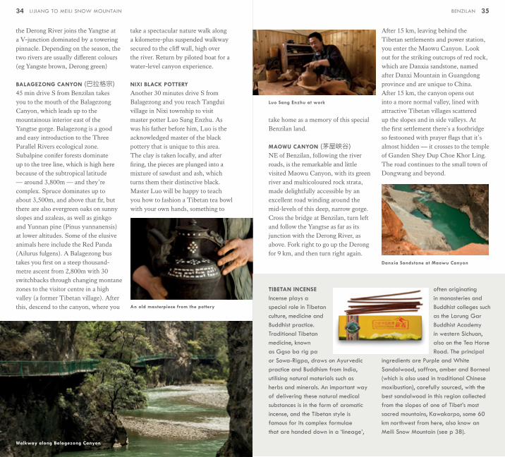
BALAGEZONG CANYON (巴拉格宗)45 min drive S from Benzilan takes you to the mouth of the Balagezong Canyon, which leads up to the mountainous interior east of the Yangtse gorge. Balagezong is a good and easy introduction to the Three Parallel Rivers ecological zone. Subalpine conifer forests dominate up to the tree line, which is high here because of the subtropical latitude — around 3,800m — and they’re complex. Spruce dominates up to about 3,500m, and above that fir, but there are also evergreen oaks on sunny slopes and azaleas, as well as ginkgo and Yunnan pine (Pinus yunnanensis) at lower altitudes. Some of the elusive animals here include the Red Panda (Ailurus fulgens). A Balagezong bus takes you first on a steep thousand-metre ascent from 2,800m with 30 switchbacks through changing montane zones to the visitor centre in a high valley (a former Tibetan village). After this, descend to the canyon, where you
take a spectacular nature walk along a kilometre-plus suspended walkway secured to the cliff wall, high over the river. Return by piloted boat for a water-level canyon experience.
NIXI BLACK POTTERY
Another 30 minutes drive S from Balagezong and you reach Tangdui village in Nixi township to visit master potter Luo Sang Enzhu. As was his father before him, Luo is the acknowledged master of the black pottery that is unique to this area. The clay is taken locally, and after firing, the pieces are plunged into a mixture of sawdust and ash, which turns them their distinctive black. Master Luo will be happy to teach you how to fashion a Tibetan tea bowl with your own hands, something to
Walkway along Balagezong Canyon
An old masterpiece from the pottery
Luo Sang Enzhu at work
TIBETAN INCENSE
Incense plays a special role in Tibetan culture, medicine and Buddhist practice. Traditional Tibetan medicine, known as Ggso ba rig pa or Sowa-Rigpa, draws on Ayurvedic practice and Buddhism from India, utilising natural materials such as herbs and minerals. An important way of delivering these natural medical substances is in the form of aromatic incense, and the Tibetan style is famous for its complex formulae that are handed down in a ‘lineage’,
often originating in monasteries and Buddhist colleges such as the Larung Gar Buddhist Academy in western Sichuan, also on the Tea Horse Road. The principal
ingredients are Purple and White Sandalwood, saffron, amber and Borneol (which is also used in traditional Chinese moxibustion), carefully sourced, with the best sandalwood in this region collected from the slopes of one of Tibet’s most sacred mountains, Kawakarpo, some 60 km northwest from here, also know an Meili Snow Mountain (see p 38).
Danxia Sandstone at Maowu Canyon
take home as a memory of this special Benzilan land.
MAOWU CANYON (茅屋峡谷)NE of Benzilan, following the river roads, is the remarkable and little visited Maowu Canyon, with its green river and multicoloured rock strata, made delightfully accessible by an excellent road winding around the mid-levels of this deep, narrow gorge. Cross the bridge at Benzilan, turn left and follow the Yangtse as far as its junction with the Derong River, as above. Fork right to go up the Derong for 9 km, and then turn right again.
After 15 km, leaving behind the Tibetan settlements and power station, you enter the Maowu Canyon. Look out for the striking outcrops of red rock, which are Danxia sandstone, named after Danxi Mountain in Guangdong province and are unique to China. After 15 km, the canyon opens out into a more normal valley, lined with attractive Tibetan villages scattered up the slopes and in side valleys. At the first settlement there’s a footbridge so festooned with prayer flags that it’s almost hidden — it crosses to the temple of Ganden Shey Dup Choe Khor Ling. The road continues to the small town of Dongwang and beyond.
34 LIJIANG TO MEILI SNOW MOUNTAIN 35BENZILAN

BENZILAN TO MEILI
The next major leg of the Tea Horse Road was from Benzilan NW to the town of Deqin and Meili Snow Mountain (Kawakarpo to Tibetans),
about 2½ hrs and 140km, crossing the divide between the catchments of the Yangtse and the Mekong. After 15 min out of Benzilan, far below and to the right of the road, the Yangtse executes an exquisitely shaped tight horseshoe bend, sometimes confusingly called the First Bend of the Yangtse (confusing because that’s the name sometimes given to the Great Bend of the Yangtse near Lijiang). For some administrative reason, tickets for the viewing point are combined with those for Feilaisi, so it’s best to visit here on the way N
to see Meili Snow Mountain. This is, in fact, an incised meander, and very much part of the story of how the Himalayas were formed. Incised meanders start with a river that’s actually flowing on flattish land, slow enough to be meandering in loops. However, if the land then starts to uplift, as happened all around here, the river keeps its shape but cuts down into the rock because it has more energy from flowing faster. Next, after 10 min, you pass Dongzhulin Monastery on the right (see p 32) and continue driving, getting higher and higher, until the pass that marks the watershed between the Yangtse and the Mekong, at 4,292m. From here, in clear weather, there are good views all around of Baima Nature Reserve, as the road cuts right through it. From here, the road winds down toward Deqin.
BAIMA NATURE RESERVE (白马雪山)Baima (White Horse) Mountain, also known as Baimang Mt. and Baimaxueshan, is the centre of a beautiful and important high-altitude protected area. With some imagination, the cluster of peaks looks like a herd of white horses, hence the name. With permanent snow over 4,000m, there are 20 peaks over 5,000m, the highest being 5,430m.
Warm valley, sparse shrub grassland
Permanent snow 4,500 m +
4,000 – 4,500 m
4,000 m
3,000 m
2,000 m
5,000 m
3,500 – 4,000 m
2,800 – 3,500 m
2,000 – 2,800 m
High mountain shrub, scree
Subalpine coniferous forest
Deciduous forest
Baima Vertical Habitats
Prayer flags at the pass
In 1983, the 180,000 hectare Baima Nature Reserve was created, to protect its primitive forests, well-layered in vertical sequence, including a well-preserved primeval frigid-zone forest, subalpine conifer forest, an exceptional azalea forest, and the rare Black snub-nosed monkey (Rhinopithecus bieti). Known locally as the Yunnan gold hair monkey (滇金丝猴), this elusive primate was first observed in the wild only in the 1990s. It lives only between the Mekong and Yangtse Rivers in the Three Parallel Rivers area, between about 3,000m and 4,500m, the highest habitat of any primate. There are about 1,500 in the Baima reserve, mainly in fir-larch forests. Other fauna include Red Panda (Ailurus fulgens), musk deer (Moschus chrysogaster), snow leopard (Panthera uncia), White eared pheasant (Crossoptilon crossoptilon). Not usually accessible between December and April because of snow blocking roads.
DEQIN (德欽)Formerly called Atuntse and well-known to the Victorian and Edwardian plant hunters (see p 38), this is the main
town of the area, but quite charmless, with nondescript, even downright ugly buildings. Drive straight through toward Feilaisi (see below) or take the lower road forking right if you’re heading for Cizhong (see p 42), or else, for the old Tea Horse Road trail to Adong, turn right into the town and drive to its northern end for the trailhead (see p 38).
FEILAISI (FEILAI TEMPLE飞来寺)The upper Mekong river road from Deqin winds around for 10 km until the view suddenly opens up of the Mekong gorge and towering above it, to the W, the sacred peaks of Kawakarpo (in Tibetan), known in Chinese as Meili Snow Mountain. Facing it on this side is the temple of Feilaisi, dating to 1614. Next to it is a large viewing area with a row of stupas and a high wall to prevent visitors from seeing the mountain without paying to enter. Drive a short distance further along the road and you can enjoy the view for free. The highly publicised view is, however, not at all guaranteed, and very unlikely during the rainy summer season. But there are many other things to do…
Tibetan hamlet near Deqin
36 37LIJIANG TO MEILI SNOW MOUNTAIN BENZILAN TO MEILI

MEILI SNOW
MOUNTAIN (梅里雪山)
WHAT’S SPECIAL
The view of the mountain peaks is what’s touted most about this area around the town of Deqin, but the really rich experiences come from trekking, which is some of the best in the world, with a wonderful variety of trails from easy to strenuous, one of them actually following the old Tea Horse Road. Valleys, gorges, Tibetan villages and monasteries, isolated gompas and a botanical paradise, this is a world-class trekking destination. If this is your thing, you’ll already be well-shod and well-equipped, but consider the time of year, as the monsoon really does reach this far north. Rains start in March, peaking in July and August, until September. March is the worst month because it’s still cold enough for snow, and of course the summer months offer the least chance of mountain views. On the other hand, there are the flowers (see The Plant Hunters below). October is fairly dry and lovely for autumn colours, while November through February offers the clearest days, even though cold.
MEKONG GORGE
For the tea caravans, the last time that the Mekong River (called here the
Lancangjiang) was in view was almost 1,000 km to the S and many weeks since they started the journey. There, in Xishuangbanna, the river divides the tea mountains on its way S to Laos, Cambodia and Vietnam. From here, the trail hugs the E bank of the deep valley and continues upriver as far as the Tibetan trading post of Mangkham (Markam), 150 km away.
ADONG (阿东)Nestled in a small side valley off the Mekong, an hour’s drive N of Feilaisi, are the two villages of Lower and Upper Adong. The climate here is mild enough for walnuts and grapes, and in 2013 the valley was chosen as the site for a Moët Hennessy winery. The Tea Horse Road avoided the detour around the mountain rising above Deqin and went directly N down an attractive valley which in Spring is lined with azaleas and in the Autumn glows with Fall foliage. The walk, some of it on stones polished by countless hooves of ponies and mules, passing clusters of mani stones, is 10 km and takes about 3 hrs, and until recently was actually quicker than the road via Feilaisi for the villagers of Adong. Now that the roads have been surfaced and a new road built up from the Mekong road, it’s little used and the numbers of village horses has dropped.
Meili Mountain (Kawakarpo) and the range
THE PLANT HUNTERS
Flowering plants have inspired some extreme heroics to fulfil a widespread passion, particularly in Europe during
the 19th century. The first collectors, in their spare time, were the French missionaries. The Jesuit Pierre Jean Marie Delavay collected 200,000 plants in the 1880s. The first professional collector was Ernest Wilson, sent by Britain’s Royal Exotic Nursery in 1900, and the Yunnanese flowering plants he brought back helped make them the gardening rage in Europe. He was followed by George Forrest, a methodical and solitary Scottish collector who in 28 years took back to Britain 31,000 species as seeds. In 1911, Frank Kingdon-Ward arrived,
Dhagu Pass
Geza Pass Shola Pass
Sinkan Pass
Pilgrimage circuit
Luasen Pass
Adong
DeqinMingyong
Xidang
Cizhong
Yubeng
Mingyong Glacier Feilaisi
Lancang (Mekong) River
Nuijiang (Salween) River
Dokar Pass
Baima Mountain
Meili Mountain
(Kawakarpo)
Tandui Pass
Tea Horse Road
38 39LIJIANG TO MEILI SNOW MOUNTAIN BENZILAN TO MEILI

and for the rest of his life, until 1957, mounted expeditions, introducing hundreds of new species for cultivation, especially Rhododendrons, Primulas, Gentians and the rare Tibetan Blue Poppy (Meconopsis). In 1922 Joseph
Rock arrived in Lijiang (p 9), and although he made his name as the chronicler of Naxi culture, his first work was as a botanist. These professional collectors were helped by the invention of the sealed glazed case by Nathaniel Ward in the 1830s. These Wardian cases, as they were known, made it possible to transport live plants halfway around the world. From the 1920s to the 1940s, Chinese botanists continued the work, including T. T. Yü, Ching Ren-Chang, K. M.Feng, C. W. Wang, W. P. Fang and H. T. Tsai.
THE EIGHT FAMOUS
FLOWERS OF YUNNAN
We’ve added a ninth, the Rhododendron, because while Azaleas
Camellia Azalea Rhododendron
Primrose Gentian Lily
Magnolia Orchid Meconopsis
A Wardian case
are also from the same genus, gardeners differentiate them: Azaleas are a little smaller, and have 5 stamens instead of the Rhododendron’s 10.
MINGYONG GLACIER (明永冰川)Snaking 12 km down from Meili Mountain is the southernmost glacier in China (in fact, the southernmost in the northern hemisphere), at an altitude of 2,700m. No cablecar here, as on Yulong Mountain near Lijiang, but a pleasant if mildly strenuous walk up from Mingyong Village. Drive N past Feilaisi and double back to descend to the bridge across the Mekong, and from there it’s 4 km to the village. The drive takes about an hour. The trail up the valley from the village leads first to Taizi temple (allow 1½ hrs), but the view is nothing special, and it’s really worth walking the extra 30 min to 1 hour to Lotus temple (Lianhuasi) and a viewing platform for a very good view of the glacier, which averages 500m in width.
XIDANG VILLAGE (西当村)At 2,400m on the Mekong itself, the village of Xidang has a climate mild enough to grow walnuts, maize and
grapes, like Adong (see above). The setting is pleasant, with a small Tibetan Buddhist temple overlooking the river and a footbridge crossing to a steep winding track up to Feilaisi. There is a hot spring here (Xidang gwenquan 西当温泉), and Xidang is becoming a staging point for treks into the mountains, such as to Yubeng (below). Ponies for this trip can be hired here.
YUBENG VILLAGE (雨崩村)A beautiful and pristine Tibetan village among fields and against the backdrop of mountains, reachable only by hiking or on horseback. It’s a 9 km trail from Xidang, and so a very long day indeed, even if you’re very fit.
MEILI SNOW MOUNTAIN (梅里雪山)Known to the Tibetans as Kawakarpo, this elegant 6,640m peak straddles the narrow divide between the Mekong and Salween river gorges, and offers itself as a perfect grandstand view from the 17th century Feilai temple across the Mekong. In the ancestral Tibetan Bön religion, a pantheon of good and evil deities is associated with specific places, and this 6,640-metre peak is the abode of a warrior god
Meili at sunrise
40 LIJIANG TO MEILI SNOW MOUNTAIN
of the same name. The second most sacred mountain for Tibetans after Mount Kailash (Gangrinpoche) in the far west, Kawakarpo attracts some 20,000 pilgrims a year, many of whom come to make the arduous holy circuit known as a kora. At 240 kilometres, this circumambulation crosses two high passes and reaches the Salween River on the other side, taking two weeks or longer to complete. A sacred journey on foot around the mountain’s slopes is one thing, but climbing its peak is quite another. After several unsuccessful attempts, first by a Japanese team in 1987, followed by two equally unsuccessful efforts by Americans in the following two years, came the 1990-91 winter attempt by a joint Japanese-Chinese expedition. On the 3rd of January, an avalanche in the middle of the night killed all seventeen members, and the local people had no doubt that the warrior god had struck. In 2001, the government banned all further attempts, and the sacred peak will remain inviolate. The plants growing on its slopes are famous in Tibetan medicine and the wood from its trees is used in incense (see p 34).
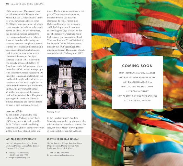
CIZHONG (茨中)80 km S from Deqin on the road following the Mekong is the village of Cizhong on the W bank, notable for its Catholic church combining Western and Chinese architecture, with a 20m-high three-storied belfry and
tower. The first Western settlers in this part of Yunnan were missionaries, from the Société des missions étrangères de Paris. Father Jules Dubernard founded the mission in 1867, building a church near here in the village of Cigu Tsekou on the site of a lamasery. Dubernard had a high success rate in converting local Tibetans, Lisu and Yi to Christianity, but he and 67 of his followers were killed in the 1905 uprising and the mission destroyed. The present church was built here in Cizhong from 1907
to 1911 under Father Theodore Monbeig, surrounded by vineyards (the missionaries also introduced wine to the area, for use at Mass). Three-quarters of the people here are still Catholic.
Cizhong church
42 LIJIANG TO MEILI SNOW MOUNTAIN
LUX* TEA HORSE ROAD LIJIANG
No. 182, Xingwen Lane, Qiyi Street, Gucheng District, Lijiang City, Yunnan Province, P.R. China
T +86 (0) 888 559 6666 / +86 (0) 888 556 1999
LUX* TEA HORSE ROAD BENZILAN
No. 74, Benzilan Village, Benzilan Town, Deqin Country, Diqing Tibetan Auto Prefecture, Yunnan P.R. China
T +86 (0) 887 899 8000 E [email protected]
COMING SOON
LUX* NORTH MALÉ ATOLL, MALDIVES
LUX* SUD SAUVAGE, REUNION ISLAND
LUX* DIANSHAN LAKE, CHINA
LUX* ORGANIC ESCAPES, CHINA
LUX* BODRUM, TURKEY
LUX* AL ZORAH, UNITED ARAB EMIRATES
LUX* PHU QUOC, VIETNAM

LUXRESORTS.COM
LUXRESORTS.COM/EN/CHINA/TEAHORSEROAD