the thermostat hypothesis jesse vannatta major: atmospheric science
TRANSCRIPT

The Thermostat
Hypothesis
Jesse VannattaMajor: Atmospheric Science

Articles Discussed•Thermodynamic regulation of ocean warming by cirrus clouds deduced from observations of the 1987 El Niño. V. Ramanthan & W. Collins. Nature Vol. 351 May 1991.•The effect of environmental conditions on tropical deep convective systems observed from TRMM satellite. Bing Lin, Bruce A. Wielicki, Patrick Minnis, Lin Chambers, Kuan-Man Xu, and Yongxiang Hu. Journal of Climate Vol. 19 November 2006.


Acronyms
DCS=Deep Convective SystemSST=Sea Surface Temperature
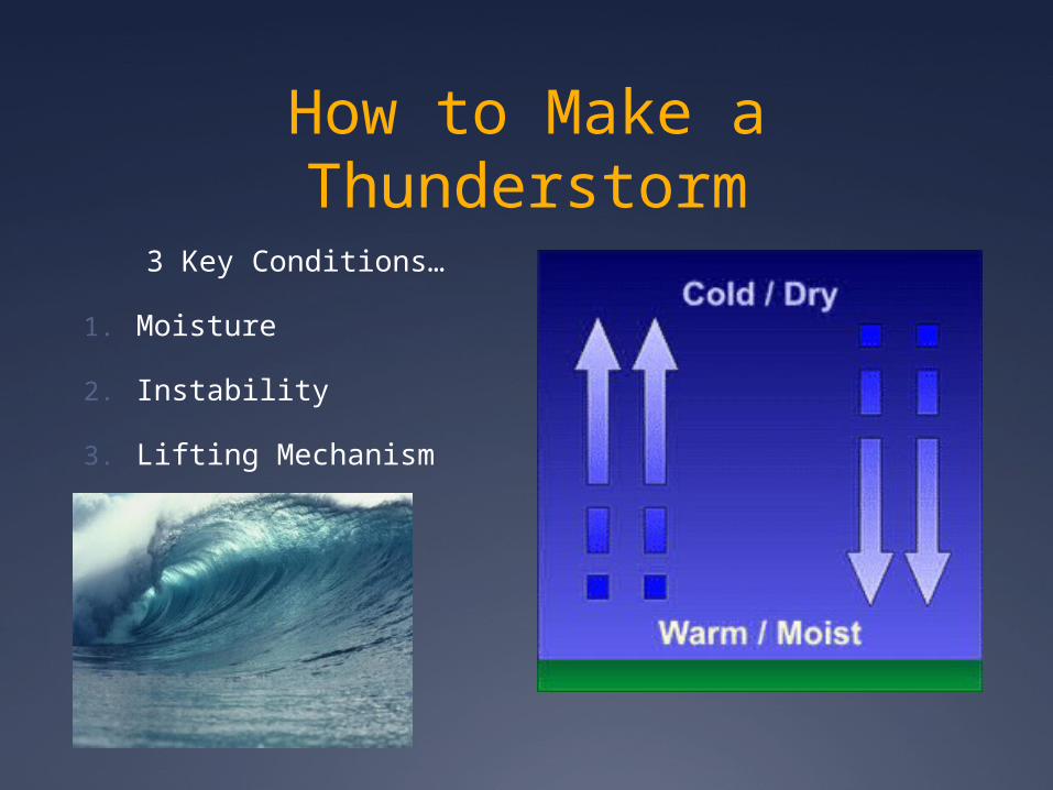
How to Make a Thunderstorm
3 Key Conditions…
1. Moisture
2. Instability
3. Lifting Mechanism

Key Features of Thunderstorms
Updrafts (Mesoscale and Convective)
Downdrafts (Mesoscale and Convective)
The storm reaches 12-18km at it’s peak
When the downdrafts cut off the updrafts, the storm will start to die.
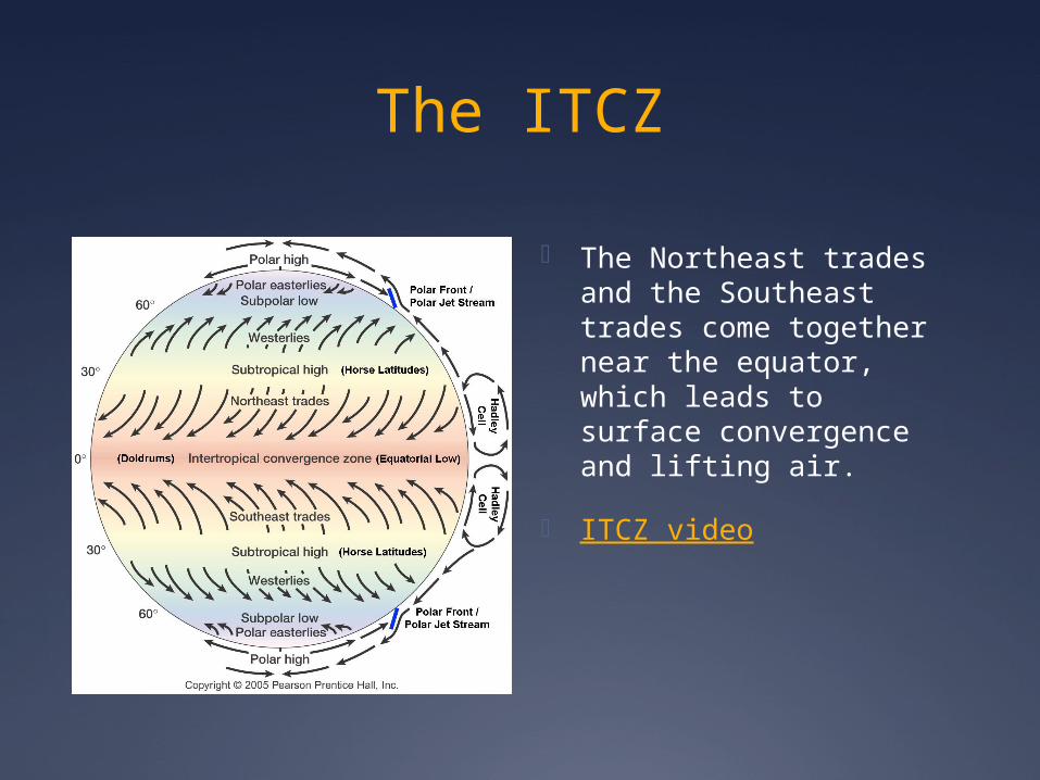
The ITCZ
The Northeast trades and the Southeast trades come together near the equator, which leads to surface convergence and lifting air.
ITCZ video

Thunderstorm Facts
•Men are 6 times more likely to be struck by lightning then women.•9 out of 10 people who are struck by lightning survive.•One lightning bolt has enough electricity to service 200,000 homes. •The Greeks fenced off spots that had been struck by lightning so that man would not trod on ground touched by Gods.•Lightning has been detected on Jupiter (also Venus) and while these strikes are less frequent then on the Earth, lightning on Jupiter can be up to 1,000 times as powerful as lightning on Earth.

Thermostat HypothesisRamanthan and Collins 1991
1987 El Niño Event
Data based off of ERBE measurements (Earth Radiation Budget Experiment)
Thermostat Hypothesis: The presence of deep convective storms over the Oceans act as a thermostat, limiting the sea surface temperatures to 305K.

Variables
Sc: incoming solar radiation
Cs: solar radiation reflected by clouds.
C1: longwave radiation trapped by clouds
Ga: Longwave radiation trapped by the atmosphere

Experiment 1
Greenhouse effect G=Ga+C1 increases sharply when SST>300K
SST increase atmospheric moisture increase Ga increase
C1 and Cs also increase with temperature.

Experiment 2Clouds always reflect more solar radiation with increasing SST
Data compares1987 el niño to 1985 normal conditions
Central and Eastern Pacific (region of max warming)
Month Year SST (K) dCs
(W/m2)
April 1985 300.1-34
1987 301.9
February 1985 299.2-32
1987 301
May 1985 300-34
1987 301.7
July 1985 299-12
1987 301
October 1985 298.6-6
1987 300.3
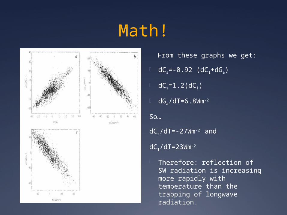
Math!From these graphs we get:
dCs=-0.92 (dC1+dGa)
dCs=1.2(dC1)
dGa/dT=6.8Wm-2
So…
dCs/dT=-27Wm-2 and
dC1/dT=23Wm-2
Therefore: reflection of SW radiation is increasing more rapidly with temperature than the trapping of longwave radiation.
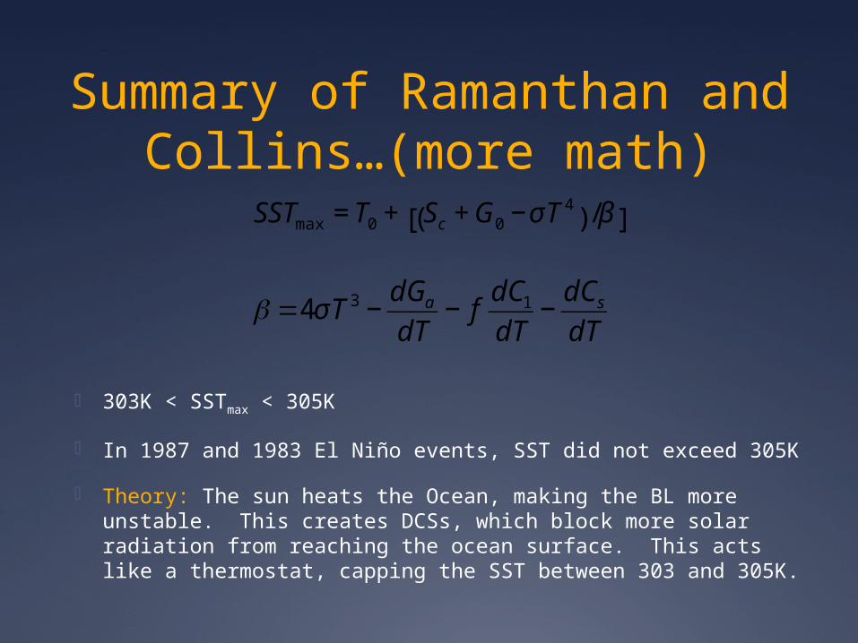
Summary of Ramanthan and Collins…(more math)
303K < SSTmax < 305K
In 1987 and 1983 El Niño events, SST did not exceed 305K
Theory: The sun heats the Ocean, making the BL more unstable. This creates DCSs, which block more solar radiation from reaching the ocean surface. This acts like a thermostat, capping the SST between 303 and 305K.
€
SSTmax = T0 + Sc +G0 −σT4
( ) /β[ ]
€
β =4σT 3 −dGadT
− fdC1dT−dCsdT
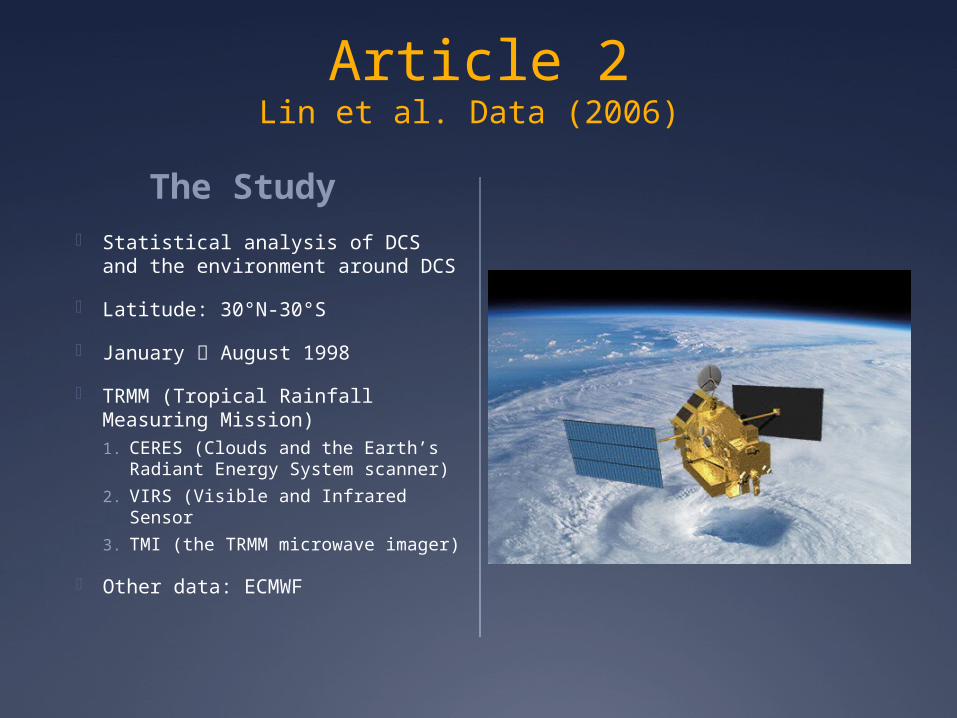
Article 2Lin et al. Data (2006)
The Study Statistical analysis of DCS and
the environment around DCS
Latitude: 30°N-30°S
January August 1998
TRMM (Tropical Rainfall Measuring Mission)1. CERES (Clouds and the Earth’s
Radiant Energy System scanner)
2. VIRS (Visible and Infrared Sensor
3. TMI (the TRMM microwave imager)
Other data: ECMWF


What counts as DCS?
Looked for CPCCs (cold precipitating cloud clusters)
CPCCs: 1. At least one precipitating
pixel
2. Thermal IR brightness temperature TbIR < 245K
3. Cloud top height above 6km
DCS: a CPCC with at least one rainfall cell with TbIR<218K
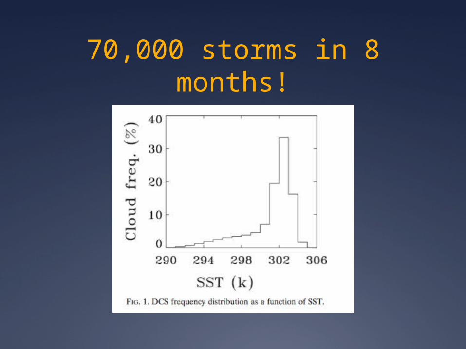
70,000 storms in 8 months!

Cloud Coverage

Precipitation

Back to the ITCZ
Study defines areas of convergence as SST > 299K

Relating this to the thermostat Hypothesis…
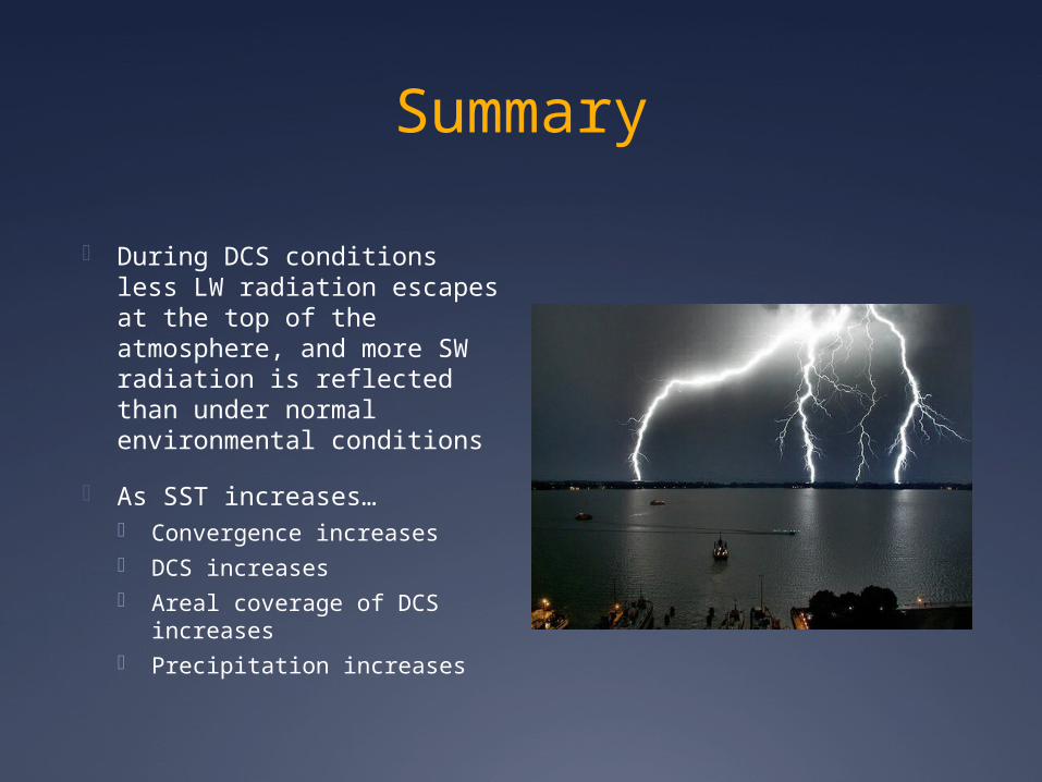
Summary
During DCS conditions less LW radiation escapes at the top of the atmosphere, and more SW radiation is reflected than under normal environmental conditions
As SST increases… Convergence increases DCS increases Areal coverage of DCS
increases Precipitation increases

Do they agree with Ramanthan and Collins?Yes, as SST increases there are more DCSs, with a greater areal coverage and more precipitation. They agreed that this will create a negative feedback, but not to the extent that Ramanthan and Collins suggested. When they did the calculations they came up with a less severe negative feedback. (Ramanthan and Collins suggested a net radiative feedback of -4Wm-2K-1 to -6Wm-2K-1, Lin et al suggested -1.75Wm-2K-1
Who cares about clouds and the SST
Climatologists do! The Ocean temperature is an integral part of climate change
Cloud feedbacks are an important factor in Earth’s energy balance, yet there is no general agreement on their climate feedbacks (especially for tropical deep convective systems)

My Opinions
•Can’t rely on this hypothesis to counteract global warming•More long range studies should be done, especially since Ramanthan and Collins, and Lin et al. found different magnitudes.

Happy Valentines Day
Sources
Fun Facts: http://www.angelfire.com/ca/Tornado/Facts.html http://www.funfactz.com/weather-facts/
Background Knowledge http://www.srh.noaa.gov/jetstream/tstorms/ingre
dient.htm