the tsunami that washed time away
TRANSCRIPT

→Next
The Tsunami That Washed Time Away
High on the clifftops at Henderson Bay, Northland, you can find millions of pebbles that were once on the ocean floor. How did they get on top of the cliffs? This question has puzzled people for years. Scientists James Goff and Scott Nichol wanted to find the answer.
by Jenna Tinkle
Individual images, text and multimedia for download →
Photograph: Copyright © S. Nichol, used with permissionMap of NZ showing Henderson Bay: Copyright © Di Fuller, used with permission
Table of contents →
From
WHY IS THAT?

2← →Previous Next
The two scientists thought the answer might have something to do with the Pacific Ring of Fire. It’s an area where there are lots of volcanoes and earthquakes. The Ring of Fire follows a line around the Pacific Ocean where tectonic plates meet. The plates move and push against each other, which causes earthquakes and volcanic eruptions. These can, in turn, cause tsunamis, or giant waves. New Zealand is on the Ring of Fire.
The Ring of FirePACIFIC RING OF FIRE
→
About 75 percent of the world’s active volcanoes are found along the Ring of Fire, and 90 percent of the world’s earthquakes occur there.
Map: By Alan Poole, copyright © Crown 2014
3← →Previous Next
Finding evidence at Henderson Bay
James and Scott are geologists – scientists who use evidence from the earth to understand things that happened in the past. They found clues that something suddenly
changed the landscape at Henderson Bay hundreds of years ago. A big clue was the shape of the pebbles on the cliffs. The pebbles were round. This showed that they had
been shaped by waves. Divers have brought up similar pebbles from the ocean floor. And the pebbles couldn’t have been brought in by the tide – the cliffs are metres above sea level!
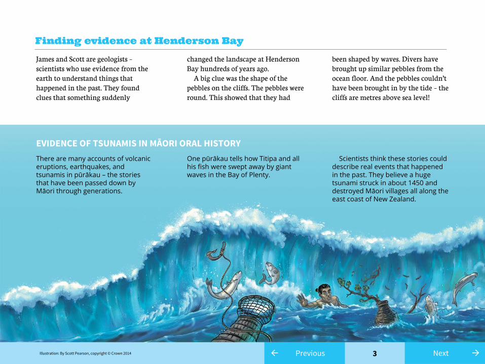
There are many accounts of volcanic eruptions, earthquakes, and tsunamis in pūrākau – the stories that have been passed down by Māori through generations.
One pūrākau tells how Titipa and all his fish were swept away by giant waves in the Bay of Plenty.
Scientists think these stories could describe real events that happened in the past. They believe a huge tsunami struck in about 1450 and destroyed Māori villages all along the east coast of New Zealand.
EVIDENCE OF TSUNAMIS IN MĀORI ORAL HISTORY
Illustration: By Scott Pearson, copyright © Crown 2014

4← →Previous Next
On some of the remaining bits of dune, there are a number of mounds. Archaeologists call these mounds “middens”. The middens are made up of shells, bones, and burnt stones – the remains of an umu (an earth oven). There were two types of midden. The older one held the bones of moa. These birds became extinct about 500 years ago. It also had lots of large tuatua shells. This midden was no longer a mound. It was spread out across the cliff top. The other midden sat on top of the older midden’s remains. This midden was still a mound and was from a much more recent time. The Māori who lived in the area at that time had a different diet. The midden held only mud snails and very small tuatua shells. These two middens told a story. In the time between the two middens, something changed the environment at Henderson Bay. There were no large shellfish in the more recent midden. One idea is that a tsunami might have wiped out the tuatua and other sea life and scattered shells, bones, and umu stones across the landscape. If this happened, any survivors would have moved away from the coast for a time. However, Māori returned to Henderson Bay and continued to use the good fishing spots, freshwater ponds, and umu stones.
A story buried in the ground
Small tuatua shells and mud snails were found in a mound here.
Large tuatua shells and moa bones were found scattered here.
↑Evidence from the middens showed there had been a change in the environment.
Photograph: Copyright © S. Nichol, used with permission
5← →Previous Next
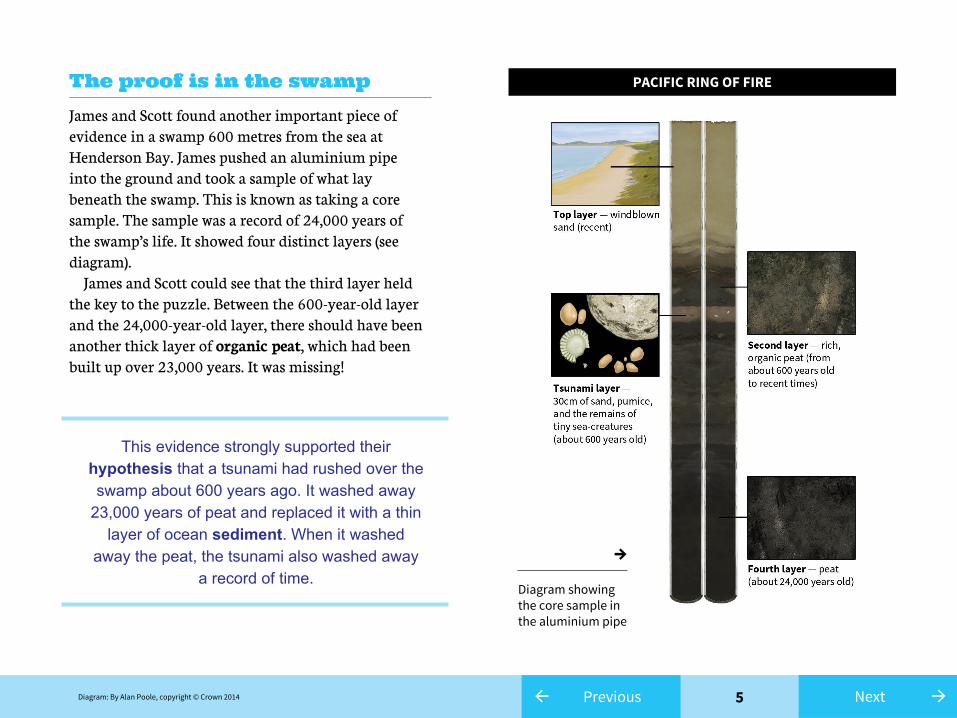
James and Scott found another important piece of evidence in a swamp 600 metres from the sea at Henderson Bay. James pushed an aluminium pipe into the ground and took a sample of what lay beneath the swamp. This is known as taking a core sample. The sample was a record of 24,000 years of the swamp’s life. It showed four distinct layers (see diagram). James and Scott could see that the third layer held the key to the puzzle. Between the 600-year-old layer and the 24,000-year-old layer, there should have been another thick layer of organic peat, which had been built up over 23,000 years. It was missing!
The proof is in the swamp
This evidence strongly supported their hypothesis that a tsunami had rushed over the swamp about 600 years ago. It washed away
23,000 years of peat and replaced it with a thin layer of ocean sediment. When it washed
away the peat, the tsunami also washed away a record of time.
PACIFIC RING OF FIRE
→Diagram showing the core sample in the aluminium pipe
Diagram: By Alan Poole, copyright © Crown 2014

6← →Previous Next
James and Scott had found evidence to support their hypothesis about the huge tsunami, but one question remained unanswered – what caused the tsunami in the first place? One possibility is that it was caused by the eruption of the Healy volcano that sits on the ocean floor to the north of East Cape. Evidence provided by the age of pumice from this undersea volcano showed that it last erupted about 600 years ago.
The Healy volcano
This date matches the evidence from the core sample. The eruption triggered a big tsunami. The wave came to Henderson Bay and other parts of Northland (washing away Titipa and all his fish in the process). Pumice from the eruption can still be found on Northland beaches.
Healy volcano cross-section: By Alan Poole, copyright © Crown 2014NZ map showing Healy volcano: By Alan Poole, copyright © Crown 2014
→Artist’s impression of scientists’ theory (not to scale)

7← Previous
James and Scott had solved the mystery of the pebbles on the clifftops at Henderson Bay. By looking at the evidence, scientists like James and Scott give us a better understanding of our history and the forces that have shaped New Zealand. They also give us a better understanding of where and when tsunamis could happen in the future and how to plan for them.
Glossary
hypothesis – a proposed explanationorganic peat – natural material (mainly plants) that has broken down over time and become spongypumice – light, soft rock formed during volcanic eruptionssediment – material (sand, dirt, rocks) carried and then deposited by water tectonic plates – parts of Earth’s crust that move very slowly
Photograph: “Crashing wave” by Sheila Sund from http://goo.gl/RUCNU2 is licensed under CC BY 2.0
Why study past tsunamis?
→Next

8← Previous
Acknowledgments
Individual images, text, and multimedia for download →
Teacher support material →
All the text, images, and photographs in this article may be copied, distributed, displayed, and revised in all media by teachers and students. Please attribute the work to the writers, illustrators, and photographers, where appropriate.
Text copyright © Crown 2014