the twelfth meeting of iscgm - github pages · pdf filethe twelfth meeting of iscgm ... from...
TRANSCRIPT

38No. 38 - June 25, 2005 International Steering Committee for Global Mapping
GLOBAL MAPPINGNEWSLETTERThe Twelfth Meeting of ISCGM
Dr. Karen KlineAssistant Secretary General of ISCGM
The Twelfth Meeting of the International Steering Committee was recently held immediately prior to the FIG Working Week/GSDI 8 conference in Cairo, Egypt. Some of the key topics of the meeting were the revision of the specifications and the definition of ‘commercial use.’
Specifications were one of the dominant themes of the meeting. The main point was the move from VPF format to GML format, which was seen to be a positive move according to the meeting participants. The move to GML will allow Global Map to be more easily used in today’s Internet based software and technology. In addition, some smaller changes to the current specifications were made to assist the Secretariat in processing the data more quickly in order to place them on the website, including dropping the requirement for names to be in all capital letters. Also falling under the specifications category are the proposed changes for the raster data layers for future versions of Global Map. Prof. Tateishi proposed the use of the Land Cover Classification System (LCCS) developed by the FAO and submitted to ISO as a proposed standard. This change will make Global Map more internationally compatible with other data sets developed by other organizations.
Regarding commercial use: Dr. Nick Land of EuroGeographics proposed that for the purposes
of Global Map, that commercial use be defined as "the re-selling of Global Map data as either a distributor or as a value-added reseller." One advantage of moving to a web based data delivery system, such as the web mapping portal under development, is the ability to accommodate mul t ip le bus iness models . However, the technology is still being developed, and therefore the abili ty to accommodate many different business models is not necessarily available today. Another key point made during the discussion is the distinction between licensing and charging – providing a license to use data does not necessarily imply charging for use of the data. In addition, as was pointed out, while the data may be available free of charge to the end use, the development of the data did incur costs.
The next meeting of the ISCGM is scheduled for November 2006 in Santiago, Chile.
ISCGM 12 Participants

Global Mapping NewsLetterP a g e No. 38- June 25, 2005
Resolutions of the Twelfth Meeting of the ISCGMCairo, Egypt17 April 2005
1. Global Map data release and participationa. The ISCGM acknowledges the continuous
efforts of the participating organizations and the assistance of the Secretariat to develop the Global Map data.
b. The ISCGM encourages the Secretariat to accelerate its action for releasing Global Map data that are not fully compliant with the Global Map specifications or that do not have all the data layers, with appropriate metadata so as to enhance data availability as soon as possible.
c. While there has been significant progress in developing Global Map version 1.0 since the Eleventh ISCGM Meeting, those participating countries that have not yet completed their contribution are strongly encouraged to do so.
d. While there has been a steady increase in the number of countries participating in Global Mapping since the Eleventh ISCGM Meeting, further efforts should be made to encourage nations not yet participating to join. In this respect, an approach from Members, Advisors, Liaison organizations and other related organizations are encouraged.
2. World Summit on Sustainable Development (WSSD)a. ISCGM, as an implementation agency under
the Type II Partnership/Initiative of WSSD and an organization with Roster consultative status granted by ECOSOC, UN, resolves to utilize this status to search for funding, to establish partnerships with the appropriate organizations, and to encourage participation in, and contribution to, the Global Map project.
b. Recognizing the continued opportunities provided by being a WSSD implementing agency and an organization with Roster
consultative status of ECOSOC, the ISCGM resolves to continue participating in WSSD follow-up activities, such as the Commission on Sustainable Development (CSD) and other appropriate activities as identified by the Secretariat.
3. Global Mapping portal developmenta. The ISCGM resolves to promote the use of
web mapping portals to facilitate the use of Global Map and other data sets together to address issues of sustainable development, urgent disaster recovery, among other applications. The ISCGM will begin the process of identifying data sets that work in conjunction with the Global Map data to address global and regional environmental issues.
b. The ISCGM gratefully acknowledges the assistance by ESRI in implementing web mapping through the creation of a portal as an extension of the existing grant program.
4. Specificationsa. The ISCGM gratefully acknowledges the
completion of basic principles for the revision of the Global Map specifications by Working Group 2 chaired by India, and continues to encourage WG 2 to start detailed discussions on the revision work.
5. Commercial usea. The ISCGM gratefully acknowledge the work
of extending use of Global Map to commercial one, and continue to encourage Working Group 3 chaired by EuroGeographics to work on the remaining issues such as license agreement.
2

P a g e Global Mapping NewsLetterNo. 38- June 25, 2005
6. Global raster data developmenta. The ISCGM gratefully acknowledges the
completion of Global raster data development plan by Working Group 4 chaired by Prof. Ryutaro Tateishi of Chiba University and continues to support the WG4 activities on the development of raster data.
b. The ISCGM encourages par t ic ipat ing organizations in the Global Mapping project to cooperate with the implementation of Global raster data development plan, especially in identification of ground truth data and validation of developed data.
7. Capacity buildinga. Recognizing the significant importance
of capaci ty bui lding in enhancing the development of Global Map, the ISCGM gratefully acknowledges the contribution of the organizers and the supporters of Global Mapping Seminars in Nairobi, Kenya, including the Global Mapping Partnership Program of the Japanese government, the Regional Centre for Mapping of Resources for Development (RCMRD), the Japan International Cooperation Agency (JICA), the Survey of Kenya and the Kenya Institute of Surveying and Mapping.
b. T h e I S C G M c o n t i n u e s t o g r a t e f u l l y acknowledge the implementation of the Global Map/GSDI grant made in the memory of Prof. John E. “Jack” Estes by Mr. Jack Dangermond of ESRI.
c. The ISCGM gratefully acknowledges a new capacity building grant from INTERGRAPH through President Preetha Pulusani and looks forward to its implementation.
d. The ISCGM gratefully acknowledges the role of the JICA group training course on Global Mapping held in Japan annually since 1994.
e. ISCGM will continue to engage in capacity building activities with the appropriate partners.
8. Promotion of Global Mapa. The ISCGM greatly appreciates the efforts
to raise awareness of Global Map in various international conferences by ISCGM members and the ISCGM Secretariat on behalf of the ISCGM, including a workshop held on the occasion of GEO-4 meeting in Tokyo.
b. The ISCGM also continues to encourage the promotion of Global Map at every opportunity.
9. Earth Observation Summit Recognizing the adoption of GEOSS 10-Year
Implementation Plan at the Third Earth Observation Summit held in Brussels, Be lg ium, in February 2005 , and a l so acknowledging the activities of ISCGM as a participating organization in Group on Earth Observation (GEO), and recognizing the value of earth observation data and related activities, the ISCGM resolves to encourage its members to actively participate in GEO activities, especially as a representative of ISCGM at GEO-I meeting to be held in May 2005 focusing on the value of Global Map as a basis of integration of both earth observation data and socio-economic data.
10. Cooperation in the utilization of remotely sensed data The ISCGM reiterates its desire to use remotely
sensed data, in particular, data from the ALOS satellite, for Global Mapping purposes, and strongly supports the GSI and the Secretariat in their discussions with JAXA to achieve this outcome.
11. Vote of Thanks The ISCGM gratefully acknowledges the
support of the Egyptian Survey Authority for this meeting.
3

Global Mapping NewsLetterP a g e No. 38- June 25, 2005
Special Resolutions on Indian Ocean Disaster on 26th December 2004
Global Mapping Session was held in FIG Working Week 2005 and GSDI-8Hiromichi Maruyama
Secretary General, ISCGM
We, the participants at the Twelfth Meeting of the ISCGM, 17 April, 2005, Cairo, Egypt:
Express our sincere and deepest sympathy to the people and countries affected by the Indian Ocean Disaster caused by earthquake and tsunami on 26 December 2004;
Recognize the necessity of geo-information for rescuing people, recovery and reconstruction from this kind of disaster, and importance of the role of NMOs which deal with geo-information;
Note that ISCGM has an established global network of NMOs with the mitigation of natural disasters as one reason for the development of Global Map;
Resolve that the ISCGM should take the following actions in close cooperation with NMOs and other related organizations:
● To discuss what NMOs can contribute to recovery from large scale disasters like the Indian Ocean Disaster in December 2004, including provision of topographic maps, aerial photography and mapping of affected areas,
● To ask participating organizations in the Global Mapping project to take necessary actions not only immediately when large scale disasters take place but also in establishing early warning systems,
● To enhance capacity building in disaster mitigating management to NMOs including preparation of good examples contributing to disaster mitigation by NMOs, and
● To enhance the use of Global Map by disaster mitigation related organizations as well as ISCGM itself.
FIG Working Week 2005 and GSDI-8 was held in Cairo, Egypt 16-21 April 2005. This conference, jointly organized by the Egyptian Committee for Surveying and Mapping (ECSM), the Egyptian Survey Authori ty (ESA), the International Federation of Surveyors (FIG) and the Global Spatial Data Infrastructure (GSDI), collected
more than 900 participants from more than 80 countries.
The program of conference was very abundant, namely, it included plenary sessions, technical sessions, panel discussions, a poster session, exh ib i t i ons and o the r va r i ous mee t i ngs . Especially, 55 technical sessions were held with 5 of them concurrently and about 270 papers were presented.
Regarding Global Mapping related presentations, Prof. Taylor, Chair of the ISCGM, presented "The History and Development of Global Map" and Dr. Kline, Assistant Secretary General of the ISCGM "The Digital Divide and Global Spatial Data and Users." Moreover, Global Mapping session, organized by the ISCGM in order to enhance
4
Global Mapping Session

P a g e Global Mapping NewsLetterNo. 38- June 25, 2005
participation in the Global Mapping from Arabic and African countries, was held on 21 April as one of technical sessions.
At the Part I of the session chaired by Prof. Dowman, 5 papers were presented on overview of Global Map, global land cover development, appl ica t ions of Globa l Map. At the very beginning of the session, Eng. Nasr, Chairman of ESA, made a welcome address and handed the application document formalizing participation of ESA in the Global Mapping Project to Prof. Tylor.
The Part II, chaired by Prof. Taylor, was panel discussion with 5 panelists, namely, Mr. Land (EuroGeographics), Mr. Mwero (Survey of Kenya), Mr. Hansen (INEGI), Mr. Chhatkuli (Nepal Survey Department) and Mr. Donnelly (USGS). Five panelists presented various issues on the Global Mapping Project such as: What have been achieved? What challenges remain? What affects had the project had on sustainable
development? What impact has this had on national mapping organizations and agencies? How can the goals and objectives of the project be more effectively disseminated to increase collaboration? These presentations followed by very active discussions among about 80 participants.
Currently sl ides of these presentations are available at TS48 and TS51 of http://www.fig.net/pub/cairo/tech_programme.htm
Global Earth Observation System of Systems (GEOSS)Dr. Ashbindu Singh
Regional Coordinator, UNEP Division of Early Warning & Assessment – North America
HistoryAs a follow up to the action plan called by the G-8 Summit held in France 2 June 2003, the First Earth Observation Summit (EO) at a Ministerial level was held on 31 July 2003 in Washington D.C. with a purpose to promote the development of a comprehensive, coordinated, and sustained Earth observation system or systems among governments and the international community to understand and address global environmental and economic challenges. To begin a process to develop a conceptual framework and implementation plan for building this comprehensive, coordinated, and sustained Earth observation system or systems.
As a result of the Earth Observation Summit, an ad hoc Group on Earth Observations (GEO) -- was
established to prepare a 10-year implementation plan for a coordinated, comprehensive, and sustained Earth observation system or systems. The Framework document is the most important document finalized after a long negotiated process by governments. The EO Summit II was held in Tokyo. A 10-year implementation was adopted at the EO Summit III held in Brussels in Feb 2005.
GEO-1The 1st plenary meeting of the [now established] intergovernmental Group on Earth Observations (GEO-I) took place at the WMO HQs in Geneva, seat of the GEO Secretariat. The GEO-I was chaired by the four Co-Chairs: Mr. Tetsuhisa Shirakawa, Deputy Minister of Education, Culture,
5
Prof. Taylor and Eng. Mohamed Hisham Nasr
Global Mapping NewsLetterP a g e No. 38- June 25, 2005
Sports, Science and Technology, Japan; Mr. Rob Adam, Director-General, Department of Science and Technology, South Africa; Mr. Conrad Lautenbacher, Under Secretary of Commerce for Oceans and Atmosphere, United States of America; and Mr. Achilleas Mitsos, Director General for Research, European Commission.
GEO-I reviewed proposals for an Executive Committee, for a science and technology and user interface mechanisms; reports on contributions and funding of the Secretariat and work plan 2005-06; and progress on the preparation of the 2006 work plan.
Proposals for the GEO Executive Committee (ExCom) was the most discussed agenda item. The task of the ExCom is to facilitate and implement the decisions of the GEO Plenary. Thus, the main function of the ExCom is to provide administrative and other support to the Plenary, which remains the GEO’s primary decision-making body. Two options were presented for the format and structure of the ExCom, one for a 15-member ExCom, comprising 12 regional representatives from 6 regions (2 Africa; 2 Asia and Oceania; 2 North America; 2 South and Central America and the Caribbean; 2 CIS and Near East; 2 Europe), and 3 representatives from Participating Organizations. A second option was for an 8-member ExCom, comprising only representation from 6 regions (1 North America; 1 South and Central America and
the Caribbean; 1 Africa; 2 Europe; 1 CIS and Near East; and 2 Asia and Oceania).
Government representatives were divided in their opinions, and after much deliberation they approved an ExCom of 12 members, with representatives from Europe (3), the Americas (3), Africa (2), Asia and Oceania (3) and the CIS (1). The ExCom will have four Co-Chairs, two from developed countries and two from developing countries.
The Members of the 1st GEO ExCom will be: the European Community, Germany, and Italy for Europe; the USA, Honduras and Brazil for the Americas; South Africa and Morocco for Africa; Japan, China and Thailand for the Asia and Oceania region; and Russia for the CIS countries. The developing countries co-Chairs will be from South Africa and China, and the developed countries co-Chairs will be the USA and EU. Members of the ExCom will serve for 2-year periods.
The next meeting of the GEO, the GEO-II, will take place in Geneva, at WMO HQs, on 14-15 December 2005.
For further details see http://www.earthobservationsummit.gov
I represented ISCGM and UNEP in the meeting.
6
Look back on the Development of the Global Map of MexicoEng. Mario Alberto Reyes
Director General, GeographyINEGI
As the national mapping agency in Mexico, the National Institute of Statistics, Geography and Informatics (INEGI), was invited in 1998 by the International Steering Committee for the Global Mapping (ISCGM) to participate in the
development of the Global Map. In 1999 the work to prepare data for the Global Map of Mexico started and went through the following phases.
● Analysis of Global Map specifications
P a g e Global Mapping NewsLetterNo. 38- June 25, 2005
In 2000 data sets were sent to the ISCGM for verification. Several details in the Hydrography data (principally water streams) were corrected as a result of the revision, and sent again to the ISCGM. Finally the data were officially delivered for its release by the ISCGM in June 2003, during the Global Mapping Forum 2003 in Japan.
ProspectsAlthough the Global Map data of Mexico are available from the ISGCM, new data sets are being prepared in the same themes, either because of changes in Land Cover – Vegetation – Land Use, as well as infrastructure (new roads, airports), or because better data sources are now available. The General Direction of Geography in INEGI, will prepare, revised and updated data sets to keep contributing to the Global Map and to the Global Spatial Data Infrastructure.
7
Eng. Mario Alberto Reyes
● Themes to include● Data dictionary● Scale of the data● Projection● Format● Tiles● Data structure (raster, vector), etc.
Data preparation and processingCrosswalk tables to convert features – attributes from the INEGI data sets – to the Global Map specifications were developed. Features to include were selected, coded and re-projected according to the Global Map.
Boundaries, Hydrography, Transportation and Populated Places layersThese layers were obtained from the 1:1 million topographic and toponymic data set.
Land Use, Land Cover and Vegetation layersThey were derived from the INEGI 1:1 million Land Use and Vegetation data set. The feature and attribute conversion was made first on the vector data and then converted to the raster data structure with 30 second of arc resolution.
ElevationThe 3 second of arc INEGI's elevation data were resampled to 30 second of arc. To complete elevation data in some ti les, data from the GTOPO30 were used for areas not in Mexico (portions of USA, Guatemala, Belize, El Salvador and Honduras).
11th PCGIAP Meeting and Open Seminar on TsunamiMr. Peter HollandPresident PCGIAP
1. OverviewThe 11th PCGIAP meeting was held on 18-21 May 2005 in Bali, Indonesia, graciously hosted by the Indonesian National Coordinating Agency
for Surveys and Mapping(BAKOSURTANAL) headed by Mr. Rudolf W Matindas. The meeting program included an Executive Board meeting, Open Seminar on Tsunami- Responses made and

Global Mapping NewsLetterP a g e No. 38- June 25, 20058
Meeting
From the Secretariat● Technical Note for Global Map First Round:Compositions and Characteristics of Boundary Layer-
The ISCGM Secretariat gratefully receives data from many countries toward the completion of the global coverage of the Global Map by 2007. The data we received contain a lot of information which does not completely meet Global Map
specifications, therefore, we spend time and effort making corrections. We realize that the current specifications have parts which may lead to a variety of interpretations and are difficult to understand compared to conventional methods.
lessons learned, Plenary and parallel Working Group sessions, and a technical tour to a sea level monitoring station. The Bali meeting, being the first one after the unprecedented tsunami disaster that struck the region on 26 December 2004, focused on the role of PCGIAP as a regional forum and on how its endeavors can serve the region, while benefiting individual nations. Around 60 people from 12 countries participated.
2. Executive Board MeetingThe Board welcomed PCGIAP’s 56th member, Timor Leste, the youngest country in the world, represented by Mr. Pedro de Sousa Xavier, Director of the National Directorate for Land and Property. Also a welcome was extended to Indonesia, who is to serve the Board until the 17th UNRCC-AP/12th PCGIAP in 2006. The Board briefly reviewed the past activities and endorsed personnel changes.
3. Open SeminarPapers from five countries, Australia, India, Indonesia, Malaysia and Japan, were presented, where the tsunami on 26 Dec. 2004 was discussed and analyzed in various perspectives from highly technical to administrative, from damage assessments to challenges to be faced and projects proposed. Information and views were exchanged among experts from various Indonesian authorities and PCGIAP members. Possible collaborative efforts were explored as well.
4. Committee MeetingActivities and progress of work plans since the 10th meeting in Bangalore, India, have been reported at the Executive and Working Group level. Also presented were reports from liaisons including ISCGM, GSDI, PCIDEA, and ISO/TC211. Ten resolutions including workshop plans and the proposed extraordinary geodetic campaign were adopted. The 12th meeting is to be held in conjunction with 17th UNRCC-AP on 5-9 September in 2006 in Bangkok, Thailand.
11th PCGIAP Meeting Participants

P a g e Global Mapping NewsLetterNo. 38- June 25, 2005
not to overlap each other. In a case that a line is valid as national boundary as well as prefecture and city boundary, a definition of "national boundary" indicates that it is also prefecture and city boundary. Lines shall be taken by prioritizing coas t l i ne>na t iona l bounda ry>pre fec tu re boundary>city boundary.
9
In order to develop “global data with consistent specifications,” which is one of the major themes of Global Mapping, common understanding and recognition on the specifications by data producers are crucial.
In view of this need, from this issue we are going to illustrate parts in question that we have frequently found in the received data using a way as easily understandable as possible to help understand the specifications. Please refer to the following web site for a general explanation of Global Map Specifications:Specifications : http://www.iscgm.org/cgi-bin/fswiki/wiki.cgi?page=Documentation
andQ & A : http://www.iscgm.org/cgi-bin/fswiki/wiki.cgi?page=FAQ
Global Map data are composed of four vector layers: boundary, drainage, transportation, and population centers, and four raster layers: elevation, land cover, land use, and vegetation. In this issue as the first effort, we take up boundary layer and explain its composition and Frequently Found Errors (FFE).<Composition of boundary layer>Boundary layer is made up of point, line, and polygon. Features included in each element are as follows:Line: 1. coastline 2. administrative boundary (1.national boundary, 2. first level boundary (prefecture and state levels) and 3. second level boundary (city and local levels)Polygon: 1. administrative area (minimum polygon in administrative area)Point: 1. administrative area(small island of less than 1km2)<Frequently Found Errors>Overlap of administrative boundary lineAdministrat ive boundary has four l ines as mentioned above. All lines shall be required
Acquisition of administrative area polygon (See figure 1)The cases frequently observed in the submitted data are: to obtain a point as a representative point of a polygon and give an attribute to this point (Figure 1- A); or to obtain all polygons of country, prefecture and city, and then compose an administrative area in one layer or as separate layers (Figure 1- B). I n t h e G l o b a l M a p d a t a , a g g r e g a t i o n o f administrative polygons of minimum units composes an entire administrative area (Figure 1 – C). As a result, a polygon of every city has attribute values of prefecture, country and city names that the city belongs to, therefore, city name on the LAA attribute table, prefecture name on NAM attribute and country name on COC
2"
a
b
c
Country A
1
2
3
4
1'
2'
3'
1"3"
CoastlineBA010
Administrative boundary (prefecture level)FA000, use = 26
Administrative boundary (city level)
FA000, use = 30
National boundaryFA000, use = 23
* Administrative area is aggregation of city polygons.
Figure 1 - A
a
c
a
b
2"
12
3
4
1'3'
1"3"
2'
In Global Map…
Figure 1 - B
LAA: 1 (city name)NAM: b (prefecture name)COC: A (country name)
Point attributes
Figure 1 - C
Polygon that does not have
attribute of administrative area
All polygons of city, prefecture and country levels compose
administrative areas
Attribute that should be owned by a polygon is owned by a point
The smallest administrative unit (city for this case) is obtained as a polygon
LAA: 1 (city name)NAM: b (prefecture name)COC: A (country name)
Point attributes
Figure 1: Method to obtain administrative area polygon
Published by : The Secretariat of the International Steering Committee for Global Mapping (ISCGM) Geographical Survey Institute (GSI) 1 Kitasato, Tsukuba-shi, 305-0811 Japan Phone : +81-29-864-6910 Fax : +81-29-864-6923 Homepage : http://www.iscgm.org E-mail : [email protected]
No. 38- June 25, 2005P a g e 1 0 Global Mapping NewsLetter
Global Map and Related MeetingsFollowings are Global Map and related meetings. Information on related meetings will be highly appreciated.
2005・ 27 June - 1 July, New York UNRCC Americas
・ 3 - 6 July, Southampton, UKCC: The exchangehttp://www.ordnancesurvey.co.uk/oswebsite/nmonetwork
・ 9 - 16 July, A Coruna, Spain XXII ICA International Cartographic Conference
2006・ September 5 - 9, Bangkok, Thailand 17th UNRCC-AP ・ November 6 – 10, Santiago, Chile GSDI 9th Conference
・ November 11, Santiago, Chile 13th Meeting of ISCGM
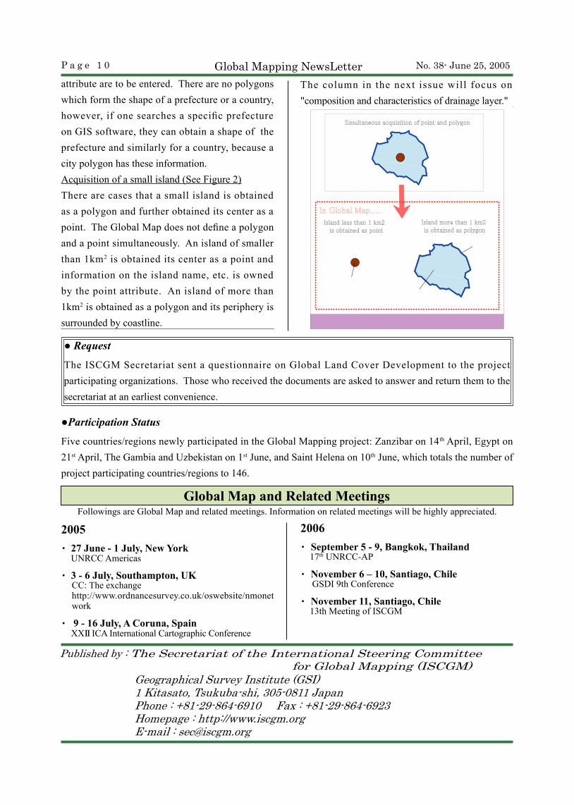
The column in the next issue will focus on "composition and characteristics of drainage layer."
Figure 2 Acquisition of small island
Island less than 1 km2 is obtained as point
Island more than 1 km2 is obtained as polygon
Simultaneous acquisition of point and polygon
Administrative area pointFA001
Administrative area polygonFA001
CoastlineBA001
In Global Map....
● Request
The ISCGM Secretariat sent a questionnaire on Global Land Cover Development to the project participating organizations. Those who received the documents are asked to answer and return them to the secretariat at an earliest convenience.
●Participation Status
Five countries/regions newly participated in the Global Mapping project: Zanzibar on 14th April, Egypt on 21st April, The Gambia and Uzbekistan on 1st June, and Saint Helena on 10th June, which totals the number of project participating countries/regions to 146.
attribute are to be entered. There are no polygons which form the shape of a prefecture or a country, however, if one searches a specific prefecture on GIS software, they can obtain a shape of the prefecture and similarly for a country, because a city polygon has these information.Acquisition of a small island (See Figure 2)There are cases that a small island is obtained as a polygon and further obtained its center as a point. The Global Map does not define a polygon and a point simultaneously. An island of smaller than 1km2 is obtained its center as a point and information on the island name, etc. is owned by the point attribute. An island of more than 1km2 is obtained as a polygon and its periphery is surrounded by coastline.