the typology and techniques ofalluvial mining: the example
TRANSCRIPT

AUSTRALASIAN HISTORICAL ARCHAEOLOGY, 14, 1996
The Typology and Techniques of Alluvial Mining:The Example of the Shoalhaven and Mongarlowe Goldfields
in Southern New South Wales
BARRY McGOWAN
The author undertook an National Estate Grants Program (NEGP) study in 1995 aimed at identifying andrecording historic mining sites in the Shoalhaven River catchment area and selected sites on the South WestSlopes ofNew South Wales. Both components of the study built upon earlier work undertaken by the authorunder an NEGP grant in 1993. This paper describes the techniques of alluvial mining (other than dredging)in the Shoalhaven and Mongarlowe goldfields and suggests a typology based on that outlined in the 1995NEGP study and that developed by Ritchie in 1981. The typology also addresses the question ofethnicity.
• Goulburn
~...! !t········.. ".· ....i ..; t··············
>'" •",Srudr
\]-
f--SaplingYard CreekHalf Moon\Bob's Creek
.~Tantulean Creek
Mongarlowe
Snowball goldfield
Shoathaven River
~ors~~• Jembaicumbene Creek
Aralnen
Horseshoe Bend
TYPOLOGY
Type A
OallenWater Supply/Golden Terraces
NadgigomarCreek ----l·t
NerrimungahCreek
Bungonla •
Type A describes the heavily scoured creek beds and banks,and adjacent to this the numerous closely grouped shallowshafts or rounded piles and hummocks of wash dirt and soil,characteristic of what Ritchie has described as 'small claim' or'pothole tailings'. Ritchie also stated that, 'Althoughindividual working areas were very small (24 feet by 24 feet)where a number of such workings were established in closeproximity .,. the aggregate was quite extensive'.4 Type Aworkings were typical of pan and cradle techniques in the firststage of an alluvial rush (Fig. 2).
Fig. 1: Shoalhaven and Mongarlowe Goldfields.
The need to develop a typology as a working tool becameobvious at a very early stage of the 1995 NEGP study. I Thisarose from a very real practical need to distinguish between thevarious techniques as a means of describing, identifying anddating the often very large and seemingly structureless andamorphous sites associated with alluvial mining within thestudy area of the Shoalhaven and Mongarlowe Goldfields(Fig. I).
The most useful and comprehensive contemporary accountof both the technique and typology of alluvial mining is that byRitchie in 1981.2 Ritchie's analysis was concerned primarilywith describing and developing a typology of tailings depositsderived from the various types of alluvial mining, and wherepossible his descriptions have been used. As stated above themain concern in the NEGP study was to develop a typologywhich helped to distinguish between the different techniquesas a means of identifying and recording the various sites. Theconcern was less with the pattern of tailings within a commonsluicing and hydraulic sluicing operation, therefore, than withidentifying the various features that distinguished suchoperations, of which the tailing mounds were only onecharacteristic, albeit a very important one.
A search of other contemporary Australasian literature ontechniques and typology was disappointing. The recentlycompleted NEGP study, Australia's Mining History, whileadmittedly an historical description of mining, made littledistinction between the various mining techniques. Commonsluicing, for example, was not mentioned and hydraulicsluicing rated only a few lines in one chapter.3 Two of the mostuseful texts were Ion Idriess' Prospecting for Gold, written in1934 and Averill's 1946 work, Placer Mining for Gold inCalifornia. Otherwise reliance was placed on a range ofpublications from the USA and New Zealand, many datingback to the last century, in some cases as far back as the 1860s.The most useful Australian sources from this period wereSmyth's The Goldfields and Mineral Districts of Victoria,published in 1869, and articles appearing in the AustralianTown and Country Journal in 1871 and 1874 and the NSWAgriculturist and Grazier in 1881.
From the outset it is necessary to distinguish betweentechniques and typology. Using Ritchie's analysis as a startingpoint, and with the exclusion of dredging and deep lead mining,there are three basic techniques of alluvial mining: pan andcradle, common (box and ground) sluicing and hydraulicsluicing, including elevating. The typology refers to the featuresassociated with each technique. There was a degree of overlapbetween the various features. Some were however unique to apartiCUlar technique and, it will be argued, to particular ethnicgroups, in this instance the Chinese. The relationship betweentypology and technique is set out in Table I.
34

TABLE 1: Alluvial mining techniques and typologies
Pan and Common (box Hydrauliccradle and ground) sluicing
sluicing
X
Fig. 3: Washed Away Creek, Type Aworkings (scouredfioor and erodedbanks).
Fig. 2: Honeysuckle Flat,lembaicumbene Creek, Type A workings(hummocks).
35
Shallow surfacing occurs where the auriferous drift has beenstripped to bed rock but at a very shallow level. This feature hasbeen classified as Type B. The area covered could be quite largebut of a very shallow depth, perhaps only a few centimetres,there being few tailing mounds of any size present. Type Bworkings were, however, closely associated with and oftenadjacent to Type D workings and were sometimes worked bycommon sluicing. In some instances, however, the depositswere too elevated to be worked by this method.
Where the creek bed was worked there is often littleobvious evidence of these activities. In its more intensive form,however, the workings are more obvious, the creek bed havingbeen cleaned out to bedrock and the side of the banks washedaway. In some instances drift shafts and tunnels (Type E and F)can be found in and near the banks. Where these tunnels andshafts have collapsed from the force of storm water runningdown the drives, they have made substantial and irregularinroads into the banks, which in tum explains much ofthe eroded landscape evident along such creeks and gullies(Fig. 3).
TypeB
X
X
X
X
X
X
X
X
X
A(Shallow shafts, roundedhummocks, creek andgully workings X
B(Shallow surfacing) X
C(Paddocks) X
0(Tailing mounds) X
01(Unstructured mounds) X
02(Vertical stone packing) X
E(Drift shafts) X
F(Drift tunnels) X
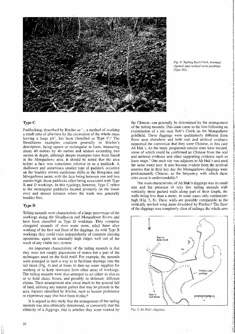
Fig. 4: Sapling Yard Creek, drainagechannel and vertical stone packings(Type D2).
TypeC
Paddocking, described by Ritchie as ' ...a method of workinga small area of alluvium by the excavation of the whole massleaving a large pit', has been classified as Type C.s TheShoalhaven examples conform generally to Ritchie'sdescription, being square or rectangular in form, measuringabout 40 metres by 40 metres and seldom exceeding twometres in depth, although deeper examples have been foundin the Mongarlowe area. It should be noted that the areabefore a face was sometimes referred to as a paddock. Ashallower and sometimes smaller type of paddock occurredon the boulder strewn auriferous drifts in the Bungonia andMongarlowe areas, with the face being between one and twometres high, these paddocks often being associated with TypeBand D workings. In this typology, however, Type C refersto the rectangular paddocks located primarily on the lowerriver and stream terraces where the wash was generallyboulder free.
TypeD
Tailing mounds were characteristic of a large percentage of theworkings along the Shoalhaven and Mongarlowe Rivers andhave been classified as Type D workings. They compriseelongated mounds of river worn stone, piled there afterworking of the face and floor of the diggings. As with Type Bworkings they could exist independently of common sluicingoperations, again on unusually high ridges well out of thereach of any viable race system.
An important characteristic of the tailing mounds is thatthey were not simply placements of stones but a part of thetechniques used on the field itself. For example, the moundswere arranged in such a way as to facilitate drainage into thetail races (Fig. 4) and at times to dam up water supplies forwashing or to keep rainwater from other areas of workings.The tailing mounds were also arranged to act either as sluicesor to hold sluice boxes, and possibly to delineate differentclaims. Their arrangement also owed much to the general fallof land, utilising any natural gullies that may be present in thearea. Factors identified by Ritchie, such as human preferenceor experience may also have been at play.6
It is argued in this study that the arrangement of the tailingmounds was also ethnically determined, or conversely that theethnicity of a diggings, that is whether they were worked by
36
the Chinese, can generally be determined by the arrangementof the tailing mounds. This issue came to the fore following anexamination of a site near Bob's Creek on the Mongarlowegoldfield. These diggings were qualitatively different fromthose seen elsewhere and both oral and archival evidencesupported the contention that they were Chinese, in this caseAh Hak's. As the study progressed similar sites were located,some of which could be confirmed as Chinese from the oraland archival evidence and other supporting evidence such aslease maps.7 One such site was adjacent to Ah Hak's and usedthe same water race. It also became evident from the archivalsources that in their hey day the Monagarlowe diggings werepredominantly Chinese, so the frequency with which thesesites occur is understandable.s
The main characteristic of Ah Hak's diggings was its smallsize and the presence of very low tailing mounds withvertically stone packed walls along part of their length, thewalls being less than a metre, in some cases only centimetreshigh (Fig. 5, 6). These walls are possibly comparable to thevertically stacked wing dams described by Ritchie.9 The floorof the diggings was completely clear of tailings, the whole area
1N
Vertical stone~.-- packings
Race toHalfMoon
Fig. 5: Ah Hak's diggings.
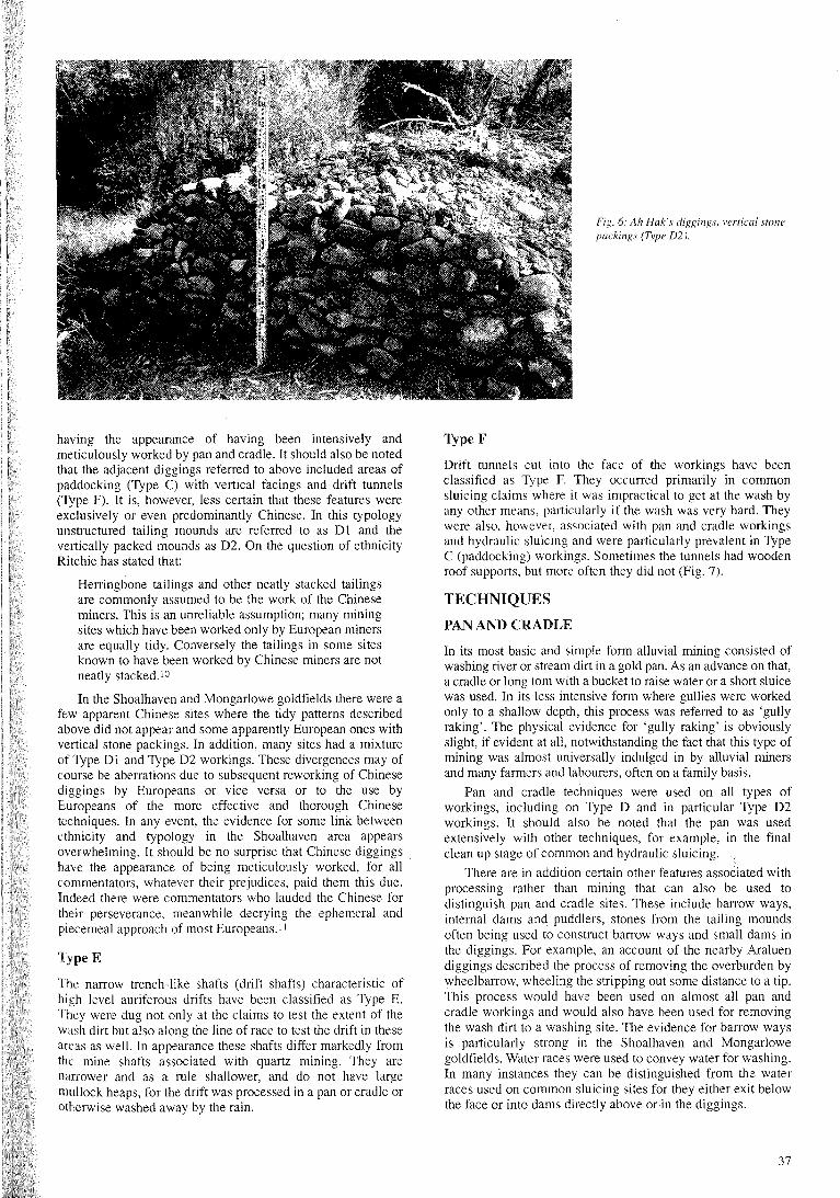
Fig. 6: Ah Hak's diggings, vertical stonepackings (Type D2).
having the appearance of having been intensively andmeticulously worked by pan and cradle. It should also be notedthat the adjacent diggings referred to above included areas ofpaddocking (Type C) with vertical facings and drift tunnels(Type F). It is, however, less certain that these features wereexclusively or even predominantly Chinese. In this typologyunstructured tailing mounds are referred to as D I and thevertically packed mounds as D2. On the question of ethnicityRitchie has stated that:
Herringbone tailings and other neatly stacked tailingsare commonly assumed to be the work of the Chineseminers. This is an unreliable assumption; many miningsites which have been worked only by European minersare equally tidy. Conversely the tailings in some sitesknown to have been worked by Chinese miners are notneatly stacked. 10
In the Shoalhaven and Mongarlowe goldfields there were afew apparent Chinese sites where the tidy patterns describedabove did not appear and some apparently European ones withvertical stone packings. In addition, many sites had a mixtureof Type D I and Type D2 workings. These divergences may ofcourse be aberrations due to subsequent reworking of Chinesediggings by Europeans or vice versa or to the use byEuropeans of the more effective and thorough Chinesetechniques. In any event, the evidence for some link betweenethnicity and typology in the Shoalhaven area appearsoverwhelming. It should be no surprise that Chinese diggingshave the appearance of being meticulously worked, for allcommentators, whatever their prejudices, paid them this due.Indeed there were commentators who lauded the Chinese fortheir perseverance, meanwhile decrying the ephemeral andpiecemeal approach of most Europeans. I I
TypeE
The narrow trench-like shafts (drift shafts) characteristic ofhigh level auriferous drifts have been classified as Type E.They were dug not only at the claims to test the extent of thewash dirt but also along the line of race to test the drift in theseareas as well. In appearance these shafts differ markedly fromthe mine shafts associated with quartz mining. They arenarrower and as a rule shallower, and do not have largemullock heaps, for the drift was processed in a pan or cradle orotherwise washed away by the rain.
Type F
Drift tunnels cut into the face of the workings have beenclassified as Type F. They occurred primarily in commonsluicing claims where it was impractical to get at the wash byany other means, particularly if the wash was very hard. Theywere also, however, associated with pan and cradle workingsand hydraulic sluicing and were particularly prevalent in TypeC (paddocking) workings. Sometimes the tunnels had woodenroof supports, but more often they did not (Fig. 7).
TECHNIQUES
PAN AND CRADLE
In its most basic and simple form alluvial mining consisted ofwashing river or stream dirt in a gold pan. As an advance on that,a cradle or long tom with a bucket to raise water or a short sluicewas used. In its less intensive form where gullies were workedonly to a shallow depth, this process was referred to as 'gullyraking'. The physical evidence for 'gully raking' is obviouslyslight, if evident at all, notwithstanding the fact that this type ofmining was almost universally indulged in by alluvial minersand many farmers and labourers, often on a family basis.
Pan and cradle techniques were used on all types ofworkings, including on Type D and in particular Type D2workings. It should also be noted that the pan was usedextensively with other techniques, for example, in the finalclean up stage of common and hydraulic sluicing.
There are in addition certain other features associated withprocessing rather than mining that can also be used todistinguish pan and cradle sites. These include barrow ways,internal dams and puddlers, stones from the tailing moundsoften being used to construct barrow ways and small dams inthe diggings. For example, an account of the nearby Araluendiggings described the process of removing the overburden bywheelbarrow, wheeling the stripping out some distance to a tip.This process would have been used on almost all pan andcradle workings and would also have been used for removingthe wash dirt to a washing site. The evidence for barrow waysis particularly strong in the Shoalhaven and Mongarlowegoldfields. Water races were used to convey water for washing.In many instances they can be distinguished from the waterraces used on common sluicing sites for they either exit belowthe face or into dams directly above or in the diggings.
37
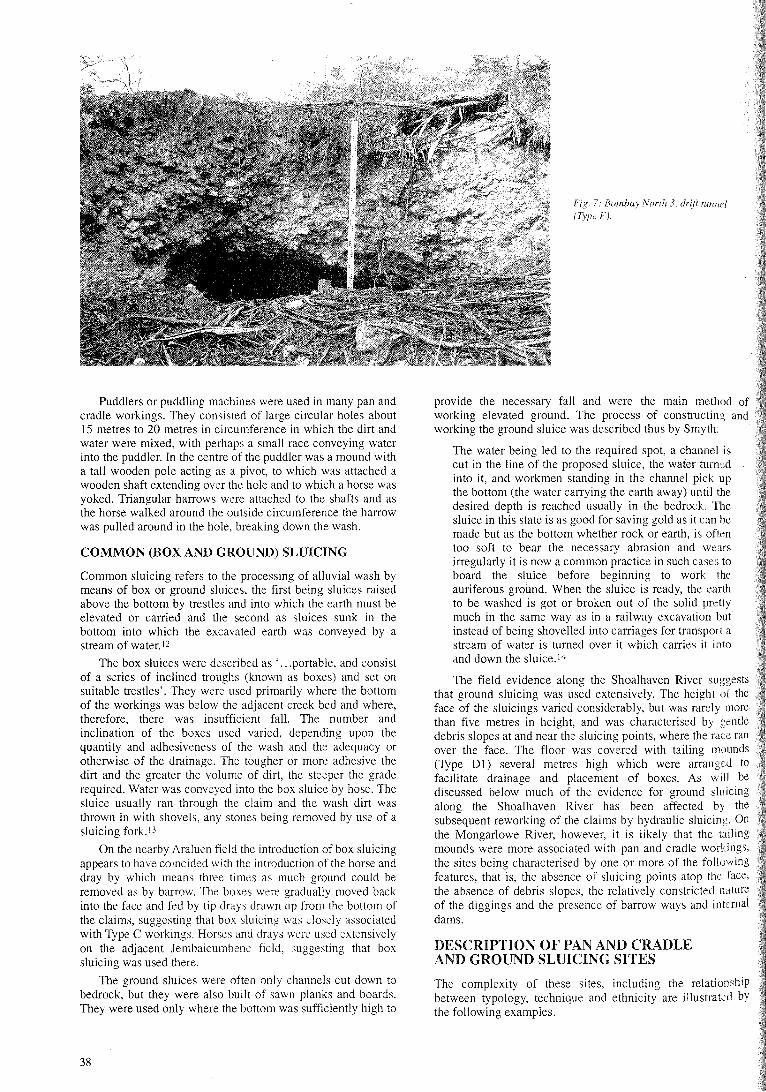
Fig. 7: Bomhay North 3. drifi tunnel(Type F).
Puddlers or puddling machines were used in many pan andcradle workings. They consisted of large circular holes about15 metres to 20 metres in circumference in which the dirt andwater were mixed, with perhaps a small race conveying waterinto the puddler. In the centre of the puddler was a mound witha tall wooden pole acting as a pivot, to which was attached awooden shaft extending over the hole and to which a horse wasyoked. Triangular harrows were attached to the shafts and asthe horse walked around the outside circumference the harrowwas pulled around in the hole, breaking down the wash.
COMMON (BOX AND GROUND) SLUICING
Common sluicing refers to the processing of alluvial wash bymeans of box or ground sluices, the first being sluices raisedabove the bottom by trestles and into which the earth must beelevated or carried and the second as sluices sunk in thebottom into which the excavated earth was conveyed by astream of water. 12
The box sluices were described as ' ...portable, and consistof a series of inclined troughs (known as boxes) and set onsuitable trestles'. They were used primarily where the bottomof the workings was below the adjacent creek bed and where,therefore, there was insufficient fall. The number andinclination of the boxes used varied, depending upon thequantity and adhesiveness of the wash and the adequacy orotherwise of the drainage. The tougher or more adhesive thedirt and the greater the volume of dirt, the steeper the graderequired. Water was conveyed into the box sluice by hose. Thesluice usually ran through the claim and the wash dirt wasthrown in with shovels, any stones being removed by use of asluicing fork. 13
On the nearby Araluen field the introduction of box sluicingappears to have coincided with the introduction of the horse anddray by which means three times as much ground could beremoved as by barrow. The boxes were gradually moved backinto the face and fed by tip drays drawn up from the bottom ofthe claims, suggesting that box sluicing was closely associatedwith Type C workings. Horses and drays were used extensivelyon the adjacent Iembaicumbene field, suggesting that boxsluicing was used there.
The ground sluices were often only channels cut down tobedrock, but they were also built of sawn planks and boards.They were used only where the bottom was sufficiently high to
38
provide the necessary fall and were the main method ofworking elevated ground. The process of constructing andworking the ground sluice was described thus by Smyth:
The water being led to the required spot, a channel iscut in the line of the proposed sluice, the water turnedinto it, and workmen standing in the channel pick upthe bottom (the water carrying the earth away) until thedesired depth is reached usually in the bedrock. Thesluice in this state is as good for saving gold as it can bemade but as the bottom whether rock or earth, is oftentoo soft to bear the necessary abrasion and wearsirregularly it is now a common practice in such cases toboard the sluice before beginning to work theauriferous ground. When the sluice is ready, the earthto be washed is got or broken out of the solid prettymuch in the same way as in a railway excavation butinstead of being shovelled into carriages for transport astream of water is turned over it which carries it intoand down the sluice. 14
The field evidence along the Shoalhaven River suggeststhat ground sluicing was used extensively. The height of theface of the sluicings varied considerably, but was rarely morethan five metres in height, and was characterised by gentledebris slopes at and near the sluicing points, where the race ranover the face. The floor was covered with tailing moundS(Type Dl) several metres high which were arranged tofacilitate drainage and placement of boxes. As will bediscussed below much of the evidence for ground sluicingalong the Shoalhaven River has been affected by thesubsequent reworking of the claims by hydraulic sluicing. Onthe Mongarlowe River, however, it is likely that the tailingmounds were more associated with pan and cradle workings,the sites being characterised by one or more of the followingfeatures, that is, the absence of sluicing points atop the face,the absence of debris slopes, the relatively constricted natureof the diggings and the presence of barrow ways and intemaldams.
DESCRIPTION OF PAN AND CRADLEAND GROUND SLUICING SITES
The complexity of these sites, including the relationshipbetween typology, technique and ethnicity are illustrated bythe following examples.

Site AVertical stone packingsand tailing mounds
39
Fig. 8: Talllulean Creek 2.
Race
To Mongarlowe Rjver
\
lOOmwide
Fig. 9: Tantulean Creek 2. vertical stone packings (Type D2) anddiggings/ace.
Face of diggings~
10
Fig. 10: Sapling Yard Creek.
Site BDamso
\ /Vertical facings
\0 20 30 40
ombay North 3
e Bombay North 3 ground diggings are located near thehoalhaven River. They are about 50 metres by 100 metres andre characterised by long tailing mounds with a number of
Cuiverts draining intoMongarlowe River
Sapling Yard Creek
The Sapling Yard Creek diggings are located on theMongarlowe River. The main diggings were typical Type Dworkings, although closer to the river are areas akin to Type C(Fig. 10). The area of tailing mounds measures about 100metres by 70 metres, the tailing mounds having been clearlyarranged to facilitate drainage into the Mongarlowe River (Fig.4). The water race enters a dam above the face, but there is noevidence that the water was run over the face, but rather that itwas used for washing, making this a pan and cradle site. Thereis considerable evidence of vertical stone packings, and mostof the tailing mounds can thus be classified as Type D2.Several hundred metres up hill there is another site containinggood examples of Type B workings, one section having beenstripped bare over an area of about 60 metres by 80 metres at adepth of only a few centimetres. Adjoining this is another areaof Type D2 workings, including a dam constructed of stones.
Tantulean Creek
Tantulean Creek 2 is located in the Mongarlowe field. It isabout 100 metres by 50 metres with a face of between two andthree metres (Fig. 8). A race runs from a nearby dam over theface to a small dammed area in the diggings, the dam alsoconstituting a barrow way. This dammed area is separatedfrom the diggings by a drift wall. There is evidence that waterwas also run over the face into the diggings, however, there isonly one sluicing point, which is not pronounced, and the faceof the diggings is vertical. A further race and a pronouncedbarrow way are located below the diggings. The diggings arevery constricted, and could at best have held only very shortsluices, It is likely therefore that this site was worked by panand cradle techniques.
A feature of these diggings is a small but very obvious areaof nearly rectangular and vertical tailing mounds (site A),similar but larger than those observed at Ah Hak's, thus fittingour Type D2 workings and suggesting a Chinese presence(Fig. 9).

80 100100m
61>o 20
Fig. 12: Bombay North 3, vertical stonepackings (Type D2).
Numcroustailingmounds
,s~~; E i::::l~\Vr~ ~
SI~Cing~nts ,5~
~ Drift /1\ ~::t_~ Islands ~\.H and~ ~II sluicingpolflls
~L i1~J\~:~'~\SIlCG I I
Gully Culvcrtsdraining into thcShoalhavcnRivcr
\
Sitc CDam/pathway
!Tailing mounds
To Shoalhavcn Rivcr
Tailing mounds
"'V>
1N
5 10 15 20 2S
Fig. 11: Bombay North 3. Fig. 13: Pipeclay 1.
vertically stone packed embankments typical of Type D2workings (Fig. II, 12). Although there are a number of raceentry points akin to sluicing points, the face of the diggings isvertical and there are also a number of drift tunnels set into theface at various points. The tailing mounds are arranged so as tofacilitate drainage into the Shoalhaven River, and in places runparallel to the face. The diggings are constricted in areasuggesting that at the most only very short sluices would havebeen used, if at all. There is a very obvious footway at the baseof the diggings leading to a small dam, suggesting that the dirtwas conveyed to this site for washing.
Pipeclay 1
Pipeclay I is a ground sluicing site fed by a primary racesystem emanating from the Shoalhaven River and possiblyLittle Bombay Creek. The diggings are extensive and measure300 metres across at their widest point and 350 metres across
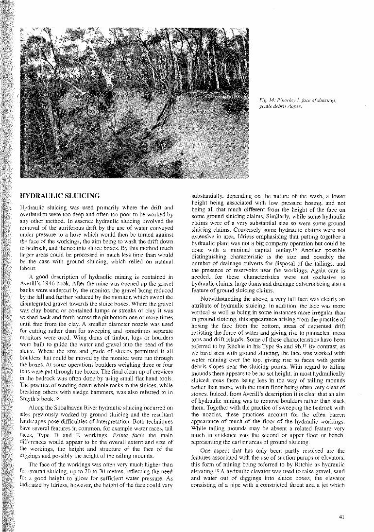
at their longest point (Fig. 13). The face of the diggings variesbut it is in parts five metres high. Along the top perimeter ofthe diggings are numerous races and channels converging atsluicing points (site D). Water was run from the sluicing pointsdown the face of the diggings, washing the excavated dirt intoground sluices or sluice boxes set between the tailing mounds.The site is characterised for the most part by gentle debrisslopes at and near the sluicing points and tailing mounds (TypeD) several metres high in places and of a considerable length(Fig. 14). There are no vertical stone packings in thesediggings, the tailing mounds being Type D I. Type E workingsare located along the west perimeter.
Proceeding down the east perimeter of the diggings is alow level embankment about 60 metres long situated veryclose to the face (site D). The embankment is a dam wall forretention of water prior to sluicing, this particular area perhapsbeing worked by low level hydraulicking or even elevating.
40
HYDRAULIC SLUICING
Hydraulic sluicing was used primarily where the drift andoverburden were too deep and often too poor to be worked byany other method. In essence hydraulic sluicing involved theremoval of the auriferous drift by the use of water conveyedunder pressure to a hose which would then be turned againstthe face of the workings, the aim being to wash the drift downto bedrock, and thence into sluice boxes. By this method muchlarger areas could be processed in much less time than wouldbe the case with ground sluicing, which relied on manuallabour.
A good description of hydraulic mining is contained inAverill's 1946 book. After the mine was opened up the gravelbanks were undercut by the monitor, the gravel being reducedby the fall and further reduced by the monitor, which swept thedisintegrated gravel towards the sluice boxes. Where the gravelwas clay bound or contained lumps or streaks of clay it waswashed back and forth across the pit bottom one or more timesuntil free from the clay. A smaller diameter nozzle was usedfor cutting rather than for sweeping and sometimes separatemonitors were used. Wing dams of timber, logs or boulderswere built to guide the water and gravel into the head of thesluice. Where the size and grade of sluices permitted it allboulders that could be moved by the monitor were run throughthe boxes. At some operations boulders weighing three or fourtons were put through the boxes. The final clean up of crevicesin the bedrock was often done by using small flat hand tools.The practice of sending down whole rocks in the sluices, whilebreaking others with sledge hammers, was also referred to inSmyth's book. IS
Along the Shoalhaven River hydraulic sluicing occurred onsites previously worked by ground sluicing and the resultantlandscapes pose difficulties of interpretation. Both techniqueshave several features in common, for example water races, tailraces, Type D and E workings. Prima facie the maindifferences would appear to be the overall extent and size ofthe workings, the height and structure of the face of thediggings and possibly the height of the tailing mounds.
The face of the workings was often very much higher thanfor ground sluicing, up to 20 to 30 metres, reflecting the needfor good height to allow for sufficient water pressure. Asindicated by Idriess, however, the height of the face could vary
Fig. 14: Pipeclay l,face ofsluicings,gentle debris slopes,
substantially, depending on the nature of the wash, a lowerheight being associated with low pressure hosing, and notbeing all that much different from the height of the face onsome ground sluicing claims. Similarly, while some hydraulicclaims were of a very substantial size so were some groundsluicing claims. Conversely some hydraulic claims were notextensive in area, Idriess emphasising that putting together ahydraulic plant was not a big company operation but could bedone with a minimal capital outlay.16 Another possibledistinguishing characteristic is the size and possibly thenumber of drainage culverts for disposal of the tailings, andthe presence of reservoirs near the workings. Again care isneeded, for these characteristics were not exclusive tohydraulic claims, large dams and drainage culverts being also afeature of ground sluicing claims.
Notwithstanding the above, a very tall face was clearly anattribute of hydraulic sluicing. In addition, the face was morevertical as well as being in some instances more irregular thanin ground sluicing, this appearance arising from the practice ofhosing the face from the bottom, areas of cemented driftresisting the force of water and giving rise to pinnacles, mesatops and drift islands. Some of these characteristics have beenreferred to by Ritchie in his Type 9a and 9b. 17 By contrast, aswe have seen with ground sluicing, the face was worked withwater running over the top, giving rise to faces with gentledebris slopes near the sluicing points. With regard to tailingmounds there appears to be no set height, in most hydraulicallysluiced areas there being less in the way of tailing moundsrather than more, with the main floor being often very clear ofstones. Indeed, from Averill's description it is clear that an aimof hydraulic mining was to remove boulders rather than stackthem. Together with the practice of sweeping the bedrock withthe nozzles, these practices account for the often barrenappearance of much of the floor of the hydraulic workings.While tailing mounds may be absent a related feature verymuch in evidence was the second or upper floor or bench,representing the earlier areas of ground sluicing.
One aspect that has only been partly resolved are thefeatures associated with the use of suction pumps or elevators,this form of mining being referred to by Ritchie as hydraulicelevating. 18 A hydraulic elevator was used to raise gravel, sandand water out of diggings into sluice boxes, the elevatorconsisting of a pipe with a constricted throat and a jet which
41
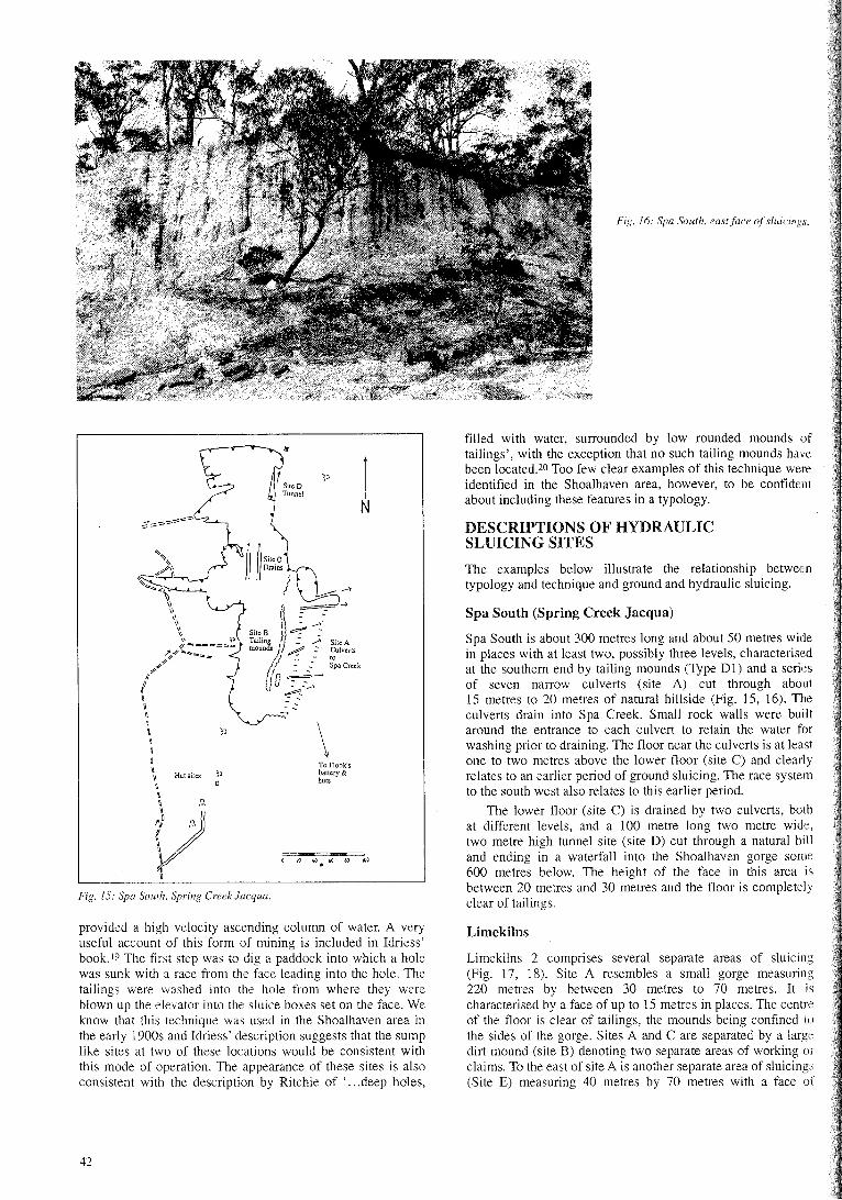
Fig. 16: Spa South. east/lice oj'sluicings.
To Flook'sbalfcry &huts
Fig. 15: Spa South, Spring Creek lacqua.
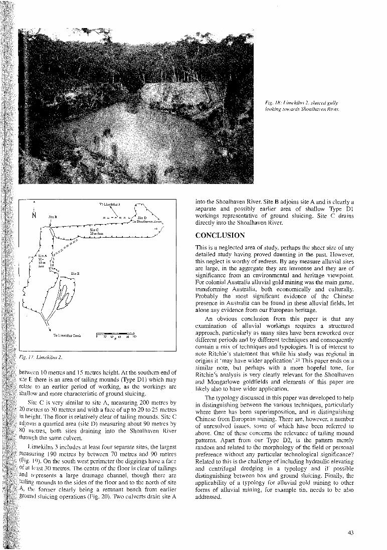
Spa South (Spring Creek Jacqua)
Spa South is about 300 metres long and about 50 metres widein places with at least two, possibly three levels, characterisedat the southern end by tailing mounds (Type Dl) and a seriesof seven narrow culverts (site A) cut through about15 metres to 20 metres of natural hillside (Fig. 15, 16). Theculverts drain into Spa Creek. Small rock walls were builtaround the entrance to each culvert to retain the water forwashing prior to draining. The floor near the culverts is at leastone to two metres above the lower floor (site C) and clearlyrelates to an earlier period of ground sluicing. The race systemto the south west also relates to this earlier period.
The lower floor (site C) is drained by two culverts, bOlhat different levels, and a 100 metre long two metre wide,two metre high tunnel site (site D) cut through a natural hilland ending in a waterfall into the Shoalhaven gorge some600 metres below. The height of the face in this area isbetween 20 metres and 30 metres and the floor is completelyclear of tailings.
DESCRIPTIONS OF HYDRAULICSLUICING SITES
The examples below illustrate the relationship betweentypology and technique and ground and hydraulic sluicing.
filled with water, surrounded by low rounded mounds oftailings', with the exception that no such tailing mounds havebeen located.2o Too few clear examples of this technique wereidentified in the Shoalhaven area, however, to be confidentabout including these features in a typology.1
\
),
:=::-4- .....-
SiteB ~-Tailil, ::...; Sile Amoun ~:: Culverts
- '0: __.. Spa Creek
D~~
~
~'\.
~\\~
"'''~IIIIII
"""\I\\ ,~
//-=_.::0:'=""'_.l'4'~""::'_"",..::r
,,:7?
Ii/1
(
\iIIi\ ;'J~
iU
\ Hutsiles l'~
\
{)U
provided a high velocity ascending column of water. A veryuseful account of this form of mining is included in Idriess'book. 19 The first step was to dig a paddock into which a holewas sunk with a race from the face leading into the hole. Thetailings were washed into the hole from where they wereblown up the elevator into the sluice boxes set on the face. Weknow that this technique was used in the Shoalhaven area inthe early 1900s and Idriess' description suggests that the sumplike sites at two of these locations would be consistent withthis mode of operation. The appearance of these sites is alsoconsistent with the description by Ritchie of ' ...deep holes,
Limekilns
Limekilns 2 comprises several separate areas of sluicing(Fig. 17, 18). Site A resembles a small gorge measuring220 metres by between 30 metres to 70 metres. It ischaracterised by a face of up to 15 metres in places. The centreof the floor is clear of tailings, the mounds being confined tothe sides of the gorge. Sites A and C are separated by a largedirt mound (site B) denoting two separate areas of working orclaims. To the east of site A is another separate area of sluicings(Site E) measuring 40 metres by 70 metres with a face of
42
between 10 metres and IS metres height. At the southern end ofsite E there is an area of tailing mounds (Type D I) which mayrelate to an earlier period of working, as the workings areshallow and more characteristic of ground sluicing.
Site C is very similar to site A, measuring 200 metres by20 metres to 30 metres and with a face of up to 20 to 25 metresin height. The floor is relatively clear of tailing mounds. Site Cadjoins a quarried area (site D) measuring about 90 metres by80 metres, both sites draining into the Shoalhaven Riverthrough the same culvert.
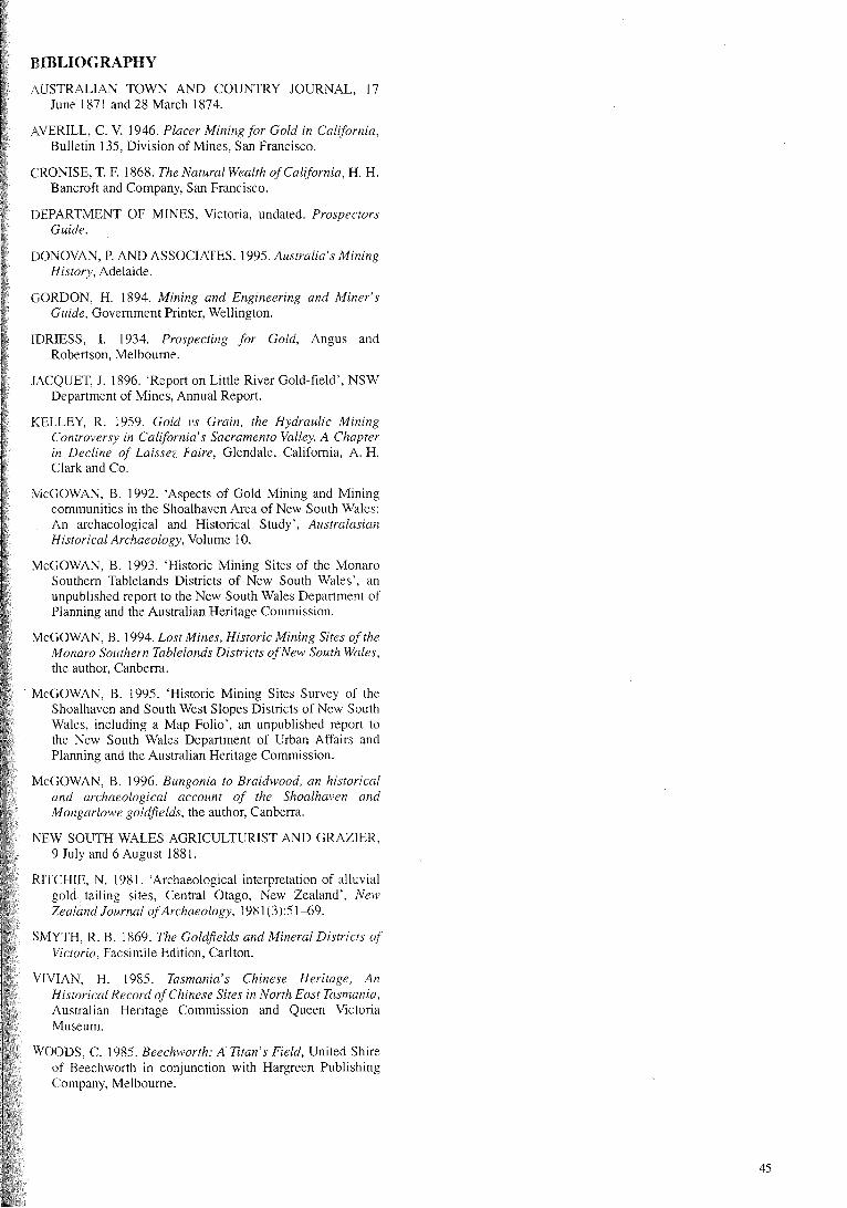
Limekilns 3 includes at least four separate sites, the largestmeasuring 190 metres by between 70 metres and 90 metres(Fig. 19). On the south west perimeter the diggings have a faceof at least 30 metres. The centre of the floor is clear of tailingsand represents a large drainage channel, though there aretailing mounds to the sides of the floor and to the north of siteA, the former clearly being a remnant bench from earlierground sluicing operations (Fig. 20). Two culverts drain site A
To Limekilns Creek
SiteC20 m face
o 2U 40 60 &0 100m
Fig. 18: Limekilns 2, sluiced gullylooking towards Sh(wlhaven River.
into the Shoalhaven River. Site B adjoins site A and is clearly aseparate and possibly earlier area of shallow Type DIworkings representative of ground sluicing. Site C drainsdirectly into the Shoalhaven River.
CONCLUSION
This is a neglected area of study, perhaps the sheer size of anydetailed study having proved daunting in the past. However,this neglect is worthy of redress. By any measure alluvial sitesare large, in the aggregate they are immense and they are ofsignificance from an environmental and heritage viewpoint.For colonial Australia alluvial gold mining was the main game,transforming Australia, both economically and culturally.Probably the most significant evidence of the Chinesepresence in Australia can be found in these alluvial fields, letalone any evidence from our European heritage.
An obvious conclusion from this paper is that anyexamination of alluvial workings requires a structuredapproach, particularly as many sites have been reworked overdifferent periods and by different techniques and consequentlycontain a mix of techniques and typologies. It is of interest tonote Ritchie's statement that while his study was regional inorigins it 'may have wider application' .21 This paper ends on asimilar note, but perhaps with a more hopeful tone, forRitchie's analysis is very clearly relevant for the Shoalhavenand Mongarlowe goldfields and elements of this paper arelikely also to have wider application.
The typology discussed in this paper was developed to helpin distinguishing between the various techniques, particularlywhere there has been superimposition, and in distinguishingChinese from European mining. There are, however, a numberof unresolved issues, some of which have been referred toabove. One of these concerns the relevance of tailing moundpatterns. Apart from our Type D2, is the pattern merelyrandom and related to the morphology of the field or personalpreference without any particular technological significance?Related to this is the challenge of including hydraulic elevatingand centrifugal dredging in a typology and if possibledistinguishing between box and ground sluicing. Finally, theapplicability of a typology for alluvial gold mining to otherforms of alluvial mining, for example tin, needs to be alsoaddressed.
43
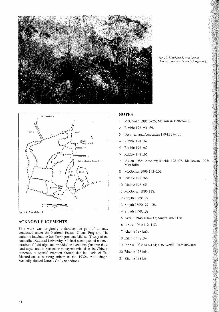
Fig. 20: Limekilns 3. west face ofslaicings. remnant hench in jiJreground.
3 Donovan and Associates 1994: 172-175.
McGowan 1995:3-25; McGowan 1996:6-21.
2 Ritchie 1981:51-69.
NOTES
4 Ritchie 1981:62.
5 Ritchie 1981 :62.
6 Ritchie 1981:66.
7 Vivian 1985: Plate 29; Ritchie 1981 :78; McGowan 1995:Map folio.
8 McGowan 1996: 143-201.
9 Ritchie 1981:68.
10 Ritchie 1981:55.
11 McGowan 1996: 128.
12 Smyth 1869:127.
13 Smyth 1869:127-128.
14 Smyth 1979: 138.
15 Averill 1946: 108-115; Smyth 1869: 138.
16 Idriess 1934: 112-148.
17 Ritchie 1981:63.
18 Ritchie 1981 :64.
19 Idriess 1934: 149-154; also Averill 1946: 106--108.
20 Ritchie 1981:64.
21 Ritchie 1981:64
ACKNOWLEDGEMENTS
44
t To Limekilns 4
N I
~\ 21".:';1SHee\\ ~ ... -\\ ,..JI' -:--~ N\\ ..... ~~\~,%-~;i"
~~~ SHeB11-:- .,-,:-:.--;- ~llJngmOUndS
/(<>~ rd::L1\ \\
\\ '\. A~;:; Tailing mounds
\~\ '\ /~ J' ~~j \\ 1/ Culverts to Shoalhaven River
II II f/j II""~ IIII II .~".===
\1 II1\ IIII II\\IJ:=.=~::::.::::.:::::~II ~
1/
ti~Jr::::::::::::::: ....
Jj ::=.:::::;;~::::-
LJ.---'-""-"-
This work was originally undertaken as part of a studyconducted under the National Estates Grants Program. Theauthor is indebted to Ian Farrington and Michael Tracey of theAustralian National University. Michael accompanied me on anumber of field trips and provided valuable insights into theselandscapes and in particular to aspects related to the Chinesepresence. A special mention should also be made of TedRichardson, a working miner in the 1930s, who singlehandedly sluiced Dunn's Gully to bedrock.
Fig. 19: Limekilns 3.
BIBLIOGRAPHY
AUSTRALIAN TOWN AND COUNTRY JOURNAL, 17June 1871 and 28 March 1874.
AVERILL, C. V. 1946. Placer Mining for Gold in California,Bulletin 135, Division of Mines, San Francisco.
CRONISE, T. F. 1868. The Natural Wealth ofCalifornia, H. H.Bancroft and Company, San Francisco.
DEPARTMENT OF MINES, Victoria, undated. ProspectorsGuide.
DONOVAN, P. AND ASSOCIATES. 1995. Australia's MiningHistory, Adelaide.
GORDON, H. 1894. Mining and Engineering and Miner'sGuide, Government Printer, Wellington.
IDRIESS, 1. 1934. Prospecting for Gold, Angus andRobertson, Melbourne.
JACQUET, J. 1896. 'Report on Little River Gold-field', NSWDepartment of Mines, Annual Report.
KELLEY, R. 1959. Gold vs Grain, the Hydraulic MiningControversy in California's Sacramento Valley. A Chapterin Decline of Laissez Faire, Glendale, California, A. H.Clark and Co.
McGOWAN, B. 1992. 'Aspects of Gold Mining and Miningcommunities in the Shoalhaven Area of New South Wales:An archaeological and Historical Study', AustralasianHistorical Archaeology, Volume 10.
McGOWAN, B. 1993. 'Historic Mining Sites of the MonaroSouthern Tablelands Districts of New South Wales', anunpublished report to the New South Wales Department ofPlanning and the Australian Heritage Commission.
McGOWAN, B. 1994. Lost Mines, Historic Mining Sites of theMonaro Southern Tablelands Districts ofNew South Wales,the author, Canberra.
McGOWAN, B. 1995. 'Historic Mining Sites Survey of theShoalhaven and South West Slopes Districts of New SouthWales, including a Map Folio', an unpublished report tothe New South Wales Department of Urban Affairs andPlanning and the Australian Heritage Commission.
McGOWAN, B. 1996. Bungonia to Braidwood, an historicaland archaeological account of the Shoalhaven andMongarlowe goldfields, the author, Canberra.
NEW SOUTH WALES AGRICULTURIST AND GRAZIER,9 July and 6 August 1881.
RITCHIE, N. 1981. 'Archaeological interpretation of alluvialgold tailing sites, Central Otago, New Zealand', NewZealand Journal ofArchaeology, 1981 (3):51-69.
SMYTH, R. B. 1869. The Goldfields and Mineral Districts ofVictoria, Facsimile Edition, Carlton.
VIVIAN, H. 1985. Tasmania's Chinese Heritage, AnHistorical Record ofChinese Sites in North East Tasmania,Australian Heritage Commission and Queen VictoriaMuseum.
WOODS, C. 1985. Beechworth: A Titan's Field, United Shireof Beechworth in conjunction with Hargreen PublishingCompany, Melbourne.
45