the use of gis and remote sensing to monitor and plan...
TRANSCRIPT

The Use of GIS and Remote Sensing to The Use of GIS and Remote Sensing to Monitor and Plan Urban ActivitiesMonitor and Plan Urban ActivitiesMonitor and Plan Urban ActivitiesMonitor and Plan Urban ActivitiesExamples from the Angola TrainingExamples from the Angola Trainingp g gp g g

SummarySummary
IntroductionIntroductionIntroductionIntroductionContext / CollaborationContext / CollaborationOverview of GIS in CMHCOverview of GIS in CMHCExamples of Students’ WorkExamples of Students’ WorkBringing Theory to the Real WorldBringing Theory to the Real WorldBringing Theory to the Real WorldBringing Theory to the Real WorldConclusion / QuestionsConclusion / QuestionsConclusion / QuestionsConclusion / Questions
CANADA MORTGAGE AND HOUSING CORPORATION 2

Example #1 Example #1 -- Water DistributionWater Distribution
CANADA MORTGAGE AND HOUSING CORPORATION 3

Example #1 Example #1 -- Water Distribution Water Distribution ((cont’d)cont’d)
CANADA MORTGAGE AND HOUSING CORPORATION 4

Example #1 Example #1 -- Water Distribution Water Distribution ((cont’d)cont’d)
CANADA MORTGAGE AND HOUSING CORPORATION 5

Example #1 Example #1 -- Water Distribution Water Distribution ((cont’d)cont’d)
CANADA MORTGAGE AND HOUSING CORPORATION 6

Example #1 Example #1 -- Water Distribution Water Distribution ((cont’d)cont’d)
CANADA MORTGAGE AND HOUSING CORPORATION 7

Example #2 Example #2 –– Density ClassificationDensity Classification
CANADA MORTGAGE AND HOUSING CORPORATION 8

Example #2 Example #2 –– Density Classification Density Classification (cont’d)(cont’d)
CANADA MORTGAGE AND HOUSING CORPORATION 9

Example #2 Example #2 –– Density Classification Density Classification (cont’d)(cont’d)
CANADA MORTGAGE AND HOUSING CORPORATION 10

Example #2 Example #2 –– Density Classification Density Classification (cont’d)(cont’d)
1 2 3
1 29,5% 9,8% 5,9%
2 1,3% 10,6% 21,7%
3 0,4% 4,1% 16,7%
Matriz - Correspondência
Cla
ssN
um
ClassVisual
56,8% Excelente
36,9% Razoavel
6,3% Mau
CANADA MORTGAGE AND HOUSING CORPORATION 11
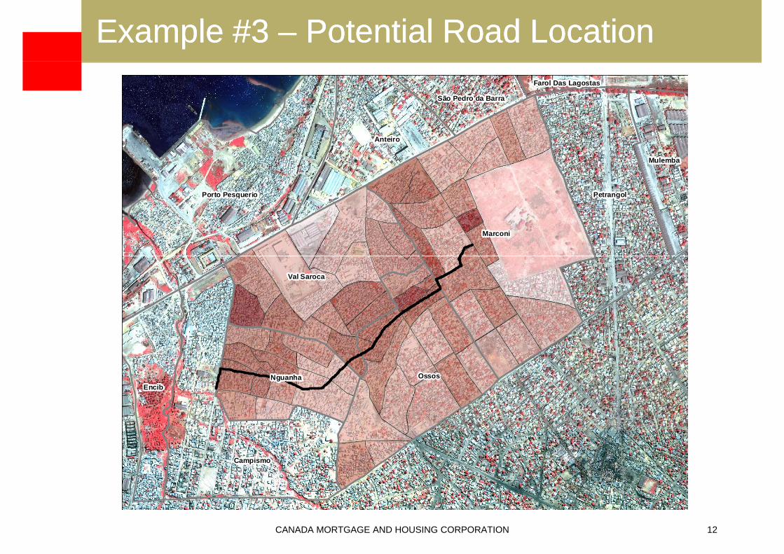
Example #3 Example #3 –– Potential Road LocationPotential Road Location
São Pedro da Barra
Farol Das Lagostas
Anteiro
Mulemba
Marconi
PetrangolPorto Pesquerio
Val Saroca
OssosEncib
Nguanha
Campismo
CANADA MORTGAGE AND HOUSING CORPORATION 12

Example #3 Example #3 –– Potential Road Location Potential Road Location (cont’d)(cont’d)
São Pedro da Barra
Farol Das Lagostas
Anteiro
Mulemba
Marconi
PetrangolPorto Pesquerio
@Val Saroca
@@@
@@@@@@@
@@@@@@@
@@
@@@@
@ OssosEncib
Nguanha
@ @@
@@@ @
@@@
@@
@@
@@Campismo
CANADA MORTGAGE AND HOUSING CORPORATION 13
@@ @@

Example #3 Example #3 –– Potential Road Location Potential Road Location (cont’d)(cont’d)
São Pedro da Barra
Farol Das Lagostas
Anteiro
Mulemba
Marconi
PetrangolPorto Pesquerio
@ @
Val Saroca
@@@
@@@@@@
@
@@@@@@@
@@
@@@@
@ OssosEncib
Nguanha
@ @@
@@@ @
@@
@@
@@
@@Campismo
CANADA MORTGAGE AND HOUSING CORPORATION 14
@ @@

Example #3 Example #3 –– Potential Road Location Potential Road Location (cont’d)(cont’d)
São Pedro da Barra
Farol Das Lagostas
Anteiro
Mulemba
Marconi
PetrangolPorto Pesquerio
@Val Saroca
@@@
@@@@@@
@
@@@@@@@
@@
@@@@
@@ OssosEncib
Nguanha
@ @@
@@@ @
@@@
@@
@@
@@Campismo
CANADA MORTGAGE AND HOUSING CORPORATION 15
@@ @@

Example #4 Example #4 –– Mudslide Risk MonitoringMudslide Risk Monitoring
CANADA MORTGAGE AND HOUSING CORPORATION 16

Example #4 Example #4 –– Mudslide Risk Monitoring Mudslide Risk Monitoring (cont’d(cont’d))
CANADA MORTGAGE AND HOUSING CORPORATION 17

Example #4 Example #4 –– Mudslide Risk Monitoring Mudslide Risk Monitoring (cont’d(cont’d))
CANADA MORTGAGE AND HOUSING CORPORATION 18

Example #4 Example #4 –– Mudslide Risk Monitoring Mudslide Risk Monitoring (cont’d(cont’d))
CANADA MORTGAGE AND HOUSING CORPORATION 19

Example #4 Example #4 –– Mudslide Risk Monitoring Mudslide Risk Monitoring (cont’d(cont’d))
CANADA MORTGAGE AND HOUSING CORPORATION 20

Example #4 Example #4 –– Mudslide Risk Monitoring Mudslide Risk Monitoring (cont’d(cont’d))
CANADA MORTGAGE AND HOUSING CORPORATION 21

Conclusion / QuestionsConclusion / Questions
CANADA MORTGAGE AND HOUSING CORPORATION 22