the whw eather rhr esearch and forecasting (wrf) model · 2014-02-08 · mm5 version 3.7 released...
TRANSCRIPT

Th W h R h dThe Weather Research and Forecasting (WRF) ModelForecasting (WRF) Model
Y.V. Rama Rao
India Meteorological DepartmentIndia Meteorological Department
New Delhi

Preamble
Weather Prediction an “Initial value problem”Hence, Earth Observing System (EOS) involvingland based, remote & space based observationsand rapid data transmission are back bone ofand rapid data transmission are back-bone ofweather forecasting
Well recognized and demonstrated thatweather/climate prediction at all time scales(short medium extended seasonal and climate)(short, medium, extended, seasonal and climate)can be achieved only by numerical models
NWP is the most appropriate approach forweather/climate prediction

Components of NWPEOS to obtain initial state of the atmosphere
Rapid collection/transmission of all forms of observations
D P i d li lData Processing and quality controlData assimilationAdvanced NWP Modeling SystemPost processing and Derivation of products Post processing and Derivation of products
for different stake holders for various applications
Efficient dissemination of forecast products
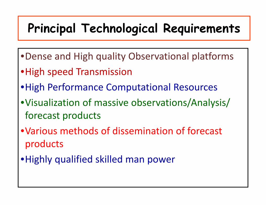
Principal Technological Requirements
•Dense and High quality Observational platforms
•High speed Transmission
•High Performance Computational ResourcesHigh Performance Computational Resources
•Visualization of massive observations/Analysis/ forecast productsforecast products
•Various methods of dissemination of forecast d tproducts
•Highly qualified skilled man power

Developments in NWP
• Present Observation System is Synoptic Scale
• Most of NWP models of 80-90’s are of Synoptic scale models.Dynamics of atmosphere is given more importance and physicalprocess are not properly resolved due to limitation of computerpower
• Advancement in Satellite & Radar observation made it possibleto get the mesoscale observations such as satellite windsto get the mesoscale observations such as satellite winds,temperature and moisture profiles at highly spatial and temporalresolution.
• Advancement in computer made it possible for mesoscalemodel forecast
• Public Demand for mesoscale forecast
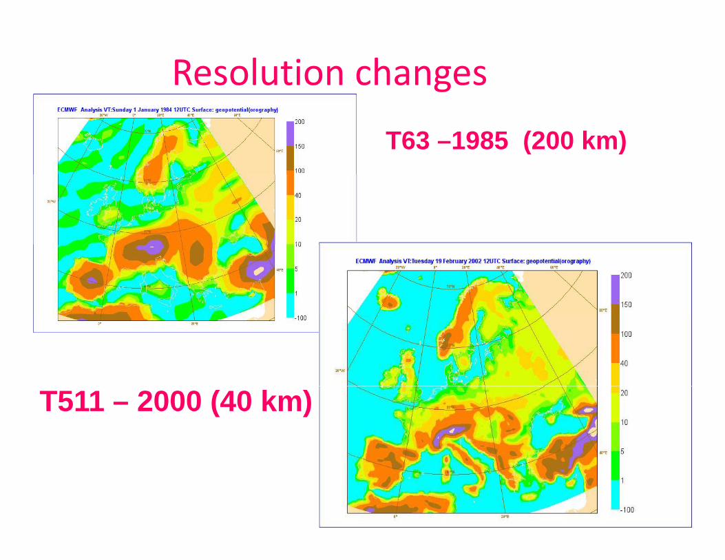
Resolution changes
T63 –1985 (200 km)
T511 – 2000 (40 km)

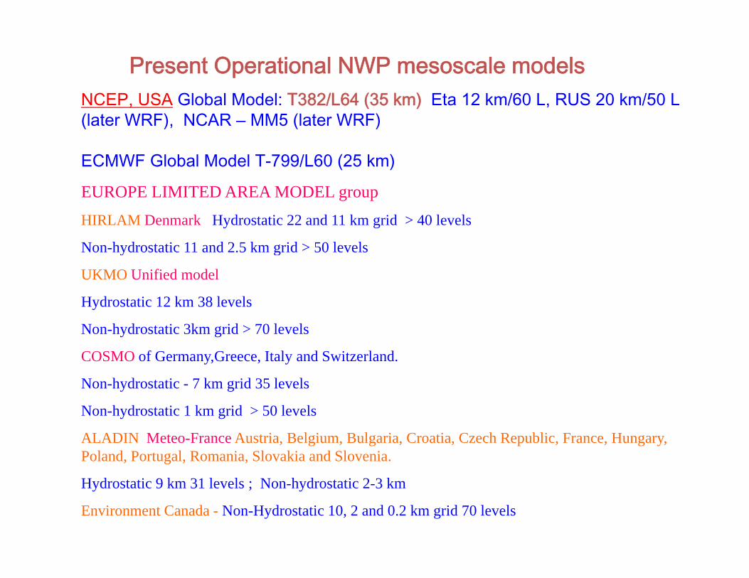
NCEP, USA Global Model: T382/L64 (35 km) Eta 12 km/60 L, RUS 20 km/50 L
Present Operational NWP mesoscale models, ( ) ,
(later WRF), NCAR – MM5 (later WRF)
ECMWF Global Model T-799/L60 (25 km)
EUROPE LIMITED AREA MODEL groupHIRLAM Denmark Hydrostatic 22 and 11 km grid > 40 levels
Non-hydrostatic 11 and 2.5 km grid > 50 levelsy g
UKMO Unified model
Hydrostatic 12 km 38 levels
N h d t ti 3k id > 70 l lNon-hydrostatic 3km grid > 70 levels
COSMO of Germany,Greece, Italy and Switzerland.
Non-hydrostatic - 7 km grid 35 levels
Non-hydrostatic 1 km grid > 50 levels
ALADIN Meteo-France Austria, Belgium, Bulgaria, Croatia, Czech Republic, France, Hungary, Poland, Portugal, Romania, Slovakia and Slovenia.
Hydrostatic 9 km 31 levels ; Non-hydrostatic 2-3 km
Environment Canada - Non-Hydrostatic 10, 2 and 0.2 km grid 70 levels
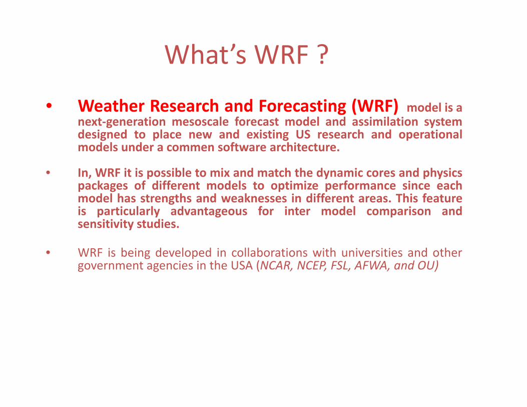
What’s WRF ?
• Weather Research and Forecasting (WRF) model is anext‐generation mesoscale forecast model and assimilation systemg ydesigned to place new and existing US research and operationalmodels under a commen software architecture.
• In, WRF it is possible to mix and match the dynamic cores and physics, p y p ypackages of different models to optimize performance since eachmodel has strengths and weaknesses in different areas. This featureis particularly advantageous for inter model comparison andsensitivity studies.y
• WRF is being developed in collaborations with universities and othergovernment agencies in the USA (NCAR, NCEP, FSL, AFWA, and OU)
MM5 Version 3.7 released in December 2004
Version 3.7.2 released in May 2005 with modification of 3.7
With WRF development MM5 development has been ended and the model isconsidered frozen
The WRF model is designed to be a flexible, state-of-the-art, portable code thati ffi i i i l ll l i i P i 2 1 2is efficient in a massively parallel computing environment. Present version 2.1.2released in January 2006.
A modular single source code is maintained that can be configured for both rA modular single-source code is maintained that can be configured for both research and operations.
It offers numerous physics options thus tapping into the experience of the broadIt offers numerous physics options, thus tapping into the experience of the broadmodeling community.
It is suitable for use in a broad spectrum of applications across scales rangingp pp g gfrom meters to thousands of kilometers such as downscaling climate simulation,driving air quality models, atmosphere-ocean coupling, and idealized simulations(e.g boundary-layer eddies, convection, baroclinic waves).
There are different versions of WRFThere are different versions of WRF
• ARW (Advanced Research WRF), NCAR, USA
• WRF NMM (Nonhydrostatic Mesoscale Model), NCEP, USA
• WRF Non-hydrostatic Meso-Scale Model (WRF-NMM) is a sub-setW N y S (W N )of ARW. Dynamical core developed by NOAA/NCEP/EMC). It includes: initialization (WRF-NMM SI) and post-processing components
• Physics and software framework are shared with WRF-ARW
• Hurricane WRF, NCEP/NOAA, USA – Air-Sea coupling, Movable1 2 ti f iliti t d t b d ti l b th1-2 way nesting facilities expected to be made operational by theend of 2007 to replace the present operational hurricane model –GFDL at NCEP model.

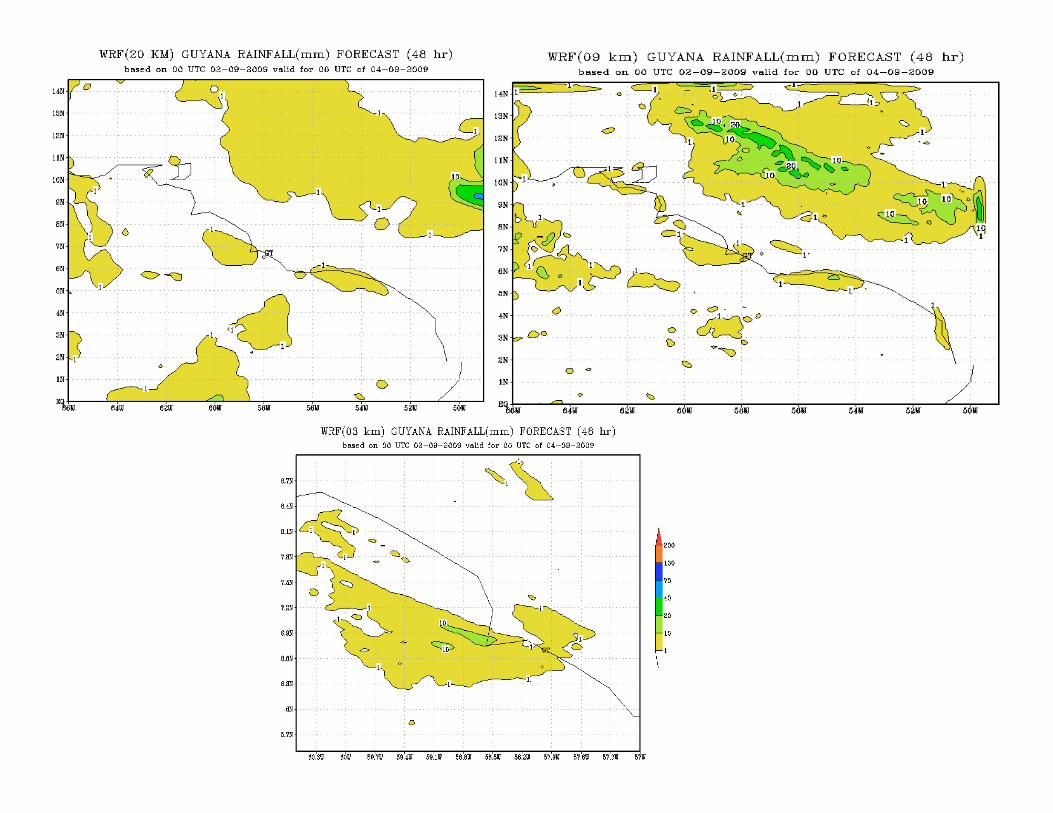
• This study aims in evaluating the ability of WRFmodel to predict Heavy Rainfall events.
• Case-I: Based on Initial Conditions of 02 September2009 and 01 November 2009.
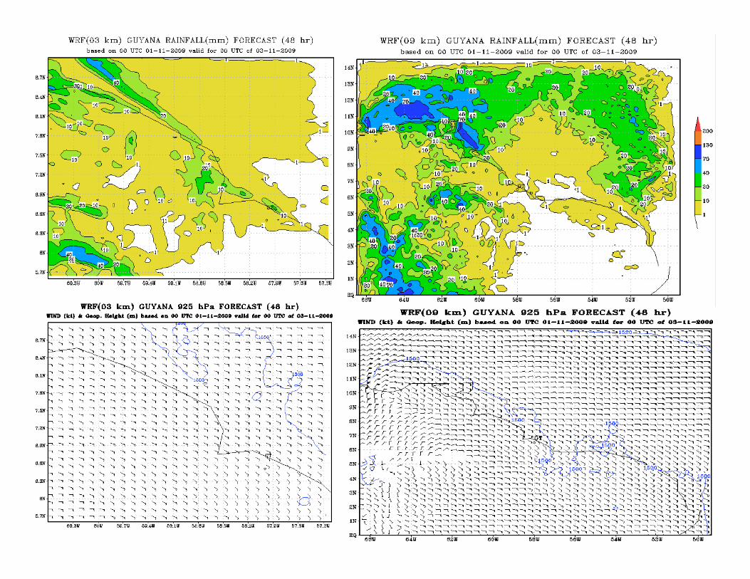
• Case-II: Impact of Resolution (20, 9 and 3 kms).

WRF Model• Dynamics:Non-hydrostatic Version (2 2)Dynamics:Non-hydrostatic Version (2.2)• Dynamical core: ARW (Advanced research WRF)• Single domain • Horizontal Resolution: 20, 9 & 3 km• Vertical Resolution: 28 Sigma levels
i 0 0 0 0• Domain: -5S0-150N; 660W-480W• Time step: 100 sec• Map projection: Mercator• Horizontal Grid system: Arakawa- C grid• Time Integration scheme: Third order Runge-Kutta schemeg g• Real-data using Standard Initialization (SI) conversion from Grib files • Spatial differencing scheme: 2nd to 6th order schemes• 6 hourly boundary conditions• Forecast run up to 72 hours (3 days) • PHYSICS• PHYSICS• Microphysics (WSM 3 simple ice scheme)• Cumulus parameterization (Kain-Fritsch scheme) Input data types• NCEP Global Analyses/Forecast (GFS) at 10x10 lat./long. resolution in GRIB format• Terrestrial data
– 30 sec (and 10 minute) topography data – 30 sec land use (data from USGS Version 2.0) – 30 sec soil type (data from 30 sec STATSGO (US) and 5 min UN/FAO (global)) (two layers) – 10 min 12 monthly vegetation fraction data– 10 min 12 monthly vegetation fraction data – 1 degree deep soil temperature data
Post Processing: A simple conversion program to convert NetCDF data to GrADS
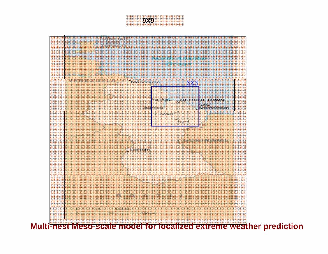
9X9
3X3
Multi-nest Meso-scale model for localized extreme weather prediction

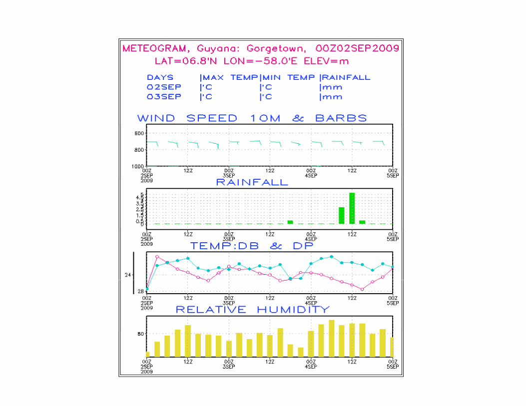
Based on Initial Conditions of 02Based on Initial Conditions of 02 September 2009.


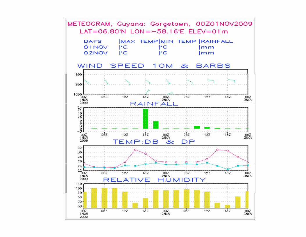
Based on Initial Conditions of 01 November 2009.


Future Demands on Weather and Climate PredictionClimate Prediction
• Develop, test and validate high resolution meso scale models (upto 0.3 km horizontal, >200 vertical levels) to predict high impact, ) p g pweather events.
• Advanced Mesoscale Data assimilation systems ( 3Dvar, 4Dvarand En KF)and En‐KF).
• Coupled Ocean Atmosphere meso scale models to predictgenesis, movement, intensification and landfall of the tropicalcyclones and associated storm surges.
• Incorporation of aerosol and atmospheric chemistry in highresolution meso‐scale model to predict city air quality and mega‐resolution meso scale model to predict city air quality and megacity out‐door activities.
• Coupled global model with T‐750 (27 km horizontal resolution)f l d t i i ti f t f h t difor seamless deterministic forecast of short, medium,extedended and seasonal scales.
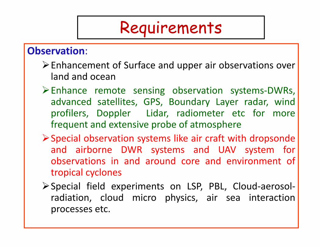
RequirementsObservation:Enhancement of Surface and upper air observations overland and oceanland and oceanEnhance remote sensing observation systems‐DWRs,advanced satellites, GPS, Boundary Layer radar, windprofilers, Doppler Lidar, radiometer etc for morefrequent and extensive probe of atmosphereSpecial observation systems like air craft with dropsondeSpecial observation systems like air craft with dropsondeand airborne DWR systems and UAV system forobservations in and around core and environment oft i l ltropical cyclonesSpecial field experiments on LSP, PBL, Cloud‐aerosol‐radiation, cloud micro physics, air sea interaction, p y ,processes etc.
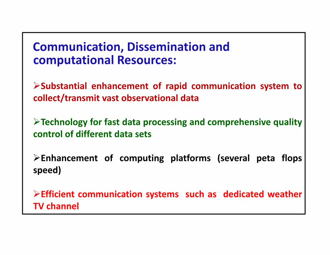
Communication Dissemination andCommunication, Dissemination and computational Resources:
Substantial enhancement of rapid communication system tocollect/transmit vast observational data
Technology for fast data processing and comprehensive qualitycontrol of different data sets
Enhancement of computing platforms (several peta flopsspeed)
Efficient communication systems such as dedicated weatherTV channelTV channel

Modeling and Man power :
State of‐the‐art four dimensional data assimilation systemfor incorporation/utilization of all available data fromdiff t b ti l l tfdifferent observational platforms
State of‐the‐art coupled high resolution meso scale andglobal modeling systemsglobal modeling systems
Visualization and location specific representation throughGIS platformGIS platform
Qualified manpower for NWP

Develop coupled mesoscale atmosphere ocean and wave model
Special requirements for Tropical CyclonesDevelop coupled mesoscale-atmosphere-ocean and wave model
with moving nest capability for better simulation andprediction of TC.The future scope for the prediction of tropical cyclone’s track
and intensity through insertion of special observations like aircraft with dropsonde, satellite radiance and airborne DWRsystems and UAV system in and around core and environmentsystems and UAV system in and around core and environmentof tropical cyclones.GPS refractivity assimilation for ground based stations and
GPS occultation for satellite (e.g. CHAMP and COSMIC)Multi model ensemble and probabilistic forecastSpecial field experiments to studyTC formation/structure changeMesoscale versus environment contribution to formationMesoscale versus environment contribution to formationBoundary layer impact on air-sea fluxesOcean variability impact on intensity and track
E t bli h t f d t k f b ti
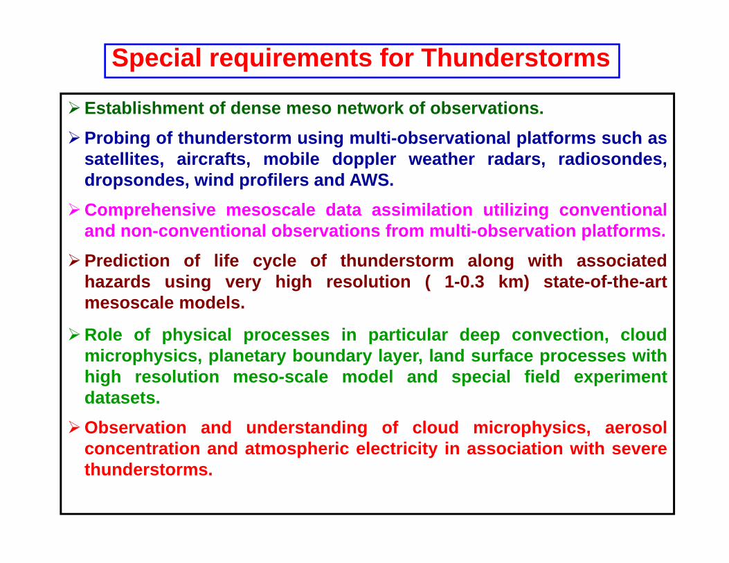
Special requirements for Thunderstorms
Establishment of dense meso network of observations.Probing of thunderstorm using multi-observational platforms such as
satellites, aircrafts, mobile doppler weather radars, radiosondes,d d i d fil d AWSdropsondes, wind profilers and AWS.
Comprehensive mesoscale data assimilation utilizing conventionaland non-conventional observations from multi-observation platforms.
Prediction of life cycle of thunderstorm along with associatedhazards using very high resolution ( 1-0.3 km) state-of-the-artmesoscale models.
Role of physical processes in particular deep convection, cloudmicrophysics, planetary boundary layer, land surface processes withhigh resolution meso-scale model and special field experimentdatasets.
Observation and understanding of cloud microphysics, aerosolconcentration and atmospheric electricity in association with severethunderstorms.
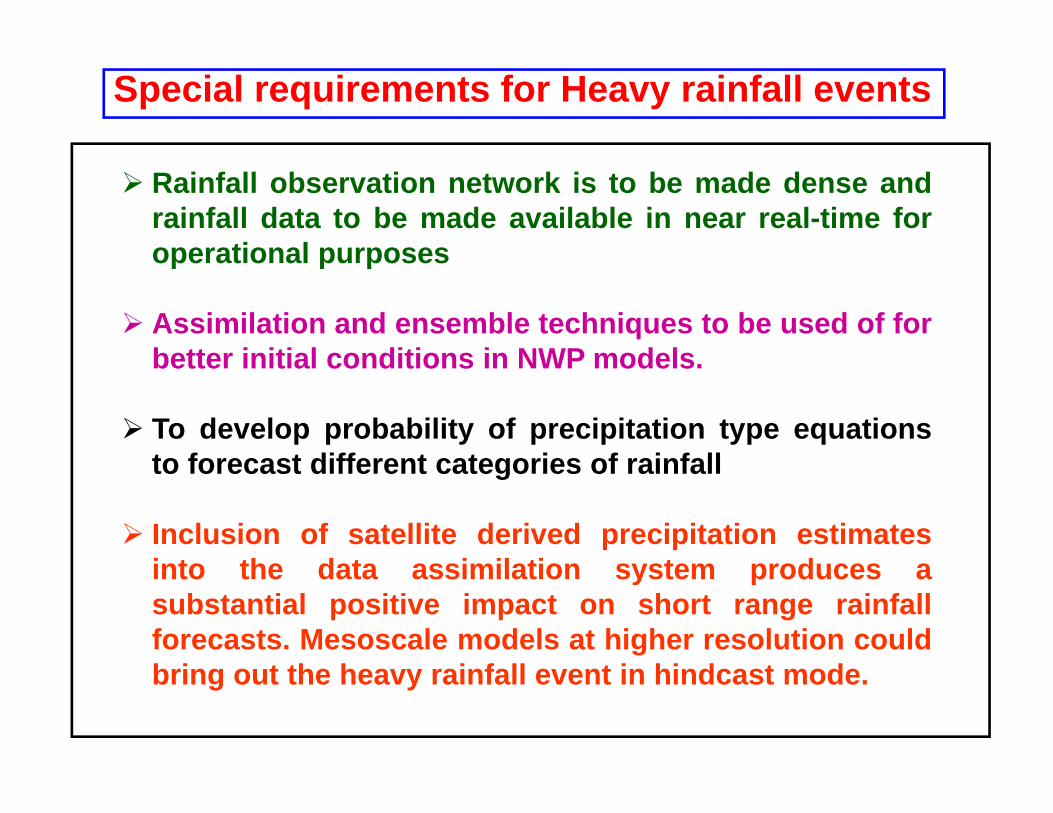
Special requirements for Heavy rainfall events
Rainfall observation network is to be made dense andrainfall data to be made available in near real-time foroperational purposesoperational purposes
Assimilation and ensemble techniques to be used of forbetter initial conditions in NWP modelsbetter initial conditions in NWP models.
To develop probability of precipitation type equationst f t diff t t i f i f llto forecast different categories of rainfall
Inclusion of satellite derived precipitation estimatesi t th d t i il ti t dinto the data assimilation system produces asubstantial positive impact on short range rainfallforecasts. Mesoscale models at higher resolution could
fbring out the heavy rainfall event in hindcast mode.

NWP Vision• Broader focus on application and impacts modelling• Probabilistic forecasting generating a range of possible
solutions to allow risk management• High resolution modelling of the atmosphere for detailg g p• Fuller integration between atmospheric and dependent
models (eg: oceanographic)• Principal observed input from satellite‐basedc pa obse ed pu o sa e e based
instrumentation• Flexible (on demand) ground based observations to meet
NWP needs• NWP output that is of sufficient detail, accuracy and
reliability as not to require routine forecaster modification.

Economic Impact
cast
atio
n
ad F
orec2010-2020
App
lic
of a
Ba2000’s
dth
of A
uenc
es 1990’s
Bre
ad
Con
sequ1980’s
gativ
e C
1970’s
Model Spatial Resolution
Neg

Thanks