thecommittee introduction - chartered institute for … · · 2015-08-05introduction...
TRANSCRIPT
Introduction
Welcome to the latest edition of the Buildings Archaeology Group (BAG) newsletterand apologies for the newsletter’s somewhat sporadic nature. Following news fromthe committee and beyond, contributors cover an interesting range of topics. KerryMassheder-Rigby discusses the regeneration of West Derby Carnegie Library for useby a local charity and as a centre for community engagement. Continuing with acommunity/regeneration theme Jackie Heath and Andy Shelley discuss therestoration after the fire that devastated Hastings Pier, funded in part by a communityshares scheme. Our own chairman, Mike Nevell, contributes a piece comparing thefate of Euston Arch with the recent consultation process for the Ordsall ChordRailway. We head back out to sea for Tim Murphy's piece on Maunsell's RedsandFort and the work being carried out by the charity Project Redsand for itsconservation. Back on dry land Geoffrey Sharpe’s article on bee boles will have youlooking at recesses in buildings with new eyes while Mark Samuel exploresVanbrugh's connection with a barn built for Stowe House, now Stowe School. Thecommittee extends a big thanks to all who contributed to this newsletter.
News from the committee
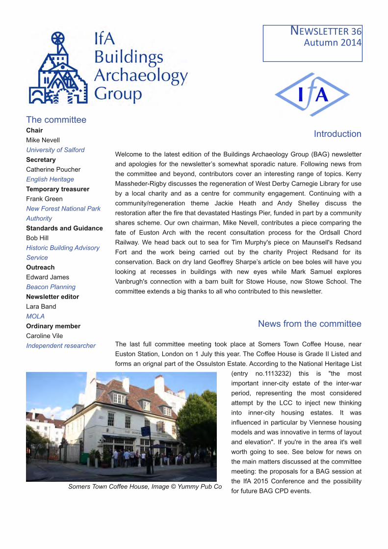
The last full committee meeting took place at Somers Town Coffee House, nearEuston Station, London on 1 July this year. The Coffee House is Grade II Listed andforms an orignal part of the Ossulston Estate. According to the National Heritage List
(entry no.1113232) this is "the mostimportant inner-city estate of the inter-warperiod, representing the most consideredattempt by the LCC to inject new thinkinginto inner-city housing estates. It wasinfluenced in particular by Viennese housingmodels and was innovative in terms of layoutand elevation". If you're in the area it's wellworth going to see. See below for news onthe main matters discussed at the committeemeeting: the proposals for a BAG session atthe IfA 2015 Conference and the possibilityfor future BAG CPD events.
Somers Town Coffee House, Image © Yummy Pub Co
The committeeChairMike NevellUniversity of SalfordSecretaryCatherine PoucherEnglish HeritageTemporary treasurerFrank GreenNew Forest National ParkAuthorityStandards and GuidanceBob HillHistoric Building AdvisoryServiceOutreachEdward JamesBeacon PlanningNewsletter editorLara BandMOLAOrdinary memberCaroline VileIndependent researcher

A smaller committee meeting took place in Bristol on 15 September followed by a guided tour of the Clifton RocksRailway, arranged as an open CPD event for BAG members. This water powered funicular railway was desinged tolink Clifton, and in particular a proposed Hydropathic Institute, with Hotwells and Bristol Harbour at the bottom of theAvon Gorge. To reduce the visual impact on the picturesque Avon Gorge it was built, with great difficulty, inside thecliffs. It opened in 1893 but was never a going concern and closed in 1934 due to diminishing trade. Its active lifedid not stop there however. It soon entered the second phase of its life as a WWII transmission base for the BBCand as a bomb shelter for local inhabitants. The BBC occupied various parts of the structure until the 1960s but afterthat it remained empty and disused. It was saved from partial demolition in the early 1990s and the Clifton RocksRailway Trust formed to care for it. It's accessible to the public on various publicised open days but outside of thesetours can be booked for groups of ten or more. It's a really fascinating place, not least because of the layers ofhistory in evidence so, again, a visit is highly recommended.
The IfA 2015 BAG conference session
The Buildings Archaeology Special Interest Group are running a session at the 2015 IfA Conference, and we inviteyou all to consider participating. The session is focusing on the twin strands of whether existing conservationprinciples are meeting the challenge of balancing the needs of the historic environment and the imperative to besustainable in light of the increasing threat posed by climate change, whilst also considering the role of buildingsarchaeology within that debate, and what that role could and should be in the future of our profession. Questionsthat will be posed and issues that need addressing include:
• Should the need to adapt, update and modify, where necessary, our built heritage to mitigateagainst climate change, outweigh the need to preserve historic fabric? How can the buildings archaeologists of thefuture contribute to the debate about what needs to be preserved?
• Given the importance of understanding our built heritage and its significance, how does the role ofthe buildings archaeologists in the planning system need reforming in order to best target our expertise to enablethe conservation of built heritage whilst mitigating for the effects of climate change? How can we change the wayclients view buildings archaeology to effect this reform?
• Should archaeological resources be directed at sites identified as being under particularly seriousthreat to gain as much information before they are lost?
The lower railway entrance, Image Fae/Wikimedia CommonsA view up the stairs, Image TimTay/Wikimedia Commons

• How might we future proof heritage assets to increase their longevity and reduce future expensiverepair and reinstatement programmes after extreme events? Where does the expertise of the buildingsarchaeologist fit into this process, and how could it be better applied in the commercial sector?
We are hoping that this will be an interesting and thought provoking session. If it's something you feel you might beable to add to, please consider contributing. The deadline for proposed papers is 30th November, and BAGcommittee members Edward James and Cath Poucher are the session organisers. See the offical Call for Papersfor details.
CPD eventsTwo CPD events were planned at the committee meeting. The first of these, An Introduction to Historic BuildingConstruction, was aimed at archaeologists and others in the profession who undertake historic building investigationand took place on 14 October in Birmingham. The course covered typical construction methods and materials forsmall to medium sized domestic architecture, c 1400 - 1939/45. It cost £65 for IFA members and £95 for nonmembers. Details were sent out to IfA members and the 24 available places filled up quickly.
Attendees came from across the UK and included English Heritage employees, local authority archaeologists andplanners, archaeological contractors and the self employed. Attendees agreed that it was an extremely usefulcourse and could even be expanded to fill two days with further emphasis on building construction and a practical,field element. The aim is to run the course again in February, taking into account attendee feedback.
Details of the second event discussed at the committee meeting have yet to be finalised but it was suggested thatthis could be a two day course providing an introduction to the theory, method and practice of buildings archaeologyin the commercial archaeology sector, delivered in partnership with a professional Registered Organisation. Ideallythe course would include lectures and seminars looking at the broad development of the discipline and the place ofbuildings archaeology within the planning process, as well practical introductions to survey types, techniques andoutputs. It would be aimed at those in their early career who want to focus in this direction as well as those alreadyestablished within the sector wishing to broaden their skillset.
The course would be endorsed by the IfA, and would contribute significantly towards member obligations in terms ofCPD and personal development. It would form a solid foundation upon which archaeologists can build furtherexperience through professional practice. It would be run as a pilot in the first instance but we are hopeful that itwould become a regular event. We are very much looking forward to getting it up and running.
Social mediaThe committee now has a LinkedIn group and are working on putting discussions and news up there. We'd love youto join in with discussions. We also have a Twitter feed so you can connect with us there too.
@IfABAG IfA Buildings Archaeology Special Interest Group (BAG)

Other newsEnglish Heritage
The consultation process for the restructuring of English Heritage closed on 7 February this year and on 14 October,DCMS confirmed that English Heritage will be re-structured from 1 April 2015. The 420 properties currently run byEnglish Heritage will remain in public ownership, managed by a charitable trust under the same name. Advisory andother services will be carried out by a new non-departmental body called Historic England. See the announcementand the results of the consultation for more details.
With regards to planning issues and heritage the Guidance on Tall Buildings, originally produced by the Commissionfor Architecture and the Built Environment and English Heritage in 2007, is under revision. A consultationquestionnaire has been issued and should be returned to English Heritage by 30th November, 2014.
SPAB Maintenance Co-operatives ProjectStella Jackson
The Maintenance Co-operatives Project is moving ahead with regionalofficers already gaining a following of enthusiastic participants. This isthe SPAB’s ambitious scheme to create a network of informedcommunity groups dedicated to the care and repair of historic buildingsused as places of worship. Backed by the HLF, the aim is to connect,encourage and support the army of volunteers across the country whoare largely responsible for the upkeep of some of our most beautifuland significant landmarks.
Training plans are maturing and the team is working hard on developing baseline condition surveys for the buildingsinvolved, with four already having been completed by our Hereford and Worcestershire Officer. In the Spring weheld our first taster events, and these were followed by further events in the the Autumn including a textileconservation day in Cumbria, a grants and funding workshop in Lincolnshire, and a Faith in Maintenance trainingday in Bath and Wells; as well as preventative maintenance taster days in the North East. We’ve got plenty morelined up over the next few months, and they're all free to attend, so please have a look at the Events page of ourwebsite (www.spabmcp.org.uk). Everyone’s welcome, even if they're only there for the free lunch!
The team is also gearing up for our National Conference on 21 November, which will launch the SPAB’s NationalMaintenance Week. The conference is being held in York this year, at the fabulous Merchant Taylor’s Hall, and thereare still a few tickets left - full details can be found on our website.
To find out more about the project and how you can get involved, follow our progress on Twitter: @SPABMCP andFacebook: SPABMCP; or get in touch with one of our Regional Project Officers
Name Region EmailKate Andrew Herefordshire & Worcester [email protected] Jackson Lincolnshire [email protected] Manson Cumbria [email protected] O'Kelly Somerset & Dorset [email protected] Schmisseur North East [email protected]

FeaturesRuination, regeneration and re-use: West Derby Carnegie LibraryKerry Massheder-Rigby
Lister Steps, a childcare charity in Liverpool,have secured initial support from the HeritageLottery Fund to regenerate the Grade II listedformer West Derby Carnegie Library on ListerDrive in Tuebrook, Liverpool.
The West Derby Carnegie Library, known locallyas Lister Drive Library, was established withfunding from an Andrew Carnegie grant, andopened in 1905. The library is a one-storeybrick built structure with stone dressings, a slateroof and an octagonal turret. It was designedby Liverpool Corporation architect Thomas
Shelmerdine who was responsible for a number ofLiverpool’s libraries. The library originally contained alending library and a number of reading rooms. Sadly,following health and safety concerns, the library closed in2006 and has remained vacant since. This period of un-occupation has resulted in the library being subject to theft,vandalism and neglect. Items stolen from the library includelead flashings, the glazing to roof lights and feature ridgetiles. There has been substantial rainwater ingress whichhas severely damaged the timber structure and internaldecorative plasterwork and joinery and dry rot is commonthroughout the building.
The ‘Lister Steps Carnegie Community Hub’ project, funded by the Heritage Lottery Fund, is currently in itsdevelopment stage, however once completed Lister Steps aim to relocate their existing childcare services into thebuilding. The regenerated building will also serve as a centre for community engagement, a ‘hub’ offeringrefreshments, activities and training opportunities for the local community and visitors.
The project will shortly begin a period of consultation with stakeholders and members of the community. The projectaims to host a number of heritage activities in the near future such as tours of the library and grounds, an oralhistory project, building recording activities and training opportunities. We welcome comments, suggestions andadvice from BAG members via our online survey: https://www.surveymonkey.com/s/NPBB39Z and we are keen tohear from members willing to share best practice ideas and suggestions for match funding.
Please follow our progress on Facebook (facebook.com/listerstepscarnegiecommunityhub), Twitter(@ListerStepsHub) and our website (https://listerstepscarnegiecommunityhub.weebly.com)
Kerry Massheder-Rigby, Heritage Development Officer,[email protected]
After the fire: the rebirth of Hastings PierJackie Heath and Andy Shelley, Ramboll UK
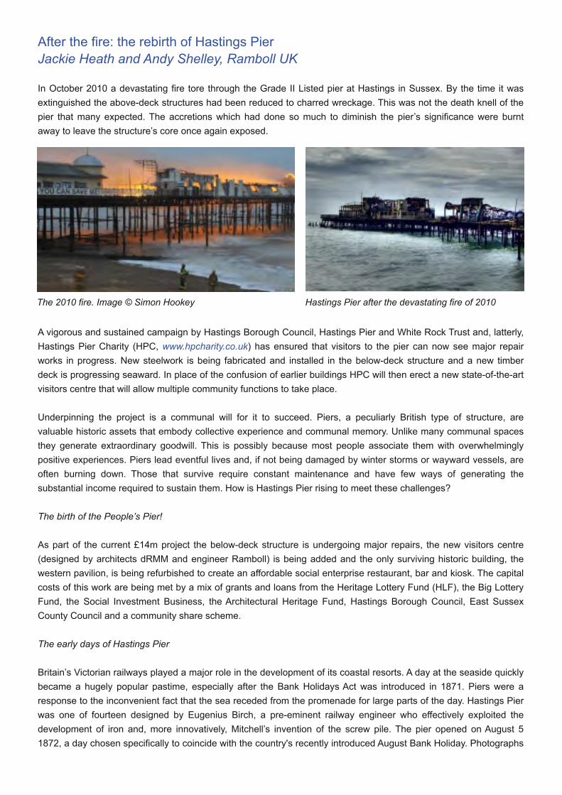
In October 2010 a devastating fire tore through the Grade II Listed pier at Hastings in Sussex. By the time it wasextinguished the above-deck structures had been reduced to charred wreckage. This was not the death knell of thepier that many expected. The accretions which had done so much to diminish the pier’s significance were burntaway to leave the structure’s core once again exposed.
A vigorous and sustained campaign by Hastings Borough Council, Hastings Pier and White Rock Trust and, latterly,Hastings Pier Charity (HPC, www.hpcharity.co.uk) has ensured that visitors to the pier can now see major repairworks in progress. New steelwork is being fabricated and installed in the below-deck structure and a new timberdeck is progressing seaward. In place of the confusion of earlier buildings HPC will then erect a new state-of-the-artvisitors centre that will allow multiple community functions to take place.
Underpinning the project is a communal will for it to succeed. Piers, a peculiarly British type of structure, arevaluable historic assets that embody collective experience and communal memory. Unlike many communal spacesthey generate extraordinary goodwill. This is possibly because most people associate them with overwhelminglypositive experiences. Piers lead eventful lives and, if not being damaged by winter storms or wayward vessels, areoften burning down. Those that survive require constant maintenance and have few ways of generating thesubstantial income required to sustain them. How is Hastings Pier rising to meet these challenges?
The birth of the People’s Pier!
As part of the current £14m project the below-deck structure is undergoing major repairs, the new visitors centre(designed by architects dRMM and engineer Ramboll) is being added and the only surviving historic building, thewestern pavilion, is being refurbished to create an affordable social enterprise restaurant, bar and kiosk. The capitalcosts of this work are being met by a mix of grants and loans from the Heritage Lottery Fund (HLF), the Big LotteryFund, the Social Investment Business, the Architectural Heritage Fund, Hastings Borough Council, East SussexCounty Council and a community share scheme.
The early days of Hastings Pier
Britain’s Victorian railways played a major role in the development of its coastal resorts. A day at the seaside quicklybecame a hugely popular pastime, especially after the Bank Holidays Act was introduced in 1871. Piers were aresponse to the inconvenient fact that the sea receded from the promenade for large parts of the day. Hastings Pierwas one of fourteen designed by Eugenius Birch, a pre-eminent railway engineer who effectively exploited thedevelopment of iron and, more innovatively, Mitchell’s invention of the screw pile. The pier opened on August 51872, a day chosen specifically to coincide with the country's recently introduced August Bank Holiday. Photographs
The 2010 fire. Image © Simon Hookey Hastings Pier after the devastating fire of 2010

show the driving rain that continuedrelentlessly throughout the openingceremony.
Birch’s pier extended to c. 280m and had amuch narrower neck than today. Thedecking was of Jarrah planks and joists(6”x3” laid flat) that spanned wrought ironbeams supported on Warren and Pratttrusses fabricated from bolted angles. Thetrusses were in turn supported by cast ironcolumns with spigot connections to the castiron screw piles. Stability was provided bytransverse trusses, vertical diagonal ‘X’bracing and horizontal rails. As was typicalin pier construction there was muchredundancy in the bracing, which partiallyaccounts for the structure’s survival. The
first violent storm struck in 1877 and wrecked one of the pier’s two tollhouses. In September 1899 a part of thedecking caught light and the following July there was another outbreak of fire during a concert. These episodeswere a prelude to a major fire in 1917 in which the ornate pavilion at the head of the pier burnt down.
The pier in the 20th century
The end of Victoria’s reign coincided with a decline in the simple pursuit of promenading. Daytrippers began todemand more sophisticated diversions. The Hastings Pier Company responded by introducing bowling and ashooting gallery and then, in 1910, a large ‘joy wheel’ roundabout. In 1916 the landward end of the pier wassignificantly widened by the addition of the Parade Extension, which is when the curving bandstand shelters wereadded. This proved to be a genuine improvement which would have undoubtedly helped arrest a decline in thepier’s wartime fortunes had the pavilion not been destroyed by fire the following year. In the early 1920s there werefurther improvements, including a widening of the deck. Today the original pier is readily identified within theenlarged structure by its raking piles which delineated its original perimeter, and also by the connection details ofBirch’s columns which are more elegant than those of later examples.
In one of the earliest depictions of Hastings Pier, the ornatetollhouses and slender deck can be seen
The bowling alley and roundabout were added in 1911. The pavilion at the end of the pier burnt down in 1917
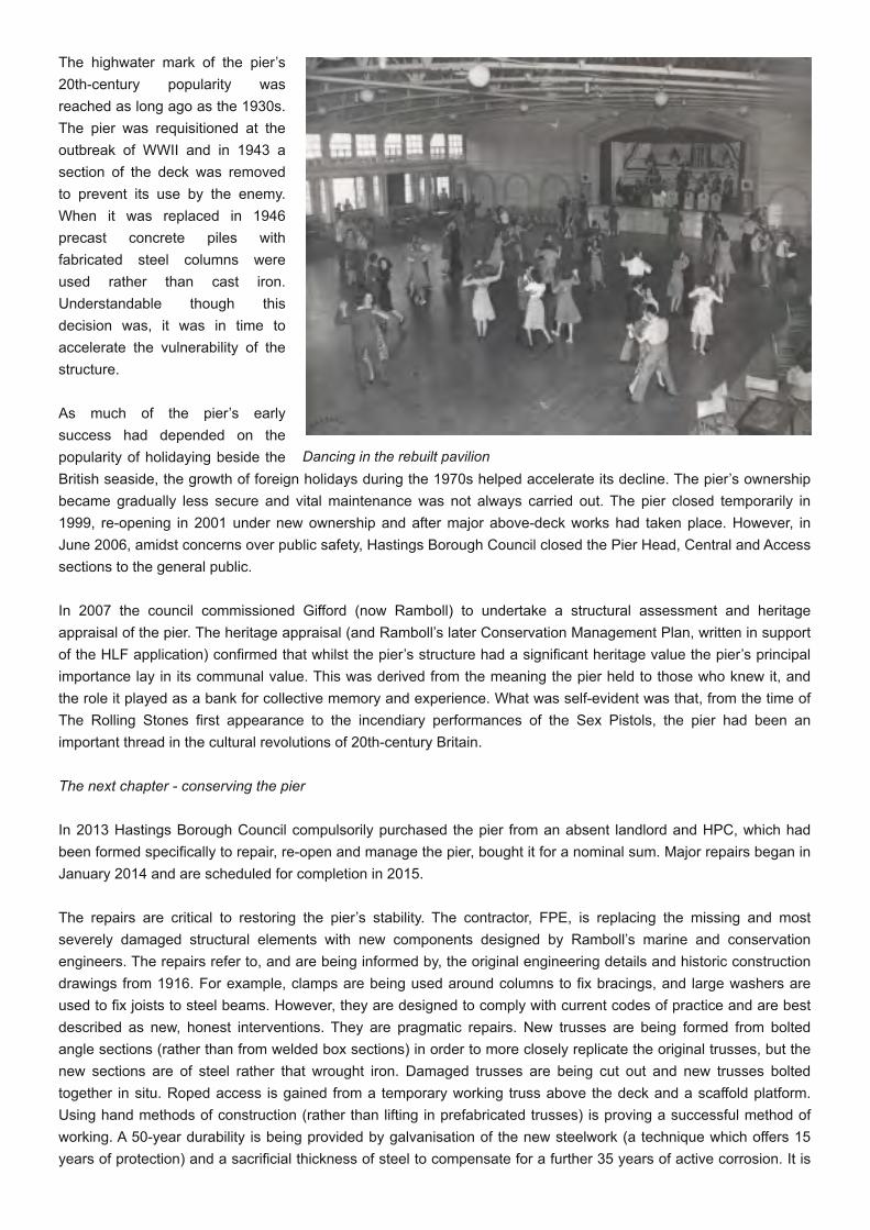
The highwater mark of the pier’s20th-century popularity wasreached as long ago as the 1930s.The pier was requisitioned at theoutbreak of WWII and in 1943 asection of the deck was removedto prevent its use by the enemy.When it was replaced in 1946precast concrete piles withfabricated steel columns wereused rather than cast iron.Understandable though thisdecision was, it was in time toaccelerate the vulnerability of thestructure.
As much of the pier’s earlysuccess had depended on thepopularity of holidaying beside theBritish seaside, the growth of foreign holidays during the 1970s helped accelerate its decline. The pier’s ownershipbecame gradually less secure and vital maintenance was not always carried out. The pier closed temporarily in1999, re-opening in 2001 under new ownership and after major above-deck works had taken place. However, inJune 2006, amidst concerns over public safety, Hastings Borough Council closed the Pier Head, Central and Accesssections to the general public.
In 2007 the council commissioned Gifford (now Ramboll) to undertake a structural assessment and heritageappraisal of the pier. The heritage appraisal (and Ramboll’s later Conservation Management Plan, written in supportof the HLF application) confirmed that whilst the pier’s structure had a significant heritage value the pier’s principalimportance lay in its communal value. This was derived from the meaning the pier held to those who knew it, andthe role it played as a bank for collective memory and experience. What was self-evident was that, from the time ofThe Rolling Stones first appearance to the incendiary performances of the Sex Pistols, the pier had been animportant thread in the cultural revolutions of 20th-century Britain.
The next chapter - conserving the pier
In 2013 Hastings Borough Council compulsorily purchased the pier from an absent landlord and HPC, which hadbeen formed specifically to repair, re-open and manage the pier, bought it for a nominal sum. Major repairs began inJanuary 2014 and are scheduled for completion in 2015.
The repairs are critical to restoring the pier’s stability. The contractor, FPE, is replacing the missing and mostseverely damaged structural elements with new components designed by Ramboll’s marine and conservationengineers. The repairs refer to, and are being informed by, the original engineering details and historic constructiondrawings from 1916. For example, clamps are being used around columns to fix bracings, and large washers areused to fix joists to steel beams. However, they are designed to comply with current codes of practice and are bestdescribed as new, honest interventions. They are pragmatic repairs. New trusses are being formed from boltedangle sections (rather than from welded box sections) in order to more closely replicate the original trusses, but thenew sections are of steel rather that wrought iron. Damaged trusses are being cut out and new trusses boltedtogether in situ. Roped access is gained from a temporary working truss above the deck and a scaffold platform.Using hand methods of construction (rather than lifting in prefabricated trusses) is proving a successful method ofworking. A 50-year durability is being provided by galvanisation of the new steelwork (a technique which offers 15years of protection) and a sacrificial thickness of steel to compensate for a further 35 years of active corrosion. It is
Dancing in the rebuilt pavilion

accepted, however, that cross bracing rods will not be galvanised because so many have failed in the past, andthese will need to be replaced as and when required.
Little original deck timber had survived into the 21st century, and almost all that had was destroyed in the 2010 fire.The original intention had been to re-use the remaining planks in the repair works, possibly to define the originalfootprint of Birch’s pier. However, it soon became apparent that they were not thick enough to support point wheelloads from vehicles, and sustainably-sourced Ekki has been used instead, with some of the old timbers being usedto make pier furniture. Work is currently progressing seaward and in mid-2014 is about half way along the deck.
The visitors centre will be built from cross-laminated timber with mirrored glass cladding. The vision is of acontemporary and sustainable venue that offers spaces for interpretation and education, and a roof terraceaccessed by an external flight of steps which doubles as seating for external events. The sides of the gently-curvedwestern pavilion will be opened up and its timber structure will be exposed to create a new restaurant. The rest ofthe deck will be a public space within which a revolving programme of seasonal events will take place.
Ramboll commissioned a laser scan ofthe structure to aid their design
Above: Works underway in 2014. Slicing through deckbeams.Image © RambollRight: The new trusswork and decking is evident fromthis angle. Image © Ramboll

Community conservation
Hastings Pier Charity is a communitybenefit society with over 3,000members. They are dedicated todelivering a programme of activitiesthat help people to engage andappreciate their pier. ‘The People’sPier’ is very much a communityconservation project and it is thecommunity who are managing thechanges to the pier. The strong andvery evident value that the people ofHastings have always placed in theirpier was a critical factor in securingfunding to help save it. The restorationis bringing the pier back into the heartof the community; many of HPC’s supporters, employees and trustees are local people, and local firms are beingused wherever possible. The pier has also become the inspiration for several creative projects including a televisiondocumentary, university projects, short films, songs and children’s works. Unusually, HPC are managing theconstruction themselves. Their engineer is involved in the restoration and rebuild and will continue to maintain thepier when it is open. In this way HPC aim to help conserve the heritage and tradition of pier maintenance as well asthe heritage and fabric of their pier.
The renaissance of Hastings Pier is emblematic of how we as heritage professionals should approach heritageconservation. We need to look beyond an asset’s architectural or engineering characteristics, important though theymay be. The key to successful conservation lies in understanding why people value a place, and then empoweringthem to sustain it. The genuine affection people hold for Hastings Pier gives it the very best chance of a viablefuture.
[email protected]@ramboll.co.uk
The Ordsall Chord Railway proposalMike Nevell
I visit London by train at least five or six times a year for a variety of reasons. Yet, whatever the cause of my trip towhat is one the great cities of the world two things always strike me as notable. Firstly, the drama of the landscapeof the journey, which starts with industrial Manchester, develops into the rolling foothills of the Peak District, takes inthe flatter fields and increasingly large towns of eastern-central England, and finishes with the suburban, thenindustrial and commercial sprawl of London. Secondly, the shock of Euston Station: from the lead-in of the deep,brick-lined, cutting with its multiplicity of rail tracks, the rectangular canopy of the station building which seems topress down on the long platforms, to the waiting-cum-booking hall which seems designed to intimidate the travellerwith its brutalistic concrete architecture [1]. Finally, there is the shock of the exit which is hidden by a group of non-descript office blocks, clustered, seemingly, to hide the embarrassment of the 1960s terminal station from theEuston Road. It is not a building I have any sympathy for….at all.
What is missing, of course, is the Euston Arch to give the entrance to the station the dramatic presence of StPancras or King’s Cross stations, ten-minutes-walk away. Euston Arch was one of the first great monuments of the
Proposal for the new visitors centre
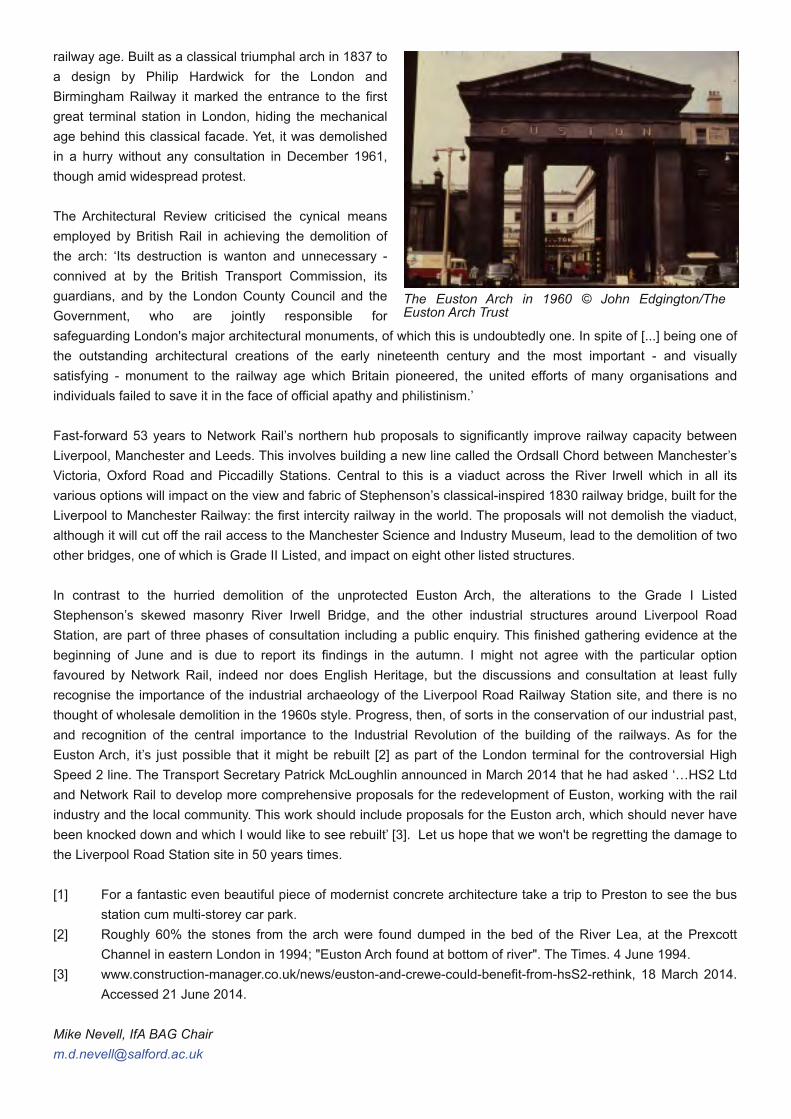
railway age. Built as a classical triumphal arch in 1837 toa design by Philip Hardwick for the London andBirmingham Railway it marked the entrance to the firstgreat terminal station in London, hiding the mechanicalage behind this classical facade. Yet, it was demolishedin a hurry without any consultation in December 1961,though amid widespread protest.
The Architectural Review criticised the cynical meansemployed by British Rail in achieving the demolition ofthe arch: ‘Its destruction is wanton and unnecessary -connived at by the British Transport Commission, itsguardians, and by the London County Council and theGovernment, who are jointly responsible forsafeguarding London's major architectural monuments, of which this is undoubtedly one. In spite of [...] being one ofthe outstanding architectural creations of the early nineteenth century and the most important - and visuallysatisfying - monument to the railway age which Britain pioneered, the united efforts of many organisations andindividuals failed to save it in the face of official apathy and philistinism.’
Fast-forward 53 years to Network Rail’s northern hub proposals to significantly improve railway capacity betweenLiverpool, Manchester and Leeds. This involves building a new line called the Ordsall Chord between Manchester’sVictoria, Oxford Road and Piccadilly Stations. Central to this is a viaduct across the River Irwell which in all itsvarious options will impact on the view and fabric of Stephenson’s classical-inspired 1830 railway bridge, built for theLiverpool to Manchester Railway: the first intercity railway in the world. The proposals will not demolish the viaduct,although it will cut off the rail access to the Manchester Science and Industry Museum, lead to the demolition of twoother bridges, one of which is Grade II Listed, and impact on eight other listed structures.
In contrast to the hurried demolition of the unprotected Euston Arch, the alterations to the Grade I ListedStephenson’s skewed masonry River Irwell Bridge, and the other industrial structures around Liverpool RoadStation, are part of three phases of consultation including a public enquiry. This finished gathering evidence at thebeginning of June and is due to report its findings in the autumn. I might not agree with the particular optionfavoured by Network Rail, indeed nor does English Heritage, but the discussions and consultation at least fullyrecognise the importance of the industrial archaeology of the Liverpool Road Railway Station site, and there is nothought of wholesale demolition in the 1960s style. Progress, then, of sorts in the conservation of our industrial past,and recognition of the central importance to the Industrial Revolution of the building of the railways. As for theEuston Arch, it’s just possible that it might be rebuilt [2] as part of the London terminal for the controversial HighSpeed 2 line. The Transport Secretary Patrick McLoughlin announced in March 2014 that he had asked ‘…HS2 Ltdand Network Rail to develop more comprehensive proposals for the redevelopment of Euston, working with the railindustry and the local community. This work should include proposals for the Euston arch, which should never havebeen knocked down and which I would like to see rebuilt’ [3]. Let us hope that we won't be regretting the damage tothe Liverpool Road Station site in 50 years times.
[1] For a fantastic even beautiful piece of modernist concrete architecture take a trip to Preston to see the busstation cum multi-storey car park.
[2] Roughly 60% the stones from the arch were found dumped in the bed of the River Lea, at the PrexcottChannel in eastern London in 1994; "Euston Arch found at bottom of river". The Times. 4 June 1994.
[3] www.construction-manager.co.uk/news/euston-and-crewe-could-benefit-from-hsS2-rethink, 18 March 2014.Accessed 21 June 2014.
Mike Nevell, IfA BAG [email protected]
The Euston Arch in 1960 © John Edgington/TheEuston Arch Trust
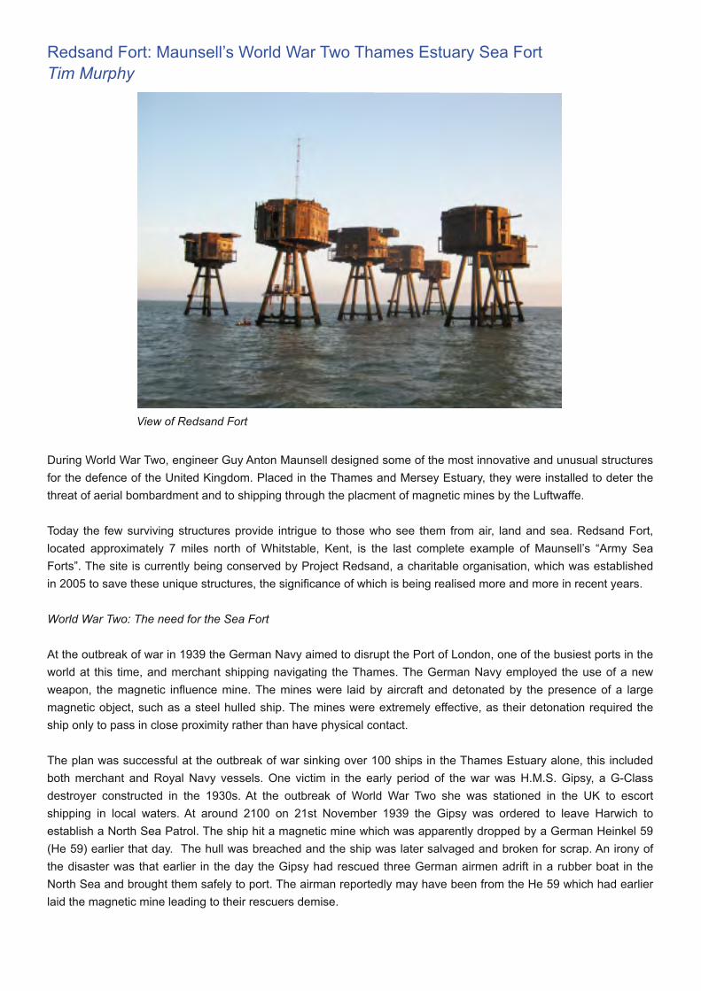
Redsand Fort: Maunsell’s World War Two Thames Estuary Sea FortTim Murphy
During World War Two, engineer Guy Anton Maunsell designed some of the most innovative and unusual structuresfor the defence of the United Kingdom. Placed in the Thames and Mersey Estuary, they were installed to deter thethreat of aerial bombardment and to shipping through the placment of magnetic mines by the Luftwaffe.
Today the few surviving structures provide intrigue to those who see them from air, land and sea. Redsand Fort,located approximately 7 miles north of Whitstable, Kent, is the last complete example of Maunsell’s “Army SeaForts”. The site is currently being conserved by Project Redsand, a charitable organisation, which was establishedin 2005 to save these unique structures, the significance of which is being realised more and more in recent years.
World War Two: The need for the Sea Fort
At the outbreak of war in 1939 the German Navy aimed to disrupt the Port of London, one of the busiest ports in theworld at this time, and merchant shipping navigating the Thames. The German Navy employed the use of a newweapon, the magnetic influence mine. The mines were laid by aircraft and detonated by the presence of a largemagnetic object, such as a steel hulled ship. The mines were extremely effective, as their detonation required theship only to pass in close proximity rather than have physical contact.
The plan was successful at the outbreak of war sinking over 100 ships in the Thames Estuary alone, this includedboth merchant and Royal Navy vessels. One victim in the early period of the war was H.M.S. Gipsy, a G-Classdestroyer constructed in the 1930s. At the outbreak of World War Two she was stationed in the UK to escortshipping in local waters. At around 2100 on 21st November 1939 the Gipsy was ordered to leave Harwich toestablish a North Sea Patrol. The ship hit a magnetic mine which was apparently dropped by a German Heinkel 59(He 59) earlier that day. The hull was breached and the ship was later salvaged and broken for scrap. An irony ofthe disaster was that earlier in the day the Gipsy had rescued three German airmen adrift in a rubber boat in theNorth Sea and brought them safely to port. The airman reportedly may have been from the He 59 which had earlierlaid the magnetic mine leading to their rescuers demise.
View of Redsand Fort
Action was required to stem the losses of vessels and disruption to merchant shipping. Ships were requisitioned andused as mobile anti-aircraft batteries. These were found to be inadequate and a more practical and efficient solutionwas required. This need was also compounded by the fact that later, in 1940, the Luftwaffe were using the Thamesto navigate towards London during the Blitz. The issue was also found in Liverpool where anti-aircraft defences,along the banks of the Mersey Estuary, were proving ineffective.
The construction & military use of the Sea Forts
The answer to mitigating the threat was found by innovative, and some consider outlandish, engineer Guy AntonMaunsell (1884-1961). By World War Two Maunsell was an experienced engineer, having worked on both militaryand maritime structures. During World War One Maunsell had been involved in the construction of explosivefactories and a secret anti-submarine construction scheme in the form of concrete towers placed in the Solent.During the inter-war period he had worked for the Ministry of Transport on schemes which were as unconventionalas his later sea forts. These included his idea for a ‘floating sea dome’ in the middle of the Atlantic for use by short-range aircraft and assessing the viability of a Channel Tunnel. Prior to outbreak of war in 1939 he had taken up aposition with his friend’s practice at Sir Alexander Gibb & Partners.
In the early years of World War Two Maunsell had several ideas for innovative engineering schemes which wouldcontribute to the war effort including submersible observation posts, pre-fabricated airfields and a submersibleharbour which some historians believe influenced the Mulberry harbours later used in D-Day.
Maunsell’s main contribution during the war was to be the design and construction of the sea forts. His original ideafor the design of the forts began in October 1940 as ‘A Proposal to Establish Martello Towers for the Defence of TheThames Estuary’. This was a paper by Maunsell in response to a request for advice from the Port of LondonAuthority’s Harbour Master, Commander E C Shankland. Maunsell had come up with the idea a few months before,detailed in a separate paper to the Admiralty, entitled ‘Marine Fort No 3’. He had envisaged, around the time ofDunkirk, a network of forts off the Belgium and Dutch Coast which were used for observation. Maunsell describedhow the forts would be built, similar to those later realised in the Thames:
“The form of construction is extremely simple and has been designed so as to lend itself to speedy erection. Thepontoons can be built on light slipways on any river foreshore in tidal water and after they have been floated, thepedestal and citadel would be rapidly constructed on the pontoons by pouring concrete in prepared shuttering. Thetime taken to construct on of these forts would be two months. A number of Forts could be built in the Port of London,so that within three months from the start, several Forts can be made available”.
Commander Shankland was concerned about the effectiveness of the magnetic mines and believed that a networkof sea forts stretching 26 miles from Margate in Kent to Clacton-on-Sea in Essex may deter the threat or at leastprovide a method of noting where mines had been laid. The sea forts project was almost shelved by Director ofNaval Construction, Sir Stanley Goodall, who believed the proposed concrete and steel marine structures would beunstable. The project was eventually pushed forward by Vice Admiral Fraser, Controller of the Navy.
By March 1941 the design details of Maunsell’s Navy Sea Forts had been agreed. The Navy Sea Forts were aprecursor and different in form to the later Army Sea Forts. The earlier Navy Forts comprised of a citadel structuresupported by two large reinforced concrete legs which rest upon the seabed. The most well-known survivingexample of this type is Roughs Towers, located 7 miles from the coast in the North Sea and today better known as“Sealand”.
The success of the Navy Forts resulted in the commission of the Army Sea Forts which were to be placed in theThames and Mersey Estuaries. The initial concept of the Army Sea Forts was a single gun tower capable of restingon sand. The Army Sea Forts were however realised as a group of these towers linked by bridges. Both Maunselland Sir Alexander Gibb were appointed as joint structural engineers on the project. In October 1941 the Cleveland
Bridge & Engineering Co Ltd won the £336,000 contract to build the first of the Army Sea Forts, in the Mersey, atBromborough Dock. The first fort in the Mersey Estuary was positioned in October 1942 and the last in July 1943.
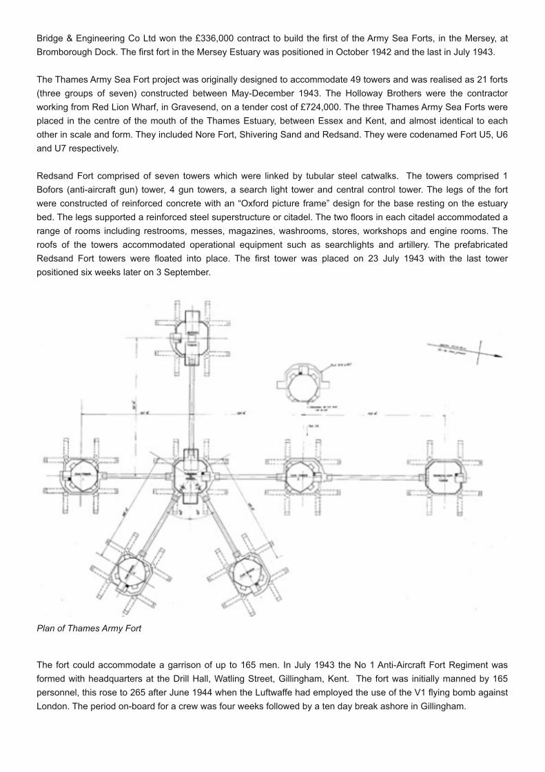
The Thames Army Sea Fort project was originally designed to accommodate 49 towers and was realised as 21 forts(three groups of seven) constructed between May-December 1943. The Holloway Brothers were the contractorworking from Red Lion Wharf, in Gravesend, on a tender cost of £724,000. The three Thames Army Sea Forts wereplaced in the centre of the mouth of the Thames Estuary, between Essex and Kent, and almost identical to eachother in scale and form. They included Nore Fort, Shivering Sand and Redsand. They were codenamed Fort U5, U6and U7 respectively.
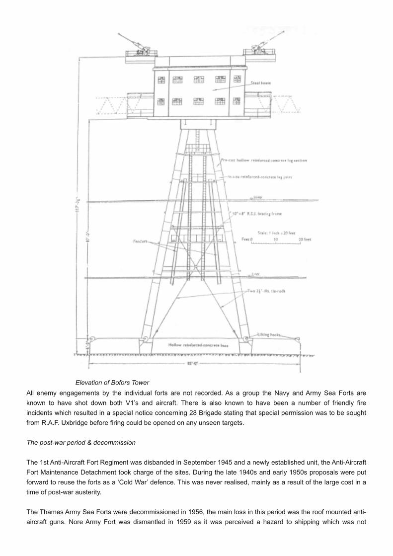
Redsand Fort comprised of seven towers which were linked by tubular steel catwalks. The towers comprised 1Bofors (anti-aircraft gun) tower, 4 gun towers, a search light tower and central control tower. The legs of the fortwere constructed of reinforced concrete with an “Oxford picture frame” design for the base resting on the estuarybed. The legs supported a reinforced steel superstructure or citadel. The two floors in each citadel accommodated arange of rooms including restrooms, messes, magazines, washrooms, stores, workshops and engine rooms. Theroofs of the towers accommodated operational equipment such as searchlights and artillery. The prefabricatedRedsand Fort towers were floated into place. The first tower was placed on 23 July 1943 with the last towerpositioned six weeks later on 3 September.
The fort could accommodate a garrison of up to 165 men. In July 1943 the No 1 Anti-Aircraft Fort Regiment wasformed with headquarters at the Drill Hall, Watling Street, Gillingham, Kent. The fort was initially manned by 165personnel, this rose to 265 after June 1944 when the Luftwaffe had employed the use of the V1 flying bomb againstLondon. The period on-board for a crew was four weeks followed by a ten day break ashore in Gillingham.
Plan of Thames Army Fort
All enemy engagements by the individual forts are not recorded. As a group the Navy and Army Sea Forts areknown to have shot down both V1’s and aircraft. There is also known to have been a number of friendly fireincidents which resulted in a special notice concerning 28 Brigade stating that special permission was to be soughtfrom R.A.F. Uxbridge before firing could be opened on any unseen targets.
The post-war period & decommission
The 1st Anti-Aircraft Fort Regiment was disbanded in September 1945 and a newly established unit, the Anti-AircraftFort Maintenance Detachment took charge of the sites. During the late 1940s and early 1950s proposals were putforward to reuse the forts as a ‘Cold War’ defence. This was never realised, mainly as a result of the large cost in atime of post-war austerity.
The Thames Army Sea Forts were decommissioned in 1956, the main loss in this period was the roof mounted anti-aircraft guns. Nore Army Fort was dismantled in 1959 as it was perceived a hazard to shipping which was not
Elevation of Bofors Tower
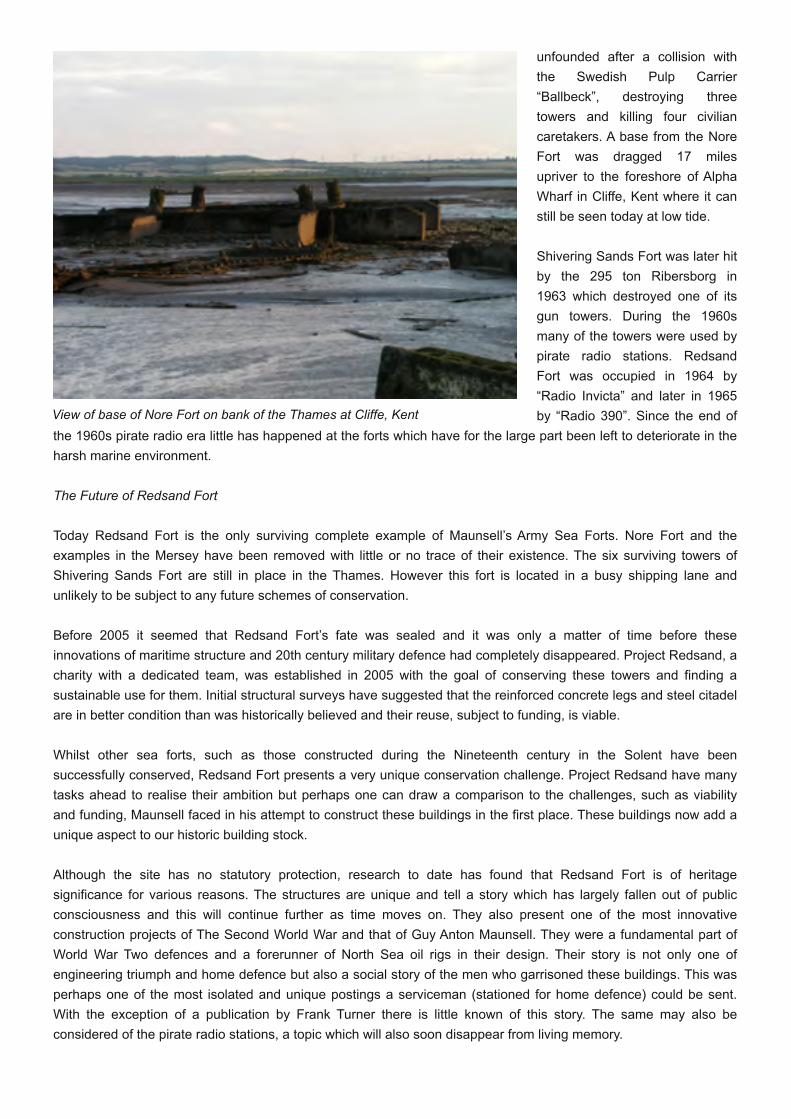
unfounded after a collision withthe Swedish Pulp Carrier“Ballbeck”, destroying threetowers and killing four civiliancaretakers. A base from the NoreFort was dragged 17 milesupriver to the foreshore of AlphaWharf in Cliffe, Kent where it canstill be seen today at low tide.
Shivering Sands Fort was later hitby the 295 ton Ribersborg in1963 which destroyed one of itsgun towers. During the 1960smany of the towers were used bypirate radio stations. RedsandFort was occupied in 1964 by“Radio Invicta” and later in 1965by “Radio 390”. Since the end of
the 1960s pirate radio era little has happened at the forts which have for the large part been left to deteriorate in theharsh marine environment.
The Future of Redsand Fort
Today Redsand Fort is the only surviving complete example of Maunsell’s Army Sea Forts. Nore Fort and theexamples in the Mersey have been removed with little or no trace of their existence. The six surviving towers ofShivering Sands Fort are still in place in the Thames. However this fort is located in a busy shipping lane andunlikely to be subject to any future schemes of conservation.
Before 2005 it seemed that Redsand Fort’s fate was sealed and it was only a matter of time before theseinnovations of maritime structure and 20th century military defence had completely disappeared. Project Redsand, acharity with a dedicated team, was established in 2005 with the goal of conserving these towers and finding asustainable use for them. Initial structural surveys have suggested that the reinforced concrete legs and steel citadelare in better condition than was historically believed and their reuse, subject to funding, is viable.
Whilst other sea forts, such as those constructed during the Nineteenth century in the Solent have beensuccessfully conserved, Redsand Fort presents a very unique conservation challenge. Project Redsand have manytasks ahead to realise their ambition but perhaps one can draw a comparison to the challenges, such as viabilityand funding, Maunsell faced in his attempt to construct these buildings in the first place. These buildings now add aunique aspect to our historic building stock.
Although the site has no statutory protection, research to date has found that Redsand Fort is of heritagesignificance for various reasons. The structures are unique and tell a story which has largely fallen out of publicconsciousness and this will continue further as time moves on. They also present one of the most innovativeconstruction projects of The Second World War and that of Guy Anton Maunsell. They were a fundamental part ofWorld War Two defences and a forerunner of North Sea oil rigs in their design. Their story is not only one ofengineering triumph and home defence but also a social story of the men who garrisoned these buildings. This wasperhaps one of the most isolated and unique postings a serviceman (stationed for home defence) could be sent.With the exception of a publication by Frank Turner there is little known of this story. The same may also beconsidered of the pirate radio stations, a topic which will also soon disappear from living memory.
View of base of Nore Fort on bank of the Thames at Cliffe, Kent
Like Project Redsand, I hope that in years to come there will be something more for those people who inquisitivelygaze from the north Kent coast towards the site pondering what the structures are and if there is a way to visit them.A programme of conservation and reuse will not only save the significant site of Redsand Fort but also protect aunique example of marine defence structure for future generations to understand and appreciate.
To date Project Redsand have provided access to one of the towers which is currently being conserved. WatermanGroup are currently working with the charity, providing baseline studies to inform future conservation and their viableuse. For further news about Project Redsand and their work please visit: www.project-redsand.com.
Tim MurphyPrincipal Heritage ConsultantWaterman Group: [email protected]
Authors Note:The Author would like to thank Project Redsand and Frank Turner for the provision of information and photographsfor this article. Most of the historical information in this article has been sourced from the following publications:Turner, F. (1995) The Maunsell Sea Forts; Part Two: The World War Two Army Sea Forts of the Thames and MerseyEstuariesTurner, F. (1995) The Maunsell Sea Forts; Part Three: The World War Two Thames Estuary Defenders, The HumanElementWatson, N. Turner, F. (2005) Maunsell: The Firm and its Founders
Relics of the past: identifying bee bolesGeoff Sharpe
Recesses and apertures in old walls are usually perceived as being aesthetic features which mark a fashion fromthe past and are regularly used to display potted plants, shrubs and garden ornaments. In many cases this was notthe original purpose and they often conceal a much deeper historic significance. In reality most were used in earlyfarm husbandry for bee-keeping with both the honey and the wax making an important contribution towards farmingincomes. Termed bee boles in most parts of the British Isles they are sometimes described as bee keps or beegarths but localised names may also be found in some regions. References to bee garths more correctly relate torecesses accessed from an enclosed high walled garden. For a long period of time honey was one of the fewavailable sweet foods and was regarded as a highly prized commodity, with the wax being used for candle makingand by craftsmen for a variety of purposes. Honey was also in much demand for the brewing of mead.
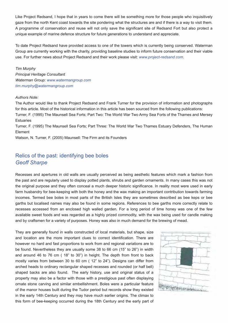
They are generally found in walls constructed of local materials, but shape, sizeand location are the more important clues to correct identification. There arehowever no hard and fast proportions to work from and regional variations are tobe found. Nevertheless they are usually some 38 to 66 cm (15” to 26”) in widthand around 46 to 76 cm ( 18” to 30”) in height. The depth from front to backmostly varies from between 30 to 60 cm ( 12” to 24”). Designs can differ fromarched heads to ordinary rectangular shaped recesses and rounded (or half bell)shaped backs are also found. The early history, use and original status of aproperty may also be a factor with those with a prestigious past often displayingornate stone carving and similar embellishment. Boles were a particular featureof the manor houses built during the Tudor period but records show they existedin the early 14th Century and they may have much earlier origins. The climax tothis form of bee-keeping occurred during the 18th Century and the early part of

the19th Century.
They are mostly discovered in garden walling which is sheltered and has a southern or south eastern aspect. It wasusual to place them some 46 to 60 cm (18” to 24”) above ground level but exceptions to this rule are to be foundand they can be discovered at eaves level, over doorways and even under window cills. It is easy to mistake similarfeatures for this purpose such as those used for falconry. Recesses of like dimensions were sometimes made forfalcons in captivity but in their natural habitat the birds prefer high places and in an attempt to replicate a similarenvironment, niches intended for nesting are likely to be found at a high level. In some parts of the British Isles theformation of goose pens within the integral part of a wall became regular practice. The much larger size andoccurrence at ground level usually provide clear distinguishing signs. A good tell-tale sign for a bole is evidence ofold metal fixings. It was regular practice to protect them with a lockable metal grill or louvred doors to prevent thetheft of honey. They are seldom found as a singleentity with at least 6 or more being spaced closelytogether.
Bees were originally kept in skeps (hives) made ofwicker fashioned into a tall conical shape whichwas then coated with a mixture of clay and dungusually termed clome. These were superseded byskeps made of coiled straw with the modernmoveable hive not appearing until the mid-nineteenth Century. An important variation to thebole is the bee alcove (Figure 4). Most weredesigned to provide room for two or more skeps on each shelf. The recesses are much larger and measure around
1.5 m ( 60”) in height and about 1.3m ( 50”) in width.
Some of the big estates and grand houses hosted more intensive methodsof bee-keeping using specially designed summer-houses which oftenfeatured artistic latticework andother decorativeembellishments. Survivingexamples are now importanthistoric relics. During the winter
months it was normal practice to keep bees in purpose-built winterquarters which can be readily identified as windowless out-buildingshaving a series of recesses within the thickness of the internal walling. Alikely distinguishing feature is exceptional wall thickness and wellinsulated roofing, which helped to maintain equable temperatures duringthe critical periods of the winter frosts. The development of the sugarcane plantations in the West Indies, and the later discovery ofprocessing sugar from beet around the time of the Napoleonic wars,diminished the demand for home produced honey and bee-keepinggradually declined as an essential activity.
Geoff Sharpe is a Chartered Surveyor and author of “Traditional Buildings of the English Countryside” and “HistoricEnglish Churches – their Construction, Design and Features”[email protected]
A skep A bee alcove
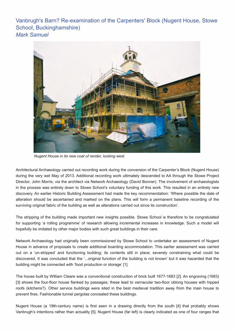
Vanbrugh's Barn? Re-examination of the Carpenters' Block (Nugent House, StoweSchool, Buckinghamshire)Mark Samuel
Architectural Archaeology carried out recording work during the conversion of the Carpenter’s Block (Nugent House)during the very wet May of 2013. Additional recording work ultimately descended to AA through the Stowe ProjectDirector, John Morris, via the architect via Network Archaeology (David Bonner). The involvement of archaeologistsin the process was entirely down to Stowe School’s voluntary funding of this work. This resulted in an entirely newdiscovery. An earlier Historic Building Assessment had made the key recommendation: ‘Where possible the date ofalteration should be ascertained and marked on the plans. This will form a permanent baseline recording of thesurviving original fabric of the building as well as alterations carried out since its construction’.
The stripping of the building made important new insights possible. Stowe School is therefore to be congratulatedfor supporting ‘a rolling programme’ of research allowing incremental increases in knowledge. Such a model willhopefully be imitated by other major bodies with such great buildings in their care.
Network Archaeology had originally been commissioned by Stowe School to undertake an assessment of NugentHouse in advance of proposals to create additional boarding accommodation. This earlier assessment was carriedout on a ‘un-stripped’ and functioning building; its contents still in place; severely constraining what could bediscovered. It was concluded that the ‘...original function of the building is not known’ but it was hazarded that thebuilding might be connected with ‘food production or storage’ [1].
The house built by William Cleare was a conventional construction of brick built 1677-1683 [2]. An engraving (1683)[3] shows the four-floor house flanked by passages; these lead to vernacular two-floor oblong houses with hippedroofs (kitchens?). Other service buildings were sited in the best medieval tradition away from the main house toprevent fires. Fashionable tunnel pergolas concealed these buildings.
Nugent House (a 19th-century name) is first seen in a drawing directly from the south [4] that probably showsVanbrugh’s intentions rather than actuality [5]. Nugent House (far left) is clearly indicated as one of four ranges that
Nugent House in its new coat of render, looking west
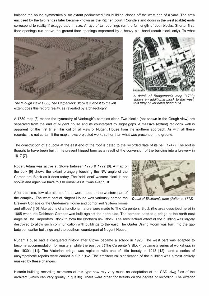
balance the house symmetrically. An extant pedimented ‘link building’ closes off the west end of a yard. The areaenclosed by the two ranges later became known as the Kitchen court. Roundels and doors in the west (gable) endscorrespond to reality if exaggerated in size. Arrays of tall openings run the full length of both blocks. Shorter first-floor openings run above the ground-floor openings separated by a heavy plat band (south block only). To what
extent does this record reality, as revealed by archaeology?
A 1739 map [6] makes the symmetry of Vanbrugh’s complex clear. Two blocks (not shown in the Gough view) areseparated from the end of Nugent house and its counterpart by slight gaps. A massive (extant) red-brick wall isapparent for the first time. This cut off all view of Nugent House from the northern approach. As with all theserecords, it is not certain if the map shows projected works rather than what was present on the ground.
The construction of a cupola at the east end of the roof is dated to the recorded date of its bell (1747). The roof isthought to have been built in its present hipped form as a result of the conversion of the building into a brewery in1817 [7].
Robert Adam was active at Stowe between 1770 & 1772 [8]. A map ofthe park [9] shows the extant orangery touching the NW angle of theCarpenters’ Block as it does today. The ‘additional’ western block is notshown and again we have to ask ourselves if it was ever built.
After this time, few alterations of note were made to the western part ofthe complex. The west part of Nugent House was variously named theBrewery Cottage or the Gardener’s House and comprised ‘sixteen roomsand offices’ [10]. Alterations of a functional nature were made to The Carpenters’ Block (the area described here) in1865 when the Dobinson Corridor was built against the north side. The corridor leads to a bridge at the north-eastangle of The Carpenters’ Block to form the Northern link Block. The architectural effect of the building was largelydestroyed to allow such communication with buildings to the east. The Garter Dining Room was built into the gapbetween earlier buildings and the southern counterpart of Nugent House.
Nugent House had a chequered history after Stowe became a school in 1923. The west part was adapted tobecome accommodation for masters, while the east part (The Carpenter’s Block) became a series of workshops inthe 1930’s [11]. The Victorian bridge was replaced with one of little beauty in 1948 [12] and a series ofunsympathetic repairs were carried out in 1962. The architectural significance of the building was almost entirelymasked by these changes.
Historic building recording exercises of this type now rely very much on adaptation of the CAD .dwg files of thearchitect (which can vary greatly in quality). There were other constraints on the degree of recording. The exterior
The ‘Gough view' 1722; The Carpenters’ Block is furthest to the leftA detail of Bridgeman's map (1739)shows an additional block to the west;this may never have been built
Detail of Bickham's map (?after c. 1772)
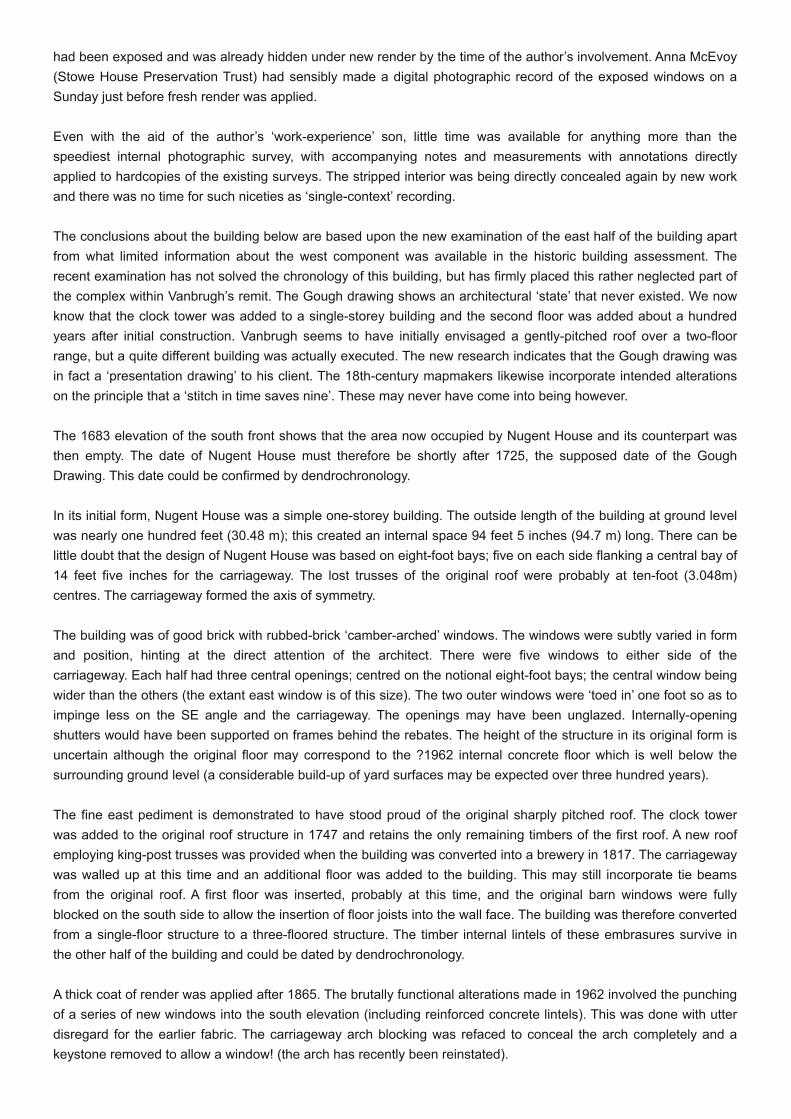
had been exposed and was already hidden under new render by the time of the author’s involvement. Anna McEvoy(Stowe House Preservation Trust) had sensibly made a digital photographic record of the exposed windows on aSunday just before fresh render was applied.
Even with the aid of the author’s ‘work-experience’ son, little time was available for anything more than thespeediest internal photographic survey, with accompanying notes and measurements with annotations directlyapplied to hardcopies of the existing surveys. The stripped interior was being directly concealed again by new workand there was no time for such niceties as ‘single-context’ recording.
The conclusions about the building below are based upon the new examination of the east half of the building apartfrom what limited information about the west component was available in the historic building assessment. Therecent examination has not solved the chronology of this building, but has firmly placed this rather neglected part ofthe complex within Vanbrugh’s remit. The Gough drawing shows an architectural ‘state’ that never existed. We nowknow that the clock tower was added to a single-storey building and the second floor was added about a hundredyears after initial construction. Vanbrugh seems to have initially envisaged a gently-pitched roof over a two-floorrange, but a quite different building was actually executed. The new research indicates that the Gough drawing wasin fact a ‘presentation drawing’ to his client. The 18th-century mapmakers likewise incorporate intended alterationson the principle that a ‘stitch in time saves nine’. These may never have come into being however.
The 1683 elevation of the south front shows that the area now occupied by Nugent House and its counterpart wasthen empty. The date of Nugent House must therefore be shortly after 1725, the supposed date of the GoughDrawing. This date could be confirmed by dendrochronology.
In its initial form, Nugent House was a simple one-storey building. The outside length of the building at ground levelwas nearly one hundred feet (30.48 m); this created an internal space 94 feet 5 inches (94.7 m) long. There can belittle doubt that the design of Nugent House was based on eight-foot bays; five on each side flanking a central bay of14 feet five inches for the carriageway. The lost trusses of the original roof were probably at ten-foot (3.048m)centres. The carriageway formed the axis of symmetry.
The building was of good brick with rubbed-brick ‘camber-arched’ windows. The windows were subtly varied in formand position, hinting at the direct attention of the architect. There were five windows to either side of thecarriageway. Each half had three central openings; centred on the notional eight-foot bays; the central window beingwider than the others (the extant east window is of this size). The two outer windows were ‘toed in’ one foot so as toimpinge less on the SE angle and the carriageway. The openings may have been unglazed. Internally-openingshutters would have been supported on frames behind the rebates. The height of the structure in its original form isuncertain although the original floor may correspond to the ?1962 internal concrete floor which is well below thesurrounding ground level (a considerable build-up of yard surfaces may be expected over three hundred years).
The fine east pediment is demonstrated to have stood proud of the original sharply pitched roof. The clock towerwas added to the original roof structure in 1747 and retains the only remaining timbers of the first roof. A new roofemploying king-post trusses was provided when the building was converted into a brewery in 1817. The carriagewaywas walled up at this time and an additional floor was added to the building. This may still incorporate tie beamsfrom the original roof. A first floor was inserted, probably at this time, and the original barn windows were fullyblocked on the south side to allow the insertion of floor joists into the wall face. The building was therefore convertedfrom a single-floor structure to a three-floored structure. The timber internal lintels of these embrasures survive inthe other half of the building and could be dated by dendrochronology.
A thick coat of render was applied after 1865. The brutally functional alterations made in 1962 involved the punchingof a series of new windows into the south elevation (including reinforced concrete lintels). This was done with utterdisregard for the earlier fabric. The carriageway arch blocking was refaced to conceal the arch completely and akeystone removed to allow a window! (the arch has recently been reinstated).

Nugent House was an ‘architect-designed’ barn. In England this was a unique concept at that date and intended toform part of the composition set out by Vanbrugh. The massive carriageway is the best evidence of the building'spurpose. In its original state, it was open-sided and capable of admitting a haywain. The internal width (N-S) of thebuilding allowed a clear distance between the two archways of 22 feet 3 inches (6.78m), only slightly less than therecommended 24-foot (7.31m) length of a threshing floor. Open carriageways provided a through-draft for thispurpose. No porches were employed but these features only come in after about 1750 [14]. An apparent absence ofbarn doors may be connected with the carriageway’s additional role as a thoroughfare. The opposing range wasdifferent in several points of detail; raising the possibility that it served a different role in this putative ‘home farm’.
The utility of HBR involvement has been made apparent here, even under circumstances which are less thanperfect. The special circumstances also show the need for experience in rapidly setting priorities for recording anddetermining ‘what really matters’ as opposed to recording for the sake of it. It is inevitable that much can only besubsequently determined from records but while a point-cloud laser survey is very impressive, such exercises reallycan do no more than delay interpretative decisions to a later day. The best place to make interpretation is when theevidence is in front of one! Subsequent analysis should then aim to test such ‘site interpretations’, and if necessaryreplace them with entirely new ones. There really is no way of escaping interpretation at every stage of the process.
[1] Network Archaeology Historic Building Assessment, 1[2] Wikipedia ‘Stowe House’ passim[3] Stowe House [south facade], anonymous (1683), RCHME[4] Gough Drawings a.4, fol.46; Bodleian[5] op. cit. 1, 9[6] Sarah Bridgeman’s map prepared for Viscount Cobham (1739); repr.
Austenonly.com/2011/05/08/the_ha_ha_at_stowe/[7] op. cit. 1, 1[8] Wikipedia[9] Map printed by George Bickham Junior in the Beauties of Stowe (1750)[10] op. cit. 1, 8[11] op. cit. 1, 3[12] op. cit. 1, 108[13] S. Wade Martins (1991) Historic Farm Buildings p.166[14] ibid.
Text: Mark Samuel, Edited: Kate Hamlyn ©Architectural Archaeology [email protected]
The south elevation today showing details of Vanbrugh's barn (in red) annotated onto the architectural survey(Limbrick Associates)