theme 6 ; the growth of towns - dungog shire · theme 6 ; the growth of towns 1. ... but by 1902...
TRANSCRIPT

THEME 6 ; THE GROWTH OF TOWNS
1. Overview
After the early cedar getters had moved on,and their rough shanties had fallen down, thefirst settlers began to stream into thePaterson and Williams Valleys, bringing theirwives and children, convict workers andservants, goods and stock. Their involvementin the convict assignment system and theirdisplacing of the local blacks meant that anever-present underlying fear of revolt orreprisals was inevitable. The spread ofsettlement was thus followed by some attemptto maintain law and order and to protectsettlers, as we have seen. The buildingsassociated with the government's influence -barracks, courthouses, lock-ups - often markedthe nuclei of later townships. Other placesof business and gathering were drawn to them,for convenience, and eventually the villagetook on a life of its own.
The period 1830 to 1850 saw the establishmentof a network of country towns in New SouthWales in a pattern which survives to thepresent day. By 1846 there were 36settlements containing more than 100 people,while eight had more than 700.1 The locationof early towns in Dungog Shire was for themain part moulded by the rivers, both asbarriers and conveyances, together with theirassociated landscapes of watersheds, valleyslopes and alluvial plains. People cametogether on the flats in bends of the river,at the heads of navigation, at crossingplaces. Sometimes, the official selectioncoincided with these "natural" sites, and thelater town developed in a regular, orderlyfashion, while at other times the officialplan was partly or wholly bypassed by privatedevelopment, for example at Gresford andAllynbrook. In many instances, settlementsranging from a few buildings to a smallprivate town grew up on esates, ribbonlikealong the roads or clustered about thehomestead. The fluctuation in industrialpatterns, because of climatic conditions andeconomic and technological developments,played havoc with the neat, orderly streetsand the plans for mutually supporting networksof towns. At Paterson, development faroutstripped the 90 acres set aside for it,
61

while at Clarence Town the generous extent ofthe plan was never fully utilized; EastGresford eventually surpassed the officialtown of Gresford; the gold mining town ofWangat was deemed to require a proper surveyin 1888, but by 1902 there were only twohouses still standing.2
Enterprising settlers quickly made use ofconvenient town sites by erecting buildingsassociated with current requirements and newindustries, supplementing official buildingsand functions. By 1830 Marshall and Lowe hadestablished their shipyards at Clarence Town,and by 1832 MacKay's wharf and store stoodnearby. At Dungog, Paterson and Gresford innswere opened during the 'thirties and 'fortiesto cater to the needs of travellers for food,accommodation and stockyards. The inns alsobecame local gathering-places, for example,the early Farmers Club, formed in about 1827met in an inn at Patersons Plains.3 Thetrades associated with transport -blacksmiths, wheelwrights, ostlers - weredrawn to the early settlements for the samereasons.
The names of towns and settlements were drawnfrom various sources, reflecting the compexmixture of elements making up the shire'shistory. Paterson took its name from theriver, named in honour of Colonel WilliamPaterson, and similarly, Clarence Townhonoured the Duke of Clarence. Pleasant,musical aboriginal names were given to Dungog,Bendobba, Dingadee, Munni, Wallarobba, Tocaland probably Carabolla. Homesick Welshmenadded a string of Welsh names to the upperPaterson district, including Gresford,Eccleston, Allyn, Lostock, Halton andTrevallyn. Later in the century Germansettlers probably named Woerden.
The various immigration schemes of the 1830'sand 1840's, although intended to encouragerural settlement, actually stimulated thegrowth of towns. The cost of their passage tothe colony was financed by land sales whichironically priced land out of the reach ofmany newly arrived settlers. They sought workin the towns instead.4
The 1840's period with its artificially highland prices, severe drought conditions,together with the withdrawal of convict
62
labour, drove many of the large and previouslysuccessful landowners to bankruptcy.Labourers left the estates and farms to seekwork in the towns, and boiling-down works werehastily set up to convert thousands of cattleand sheep, purchased during the bouyant'thirties, into tallow and lard.5 At the sametime the occupation of the rural areas didincrease to some extent, as many large estatesin the Hunter Valley were subdivided and sold.In Dungog Shire a more common practice was totenant the large estates and many smallsettlements grew up associated with the earlyestates as a result. Bounty schemesencouraged large landowners to import labourfor their estates in place of the convicts.At Lewinsbrook and Cawarra, German vintnersand labourers were brought in to tend thevineyards.6
The pattern of populations in flux continuedduring the following decade. With the goldrushes of the 1850s onwards, a steady streamof hopeful diggers headed for the variousgoldfields and the settled population fell,particularly on tenanted land. There was alsoan exodus of landowners to the NorthernRivers, corresponding with an incoming rush ofIrish immigrants. Between 1851 and 1861 theproportion of Catholics rose considerably inthe county of Durham as a result.?
The second half of the nineteenth century wasgenerally a boom-time for the major towns inDungog Shire, and thus also a period ofphysical consolidation and community growth.The 1860s brought neat, solid governmentbuildings, such as police stations, watchhouses, post offices and court houses, allbuilt to indicate a civilized and well-orderedsociety. Rows of stores and offices werebuilt by merchants, professional people, banksand businessmen along the main streets, slowlyfilling up the grids laid down by surveyorsforty years before. Clarence Town andPaterson developed as busy transport nodeswhere goods and produce from further up thevalleys were loaded onto the riverboats forNewcastle and Sydney, and the necessities andcomforts of life were offloaded anddistributed. Boatloads of sight-seers andday-trippers came up from Newcastle to viewthe marvels of the bustling towns set in theirundulating hills by the lifeline rivers.8
63

The depression of the 1890s appears not tohave greatly affected the shire's major towns,and the many fluctuations in rural industriesusually brought only temporary setbacksfollowed by the strengthening influence of newindustries. The early wheat and corn millscontinued to function until rust brought theend of widespread wheat growing in the 1860s.Tobacco growing declined in the followingdecade because of the spread of blue mould.At the same time however, the new saw millspowered by steam that were set up from the1860s brought the resurgence of the timberindustry and a large cornflour mill wasestablished at Dungog in 1878. The 1880s sawthe establishment of a flourishing citrusindustry,.and the dramatic developments indairying technology led to large scaledairying in the region from the 1890s and athus great increase in the shire'spopulation.9
The early twentieth century brought theextension of a Northern Railway throughPaterson to Dungog, altering the pictureconsiderably. At first the cutting ofsleepers stimulated the local timber industry,but upon its opening in 1911, the railwaynegated the role of both Clarence Town andPaterson as vital centres of river/roadtransport. Both towns lost much of theirimpetus and eventually simply became quietrural centres. Meanwhile, Dungog derivedconsiderable growth from the railway whichterminated there for a time. The railwayworkers and the timber required for sleepershad stimulated the service and timberindustries, and the railway itselfstrengthened the town's status as a transportnexus and service centre, spurring itsphysical development during the 1910s and1920s. Dowling Street's handsome array offacades illustrates the growth of'the townfrom the 1890's through to the 1920s, with itslavishly detailed Victorian, Federation and1920s style shops, banks, offices and hotelsstretching almost continuously from one end ofthe town to the other. It was, indeed, a townof note.
In the end, however, the decline of thedairying industry, together with general ruralslump, the bypassing of the shire by majorrouteways, and growing centralisation of largeurban areas, led to the slowing of growth in
64

the towns and villages since about the 1950s.At the same time, and precisely for thisreason, the region has retained much of itshistoric and natural landscapes and itssplendid architectural heritage, factors whichdraw increasing numbers of tourists and formthe basis for yet another industry.
2. Major Towns
Paterson
Paterson's origins probably lay in the rough,makeshift camps of the early cedar getterswho named the Paterson "Cedar Arm" and thesite of the town "Old Banks". They may stillhave been stripping the temperate rainforestswhen police were appointed to the district by1820. In that year barracks were erected,probably on the site of the present-daycourthouse building, constituting the town'sfirst more or less permanent structure. Aslab courthouse and lock-up were erected in1828 in the wake of the rapid settlement ofthe Paterson and Allyn Rivers.1
The town site, set in the midst of richalluvial lands 12 kilometres below the head ofnavigation at Gostwyck, was the third to besurveyed in the Hunter Valley after Newcastleand Maitland. Since it had not initially beenset aside during Dangar's survey, ninety acresof Mrs. S.M. Ward's Cintra estate waspurchased in 1832. At the time of the firstsurvey, a track ran irregularly along the browof Mt. Johnston, connecting the properties onthe west bank. It was straightened by thesurvey of George Boyle White, and laterincorporated into the town plan. A spot wasalso marked for a public wharf. The townitself was laid out the following year andcomprised only six streets, all namedreassuringly within the theme of royalty andtitle - King, Queen, Prince, Duke, Count andMarquis. It was a finite town plan, set in aneat grid tightly enclosed by the river, theMount Johnston Ranges and Hungry Hill, and itrapidly became totally inadequate in size asthe century progressed.2
By 1833 the surveyor could already markseveral buildings on the new plan - acourthouse and lock-up, a pound (in PrinceStreet), two early churches (St. Ann's
65

NoumeaPrince StreetPaterson:SignificantBuilding
Paterson TavernPrince StreetPaterson:SignificantBuilding
Site ofPatersonsArms HotelbetweenVictoria andSloane StreetsPaterson:ArcheologicalSite.
Presbyterian and St. Paul's Anglican - bothwere forerunners of the present churches) andan inn on James Phillips' Bona Vista estate.The inn may have been the predecessor of hislater inn, the Patersons Arms.3
With the introduction of the steamer serviceduring the 1830's, the town's future wasassured and many substantial and fineresidential, commercial and church buildingswere erected during the next two decades. InPrince Street, two buildings, Noumea, acottage, and the Paterson Tavern are thoughtto date from this early period, and may havebeen designed by the noted architect JohnVerge.4 Verge had been granted a property,Lyndhurst Vale, in the Wallarobba district,and his allegiance appears to have been withPaterson. He was commissioned in 1836 byLieutenant Frederick Bedwell, of ValentiaLodge nearby, to "design in pencil ....a housein Paterson, finished plans and a list ofscantling." Verge completed drawings for fourcottages but it is not known whether they wereever built on Bedwell's land (Queen Street andcorner King and Duke Street)5. His connectionwith the Paterson Hotel (later Patersons ArmsHotel) is stronger. He was commissioned todesign it by James Phillips in 1835 and theinn was built on the Bona Vista estateadjoining the township. The location became asite in a street connecting Victoria andSloane Streets, in the private township. Aphoto dated c1880, by which time it had becomea private residence, Brooklyn House, shows thebuilding in considerable detail and as typicalof Verge's restrained and balanced style. (SeeFigs. 12 and 13). It was completed in about1838, and by 1840 it was described as:
...containing on the ground floor fivelofty rooms, one of which is fitted upas a bar room with counter and shelvescomplete. The upper floor which isapproached by a winding stonestaircase..... contains also five neatlyfinished bedrooms with a balconyenclosed by iron palisading of exquisitedesign and taste.
Set on the main road to Maitland on highground and surrounded by extensive gardens, itwas a "lucrative establishment" with aturnover of ten thousand pounds per annum.The building survived until 1949, when it waspulled down because of poor condition.?
66

Site of theBush Inn/SussexHouse,Gresford Rd,Paterson:ArchaeologicalSite.
Former
Royal Oak Inn
King Street
Paterson:
Significant
Building
AnnandaleHouseKing StreetPaterson:SignificantBuilding
St. Anne'sPresbyterianChurch,King Street,Paterson:SignificantBuilding.
St. Paul'sAnglicanChurch andBurial GroundDuke Street,Paterson:SignificantBuilding
At the same time another inn was establishedon the road leading to the districts furthernorth. The Bush Inn was erected on Mrs. Ward'sCintra estate high above the riverside road.It had a plaque over the doorway engraved"Long House Green 1836" and comprised twostoreys of stone one room wide with a smallcentral gable set in the gabled roof.Bellcast verandahs stood at either end of thestructure which also featured 12-panedwindows. (See Fig. 14). It apparently servedas an inn and wine shop throughout thenineteenth century until it was purchased byWilliam Corner in 1900. A new brick twostorey verandah'd section was added to thefront at this stage, camouflaging the earlybuilding, and it was then renamed SussexHouse. Both sections were demolished in1966.8
In the township itself the Royal Oak Hotel(extant) was erected in King Street during the1830s and it was subsequently used as abarber's shop, private residence and C.B.C.bank office. Further along King Street, MajorEdward Johnstone, possibly a relative ofGeorge Johnstone and an early PoliceMagistrate, built Annandale House in 1839.The fine two storey stone residence faces outover the river and Street with its surroundingbellcast verandah, echoes on a small scale thestyle of the estate-houses Trevallyn,Gostwyck, Tocal and Dunmore.9
By 1834 Paterson had a post office which wasprobably run from a private residence. Anearly school house, most likely slab, was alsoused as a chapel, although the denomination isunclear, and in 1837 a teacher who could"speak Gaelic grammatically" was required forthe Presbyterian school. The austere, solidlines of St. Anne's Presbyterian churchappeared in 1840. It was set on a landmarksite on a rocky outcrop on the northwest edgeof the town, overlooking the river and boththe official town and the string of mills,cottages and inns on the road out to Gresford.Work on St. Paul's Anglican Church began underthe direction of Reverend John Jennings Smithin 1839. The simple stone gothic church wasconsecrated in 1845, while the graveyard atthe rear predated it. Burials had at firsttaken place on a site selected by ReverendG.A. Middleton on the Tillimby estate, andlater in an area at the far eastern point of
67


asr:
4


Commercial RoadPrecinct,Paterson:Industrial/HistoricalArchaeology.
Court HouseHotel,King Street,Paterson:SignificantBuilding.
the town, a riverside site on the peninsular,as shown on an 1839 survey.10
The 1840's were a period of expansion of thetown itself , in spite of the setbacks ofdrought and the depression . James Phillips in1840 was able to subdivide and sell the northeastern portion of his estate as the privatesection of town (now the area south of PrinceStreet,11 (See Fig . 15)). The area along theriver and Gresford road north west of thetownship was another area of lively but rathermore haphazard industrial development. Anetwork of roads developed connecting thevarious buildings , as illustrated on surveyorHenry Carmichael ' s map of 1850. (See Fig.16).Carmichael had been assigned the realignmentof the flood prone riverside roads in thatyear and the map shows two flour mills (onewas Keppie's), each with its own wharf, with a"double cottage " and the remains of anothercottage between them . Further along stoodwork shops , another brick cottage , a store,Keppie's Inn (possibly the Cricketer ' s Arms)and a blacksmith ' s shop . David Brown's BushInn with its stables, yard and gardens isshown on another road further up the slope.Quarries from which stone for the town'sbuildings was taken stood at the entrance tothe town . Although the road was realigned inthe 1850s , the activities of the "CommercialRoad" as it became known , did not cease untila devastating flood covered the area in 1875.The Cricketer's Arms Hotel was subsequentlyremoved brick by brick into the town andbecame the present Court House Hotel.Photographs show that the early symmetricalbrick structure was later ( c1880 ) doubled insize by the addition of a larger wingadjacent , and the whole was given a verandahof iron lace . ( See Figs. 17 and 18 ). Today itappears that only the later building hassurvived. Down on the Commercial Road area apost and rail fence , with its debris of morerecent floods , still marks the line of theoriginal road . A large brick grain storagebarn and a two-storeyed miller's cottage arealso still intact , contributing to the site'svalue as an outstanding historical/archaeological research area.T2
John Tucker, a notable local figure and thetown's early historian, wrote a nostalgicpiece in 1933 describing Paterson in the 1840sas a well established, thriving town. It had
68


six public houses (Paterson Arms, WellingtonArms, Settlers Arms, The Bush Inn, The PloughInn and The Cricketer's Arms), fourblacksmith's shops, four stores, threebootmakers, a tannery, two butcher's shops anda bakery, two tailors, two auctioneers, ashipyard (across the river), two steam flourmills, and a busy timber industry providingmaterial for houses, fences, and ships' sides,ribs and beams, furniture and casks. Theshipyard's first ship was launched in 1846 andother ships constructed included the "Pegasus"and "Paterson Packet". By 1848 the town had aracecourse near Webber's Creek and hadestablished annual race days. For Tucker,looking back from the bleak 1930s, Patersonseemed a brighter, simpler and greener place -an ironic conclusion in some ways, in view ofthe desperate circumstances of the dry anddepressed 1840s.13
PatersonWharf,Paterson:SignificantStructure
Union Shedadjacent toWharf,Paterson:IndustrialArchaeology
Glen Ayr,Corn Staddleand Cottage,
During the second half of the nineteenthcentury Paterson consolidated both itsimportance and its physical formation, andcontinued to grow. It was a service centrefor the rich agricultural land around it andthis together with its role as a transportmode attracted various industries. Most ofthe transport and marketing activities werecentred on the wharf, and buildings sprang upaccordingly. Produce was loaded onto draysand carts which streamed down the variousroads of the Paterson and Allyn Valleys,converging on Paterson, and there, river boatswhich received the loads brought various goodsup from Sydney and Newcastle. Below St.Anne's, Andrew and John Keppie's saw millstood adjacent to the public wharf, and thestore houses and offices of the Hunter RiverSteam Navigation Company, including the unionor market shed, were built nearby, on the siteof the earlier Wellington Arms. Market day inPaterson was traditionally Tuesday and thetown would be crowded with farmers sellingtheir produce and buying up goods and stores.Wilson and Keppie ran the market shed for manyyears until it closed in the 1950s.14
Fry's coach service was established to connectthe town by road with Maitland in the south,and, more importantly, with the settlementsbeyond the head of navigation further north.The links were made considerably easier by theconstruction of the valley's various bridgesduring the 1870s and 1880s. Fry's depot was
69

Maitland RoadPaterson:SignificantBuildings/IndustrialArchaeology
FormerCourthouseKing Street,Paterson:SignificantBuilding
Former SchoolChurch Street;Post Office,King Street;School of Arts,King Street;Oddfellows HallChurch Street;Paterson:SignificantBuildings.
Orange PackingShed, nearTucker Park,Paterson:IndustrialArchaeology
on the corner of Prince Street and MaitlandRoad east of the private town, and comprised ablacksmith's shop, stables, hearse shed, acottage and a corn staddle. The corn staddleand cottage, together with the Fry's familyhome Glen Ayr (1900) are still extant.15
The erection of official buildings in the townbegan in the 1850s with the new lock-up andwatchhouse, and in 1857 a fine new courthouseon the site of the old slab building wasbegun. The building, designed by the thenColonial Architect Alexander Dawson, was of aneo-classical style, with arched portico andfine stucco detailing. It stands on asuitably elevated site overlooking the townand the river and functioned as a courthouseuntil 1967. It now houses the museumcollection of the Paterson Historical Society.The town had a gothic school building erectedin 1877, a small Italianate post office duringthe 1880s, along with a police residence in1882. A School of Arts was erected in 1883and served as a focus for communityactivities, a function continued by its 1935replacement. An Oddfellows hall was alsobuilt in 1865.16
Paterson suffered some setbacks during the1850s and 1860s as a result of the rapidspread of rust which wiped out the wheatfieldsstretching "....from Hinton to Lostock", andforcing the cultivation of wheat to the drierplains further west. Similarly, the tobaccocrops were eventually finished off by bluemould which also spread rapidly in therelatively wet climate.17 However, asuccessful citrus industry was laterestablished and expanded up the Paterson asfar as Carrabolla, and this together with therise in dairying brought on by therevolutionary developments in that industry,boosted the town's population and reaffirmedits importance. The land adjacent to TuckerPark was formerly an orange orchard and anextant packing shed there is a physicalreminder of the industry. Paterson Riveroranges were well known and sought after, andin its heyday early this century 30,000 caseswere handled through Paterson in a season.18The new feasibility of small citrus and dairyfarms also brought the end of the remaininglarge estates in the shire. Almost all weresubdivided and sold off in the first thirtyyears of the century, and they were invariably
70

advertised as citrus and dairy farms, with anemphasis on the fertility of the land and theefficient transport links. Since both typesof land-use usually involved the labour oflarge families, the population of the area wasgreatly increased.1 9
Former C.B.C.Bank, cnr.King andDuke Streets,Paterson:SignificantBuilding.
Former AnglicanRectory, cnr.Prince andDuke Streets,Paterson:SignificantBuilding.
PatersonRailwayStation andBridge,Paterson:IndustrialArchaeology
The C.B.C. Bank displayed its confidence inthe future of the town by building a handsome,impressive office on the corner of King andDuke Streets in 1902. The verandahs of bothstoreys lend a pleasing domestic appearance tothe building, which is a major feature of thetownscape. The bank office was maintaineduntil its closure in 1979. A new Anglicanrectory was built in 1906 on the site ofReverend Smith's 1839 rectory at the corner ofPrince and Duke Streets. Again the fineEdwardian building is an eloquent expressionof the town's self-confidence as it began thenew century, and also forms a strikingtermination to Maitland Road at the entranceto the town.20
Bankers and churchmen, businessmen and farmersprobably considered the extension of the NorthCoast railway through their town as yetanother boon by which the town's role as amarket and transport centre would bestrengthened. Instead, the railway eventuallydeprived Paterson of its lively river tradeand gave no real benefit in return. Therailway line carved up its townscape and therailway bridge was aligned directly over thewharf, aptly reflecting the dominance of railover water. A girder from the bridge fellthrough the riverboat Marie, causing seriousdamage, and later ashes from a steam engineboiler set her alight. The public landingplace was transferred and a new wharf, QueensWharf, was built in the Tucker Park area.Over the next four decades, cream boats andpleasure craft plied the waters, but by the1930s, those too had vanished.21
During the years following the 1930s the townbecame a quiet rural centre with few newdevelopments. With the closure of many publicand private concerns, Paterson was left withmany empty buildings - an ironic situation inview of its long history of buildingdevelopment continually spilling over itsofficial boundaries. The lack of moderndevelopment has, however, led to a new touristindustry, based on its beautiful natural
71
environment and historic landscape. Whatremains is, in fact, a striking outdoor museumof nineteenth century life.
Site ofSingleton'sMill, northof ClarenceTown:ArchaeologicalSite.
Site ofMarshall &Lowe's DeptfordShipyards,Clarence Town:ArchaeologicalSite
Clarence Town
The crew of the Lady Nelson rowing up theClarence River, viewed the site of ClarenceTown in 1801 before they were stopped by thefalls about 4 miles/6 kilometres further alongthe Williams River. Although no cedar wasnoted on this first trip, cedar getters laterlocated pockets along the river and forestsbeyond the head of navigation. It is thoughtthat their makeshift camps may have been onthe site of Clarence Town, and timber was tobe the town's major industry for much of itsexistence.1
Benjamin Singleton, an enterprising man whohad discovered the early Bulga Road route andhad various interests at Singleton, built awater-driven flour mill in 1829, inanticipation of the wheat crop of the largeestates established in the area in 1828 and1829. He advertised his service in the SydneyGazette:
Mr. Benjamin Singleton of the John MillsWilliams River...... inform(s).... thatthe above are now in full work. He hastwo crafts now on the River which willtake grain from the different farms andreturn meal when ground at the rate offifteen pence sterling per bushell...2
The track towards his mill had beenestablished and was marked on an 1832 map ofthe town site. (See Fig.19). In spite of thedepression and drought of the 1840s, the millsurvived until it was washed away in the great1857 flood.3
While the land on the Williams was generallytaken up rapidly, the soils around ClarenceTown were relatively poor, with the resultthat the town's development at first laggedslightly behind the others in the Shire. Thesettlement pattern around the town for variousreasons also tended towards smaller, poorerfarms, contrasting with the extensive, richestates along the Paterson and around Dungog.At the same time, its location on the riverand proximity to sources of fine timber ledWilliam Lowe and James Marshall to establishtheir ship-building yard at the southern end
72

Pig. 19 : (Overleaf) Excerpt from "Clarence Town showing tomreserve, farms etc. on Williams River", 1832. Marshalland lowe's shipyard is narked, along with Macray's store,Rusher's huts and various tracks. (A.O. Map 2208).


Fig. 20 : (Overleaf) "Clarence in, County of Durham, 1864"(Mitchell Library) .

Hua TsaKing Street,Clarence Town:SignificantBuilding
Site ofDeptford House,Marshall & LoweShipyards,Clarence Town:ArchaeologicalSite
of the town in 1830. The Deptford Shipyard,as it was named, was on land purchased fromthe Reverend Father Therry. Its reputationwas consolidated by the launching of thefamous William IV, the first ocean-goingsteamer built in Australia, in 1832. Deptfordbecame the nucleus of the town and by 1832,the "Huts and Yard etc. occupied by Messrs.Lowe and Marshall" were joined by MacKay'sstore, while in the bend of the river to thenorth east, James Rusher had 26 acres clearedand cultivated, and had erected several huts.(See Fig.19). The first wharf was built byDavid Farquar at Deptford soon after, alongwith a store. A pound was also set up beforethe town was laid out.4
As a result of this activity, the town wasproclaimed in 1832, the third in the HunterValley, after Newcastle and Maitland, and itsplan was laid out on the extensive, open,elevated terrace overlooking the river. Itwas a scheme so generous that it was neverfully utilised, even at the height of the boomperiod. As usual, the streets almost withoutexception formed a rectilinear grid patternsuperimposed on the contours of the river andover existing creeks, tracks and structures.The area was divided up into one and two acreblocks and sold off at two pounds an acre.(See Fig. 20). A survivor from this earlyperiod is Hua Tsa, built by S.N. Dark, a long,low house of brick with a sweeping, steeplypitched roof stretching unbroken over the wideencircling verandah. The two front doors,each crowned with semi-circular fanlightsreinforce the claim that it was at one stageused as an inn.5
Marshall and Lowe's partnership had dissolvedby 1836 and Lowe carried on the Deptford worksuntil 1855. It was he who built DeptfordHouse (see Fig. 21) which stood above theyards until the complex burnt down in theearly twentieth century.6
Lowe and Marshall acquired about 600 acres onthe opposite side of the river from ClarenceTown by 1840, and in that year numerous smallfarms stretched down along the river below hissouthern boundary. The withdrawal of convictlabour, together with the depression anddrought also lead many large landowners tosublet their estates, with the result of anincrease in the population in the district.7
73

co0

Steam FlourMill Site,King Street,Clarence Town:ArchaeologicalSite. ?
Victoria MillRifle Street,Clarence Town:ArchaeologicalSite ?
CommercialHotel,
The new settlers were served by a regularsteamer service established in about 1856, anda punt across the river at Deptford linked thetown more directly with the settlement atRaymond Terrace. Both regular cattle salesand annual race meetings were held from thatyear. A post office was established in 1839and in the following year, the town alreadyhad 93 inhabitants and 18 houses. A schoolwas set up in 1849, the earliest NationalSchool in the Shire, which for a period becameone of the best in the State.8
The late 'forties also saw Surveyor HenryCarmichael marking out the allotment for thevarious church buildings, including land for aRoman Catholic burial ground (1847), aPresbyterian school in Marshall Street (1847),Presbyterian Manse and Church (1849) and aWesleyan Chapel (1849). These maps givelittle idea of other existing structures,although an inn was marked in Queen Streetclose to Grey Street in 1847. Only Queen andGrey Streets were actually formed to someextent at this stage, all the rest stillmarked as dotted lines. However, by 1851, thetown's po)pulation of 193 surpassed that ofPaterson.
Industries associated with both agricultureand timber began to appear in the town andcontinued to thrive throughout the nineteenthcentury. A steam flour mill had beenestablished by 1845 (Lots 7,8 King Street) andwas joined by G. A' Church's Victoria Mill inLot 4 Rifle Street, flourishing until rustwiped out the district wheat crops in the1860s. Similarly the town had two tobaccofactories treating leaf during the 1870s, butthese closed down after the onset of bluemould. In 1866, however, the town could stillboast two flour mills and two tobaccofactories. One of the latter had beenestablished by James Lyall, together with atannery. Another tannery owned by Mr. A. Lloydwas on Stony Creek near the cemetery west ofClarence Town. His greenhide and fancyleathers became wellknown and won manyprizes.10
The busy river trade was, once again, fed bythe roads fanning out into the valleys, andshipped timber, tobacco, wheat, potatoes,pumpkins, barley, maize and butter from atleast two wharves. Clarence Town's three
74
Clarence Town:SignificantBuilding
Hollydeneand earlierbuildings,Russell Street,Clarence Town:SignificantBuildings.
Courthouse,Police Station,Post Office,Clarence Town:SignificantBuildings.
FotheringayClarence Town:SignificantBuilding
hotels, including the George and Dragon, theCommercial and the Fitzroy, saw to thetraveller's and the local's needs. Of thesethree, only remnants of the Commercial Hotelsurvive. The 1850s also brought the passingtrade of traffic bound for the goldfields atHanging Rock, and this reoccurred during the1880s when discoveries were made at Wangat andWhispering Gully. The journey throughClarence Town was made easier by the openingof the Clarence Town bridge in 1880.11
By 1866 the town had a coach booking office"for passengers and light parcels", a savingsbank, and a branch of the Liverpool, Londonand Globe Insurance Company serving itspopulation of three hundred. Three churchesand two schools, the National and the RomanCatholic, had also been established. Theprosperity and vitality of the town wasquickly reflected in the architecture. Thefirst hotel, the George and Dragon (builtc1845) was owned by Samuel Walters who alsopurchased about four acres in Russell Street,erecting his small stone cottage and a stonecreamery and storage room on it. His hotelprospered, and during the boom years of the1880s, Walters built the present Hollydene onthe site. (See Fig. 22). The two storeyedvilla represents the optimism and opulence ofthe day, with its lavish cast iron detailingand joinery. Part of the earlier, modeststructures stand at the rear.12
Walters also built the town's watchhouse andlock-up in 1854, along with a temporarycourthouse. The present courthouse wascompleted in 1869 to the design of GovernmentArchitect James Barnet, and during the 1880s aPost Office and Police Station completed thetown's array of impressive public buildings.13
Another physical reminder of Clarence Town'sboom period is Fotheringay, an unusual,elaborate, L-shaped house of brick and fieldstone with a prominent octagonal drawing roomfacing out over the river. The property onwhich it stands was an amalgamation of sevensmaller allotments, and the house appears todate from c1860s. The wealthy timbercontractor William Croker purchased it in 1895and resided there for many years until hisdeath in 1919 aged 79.14
Besides the river boats laden with goods and
75
Robards & SonsBacon & PorkFactory,Glen William Rd.Clarence Town:IndustrialArchaeology.
produce, the river also carried pleasure boatsfull of day-trippers enjoying the tranquilriver and landscape during the four-hour tripfrom Newcastle. An anonymous tourist in 1878remarked on Clarence Town's "forward state"and "healthful situation", the three steamerslying at the wharf, and the W.C. Wentworthpreparing to load timber, large quantities ofwhich lined the banks for a considerabledistance.15
During the 1860s, the local timber wasdescribed as "of excellent quality....abundant" and "large quantities split andsawn are exported". Handsawing and the oldsawpits began to be replaced by steam driventimber mills in that decade, and timber grewinto a major industry as a result. TheEnterprise Sawmill was located on the riverdownstream from the town, and may have beenthe "Ellis Sawmill" shown in an undatedphotograph. (See Fig.61). The Enterpriseclosed down in 1893 when lightning struck thesmoke stack, but was reopened in 1901 byArmstrong and Royce of Newcastle. Anothermill was operated by the Flannery family.16
The timber industry, river trade and the risein dairying from the 1890s appear to havecompensated for the setbacks of the loss ofwheat and tobacco. One of the shire'searliest creameries was established at GlenWilliam, near Clarence Town, in 1893, andcream and butter from this and many otherpoints were brought to Clarence Town by cartfor transhipping to Ireland's at Newcastle orFoley Bros. in Sydney. A lucrative baconindustry also sprang up with dairying, sincepigs could be fed on the buttermilk. A largebacon and pork factory was run by S. Robardsand Sons which filled big contracts of pickledpork for the Navy. Remains of the factory arelocated on the Glen William Road outside thetown.17
By the time William Lowe had left the DeptfordShipyards in c1860 it had produced the EarlGrey, the Comet, Elfin, Experiment and Ceres.Other shipyards were established along theriver, probably nurtured by the busy shippingtrade and the resurgence of the timberindustry. Shipbuilders included CaptainHackett, McPherson, Roderick, Oliver andMoynham. The industry began to decline in thelate nineteenth century and the shipyards had
76

Fig. 23 : "View of Clarence Tom Wharf 1909" shows goods waiting to beloaded at the Williams River Steam Navigation Ccupany wharf.These structures were rebuilt after the original buildingsburnt dam in 1906. (Newcastle Local History Library).

closed by 1907, when the last ship, Erringhiwas launched at Clarence Town.18
W.R.S.N. Co.Wharf and Shed,end of Grey St.Clarence Town:IndustrialArchaeology.
In 1880 the Williams River Steam NavigationCompany was established with its boatFavourite, later building Cooreei (1886) toaugment the service. The company set up itsheadquarters at Clarence Town, and built itswharf at the foot of Grey Street, along with afour storey brick warehouse and stockyards.Fire destroyed the wharf, buildings and theCooreei in 1906, but the company survived,rebuilt, and added the Erringhi to itsservice the following year. (See Fig.23). Theimpact of the North Coast Railway opening in1911, which bypassed Clarence Town completely,was almost immediate - the company went intoliquidation and was auctioned two yearslater. 19
Although the railway boosted the timberindustry around Clarence Town initially, theeventual consequences for the town were evenmore drastic than the effect on Paterson. Theentire pattern of trade and transport wasshifted and Dungog became first a railterminus and later remained a centraltransport/distribution nexus, as well as thelargest service centre. Clarence Town wasleft behind and lost its impetus. Thepopulation began to decline from the 1920s andvery little new development has taken placesince . Like Paterson, it thus retains manyof its nineteenth century buildings, a recordof its development and the long boom period,set in the green, undulating valleylandscape.20
Dungog
The Shire's present day major town, andcentre of local government, was establishedslightly later than Paterson and ClarenceTown. Dungog had a steadier growth lessmarked by the fluctuations of population andindustries, and although lacking the vigorousriver trade, it gained rather than lost statusas a transport centre when the railway wasopened in 1911.
Dungog's origins, like those of Clarence Town,are obscure and are probably once more linkedwith the camps of the timber getters searchingout pockets of red cedar on the Williams after
77
Pig. 24 : (Overleaf) ?lusden's "Plan of the Village of Dungog...."1838. (A.O. Nap 2419).


ON THE UnnfA WILLIAMS Kivt,
Fig. 25 : "Plan of the rtFm of Dungog on the Upper Williams River", 1866, showingthe subdivision of the area originally reant as a park, reserve.(Mitchell Library)
a r••••r • t r•r••r • y r•
.d w

1825. Cedar cutting remained a chief sourceof the district's wealth during the earlyperiod.1
When George Boyle White surveyed and mappedthe upper Williams in 1829 , he did not evenmark the site of the future town site, namingonly the large estates of MacKay, Anley, Mann,Dowling, Myles and Brown. Many of thesenames, as well as those of settlers whoarrived later appeared on the streets of thenewly laid out town in 1838. It appears thattwo tracks, forerunners of later roads, ransoutheast to northwest and southwest tonortheast, crossed in the valley which"covered a succession of ridges which fallinto one another like the fingers of claspedhands". Dungog's site was thus at thecrossroads in a beautiful valley at the centreof rich, extensive estates. (See Fig. 24).2
The town was gazetted in 1834, and betweenthis time and the survey in 1838, anunofficial settlement grew up. A Court ofPetty Sessions was established in 1833 and acourthouse and lock-up stood on the northeastcorner of Chapman and Dowling Streets. Apound and a poundkeeper's hut stood on thecorner of Chapman and Lord Streets, and theChurch of England had erected a cruciformchurch, a school and a parsonage on VergeStreet between Mary and Myles Streets. Oncemore, the town was laid in a grid pattern overthe existing structures and the crisscrossedtracks weaving over the valley floor uptowards Dingadee and Port Stephens, theFosterton district, and down river to ClarenceTown and Paterson. (See Fig. 24). At theeastern end of town the surveyor planned a"promenade and cirular pleasure grounds nearthe beautiful reaches and bends of the river".Unfortunately, the park was never realized, -by 1857 the area had been divided intoallotments and streets (Vine and Mary Streets,see Figs. 24 and 25).3
The town's role as a service centre andconvenient crossroads/stopover point thusemerged early. Its post office wasestablished in 1835 and a building was erectedin Dowling Street on the corner of Bain Street(later Catholic Church site). During thelater 1840s sites were marked out for theWesleyan Chapel (1847, built 1853) and school,a Roman Catholic schoolhouse and burial ground
78

(1847), a Wesleyan Parsonage (1849) and, in1851, the Presbyterian Church site. Theconstable's house and stockade was already inexistence on the latter site at the corner ofDowling and Chapman Streets.4
Former Dungog The first inn was erected by James StephensonInn, Dowling St., in 1840, to provide accommodation andDungog: refreshment for travellers who crossed theSignificant valley on their journeys north and south.Building Stephenson himself was an ex-convict who had
served his time with the A.A. Company, andupon the expiry of his sentence, he purchasedtwo allotments in Dowling Street from WilliamAitkens. The colonial style building is nowone of the oldest in the town, featuring asteeply pitched roof and bullnosed, partlyenclosed verandah. (See Fig. 26). The facadeappears to have been renovated c1880. Thecomplex also included a kitchen, stable, barn,yards and other buildings, some of whichsurvive. Stephenson may have also erected astore on the adjoining lot, and leased it.5This inn was successful and was soon followed
Court House by Thomas Johnston's Union Hotel in MacKayHotel Street (1842). The Settlers Arms opened inDungog: 1848 and is the present Court House Hotel, andSignificant the Royal Hotel originally opened in theBuilding 1850s.6
Dungog was given a glowing account in Wells'Gazetteer of 1848, in spite of thedifficulties faced by settlers in that decade:
There are two schools and two largeexcellent inns. Many excellent dwellinghouses, a court house and lock up and ahandsome horse barracks. The villagecan also boast a peal of bells and aband of music. There is a magnificentsteam flour mill now completing.....andmail arrives and departs twice a weekfrom and to Sydney ..... 7
Dungog's police and magisterial needs werealso well-filled, since court sessions wereheld twice a month. Two honorary magistratesand a clerk of sessions had been appointedalong with a chief constable, police force anda guard of horse troopers. Horse racing hadalready begun and a Mr. Marsh had an"....extensive horse breaking and trainingstable". The Gazetteer's conclusion was thatDungog was "a prominent place in the list ofthe habitations of civilised man". The onlyreminder of the bad times of the 1 840s was MrsHooke's boiling down works at the edge of the
79

town.8
The two schools were the Roman Catholic schoolon the corner of Myles and Dowling Streets,and the Presbyterian school in Chapman Streeton the corner of Windeyer Street. The latterwas converted to a National School at therequest of the church in 1851. A later schoolwas built on the site of the constable's houseand stockade, while the original courthousewas converted to a lock-up in 1849. A new
Courthouse courthouse designed by Government ArchitectDungog: Mortimer Lewis was built in the same year andSignificant had its courtroom redesigned by James BarnetBuilding. in 1862.9
During the 1850s, Dungog, like Clarence Town,benefited from a position on the route to thePeel River and Gloucester goldfields, and thiswas repeated during the 1880s with the findsat Wangat (within the Shire), Whispering Gullyand Barrington.10 Several industries werealso established from the 1850s. Besides thesteam flour mill (by 1848), there was a waterdriven mill by 1866, probably the one shown onA.O. map 2517 (1865) of the proposed bridgeover the Williams just outside Dungog. Thebuilding and water-race shown on the east ofthe road to Gloucester may have been ThomasWalker's mill, which he had first establishedat Wiry Gully. In 1891, Walker's son, John,established a sawmill adjacent to theAllendale flour mill in the town, and J. Crollpurchased both in 1916 as a sawmill.(SeeFig. 61. )11
Tobacco was evidently still under cultivationin the district, as there were two factoriesin 1866 (G.W. Lloyd's and McWilliam's), alongwith two tanneries. However, the district wasbest known for its cereals - "very fine wheat,barley, maize .. . . and hay". Four hotels nowserved the town's 500 inhabitants and thepassing trade of bullock drivers, carters andpassengers. Blacksmiths making and mendingvehicles' tools and implements, and shoeinghorses, set up shop from the earliest periodand at least twelve are known to have existedin the town, some of whom earned reputationsfor the excellence of their skills. 12
The boom of the 1880s enhanced an alreadyPost Office thriving town. A handsome Italianate PostDowling Street Office was completed in 1874 and a telegraphDungog: office in 1881. Dowling Street was lined with
80

03
(N
UU

SignificantBuilding
Dowling Street,Dungog:SignificantTownscape
Dark's StoresDowling StreetDungog:SignificantBuildings
C.B.C. BankDowling Streetcnr Hooke St.Dungog:SignificantBuilding
Skillen &Walker's StoreformerlyOddfellows Hall,Dowling StreetDungog:SignificantBuilding
Former Schoolof Arts,
one and two storeyed shops, hotels andoffices, built of brick or timber, andpresenting an array of wide, shady verandahs.An anonymous correspondent writing in 1888listed the town's businesses as includingthree banks, four hotels, four large generalstores, three butchers, three bakers, acoachmaker, wheelwrights, three blacksmiths, ahairdresser, a fancy tailor, boot makers,three saddle and harness makers and fourchurches, a weekly newspaper and "a School ofArts a credit to any town". The town'spopulation swelled from 436 in 1881 to 878 in1891 and 1169 in 1898.13
Mr. M.A. Dark had established his generalstore in 1877 and the business wassubsequently expanded by the addition ofidentical gabled stores along Dowling Streetin 1896, 1900 and finally in 1920. EdwardPiper ran a successful business in largepremises built by Mr. Wade on the corner ofDowling and Hooke Streets (the business wassold to North Lachlan in 1903).14 Banks weredrawn to the town from the 1870s. The J.W.Pender designed C.B.C. bank in Dowling Streetwas erected in 1874, typical of solid,elaborate boom-style country banks, and theN.S.W. bank first opened in 1884 in Mrs. ElizaDark's 2-storey building on the corner ofDowling and MacKay Streets. (See Fig. 27).The branch bought up gold from the diggings onthe Wangat River, and the building waspurchased in 1899, serving until itsreplacement in 1936.15 The town's social lifewas enriched by three lodges, a gun club,jockey club and a debating society.
In 1888, Walter Bennett founded the DungogChronicle (originally the Durham Chronicle andDungog and Williams River Advertiser), inorder to "make our resources and progress moregenerally known". Its office was locatedfirst in a private house, but an office wasbuilt and occupied from 1889.16 An OddfellowsHall was built in Dowling Street in 1881,later becoming Skillen and Walker's Store.During 1898 a new School of Arts (nowHistorical Society Museum) was erected,designed by local architect C.M. Button. itreplaced an earlier building (1880) which hadbeen burnt down in an adjoining bakehousefire. H.M. MacKenzie visited the town in 1898and was greatly impressed, giving lengthy anddetailed description of the new building, a
81

Dowling Street,Dungog:SignificantBuilding
OomabahDungog:SignificantBuilding
HillsideDungog:SignificantBuilding
Brady's BankHotel, formerlyJohn Walker'sresidenceDowling St.cnr Hooke St.Dungog:SignificantBuilding
Dungog HospitalHospital StreetDungog:SignificantBuilding
R.S.L. Clubformerly CouncilChambers,Dungog:SignificantBuilding
"handsome addition to the architecture of themain street", which was detailed with a flurryof pilasters, brackets, and pediments.17
Several fine residences were also built in thetown, often making use of spectacular sites.The houses' grand views over the town andvalley were matched by the impressive vistasthey themselves formed. Oomabah, a splendidgothic house on a striking site near theoutskirts of the town was built in 1893 bydesigner builder J.A. Hall for J.K. MacKay.It was leased as a residence for some years,later became a private hospital, and wasfinally purchased by the Jehovah's WitnessesChurch. Edward Piper, the successful merchantbuilt Hillside, "a fine villa" with a grandgarden, probably in the late 1880s. Thenotable local figure John Walker had a fineresidence c1880 in Dowling Street, and in 1891it had its gracious encircling verandahsinterrupted by a grand vestibule and a smallstore, when it was converted to Brady's BankHotel. (See Fig.28).18
Dungog Cottage Hospital was opened in 1892 ina small (two-roomed) ornate Italianate brickbuilding in Hospital Street at the western endof town. (See Fig. 52).19 A year later Dungogwas proclaimed a Municipality, with F.A. Hookas Mayor and D.Bruyn, H.C. Dark, JosephAbbott, John Robson and J.A. Jones asaldermen. Meetings were held in the firstSchool of Arts until the Council Chambers (nowR.S.L. Club) were built in 1894. TheCouncil's immediate concerns were roads andculverts, health and sanitation and thelicensing of slaughtering, carrying andselling meat. One of its early projects wasthe removal of all stumps from the streets andtheir resurfacing with gravel. Dry earthclosets were closed, emptied and filled in anda sanitary service was introduced in 1895.The Council also took over the supervision ofslaughter houses and dairies in that year.20
The 1880s and 1890s strengthened existingindustries and brought new ones. Cooreei CornFlour Mill was opened by Messrs. Wade and Co.on part of Alison's estate opposite Dungog in1878, and was generally regarded as somethingof a modern marvel. With the use of thedairying industry and the swing away frommaize growing the factory was moved to Sydneyin 1900.21 Butter factories were set up at
82

Wirragulla in 1893, and in 1898 Skillen andWalker opened their Heather Bell factory inDungog behind their store. The Dungog Co-operative Butter Factory was established aftera public meeting in 1905, erecting its firstfactory on the Fosterton Road and moving toits site near the railway in 1914. Dungogalso became one of the leading cattle marketsin N.S.W. and could support two flourishingauctioneering firms, John Robson and Carltonand Abbott.22
The outlook around the turn of the century wasthus promising. Dungog's primary andsecondary industries continued to thrive, itsMunicipal Council was establishing servicesand amenities, and the coming of the railwaywas expected to enhance its prospects. TheSydney Mail reported in 1907 that "the town isgoing ahead fast and is destined to greaterdevelopment when the railway is through .The line of the railway was unfortunate, sinceit cut through the town's grid plan, but itsconstruction boosted Dungog's timber andservice industries. The entire population ofthe district turned out at the new, simple
Dungog weatherboard station at the end of BrownRailway Station, Street on August 14, 1911 to watch theIndustrial official opening.24 Dungog took the place ofArchaeology. the old river towns of Paterson and Clarence
Town as the Shire's central transport node,and continued to prosper and grow. Therailway replaced the coach services toMaitland and Clarence Town - Fry's long-running coach service ceased in the same weekthe railway was opened.25
Dowling Street, Dungog's main street continued to developDungog: during the 1910s and 1920s, with numerousSignificant face-lifts for its existing stores and hotels,Townscape and the addition of many new ones, still with
the wide, airy verandahs shading thefootpaths. The early two-storey colonialstyle Royal Hotel was demolished to make wayfor a magnificent new building with a dutchgabled facade and a massive two-storeyverandah. The Post Office was given a lessattractive facade in the style of W.L. Vernonc1910, and a telephone exchange was opened in1909. The spread of the motor car broughtgarages which slowly superseded the smithies,which had already lost out to the railway.R.P. Crouch ran a garage business before 1919which was sold in that year to Davey andOlson, who later moved it to its present
83

BRADY'SBANKHOTEL
`^^a 3^c \7,`r 3i n
IM Tm 'M
Fig. 28 : Brady's Bank Hotel and Victoria Hall (now demolished) adjacent. Thebuilding was originally John walker's residence (c1880) and wasconverted in 1891 (PBitchell Library).

site.26
Dungog benefited from another public worksproject when the Chichester Dam was
Chichester Dam constructed high on the Chichester and WangatIndustrial Rivers between 1918 and 1925. Again, theArchaeology timber and service industries were boosted and
the town's water supply was assured by theextension of the main in 1927. The issue of awater supply for the town had been a long andagitated one. Before the beginning of a watersupply scheme in 1910, a small water tank on aspring cart provided water to the townsfolkduring the dry summer months at 2/6 for 100gallons. During the drought years of the late1880s, when domestic tanks were empty, onecorrespondent wrote, outraged, of the need forboth a proper approach to the river and anadequate supply of water, since:
In this dearth of water, families haveto carry their washing to the river andit is pitiable to see women strugglingwith baskets of clothes and washing tubsthrough almost insuperable obstructions.
It is an image out of kilter with the town'sreputation for civilized conditions.Eventually the council decided to constructthe water supply scheme (1910) and this wassuperseded by water from Chichester Dam in1927. Electricity was provided by the DungogElectric Light Co. from 1917 to 1939 when theCouncil took over, while street lightingcommenced in 1925, and a garbage collectionservice began in 1930. The town's seweragesystem was finally commenced in 1941.28
During the 1920s the businessmen of Dungogbegan to see the possible commercial value ofBarrington Tops area to the north of theShire. In an entrepreneurial spirit ofoptimism, they formed the Barrington TopsLeague to promote the development of the areaas a tourist resort on par with the boomingBlue Mountains. They erected a huge
Direction Sign, directional sign in Dowling Street and a hotelDowling Street, owner built Barrington Tops House nearDungog: Salisbury between 1925 and 1930. Little cameSignificant of the plans. Barrington Tops remainedItem. isolated and beautiful, visited by campers and
hikers, and has only recently begun to attractthe attention of environmentalists.29
After the ravages of the Depression and WorldWar II, Dungog lost its growth rate and its
84

impetus. The gradual decline in dairying andincreased mechanization in agriculture, thecentralizing influence of Newcastle andSydney, together with the breaking down ofdistance by motor transport, robbed the townof its role as a service centre, itsimportance in manufacturing industries, andits "town at the crossroads" status. LikePaterson, its newest industry is tourism andit is a minor resort and gateway to scenicupper valleys, Barrington Tops and ChichesterDam areas.3t The town itself also offers itshistoric and cohesive townscape set in itsgreen valley by the river.
Gresford and East Gresford
Gresford was another early town which grew upat crossroads. It also had a strongconnection with Charles Boydell's Camyrallynestate. While the road linking the upperPaterson and Allyn River districts withPaterson and Maitland ran along the east bankof the Paterson River, fording it at Vacy,another road traversed the country from theSingleton area, fording the Paterson at theGresford town site. (See Figs. 29 and 34).The initial settlement clustered at thiscrossing on the west bank of the river,including sale yards, the original St. Anne'sAnglican Church (c1843) and the reputedly
Ard-na-Hane convict built Ard-na-Hane stone dwelling whichGresford: served successively as an inn, workshop andSignificant private residence.1 Further developmentBuilding towards Singleton did not occur and the focus
of settlement later moved across the river tothe east bank, where a town was marked out.It was a service centre for both localsettlers (including large estate holders andtheir employees) and the travellers, stockmen,timbermen and carriers passing through. Apost office was opened in 1841 and mailpackets made up at Gresford were run about acircuit, including East Gresford, Allynbrook,Lostock and Mt. Rivers. A school wasestablished in 1868 and the school buildingwas also used as a Post Office. Later thePost Office was moved to a building leased
Gresford Public from Dr. Lindeman of Cawarra, and a PostSchool, Gresford: Office building was finally erected in 1916.Significant The school at Gresford had a new buildingBuilding erected in 1882 at the "crossroads".2
By 1866 the town was described as a postal
85

St Anne'sAnglican Churchand Cemetery,Gresford:SignificantBuilding
St Helen'sR.C. Church,East Gresford:SignificantBuilding
Hotel Beatty,East Gresford:SignificantBuilding
village with a "tolerably large but scatteredpopulation, set in a district noted for itsagricultural wine making. A flour mill hadbeen in operation for two years but had closedas a result of the failure of the wheat crop.The town had one hotel, the Gresford Arms, andwas linked to other settlements by horse anddray, mail cart to Morpeth and thence rail orsteamer to Sydney.3
Ruby Doyle remembered the Cross Roads atGresford as "...a great spider" stretchingits "arms in all directions". One arm went toCawarra and Fry's Livery Stables; another toSingleton; another ran "up into the hills...to Mt. Rivers, Lostock and finally toCarrabolla".4 At the same time however, theroad leading up the valley through Vacy,Trevallyn and Elmshall, and past Torryburn,Lewinsbrook and Gostwyck, grew in importancealong with these estate-settlements. WhenBoydell built a hotel, the Junction Inn onthis road, which passed just east of Gresford,an unofficial settlement grew up around it inribbon development. It too was a convenientstopover point for the traveller going to thegrowing districts further north aroundAllynbrook. The two towns, Gresford and EastGresford became twin settlements, curiouslyclose together, and interacting, yetseparate.5
For the second half of the nineteenth century,both towns developed simultaneously, vying forpassing trade and local custom. The 1844slab church at Gresford was replaced by ahandsome brick edifice by the river crossing.Many of the districts early pioneers wereburied in the cemetery adjacent. A brickSchool of Arts was originally built atGresford, and was later sold to the AnglicanChurch and became a Parish Hall. A new Schoolof Arts was built at East Gresford in 1930.The police station was built at East Gresford,along with St. Helen's Roman Catholic Churchin 1867. Boydell's Junction Inn at one stagecombined a hotel, saddlery, pharmacy andjoinery. Eventually it burned down and wasreplaced by the Victorian Inn (now Beatty's),an impressive two-storey brick c1880 hotelwith a projecting bay and wide verandahs. Atthe Gresford: same time Gresford continued tosupport its hotel, known variously asHancock's Hotel, Crossroads Hotel and GresfordHotel, until it burnt down in 1922.6
86

Scout Hall,formerlyButter Factory,Gresford:IndustrialArchaeology
The spread of dairy farms along the riverflats and valley slopes stimulated both townswith the rise in population and the opening ofcreameries and a butter factory at Gresford.Several stores lined the streets of both towns- F. Halstead had stores at both locations.At Gresford, Tom Walker ran a blacksmithsshop, Dennie Smith a saddlery and Mr. Kelchera shoe makers shop facing the crossroads.They were all indispensable in a communitydependent on horses, bullocks, carts and draysand shoes for travelling. Fry's mail coachesran regular services along the roads whichradiated from the settlements.7
By 1927, however, East Gresford had won out,becoming the more important settlement. Itwas marked as "Gresford" on tourists' mapswhile the original Gresford was merely shownas "Gresford School". in spite of this, thelatter was still described as a "....go aheadlittle township" in 1933, retaining some ofits significance at its crossroads location.8
Gresford and East Gresford and theirassociated roads, river and outlyingsettlements, present an important and mostinteresting material example of the movement,development and relationship of towns, fromthe early settlement on the west bank throughthe official growth of Gresford proper, to thedominance of East Gresford in the earlytwentieth century.
Other Small Settlements
One of the most striking features of DungogShire's historical and demographic developmentis the network of over fifty small settlementsscattered along and between the five rivervalleys, which complemented the services,industries and transport facilities providedby the larger towns. In a way they are amicrocosm of the larger network of towns whichsprang up in the settled districts between1830 and 1850. Many had their origins in thegreat estates of the 1820s and 1830s; othersgrew up simply as small rural service centres,particularly after the boom in timber, citrusand dairying in the late nineteenth century;still others owed their existence to one formof industrial activity or another - a mill, amine or a creamery for example. Some of thesmall settlements combined all these
87

functions, and many were established,flourished and then declined within the spaceof the Shire's history, leaving hardly a traceof their existence.
The overwhelming determinant in the mouldingof the small villages was isolation caused bydistance, by the river-barriers, by bad roads,or the lack of roads altogether. The majortowns were, for many settlers, simply toolong and difficult a journey away to meet day-to-day and weekly needs. Isolation forcedfarmers and workers to send their children tosmall local schools, to attend services in therough slab churches and to hold meetings andsocial events close to their farms and houses.Isolation fashioned the settlements andnurtured their existence, and its gradualbreakdown by the spread of motor transportfrom the 1920s robbed them of their vitalfunctions and lead utimately to their declineand, often, disappearance.
Details of the small settlements aretantalizingly few - fragments turn up on earlymaps, as passing references in historicalaccounts, as vaguely-titled images inphotographs. Yet the myriad villages were amost dominant and commonplace feature in theregions, a phenomenon which defined rural lifein nineteenth century Dungog Shire. Thesubject is rich in potential and thus deservesdetailed historical and archaeologicalresearch, which is unfortunately beyond thescope and resources of this study.
The information which has been gathered onsmall settlements has been collated andpresented, for ease of reference, in thetabulated form below. The locations arearranged in alphabetical order with a keynumber denoting the basic function/characterof each (see below). A known or likely dateof origin is also given, together withrelevant historical notes. Three fundamentaltypes have emerged from the study:
1. Estate "towns"; and settlementsclosely associated with particularestates.
2. Rural service villages.3. Settlements associated with a
particular industry.
88

The first two often overlap and areoccasionally combined with the third. Estatetowns grew up as private settlements on thelands of the early grantees, who oftenimported or attracted free labourers and theirfamilies, controlling their employment, landsand houses. Some settlements grew up onsublet and subdivided estates, in the hands oftenants and small settlers, while otherssimply developed close by the large estates,surrounding settlers being drawn in by achurch or school on it. Later in thenineteenth and in the early twentieth century,with the use of dairying, citrus and timberindustries, a few service centres grew up tomeet the needs of the newly-arrivedpopulation, independent of earlier estates.For the main part, however, the latterconstituted the pre-existing nuclei of latersettlements, and they developed or declinedaccording to local needs and conditions. Somevillages grew up associated with a singleindustry, such as timber getting and milling,mining or dairying.
There were other less significant themes inthe shaping of the small villages and centres.One was nationality, another was religiousbeliefs. There are clear patterns of clustersof settlers from particular countries - theWelsh in the Gresford area (Lostock,Eccleston, Allynbrook) - the Irish atCarabolla and Mt. Rivers - the Scots aroundPaterson and Dungog and, later Germans aroundWoerden and Wallarobba. Some settlements aredominated by one religious group or another,which often left its mark on the district,such as the Baptist community at Thalaba, theCongregationalists at Eccleston, theMethodists around Bandon Grove and theCatholics at Brookfield. Occasionally thesmaller settlements were influenced by thetransport networks. Below the heads ofnavigation, some were minor depots between themajor wharves (Thalaba, Glen William,Gostwyck). On the main roads some settlementsgained the status of halfway points, and couldas a result support an inn (Vacy, Brookfield,Wallarobba). River crossings and the junctionof two rivers also became sites for villages(Vacy, Bandon Grove). The construction of therailway also lent some importance to largeproperties where sidings were built which drewin goods and produce to be railed to majorcentres.
89

The more significant villages are starred, andseparate accounts of their development aregiven below the table. Occasionally, nothingis known of a settlement besides its name andlocation. Two important sources includeH.E.C. Robinson's 1927 Road Guidel (seeFig.29), and the Dungog Cott age Hospital -Reports and Balance Sheets for 1912, 1913,1914, which includes lists of villages wherefunds were collected for the hospitalannually. This is a good indication of theexistence of settlement, since a considerablepopulation at the various points would havemade the arduous journeys worthwhile.
Table 2: Small Settlements within Dungog Shire
Date of Origin/Name Type Existence,(if known) Notes
Alison 1 late C19th - Robinson, 1927on Dungog-ClarenceTown Road
* Allynbrook 1,2,3 1840s
* Bandon Grove 1,2 1840s
see below
see below
Banfield 1,? - Robinson, 1927on Williams Riverabove Glen William
Bendolba 1,2 1830s - Marked on G.B.White's 1829 map ofWilliams River-included in Anglicanservices circuit from1850s- Public school markedon subdivision mapcl 920s- Hospital collectedfunds there early 1910s- Robinson 1927
Bingleburra 2 by c1880 - Robinson, 1927, northeast of Gresford- School in existencethere c1880
Bonnington Park - N.R.M.A. Lower NorthCoast District Map, 1984,N.E. of Halton.
90

Date of Origin/Name Type Existence,(if known) Notes
*Brookfield 1,2 c1830s See below
Cambra - N.R.M.A. 1984,S.E. of Dungog
Campsie 2 by c1880 -School in existence(Trevallyn) there c1880
Carrabolla 2 c1880 - early cattle station- Robinson, 1927- service centre fororange orchards anddairy farms; Irishsettlers there, earlyC20th.
Carringalla 1,2 1830s - marked on G.B. White's1829 map of the Williams,estate of Judge Dowling- Hospital collectedfunds there, early 1910s.
Chichester 2 by 1900 - Hospital collected fundsthere, 1910s- Robinson, 1927, high onChichester river
Coulston 1,2 after 1850 - Coulston was theproperty of Mr. H.H.Brown, M.L.A.- school was establishedthere in the second halfof the 19th century- Robinson 1927, onPaterson northwest ofGresford
Dingadee 1,3 1829 - Lawrence Myles' estate
s.'ttovdb e
91
marked on G.B.White's1829 map of the WilliamsRiver, N.E. of Dungog-one of district's firstcream separators set upc1900- A railway siding wasbuilt there andoperated from 1911,receiving timber anddairy goods- Robinson 1927- timber mill by c1900

Date of Origin/Name Type Existence,(if known) Notes
Dusodie - Robinson 1927Chichester River northof Bandon Grove
*Eccleston 1,2 c1840s See below
Elmshall 1,2 c1840s - William Bucknell'sestate, 1827- Robinson 1927, betweenVacy and Gresford
Fishers Hill - school, c1890s- Robinson 1927, in loopin road by Paterson Rivernorth of Vacy
Flat Tops - N.R.M.A 1984southeast of Dungog
Fosterton 2 by 1856 - laid out in rectilineargrid pattern adjacent toMyles' land by 1856- National school by 1856- funds for DungogHospital collected in1910s.- 0900 George Heath'stimber mill
Glen Martin - Robinson 1927, onWilliams River belowGlen William
Glen Oak - Robinson 1927,between Seaham andClarence Town
Glen William 1,2,3 c1840s - William Lowe's propertyc1840;- National school by 1850- Lowe Bros ErringhiCreamery 1890s
- Funds for hospitalcollected 1910s
- Robinson 1927
*Gostwyck 1,2,3 1830s See below
92

NameDate of Origin/
Type Existence ,( if known) Notes
Halton 1,2 1850s (?) - Christopher Rolleston'spropertydairy townschool by c1900
- Robinson 1927, on AllynRiver north of Allynbrook
Hillsdale - rail siding 1911,railway line SW of Dungog
Irwin's Flat 3 1900s - steam timber millc1900
Lewinsbrook 1,2 1830s - Alexander Park'sLewinsbrook estate, 1826- school by 1890s- Robinson 1927, northeast of Gresford
Lostock 2,3 c1840s - Probably originallyRev John Therry Smith Welsh settlementreported on slab - St John's Church c1840church after arrival - timber and dairyingin 1839 town
- population boosted byconstruction of LostockDam, 1960s
Marshdale - Robinson 1927, southeast of Dungog
*Martins Creek 3 after 1856 See below
Masseys Creek - Robinson 1927, northeast of Allynbrook
Melbury 1 - Robinson 1927, betweenSalisbury and Underbank
Mount Rivers 1,2 post 1850 - associated with J.P.Webber's Penshurst estate(1825)- famous for cheese c1900- by 1914 had a publicschool, cottage, storeand bulk store on blockadjacent to thePenshurst homestead block
93

Late of Origin/Name Type Existence,(if known) Notes
Munni 1,2 1830s - Mann's property est. by1829 (G.B. White's map1829)- Funds for DungogHospital collected 1910s- Robinson 1927, onWilliams River northwestof Dungog
New Jerusalem 3 c1900 - timber mill c1900- now Chichester StateForest
New Park 2 by 1880s - Wine Licence ofThomas Leonard's wineshop renewed 1888- Funds for hospitalcollected 1910s- Robinson 1927, onChichester Riverbetween Dusodie andWangat
Pine Brush - Robinson 1927, onWilliams River southof Dungog
Salisbury 2
Summer Hill 2 by 1870s
- isolated settlementon Williams River- by 1900, school- at end of the roadfrom Bendolba andDungog 1927, later roadextended to BarringtonHouse (1930)- some early tourism
- school by 1870s
Thalaba 1,2 c1830s - Benjamin Solomon'sThalaba estate 1820s- later sublet- strong Baptistcommunity built awooden church/school("The Baptist Cathedral")opened church 1881- subdivided and soldc1900- hospital fundscollected early 1910s
94
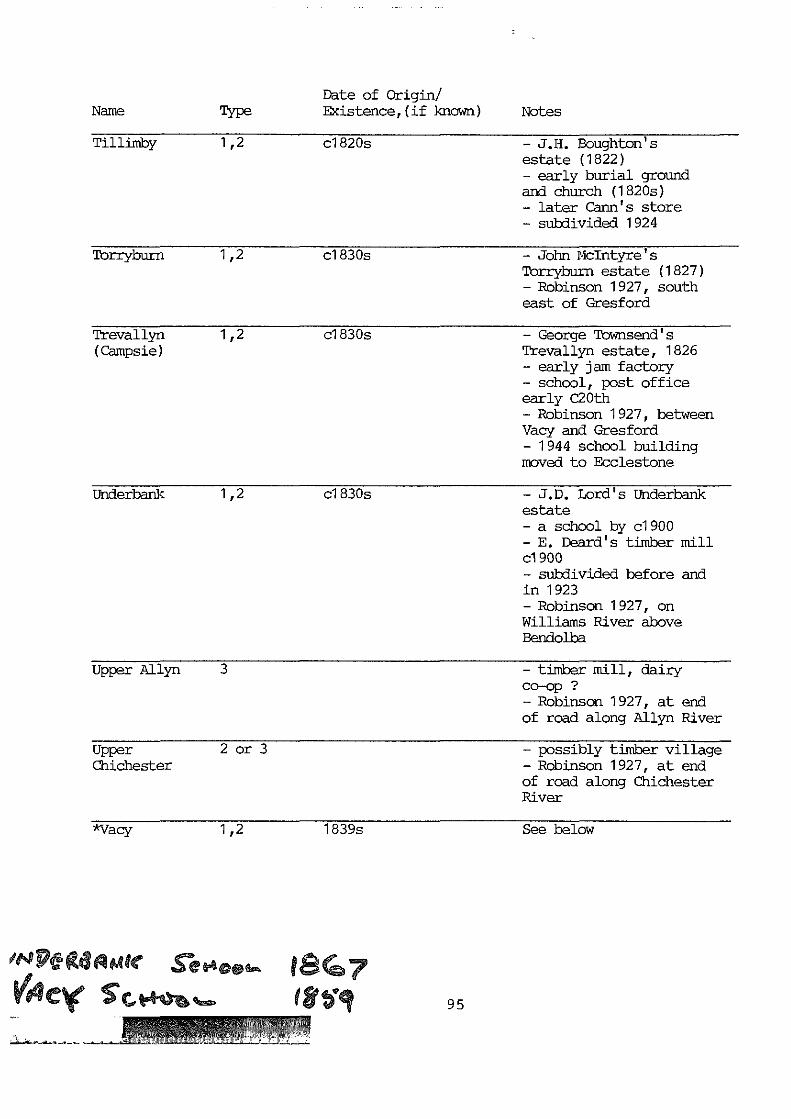
Date of Origin/Name Type Existence,(if }mown) Notes
Tillimby 1,2 c1820s - J.H. Houghton'sestate (1822)- early burial groundand church (1820s)- later Carne's store- subdivided 1924
Torryburn 1,2 c1830s
Trevallyn 1,2(Campsie)
c1830s
- John McIntyre'slbrryburn estate (1827)- Robinson 1927, southeast of Gresford
- George Townsend'sTrevallyn estate, 1826- early jam factory- school, post officeearly C20th- Robinson 1927, betweenVacy and Gresford- 1944 school buildingmoved to Ecclestone
Underbank 1,2 c1830s
Upper Allyn 3
Upper 2 or 3Chichester
*Vacy 1,2
- J.D. Lord' s Underbankestate- a school by c1900- E. Deard's timber millc1900- subdivided before andin 1923- Robinson 1927, onWilliams River aboveBendolba
- timber mill, dairyco-op ?- Robinson 1927, at endof road along Allyn River
- possibly timber village- Robinson 1927, at endof road along ChichesterRiver
1839s See below
!n Mee fl e4
C. I 95

Date of Origin/Name Type Existence,(if known) Notes
Wallarobba 1,2 1830s - Associated with JohnVerge's Lyndhurst estate1829- probably served passingtrade after Dungog-Paterson road completedthrough it 1870s- German settlers inarea 1870s- funds for DungogHospital collected 1910s
*Wangat 3 1880s See below
Welshmen's 2Creek
after 1850s (7) - Welsh small setters- funds for hospitalcollected 1910s
Wirragulla 1,2,3 1830s - John Hook's Wiry(originally Gully estate, 1828Wiry Gully) - Thomas Walker's flour
mill- Hooke Bros Butter CupMiry Factory, 1893- railway siding 1911- Robinson 1927, belowDungog
Woerden 2 1870s - German settlers tookup land around Woerden1870s after road overWallarobba Range wascompleted- Robinson 1927, southwest of Dungog
96

^Eccleston
n Vale
'Undgrhank)
}t1//
h" 1 HalkG2^^_,:•• MyaIICkx
SLClai4 F,(
FWolive
tanhbpe
\Lamb
c, '^ bMassey^Ck
Cawarra'Gre•,rorct
u xntai;
Paterson
ytt Woerden
N,a136md
,Iy Clarencetoi(
13.m 4^t
w o5c.
ti4
Mirannie5t^
GlendonBrook
"^ Bingleburra°2' a LewinsbrookreoFord
TrevallynoToryburn
Ir,WallarobbalElmshall it4mI
Po(rypale 3 O`
.MarshdaleAlison
8lackCamp?`iu//a Mani. ' Boor'
Pine Brush ,.rookfield ®,8anfield
GIPnWilliam.'^^.
GlehMartin/;
Fig. 29 : Composite map from H.E.C. Robinson's TI.S.T+7. i!otorists Load Guide1927, showing the numerous small settlements an vi ages inexistence at the tire. Many have now vanished.

St. Mary's-On-Allyn AnglicanChurch,Allynbrook:SignificantBuilding
AllynbrookPublic School& ResidenceAllynbrook:SignificantBuilding
"Reynella"formerly Byrd'sWine Shop;Blacksmith'sShop & HearseShed,Allynbrook:SignificantBuildings
Allynbrook
The village of Allynbrook grew up aroundWilliam Boydell ' s Caergrwle estate , which hetook up in 1836 . Boydell married Mary PhoebeBroughton and was apparently persuaded by herfather Bishop Broughton to erect a church onhis property . St. Mary's-on - Allyn wasdesigned and built by Boydell in 1844 andbecame the focus of the village. To beginwith it was a simple rectangular gothicstructure of stone with a small belfry,similar in scale to St. Paul's at Paterson(see Fig.40). The present -day transepts,added in 1904 , considerably enlarged thechurch, reflecting the increase in thedistrict ' s population by the early twentiethcentury.3
An official village site - Lewinsbrook - hadoriginally been selected about one milefurther upstream , but never developed and waseventually subdivided and sold off in 1861.Meanwhile , Allynbrook was laid out lateraround the existing buildings east ofCaergrwle estate . After the difficult droughtperiod of 1840s and 1850s, populationincreased and a school , known as Caergrwleschool, was opened in 1869. It was held in aslab hut with an earth floor , which alsoserved as a Post Office ( established 1866). Anew brick school with an iron roof was builtin 1882, along with a residence , and when thepopulation again boomed with the rise of thedairying and citrus industries , weatherboardadditions were made in 1902. The school andchurch today still form the core of thevillage. 4
Other services and factories sprang up in thelate nineteenth century, including a hotel,two shops , Byrd's wine shop, which also servedas a boarding house, and a blacksmith's shopwhich was combined with an undertakingbusiness . A eucalyptus oil and soap factory,and Buxton ' s tobacco factory operated briefly,while winemaking was carried on at Caergrwle.After 1860s timber became an importantindustry and sawmills were set up in thearea.5
Allynbrook remained extremely isolatedthroughout the nineteenth century until thefirst coaches began to call there on theirruns . By 1890 George Fry ran a thrice weekly
97

passenger and mail service, and coachingcontinued until superseded by motor buses in1913, which brought daily mail and passengerservices. The Allyn River at Allynbrook wasnot bridged until 1900 with the constructionof St. Mary's Bridge (replaced 1970) and manyother crossings remained unbridged until the1920s.6
The village was still considered a "thrivingdairying community" by a local teacher in the1940s and 1950s, but has declined along withdairying since then. The Post Office closedin 1977 and the bridge washed away by 1970 andwas replaced. Caergrwle passed out of thehands of the Boydell family in 1983, by whichtime it was the "last big river holding in theGresford area", thereby ending the Boydell'slink with the area which spanned almost 150years.7
Bandon Grove
Bandon Grove is a relatively early village,predating the settlements which grew up withthe dairying and citrus industries. itoriginated with Samuel Kingston's Bandon Groveestate established on a portion of Dowling'searlier Canningalla estate in 1846, and thevillage grew up at the confluence of theWilliams and Chichester Rivers. Kingstonpresumably built the sprawling verandah'dBandon Grove House soon after.8 A Wesleyan
Wesleyan Chapel, Chapel of brick was erected by settlers inBandon Grove: 1 849 and a year later, a school wasSignificant established on W.T. Forster's Mulconda estateBuilding nearby, and accordingly named Mulconda school.
By the time the school was closed and moved toBandon Grove in 1858 the village already hadthe church, Post Office (established 1858), astore and a tobacco factory. A slab schoolwas erected in 1861, (see Fig. 50), but withthe closure of the tobacco factory in 1875,attendances fell with the departure ofworkmen and their families. The erection of a
Bandon Grove new school and footbridges across thePublic School: Chichester and Williams Rivers in 1879 allowedSignificant more children from surrounding areas toBuilding attend. By 1897 the village was described as
a strongly Protestant settlement, a "smallhamlet comprising the usual church, school andblacksmith's shop". A timber truss bridgeerected over the Williams River at the end ofthe nineteenth century facilitated traffic
98
St.Killain'sCatholic ChurchBrookfield:SignificantBuilding
Catholic ConventBrookfield:SignificantBuilding
BrookfieldHouse, Dungog:SignificantBuilding
links.9
Bandon Grove House, the post office and thestore were all demolished around the turn ofthe century, along with the tobacco factory,to make way for Sam Smith's brick house.Funds for Dungog Cottage Hospital wereregulary collected at Bandon Grove during the1910s, and the village prospered through thelocal dairy and citrus farms. During theconstruction of the Chichester Dam and itsgravitation main in the 1920s, the PublicWorks Department established a concretesleeper factory on the river flats near thebridge. The sleepers were the base on whichthe main was set. A School of Arts waserected during the 1930s.10
Brookfield
Today, Brookfield is marked by the Catholicchurch and convent, together with some matureNorfolk Island Pines on their striking sitehalfway between Clarence Town and Dungog.There were probably many more buildings thereduring the nineteenth century, particularlythe second half, but the church buildingsappear to be the sole survivors.
Brookfield was originally the property ofCharles T. Smeathman, which he took up in1828. It is likely that Smeathman, or hissuccessor, had numerous Irish tenants orworkers, since by about 1850 there was aCatholic school established there. St.Killain's church was built as a result of thezeal of Father Jeremiah Murphy who had arrivedin Dungog in 1875 and found the "inhabitantsof the district.... obliged to hear mass in abrick building which was at one time used as aCatholic school". The new church was openedin 1879 and the convent and school in 1889. Aseparate school was erected in 1892 andfunctioned until its closure in 1957 when thebuildin was removed to Dungog (now BrookfieldHouse).71
Brookfield also had an early inn - James D.Walker's Union Hotel (1839) and later the AlmaInn between 1860 and 1874. Later theBrookfield Inn, run by Thomas Leedham, had itslicence renewed in 1888. These may or may nothave functioned from the same building.Brookfield's location midway between Dungog
99
and the river port at Clarence Town made it aconvenient stopover point for the travellers'drays, timber wagons and, later, cream cartswhich streamed down the road to Clarence Town.The inn(s) must have been successful, and itis likely that various other service/transportbusinesses once existed there.12
Eccleston
Eccleston appears to have originated with theproperty of Alexander Seymour (1830s) in thepredominantly Welsh Gresford district. It islocated on the upper Allyn above Allynbrookand must therefore have been very isolatedover most of the nineteenth century. Theroads around Eccleston and Salisbury, furtherup the valley were not built until 1920.13
Emily Anne Manning sketched some slab barnsunder construction at Eccleston in 1839 (seeFig. 5). They were possibly Seymour's andwere probably some of the first buildings inthe district. By 1853 there were enoughfamilies to support an Anglican church and aschool was set up on land donated by HughMassie . St. Paul's Anglican church was a neathorizontal slab building with a gabled roofand portico, as shown in a watercolour held inthe Mitchell Library. It was rebuilt in 1924.Eccleston School had had a long history offrequent temporary closures, reflecting thefluctuations in population and industries.The three roomed slab school with a shingledroof closed down in 1864, but was repaired andreopened as a public school in 1867. Newbuildings were erected in 1885 and theresidence was still extant in 1967. Theschool building became unsafe and was replacedby a school building brought up from Trevallynin 1944, which remained there at least until1967.14
During the 1880s, Eccleston also became thecentre of the Congregational church in thedistrict. The first services were held in theCongregational church in 1885, and by 1903 itwas the centre of a preaching circuit whichincluded Gresford.15
Eccleston became the centre of an importantcitrus and dairying area, producing oranges,cream, milk, and timber which was sent downthe valley roads to Paterson.
100
Site ofFlour mill/timber milland dam,Gostwyck:IndustrialArchaeologicalSite
GostwyckHouse,Gostwyck:SignificantBuilding
Site Butterand Ice CreamFactory,Gostwyck:IndustrialArchaeology
Martins CreekPublic School:SignificantBuilding
Gostwvck
Gostwyck was one of the earliest estatesettlements, thriving from the 1830s andpopulated at first with convict labourers andcraftsmen. It was the estate of EdwardGostwyck Cory taken up in 1826. Cory was anenterprising man and set about establishingvineyards, tobacco and wheat fields, therearing of bloodstock and built a flour milland dam on the Paterson River. The river wasused to transport grain and flour, as well asother goods, as it was navigable up to thispoint. By 1843 the mill was run by StephenDark, who instigated a riverboat service"plying from the...... Mills to Raymond Terraceand Morpeth". During the 1840s the Gostwyckcomplex comprised servants' quarters, dairy,slaughter house, kitchen, barn and offices,all dominated by the grand house, Gostwyck(see Fig. 8). The only slab house "VineyardCottage" had become an inn serving thosetravelling to Paterson, Gresford and Dungog.After Cory's death in 1873, the estate wassold to John P. Luke who pulled down the flourmill and built a timber mill in its place,also run by Stephen Dark. The estate wassubdivided in 1902 and a butter and ice creamfactory, said to be the original Petersfactory, opened in 1906. However, by 1927Gostwyck had vanished from the road maps. (SeeFig.29)16
Martins Creek
Martins Creek took its name from Edward Martinwho settled on the Paterson near the junctionwith the creek in 1851. He was a timbercarrier and horse trader, and was followedduring the next decades by settlers graduallyfilling up the surrounding land, including theKeppie, O'Connor, Vogele, Eskert, Lewis, Cookand Gardiner families. A c1900 photograph ofJames Cook's simple weatherboard cottage (seeFig. 30) with its iron roof, water tank andprofusion of cannas and flowering shrubstypifies the modest scale of settlement in thearea.
A small private school was held in a slab hutand predated the public school opened in 1892.The school was of weatherboards and wasreplaced in 1913 and removed in 1923 to a newsite. The settlers attended Anglican services
101
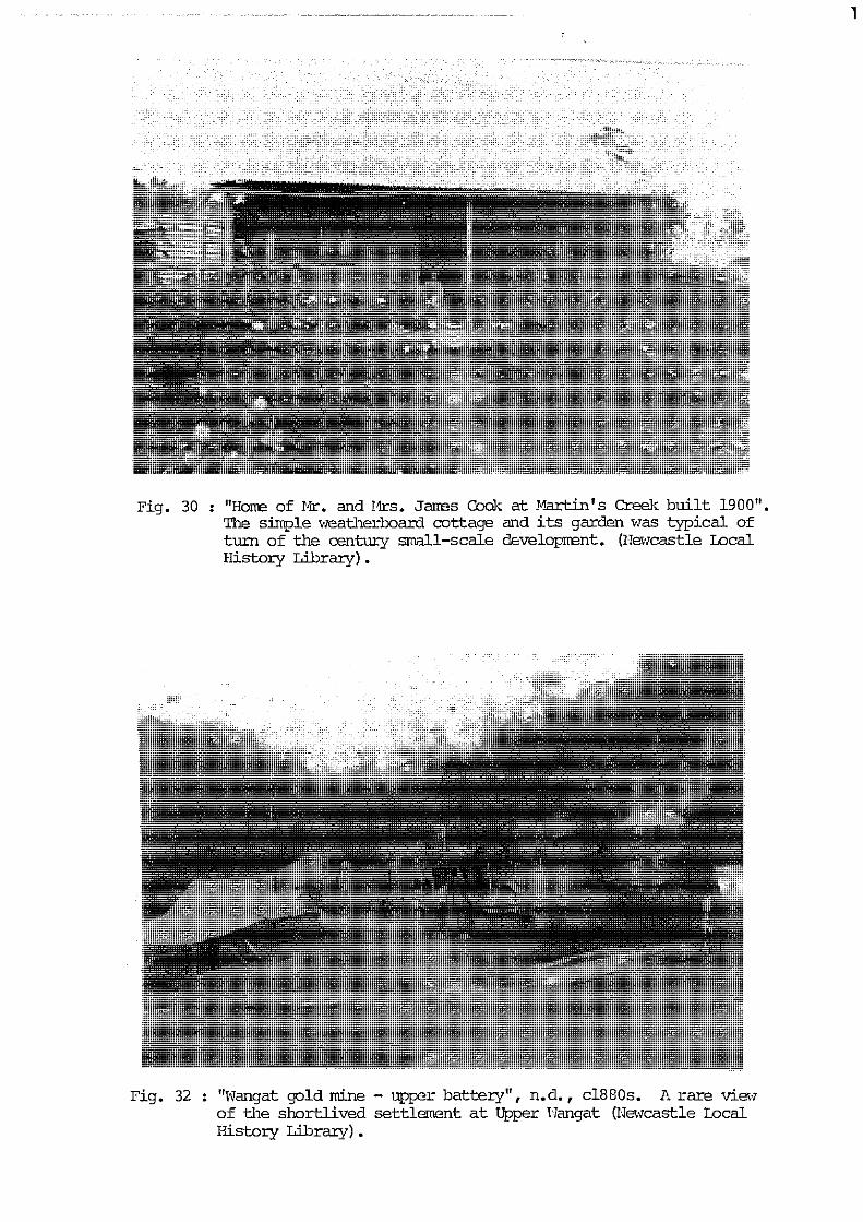
1
Fig. 30 : "Hone of Mr. and I4rs. Janes cook at Martin's creel-, built 1900".The simple weatherboard cottage and its garden was typical ofturn of the century small-scale development. (Newcastle LocalHistory Library).
Fig. 32 : "Wangat gold mine - upper battery", n.d., c1880s. A rare viewof the shortlived settlement at Upper Wangat (Newcastle LocalHistory Library).

in a barn before a small timber church wasSt. James erected in 1899 (St. James Anglican Church),Anglican Church and this was replaced by the half-timberedMartins Creek: Federation style church in 1928.SignificantBuilding The construction of the railway through
Martins Creek after 1908 changed its fortunes.Both State and private andacite (blue metal)quarries were opened in 1913 to provideballast for the railway and later for roadsand other construction work. At first theState quarry employed 44 men and this rose to80-100 men at the peak of production, who werehoused with their families in huts and tents.The quarry still employed 31 men and produced850 tons of blue metal a day in 1967.17
Vacy
Vacy's most interesting historical feature isthat it remained a completely private townfrom its origins as John J. Cory and laterGilbert Cory's Vacy estate in 1824 up to itssubdivision and sale in 1927. Its plan, aribbon development along the Gresford Road upto the bridge (see Fig. 31) contrasts directlywith the standard grid pattern of the officialtowns, neatly encapsulating its differentdevelopment.
Vacy's mid-way location between Paterson andGresford made it, like Brookfield, aconvenient stopping point for travellers onthis important road. The village's earlieststructures were probably an Anglican church,St. Johns, built of slabs by Gilbert Cory "forhis many tenants and families", and an inn,the "Halfway House" which was in existenceprior to 1859. A school was also erected inthat year by Cory, and a Post Office, run bythe teacher, was opened in 1860. By 1866, itwas a centre of some importance, with a tobaccofactory, an arrowroot factory and a populationof thirty, although it was connected toGresford by only one-horse post running threetimes a week.
The village continued to expand towards theend of the century. Fry's and Hancock's
St. Johns coaching service connected it more closelyAnglican Church with Paterson and Gresford by the 1880s. TheVacy: slab church was replaced by an attractiveSignificant brick apsidal church with an asbestos tiledBuilding roof in 1887. A blacksmith set up shop at the
102

Butchers Shop
Blacksmiths ShopBaker
StoreResidences
Vacait B&/ding LotsloTssPaddoccks
RichAgriculturalGrajingsDairyfarms
Pasture LandsSUBDIVIDED INTOCONVENIENT LOTS
AVTETH/SPLA#IS .MITT
Affm¢asuremantt andareas subject to
aaposited Pbnt
farm Lots /0 Years
FOR SALE BVAUCTION , C^j /merest 6Yi%
AT THE FARMERS HOTEL VACY ONWIEDMFI A4 P
King a Humphrey /?/P/tt S! Sydney] Auctioneers in
Carp Rrnthonr West Mait/and Dnnction ,
p^j vg 0 A1 [nfU' && Lg & it
Fig. 31 : "The Vacy Estate" subdivision plan, 1927. The sale included bothrural and tan allotments and buildings. (Ilitchell Library).

southern end of town, and Wormersley BrothersBootmakers were in operation from the 1870s.Later a bakery, butcher, general stores, apost office and school lined the road and aSchool of Arts was erected next to the church(see Fig.31). A creamery was built by UriahHeep north of the bridge, and cream was takenby dray down to Paterson.
Timber TrussBridge, Vacy:IndustrialArchaeology
Site of townof Wangat:IndustrialArchaeology
Site ofUpper Wangat:IndustrialArchaeology
The crossing of the Paterson River at Vacy hada shaping influence on the town. The originalroad curved and dog-legged down to a ford atthe confluence with the Allyn River. The fordwas later replaced by a low-level bridge, andthe only hotel was erected on this originalline. It was by-passed when the road wasstraightened to meet the high level timbertruss bridge built in 1898 (see Fig. 31).
Gilbert Cory, owner of the tenanted land andbuildings, died in 1896 and upon his wife'sdeath in 1926 the estate was finally sold upin 1927. The sale included 50 buildingblocks, houses, hotel and shops, together withdairy farms and orchard allotments. After thesale the township continued much as it alwayshad, though declining slowly, like the othertowns in the Shire, over the later twentiethcentury.18
Wangat
Based on the discovery of gold and asubsequent minor rush, the town of Wangat hada short but busy life, constrasting with theslow, steadier development of most othersettlements. Reefs were discovered on theWangat River in 1879 about six miles from itsconfluence with the Chichester River. A totalof 90 tons was raised by 20 mines in thatyear, but was not crushed until the arrival oftwo stamper batteries with two and ten heads.The settlement divided into Upper and LowerWangat (see Fig. 29) in 1881, with one batteryeach, and 50 mines and 80 people between them.Wangat was surveyed as a town in 1884, withthe familiar grid pattern set by the river andadjacent to the diggings. The rough,makeshift and transient type of buildingserected are shown in Fig. 32 and reflect thenature of the settlement. Wangat village grewrapidly and acquired a school, hall andnumerous houses in the 1880s and 1890s.
103

Ore from the Whispering Gully fields (see Fig.29) was also brought over the watershed bypackhorse to be crushed at Upper Wangat. By1886, Wangat was a town full of children - itspopulation comprised only 14 men, seven womenand between 20 and 30 children.
The yield began to dwindle from the mid 1880s,and the villages began to decline as the rushfaded out as quickly as it had come. By 1902there were only two houses still standing atWangat.19
Sixteen years later the town was brieflybrought back to life by the arrival ofhundreds of Chichester dam workers and theirfamilies who set up a temporary settlement ofcottages, rough huts and tents set in longrows along the hills (see Fig. 69). Work onthe dam was completed in 1925 and the town wasagain quickly deserted, and access to it andUpper Wangat cut off to traffic.20
4. Transport Network
The large bustling towns and their many smallsatellite villages were connected by complex,interlocked systems of transport, comprisingfirst rivers and roads and, after 1911,predominantly roads and the railway.Throughout the nineteenth and twentiethcenturies transport networks and economic andindustrial development interacted closely,with direct repercussions on the life of thetowns. The process could, paradoxically, goeither way - on one hand a busy transportroute could build up towns such as ClarenceTown and Paterson, while the lack of accesscould also nurture small isolated villages.Conversely, the revolution in transport in theearly twentieth century with the coming of therailway and motor vehicles, meant both the endof the busy shipping ports and the decline ofthe small settlements.
The Rivers
The rivers were the early lifelines of theShire - they brought explorers, cedar cuttersand early settlers. Regular steamer serviceswere established from Paterson in the 1830sand from Clarence Town in 1856, while
104
I
enterprising men lost little time in settingup flour mills at the heads of navigation atGostwyck on the Paterson and Mill Dam Falls onthe Williams. Land for a public wharf was setaside in the original survey of Paterson,while at Clarence Town, Ferdinand Hammerleyapplied for 5 acres to provide wharffacilities in 1829. Whether or not he wassuccessful is not known, but an early wharfwas established near the Deptford shipyards ofMarshall and Lowe.1
These two towns grew up dependent on therivers for supply and acted as centrepointsfor the goods arriving from both the valleysto the north and the towns and cities of thesouth. Jeans maintains that the vital HunterValley river transport also "determined afunction of land use, related to distance fromshipping ports".2 Produce from the Williamsand Paterson valleys was taken down to Morpethfor trans-shipment to coastal steamers whichcarried the traffic more cheaply than the
Wharf and railway. The Hunter River Steam NavigationUnion Shed, Company built offices and a Union (marketPaterson: shed above the public wharf at Paterson,3Industrial while Clarence Town became the headquarters ofArchaeology the Williams River Steam Navigation Company,
established in 1880. The company began with"Favourite" of 51 tons, which was built atEagleton and later built the "Cooreei", anderected the 4-storey brick store, wharf andstockyards at the end of Grey Street. Firedestroyed these structures and the "Cooreei"in 1906, but the company rebuilt, as shown inFig. 23, and launched "Erringhi" the followingyear. Passengers could board the riverboat toNewcastle and there take a steamer to Sydney -a trip of 24 hours. After the commencement ofthe railway in 1911, the company survived onlytwo more years, and went into liquidation in1913. Cream boats and pleasure craftcontinued to ply the waters during the 1910sand 1920s, while steamers called less and lessfrequently, until they ceased completely in1941.4
A similar pattern emerged at Paterson. Theriver trade peaked in the 1880s and wasboosted by the growth of dairying after the1890s. The ships carried away timber drawn inby bullock teams, cases of oranges, butter incasks and cream in canisters, sacks of maizeand boxes of cornflour. (See Fig. 65). Apartfrom the government wharf, Corner's wharf with
105

an attached tramway stood on the Cinta estate,north of the town. John Tucker remembered theriver scene of the 1860s - "It was a weird andpicturesque sight to see the tall masts withsails close-furled moving through the fringeof riverside trees". The new rail bridge was
Queens Wharf built directly over the old wharf, and the newPaterson: Queen's Wharf around the head near Tucker ParkIndustrial never matched the original in volume ofArchaeology traffic.5
Roads and Bridges
The early development of the Shire's roadsystem has been discussed in Theme 4. It wasbased on the haphazard but convenient tracksmade by settlers and their stock, and possiblyby cedar getters before them. The tracksusually followed the rivers which alsogoverned crossing places. Surveyors duringthe 1830s, 1840s and 1850s were sent tostraighten out the lines. Sometimes theirplans were adopted, at other times they werecompletely ignored by travellers, carriers anddrovers.
While the need for roads was not so great inthe lower part of the Shire with its dominantand convenient river transport, above theheads of navigation a maze of crisscrossedtracks quickly appeared, following the linesand spread of settlement. The generallocation of the present day roads connectingDungog, Clarence Town, Paterson, Gresford andVacy were laid down in the early (1830s)period, and were slowly pushed further andfurther up the valleys as the centuryprogressed. By about 1920 they had reachedtheir present limit at the foot of theBarrington Tops, apart from the road toBarrington House constructed 1925-1930. (SeeFig. 29).
During the first half of the nineteenthcentury, convict gangs were commonly used inthe construction and maintenance of roads, anda few were probably posted to this area. In1860 the Public Works Department assumedcontrol of roads, but appears to haveconcentrated its effort on the numerous andspectacular bridges it built throughout theHunter Valley. Work was undertaken onimproving the road between Paterson and Dungogover the Wallarobba Range in the 1870s after
106

much local agitation. Extensive side cuttingwas undertaken and grades of 1 in 5 weremaintained. This road was superseded in 1966by another line of steeper grades.6 For themain part, however, the roads followed theundulating lands adjoining the rivers andconstruction work required was minimal. Thepattern of riverside roads also had itsdangers in the floods which could suddenlydamage and sweep away roadside buildings. Thisproblem eventually forced the end of theofficial settlement on Commercial Road northof Paterson, an area which is stilloccasionally inundated.?
In 1907 Wallarobba Shire was proclaimed andtook control of the Shire's roads from thePublic Works Department. It appears to havegiven priority to the task of road buildingand maintenance, and during the next twodecades, the Shire's main roads were improvedand extended. It established requirements forproper road widths and culverts, - the lack ofthe latter in particular had been a threat tolife and property. When Torryburn estate wassubdivided in 1908 its advertising posterproclaimed its roads and "substantial culvertsin accordance with Shire Councilrequirements".8 The Shire went aboutmethodically gravelling, wideningcarriageways, improving corners and sightlines, fillings ruts and depressions and, inlater years, sealing pavements. Improvementswere backed up by maintenance men, each withhand tools and his own horse and dray, whowere responsible for sections of the roads.In addition, in 1917, the Council produced aplan of the roads in the Allyn and PatersonRiver valleys north of Gresford, whichrecorded the lack of bridges in this so farisolated area. The council commenced aprogram of constructing bridges and of roaddeviation to avoid river crossings. High onthe Williams River, the road up to BarringtonHouse from Salisbury was constructed byvolunteers between 1827 and 1930, to allowaccess to the new resort. Another road openedin the early twentieth century was the roadacross the watershed from Eccleston toSalisbury. A group of local people gatheredto celebrate the occasion of its opening, anda photographer recorded the event. It isstill an unsealed road today.9
The nature of early twentieth century road
107

building is evoked by a photograph of aneight-man road gang with a horse, cart,broadmouth shovels, and picks (see Fig. 33).They were working on the new road to UpperChichester in the Underbank area.10 ClarenceSmith's jotted recollections (1963) of roadbuilding practices enliven the picture:
George Neil..... Tom Dark and others withpicks and shovels etc. filled the tipdrays .... and removed from gravelquarries along sides of roads, mostly topositions previously approved by roadsuper - resident Stroud. Tipped onroadside, knapped by hammer... .andstacked ready for measurement. Thesuper would put white mark or string onwheel spoke..... Travel road decided forrepair counting revolutions per mark onspoke and then decide distance whichwould recieve attention.11
The methods were almost identical to thoseused by ganged convicts eighty years earlier.In the early 1900s, though, "contracts werelet for gravelling of road lengths up to amile in length". Travellers avoided thenewly-gravelled portions "as far as possible,being rough and slow travelling....", so theroad builders placed fenders of timber alongthe roads' shoulders every thirty metres or soto force traffic onto the newly-madepavement.12
The sections which were ungravelled claysurfaces remained hazardous, however,particularly on steep hills. Smith listedClay Hill (still considered difficult in1983), Hutchinsons at New Park, Tighes Hill,Lester Kingston's Steep Hill, and the hill atBandon Grove as particularly difficult forbullocks and horses. The numerous unbridgedstreams were also a common obstacle. AtBrookfield boggy places had been crossed bycorduroy roads of logs placed crossways. Thepoor condition of the roads at certain pointsled to the practice of teamsters travellingtogether, "to render help if needed".13
Sealing the roads had begun in earnest by1936, when the Shire Council obtained 360tonnes of slag sealing aggregate from thesteelworks at Newcastle. The material wasbrought up by steamer to Clarence Town,transferred by motor lorry to the roads andstacked at intervals along them to be spreadby hand on the tar.14
108

N
mM
G^f
The Shire's numerous extensive waterwayspresented countless obstacles to land traffic,particularly above the heads of navigationwhere the shape of the valleys moulded thelocation of the roads. In the earliest daysthe waters were forded at the least dangerouspoint, and roads were arranged accordingly.It was still a hazardous business and therewere many drownings at the crossings,particulary during floods. The role of therivers was thus ambiguous in several ways -they were the life-line of the earlysettlements, the ships gliding smoothly inhours where carriages and drays jolted fordays. Yet they posed devastating threats intimes of flood, and effective barriers to roadtransport, forcing stock and heavily-ladendrays to move down one side of the river,going the long way round to suitable crossingplaces. While ferries and bridges wereestablished in the lower districts,particularly on heavily used roads, in themore isolated areas to the north, riverscontinued to be forded. Fosterton had twofords over the Williams River at its southwestern entrance in 1856, Dungog still hadAbbots ford over the William at the easternextremity of the town in 1865 (see Fig.25) andbetween Gresford and Allynbrook there werestill nine unbridged crossings of the Allyn in1917. At Gresford the ford was used bytraffic coming across from Singleton (see Fig.34), although a footbridge had been built byabout 1890. There were also fords on the mainroads at Vacy, and at Vineyard Crossing nearGostwyck until 1877.15
Where the rivers were too broad to be forded,punts were established. A punt near Deptfordlinked Clarence Town with the small settlerson the east bank, and the road to RaymondTerrace in 1844. Three years earlier, a newroad connected Paterson with Maitland andMorpeth, with ferries across the Paterson andHunter at Hinton. Paterson was also linkedwith the east bank of the river by a puntsouth of the village by 1856. A photographheld in Mitchell Library showing a simpletimber platform drawn across the Paterson onropes, may be this crossing. (See Fig. 35).Punts were slow, inconvenient and stilldangerous, but they were safer than fording orswimming the broad waters, and quicker thantravelling up river to suitable crossingplaces.16
109

Fig. 34 : "Gresford Crossing, Paterson River", a c1880 view from the I.errycollection showing the trestle-type foot bridge andthe steep road approaches to the ford below. The to mship proper ison the left, and a glimpse of the early house Ard-na-hane on theright. (Mitchell Library).

Ui1
G-^
Other means were also employed in the crossingof waterways. Temporary low-level bridgeswere built of round timber beams set on crosspieces, forming spans (see Fig. 36). Theseappear to have been used for foot and horsetravellers. A suspension footbridge spannedthe Williams River at the Tunnybrook crossing(see Fig. 37), and this was probably the typeerected at Bandon Grove for the schoolchildren in the 1880s. The old ford atGresford was situated adjacent to a much moreelaborate trestle-type footbridge set highabove flood level on sturdy timber piers. (SeeFig. 34).
From the 1860s the Public Works Departmentbegan its ambitious program of bridging theriver in the Hunter Valley. The earliestappears to have been the bridge over the riverat Dungog, where a site was selected and plansof the river's course were drawn up in 1865.A bridge had been in existence over MyallCreek nearby in 1856.17 The bridge wascompleted in 1877, the year before the
Gostwyck Bridge Gostwyck Bridge over the Paterson was opened,Gostwyck: shortening the Paterson - Dungog road byIndustrial cutting off the old Vineyard Crossing. It wasArchaeology opened with a great celebration, which
expressed the importance and impact of such apublic work to the community. Six hundredpeople attended the festivities which includeda childrens' party, speeches and telegram-reading, morning tea and a gala ball in theevening. The bridge itself had a 370 footspan comprising two 90 foot spans, two 70 footspans and a bank span of 50 feet. At theopening it was enthusiastically predicted thatthe bridge would provide a "convenient way toan excellent road to Maitland market". Theroad, then under construction, would "open upthe country" in conjunction with freeselection, and also "give access to thevaluable source of timber" further north.18
Another major bridge was at Clarence Town,spanning the Williams River, and connecting
Clarence Town Clarence Town and Dungog directly with RaymondBridge, Terrace, Port Stephens and Newcastle.Clarence Town: Constructed between 1878 and 1879, and openedIndustrial in 1880, it comprised two timber truss spans,Archaeology in the old form of the MacDonald truss used
between 1860 and 1880, each 100 feet long, inaddition to two 45 foot timber beam spans andone 40 foot beam span on the township side.The spans were set on cylindrical piers. In
110
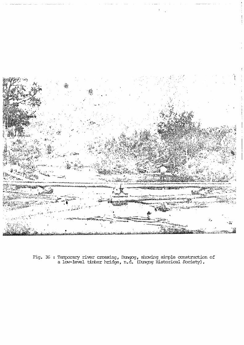
Pig. 36 : Temporary river crossing, Dungog, shading simple construction ofa lad-level timber bridge, n.d. (Dungog Historical Society).

a)
o a
ph0M

1926-27 the bridge was rebuilt to the originaldesign.19
The Paterson River was bridged at Paterson in1887, replacing the punt; at Woodville in1898, and at Vacy in the same year. High upon the Allyn River, St. Mary's Bridge waserected at Allynbrook in 1900, after agitationsince 1892. The bridge at Bandon Grove,opening the road to the upper Chichester andWangat valleys was probably also erectedaround the turn of the century. Numerousother smaller bridges were built by theWallarobba Shire from the 1920s. However, themajor bridges at Paterson, Gostwyck, ClarenceTown, Vacy, Bandon Grove and the CooreeiBridge at Dungog (1904) remained NationalWorks and remained in the hands of the PublicWorks Department.20
Crossing the Shire's rivers and creeks was amajor feature of travelling and transportduring the nineteenth and early twentiethcenturies. Beginning with fords, punts andmakeshift bridges, the hazardous and numerousbarriers were gradually broken down by theambitious projects of the Public WorksDepartment and Wallarobba Shire Council.Bridge building, rebuilding and maintenanceremains a major consideration in the Shire'spublic works today.
The Railway
The North Coast Railway had an immediateimpact on many aspects of the Shire's earlytwentieth century development. In the shortterm the presence of surveyors and hundreds ofworkers in their camps along the line (seeFig. 38) stimulated the service industries ofsome towns and underlined the excitementengendered by the work and changes it wouldbring. Even after the railway was opened, thelong procession of railway workers in drayspassing through Dungog on the way furthernorth was a striking sight (see Fig. 39). Thecutting of sleepers also boosted the localtimber industry. In the long term, therailway completely reorganised the oldroad/rivers transport relationship andgradually led towards the centralization ofindustry and commerce in the large urban areasof Newcastle and Sydney.21
111
0

rnm

The railway line between Sydney, Newcastle,Maitland and Tamworth was opened in 1889 withthe Hawkesbury River Railway Bridge. Theroute of the North Coast Railway throughDungog was fixed by 1900, surveys and thenearthworks began in 1908 and the line openedthree years later. It drew in goods andproduce to the towns and to small sidings atintervals between them. In some cases it drewthe industries to establish themselves nearby,for example, the Dungog Co-op Butter Factoryin 1914. The railway ended Fry's coachingservice immediately, and greatly diminishedthe importance of the river boats and thetowns of Clarence Town and Paterson. Cattledroving down the valleys to Maitland becameless common, since cattle could be consignedby rail straight to the Homebush Markets inSydney. Milk trains picked up dairy produceand took it directly to the butter factory atDungog, and butter was then railed down toNewcastle and Sydney. During the period ofsubdivision in the early twentieth century,the access to the railway at Paterson andDungog, and the sidings in between wasinvariably stressed as a great advantage tothe propective farmer. Andacite quarriesopened at Martin's Creek, assured both thesurvival of the town and the continued supplyof ballast for the railway line.22
The growth of towns and their interlockingroad, river and railway networks thusrepresent focal points of the Shire'shistorical development. Their growth anddecline, physical shape and appearance, andspatial relationships constitute a blueprintfrom which European activity may be read. Theformation of communities with theirmultifarious activities developed parallel tothe town and villages, from simple origins tocomplex webs of social interaction.
112

THEME 6 : THE GROWTH OF TOWNS
NOTES
1 Overview
1. Jeans, p.127.
2. Ibid, see also discussion in PerumalWrathall and Murphy, loc.cit.; H.W.Graeme "Wangat Village Redesign" 1884,A.O. Map 6131.
3. Dangar, p.107.
4. Bairstow, Section 3.
5. Mitchell, p.142; Perumal Wrathall andMurphy, pp.13-14.
6. E.A. Manning, Sketchbook, "German'sHut, Lewinsbrook"; Bairstow, Section 3;Information from Mrs. P. Clements.
7. Perumal Wrathall & Murphy, p.11; Jeans,pp.168, 169, 172.
8. Jeans, p.181; information from Mr. RegFord; Anon, "A Trip up the Hunter andWilliams to Clarence Town", unidentifiednewspaper clipping, 1878, NewcastleLocal History Library.
9. These industries are discussed in detailin Theme 8.
10. Perumal Wrathall and Murphy,Supplement, entries for Paterson,Clarence Town and Dungog.
2 Major Towns
Paterson
1. Mitchell, p.139-140; Archer, "TheSettlement.....", pp.4, 20-22; Jeans,p.87.
2. Perumal Wrathall and Murphy,Supplement, entry for Paterson; PatersonHistorical Society, "Historic Paterson",leaflet, 1985; G.B. White, "Paterson
113

Village, Parish Houghton, County ofDurham, 90 acres purchased from Mrs.Ward, Paterson's River", 31 Dec 1832,A.O. Map 4877A.
3. Archer, "The Settlement ....." pp.20-25.
4. Bairstow, Section 2.
5. Mitchell, p.153.
6. Ibid, pp.147-148; photograph of BrooklynHouse held in collection of PatersonHistorical Society Museum; for locationof site see map in "Historic Paterson".
7. Ibid
8. Mitchell, p.174; Archer, "TheSettlement...", p.25; photographs andinformation held in collection of thePaterson Historical Society Museum.
9. "Historic Paterson"; Mitchell, p.157.Architectural evidence suggests that thetop storey may be a later addition.
10. New South Wales Calendar and Directory,1834; Mitchell, pp.143, 149-151; R.D.Yimmang (pseud.) Parish of PatersonN.S.W. Centenary 1839-1939 Phases of aParochial Past, 1939, p.6 ff.; G.B.White, "Plan Showing land set apart forChurch, School and Parsonage in Villageof Paterson", 1839, A.O. Map 1925.
11. Mitchell, p.154.
12. "Historic Paterson"; Henry Carmichael,"Plan showing the roads now in use,together with newly proposed lines fromPaterson through David Brown's land onPaterson River", 1850, A.O. Map 5141.
13. Tucker, op.cit.
14. Perumal Wrathall and Murphy, Supplement,entry for Paterson; "Historic Paterson".
15. "Historic Paterson".
16. Archer, "The Settlement.....", pp. 20-21; Mitchell, p.143; "HistoricPaterson".
114

17. Tucker, op.cit; Jeans, p.168, 201, 209;Perumal Wrathall and Murphy, p.14.
18. Jeans, pp .251 ff.; "Historic Paterson".
19. Jeans , p.251 ; See "N . S.W. Homestead andProperty Plans , County of Durham",Mitchell Library, which containsnumerous early twentieth centurysubdivision plans.
20. "Historic Paterson".
21. Ibid; Perumal Wrathall and Murphy,Supplement, entry for Paterson.
Clarence Town
1. Mitchell, p.80; Perumal Wrathall andMurphy, Supplement, entry for ClarenceTown; Dungog Town and District, p.6.
2. Cited in Mitchell, p.81.
3. A.O. Map 2208; Dungog Town and District,p.3.
4. Jeans, p.131; Mitchell, pp.80-81; A.O.Map 2208; Wood, p. 256; Anon,"Historical Notes on Clarence Town",Newcastle Local History Library.
5. Perumal Wrathall and Murphy, Supplement,entry for Clarence Town; Mitchell,pp.83-84; information from Reg Ford,Clarence Town.
6. Mitchell, p.81; photographs of DeptfordHouse held in Newcastle Local HistoryLibrary; Newcastle Morning Herald, 19February 1977.
7. See J.C. Burnett, "Plan of 17 farms onthe Williams R. near Clarence Town",1840, A.O. Map 2309; Jeans, p. 125.
8. Bairstow, op.cit, Perumal Wrathall andMurphy, Supplement, entry for ClarenceTown; Mitchell, p.82; Clarence TownPrimary School Commemorating 125 years ofPublic Education 1849-1974, 1974;information from Reg Ford, ClarenceTown.
115

9. See A.O. Maps 2073, 2075, 21 21 , 21 91 ,2208.
10. Damaris Bairstow, "Hunter RegionHeritage Study - Industrial Archaeology- Mining, Heavy Industries, Timber,Transport and Flour Mills", unpublishedreport prepared for the Department ofEnvironment and Planning, 1982;Bailliere's Gazetteer, 1866; Mitchell,p.84.
11. Mitchell, p.82; information from Mr. RegFord; Perumal Wrathall and Murphy,Supplement, entry for Clarence Town;Port Stephens Pictorial Examiner, 18October 1978.
12. Bailliere's Gazetteer, 1866; MaitlandMercury, 26 April 1982.
13. Maitland Mercury, 26 April 1982;National Trust of Australia (N.S.W.),Register, 1982; Mitchell, p.84.
14. Mitchell, p.82; Newcastle Sun, 7 July1966.
15. Anon., "A Trip up the Hunter andWilliams to Clarence Town", unidentifiednewspaper clipping, 1878, NewcastleLocal History Library.
16. Bailliere's Gazetteer, 1866; Anon.,"Historical Notes on Clarence Town",Newcastle Local History Library.
17. Dungog Town and District, p.12; Ibid.
18. Mitchell, p.81;Newcastle Morning Herald, 30 June 1951.
19. Dungog Chronicle, 31 July 1980.
20. Perumal Wrathall and Murphy, Supplement,entry for Clarence Town; Mitchell, p.82.
Dungog
1. Dungog Town and District, p.2,6; Brock,pp.5,15.
116

2. G.B. White, "West Bank of Williams Riverfrom Wattle Creek to Tabbil Creek",1829, A.O. Map SZ 531; Rusden, "Plan forthe Village of Dungog on the UpperWilliams", 1838, A.O. Map 2519; Wells,Gazetteer, 1848.
3. See "Plan for the Village of Dungog";Brock, p.12.
4. Dungog Town and District, p.10; See A.O.Maps 2066, 2072, 2089, 2194, 2195, 2123.
5. C. Hunter, "Stephenson's Inn or theDungog Inn (1840-c1868)", 1985,unpublished notes, Dungog HistoricalSociety.
6. Dungog Town and District, p.8.
7. Wells, Gazetteer, entry for Dungog.
8. Ibid.
9. Dungog Town and District, p.2; A.O. Maps2072, 2194; National Trust of Australia(N.S.W.) Register, C. Hunter, "CourseOutline".
10. Perumal Wrathall and Murphy, Supplement,entry for Dungog.
11. Dungog Town and District, p.7; notes inDungog file, Newcastle Local HistoryLibrary.
12. Bailliere's Gazetteer, 1866; DungogTown and District, p.9.
13. Anon., unidentified press clipping,possibly Town and Country Journal, Aug15 1888 , Newcastle Local HistoryLibrary.
14. Hunter Valley Tourist, Aug-Sept 1980; C.Hunter, "Hillside", unpublished notes,n.d., Dungog Historical Society.
15. Dungog Chronicle, 8 August 1984;National Trust of Australia, Register;Newcastle Morning Herald, 17 July 1975.
16. Dungog Town and District, p.3.
117

17. Dungog Historical Society , Notes forVisitors , n.d.; H.M . MacKenzie , "A Visitto Dungog " one of a series of lettersentitled "Among the Pastoralists andProducers " published in the MaitlandWeekly Mercury 1896-1899; volume ofclippings held in Mitchell Library.
18. C. Hunter , "Oomabah" , "Hillside",unpublished notes, n.d., DungogHistorical Society; Dungog HistoricalSociety , Notes for Visitors, n.d.
19. Dungog Town and District, p.3.
20. Ibid ., pp.5-6.
21. Maitland Mercury, July 1878 typescriptcopy , Dungog Historical Society; C.Hunter, "Course Outline".
22. Dungog Town and District, p.12.
23. Sydney Mail , 7 August 1907.
24. See photograph of railway opening,Mitchell Library, Small Picture File.
25. Information from Don McLaren , DungogHistorical Society.
26. Dungog Chronicle, 15 December 1979.
27. Anon., unidentified press clipping, 15August 1888 , Newcastle Local HistoryLibrary.
28. Dungoq Town and District , pp.5-6.
29. See W .J. Enright "Barrington Tops", aninformation sheet prepared by theBarrington Tops League , 1923 (NewcastleLocal History Library); ThereseAitchison , Barrington House Then andNow, 1980 ?.
30. Perumal Wrathall and Murphy , Supplement,entry for Dungog.
Gresford
1. Gresford 1829-1979
118

2. Ibid.
3. Bailliere's Gazetteer, 1866.
4. Doyle, pp.4-5.
5. Gresford 1829-1979
6. Ibid.; Dungog Historical Society,unpublished historical notes on Gresfordand Vacy, n.d.
7. Gresford 1828-1979; Doyle, p.5.
8. H.E.C. Robinson Ltd., N.S.W. Motorists'Guide, Sydney, 1927; Doyle, p.5.
3 Other Small Settlements
1. H.E.C. Robinson, N.S.W. Motorists' RoadGuide, Sydney 1927.
2. Held in Mitchell Library.
3. Helen Gibson, et.al. Allynbrook PublicSchool 1027, compiled for the Centenary1869-1969, 1969, pp.5, 28.
4. Ibid.,p.9 ff.
5. Ibid.,pp. 5,8, 27,29.
6. Ibid., p.8; Maitland Mercury, 21 August1970; Newcastle Morning Herald, 14 August1970.
7. Gibson et.al. p.8; Newcastle MorningHerald, 2 May 1977; Newcastle MorningHerald, 10 October 1983.
8. Clarence Smith, "The Bandon GroveWesleyan Chapel 1849-1889", unpublishedtypescript, Dungog Historical Society.
9. Anon., Bandon Grove Public SchoolCentenary Souvenir 1862-1962, Dungog,1962; H.M. MacKenzie, "Among thePastoralists and Producers - AroundDungog"; Anon., "Bandon Grove PostOffice Centenary" unpublishedtypescript, Dungog Historical Society.
119

10. MacKenzie, "Among the Pastoralists....";Dungog Cottage Hospital - Report andBalance Sheet, 1912-1914; See series ofPublic Works Dept. photographs ofconstruction Chichester Dam andGravitational Main 1918-1927 in MitchellLibrary. One view shows men at work atthe sleeper factory and stacks ofsleepers on the river bank; Dun oChronicle, 6 July 1983.
11. Information from Mr. Reg Ford; DungogChronicle, 10 October 1979.
12. Dungog Town and District, p.8; List ofReturns of Publicans Licences for theDungog District extracted from theGovernment Gazette, 1866, 1868, 1872,1874, 1895, Dungog Historical Society.
13. Gresford 1829-1979; Vacy PublicSchool Centenary 1859-1959.
14. Emily Anne Manning, Sketchbook, MitchellLibrary; Maitland Mercury, 20 October1967.
15. Gresford 1829-1979
16. Mitchell, pp. 175-199; Archer, "TheSettlement....", pp. 1 3-1 4,The Australian, 10 August 1842; VacyPublic School Centenary, pp.5, 15.
17. Maitland Mercury, 5 June 1967.
18. Vacy Public School Centenary;Bailliere's Gazetteer, 1866; R.D.Yimmang, op.cit.; "Gresford",unpublished notes for visitors, DungogHistorical Society.
19. G. Higginbotham, "Aspects of GoldMining in the Hunter Valley, 1860-1900",History Thesis, Newcastle C.A.E., 1979;A.P. Foster, "Whispering Gully",unpublished typescript, DungogHistorical Society; Charles Bennett,historical notes, Newcastle LocalHistory Library, Dungog file.
120

20. Dungog Town and District , p.10; Seriesof photographs of dam construction,Mitchell Library; Dorothy Dowling,"Chichester Dam, Newcastle ' s WaterSupply", Sydney Morning Herald 3 January1930.
4 Transport Networks
1. Newcastle Morning Herald , 19 February1977; Anon., "Historical Notes onClarence Town" , unpublished notes heldin Newcastle Local History Library,Clarence Town File.
2. Jeans, p. 235.
3. "Historic Paterson".
4. Dungog Chronicle 31 July 1980;information from Mr . Reg Ford.
5. Tucker, op . cit.; "Historic Paterson".
6. Dungog Chronicle, Dungog Shire Council25th Anniversary, Supplement , 27 July1983.
7. "Historic Paterson".
8. Dungog Chronicle , Supplement , 27 July1983; see Torryburn Subdivision plan in"N.S.W. Homestead and Property Plans -County of Durham", Mitchell Library.
9. Dungog Chronicle , Supplement , 27 July1983; Aitchison, Barrington House Thenand Now; Photograph , "Opening of road toEccleston from Salisbury ", MitchellLibrary, Small Picture File.
10. Mitchell Library, Small Picture File.
11. Clarence Smith "Roads ", unpublishednotes, typescript held by DungogHistorical Society, 1963.
12. Ibid.
13. Ibid; Dungog Chronicle , Supplement, 27July 1983.
14. Dungog Chronicle , Supplement, 27July 1983.
121

15. See "Plan of the Parish Road from Dungogto Fosterton along the west bank of theRiver Williams", 1856, A.O. Map 5145;Dungog Chronicle, Supplement, 27 July1983.
16. Bairstow, op.cit; see "Plan of theEstate of Bona Vista", 1856, Fig. 15.
17. See A.O. Maps 5145 and 2517.
18. Maitland Mercury, 3 August 1878.
19. Port Stephens Pictorial Examiner, 18October 1978.
20. J. Birmingham, "Hunter Region HeritageSurvey - Industrial Archaeology sites -Brickworks, Bridges, Wineries, Pastoral,Dairying", unpublished report preparedfor the Department of Environment andPlanning, 1982, pp.2-22; NewcastleMorning Herald, 14 August 1970; DungogChronicle, Supplement, 27 July 1983.
21. See various photographs in MitchellLibrary, Small Picture File; PerumalWrathall and Murphy, Supplement, entriesfor Dungog & Clarence Town.
22. Newcastle Sun, 6 November 1967,Dungog Town and District, Jeans, p.185;information from Don MacLaren; DungogChronicle, Supplement, 27 July 1983;"N.S.W. Homestead and Property Plans -County of Durham", Mitchell Library.
122