thirdfork mitigation plan report cover
TRANSCRIPT

Mitigation Plan
Third Fork Creek, Forest Hills Park Durham, North Carolina
1652 Mail Service Center Raleigh, NC 27699-1652
December 2005
KCI Associates of North Carolina, P.A. Landmark Center II, Suite 220 4601 Six Forks Road Raleigh, North Carolina 27609

Mitigation Plan Third Fork Stream Restoration Project
TABLE OF CONTENTS
1.0 Introduction .......................................................................................................................1 2.0 Project Summary...............................................................................................................1 3.0 Success Criteria .................................................................................................................8
4.0 Monitoring Schedule .........................................................................................................8 5.0 Mitigation...........................................................................................................................8
6.0 Contingency and Maintenance Plans.............................................................................10 7.0 References ........................................................................................................................12
Figures Figure 1. Vicinity Map ..................................................................................................................2 Figure 2. Location Map.................................................................................................................3 Figure 3. Reference Site Location ................................................................................................5 Figure 4. Mitigation Type and Extent .........................................................................................9
Tables Table 1. Morphological Design Criteria ......................................................................................6 Table 2. Priority Levels of Incised River Restoration................................................................7 Table 3. Contingency Plans ........................................................................................................10 Table 4. Re-seeding Specifications .............................................................................................11
Appendices Appendix A – As-Built Plan Sheets Appendix B – Monitoring Plan Sheets

Mitigation Plan Third Fork Stream Restoration Project
1
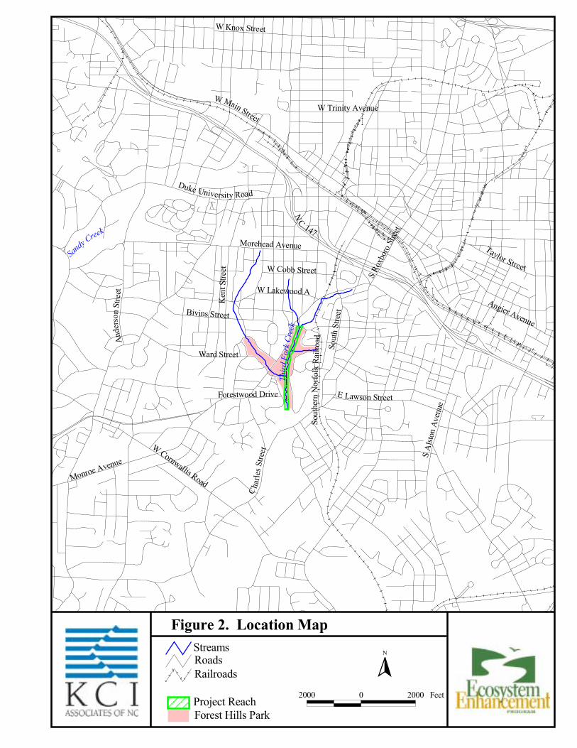
1.0 Introduction Project planning was initiated in 2002 for the implementation of an urban stream restoration project in Durham, North Carolina (Figure 1). The project included a detailed analysis of watershed conditions, an evaluation of the existing stream utilizing Rosgen assessment/classification methodologies, the identification and assessment of an appropriate reference reach, data analysis, preparation of complete design plans and specifications, permitting, local government and stakeholder coordination, and implementation. The Third Fork Creek watershed (US Geological Survey 14-digit Hydrologic Unit Code 03030002060120) within the New Hope Creek Sub-basin of the Upper Cape Fear River (NC Division of Water Quality Sub-basin 03-06-05) contributes drainage to the project site. The project site is located in an urban setting within the Piedmont Physiographic Province. The historic dendritic drainage patterns of the watershed have been substantially replaced by curb and gutter stormwater drainage systems. Likewise, the normally broad alluvial valleys have been narrowed due to the encroachment of residential commercial development and associated transportation systems. The entire restoration site is contained within Forest Hills Park on property owned by the City of Durham. The site is dominated by open space, with structures and facilities located in close proximity to the stream. The surrounding area is highly urbanized, with residential and commercial development and secondary roads comprising the majority of the land use. The project reach totals approximately 2,900 linear feet and extends in a north-south orientation from East Forest Hills Boulevard (near the intersection with University Drive) downstream to the Park property boundary, located upstream of South Roxboro Street (Figure 2). The project reach is incised with active bed degradation and channel widening characterized by severe bank erosion. 2.0 Project Summary The restoration of the portion of Third Fork Creek located within the Forest Hills Park in Durham was conducted to restore stable channel morphology to improve sediment flow in the watershed, improve aquatic habitat diversity, and restore riparian vegetation. The goal of the project was to develop a stable stream channel with reduced bank erosion, efficient sediment transport, and improved overall stream habitat and site aesthetics. A Rosgen Level II Morphological Assessment and Classification of the project reach was conducted in accordance with the methodologies presented in “A Classification of Natural River Systems” (Rosgen, 1994). As part of this assessment, detailed stream morphologic characteristics and dimensions were field surveyed and analyzed. During the geomorphic analysis, observed bankfull indicators were identified and surveyed both in section and profile. Estimates of bankfull discharge were determined based on bankfull geometry, channel roughness, and bed slope using Manning’s open channel flow equation. Hydraulic parameters such as discharge, flow area, wetted perimeter, slope and velocity were calculated to further analyze existing conditions and to provide a means for evaluating potential responses during the restoration design phase. Collected data were correlated with USGS gauge data to verify field determinations and an evaluation of stream competence was conducted utilizing critical shear stress and depth calculations to assess existing sediment transport characteristics.

���������������� ����
�
������������� �
��������������� ����������������������������������������
��� � ��� ���
������������
��� ��
� �����
��
�������������
����������
���� �� �����
���������������
�������������
����� ���� ���� �� ����� ���
����������������
������������
���������������
�����������
�������������
�����������
������������������
���� ��������!�����
"�!����������������������� ��������������
�������������
���#$%
��������� ������
��&���������
�� ���
��
��"�����!������
�������������
������������� ������
�������������������'�
(��)�*�����* ������+�����(���
�
,--- - ,--- ���

Mitigation Plan Third Fork Stream Restoration Project
4
Due to the nature of the site as an urban park, the presence of utilities, buildings and other infrastructure were a concern throughout project assessment, design and implementation. The site assessment included the meticulous location and evaluation of these features. Detailed criteria were developed during the preliminary design phase that established guidelines regarding the avoidance and incorporation of these constraints in the restoration design. The following are documented constraints that were considered in the development of the restoration strategy for Third Fork Creek within Forest Hills Park: FEMA Detailed Flood Study Area. Stakeholder mandate to preserve large trees along the existing stream corridor. Park infrastructure and space utilization requirements constraining channel adjustment/relocation in
specified areas. Presence of a subsurface sanitary sewer line that runs parallel and adjacent to the west bank of the
project reach for its entire length. Sanitary sewer line crossings, including one at Sta. 28+20 that will need to be modified in order to
accommodate proposed design profile. Two culverted road crossings for East Forest Hills Boulevard that control profile and planform
adjustments. Two existing pedestrian bridge crossings: one which remains and one which will be removed and
replaced over the proposed stream. In addition, the project reach is located within a FEMA detailed flood study area. Activities within this area, including the stream restoration strategies implemented, are subject to a “no rise” certification that requires that the 100-year flood elevation not be increased from its current level. Therefore, the assessment and design process incorporated the use of a HEC-RAS hydrologic/hydraulic model of existing and proposed conditions to further evaluate channel discharge parameters and to verify design components. The restoration of the project reach was based upon the use of an analog design or reference reach methodology. A Rosgen Level II Morphological Assessment and Classification was completed on the selected reference reach – a stable section of North Prong Creek located in Durham that flows south into Northeast Creek (Figure 3). Selection of this site was appropriate due to its close proximity to the subject site, location within the same watershed as the project site, and similarity of physiographic characteristics (i.e., geology, landscape position, and topographic relief) to the project site. Channel dimensions, pattern and profile were measured at the stable reference site and used to develop quantitative dimensionless ratios upon which the restoration design was based (Table 1). Following the analysis of the watershed, site and reference reach data, potential stream restoration strategies were evaluated based upon the four priorities of incised river restoration developed by Dave Rosgen (Rosgen, 1997). For clarity and convenience, descriptions of these “Priorities” and their associated methods, advantages and disadvantages are provided in Table 2. The stream design specified the implementation of Priority 2 approach that will reestablish approximately 3,025 linear feet of meandering, bankfull channel and a new floodplain at the stream’s existing level to provide stable flow maintenance and sediment transport. Reestablishment of a vegetated buffer consisting of native plant species was also integral to the project.

���������������
�����������
���� � ���� ���
���
��������������� ����������������������������������������
Figure 3. Reference Reach Location Map
±

Mitigation Plan Third Fork Stream Restoration Project
6
Table 1. Morphological Design Criteria
Parameters Reference Reach
Upper Reach*
Lower Reach*
Rosgen Stream Type C5 C5 C5 Drainage Area (mi2) 3.04* 0.8 - 1.1 1.76 Reach Length (ft) 407 2083 925
Bankfull Width (ft) 17.8 27 30.0 Mean Bankfull Depth (ft) 1.5 2.2 2.5 Width/Depth Ratio 12.1 12.1 12.0 Bankfull Area (ft2) 26.2 60 75 Max Bankfull Depth 3.0 4.0 4.25 Width of Floodprone Area (ft) 600 + 62 - 400 200 Entrenchment Ratio 33.7 2.3 - 14.8 6.7 Max. Pool Depth (ft) 3.3 - 4.0 4.8 - 6.0 5.5 - 6.75 Ratio: Max. Pool Depth / Mean Bkf Depth 2.2 - 2.7 2.2 - 2.7 2.2 - 2.7 Pool Width (ft) 26.1 38 43 Ratio: Pool Width / Bankfull Width 1.5 1.41 1.43 Pool Cross-Sectional Area (ft2) 30.9 84 105 Ratio: Pool Area / Bankfull Area 1.2 1.4 1.4 Bankfull Mean Velocity (u) (ft/s) 3.1 4.7 4.7
Dim
ensi
on
Bankfull Discharge (Q) (cfs) 83* 280 350 Meander Length (ft) 94 - 143 160 - 190 180 - 210 Ratio: Meander Length / Bankfull Width 5.3 - 8.0 6.0 - 7.0 6.0 - 7.0 Radius of Curvature (ft) 37 - 40 60 - 75 60 - 80 Ratio: Radius Curvature / Bankfull Width 2.1 - 2.3 2.2 - 2.8 2.2 - 2.7 Meander Belt Width (ft) 158 120 90 Meander Width Ratio (MWR) 8.9 4.4 3.0
Patte
rn
Sinuosity (K) 1.28 1.13 1.10 Valley Slope (ft/ft) (%) 0.23 0.30 0.30 Water Surface Slope (ft/ft) (%) 0.24 0.25 0.20 Riffle Slope (ft/ft) (%) 0.2 - 2.1 0.25 - 0.29 0.25 Ratio: Riffle Slope / WS Slope 0.8 - 8.8 1.07 1.25 Pool Slope (ft/ft) (%) 0.0 - 0.05 0.0 - 0.05 0.0 - 0.05 Ratio: Pool Slope / WS Slope 0.0 - 0.2 0.0 0.0 Pool to Pool Spacing (ft) 40 - 85.5 60 - 125 70 - 140 Ratio: Pool Spacing / Bankfull Width 2.2 - 4.7 2.3 - 4.7 2.3 - 4.7 Pool Length (ft) 8 - 30 27 - 40 30 - 45 Ratio: Pool Length / Bankfull Width 0.4 - 1.6 1.0 - 1.5 1.0 - 1.5 Low Bank Height (ft) 3.0 4.0 4.25
Prof
ile
Ratio: Low Bank Height / Max. Bkf Depth 1.0 1.0 1.0 Channel Materials (D50) (mm) 0.20 0.31 - 0.38 0.41
* Note: • The project reach is subdivided into two sections due to the controlling influence of a culverted road crossing (East Forest Hills
Blvd.) and the confluence of a tributary that increases the contributing drainage area. • The discharge contributed to the reference site by its delineated drainage area is reduced due to impoundment and altered drainage
patterns in the watershed. • Existing channel pattern and bed morphological features have been altered due to extensive site disturbance. • The design belt width and sinuosity are less than those indicated by the reference due to project site (Park) space utilization
requirements that laterally constrain stream planform adjustments.

Mitigation Plan Third Fork Stream Restoration Project
7
Table 2. Priority Levels of Incised River Restoration. DESCRIPTION METHODS ADVANTAGES DISADVANTAGES
PRIORITY 1 Convert G and/or F stream types to C or E at previous elevation with floodplain.
Re-establish channel on previous floodplain using relic channel or construction of new bankfull discharge channel. Design new channel for dimension, pattern, and profile characteristic of stable form. Fill in existing incised channel or with discontinuous oxbow lakes level with new floodplain elevation.
Re-establishment of floodplain and stable channel: 1) reduces bank height and streambank erosion, 2) reduces land loss, 3) raises water table, 4) decreases sediment, 5) improves aquatic and terrestrial habitats, 6) improves land productivity, and 7) improves aesthetics.
1) Floodplain re-establishment could cause flood damage to urban, agricultural, and industrial development. 2) Downstream end of project could require grade control from new to previous channel to prevent head-cutting.
PRIORITY 2 Convert F and/or G stream types to C or E. Re-establishment of floodplain at existing level or higher, but not at original level.
If belt width provides for the minimum meander width ratio for C or E stream types, construct channel in bed of existing channel, convert existing bed to new floodplain. If belt width is too narrow, excavate streambank halls. End-haul material or place in streambed to raise bed elevation and create new floodplain in the deposition.
1) Decreases bank height and streambank erosion, 2) Allows for riparian vegetation to help stabilize banks, 3) Establishes floodplain to help take stress off of channel during flood, 4) Improves aquatic habitat, 5) Prevents wide-scale flooding of original land surface, 6) Reduces sediment, 7) Downstream grade transition for grade control is easier.
1) Does not raise water table back to previous elevation. 2) Shear stress and velocity higher during flood due to narrower floodplain. 3) Upper banks need to be sloped and stabilized to reduce erosion during flood.
PRIORITY 3 Convert to a new stream type without an active floodplain, but containing a floodprone area. Convert G to B stream type, or F to Bc.
Excavation of channel to change stream type involves establishing proper dimension, pattern, and profile. To convert a G to B stream involves an increase in width/depth and entrenchment ratio, shaping upper slopes and stabilizing both bed and banks. A conversion from F to Bc stream type involves a decrease in width/depth ratio and an increase in entrenchment ration.
1) Reduces the amount of land needed to return the river to a stable form. 2) Developments next to river need not be relocated due to flooding potential. 3) Decreases flood stage for same magnitude flood. 4) Improves aquatic habitat.
1) High cost of materials for bed and streambank stabilization. 2) Does not create the diversity of aquatic habitat. 3) Does not raise water table to previous levels.
PRIORITY 4 Stabilize channel in place.
A long list of stabilization materials and methods have been used to decrease streambed and streambank erosion, including concrete, gabions, boulders, and bioengineering methods.
1) Excavation volumes are reduced. 2) Land needed for restoration is minimal.
1) High cost for stabilization. 2) High risk due to excessive shear stress and velocity. 3) Limited aquatic habitat depending on nature of stabilization methods used.

Mitigation Plan Third Fork Stream Restoration Project
8
3.0 Success Criteria The success of stream channel restoration, erosion control, and vegetation planting/seeding will be evaluated in accordance with the following guidelines. Annual cross-sectional measurements should show little change from the as-built cross-sections. If changes do occur, they will be evaluated to determine whether they are minor adjustments associated with settling and increased stability or whether they indicate movement toward an unstable condition. Bed material measurements (d50 and d84) should indicate maintenance of the coarseness in riffles and fineness in pools. Profile measurements should indicate stable bedform features with little change from the as-built survey. The bank height ratio (low bank height/max. bankfull depth) should remain near 1.0. The pools should maintain their depth with lower water surface slopes, while the riffles should remain shallower and steeper. Planted riparian and bank vegetation must meet a minimum survival success rate of 320 stems/acre after five years. Successive annual photographs taken at cross-section and permanent photo reference point locations should point to increasing overall site stability. The photographs should indicate an absence of channel aggradation/degradation and bank erosion while also indicating the continued maturation of established vegetation. 4.0 Monitoring Schedule Monitoring of stream stability and vegetation survival will be conducted annually for a period of five (5) years following the completion of all restoration activities, to include both channel construction and vegetation planting. Annual monitoring reports will be submitted to the U.S. Army Corps of Engineers and the North Carolina Division of Water Quality – 401/Wetlands Group at the end of each yearly monitoring period. 5.0 Mitigation Based upon the assessment of the existing stream characteristics, the NCDWQ includes the project section of Third Fork Creek as an impaired stream on the North Carolina Draft 2002 Impaired Waters List (303(d) list). This section of Third Fork Creek is assigned a Low Priority within Category 6 (biologically impaired waters). Results from future pollution/pollutant monitoring may place Category 6 waters within either Category 4c (waters impaired by pollution, not by a pollutant, and therefore don’t require TMDLs) or Category 5 (waters impaired by a pollutant, for which TMDLs are required) refer to Figure 4. The degraded stream section was restored to a stable state by reestablishing appropriate cross-sectional dimension, increasing sinuosity through the establishment of a meandering stream planform, and adjusting the base elevation of the stream to eliminate headcuts and maintain connectivity with the floodplain during bankfull flow events. Site problems were addressed and natural stream system functions and values were restored in a morphologically appropriate manner that was compatible with and complementary to the continued use of the site as an urban recreational park.

Unive
rsity
Driv
e
Figure 4. Mitigation Type and Extent
±250 0 250125
Feet
Project Reach - Restoration Priority Level 2 (3,025 linear feet)
Streams
Roads

Mitigation Plan Third Fork Stream Restoration Project
10
6.0 Contingency and Maintenance Plans Contingency and maintenance plans were developed to help ensure the proper maintenance of the restored channel and adjacent riparian buffers, in order to promote the long-term success of the stream restoration project. Corrective actions, as detailed in Ta ble 3, will be taken to rectify identified site problems as well as to address monitoring findings that indicate a failure to meet established success criteria. Table 3. Contingency Plans.
Identified Problem Corrective Action 1. Localized bank erosion Reestablish eroded bank section in
accordance with design cross-section, reseed with appropriate mix, and apply coir matting to stabilize.
2. Excessive debris creating obstruction or diversion of stream flow.
Remove obstruction, by hand if possible. If needed, correct erosion problem i.a.w. #1. St
ream
3. Severe scour/erosion adjacent to in-stream structures.
Divert flow, repair or replace degraded structure. Repair bank i.a.w. #1, above.
4. Riparian or bank woody vegetation not meeting success criteria
Determine reason for failure, determine quantity of plantings required to replant, develop list of species to be utilized, and install in accordance with original design specifications.
5. Barren areas void of herbaceous vegetation. Determine reason for failure, prepare area applying topsoil and amendments as necessary, and reseed with appropriate mix.
Veg
etat
ion
6. Invasive Species Hand removal of or herbicide application to invasive plants. Herbicide application should be done by a licensed practitioner only. Broadcast herbicide application should NOT be allowed.
In addition: All work within the riparian buffer and stream shall be conducted in accordance with the provisions established in the protective conservation easement. No work within the conservation easement area will be conducted without prior coordination with and approval by the NCEEP. Upon the completion of approved work activities, the impacted area shall be put back to the original design grade, stabilized and re-vegetated.
The deposition of material, such as soil, rock, wood, and grass clippings, into the stream and/or along the banks is prohibited. The unnecessary deposition into the stream and along the banks may cause channel instability, reduce the ability of bank vegetation to establish, and/or adversely impact instream habitat.
Pumping water out of the stream should be avoided except when done in conjunction with appropriate channel maintenance activities or under emergency situations (i.e. fire).
Pedestrian access should be limited to areas outside of the top of bank and to designated stream access points only. Conservation easement boundary markers with educational information have been installed throughout the project site to promote stream/riparian buffer restoration awareness.
Guidance related to the approved seed mixture to be used in the event that any reseeding activities are necessary is provided in Table 4.

Mitigation Plan Third Fork Stream Restoration Project
11
Table 4. Re-seeding Specifications. Riparian Buffer (All areas outside top of stream banks): Summer Mix (April 15 – October 15) Application Rate (in Mix) Species % of Mix lbs./acre Redtop Agrostis alba 5 1.5 Purple Lovegrass Eragrostis spectabilis 5 1.5 Gama grass Tripsacum dactyloides 35 10.5 Switchgrass Panicum virgatum 30 9.0 Brown Top Millet Pennisetum glaucoma 25 7.5 TOTALS 100 30.0 Winter Mix (October 15 – April 15) Same as above except substitute Rye Grain (Secale cereale) for Brown Top Millet. Stream Zone (All areas within the top of stream banks): Summer Mix (April 15 – October 15) Application Rate (in Mix) Species % of Mix lbs./acre Tussock Sedge Carex stricta 5 1.5 Redtop Agrostis alba 5 1.5 Purple Lovegrass Eragrostis spectabilis 5 1.5 Gama grass Tripsacum dactyloides 30 9.0 Switchgrass Panicum virgatum 30 9.0 Brown Top Millet Pennisetum glaucoma 25 7.5 TOTALS 100 30.0 Winter Mix (October 15 – April 15) Same as above except substitute Rye Grain (Secale cereale) for Brown Top Millet.

Mitigation Plan Third Fork Stream Restoration Project
12
7.0 References Rosgen, D.L. 1994. A Classification of Natural Rivers. Catena 22 (1994): 169-199. Rosgen, D.L. 1997. A Geomorphological Approach to Restoration of Incised Rivers. In: Management
of Landscapes Disturbed by Channel Incision, Univ. Miss., Oxford, MS. Pg. 3-22.

Appendix A As-Built Plan Sheets


Appendix B Monitoring Plan Sheets

...\CADD\monitoring_report_01.dgn 12/1/2005 10:27:02 AM

...\CADD\monitoring_report_02.dgn 12/1/2005 10:28:12 AM