this document is proprietary. any dispatch or disclosure of content is authorized only after written...
TRANSCRIPT
This document is proprietary. Any dispatch or disclosure of content is authorized only after written authorization by MEEO S.r.l.
11
PM MAPPER®: An air quality monitoring system from MODIS data
NGUYEN Thi Nhat Thanh1,3, BOTTONI Maurizio2, MANTOVANI Simone1,2
1 MEEO SRL. Via Saragat 9, 44122 Ferrara, Italy2 SISTEMA GmbH, Dr. Karl Lueger Platz 5, A-1010 Wien, Austria
3 University of Ferrara, Via Giuseppe Saragat 1, 44122 Ferrara, Italy
This document is proprietary. Any dispatch or disclosure of content is authorized only after written authorization by MEEO S.r.l.
22
Outline
• OVERVIEW
• VALIDATION
• CONCLUSION
This document is proprietary. Any dispatch or disclosure of content is authorized only after written authorization by MEEO S.r.l.
33
PM MAPPER® Overview

This document is proprietary. Any dispatch or disclosure of content is authorized only after written authorization by MEEO S.r.l.
4
PM MAPPER®Features PM MAPPER®
Input MODIS – Moderate Resolution Imaging Spectroradiometer
Output data Aerosol Optical Thickness Map
PM2.5/10 Concentration Map
Air Quality Index Map
Land cover information
Output Resolution
3 x 3 km2
•Orbit: 705km, sun-synchronous, near-polar, circular 10:30 a.m. descending node (Terra) or 1:30 p.m. ascending node (Aqua) •2330 km (cross track) by 10 km (along track at nadir) •Spectrum region from 0.41 to 14.235 µm•Spatial resolution (250m (band 1 -2), 500m (band 3-7), 1km (band 8-36))
This document is proprietary. Any dispatch or disclosure of content is authorized only after written authorization by MEEO S.r.l.
5
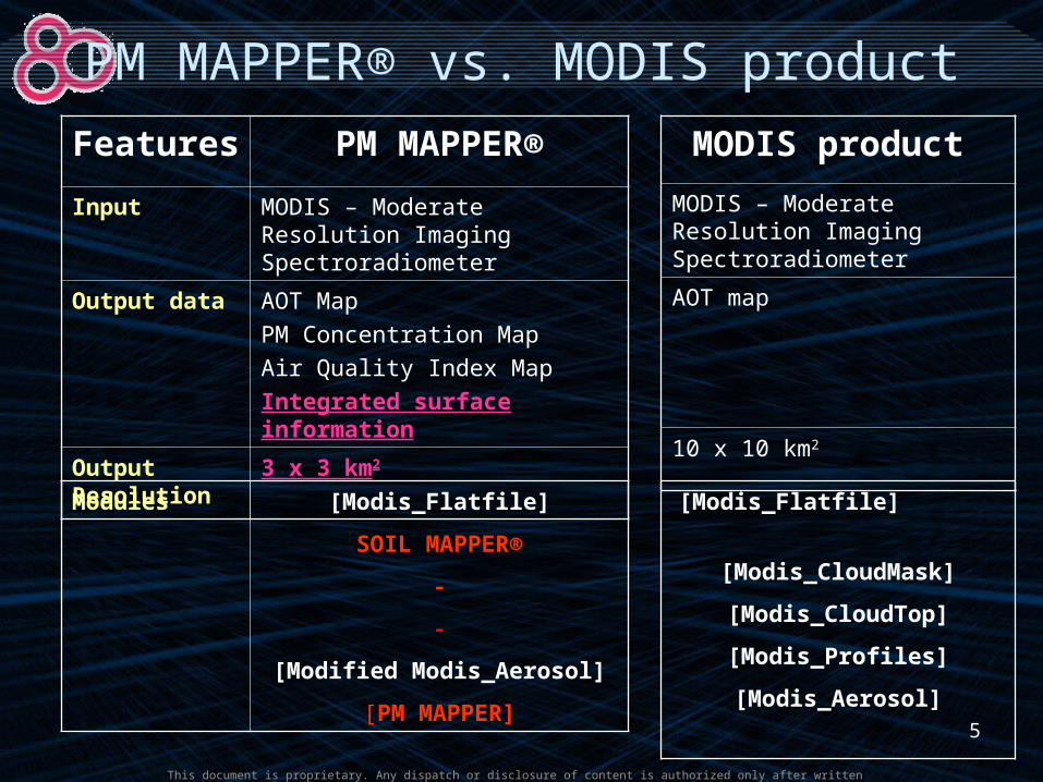
PM MAPPER® vs. MODIS product
Features PM MAPPER®
Input MODIS – Moderate Resolution Imaging Spectroradiometer
Output data AOT Map
PM Concentration Map
Air Quality Index Map
Integrated surface information
Output Resolution
3 x 3 km2
MODIS product
MODIS – Moderate Resolution Imaging Spectroradiometer
AOT map
10 x 10 km2
Modules [Modis_Flatfile]
SOIL MAPPER®
-
-
[Modified Modis_Aerosol]
[PM MAPPER]
[Modis_Flatfile]
[Modis_CloudMask]
[Modis_CloudTop]
[Modis_Profiles]
[Modis_Aerosol]
This document is proprietary. Any dispatch or disclosure of content is authorized only after written authorization by MEEO S.r.l.
6
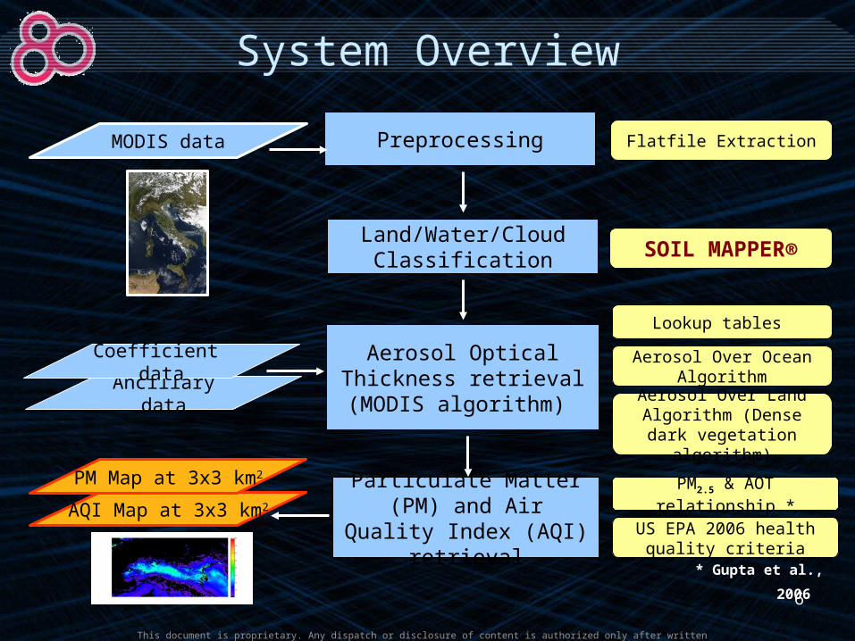
System Overview
AQI Map at 3x3 km2
Aerosol Optical Thickness retrieval
(MODIS algorithm)
Particulate Matter (PM) and Air Quality Index
(AQI) retrieval
Aerosol Over Ocean Algorithm
Aerosol Over Land Algorithm (Dense dark vegetation algorithm)
PM2.5 & AOT relationship *
US EPA 2006 health quality criteria
Ancillary data
Coefficient data
PM Map at 3x3 km2
Land/Water/Cloud Classification
Preprocessing Flatfile Extraction
SOIL MAPPER®
MODIS data
Lookup tables
* Gupta et al., 2006

This document is proprietary. Any dispatch or disclosure of content is authorized only after written authorization by MEEO S.r.l.
77
MODIS data 56 classes AOT over Ocean AOT over Land
AQI map PM2.5 map
Inte
grat
ed A
OT

This document is proprietary. Any dispatch or disclosure of content is authorized only after written authorization by MEEO S.r.l.
8
MODIS AOT vs. PM MAPPER® AOT

This document is proprietary. Any dispatch or disclosure of content is authorized only after written authorization by MEEO S.r.l.
9
Land Cover Integration

This document is proprietary. Any dispatch or disclosure of content is authorized only after written authorization by MEEO S.r.l.
101010
PM MAPPER® Validation

This document is proprietary. Any dispatch or disclosure of content is authorized only after written authorization by MEEO S.r.l.
1111
Validation
• Objectives– Assess the quality of PM MAPPER® product at 3x3
km2 spatial resolutions– Assess the performance of PM MAPPER® over
different land backgrounds• Comparison: MODIS products• Data set
– Over Italy– 6 months (January 2008 – June 2008)– Selection of 15 images (out of the 180 available)
• Validation Factors – Correlation Coefficient– Number of Retrieved Pixels

This document is proprietary. Any dispatch or disclosure of content is authorized only after written authorization by MEEO S.r.l.
1212
PM MAPPER® with 3x3 km2 resolution
Correlation Coefficient
0
0.2
0.4
0.6
0.8
1
1.2
1 2 3 4 5 6 7 8 9 10 11 12 13 14 15
Images
Co
rre
lati
on
Land & Ocean
Land
Ocean
• Average Correlation Coefficient over Land & Ocean: 0.88• Deviation: 0.78 – 0.95

This document is proprietary. Any dispatch or disclosure of content is authorized only after written authorization by MEEO S.r.l.
1313
PM MAPPER® with 3x3 km2 resolution
Retrieval Pixels over L & O
0
200000
400000
600000
800000
1000000
1200000
1400000
1 2 3 4 5 6 7 8 9 10 11 12 13 14 15
Images
Num
ber o
f Pix
els PM-L&O
IMAPP-L&O
Retrieval Pixels over Land
0100000200000
300000400000500000600000
700000800000
1 2 3 4 5 6 7 8 9 10 11 12 13 14 15
Images
Num
ber o
f Pix
els
PM-Land
IMAPP-Land
Retrieval Pixels over Ocean
0
100000
200000
300000
400000
500000
600000
1 2 3 4 5 6 7 8 9 10 11 12 13 14 15
Images
Num
ber
of P
ixel
sPM-Ocean
IMAPP-Ocean

This document is proprietary. Any dispatch or disclosure of content is authorized only after written authorization by MEEO S.r.l.
14
PM MAPPER® over different backgrounds• Group 1, group 2 : poor statistics on dataset and low correlation • Group 3 : bright and dense classes• Group 4 : dark, large number of retrieval pixels, and high correlation
Group Classes Number Label Darkness AOT Pixels AOT Correlation
1 14 Bright Weak Vegetation 0 0 0
1 16 Bright Strong Shrub Rangeland 0 0 0
1 17 Dark Strong Shrub Rangeland 0 0 0
1 20 Strong Herbaceous Rangeland 0 0 0
1 36 Dark Barren Land 2 0 0 0
2 23 Bright Barren Land 1 0.989 409 0.38683900
2 31 Average Barren Land 1 1 1,450 0.53916040
2 35 Dark Barren Land 1 1 102 0.55672200
2 28 Strong Barren Land 2 0.982 2,775 0.67422529
2 38 Dark Barren Land 4 1 191 0.70847186
2 7 Dark Peat Bogs 1 99 0.70906600
2 27 Strong Barren Land 1 1 485 0.73638586
2 11 Bright Strong Vegetation 1 76 0.75544625
2 15 Dark Weak Vegetation 0.989 110 0.83535935
3 24 Bright Barren Land 2 0.163 105,765 0.62656844
3 26 Bright Barren Land 4 0.431 345,917 0.80878480

This document is proprietary. Any dispatch or disclosure of content is authorized only after written authorization by MEEO S.r.l.
15
PM MAPPER® over different backgroundsGroup Classes Number Label Darkness AOT Pixels AOT Correlation
4 21 Average Herbaceous Rangeland 1 17,985 0.74601631
4 32 Average Barren Land 2 0.999 6,436 0.74735650
4 50 Dark Range Land 1 83,288 0.76368429
4 10 Dark Strong Vegetation 1 87,393 0.76461758
4 9 Bright Peat Bogs 0.998 3,806 0.78243092
4 44 Wet land 0.996 13,829 0.78631986
4 41 Shadow Barren Land 0.978 8,914 0.79855887
4 19 Dark Average Shrub Rangeland 1 50,557 0.80909021
4 29 Strong Barren Land 3 1 52,505 0.81401573
4 40 Shadow Vegetation 0.921 76,124 0.81550220
4 18 Bright Average Shrub Rangeland 0.999 697,678 0.81552407
4 30 Strong Barren Land 4 0.999 190,492 0.81709721
4 37 Dark Barren Land 3 1 129,072 0.82782053
4 49 Strong Barren Land 5 0.997 48,374 0.83077167
4 25 Bright Barren Land 3 0.908 41,569 0.83334107
4 48 Very Bright Average Vegetation 2 0.998 976,442 0.83837347
4 34 Average Barren Land 4 1 206,557 0.83893550
4 8 Mid tone Peat Bogs 1 5,225 0.84086842
4 12 Bright Average Vegetation 1 1,133,162 0.85488120
4 47 Very Bright Average Vegetation 1 1 392,399 0.85551107
4 39 Bright Rangeland 0.999 231,669 0.85601407
4 13 Dark Average Vegetation 0.999 308,450 0.86284347
4 22 Mid tone Rangeland 1 386,860 0.87782180
4 33 Average Barren Land 3 1 326,197 0.87997400

This document is proprietary. Any dispatch or disclosure of content is authorized only after written authorization by MEEO S.r.l.
Conclusion and Future Work
This document is proprietary. Any dispatch or disclosure of content is authorized only after written authorization by MEEO S.r.l.
17
Conclusion• PM MAPPER® characteristics
– Input: MODIS data
– Output: AOT, PM2.5, PM10, AQI, Land Cover information
– Consistent with MODIS standard products
• Advantages– Finer spatial resolution– Increase the number of retrieval pixels– Remove the coastline effects– Land cover classes integration

This document is proprietary. Any dispatch or disclosure of content is authorized only after written authorization by MEEO S.r.l.
18
Future works• Improve AOT quality on some bright and dark
surfaces by statistic approach (data-driven model)
• Validate PM MAPPER® products in the comparison with ground-based sensors
• Continue to increase spatial resolution up to 1x1 km2
• Apply our approach for other existing satellite sensors (AATSR)
• Extend PM MAPPER® to future mission like Sentinel 3

This document is proprietary. Any dispatch or disclosure of content is authorized only after written authorization by MEEO S.r.l.
191919
Thank you for your attention

20
This document is proprietary. Any dispatch or disclosure of content is authorized only after written authorization by MEEO S.r.l.
20
CONTACTS
Via Saragat, 9. I-44122, Ferrara, ItalyTel.: +39-0532-1861501Fax: +39-0532-1861637
[email protected] www.meeo.it

21
This document is proprietary. Any dispatch or disclosure of content is authorized only after written authorization by MEEO S.r.l.
MODIS 10 x 10 km2
PM MAPPER® 3 x 3 km2
PM MAPPER® with 3 x 3 km2 resolution
• Effectively monitoring air pollution at the finer scale (i.e. over urban areas where surface and pollution field are complex).
• Providing detailed AOT distribution maps to identify emission sources.
22
This document is proprietary. Any dispatch or disclosure of content is authorized only after written authorization by MEEO S.r.l.
22
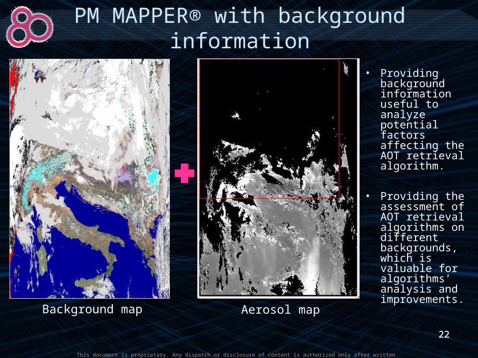
Background map Aerosol map
• Providing background information useful to analyze potential factors affecting the AOT retrieval algorithm.
• Providing the assessment of AOT retrieval algorithms on different backgrounds, which is valuable for algorithms’ analysis and improvements.
PM MAPPER® with background information
23
This document is proprietary. Any dispatch or disclosure of content is authorized only after written authorization by MEEO S.r.l.
23
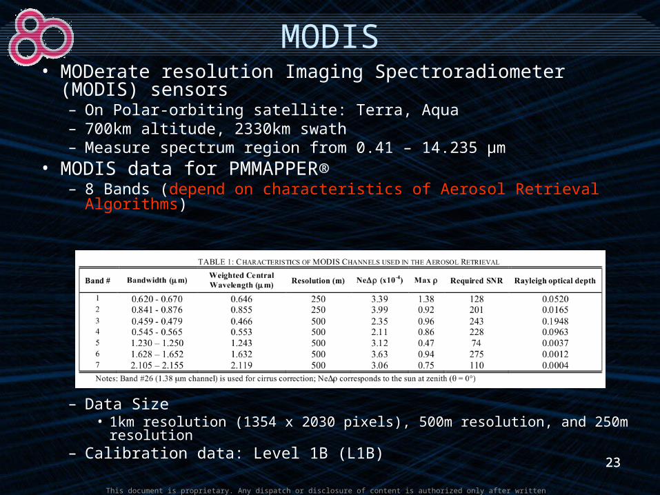
MODIS• MODerate resolution Imaging Spectroradiometer (MODIS)
sensors– On Polar-orbiting satellite: Terra, Aqua– 700km altitude, 2330km swath– Measure spectrum region from 0.41 – 14.235 µm
• MODIS data for PMMAPPER®– 8 Bands (depend on characteristics of Aerosol Retrieval Algorithms)
– Data Size• 1km resolution (1354 x 2030 pixels), 500m resolution, and 250m
resolution– Calibration data: Level 1B (L1B)

24
This document is proprietary. Any dispatch or disclosure of content is authorized only after written authorization by MEEO S.r.l.
Aerosol Algorithm over Ocean - Principles
• Measured radiance = path radiance + ocean surface reflection
• Physical Factors– Ocean surface reflection
• Glitter (glitter angle)• Foam reflection:
– Independent with visible channels– Decrease to 0.8, 0.5, and 0.25 at 1.24, 1.64, and 2.13µm
• Lambertian Reflectance (Water-leaving radiance): – Affect much on reflectance of 0.47, 0.55, 0.66 µm– Almost un-affected on reflectance of other bands
– Atmosphere factors:• Cloud contamination: 0.55 µm• Dust: 0.47, 0.66 µm• Cloudy: 0.47 µm• Cirrus cloud: 1.38, 1.24 µm
Ocean surface reflection is almost un-affected on some special bands
Choosing special bands to eliminate atmosphere factors

25
This document is proprietary. Any dispatch or disclosure of content is authorized only after written authorization by MEEO S.r.l.
Aerosol Algorithm over Ocean - Principles
• Define Aerosol models– Bi-modal log-normal distribution
• Present Radiance is detected by satellite
• Estimate Aerosol models to minimize the quantity
cL
sl
),,()1(),,(),,( vvsl
vvss
vvsc LLL
Small model Large model
2
1
)()()(
j
j
dr
rdN
dr
rdNrn
Where is single-mode log-normal distribution function
dr
rdN j )(
n
j vvsm
vvsc
vvsm
sl j
jj
L
LL
n 1
2
01.0),,(
),,(),,(1
sl

26
This document is proprietary. Any dispatch or disclosure of content is authorized only after written authorization by MEEO S.r.l.
Aerosol Algorithm over Ocean
AOT
Masking pixel by pixel
-Reflectance-Averaged reflectance for the box-Solar zenith angle-Lookup reflectance-Scattering angle
Interpolate and calculate associated parameters
LUT• Associated parameters• Aerosol Model Parameters• Model Contribution Parameters • Optical Thickness
-Spatial variability (0.55)-Dust call back (0.47, 0.66)-Cloudy (0.47)-IR test-Cirrus cloud test (1.38, 1.24)-Sediment maskDiscard brightest 25% & darkest 25%
(0.86)
Enough good pixels & condition?
0.47, 0.55, 0.66, 0.86, 1.24, 1.38, 1.64, 2.13µm
Derive the optical thickness
Estimate Aerosol model (small and large size distribution)

27
This document is proprietary. Any dispatch or disclosure of content is authorized only after written authorization by MEEO S.r.l.
Aerosol Algorithm over Land - Principles
• Separate path radiance from measured radiance of satellite
• Conditions– Contribution of ρ* from path
radiance is large• Shorter wavelengths• Low values of surface reflectance
(ρ <0.06)
– Small uncertainty of path radiance • From +-0.005 to +- 0.01
)1(
),,()()(),,(),,(
'00
00*
p
pTFpp da
Measured radiance Path radiance Reflection radiance from surface
28
This document is proprietary. Any dispatch or disclosure of content is authorized only after written authorization by MEEO S.r.l.
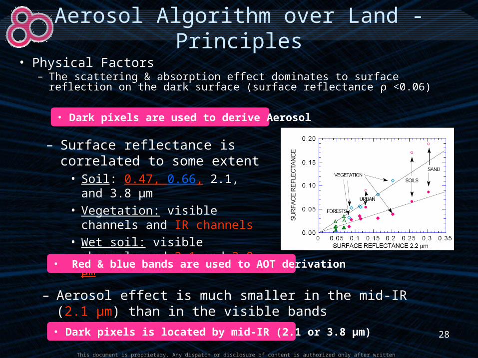
Aerosol Algorithm over Land - Principles
• Physical Factors– The scattering & absorption effect dominates to surface
reflection on the dark surface (surface reflectance ρ <0.06)
– Surface reflectance is correlated to some extent
• Soil: 0.47, 0.66, 2.1, and 3.8 µm
• Vegetation: visible channels and IR channels
• Wet soil: visible channels and 2.1 and 3.8 µm
• Dark pixels is located by mid-IR (2.1 or 3.8 µm)
– Aerosol effect is much smaller in the mid-IR (2.1 µm) than in the visible bands
• Dark pixels are used to derive Aerosol
• Red & blue bands are used to AOT derivation

29
This document is proprietary. Any dispatch or disclosure of content is authorized only after written authorization by MEEO S.r.l.
Aerosol Algorithm over Land
AOT
LUT
Average Land Reflectance-Detect and delete cloud pixels-Identify dark pixels (2.1µm)-Remove 50% brightest & 20% darkest pixels (0.66µm)
0.47, 0.66, 2.12, 3.8 µm
Determine the aerosol model
Compute and interpolate the associated parameters
Derive non-cloudy AOT from MODIS measured radiances
-Continental aerosol-Biomass burning-Industrial/urban aerosol-Dust aerosol
Fail 1, change cloud thresholdFail 2
Success
LUT
-Scattering angle-Lookup Reflectance -Path radiance, slope, error
If (dark pixels > 10%), calculate the average reflectance
-Spatial variability